Embed Size (px)
Citation preview

Chapter 4 Micro Study: The Primary Survey
Chapter 4
105
CHAPTER 4
MICRO STUDY: THE PRIMARY SURVEY
The Micro study is based on a field survey conducted by the researcher on Common property access, collections from Commons, and the extent of dependence of sample households on Common property resources (CPRs) including Common property water resources (CPWRs).
This survey facilitated another enquiry on the availability of CPWRs, pattern of use and water quality. The second phase of the survey was a study of Common water bodies (ponds) in the villages and involved testing of water of these water bodies, for potability of water.
Set in rural West Bengal, the field survey covered seven villages from seven districts of the State which are diverse in terms of ecology, especially water resources. Together these villages represented all the agro-climatic zones of the State. The sample villages represent the hilly, the dry and the flood-prone – all types of land in West Bengal. A sample of 441 households was selected1.The period of collection of sample data is December 2004 to January 2005. The second phase of the survey was undertaken in March 2006.
Since the study is exploratory in nature, some tools of qualitative analysis were resorted to other than merely canvassing the Questionnaire. As a result, observation and dialogue formed the basis of creating a village profile before the final choice of villages was made. Also both observation and interview were techniques that were followed for the collection of data. 4.1. Objectives of the Survey 1. To Study the dependence of the sample households on CPRs including CPWRs,
collection from which is very much prevalent in entire West Bengal. 2. To look at the availability and access of CPWRs in sample villages and also
identify Common ponds in villages as CPWRs. 1 The analysis of data is on 440 household because one household did not respond.
Chapter 4
106
3. To investigate water quality of the Common ponds and relate it to health and well being of user households.
4. To analyse the contribution of outside catalysts, namely, Non-Government Organizations (NGOs) towards well-being of villagers.
Hypothesis 1. To test if, irrespective of ecological differences, the very poor in a rural setting
depend significantly on collections from Commons for survival and nutrition. 2. To test if, degraded surface water of Common ponds, leads to ailments and
preservation of ponds is key to health well being. 4.1.1. Methodology A. Choice of Sample Villages One village from each district i.e. 7 villages in all, were selected. Apart from logistical advantages, four criteria have been used to influence choice: a. Different water ecology. Hence villages were to be from different ecological
zones. b. Large percentage of poor in the population of the village. c. Some noticeable water related degradation in the CPRs of the village. Here,
diversity in type of degradation was the basis of choice. d. Some community effort to tackle or reverse the problem of degradation. Presence
of NGOs or social workers as well as Self Help Groups’ (SHGs) participation was important in deciding choice.
The choice was a three part exercise.
At first the districts were selected. The choice of 7 districts had to be in a way that all 3 Agro climatic zones viz. Eastern Himalayas and Brahmaputra Valley (EHm); Eastern Plateau Hills(EHg) and Lower Gangetic Plain (LG) are covered. This was done in the interest of taking a study area that is ecologically diverse.2
2 The choice of districts is given in chapter 3(fig. 3.1)
Chapter 4
107
Jalpaiguri was chosen from EHM; Birbhum from EHG; and Nadia, Bankura, Medinipur (west), 24 Parghanas (N) and 24 Parghanas (S) from different parts of LG.
The selection looks biased to the Gangetic plain but there are also sub regions of the agro-climatic zones3 of the State. As per the sub-regions, Jalpaiguri was chosen from the Northern Hills; Birbhum, Bankura and Medinipur in the Laterite zone and Nadia in Vindhyan Alluvial zone; 24 Parghanas (N) in Deltaic Alluvial zone and 24 Parghanas (S) in Coastal saline zone.
Choice of the Development Block in each district.4 Adhering to the above criteria, adopted for selection of villages, the Blocks in the chosen districts were purposively adopted with low development indicators.
The Blocks chosen were Kalchini from Jalpaiguri; Labpur from Birbhum; Chhatna from Bankura; Salboni from Medinipur (W); Ranaghat-I from Nadia; Gaighata from 24 Parghanas (N) and Diamond Harbour-II from 24 Parghanas (S).
In actual selection of villages, for applying the four choice criteria, village details had to be known for which, checking of Record of Rights (ROR) of all villages under the 7 Blocks was done. The village profile was available in the Census 1991 but since some villages were not Revenue villages, profile of such villages were procured from the Blocks.
The social welfare organizations operating in these villages, were helpful for the purpose of identification of households and other details in their area of operation.5
The villages chosen were Radharani Tea Garden, Kalikapur, Ghoshergram, Jagannathpur, Sibpur, Gazna-I and Khakrakona. 3 The sub-regions are Northern Hill, TeraiTeesta alluvial zone, Gangetic alluvial zone, Laterite zone,
Coastal saline zone & Vindhyan Alluvial Zone, given the agro climatic map of West Bengal in Chapter 3 (fig 3.3).
4 The importance of the Block is paramount. Rural Census figures, after the 73rd Amendment of the Constitution, are published Panchayat wise. But in West Bengal, the Gram Panchayat (GP) may not be the same boundary as the Mouja( Revenue village). Hence, Community development (CD) Blocks are now the major unit of boundary.
5 The organizations were Lok KalyanParishad, active in 2 of the chosen villages, namely, Radharani Tea Garden (RTG) and Kalikapur; ENDEV, an environment development NGO which created bio-diversity registers in 2 of the surveyed villages, namely, Sibpur and Khakrakona, both having rural bases but having the head office in Calcutta..The third was KisholoyTarunTeertha, an educational NGO working for awareness about arsenic in groundwater, operating in village Gazna. Ashurali Gramonnayan Parished is opearative in South 24Parghanas. It is in Ashurali mauja of which Khakrakona is a part.. It has the bio diversity register of Khakrakona in its library.
Chapter 4
108
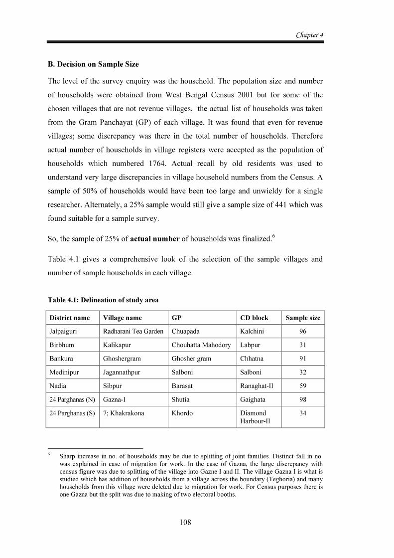
B. Decision on Sample Size The level of the survey enquiry was the household. The population size and number of households were obtained from West Bengal Census 2001 but for some of the chosen villages that are not revenue villages, the actual list of households was taken from the Gram Panchayat (GP) of each village. It was found that even for revenue villages; some discrepancy was there in the total number of households. Therefore actual number of households in village registers were accepted as the population of households which numbered 1764. Actual recall by old residents was used to understand very large discrepancies in village household numbers from the Census. A sample of 50% of households would have been too large and unwieldy for a single researcher. Alternately, a 25% sample would still give a sample size of 441 which was found suitable for a sample survey.
So, the sample of 25% of actual number of households was finalized.6
Table 4.1 gives a comprehensive look of the selection of the sample villages and number of sample households in each village. Table 4.1: Delineation of study area
District name Village name GP CD block Sample size Jalpaiguri Radharani Tea Garden Chuapada Kalchini 96 Birbhum Kalikapur Chouhatta Mahodory Labpur 31 Bankura Ghoshergram Ghosher gram Chhatna 91 Medinipur Jagannathpur Salboni Salboni 32 Nadia Sibpur Barasat Ranaghat-II 59 24 Parghanas (N) Gazna-I Shutia Gaighata 98 24 Parghanas (S) 7; Khakrakona Khordo Diamond
Harbour-II 34
6 Sharp increase in no. of households may be due to splitting of joint families. Distinct fall in no.
was explained in case of migration for work. In the case of Gazna, the large discrepancy with census figure was due to splitting of the village into Gazne I and II. The village Gazna I is what is studied which has addition of households from a village across the boundary (Teghoria) and many households from this village were deleted due to migration for work. For Census purposes there is one Gazna but the split was due to making of two electoral booths.
Chapter 4
109
4.1.2. The Sampling Procedure and Mode of Enquiry The choice of villages was purposive but sample households were selected as a random sample using Circular Systematic Sampling.7
Two Questionnaires, one for the village and the other for households, were designed. The village Questionnaire sought general information about the village, which was responded to by the GP members. The information sought was mainly on village facilities, type and extent of village Common land and water resources, extent of access to forest land. There were queries on size of population below poverty line; occupation profile of households and behavior of migration for work; social details like festivals and amity among various social groups and also contribution of organizations promoting welfare of the village community (NGOs and SHGs).
The Household Questionnaire was canvassed to all sample households.8 Information was sought in the Household Questionnaire on socio-economic factors covering household type, income, asset holdings both in terms of land and livestock as well as households articles in a household roster (question 2). Detailed information was sought on food habits and nutrition (question 5) and collection from the Commons in terms of source (questions7and 8), reason for collection and time of collection in the year (question 9). Information on other factors affecting well-being like facilities of a separate kitchen in the house; smokeless chulha and toilet. To ascertain level of living, information was collected on incidence of borrowing grains or money for food; habit of savings; vaccination and education of children etc. (question 6). Information on health of households was sought to create a disease profile (question 28).
Another part of the enquiry was on water resources of the village. This section sought information on pattern of water use by households for multiple domestic use from various sources, notably ponds, the local CPWRs (question 22). The truth is, even if clean drinking water is available from deep tube wells in most districts of West Bengal, potability of surface water for bathing and cooking is suspect. The information on water quality and opinion on abatement practice were sought in questions 25, 26 and 27. 7 In each village, the households were listed and every fourth house was selected and rotation
continued till the requisite number for the village was taken. 8 Both questionnaires are available in Appendix 1.1 and 1.2.
Chapter 4
110
The actual survey was conducted in local language. So both the Questionnaires were translated to Bengali and both were pre-tested in two villages (Kalikapur and Sibpur). Two local investigators were trained for the canvassing of a rather long and probing Questionnaire.9 The information on collection was in terms of individual items where there were only two responses of the households, yes and no.
The preliminary tabulation for the entire sample data, gave an overview of the socio economic reality of the sample households in terms of personal income, source of earning, type of dwelling and ownership of assets which are attendant indicators of level of living. From this overall picture, several variables were generated for estimation of the relationship between poverty of households and collection from Commons.
Later, detailed tabulation, by village, was done on various household characteristics relating to literacy, formal education, age structure, number of earning members and factors affecting wellbeing, taking a broad view of defining poverty status and the extent of collections of fuel and food. The collections were tabulated by village separately from CPWRs and other CPRs. The extensive tabulation was essential for understanding the collection behavior of poor households to vindicate the hypothesis that poor collect for sustenance from the Commons.
Using the data on collections from the Commons, a two way table on the collections from Commons in detail was constructed. This table shows collection by items, by purpose (sale or consumption), by source of collection, by time of the year for collections and also by time spent in collection. The sources considered as CPRs in the survey were six:
Grazing land; forest of access; village Common land; village canal pond, pond side; area under Ease man Rights10 and private property treated as Common, by usage.
Based on the survey information on water, tables were made on access, nature of ownership and source of water by use, by village. There was identification of ponds as Common both by de facto and de jure concepts of CPWRs. 9 The village questionnaires were totally filled by the researcher but household questioners were
equally divided between the researcher and two investigators. The survey ended with transfer of data to English formats.
10 Land under Ease man Right is usually under specific religious groups’ use like cemetery, of Muslims/Christians, Hindu sacred site or cremation ground (smashan).
Chapter 4
111
To test the hypothesis that the very poor, in any agro climatic condition, collect from the Commons the goods that they consume, a regression exercise has been worked out, using a Logit Model.
Statistical analysis of the survey data, the specification of the model, description of variables and analysis of Results of the Regression exercise are given in Chapter 5.
The second enquiry on water quality of ponds is based on actual testing of water samples from 6 Common ponds in villages Kalikapur, Ghoshergram, Jagannathpur, Sibpur, Gazna- I and Khakrakona. Findings on water resources in the villages surveyed and the Report on water quality of one Common pond in each village, form the first part of Chapter 6.
The hypothesis, that degraded surface water of multi-purpose Common ponds lead to ailments, is tested using a probit model. The model specification, description of variables and analysis of Results are contained in the second part of Chapter 6. Data Sources
1. Main data source is the Primary data from the village survey. 2. For study of Land use in individual villages, Record of Rights as in the BHUMI
software managed by the Directorate of Land Records of the Government of West Bengal was used. These had to be obtained from Block authorities of each of the seven district Blocks.
3. Some data was obtained from village Gram Panchayats(GP) of non-revenue villages, on actual population and household number or daily migration in some cases.
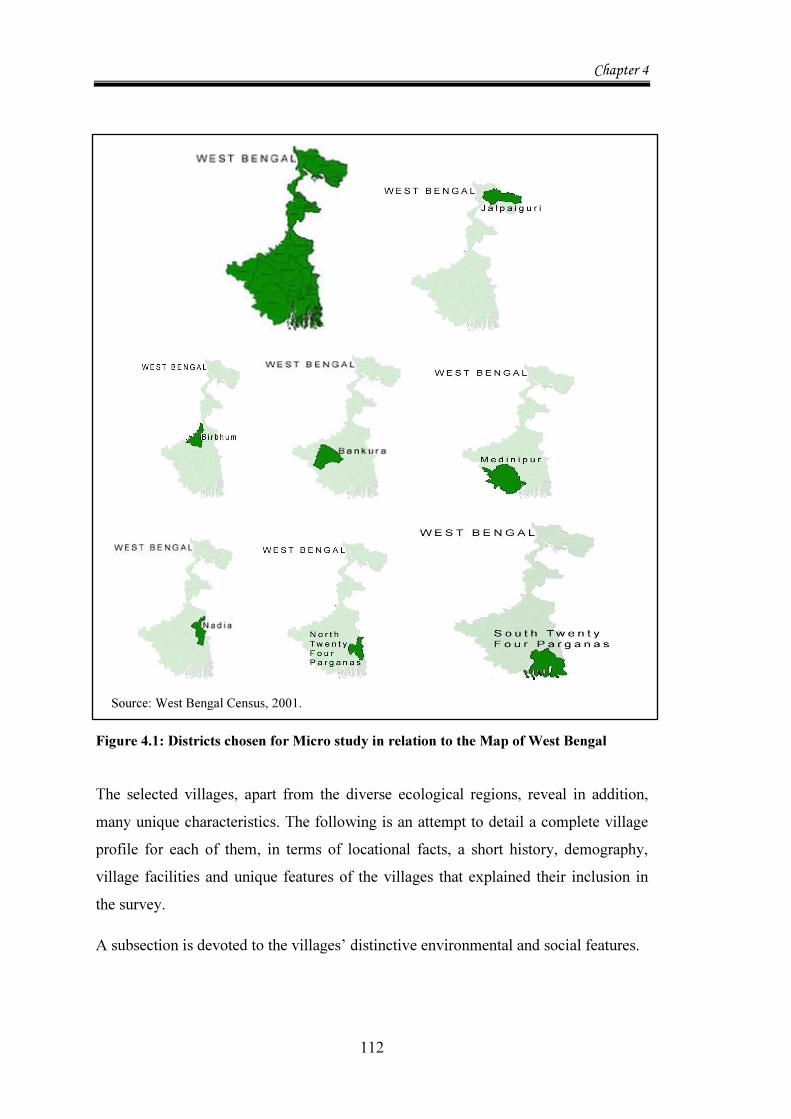
4.1.3. Description of the Study Area Figure 4.1 shows the Map of West Bengal and separate maps for showing the position of each district on the State Map. The diversity in location is clear from the figure. The districts cover the Northern (hilly), Western (draught prone) and Eastern (flood prone) parts of West Bengal.
Chapter 4
112
Figure 4.1: Districts chosen for Micro study in relation to the Map of West Bengal The selected villages, apart from the diverse ecological regions, reveal in addition, many unique characteristics. The following is an attempt to detail a complete village profile for each of them, in terms of locational facts, a short history, demography, village facilities and unique features of the villages that explained their inclusion in the survey.
A subsection is devoted to the villages’ distinctive environmental and social features.
Source: West Bengal Census, 2001.

Chapter 4
113
Village Setting and Physical Features Radharani Tea Garden (Village 1) in Kalchini block of Jalpaiguri district is quite isolated as the nearest Railway Station Alipur Duar is at a distance of 35 km. It is a fringe village of Buxar Tiger Reserve. There is extreme forest dependence for collection and sale of fuel wood and other edible forest products. There is also another village within the forest called Pana Basti. The poor from both Radharani and Pana, harvest the same forest belt.
The village receives annually 160mm of rainfall but has no surface water like ponds and also no shallow ground water due to large sand deposits. At the time of the survey it had only one private well. The ground water here can be tapped only after 350 feet. The Tea garden has a deep tube well 380 ft. deep which is the only source of drinking water in the village. Entire irrigation of the tea plantation as well as all taps is served by it.
Kalikapur (Village 2) is in the Labpur Block of District Birbhum. It is about 26 km from Bolpur.11 The basic information about this village is not available from the Census as it is not a revenue village. It is a part of the Shekhampur mouja under GP Chouhatta Mahodary-I. The information on population, exact number and location of village households, also on CPR land and water of Kalikapur was provided by the GP from the Mouja map of Shekhampur. The village has a homogenous population of only Adivasis (ST).
This village is in the extremely dry patch of Birbhum although there are 2 rivers which are accessible to the village called River Kopai which runs about 20 feet below the village surface, and a seasonal river called Kuye nadi. The village is also near the confluence of River Kopai and the Bakreshwar hot springs. At a distance of 11 kms, is the river Mayurakshi, which is accessible only to the young and able villagers as there is no transport facility. This village is ravaged by flash floods from the big rivers of Birbhum, namely Ajay and Damodar.
11 Bolpur is the host town of Shantiniketan and the Vishwabharati University founded by
Rabindranath Tagore.
Chapter 4
114
Hence, the village suffers extreme drought and occasional floods, both negatively affecting crops.
Ghoshergram (Village 3), under the Chhatna block of district Bankura is a full mouja village so that the GP is also Ghoshergram. This is a large village with six hamlets (padas) of heterogenous population. There is Majhpada that has a total population of adivasis; Kamarpada that has some adivasis but the name is owing to the fact that mostly people are blacksmiths (kamars); Bauripada where we have wage labourers as well as cultivators but the name is derived from the fact that majority of the population are of Bauri caste. The other padas are Dhadanga, Kashipada and Gerardihi which have mixed population of general caste, SC and OBCs. These hamlets are poor, dirty, congested and have very poor facility of drinking water and road.
The village has undulating land with high degree of porosity. As a result, there is both soil erosion on the slopes and fast loss of moisture on lower lands.
The next village of the study is Jagannathpur (Village 4), situated in Block Salboni of Medinipur (West) district. The Gram Panchayat is also Salboni.
This is one of the poorest areas in the District. Salboni is a very poor Block with almost no facilities of health, transport and even market establishments. There is no hotel, eating place-even local transport from railway station, like rickshaw. But the Block office has excellent work culture and all information at the Block level is available with a computer savvy staff. It also arranges Staff Training Programs for the Department of Panchayat and Rural Development. It releases an information booklet every year which has minute details of every development project, complete with the list of beneficiaries at the level of the GP. Even the GP, with no modern facilities like a computer or a Xerox machine keeps all handwritten records up to date.
This village is very dry. It is situated along the River Tamal which is the main surface water source for irrigation available to about 12 villages, on both sides. But most of these villages have highlands which cannot be serviced without lift irrigation. Lift
Chapter 4
115
irrigation can be afforded by only the villages which are in the upstream area and already prosperous. Hence this village does not gain as the river runs 20 feet below and lift irrigation facility is not available.
Sibpur (Village 5) in Block Ranaghat-I, District Nadia belongs to Barasat GP. It is almost 80 km from the capital city, Kolkata. This village was not a Revenue village and was treated for administrative purposes with the neighbouring village called Durgapur in the 1991 Census of West Bengal. The West Bengal Census 2001 has enumerated both the villages but they were still in a dual mode of administration at the time of the survey. This is a water sufficient area and with the help of a dug well, two crops of paddy and one of jute is Common. But extreme proneness to floods has compromised the agricultural advantage.
The village is equidistant from two railway stations Taherpur and Birnagar. But motor able road access stops with Ushagram which is 3 kms from the village.
The village has a peripheral wetland called Sibpur Beel, originally called Chakra Beel. It is surrounded by 5 villages-Birnagar, Kamgachhi, Raghabpur, Sibpur and Durgapur. It has rivers Ganga and Churni on 2 sides. The major water flows into the Beel from Ganga and a part flows out through Churni. All the villages highly valued the fresh and cool breeze that keeps the summer days very pleasant. There were many families who had fishing as their primary occupation. This is truly a Common property water resource but lack of maintenance has rendered it to open access for fishing, and retting of jute.
Gazna-I (Village 6), belongs to the Gaighata Block of District 24 Parghanas (N).This village is a revenue village but there is an electoral division here as Gazna-I and Gazna II. For the survey Gazna I is chosen, under which some part of a village with overlapping boundary called Teghoria is included.
This village also has a porous border with Bangladesh and three rivers, Ichhamati, its tributaries Jamuna and Padma, are Common between the two countries India and Bangladesh. The major water body here is an ox bow lake formed by the confluence
Chapter 4
116
of the rivers on three sides of the village. The village can be approached by auto rickshaws and car. It is situated on a metalled road but flood like situation keeps the approach road in a murky state, almost 4 to 5 months of the year, making transport difficult
This village is much better than all other villages selected for the survey. There are regular bus services from outside the village. There are many roads connecting the different segments of the village. The village is divided into 6 hamlets (parhas)- namely Khalparha (canal side settlement); Ghoshparha (mainly habited by dairy workers and owners); Kalitola(near a kali temple); Colony (more recent settlers) and unchuparha (situated on high land).The village has an interesting topography.
Khakrakona (Village 7) is not a revenue village. It is a part of Asurali Mouja. and belongs to District 24 Parghanas (S). Block Diamond Harbour II and its GP is Khordo.
The village is situated to the West of Asurali, situated off a road from Sarisha Hat to Falta (an Export Processing Zone) and on a feeder road from Sankhua Pul to Asurali (this is a bridge beyond which no transport is available). There is a feeder canal of Balarampur to the west of Asurali which has a small wooden bridge that leads to a mud path to Bhaukol village, over paddy fields and houses of Khakrakona.
The village has its own Gram Sansad (GS). The information on population and other village details was taken from the GP; the land use information from the Block and all social details from the Report of Biodiversity of the village undertaken by ENDEV12.
Physiographic type of this village is deltaic plain land. This area has been created by accumulation of alluvial deposits from the Ganges. The cultivable land is under private ownership and mostly classed as Shali land i.e. low and medium quality land.
12 In this village Ashish Ghosh of ENDEV, has done the bio diversity registration work. His Report
in Bengali is called Jana Jaibo boichitra Nothi. In it there was a census of all the 109 households. Before the sample survey, this provided a full and detailed background of the village.
Chapter 4
117
History13 Radharani Tea Garden is in existence since 1911 when the tea garden was established, clearing thick jungle with a total area of 972.82 acres under tea plantation out of which only 379.10 acres are presently the available land. The Founder, Jatish Chandra Pal Choudhury came into this forested area of the Duars, to be a pioneer tea planter, when tea plantations were mostly British ventures. He named his Estate after his mother, Radharani and started production on a small strip of land, adjacent to the Buxar Tiger Reserve Forest which grew to be a successful operation that provided workers with all basic amenities of life by the time of India’s independence. For over 90 years, the Estate has worked well except that the village outside its activity has been a den of poverty14.
The inhabitants of the village are a motley crowd of different cultures. All of them are descendants of tea garden workers who were hired in the beginning of the 20th century from different parts of Eastern India. The main group is Nepali speaking and a majority of others are adivasis from Bihar and Jharkhand.
Kalikapur (Village 2) was about 75 years old during the survey. 100% of its population is Tribal and hence ST. It is interesting to know why it is so. A short history of the village was narrated by a retired GP member. Around 1930, the Zamindar of Labpur, Shasthi Kinkar Banerjee, brought 6-7 families of Tudu, Soren and Murmu caste and gave free homestead land. Some more Kishku families came later. All the settled families were given in addition to bastu (homestead land), some land as Krishani (sharecropper). The share of the landlord was 3/5 of total produce. The famous Tebhaga stir in West Bengal, to bring down share of land lord to1/3 of produce, was not beneficial to this village as they remained isolated due to their special situation. A sense of servility prevailed. After abolition of Zamindari, in 1953, some land was vested with an understanding of allegiance. After 1969, there was 1 hectare and 2.47 acres vests to individual beneficiaries, none of whom were landless. Since 2003-4 the Land Records of West Bengal villages were being finalized. It was
13 History here, is the oral transect and recall of the villagers during the survey. Informal interactions
with the villagers and interview of the GP members are the source of information. 14 As related by Ritam Sinha, the Senior Executive of the Garden.
Chapter 4
118
astonishing that in this poor village, there were only 10% registered Bargadars (share croppers), 90% families did not get any land.
Ghoshergram, an old village does not have much of a historical lore going around in the village. Although set in the vicinity of a local King’s palace there was no definite way to know about its history during the researcher’s interaction with villagers.15
Jagannathpur is an old village and was witness to the indigo plantation by the British. There is the remnant of a Neel Kuthi (the house of a British Indigo Planter) and the main water source, which is a very old private property with Common access is named-Kuthir Bandh (meaning tank of the Indigo House). One is not sure if it really belonged to the planter but its Common usage is unquestioned. People swear by the goodness of its water and even drink it in times of stress.
Sibpur is a fairly young village compared to the others in the sample. It was habited only after 1947. It is a village of settlers (from East Pakistan, now called Bangladesh) after India’s Independence from British rule with the attendant hazard of partition. So very few families reported residence here of more than 50 years.
Gopal Chandra Chakraborty, a retired Head Master and a freedom fighter from Fulia in East Pakistan, came here soon after independence in 1947 and worked untiringly to bring order and basic facilities to an area peopled with oustees from East Pakistan. He initiated building of roads and the first primary school in the area.
The Usha Gram Trust, a non political voluntary organization, was formed in 1980 under his leadership. With the help of the Trust’s founder Secretary, Late Jyotirmoy Basu, the Trust carried on all round development work in 14 villages of Barasat GP of Block-Ranaghat-I. Sibpur is one of the 14 villages under Usha Gram Trust. Hence the history of Sibpur is intertwined with the activities of the Trust.
Gazna-I is an old village but has had huge shift of population to East Pakistan and huge influx of refugees from there. The influx continued even after the formation of Bangladesh. But the later entrants are more educated, interestingly even doctors. The land use maps show even greater changes in the contour of the village after 1947. 15 At the time of the Survey the village had a very young GP Pradhan who commented that the
village has only a meaningful present and bright future but he did not elaborate on the past.
Chapter 4
119
The present generation could not enlighten the researcher on the earlier history.
Khakrakona again is a village where more was known about its link with Asurali and its own history was not uncovered by the researcher during the survey. Unique Features Radharani Tea Gardens has the unique characteristic of having a population employed by the tea garden and a host of poor relations who are non-workers subsisting there without a viable living. Tea has a 9-month season. After pruning in December, flowering starts by March. Up to June, tea is ready to be harvested. June to October is the peak plucking season. At this time, there is employment of casual labor. Anyway, of all the laborers, the ones engaged in plucking tea are paid the least.
A majority of adivasis are Christians. No other village in the sample has Christian inhabitants.
There were no agriculturists in this village in the 1991 census. In 2001, guided by the Social Welfare organization, Lok Kalyan Parishad (LKP), alternative farming has started on CPR land. Also, a variety of fodder grass, gambhari started being planted on the roadside periphery of the garden and wastelands.
The reason for the choice of this village was its major CPR access to the forest and its ecological stress.
River Pana is the only CPWR of the village that is dry beyond monsoon and leaves pernicious sand deposits. Also there is no pond or other ground water source.
Kalikapur (Village 2) is the one with 100% tribal population. It has rules of conservation for village ponds and has equitable sharing tradition of village assets. There is immense ecological problem of water stress caused by porosity of soil, also alternate bouts of floods and draught. Within the village there are 6 water bodies, 3 of which run totally dry in summer months. The village takes drinking water from under the sand of Kopai in those times.
Chapter 4
120
But the redeeming feature of the village is its community effort to reverse the water stress. The choice of the village was prompted by its community’s initiative of excavating a new pond by voluntary labour.
This village has been chosen because of its decidedly strong community effort in development, particularly of water resources.
Ghoshergram is the only village with total heterogeneity of population and where village hamlets are marked out caste wise. But the village still has a lot of social cohesion and amity. The unique feature of this village is that other than ponds, there is no provision for water for bath and other household requirement, washing cattle or irrigation.
For irrigation, a manual hose called duni is still used to water the fields from the pond. There is very little use of modern equipment for agriculture.
It is the only village with a watershed programme of the Central Government called Hariyali Project which is designed to reduce soil erosion and water stress in the village.
The project has encouraged step wise planting of trees and making arrangement for better recharge of ground water. This may be the beginning of a turnaround for agriculture in this village.
Notably, this village under the GP initiative had started planting Jatropha (Bio-fuel plants) on village Common lands.16
This village has been chosen for this study because it represents the best example of multi-purpose usage of CPWRs, in this case, of one Common village pond.
Jagannathpur is unique as the village not only has access to the Arabari forest, but also has many households as members of the joint forest committee. The forest offers great livelihood options from collections of leaves of the Saal trees; cashew and Mahua. The collections, which have a ready market for sale, are not augmenting the
16 The Jatropha system can be an integral part of rural development with its multiple benefits of
control of erosion, acting as a source of renewable energy, acting as a strategy for rural income generation using CPRs that are agriculturally unusable.
Chapter 4
121
village households’ income enough because the benefits of Joint Forest Management through fair share principle of forest products, is not adhered to.
The interesting fact about water here is that the village is solely dependent on wells for drinking water. The ground water level is very low and where it is accessible, water is unusable due to high concentration of iron. It is almost totally dependent on the Common pond, Kuthirbandh for all domestic water use.
The choice of this village was because of the great contrast of modern work culture in the block and other local government offices with extreme poverty and backwardness outside.
Sibpur is a special village which has a homogenous population of mostly people from the Schedule Caste (SC). The boundaries of Sibpur and Durgapur merge but Sibpur has distinct development traits, thanks to the endeavour of a Trust formed for service to the downtrodden called the Usha Gram Trust.17
Poverty notwithstanding, this village has a mobile library, access to a secondary school, a balwadi and a youth club.
The unique feature of this village is a peripheral water body called a Beel with two rivers – Ganges and Churni draining into it. Beel is polluted first by retting of jute and then from chemical fertilizers used in rice cultivation on the banks. Effect is fall in fish catch. Loss of depth has made the village prone to annual floods.
This village was chosen due to its unique CPWR that extends to the entire periphery of the village. Pollution of the water in the beel has created an environmental problem of loss of depth, leading to the probability of flooding during heavy monsoon months.
The specialty of the village Gazna-I is that its ground water is highly polluted with Arsenic. The awareness of the danger is high and there is a project to teach the villagers arsenic removal technique. The other unique features of the village are its high literacy rate, its anti-arsenic programs and milk co-operative. Around twenty self-help groups(SHGs) are active in the village. 17 The village Usha Gram houses the Trust. The name of the village-Usha Gram literally means the
“village of dawn” and signifies awakening and striving for a better community consciousness.
Chapter 4
122
The choice of the village is undoubtedly because of its arsenic in groundwater and the positive endeavour of the entire village community to mark out unsafe deep tube wells for safety of the people from diseases related to arsenic contamination.
Khakrakona is an icon in contrasts.
The village is situated near Falta Export Processing Zone which provides employment to some villagers but it has not extended benefits of modernization here. The village is not accessible by car for at least 2 kms from the nearest metalled road. Within the village, there are no proper roads or electricity. Four surrounding villages have electricity but this village does not have the requisite number of people who would subscribe for it. Hence it is without power.
The village is very rich in water resources but its ground water is saline above 850 feet. Hence drinking water from deep tube well is precious.
A distinctive feature of this village is that all the 45 water bodies in the village are privately owned but some of them, by providing Common access to a large number of people, are treated as CPWRs, typifying the de facto concept of CPWRs.
In 37 out of 45 water bodies in the village, indigenous fishing methods are practised but in the other 8, scientific fishing is prevalent.
Another unique feature of the village is natural irrigation by overflow of the canal around it. There is no other artificial means of irrigation. There is loss of bio-diversity in rice and medicinal plants production. It has a bio-diversity register.
The main reason for including this village for this survey is its high level of literacy despite serious logistic difficulties. It is one of the 10 villages in West Bengal which had its own biodiversity register. The children of the village assisted in the bio-diversity project of Ashish Ghosh of ENDEV. The level of awareness of environment is very encouraging.18
18 RukminiHaldar, a XII class student, gave the researcher the entire list of village households with
names of Head and their exact location in the 3 hamlets; information on Type of dwelling of each household ; kind of fuel used and novel way of understanding Common usage of private property. She is one of the young persons who was involved in Ghosh’s Bio Diversity Project. She also gave the total information on number and status of all water bodies in the village.
Chapter 4
123
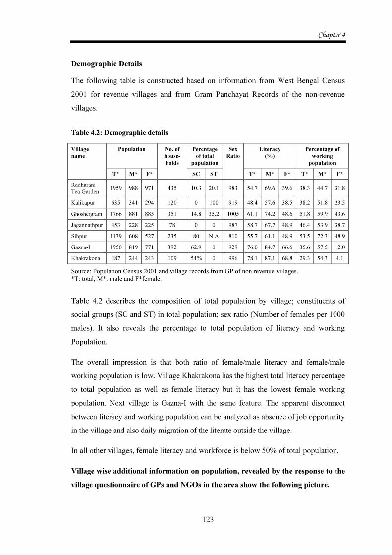
Demographic Details The following table is constructed based on information from West Bengal Census 2001 for revenue villages and from Gram Panchayat Records of the non-revenue villages. Table 4.2: Demographic details Village name
Population No. of house-holds
Percntage of total
population Sex Ratio
Literacy (%)
Percentage of working population
T* M* F* SC ST T* M* F* T* M* F* Radharani Tea Garden 1959 988 971 435 10.3 20.1 983 54.7 69.6 39.6 38.3 44.7 31.8
Kalikapur 635 341 294 120 0 100 919 48.4 57.6 38.5 38.2 51.8 23.5 Ghoshergram 1766 881 885 351 14.8 35.2 1005 61.1 74.2 48.6 51.8 59.9 43.6 Jagannathpur 453 228 225 78 0 0 987 58.7 67.7 48.9 46.4 53.9 38.7 Sibpur 1139 608 527 235 80 N.A 810 55.7 61.1 48.9 53.5 72.3 48.9 Gazna-I 1950 819 771 392 62.9 0 929 76.0 84.7 66.6 35.6 57.5 12.0 Khakrakona 487 244 243 109 54% 0 996 78.1 87.1 68.8 29.3 54.3 4.1 Source: Population Census 2001 and village records from GP of non revenue villages. *T: total, M*: male and F*female. Table 4.2 describes the composition of total population by village; constituents of social groups (SC and ST) in total population; sex ratio (Number of females per 1000 males). It also reveals the percentage to total population of literacy and working Population.
The overall impression is that both ratio of female/male literacy and female/male working population is low. Village Khakrakona has the highest total literacy percentage to total population as well as female literacy but it has the lowest female working population. Next village is Gazna-I with the same feature. The apparent disconnect between literacy and working population can be analyzed as absence of job opportunity in the village and also daily migration of the literate outside the village.
In all other villages, female literacy and workforce is below 50% of total population.
Village wise additional information on population, revealed by the response to the village questionnaire of GPs and NGOs in the area show the following picture.
Chapter 4
124
Radharani Tea Garden has an average family size of 4 (2001 Census). Population under age of 6 years is 315-160 Male and 155 female.
The specialty of the village is that there were no agriculturists in the area according to 1991 Census as all cultivation was tea plantation. The one single reason that agriculture is not attractive as an occupation is that all arable good land is under tea plantation. The rest of the land was at best, cultivable waste.
Only 39.5% of males and 29.7% of the females were workers with the tea garden. 9.6% of males and 13.4% of females were marginal workers with the tea garden. Percentage of non-working population is 61.7% and 68.2% for male and female respectively.
This is because the Tea Garden has a 1:1 replacement policy for labour .So, higher population in the village, in the absence of alternative occupation, will swell up the number of non-working people. However there is a small beginning. 97 out of a population of 1959 (about 12.9%) are reported to be cultivators although agriculture is not their mainstay (2001 Census).
In village Kalikapur, the average family size is 5. The village has an extremely homogenous population. There is no SC population or people of General caste. 100% of its population is Tribal and hence ST.
Ghoshergram has an average family size of 5. In this village the sex ratio is surprisingly high, at 1005. Reportedly, the entire village population is Hindu.
A water starved village, with 44.7% as cultivators and 18.6% as agricultural workers, the village has a single crop of paddy. This explains a high percentage of total non working population
Nearly 40% of workers belong to the “other worker” category and along with agricultural labourers in the non- cropping months, constitute almost 85% of working population who go out of the village each day in job search. Particularly, in months of December, January, March and April, almost 25% of households migrate to find work.
Chapter 4
125
The village Jagannathpur has 78 households by Census 2001 but the total number turned out to be 93 in Jan.2005. This is mainly due to division of families into nuclear mould. The average family size is 6. This village has no SC or ST population. All are Hindus.
A large number of people are non workers.87.1% of workers are dependent on agriculture out of which proportion of agricultural labourers to total workers is 47.6%.
Sibpur was a non revenue village under the Birnagar Mauja of Nadia District (1991) and is enumerated in 2001. Hence demographic profile is following the Block information and also corroboration with The Usha Gram Trust figures for this constituent village. The effort of cross checking is important because this village has a porous border with Bangladesh. The figures given here are the same as the electoral rolls of 2004-05. Also physical rechecking gave the final number of households as 235.
These figures are correct for the village although Census figures are totally different which may be due to new boundaries accorded to the village.19
Average households size is 4. The village has majority of people in the SC category. There are some Muslims but no tribals and caste Hindus.
The surprising aspect is the percentage of other workers to total population is 75.1% which is 95.1% for women.
This explains the finding that daily migration to cities particularly of women is significant, pointing to very low job options for the village.
The village is ideal for agriculture but only 23% are occupied with agriculture. Only 14.6% are cultivators and 9% are agricultural labourers.
19 Since the 2001 Census CD was released much after this survey, the best option was to use the
Trust figures. The figures in the census shows only a population of 600 and 161 as number of households. Sex ratio of 807 and average family size of 4. In thhis survey also family size is 4 but sex raio is 872.
Chapter 4
126
According to WB Census 2001, Gazna-I has 623 households. But for the survey village Gazna-I, the total number of households is 392.20 The total population as given by the GP in response to the village Questionnaire is 1950. Average family size was 5. There was very low work participation rate of only 12% , and more than 40% workers were in the “other worker” category. This clearly showed inability of the agricultural sector to gainfully employ people in spite of conditions of high fertility prevailing.
Village Khakrakona is a non revenue village under the Asurali Mouja. The population figures are from the GP Khordo with corroboration of the village Census by ENDEV in 2004. Number of households was 109. The average family size was 5. Total population was 487, out of which, 245 were Male and 242 are Female which shows a very favourable sex ratio of 996.
Out of a total population of 487 there were 98 males and 113 females below 18 years of age, a total of 211 between the age of 18 and 65. Above the age of 65, there are only 18 men and 14 women bringing longevity beyond 65 years rare, just 7.38%.
People are interested in education and almost 100% of children between ages 5 and 14 go to school. Illiteracy was very high in the age group above 65. 55.56% of Males and 93.34% of Females were illiterate. Between 18 and 65, the rate it was much lower: 13.28% Males and 22.65 of females were illiterate. Village Facilities Since the choice of villages was on the basis of less developed districts and backward blocks and a large poor population in it, the probability of poor village facilities is high. But diversity of villages chosen show different areas of lack of facilities.
In Table 4.3, a standard format used by NSS of distance of basic facilities from the center of the village is used. Figures are from the 2001 Census for revenue villages and GP for the non revenue villages.
20 Gazna-I is an electoral division of the entire village Gazna. Hence the population figures are
according to jurisdiction of Gazna I. The fact of this bifurcation was known only after thechoice of the village was made.
Chapter 4
127
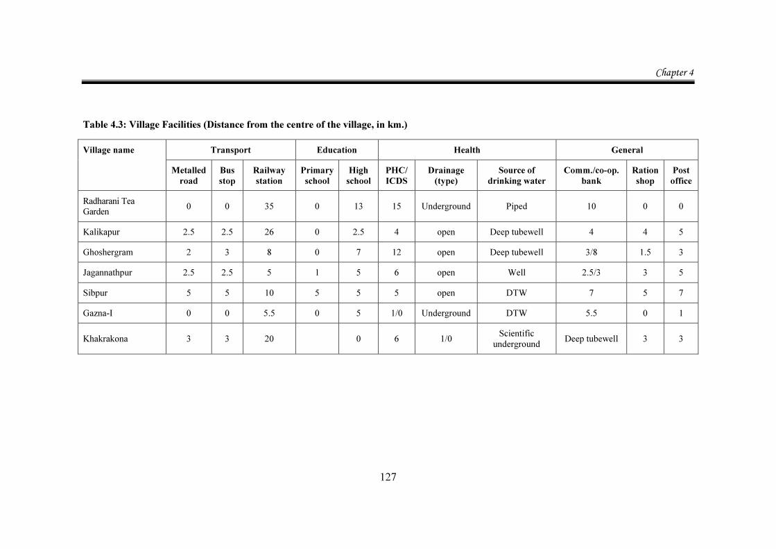
Table 4.3: Village Facilities (Distance from the centre of the village, in km.)
Village name
Transport Education Health General Metalled road
Bus stop
Railway station
Primary school
High school
PHC/ ICDS
Drainage (type)
Source of drinking water
Comm./co-op. bank
Ration shop
Post office
Radharani Tea Garden 0 0 35 0 13 15 Underground Piped 10 0 0
Kalikapur 2.5 2.5 26 0 2.5 4 open Deep tubewell 4 4 5 Ghoshergram 2 3 8 0 7 12 open Deep tubewell 3/8 1.5 3 Jagannathpur 2.5 2.5 5 1 5 6 open Well 2.5/3 3 5 Sibpur 5 5 10 5 5 5 open DTW 7 5 7 Gazna-I 0 0 5.5 0 5 1/0 Underground DTW 5.5 0 1
Khakrakona 3 3 20 0 6 1/0 Scientific underground Deep tubewell 3 3
Chapter 4
128
Additional information on facilities specific to the villages is furnished in the following discussion on facilities by village.
Radharani Tea Garden is a picture of isolation. The nearest town, Alipur Duar, is 35 km. away from the village. The distance from the Block office, Kalchini is 13 km. Connectivity is poor – there was bus services to and from Kalchini costing Rs.16 (return fare) and trekker services which are very crowded, cost Rs.14(return fare). For local people this was unaffordable. It may be the most important factor, explaining huge dropout rate after Class V. Taxi service was available from Kalchini and each round trip cost Rs.350-40021.
The village is connected to the nearest Town by tar road but the condition is very poor with big craters and all rides are bumpy. This factor must be taken into account when one tries to find the reason for a large number of births taking place at homes.
Because of the Tea Garden in the periphery, the non workers in the Garden could avail of low voltage electricity, piped water and some facilities of health from the Primary Health Center as well as facilities of an in-village ration shop.
There are some make-shift shops, selling bare necessities but no full-fledged market. The distance from any market is 4 kms which has to be negotiated on foot or for some on a bicycle.
The village only has a Primary School. Telephone facility is available within village but connectivity by mobile network is almost impossible due to poor network signals.
All Banks including Co-op Banks are at least 10 km. away.
There is no accommodation for visitors other than the Tea Garden Guest House in the village which was fortunately offered for the survey, saving the team the toils of commuting every day.22
21 All prices are at 2005 level. 22 Two SHG leaders, Chandramaya Sarkey and Maya Chhetri helped to get the Gram Sansad register,
containing list of all household in the village. With exact location in “Lines,” it made sampling an easy task and actual visit to selected household was simpler.
Chapter 4
129
Kalikapur has a metalled road (made under the auspices of the Prime Ministers’ road project during the NDA government rule) and has an all weather road winding through the village, made by the villagers, with GP funds (2.5 km).
It has access to a Library, (Tarashankar Pathagar) at a distance of 2.5 km. There is no commercial banking facility even up to 5 km. Within village, there is a primary school and a Balwadi. Every week there are 2 Haat (market) days, Monday and Friday.
There are 2 deep tube wells (located in front of the Primary school and Thakurtala) owned by the Panchayat and a Common well for drinking water. Most people have to carry water for some distance but not long distances. There are 3 more private wells which can be accessed in summer.
There are primitive sanitary facilities. Defecation in the open is Common .There is no organized drainage.
The village is electrified but only few houses can afford to take connection. There is power theft by households where students in the higher classes study till late night. Also power quality is poor, mostly low voltage.
Ghoshergram is a very backward village in terms of facilities. There are no all weather roads in the village. There is only a primary school and a Balwadi within the village. With the Primary health centre at a distance of 12 km, there is no registered medical practitioner or family welfare centre nearby i.e. within 10 km. There is no ration shop in the village. People have to walk at least 1.5 km. The village has no market. There is no weekly or fortnightly market also. They access a market 2 km away for all purchases. There is a library at a distance of 2 km which hardly any one accesses. There is no electricity in the village. There is open and improper drainage.
Drinking water is available from 5 Tube wells, all dug and maintained by the GP and hence have Common use. They are not very deep, only 120- 125 ft. Many times they do not work due to over use and then a long period of stress ensues, as no alternative sources of water are there. In fact only since 2002, number of tube wells have increased. In 1991 Census, the village reportedly had only 1 tube well for 6 hamlets. So carrying water was a significant household chore. Now the water source is nearer.
Chapter 4
130
Other than ponds, there is no provision for water for bath, other household requirements, washing cattle or irrigation. There is no equipment other than a manual hose called Duni, which is used to water the fields.
Jagannathpur, the most backward village is very low on facilities. Within the village there are roads made of gravel, called Moram Rasta. The tarred road, bus stop and public telephone, bank (PNB) are all 2.5 km away at a place called Mandalkupi. The terrain is uneven and these facilities are intercepted by a mainline Railway track of South Eastern Railway on an elevation which has no over bridge or even a manned crossing. This causes inordinate delays and uncertainties for all activities. The ration shop is 3 km away.
There is no electricity in the village although there is a generator .This is because there is not enough number of subscribers (At the time of the survey the number required was 16).
There are open drains and no scientific drainage. Very few people have toilets at home or even nearby which they can access. So defecation in the open is quite the acceptable behaviour.
There are only two wells in the village for drinking water. In the past, there was a tube well drilled by the GP which fell in disuse. In 2006, an effort was made to dig a deep tube well of about 250 ft. depth which has not been done due to foul taste in water at that level. There is reportedly bad taste even in the well water. There is high level of iron in the drinking water here. For all other purposes, the residents use pond water or water from the well.
Village Sibpur has no all-weather road up to 5km.
The nearest railway station is Birnagar, on the local Krishnanagar line from Sealdah in Kolkata. From there, the metalled road reaches one to the peripheries of Usha Gram.
This distance is 5 km from Birnagar station to the metalled road. So the Railway station is 10 km from the village.
Chapter 4
131
Thereafter, the village Sibpur is to be reached by kuccha roads made by the Trust and periodically maintained by it. Other than bicycles, there are only rickshaw cart vans for transport. This is a flood prone area and transport in rainy season is difficult. Most distance is covered on foot.
The village has an Integrated Child Development Scheme (ICDS) operating but there is no Primary Health Center (PHC) in the village.
The village has a Balwadi with 2 teachers and is managed by the youth club called Miloni Sangha. The youth club also houses a library with rotation system of 3 months, arranged with mobile units.
Village Gazna-I is by far the best equipped village in terms of village facilities. It has the tar road and other feeder roads within village. Other than the tarred road, no other road is all-weather since this village is highly flood prone in rains.
Primary School is within the village run by the NGO, Kisholoy Torun Tirtha. Although the school is built with tin roof and make- shift walls, education is imparted with modern curricula. There is one computer in the NGO office which is used for audio visual mode of teaching children.
A college is at a distance of 5 km. With public transport available within the village, literacy situation is good here.
Although the school has a small collection of books, a proper public library is at a distance of 6 km. from the village.
The Primary Health Centre is 1 km. away. But there are private medical practitioners-both allopath and homoeopaths. A curious observation here is that many good and competent doctors practice medicine alongside a chemist shop as they do not possess license to practice in India. The ease of coming into India from Bangladesh has thrown up this problem in a serious way.
There is a full-fledged market within the village. Also two days a week there is a local flea market within the village. There is electricity in the village. There is scientific drainage. There are no open drains.

Chapter 4
132
The last village, Khakrakona is very poor in terms of many village facilities. All roads, main and feeder are kuccha. Metalled road as well as a brick road is 3 km away from the village. There is one main mud road through the length of the village. The periphery of the village is 5 km. This road winds through all houses, water boundaries and around the village. The road is so narrow that even a normal bullock cart cannot go over it. The only way one moves, is on foot.
The Railway station Diamond Harbour is 20 km away, so is a college and a cinema hall or a video parlour. The Bus Stop (at Sankhua pool), The Post Office, Telephone facility, Commercial Bank are all 3 km away.
There is Balwadi and also ICDS in the village. There is a good Primary School within the village. The Secondary school is 3 km away and most children access it on foot. The Higher Secondary School however is at a distance of 6 km. Yet many students aspire to finish at least Class 10.
There is no electricity in the village. However, the village has no open drain and 98% of households have scientific drainage.
The village has no market, not even a weekly market. The distance from market is 1 km and that from the Ration shop is 3 km.
There are a number of water bodies here. There is an irrigation canal flowing by the side of the village, with the help of which summer crop is irrigated. 4.2. Learning from the Village Survey 4.2.1. Identifying CPRs in the Villages The villages, when surveyed on foot, revealed great disparity in basic socio economic as well as ecological details, much more than was apparent from the village profiles provided by the West Bengal Census 2001 and of GPs for non revenue villages. It is interesting to note that land details have different nomenclature in each district surveyed. So delineation of CPRs from Record of Rights (ROR) was not uniform as different kinds of CPRs were there and also they were designated differently, following that particular District’s nomenclature.
Chapter 4
133
Each village’s CPRs was calculated from the land use pattern in the ROR of the village. For revenue villages this was part of a Compact Disc (BHUMI), available at the Block in which the village is situated. For non revenue villages, it had to be extracted from the mouja map (the mouja which includes the village) kept with the GP.
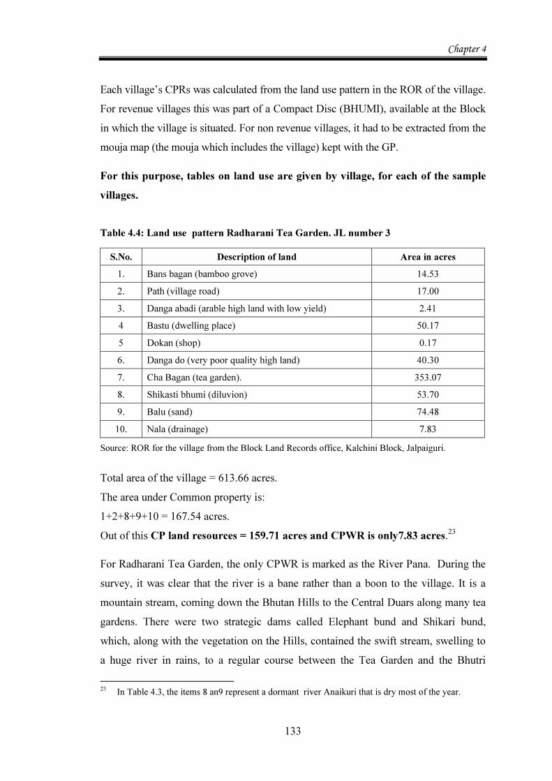
For this purpose, tables on land use are given by village, for each of the sample villages. Table 4.4: Land use pattern Radharani Tea Garden. JL number 3
S.No. Description of land Area in acres 1. Bans bagan (bamboo grove) 14.53 2. Path (village road) 17.00 3. Danga abadi (arable high land with low yield) 2.41 4 Bastu (dwelling place) 50.17 5 Dokan (shop) 0.17 6. Danga do (very poor quality high land) 40.30 7. Cha Bagan (tea garden). 353.07 8. Shikasti bhumi (diluvion) 53.70 9. Balu (sand) 74.48 10. Nala (drainage) 7.83
Source: ROR for the village from the Block Land Records office, Kalchini Block, Jalpaiguri. Total area of the village = 613.66 acres. The area under Common property is: 1+2+8+9+10 = 167.54 acres. Out of this CP land resources = 159.71 acres and CPWR is only7.83 acres.23
For Radharani Tea Garden, the only CPWR is marked as the River Pana. During the survey, it was clear that the river is a bane rather than a boon to the village. It is a mountain stream, coming down the Bhutan Hills to the Central Duars along many tea gardens. There were two strategic dams called Elephant bund and Shikari bund, which, along with the vegetation on the Hills, contained the swift stream, swelling to a huge river in rains, to a regular course between the Tea Garden and the Bhutri 23 In Table 4.3, the items 8 an9 represent a dormant river Anaikuri that is dry most of the year.
Chapter 4
134
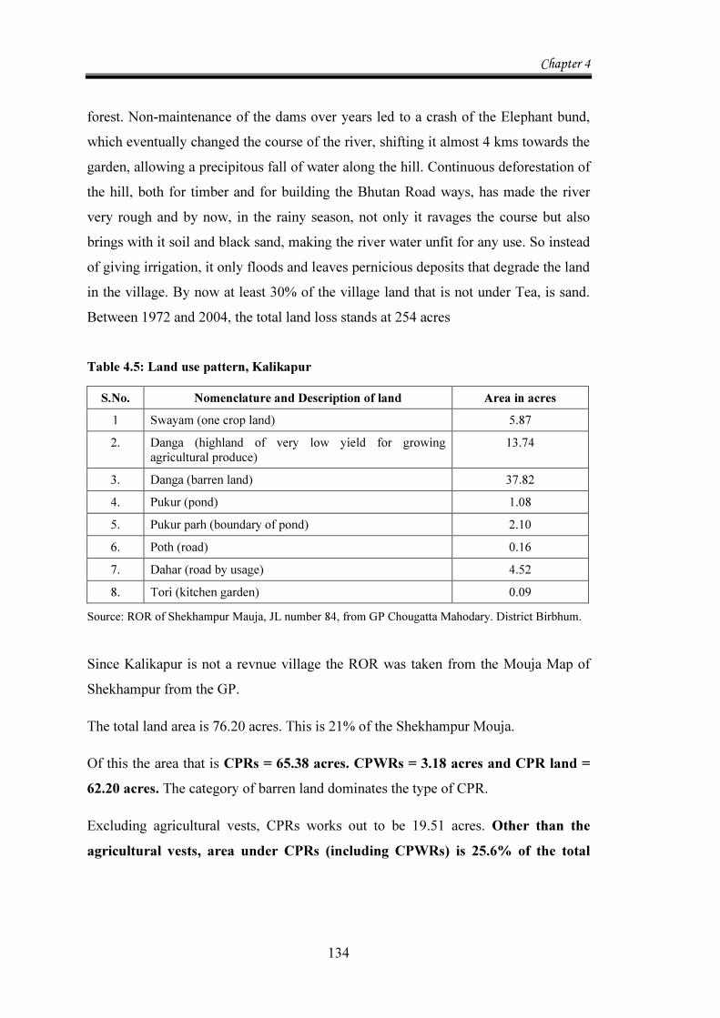
forest. Non-maintenance of the dams over years led to a crash of the Elephant bund, which eventually changed the course of the river, shifting it almost 4 kms towards the garden, allowing a precipitous fall of water along the hill. Continuous deforestation of the hill, both for timber and for building the Bhutan Road ways, has made the river very rough and by now, in the rainy season, not only it ravages the course but also brings with it soil and black sand, making the river water unfit for any use. So instead of giving irrigation, it only floods and leaves pernicious deposits that degrade the land in the village. By now at least 30% of the village land that is not under Tea, is sand. Between 1972 and 2004, the total land loss stands at 254 acres Table 4.5: Land use pattern, Kalikapur
S.No. Nomenclature and Description of land Area in acres 1 Swayam (one crop land) 5.87 2. Danga (highland of very low yield for growing
agricultural produce) 13.74
3. Danga (barren land) 37.82 4. Pukur (pond) 1.08 5. Pukur parh (boundary of pond) 2.10 6. Poth (road) 0.16 7. Dahar (road by usage) 4.52 8. Tori (kitchen garden) 0.09
Source: ROR of Shekhampur Mauja, JL number 84, from GP Chougatta Mahodary. District Birbhum. Since Kalikapur is not a revnue village the ROR was taken from the Mouja Map of Shekhampur from the GP.
The total land area is 76.20 acres. This is 21% of the Shekhampur Mouja.
Of this the area that is CPRs = 65.38 acres. CPWRs = 3.18 acres and CPR land = 62.20 acres. The category of barren land dominates the type of CPR.
Excluding agricultural vests, CPRs works out to be 19.51 acres. Other than the agricultural vests, area under CPRs (including CPWRs) is 25.6% of the total
Chapter 4
135
geographical area.24 But taking the vested agricultural land this percentage is extremely high, at 85.8%
Within the village there are 6 water bodies, 3 of which run totally dry in summer months. The village takes drinking water from under the sand of Kopai in those times.
At present, there is almost no Common land area left other than the roadside, pond boundaries and Tribal social and religious meeting places. The wood lots, created by the zamindar were later taken over by the Forest Department. Much of the Common land was converted to rice fields or residential land. Table 4.6: Land use pattern Ghoshergram, JL number 136 S.No. Nomenclature and description of land Area in acres 1. Sali (the best type of paddy lands growing Aman Paddy) 0.12 2. Sole 149.45 3. Kanali (inferior to Shali, It is a low lying paddy land growing
Aman Paddy) 94.28
4. Suna (higher land than Kanali or Shali, growing Aus paddy and Rabi crops as Jute)
7.75
5. Baid 320.51 6. Taura (uplands, generally growing Rabi crops) 142.59 7. Bagan (orchard) 0.55 8. Pukur (Tank primarily used for irrigation purposes) 40.25 9. Doba (smaller version of Pukur) 4.10 10. Bandh (storage of water, with embankment across the slope, used
for irrigation) 1.99
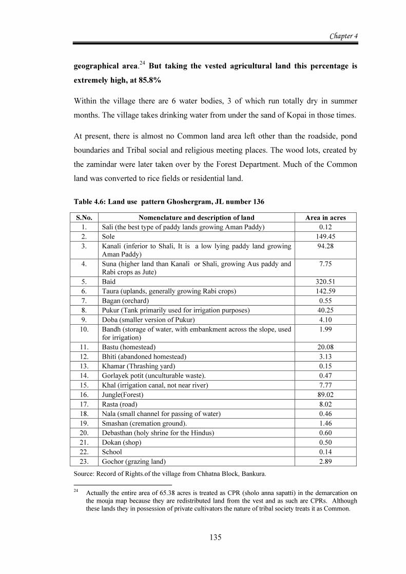
11. Bastu (homestead) 20.08 12. Bhiti (abandoned homestead) 3.13 13. Khamar (Thrashing yard) 0.15 14. Gorlayek potit (unculturable waste). 0.47 15. Khal (irrigation canal, not near river) 7.77 16. Jungle(Forest) 89.02 17. Rasta (road) 8.02 18. Nala (small channel for passing of water) 0.46 19. Smashan (cremation ground). 1.46 20. Debasthan (holy shrine for the Hindus) 0.60 21. Dokan (shop) 0.50 22. School 0.14 23. Gochor (grazing land) 2.89
Source: Record of Rights.of the village from Chhatna Block, Bankura. 24 Actually the entire area of 65.38 acres is treated as CPR (sholo anna sapatti) in the demarcation on
the mouja map because they are redistributed land from the vest and as such are CPRs. Although these lands they in possession of private cultivators the nature of tribal society treats it as Common.
Chapter 4
136
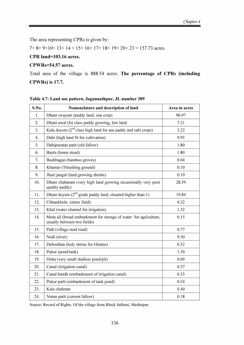
The area representing CPRs is given by: 7+ 8+ 9+10+ 13+ 14 + 15+ 16+ 17+ 18+ 19+ 20+ 23 = 157.73 acres. CPR land=103.16 acres. CPWRs=54.57 acres. Total area of the village is 888.54 acres. The percentage of CPRs (including CPWRs) is 17.7. Table 4.7: Land use pattern, Jagannathpur, JL number 389
S.No. Nomenclature and description of land Area in acres 1. Dhani swayam (paddy land, one crop) 96.97 2. Dhani awal (Ist class paddy growing, low land 7.21 3. Kala doyem (2nd class high land for aus paddy and rabi crops) 3.22 4. Dahi (high land fit for cultivation) 9.95 5. Dahipuratan patit (old fallow) 1.80 6. Bastu (home stead) 1.80 7. Bashbagan (bamboo groves) 0.04 8. Khamar (Thrashing ground) 0.10 9. Jhuri jangal (land growing shrubs) 0.19 10. Dhani chaharam (very high land growing occasionally very poor
quality paddy) 28.59
11. Dhani doyem (2nd grade paddy land, situated higher than-1) 19.84 12. Chhankhola (straw field) 0.32 13. Khal (water channel for irrigation) 1.32 14. Mota ail (broad embankment for storage of water for agriculture,
usually between two fields) 0.15
15. Path (village mud road) 0.77 16. Nodi (river) 9.50 17. Debosthan (holy shrine for Hindus) 0.32 18. Pukur (pond/tank) 1.30 19. Doba (very small shallow pond/pit) 0.09 20. Canal (irrigation canal) 0.37 21. Canal bandh (embankment of irrigation canal) 0.33 22. Pukur parh (embankment of tank pond) 0.54 23. Kala chahram 0.40 24. Nutan patit (current fallow) 0.18
Source: Record of Rights. Of the village from Block Salboni, Medinipur.
Chapter 4
137
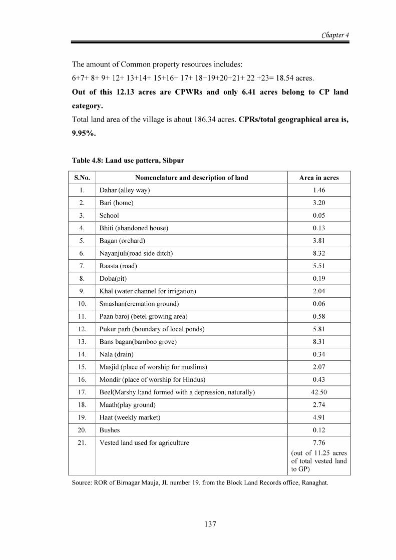
The amount of Common property resources includes: 6+7+ 8+ 9+ 12+ 13+14+ 15+16+ 17+ 18+19+20+21+ 22 +23= 18.54 acres. Out of this 12.13 acres are CPWRs and only 6.41 acres belong to CP land category. Total land area of the village is about 186.34 acres. CPRs/total geographical area is, 9.95%. Table 4.8: Land use pattern, Sibpur
S.No. Nomenclature and description of land Area in acres 1. Dahar (alley way) 1.46 2. Bari (home) 3.20 3. School 0.05 4. Bhiti (abandoned house) 0.13 5. Bagan (orchard) 3.81 6. Nayanjuli(road side ditch) 8.32 7. Raasta (road) 5.51 8. Doba(pit) 0.19 9. Khal (water channel for irrigation) 2.04 10. Smashan(cremation ground) 0.06 11. Paan baroj (betel growing area) 0.58 12. Pukur parh (boundary of local ponds) 5.81 13. Bans bagan(bamboo grove) 8.31 14. Nala (drain) 0.34 15. Masjid (place of worship for muslims) 2.07 16. Mondir (place of worship for Hindus) 0.43 17. Beel(Marshy l;and formed with a depression, naturally) 42.50 18. Maath(play ground) 2.74 19. Haat (weekly market) 4.91 20. Bushes 0.12 21. Vested land used for agriculture 7.76
(out of 11.25 acres of total vested land to GP)
Source: ROR of Birnagar Mauja, JL number 19. from the Block Land Records office, Ranaghat.
Chapter 4
138
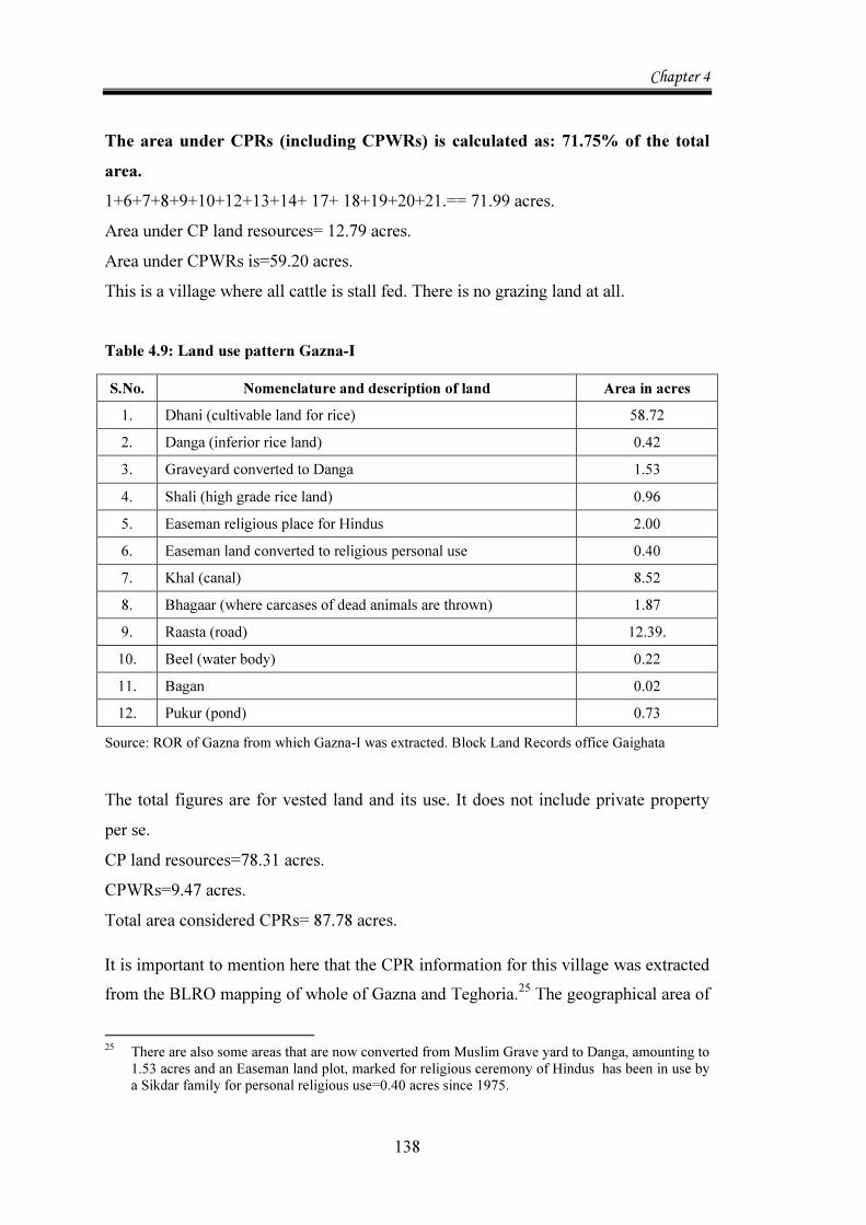
The area under CPRs (including CPWRs) is calculated as: 71.75% of the total area. 1+6+7+8+9+10+12+13+14+ 17+ 18+19+20+21.== 71.99 acres. Area under CP land resources= 12.79 acres. Area under CPWRs is=59.20 acres. This is a village where all cattle is stall fed. There is no grazing land at all. Table 4.9: Land use pattern Gazna-I
S.No. Nomenclature and description of land Area in acres 1. Dhani (cultivable land for rice) 58.72 2. Danga (inferior rice land) 0.42 3. Graveyard converted to Danga 1.53 4. Shali (high grade rice land) 0.96 5. Easeman religious place for Hindus 2.00 6. Easeman land converted to religious personal use 0.40 7. Khal (canal) 8.52 8. Bhagaar (where carcases of dead animals are thrown) 1.87 9. Raasta (road) 12.39. 10. Beel (water body) 0.22 11. Bagan 0.02 12. Pukur (pond) 0.73
Source: ROR of Gazna from which Gazna-I was extracted. Block Land Records office Gaighata The total figures are for vested land and its use. It does not include private property per se. CP land resources=78.31 acres. CPWRs=9.47 acres. Total area considered CPRs= 87.78 acres.
It is important to mention here that the CPR information for this village was extracted from the BLRO mapping of whole of Gazna and Teghoria.25 The geographical area of 25 There are also some areas that are now converted from Muslim Grave yard to Danga, amounting to
1.53 acres and an Easeman land plot, marked for religious ceremony of Hindus has been in use by a Sikdar family for personal religious use=0.40 acres since 1975.
Chapter 4
139
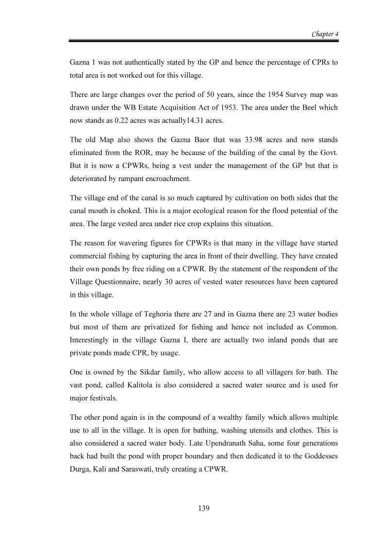
Gazna 1 was not authentically stated by the GP and hence the percentage of CPRs to total area is not worked out for this village.
There are large changes over the period of 50 years, since the 1954 Survey map was drawn under the WB Estate Acquisition Act of 1953. The area under the Beel which now stands as 0.22 acres was actually14.31 acres.
The old Map also shows the Gazna Baor that was 33.98 acres and now stands eliminated from the ROR, may be because of the building of the canal by the Govt. But it is now a CPWRs, being a vest under the management of the GP but that is deteriorated by rampant encroachment.
The village end of the canal is so much captured by cultivation on both sides that the canal mouth is choked. This is a major ecological reason for the flood potential of the area. The large vested area under rice crop explains this situation.
The reason for wavering figures for CPWRs is that many in the village have started commercial fishing by capturing the area in front of their dwelling. They have created their own ponds by free riding on a CPWR. By the statement of the respondent of the Village Questionnaire, nearly 30 acres of vested water resources have been captured in this village.
In the whole village of Teghoria there are 27 and in Gazna there are 23 water bodies but most of them are privatized for fishing and hence not included as Common. Interestingly in the village Gazna I, there are actually two inland ponds that are private ponds made CPR, by usage.
One is owned by the Sikdar family, who allow access to all villagers for bath. The vast pond, called Kalitola is also considered a sacred water source and is used for major festivals.
The other pond again is in the compound of a wealthy family which allows multiple use to all in the village. It is open for bathing, washing utensils and clothes. This is also considered a sacred water body. Late Upendranath Saha, some four generations back had built the pond with proper boundary and then dedicated it to the Goddesses Durga, Kali and Saraswati, truly creating a CPWR.
Chapter 4
140
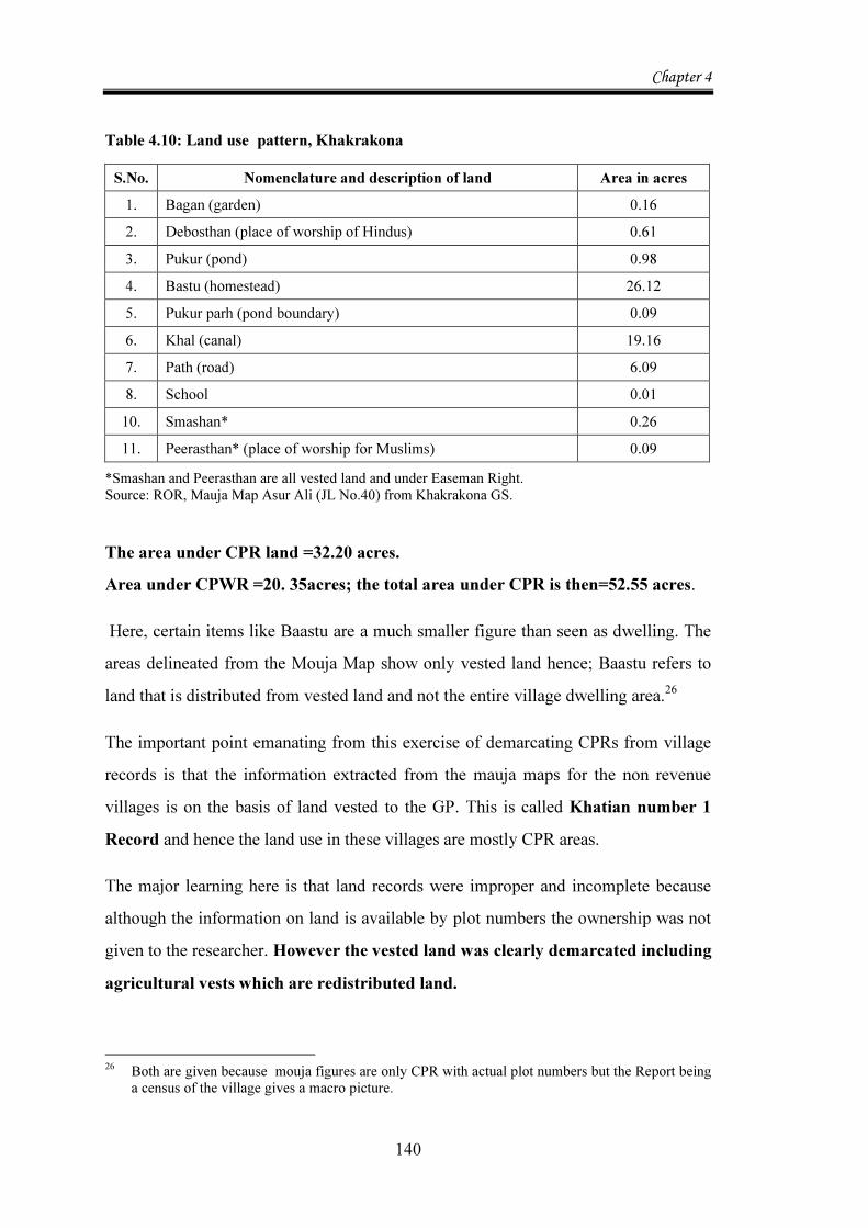
Table 4.10: Land use pattern, Khakrakona
S.No. Nomenclature and description of land Area in acres 1. Bagan (garden) 0.16 2. Debosthan (place of worship of Hindus) 0.61 3. Pukur (pond) 0.98 4. Bastu (homestead) 26.12 5. Pukur parh (pond boundary) 0.09 6. Khal (canal) 19.16 7. Path (road) 6.09 8. School 0.01 10. Smashan* 0.26 11. Peerasthan* (place of worship for Muslims) 0.09
*Smashan and Peerasthan are all vested land and under Easeman Right. Source: ROR, Mauja Map Asur Ali (JL No.40) from Khakrakona GS. The area under CPR land =32.20 acres. Area under CPWR =20. 35acres; the total area under CPR is then=52.55 acres.
Here, certain items like Baastu are a much smaller figure than seen as dwelling. The areas delineated from the Mouja Map show only vested land hence; Baastu refers to land that is distributed from vested land and not the entire village dwelling area.26
The important point emanating from this exercise of demarcating CPRs from village records is that the information extracted from the mauja maps for the non revenue villages is on the basis of land vested to the GP. This is called Khatian number 1 Record and hence the land use in these villages are mostly CPR areas.
The major learning here is that land records were improper and incomplete because although the information on land is available by plot numbers the ownership was not given to the researcher. However the vested land was clearly demarcated including agricultural vests which are redistributed land.
26 Both are given because mouja figures are only CPR with actual plot numbers but the Report being
a census of the village gives a macro picture.
Chapter 4
141
The delineation of these areas as CPRs including CPWRs confirms the fact that CPRs in West Bengal is not insignificant as reported by NSS and others in 1990s. 4.2.2. Environmental Problems In Radharani Tea Garden, two kinds of problems were apparent.
One is regarding the ravages of the River Pana which causes both soil erosion during monsoon and also sand deposits on fertile Tea area.
In addition, this village suffers degradation in its main CPR namely the forest. One sees here both the cause and effect of degradation of the forest. Since continuous harvest of the forest by both villages is denuding supplies of food, people are digging deep,upto 6ft and over to get roots and tuber that might have been food for animals like elephants. On the other hand, cutting of trees have also made access to these villages from the forest, easier. Just as the villagers poach into the roots and fruits of the forest, the elephants feast on the small crops of corn and cereal substitutes that the villagers are trying to grow. The result is a vicious circle of degradation of the village ecosystem and the forest eco system. Conflict between man and other species is visibly very real.
Main Ecological problem in Kalikapur faced is that there is no water in 3 of the six ponds by mid-March. There is great hardship.
The water related degradation is compounded by the highly porous soil quality which soaks up all rain water.
The village community was able to create a new pond (called Notun pukur) in 2003-04.27 Their sole motivation was to augment water resources via rain water harvesting, thereby dealing with water crisis with self- help. This is indeed an excellent example of community participation to create a CPWR.
But the pond created by exemplary collective action is going dry because the water of the pond is attracted to the river bed of river Kopai which flows almost 10 feet below
27 90 families in the village worked partially on wages from the Panchayat and mainly on the
principal of Shramdaan and excavated a 3 acre pond. Panchayat paid Rs. 20000/- and a matching cost of Rs.20000/- was contributed by voluntary effort of Shram daan.
Chapter 4
142
the village land level. The pond may need an artificial lining or provision of mixed soil that holds water. Hence, this village is in need of urgent scientific assistance to fend for itself during water stress.
The ecological problem in Ghoshergram is soil erosion and consequent loss of agricultural productivity. The problem is being addressed by the Watershed Project in the village. The other problem is pollution of the single Common pond accessed by most households for unrestricted mixed use.
Village Jagannathpur has the problem of very low yielding aquifers allowing no deep tube well for drinking water. At the same time there is iron contamination in the available well water.
In Sibpur, lack of maintenance of its natural Common wetland has led to open access for fishing and retting of jute. The latter is a major polluting factor. There are also people who have access to the fertile land at the banks and produce paddy. Their use of fertilizers also has a negative effect on the water quality of the Beel.
The main problems with the water body are:
(a) Encroachments on the boundaries since the last 25 years. This has reduced its area from 0.5017 to 0.2665 sq. km.
(b) Poor ecological condition is shown by siltation and loss of depth. Silt formation is continuous and neglected on the mouth of river Churni. Average depth is only 2 to 3 ft. now which was 5 to 6 ft. only a decade before. One can actually look at this ecological change as a significant factor, along with poor silt removal from the two rivers, explaining yearly flood in this region.
(c) Pollution level is high. The Beel has been placed in D class of water quality according to IS 2296 norms in 2006.
(d) Water hyacinth is another good indicator of pollution in this water body.
Gazna-I, has recurring floods that cause great loss of agricultural produce in this very fertile land. It hinders educational activities specially in this village for serious
Chapter 4
143
students aspiring for graduation, technical studies etc. There is no provision for disaster management at all. People sit at roof tops during floods.
The main problem faced by the village is arsenic in ground water. Since there is no piped water in the village and people depend on deep tube well water, this pollution is very critical to health well being. The villagers are in the know of two arsenic related diseases namely respiratory ailment and arsenichosis , spreading on the skin. Since the last 9 years the village is trying to work towards safe water practices.
Village Khakrakona has the main ecological problem of salinity in ground water above 850 feet.
Other than this main problem, it is facing degradation in the agro eco system, particularly the loss of bio diversity through extinction of indigenous paddy varieties.
There is very high preference for HYV against the traditional variety, mainly because:
HYV yields are higher i.e. even if costs are higher, higher productivity per Bigha justifies their choice.
Staple food is rice and its sufficiency is the main criterion. Increase in population per family and resultant decline in land per head necessitates intensive use of land. So even with loans, they prefer HYV.
Vegetative growth of indigenous plant is more but resistance to storm is less which leads to flowers falling off, thus reducing total yield. Indigenous varieties also have longer gestation periods.
Whatever is the explanation, the truth is, there is extinction of indigenous strains of paddy. Even 10 to 15 years back, the village had 49 varieties. Now only 17 varieties are produced.
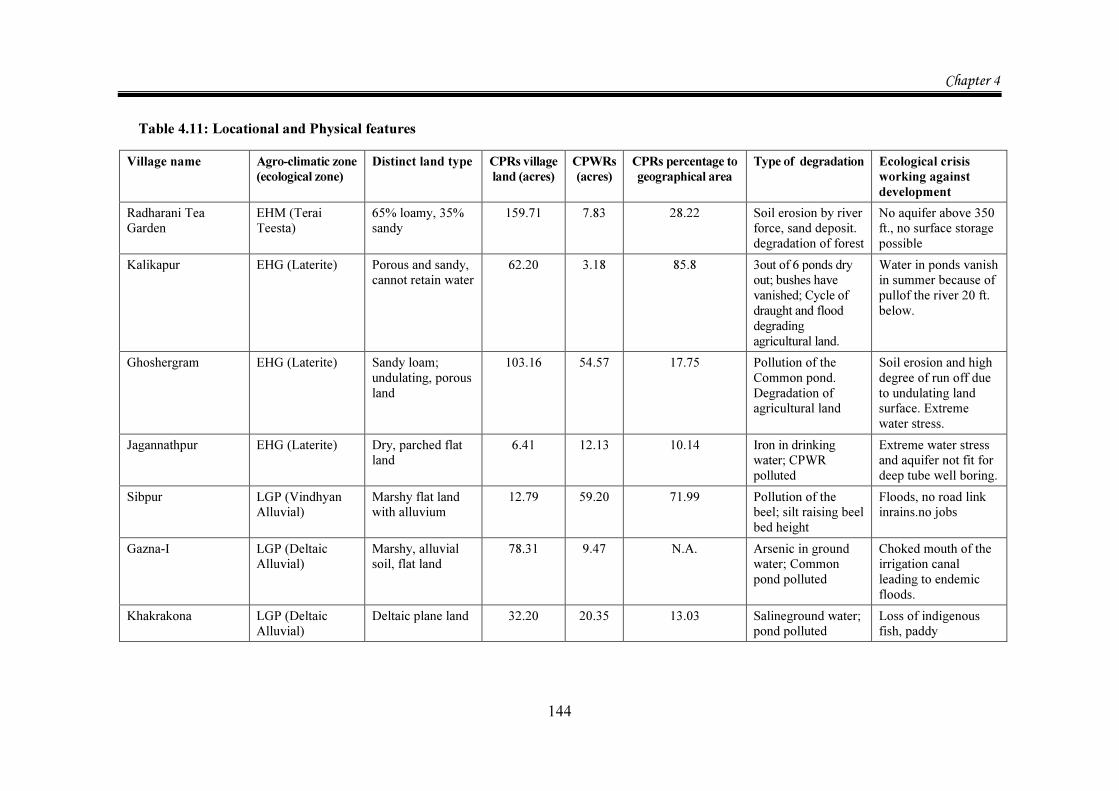
An overview of the villages is rewarding providing insights into the kind of life in the sample villages.
Table 4.11 is a composite picture of all the 7 sample villages described above in terms of their locational and ecological features.
Chapter 4
144
Table 4.11: Locational and Physical features Village name Agro-climatic zone
(ecological zone) Distinct land type CPRs village
land (acres) CPWRs (acres)
CPRs percentage to geographical area
Type of degradation Ecological crisis working against development
Radharani Tea Garden
EHM (Terai Teesta)
65% loamy, 35% sandy
159.71 7.83
28.22 Soil erosion by river force, sand deposit. degradation of forest
No aquifer above 350 ft., no surface storage possible
Kalikapur EHG (Laterite) Porous and sandy, cannot retain water
62.20 3.18 85.8 3out of 6 ponds dry out; bushes have vanished; Cycle of draught and flood degrading agricultural land.
Water in ponds vanish in summer because of pullof the river 20 ft. below.
Ghoshergram EHG (Laterite)
Sandy loam; undulating, porous land
103.16 54.57 17.75 Pollution of the Common pond. Degradation of agricultural land
Soil erosion and high degree of run off due to undulating land surface. Extreme water stress.
Jagannathpur EHG (Laterite) Dry, parched flat land
6.41 12.13 10.14 Iron in drinking water; CPWR polluted
Extreme water stress and aquifer not fit for deep tube well boring.
Sibpur LGP (Vindhyan Alluvial)
Marshy flat land with alluvium
12.79 59.20 71.99 Pollution of the beel; silt raising beel bed height
Floods, no road link inrains.no jobs
Gazna-I LGP (Deltaic Alluvial)
Marshy, alluvial soil, flat land
78.31 9.47 N.A. Arsenic in ground water; Common pond polluted
Choked mouth of the irrigation canal leading to endemic floods.
Khakrakona LGP (Deltaic Alluvial)
Deltaic plane land 32.20 20.35 13.03 Salineground water; pond polluted
Loss of indigenous fish, paddy
Chapter 4
145
This composite table reveals the existence of great diversity among the selected villages. The point of interest here is that all villages have development blockage caused by water related degradation. In many ways Radharani Tea Garden is an outlier in the experience as it has degradation also of the peripheral forest area. 4.2.3. Socio Economic Details A broad view of the study area was also available by looking at the social features and activities including occupation, migration, initiatives of local NGOs, festivals and an overview of collections from Commons from impressions gathered by the survey. Social Features and Activities The inhabitants of Radharani Tea Garden are a motley crowd of different cultures, as all of them are descendents of tea garden workers who came to work from different parts of Eastern India. The main group is Nepali speaking and majority of others are adivasis from Bihar and Jharkhand. A major section of Adivasis are Christians. A minority is of Bengali origin. There is a lot of tolerance and good will among the people about each other’s cultural difference. People are hardy and work against all challenges. They generally cover 8 to 10 kms. on foot, to procure their daily requirements either from the nearest market or from the forest.
Good relations between the management and workers of the Tea Garden are responsible for unifying the whole village under Gram Panchayat.28 Poor in this village are among the non- workers, who arrange for home, food, water etc., mostly free riding on working members of the family. Many take on menial jobs in houses of salaried employees of the Tea garden; helping out in shops and the one eating house in the bazaar or at best get casual employment with the bus and trekker services.
There is an employment generation drive from 2004 which is collection of stones from the riverbed and crushing. This was supposed to aid the construction industry in 28 With a memorandum of understanding between the Pradhan of Chuapada Gram Panchayat, Shri
Ramkumar Lama of Jalpaiguri Zilla Parishad and the Senior Executive of RTG, in 2002, the Radharani Gram Sansad was formed and with it, started 6 SHGs. with the initial responsibility of starting a savings program and creating a Gram Register, incorporating baseline information necessary for planning.
Chapter 4
146
the area. However, it is not free from the ecological problem of not being able to contain floodwaters in the monsoon. Also, since the crushing unit is not located in the village, employment generation has been moderate so far and no skill formation has resulted.29 With very limited options for livelihood, most of the poor take to collections from the nearby forest as their chief occupation.
Village Kalikapur is very poor as is clear from the observation that other than the Panchayat school building, there is only one pucca house of an old settler. All others are mud houses. There are 68 households registered as Below Poverty Line (BPL) but there are many others which deserve to be. On an average day, nearly 45% of all able bodied people went out of the village. It was odd, that the village was populated by children and old people only, between 9am and 5pm. All households interviews therefore had to be in the evening. 30
The traditional variety of paddy production involved a full 7 month period from mid-June to mid January. But HYV (swarna) variety is fast yielding and has a crop period lasting full 5 months- from mid- June to mid-November. With no provision for irrigation, all local farming is in single crop mode. As a result, during the months of November-January, and again March – April, nearly 75% of agricultural labour migrate to Mayurakshi riverside (nearly 11 km. away) for Rabi and summer cultivation. There also, demand for labour is of shorter duration due to HYV paddy.
Everyone in the village pointed out that availability of water is crucial for their survival.
The interaction with old respondents revealed the perception of villagers that amounts of collection of edible things from local shrubs and other Commons is dwindling. In the last 25 years, the village has lost its own little forest cover that was rich with varied items of collection –like honey, black berries, passion fruit, different types of Ber and custard apple. There were vegetables like kakrol and other wild varieties of
29 Both these ideas were shared by the researcher with the Panchayat representative of the Gram
Sansad. 30 This had the disadvantage that after dusk, one could not actually see the trees and other vegetation
on homestead land. This problem was overcome, by choosing houses with home garden, for survey during daytime.
Chapter 4
147
potato that could substitute staples. But these are now lost to the villagers. There was traditional use of the Margosa fruit for medicinal oils and honey extraction. Hence, what is also lost, is a knowledge base for traditional medicine
The village is special in various respects of societal behaviour.
All inhabitants are adivasis who are followers of their spiritual head, Maran buru, an abstract holy mountain concept. Nobody has seen him but everyone believes in his power. The people here, truly are, worshippers of nature’s powers.
There is one sacred tree with a prayer platform, called Majhi Harham. Their main festival is called Badna (in mid January). Others are Jaher erha and Gosain erha. There is a community feast of Khichri (lentil and rice gruel) in bowls made of palm leaf on the first day of Badna. The festival starts from the sacred tree base and is celebrated in a Common land area reserved for such congregation. All households in the village participate. The festival lasts for 4 days. People drink their traditional drink Haandia and have fish, chicken and pork forgetting their daily fare of over cooked rice or gruel.
Haandia is a preferred drink to liquor vended in taverns. The women have a separate oven for making it. Rice is cooked in an earthen pot till the bottom layer burns. Herbs and medicinal roots are then ground and mixed well and the pot is buried underground for10-15 days. The fermented brew is strained through clean cloth and the drink stored in small earthen pitchers. It was strange to hear that this cooling alcoholic drink is taken for its nutritive value and also because it is filling and reduces hunger pangs.
Their societal norms of co-operation in all communal matter is monitored by their tribal Headman (the Morol or Chowkidar). Use of all Common water resources (6 ponds) is graded.
Jamda pukur is only meant for collection of cooking water, washing vegetable and rice, dal and utensils and bath.
Koiragori (alongside banana grove) is used for fishing, bath and sanitary use.
Gugru pukur is used for washing of livestock and retting of jute. It is also full of fish of the wild variety.
Chapter 4
148
Hishab bandh is used only for rearing fish. The fish pawns are introduced in May-June. Here fishing using net is not allowed.
Harangadi has water only in the rainy season, later there is too much pebble and gravel for it to be used.
Dai jom is only used for bathing.
All the 6 ponds in the village are CPWRs (called Sholo anna Shompotti) ie. all have equal stakes in use and conservation. All members of the community are allowed to collect minor pond resources like small fish, shells, snails, oyster and greens. There is a committee of the gram sansad members who monitor the big fish production and use in the pond. Twice a year, they catch all big fish and distribute the catch equally among all households. Usually it precedes the festivals two times a year.
Although very poor, the community shies away from borrowing. Collection from Commons and a frugal lifestyle is the norm.
Many households take allopathic medicines but for specific ailments, tribal medicine is taken. Snake bites and all cases of fits, (understood by them as possession of evil spirits) are treated by the Ojha (indigenous healer).
Ghoshergram is a politically homogenous village, being a stronghold of a single party, CPM. Hence there is no indication of tension and conflict.
There is amity among the villagers and every one participates in the three major festivals of Manasa(snake goddess) Puja, Saraswati (Goddess of Learning) Puja and and Anukul Thakur Utsav. The Common land area of the play ground is used for these. For immersion of idols, the Common Pond, Kulur Bandh is used.
The Tribal population celebrates their traditional festival of THUSU, celebrated in January end. There is a fair complete with a Giant wheel. There is much enthusiastic participation by all communities and the village Common land is used.
An important fact to notice is this village has no SHG formed from among the people but through the effort of the Development Block, groups are being created. These
Chapter 4
149
groups are encouraged to save at least Rs. 30/- pm, after a year’s collection is accumulated, the members can have access to loans up to twice the collected amount, the extra amount being arranged by the Block. But the scheme lacks clarity and as a top down effort, is not popular.
Here also, the Gram Sansad register was up to date and the member, Mrityunjoy Das, knew almost all the villagers personally. Both the GP and the Sansad leaders are young and share the angst of the youth in terms of lack of facilities in the village and avenues of employment. Although the village has a literacy rate among males of more than 75%, almost 85% of workers go to look for work outside the village, almost daily, covering 25% families. Particularly difficult months are Dec to March end when out migration is at the peak.
Jagannathpur, the poorest village in the sample has a Common pond, Kuthir Bandh which is their sacred water source. It provides the cultural service of being used for village festivals like Thusu, Saraswati Puja and worship of the local people’s deity Mother Goddess. The water is used for the ceremony and also immersion of the idol.
There is also a sacred grove which houses the earthen idol and a water pitcher (Ghaut). This celebration is along with the harvest festival called Poush Parban in Mid-January. Village Common land around the grove is used for it. There is wide participation in social activity.
There is no Self Help Group here and none of the economic activities encouraged by the GP are practiced here. Projects like making Saal leaf plates out of collection of leaves from Arabari, husking rice, frying puffed rice, tailoring, rearing goats etc. have not succeeded due to very poor participation.
Sibpur has a homogenous society, primarily of SC category of people. But caste is not a big factor in societal dealings. The main occupation is agriculture with paddy as the main crop. In some parts of the village, there is a summer crop of Paddy (Boro) with Groundwater use. Some farmers cultivate wheat as well as pulses. The main cash crop is jute. However, a new cash crop that yields daily income is flowers. Marigolds and Rajanigandha (a variety of night lilies) are mostly cultivated. Seasonal vegetable
Chapter 4
150
and products of wetland plants also are traded. Sunflower and gingelly are the oilseeds that are grown. Some have started mushroom farming too. .
This village’s economic lifeline is the Railway Station. Most crops of flowers, betel leaves and nuts, bananas, lemon and lotus are sold. The women are extremely enterprising and diligent. But it is sad to know that nearly 100 people go to work outside the village every day and majority of them are women. Factors like low demand for traditional skills, cheap and regular suburban train service and high wages for domestic work in towns, make women choose housework as a primary means to improve lives at home. For very poor families that are nuclear, this has led to neglected children at home, affecting lives negatively in other spheres.
The village’s CPWR, the beel was their sacred water resource. But lately due to pollution in the beel, other than immersion of the idol during Durga puja, there is no other sanctity of the water. People prefer to go to the nearest bank of Ganges to take their holy dips as this water is responsible for skin allergies and other ailments.
All the villagers, however, highly valued the fresh and cool breeze that keeps the summer days very pleasant. There were many families who had fishing as their primary occupation. All this has changed in the last 10 years or so as pollution and loss of depth of the Beel has made fish catch very low.
Village Gazna-I is one of the more advanced societies in the sample. This is the only village in the sample which has a Milk Co-operative.
The primary occupation is agriculture and all cultivators are mainly producers of rice in the Kharif season. Almost all households use hybrid seeds (swarna basuri and sonamukhi). For the second and third crop of paddy, sown in January (winter rice) and April (Boro) and harvested in July-August, Chinese variety of HYV seeds and a variety called Mini Kit are used. Jute is also grown at this time. The more prosperous farmers produce alternate crops like mustard, bananas, pumpkin, radish, cauliflower, gourd, sugarcane etc.
In this village, irrigation potential is plentiful, thanks to an irrigation canal and also rich and easily accessible ground water. But due to encroachment on the canal embankments
Chapter 4
151
and total neglect of desilting of the feeder canals during heavy rains, flooding is fast. There are floods almost every year.31 This makes agriculture uncertain. Ironically, poverty is substantial in this progressive society. Nearly 65 to 70 families, involving close to 100 people go out of the village daily for work. Employment within village is a critical need. This is accentuated by slow infiltration across the border. At the time of the survey, the electoral rolls were being revised with the objective of bringing to light this factor.
Recurring floods other than loss of produce hinder educational activities. Specially in this village, serious students are aspiring for graduation, technical studies etc. In this village, in spite of all hardships faced, there was an Engineer and a Post Graduate teacher. There is no provision for fast reiief for the recurrent floods.
Since this is a very fertile area, many homestead gardens grow a variety of greens, medicinal plants like tulsi and basak and vegetable like gourd, pumpkin and jukinni. There are fruits grown like guava, jackfruit and bananas. Many homes also have mature trees growing commercial items like timber, betel nuts, etc. But loss of trees due to floods, make earnings from sale of the items grown in these trees also uncertain.
The village has a heterogeneous society with a substantial Muslim population. It has amity between social groups and many festive occasions are celebrated here.
This village has a number of festivals: Main religious festivals are Durgapuja and Eid.
Both these are celebrated with joint participation of Hindus and Muslims. The Common ground of the school is used for the purpose. The others are:
Saraswati Puja (worship of Goddess of learning and arts) in which both Hindus and Muslims participate and partake of Prasad together. It is held in Kalitola near the Sikdar pond. Kalipuja (Diwali) Basanti puja (Navaratri of Spring). Charhak puja (Baisakhi). 31 Even in 2004-05, it was not possible to visit the Block office in September but visit to the village
as it was on a metalled road and although one observed the aftermath of excessive rain accentuating the flood situation. Till January 2005, rehabilitation activity was on in this area.
Chapter 4
152
There is a religious fair for the whole village held in a Common land designated for the fair, with a wooden idol of Shiva being worshipped. It signifies the social reverence for people who take Sanyas (renunciation). Except this last one, the other religious meets are organized by the well to do families and are attended by all in the village.
A popular social festival is Poush parban (a harvest festival, celebrating new paddy, coconut and jaggery) which is celebrated by the Sikdar family32 and everyone in the village, both Hindus and Muslims being part of it. The ritual is performed beside the pond. The traditional process of husking paddy and pounding rice for the making of Prasad (sacrament) is adhered to, in which there is participation of women from all social groups. With the proliferation of rice mills, this equipment called dhenki locally, is extinct in most villages. This used to be an employment generating device for poor women in rural West Bengal before.
Khakrakona is a very special village for agricultural production. Paddy is the main crop, of which 10 indigenous and 12 HYV types are grown. During Boro (summer cultivation) only 6 varieties are practiced. There is no plan for irrigation but fields get inundated through overflow of the village canal that is connected to the Ganges.
Boro cultivation also discourages pulses’ sowing area. The main reason for low production of pulses is that dry season pulses do not tolerate flooding. But the canal water in this village inundates plots uniformly. The existing traditional knowledge of the village reveals that, after Aman harvest, on the same land the retained moisture can produce pulses. No irrigation or fertilizer use is required. Some moong and khesari is grown on highlands where no irrigation reaches. During rains, on bunds, urad and arhar are produced. This limited crop rotation is also beneficial in improving productivity.
Since 2000, sunflower is being cultivated.
Vegetable and greens of 29 types are grown, using bunds on fields. Both hybrid and indigenous varieties are there. Many varieties of rustic beans are produced (one 32 This pond is the sacred water source of the village. Although a private water body it has been
allowed Common access to the village especially for holy bath and other rituals.
Chapter 4
153
beetroot-coloured bean is rather unique). The main summer vegetables are jukkini, lady’s finger, snake gourd, bitter gourd etc. The winter vegetables are many types of beans, radish, spinach etc.
A Green manure plant called Dhonche is produced.
There are many herbs grown, useful as home remedies for Common cold (tulsi, basak); for jaundice(maniraj) and kalmegh for any liver dysfunction; diarrhea / dysentery and other intestinal disorders (chinisagar, gandal and thankuni)
Even if there is no road and no electricity and size of holding is small, there is use of “mini tractors” that can be hired. There are also hand operated machines for cleaning paddy and cutting hay.
There is substantial poverty in this village
Daily about 60 people, involving about 15 to 20 families, go out of the village for employment.33
This is a village in which 100% population is Hindu.
Their main religious festivals are: Raksha Kali puja; Seetla puja; Saraswati Puja and Shyama Puja.
An interesting local festival is called Jantal. For this, there is use of a Common sacred ground. There is an equestrian figure that is worshipped. There are Brahmins in the village who received homestead land from the Commons. They give a feast to the whole village for this occasion (usually on 13th /14th January).
For all social occasions there is a lot of amity among neighbours.
A deep insight is earned in studying the institutions of rural life here which fairly states the CPR-PPR interface. Social piety is an important asset here. As a result many co operative economic activities take place and access of the poor to private assets become possible eg.
33 Details of agriculture is from the Bio diversity Register of the village by A. K. Ghosh.
Chapter 4
154
A landless person can sow some pulses in the land considered current fallow by the owner. When the harvest comes both parties share it.
Growing greens in other people’s ponds and collecting when needed is acceptable.
Poor people fish on behalf of the owner and in return get fish when neither the net nor the pond belongs to him. This transaction is over and above the wages they receive.
Curing of degraded ponds leads to free consumption of fish for the poor, hired for the service.
Mutual borrowing of rice, condiments etc. is most common. Actually very poor neighbours receive free share of home grown vegetable and seasonal fruits as well as left-over food from feasts. If they are short of fuel, they barter labour to produce cow dung cakes and get a free share.
It is acceptable to borrow from a neighbour a good dress or shoes for a special occasion.
Marriages and funerals are occasions when very poor villagers receive help in kind from more able households.
Battery operated TV and Video sets are hired by the well to do neighbours and the poorer households free ride the service of entertainment.
A Common practice in live stock rearing called Poshani, is a novel way to get a calf in a poor family. The institution is old and simple. A poor family gets a cow that is expecting, tends to her and after the calves are born, returns the cow and the first born to the owner and retains the younger one. Eventually, if the cow is sold, there is a share to the tender of the cow.34 4.3. Outside Agencies Operating in the Village In Radharani Tea Garden, there is the presence of a wing of LKP, a very active social welfare organization with head office in Calcutta which has sustained the growth, and 34 The social details of piety and sharing was narrated by a local school student Rukmini Haldar
who helped in the Bio diversity Register Project and also helped the researcher with full information about life in this village.
Chapter 4
155
activities of the SHGs in this village. At the time of the survey, there were 12 SHGs in the village, which were all-women groups. They functioned with the objective of nurturing the co operative spirit in all village activities. Their aim was to identify the poorest among poor in the village and try to get those BPL cards and benefits that go with it35.
To be self-sufficient, every member was required to save at least Rs. 20/- a month. Total monthly savings were deposited in Uttar Banga Grameen Bank. The members were eligible to get loans out of this fund at 2% interest for purchase of livestock, opening of shop etc.
Guided by LKP, they started in 2003 to organize Panchayat construction work for all women, when 37 man-days were worked repairing the main drainage of the tea garden.
With the cooperation between LKP, the Tea Garden and the GP, planting shade trees within the garden started that would benefit the tea plants which would be at the cost of the SHGs. But there were to be support trees for income-generation. Climbers, like black pepper and vanilla were planted on the shade trees which the SHGs would tend and own. At any time if the trees were cut, the SHGs, would receive 75% of the value of sale.
Besides, 18.14 hectare of CPR land was used for alternative farming e.g, planting food trees like cassava (Simul kanda) or Pigeon pea (Arhar) as starch and protein supplements.
34 home gardens under the Malibari project were established with 400 fruit plants (200 each of lemon and guava) were planted in SHG members’ homes.
Individuals, who wanted to cultivate, were given plots, on which suitable local crops like makai, marua, sweet potato, panchamukhi kochu, arbi and pumpkin were grown. But an elephant menace destroyed the entire staples crop on the riverside.
35 The problem of non enumeration of the real poor under BPL is most acute in this village.
Chapter 4
156
Also, a variety of fodder grass Gambhari was grown on CPR land. 800 agro forestry saplings raised in the LKP nurseries were planted on the roadside, periphery of the garden and wastelands. Initially there was limited success due to cattle eating up roadside plants. SHGs made renewed efforts to save crops, as the problem of “no agriculture” had to be tackled.
SHGs were encouraged to learn manufacture of compost and vermin compost. Tea Gardens in the area were to be their first clients.
SHGs also arranged Entrepreneurship Development Programs for women, facilitated by LKP. Honey Production, which is a traditional trade, is one such endeavour.
In Kalikapur also, LKP has a benign presence.
Other than guiding the villagers to form SHGs, LKP is instrumental in giving them a lead in agricultural development, creating and maintaining social capital in terms of local initiatives.
The Fruit tree Project of Lok Kalyan Parishad, uses 4 Bighas or about 1.33 acres of Common land area for plantation of fruit trees like mango, guava, custard apple, pomegranade, lichees and sweet lime by the SHGs.
Waste land use Project of Lok Kalyan Parishad used roadsides for pigeon pea and some culturable wasteland for gram production by the SHGs. Gourds and bananas were planted on the pond peripheries.
Also 3 SHGs were entrusted with 1 bigha vegetable plots where different local greens – called panka, palak, chauli, puin, raddish, and vegetable like string beans, red pumpkin, ash gourd and kundru were produced.
All three projects had co-operation between authorities and the people, mediated for all hurdles, by the Lok Kalyan Parishad.
This village is an example of amicable and co-operative effort to create social capital in which, the villagers, the Panchayat and the social organization Lok Kalyan Parishad are participants. In spite of crushing poverty, there is indomitable spirit of the people which LKP is channelizing to build strong self help groups.
Chapter 4
157
The villages Ghoshergram and Jagannathpur are not under any NGO but the GP and a religious foundation is leading Ghoshergram people to form SHGs. In Jagannathpur some initiative is taken by the Block and GP of Salboni.
Sibpur, under the leadership of the Usha Gram Trust operates a welfare scheme for children called SAHAY, which in 2005, had 742 children beneficiaries and 34 families under it. It is a unique effort to change lives, not only of the children but also of their families. Hence, families can get help in sanitation, home repair, bedding etc which makes life and the environment better. Children get all auxiliary help in education, nutrition and health care.
The village has a sizable number of women who are keen to learn new skills. Under the wing of the SHGs, children identified as malnourished by the ICDS personnel in the village, are provided nutritional meals. The fortified food packets are given by the organization, CINI, India, which has a prominent presence in Joka area of South 24 Parghanas of West Bengal. In spite of employment and training in weaving and jute work, it is difficult to attract women to occupations in village due to the lure of high wages in domestic work and also dreams of pursuing an alternative existence.
The major NGO in Gazna-I is the Kisholoy Torun Tirtha which has conducted a social survey of both Gazna and Teghoria, collecting arsenic information and found an arsenic free deep tube well below 800 feet. (Details on the project in Chapter 6). At the moment awareness, testing and abatement and remedial policy of providing arsenic filters are all included in their work. During 2004-06 they were involved in a project funded by a Danish NGO to promote awareness on arsenic menace and teach simple abatement techniques.
However, co-operation of people and GP will have to be strong for a solution to the problem. Also very active are some 20 SHGs working in the village.
Four major areas of village development activity are: Supply of arsenic free water; Initiating a literacy campaign; empowerment of women via SHGs and training of women in children’s physical and mental development.
This village has maximum potential in the sample to develop, but basic ecological hazards often come in the way.
Chapter 4
158
Khakrakona is guided by the local development NGO, Asurali Gramonnayan Parishad (AGP). The discussion with them was very fruitful in comprehending this outstanding village.
The level of literacy is high despite logistic difficulties. There is no SHG here but guidance of the NGO (AGP) is invaluable to the residents.
The ICDS works efficiently with a well-organized programme for malnourished children with the help of AGP.
The village has access to employment in the CINI chapter of Mother and Child programme under RCH. There is a base of CINI activity in AGP. 36
People access the library of the NGO, ½ km from the village. One could access the Biodiversity Register of Dr. Ghosh and also the Programmes of SAHAY and CINI here.
The Project SAHAY which sponsors children between the age of 3 and 18 has a base here. Under the scheme, sponsorship extends to the whole family with very low level of income. It includes dresses, books and accessories for the child and covers provision of adequate bedding, repair of home and tube well accessed by the family. At the time of the survey, 65 children were covered under the scheme.
It also provides proper school rooms. Since 1986, special child friendly architecture has been adopted for schools. Since children sit on the floor in a class, the windows are designed low on the wall, to provide both light and breeze from outside. This was novel in a situation of no electricity in the village.
It also runs voluntary programmes on cleanliness and hygiene. This includes discussion on how to keep the water bodies clean.
There are also special nutrition programmes for exposure of parents to new ideas on childcare.
With the wide range of information on various aspects of life in these seven villages, a comprehensive Table has been constructed for a quick glance at village characteristics for the sample villages. 36 CINI stands for Child in need India, RCH is Reproductive child health.
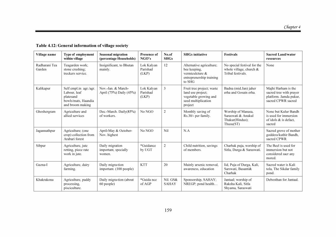
Chapter 4
159
Table 4.12: General information of village society Village name Type of employment
within village Seasonal migration (percentage Households)
Presence of NGO’s
No.of SHGs
SHGs initiative Festivals Sacred Land/water resources
Radharani Tea Garden
Teagarden work; stone crushing; treckers service.
Insignificant, to Bhutan mainly.
Lok Kalyan Parishad (LKP)
12 Alternative agriculture; bee keeping, vermiculcture & entreprenership training to SHG
No special festival for the whole village, church & Tribal festivals.
None
Kalikapur Self empl.in agr./agr. Labour, leaf platesand bowls/mats, Haandia and broom making
Nov.-Jan. & March-April (75%) Daily (45%)
Lok Kalyan Parishad (LKP)
3 Fruit tree project; waste land use project; vegetable growing and seed multiplication project
Badna (mid.Jan) jaher erha and Gosain erha.
Majhi Harham is the sacred tree with prayer platform. Jamda pukur, sacred CPWR sacred
Ghoshergram Agriculture and allied services
Dec.-March. Daily(85%) of workers.
No NGO 2 Monthly saving of Rs.30/- per family.
Worship of Manasa, Saraswati & Anukul Thakur(Hindus); Thusu(ST)
None but Kulur Bandh is used for immersion of idols & is defact, sacred
Jagannathpur Agriculture; (one crop) collection from Arabari forest
April-May & October-Nov. highest
No NGO Nil N.A Sacred grove of mother goddess/kuthir Bandh, sacred CPWR
Sibpur Agriculture, jute retting, piece rate work in jute.
Daily migration important, specially women.
*Guidance by UGT
2 Child nutrition, savings of members.
Charhak puja, worship of Sitla, Durga & Saraswati.
The Beel is used for immersion but not considered sacr any mored.
Gazna-I Agriculture, dairy farming.
Daily migra-tion important. (100 people)
KTT 20 Mainly arsenic removal, awareness, education
Iid, Puja of Durga, Kali, Sarswati, Basanti& Charhak
Sacred water is Kali tola, The Sikdar family pond.
Khakrakona Agriculture, paddy processing, pisciculture.
Daily migra-tion (about 60 people)
*Guida nce of AGP
Nil. GS& SAHAY
Sponsorship, SAHAY; NREGP; pond health…
Jantaal; worship of Raksha Kali, Sitla Shyama, Saraswati
Debosthan for Jantaal.
Chapter 4
160
4.4. Nature of Collections from CPR: A Preliminary View
In Radharani Tea Gardens, villagers collect: Fuel wood, allowable varieties of twigs, leaves and other foliage. But many households collect piles of wood to sell. For the families which are in absolute destitution, this is the only source of money income37.
A lot of food products like wild potatoes called toroo, tubors called Kanda, bitter tubors called Githha are collected. They all supplement the staples and hence are accessed by people who do not have enough cereals, Vegetables like pumpkin, bitter gourd, jungle mushrooms and a variety of arbi (yam) can be procured and also collected. In addition, many local greens like shishnu saag, kechipat, greens of pumpkin, gourd and arbi and very large wild mushrooms are items often collected from the forest.
Traditional knowledge of medicinal herbs is there with the older folks.eg. leaves of bhui neem is widely collected and used for treatment of malaria; Nakbel roots are used in treatment of fever; arhar (pigeon pea) leaves are given for cure of jaundice. Exact locations of these plants are known to the locals. But collection is need-dependent and feedback on it is poor.
Seasonal fruits like berries, mangostein, passion fruit, amlaki, kusum etc are items of collection.
In season, even tea flowers are collected and used as greens in the meal.
The river side in Kalikapur is rich in edible greens, locally called kalm, kulekhara, shushni, helencha and shorshe. These greens as well as leaves, flowers, and sticks of drumstick trees are collected by all. This collection for the poorest is often the only nutrition in their diet.
The village also accesses a seasonal river called kuye nadi and a confluence of river Kopai and the Bakreshwar hot springs, called Haansuli Baank38. Between the months
37 Most of them sell to non collecting household. in the village or to the residents of the two other
Tea Gardens nearby. Poor roads and expensive transport makes for oversupply of fuel wood and prices fall very low. As a result very few can quote figures on sale of wood.
38 Famous as setting for Tarashankar Bandyopadhyay’s novel Haansuli Baanker Upakatha.
Chapter 4
161
of July and September, fish and in November-December crabs, tortoise and oyster are available.
The more sturdy among the villagers, access the river Mayuraksi, at a distance of 11 km. for all the above mentioned items of collection. In addition, they collect the roots, greens and fruit of large multi headed yams, locally called, Panchamukhi kochu. These can be used as staple in times of distress. Most villagers buy only rice and some potatoes. They totally depend on greens from Commons.
Collections from Commons includes leaves of coconut trees to make hard brooms, taal (tall palm) leaves for making cups and bowls. Leaves of date palm (khejur) are collected to make mats. All the production is for use in the village and hardly has a market.
In Ghoshergram, the villagers have no caste bars for accessing Common sources of water and other collections. Villagers collect kalmi saak (a water side green) and yam from the main pond called Kulur Bandh. From off field areas and the roadside, they collect dry greens called hingche, drumsticks and other sticks that are edible. Many families grow medicinal plants like Tulsi, Kalmegh and Turmeric. This is one of the two villages in the sample which actually have grazing land but mostly it has bald patches and wild varieties of edibles can be collected from there.
Jagannathpur has access to the Arabari Forest which is at a distance of 2.5 km in Ghagra Mouja. This village has the right to collect non timber forest products. Some people collect Saal leaves, a variety of edible greens, cashew and sandal from the forest.
Here again very few families are members of JFM committee and do not know about right to collect.
There are some shrubs and village forested areas where every villager has full right of collection for their own use. They collect ber (goose berry), black berries (jamun), lemon, mangoes, mangostein and medicinal plants like kalmegh from village shrubs and village Common land. Many households collect a variety of greens, locally called shishnu, Hingche and kolmi from pond sides.
Most people use homestead land to produce guava, drumsticks, yam, Papaya and Turmeric.
Chapter 4
162
However the months of April-May and October –November are stressful for the very poor. This is the time when water stress and water pollution spreads typhoid, Jaundice and diarrhoea.
The collection items for Sibpur were not available to the researcher from the village questionnaire inputs. Details of collection are available in the household data.
Gazna-I, reported poor households collection of greens and fish from water locked areas during the months of stress which are July to September. During summer, items of collection are fallen fruits like mango, jackfruit, blackberries, lichi and passion fruit. In winter months, fruits like guava and ber are collected.
In Khakrakona, in all seasons, collection from the Commons is possible. Mainly greens are collected:
In summer, it is greens of pumpkin, gourd, pui, both green and red varieties of Choulai (called Note saag locally), drumsticks, flower and stem of banana etc;.
In the rainy season it is kolmi (a water green), kochu (yam greens) and hingche(a local green fortified with Vitamin A), in winter, people working as farm hands and even others who pick up discarded edible leaves, collect greens of cabbage, cauliflower, radish, mustard, black grams and coriander.
The nature of collections reported by the villagers is a picture of anticipated collection behaviour. Analysis of survey data with proper tabulation, contained in Chapter 5 will give the true variety of household response.
The village survey has been a very enriching experience for the researcher for the varied tapestry of village life in 7 sample villages that are unique in every respect.
Impressions from the response to the village Questionnaires by Gram Sansad and Gram Panchayats and Common people of the villages, gave a clear picture of life in these difficult and insulated settlements.
The next chapter is devoted to statistical appraisal of the data collected in the primary survey and learning from the socio economic condition of the households surveyed and analysis of collection data with Results.