Embed Size (px)
Citation preview
The Arboretum Specific Plan4–�
Chapter 4.0
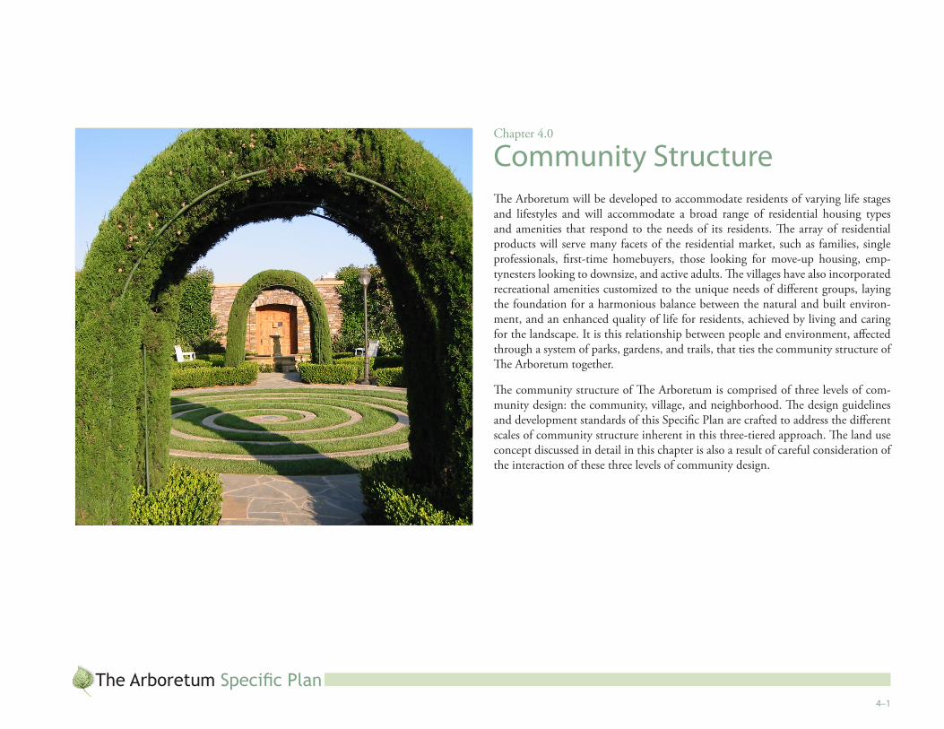
Community StructureThe Arboretum will be developed to accommodate residents of varying life stages and lifestyles and will accommodate a broad range of residential housing types and amenities that respond to the needs of its residents. The array of residential products will serve many facets of the residential market, such as families, single professionals, first-time homebuyers, those looking for move-up housing, emp-tynesters looking to downsize, and active adults. The villages have also incorporated recreational amenities customized to the unique needs of different groups, laying the foundation for a harmonious balance between the natural and built environ-ment, and an enhanced quality of life for residents, achieved by living and caring for the landscape. It is this relationship between people and environment, affected through a system of parks, gardens, and trails, that ties the community structure of The Arboretum together.
The community structure of The Arboretum is comprised of three levels of com-munity design: the community, village, and neighborhood. The design guidelines and development standards of this Specific Plan are crafted to address the different scales of community structure inherent in this three-tiered approach. The land use concept discussed in detail in this chapter is also a result of careful consideration of the interaction of these three levels of community design.
The Arboretum Specific Plan4–�
4.� CommunityThe Arboretum is envisioned as a master-planned community on 531.3 gross acres and will contain a maximum of 3,526 residential units; two school district sites; private and public recreational facilities; and an activity center. The overall design of The Arboretum land use plan was intended to achieve a collection of villages embodied within an arboretum landscape, as discussed in Chapter 1, Vision. The Arboretum land use plan is crafted to take advantage of the scenic mountainous backdrop of the San Bernardino and San Gabriel Mountains and the proximity to the City’s future Corporate Corridor located just to the north and west of the Arboretum project area.
Several overarching themes of The Arboretum contribute to the comprehensive community structure; sustainability, social infrastructure, lifelong learning, and community partnerships are all core components of the Vision for The Arboretum (and are discussed in more detail in Chapter 1, Vision, of this Specific Plan). These themes are carried throughout each village and, ultimately, neighborhood to create a unified, cohesive community structure. Thus, community level elements of this Specific Plan address development throughout the entire project area.
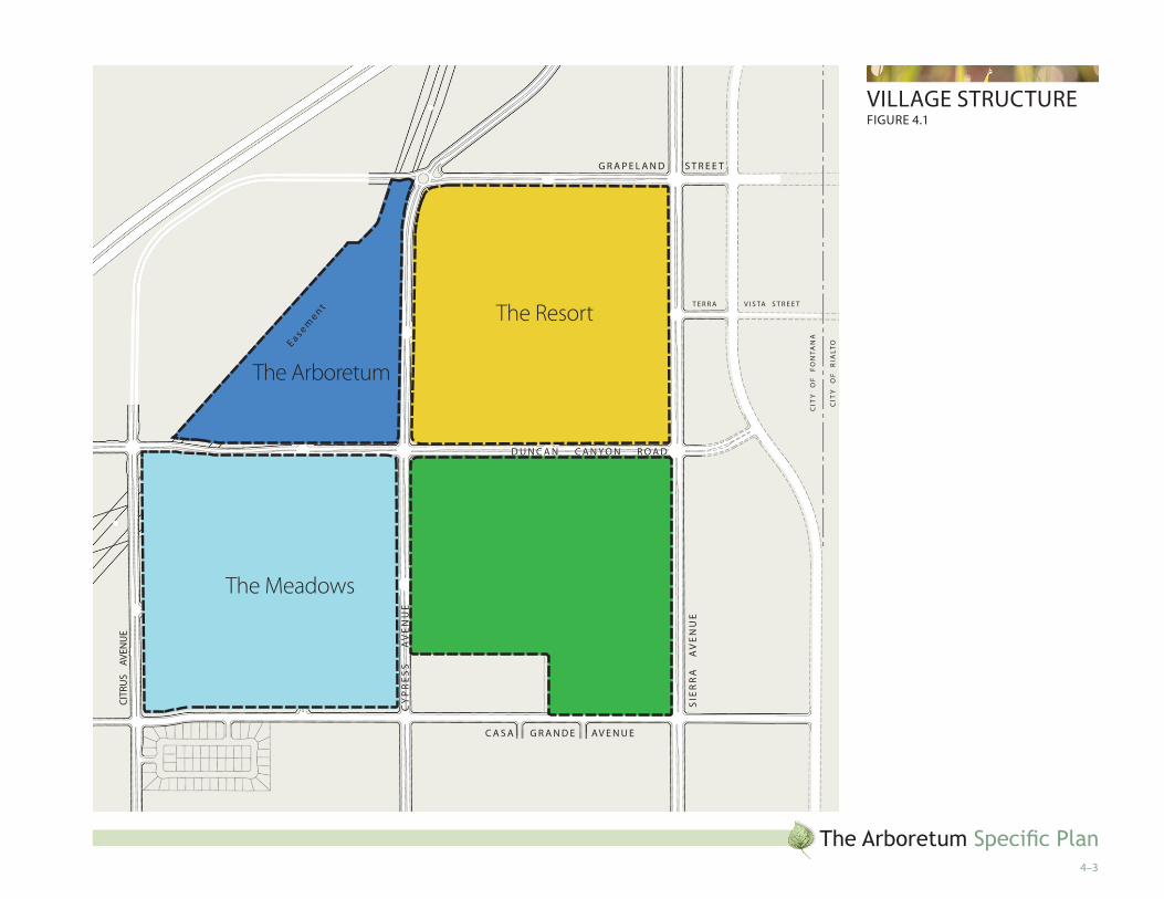
4.� VillageThe Arboretum community is composed of four villages, roughly defined by the existing circulation pattern of arterials that divide the Arboretum property into four quadrants. As shown on Figure 4.1, Village Structure, The Meadows, The Gar-dens, The Resort, and The Arboretum are four distinct areas within The Arboretum project area. Each village will provide different housing opportunities within the community.
The architectural styles and assortment of gardens included in each village will be reflective of the residential product types and associated lifestyles found there. However, community-level theming and design will be incorporated throughout each village, responding to the villages’ residential product type while still carry-ing through the elements of the Arboretum Vision that comprise the community structure. In essence, each village will offer a distinct character while retaining an overall community identity.
4.3 NeighborhoodIndividual neighborhoods will be created within each village; this is the third level of The Arboretum Specific Plan, which contains individual development areas, re-ferred to as “planning areas.”
These planning areas were formed on the basis of clustering development. Each planning area will have unique characteristics, but will be integrated into the broad-er, cohesive collection of residential villages. Collectively, the various planning areas will form the interlinked Arboretum community through complementary archi-tectural and landscape themes, a network of community trails, and common rec-reational amenities strategically positioned throughout the community, as seen in Figure 4.2, Overall Land Use Plan and Figure 6.18, Pedestrian Circulation, Bikeways and Trails Plan.
Neighborhoods within The Arboretum will be formed in part by individual land uses, the composition of residential product types, and internal street patterns. However, these neighborhood-level delineations are not absolute; this level of detail will be more thoroughly fleshed out at the tentative tract map stage of the develop-ment process. Likewise, actual residential lotting and selection of specific recre-ational amenities will not be determined until the tentative tract map stage. Given that the development areas and specific product types are not identified in the spe-cific plan, fencing/gating requirements for each residential development which has a density of seven (7) units per acre or greater, or is being developed at multi-family standards shall be at the discretion of the Director of Community Development. The Design Guidelines and Development Standards contained in Chapters 7 and 8 of this Specific Plan, respectively, will ensure uniformity of use and design as it pertains to zoning and community character.
Although individual neighborhoods will not be delineated or discussed within this document, they are integral to the overall Arboretum Plan. For instance, the in-timate spaces created through this Plan’s emphasis on indoor/outdoor living are dependent upon an individual development’s compliance with the standards and guidelines contained in this document. As a result, the community structure of The Arboretum extends all the way to the neighborhood level.
The Arboretum Specific Plan4–3
Village StruCtureFigure 4.�
The Meadows
The Resort
The Gardens
The Arboretum
g r a P e l a N D S t r e e t
Sie
rr
a
aV
eN
ue
CY
Pr
eS
S
a
Ve
Nu
e
Citr
uS
aV
eNu
e
D u N C a N C a N Y O N r O a D
C a S a g r a N D e aV e N u e
ea s emen t t e r r a V i S ta S t r e e t
Cit
Y
OF
F
ON
taN
a
Cit
Y
OF
r
ialt
O

The Arboretum Specific Plan4–4
4.4 land use ObjectivesThe Arboretum Specific Plan provides for a long-range comprehensive planning approach that cannot be accomplished solely by designing the site at a parcel level. To achieve this goal, a number of important issues were considered during the preparation of this Specific Plan document, including the City of Fontana’s Zon-ing and Development Code, General Plan and other regulatory policies, as well as engineering feasibility, environmental constraints, market acceptance, economic viability, development phasing, and local community goals. To ensure the func-tional integrity, economic viability, environmental sensitivity, and positive aesthetic contribution of the Specific Plan to the north Fontana area, this extensive analysis was used to establish the following list of project objectives. The Arboretum project intends to:
Set forth a comprehensive development plan that implements the appli-cable portions of the City of Fontana General Plan and achieves the City’s development goals for this portion of northern Fontana.
Provide a balance of compatible and complementary residential and recre-ational land uses in a well-designed master-planned community.
Provide a community design that establishes four unique residential vil-lages with housing options for diverse ages, lifestyles, and income levels.
Provide recreational facilities and amenities to meet the needs of the com-munity by incorporating public and private parks, public and private rec-reation centers, and a pedestrian paseo and bicycle circulation system.
Contribute to the range of existing housing choices in the north Fon-tana area by providing both attached and detached housing options in one master-planned community.
Anticipate marketing needs and public demand by providing homes that will be marketable within the evolving economic profile of north Fontana and the surrounding region.
Create an aesthetically pleasing and distinct community identity (“sense of place”) through the establishment of design criteria for architecture, land-scaping, walls, street improvements, signs, entry monuments, and other planning and design features.
•
•
•
•
•
•
•
Create a sense of internal community connectivity and enhance the rela-tionship of buildings to the street within the Specific Plan area.
Create a strong sense of arrival into the project.
Create a community that has a timeless character, with amenities, architec-ture, and landscaping that evolves as the community ages.
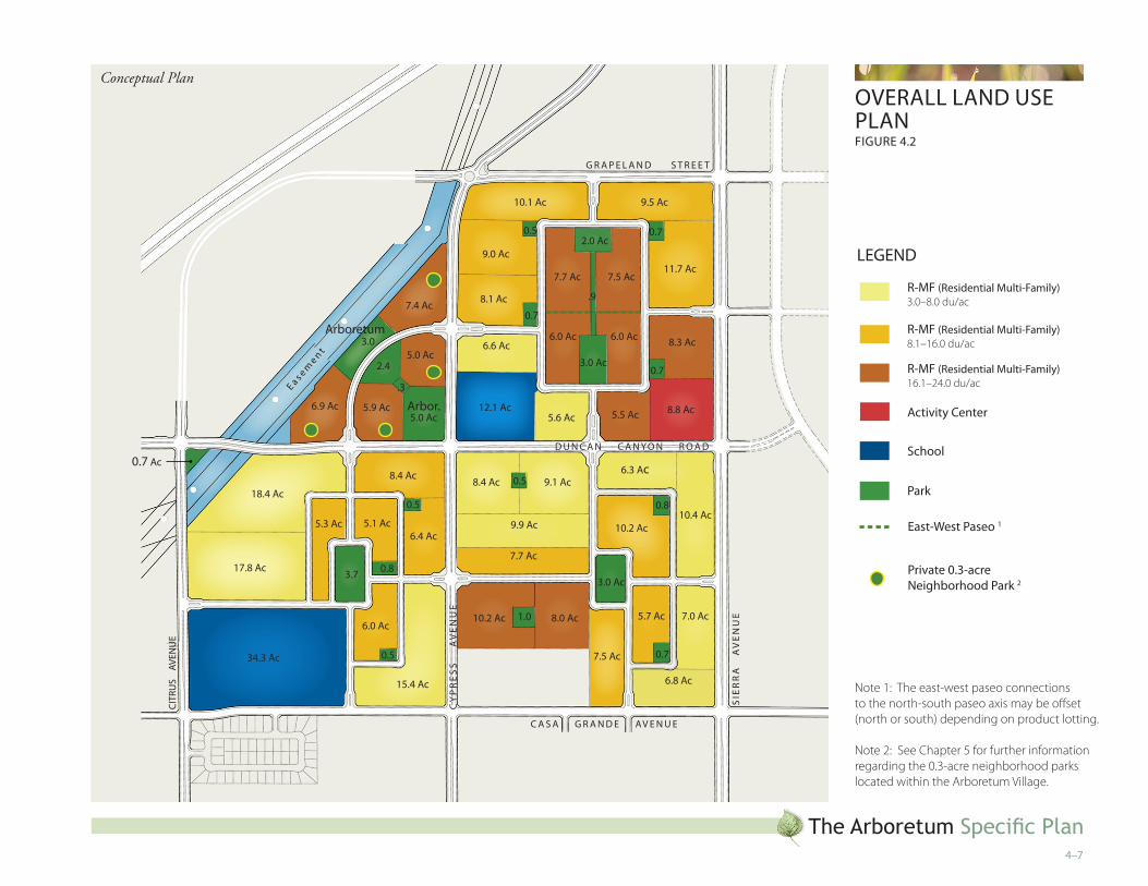
4.5 land use Plan OverviewThe Arboretum Specific Plan area will contain a high quality and aesthetically pleas-ing community composed of residential homes, an activity center and recreational land uses on 531.3 gross acres. Recreational amenities will include public and pri-vate gardens and parks, recreation centers, community paseos, and a pedestrian and bicycle circulation system. Actual density (residential uses) and Floor Area Ra-tio (FAR) (non-residential uses) ranges are determined on a parcel specific basis. Density and FAR are based on adjusted gross acreage, which takes out the area for collector streets and above, public facilities (excluding schools), and open space (excluding parks).
The Land Use Plan for The Arboretum community is illustrated on Figure 4.2, Overall Land Use Plan, and includes 38 planning areas. Specific information on each of the planning areas is provided in statistical summaries provided in Tables 4.3–4.6, which focus on individual villages within The Arboretum.
4.5.� residential land uses
Residential planning areas contain 3,526 dwelling units. The overall adjusted gross density of the project will be 8.5 dwelling units per adjusted gross acre. In con-formance with project goals, a variety of single-family detached and high-density attached residential housing styles, sizes, and values are proposed, appealing to a wide range of future Arboretum residents. The housing mix may include homes on traditional single-family lots, detached small-lot and cluster homes, and attached residential homes.
•
•
•
C O m m u N i t Y S t r u C t u r e4–5
4.5.� Nonresidential land uses
Nonresidential land uses account for 97.6 acres of the Specific Plan and are com-prised of several public and private parks, public and private recreation centers and trails, the signature Arboretum park and gardens, school sites, an activity center, and local streets. Please see Figure 6.1, Circulation Plan, for specific street classifica-tions.
ParkS aND reCreatiON CeNterS
As shown in Figures 4.2–4.6, there are several public and private parks and recre-ation areas within The Arboretum. See Chapter 5, Parks and Amenities, for a de-tailed description of the park amenities in The Arboretum community. Timing for the Arboretum’s parks and recreation centers can be found in Chapter 9, Phasing and Infrastructure.
the meadows
The Meadows village contains a 34.3-acre school site, a 3.7-acre village park, a 0.8-acre neighborhood park, and two 0.5-acre neighborhood parks. As The Meadows is not a gated village, these parks and recreation facilities are open to residents of The Arboretum and the City of Fontana at large, with the exception of the 0.8-acre park and the two 0.5-acre neighborhood parks, which are private. The Meadows will have a minimum of three community gardens which can be integrated into the village’s planned parks (see Appendix B, Community Gardens). Please see Chapter 5 regarding proposed uses for The Meadows’ parks and recreational facilities.
the gardens
The non-gated Gardens village contains a 3-acre private community recreation cen-ter, a 1-acre private neighborhood park, one 0.8-acre private neighborhood park, one 0.7-acre private neighborhood park, and one 0.5-acre private neighborhood park. The Gardens will have a minimum of five community gardens which can be integrated into the village’s planned parks (see Appendix B, Community Gardens). Please see Chapter 5 regarding proposed uses for The Gardens’ parks and recre-ational facilities.
the resort
The Resort village contains a 3-acre private recreation center and a 2-acre private village park connected by a 0.9-acre “Resort Village Paseo”. The Resort also in-cludes three 0.7-acre private neighborhood parks, and one 0.5-acre private neigh-borhood park. Because the Resort is gated, these parks and recreation facilities are intended to service The Resort village exclusively. The Resort will have a minimum of five community gardens which can be integrated into the village’s planned parks (see Appendix B, Community Gardens). Please see Chapter 5 regarding proposed uses for The Resort’s parks and recreational facilities.
the arboretum
The non-gated Arboretum village contains the 10.7-acre signature Arboretum Park that form the heart of the overall Arboretum community. Each of the four plan-ning areas within the Arboretum Village will have a private 0.3-acre neighborhood park. Please see Chapter 5 regarding proposed timing for The Arboretum’s parks and recreational facilities.
elemeNtarY SChOOlS aND miDDle SChOOl
The Arboretum will be served by the Fontana Unified School District (FUSD). Students from the Arboretum will attend the proposed 34.3-acre elementary and middle schools Elementary School #36 and Middle School #10 at the northeast corner of Citrus Avenue and Casa Grande Avenue in the Meadows village. The development of a 12.1-acre Elementary School #37 adjacent to the Resort village is planned for the northeast corner of Duncan Canyon Road and Cypress Avenue. In the event that a school is not developed in this second site, it is envisioned that resi-dential units will be developed in its place. For more discussion on the implementa-tion of residential uses in lieu of proposed school sites within The Arboretum, see Chapter 10, Administration.
aCtiVitY CeNter
An 8.8-acre activity center will be located at the northwest corner of Sierra Avenue and Duncan Canyon Road. The activity center is intended to serve north Fontana residents and will provide a variety of commercial retail and neighborhood ser-vices.
The Arboretum Specific Plan4–�
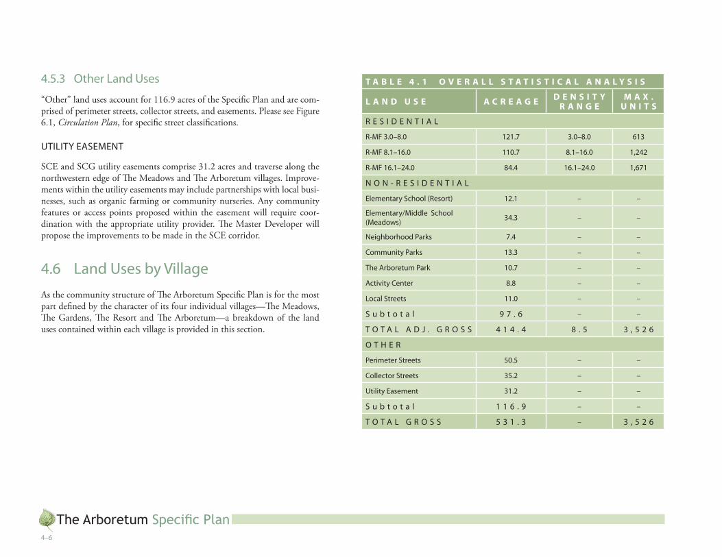
4.5.3 Other land uses
“Other” land uses account for 116.9 acres of the Specific Plan and are com-prised of perimeter streets, collector streets, and easements. Please see Figure 6.1, Circulation Plan, for specific street classifications.
utilitY eaSemeNt
SCE and SCG utility easements comprise 31.2 acres and traverse along the northwestern edge of The Meadows and The Arboretum villages. Improve-ments within the utility easements may include partnerships with local busi-nesses, such as organic farming or community nurseries. Any community features or access points proposed within the easement will require coor-dination with the appropriate utility provider. The Master Developer will propose the improvements to be made in the SCE corridor.
4.� land uses by VillageAs the community structure of The Arboretum Specific Plan is for the most part defined by the character of its four individual villages—The Meadows, The Gardens, The Resort and The Arboretum—a breakdown of the land uses contained within each village is provided in this section.
T A B L E 4 . 1 O V E R A L L S T A T I S T I C A L A N A L Y S I S
L A N D U S E A C R E A G E D E N S I T Y R A N G E
M A X .U N I T S
r e S i D e N t i a l
r-mF 3.0–8.0 ���.7 3.0–8.0 ��3
r-mF 8.�–��.0 ��0.7 8.�–��.0 �,�4�
r-mF ��.�–�4.0 84.4 ��.�–�4.0 �,�7�
N O N - r e S i D e N t i a l
elementary School (resort) ��.� – –
elementary/middle School (meadows) 34.3 – –
Neighborhood Parks 7.4 – –
Community Parks �3.3 – –
the arboretum Park �0.7 – –
activity Center 8.8 – –
local Streets ��.0 – –
S u b t o t a l 9 7 . � – –
t O t a l a D J . g r O S S 4 � 4 . 4 8 . 5 3 , 5 � �
O t h e r
Perimeter Streets 50.5 – –
Collector Streets 35.� – –
utility easement 3�.� – –
S u b t o t a l � � � . 9 – –
t O t a l g r O S S 5 3 � . 3 – 3 , 5 � �
The Arboretum Specific Plan4–7
OVerall laND uSe PlaNFigure 4.�
9.5 ac
��.7 ac
�0.� ac
9.0 ac
8.� ac
7.7 ac 7.5 ac
�.0 ac�.0 ac 8.3 ac�.� ac
��.� ac5.� ac 5.5 ac 8.8 ac
�.0 ac
3.0 ac
0.7
7.4 ac
5.0 ac
arbor.5.0 ac
arboretum
5.9 ac�.9 ac
0.5
0.7
0.7
�.3 ac
�0.4 ac�0.� ac
0.8
0.7
7.0 ac5.7 ac
�.8 ac
3.0 ac
9.� ac8.4 ac 0.5
9.9 ac
7.7 ac
8.0 ac�0.� ac �.0
8.4 ac
�8.4 ac
�7.8 ac
5.3 ac 5.� ac�.4 ac
�.0 ac
�5.4 ac
3.7
0.5
34.3 ac
g r a P e l a N D S t r e e t
Sie
rr
a
aV
eN
ue
CY
Pr
eS
S
a
Ve
Nu
e
Citr
uS
aV
eNu
e
.3
�.4
3.0
0.8
0.5
D u N C a N C a N Y O N r O a D
C a S a g r a N D e aV e N u e
.9ea s em
en t
7.5 ac
LEGEND
r-mF (residential multi-Family) 3.0–8.0 du/ac
r-mF (residential multi-Family) 8.1–16.0 du/ac
r-mF (residential multi-Family) 16.1–24.0 du/ac
activity Center
School
Park
east-West Paseo �
Private 0.3-acre Neighborhood Park �
0.7 ac
Note 1: The east-west paseo connections to the north-south paseo axis may be offset (north or south) depending on product lotting.
Note 2: See Chapter 5 for further information regarding the 0.3-acre neighborhood parks located within the Arboretum Village.
Conceptual Plan
The Arboretum Specific Plan4–8
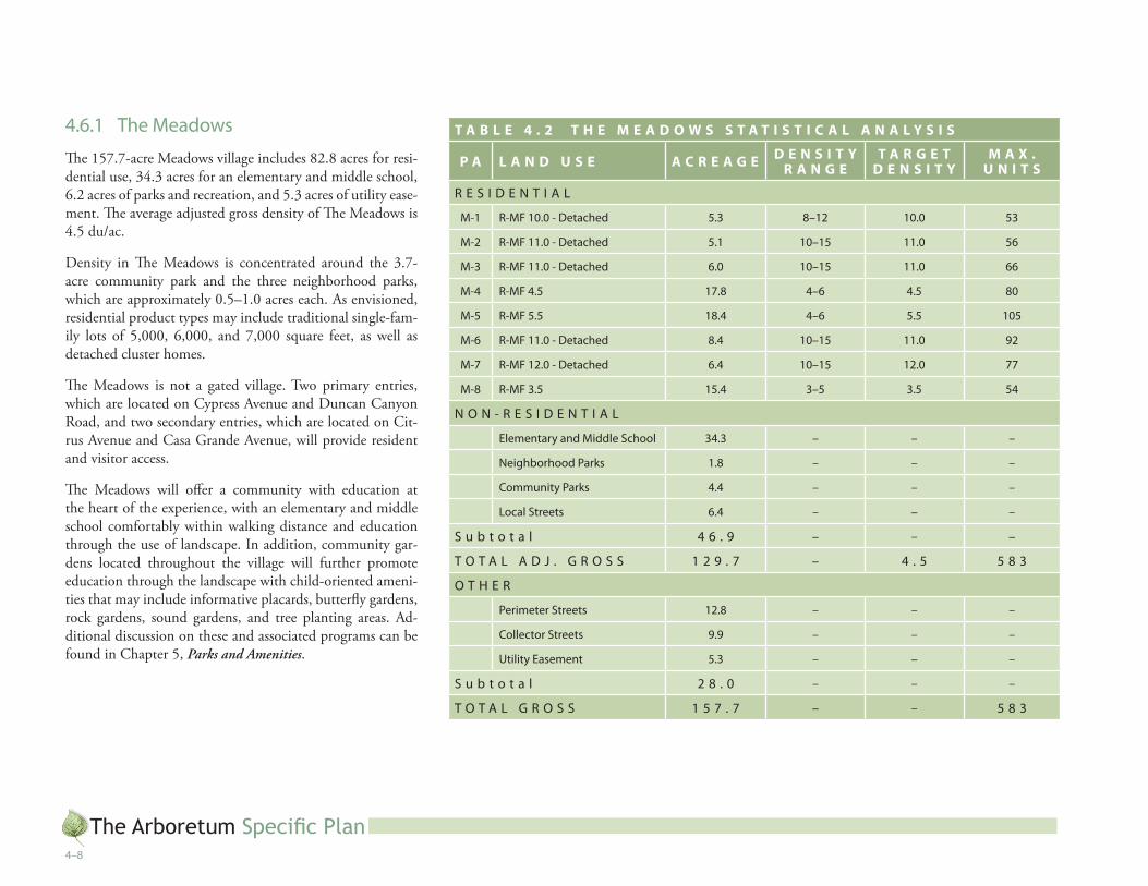
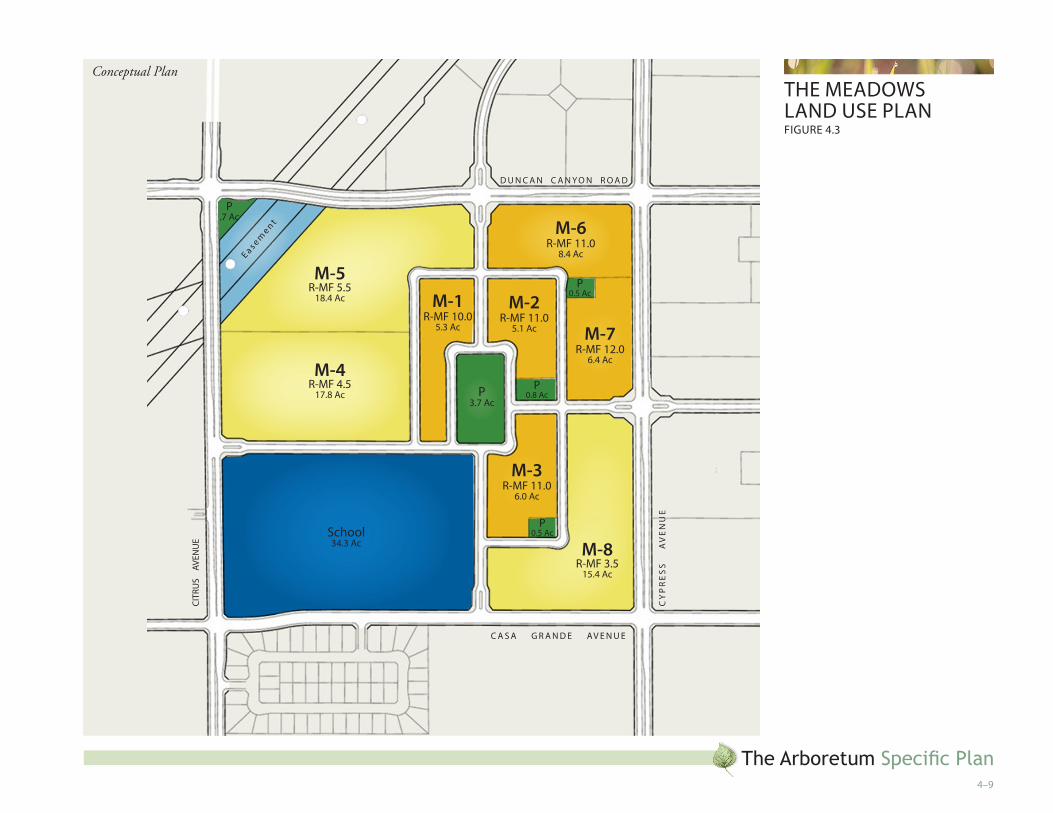
4.�.� the meadows
The 157.7-acre Meadows village includes 82.8 acres for resi-dential use, 34.3 acres for an elementary and middle school, 6.2 acres of parks and recreation, and 5.3 acres of utility ease-ment. The average adjusted gross density of The Meadows is 4.5 du/ac.
Density in The Meadows is concentrated around the 3.7-acre community park and the three neighborhood parks, which are approximately 0.5–1.0 acres each. As envisioned, residential product types may include traditional single-fam-ily lots of 5,000, 6,000, and 7,000 square feet, as well as detached cluster homes.
The Meadows is not a gated village. Two primary entries, which are located on Cypress Avenue and Duncan Canyon Road, and two secondary entries, which are located on Cit-rus Avenue and Casa Grande Avenue, will provide resident and visitor access.
The Meadows will offer a community with education at the heart of the experience, with an elementary and middle school comfortably within walking distance and education through the use of landscape. In addition, community gar-dens located throughout the village will further promote education through the landscape with child-oriented ameni-ties that may include informative placards, butterfly gardens, rock gardens, sound gardens, and tree planting areas. Ad-ditional discussion on these and associated programs can be found in Chapter 5, Parks and Amenities.
T A B L E 4 . 2 T H E M E A D O W S S T A T I S T I C A L A N A L Y S I S
P A L A N D U S E A C R E A G E D E N S I T Y R A N G E
T A R G E T D E N S I T Y
M A X . U N I T S
r e S i D e N t i a l
m-� r-mF �0.0 - Detached 5.3 8–�� �0.0 53
m-� r-mF ��.0 - Detached 5.� �0–�5 ��.0 5�
m-3 r-mF ��.0 - Detached �.0 �0–�5 ��.0 ��
m-4 r-mF 4.5 �7.8 4–� 4.5 80
m-5 r-mF 5.5 �8.4 4–� 5.5 �05
m-� r-mF ��.0 - Detached 8.4 �0–�5 ��.0 9�
m-7 r-mF ��.0 - Detached �.4 �0–�5 ��.0 77
m-8 r-mF 3.5 �5.4 3–5 3.5 54
N O N - r e S i D e N t i a l
elementary and middle School 34.3 – – –
Neighborhood Parks �.8 – – –
Community Parks 4.4 – – –
local Streets �.4 – – –
S u b t o t a l 4 � . 9 – – –
t O t a l a D J . g r O S S � � 9 . 7 – 4 . 5 5 8 3
O t h e r
Perimeter Streets ��.8 – – –
Collector Streets 9.9 – – –
utility easement 5.3 – – –
S u b t o t a l � 8 . 0 – – –
t O t a l g r O S S � 5 7 . 7 – – 5 8 3
The Arboretum Specific Plan4–9
the meaDOWSlaND uSe PlaNFigure 4.3
M-1r-mF �0.0
5.3 ac
P0.5 ac
M-2r-mF ��.0
5.� ac M-7r-mF ��.0
�.4 ac
M-6r-mF ��.0
8.4 ac
M-3r-mF ��.0
�.0 ac
M-8r-mF 3.5
�5.4 ac
P0.5 ac
M-4r-mF 4.5
�7.8 ac
M-5r-mF 5.5
�8.4 ac
P0.8 acP
3.7 ac
School34.3 ac
P .7 ac
CY
Pr
eS
S
a
Ve
Nu
e
Citr
uS
aV
eNu
e
D u N C a N C a N Y O N r O a D
C a S a g r a N D e aV e N u e
ea s emen t
Conceptual Plan

The Arboretum Specific Plan4–�0
4.�.� the gardens
The 142.0-acre Gardens village includes 107.2 acres for resi-dential use and 6.0 acres of parks and recreation. The average adjusted gross density of The Gardens is 7.7 du/ac.
Density is concentrated at the core of The Gardens, with high and medium density residential flanking the Cypress Avenue entry into the village and surrounding the community park, and low density residential situated around the periphery of the village. Residential product types may include traditional single family lots of 4,000 to 7,000 and 10,000 square feet, as well as detached cluster homes and attached townhomes.
The Gardens is a non-gated village. Two primary entries, which are located on Cypress Avenue and Duncan Canyon Road, will provide resident and visitor access. Two secondary entries, which are located on Casa Grande Avenue and Sierra Avenue, will also provide access.
T A B L E 4 . 3 T H E G A R D E N S S T A T I S T I C A L A N A L Y S I S
P A L A N D U S E A C R E A G E D E N S I T Y R A N G E
T A R G E TD E N S I T Y
M A X . U N I T S
r e S i D e N t i a l
g-� r-mF 7.0 8.4 �–8 7.0 59
g-� r-mF 5.5 9.� 4–� 5.5 50
g-3 r-mF 5.5 �.3 4–� 5.5 34
g-4 r-mF 8.0 - Detached �0.� 8–�� 8.0 8�
g-5 r-mF �.0 �0.4 4–� �.0 ��
g-� r-mF �0.0 - Detached 5.7 �0–�5 �0.0 57
g-7 r-mF 4.0 7.0 3–5 4.0 �8
g-8 r-mF 4.0 �.8 3–5 4.0 �7
g-9 r-mF ��.0 - attached 8.0 ��–�0 ��.0 ��8
g-�0 r-mF �8.0 - attached �0.� �8-�0 �8.0 �83
g-�� r-mF �0.0 - Detached 7.7 �0–�5 �0.0 77
g-�� r-mF 3.0 9.9 �–4 3.0 30
g-�3 r-mF ��.0 - Detached 7.5 �0-�5 ��.0 90
N O N - r e S i D e N t i a l
Neighborhood Parks 3.0 – – –
Community Parks 3.0 – – –
local Streets 4.� – – –
S u b t o t a l � 0 . � – – –
t O t a l a D J . g r O S S � � 7 . 8 – 7 . 7 9 0 �
O t h e r
Perimeter Streets �3.5 – – –
Collector Streets �0.7 – – –
S u b t o t a l � 4 . � – – –
t O t a l g r O S S � 4 � . 0 – – 9 0 �

The Arboretum Specific Plan4–��
the garDeNS laND uSe PlaN
G-4r-mF 8.0
�0.� ac
G-11r-mF �0.0
7.7 ac
G-6r-mF �0.0
5.7 ac
G-3r-mF 5.5
�.3 ac
G-5r-mF �.0
�0.4 ac
G-7r-mF 4.0
7.0 ac
P0.7
P0.8
P3.0 ac
P�.0 ac
G-9r-mF ��.0
8.0 ac
G-10r-mF �8.0
�0.� ac
G-8r-mF 4.0
�.8 ac
P0.5
G-12r-mF 3.0
9.9 ac
G-1r-mF 7.0
8.4 ac
G-2r-mF 5.5
9.� ac
G-13r-mF ��.0
7.5 acNAP
16.9 Ac
Sie
rr
a
aV
eN
ue
CY
Pr
eS
S
a
Ve
Nu
eD u N C a N C a N Y O N r O a D
C a S a g r a N D e aV e N u e
Conceptual Plan
The Arboretum Specific Plan4–��
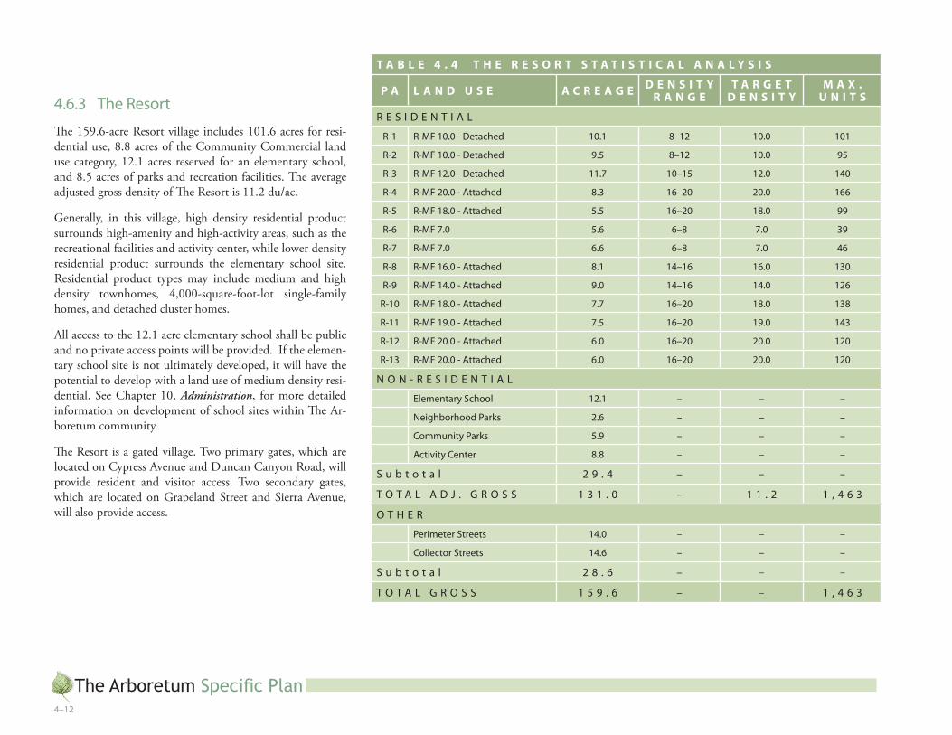
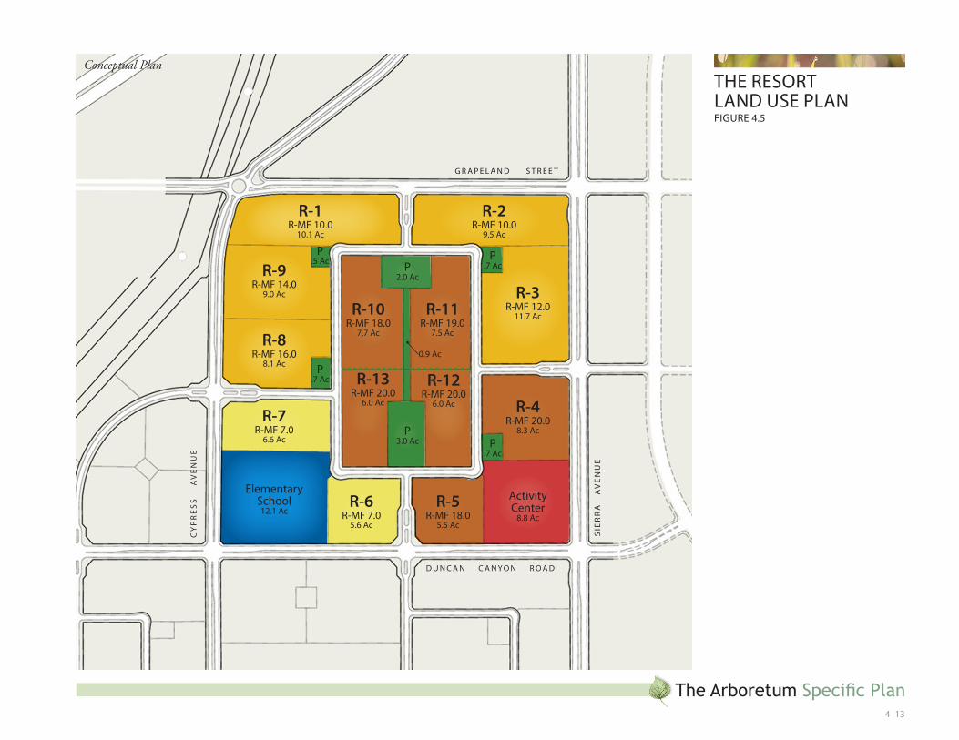
4.�.3 the resort
The 159.6-acre Resort village includes 101.6 acres for resi-dential use, 8.8 acres of the Community Commercial land use category, 12.1 acres reserved for an elementary school, and 8.5 acres of parks and recreation facilities. The average adjusted gross density of The Resort is 11.2 du/ac.
Generally, in this village, high density residential product surrounds high-amenity and high-activity areas, such as the recreational facilities and activity center, while lower density residential product surrounds the elementary school site. Residential product types may include medium and high density townhomes, 4,000-square-foot-lot single-family homes, and detached cluster homes.
All access to the 12.1 acre elementary school shall be public and no private access points will be provided. If the elemen-tary school site is not ultimately developed, it will have the potential to develop with a land use of medium density resi-dential. See Chapter 10, Administration, for more detailed information on development of school sites within The Ar-boretum community.
The Resort is a gated village. Two primary gates, which are located on Cypress Avenue and Duncan Canyon Road, will provide resident and visitor access. Two secondary gates, which are located on Grapeland Street and Sierra Avenue, will also provide access.
T A B L E 4 . 4 T H E R E S O R T S T A T I S T I C A L A N A L Y S I S
P A L A N D U S E A C R E A G E D E N S I T Y R A N G E
T A R G E T D E N S I T Y
M A X . U N I T S
r e S i D e N t i a l
r-� r-mF �0.0 - Detached �0.� 8–�� �0.0 �0�
r-� r-mF �0.0 - Detached 9.5 8–�� �0.0 95
r-3 r-mF ��.0 - Detached ��.7 �0–�5 ��.0 �40
r-4 r-mF �0.0 - attached 8.3 ��–�0 �0.0 ���
r-5 r-mF �8.0 - attached 5.5 ��–�0 �8.0 99
r-� r-mF 7.0 5.� �–8 7.0 39
r-7 r-mF 7.0 �.� �–8 7.0 4�
r-8 r-mF ��.0 - attached 8.� �4–�� ��.0 �30
r-9 r-mF �4.0 - attached 9.0 �4–�� �4.0 ���
r-�0 r-mF �8.0 - attached 7.7 ��–�0 �8.0 �38
r-�� r-mF �9.0 - attached 7.5 ��–�0 �9.0 �43
r-�� r-mF �0.0 - attached �.0 ��–�0 �0.0 ��0
r-�3 r-mF �0.0 - attached �.0 ��–�0 �0.0 ��0
N O N - r e S i D e N t i a l
elementary School ��.� – – –
Neighborhood Parks �.� – – –
Community Parks 5.9 – – –
activity Center 8.8 – – –
S u b t o t a l � 9 . 4 – – –
t O t a l a D J . g r O S S � 3 � . 0 – � � . � � , 4 � 3
O t h e r
Perimeter Streets �4.0 – – –
Collector Streets �4.� – – –
S u b t o t a l � 8 . � – – –
t O t a l g r O S S � 5 9 . � – – � , 4 � 3
The Arboretum Specific Plan4–�3
the reSOrt laND uSe PlaNFigure 4.5
P.7 ac
R-2r-mF �0.0
9.5 ac
R-3r-mF ��.0
��.7 ac
R-4r-mF �0.0
8.3 ac
P.7 ac
R-1r-mF �0.0
�0.� ac
R-9r-mF �4.0
9.0 ac
R-8r-mF ��.0
8.� ac
P.5 ac
P.7 ac
P�.0 ac
P3.0 ac
R-10r-mF �8.0
7.7 ac
R-11r-mF �9.0
7.5 ac
R-13r-mF �0.0
�.0 ac
R-12r-mF �0.0
�.0 ac
R-6r-mF 7.0
5.� ac
R-5r-mF �8.0
5.5 ac
R-7r-mF 7.0
�.� ac
elementarySchool��.� ac
activity Center
8.8 ac
0.9 ac
g r a P e l a N D S t r e e t
Sie
rr
a
aV
eN
ue
CY
Pr
eS
S
a
Ve
Nu
e
D u N C a N C a N Y O N r O a D
Conceptual Plan
The Arboretum Specific Plan4–�4
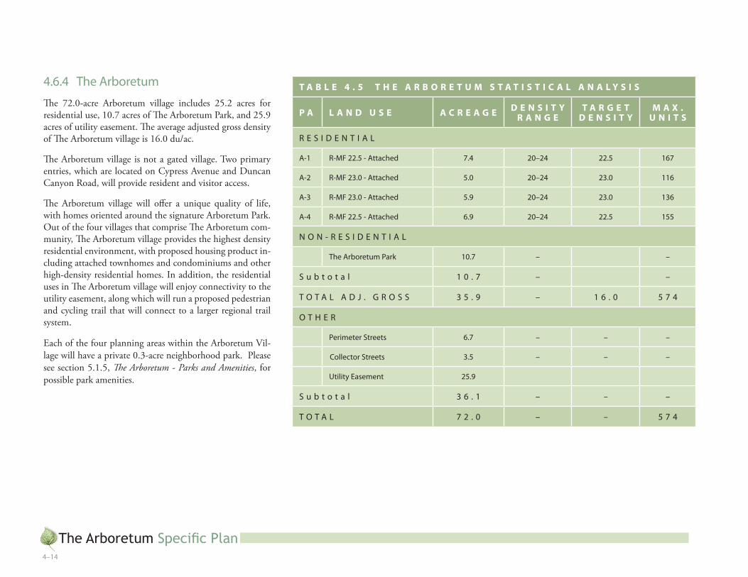
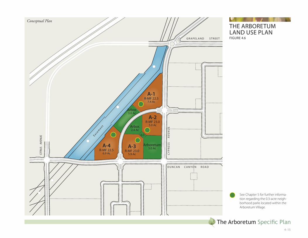
4.�.4 the arboretum
The 72.0-acre Arboretum village includes 25.2 acres for residential use, 10.7 acres of The Arboretum Park, and 25.9 acres of utility easement. The average adjusted gross density of The Arboretum village is 16.0 du/ac.
The Arboretum village is not a gated village. Two primary entries, which are located on Cypress Avenue and Duncan Canyon Road, will provide resident and visitor access.
The Arboretum village will offer a unique quality of life, with homes oriented around the signature Arboretum Park. Out of the four villages that comprise The Arboretum com-munity, The Arboretum village provides the highest density residential environment, with proposed housing product in-cluding attached townhomes and condominiums and other high-density residential homes. In addition, the residential uses in The Arboretum village will enjoy connectivity to the utility easement, along which will run a proposed pedestrian and cycling trail that will connect to a larger regional trail system.
Each of the four planning areas within the Arboretum Vil-lage will have a private 0.3-acre neighborhood park. Please see section 5.1.5, The Arboretum - Parks and Amenities, for possible park amenities.
T A B L E 4 . 5 T H E A R B O R E T U M S T A T I S T I C A L A N A L Y S I S
P A L A N D U S E A C R E A G E D E N S I T Y R A N G E
T A R G E T D E N S I T Y
M A X . U N I T S
r e S i D e N t i a l
a-� r-mF ��.5 - attached 7.4 �0–�4 ��.5 ��7
a-� r-mF �3.0 - attached 5.0 �0–�4 �3.0 ���
a-3 r-mF �3.0 - attached 5.9 �0–�4 �3.0 �3�
a-4 r-mF ��.5 - attached �.9 �0–�4 ��.5 �55
N O N - r e S i D e N t i a l
the arboretum Park �0.7 – –
S u b t o t a l � 0 . 7 – –
t O t a l a D J . g r O S S 3 5 . 9 – � � . 0 5 7 4
O t h e r
Perimeter Streets �.7 – – –
Collector Streets 3.5 – – –
utility easement �5.9
S u b t o t a l 3 � . � – – –
t O t a l 7 � . 0 – – 5 7 4
If, in the future, property owners would like to incorporate live/work uses in the Specific Plan area, they shall be integrated into the Arboretum village around the Arboretum Park. The “work” component of the live/work uses should be comprised of uses such as coffee shops, florists, and other uses that complement the Arboretum theme. If live/work uses are desired in the future, additional development standards may be necessary to regulate the type of uses permitted and conditionally permitted and to regulate the appearance of the built environment. In no case shall new live/work uses exceed the maximum dwelling units and square footage permitted by the land use plan (Figure 4.2) without a Specific Plan Amend-ment and the appropriate environmental review.
The Arboretum Specific Plan4–�5
the arbOretum laND uSe PlaNFigure 4.�
A-1r-mF ��.5
7.4 ac
A-2r-mF �3.0
5.0 ac
A-3r-mF �3.0
5.9 ac
A-4r-mF ��.5
�.9 ac
arboretum5.0 ac
arbor.3.0 ac
0.3
arbor.�.4 ac
g r a P e l a N D S t r e e t
CY
Pr
eS
S
a
Ve
Nu
e
Citr
uS
aV
eNu
e
D u N C a N C a N Y O N r O a D
ea s emen t
See Chapter 5 for further informa-tion regarding the 0.3-acre neigh-borhood parks located within the Arboretum Village.
Conceptual Plan

The Arboretum Specific Plan4–��
This page intentionally left blank.