Embed Size (px)
Citation preview
Chapter 5
Community Character & Design
Table of Contents
Page
A. Introduction .............................................................................................................................5-1
B. Purpose and Authority...........................................................................................................5-1
C. The Rio Vista Principles: Implementing the Community Vision.....................................5-3
D. Setting .......................................................................................................................................5-5
E. Outlook...................................................................................................................................5-11
F. Goals, Policies, and Implementing Actions.......................................................................5-18
G. Implementing Actions for Community Character & Design (CD) ................................5-42
List of Tables
5-1 Streets and Blocks Design Criteria, Garage Placement.......................................................5-47 5-2 Density Bonuses for Carriage Houses...................................................................................5-50
List of Figures
5-1 Lot and Building Patterns .........................................................................................................5-8 5-2 Developed Areas and Recent Annexations............................................................................5-9 5-3 Key Hilltops, Valleys and Ridgelines....................................................................................5-12 5-4 Rio Vista’s Historic Development Pattern............................................................................5-16 5-5 Rio Vista’s Historic Lot Patterns ............................................................................................5-17 5-6 Community Entryways, Identity Features, and Landmarks .............................................5-22 5-7 Pedestrian Access through Parking Lots ..............................................................................5-43 5-8 Neighborhood Core District Conceptual Illustration………………………..……………5-53
Rio Vista General Plan 2001 5-i Community Character & Design July 18, 2002
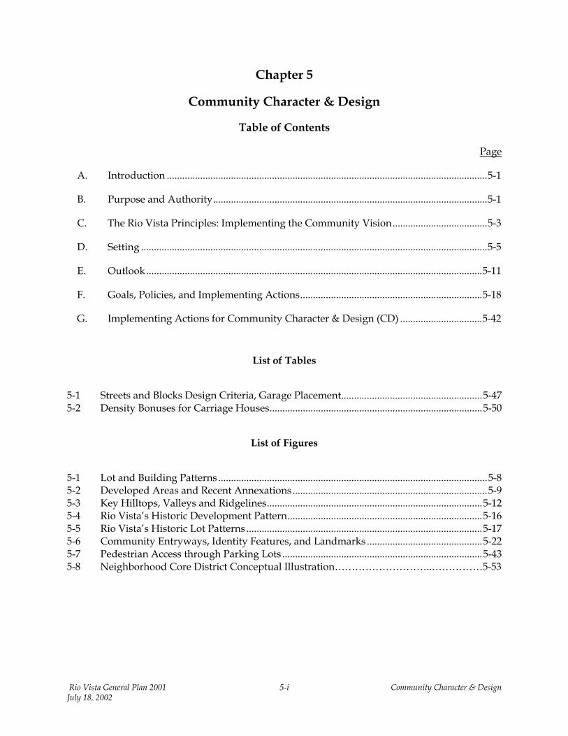
Chapter 5 Community Character & Design
A
“t“ciadpt
J
. Intro
Community o a communeighborhooharacteristic
dentity in evnd engineerevelopmentrinciples and
he vision and
Rio Vista Generauly 18, 2002
duction
character” refers to the pnity. Concepts such d,” and “community” as—landmarks, streets, bery community. “Comming design principles th and the redevelopment policies are intended to goals of residents and
l Plan 2001
hysical characteristics that lend shape, form, and identity as “small town,” “quality of life,” “living environment,” re, to a large extent, expressions of familiar physical uildings, parks, and natural features that create a unique
unity design” or “urban design” refers to the architectural at create the shape, form, and appearance of both new of existing districts and neighborhoods. Community design ensure that the community character of the future reflects
decision makers.
5-1 Community Character & Design
B. Purpose and Authority
Community character and design are critical to the decisions that determine the shape and form of growth and development. This element is not one of the seven “mandatory” elements under California law governing general plans. However, many general plans statewide contain design elements and policies. Aesthetics and design have long been recognized by California law and upheld by the courts as legitimate public policy issues within the regulatory authority of municipalities.
As described below, community character and design issues are integral to implementation of the vision articulated by the community in the General Plan Town Hall meetings, upon which this General Plan is based. The policies and implementing measures in this element reinforce and complement those in other elements, particularly Land Use (physical character of the various land use districts), Circulation & Mobility (street and block design standards), Public Facilities & Services (park and recreation siting, and access within neighborhoods and districts), Open Space & Recreation (environmental design), and Resource Conservation & Management (conservation and management of sensitive local resources). The community design goals, policies, and implementing actions articulated below reinforce each element in the relationship of their subject matter to the desired physical form and characteristics of Rio Vista throughout the planning period (2000 – 2020).
Rio Vista General Plan 2001 5-2 Community Character & Design July 18, 2002
C. The Rio Vista Principles: Implementing the Community Vision
Preservation of the existing physical characteristics that define Rio Vista and the desire for new growth to reflect those characteristics are primary issues in the community. The community vision and planning principles that most directly relate to the Community Character & Design element are listed below.
PRESERVE RIO VISTA’S SENSE OF COMMUNITY AND SMALL-TOWN CHARACTER
Rio Vista should still be recognizable to today’s residents 30 years from now. New development should reinforce the characteristics that make Rio Vista unique. Existing neighborhoods should be examined and strengthened.
Farmland and nature are important elements of the community. A clear edge between urban development and agriculture should be maintained.
The Sacramento River and related natural areas should be showcased and enhanced. These resources should be recognized as vital and essential to the community.
New development should create complete neighborhoods rather than a series of subdivisions that are indistinguishable from those in other communities.
Parking lots should not dominate street frontage, public spaces, or buildings.
Community identity should be strengthened with attractive entryways on Highway 12, Main Street, and River Road.
PRESERVE AND STRENGTHEN THE DOWNTOWN, WATERFRONT, AND HISTORIC PLACES
The existing downtown and waterfront should be strengthened and retained as the central focus of the community. Cultural, civic, entertainment, and specialty retail uses—and supporting uses and activities should be located in the downtown and adjacent areas.
Redevelopment of Rio Vista’s downtown and waterfront should create economic vitality and an atmosphere for walking and shopping. Historic building facades should be restored, and new projects should be linked to their surroundings.
The Sacramento River should be made an accessible resource for the enjoyment of Rio Vista residents and the general public.
Commercial development along the Highway 12 corridor should not displace or preempt investment from the downtown or along the existing developed corridor.
PRESERVE THE ENVIRONMENTAL RESOURCES THAT DEFINE RIO VISTA
New development should accommodate and showcase natural features as community amenities. New development should respect the contours of hillsides, valleys, and drainageways as important recognizable features of Rio Vista. Key hilltops to be preserved for public use and vistas should be identified.
Rio Vista General Plan 2001 5-3 Community Character & Design July 18, 2002
The community should seek to connect the existing town to new developments and the Sacramento River waterfront by an extensive and interconnecting trail system. The natural drainageways, hills, and sensitive vegetation areas should be the basis for designing such a system.
ENSURE EASE OF MOBILITY FOR ALL RESIDENTS, VISITORS, AND BUSINESSES
Accessible, easy, and convenient circulation systems for autos, pedestrians, and bicyclists alike should be designed into all new developments.
Convenient and accessible truck routes for delivery and shipping of goods and services should be provided, while minimizing the impact to residential neighborhoods and sensitive districts.
The development of the connecting trail system suggested by the above principles should be pursued as a key circulation facility, as well as a natural resource opportunity.
Many activities of daily living should occur within walking distance of each other. This design allows independence and safe movement for those who do not drive, especially seniors and young people. Schools should be sized and located to enable children to walk or bicycle to them. Interconnected networks of streets should be designed to encourage walking and reduce the number and length of automobile trips.
The needs of automobiles and pedestrians should be balanced. It is a fact of modern life that development must adequately accommodate automobiles. However, pedestrian accessibility should not be sacrificed or made less important than automobile accessibility.
Streets, thoroughfares, and public spaces should be:
• Safe, comfortable, attractive, and interesting to the pedestrian and motorist alike; and • Free of barriers and designed with multiple connections to various parts of the community.
Rio Vista General Plan 2001 5-4 Community Character & Design July 18, 2002
D. Setting
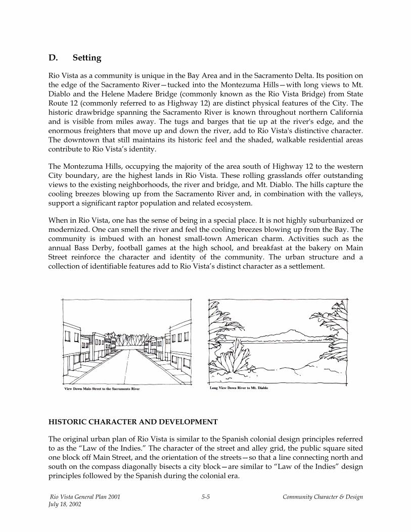
Rio Vista as a community is unique in the Bay Area and in the Sacramento Delta. Its position on the edge of the Sacramento River—tucked into the Montezuma Hills—with long views to Mt. Diablo and the Helene Madere Bridge (commonly known as the Rio Vista Bridge) from State Route 12 (commonly referred to as Highway 12) are distinct physical features of the City. The historic drawbridge spanning the Sacramento River is known throughout northern California and is visible from miles away. The tugs and barges that tie up at the river's edge, and the enormous freighters that move up and down the river, add to Rio Vista's distinctive character. The downtown that still maintains its historic feel and the shaded, walkable residential areas contribute to Rio Vista’s identity.
The Montezuma Hills, occupying the majority of the area south of Highway 12 to the western City boundary, are the highest lands in Rio Vista. These rolling grasslands offer outstanding views to the existing neighborhoods, the river and bridge, and Mt. Diablo. The hills capture the cooling breezes blowing up from the Sacramento River and, in combination with the valleys, support a significant raptor population and related ecosystem.
When in Rio Vista, one has the sense of being in a special place. It is not highly suburbanized or modernized. One can smell the river and feel the cooling breezes blowing up from the Bay. The community is imbued with an honest small-town American charm. Activities such as the annual Bass Derby, football games at the high school, and breakfast at the bakery on Main Street reinforce the character and identity of the community. The urban structure and a collection of identifiable features add to Rio Vista’s distinct character as a settlement.
HISTORIC CHARACTER AND DEVELOPMENT
The original urban plan of Rio Vista is similar to the Spanish colonial design principles referred to as the “Law of the Indies.” The character of the street and alley grid, the public square sited one block off Main Street, and the orientation of the streets—so that a line connecting north and south on the compass diagonally bisects a city block—are similar to “Law of the Indies” design principles followed by the Spanish during the colonial era.
Rio Vista General Plan 2001 5-5 Community Character & Design July 18, 2002
The City retains its original urban structure—a grid system comprised of 250-foot square blocks, with 20-foot-wide alleys bisecting the block in both directions. The grid is oriented 45 degrees west of north, with a strong orientation to the edge of the Sacramento River. Main Street leads directly to a landing and ferry dock at the edge of the river, and a public square is located one block south of Main Street. The original road and alley structure provide an accessible and pedestrian-friendly urban environment, where residential neighborhoods are well connected to the commercial activities along Main Street and the river edge. The ease of movement throughout the downtown core is a function of scale, combined with the road and alley grid that allows an opportunity to change direction every half block. These numerous intersections and rights-of-way contribute to the well-integrated residential and commercial activities. Today, as in the early years of Rio Vista, the primary commercial activities are located along Main Street, the edge of the Sacramento River, and Highway 12.
By 1903, the majority of the original urban plan was complete, and the grid extended to its current limits. The original grid supported the modest growth of the town between the early 1900s and the end of World War II. After the war, several annexations were approved that began a process of urban expansion influenced by the widespread use of the automobile. Highway 12 created a barrier between the developing residential areas to the north and the existing urban core along Main Street. Residential development after World War II was oriented toward the automobile. Developers often stretched blocks into long rectangular patterns to reduce road construction and increase lot yield. Some cul-de-sacs appeared, and the character and inter-connectedness of the urban structure began to change, although the new neighborhoods remained relatively compact and well connected internally. The relatively few neighborhoods that were developed in Rio Vista between 1950 and 1990 are isolated from older areas, largely due to the bisection of the community by Highway 12. The edge of this pre-1990 community remains well defined in most areas.
The traditional grid provides the shortest trip lengths and the largest number of route choices (and therefore the most convenient pedestrian travel) of any street layout, due to the multitude of interconnections available within a 250– to 300-foot block length. Like most American communities, Rio Vista began to deviate from the traditional grid street system after World War II. A return to the pre-1900s grid is not necessarily the solution for Rio Vista or any developing American city. The future may lie in a hybrid of development patterns that seeks to balance the need for connectedness with current development strategies and consumer interests.
Conventional suburban neighborhood streets also have changed in character and shape. A typical historic residential street section was from 24 to 28 feet curb-to-curb, with a “parkway strip” or “tree lawn” between the sidewalk and the property line. Typically, street trees were planted in the parkways, providing shade and definition to the street edge and separating pedestrian from vehicular traffic. The typical post-war street is at least 36 feet wide at the curbs, with a “monolithic” sidewalk that is adjacent to the curb and no parkway. If street trees are planted, they occur in public utility easements or front yards, where they are much less likely to survive. Most modern neighborhoods do not produce the tree canopy that was commonplace in historic residential neighborhoods. Notable exceptions are the 1950s neighborhoods north of Highway 12. Here, monolithic sidewalks exist but street trees were planted close to the walks; a
Rio Vista General Plan 2001 5-6 Community Character & Design July 18, 2002
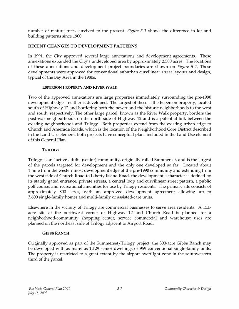
number of mature trees survived to the present. Figure 5-1 shows the difference in lot and building patterns since 1900.
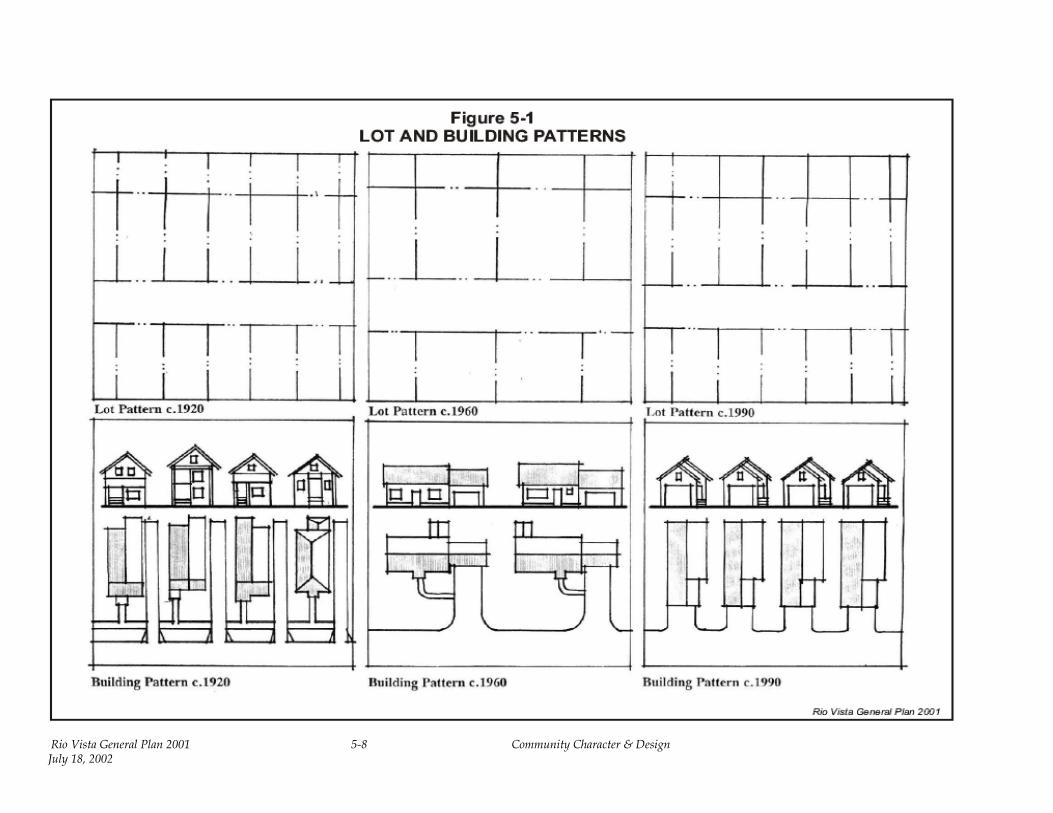
RECENT CHANGES TO DEVELOPMENT PATTERNS
In 1991, the City approved several large annexations and development agreements. These annexations expanded the City’s undeveloped area by approximately 2,500 acres. The locations of these annexations and development project boundaries are shown on Figure 5-2. These developments were approved for conventional suburban curvilinear street layouts and design, typical of the Bay Area in the 1980s.
ESPERSON PROPERTY AND RIVER WALK
Two of the approved annexations are large properties immediately surrounding the pre-1990 development edge—neither is developed. The largest of these is the Esperson property, located south of Highway 12 and bordering both the newer and the historic neighborhoods to the west and south, respectively. The other large parcel, known as the River Walk property, borders the post-war neighborhoods on the north side of Highway 12 and is a potential link between the existing neighborhoods and Trilogy. Both properties extend from the existing urban edge to Church and Amerada Roads, which is the location of the Neighborhood Core District described in the Land Use element. Both projects have conceptual plans included in the Land Use element of this General Plan.
TRILOGY
Trilogy is an “active-adult” (senior) community, originally called Summerset, and is the largest of the parcels targeted for development and the only one developed so far. Located about 1 mile from the westernmost development edge of the pre-1990 community and extending from the west side of Church Road to Liberty Island Road, the development’s character is defined by its stately gated entrance, private streets, a central loop and curvilinear street pattern, a public golf course, and recreational amenities for use by Trilogy residents. The primary site consists of approximately 800 acres, with an approved development agreement allowing up to 3,600 single-family homes and multi-family or assisted-care units.
Elsewhere in the vicinity of Trilogy are commercial businesses to serve area residents. A 15±-acre site at the northwest corner of Highway 12 and Church Road is planned for a neighborhood-community shopping center; service commercial and warehouse uses are planned on the northeast side of Trilogy adjacent to Airport Road.
GIBBS RANCH
Originally approved as part of the Summerset/Trilogy project, the 300-acre Gibbs Ranch may be developed with as many as 1,129 senior dwellings or 959 conventional single-family units. The property is restricted to a great extent by the airport overflight zone in the southwestern third of the parcel.
Rio Vista General Plan 2001 5-7 Community Character & Design July 18, 2002
Rio Vista General Plan 2001 5-8 Community Character & Design July 18, 2002
Figure 5-2 DEVELOPED AREAS AND RECENT ANNEXATIONS
Rio Vista General Plan 2001 5-9 Community Character & Design July 18, 2002

Allowable uses under the Airport/Land Use Compatibility Plan (ALUP) include a golf course, other open space uses and industrial and warehouse (see discussions in the Land Use and Safety & Noise elements). The City has approved development agreements for predominantly residential projects with some neighborhood and community-serving commercial uses. Included are significant areas of low-intensity open space or golf course uses due to floodplain and airport flight zone constraints.
Unlike areas to the east, Gibbs Ranch (along with Trilogy) is relatively flat and unrestricted, except for some floodplain areas around Liberty Island and Canright Roads. Most of the undeveloped lands are still in grazing or dry land agricultural uses, pending future development.
BRANN RANCH
The 300-acre Brann Ranch, which lies west of Liberty Island Road and north of Highway 12, is also approved as an unrestricted residential development (i.e., not senior housing). The project was approved in the early 1990s as a conventional suburban, predominantly single-family subdivision with curvilinear streets—development has not commenced to date. Development is restricted by the airport, but less so than for the Gibbs Ranch. A relatively large open space area is provided that is primarily floodplain. A small creek channel meanders through the middle of the parcel, adjacent to Canright Road. The approved tentative map includes a conventional, modern street layout that features long blocks, curvilinear pattern, and standard widths.
HOMECOMING
A smaller subdivision, known as Homecoming, is located north of Highway 12 and River Walk; east of Trilogy; and adjacent to the Rio Vista Business Park (former airport). The subdivision is characterized by conventional, post-war streets and contains approximately 290 single-family homes that are near completion.
NATURAL GAS WELL SITES
A number of natural gas well sites exist throughout the undeveloped portion of the Planning Area—most are located on the Esperson property. Several wells are currently in production in or around this area south of Highway 12. Presently, the gas well sites in Trilogy are not in production. Until they are drilled and begin producing, the sites are being used for private open space facilities to serve neighborhood open space needs. Gibbs Ranch also has five such sites, several of which are located in the residential areas and provide the same open space opportunities. Brann Ranch has only a few gas well sites, most of which are located in areas proposed for larger open space uses.
Rio Vista General Plan 2001 5-10 Community Character & Design July 18, 2002
E. Outlook
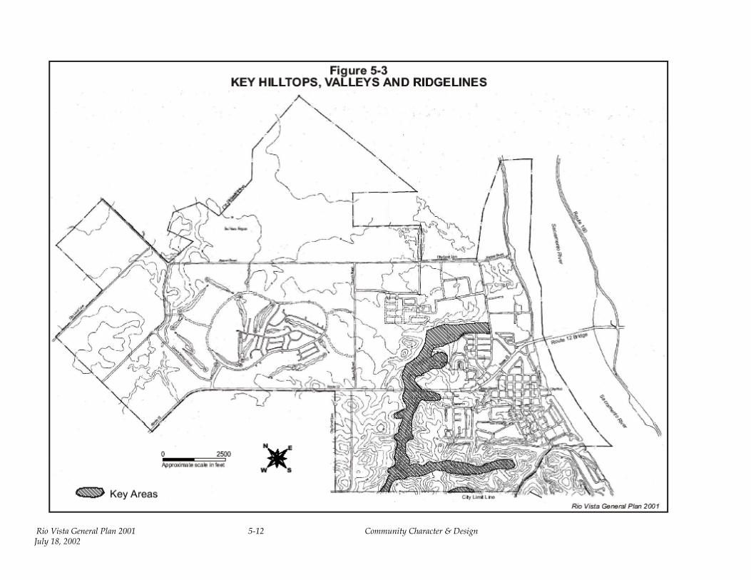
Rio Vista's relationship to the land is at the center of its character as a city. The environmentally sensitive and beautiful Montezuma Hills, which roll through much of the Planning Area, should be the primary shaper of the community’s future form. To both protect and develop the landscape of the Montezuma Hills is the fundamental purpose and challenge for which this element was developed. Figure 5-3 identifies the general locations of key hilltops, valleys, and ridgelines.
LANDS EAST OF CHURCH AND AMERADA ROADS
This portion of the Planning Area is the highest and most steeply sloped land within the city limits. The Montezuma Hills extend into these lands and display their most significant features, including natural drainageways, hillsides, and view opportunities. The preservation of landforms can create places for extensive views, natural drainage flows, public open space, and protected habitat. The edge between the existing (pre-1990) urban neighborhoods and this portion of the Planning Area has few road stubs or open space connections to roads that could be used for pedestrian, bicycle, or emergency access. This element and the Circulation & Mobility element seek to take advantage of the few opportunities to connect the existing community to future development. Hilltops create opportunities for visual connections to the existing urban center and regional landscape. The use of natural gas well sites for open space amenities, implementation of a comprehensive parks and trails system, and the application of street standards to achieve the desired balance between motorized and non-motorized travel are objectives that can be achieved to help meet community character goals for this portion of the Planning Area.
The system of natural gas wells and transmission line easements is both an opportunity for public open space and a constraint to development. The gas well drill sites require a 150-foot-radius clear zone around the well. Although the drill site itself is typically a fenced enclosure, 40 by 40 feet or less, the clear zone constrains development and provides potential for public open space. The even distribution of the well sites within the study area presents an opportunity to develop an equal distribution of neighborhood parks with convenient access to surrounding neighborhoods. To provide sufficient community or active park space that meets park and recreation standards (for example, for regulation fields), these clear zones will need to be expanded or supplemented in various areas. Although the gas transmission line easements are usable as public trail corridors or perhaps street locations, the easements divide the area into oddly shaped sections that are more difficult to subdivide. It may be possible to move these transmission lines as a part of the development process.
Rio Vista General Plan 2001 5-11 Community Character & Design July 18, 2002
Rio Vista General Plan 2001 5-12 Community Character & Design July 18, 2002
Opportunities exist in the area for a diverse public park and trail system. The scale of the plan area, the distribution of the natural gas system, and the location of the main drainage corridor, create an opportunity to enhance the recreational potential of the site and provide an important addition to the entire City’s circulation system. The parks and trails can connect the existing urban center and the Planning Area, and aid in the preservation of habitat. The Circulation & Mobility and Open Space & Recreation elements identify a pedestrian and bicycle trail and pathway system, linking the Sacramento River to existing neighborhoods and downtown, as well as future neighborhoods, parks, and commercial centers. These opportunities are further developed in the Land Use, Resource Conservation & Management, and Public Facilities & Services elements.
LANDS WEST OF CHURCH AND AMERADA ROADS
The lands west of Church and Amerada Roads are generally flatter and have less sensitive natural resource areas than the lands east of Church Road. Only a small portion of the lands south of Highway 12 are within the city limits or urban growth boundary (UGB) (see the Planning Constraints & Boundaries element). The lands south of the highway therefore are expected to remain in agricultural uses for the duration of the planning period. Lands north of the highway that are within the UGB consist of Sub-Planning Areas 4 and 5 on the Rio Vista General Plan Area and Sub-Planning Areas Map (see the discussion on “Planning Areas” in the Land Use element). Sub-Planning Area 4 consists of the 820±–acre Marks Ranch, the site of the Trilogy senior housing development and commercial lands, plus the 320-acre each Gibbs and Brann Ranches—expected to be developed as family residential neighborhoods. The Brann and Gibbs Ranches should be designed and developed to function in an integrated manner. An elementary school and community park site, as well as potential employment, retail and commercial development, and other community facilities will be located there. (See Land Use, Housing, Economic Development, Open Space & Recreation, and Public Facilities & Services elements, respectively.) Sub-Planning Area 5 consists of the airport, public and restricted lands, and the future Northwest Wastewater Treatment Plant site (see the Planning Constraints & Boundaries, Land Use, and Safety & Noise elements).
The same conditions, opportunities, and expectations exist in Sub-Planning Area 4 as in the lands east of Church and Amerada Roads. The entire area contains pre-sited existing and future natural gas wells and mineral reserve areas that provide both challenges and opportunities for neighborhood open space and landscaping. By virtue of its private streets and recreation system, the Trilogy project uses and maintains these sites as neighborhood open spaces through the homeowners’ association.
This area is expected to utilize the same neighborhood street system and standards as the area east of Church and Amerada Roads, in family housing neighborhoods, where public streets are expected. Private streets may vary from public streets in most locations.
HIGHWAY 12 CORRIDOR
Through much of Rio Vista, Highway 12 is a high-speed, two-lane roadway without pedestrian access, turn lanes, or road shoulders to provide a measure of safety. The existing commercial uses adjacent to the highway lack adequate landscaping, traffic or turn movement controls, pedestrian crossings, and even sidewalks in numerous locations. Handicapped access to
Rio Vista General Plan 2001 5-13 Community Character & Design July 18, 2002
sidewalks is practically nonexistent. Although the highway is the City’s “front door” and near Rio Vista’s historic downtown and waterfront, few linkages connect the downtown residential and commercial uses and the highway commercial “strip.”
During the series of Town Hall meetings that initiated the General Plan effort, Highway 12 was identified as one of the most significant concerns of Rio Vista residents—particularly in the areas of safety, access, and more efficient traffic movement. The General Plan update process also has identified a strong interest in providing a pedestrian and bicycle trail and pathway system, linking the Sacramento River to existing neighborhoods and downtown, as well as to future neighborhoods, parks, and commercial centers. Highway 12 often acts as a barrier between the two “halves” of Rio Vista; pedestrian crossings are particularly hazardous. This hazard poses one of the most serious obstacles to the realization of a trail system linkage. A plan must be developed for crossing Highway 12 at key locations between signalized intersections.
The environmental and aesthetic character of the Highway 12 corridor varies in different places throughout the City. From the east, the character is still largely rural as one enters the city limits; rural character is found on the south frontage, with a rural-suburban design on the north frontage next to Summerset/Trilogy. Continuing east beyond Church Road, Highway 12 traverses a series of hills and drainages before reaching Drouin Drive near the edge of the developed area. From Drouin Drive to the bridge, the existing highway commercial district dominates both sides.
Highway 12 will continue to serve as the principal bicycle corridor, as shown in the Solano Countywide Bicycle Master Plan. The Circulation & Mobility element of this General Plan shows this bicycle lane on its pedestrian and bicycle trail and pathway system (Trail and Pathways Map). Currently, the community is not linked by bicycle paths. As development proceeds, the City intends to provide trail connections along Highway 12 from the Sacramento River to existing neighborhoods and downtown, as well as to future neighborhoods, parks, and commercial centers.
CHARACTER OF STREETS
Modern street standards typically are oriented toward safe and efficient automobile travel and easy emergency vehicle access. Generally, street standards are less concerned with pedestrians, bicycles, street character, and microclimatic issues. Because streets occupy the majority of the public domain, they can be designed to serve the whole community. Traditional (narrower roadways, parkways, and street trees) rather than modern street standards should be used wherever possible. Private streets may vary from public streets in some locations. The Circulation & Mobility element establishes a performance-based public street system for future neighborhoods. Within the performance-based street system, layout can vary considerably, based on desired density or aesthetic and engineering issues. The “grain” (the overall urban character or the combined impact of block, street, lot, and house size) of the existing urban center is a model for the desired grain of the future neighborhoods. The Circulation & Mobility element includes a full discussion of street standards.
Rio Vista General Plan 2001 5-14 Community Character & Design July 18, 2002
DOWNTOWN/WATERFRONT AND HISTORIC RESIDENTIAL NEIGHBORHOODS
Rio Vista’s historic urban structure is a point of reference as the City grows and develops new streets and neighborhoods, particularly for those lands immediately adjacent to the pre-1990 urban edge. It is important to identify what works best about the existing community and how that knowledge can be applied to current issues and concerns. It is also important to emphasize that even Rio Vista’s postwar neighborhoods exhibit several of the distinguishing characteristics of the historic pattern—they are compact, and generally grid-based neighborhoods. Some of these neighborhoods also retain the traditional tree canopy. Only the largest and most recent project, Summerset/Trilogy deviates significantly from this context—in terms of its isolation from other neighborhoods and the downtown, and in the character of the community (i.e., a gated, largely self-contained community that provides recreational facilities to its occupants). The goals and policies of this element seek a balance between successful historical patterns and the realities of current development trends—emphasizing the need for connection between new areas and old, and building on the desirable characteristics of the existing community.
Figure 5-4 shows the historical development pattern of Rio Vista. The structure of the City, particularly its historic core, is clear and easy to travel. The historic grid is oriented to the River and facilitates access to its banksMain Street leads directly to the River’s edge.
Commercial activities are organized along Main Street and the river, and the grid provides easy access to the adjacent residential areas. The recognition of landmarks also adds to the structure of the City. The continuity of the river edge, the historic drawbridge, the landform and gradients up from the river, and the panoramic views of Mt. Diablo are all part of the structure of the City.
Figure 5-5 shows the historic lot patterns in the historic residential neighborhoods. Most of these neighborhoods contain mixed uses, with single-family homes, duplexes, small multi-family units, civic buildings, churches, and schools existing side-by-side—often within the same block. Conventional zoning standards do not fit well in these neighborhoods. The Land Use element takes the first step to correcting this problem by recognizing existing neighborhood characteristics through the Existing City Districts. (See Figures 4-2 and 4-3 in the Land Use element.)
The City has recently completed its City of Rio Vista Downtown Marketing and Design Study (Jeffrey Eichenfeld & Associates et al., 1999) that recommended specific streetscape improvements along Main Street and historic building rehabilitations. Grants totaling $900,000 recently have been confirmed from the Metropolitan Transportation Commission (MTC) Transportation for Livable Communities (TLC) Program and the Solano Transportation Authority (STA) to implement the streetscape improvements along Main Street. Completion is scheduled for 2001. The project will consist of street trees, lighting, pavement reconstruction, street furniture, and curb improvements. Design guidelines for the historic structures currently are being formulated from these recommendations.
The downtown waterfront south of the Rio Vista Bridge provides an opportunity for public access and redevelopment. The areas between the river and Front Street, and from the Bridge to Main Street, are currently the subject of a design and development planning study that will produce a recommended development plan for the area.
Rio Vista General Plan 2001 5-15 Community Character & Design July 18, 2002

Rio Vista General Plan 2001 Community Character &July 18, 2002
5-16 5-16
Design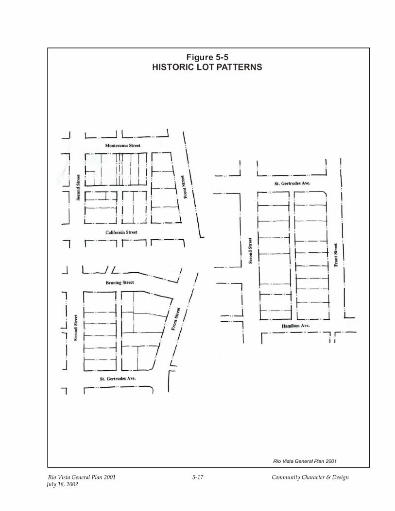
Rio Vista General Plan 2001 5-17 Community Character & Design July 18, 2002

F. Goals, Policies, and Implementing Actions
Community Character & Design goals, policies, implementing actions, and design criteria stem from, and are directly intended to achieve, the related Rio Vista Principles and vision statements described in Section C above. Because policies of this element primarily are concerned with design, implementing actions are presented in the form of design criteria. These criteria are specific design statements intended to give direction for carrying out the policies with respect to various site and building issues. Many of the criteria eventually will be incorporated into a separate design standards or guidelines document. Because the design criteria are consistent with the goals and policies of the General Plan, they can be used as a tool by staff and the Planning Commission to evaluate new development proposals.
The Community Character & Design element focuses on 15 policy areas:
• Environmental design. • Entryways, identity features, and focal points in new developments. • Highway 12. • Streets and blocks. • Residential housing. • Ancillary or second units (carriage units). • Multi-family attached housing. • Nonresidential building siting, orientation, and access. • Neighborhood core district. • Highway and convenience commercial. • Business park and airport commercial. • Lighting and signage. • Existing city districts. • Reconstruction and new additions. • Rehabilitation and remodeling.
The implementing actions associated with each policy are described fully at the end of this element.
ENVIRONMENTAL DESIGN
Rio Vista is a visually interesting and vibrant city, with its built environment enveloped in a naturally beautiful one. Extending along the banks of the Sacramento River, the City’s riverfront remains natural in areas that extend beyond its working waterfront and active recreation spots.
The hilltops of Rio Vista, dotted with natural gas wells, are familiar landmarks that are open to outstanding views and connect the existing historic community to the larger regional landscape.
Rio Vista General Plan 2001 5-18 Community Character & Design July 18, 2002
The valleys form an effective natural drainage system that manages storm runoff and provides corridors for public trails and wildlife. Preservation of key hilltops and valleys allows this natural system to become a useful and beneficial public resource, benefiting the overall health of the community.
The preservation and development of habitat is central to a healthy, low-maintenance open space system. Natural drainage corridors have a greater carrying capacity. By slowing runoff, these corridors reduce erosion and the risk of flooding. Native, drought-tolerant plants fit the character of the landscape, reduce maintenance and irrigation costs, and contribute to the habitat value of the open space system.
Goals, policies, and implementation measures, including design criteria, that relate to these key resources and the opportunities they represent, are stated mainly in three Elements: Chapter 5, Community Character and Design; Chapter 9, Open Space and Recreation; and Chapter 10, Resource Conservation and Management.
GOAL 5.1 TO RESPECT THE CHARACTER OF THE EXISTING LANDFORM AND THE NATURAL DRAINAGE PATTERNS.
Policy Implementing Action
5.1.A The City shall protect natural drainage flows to the greatest extent possible.
CD-1 Environmental/Visual Constraints Map
CD-2 Environmental Design Criteria
5.1.B The City shall ensure that natural creek beds and watercourses remain undisturbed for a minimum distance of 20 feet from the top of the bank.
CD-1 Environmental/Visual Constraints Map
CD-2 Environmental Design Criteria
5.1.C The City shall protect key hilltops, valleys, and watercourses from mass grading. See also policies of Goals 10.5, 10.6 and 10.11.
CD-1 Environmental/Visual Constraints Map
CD-2 Environmental Design Criteria
Rio Vista General Plan 2001 5-19 Community Character & Design July 18, 2002
GOAL 5.2 TO WEAVE THE NATURAL FEATURES OF RIO VISTA INTO THE URBAN FABRIC FOR PUBLIC USE.
Policy Implementing Action
5.2.A The City shall integrate natural gas well sites and transmission line easements into the public parks and open space system.
CD-2 Environmental Design Criteria CD-3 Parks Master Plan CD-4 Trails and Pathways Map
5.2.B The City shall preserve key hilltops for public use and views.
CD-1 Environmental/Visual Constraints Map
CD-2 Environmental Design Criteria CD-3 Parks Master Plan CD-4 Trails and Pathways Map
GOAL 5.3 TO DEVELOP AN INTERCONNECTED PUBLIC PARK AND OPEN SPACE SYSTEM.
Policy Implementing Action
5.3.A The City shall require the development of trail connections between public parks and open space to the greatest extent feasible.
CD-2 Environmental Design Criteria CD-3 Parks Master Plan CD-4 Trails and Pathways Map
GOAL 5.4 TO PROTECT AND DEVELOP NATIVE HABITAT AND CREATE A VARIETY OF RECREATIONAL EXPERIENCES.
Policy Implementing Action
5.4.A The City shall require development projects to incorporate native habitat, trails, and parks into the site design to the greatest extent feasible.
CD-1 Environmental/Visual Constraints Map
CD-2 Environmental Design Criteria CD-3 Parks Master Plan CD-4 Trails and Pathways Map
Rio Vista General Plan 2001 5-20 Community Character & Design July 18, 2002

GOAL 5.5 TO BUILD A STRONG AND USABLE PUBLIC TRAIL SYSTEM.
Policy Implementing Action
5.5.A The City shall integrate streets and trails into a multi-modal transportation network that serves the whole community.
CD-2 Environmental Design Criteria CD-3 Trails and Pathways Map
ENTRYWAYS, IDENTITY FEATURES, AND FOCAL POINTS IN NEW DEVELOPMENTS
Rio Vista gains its identity largely through the views that are perceived by its residents and visitors to the City. The community recognizes the importance of its identity and is committed to creating a special environment. Several distinctive features define Rio Vista, such as the Rio Vista Bridge, the waterfront, the historic downtown, and the City’s traditional neighborhoods. These features, along with numerous other landmarks and unique areas, can be preserved and enhanced through a comprehensive approach to community design.
The City can continue to build a strong, appealing image by providing policy direction that emphasizes enhancing the community’s inherent physical qualities and values. The policies presented below will facilitate creation of a memorable City image by defining the entries to Rio Vista, preserving City landmarks, and encouraging distinctive private development. An opportunities map for community entryways, identity features, and landmarks is shown in Figure 5-6.
GOAL 5.6 TO CREATE A STRONG SENSE OF COMMUNITY IDENTITY.
Policy Implementing Action
5.6.A The City shall establish a hierarchy of community features and focal points, as shown in Figure 5-6.
CD-5 Community Design Criteria
5.6.B The City shall ensure that community features are placed at key gateways or entries along Highway 12.
CD-5 Community Design Criteria
Rio Vista General Plan 2001 5-21 Community Character & Design July 18, 2002

5-23 5-22 Community Character & Design July 18, 2002 Rio Vista General Plan 2001
Policy Implementing Action
5.6.C For secondary entryways that are considered important, but not primary entries for residents and visitors, the City shall locate them on Airport Road, Montezuma Hills Road-Second Street, Beach Street, and Front Street.
CD-5 Community Design Criteria
GOAL 5.7 TO CREATE COMMUNITY LANDMARKS AND FOCAL POINTS AT STRATEGIC AND IMPORTANT ACTIVITY CENTERS.
Policy Implementing Action
5.7.A The City shall incorporate community landmarks and focal points into community and neighborhood parks, linear pathway intersections, and commercial areas in the Existing City and Neighborhood Core Districts.
CD-5 Community Design Criteria
5.7.B The City shall ensure that structures at corners of major intersections, dominant buildings in a cluster or complex, and central gathering places become community landmarks. The City shall ensure that these structures are designed to provide definition and identity to the community and individual neighborhood through the use of significant building features and landscaping.
CD-5 Community Design Criteria
5.7.C The City shall ensure that special landscaping treatment, textured paving, monuments, or community identity signage is placed at primary access points in order to defined project areas, major and minor street intersections; and at mid-block points for longer residential blocks.
CD-5 Community Design Criteria
Rio Vista General Plan 2001 5-23 Community Character & Design July 18, 2002
Policy Implementing Action
5.7.D The City shall require developers to create core commercial landmarks with the use of building features at key locations and the creation of central plazas and open space courtyards, which would provide an internal focus for any commercial or mixed-use project.
CD-5 Community Design Criteria
5.7.E The City shall ensure that developers incorporate such building features as clock towers, steeples, and cupolas into new structures at key focal points.
CD-5 Community Design Criteria
HIGHWAY 12
Highway 12 is the principal corridor through the City of Rio Vista. This highway serves as the entrance from the east—over the Rio Vista Bridge, and from the west— through the Montezuma Hills. Since most travelers pass through the City on Highway 12, facilitating well-designed development along this corridor is key to establishing a desirable community image.
GOAL 5.8 TO CREATE A STRONG SENSE OF ENTRY INTO THE CITY ALONG HIGHWAY 12.
Policy Implementing Action
5.8.A The City shall emphasize separation of local and through traffic in Highway 12 improvements and measures that slow motorists as they enter the city.
CD-6 Highway 12 Corridor Design Criteria
5.8.B The City shall construct traffic islands and street planting in order to provide a strong transition between through and local traffic.
CD-6 Highway 12 Corridor Design Criteria
5.8.C The City shall preserve existing terrain and grades to the greatest extent possible.
CD-6 Highway 12 Corridor Design Criteria
Rio Vista General Plan 2001 5-24 Community Character & Design July 18, 2002
Policy Implementing Action
5.8.D The City shall preserve the rural and rolling hillside and valley character of the Highway 12 corridor to the greatest extent possible.
CD-6 Highway 12 Corridor Design Criteria
5.8.E The City shall initiate a corridor design process that includes all stakeholders (private landowners and developers, Caltrans, the Highway 12 Association, local residents, and business owners) to create an appropriate standard for future expansion throughout the corridor and more immediate improvements between Drouin Drive and the Rio Vista Bridge.
CD-6 Highway 12 Corridor Design Criteria
5.8.F The City shall ensure that development encroaches as little as possible on sensitive areas adjacent to Highway 12.
CD-6 Highway 12 Corridor Design Criteria
STREETS AND BLOCKS
The guiding principle of the City’s circulation system is linking the community. Streets should be designed to unite the areas targeted for new development with the existing urban center. The street system should safely and efficiently link the neighborhoods, public facilities, and commercial uses of the Plan area in a manner that will serve the entire community.
Some of the older neighborhoods of Rio Vista are good models for street design. Traditional grid patterns, alleys to the rear of residences, and the scale of streets promote a pedestrian-friendly environment while also allowing efficient movement of motorized vehicles throughout a neighborhood.
Deciduous street trees create shade in summer, keep the pavement cool, and allow solar access during colder winter months. Trees soften the street and define corridors of use. Street trees are essential in making streets beautiful and livable.
These traditional neighborhood street design concepts are a key component of the General Plan’s vision for future development. To the extent practicable, the City seeks to preserve and promote this circulation concept throughout the urbanized area.
Rio Vista General Plan 2001 5-25 Community Character & Design July 18, 2002
GOAL 5.9 TO CREATE SAFE, ATTRACTIVE STREETS THAT SERVE THE ENTIRE COMMUNITY.
Policy Implementing Action
5.9.A The City shall create street patterns that provide pedestrian opportunities, variety, and visual interest.
CD-7 Streets and Blocks Design Criteria
5.9.B The City shall interconnect the neighborhood street pattern at numerous points in a traditional village system in order to avoid a concentration on major streets of vehicles and pedestrians associated with internal neighborhood trips.
CD-7 Streets and Blocks Design Criteria
5.9.C The City shall discourage long, unbroken blocks; interruptions of pathways to logical destinations; or other design elements that discourage pedestrian circulation in favor of the automobile for internal trips.
CD-7 Streets and Blocks Design Criteria
5.9.D The City shall use deciduous street trees in order to create a shaded environment in summer and to define the clear separation of uses.
CD-7 Streets and Blocks Design Criteria
5.9.E The City shall ensure that primary pedestrian accesses (i.e., front doors) to all single-family and most multi-family residences face a public street or pathway in order to orient residences to public areas, rather than to interior blocks or parking lots.
CD-7 Streets and Blocks Design Criteria
5.9.F The City shall ensure that clustered and attached housing units front privately maintained common greens or—if present —access ways, where a public street or pathway is not accessible.
CD-7 Streets and Blocks Design Criteria
Rio Vista General Plan 2001 5-26 Community Character & Design July 18, 2002
Policy Implementing Action
5.9.G The City shall maintain safety along major streets by the use of frontage drives paralleling the major street or extensive landscaped pedestrian pathway corridors.
CD-7 Streets and Blocks Design Criteria
5.9.H Where feasible, the City shall ensure that developments are designed so that a neighborhood street or pathway abuts the nonresidential site on at least one side adjacent to the residential neighborhood.
CD-7 Streets and Blocks Design Criteria
5.9.I The City shall ensure that all homes within a neighborhood are connected by minor streets and pedestrian corridors to community civic areas, schools, parks, workplace, and commercial areas.
CD-7 Streets and Blocks Design Criteria
5.9.J The City shall ensure wherever feasible that no resident is forced to travel on an arterial street in order to access a neighborhood park, community facility or neighborhood-serving retail use within ¼-mile from home.
CD-7 Streets and Blocks Design Criteria
GOAL 5.10 TO INCLUDE PEDESTRIANS AND BICYCLES AS A CENTRAL ELEMENT IN THE STREET SYSTEM DESIGN.
Policy Implementing Action
5.10.A The City shall ensure that subdivision design facilitates walking and bicycling and discourages short auto trips.
CD-7 Streets and Blocks Design Criteria
Rio Vista General Plan 2001 5-27 Community Character & Design July 18, 2002
Policy Implementing Action
5.10.B The City shall design neighborhood and local street widths such that they slow traffic and create a safer pedestrian and bicycle environment.
CD-7 Streets and Blocks Design Criteria
5.10.C The City shall require multiple linkages and grid patterns as part of a comprehensive street system.
CD-7 Streets and Blocks Design Criteria
5.10.D The City shall provide direct pedestrian access from neighborhoods to nonresidential uses where residential neighborhoods abut planned commercial centers, or quasi-public or office uses.
CD-7 Streets and Blocks Design Criteria
5.10.E The City shall locate pedestrian access routes along the streets or so that they are easily visible from streets.
CD-7 Streets and Blocks Design Criteria
5.10.F The City shall discourage access routes through parking lots and loading and service areas, or behind residential rear yards wherever possible.
CD-7 Streets and Blocks Design Criteria
RESIDENTIAL HOUSING
The community characteristics of the historic residential neighborhoods (i.e., their overall proportions and the combined impact of block, street, lot, and house size) are a model for the desired character of the new growth areas. The placement and orientation of residential buildings on a lot or building site and their relationship to the public street are crucial to achieving the City’s desired community character.
“Conventional” or modern subdivision design includes placement of the garage in front of the house toward the street, with the rest of the structure behind or to the side of the garage. Often, the garage accounts for more than half the visible house frontage or lot width, and sometimes as much as 80 percent or more. The garage thus becomes the primary visual element of the streetscape, with the living areas becoming secondary. This “conventional” garage placement
Rio Vista General Plan 2001 5-28 Community Character & Design July 18, 2002

reduces the driveway length, forcing cars to be parked closer to the street, adding further to automobile dominance of the streetscape.
Coupling these features with the widths for two- and three-car garages and driveways—in addition to wide streets—creates an environment that limits pedestrian comfort or convenience and discourages street use for any purpose other than driving or parking motor vehicles. The public realm of street and neighborhood become remote and out of sight; family living and recreation activities take place behind closed doors and in back yards, away from the street. This design reduces community interaction and contact with neighbors.
On blocks with relatively small lots, garages should be recessed or pushed back at least 15 feet behind the front living area or porch so that cars parked in the driveway do not dominate the streetscape. By locating the garage toward the rear of the site and by reducing the driveway cut to one lane, the continuity of street edges and the public landscape are enhanced. Pulling the house forward on the site and recessing the garage improves street character and increases the private rear yard area.
A shift away from conventional residential subdivision design toward more traditional neighborhood design will help to promote community interaction, increase efficiency in movement throughout the community, and retain the City’s small-town flavor. The General Plan’s policies and design guidelines for residential housing are intended to guide development in this direction.
GOAL 5.11 TO ENHANCE COMMUNITY CHARACTER THROUGH RESIDENTIAL BUILDING ORIENTATION, ARCHITECTURE, AND REVERSAL OF GARAGE-DOMINATED STREETSCAPES.
Policy Implementing Action
5.11.A The City shall ensure the placement of residential structures on lots and building sites is carried out in a manner that reinforces residents’ awareness of the neighborhood and community interaction.
CD-8 Residential Housing Design Criteria
5.11.B The City shall ensure that house frontages, yards, and sidewalks are the prominent features of the streetscape and that attached garages do not dominate the appearance of the front elevation of any residential structure.
CD-8 Residential Housing Design Criteria
Rio Vista General Plan 2001 5-29 Community Character & Design July 18, 2002
Policy Implementing Action
5.11.C The City shall achieve visual interest through a variety of architectural elements.
CD-8 Residential Housing Design Criteria
5.11.D The City shall ensure that all elevations of a building have consistent architectural treatments, although one or more elevations may be emphasized. Generally, the same treatment used on the front elevation will continue around the sides far enough to provide a finished appearance from the street.
CD-8 Residential Housing Design Criteria
5.11.E The City shall ensure that carports, garages, and other accessory structures incorporate the architectural theme of the main building, including roof line and materials.
CD-8 Residential Housing Design Criteria
5.11.F The City shall ensure that building entries receive special design treatment to provide a balanced sense of security and privacy.
CD-8 Residential Housing Design Criteria
5.11.G The City shall ensure that primary entries occur at frequent intervals along the street.
CD-8 Residential Housing Design Criteria
5.11.H The City shall ensure that primary entries are accented by the building’s architecture, preferably with a vertical feature such as a gable roof element or entry porch. The City will require parking areas to be placed behind multi-family structures, rather than adjacent to the public street wherever possible.
CD-8 Residential Housing Design Criteria
Rio Vista General Plan 2001 5-30 Community Character & Design July 18, 2002

GOAL 5.12 TO ENSURE THAT THE ARCHITECTURAL CHARACTER OF NEW NEIGHBORHOODS REFLECTS ELEMENTS OF HISTORIC RESIDENTIAL STYLES IN A MODERN CONTEXT.
Policy Implementing Action
5.12.A The City shall ensure that each neighborhood provides a variety of styles and architectural elements, including front and side porches, bay windows, roof lines, front door entrances, massing, and facade detailing.
CD-8 Residential Housing Design Criteria
5.12.B The City shall ensure that features and exterior colors vary from house to house along a street. The City shall ensure that significant changes in massing and rooflines are incorporated in elevations of the same floor plan in order to avoid a “tract” appearance.
CD-8 Residential Housing Design Criteria
5.12.C The City shall ensure that residential building design reflects a variety of forms—not only the addition of finishes to uncreative building “boxes.”
CD-8 Residential Housing Design Criteria
5.12.D The City shall ensure that exterior materials and architectural maintain a consistent and harmonious relationship and that frequent changes in materials are avoided.
CD-8 Residential Housing Design Criteria
ANCILLARY OR SECOND UNITS (CARRIAGE UNITS)
Ancillary units are second dwelling units on the same lot as a single-family home, variously known as “carriage houses” and “granny flats.” Carriage houses are ancillary units, typically built over detached garages. Carriage houses and other ancillary units help to provide affordable housing opportunities. These units support both pedestrian activity and transit use, by increasing the overall density of an area while maintaining its single-family character and ownership patterns. “Granny units” can be rented to offset housing costs for the primary unit, they can provide needed space for teens or elderly family members, and they can furnish additional studio or office space. As a source of affordable rental housing, these units avoid the
Rio Vista General Plan 2001 5-31 Community Character & Design July 18, 2002
“institutional” character of many apartment projects and the segregation of lower income residents.
GOAL 5.13 TO PROVIDE ADDITIONAL HOUSING OPPORTUNITIES BY INTEGRATING WELL-DESIGNED SECONDARY UNITS INTO RESIDENTIAL NEIGHBORHOODS.
Policy Implementing Action
5.13.A The City shall require that secondary units are consistent with the architectural theme of the main residence, including roof line and materials.
CD-9 Ancillary or Second Unit (Carriage Unit) Design Criteria
5.13.B The City shall require that parking for ancillary units is designed in order to avoid affecting neighborhood traffic safety or impairing useful open space (yard area) of the lot.
CD-9 Ancillary or Second Unit (Carriage Unit) Design Criteria
5.13.C The City shall require that ground-floor units adjacent to a street orient living spaces toward the street, rather than toward internal parking areas.
CD-9 Ancillary or Second Unit (Carriage Unit) Design Criteria
5.13.D The City shall require that secondary units can be accessed directly from the street wherever possible.
CD-9 Ancillary or Second Unit (Carriage Unit) Design Criteria
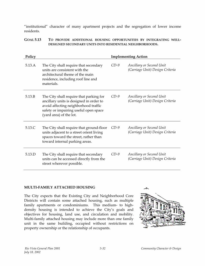
MULTI-FAMILY ATTACHED HOUSING
The City expects that the Existing City and Neighborhood Core Districts will contain some attached housing, such as multiple family apartments or condominiums. This medium- to high-density housing is intended to achieve the City’s goals and objectives for housing, land use, and circulation and mobility. Multi-family attached housing may include more than one family unit in the same building, occupied without restrictions on property ownership or the relationship of occupants.
Rio Vista General Plan 2001 5-32 Community Character & Design July 18, 2002
GOAL 5.14 TO INCLUDE MULTI-FAMILY HOUSING AS AN INTEGRAL PART OF A MIXED-USE SCENARIO IN THE DOWNTOWN COMMERCIAL DISTRICT, WHERE INTENSITY OF DEVELOPMENT SHOULD BE HIGHEST.
Policy Implementing Action
5.14.A The City shall ensure that primary entries to both ground- and upper-floor units adjacent to a street or plaza are visible from the street or plaza wherever possible and shall allow secondary building entries to face parking areas or internal open spaces.
CD-10 Multi-Family Unit Design Criteria
5.14.B The City shall ensure that building facades (including side or rear elevations) that face entry drives, public streets, or common open space are treated to provide architectural interest and orientation to the street or open space.
CD-10 Multi-Family Unit Design Criteria
5.14.C The City shall require that each multi-family residential unit have directly accessible, usable open space. This requirement shall not include parking areas, driveways, front yards, or buildings but may include recreation centers, decks, patios, or roofs with open space areas.
CD-10 Multi-Family Unit Design Criteria
NONRESIDENTIAL BUILDING SITING, ORIENTATION, AND ACCESS
Siting and orientation are as important for nonresidential buildings as for residential structures. Proper placement of office and commercial structures in relation to the surrounding development and roadways can facilitate pedestrian activity and reduce dependence on the automobile. In traditional neighborhoods and downtowns, the placement of businesses on the street—adjacent to a wide sidewalk—encourages easy pedestrian access from nearby neighborhoods and businesses, as well as access by vehicle. By contrast, modern centers typically turn unattractive “back doors” to the street and sidewalk, while their storefronts face internally toward the parking lots. They are located at intersections of arterials or major collector streets with few, if any, direct connections to adjacent neighborhoods. Even though strip centers and individual commercial uses frequently abut each other, direct connections do
Rio Vista General Plan 2001 5-33 Community Character & Design July 18, 2002
not exist between them. Consequently, cars are forced to back out onto the frontage street in order to access an adjacent center.
The General Plan policies and design criteria recognize that modern commercial centers need high visibility, necessitating locations at major intersections. However, the Nonresidential Design Criteria encourage the internal creation of a “Main Street” appearance, requiring building fronts to be oriented toward at least one street or plaza and away from parking lots. Linkages for both vehicles and pedestrians are to be created between commercial uses and residential neighborhoods, multi-family buildings, and plazas.
GOAL 5.15 TO DEVELOP ATTRACTIVE NONRESIDENTIAL DISTRICTS THAT ENCOURAGE PEDESTRIAN ACTIVITY AND PROVIDE MULTI-MODAL ACCESS FROM NEARBY NEIGHBORHOODS AND BUSINESS CENTERS.
Policy Implementing Action
5.15.A The City shall ensure that all nonresidential buildings front on adjacent streets and create a pedestrian orientation wherever possible.
CD-11 Nonresidential Building Siting, Orientation, and Access Design Criteria
5.15.B Where building orientation on the street is not feasible, the City shall require that businesses have landscaped setbacks from adjacent streets.
CD-11 Nonresidential Building Siting, Orientation, and Access Design Criteria
5.15.C The City shall ensure that new structures are complementary to (and not clash with) existing structures.
CD-11 Nonresidential Building Siting, Orientation, and Access Design Criteria
5.15.D The City shall require that all loading, delivery and storage areas, and mechanical and utility equipment are screened from views on public streets and pedestrian corridors.
CD-11 Nonresidential Building Siting, Orientation, and Access Design Criteria
5.15.E Where nonresidential buildings are sited close to a residential area, the City shall ensure that their scale and character complement the adjacent neighborhood.
CD-11 Nonresidential Building Siting, Orientation, and Access Design Criteria
Rio Vista General Plan 2001 5-34 Community Character & Design July 18, 2002
Policy Implementing Action
5.15.F The City shall require that site design and architecture protects the privacy of adjacent developments.
CD-11 Nonresidential Building Siting, Orientation, and Access Design Criteria
5.15.G Where backyards and parking and loading areas abut, the City shall require landscape buffers and walls between residential and nonresidential uses.
CD-11 Nonresidential Building Siting, Orientation, and Access Design Criteria
5.15.H The City shall require that pedestrian access between parking lots is provided.
CD-11 Nonresidential Building Siting, Orientation, and Access Design Criteria
5.15.I The City shall require that nonresidential development that abuts a residential neighborhood street provides both pedestrian and vehicular access to and from that street.
CD-11 Nonresidential Building Siting, Orientation, and Access Design Criteria
5.15.J The City shall require that side and rear facades of buildings are treated with the same quality of design and materials as the front elevations.
CD-11 Nonresidential Building Siting, Orientation, and Access Design Criteria
5.15.K Where location of a parking area or lot directly adjacent to a public street cannot be avoided, the City shall require that cars are screened from view by berms, walls, hedges, dense plantings, or a combination of these features.
CD-11 Nonresidential Building Siting, Orientation, and Access Design Criteria
Rio Vista General Plan 2001 5-35 Community Character & Design July 18, 2002
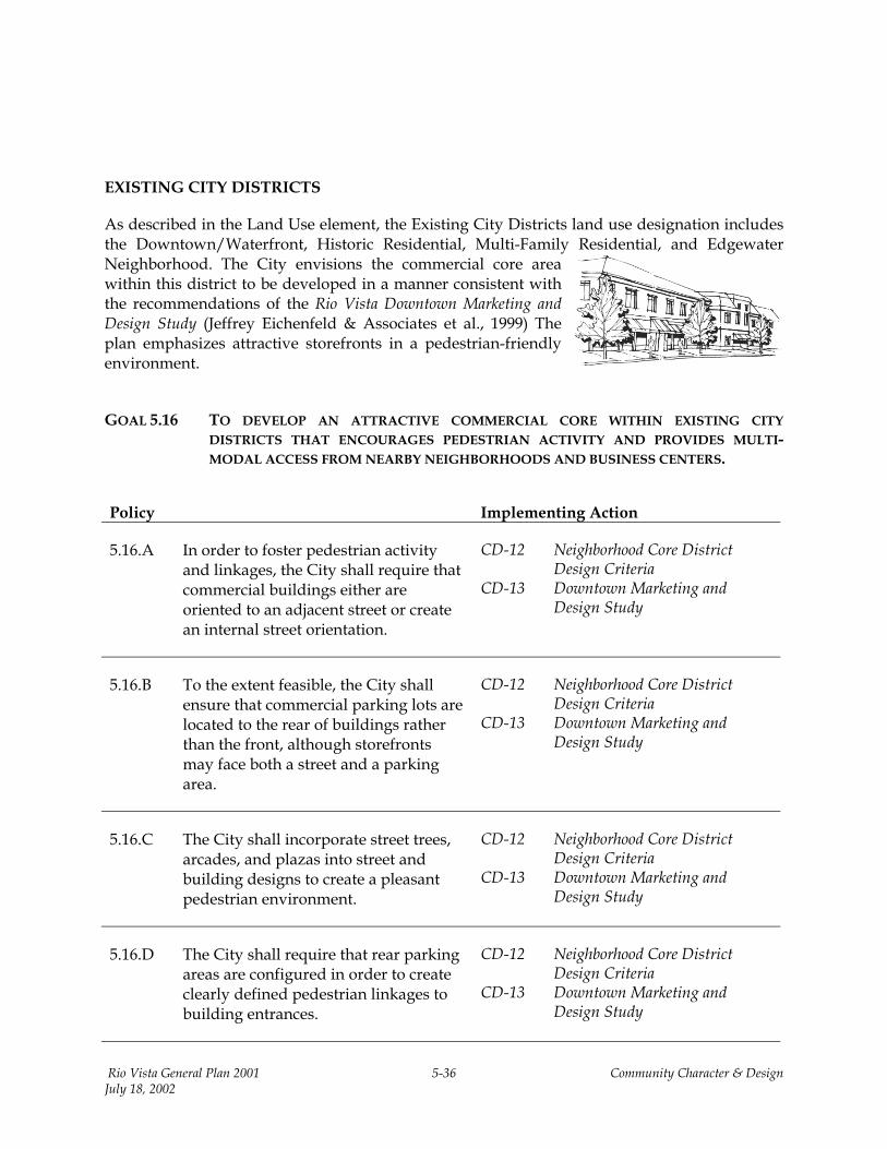
EXISTING CITY DISTRICTS
As described in the Land Use element, the Existing City Districts land use designation includes the Downtown/Waterfront, Historic Residential, Multi-Family Residential, and Edgewater Neighborhood. The City envisions the commercial core area within this district to be developed in a manner consistent with the recommendations of the Rio Vista Downtown Marketing and Design Study (Jeffrey Eichenfeld & Associates et al., 1999) The plan emphasizes attractive storefronts in a pedestrian-friendly environment.
GOAL 5.16 TO DEVELOP AN ATTRACTIVE COMMERCIAL CORE WITHIN EXISTING CITY
DISTRICTS THAT ENCOURAGES PEDESTRIAN ACTIVITY AND PROVIDES MULTI-MODAL ACCESS FROM NEARBY NEIGHBORHOODS AND BUSINESS CENTERS.
Policy Implementing Action
5.16.A In order to foster pedestrian activity and linkages, the City shall require that commercial buildings either are oriented to an adjacent street or create an internal street orientation.
CD-12 Neighborhood Core District Design Criteria
CD-13 Downtown Marketing and Design Study
5.16.B To the extent feasible, the City shall ensure that commercial parking lots are located to the rear of buildings rather than the front, although storefronts may face both a street and a parking area.
CD-12 Neighborhood Core District Design Criteria
CD-13 Downtown Marketing and Design Study
5.16.C The City shall incorporate street trees, arcades, and plazas into street and building designs to create a pleasant pedestrian environment.
CD-12 Neighborhood Core District Design Criteria
CD-13 Downtown Marketing and Design Study
5.16.D The City shall require that rear parking areas are configured in order to create clearly defined pedestrian linkages to building entrances.
CD-12 Neighborhood Core District Design Criteria
CD-13 Downtown Marketing and Design Study
Rio Vista General Plan 2001 5-36 Community Character & Design July 18, 2002
Policy Implementing Action
5.16.E The City shall consider reducing parking requirements for individual uses that demonstrate the existence of an overlap of parking demand for the overall commercial complex.
CD-12 Neighborhood Core District Design Criteria
5.16.F Where commercial centers or office complexes abut each other, the City shall require both vehicular and pedestrian connections between parking areas and buildings in order to minimize vehicle turn movements onto major streets.
CD-12 Neighborhood Core District Design Criteria
HIGHWAY AND CONVENIENCE COMMERCIAL
Several small commercial centers are located at major intersections of Highway 12 and along arterials, adjacent to or behind residential or office and industrial areas. It is expected that these smaller commercial centers will accommodate small commercial uses, such as convenience markets, cafes or coffee shops, dry cleaners, gas stations, office service and support, video stores, and other service-oriented businesses. The General Plan provides design guidelines to avoid random placement and design of highway and convenience commercial structures, to facilitate non-motorized access to businesses, and to create aesthetically pleasing commercial corridors along heavily traveled routes through town.
GOAL 5.17 TO PROVIDE ATTRACTIVE HIGHWAY COMMERCIAL DEVELOPMENT THAT ALLOWS FOR SAFE AND CONVENIENT ACCESS.
Policy Implementing Action
5.17.A The City shall ensure that commercial development reflects a human scale, with abundant use of landscaping, entries, courtyards, and parking plazas.
CD-14 Highway and Convenience Commercial Design Criteria
5.17.B The City shall require that pedestrian and vehicular linkages to adjacent neighborhoods are provided in highway commercial developments.
CD-14 Highway and Convenience Commercial Design Criteria
Rio Vista General Plan 2001 5-37 Community Character & Design July 18, 2002
Policy Implementing Action
5.17.C The City shall require that convenience commercial buildings that are located adjacent to or within residential neighborhoods are compatible with the pedestrian scale and orientation of the neighborhood.
CD-14 Highway and Convenience Commercial Design Criteria
5.17.D The City shall require that primary and main entrances are oriented toward the highway or arterial street on which it is sited.
CD-14 Highway and Convenience Commercial Design Criteria
5.17.E The City shall require that pedestrian and vehicular access are provided by businesses adjacent to sites where commercial, office, or multi-family residential development is planned or existing.
CD-14 Highway and Convenience Commercial Design Criteria
5.17.F The City shall establish controlled pedestrian crossings on Church Road as part of the overall Core Commercial entry area.
CD-14 Highway and Convenience Commercial Design Criteria
BUSINESS PARK AND AIRPORT COMMERCIAL
Large areas of nonresidential uses are located generally on both sides of Airport Road and in the Liberty Island and Canright Road areas. These businesses combine office, airport-related commercial, and limited industrial uses. In some areas, the intensity of these uses is significantly affected by the Rio Vista Airport/Land Use Compatibility Plan (Solano County Airport Land Use Commission, 1988). In various land use districts in the Planning Area, sites may be developed for public and quasi-public uses, such as churches or community centers.
Rio Vista General Plan 2001 5-38 Community Character & Design July 18, 2002
GOAL 5.18 TO CREATE A MULTI-MODAL ENVIRONMENT IN THE VICINITY OF THE BUSINESS PARK AND AIRPORT.
Policy Implementing Action
5.18.A The City shall ensure that office, business park, airport commercial, industrial, and employment uses are developed in a manner that achieves pedestrian orientation and are sited for ease of access.
CD-15 Business Park and Airport Commercial Design Criteria
CD-16 Airport/Land Use Compatibility Plan
LIGHTING AND SIGNAGE
Copying design elements that are indistinguishable from those in many other locations can quickly erode Rio Vista’s identity as a unique place and community. Lighting and signage are key design elements that can help Rio Vista retain its feel of an older or traditional downtown, while continuing to function as a modern community.
GOAL 5.19 TO INCORPORATE LIGHTING AND SIGNAGE ELEMENTS INTO A COMMUNITY DESIGN THAT RETAINS THE TRADITIONAL CHARACTER OF RIO VISTA.
Policy Implementing Action
5.19.A The City shall ensure that an accumulation of “franchise” structures competing for the attention of passing traffic is avoided.
CD-17 Lighting and Signage Design Criteria
5.19.B The City shall ensure that corporate logos and images are designed into structural elements that relate to the community as a place.
CD-17 Lighting and Signage Design Criteria
5.19.C The City shall ensure that the view of onsite lighting is shielded from those outside the premises to the greatest extent feasible.
CD-17 Lighting and Signage Design Criteria
Rio Vista General Plan 2001 5-39 Community Character & Design July 18, 2002
5.19.D The City shall minimize illumination of the night sky to the greatest extent feasible.
CD-17 Lighting and Signage Design Criteria
DOWNTOWN/WATERFRONT AND HISTORIC RESIDENTIAL NEIGHBORHOODS
The residential structures in the downtown and waterfront and historic neighborhoods generally are intact and relatively unchanged from the time of construction. Most structures still exhibit the majority—if not all—of the original architectural elements and details that make them unique. The historic character of these structures and neighborhoods should be preserved and enhanced. Blanket or prescriptive zoning regulations that are not compatible with the density or design characteristics of these neighborhoods should be replaced with a historic district that provides appropriate land use and design policies and criteria. Historic character and design issues are addressed by the following policies and criteria. (See the Land Use element for a discussion of land use policies and actions.)
GOAL 5.20 TO PRESERVE THE CHARACTER OF RIO VISTA’S HISTORIC DISTRICT.
Policy Implementing Action
5.20.A The City shall require that new and remodeled commercial structures are consistent with downtown’s historic character and building scale.
CD-18 Downtown/Waterfront and Historic Residential Design Criteria
RECONSTRUCTION AND NEW ADDITIONS
GOAL 5.21 TO ENSURE THAT RECONSTRUCTION AND NEW ADDITIONS ENHANCE RATHER THAN DETRACT FROM THE SURROUNDING NEIGHBORHOOD.
Policy Implementing Action
5.21.A The City shall ensure that new buildings and additions are constructed to a height, massing, and scale that bear a reasonable relationship to adjacent buildings.
CD-19 Reconstruction and New Additions Design Criteria
Rio Vista General Plan 2001 5-40 Community Character & Design July 18, 2002
REHABILITATION AND REMODELING
GOAL 5.22 TO ENSURE THAT THE DISTINGUISHING QUALITIES AND ORIGINAL CHARACTER OF A BUILDING, STRUCTURE, OR SITE AND ITS ENVIRONMENT ARE NOT DESTROYED.
Policy Implementing Action
5.22.A The City shall ensure that remodeling and rehabilitation of existing structures preserve and enhance the historic character of the structure to the greatest extent feasible.
CD-20 Rehabilitation and Remodeling Design Criteria
5.22.B The City shall discourage alterations with no historic basis or that seek to create an appearance from an earlier or later historic period.
CD-20 Rehabilitation and Remodeling Design Criteria
5.22.C The City shall ensure that distinctive stylistic features or examples of skilled craftsmanship that characterize a building, structure, or site are treated with sensitivity.
CD-20 Rehabilitation and Remodeling Design Criteria
5.22.D The City shall ensure that deteriorated architectural features are repaired, rather than replaced, whenever feasible.
CD-20 Rehabilitation and Remodeling Design Criteria
5.22.E The City shall ensure that demolitions of historic structures are considered a “last-resort” remedy for buildings in such disrepair that they are beyond rescue and are creating blight and threatening public health and safety. Prior to any demolition, the City shall ensure that the neighborhood interest will be served best by removal and that demolition is the only reasonable course of action.
CD-20 Rehabilitation and Remodeling Design Criteria
Rio Vista General Plan 2001 5-41 Community Character & Design July 18, 2002
G. Implementing Actions for Community Character & Design (CD)
Each of the following actions will be used, wherever appropriate, to implement the goals and policies of the Community Character & Design element. These implementation measures should be utilized in conjunction with the policies and implementation measures in other Elements, particularly those in Chapter10, Resource Conservation and Management.
CD-1 ENVIRONMENTAL/VISUAL CONSTRAINTS MAP (Proposed)
The City will require with each development proposal an environmental and visual constraints map, based on the findings of the project-specific biological resources assessment and consistent with the General Plan goals and policies. These maps should consider the potential open space opportunities illustrated in Figure 5-3 and 10-2, showing key hilltops, valleys, and sensitive areas.
CD-2 ENVIRONMENTAL DESIGN CRITERIA (Proposed)
The hilltops, ridgelines, valleys, drainage corridors offer a variety of outstanding community benefits as the community develops adjacent to these sensitive environmental areas. The preservation of these significant environmental resources presents a unique opportunity for public access and enjoyment that is otherwise impossible to create. By protecting and utilizing these key resources, Rio Vista can create an exceptional public and environmental benefit of lasting significance to the community.
1. Where feasible the City will require developers to minimize the creation of engineered drainage channels that concentrate runoff and damage natural drainage patterns. Runoff should be directed into vegetated valleys to allow for greater absorption of storm water into the water table.
2. Key hilltops (landforms), valleys, and sensitive areas are identified in Figure 5-3. The City will require the development design and review process to incorporate these features into the project as follows:
• Key hilltops (landforms). Sufficient natural slope and contours should remain to retain the view of the landform from nearby streets and public areas as an easily identifiable natural landmark.
• Valleys. Engineered cut or fill along banks should be avoided so that natural drainage retention and opportunities remain for trails at the top of the bank. The valley should not be substantially altered from its natural form and direction.
• Refer to Figure 5-7 for illustration of the preferred developed condition.
3. The City will require the submittal of vegetation protection and restoration plans as part of the development review process.
Rio Vista General Plan 2001 5-42 Community Character & Design July 18, 2002
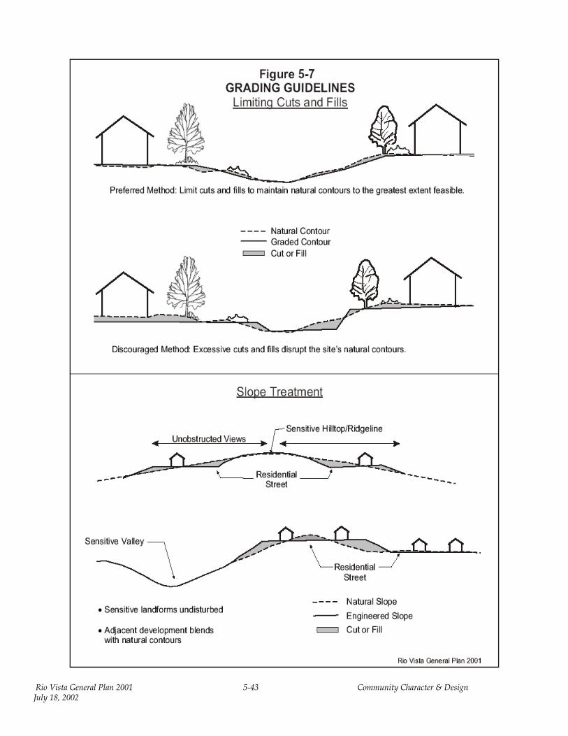
Rio Vista General Plan 2001 5-43 Community Character & Design July 18, 2002

4. Natural gas well reserve sites should be developed as usable open space or neighborhood visual amenities. Opportunities for the development of natural gas well sites as park facilities are discussed in the Open Space & Recreation element.
CD-3 PARKS MASTER PLAN (Proposed)
The City will prepare a Parks Master Plan prior to or concurrent with project approvals associated with the proposed large development projects. This plan will identify community park sites, trails, and open space areas so that the City can work with developers to create an integrated system well in advance of subdivision development.
CD-4 TRAILS AND PATHWAYS MAP (To be adopted as part of this General Plan)
A comprehensive trails system will be developed for the entire Planning Area (also see Circulation & Mobility, Open Space & Recreation, and Resource Conservation & Management elements). A Trails Master Plan should provide the means of finding and setting priorities for trail development. This General Plan has established a Trails and Pathways Map in the Circulation & Mobility element (see Figure 8-6). The City will require design review of any development within or alongside an area with a proposed trail as identified on the adopted Trails and Pathways Map.
CD-5 COMMUNITY DESIGN CRITERIA (Proposed)
1. Community identity features and landmarks are to be included, as shown in Figure 5-6.
2. The primary entry points into the community will be located on Highway 12, River Road, Main Street, and near the Helen Madere Bridge (commonly referred to as the Rio Vista Bridge). At these entry points, distinctive landscaping and identity signage will establish a unifying identity for the entire community.
3. Median or triangle treatments may be included as a design element for the entryways.
4. Project identity signage should be used to provide consistent design identity, with the major entry features as unifying elements.
5. Special identity features may be created for downtown and Old Town entries.
6. For major intersections of arterials, collectors, and primary streets, each entry or connection into a distinct neighborhood should be given its own identity through use of textured pavement, landscaped islands, and “neckdowns” (roadway width reductions at strategic locations). These features will slow traffic and preserve neighborhoods, as described in the Circulation & Mobility element. The
Rio Vista General Plan 2001 5-44 Community Character & Design July 18, 2002

treatment of these intersections also will carry over the main design and material elements of the community entries, reinforcing the connection with Rio Vista as a community and with specific neighborhoods.
7. For minor street intersections and mid-block interest features, special landscaping treatments, street tree accents, textured paving, roundabouts, or medians should be used to create interest and provide identities to smaller neighborhoods or residential clusters—without separating them and allowing for free access between and through them. These features also may be used at pathway crossings or in longer blocks in order to meet the requirements that follow this section.
8. For parks and linear pathway intersections, landscaping and landform treatments to call attention to the end of the street at a park or pathway and a pathway crossing should be used at mid-block of a street. At these points, it is critical to alert pedestrians, bicyclists, and auto drivers that the upcoming intersection exists and caution is required. These intersections should be landscaped and signed to maintain clear visibility to both path and roadway.
9. In part, landmarks will be created by the hierarchy of entries and identified focal points.. Buildings occupying key locations or tending to dominate the landscape, should create forms and structural elements that enhance their landmark status and function.
10. When clock towers, cupolas, steeples and, in some cases, distinctive signage structures serve the purpose of enhancing a building’s landmark status and function, such treatments should be incorporated into the design. Such features may be erected to a greater height than the main roof line, provided the design is in keeping with the overall character of the structure and surroundings.
CD-6 HIGHWAY 12 CORRIDOR DESIGN CRITERIA (Proposed)
1. The overall landscape treatment and specific entry features along Highway 12 should enhance the sense of arrival.
2. As Highway 12 is expanded, particularly east of Drouin Drive, lower design speeds should be used that are consistent with the levels of service standards identified in the Circulation & Mobility element.
Rio Vista General Plan 2001 5-45 Community Character & Design July 18, 2002
3. View corridors and open space should be designed in the vicinity of the proposed trail and drainageways between Church Road and Drouin Drive.
4. “Back-up” walls should be limited as much as possible along the residential sections of the corridor. Landforms and open space should be used for noise mitigation rather than walls wherever feasible.
CD-7 STREETS AND BLOCKS DESIGN CRITERIA (Proposed)
1. The street sections identified in the Circulation & Mobility element should be used for arterial, collector, and neighborhood (local) residential streets.
2. Average block lengths of 300 feet or less are encouraged; 600 feet will be considered the maximum block length without a cross street or pedestrian corridor intersection. The use of cul-de-sacs should be minimized, except where the ends of the streets are open and connect to pedestrian corridors or pass-through.
3. Each side of a neighborhood street should have a minimum planting strip width of at least 5 feet and minimum sidewalk width of 5 feet. There should be a continuity of landscaping within the planting strip, with trees spaced on average at least every 30 linear feet (refer to the Circulation & Mobility element).
If access routes through parking lots, through loading and service areas, or behind residential rear yards cannot be avoided, a convenient, attractive, and safe route should be provided—with such features as shade, special paving, and pathway separation. Simply painting crosswalks through parking areas is not sufficient to delineate a pedestrian route.
CD-8 RESIDENTIAL HOUSING DESIGN CRITERIA (Proposed)
1. The living areas of the house should be kept close to the street, reinforcing residents’ awareness of the neighborhood and community interaction.
2. Garages should be placed behind the residence, although alleyways and detached garages are not required.
3. Residential structure and garage placement should be oriented to place living areas closer to the street than garage openings.
4. Building entries should be emphasized and should receive special design treatment to provide a balanced sense of security and privacy. Entry patios, courtyards, porticoes, and porches are encouraged. Entry doors should be visible from streets or other well-used public areas. In large multi-family or cluster projects, units may orient toward private open space or courtyards, except for units directly adjacent to public streets or the primary access way into the development.
Rio Vista General Plan 2001 5-46 Community Character & Design July 18, 2002
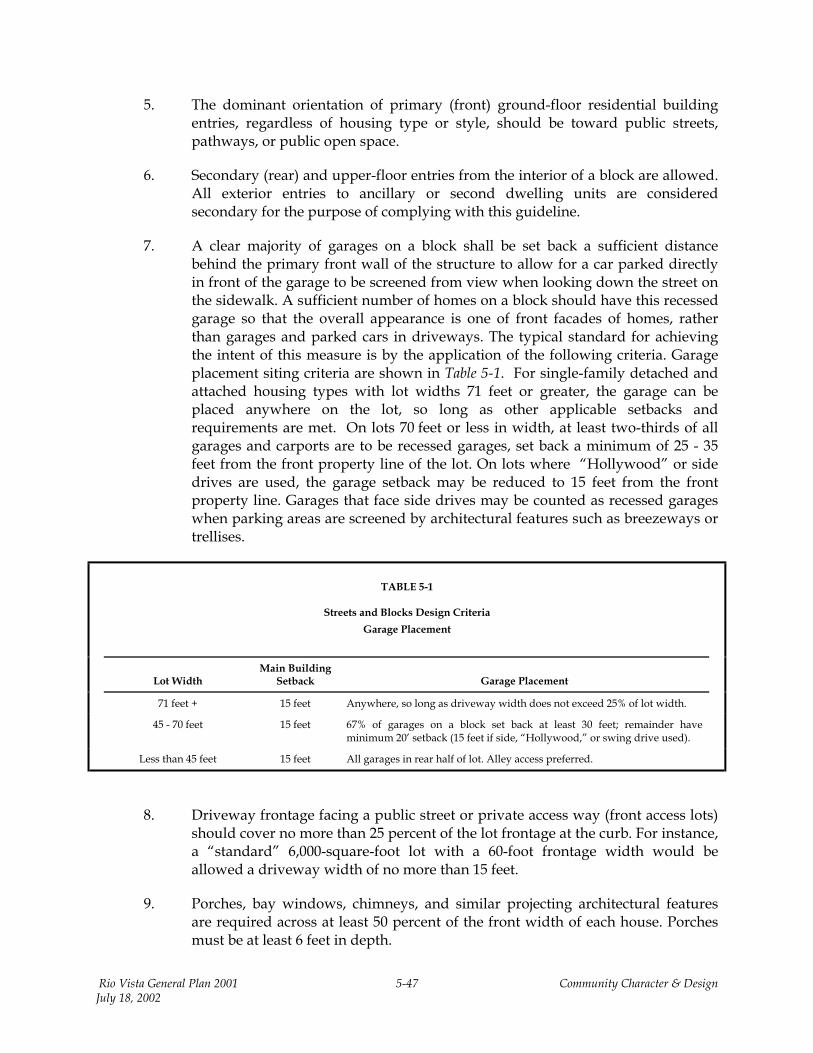
5. The dominant orientation of primary (front) ground-floor residential building entries, regardless of housing type or style, should be toward public streets, pathways, or public open space.
6. Secondary (rear) and upper-floor entries from the interior of a block are allowed. All exterior entries to ancillary or second dwelling units are considered secondary for the purpose of complying with this guideline.
7. A clear majority of garages on a block shall be set back a sufficient distance behind the primary front wall of the structure to allow for a car parked directly in front of the garage to be screened from view when looking down the street on the sidewalk. A sufficient number of homes on a block should have this recessed garage so that the overall appearance is one of front facades of homes, rather than garages and parked cars in driveways. The typical standard for achieving the intent of this measure is by the application of the following criteria. Garage placement siting criteria are shown in Table 5-1. For single-family detached and attached housing types with lot widths 71 feet or greater, the garage can be placed anywhere on the lot, so long as other applicable setbacks and requirements are met. On lots 70 feet or less in width, at least two-thirds of all garages and carports are to be recessed garages, set back a minimum of 25 - 35 feet from the front property line of the lot. On lots where “Hollywood” or side drives are used, the garage setback may be reduced to 15 feet from the front property line. Garages that face side drives may be counted as recessed garages when parking areas are screened by architectural features such as breezeways or trellises.
TABLE 5-1
Streets and Blocks Design Criteria
Garage Placement
Lot Width
Main Building Setback Garage Placement
71 feet + 15 feet Anywhere, so long as driveway width does not exceed 25% of lot width.
45 - 70 feet 15 feet 67% of garages on a block set back at least 30 feet; remainder have minimum 20’ setback (15 feet if side, “Hollywood,” or swing drive used).
Less than 45 feet 15 feet All garages in rear half of lot. Alley access preferred.
8. Driveway frontage facing a public street or private access way (front access lots) should cover no more than 25 percent of the lot frontage at the curb. For instance, a “standard” 6,000-square-foot lot with a 60-foot frontage width would be allowed a driveway width of no more than 15 feet.
9. Porches, bay windows, chimneys, and similar projecting architectural features are required across at least 50 percent of the front width of each house. Porches must be at least 6 feet in depth.
Rio Vista General Plan 2001 5-47 Community Character & Design July 18, 2002
10. On blocks with standard or narrow lots (less than 71 feet), at least two-thirds of all homes should have porches or architectural features, or the garage should be recessed (set back) at least 15 feet back from the front wall of the structure.
11. When porches are constructed at a setback of 10 feet, a 25-foot garage setback will screen most of the parked cars and allow the living areas, rather than the garage and cars, to dominate visually. A 35–foot garage setback allows for more driveway parking capacity and reduces the need for on-street parking, in turn allowing reduction of street width. The figure below illustrates various setbacks on both narrow and wide lots.
12. The minimum front yard setbacks for main or primary structure should be:
• Living area walls – 15 feet. This amount may be reduced to 10 feet when a recessed garage is used and there is at least 15 feet between the front wall or porch and the garage door (if approved through development review or architectural review).
• Porches – 10 feet.
• Bay windows, chimneys, and similar architectural features may encroach into a required yard up to 2 feet.
13. A “tract” appearance should be avoided by incorporating significant changes in massing and rooflines between elevations of the same floor plan. Where varying options of the same floor plans are proposed, a significant difference in the massing and composition of each option (not just finish materials) is to be achieved.
CD-9 ANCILLARY OR SECOND UNIT (CARRIAGE UNIT) DESIGN CRITERIA (Proposed)
1. The height of the main structure or house should be at least that of the carriage house to retain an appropriate scale between them two, as shown below.
Rio Vista General Plan 2001 5-48 Community Character & Design July 18, 2002

2. Carriage houses entries may be accessed from side-yard driveways on corner lots, or from alleys or private rear drives. Examples are illustrated below.
3. Density bonus—As a permitted use, carriage houses may be counted as a 0.75 multi-family unit or a 0.4 single-family unit in density requirement calculations. Table 5-2 illustrates the density bonus received when carriage houses are provided—either at the time the home is built or as an option by the homeowner. (Note: The space must be provided over the garage initially, with electrical and plumbing service either in place or stubbed for easy access.)
Rio Vista General Plan 2001 5-49 Community Character & Design July 18, 2002
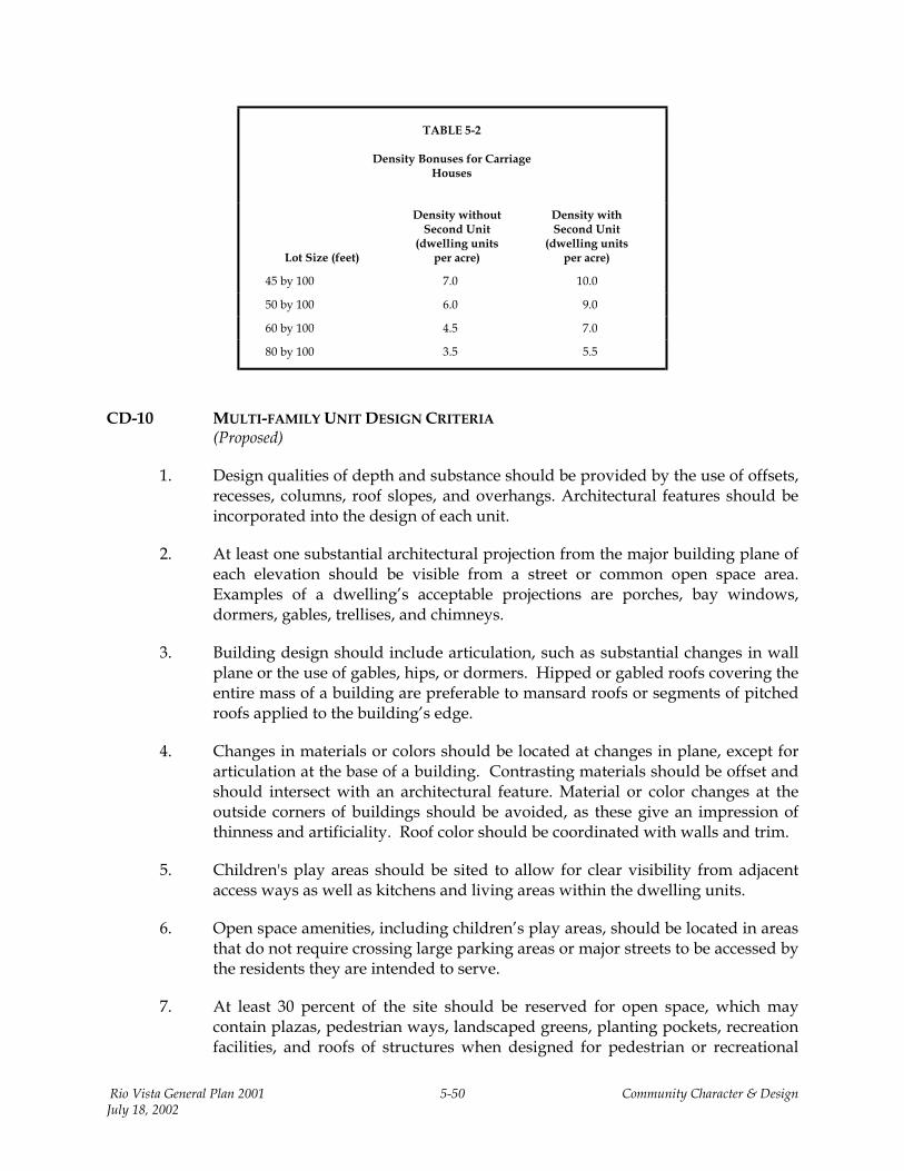
TABLE 5-2
Density Bonuses for Carriage
Houses
Lot Size (feet)
Density without Second Unit
(dwelling units per acre)
Density with Second Unit
(dwelling units per acre)
45 by 100 7.0 10.0
50 by 100 6.0 9.0
60 by 100 4.5 7.0
80 by 100 3.5 5.5
CD-10 MULTI-FAMILY UNIT DESIGN CRITERIA (Proposed)
1. Design qualities of depth and substance should be provided by the use of offsets, recesses, columns, roof slopes, and overhangs. Architectural features should be incorporated into the design of each unit.
2. At least one substantial architectural projection from the major building plane of each elevation should be visible from a street or common open space area. Examples of a dwelling’s acceptable projections are porches, bay windows, dormers, gables, trellises, and chimneys.
3. Building design should include articulation, such as substantial changes in wall plane or the use of gables, hips, or dormers. Hipped or gabled roofs covering the entire mass of a building are preferable to mansard roofs or segments of pitched roofs applied to the building’s edge.
4. Changes in materials or colors should be located at changes in plane, except for articulation at the base of a building. Contrasting materials should be offset and should intersect with an architectural feature. Material or color changes at the outside corners of buildings should be avoided, as these give an impression of thinness and artificiality. Roof color should be coordinated with walls and trim.
5. Children's play areas should be sited to allow for clear visibility from adjacent access ways as well as kitchens and living areas within the dwelling units.
6. Open space amenities, including children’s play areas, should be located in areas that do not require crossing large parking areas or major streets to be accessed by the residents they are intended to serve.
7. At least 30 percent of the site should be reserved for open space, which may contain plazas, pedestrian ways, landscaped greens, planting pockets, recreation facilities, and roofs of structures when designed for pedestrian or recreational
Rio Vista General Plan 2001 5-50 Community Character & Design July 18, 2002
usage. Open space should be evenly distributed.
8. Primary open space directly accessible from the dwelling may include yards, decks, and balconies. Private usable open space should have a minimum dimension of 10 by 10 feet at ground-floor level or 6 by 10 feet aboveground.
CD-11 NONRESIDENTIAL BUILDING SITING, ORIENTATION, AND ACCESS DESIGN CRITERIA (Proposed)
1. Setbacks and landscaping should vary according to the use and intensity of the particular nonresidential site.
2. Buildings should be sited to complement adjacent buildings and landscape. New structures should not clash with existing structures and sites.
3. All loading, delivery and storage areas, and mechanical and utility equipment should be screened from view from public streets and pedestrian corridors.
4. To ensure neighborhood compatibility, where nonresidential uses are sited close to a residential area or neighborhood, the scale and character of new buildings always should relate to the adjacent neighborhood. Site plans and architecture should protect the privacy of adjacent developments. Landscape buffers and walls are required between residential and nonresidential uses where parking or loading areas abut backyards.
5. Pedestrian access through the parking lot should be provided for, as illustrated in Figure 5-8. If the development abuts a residential neighborhood street, both pedestrian and vehicular access should be provided to and from the street.
6. Side and rear facades of buildings should be treated with the same quality of design and materials as the front elevations.
7. If locating a parking area or lot directly adjacent to a public street cannot be avoided, cars should be screened from view by berms, walls, hedges, density of plant materials, or a combination of these treatments.
CD-12 NEIGHBORHOOD CORE DISTRICT DESIGN CRITERIA (Proposed)
1. The street that separates the main commercial development site from the adjacent multi-family and medium-density, single-family areas should function as a commercial pedestrian street (see Figure 5-8 below). The character of this street is critical to ensure that the adjacent housing is integrated into, rather than separated from, the commercial core. In other words, the street should invite access rather than constitute a barrier.
2. Consistent with the traditional commercial buildings constructed in older downtown business districts, large commercial structures within the
Rio Vista General Plan 2001 5-51 Community Character & Design July 18, 2002
Neighborhood Core District should create the appearance of a series of individual, one- and two-story identity storefronts or building spaces with vertical elements, rather than a horizontally oriented “box” typical of modern shopping centers. Variations in floor level, facades, architectural details, and finishes that strengthen the appearance of several smaller buildings or storefronts within a longer building should be strongly encouraged. Chain or franchise trademark buildings should be discouraged. Store interiors and display windows should be visible from the street. Architectural styles may vary, with consistency achieved through use of materials and details, light fixtures, and street furniture.
Rio Vista General Plan 2001 5-52 Community Character & Design July 18, 2002
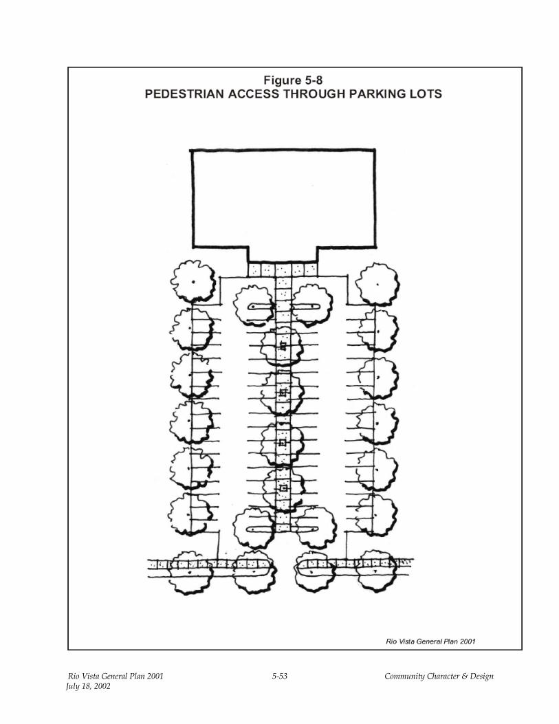
Rio Vista General Plan 2001 5-53 Community Character & Design July 18, 2002
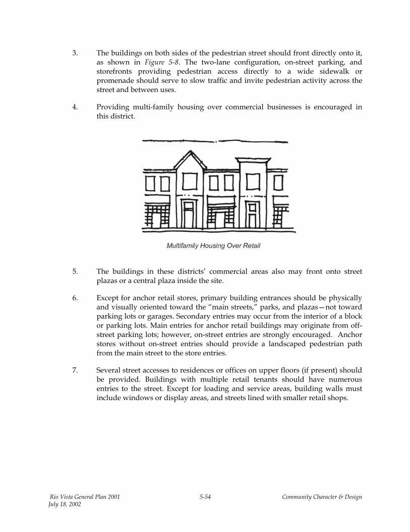
3. The buildings on both sides of the pedestrian street should front directly onto it, as shown in Figure 5-8. The two-lane configuration, on-street parking, and storefronts providing pedestrian access directly to a wide sidewalk or promenade should serve to slow traffic and invite pedestrian activity across the street and between uses.
4. Providing multi-family housing over commercial businesses is encouraged in this district.
5. The buildings in these districts’ commercial areas also may front onto street plazas or a central plaza inside the site.
6. Except for anchor retail stores, primary building entrances should be physically and visually oriented toward the “main streets,” parks, and plazas—not toward parking lots or garages. Secondary entries may occur from the interior of a block or parking lots. Main entries for anchor retail buildings may originate from off-street parking lots; however, on-street entries are strongly encouraged. Anchor stores without on-street entries should provide a landscaped pedestrian path from the main street to the store entries.
7. Several street accesses to residences or offices on upper floors (if present) should be provided. Buildings with multiple retail tenants should have numerous entries to the street. Except for loading and service areas, building walls must include windows or display areas, and streets lined with smaller retail shops.
Rio Vista General Plan 2001 5-54 Community Character & Design July 18, 2002

CD-13 DOWNTOWN MARKETING AND DESIGN STUDY
(Existing)
The City will implement recommendations contained in the draft design guidelines of the 1999 Rio Vista Downtown Marketing and Design Study (Jeffrey Eichenfeld & Associates, 1999). The guidelines list 15 elements commonly found in downtown Rio Vista buildings. Building elements include architectural style, scale, parking, and maintenance; façade elements include roofline, upper wall, storefronts, materials, and color; storefront elements include entrance, display windows, bulkhead, transom windows; and storefront accessories include signs and shading. The guidelines also contain recommendations for specific streetscape improvements along Main Street.
CD-14 HIGHWAY AND CONVENIENCE COMMERCIAL DESIGN CRITERIA (Proposed)
1. Such measures as traffic signals and textured paving, or a combination thereof, should be considered to reduce traffic speeds.
2. Parking may be either to the rear or side of the main building. If configured in an “L” shape, the building layout may actually face some of the storefronts onto the parking lot. This layout is acceptable as long as most storefronts are oriented to street frontage. Pedestrian access should be emphasized in a clear and convenient manner.
3. Sidewalk widths should be at least 10 feet in front of commercial buildings with storefronts. This standard may be accomplished by a combination of private promenades and plazas and public sidewalks. Sidewalks on the existing Highway 12 commercial district east of Drouin Drive must be at least 5 feet wide.
4. Whenever possible, parkways should be incorporated and shade trees should be provided adjacent to the roadway.
5. Drive-through windows should not face onto a public street. Stacking lanes must be screened from view from the street by landscaping, berms, and berm walls (not simply a wall or fence).
CD-15 BUSINESS PARK AND AIRPORT COMMERCIAL DESIGN CRITERIA (Proposed)
1. To the maximum extent feasible, entries to office and public space should orient to streets, parks, plazas, and pedestrian corridors and pathways. Secondary entrances may orient to parking lots or garages. Buildings that lay out in a “U” or “L” shape and create courtyards or define the perimeter of a block are preferred to those with long setbacks from the street.
2. Preferred materials for business park and airport commercial developments are stucco, brick, masonry, and wood-siding exterior elevations. Concrete tilt-up and
Rio Vista General Plan 2001 5-55 Community Character & Design July 18, 2002
metal construction may be used in industrial and employment districts but must be designed to reflect the following the features described in the remaining items in this section.
3. Roof elements should be pitched, not flat.
4. Roofing materials should be concrete, tile, slate, or metal-standing seam. Asphalt shingles or tar and gravel roofing may be used when warranted by the type or style of a particular building.
5. Elevations should be well-articulated and stress an original design, not a generic or “franchise” building style. Small, boxy structures should be avoided.
6. Buildings should be sited to complement adjacent buildings and landscape. New structures should not clash with existing structures and sites.
7. All loading, delivery and storage areas, and mechanical and utility equipment should be screened from view from public streets and pedestrian corridors.
8. Where nonresidential uses are sited close to a residential area or neighborhood, the scale and character of new buildings should relate to the adjacent neighborhood. Site plans and architecture should protect the privacy of adjacent developments. Landscape buffers and walls are required between residential and nonresidential uses.
9. Side and rear facades of buildings should be treated with the same quality of design and materials as the front elevations.
10. Where location of a parking area or lot directly adjacent to a public street cannot be avoided, cars should be screened from view by berms, walls, hedges, density of plant materials, or a combination of these treatments.
CD-16 AIRPORT/LAND USE COMPATIBILITY PLAN (Existing)
Solano County Airport Land Use Commission’s 1988 Airport/Land Use Compatibility Plan for the Rio Vista Airport, adopted as a City ordinance, sets forth the standards and policies for acceptable land uses within various restrictive zones and noise areas around the airport. The airport and land use criteria are used to minimize risks associated with the operation of aircraft through density reducing and maximizing the amount of open land within the vicinity of the airport.
CD-17 LIGHTING AND SIGNAGE DESIGN CRITERIA (Proposed)
1. Freestanding signs generally are not allowed except where residential structures are converted to commercial uses, or new buildings are located where
Rio Vista General Plan 2001 5-56 Community Character & Design July 18, 2002
residential-type setbacks are preferred. In these cases, freestanding signs should be relatively small and restrained. Pole signs are not allowed.
2. Colors or logos identifiable with an individual company are acceptable but should not become a dominant architectural element.
3. Gasoline island or other open canopies should be designed to look like adjacent structures, not merely flat-roofed covers. Thick columns and pitched roofs to match the main structure(s) should be used. (Note: These uses generally are not allowed in the areas designated as an Existing City District.)
4. Building mass should avoid proportionally long, flat surfaces. The architecture should include pitched-roof elements, columns, indentations, overhangs, patios, trellises, and surface textures on all elevations that are visible offsite. Storefronts should wrap around corners to create a sense of transparency and activity at intersections. Large areas of blank walls with few openings or details should be avoided on facades facing streets or public spaces.
5. Storefronts with a traditional appearance are encouraged (and required in the downtown); storefronts should be divided into horizontal bands of transom, display windows, and a small (usually 1- to 2-foot-wide) base under the windows. Single-story buildings should have a solid wall space extending above the storefront and a cornice—with or without parapet. Multiple-story buildings usually should have a horizontal band above the ground-floor windows and windows on all stories above that. A cornice should be present above the windows on the uppermost floor.
6. Windows should be organized in multiple bays wherever possible. The directional expression of commercial windows should generally be vertical; however, several vertical windows can be combined to create an overall horizontal opening. Upper floor windows should be composed as punched openings for individual windows or sets of windows, with much less glazing area than the ground-floor storefront. Trim and framing should appear solid and be almost as deep as the wall thickness. Residential-type window trim should be avoided, unless the entire building design is residential in character.
7. Signage should be restrained. Freestanding signs should be the low-monument type with a height and area that are proportional to the building and site. Wall signage should be oriented toward pedestrians in the downtown area and visible (but unobtrusive) on buildings facing Highway 12. Lighting for signage should be external in the downtown. Internally lit, plastic lettering should be avoided downtown but may be used elsewhere, provided that individual letters rather than “can” signs are used. Neon signage may be allowed where the signage is decorative and complements the building design or business theme.
8. Light fixtures are to be designed to cast light downward, minimizing side and upper projection of light that could illuminate the night sky.
Rio Vista General Plan 2001 5-57 Community Character & Design July 18, 2002
CD-18 DOWNTOWN/WATERFRONT AND HISTORIC RESIDENTIAL DESIGN CRITERIA (Proposed)
1. New structures should front directly onto the street with parking provided behind the structures, on the street, or in public lots.
2. The height of new commercial buildings should be greater than 16 feet but not more than 40 feet (as measured from the sidewalk to the top of the cornice).
3. Where building heights differ between adjacent properties, the adjacent heights of major facade elements (e.g., storefronts, ground floors, upper floors, and sill lines) and strong horizontal features (e.g., belt courses and cornices) should be related.
4. Buildings and facades should be constructed to the property line facing the adjacent street(s). Only entries and flanking display windows may be recessed from the property line.
5. Doorways should be designed to focus on the street in order to create more activity along the sidewalk.
6. Storefronts should be varied in design and character but continuous along each block where feasible.
7. Canvas awnings attached above street-level storefronts and over individual windows should be encouraged. Metal and glass awnings should be discouraged, except when used in a specific design context. Mansard, free-form, and geometric-form awnings or other sidewalk covers should be discouraged. Care should be taken in choosing the size, type, location, configuration, and color of awnings to ensure compatibility with the building’s architecture and the character of adjacent structures.
8. The National Trust for Historic Preservation’s suggested guidelines should be used as the basis for design criteria for rehabilitation and new construction in Rio Vista’s historic residential neighborhoods.
9. Proposed rehabilitation of, new construction on, or addition to a structure should be reviewed in the context of the architectural or historic value, the significance of the site, structure or surroundings, and the visual relationship to the surrounding area.
Rio Vista General Plan 2001 5-58 Community Character & Design July 18, 2002
Rio Vista General Plan 2001 5-59 Community Character & Design July 18, 2002
CD-19 RECONSTRUCTION AND NEW ADDITIONS DESIGN CRITERIA (Proposed)
The spacing of buildings on streets; relationship of materials and textures; architectural details and roof shapes; site elements such as walls, fences, and landscaping; and directional expression of front elevations should be compatible with adjacent structures. Other design criteria, as described above, will be applied to the greatest extent possible.
CD-20 REHABILITATION AND REMODELING DESIGN CRITERIA (Proposed)
The relationship of materials and textures; architectural details and roof shapes; site elements such as walls, fences, and landscaping; and directional expression of front elevations should be compatible with adjacent structures. Other design criteria, as described above, will be applied to the greatest extent possible.


![CHAPTER OF CHARACTER ] Aerith Gainsborough...Final Fantasy i Barett Wallace CHAPTER OF CHARACTER | ( IIAl’Tl K or ( 11 \1< V I I l< Chocobo Highwind CHAPTER OF CHARACTER] Cloud Strife](https://img.pdfslide.net/doc/110x75/614ac35712c9616cbc69a066/chapter-of-character-aerith-gainsborough-final-fantasy-i-barett-wallace-chapter.jpg)