Embed Size (px)
Citation preview
133
Chapter 5 Compilation of Digital Spatial Data Sets and Information Disclosure
5.1 Current State and Evaluation of GIS Database at MEM
5.1.1 Prehistory of Database Creation at MEM
The Department of Mining & Geology (DMG) in the Ministry of Energy and Mining (MEM)
has implemented a GIS-based government solution in order to provide a positive administrative
environment that will support increased mining and development activity in Serbia through several
projects (Table 5.1).
In 2001, the MEM began converting all mining and geological exploration and exploitation
datasets into a digital database through the framework of the CISGEM project. In the same year, a
text-based mineral resource database was created with GIS datasets through a project supported by the
French Bureau of Geological and Mining Research (BRGM). This was the first step towards
construction of a GIS database in the mining section of MEM. In 2002, a capacity building project was
created by the United Nations Development Program (UNDP) to implement GIS software and training.
Other pilot projects for GIS applications such as web-GIS and a management system for mining rights,
have also been started recently.
Table 5.1 Development of a GIS Database at MEM-DMG Project name Organization Year
1 CISGEM: Computerized Information System for Geological Exploration & Mining MEM 2001
2 Database of Central & South-Eastern Europe BRGM 2001
3 Formation of a GIS-based database of mineral occurrences in Serbia MEM 2001-02
4 GIS Software Application and Training UNDP 2002-03
5 Digital Spatial Data for Serbia MEM 2004-05
6 CISGEM project extension MEM 2006-07
7 JICA M/P Study JICA 2007-08
5.1.2 BRGM’s Databases of the Mineral Deposits and Mining Districts of Serbia
The BRGM’s databases for mineral deposits and mining districts of Serbia was constructed in
2001. The project has benefited from the knowledge acquired by the BRGM through its scientific
research project entitled “GIS Central Europe” as well as from various expert assessment missions to
the Balkans during the period 2000 to 2001. The information compiled in the Balkans has been
disclosed through a web-base GIS (http://giseurope.brgm.fr/).
Information on the mineral deposits and mining districts of Serbia is compiled with the
collaboration of the Faculty of Mines and Geology of the University of Belgrade and the GeoInstitute
(former Geological Institute). The databases comprised information on mineral deposits and districts,
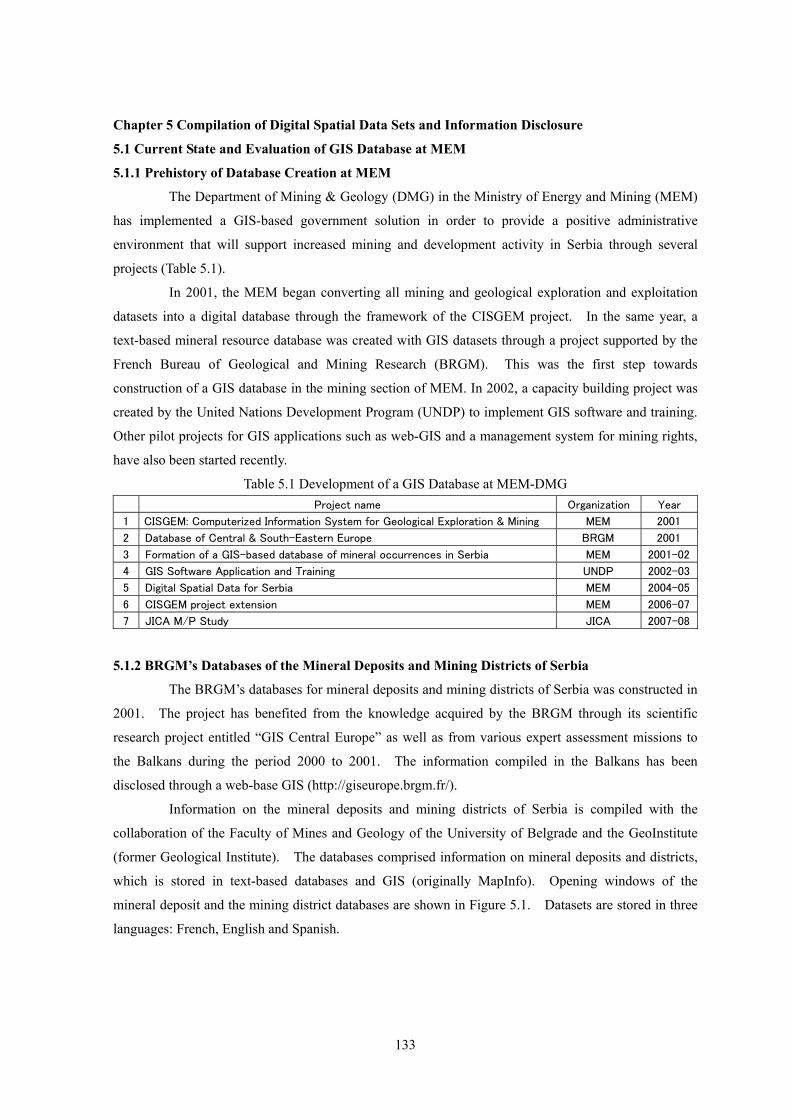
which is stored in text-based databases and GIS (originally MapInfo). Opening windows of the
mineral deposit and the mining district databases are shown in Figure 5.1. Datasets are stored in three
languages: French, English and Spanish.
134
Fig.5.1 Databases Created by BRGM (a) Mineral Deposit Database, (b) Mining District Database
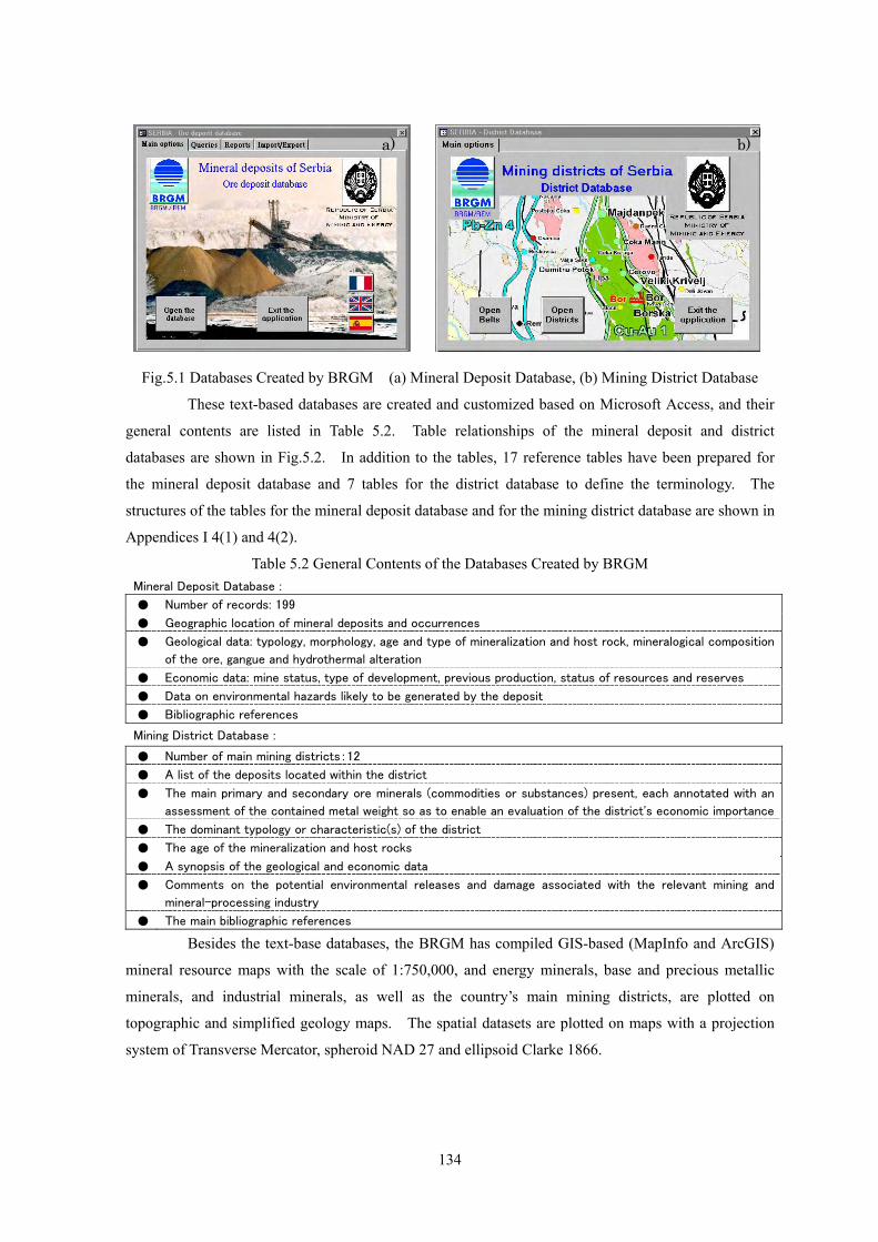
These text-based databases are created and customized based on Microsoft Access, and their
general contents are listed in Table 5.2. Table relationships of the mineral deposit and district
databases are shown in Fig.5.2. In addition to the tables, 17 reference tables have been prepared for
the mineral deposit database and 7 tables for the district database to define the terminology. The
structures of the tables for the mineral deposit database and for the mining district database are shown in
Appendices I 4(1) and 4(2). Table 5.2 General Contents of the Databases Created by BRGM
Mineral Deposit Database :
● Number of records: 199
● Geographic location of mineral deposits and occurrences
● Geological data: typology, morphology, age and type of mineralization and host rock, mineralogical composition
of the ore, gangue and hydrothermal alteration
● Economic data: mine status, type of development, previous production, status of resources and reserves
● Data on environmental hazards likely to be generated by the deposit
● Bibliographic references
Mining District Database :
● Number of main mining districts:12
● A list of the deposits located within the district
● The main primary and secondary ore minerals (commodities or substances) present, each annotated with an
assessment of the contained metal weight so as to enable an evaluation of the district's economic importance
● The dominant typology or characteristic(s) of the district
● The age of the mineralization and host rocks
● A synopsis of the geological and economic data
● Comments on the potential environmental releases and damage associated with the relevant mining and
mineral-processing industry
● The main bibliographic references
Besides the text-base databases, the BRGM has compiled GIS-based (MapInfo and ArcGIS)
mineral resource maps with the scale of 1:750,000, and energy minerals, base and precious metallic
minerals, and industrial minerals, as well as the country’s main mining districts, are plotted on
topographic and simplified geology maps. The spatial datasets are plotted on maps with a projection
system of Transverse Mercator, spheroid NAD 27 and ellipsoid Clarke 1866.
a) b)
135
Fig.5.2 Table Relationships in the Databases Created by BRGM
(a) Mineral Deposit Database, (b) Mining District Database
The following items shall be considered and revised for the future use of BRGM’s databases.
① The compiled datasets in the BRGM’s databases are not stored in current GIS database of the MEM
but they should be integrated. ② Since the stored datasets in the database such as ore reserves and minerals shall be checked,
adequate assessment and amendments will be required in subsequent studies. ③ Projection system used in the GIS datasets should be converted to either WGS84, the world
standard coordinate system or Gauss-Kruger(datum:Hermannskogel old Yugoslavia)which is
commonly used in Serbia.
(b)
(a)

136
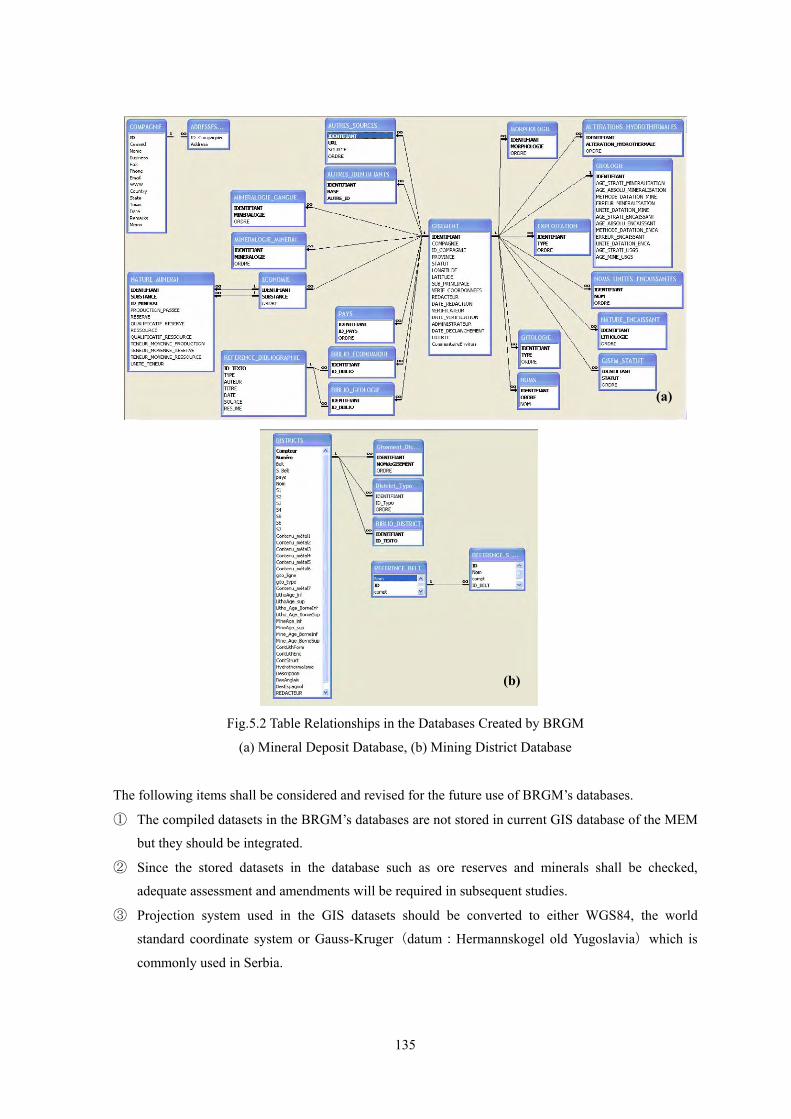
5.1.3 Current Database of MEM
In the current GIS database, information on mineral resources is stored in several linked tables
with a relatively simple structure. The main contents are listed in Table 5.3. These mineral resource
datasets are on 1:300,000 digital base maps created by the Military Geographical Institute (MGI).
Geographic information provided by the MGI is transformed to the ArcGIS geo-database and stored in
more than 70 layers (Fig.5.3). Although the level of accuracy for the base-maps is not adequate for
micro-location planning, it is sufficient and suitable for basic overview of infrastructure related to
mineral resources prospects. A set of Digital Elevation Model (DEM) data files by the Shuttle Radar
Topography Mission (SRTM) with 90m intervals and Landsat-TM mosaic imagery have already been
entered into the database. The satellite datasets comprise only three channels for background images,
and are not available for imagery processing for geological exploration. Table 5.4 shows the system
management of the GIS database at the MEM-DMG.
Table 5.3 Mine Datasets Stored in the Current GIS Database at MEM Items Status
Geological maps Scanned imagery
Metallogenic provinces None
Mining sites Exist (408 points)
Geological exploration sites (mineral resources) Exist (403 points)
Geological exploration sites (water resources) Exist (66 points)
Mining license areas Exist (4 areas)
Mineral occurrences Exist (275 points)
Areas requested for GIS information Exist (35points)
Abandoned mines and reasons for abandonment Exist
Infrastructural datasets: administrative boundaries, power stations & lines,
hydrography, roads, railways, transportation & communication networks,
cultural heritage, populated areas, river-networks, contours, economy,
toponyms, tourism, vegetation, etc.
Exist (purchased from MGI)
More than 70 layers
Tailings dam sites Exist
Monitoring data for mining pollution Exist
DEM Exist (SRTM: 90m intervals)
Satellite imagery Mosaic Landsat TM (3 bands)
Table 5.4 System Management for the Current Mineral Resources GIS Database at the MEM-DMG
Item Status
GIS core system ArcView, ESRI
Database management software Access, Microsoft
Web-publishing software for maps, data and metadata ArcIMS, ESRI
Intranet Networking
Stand-alone usage for database and GIS
Web GIS server None
Data entry of mining licenses and mineral resource
information Two or three staff members at the MEM
Editing of spatial information One staff member at the MEM
Construction and revision of database Out-sourcing to domestic GIS consultant
137
Fig.5.3 A view of the current GIS database at the MEM
5.2 MEM Website
5.2.1 Former MEM Website
The MEM website (http://www.mem.sr.gov.yu/) provides information on mining-related and
energy sector activities in Serbia. Fundamental mining information such as government announcements,
mining policies, related laws and regulations, taxes, organizations, active state/private companies, etc.,
are provided, and the content is revised and updated frequently through an appropriate checking system
at the MEM. A web management tool has already been developed for the MEM staff to update
contents, and contributes a lot to daily web management. On the other hand, some important
information such as mining laws and related regulations was just put on the page without any
instructions for clients, and there was a lack of a user’s perspective. Furthermore, there were no spatial
datasets, for instance, geology, distribution of ore deposits and so on. Although the frame windows for
future English content have been completed, there has been no actual construction plan and its progress
has stopped.
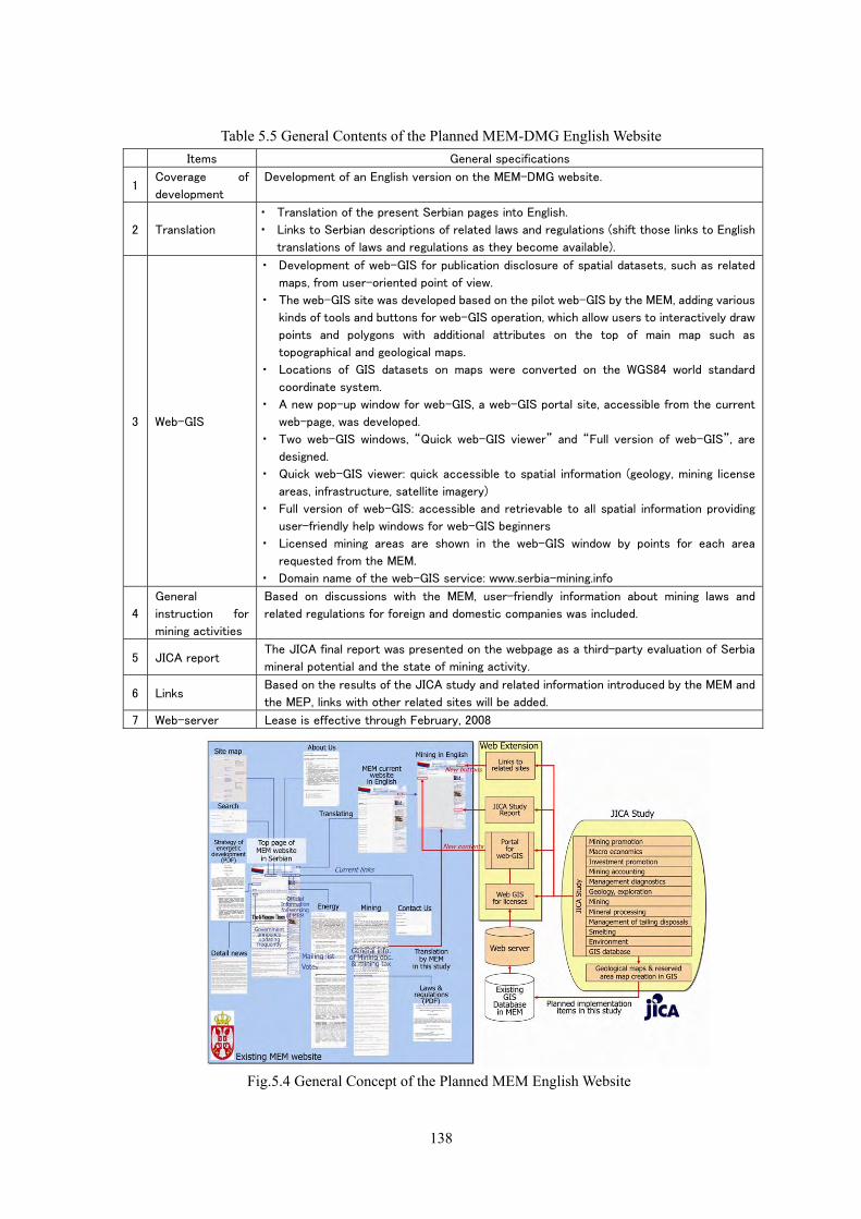
5.2.2 Expansion of the MEM Website
Regarding the updating and expansion of the MEM’s mining sector website, the MEM and the
JICA Study Team agreed to construct an English MEM website. The general contents are listed in
Table 5.5. The general concept of the planned English version of the MEM website is shown in
Fig.5.4.
138
Table 5.5 General Contents of the Planned MEM-DMG English Website Items General specifications
1 Coverage of
development
Development of an English version on the MEM-DMG website.
2 Translation
・ Translation of the present Serbian pages into English.
・ Links to Serbian descriptions of related laws and regulations (shift those links to English
translations of laws and regulations as they become available).
3 Web-GIS
・ Development of web-GIS for publication disclosure of spatial datasets, such as related
maps, from user-oriented point of view.
・ The web-GIS site was developed based on the pilot web-GIS by the MEM, adding various
kinds of tools and buttons for web-GIS operation, which allow users to interactively draw
points and polygons with additional attributes on the top of main map such as
topographical and geological maps.
・ Locations of GIS datasets on maps were converted on the WGS84 world standard
coordinate system.
・ A new pop-up window for web-GIS, a web-GIS portal site, accessible from the current
web-page, was developed.
・ Two web-GIS windows, “Quick web-GIS viewer” and “Full version of web-GIS”, are
designed.
・ Quick web-GIS viewer: quick accessible to spatial information (geology, mining license
areas, infrastructure, satellite imagery)
・ Full version of web-GIS: accessible and retrievable to all spatial information providing
user-friendly help windows for web-GIS beginners
・ Licensed mining areas are shown in the web-GIS window by points for each area
requested from the MEM.
・ Domain name of the web-GIS service: www.serbia-mining.info
4
General
instruction for
mining activities
Based on discussions with the MEM, user-friendly information about mining laws and
related regulations for foreign and domestic companies was included.
5 JICA report The JICA final report was presented on the webpage as a third-party evaluation of Serbia
mineral potential and the state of mining activity.
6 Links Based on the results of the JICA study and related information introduced by the MEM and
the MEP, links with other related sites will be added.
7 Web-server Lease is effective through February, 2008
Fig.5.4 General Concept of the Planned MEM English Website
139
Through this study, the quality and quantity of the web site have been improved dramatically
by creating an English version, updating the Serbian version and creating web-GIS. A comparison of
the MEM web contents (fundamental items for government mining sites) before and after this study are
shown in Table 5.5, with reference to Wada et al. (2006). Here, since there was no English content
before this study, I used some Serbian version contents for comparison.
Table 5.6 Development Status of Mining-related Information on the MEM Website
Item State of the MEM website
before this study Current situation
Mining Policy Existed, but could be confused with unrelated information
Stores it in an appropriate location
Mining law and related regulations
Existed, but no appropriate instructions on procedures for users
Groups laws & regulations, and shows laws in English and new guidelines for investors
Database of mineral resource information
None Stores it in “Web-GIS”
Existing geological and topographical maps and their procurement methods
None Stores in “ Web-GIS ” (1/500,000 geol. maps) Puts some docs for procurement
News & government announcements
Existed, but no fresh information Refreshed in “NEWS”
Environmental information No link to the MSEP site Links to the MSEP site
Mining license areas None Provided in “Web-GIS” (dots as areas)
Conservation and restricted areas
None Provided in “Web-GIS”
Background information such as infrastructure data
None Provided in “Web-GIS”
Support from international organizations
None JICA, (BRGM, UNDP, EBRD etc., planning)
Reports by third parties None Stores the final report & various
supplements of this study
Links to related organizations
None Links
Address Existed Adds a map (planning)
Retrieval tool Existed Adds new tool in “Web-GIS”
Web management Managed by IT engineers at the MEM Appropriate check flow for content revision and uploading exists
Language In Serbian (English version was under construction)
In Serbian & English
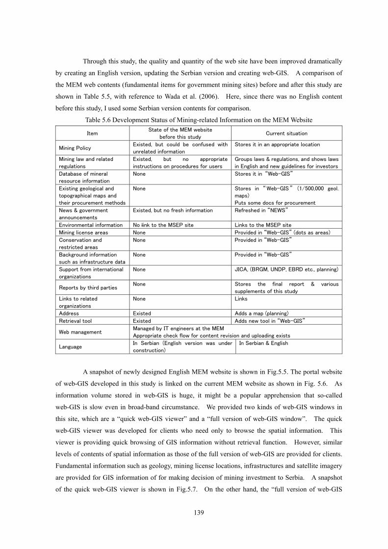
A snapshot of newly designed English MEM website is shown in Fig.5.5. The portal website
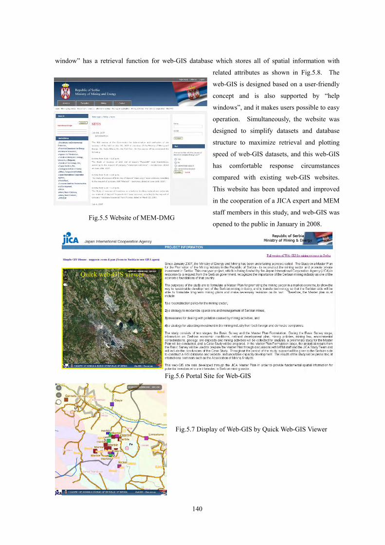
of web-GIS developed in this study is linked on the current MEM website as shown in Fig. 5.6. As
information volume stored in web-GIS is huge, it might be a popular apprehension that so-called
web-GIS is slow even in broad-band circumstance. We provided two kinds of web-GIS windows in
this site, which are a “quick web-GIS viewer” and a “full version of web-GIS window”. The quick
web-GIS viewer was developed for clients who need only to browse the spatial information. This
viewer is providing quick browsing of GIS information without retrieval function. However, similar
levels of contents of spatial information as those of the full version of web-GIS are provided for clients.
Fundamental information such as geology, mining license locations, infrastructures and satellite imagery
are provided for GIS information of for making decision of mining investment to Serbia. A snapshot
of the quick web-GIS viewer is shown in Fig.5.7. On the other hand, the “full version of web-GIS
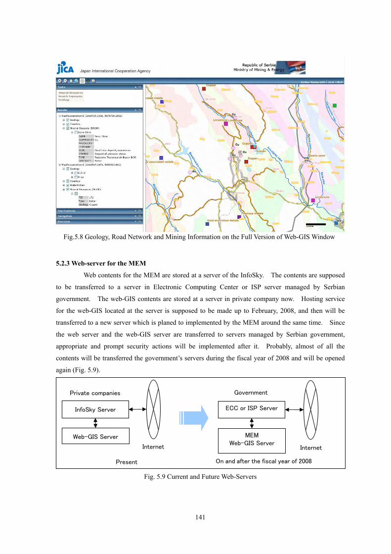
140
window” has a retrieval function for web-GIS database which stores all of spatial information with
related attributes as shown in Fig.5.8. The
web-GIS is designed based on a user-friendly
concept and is also supported by “help
windows”, and it makes users possible to easy
operation. Simultaneously, the website was
designed to simplify datasets and database
structure to maximize retrieval and plotting
speed of web-GIS datasets, and this web-GIS
has comfortable response circumstances
compared with existing web-GIS websites.
This website has been updated and improved
in the cooperation of a JICA expert and MEM
staff members in this study, and web-GIS was
opened to the public in January in 2008.
Fig.5.5 Website of MEM-DMG
Quick web-GIS viewer
Fig.5.6 Portal Site for Web-GIS
Fig.5.7 Display of Web-GIS by Quick Web-GIS Viewer
141
5.2.3 Web-server for the MEM
Web contents for the MEM are stored at a server of the InfoSky. The contents are supposed
to be transferred to a server in Electronic Computing Center or ISP server managed by Serbian
government. The web-GIS contents are stored at a server in private company now. Hosting service
for the web-GIS located at the server is supposed to be made up to February, 2008, and then will be
transferred to a new server which is planed to implemented by the MEM around the same time. Since
the web server and the web-GIS server are transferred to servers managed by Serbian government,
appropriate and prompt security actions will be implemented after it. Probably, almost of all the
contents will be transferred the government’s servers during the fiscal year of 2008 and will be opened
again (Fig. 5.9).
Fig. 5.9 Current and Future Web-Servers
Web-GIS Server
InfoSky Server
MEM Web-GIS Server
ECC or ISP Server
Internet Internet
Present On and after the fiscal year of 2008
Private companies Government
Fig.5.8 Geology, Road Network and Mining Information on the Full Version of Web-GIS Window
142
5.3 Some Approaches to Database Creation at MEP
In order to compile geological and mineral resource information, the former Ministry of
Science and Environmental Protection (MSEP) had been conducting the following projects. The
MSEP was subsequently divided into two ministries, i.e., Ministry of Environmental Protection (MEP)
and Ministry of Science (MS), and these projects are now being handled by the MEP.
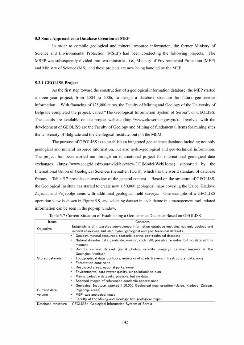
5.3.1 GEOLISS Project
As the first step toward the construction of a geological information database, the MEP started
a three–year project, from 2004 to 2006, to design a database structure for future geo-science
information. With financing of 125,000 euros, the Faculty of Mining and Geology of the University of
Belgrade completed the project, called “The Geological Information System of Serbia”, or GEOLISS.
The details are available on the project website (http://www.ekoserb.sr.gov.yu/). Involved with the
development of GEOLISS are the Faculty of Geology and Mining of fundamental items for mining sites
the University of Belgrade and the Geological Institute, but not the MEM.
The purpose of GEOLISS is to establish an integrated geo-science database including not only
geological and mineral resource information, but also hydro-geological and geo-technical information.
The project has been carried out through an international project for international geological data
exchanges (https://www.seegrid.csiro.au/twiki/bin/view/CGIModel/WebHome) supported by the
International Union of Geological Sciences (hereafter, IUGS), which has the world standard of database
frames. Table 5.7 provides an overview of the general content. Based on the structure of GEOLISS,
the Geological Institute has started to create new 1:50,000 geological maps covering the Uzice, Kladovo,
Zajecar, and Prijepolje areas with additional geological field surveys. One example of a GEOLISS
operation view is shown in Figure 5.9, and selecting dataset in each theme in a management tool, related
information can be seen in the pop-up window.
Table 5.7 Current Situation of Establishing a Geo-science Database Based on GEOLISS Items Contents
Objective Establishing of integrated geo-science information database including not only geology and mineral resources, but also hydro-geological and geo-technical datasets.
Stored datasets
・ Geology, mineral resources, tectonic, boring, geo-technical datasets ・ Natural disaster data (landslide, erosion, rock fall), possible to enter, but no data at this
moment ・ Remote sensing dataset (aerial photos, satellite imagery): Landsat imagery at the
Geological Institute ・ Topographical data, contours, networks of roads & rivers, infrastructural data: none ・ Forestation data: none ・ Restricted areas, national parks: none ・ Environmental data (water quality, air pollution): no plan ・ Mining cadastre datasets: possible, but no data ・ Scanned images of referenced academic papers: none
Current data volume
・ Geological Institute: started 1:50,000 Geological map creation (Uzice, Kladovo, Zajecar, Prijepolje areas)
・ MEP: two geological maps ・ Faculty of the Mining and Geology: two geological maps
Database structure GEOLISS: Geological Information System of Serbia
143
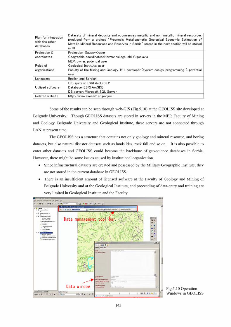
Plan for integration with the other databases
Datasets of mineral deposits and occurrences metallic and non-metallic mineral resources produced from a project “Prognosis Metallogenetic Geological Economic Estimation of Metallic Mineral Resources and Reserves in Serbia” stated in the next section will be stored in GI
Projection & coordinates
Projection:Gauss-Kruger Geographic coordinates:Hermannskogel old Yugoslavia
Roles of organizations
MEP: owner, potential user Geological Institute: user Faculty of the Mining and Geology, BU: developer (system design, programming,..), potential user
Languages English and Serbian
Utilized software GIS system: ESRI ArcGIS9.2 Database: ESRI ArcSDE DB server: Microsoft SQL Server
Related website http://www.ekoserb.sr.gov.yu/
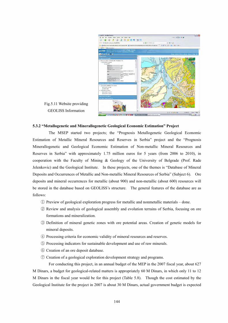
Some of the results can be seen through web-GIS (Fig.5.10) at the GEOLISS site developed at
Belgrade University. Though GEOLISS datasets are stored in servers in the MEP, Faculty of Mining
and Geology, Belgrade University and Geological Institute, these servers are not connected through
LAN at present time.
The GEOLISS has a structure that contains not only geology and mineral resource, and boring
datasets, but also natural disaster datasets such as landslides, rock fall and so on. It is also possible to
enter other datasets and GEOLISS could become the backbone of geo-science databases in Serbia.
However, there might be some issues caused by institutional organization.
• Since infrastructural datasets are created and possessed by the Military Geographic Institute, they
are not stored in the current database in GEOLISS.
• There is an insufficient amount of licensed software at the Faculty of Geology and Mining of
Belgrade University and at the Geological Institute, and proceeding of data-entry and training are
very limited in Geological Institute and the Faculty.
Data management tool bar
Data window Fig.5.10 Operation Windows in GEOLISS
144
5.3.2 “Metallogenetic and Minerallogenetic Geological Economic Estimation” Project
The MSEP started two projects; the “Prognosis Metallogenetic Geological Economic
Estimation of Metallic Mineral Resources and Reserves in Serbia” project and the “Prognosis
Minerallogenetic and Geological Economic Estimation of Non-metallic Mineral Resources and
Reserves in Serbia” with approximately 1.75 million euros for 5 years (from 2006 to 2010), in
cooperation with the Faculty of Mining & Geology of the University of Belgrade (Prof. Rade
Jelenkovic) and the Geological Institute. In these projects, one of the themes is “Database of Mineral
Deposits and Occurrences of Metallic and Non-metallic Mineral Resources of Serbia” (Subject 6). Ore
deposits and mineral occurrences for metallic (about 900) and non-metallic (about 600) resources will
be stored in the database based on GEOLISS’s structure. The general features of the database are as
follows:
① Preview of geological exploration progress for metallic and nonmetallic materials – done.
② Review and analysis of geological assembly and evolution terrains of Serbia, focusing on ore
formations and mineralization.
③ Definition of mineral genetic zones with ore potential areas. Creation of genetic models for
mineral deposits.
④ Processing criteria for economic validity of mineral resources and reserves.
⑤ Processing indicators for sustainable development and use of raw minerals.
⑥ Creation of an ore deposit database.
⑦ Creation of a geological exploration development strategy and programs.
For conducting this project, in an annual budget of the MEP in the 2007 fiscal year, about 627
M Dinars, a budget for geological-related matters is appropriately 60 M Dinars, in which only 11 to 12
M Dinars in the fiscal year would be for this project (Table 5.8). Though the cost estimated by the
Geological Institute for the project in 2007 is about 30 M Dinars, actual government budget is expected
Fig.5.11 Website providing
GEOLISS Information
145
to be at the same level as last year, and a large budget discrepancy will appear. Database creation will
be included in (a) to (c) in the following Table.
Table 5.8 Budgets for the Project (unit:Million Dinars)
(a) (b) (c) (c) Government budget
Year Metal Non-metal
Fossil Fuel
Mineral Genetic
This project
Total in geological section
Estimation based on 2007 plan
2006 2.2 4.6 0.8 3.1 10.7 55 -
2007 ? ? ? ? 11-12? 60 30
There are some issues with conducting the project in this calendar year, and it will be
necessary to make a downward revision of specifications.
• A shortage of government funding (might be approximately one-third of estimated costs)
• Shortening of the term by delays of tenders and contracts will result in a total working time of
only about three months, making it difficult to complete all of tasks planned by the Geological
Institute.
• A lack of IT skilled workers for data conversion and creation of spatial datasets
5.3.3 “Strategy for Sustainable Development of Mineral Resources in Serbia” Project
This project was financed by the European Bank for Reconstruction and Development
(EBRD), and covers 7 fields. One of tasks is to review ore deposits and mineral occurrences for
metallic, non-metallic, and fossil fuels. Upon completion, it will be the most accurate geological
information resource in Serbia to date. The project was undertaken with the cooperation of Faculty of
Mining & Geology of the University of Belgrade, the Geological Institute, and the MEM. It is
currently in the final stage of data compilation.
As these projects are fundamental steps towards establishing a database which integrates the
most accurate datasets, their final results will provide important and valuable information. Therefore,
the MEM also needs to create a partnership with related organizations to advance future cooperative
utilization of the database.
5.4 Geological and Related Maps at the Geological Institute
The Geological Institute has produced geological maps, hydro-geological maps, and other
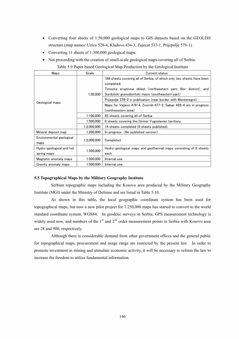
maps of Serbia. Table 5.9 lists paper-based maps produced by the Geological Institute.
As the Geological Institute is one of the governmental organizations which has started to utilize GIS
technology, the technical potential there is very high. The Geological Institute is creating GIS datasets
with geological field surveys. However, the process of converting geological information to GIS
datasets is moving slowly at the present time, because of a lack of budget for field surveys. The
current state of the GIS database at the Geological Institute is as follows.
• Creating GIS datasets for two 1:100,000 metallogenetic province maps; 1:25,000 maps for one
of the areas have already been completed.
146
• Converting four sheets of 1:50,000 geological maps to GIS datasets based on the GEOLISS
structure (map names: Uzice 528-4, Kladovo 434-3, Zajecar 533-1, Prijepolje 578-1).
• Converting 11 sheets of 1:300,000 geological maps.
• Not proceeding with the creation of small-scale geological maps covering all of Serbia.
Table 5.9 Paper-based Geological Map Production by the Geological Institute Maps Scale Current status
189 sheets covering all of Serbia, of which only two sheets have been
completed:
Timocka eruptivna oblast (northeastern part; Bor district), and
Surdulicki granodioritski masiv (southeastern part)
Prijepolje 578-2 in publication (near border with Montenegro)
1:50,000
Maps for Valjevo 478-4, Zvornik 477-2, Sabac 428-4 are in progress
(northwestern area)
1:100,000 65 sheets covering all of Serbia
1:500,000 6 sheets covering the former Yugoslavian territory
Geological maps
1:2,000,000 14 sheets completed (9 sheets published)
Mineral deposit map 1:200,000 In progress (No published version)
Environmental geological
maps 1:2,000,000 Completed
Hydro-geological and hot
spring maps 1:500,000
Hydro-geological maps and geothermal maps consisting of 6 sheets
each
Magnetic anomaly maps 1:500,000 Internal use
Gravity anomaly maps 1:500,000 Internal use
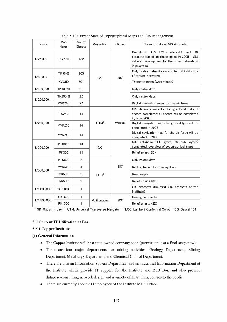
5.5 Topographical Maps by the Military Geography Institute
Serbian topographic maps including the Kosovo area produced by the Military Geography
Institute (MGI) under the Ministry of Defense and are listed in Table 5.10. As shown in this table, the local geographic coordinate system has been used for
topographical maps, but now a new pilot project for 1:250,000 maps has started to convert to the world
standard coordinate system, WGS84. In geodetic surveys in Serbia, GPS measurement technology is
widely used now, and numbers of the 1st and 2nd order measurement points in Serbia with Kosovo area
are 28 and 900, respectively.
Although there is considerable demand from other government offices and the general public
for topographical maps, procurement and usage range are restricted by the present law. In order to
promote investment in mining and stimulate economic activity, it will be necessary to reform the law to
increase the freedom to utilize fundamental information.
147
Table 5.10 Current State of Topographical Maps and GIS Management
Scale Map
Name
No. of
Sheets Projection Ellipsoid Current state of GIS datasets
1/25,000 TK25/III 732
Completed DEM ( 25m interval ) and TIN
datasets based on these maps in 2005. GIS
dataset development for the other datasets is
in progress.
TK50/II 203 Only raster datasets except for GIS datasets
of stream networks 1/50,000
KVO50 201 Thematic maps (watersheds)
1/100,000 TK100/II 61 Only raster data
TK200/II 22 Only raster data 1/200,000
VVK200 22
GK1 BS4
Digital navigation maps for the air force
TK250 14
GIS datasets only for topographical data, 2
sheets completed; all sheets will be completed
by Nov. 2007
VVK250 14 Digital navigation maps for ground type will be
completed in 2007
1/250,000
VVK250 14
UTM2 WGS84
Digital navigation map for the air force will be
completed in 2008
PTK300 13 GIS database (14 layers, 69 sub layers)
completed, overview of topographical maps 1/300,000
RK300 13
GK1
Relief chart (3D)
PTK500 2 Only raster data
VVK500 4 Raster, for air force navigation
SK500 2 Road maps 1/500,000
RK500 2 Relief charts (3D)
1/1,000,000 OGK1000 1
LCC3
BS4
GIS datasets (the first GIS datasets at the
Institute)
GK1500 1 Geological charts 1/1,500,000
RK1500 1 Polikonusna BS4
Relief charts (3D)
1 GK:Gauss-Kruger 2 UTM: Universal Transverse Mercator 3 LCC: Lambert Conformal Conic 4BS: Bessel 1841
5.6 Current IT Utilization at Bor
5.6.1 Copper Institute
(1) General Information • The Copper Institute will be a state-owned company soon (permission is at a final stage now).
• There are four major departments for mining activities: Geology Department, Mining
Department, Metallurgy Department, and Chemical Control Department.
• There are also an Information System Department and an Industrial Information Department at
the Institute which provide IT support for the Institute and RTB Bor, and also provide
database-consulting, network design and a variety of IT training courses to the public.
• There are currently about 200 employees of the Institute Main Office.
148
• There are 5 members in the Industrial Information Department.
• There are 14 university-educated programmers and system engineers.
• There is no geophysical exploration by the Copper Institute and no geophysicists.
(2) Current State of IT Utilization at the Copper Institute
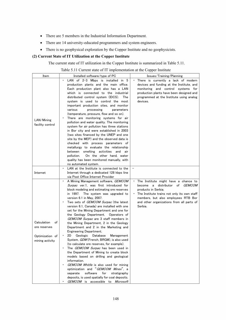
The current state of IT utilization in the Copper Institute is summarized in Table 5.11.
Table 5.11 Current state of IT implementation at the Copper Institute Item Installed software/type of PC Issues/Training/Planning
LAN/Mining
facility control
・ LAN of 2-3 Mbps is installed in 5 production plants and the main office. Each production plant also has a LAN which is connected to the industrial distributed control system (IDCS). The system is used to control the most important production sites, and monitor various processing parameters (temperature, pressure, flow and so on).
・ There are monitoring systems for air pollution and water quality. The monitoring system for air pollution has three stations in Bor city and were established in 2003 (two sites financed by the UNEP and one site by the MEP) and the observed data is checked with process parameters of metallurgy to evaluate the relationship between smelting activities and air pollution. On the other hand, water quality has been monitored manually, with no automated system.
・ There is currently a lack of modern devices and funding at the Institute, and monitoring and control systems for production plants have been designed and programmed at the Institute using analog devices.
Internet
・ LAN at the Institute is connected to the Internet through a dedicated 128 kbps line via Post Office Internet Provider
-
Calculation of
ore reserves
Optimization of
mining activity
・ A Mining Management software, GEMCOM Surpac ver.1, was first introduced for block modeling and estimating ore reserves in 1997. The system was upgraded to version 6.1 in May, 2007.
・ Two sets of GEMCOM Surpac (the latest version 6.1, Canada) are installed with one set for the Mining Department and one for the Geology Department. Operators of GEMCOM Surpac are 3 staff members in the Mining Department, 2 in the Geology Department and 2 in the Marketing and Engineering Department.
・ 2D Geologic Database Management System, GDM (French, BRGM), is also used (to calculate ore reserves, for example).
・ The GEMCOM Surpac has been used in the Department of Mining to create block models based on drilling and geological information.
・ GEMCOM Whitlle is also used for mining optimization and “GEMCOM Minex”, a separate software for stratigraphy deposits, is used spatially for coal deposits.
・ GEMCOM is accessible to Microsoft
・ The Institute might have a chance to become a distributor of GEMCOM products in Serbia.
・ The Institute trains not only its own staff members, but also employees RTB Bor and other organizations from all parts of Serbia.
149
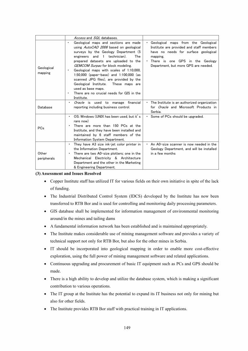
Access and SQL databases.
Geological
mapping
・ Geological maps and sections are made using AutoCAD 2006 based on geological surveys by the Geology Department (5 engineers and 1 technician). The prepared datasets are uploaded to the GEMCOM Surpac for block modeling.
・ Geological maps with scales of 1:10,000, 1:50,000 (paper-base) and 1:100,000 (as scanned JPG files), are provided by the Geological Institute. These maps are used as base maps.
・ There are no crucial needs for GIS in the Institute.
・ Geological maps from the Geological Institute are provided and staff members have no needs for surface geological mapping.
・ There is one GPS in the Geology Department, but more GPS are needed.
Database
・ Oracle is used to manage financial reporting including business control.
・ The Institute is an authorized organization for Oracle and Microsoft Products in Serbia.
PCs
・ OS: Windows (UNIX has been used, but it’s rare now)
・ There are more than 150 PCs at the Institute, and they have been installed and maintained by 6 staff members of the Information System Department.
・ Some of PCs should be upgraded.
Other
peripherals
・ They have A3 size ink-jet color printer in the Information Department.
・ There are two A0-size plotters; one in the Mechanical Electricity & Architecture Department and the other in the Marketing & Engineering Department.
・ An A0-size scanner is now needed in the Geology Department, and will be installed in a few months
(3) Assessment and Issues Resolved
• Copper Institute staff has utilized IT for various fields on their own initiative in spite of the lack
of funding.
• The Industrial Distributed Control System (IDCS) developed by the Institute has now been
transferred to RTB Bor and is used for controlling and monitoring daily processing parameters.
• GIS database shall be implemented for information management of environmental monitoring
around/in the mines and tailing dams
• A fundamental information network has been established and is maintained appropriately.
• The Institute makes considerable use of mining management software and provides a variety of
technical support not only for RTB Bor, but also for the other mines in Serbia.
• IT should be incorporated into geological mapping in order to enable more cost-effective
exploration, using the full power of mining management software and related applications.
• Continuous upgrading and procurement of basic IT equipment such as PCs and GPS should be
made.
• There is a high ability to develop and utilize the database system, which is making a significant
contribution to various operations.
• The IT group at the Institute has the potential to expand its IT business not only for mining but
also for other fields.
• The Institute provides RTB Bor staff with practical training in IT applications.
150
5.6.2 RTB Bor
(1) General Information
• RTB Bor is comprised of the following three companies:
① The Bor Copper mine: RBB located in Bor City
② The Majdanpek Copper mine: RBM located in Majdanpek City (80 km north of Bor city)
③ The Copper Smelter: TIR located in Bor city
• The web site for RBB (http://www.rbb.co.yu/) has been suspended because the web content was
moved to a new server at RBB. It is operated by the Data Automation Department.
• Mining equipment procurement has the first priority at RBB at this time, and the replacement
of software and PCs has been delayed in spite of the demand for it.
(2) Current Situation of IT Utilization at RBB Bor
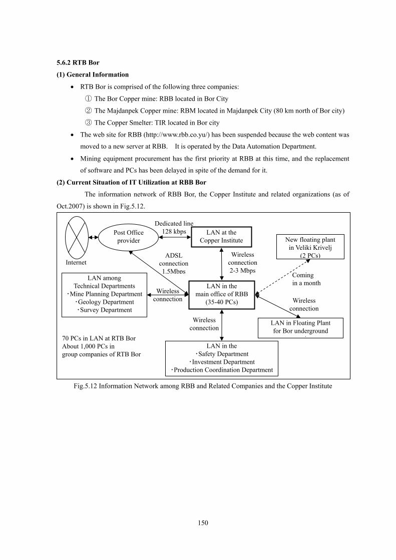
The information network of RBB Bor, the Copper Institute and related organizations (as of
Oct.2007) is shown in Fig.5.12.
Fig.5.12 Information Network among RBB and Related Companies and the Copper Institute
LAN in the main office of RBB
(35-40 PCs)
LAN among Technical Departments
・Mine Planning Department ・Geology Department ・Survey Department
LAN in Floating Plant for Bor underground
tiLAN in the
・Safety Department ・Investment Department
・Production Coordination Department
LAN at the Copper Institute New floating plant
in Veliki Krivelj (2 PCs) ADSL
connection 1.5Mbps
70 PCs in LAN at RTB Bor About 1,000 PCs in group companies of RTB Bor
Post Office provider
Dedicated line128 kbps
Internet
Wireless connection
Wireless connection
Wireless connection 2-3 Mbps
Coming in a month
Wireless connection
151
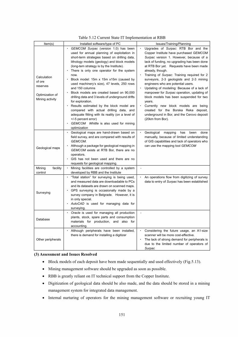
Table 5.12 Current State IT Implementation at RBB Item(s) Installed software/type of PC Issues/Training/Planning
Calculation of ore reserves Optimization of Mining activity
・ GEMCOM Surpac (version 1.0) has been used for annual planning of exploitation in short-term strategies based on drilling data, lithology models (geology) and block models (long-tem strategy is by the Institute).
・ There is only one operator for the system now.
・ Block model: 15m x 15m x15m (caused by used machinery’s size), 47 levels, 250 rows and 150 columns
・ Block models are created based on 90,000 drilling data and 3 levels of underground drifts for exploration.
・ Results estimated by the block model are compared with actual drilling data, and adequate fitting with its reality (on a level of +/-5 percent error)
・ GEMCOM Whitlle is also used for mining optimization
・ Upgrades of Surpac: RTB Bor and the Copper Institute have purchased GEMCOM Surpac version 1. However, because of a lack of funding, no upgrading has been done at RTB Bor yet. Requests have been made already, though.
・ Training of Surpac: Training required for 2 surveyors, 2-3 geologists and 2-3 mining engineers who are potential users.
・ Updating of modeling: Because of a lack of manpower for Surpac operation, updating of block models has been suspended for two years.
・ Currently new block models are being created for the Borska Reka deposit, underground in Bor, and the Cerovo deposit (20km from Bor).
Geological maps
・ Geological maps are hand-drawn based on field survey, and are compared with results of GEMCOM.
・ Although a package for geological mapping in GEMCOM exists at RTB Bor, there are no operators.
・ GIS has not been used and there are no requests for geological mapping.
・ Geological mapping has been done manually, because of limited understanding of GIS capabilities and lack of operators who can use the mapping tool GEMCOM
Mining facility control
・ Mining facilities are controlled by a system developed by RBB and the Institute
-
Surveying
・ “Total station” for surveying is being used, and measured data are downloadable to PCs and its datasets are drawn on scanned maps.
・ GPS surveying is occasionally made by a survey company in Belgrade. However, it is in only special.
・ AutoCAD is used for managing data for surveying.
・ An operations flow from digitizing of survey data to entry of Surpac has been established
Database
・ Oracle is used for managing all production plants, stock, spare parts and consumption materials for production, and also for accounting.
-
Other peripherals
・ Although peripherals have been installed, there is demand for installing a digitizer
・ Considering the future usage, an A1-size scanner will be more cost-effective.
・ The lack of strong demand for peripherals is due to the limited number of operators of Surpac
(3) Assessment and Issues Resolved
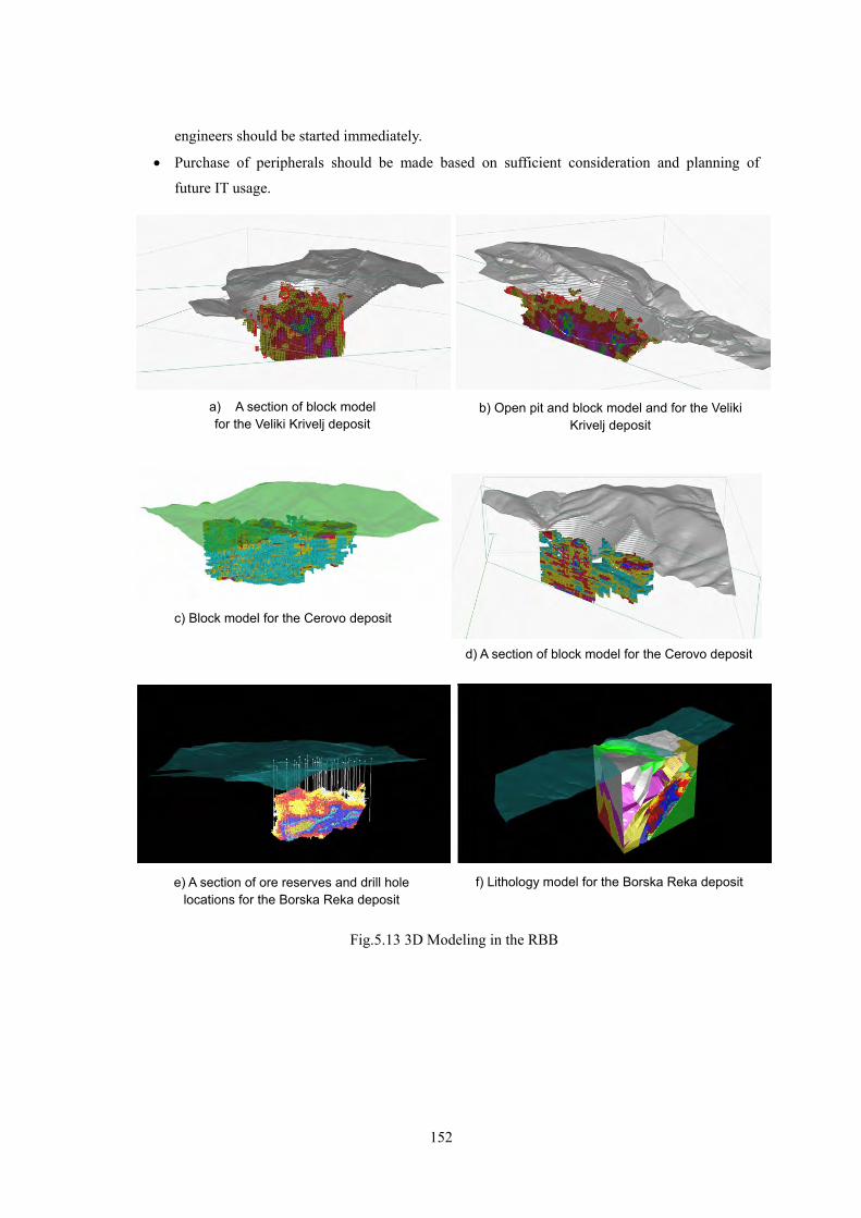
• Block models of each deposit have been made sequentially and used effectively (Fig.5.13).
• Mining management software should be upgraded as soon as possible.
• RBB is greatly reliant on IT technical support from the Copper Institute.
• Digitization of geological data should be also made, and the data should be stored in a mining
management system for integrated data management.
• Internal nurturing of operators for the mining management software or recruiting young IT
152
engineers should be started immediately.
• Purchase of peripherals should be made based on sufficient consideration and planning of
future IT usage.
b) Open pit and block model and for the Veliki Krivelj deposit
a) A section of block model for the Veliki Krivelj deposit
c) Block model for the Cerovo deposit
d) A section of block model for the Cerovo deposit
f) Lithology model for the Borska Reka deposite) A section of ore reserves and drill hole locations for the Borska Reka deposit
Fig.5.13 3D Modeling in the RBB
153
5.7 The Seismological Survey of Serbia
In order for mining activity to remain safe, it is crucial to grasp information and risk of natural
disaster for acquiring transportation routes of products. Information on seismic disasters and
landslides is of particular interest to the Seismological Survey of Serbia. The main missions of
Seismological Survey of Serbia are to 1) obtain information on the seismicity of the country through
seismic observation, and 2) create seismological risk maps based on the current seismicity and historical
seismic activities. The Institution is run by 18 staff members with an annual budget of 25 million
Dinars and financed by international support from JICA, NATO, and so on.
In 2006, the Survey acquired the ability to detect micro earthquakes and monitor events with a
magnitude of 1.5 or more occurring anywhere in the country. The distribution of hypocenters is
managed by the standard GIS software, ArcGIS and MapInfo. For disastrous earthquake occurrence
risk maps, “hazard maps of max aspects of intensity” are accessible from the website
(http://www.seismo.sr.gov.yu/). These maps have been created based on historical seismic events and
soil conditions, and classifying potential of maximum intensities in 12 categories on the Mercalli scale,
which may occur in the coming 100 years. However, active fault studies have been not carried out,
and there has been no consideration of wide area tectonics for risk map creation.
Landslide damage has been reported in this country, but no specific organizations have been
managing such information.
5.8 Construction of a MEM GIS Database
As a result of discussions with the MEM staff, we agreed to extend the current GIS database
through the following means:
• Geological maps, topographical and geological index maps, and distribution of updated
conservation and restricted areas, shall be added to the present GIS database as fundamental
spatial information for mining license management and for foreign investors, and will be
available on the MEM website.
• Six sheets of 1:500,000 geological maps provided by the Geological Institute were scanned and
converted to shape files. Geological unit attribute information was added by the MEM and the
JICA expert (Fig.5.14). The geological information was provided for the GIS database and
web-GIS creation.
• Index maps for 1:25,000, 1:50,000, and 1:100,000 topographical and geological maps provided
by the Geological Institute and the MGI are being converted to shape files with attributes added
by MEM staff.
• Paper-based maps of conservation and restricted areas such as national parks, nature parks,
nature reserve areas, areas being considered for protection and so on provided by the Institute
for Nature Conservation of Serbia was added to the current GIS database.
154
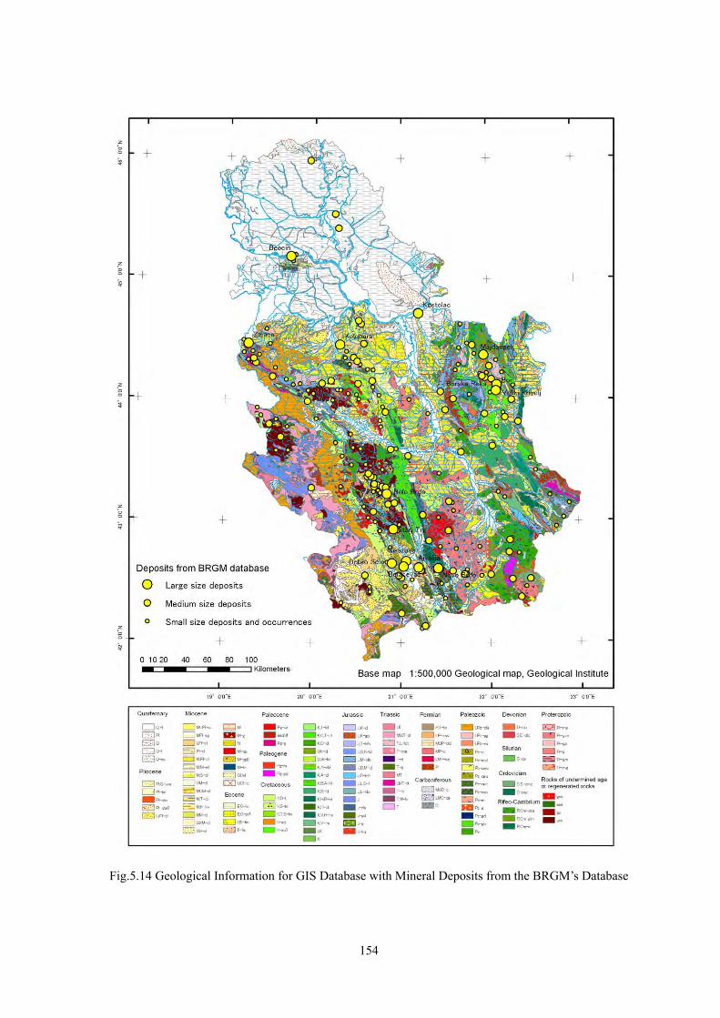
Fig.5.14 Geological Information for GIS Database with Mineral Deposits from the BRGM’s Database

155
5.9 Local Consignment and Lease
In this study we made subcontracting agreements and signed leases with local companies to
facilitate the development of the website and to assist with GIS operation at the MEM.
PCs and peripherals have been provided to the MEM with leases through the end of February,
2008, as shown in Table 5.13. In response to requests from the MEM, an A1 size printer was provided
for a large –sized printout of standard maps, and an A3 size scanner with an automatic feeder was
provided to convert various paper-based application documents of more than 10,000 pages for
computer-based storage in PDF format. As result, staff of the MEM can use this scanner to quickly
scan documents at rate of about 20 pages per minute, and it seems to lead to store application
documents related to mining licenses into a database. GIS software is also being provided as a result
of discussions with the MEM, as listed in Table 5.14.
Table 5.13 Computers and Peripherals Name Specifications set
1 Desktop PC
Desktop PC CPU: Core2Duo E6320 1.86GHz, RAM: 2GB, HDD: 400GB, Graphic Card: 512MB, DVD-R+R/RW, Wireless mouse, Display: LCD 21"(ViewSonic) with DVI (Digital Video Interface), OS: Windows-XP
1
2 Laptop PC(1) TOSHIBA Tecra A8-104 Laptop PC, display: 15.4", CPU: Core2Duo T7200 2GHz, Memory: 2GB, HDD:120GB, DVD-RW, OS: Windows-XP
1
3 Laptop PC(2) TOSHIBA Satellite P200-10C Laptop PC, display: 17", CPU: Core2Duo T7200 2GHz, Memory: 2GB, HDD:250GB, DVD-RW, OS:Windows-XP
1
4 Printer (A3) HP Business Ink Jet 2800 Powerful A3+ Color printer, size: A3, 24ppm, 4800dpi, 150 sheet Input Tray
1
5 Printer (A1) HP Designjet 130 Color printer, 2400 x 120dpi, size: A1
1
6 Scanner (A3) EPSON A3 AKENER GT 15000 + ADF Scanner with feeder, size: A3-A5, Duplex/Simplex, ADF only, Load & Eject Capacity 100 sheets, Ultra SCSI+USB
1
Table 5.14 GIS Software
Name of software General specifications set
1 GIS core system ESRI ArcEditor 9.2
Powerful GIS desktop system for editing and managing geographic data. Includes all the functionality of ArcView and adds a comprehensive set of tools to create, edit, and ensure the quality of data
1
2 Extension software: Spatial Analyst
Extensive tools for comprehensive, raster-based spatial modeling and analysis 1
3 Extension software: 3D Analyst
Extensive tools for three dimensional visualization and analysis 1
4 Extension software: Geostatistical Analyst
Extensive tools for spatial data exploration, identification of data anomalies, optimum prediction, evaluation of prediction uncertainty, and surface creation
1
5.10 Technology Transfer
The expert has given MEM staff instructions on how to create “shape” files for geological
maps and index maps, and how to add attributes to them. The JICA Study Team and the MEM have
156
agreed to pick up items for training, while confirming progress of GIS operations.
To update the MEM website, the expert instructed the MEM staff members about crucial
items such as information disclosure from mining-related government sites and adequate file formats.
5.11 Strategic Future Database Construction
In this section, I will discuss the future management of geological and mineral resource
information based on the current organizational structure.
5.11.1 MEM-DMG
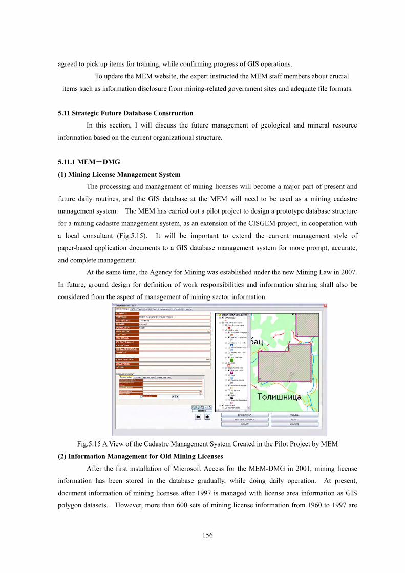
(1) Mining License Management System
The processing and management of mining licenses will become a major part of present and
future daily routines, and the GIS database at the MEM will need to be used as a mining cadastre
management system. The MEM has carried out a pilot project to design a prototype database structure
for a mining cadastre management system, as an extension of the CISGEM project, in cooperation with
a local consultant (Fig.5.15). It will be important to extend the current management style of
paper-based application documents to a GIS database management system for more prompt, accurate,
and complete management. At the same time, the Agency for Mining was established under the new Mining Law in 2007.
In future, ground design for definition of work responsibilities and information sharing shall also be
considered from the aspect of management of mining sector information.
Fig.5.15 A View of the Cadastre Management System Created in the Pilot Project by MEM
(2) Information Management for Old Mining Licenses
After the first installation of Microsoft Access for the MEM-DMG in 2001, mining license
information has been stored in the database gradually, while doing daily operation. At present,
document information of mining licenses after 1997 is managed with license area information as GIS
polygon datasets. However, more than 600 sets of mining license information from 1960 to 1997 are
157
still stocked in the Central Archives in the Republic of Serbia as paper-documents and paper-maps with
standardized references numbers. Thus datasets for past mining activities would be very informative
and would accelerate current and future mining exploration and exploitation, provided that the stocked
existing information is managed in digital format in the database and is provided for mining companies
and investors. So, it is very important to digitize all of existing information and to stored in the
appropriate database, rapidly as possible.
However, a volume of this operation is very huge for the present staff members in the
MEM-DMG while doing daily management for mining activities, and it would be difficult to complete
the tons of information. Therefore, supports of international organization in JICA or WB expert
dispatch or in mini-project might be very effective for this achievement. In this case, it would be
possible to complete for text-entry, document scanning, digitizing areas as polygon files and so on by
two database experts and local consultants who have enough understanding and knowledge of mining
activities in Serbia through one-year project.
5.11.2 MEP, GI, BU
The MEP is proceeding to create a geological and mineral resource database (GEOLISS) and
GIS-based geological mapping with the Geological Institute and the Faculty of Mining and Geology of
the University of Belgrade. The framework will be fundamental geo-science datasets of Serbia which
will provide the backbone of an earth science information system through revision of the GEOLISS.
The MEP is also managing datasets for water quality monitoring, which shall be integrated for future
information disclosure.
5.11.3 MGI
Geodetic measurements and topographic maps are made by the MGI. Restrictions have been
imposed on their use, not only by the public but also by government organizations, and they have not
given status of public property. The current lack of infrastructural information such as topography,
road and stream networks, etc., of the geological and mineral resource database shall be ameliorated to
achieve one of the most basic missions in a nation, which is providing basic information for mining
activity.
158
Chapter 6 Environmental Considerations
6.1 Laws and Regulations related to Environment
There are said to be 100 or more environmental protection laws and regulations in addition
to the basic four below.
1. Law of Environmental Protection
2. Law on Strategic Environmental Impact Assessment
3. Law on Environmental Impact Assessment
4. Law on Integrated Environmental Pollution Prevention and Control-IPPC
These four basic environmental laws are modeled on the EC standard. This will make it
possible for Serbia to work easily with EC countries and eventually join the EC as a signatory
country.
Environmental laws and regulations are basically grouped as follows. The main laws and
regulations are enumerated at the supporting data A in the end of this report.
6.1.1 Basic Environmental Laws
a) Law of Environmental Protection
The Law of Environmental Protection is the fundamental law for environmental protection,
and has served as the basis for three other laws. The items regulated by this law include not only
measures for prevention air, water, soil, noise and vibration pollution, but also provisions for waste
control, radiation protection and chemical materials management. The law is also used to promote
sustainable development of natural resources, maintain biodiversity, protect the ozone layer, and
provide for a public participation system. The independent management and voluntary control are
expressed as a method of risk management, and minimizing impacts on the environment by adopting
BAT (Best Available Technology) is clear. The regulatory values are not clearly defined in the
provision, but the law does specify that the government provide the environmental standards and
emission norms. The regulatory values are set in individual laws and regulations.
b) Law on Strategic Environmental Impact Assessment
The Law on Strategic Environmental Impact Assessment provides that the adverse effects
etc., which a project has on the environment, are forecast beforehand and are evaluated, are
prevented and are controlled, to makes compatible with Sustainable Development and the
Environmental Protection (including the protection of natural resources, the spectacle and cultural
asset, and biodiversity, etc.). At the same time it is to maintain the consistency with another field.
The projects, plans and sector master plans that should execute the Strategic Environmental Impact
Assessment are in the field of the spatial plan, the town planning or the land use planning, planning
in the fields of agriculture, forestry, fishing industry, hunting, energy, industry, transport, the waste
management, the water management, telecommunications, tourism, preservation of natural habitats
159
and wildlife (flora and fauna). The master plan according to the mining field isn't included. We
confirmed to the Ministry of Energy and Mining and the Ministry for Science and Environmental Protection that this master plan for Promotion of Mining Industry in republic of
Serbia doesn't correspond to the master plan executing SEA.
The person to actually execute the Strategic Environmental Impact Assessment and to
describe its report is prescribed clearly that the legal person or the natural person is registered in the
registry book, and forms the specialist group composed of experts who have the qualification of the
analysis concerning each strategy assessment element. The person in charge of the report author is a
specialist with an appropriate university degree, who has the work experience for five years or more
in the particular field, and who has already participated in two environmental impact assessment
services. Then, it is necessary to consign it to third party's registered agency even in case of the
competent authorities. The SEA procedure and the content of the SEA report and the criteria for the
evaluation of the SEA reports are provided for in detail. Also, this law is clearly provided the adapt
of the public participation system.
c) Law on Environmental Impact Assessment
Law on Environmental Impact Assessment provides regulations concerning the
environmental assessment procedure to the project that exerts a heavy influence on the environment.
That is, it provides for the content of the EIA study report, monitoring procedures, the participation
of the public, and the exchange of information on the project with the possibility of the border
transgression contamination to the neighbor countries etc.
The execution of Environmental Impact Assessment is obligated to all projects that are
planned in the natural resources protection area and in the cultural asset protection area. Also, the
projects in the fields of industry, mining, energy production, transport, tourism, agriculture, forestry,
the water management, waste management, and utility service are obligated. It is executed to each
stage (at the time when the project is planned and executed, in the case of the exchange of the
technology, reconstruction, the ability enhancing, the end of operation, and the abolishment of the
project that has an heavy influence on the environment). The execution of Environmental Impact
Assessment is obligated from the exploration stage in the mining field.
The Ministry for Science and Environmental Protection is able to specify the project that
the Ministry admits the necessity for the object of EIA besides the above-mentioned obligated
objects. The project developer will submit to the Ministry the application of the decision of the
necessity of EIA according to this law. So, there is a problem that the project developer cannot judge
if the project is needed the EIA procedure or not.
Moreover, the execution of EIA can be subcontracted out. In that case, the subcontractor
must be a corporation or individual listed in the registry book who has experts who have are
qualified to work in that particular field. A technical committee that includes an outside specialist is
160
supposed to be set up and may undertake evaluations of EIA reports and take the approval procedure
of the EIA. This law is provided that the public concerned and the local government may submit
their opinion.
d) Law on Integrated Environmental Pollution Prevention and Control-IPPC
The Law on Integrated Pollution Prevention and Control is called IPPC in the EC
countries. In the IPPC process, enterprises and organizations regulated by this law submit to the
inspective organization the application with data, how to treat the materials that might cause harmful
effects on the environment, and the number and amounts of substances are discharged into the
environment. If, after an application is examined and approved by the inspecting organization, the
enterprise or organization receives approval, it can begin operations. It is supposed that a actual
emission limit values are decided under the inspective organization examinations. A permit with time
limit may be authorized, and it will be reviewed twice during the time it is in effect. Moreover, the
approved information and conditions are a matter of public record.
A concrete emission standard is like the character that undertakes the examination and is
decided.
6.1.2 Restrictive Laws and Regulations on Environmental Protection
There are laws on water, regulations on water classification and regulations on harmful
substances contributing to water pollution. There are regulations on permitted noise levels. There is
also laws covering waste substance handling.
Environmental standards are provided for by acts of Parliament.
We were informed that laws on air pollution corresponding to laws on water pollution are
currently being drafted. Once these new laws are approved and enforced, there will be a uniformity
of legal restrictions.
6.1.3 Laws and Regulations Related to Monitoring
Laws and regulations related to monitoring are divided into those that cover monitoring
organizations, and those that cover collection of data, such as parameters measured and measuring
methods.
The former includes the regulations on establishing networks and the work programs of
meteorological stations of interest for the entire country, regulations on detailed conditions which
must be fulfilled by professional organizations performing emissions measurement, and the decree
establishing Air Quality Control Programmes in 2004 and 2005.
The latter includes regulations on limit values, emission measuring methods, criteria for
sample spot selection and data collection, regulations on emission limits, and methods and
timeframe for data measurement and notation.
161
The Republic Hydro-meteorological Institute and Republic Health Institute are the
organizations that execute environmental monitoring according to these laws. Measurement methods
are provided in considerable detail to ensure reliable measurement data. Details are described in the
next paragraph.
6.1.4 Basic Specifications of Other Category Laws and Regulations
This group is includes basic laws and regulations in other categories. Examples include
laws covering geological investigations, mining, energy, agricultural land, forestry, tourism, national
parks, workplace safety, and public safety. These laws and regulations are inter-related, so it is
critical that they mesh with environmental laws and regulations.
Importantly, laws and regulations covering the handling of poisons and dangerous and
combustible materials are included in this group.
In the mining field, laws on geological investigations and mining are intricately interlaced
with laws covering agricultural land, forest water, public health, water quality, and harmful
substances.
6.1.5 Relevant Statutes Covering Related Organizations
This group includes laws and regulations covering laws on ministries, autonomous
province competencies, municipal activities, local self-governance. These law and regulations
determine the division of authority and powers between local governments and the autonomous
provincial government.
Environment-related organizations include: the Ministry of Agriculture, Forestry and
Water Management (Directorate for Agriculture, Directorate for Forestry, Directorate for Water,
Directorate for Plant Protection, and Veterinary Directorate), the Ministry of Economy (Directorate
for Industry), the Ministry of Health (public health section related to environment), the Ministry of
Capital Investments (sections related to construction, roads, aircraft, railways, and water traffic), the
Ministry of Energy and Mining (sections related to mineral resources and energy), and the Ministry
of Culture (section related to cultural assets).
National organizations, like the Ministry of Environmental Protection and the
Hydrometeorology Institute, manage factors like air and water quality which contribute to the quality
of the environment in general. Other the hand, city and provincial organizations (for instance, local
and autonomous governments, and the Public Health Institute) manage comparitively local
environmental issues, such as noise pollution and communal waste.
6.1.6 Environmental Standards
The Serbian regulations on water classification divide water quality into four categories

162
according to purpose and usage (wastewater is a 5th category).
Category I: Natural water that is drinkable and can be used for specialized fishing.
Category II: Natural water that is drinkable and can safely be used for bath water and leisure
activities, food-related agricultural and industrial uses, and ordinary fishing.
Category III: Natural water that is available for non-food-related agricultural and industrial
uses.
Category IV: Water for special agricultural uses.
The preferable water category for each river in Serbia has been decided (204 river districts
have been specified), and environmental protection measures that maintain them have been executed.
The categories of the main rivers are as follows: the Danube river (Category II), the Tisa river
(Category II), the Sava river (Category II), the Lim river (Category II), the Kolubara river (Category
IIa), the Velika Morava river (Category IIa), the Ibar river (Category IIa), and Juz Morava river
(Category IIb). Standards for surface water quality are detemined in each of the above-mentioned
categories, including 13 general items (excluding radiation) and total 223 items that are regulated as
harmful and dangerous substances. The majority are organic compounds including agricultural
chemicals, and there are few inorganic materials. There are also 20 heavy metals that are closely
related to mining. Table 6.1 shows these items. These are considerably different from the types and
amounts of restricted materials Japan. Most notably, a bacillus item is included.
Table 6.1 Water Quality Standards
Emission limit value (GVI) is regulated in the air pollution prevention. GVI values of
heavy metals are Pb (250μg/m2/day), Cd (5μg/m2/day), Zn (400μg/m2/day) and total deposited
particulates (200μg/m2/day).
Regulated dangerous and hazardous elements in the soil, (with maximum permissible
163
content in parentheses) are Hg (2mg/kg), Cd (3mg/kg), As (25mg/kg), Ni (50mg/kg), Pb, Cu
(100mg/kg), and Zn (300mg/kg).
Emission limit value (GVI) is regulated in the air pollution prevention. GVI values of
heavy metals are Pb (250μg/m2/day), Cd (5μg/m2/day), Zn (400μg/m2/day) and total deposited
particulates (200μg/m2/day).
Regulated dangerous and hazardous elements in the soil, (with maximum permissible
content in parentheses) are Hg (2mg/kg), Cd (3mg/kg), As (25mg/kg), Ni (50mg/kg), Pb, Cu
(100mg/kg), and Zn (300mg/kg).
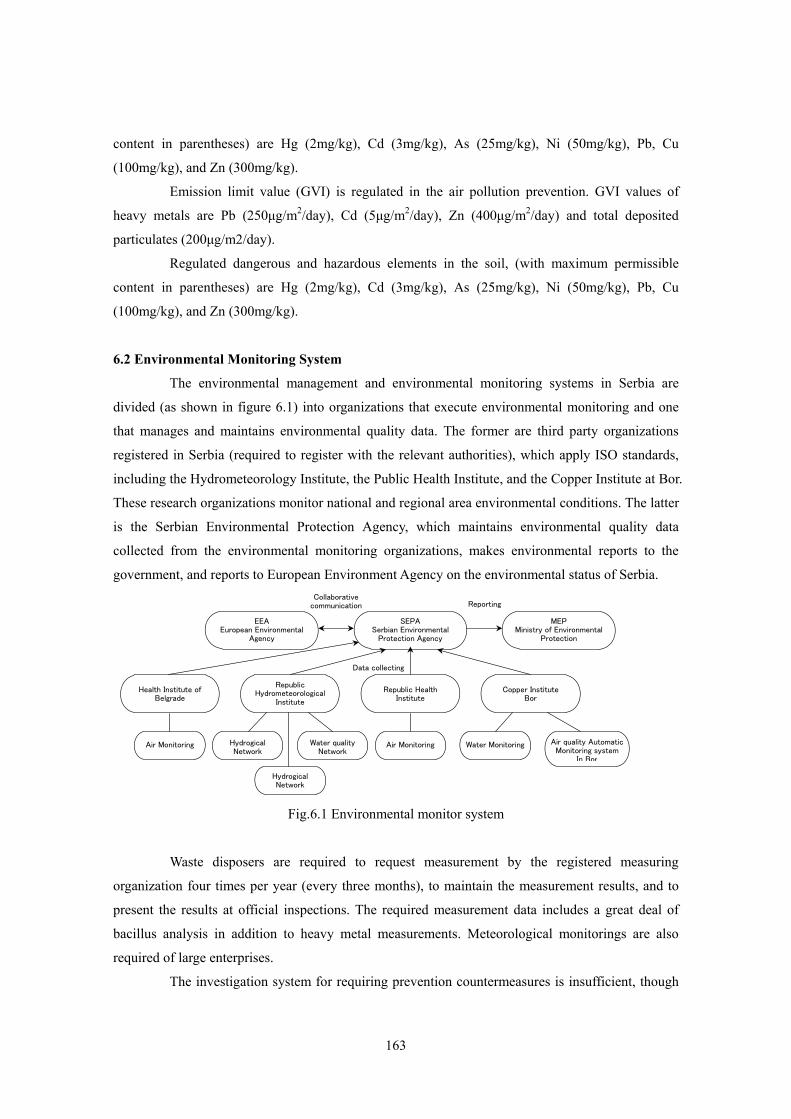
6.2 Environmental Monitoring System
The environmental management and environmental monitoring systems in Serbia are
divided (as shown in figure 6.1) into organizations that execute environmental monitoring and one
that manages and maintains environmental quality data. The former are third party organizations
registered in Serbia (required to register with the relevant authorities), which apply ISO standards,
including the Hydrometeorology Institute, the Public Health Institute, and the Copper Institute at Bor.
These research organizations monitor national and regional area environmental conditions. The latter
is the Serbian Environmental Protection Agency, which maintains environmental quality data
collected from the environmental monitoring organizations, makes environmental reports to the
government, and reports to European Environment Agency on the environmental status of Serbia.
Fig.6.1 Environmental monitor system
Waste disposers are required to request measurement by the registered measuring
organization four times per year (every three months), to maintain the measurement results, and to
present the results at official inspections. The required measurement data includes a great deal of
bacillus analysis in addition to heavy metal measurements. Meteorological monitorings are also
required of large enterprises.
The investigation system for requiring prevention countermeasures is insufficient, though
SEPASerbian Environmental
Protection Agency
MEP Ministry of Environmental
Protection
EEA European Environmental
Agency
Republic HealthInstitute
Copper InstituteBor
Republic Hydrometeorological
Institute
Health Institute of Belgrade
Air Monitoring Hydrogical Network
Hydrogical Network
Water qualityNetwork
Air Monitoring Water Monitoring Air quality Automatic Monitoring system
In Bor
Collaborativecommunication Reporting
Data collecting
164
some environmental monitoring and investigation are performed at large enterprises, like the Bor
mine. Small and medium-sized mines are only required by law to perform environmental monitoring
four times per year (every three months). Neither daily measurements of pH, EC, and turbidity, nor
flow measurements are taken. These are necessary for environmental protection. Monitoring is quite
infrequent.
The Ministry of Environmental Protection maintains an automatic air quality monitoring
network. They hope to set up a similar automatic monitoring network for river water quality. Their
plan is monitor at the entrance points into Serbia of the major rivers: the Danube, the Tisa, and the
Sava, and also at the outlet of the Danube river, including chemical analysis variables in addition to
the standard water quality monitoring parameters (water level, flow velocity, pH, water temperature,
EC, DO, turbidity, and ORP).
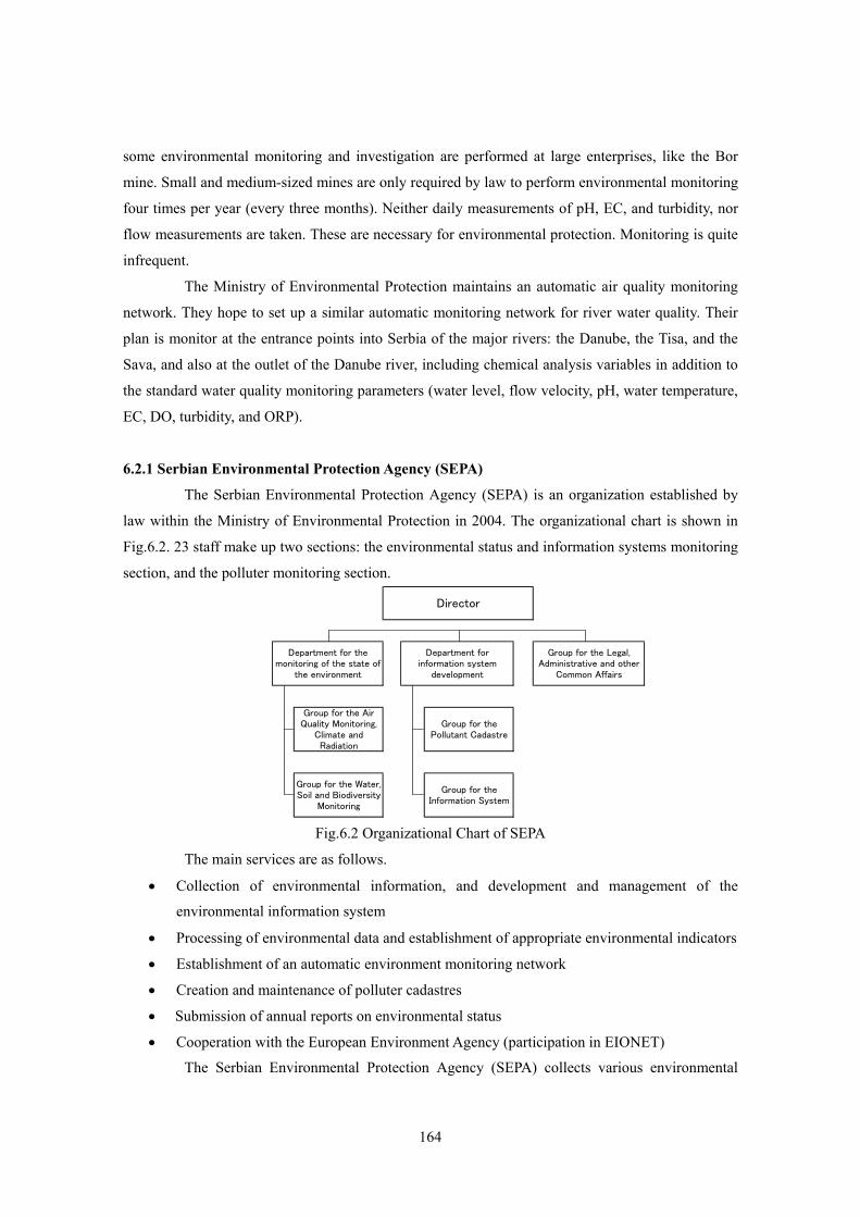
6.2.1 Serbian Environmental Protection Agency (SEPA)
The Serbian Environmental Protection Agency (SEPA) is an organization established by
law within the Ministry of Environmental Protection in 2004. The organizational chart is shown in
Fig.6.2. 23 staff make up two sections: the environmental status and information systems monitoring
section, and the polluter monitoring section.
Fig.6.2 Organizational Chart of SEPA The main services are as follows.
• Collection of environmental information, and development and management of the
environmental information system • Processing of environmental data and establishment of appropriate environmental indicators • Establishment of an automatic environment monitoring network • Creation and maintenance of polluter cadastres • Submission of annual reports on environmental status • Cooperation with the European Environment Agency (participation in EIONET)
The Serbian Environmental Protection Agency (SEPA) collects various environmental
Director
Group for the Water,Soil and Biodiversity
Monitoring
Department for themonitoring of the state of
the environment
Department forinformation system
development
Group for the Legal,Administrative and other
Common Affairs
Group for the AirQuality Monitoring,
Climate andRadiation
Group for thePollutant Cadastre
Group for theInformation System
165
information from the monitoring organizations including the Hydrometeorology Institute, the Public
Health Institute, the Public Health Institute of Belgrade, the Public Health Institute of Novi Sad, the
Copper Institute at Bor, the Institute for Serbian Nature Conservation, and the Municipal Directorate.
The SEPA evaluates them, and creates indexes showing Serbian environmental status, and submits
annual reports. These indices are also sent to the European Environment Agency (EEA).
Moreover, SEPA plans to construct an air quality monitoring system. In a previous
progress report, the CARDS project (25 stations) was advanced by SEPA. The Serbian
Environmental Protection Agency informed us that a restructuring of the CARDS project together
with the NIP project (another automatic monitoring system with 17 stations) is in currently progress
because of overlaps between monitoring stations and measurement parameters. However, four
automatic measurement stations have already been set up in the cities of Smederevo and Bor with
capital from the Serbian environmental fund.
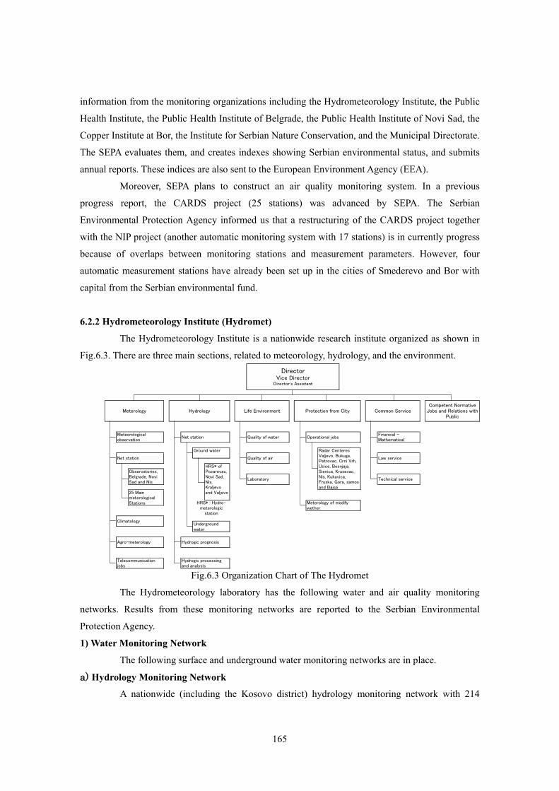
6.2.2 Hydrometeorology Institute (Hydromet)
The Hydrometeorology Institute is a nationwide research institute organized as shown in
Fig.6.3. There are three main sections, related to meteorology, hydrology, and the environment.
Fig.6.3 Organization Chart of The Hydromet The Hydrometeorology laboratory has the following water and air quality monitoring
networks. Results from these monitoring networks are reported to the Serbian Environmental
Protection Agency.
1) Water Monitoring Network
The following surface and underground water monitoring networks are in place.
a) Hydrology Monitoring Network A nationwide (including the Kosovo district) hydrology monitoring network with 214
Climatology
Agro-meterology
Common ServiceCompetent Normative
Jobs and Relations withPublic
Meteorologicalobservation
Net station
Operational jobs
Radar CenteresValjevo, Bukuga,Petrovac, Crni Vrh,Uzice, Besnjaja,Sienica, Krusevac,Nis, Kukavica,Fruska, Gora, samosand Bajsa
Meterology Hydrology
Telecommunicationjobs
Net station
Hydrogic prognosis
Hydrogic processingand analysis
Ground water
Undergroundwater
HRS* ofPozarevac,Novi Sad,Nis,Kraljevoand Valjevo
HRS* : Hydro-meterologic
station
Observatories,Belgrade, NoviSad and Nis
25 MainmeterologicalStations
DirectorVice Director
Director's Assistant
Meterology of modifywether
Financial -Mathematical
Law service
Technical service
Quality of water
Quality of air
Laboratory
Life Environment Protection from City
166
surface water measurement points. This network utilizes snap sampling, and measurements include
water flow quantity, (by the water level, with a self-registering water meter or staff rod), water
temperature, suspended solids, freezing time. Measurement typically includes a total of 36-63 water
quality parameters (see the supporting data B in the end of this report) depending on the
measurement location and conditions. The measurement frequency, which varies with the
measurement point, is 12-24 times a year. It is executed in accordance with the each annual
measurement plan, in which the measurement parameters, intervals, and frequency vary. The
measurement points for this monitoring network can be referenced by region or basin on the
Hydrometeorology Institute homepage.
The display method (measurement points, measurement parameters, and results) has
changed. Beginning with the hydrology monitoring network 2006 measurements, the target water
quality category (I-IV) for each measurement point in each basin is displayed. The water quality
category is displayed for each measurement parameter (dissolved oxygen, dissolved oxygen
saturation rate, coliform bacterium group, spoilage microorganism indicator, BOD5, COD,
suspended solids, evaporation residue amount, pH, color, and stench). Overall conditions are
evaluated at the same time. Measurement results were summarized in the 2006 annual report on
environment conditions.
The number of measurement points for each river in 2006 are as follows (2005 values are
shown in parenthesis for reference):
• Danube river 58 points (51 points)
• Zapadna Morava river 28 points (44 points)
• Juzna Morava river 25 points (38 points)
• Velika Morava river 13 points (16 points)
• Sava river 7 points (8 points)
• Kolubara river 5 points (14 points)
• Drina river 8 points (10 points)
• Timok river 4 points (9 points)
• Beli Drim river 8 points (17 points)
• Egej river 2 points (7 points)
b) Water Quality Monitoring Network
The nationwide water quality monitoring network is an automatic surface water
monitoring network with 12 measurement points. Measurement is done with daily sampling, and the
measurement parameters are: water level, flow quantity, pH, dissolved oxygen, dissolved oxygen
saturation rate, COD, electric conductivity, ammonia nitrogen, and nitrate nitrogen. (phenols is
added in the Ibar river basin, and 8-10 parameters in total are measured). Other water quality
parameters are measured twice a month. Measurements are executed in accordance with the annual
167
measurement plan. The measurement points for this water quality network and its results can be seen
on the Hydrometeorology Institute homepage. Past result charts can also be displayed, but do not
show all parameters for all periods because of an equipment maintenance problem.
The number of measurement points in each river are as follows:
• Danube river 2 points
• Zapadna Morava river 2 points
• Juzna Morava river 1 point
• Velika Morava river 2 points
• Sava river 2 points
• Kolubara river 1 point
• Tisa river 1 point
• Lim river 1 point
The case that can be compared directly is a little because the number of measurement
points is little. But there is a possibility to presume the area of the inflow of polluted water on
upstream side of the measurement point by using the change of pH and flowing quantity etc.
between the measurement points.
c) Underground Water Monitoring Network
In the monitoring network related to underground water, there is no automatic monitoring
net. The monitoring of the water level of underground water has been measured at the frequency of
3-6 times per month on average with 431 monitoring points of 13 regions, which is mainly on the
northern part region of Danube river and Sava river basin. Moreover, the section of the water level of
underground water is measured with 27 sections on 135 measurement points of 4 regions, which are
mainly the Morava river and the Tisa river basin. The water quality of underground water measures
by 30 parameters (water level, water temperature, temperature, pH, EC and the ions to request
chemical composition formula of Kurlov) at frequency of two sample collections per year on
average on 67 measurement points of 10 regions, which is the northern part region in Danube river
and the Sava river basin, and the Morava river basin as well as the water level measurement network.
The measurement of the water level and the water quality of underground water by the
Hydrometeorology Institute is executed only from a hydrology viewpoint, and the monitoring wells
arranged in each aquifer. The pumping up the underground water and supplying water are services of
the water bureau of the ministry of agriculture, forestry, and the water management to obtain the
drinking water. The monitoring network of the Hydrometeorology Institute is independent.
d) Monitoring of Other Lakes and Marshes
The monitoring related to lakes and marshes and the reservoir is executed in all the main
lakes and marshes. There is no automatic monitoring network. 36-63 parameters are analyzed by the
biannual sample collection and the measurement of precipitation is executed once per year in the
168
river and the reservoir.
2) Air Quality Monitoring Network
The monitoring network related to the air includes the automatic monitoring network in
the Belgrade region and the monitoring network of the air quality of the whole country.
a) Automatic Air Quality Monitoring Network in the Belgrade Region
The automatic monitoring network in the Belgrade region measures SO2, smoke, and NO2
with the day sample by the monitoring equipment set up in three places in the city. In every day,
each measured results of each measurement point at the day before and a result for a graph of the
measurements for the recent week are shown on the homepage of the Hydrometeorology Institute.
Also, the comment on the environmental status is put on there. b) Nationwide Air Quality Monitoring Network
The air quality monitoring network of the whole country measures SO2, smoke, and NO2
with the day sample in the monitoring equipment set up in the meteorological stations (29 places) in
the whole country. The analysis with the collection of 24 hour sample is executed in two years (2004
and 2005 year) with 24 measurement points in total, which are consist of 13 points not influenced
from an important polluter, 13 points received the influence of pollution from the polluter near the
monitoring station and one point specified monitor station for EMEP program promotion in
according to the air quality measurement decree that the government adopted. The measurement of
the ionizing ray (gamma rays) is executed in a part of them. 3) Public Health Institute, Copper Institute at Bor, and Others
Public Health Institute is executing the environmental monitoring of the water quality of
the surface water and the drinking water, the air quality, and noises in a large and local city area.
They execute the measurement of the air quality at 60 measurement points of 28 cities. The Copper Institute in Bor is executing the management related to the air of three
automatic measurement stations (Gradski park, Jugopetrol and Brezonik) and the sample collection
and the analysis of the water quality and the soil. The automatic monitoring of the air measures the
SO2 density in each 15 minutes, and the Bor copper smelter has changed its operation by the exceed
time and density. For the SO2 value during 24 hour and dust, the sample is separately collected and
all sample of one month are mixed, and the heavy metal etc. are analyzed at once per month. Besides
continuous monitoring point, there are some measurement points of the smoke, the flying particle,
and the deposit dust, where the sample is collected by 24 hour sampling equipment. Using the
deposit dust sample, measures pH, the dissolved materials, the sulfate ion, the non-dissolved
materials, and the inflammable materials, the ash, Pb, Cd, Zn, and the total deposit dust are measured
too. The research and investigation related to the water quality and the soil are executed as a special
program.
In the air quality monitoring in the local city, some or all of the parameters, which are the smoke,
169
SOx, NOx, CO2, ozone, a particulate material, and some of the heavy metals, are executed at twice
per year on 76 measurement points of the 40 villages. The specific pollutants, which are acrolein,
formaldehyde, phenol, ammonia, and benzene, are measured at total of 44 measurement points on 19
villages in the area where the production facilities of the specific pollutants exist.
4) Industrial Wastewater
As for the monitoring of the industrial wastewater in a Serbia, it is only obligated to
execute four times monitoring per year (every three months) for the enterprise who discharged.
These monitoring data would be basically kept by the enterprise. It is cleared that the government
does systematically not collect and keep these data. The inspection section of the Ministry of the
Environment protection has jurisdiction over the poisonous substance in the water quality, and
moreover, the inspection section of the Ministry of Health will check the quality of the drinking
water (surface water and underground water), and the inspection section of the Ministry of
agriculture, forestry, and the water management has jurisdiction over the general term of water. So, it
is difficult to uniform in the inspection matter among these organizations. The measurement parameters of the monitoring waste water, in case of the Grot mine,
reaches 49 parameters in total, which are the water temperature, the temperature, the color, the
stench, pH, EC, the subsidence materials, the suspended solids, the amount of the evaporation
residue, the consumption of KMnO4, COD(KMnO4, K2Cr2O7), BOD5, the dissolved oxygen, the
dissolved oxygen saturation rate, ammonia nitrogen, the nitrate nitrogen, the nitrite nitrogen,
chlorine, sulfate radical, hydrogen sulfide, fluorine, cyanide, phosphoric acid, Fe, Total Cr, Cr6+,
Cr3+, Ni, Cu, Zn, Pb, Hg, Cd, As, Ba, phenols, anions, tri-chloridie ethane, tri-chloridie ethylene, and
8 kinds of bacteriological. index (the coliform bacterium group, the spoilage microorganism
indicator etc.). In case of the Rudnik mine, reaches 43 parameters in total, which are the water
temperature, the temperature, the color, the stench, pH, EC, the subsidence materials, the suspended
solids, the amount of the evaporation residue, the consumption of KMnO4, COD, BOD5, the
dissolved oxygen, the dissolved oxygen saturation rate, ammonia nitrogen, the nitrate nitrogen, the
nitrite nitrogen, chlorine, sulfate radical, cyanide, phosphoric acid, Fe, Cr6+, Cr3+, Ni, Cu, Zn, Pb, Cd,
Ca, Mg, Mn, phenols, anions, oil and fats, hardness of water, alkalinity, TOC etc. in little difference
with the Grot mine). And the monitoring points are 5 more than the Grot mine. I have doubt that
these many parameters should be obligated to measure on wastewater in mining. I judged that to
increase the analysis frequency is better than to increase the analysis parameters on the view of
managing wastewater in the mining.
6.3 Inspection System
The services concerning to the environment has the character that becomes complex easily
in either country, because there are a lot of corresponding fields starting with the permit approval
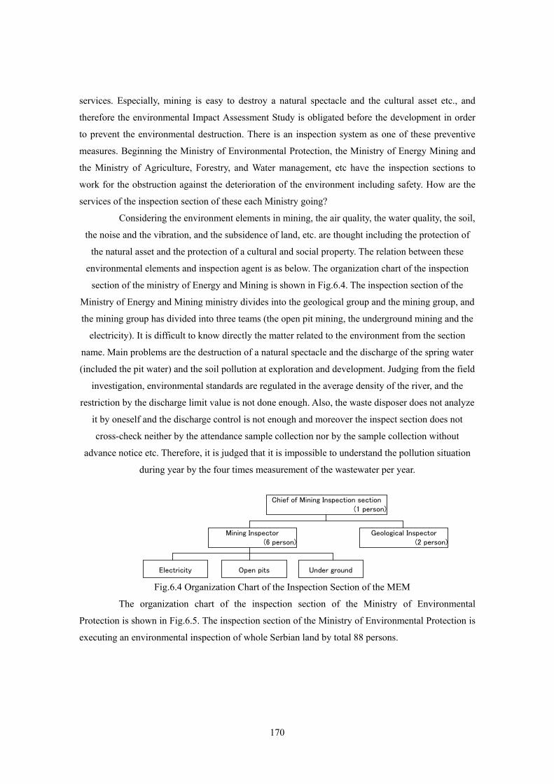
170
services. Especially, mining is easy to destroy a natural spectacle and the cultural asset etc., and
therefore the environmental Impact Assessment Study is obligated before the development in order
to prevent the environmental destruction. There is an inspection system as one of these preventive
measures. Beginning the Ministry of Environmental Protection, the Ministry of Energy Mining and
the Ministry of Agriculture, Forestry, and Water management, etc have the inspection sections to
work for the obstruction against the deterioration of the environment including safety. How are the
services of the inspection section of these each Ministry going? Considering the environment elements in mining, the air quality, the water quality, the soil,
the noise and the vibration, and the subsidence of land, etc. are thought including the protection of
the natural asset and the protection of a cultural and social property. The relation between these
environmental elements and inspection agent is as below. The organization chart of the inspection
section of the ministry of Energy and Mining is shown in Fig.6.4. The inspection section of the
Ministry of Energy and Mining ministry divides into the geological group and the mining group, and
the mining group has divided into three teams (the open pit mining, the underground mining and the
electricity). It is difficult to know directly the matter related to the environment from the section
name. Main problems are the destruction of a natural spectacle and the discharge of the spring water
(included the pit water) and the soil pollution at exploration and development. Judging from the field
investigation, environmental standards are regulated in the average density of the river, and the
restriction by the discharge limit value is not done enough. Also, the waste disposer does not analyze
it by oneself and the discharge control is not enough and moreover the inspect section does not
cross-check neither by the attendance sample collection nor by the sample collection without
advance notice etc. Therefore, it is judged that it is impossible to understand the pollution situation
during year by the four times measurement of the wastewater per year.
Fig.6.4 Organization Chart of the Inspection Section of the MEM
The organization chart of the inspection section of the Ministry of Environmental
Protection is shown in Fig.6.5. The inspection section of the Ministry of Environmental Protection is
executing an environmental inspection of whole Serbian land by total 88 persons.
Geological Inspector (2 person)
Electricity Open pits Under ground
Mining Inspector (6 person)
Chief of Mining Inspection section(1 person)
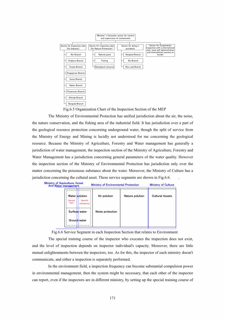
171
Fig.6.5 Organization Chart of the Inspection Section of the MEP
The Ministry of Environmental Protection has unified jurisdiction about the air, the noise,
the nature conservation, and the fishing area of the industrial field. It has jurisdiction over a part of
the geological resource protection concerning underground water, though the split of service from
the Ministry of Energy and Mining is lucidly not understood for me concerning the geological
resource. Because the Ministry of Agriculture, Forestry and Water management has generally a
jurisdiction of water management, the inspection section of the Ministry of Agriculture, Forestry and
Water Management has a jurisdiction concerning general parameters of the water quality. However
the inspection section of the Ministry of Environmental Protection has jurisdiction only over the
matter concerning the poisonous substance about the water. Moreover, the Ministry of Culture has a
jurisdiction concerning the cultural asset. These service segments are shown in Fig.6.6. .
Fig.6.6 Service Segment in each Inspection Section that relates to Environment
The special training course of the inspector who executes the inspection does not exist,
and the level of inspection depends on inspector individual's capacity. Moreover, there are little
mutual enlightenments between the inspectors, too. As for this, the inspector of each ministry doesn't
communicate, and either a inspection is separately performed.
In the environment field, a inspection frequency can become substantial compulsion power
in environmental management, then the system might be necessary, that each other of the inspector
can report, even if the inspectors are in different ministry, by setting up the special training course of
Sector for inspection jobs(for Nature Protection)
Nis Branch
Sector for Inspection jobs (for Industry)
Sector for doing in accidents
Sector for Cooperation inspection with a internationalnets, local self administration and international success at
border
Kraljevo Branch
Vranje Branch
Kragujevac Branch
Uzice Branch
Sabac Branch
Pozarevac Branch
Kikinda Branch
Beograd Branch
Natural good
Fishing
Geological resource
Beograd Branch
Nis Branch
Novi sad Branch
Minister’s Consulter sector for control and supervision of contaminant
Water polution Air polution Nature polution Cultural Assets
Surface water
Ground water
Noise protection
General Item
Harmful
substances
Ministry of Aquiculture, forest And Water management Ministry of Environmental Protection Ministry of Culture
172
inspector, and reducing the difference of the content of the inspection.
6.4 Environmental Status in Serbia and Environmental Problems in Local Mine
Hot spots of pollution specified by UNEP include the following. These hot spots are taking
measures to combat the pollution.
・ Bor Leakage of insulation oil including PCBs from electrical substation
equipment damaged by NATO bombing
Air pollution from the Bor smelter
・ Novi Sad Outflow of crude oil and petroleum products from an oil refinery
・ Pancevo Outflow of crude oil and petroleum products from an oil industrial
complex
Outflow of harmful substance from a fertilizer plant
・ Kragujevac Leakage of insulation oil containing PCBs from electrical substation
equipment caused by NATO bombing
Moreover, pollution in mining is generated besides these, and the accident, that a part of
the tailing dam of the Veliki Majdan mine was collapsed because of the heavy rain, was occurred in
June, 2001. Environmental problems of Bor mine/smelter have been generated in each field of the air,
the water quality, and the soil. Environmental problems of Bor mine/smelter have the possibility that
the pollution diffuses transboundary, because this mine is near to the Romania border. Details are
described later in the paragraph in the Bor mine.
Mining influences especially a lot of environmental parameters, and the source of release
includes many things. But, there are relativities between the source and the parameter that influences.
For example, the sources that influence the air are a smelting factory with a furnace, a sintering plant,
and a sulfuric acid plant. The sources of water pollution are a wastewater of the mine from the waste
rock dam and the open pits, and a wastewater from the tailing dam of the floatation plant and the
plant of wet metallurgy and the sulfuric acid plants. Especially, the acid discharge becomes a big
problem. The soil pollution exists as primary contamination, which is caused directly by the sands
and rocks that flows out from the open pit mark, the waste rock storage, and the tailing dam of
floatation plant and as a secondary contamination, which the air pollutants and water pollutants
cause the secondary contamination.
The environmental status of each mine where the field investigation was done is described
as follows.
6.4.1 Grot Mine
The Grot mine is operating. But the possibility of the noise problem is very few, because
the dressing machines are in the building and the dressing plant is away from resident's houses.
173
The mine water of the Grot Mine is pH8.5, and is discharged at a rate of about 60m3/hr. Of
this amount, 54m3/hr (90% of the discharged water) is sent to the dressing plant through the drift
tunnel that is the haulage level. Most of this water is used in the plant, and the water that cannot be
used is sent to the tailings pond. The remaining 6m3/hr water is discharged from the mine mouth on
the other side.
The wastewater from the tailings pond that isn’t recycled at the dressing plant (pH7.5), is
discharged into the Juzna. Morava River through the Selecki Potok stream then into the Danube
River and finally reaches Black Sea. There are two monitoring points until joining the Juzna.
Morava River. Monitoring must be conducted four times per year (every three months) by a qualified
organization. Other types of monitoring are not conducted. There was no problem with the analytical
results at any of the monitoring points. Because the measurement frequency is too few, it cannot be
judged if the environmental management is performed in a healthy manner.
Though the wastewater from the other side of the mine did not adversely affect the
analytical result of the monitoring, I was told in an interview with the regional environmental
inspectors of the Directorate for Environmental Protection that high density heavy metal (Zn 0.93%)
had been detected in the bottom sediments of a marsh downstream. Such a high density in the
bottom sediments is almost never caused by pit water only. Deterioration of the bottom sediment
may have been caused by the erosion of land in the mineralization area, by sand and soil flowed out
by rain water, etc., which partially contained ore minerals from the waste rock depositing area where
waste rock and mineralized rock ware piled up when the tunnels were excavated. These substances
were deposited in the stream and the marsh, especially in the bottom sediments in the marsh.
Because there is no subsidence facility like the tailings pond on the other side, the settling
separation of the pollutant cannot be done, and pollution is diffused. The bottom sediments of the
marsh will deteriorate more without the treatments of the polluted water and the eroded solid from
the mine site, before they enter to the mountain stream out of the mine for instance of setting up the
sedimentation pond. Because there is a lake used for drinking water downstream in the Bosilegrad
town, it is necessary to determine whether the heavy metal of the bottom sediment is dissoluble
matter or not and take immediate measures to mitigate any threat.
The tailings dam is constructed of sand separated by cyclone separation. Three collecting
pipes are set up in the tailing dam. Rainwater from outside of the tailings pond is kept out of the
pond by an unlined street gutter, and drained together with overflow water of the pond through the
collecting pipes. However, there is no well to measure the water level in the dam body, so it seems
that the control of the water level in the dam body relies on experience. Moreover, there is no
scarcement on the dam body, so sand piles up directly from the lower base to the upper part of the
embankment. Plants grow thick on the side of the dam body and in the pond, and there is no
deforestation. Therefore the impervious bed is not formed. Some problems exist. Moreover, there is
174
not a watering device to prevent the dust generation from the body of the bank.
6.4.2 Kizevak Mine
Mine is currently controlled by a bank and is not operating. The material for tender is
being prepared to restart operation. The mine has two open-pits. Though water has not entered the
pit bottom, there are many waste rock deposits around the open-pit (chiefly downstream part), and
there are no soil and sand revetments. Acid water (pH2-4) flows out in some places from the lower
base bottom of the waste rock deposits into the stream and the river through the road and the
mountain stream.
The equipment of the dressing plant is old, and flotation cells etc. are severely corroded.
Moreover, it hasn't been maintained since the operations were stopped. Therefore it seems that
restarting operations will be difficult if nothing is done. The conveying pump to the tailing dam is
Fig.6.7 Plan and Cross Section of
the Tailings Dam of the Grot Mine
Street gutter around the Tailings Dam Collector Pipe of the Tailings Dam
175
sometimes used for the wastewater management but we could not confirm on site.
There are two tailing dams, a new one and an old one. The old tailing dam is vertical type
collector pipe that is enclosed on all sides by an embankment, and exists on one of the banks of the
Ibar River. The tailings dam consists of a big part, and a small part, which adjoin one another. Each
collecting pipe has partial damage. Since the two tailings dams have not been used for a considerable
time, there has been considerable deterioration of the dam body. Although the mine has the
replanting plan, the plan has not been carried out due to the lack of funding. There are a few trees
and some grass that have spouted spontaneously in the dam body and the pound. So, the use of these
plants is considered to be “planting”.
Old tailing dam of the Mine
Waste Dump of the Kizevak Mine
Old Tailings Dam of the Erosion of the Dam
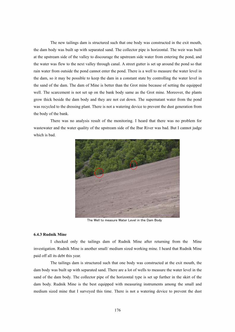
176
The new tailings dam is structured such that one body was constructed in the exit mouth,
the dam body was built up with separated sand. The collector pipe is horizontal. The weir was built
at the upstream side of the valley to discourage the upstream side water from entering the pond, and
the water was flew to the next valley through canal. A street gutter is set up around the pond so that
rain water from outside the pond cannot enter the pond. There is a well to measure the water level in
the dam, so it may be possible to keep the dam in a constant state by controlling the water level in
the sand of the dam. The dam of Mine is better than the Grot mine because of setting the equipped
well. The scarcement is not set up on the bank body same as the Grot mine. Moreover, the plants
grow thick beside the dam body and they are not cut down. The supernatant water from the pond
was recycled to the dressing plant. There is not a watering device to prevent the dust generation from
the body of the bank.
There was no analysis result of the monitoring. I heard that there was no problem for
wastewater and the water quality of the upstream side of the Ibar River was bad. But I cannot judge
which is bad.
The Well to measure Water Level in the Dam Body
6.4.3 Rudnik Mine
I checked only the tailings dam of Rudnik Mine after returning from the Mine
investigation. Rudnik Mine is another small/ medium sized working mine. I heard that Rudnik Mine
paid off all its debt this year.
The tailings dam is structured such that one body was constructed at the exit mouth, the
dam body was built up with separated sand. There are a lot of wells to measure the water level in the
sand of the dam body. The collector pipe of the horizontal type is set up further in the skirt of the
dam body. Rudnik Mine is the best equipped with measuring instruments among the small and
medium sized mine that I surveyed this time. There is not a watering device to prevent the dust
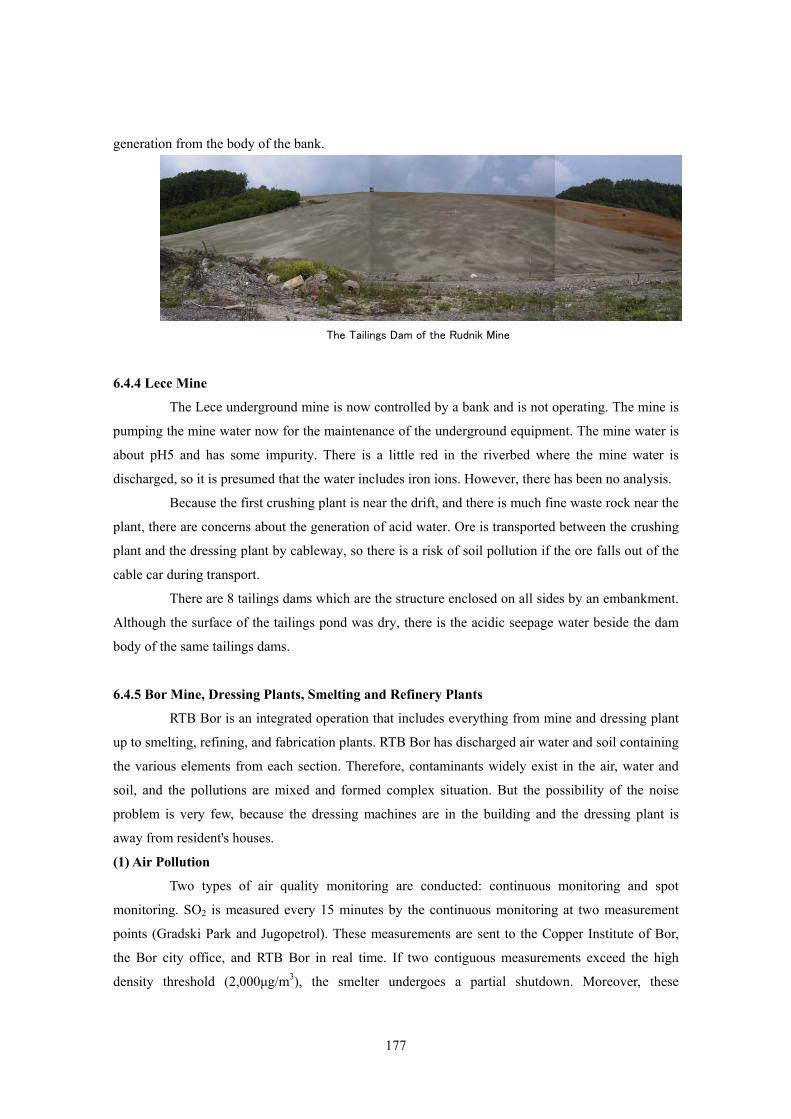
177
generation from the body of the bank.
The Tailings Dam of the Rudnik Mine
6.4.4 Lece Mine
The Lece underground mine is now controlled by a bank and is not operating. The mine is
pumping the mine water now for the maintenance of the underground equipment. The mine water is
about pH5 and has some impurity. There is a little red in the riverbed where the mine water is
discharged, so it is presumed that the water includes iron ions. However, there has been no analysis.
Because the first crushing plant is near the drift, and there is much fine waste rock near the
plant, there are concerns about the generation of acid water. Ore is transported between the crushing
plant and the dressing plant by cableway, so there is a risk of soil pollution if the ore falls out of the
cable car during transport.
There are 8 tailings dams which are the structure enclosed on all sides by an embankment.
Although the surface of the tailings pond was dry, there is the acidic seepage water beside the dam
body of the same tailings dams.
6.4.5 Bor Mine, Dressing Plants, Smelting and Refinery Plants
RTB Bor is an integrated operation that includes everything from mine and dressing plant
up to smelting, refining, and fabrication plants. RTB Bor has discharged air water and soil containing
the various elements from each section. Therefore, contaminants widely exist in the air, water and
soil, and the pollutions are mixed and formed complex situation. But the possibility of the noise
problem is very few, because the dressing machines are in the building and the dressing plant is
away from resident's houses.
(1) Air Pollution
Two types of air quality monitoring are conducted: continuous monitoring and spot
monitoring. SO2 is measured every 15 minutes by the continuous monitoring at two measurement
points (Gradski Park and Jugopetrol). These measurements are sent to the Copper Institute of Bor,
the Bor city office, and RTB Bor in real time. If two contiguous measurements exceed the high
density threshold (2,000μg/m3), the smelter undergoes a partial shutdown. Moreover, these
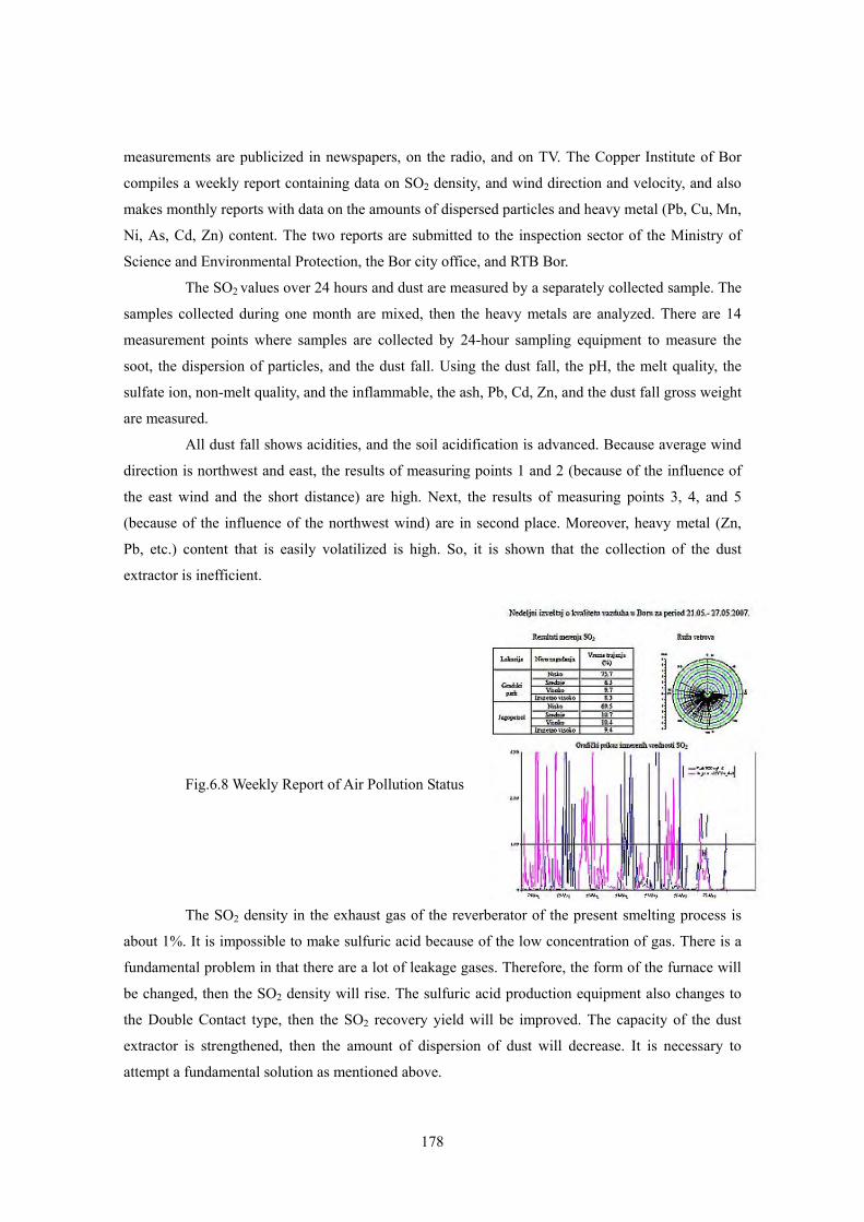
178
measurements are publicized in newspapers, on the radio, and on TV. The Copper Institute of Bor
compiles a weekly report containing data on SO2 density, and wind direction and velocity, and also
makes monthly reports with data on the amounts of dispersed particles and heavy metal (Pb, Cu, Mn,
Ni, As, Cd, Zn) content. The two reports are submitted to the inspection sector of the Ministry of
Science and Environmental Protection, the Bor city office, and RTB Bor.
The SO2 values over 24 hours and dust are measured by a separately collected sample. The
samples collected during one month are mixed, then the heavy metals are analyzed. There are 14
measurement points where samples are collected by 24-hour sampling equipment to measure the
soot, the dispersion of particles, and the dust fall. Using the dust fall, the pH, the melt quality, the
sulfate ion, non-melt quality, and the inflammable, the ash, Pb, Cd, Zn, and the dust fall gross weight
are measured.
All dust fall shows acidities, and the soil acidification is advanced. Because average wind
direction is northwest and east, the results of measuring points 1 and 2 (because of the influence of
the east wind and the short distance) are high. Next, the results of measuring points 3, 4, and 5
(because of the influence of the northwest wind) are in second place. Moreover, heavy metal (Zn,
Pb, etc.) content that is easily volatilized is high. So, it is shown that the collection of the dust
extractor is inefficient.
Fig.6.8 Weekly Report of Air Pollution Status
The SO2 density in the exhaust gas of the reverberator of the present smelting process is
about 1%. It is impossible to make sulfuric acid because of the low concentration of gas. There is a
fundamental problem in that there are a lot of leakage gases. Therefore, the form of the furnace will
be changed, then the SO2 density will rise. The sulfuric acid production equipment also changes to
the Double Contact type, then the SO2 recovery yield will be improved. The capacity of the dust
extractor is strengthened, then the amount of dispersion of dust will decrease. It is necessary to
attempt a fundamental solution as mentioned above.
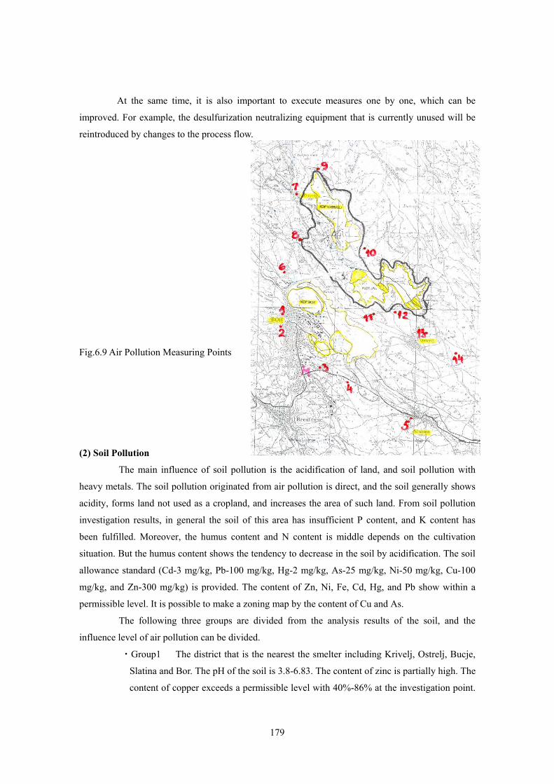
179
At the same time, it is also important to execute measures one by one, which can be
improved. For example, the desulfurization neutralizing equipment that is currently unused will be
reintroduced by changes to the process flow.
Fig.6.9 Air Pollution Measuring Points
(2) Soil Pollution
The main influence of soil pollution is the acidification of land, and soil pollution with
heavy metals. The soil pollution originated from air pollution is direct, and the soil generally shows
acidity, forms land not used as a cropland, and increases the area of such land. From soil pollution
investigation results, in general the soil of this area has insufficient P content, and K content has
been fulfilled. Moreover, the humus content and N content is middle depends on the cultivation
situation. But the humus content shows the tendency to decrease in the soil by acidification. The soil
allowance standard (Cd-3 mg/kg, Pb-100 mg/kg, Hg-2 mg/kg, As-25 mg/kg, Ni-50 mg/kg, Cu-100
mg/kg, and Zn-300 mg/kg) is provided. The content of Zn, Ni, Fe, Cd, Hg, and Pb show within a
permissible level. It is possible to make a zoning map by the content of Cu and As.
The following three groups are divided from the analysis results of the soil, and the
influence level of air pollution can be divided.
・Group1 The district that is the nearest the smelter including Krivelj, Ostrelj, Bucje,
Slatina and Bor. The pH of the soil is 3.8-6.83. The content of zinc is partially high. The
content of copper exceeds a permissible level with 40%-86% at the investigation point.
180
The As content exceeds a permissible level with 20%-64% at the investigation point.
・Group2 The district that is the medium zone including Brestovac、Metovnica and
Sarbanovac. The pH of the soil is 4.4~6.32 (minimum value is a little high). Though it
is different from group 1, the content of Cu and As is within a permissible level.
・Group 3 The district that is the fringe zone including Zlot and Gornjane. The pH of the
soil shows acidity but the district that is not shown the air pollution effect.
The soil pollution by heavy metals that generates acid water, and the soil pollution by
solids from the tailings dam and waste rocks deposited by wind and rain, then the soil pollution of
the river bottom that is caused by flying solids. However, the investigation from this viewpoint is
insufficient excluding investigation that deteriorated the bottom sediment due to water pollution. A
systematic investigation is necessary.
(3) Water Pollution
The wastewater of the Bor mine, where various wastewaters are generated by the place,
flow volume, and the chemical composition, flow into the Bor river or the Krivelj river and
eventually reach the Black Sea through the Timok river and the Danube river. If these wastewaters
are classified, it is possible to classify them into seven kinds as follows.
A) Wastewater that Flows into the Krivelj River
・Wastewater from open pit ”Veliki Krivelj”
・Wastewater from ”Saraka” stream
・Wastewater from open pit ”Bor”
・Wastewater from the pond of Floatation tailing dam ” Veliki Krivelj” 1A
・Wastewater from the pond of Floatation tailing dam” Veliki Krivelj” 3A
B) Wastewater that Flows into the Bor River
・Wastewater from ”Robule” lake
・Wastewater from open pit “Bor”, sulfuric acid plant, copper dry smelting plant,
hydrometallurgy plant, and fabrication plant
Fig.6.11 shows the origin of these wastewaters.
a) Wastewater from open pit ”Veliki Krivelj”
Wastewater from the collecting pipe in the pit bottom of the open pit "Veliki Krivelj", and the
surface water and wastewater of the underground water origin. The wastewater has a reading of
pH4.40 and is pumped up by flow volume 2,333m3/day with densities of SO4 360mg/l, Cu
127.5mg/l, Fe 0.38mg/l and Zn 3.1mg/l.
b) Wastewater from ”Saraka” stream (wastewater is shown in Fig.6.10.)
There is a waste rock deposit from the open pit "Veliki Krivelj" on the upstream of "Saraka"
stream, and the oozed water from the waste rock deposit flows into "Saraka" stream. This
wastewater is easily influenced by weather, so the flow quantity and density are variable. The
181
wastewater has a reading of pH4.29 and flows into the Krivelj river 3,802m3/day with
densities of SO4 148mg/l, Cu 101.9mg/l, Fe 34.3mg/l and Zn 1.3mg/l.
c) Wastewater from open pit ”Bor”
This wastewater is from the open pit "Bor", and flows into the Krivelj river through the
changing waterway of the Bor river. The wastewater has a reading of pH2.87 and is pumped
up by flow volume 3,599 m3/day with densities of SO4 247mg/l, Cu 192.1mg/l, Fe 678mg/l
and Zn 34.5mg/l.
d) Wastewater from the pond of Floatation tailing dam ” Veliki Krivelj” 1A
This wastewater is the supernatant water of the pond of the tailing dam of flotation "Veliki
Krivelj" 1A and surface water. It flows into the Krivelj river 1,944 m3/day. It varies in
pH6.08-8.12. Also, it varies with densities of SO4 59-730mg/l, Cu 0.07-0.356mg/l, Fe
0.01-4.5mg/l and Zn 0.001-2.612mg/l. Because these wastewaters are from flotation tailing,
they should be in the alkali sides originally. However, it is presumed to mix and to treat the
water if it frequently becomes acidic. Although the Cu density is low because the Cu forms
precipitation in such pH range, the treatment of zinc and Cd becomes insufficient in such pH
range. This requires attention.
e) Wastewater from the pond of Floatation tailing dam” Veliki Krivelj” 3A
This wastewater is the supernatant water of the pond of the tailing dam of flotation "Veliki
Krivelj" 3A. It flows into the Krivelj river 3,024m3/day. It varies in pH4.6-8.24 as well as the
wastewater of the pond of 1A. Also, it varies with densities of SO4 12-701mg/l, Cu
0.02-0.276mg/l, Fe 0.01-2.5mg/l and Zn 0.001-1.95mg/l. Because these wastewaters are from
Fig.6.10 Origin Points
of Wastewater
182
flotation tailing, they should be on the alkali side originally. However, it is presumed similarly
to mix and to treat the water if it frequently becomes acidic. Although the Cu density is low
because the Cu forms precipitation in such pH range, the treatment of zinc and Cd becomes
insufficient in such pH range. This requires attention.
f) Wastewater from ”Robule” lake
"Robule" lake is on the side of the waste rock deposit of the open pit "Bor", the leached water
from the waste rock deposit is gathered and formed a lake. A part of the wastewater from
smelting and the hydrometallurgy plant has been exhausted near the lake. This wastewater has
a reading of pH2.97 and flows into the Bor river 484m3/day. It has densities of SO4 4145mg/l,
Fe 895mg/l, Cu 55mg/l and Zn 26.5mg/l. This wastewater is reddish brown color, and the
form of dissolved iron is ferrous (two-valent) iron. This wastewater easily maintains its acidity
because the pH decreases when two-valent iron is oxidized to three-valent iron. This
wastewater has been exhausted without treatment.
g) Wastewater from open pit “Bor”, sulfuric acid plant, copper dry smelting plant,
hydrometallurgy plant, and fabrication plant
This wastewater is a compound of the wastewater from plants including “Bor" open pit,
sulfuric acid plant, copper dry smelting plant, and copper hydrometallurgy plant, and flows into the
Bor river 2,323m3/day. This wastewater has a reading of pH2.35. It has densities of SO4 1640mg/l,
Cu 54mg/l, Fe 323mg/l, Zn 1.92mg/l, Pb 2.08mg/l, Mn 9.63mg/l and Ni 1.05 mg/l.
The wastewater from the hydrometallurgy plant (7A1) is abundant with Fe, Ni, As, Al, Bi,
Zn, Sb, Te, Pb, and Mn, besides sulfuric acid (16.63g/l) and Cu (4.8g/l), and the flow volume is
2,874m3/year. The wastewater from the PM plant has abundant As, Te, Fe, Co, Zn, Pb, Sb, and Bi, as
well as sulfuric acid (15.3g/l) and Cu (2.85g/l), and the flow volume is 1,946m3/year. The
wastewater of the regeneration factory have abundant Te, Fe, Bi, Zn, and Sb, as well as sulfuric acid
(386g/l), Cu (15.15g/l), Ni (3.07g/l), and As (2.43g/l), and the flow volume is 1,071m3/year. The
wastewater of the sulfuric acid plant is sulfuric acid (0.81g/l), Cu (0.041g/l), and the flow volume is
34,944m 3/year. These wastewaters have been discharged as imperfect without treatment.
If these data are collected, it becomes as shown in Fig.6.11. The flow volume of a
wastewater is large, then it is difficult to directly treat wastewater disposal. The principle of
wastewater disposal separation of polluted water and non-polluted water, so that the high density
polluted water is treated directly without dilution. It is important to investigate how to separate
polluted water from non-polluted water.
183
1
q = 2,333 m3/day
pH = 4.40
[SO4] = 360mg/l
[Cu] = 127.5mg/l[Fe] = 0.38mg/l[Zn] = 3.1mg/l
2
3 q = 3,802 m3/daypH = 4.29
q = 3,599 m3/day [SO4] = 148mg/l
pH = 2.87 [Cu] = 101.9mg/l
[SO4] = 247mg/l [Fe] = 34.3mg/l
[Cu] = 192.1mg/l [Zn] = 1.3mg/l[Fe] = 678mg/l[Zn] = 34.5mg/l
74
q = 3,802 m3/day q = 1,944 m3/daypH = 4.29 pH = 6.08 - 8.12[SO4] = 148mg/l [SO4] = 59 - 730mg/l
[Cu] = 101.9mg/l [Cu] = 0.07 - 0.356mg/l[Fe] = 322.5mg/l [Fe] = 0.01 - 4.5mg/l[Zn] = 1.3mg/l [Zn] = 0.001 - 2.612mg/l
65
q = 484 m3/day q = 3,024 m3/daypH = 2.97 pH = 4.6 - 8.24[SO4] = 4145mg/l [SO4] = 12 - 701mg/l
[Cu] = 55mg/l [Cu] = 0.02 - 0.276mg/l[Fe] = 895mg/l [Fe] = 0.01 - 2.5mg/l[Zn] = 26.5mg/l [Zn] = 0.001 - 1.95mg/l
Pumped out wastewater fromopen pit Bor.
Collected wastewater pumpedout open pit Bor (closed in1992) and from copperSmelting and refinary plants.
Timok river
Danube river
FLOWSHEET OFWASTEWATER STREAMS
FROM RTB-BOR
Bor river
Drainage wastewater offlotation dam 3A of flotationtailing pond Veliki Krivelj.
Wastewater from lake Robule,which originate fromaccumulation of leach solutionsfrom Pit Bor tailings pond.
Krivelj river
Water collector on bottom ofopen pit Veliki Krivelj.
Wastewater with leach solutionfrom surface water streamSaraka.
Surface, drainage wastewaterof flotation dam 1A of flotationtailing pond Veliki Krivelj.
Fig.6.11 Flow of Polluted Water
(4) Other Environmental Issues
The tailing dam is structured such that one body was constructed in the exit mouse, the
dam body was built up by separated sand. Two tailing dams made the pond a back match, and there
is a dam body in both ends. I heard that there are three dam bodies. I did not confirm that. There are
a lot of wells to measure the water level in sand of the both dam bodies 1A and 3A. But, many wells
cannot measure the water level because of filling slime in the well. Because the dam body started
moving before, there is a re-installation plan for the well on the dam body of dam 3A. Only the
lowest well in the dam body of dam 1A can measure the water level, then management of the water
level in the pond could be controlled with this information and the observation of the collecting pipe
set up in the skirt of the dam body. There is not a watering device to prevent the dust generation from
the body of the bank of both tailing dams.It should be noted that the heavy metal hydroxide that was
separated will dissolve in the pond if the pH in the pond is not kept on the alkali side as much as
possible when acid water is introduced into the pond of the tailing dam for neutralization. Also, there
is a danger of raising the content of heavy metal of the wastewater oppositely.
Moreover, Tailings dam of Bor has the problem of the crack of the drain pipe set up in
bottom of the dam. Therefore, the drain water, which is contained the heavy-metal component, is
permeated. Lowering of pH of the pound water has danger of depraving this problem.
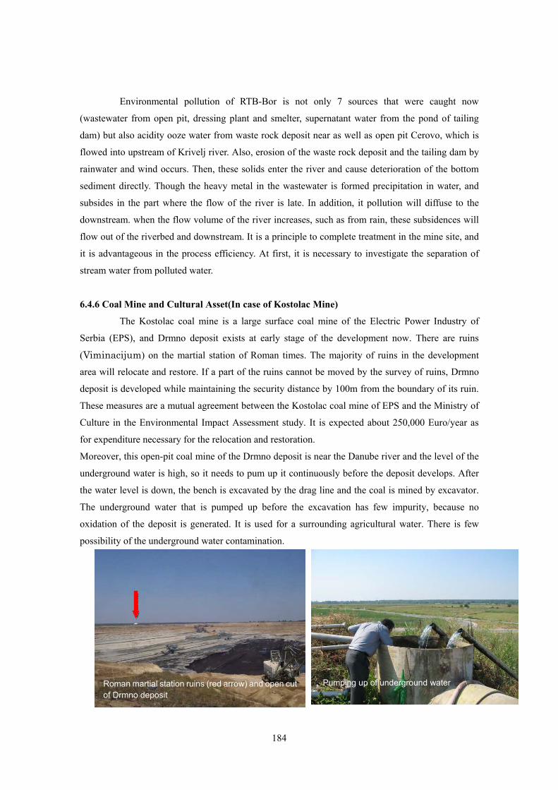
184
Environmental pollution of RTB-Bor is not only 7 sources that were caught now
(wastewater from open pit, dressing plant and smelter, supernatant water from the pond of tailing
dam) but also acidity ooze water from waste rock deposit near as well as open pit Cerovo, which is
flowed into upstream of Krivelj river. Also, erosion of the waste rock deposit and the tailing dam by
rainwater and wind occurs. Then, these solids enter the river and cause deterioration of the bottom
sediment directly. Though the heavy metal in the wastewater is formed precipitation in water, and
subsides in the part where the flow of the river is late. In addition, it pollution will diffuse to the
downstream. when the flow volume of the river increases, such as from rain, these subsidences will
flow out of the riverbed and downstream. It is a principle to complete treatment in the mine site, and
it is advantageous in the process efficiency. At first, it is necessary to investigate the separation of
stream water from polluted water.
6.4.6 Coal Mine and Cultural Asset(In case of Kostolac Mine)
The Kostolac coal mine is a large surface coal mine of the Electric Power Industry of
Serbia (EPS), and Drmno deposit exists at early stage of the development now. There are ruins
(Viminacijum) on the martial station of Roman times. The majority of ruins in the development
area will relocate and restore. If a part of the ruins cannot be moved by the survey of ruins, Drmno
deposit is developed while maintaining the security distance by 100m from the boundary of its ruin.
These measures are a mutual agreement between the Kostolac coal mine of EPS and the Ministry of
Culture in the Environmental Impact Assessment study. It is expected about 250,000 Euro/year as
for expenditure necessary for the relocation and restoration.
Moreover, this open-pit coal mine of the Drmno deposit is near the Danube river and the level of the
underground water is high, so it needs to pum up it continuously before the deposit develops. After
the water level is down, the bench is excavated by the drag line and the coal is mined by excavator.
The underground water that is pumped up before the excavation has few impurity, because no
oxidation of the deposit is generated. It is used for a surrounding agricultural water. There is few
possibility of the underground water contamination.
Roman martial station ruins (red arrow) and open cut of Drmno deposit
Pumping up of underground water
185
6.4.7 Prevention Measures of Environmental Deterioration for the Execution of Case Study
It is desirable to execute measures of the process improvement in the contents of the case
study, because it means that the heavy-metal component (Cu, Pb, Zn) in tailings is decreased. On the
other hand, the possibility to be included more in tailings becomes higher as for the another
heavy-metal component (Fe and As, etc.) as impurities. In general, if the pH in the tailing pond is
maintained to the pH zone where the hydroxides of these heavy metal elements are generated, the
danger of the pollution by heavy metal becomes small. That is, the pH in the tailing pond is
maintained to the alkali side, and the installation of equipment of the neutralization of drain with
acid is needed.
The recovery of copper and the recovery of gold are investigated for the utilization of
untapped natural resources. But, There is danger of depraving the environment according to the
recovering flow process, unless the following points are considered.
• The adoption of the cement copper extraction method for cupper recovery generates the acid
drainage water that is included the a small amount of copper ion with higher content of iron ion
after the precipitation, because the copper recovery of this method is so not high. This kind of
drain often becomes voluminously, and it is necessary to treat enough processing.
• Although the CN leaching has advantage in the recovery of the Au leaching process, it is
necessary to execute sufficiently the decomposing process of CN after the leaching.
In the former, though the SX-EW method is devised instead of the cement copper
extraction method, because the copper concentration of the obtained solution is ordinarily low, it is
difficult to maintain the economy. Therefore, it is necessary not to mix extra water at the same time
as a means to raise the oxidation and extraction rate of copper as a means to raise the copper
concentration. Basically, it is necessary to decide the process flow while considering the separation
of copper dissolution liquid from other drains.
In the latter, it is necessary to provide the process flow considering the combination of the
equipments for the CN leaching and the method to decompose the cyanides from viewpoint of the
environmental protection. There are many procedures to decompose cyanides that are as Alkali
Chlorination Process (Two Step Decomposing Method), Ferrician Blue Method (Hardly-soluble
Complex Compounds Precipitation Method), Sublimation and Absorption Method, Ultraviolet Ray
Decomposition Method, Electrolytic Oxidation Method, Hot Water Hydrolysis Method, Microbial
Decomposition Method, and Combination Method of those techniques. The CN density of each
method to be applied is different, and it is necessary to select the proper procedure.
The survey result concerning the investigation mines and the case studies are compared
according to the environmental elements and the Appendix I, 6 is shown as following.
186
(Supporting Data A) Laws and Regulations of Serbia concerning the Environment
The main laws and regulations are as follows. These include laws from the former Yugoslavia
age.
• Low on the Environmental Protection
• Low on Strategic Environmental Impact Assesment
• Low on Environmental Impact Assesment
• Low on Integrated Prevention and Pollution Control
• Low on Minning
• Low on the Geological Researches
• Low about Agriculturl Soil
• Low about Forests
• Law on energetic
• Law on tourism
• Low about National Park
• Law on Plant Protection
• Law on the protection at work
• Law on public health protection
• Low on Planning and Constructing
• Low on Water
• Low on Waste Management
• Law on trade on explosive substances
• Law on Explosive Substances, Inflammable Liquids and Gases
• Law on Standardization
• Law on spatial plan of the Republic of Serbia
• Law on Enterprises
• Regulation on Permited Noise Level in Environment
• Regulation on dangerous matters in the water
• Regulation on Handling Waste which has characteristics of hazardous substances
• Regulation on permitted quantity of dangerous and hazardous matters in the soil
• Regulations of the sanitary quality of the drinking water
• Decree on Watercourses classification
• Low about Ministries
• Law on local self-government
• Law on activities of municipalities
• Law on determining certain competencies for autonomous province
187
• Law on hydro-meteorological affairs of interest for the whole country
• Regulation on detailed conditions which must be fulfilled by professional organisations
which perform emissions and imissions measurement
• Regulations on establishing networks and work programs of meteorological stations of
interest for the whole country
• Regulation on Trashhold values, imission measuring methods, and criteria for setting-up
of measuring points and data evidention
• Regulation on Emission Trashhold Values, Method and Deadlines for measuring, and data
collecting
• Regulations on methods and minimum number of wastewater quality testing
• Regulations on methodology for chemical accident risk and environmental pollution
assessment preparatory measures and measures for remediation consequences
• Decree on determining organizations that fulfill conditions for measuring noise in the
human environment
• Decree on the Establishment of the Air Quality Control Programme in 2004 and 2005
• Water Master Plan of the Republic of Serbia
• Annual Programmes for Construction, Reconstruction and Maintenance of Water
Management Facilities and Programmes for Construction, Reconstruction and
Maintenance of Water Management Facilities.
• Annual Decree on the water use tax, water protection tax and tax on excavation of
construction materials from water bodies.
etc.
(Supporting Data B)
The measurement items of surface water related to Hydrology Monitoring by the
Hydrometeorology Institute are selected 36-63 items from the following items on the
measurement program which is planned every year and is executed.
Flow rate (water level, flow volume), Temperature (water, air), Sensory examination
items (appearance, stench, color), Particle items (degree of clearness, turbidity, suspended solids,
[subsidence materials, evaporation residue]), Oxygen items (dissolved oxygen, dissolved oxygen
saturation rate), Carbonate and acid degree-alkalinity (alkalinity, water hardness, carbon dioxide,
carbonate, hydrogen carbonate, calcium carbonate), Electrochemical items (pH, EC, Total
dissolved natrium chloride), Nitrogen items (ammonia nitrogen, the nitrate nitrogen, the nitrite
nitrogen, organic nitrogen, total nitrogen), Nutrient items (phosphoric phosphorus, total dissolved
phosphorus, total phosphorus), silicate (dissolved silicate), Cation of inorganic element (Na, K, Ca,
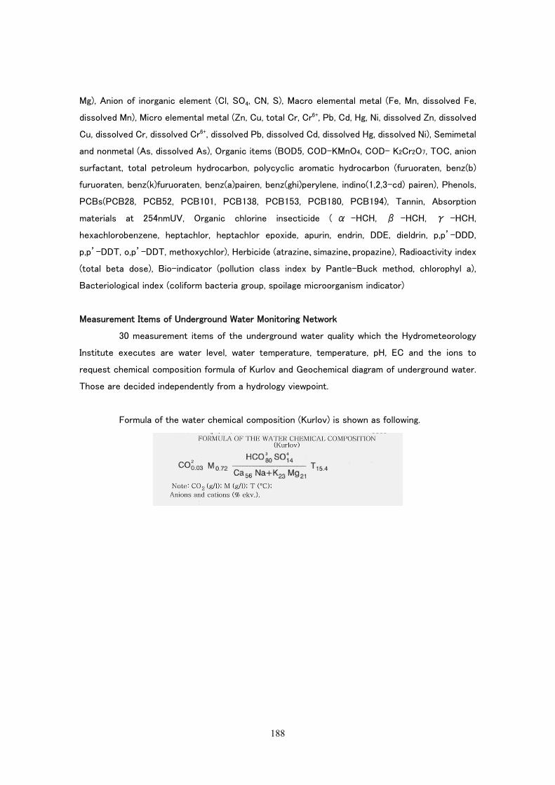
188
Mg), Anion of inorganic element (Cl, SO4, CN, S), Macro elemental metal (Fe, Mn, dissolved Fe,
dissolved Mn), Micro elemental metal (Zn, Cu, total Cr, Cr6+, Pb, Cd, Hg, Ni, dissolved Zn, dissolved
Cu, dissolved Cr, dissolved Cr6+, dissolved Pb, dissolved Cd, dissolved Hg, dissolved Ni), Semimetal
and nonmetal (As, dissolved As), Organic items (BOD5, COD-KMnO4, COD- K2Cr2O7, TOC, anion
surfactant, total petroleum hydrocarbon, polycyclic aromatic hydrocarbon (furuoraten, benz(b)
furuoraten, benz(k)furuoraten, benz(a)pairen, benz(ghi)perylene, indino(1,2,3-cd) pairen), Phenols,
PCBs(PCB28, PCB52, PCB101, PCB138, PCB153, PCB180, PCB194), Tannin, Absorption
materials at 254nmUV, Organic chlorine insecticide ( α -HCH, β -HCH, γ -HCH,
hexachlorobenzene, heptachlor, heptachlor epoxide, apurin, endrin, DDE, dieldrin, p,p’-DDD,
p,p’-DDT, o,p’-DDT, methoxychlor), Herbicide (atrazine、simazine、propazine), Radioactivity index
(total beta dose), Bio-indicator (pollution class index by Pantle-Buck method, chlorophyl a),
Bacteriological index (coliform bacteria group, spoilage microorganism indicator)
Measurement Items of Underground Water Monitoring Network
30 measurement items of the underground water quality which the Hydrometeorology
Institute executes are water level, water temperature, temperature, pH, EC and the ions to
request chemical composition formula of Kurlov and Geochemical diagram of underground water.
Those are decided independently from a hydrology viewpoint.
Formula of the water chemical composition (Kurlov) is shown as following.


![Bipolar Fuzzy Spatial Information: Geometry, Morphology ... · intuitionistic fuzzy sets derived from image intensity and entropy or divergence criteria [24, 29, 57]. Spatial representations](https://img.pdfslide.net/doc/110x75/604fd86c7fef572a834c1495/bipolar-fuzzy-spatial-information-geometry-morphology-intuitionistic-fuzzy.jpg)