Embed Size (px)
Citation preview

201
Chapter 5: Mineral Resources of the
Southwestern US
What is a mineral?A mineral is a naturally occurring inorganic solid with a specific chemical composition and a well-developed crystalline structure. Minerals provide the foundation of our everyday world. Not only do they make up the rocks we see around us in the Southwest, they are also used in nearly every aspect of our lives. The minerals found in the rocks of the Southwest are used in industry, construction, machinery, technology, food, makeup, jewelry, and even the paper on which these words are printed.
Minerals provide the building blocks for rocks. For example, granite, an igneous rock, is typically made up of crystals of the minerals feldspar, quartz, mica, and amphibole. In contrast, sandstone may be made of cemented grains of feldspar, quartz, and mica. The minerals and the bonds between the crystals define a rock's color and resistance to weathering.
Several thousand minerals have been discovered and classified according to their chemical composition. Most of them are silicates (representing approximately a thousand different minerals, of which quartz and feldspar are two of the most common and familiar), which are made of silicon and oxygen combined with other elements (with the exception of quartz, SiO2). Carbonate rocks are made of carbon and oxygen combined with a metallic element; calcium carbonate (CaCO3) is the most common example, and most of it today originates as skeletal material precipitated by organisms. Other mineral categories include native elements (such as gold), oxides and sulfur-bearing minerals, and salts.
Metallic minerals are vital to the machinery and technology of modern civilization. However, many metals occur in the crust in amounts that can only be measured in parts per million (ppm) or parts per billion (ppb). A mineral is called an ore when one or more of its elements can be profitably removed, and it is almost always necessary to process ore minerals in order to isolate the useful element. For example, chalcopyrite (CuFeS2), which contains copper, iron, and sulfur, is referred to as a copper ore when the copper can be profitably extracted from the iron and sulfur. Ores are not uniformly distributed in the crust of the Earth, but instead occur in localized areas where they are concentrated in amounts sufficient to be economically extracted by mining.
Non-metallic minerals do not have the flash of a metal, though they may have the brilliance of a diamond or the silky appearance of gypsum (CaSO·2H2O). Generally much lighter in color than metals, non-metallic minerals can transmit light, at least along their edges or through small fragments.
CHAPTER AUTHOR
Thomas R. Fisher
granite • a common and widely occurring type of igneous rock.
igneous rocks • rocks derived from the cooling of magma underground or molten lava on the Earth’s surface.
mica • a large group of sheetlike silicate minerals.
amphibole • a group of dark colored silicate minerals, or either igneous or metamorphic origin.
sandstone • sedimentary rock formed by cementing together grains of sand.
cementation • the precipi-tation of minerals that binds together particles of rock, bones, etc., to form a solid mass of sedimentary rock.

202
Mineral Identification Although defined by their chemical composition and crystal structure, minerals are identified based on their physical properties. A variety of properties must usually be determined when identifying a mineral, with each such property eliminating possible alternatives.
Mineral Resources
Review
5Elements: The Building Blocks of Minerals
Elements are the building blocks of minerals. The mineral quartz, for example, is made of the elements silicon and oxygen, and, in turn, is also a major component of many rocks. Most minerals present in nature are not composed of a single element, though there are exceptions such as gold. Elements such as copper (Cu), lead (Pb), zinc (Zn), and even silver (Ag), gold (Au), and diamond (C) are not rare, but they are usually widely dispersed throughout rocks and occur at very low average concentrations. Eight elements make up (by weight) 99% of the Earth’s crust, with oxygen being the most abundant (46.4%). The remaining elements in the Earth’s crust occur in very small amounts, some in concentrations of only a fraction of one percent. Since silicon (Si) and oxygen (O) are the most abundant elements in the crust by mass, it makes sense for silicates (e.g., feldspar, quartz, and garnet) to be some of the most common minerals in the Earth's crust and to therefore be found throughout the Southwest.
Mineral percentage by mass in the Earth's crust.
copper • a ductile, malleable, reddish-brown metallic element (Cu).
gold • a soft, yellow, corrosion-resistant element (Au), which is the most malleable and ductile metal on Earth.
feldspar • an extremely common group of rock-forming minerals found in igneous, metamorphic and sedimentary rocks.
quartz • the second most abundant mineral in the Earth’s continental crust (after the feldspars), made up of silicon and oxygen (SiO2 ).
hardness • a physical property of minerals, specifying how hard the mineral is, and its resistance to scratching.
erosion • the transport of weathered materials.
calcite • a carbonate mineral, consisting of calcium carbonate (CaCO3 ).
203
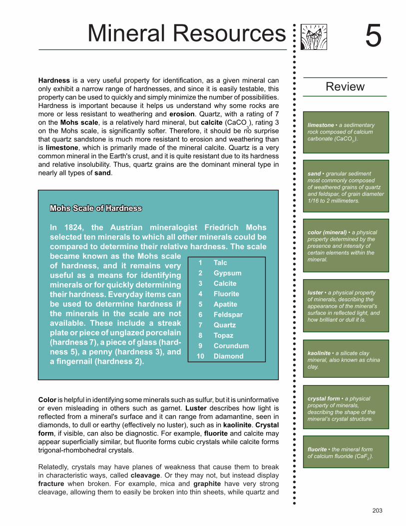
Hardness is a very useful property for identification, as a given mineral can only exhibit a narrow range of hardnesses, and since it is easily testable, this property can be used to quickly and simply minimize the number of possibilities. Hardness is important because it helps us understand why some rocks are more or less resistant to weathering and erosion. Quartz, with a rating of 7 on the Mohs scale, is a relatively hard mineral, but calcite (CaCO
3), rating 3
on the Mohs scale, is significantly softer. Therefore, it should be no surprise that quartz sandstone is much more resistant to erosion and weathering than is limestone, which is primarily made of the mineral calcite. Quartz is a very common mineral in the Earth's crust, and it is quite resistant due to its hardness and relative insolubility. Thus, quartz grains are the dominant mineral type in nearly all types of sand.
Color is helpful in identifying some minerals such as sulfur, but it is uninformative or even misleading in others such as garnet. Luster describes how light is reflected from a mineral's surface and it can range from adamantine, seen in diamonds, to dull or earthy (effectively no luster), such as in kaolinite. Crystal form, if visible, can also be diagnostic. For example, fluorite and calcite may appear superficially similar, but fluorite forms cubic crystals while calcite forms trigonal-rhombohedral crystals.
Relatedly, crystals may have planes of weakness that cause them to break in characteristic ways, called cleavage. Or they may not, but instead display fracture when broken. For example, mica and graphite have very strong cleavage, allowing them to easily be broken into thin sheets, while quartz and
Mohs Scale of Hardness
In 1824, the Austrian mineralogist Friedrich Mohs selected ten minerals to which all other minerals could be compared to determine their relative hardness. The scale became known as the Mohs scale of hardness, and it remains very useful as a means for identifying minerals or for quickly determining their hardness. Everyday items can be used to determine hardness if the minerals in the scale are not available. These include a streak plate or piece of unglazed porcelain (hardness 7), a piece of glass (hard-ness 5), a penny (hardness 3), and a fingernail (hardness 2).
1 Talc2 Gypsum3 Calcite4 Fluorite5 Apatite6 Feldspar7 Quartz8 Topaz9 Corundum
10 Diamond
Mineral Resources
Review
5
limestone • a sedimentary rock composed of calcium carbonate (CaCO3 ).
sand • granular sediment most commonly composed of weathered grains of quartz and feldspar, of grain diameter 1/16 to 2 millimeters.
color (mineral) • a physical property determined by the presence and intensity of certain elements within the mineral.
luster • a physical property of minerals, describing the appearance of the mineral's surface in reflected light, and how brilliant or dull it is.
kaolinite • a silicate clay mineral, also known as china clay.
crystal form • a physical property of minerals, describing the shape of the mineral’s crystal structure.
fluorite • the mineral form of calcium fluoride (CaF2 ).
204
glass (the latter not being a mineral) have no cleavage, instead displaying a distinctive curved fracture form known as conchoidal. The density of a mineral may also aid in identifying it (e.g., metals tend to be very dense). Finding the exact density is straightforward, but it does require measuring the volume of the sample. Placing an unknown mineral in water (or other liquid) to find its volume by displacement can be a risky undertaking since several minerals react violently with water, and many more break down with exposure. A mineral's streak is obtained by dragging it across a porcelain plate, effectively powdering it. The color of the powder eliminates conflating variables of external weathering, crystal habit, impurities, etc. Some minerals are magnetic (affected by magnetic fields), while a few are natural magnets (capable of producing a magnetic field).
Most minerals can be identified through the process of elimination after examining a few of these properties and consulting a mineral identification guide. Mineral testing kits often include several common objects used to test hardness: a porcelain streak plate, a magnet, and a magnifying glass. Some minerals have rare properties, which may be more difficult to test. For example, there are minerals that exhibit luminescence of all types, giving off light due to a particular stimulus. Some minerals are radioactive, usually due to the inclusion of significant amounts of uranium, thorium, or potassium in their structure. Carbonate minerals will effervesce when exposed to hydrochloric acid. Double refraction describes the result of light passing through a material that splits it into two polarized sets of rays, doubling images viewed through that material. For example, a single line on a sheet of paper will appear as two parallel lines when viewed through a clear calcite crystal.
What Are Minerals Used For?Mineral resources fall into many different categories, including industrial minerals, construction materials, gemstones, and metallic and non-metallic ores. Some minerals and rocks are abundant and are used in the construction industry or in the manufacturing of many of the products we commonly find in stores. Construction materials include dimension stone (e.g., sandstone, limestone, and granite), which is used for the exterior or interior of structures.
Minerals used in manufacturing include kaolinite for ceramics, gypsum for wallboard, fluorite for the fluoride in toothpaste, and halite for common table and rock salt. We also seek out specific rock types and sediment to use in the construction of buildings, highways, and bridges. Decorative statues are commonly constructed of marble, jade, or soapstone. Granite, travertine, and other decorative stones are increasingly used to beautify our home interiors and
Mineral Resources
Review
5
There are many more interesting and distinguishing properties that minerals may possess, and there are many more elaborate and precise means for iden-tifying them. The branch of geology that studies the chem-ical and physical properties and formation of minerals is called mineralogy.
density • a physical property of minerals, describing the mineral’s mass per volume.
streak • a physical property of minerals, obtained by dragging the mineral across a porcelain plate and effectively powdering it.
magnetic • affected by or capable of producing a magnetic field.
luminescence • the emission of light.
radioactivity • the emission of radiation by an unstable atom.
thorium • a radioactive rare earth element.
effervesce • to foam or fizz while releasing gas.
double refraction • the result of light passing through a material that splits it into two polarized sets of rays, doubling images viewed through that material.

205
to make art, in addition to being used in public buildings. Some minerals are considered to be precious or semi-precious and are used in jewelry, including diamond and some crystalline forms of quartz.
Metallic minerals have many applications and are used to manufacture many of the items we see and use every day. For example, iron comes from hematite and magnetite, and from it we make steel. Lead, from the mineral galena, is used in the manufacture of batteries and in the solder found in electronic devices. Titanium, from the mineral ilmenite, is used in airplanes, spacecraft, and even white nail polish. Aluminum comes from bauxite and is known for being both lightweight and strong—many of the parts that make up today's
Review
5Mineral Resources
What distinguishes a regular mineral from a gem?
Minerals are assigned to the category of gemstones based primarily on our interpretation of what has value. Typically, the beauty, durability, and rarity of a mineral qualify it as a gemstone. Beauty refers to the luster, color, transparency, and brilliance of the mineral, though to some degree it is dependent on the skillfulness of the cut. Not all gems are prized for these reasons; for example, scarcity may be artificially inflated, or a mineral may be valued for its unusual color.
Gemstones can be further categorized as precious or semiprecious stones. Precious stones, including diamond, topaz, and sapphire, are rare and translucent to light. They are more durable because they are hard, making them scratch resistant. On the Mohs scale of hardness, the majority of precious gemstones have values greater than 7. Semi-precious stones are generally softer, with hardness scale values between 5 and 7. The minerals peridot, jade, garnet, amethyst, citrine, rose quartz, tourmaline, and turquoise are examples of semi-precious stones that can be cut and used in jewelry.
Gems may have common names that differ from their geological ones, and these names may be dependent on mineral color. For example, the mineral beryl is also referred to as emerald, aquamarine, or morganite depending on its color. Corundum can also be called sapphire or ruby, and peridot is another name for olivine.
gem • a mineral that has aesthetic value and is often cut and polished for use as an ornament.
dimension stone • the commercial term applied to quarried blocks of rock cut to specific dimensions.
corundum • an aluminum oxide mineral (Al2O3) that is, after diamond, the hardest known natural substance.
olivine • an iron-magnesium silicate mineral ((Mg,Fe)2SiO4) that is a common constituent of magnesium-rich, silica-poor igneous rocks.
hematite • a mineral form of iron oxide (Fe2O3 ), with vivid red pigments that make it valuable as a commercial pigment.
magnetite • a mineral form of iron oxide (Fe3O4 ) with naturally occurring magnetic properties.
lead • a metallic chemical element (Pb).
206
automobiles are made of this metal. Copper comes from a variety of copper-bearing minerals, including chalcopyrite, and is used to make electrical wire, tubing, and pipe.
Mineral FormationEconomically recoverable mineral deposits are formed by geologic processes that can selectively concentrate desirable elements in a relatively small area. These processes may be physical or chemical, and they fall into four categories:
Magmatic processes separate minor elements of magma from the major elements and concentrate them in a small volume of rock. This may involve either the early crystallization of ore minerals from the magma while most other components remain molten or late crystallization after most other components have crystallized. Magmatic processes responsible for the formation of mineral deposits are usually associated with igneous intrusions (formed during mountain building events, rifting, and volcanic activity), which can range in composition from granite (felsic) to gabbro (mafic). Metamorphism may also cause recrystallization of minerals and concentration of rare elements. Under conditions of extreme high-temperature metamorphism, minerals with the lowest melting temperatures in the crust may melt to form small quantities of pegmatite magmas.
Hydrothermal processes involve hydrothermal solutions that dissolve minor elements dispersed through large volumes of rock, transport them to a new location, and precipitate them in a small area at a much higher concentration. Hydrothermal solutions are commonly salty, acidic, and range in temperature from over 600°C (~1100°F) to less than 60°C (140°F). Some of these fluids may travel very long distances through permeable sedimentary rock. Eventually, the hydrothermal fluids precipitate their highly dissolved load of elements, creating concentrated deposits.
Sedimentary processes gather elements dispersed through large volumes of water and precipitate them in a sedimentary environment, such as in sedimentary layers on the ocean floor or on lakebeds. Sedimentary mineral deposits form by direct precipitation from the water.
Weathering and erosion break down large volumes of rock by physical and chemical means and gather previously dispersed elements or minerals into highly concentrated deposits. Residual weathering deposits are mineral depos-its formed through the concentration of a weathering-resistant mineral, as a result of surrounding minerals being eroded and dissolved. In contrast, mineral deposits formed by the concentration of minerals in moving waters are called placer deposits.
Mineral Resources
Review
5
magma • molten rock located below the surface of the Earth.
intrusive rock • a plutonic igneous rock formed when magma from within the Earth’s crust escapes into overlying strata.
rift • a break or crack in the crust that can be caused by tensional stress as a landmass breaks apart into separate plates.
volcanism • the eruption of molten rock onto the surface of the crust.
felsic • igneous rocks with high silica content and low iron and magnesium content.
gabbro • a coarse-grained, mafic and intrusive igneous rock.
mafic • igneous rocks that contain a group of dark-colored minerals, with relatively high concentrations of magnesium and iron.

207
Minerals in the Southwest Each region of the Southwest (the Colorado Plateau, Basin and Range, Rocky Mountains, and Great Plains) contains significant economic metallic and non-metallic mineral deposits. The distribution and occurrence of these deposits are not always restricted to one region—the geology, geologic history, and associated mineral resources of the Southwestern US are intimately intertwined across regional and state boundaries. This cross cutting of the regions by mineral deposits reflects not only the type of deposit but also how and when the minerals were emplaced, and how geology controlled their emplacement. In many parts of the Southwest, the dry environment also allows for relatively easy access to both bedrock surfaces and accumulations of weathered rock for the exploration of minerals that lie within or that have been weathered out of the region's rocks.
Both the Southwestern and Northwest Central states are major contributors to mineral production in the United States. In some cases, these states produce the majority of a particular mineral used by the US and may even contain the largest deposits in the world of certain mineral types. For example, most of the country's uranium deposits are located in the Southwest or the Northwest Central. Ninety percent of the copper produced in the US comes from two states in the Southwest: Arizona and Utah. Significant quantities of gold, silver, and molybdenum are also produced here, along with industrial minerals such as potash and soda ash. Throughout the Southwest, the deposition of sediment has also left behind an abundance of deposits useful as construction materials. River systems deposited sand and gravel, while ancient seas that spread across the area left behind thick deposits of halite and gypsum. The advance of inland seas and the subsequent deposition of marine detritus also made possible the widespread existence of energy resources (fossil fuels) throughout the area, most notably oil, natural gas, and coal. Some of the natural gas produced in the Southwest also contains helium in sufficient concentrations to be profitably extracted—it originates from the decay of radioactive elements in the source rocks of accumulated natural gas.
Region 1
5Mineral Resources
See Chapter 6: Energy to learn more about the extraction of fossil fuel resources in the Southwest.
A mineral is not necessarily restricted to one method of concentration or environment of formation. For example, economically important deposits of gypsum may form as a precipitate from evaporating water. In contrast, gypsum formation may also be associated with volcanic regions where limestone and sulfur gases from the volcano have interacted with one another, or even from other areas as a product of the chemical weathering of pyrite.
metamorphic rocks • rocks formed by the recrystallization and realignment of minerals in pre-existing sedimentary, igneous, and metamorphic rocks when exposed to high enough temperature and/or pressure.
recrystallization • the change in structure of mineral crystals that make up rocks, or the formation of new mineral crystals within the rock.
pegmatite • a very coarse-grained igneous rock that formed below the surface.
hydrothermal solution • hot, mineral-rich water moving through rocks.
permeability • a capacity for fluids and gas to move through fractures within a rock, or the spaces between its grains.

208
Mineral Resources of the Colorado PlateauRegion 1
An area about the size of the state of Montana, the Colorado Plateau is an enigmatic block of continental crust some 45 kilometers (28 miles) thick that has remained relatively stable for over 500 million years. It began rising around 100 million years ago, rose further in the Eocene (56-33 million years ago), and then once more during an epeirogenic event approximately 8 to 6 million years ago. The Grand Canyon began to incise into the Plateau beginning in the Eocene, eventually cutting down far enough to expose 500 million years of horizontal sedimentary strata and underlying tilted metamorphic and igneous Precambrian basement rocks. There have been no major magmatic events in the Colorado Plateau, so the metallic resources found there are relatively minor, although a few younger igneous and volcanic intrusive rocks were important to metal emplacement. Most of the Plateau's mineral ore deposits have sedimentary origins and are associated with the region's depositional basins (Figure 5.1).
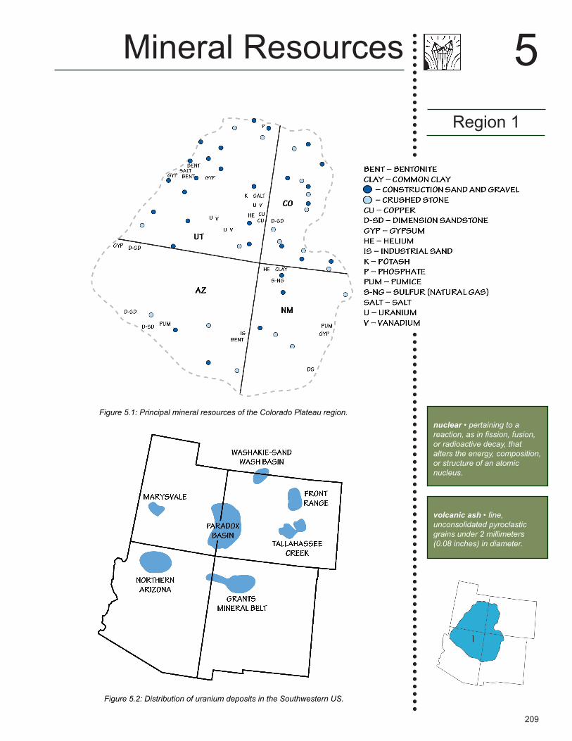
Metallic ResourcesAlthough the US has perennially imported over 90% of its uranium ore from foreign sources, the Paradox Basin in the Colorado Plateau is seen as an important source for US uranium supplies (Figure 5.2), which are mined for use in nuclear energy. These uranium deposits occur largely as “roll-front” deposits, in which groundwater leaches uranium from the source rock (usually igneous or metamorphic basement rock or volcanic ash deposits), and carries it through a porous and permeable rock, typically sandstone or conglomerate. Uranium oxide minerals are precipitated when the uranium-bearing groundwater is reduced by contact with organic materials within the rock. The uranium minerals carnotite and coffinite account for the majority of the ores in these deposits. Vanadium minerals such as corvurite and doloresite are also found with these ores. Most commonly, the region's uranium- and vanadium-bearing minerals are hosted in fluvial and lacustrine sandstones and limestones of the Triassic Chinle, Jurassic Morrison and Todilto, and Cretaceous Dakota formations. Lithium, a major component of high-tech batteries, is recovered from the Paradox Basin.
Of the US states, New Mexico currently ranks second in uranium resources after Wyoming. Most of the state's deposits are located in the Grants Mineral Belt to the northwest, although no mining has taken place there since 2002. Other major uranium deposits are found near Moab, Utah in the Paradox Basin; on the San Rafael Swell in central Utah; and near Uravan, Colorado, where the
Mineral Resources
Region 1
5
See Chapter 4: Topography for more information about the formation of the Grand Canyon.
Eocene • a geologic time period extending from 56 to 33 million years ago.
Precambrian • a geologic time interval that spans from the formation of Earth (4.6 billion years ago) to the beginning of the Cambrian (541 million years ago).
basement rocks • the foundation that underlies the surface geology of an area, generally composed of igneous or metamorphic crystalline rock.
perennial • continuous; year-round or occurring on a yearly basis.
See Chapter 6: Energy for more information about nuclear power in the Southwest.
epeirogenic • large-scale crustal uplift caused by hot or upwelling mantle underlying the surface.
209
Region 1
5Mineral Resources
Figure 5.2: Distribution of uranium deposits in the Southwestern US.
Figure 5.1: Principal mineral resources of the Colorado Plateau region.nuclear • pertaining to a reaction, as in fission, fusion, or radioactive decay, that alters the energy, composition, or structure of an atomic nucleus.
volcanic ash • fine, unconsolidated pyroclastic grains under 2 millimeters (0.08 inches) in diameter.

210
Mineral Resources
Region 1
5
Figure 5.3: Distribution of the Eocene Green River Formation. Blue areas mark the location of middle Eocene lakebeds that bear very large oil shale, nahcolite, and trona deposits.
power • the rate at which energy is transferred, usually measured in watts or, less frequently, horsepower.
stratiform deposit • a mineral deposit that forms when a hydrothermal solution moves through a sedimentary deposit such as an aquifer, and deposits minerals parallel to the sedimentary layers.
laccolith • an intrusive igneous rock body that forms from magma that has, through pressure, been forced between two sedimentary layers.
Oligocene • a geologic time interval spanning from about 34 to 23 million years ago.
Miocene • a geological time unit extending from 23 to 5 million years ago.
last uranium mine was closed in 2009 due to a drop in uranium prices. New mines are being planned for the Colorado Plateau should demand increase for nuclear power.
Similar to uranium deposits, sediment-hosted stratiform copper deposits are found in the Triassic, Jurassic, and Cretaceous rocks of the Plateau, mainly in Utah's Paradox Basin. The Salt and Lisbon valleys near Moab, Utah host several copper deposits in porous and permeable fluvial sandstones. These deposits formed from warm saline and copper-bearing fluids that deposited copper minerals, such as chalcocite, malachite, and azurite.
The only gold deposits reported on the Colorado Plateau are of placer origin. These are found largely in the Abajo, La Sal, and Henry mountains of Utah and along the nearby Green, Colorado, and San Juan rivers and their tributaries. The Abajo, La Sal, and Henry mountains are all laccolithic intrusions of relatively late Oligocene to early Miocene in age (29 to 22 million years ago). The region's placer gold was likely concentrated by the erosion of these intrusive rocks.
Non-Metallic ResourcesIn Colorado and Utah, the Colorado Plateau hosts the Eocene Green River Formation, which represents an almost continuous six-million-year record of very thinly bedded lacustrine (lake) sediments, including salt deposits from times of high salinity. The formation is restricted to the Green River basins of Wyoming, the Uinta and Washakie basins of Utah, and the Piceance Basin of Colorado (Figure 5.3). These basins contain the largest known deposit of the mineral nahcolite (sodium bicarbonate) in the world. Sodium bicarbonate, commonly known as baking soda, is used in cooking, fire extinguishers, “green” bio-pesticides, hygiene products, cleaning agents, and numerous medical applications. The Green River Formation also contains the world's largest deposit of trona, a non-marine evaporite mineral that is mined as a primary source of sodium carbonate. Trona is a common food additive and water softener, and it also has applications in the manufacturing of paper, textiles, glass, and detergents.
211
Region 1
5Mineral Resources
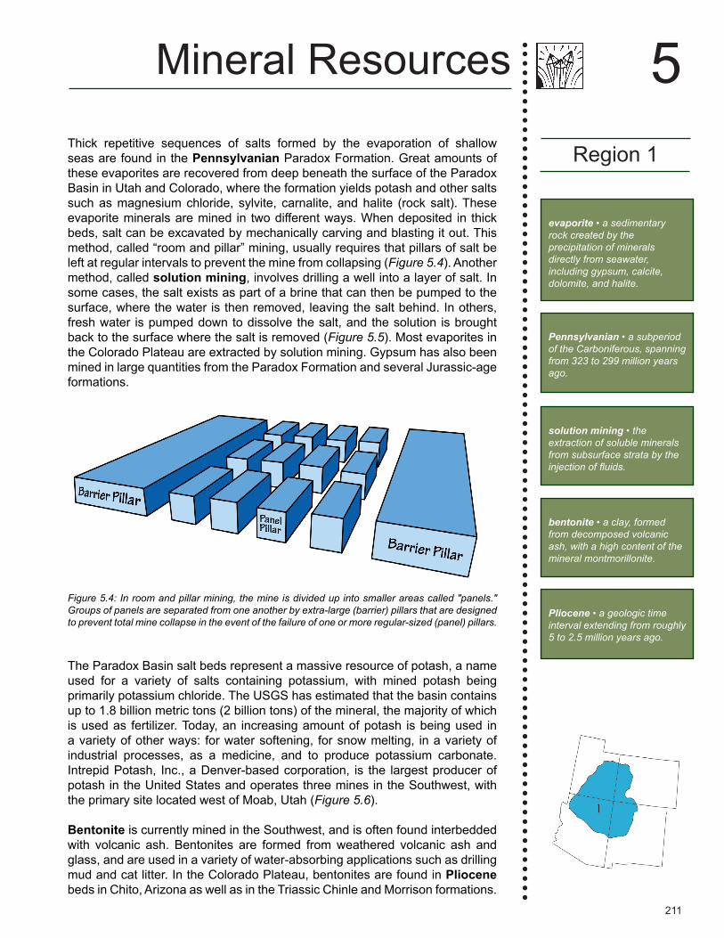
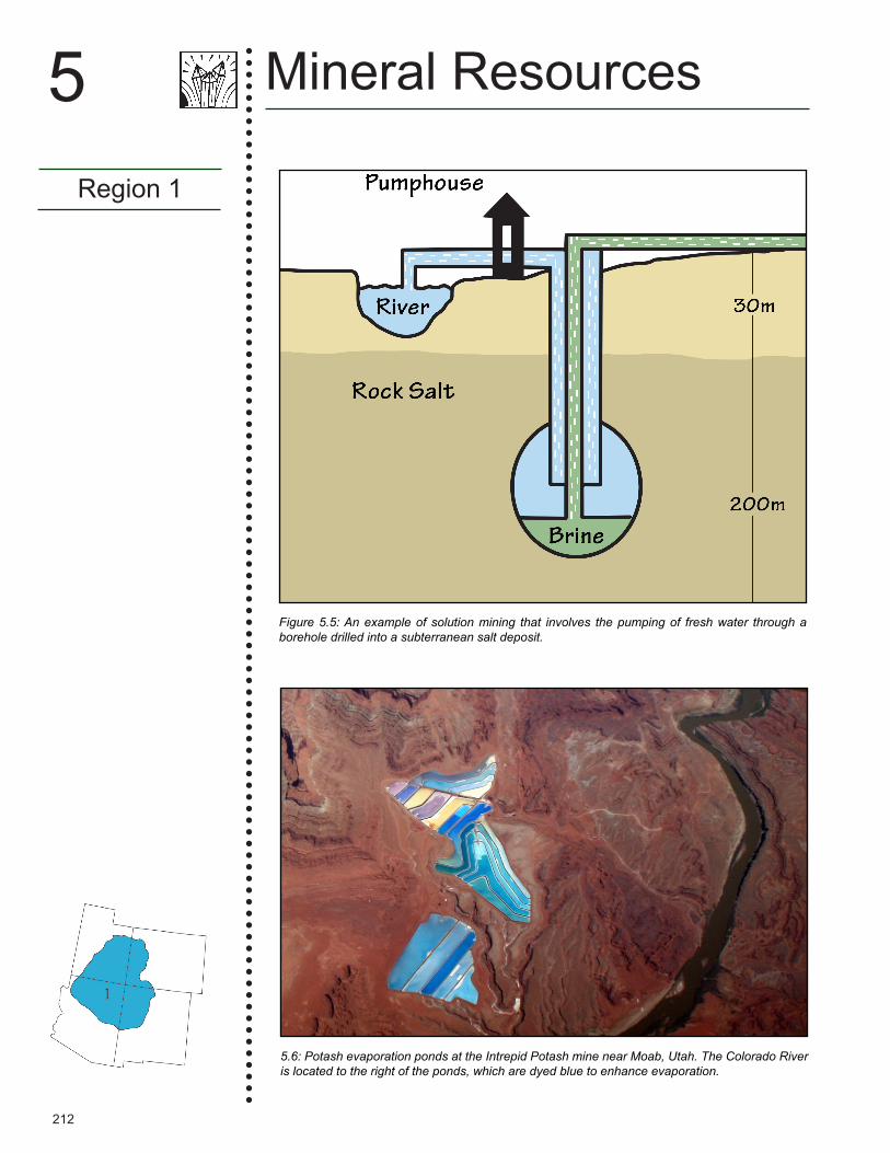
Thick repetitive sequences of salts formed by the evaporation of shallow seas are found in the Pennsylvanian Paradox Formation. Great amounts of these evaporites are recovered from deep beneath the surface of the Paradox Basin in Utah and Colorado, where the formation yields potash and other salts such as magnesium chloride, sylvite, carnalite, and halite (rock salt). These evaporite minerals are mined in two different ways. When deposited in thick beds, salt can be excavated by mechanically carving and blasting it out. This method, called “room and pillar” mining, usually requires that pillars of salt be left at regular intervals to prevent the mine from collapsing (Figure 5.4). Another method, called solution mining, involves drilling a well into a layer of salt. In some cases, the salt exists as part of a brine that can then be pumped to the surface, where the water is then removed, leaving the salt behind. In others, fresh water is pumped down to dissolve the salt, and the solution is brought back to the surface where the salt is removed (Figure 5.5). Most evaporites in the Colorado Plateau are extracted by solution mining. Gypsum has also been mined in large quantities from the Paradox Formation and several Jurassic-age formations.
The Paradox Basin salt beds represent a massive resource of potash, a name used for a variety of salts containing potassium, with mined potash being primarily potassium chloride. The USGS has estimated that the basin contains up to 1.8 billion metric tons (2 billion tons) of the mineral, the majority of which is used as fertilizer. Today, an increasing amount of potash is being used in a variety of other ways: for water softening, for snow melting, in a variety of industrial processes, as a medicine, and to produce potassium carbonate. Intrepid Potash, Inc., a Denver-based corporation, is the largest producer of potash in the United States and operates three mines in the Southwest, with the primary site located west of Moab, Utah (Figure 5.6).
Bentonite is currently mined in the Southwest, and is often found interbedded with volcanic ash. Bentonites are formed from weathered volcanic ash and glass, and are used in a variety of water-absorbing applications such as drilling mud and cat litter. In the Colorado Plateau, bentonites are found in Pliocene beds in Chito, Arizona as well as in the Triassic Chinle and Morrison formations.
Figure 5.4: In room and pillar mining, the mine is divided up into smaller areas called "panels." Groups of panels are separated from one another by extra-large (barrier) pillars that are designed to prevent total mine collapse in the event of the failure of one or more regular-sized (panel) pillars.
evaporite • a sedimentary rock created by the precipitation of minerals directly from seawater, including gypsum, calcite, dolomite, and halite.
Pennsylvanian • a subperiod of the Carboniferous, spanning from 323 to 299 million years ago.
solution mining • the extraction of soluble minerals from subsurface strata by the injection of fluids.
bentonite • a clay, formed from decomposed volcanic ash, with a high content of the mineral montmorillonite.
Pliocene • a geologic time interval extending from roughly 5 to 2.5 million years ago.
212
Mineral Resources
Region 1
5
5.6: Potash evaporation ponds at the Intrepid Potash mine near Moab, Utah. The Colorado River is located to the right of the ponds, which are dyed blue to enhance evaporation.
Figure 5.5: An example of solution mining that involves the pumping of fresh water through a borehole drilled into a subterranean salt deposit.
213
Mineral Resources of the Basin and RangeRegion 2
The Basin and Range region covers significant portions of Utah, Arizona, and New Mexico, as well as Nevada and parts of adjacent states. Around 30 million years ago in the early Oligocene, the North American plate began to override hot upwelling mantle, resulting in extensional forces that pulled the continental crust apart to form the region's distinctive "horst and graben" or “basin and range” structure of alternating, roughly north-south oriented valleys and mountain ranges. This extension influenced the shape of geological structures
Regions 1-2
5Mineral Resources
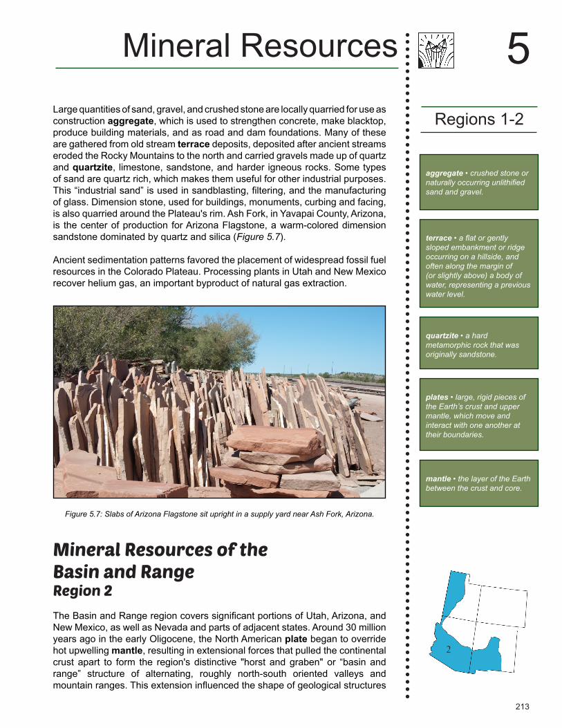
Figure 5.7: Slabs of Arizona Flagstone sit upright in a supply yard near Ash Fork, Arizona.
aggregate • crushed stone or naturally occurring unlithified sand and gravel.
terrace • a flat or gently sloped embankment or ridge occurring on a hillside, and often along the margin of (or slightly above) a body of water, representing a previous water level.
quartzite • a hard metamorphic rock that was originally sandstone.
Large quantities of sand, gravel, and crushed stone are locally quarried for use as construction aggregate, which is used to strengthen concrete, make blacktop, produce building materials, and as road and dam foundations. Many of these are gathered from old stream terrace deposits, deposited after ancient streams eroded the Rocky Mountains to the north and carried gravels made up of quartz and quartzite, limestone, sandstone, and harder igneous rocks. Some types of sand are quartz rich, which makes them useful for other industrial purposes. This “industrial sand” is used in sandblasting, filtering, and the manufacturing of glass. Dimension stone, used for buildings, monuments, curbing and facing, is also quarried around the Plateau's rim. Ash Fork, in Yavapai County, Arizona, is the center of production for Arizona Flagstone, a warm-colored dimension sandstone dominated by quartz and silica (Figure 5.7).
Ancient sedimentation patterns favored the placement of widespread fossil fuel resources in the Colorado Plateau. Processing plants in Utah and New Mexico recover helium gas, an important byproduct of natural gas extraction.
plates • large, rigid pieces of the Earth’s crust and upper mantle, which move and interact with one another at their boundaries.
mantle • the layer of the Earth between the crust and core.
214
Mineral Resources
Region 2
5
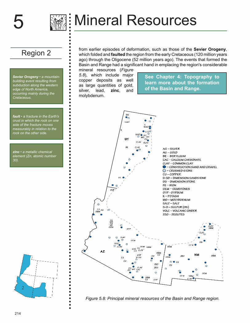
Figure 5.8: Principal mineral resources of the Basin and Range region.
Sevier Orogeny • a mountain-building event resulting from subduction along the western edge of North America, occurring mainly during the Cretaceous.
fault • a fracture in the Earth's crust in which the rock on one side of the fracture moves measurably in relation to the rock on the other side.
from earlier episodes of deformation, such as those of the Sevier Orogeny, which folded and faulted the region from the early Cretaceous (120 million years ago) through the Oligocene (52 million years ago). The events that formed the Basin and Range had a significant hand in emplacing the region's considerable mineral resources (Figure 5.8), which include major copper deposits as well as large quantities of gold, silver, lead, zinc, and molybdenum.
See Chapter 4: Topography to learn more about the formation of the Basin and Range.
zinc • a metallic chemical element (Zn, atomic number 30).
215
Some of the region's mineral deposits predate Cenozoic extension of the landscape. In western Utah, for example, deposits are often concentrated in semi-parallel northeast-trending belts, reflecting deep crustal structures or zones of weakness. The three belts in Utah are, north to south, the Uinta, the Tintic, and the Pioche belts. These structures cross physiographic region boundaries (e.g., from the Basin and Range into the Colorado Plateau), indicating they predate the development of these regions, and may date back to the Precambrian. Similar northeast-trending zones extend across other parts of the western US. These zones served as natural pathways for magmas and associated hydrothermal fluids to rise through the crust, from areas where heat from the hot, upwelling mantle melted the lower crust. This magmatic activity peaked from about 35 to 17 million years ago, and has continued at a decreasing rate nearly to the present day.
Metallic ResourcesThe Basin and Range is a hotbed of metallic ore deposits, especially along orogenic belts—the sites of mountain formation. The Sevier Orogenic Belt, a major geologic feature of the Basin and Range (and of the much larger Cordilleran Fold and Thrust Belt), marks the transition from the Colorado Plateau to the Basin and Range. Formed in the late Cretaceous and Paleogene, its structures provided fluid paths and hosts for mineral deposits all along this transition line. Economic deposits of gold, silver, copper, tungsten, and oil and gas are found within the margins of the Sevier Belt.
Thanks to the prolific amounts of copper ore found in Utah and Arizona, both states have taken copper as their state mineral. The Uinta, Tintic, and Pioche belts in Utah produce copper, gold, silver, lead, molybdenum, tungsten, uranium, and beryllium (Figure 5.9). The Tintic Mining District, although largely defunct today, was an important source of silver, gold, copper, and bismuth during the late 19th and early 20th centuries. The Pioche Belt also contains the world's largest deposit of alunite, a sulfate mineral that is a source of both potassium and aluminum. The Bingham Canyon deposit, located within the Uinta Belt, contains significant quantities of copper as well as considerable amount of gold and other minerals. Kennecott Copper's Bingham Canyon Mine, near Salt Lake City, Utah, is one of the largest open pit mines in the world and produces 25% of the US domestic copper supply (Figure 5.10). So large that it is visible from space, the mine is about a kilometer (over half a mile) deep and produces 408,000 metric tons (450,000 tons) of material per day. Since extraction began in 1863, the mine has produced over 15.4 billion kilograms (17 million tons) of copper, 715,000 kilograms (23 million troy ounces) of gold, 5.9 million kilograms (190 million troy ounces) of silver, and 317 million kilograms (850 million pounds) of molybdenum. This quantity exceeds all of the metals ever produced from the famous Comstock Lode, the Klondike, and the California Gold Rush combined.
Southeastern Arizona is dominated by porphyry copper and associated lead, zinc, gold, and silver deposits in granitic rocks. These deposits were emplaced between 75 and 55 million years ago, predating the development of the Basin and Range's modern structure. Metal ores along the state's western side are dominated by gold deposits in 25- to 15-million-year-old volcanic rocks. Although gold was the first mineral to be mined in Arizona, the state quickly
Region 2
5Mineral Resources
Cenozoic • the geologic time period spanning from 66 million years ago to the present.
physiography • a subfield of geography that studies the Earth’s physical processes and patterns.
heat • a form of energy transferred from one body to another as a result of a difference in temperature or a change in phase.
Paleogene • the geologic time period extending from 66 to 23 million years ago.
porphyry • an igneous rock consisting of large grained crystals, or phenocrysts, cemented in a fine-grained matrix.

216
Mineral Resources
Region 2
5
Figure 5.10: The Bingham Canyon Mine in Salt Lake County, Utah, is one of the largest man-made excavations in the world and the second largest copper producer in the US.
Figure 5.9: Gold and quartz from the Saw Tooth Mountains, near Salt Lake City, Utah.

217
Region 2
5Mineral Resources
became known for its copper, and by 1910 it was the top copper-producing state in the nation—a title it still holds today. Enormous mines in Arizona's southeastern corner account for over 60% of US copper production (Figures 5.11 and 5.12); the Morenci Mine in Greenlee County has reserves estimated at 2.9 billion metric tons (3.2 billion tons) of ore. There is so much copper in Arizona that its nickname is “the Copper State.”
The Rio Grande Rift, which extends from Mexico into Colorado and the southern Rocky Mountains, was formed by extensional forces that pulled the continental crust apart in an east-west direction to form the Rio Grande Valley. Like the
Mining
Mining is a profit-focused undertaking. The profitability of mining minerals or rocks depends on a number of factors, including the concentrations of recoverable elements or material contained in the deposit, the anticipated amount of the deposit that can be mined, its accessibility using current mining methods and technologies, its marketability, and lastly the cost of returning the site to its original state once the extraction phase of mining has ended (reclamation). All these factors determine the choice of mining method. Types of mining include underground (tunnel or shaft), surface (open pit or quarry), hydraulic operations (placer), solution using hot water, and seawater evaporation ponds. Once a mineral resource has been removed from the ground, the next step is to process it in order to recover its useful elements or to transform it so that it can be used in manufacturing or other industrial processes.
Modern mining is accomplished in three phases: exploration, extraction, and reclamation. Exploration is performed to determine the extent of the mineral resource and usually involves extensive use of drilling and geophysical techniques to determine the shape, size, and quality of the resource. Extraction involves removing the mineral resource from the ground. Reclamation is undertaken when mining ceases and is designed to restore the land to a condition where it can be used for other purposes. This last phase usually involves removing sources of contamination, which can be considerable depending on the scope of the mining activity.

218
Mineral Resources
Region 2
5
Figure 5.12: Native copper, the naturally occurring form of copper ore, from Arizona.
Figure 5.11: Distribution of copper mines in the Southwestern US.
manganese • a metallic chemical element (Mn).
rare earth elements • a set of 17 heavy, lustrous elements with similar properties, some of which have technological applications.
wind • the movement of air from areas of high pressure to areas of low pressure.

219
Region 2
5Mineral Resources
extrusion • an igneous rock formed by the cooling of lava after magma escapes onto the surface of the Earth through volcanic craters and cracks in the Earth’s crust.
rest of the Basin and Range, ore in the Rio Grande Rift was deposited from hydrothermal solutions associated with magmatic bodies that rose after heat from the hot upwelling mantle melted them near the lower crust. The Rift is known for its production of copper, gold, silver, lead, zinc, manganese, and a host of other minerals, as well as molybdenum from the Questa Mine near Red River. New Mexico is currently the nation's number three copper-producing state, with two large open pit mines in Grant County: the Tyrone mine and the Santa Rita mine. Together, these mines have produced as much as 113 million kilograms (249 million pounds) of copper, 370,000 grams (13,000 ounces) of gold, and 5.9 million grams (209,000 ounces) of silver per year. The Santa Rita mine is the oldest copper mine in the western US, and was used by Spaniards as early as 1800.
The Rio Grande Rift is also home to a great number of rare earth elements vital to developing technologies, including thorium, lanthanum, yttrium, and the cerium-rich mineral bastnasite. These valuable metals are useful in a range of technological industries, with applications ranging from manufacturing processes to use in electronics such as HDTVs, computers, hybrid and electric vehicles, solar and wind power generators, compact fluorescent lamps, and LEDs.
Non-Metallic ResourcesThe Southwestern US, particularly the Basin and Range, is especially well-known for its gemstones and precious stones. This region, with its combination of faulted sedimentary rocks and intrusive and extrusive igneous rocks, provides a rich set of geochemical environments for a diversity of minerals to grow along fracture surfaces, in cavities, and within the igneous bodies themselves. Thus, while the individual minerals form under specific conditions (e.g., chemistry, heat, pressure, and space for growth), the region has a sufficiently broad mix of conditions to allow many different precious gems to form. Gems and precious stones found in the Basin and Range include turquoise, peridot, amethyst, garnet, jade, opal, beryl, topaz, and many others.
The Basin and Range is especially famous for turquoise; it is the state gemstone of both Arizona and New Mexico (Figure 5.13). This copper-bearing precious mineral is found in areas with substantial copper deposits, and is sometimes removed during copper mining. In the Basin and Range, turquoise is found where copper sulfide deposits weather around certain intrusive igneous rocks. It was one of the first gems to be mined, generally for use in jewelry or sculpture, with extraction dating back over one thousand years. Arizona and parts of New Mexico are among the largest turquoise producing areas of the US, and Arizona still produces the most valuable turquoise in the country, though many mines there have now been depleted. The precious stones azurite and malachite, spectacular blue and green by-products of copper ore weathering, are also common in this area and highly prized by collectors (Figure 5.14).
See Chapter 2: Rocks to learn about the types and origins of different igneous rocks.
opal • a silicate gemstone lacking a rigid crystalline structure.
beryl • a white, blue, yellow, green, or pink mineral, found in coarse granites and igneous rocks.
220
Mineral Resources
Region 2
5
What are hydrothermal solutions?
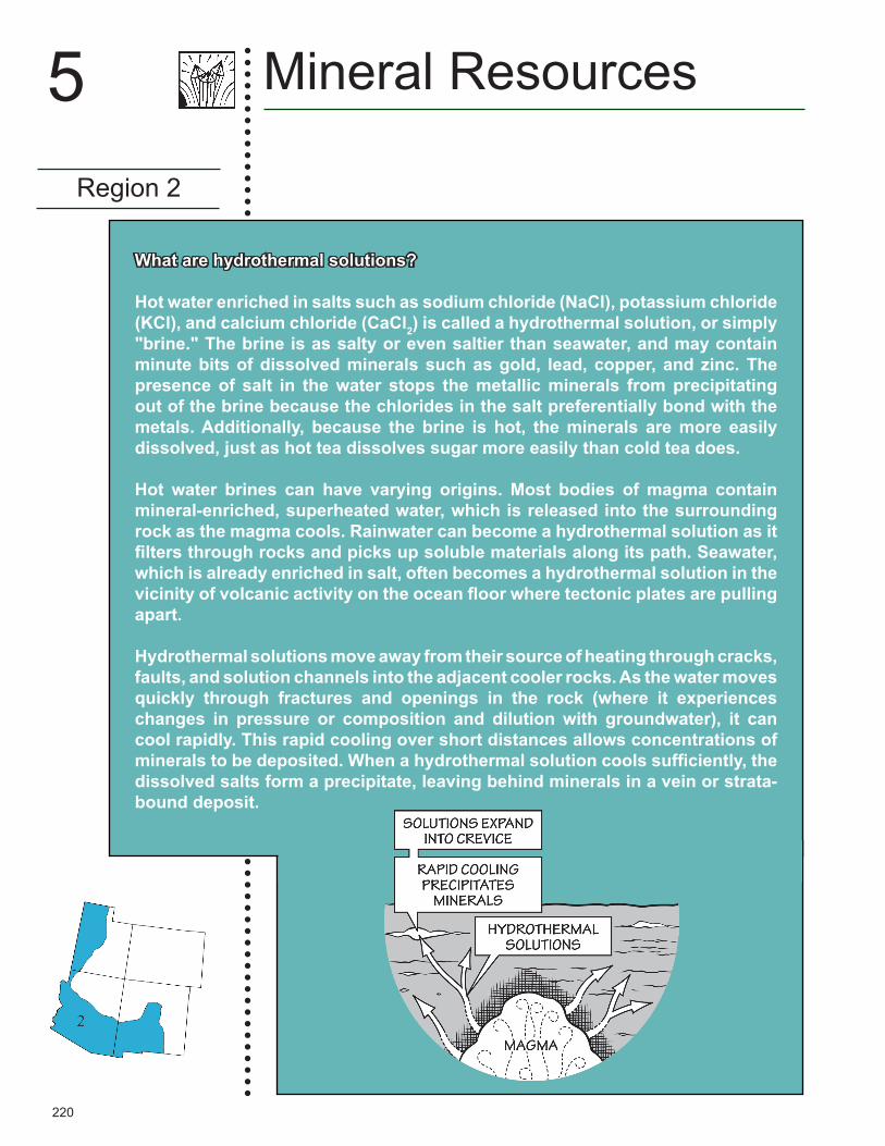
Hot water enriched in salts such as sodium chloride (NaCl), potassium chloride (KCl), and calcium chloride (CaCl2) is called a hydrothermal solution, or simply "brine." The brine is as salty or even saltier than seawater, and may contain minute bits of dissolved minerals such as gold, lead, copper, and zinc. The presence of salt in the water stops the metallic minerals from precipitating out of the brine because the chlorides in the salt preferentially bond with the metals. Additionally, because the brine is hot, the minerals are more easily dissolved, just as hot tea dissolves sugar more easily than cold tea does.
Hot water brines can have varying origins. Most bodies of magma contain mineral-enriched, superheated water, which is released into the surrounding rock as the magma cools. Rainwater can become a hydrothermal solution as it filters through rocks and picks up soluble materials along its path. Seawater, which is already enriched in salt, often becomes a hydrothermal solution in the vicinity of volcanic activity on the ocean floor where tectonic plates are pulling apart.
Hydrothermal solutions move away from their source of heating through cracks, faults, and solution channels into the adjacent cooler rocks. As the water moves quickly through fractures and openings in the rock (where it experiences changes in pressure or composition and dilution with groundwater), it can cool rapidly. This rapid cooling over short distances allows concentrations of minerals to be deposited. When a hydrothermal solution cools sufficiently, the dissolved salts form a precipitate, leaving behind minerals in a vein or strata-bound deposit.

221
Region 2
5Mineral Resources
Figure 5.13: A pile of polished natural turquoise from New Mexico.
rhyolitic • a felsic volcanic rock high in abundance of quartz and feldspar.
matrix • a fine-grained mass of material around and embedding larger grains or crystals.
Topaz and beryl form in the fractures and cavities of silica-rich igneous rocks such as granite and rhyolite. Topaz is hard (Mohs scale 8) and resistant to erosion, often weathering out of its matrix to be found as pebbles in streams. In Utah, where it is the state gem, topaz can be collected from the rhyolites of the Thomas Range, specifically at Topaz Mountain. The mineral is fairly rare, as it contains
Figure 5.14: A polished specimen of azurite and malachite from the Bisbee Mine in Cochise County, Arizona. Specimen is 9 centimeters (3.5 inches) wide.

222
fluorine, which does not occur frequently in quantities sufficient for mineral formation. Other gemstones can be found at Topaz Mountain, including red beryl. This rare mineral contains the element beryllium, and is colored red due to trace amounts of manganese.
The Basin and Range in Utah is known for the expansive Bonneville Salt Flats, a 12,000-hectare (30,000-acre) salt pan along the western margin of the Great Salt Lake Basin (Figure 5.15). The salt crust is as much as 1.5 meters (5 feet) thick toward the center of the salt flats, and its total volume has been estimated at 133 million metric tons (147 million tons) of salt. This massive, salty expanse is the evaporative remnant of Pleistocene Lake Bonneville—a huge pluvial lake that once covered much of Utah. The salt is mined at Sevier Lake and the Great Salt Lake, where it is recovered for industrial and commercial use via evaporation in man-made ponds. The salt beds and brines of the Great Salt Lake produce salt, potassium sulfate, and magnesium chloride, and are reported to contain lithium chloride. A potash development project is also underway at Sevier Lake.
Volcanic deposits associated with Basin and Range tectonics provide industrial minerals such as volcanic cinder and pumice, as well as clays from weathered volcanic ash. The combination of volcanic glass and ash with saline and alkaline water in rift basins gave rise to natural zeolites, which are mined in New Mexico and Arizona. These porous alumino-silicate minerals have cation-exchange properties that can transform hard water into soft water.
Mineral Resources
Region 2
5
Figure 5.15: The Bonneville Salt Flats near Interstate 80, Utah.
hectare • a metric unit of area defined as 10,000 square meters.
Pleistocene • a subset of the Quaternary, lasting from 2.5 million to about 11,700 years ago.
pluvial lake • a landlocked basin that fills with rainwater or meltwater during times of glaciation.
cinder • a type of pyroclastic particle in the form of gas-rich lava droplets that cool as they fall.
pumice • a pyroclastic rock that forms as frothing and sputtering magmatic foam cools and solidifies.
See Chapter 8: Climate for more about Lake Bonneville and the Southwest's Pleistocene environment.
223
Mineral Resources of theRocky MountainsRegion 3
The Rocky Mountains are a discontinuous chain of mountain ranges that extend from northern New Mexico northward into Alberta and British Columbia, Canada. In the Southwestern US, the Southern Rocky Mountains are a formally recognized physiographic division that contains the southernmost extension of these ranges, extending from New Mexico through Colorado and into the southern half of Wyoming. The Southern Rocky Mountains began to rise during the Laramide Orogeny (which peaked about 68 to 65 million years ago). The region is rich in minerals and mining lore, and continues to produce a variety of mineral resources (Figure 5.16). This was one of the earliest areas exploited for minerals during westward expansion across the US. Minerals, especially gold, were known to early Native Americans in this region, and later mined in small amounts by Spanish explorers—perhaps as early as the mid-16th century, and certainly in the 17th and 18th centuries.
Metallic ResourcesThe Rocky Mountains saw its greatest development with the advent of the Great Pikes Peak Gold Rush of 1859, when gold and silver were discovered in the mountains just west of Denver, Colorado. With the Gold Rush came the discovery and development of rich mineral resources all along the Colorado Mineral Belt, which trends northeastward from the southwest corner of the state in the La Plata Mountains to the Front Range near Denver before disappearing at a depth of around 4200 meters (13,000 feet) beneath the sedimentary cover of the Denver Basin (Figure 5.17). The Colorado Mineral Belt generally follows a pre-existing and deep-seated crustal structure or a zone of crustal weakness that is Precambrian in age (about 1.4 billion years old). It lies within an ancient terrane formed by the crustal accretion of central Colorado 1.8 to 1.7 billion years ago. During magmatic events in the Cretaceous and Paleogene, minerals (e.g., gold, silver, and uranium) were carried from deeper Precambrian rocks and deposited as veins and other ore bodies. Abundant quantities of gold, silver, molybdenum, lead, zinc, and other minerals have been found in the Colorado Mineral Belt. Most of Colorado's major mining districts have been located along this belt, with a major exception being Cripple Creek (Figure 5.18). Here, the Newmont Mining Corporation currently produces gold from an open pit mine in the mountains west of Colorado Springs. This mine is the largest producer of gold in Colorado; it was incorporated in 1892, and was maintained as an underground operation until 1995. The surrounding Cripple Creek Mining District is now a National Historic Landmark.
Region 3
5Mineral Resources
See Chapter 4: Topography for more about the Southwest's physiographic regions and divisions.
clay • the common name for a number of very fine-grained, earthy materials that become plastic (flow or change shape) when wet.
rift basin • a topographic depression caused by subsidence within a rift.
zeolites • porous alumino-silicate minerals, often formed some time after sedimentary layers have been deposited, or where volcanic rocks and ash react with alkaline groundwater.
Laramide Orogeny • a period of mountain building that began in the Late Cretaceous, and is responsible for the formation of the Rocky Mountains.
See Chapter 1: Geologic History to learn how Cenozoic volcanism shaped the Southwest.
terrane • a piece of crustal material that has broken off from its parent continent and become attached to another plate.

224
Mineral Resources
Region 3
5
Figure 5.17: Map of Colorado showing position of the Colorado Mineral Belt and nearby sites of mining activity. (See TFG website for a full-color version.)
Figure 5.16: Principal mineral resources of the Rocky Mountains region.
225
Region 3
5Mineral Resources
Mining Districts
Mines in the American West are grouped into "mining districts," defined by their mineral resources as well as by natural boundaries such as rivers. Districts were originally defined informally by miners, but in the late 19th century the US federal government developed regulations for staking claims, property ownership, and mining itself. Some districts have been defined by political boundaries.
The first discoveries of gold and silver in the Colorado Mineral Belt opened the mining districts of Idaho Springs, Central City, and Georgetown, Colorado. These were followed closely by the opening of the Gold Hill area west of the city of Boulder, Colorado, known for its gold and tungsten deposits. The belt includes the once famous mines of the Leadville area, known for rich silver, gold, and lead ores, and for the eccentric personalities associated with these mines. The story of the legendary Matchless Mine, owned by Horace Tabor and his wife "Baby Doe," inspired the opera The Ballad of Baby Doe. The famed Little Johnny Gold Mine owned by J. J. Brown and his wife, the "Unsinkable" Molly Brown (known for her bravery during the sinking of the RMS Titanic), inspired the musical play and movie of that name. The gold mines of Aspen, Telluride, Ouray, Creede, and Silverton are also located in the Colorado Mineral
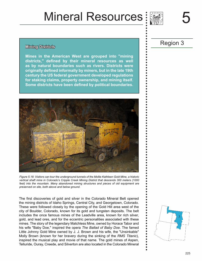
Figure 5.18: Visitors can tour the underground tunnels of the Mollie Kathleen Gold Mine, a historic vertical shaft mine in Colorado’s Cripple Creek Mining District that descends 300 meters (1000 feet) into the mountain. Many abandoned mining structures and pieces of old equipment are preserved on site, both above and below ground.
226
Mineral Resources
Region 3
5
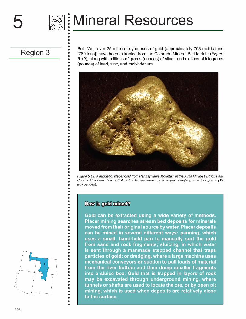
Figure 5.19: A nugget of placer gold from Pennsylvania Mountain in the Alma Mining District, Park County, Colorado. This is Colorado’s largest known gold nugget, weighing in at 373 grams (12 troy ounces).
How is gold mined?
Gold can be extracted using a wide variety of methods. Placer mining searches stream bed deposits for minerals moved from their original source by water. Placer deposits can be mined in several different ways: panning, which uses a small, hand-held pan to manually sort the gold from sand and rock fragments; sluicing, in which water is sent through a manmade stepped channel that traps particles of gold; or dredging, where a large machine uses mechanical conveyors or suction to pull loads of material from the river bottom and then dump smaller fragments into a sluice box. Gold that is trapped in layers of rock may be excavated through underground mining, where tunnels or shafts are used to locate the ore, or by open pit mining, which is used when deposits are relatively close to the surface.
Belt. Well over 25 million troy ounces of gold (approximately 708 metric tons [780 tons]) have been extracted from the Colorado Mineral Belt to date (Figure 5.19), along with millions of grams (ounces) of silver, and millions of kilograms (pounds) of lead, zinc, and molybdenum.
227
Region 3
5Mineral Resources
The Climax Mine north of Leadville, Colorado, and the Henderson Mine west of Empire, Colorado, in the northern part of the Rio Grande Rift, contain some of the largest molybdenum ore bodies on Earth. This ore was emplaced between 33 and 24 million years ago, during the Oligocene. The mines extract resources from molybdenum-quartz veins and molybdenum sulfide ore related to certain granites and rhyolite porphyry bodies. The Climax Mine supplied 75% of the world's molybdenum for many years during its period of highest output, and today its ore reserves are estimated at about 227 million kilograms (500 million pounds).
The Colorado Mineral Belt is not the only area of the Rocky Mountains to have hosted large ore mines. Park City, Utah was a site of a major silver rush in the 1860s thanks to the finding of silver, gold, and lead; the town flourished for nearly one hundred years before silver prices dropped in the late 1950s. Park City Mountain and the neighboring Deer Valley are major ski resorts today, but beneath those slopes lie more than 1600 kilometers (1000 miles) of old silver mine workings and tunnels.
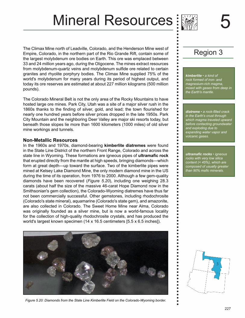
Non-Metallic ResourcesIn the 1960s and 1970s, diamond-bearing kimberlite diatremes were found in the State Line District of the northern Front Range, Colorado and across the state line in Wyoming. These formations are igneous pipes of ultramafic rock that erupted directly from the mantle at high speeds, bringing diamonds—which form at great depth—up toward the surface. Two of the kimberlite pipes were mined at Kelsey Lake Diamond Mine, the only modern diamond mine in the US during the time of its operation, from 1976 to 2000. Although a few gem-quality diamonds have been recovered (Figure 5.20), including one weighing 28.3 carats (about half the size of the massive 46-carat Hope Diamond now in the Smithsonian's gem collection), the Colorado-Wyoming diatremes have thus far not been commercially successful. Other gemstones, including rhodochrosite (Colorado's state mineral), aquamarine (Colorado's state gem), and amazonite, are also collected in Colorado. The Sweet Home Mine near Alma, Colorado was originally founded as a silver mine, but is now a world-famous locality for the collection of high-quality rhodochrosite crystals, and has produced the world's largest known specimen (14 x 16.5 centimeters [5.5 x 6.5 inches]).
Figure 5.20: Diamonds from the State Line Kimberlite Field on the Colorado-Wyoming border.
kimberlite • a kind of rock formed of iron- and magnesium-rich magma, mixed with gases from deep in the Earth's mantle.
diatreme • a rock-filled crack in the Earth's crust through which magma traveled upward before contacting groundwater and exploding due to expanding water vapor and volcanic gases.
ultramafic rocks • igneous rocks with very low silica content (< 45%), which are composed of usually greater than 90% mafic minerals.

228
Mineral Resources
Region 3
5
Figure 5.21: A close-up of a pumice stone, revealing its highly porous and vesicular texture. These gas bubbles make the rock so lightweight that it is able to float. Field of view is 2.7 centimeters (1 inch) across.
glacier • a body of dense ice on land that does not melt away annually and has sufficient mass to move under its own weight.
alluvial • a layer of river-deposited sediment.
asphalt • a black, sticky, semi-solid and viscous form of petroleum.
Mississippian • a subperiod of the Carboniferous, spanning from 359 to 323 million years ago.
contact metamorphism •the process by which a metamorphic rock is formed through direct contact with magma.
Industrial stone and construction materials are mined throughout the Rocky Mountains. Crushed granite, quartzite, and rhyolite, along with rounded gravel from rivers, are quarried for landscaping, paving base material, and drainage applications. Sand and gravel aggregate is collected from glacial and alluvial deposits throughout the Rocky Mountains, and is used as ice control for highways, for filtration purposes, and to aid in the manufacture of concrete, asphalt, and other construction projects. The region is also home to the white Yule Marble, used to construct the Lincoln Memorial in Washington DC and the Tomb of the Unknown Soldier at Arlington National Cemetery. The primary quarry for this stone is located at Marble, Colorado, where Mississippian lime-stones underwent contact metamorphism from the heat of an adjacent Cenozoic igneous intrusion.
Volcanic materials contribute to an important mining industry in north-central New Mexico. Perlite, a rapidly cooled volcanic glass with high silica content, is used in horticulture, water filters, lime, and cement, as well as in construction-related materials such as ceiling tiles and insulation boards. New Mexico produces the most perlite of any US state, and it is quarried in the No Agua Peaks of Taos County as well as a few other locations with more moderate yields. In addition, pumice and volcanic cinders are quarried in the Rocky Mountains of New Mexico. These deposits are notable for having a lower density and higher porosity than most other rocks (Figure 5.21); this makes them commercially valuable for use as a lightweight yet strong construction material. Pumice can also be used as lightweight aggregate, insulators, absorbents, and abrasives. Pumice and cinders are quarried in Rio Arriba County, New Mexico; farther south in Sandova County, pumice is also quarried commercially.
See Chapter 2: Rocks for more information about the Yule Marble.

229
Region 4
5Mineral Resources
lime • an inorganic white or grayish-white compound made by roasting limestone (calcium carbonate, CaCO3) until all the carbon dioxide (CO2) is driven off.
Mineral Resources of the Great PlainsRegion 4
The eastern margin of the Southwest encompasses the Great Plains, a rolling, grassy expanse that slopes eastward to the mid-continent. The Plains are interrupted only by glacial and windblown deposits, river and stream valleys, and other recent erosional features. Beneath a surface cover of Quaternary and Neogene sediments lies a series of sedimentary and structural basins. Some of these basins were formed during the Laramide Orogeny, and others during tectonic events of the Paleozoic and Mesozoic. These basin deposits are important sources of minerals such as potash, but major metallic mineral deposits are unknown in this region (Figure 5.22).
Figure 5.22: Principal mineral resources of the Great Plains region.
Quaternary • a geologic time period that extends from 2.6 million years ago to the present.
Neogene • the geologic time period extending from 23 to 2.6 million years ago.
Paleozoic • a geologic time interval that extends from 541 to 252 million years ago.
Mesozoic • a geologic time period that spans from 252 to 66 million years ago.
230
Mineral Resources
Region 4
5
Permian • the geologic time period lasting from 299 to 252 million years ago.
The Great Plains region contains substantial energy resources, including coal, uranium, abundant oil and gas, and coalbed methane. The region's widespread fossil fuel resources have led to the recovery of several associated elements that are often found alongside gas and oil. Sulfur is extracted from natural gas fields in the Permian Basin (New Mexico's southeastern corner), and from oil fields in the Denver Basin (Adams County, Colorado). Sizeable helium reserves, also associated with the Denver Basin, have been tapped in Cheyenne County, Colorado.
Mountain streams transported and deposited large volumes of eroded sediment onto the plains, resulting in a thick blanket of sand, gravel, silt, and clay on top of eroded Mesozoic and Permian strata throughout the region. The sands and gravels here are rich in quartz and feldspar from the weathering and erosion of igneous and metamorphic rocks in the Rocky Mountains to the west. Sand, gravel, limestone, dimension stone, and other construction materials are mined throughout the Great Plains. Refractory clay is found in great abundance along the border of the Rocky Mountains in central Colorado, where it is collected for use in the manufacture of brick and ceramics.
Thanks to the Permian Basin's history as part of an ancient inland ocean, it contains some of the world's largest potash deposits, which formed as the seawater evaporated and its potassium salts crystallized. Potash is mined in the vicinity of Carlsbad, New Mexico, and the world's purest mined potash deposit is found in Lea County.

231
Resources
Books and Articles on Mineral ResourcesFrank D., J. Galloway, & K. Assmus, 2005, The life cycle of a mineral deposit – a teacher's
guide for hands-on mineral education activities, US Geological Survey General Information Product 17, 40 pp.
Johnsen, O., 2002, Minerals of the World, Princeton University Press, Princeton, NJ, 439 pp. Long, K.R., B.S. Van Gosen, N.K. Foley, & D. Cordier, 2010, The principal rare earth elements
deposits of the United States: a summary of domestic deposits and a global perspective, US Geological Survey Scientific Investigations Report 2010–5220, 96 pp.,
http://pubs.usgs.gov/sir/2010/5220/pdf/SIR2010-5220.pdf.Skinner, B. J., 1989, Mineral resources of North America, in A.W. Bally & A.R. Palmer, eds.,
The Geology of North America: An Overview, vol. A, The Geological Society of America: Boulder, CO, pp. 575-584.
Stevens, R., 2010, Mineral Exploration and Mining Essentials, Pakawau GeoManagement, Port Coquitlam, BC, 322 pp.
Wark, J., 2012, The World of Mining, CRC Press/Balkema, Boca Raton, FL, 250 pp. [Coffee-table book]
Websites on Mineral Resources [Copper] Education, Copper Development Association, https://www.copper.org/education/.Handbook of Mineralogy. [Technical information on 420 minerals available as free individual
pdfs.] http://www.handbookofmineralogy.org. Mineral Data, Hudson Institute of Mineralogy. [Claims to be the world's largest public database
of mineral information.] http://www.mindat.org. Mineral Gallery, Amethyst Galleries, http://www.galleries.com/.Mineralogy Database, http://webmineral.com.Mineralpedia—A Mineral Photo Database and Identification Guide, by T. Loomis & V. Loomis,
Dakota Matrix Minerals, http://www.dakotamatrix.com.Mining History Association, http://www.mininghistoryassociation.org/links.htm#museums.Mining Museums and Tours, National Mining Association, http://www.nma.org/index.php/mining-resources/mining-museums-and-tours.The New International Mineralogical Association List of Minerals—A Work in Progress, updated
July 2016, http://nrmima.nrm.se//IMA_Master_List_%282016-07%29.pdf.Some Definitions of Common Terms Used in Describing Mineral Deposits, Earth Science
Australia, http://earthsci.org/mineral/mindep/depfile/ore_def.htm.The Gem Hunter, W.D. Hausel, http://gemhunter.webs.com.US Geological Survey. [A wide range of data on mineral distribution and mining.] http://minerals.usgs.gov/.
Books and Articles on Mineral Resources of Specific Areas of the Southwest
Books and ArticlesAnthony, J., 1995, Mineralogy of Arizona, 3rd edition, University of Arizona Press, Tucson, AZ,
508 pp.Arizona Bureau of Mines, 2016, The Mineral Industries of Arizona: a Brief History of the
Development of Arizona's Mineral Resources, CreateSpace Independent Publishing Platform, North Charleston, SC, 48 pp.
Resources
5Mineral Resources
For mineral field guides, see the Resources section in Chapter 2: Rocks.
232
Mineral Resources
Resources
5Huggard, C. & T. Humble, 2012, Santa Rita del Cobre: a Copper Mining Community in New
Mexico, Mining the American West, University Press of Colorado, Boulder, CO, 272 pp..Lundwall, H. & T. Humble, 2012, Copper Mining in Santa Rita, New Mexico, 1801–1838,
Sunstone Press, Santa Fe, NM, 160 pp.Northrop, S. & F. LaBruzza, 1996, Minerals of New Mexico, 3rd edition, University of New
Mexico Press, Albuquerque, 346 pp.Parry, W., 2004, All Veins, Lodes, and Ledges Throughout Their Entire Depth: Geology and the
Apex Law in Utah Mines, University of Utah Press, Salt Lake City, 152 pp. Price, L. G., D. Bland, V. T. McLemore, & J. M. Barker, 2005, Mining in New Mexico: the
Environment, Water, Economics and Sustainable Development, Decision-Makers Field Conference, New Mexico Bureau of Geology and Mineral Resources, Socorro, 168 pp.
Teacher Resource Packet, by Dave Futey, The Western Museum of Mining and Industry, Colorado Springs, CO, 21 pp., http://www.wmmi.org/_literature_44248/Teacher_Packet.
Voynick, S., 2002, Colorado Gold: From the Pike's Peak Rush to the Present, Mountain Press Publishing Company, Missoula, MT, 224 pp.
Whitley, C., 2006, From the Ground Up: the History of Mining in Utah, Utah State University Press, Logan, 508 pp.
Wilson, A. B. & P. K. Sims, The Colorado mineral belt revisited—an analysis of new data, US Geological Survey Open-File Report 03-046, 4 pp., 2 maps,
http://pubs.usgs.gov/of/2003/ofr-03-046/OFR-03-046-508.pdf.
WebsitesFrom Ore to More: a Six-Minute Video on the Story of Copper from Start to Finish, Kennecott
Mine, http://www.kennecott.com/content/educator-resources.Mineral Resources/Mining in Arizona, The Arizona Geological Survey, http://www.azgs.az.gov/minerals_mining.shtml.Mineral Resources [of Colorado], Colorado Geological Survey, http://coloradogeologicalsurvey.org/mineral-resources/.Rio Tinto Kennecott Tour, Virtual Tour, Kennecott Mine, http://www.kennecott.com/virtual-tour.
For additional resources on rocks and minerals, see Chapter 2: Rocks.

i
The
Teacher-Friendly GuideTM
to the Earth Science of the
Southwestern US
Edited by Andrielle N. Swaby, Mark D. Lucas, & Robert M. Ross
Paleontological Research Institution2016
ii
ISBN 978-0-87710-514-5Library of Congress no. 2016952807PRI Special Publication no. 50
© 2016 Paleontological Research Institution 1259 Trumansburg Road Ithaca, New York 14850 USA priweb.org
First printing September 2016
This material is based upon work supported by the National Science Foundation under grant DRL-0733303. Any opinions, findings, and conclusions or recommendations are those of the author(s) and do not necessarily reflect the views of the National Science Foundation. The publication also draws from work funded by the Arthur Vining Davis Foundations and The Atlantic Philanthropies.
The interactive online version of this Teacher-FriendlyGuide™ (including downloadable pdfs) can be found at http://teacherfriendlyguide.org. Web version by Brian Gollands.
Any part of this work may be copied for personal or classroom use (not for resale). Content of this Teacher-FriendlyGuide™ and its interactive online version are available for classroom use without prior permission.
TheTeacher-FriendlyGuide™ series was originally conceived by Robert M. Ross and Warren D. Allmon.Original illustrations in this volume are mostly by Jim Houghton (The Graphic Touch, Ithaca), Wade Greenberg-Brand, Christi A. Sobel, and Andrielle Swaby.
Layout and design by Paula M. Mikkelsen, Andrielle Swaby, Elizabeth Stricker, Wade Greenberg-Brand, and Katherine Peck.
TheTeacher-FriendlyGuide™ is a trademark of the Paleontological Research Institution.
Cite this book as:Swaby, A. N., M. D. Lucas, & R. M. Ross (eds.), 2016, TheTeacher-FriendlyGuidetotheEarthScienceoftheSouthwesternUS. Paleontological Research Institution (Special Publication 50), Ithaca, New York, 458 pp.
Cite one chapter as (example):Allmon, W. D., and R. A. Kissel, 2016, Fossils of the Southwestern US. Pages 89–157, in: A. N. Swaby, M. D. Lucas, & R. M. Ross (eds.). TheTeacher-FriendlyGuidetotheEarthScienceoftheSouthwesternUS.Paleontological Research Institution (Special Publication 50), Ithaca, New York.
On the back cover: Blended geologic and digital elevation map of the Southwestern US. Each color represents the age of the bedrock at the surface. Adapted from Barton, K.E., Howell, D.G., Vigil, J.F., TheNorthAmericaTapestryofTimeandTerrain, US Geological Survey Geologic Investigations Series I-2781, http://pubs.usgs.gov/imap/i2781.