Embed Size (px)
Citation preview
KARUMA HPP (600 MW)_______________________________________________________
SOCIO-ECONOMIC ENVIRONMENT_________________________________________ 6-1
EIPL
CHAPTER 6
SOCIO- ECONOMIC ENVIRONMENT
Karuma Hydro Power Project, proposed to be constructed nearly 1.5 km upstream of Karuma Bridge
across river Nile, falls in Kiryandongo and Oyam Districts of Uganda. Total land required for the
project is 465.52 ha out of which 192.75 ha of land is privately owned land which is required to be
acquired from locals residing in four villages i.e., Karuma and Awoo villages located in Mutunda
Subcounty of Kiryandongo district and Nora and Akuridia villages in Kamdini sub county of Oyam
district. As the land of private owner is required to be acquired, information on the socio-economic
status of the people living in the vicinity of the project especially in the four villages from where the
land will be acquired is necessary. Therefore, socio-economic survey was undertaken in the affected
villages using sample size of 149 households for entire population in four villages apart from a
comprehensive survey by the Chief Government Valuer of Uganda for developing Resettlement
Action Plan (RAP) for the Karuma HPP which is presented separately in volume IV of the present
report. Desk study was also taken and the literature that was reviewed included policy documents,
district development plans as well as other related literature. Findings of the socio-economic survey
and review is discussed and presented in this chapter.
6.1 DISTRICT PROFILE
6.1.1 Oyam District
Oyam district is a district in the Northern Region of Uganda. Like most Ugandan districts, it is
named after its 'chief town', Oyam, where the district headquarters are located. the District is
bordered by Gulu District to the north, Lira District to the northeast, Apac District to the east and
south, Kiryandongo District to the southwest and Nwoya District to the west. The administrative
headquarters of the district at Oyam, are located 73 km by road, west of Lira, the largest city in the
sub-region.
Oyam District with total land area of 2.207 sq km was established by the Ugandan Parliament in
2006. Prior to that, Oyam District was part of Apac District. Together with Lira District, Amolatar
District, Apac District and Dokolo District, Oyam District is part of the larger Langi sub-region,
home to an estimated 2.7 million Langi. The district is a predominantly rural district
6.1.2 Kiryandongo District
Kiryandongo district falls in western part of Uganda and is named after the town Kiryandongo
which is the main municipal, administrative, commercial center and headquarter of the district.
District is located on the main Gulu-Masindi Highway abs is bordered by Nwoya District to the
KARUMA HPP (600 MW)_______________________________________________________
SOCIO-ECONOMIC ENVIRONMENT_________________________________________ 6-2
EIPL
north, Oyam District to the northeast, Apac District to the east, and Masindi District to the south and
west. The District was established on 01 July 2010. Prior to that, it was part of Masindi District. The
district is part of Bunyoro sub-region, which is coterminous with Bunyoro Kingdom.
6.1.3 Demographic Profile of Districts
Oyam district had a population of 268,415 with the density of 99 persons per sq.km, of which
131,658 were males and 136,757were females in 2002. The population of Oyam is predominantly
rural with 95% percent living in rural areas and is facing high poverty level, high level of illiteracy
and low level of income. The population of Kiryandongo District according to the 2002 national
census was about 187,700 (Table 6.1).
Table 6.1: Total Population of districts Kiryandongo and Oyam
District Population of the district
Kiryandongo 187,700
Oyam 268,415
Source: 2002 Uganda Population and Housing Census
According to the 2002 population and housing census, average household size in Kiryandongo was
5 persons, while in Oyam it was 4.7 persons.
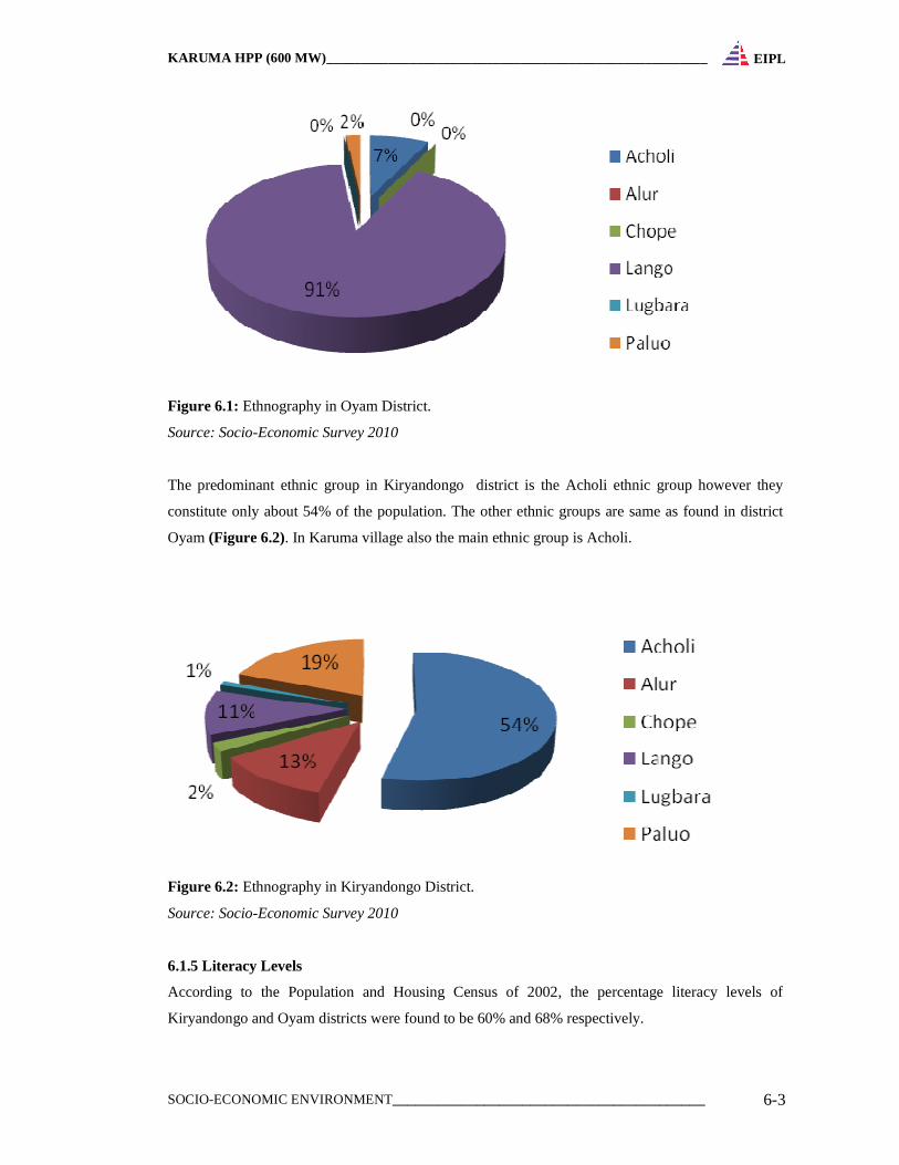
6.1.4 Ethnography
The predominant ethnic group in Oyam District as discussed above is the Langi ethnic group. The
origins of the Langi are somewhat obscure but it is believed that they originated from Abyssinia in
Ethiopia. They are considered to be part of the Nilo-Hamites (also known as semi-Hamitic) group
which includes the Teso, Kumam, Jie and Karamojong tribes. The Langi, in contrast of their fellows,
have adopted the simpler Nilotic tongue. It is believed that their move from further North into the
present habitat took place between the years 1800-1890 approximately. Apart from times of wars,
when some sort of cohesion was achieved under one or two war leaders, the Langi before the advent
of British Administration in 1889, were divided into many small groups or clans each with its own
leader, i.e. chieftainship. British Administration of the District dates back to year 1900.
Administration in the early days was in the hands of Buganda agents. Other ethnic groups present in
district are Acholi, Alur, Chope, Palwo and Lugbara (Figure 6.1).
KARUMA HPP (600 MW)_______________________________________________________
SOCIO-ECONOMIC ENVIRONMENT_________________________________________ 6-3
EIPL
Figure 6.1: Ethnography in Oyam District.
Source: Socio-Economic Survey 2010
The predominant ethnic group in Kiryandongo district is the Acholi ethnic group however they
constitute only about 54% of the population. The other ethnic groups are same as found in district
Oyam (Figure 6.2). In Karuma village also the main ethnic group is Acholi.
Figure 6.2: Ethnography in Kiryandongo District.
Source: Socio-Economic Survey 2010
6.1.5 Literacy Levels
According to the Population and Housing Census of 2002, the percentage literacy levels of
Kiryandongo and Oyam districts were found to be 60% and 68% respectively.
KARUMA HPP (600 MW)_______________________________________________________
SOCIO-ECONOMIC ENVIRONMENT_________________________________________ 6-4
EIPL
6.1.6 Birth rate and Mortality
At current mortality levels, one in every 13 Ugandan children dies before reaching age of one year,
while one in every seven does not survive to the fifth birthday. Mortality is consistently lower in
urban areas than in rural areas with rates of 68 and 88 deaths per 1,000 live births, respectively, for
infant mortality while 114 and 153 deaths per 1,000 live births for under-five mortality.
In Oyam district and Kiryandongo District Maternal mortality rate is still high at 500 and 402 deaths
respectively for every 100,000 birth as compared to the national target of 300. In Oyam district
infant mortality rate (per 1000 live birth) is 114 infants while under 5 mortality rate (per 1000 live
births) is 191 children.
6.1.7 Occupation
The economy of the area is predominantly agricultural with the majority of the population dependent
on subsistence farming and light agro-based industries. Hence most of people earn their livelihoods
in the agricultural sector in particular crop farming. Major crops grown in the two districts are
Cassava, Maize, G/nuts, Millet, Vegetables & Sun flower.
6.1.8 Gender Issues
In Kiryandongo district, gender issues continue to be of great concern at household level as well as
at institutional level. Across the sectors and institutions, gender gap has continued to exist and main
gaps between the girl child and women can be sighted in unequal participation in development
programmes, low levels of literacy, disparities in employment, high dropout rates, limited
ownership, access and control of resources especially land. This implies that women are exploited
and lag behind in development.
In Oyam district there is also poor participation of women in technology development and decision
making, limited share benefits accruing from the sale of crop products and unequal division of labor
in agricultural activities. Traditional culture amongst the farming communities in the district with
high illiteracy levels constraints women farmer’s ability to access and utilize advantage services;
women productivity is also severely constrained by the fragmentation of their time and
responsibilities and lack of access to essential inputs including knowledge.
6.1.9 Health Profile
KARUMA HPP (600 MW)_______________________________________________________
SOCIO-ECONOMIC ENVIRONMENT_________________________________________ 6-5
EIPL
According to the 2002 Population and Housing Census, 81.5% of dwelling units in Kiryandongo
and 94.9% in Oyam were found to be in temporary condition. This means that most households are
ranked as poor and vulnerable to health risks.
6.1.9.1 Health facilities
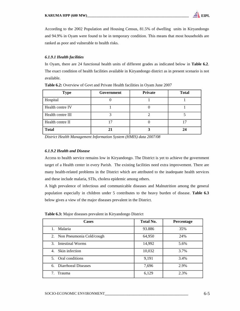
In Oyam, there are 24 functional health units of different grades as indicated below in Table 6.2.
The exact condition of health facilities available in Kiryandongo district as in present scenario is not
available.
Table 6.2: Overview of Govt and Private Health facilities in Oyam June 2007
Type Government Private Total
Hospital 0 1 1
Health centre IV 1 0 1
Health centre III 3 2 5
Health centre II 17 0 17
Total 21 3 24
District Health Management Information System (HMIS) data 2007/08
6.1.9.2 Health and Disease
Access to health service remains low in Kiryandongo. The District is yet to achieve the government
target of a Health center in every Parish. The existing facilities need extra improvement. There are
many health-related problems in the District which are attributed to the inadequate health services
and these include malaria, STIs, cholera epidemic among others.
A high prevalence of infectious and communicable diseases and Malnutrition among the general
population especially in children under 5 contributes to the heavy burden of disease. Table 6.3
below gives a view of the major diseases prevalent in the District.
Table 6.3: Major diseases prevalent in Kiryandongo District
Cases Total No. Percentage
1. Malaria 93.886 35%
2. Non Pneumonia Cold/cough 64,950 24%
3. Intestinal Worms 14,992 5.6%
4. Skin infection 10,032 3.7%
5. Oral conditions 9,191 3.4%
6. Diarrhoeal Diseases 7,696 2.9%
7. Trauma 6,129 2.3%
KARUMA HPP (600 MW)_______________________________________________________
SOCIO-ECONOMIC ENVIRONMENT_________________________________________ 6-6
EIPL
Cases Total No. Percentage
8. STIs 5,666 2.1%
9. Eye conditions 5,156 1.9%
10. Gastro Intestinal disorders 4,251 1.6%
Source: District HMIS data 2007/08
Apart from the heavy burden of preventable diseases, Oyam District is also simultaneously
experiencing marked upsurge in the occurrence of non-communicable disease e.g. mental illnesses
(trauma). Malaria remains the predominant disease in the District as shown in the Table 6.4.
Table 6.4: Burden of Diseases versus Health Expenditure in Oyam District
No. Diseases % of total life
yrs lost
Rank of burden
of diseases
(BOD)
% total
BOD
Rank
spending
1 Malaria 28.3 1 29.2 1
2 Malnutrition 17.3 2 14.2 10
3 Intestinal worm 14.9 3 14.1 4
4 Skin diseases 11.3 4 16.6 7
5 Diarrhoeal diseases 8.3 5 1.3 3
6 Pneumonia 5.6 6 2.4 6
7 STI/HIV/AIDS 5.1 7 5.1 2
8 Eye infection 2.9 8 1.9 9
9 Tuberculosis 2.8 9 1.2 5
10 Dental/ oral diseases 1.9 10 8.5 9
(HMIS June 2007, Report)
6.1.9.3 HIV/AIDS
Like any other districts in Uganda HIV/AIDS is a development challenge in the Kiryandongo and
Oyam District. It has evolved from a health burden to a serious development crisis with visible
social and economic effects on the entire community. Mainly it has affected the Youth aged
between 15-35 years. However the highly most affected population are the Youth aged between 15-
24 years. Socio-economic factors such as poverty, migrant labour, the low status of women
including over dependency on men, illiteracy, and lack of formal education, discrimination and
substance abuse especially alcoholism also have a big bearing to HIV infection.
6.1.9.4 Access to Safe Drinking Water
KARUMA HPP (600 MW)_______________________________________________________
SOCIO-ECONOMIC ENVIRONMENT_________________________________________ 6-7
EIPL
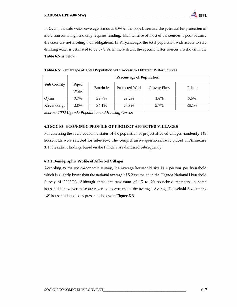
In Oyam, the safe water coverage stands at 59% of the population and the potential for protection of
more sources is high and only requires funding. Maintenance of most of the sources is poor because
the users are not meeting their obligations. In Kiryandongo, the total population with access to safe
drinking water is estimated to be 57.8 %. In more detail, the specific water sources are shown in the
Table 6.5 as below.
Table 6.5: Percentage of Total Population with Access to Different Water Sources
Sub County
Percentage of Population
Piped
Water Borehole Protected Well Gravity Flow Others
Oyam 0.7% 29.7% 23.2% 1.6% 0.5%
Kiryandongo 2.8% 34.1% 24.3% 2.7% 36.1%
Source: 2002 Uganda Population and Housing Census
6.2 SOCIO- ECONOMIC PROFILE OF PROJECT AFFECTED VIL LAGES
For assessing the socio-economic status of the population of project affected villages, randomly 149
households were selected for interview. The comprehensive questionnaire is placed as Annexure
3.1; the salient findings based on the full data are discussed subsequently.
6.2.1 Demographic Profile of Affected Villages
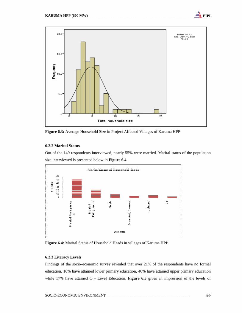
According to the socio-economic survey, the average household size is 4 persons per household
which is slightly lower than the national average of 5.2 estimated in the Uganda National Household
Survey of 2005/06. Although there are maximum of 15 to 20 household members in some
households however these are regarded as extreme to the average. Average Household Size among
149 household studied is presented below in Figure 6.3.
KARUMA HPP (600 MW)_______________________________________________________
SOCIO-ECONOMIC ENVIRONMENT_________________________________________ 6-8
EIPL
Figure 6.3: Average Household Size in Project Affected Villages of Karuma HPP
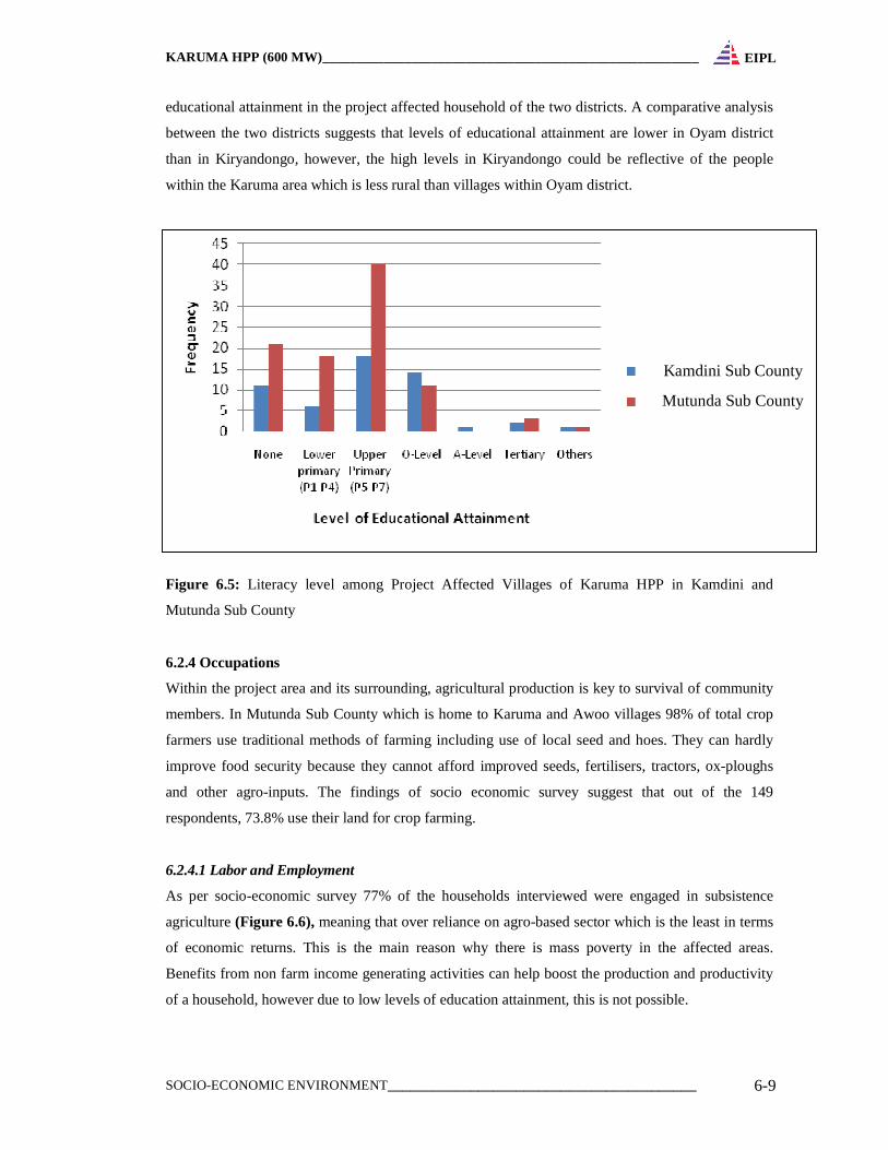
6.2.2 Marital Status
Out of the 149 respondents interviewed, nearly 55% were married. Marital status of the population
size interviewed is presented below in Figure 6.4.
Figure 6.4: Marital Status of Household Heads in villages of Karuma HPP
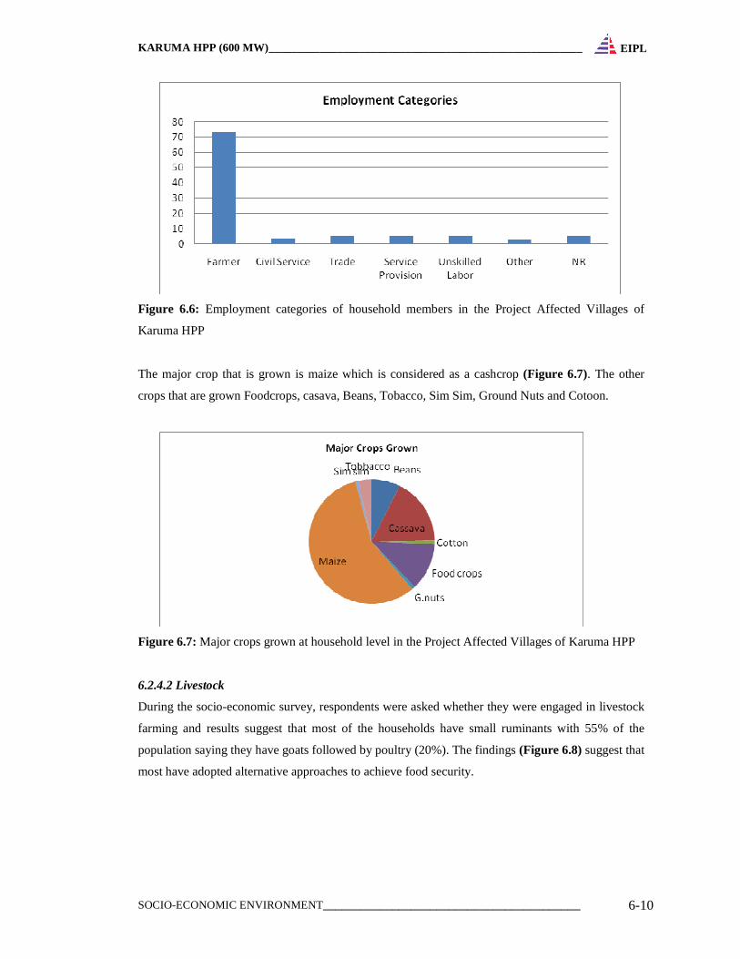
6.2.3 Literacy Levels
Findings of the socio-economic survey revealed that over 21% of the respondents have no formal
education, 16% have attained lower primary education, 40% have attained upper primary education
while 17% have attained O - Level Education. Figure 6.5 gives an impression of the levels of
KARUMA HPP (600 MW)_______________________________________________________
SOCIO-ECONOMIC ENVIRONMENT_________________________________________ 6-9
EIPL
educational attainment in the project affected household of the two districts. A comparative analysis
between the two districts suggests that levels of educational attainment are lower in Oyam district
than in Kiryandongo, however, the high levels in Kiryandongo could be reflective of the people
within the Karuma area which is less rural than villages within Oyam district.
Figure 6.5: Literacy level among Project Affected Villages of Karuma HPP in Kamdini and
Mutunda Sub County
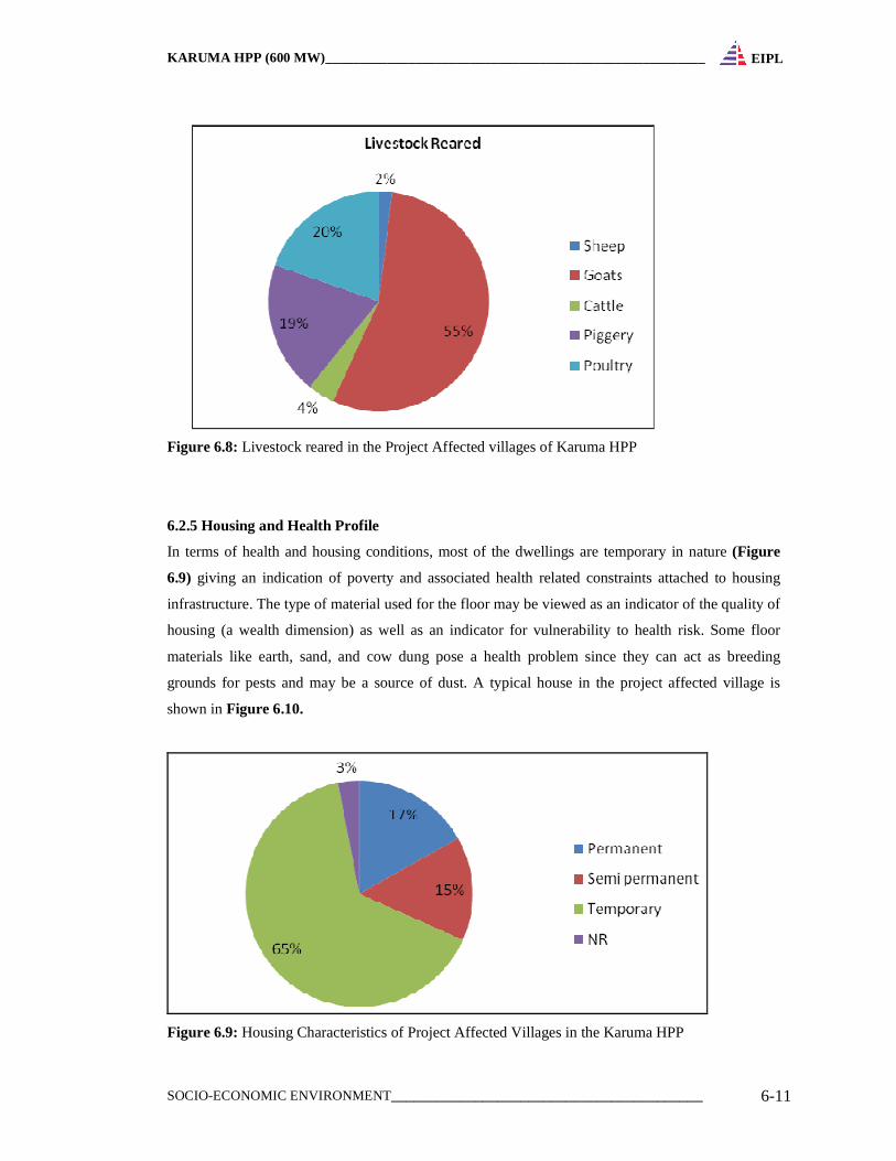
6.2.4 Occupations
Within the project area and its surrounding, agricultural production is key to survival of community
members. In Mutunda Sub County which is home to Karuma and Awoo villages 98% of total crop
farmers use traditional methods of farming including use of local seed and hoes. They can hardly
improve food security because they cannot afford improved seeds, fertilisers, tractors, ox-ploughs
and other agro-inputs. The findings of socio economic survey suggest that out of the 149
respondents, 73.8% use their land for crop farming.
6.2.4.1 Labor and Employment
As per socio-economic survey 77% of the households interviewed were engaged in subsistence
agriculture (Figure 6.6), meaning that over reliance on agro-based sector which is the least in terms
of economic returns. This is the main reason why there is mass poverty in the affected areas.
Benefits from non farm income generating activities can help boost the production and productivity
of a household, however due to low levels of education attainment, this is not possible.
Kamdini Sub County
Mutunda Sub County
KARUMA HPP (600 MW)_______________________________________________________
SOCIO-ECONOMIC ENVIRONMENT_________________________________________ 6-10
EIPL
Figure 6.6: Employment categories of household members in the Project Affected Villages of
Karuma HPP
The major crop that is grown is maize which is considered as a cashcrop (Figure 6.7). The other
crops that are grown Foodcrops, casava, Beans, Tobacco, Sim Sim, Ground Nuts and Cotoon.
Figure 6.7: Major crops grown at household level in the Project Affected Villages of Karuma HPP
6.2.4.2 Livestock
During the socio-economic survey, respondents were asked whether they were engaged in livestock
farming and results suggest that most of the households have small ruminants with 55% of the
population saying they have goats followed by poultry (20%). The findings (Figure 6.8) suggest that
most have adopted alternative approaches to achieve food security.
KARUMA HPP (600 MW)_______________________________________________________
SOCIO-ECONOMIC ENVIRONMENT_________________________________________ 6-11
EIPL
Figure 6.8: Livestock reared in the Project Affected villages of Karuma HPP
6.2.5 Housing and Health Profile
In terms of health and housing conditions, most of the dwellings are temporary in nature (Figure
6.9) giving an indication of poverty and associated health related constraints attached to housing
infrastructure. The type of material used for the floor may be viewed as an indicator of the quality of
housing (a wealth dimension) as well as an indicator for vulnerability to health risk. Some floor
materials like earth, sand, and cow dung pose a health problem since they can act as breeding
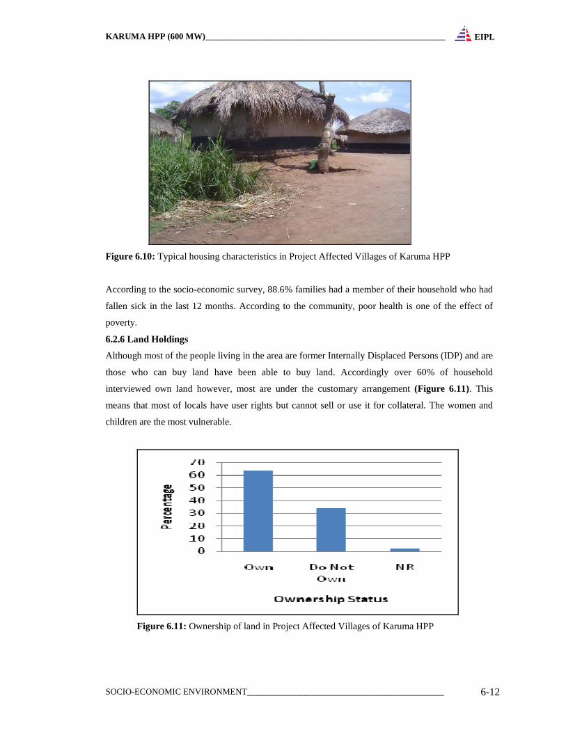
grounds for pests and may be a source of dust. A typical house in the project affected village is
shown in Figure 6.10.
Figure 6.9: Housing Characteristics of Project Affected Villages in the Karuma HPP
KARUMA HPP (600 MW)_______________________________________________________
SOCIO-ECONOMIC ENVIRONMENT_________________________________________ 6-12
EIPL
Figure 6.10: Typical housing characteristics in Project Affected Villages of Karuma HPP
According to the socio-economic survey, 88.6% families had a member of their household who had
fallen sick in the last 12 months. According to the community, poor health is one of the effect of
poverty.
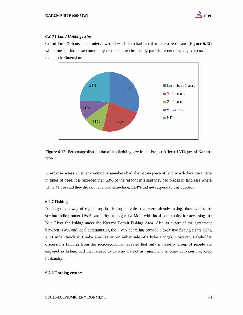
6.2.6 Land Holdings
Although most of the people living in the area are former Internally Displaced Persons (IDP) and are
those who can buy land have been able to buy land. Accordingly over 60% of household
interviewed own land however, most are under the customary arrangement (Figure 6.11). This
means that most of locals have user rights but cannot sell or use it for collateral. The women and
children are the most vulnerable.
Figure 6.11: Ownership of land in Project Affected Villages of Karuma HPP
KARUMA HPP (600 MW)_______________________________________________________
SOCIO-ECONOMIC ENVIRONMENT_________________________________________ 6-13
EIPL
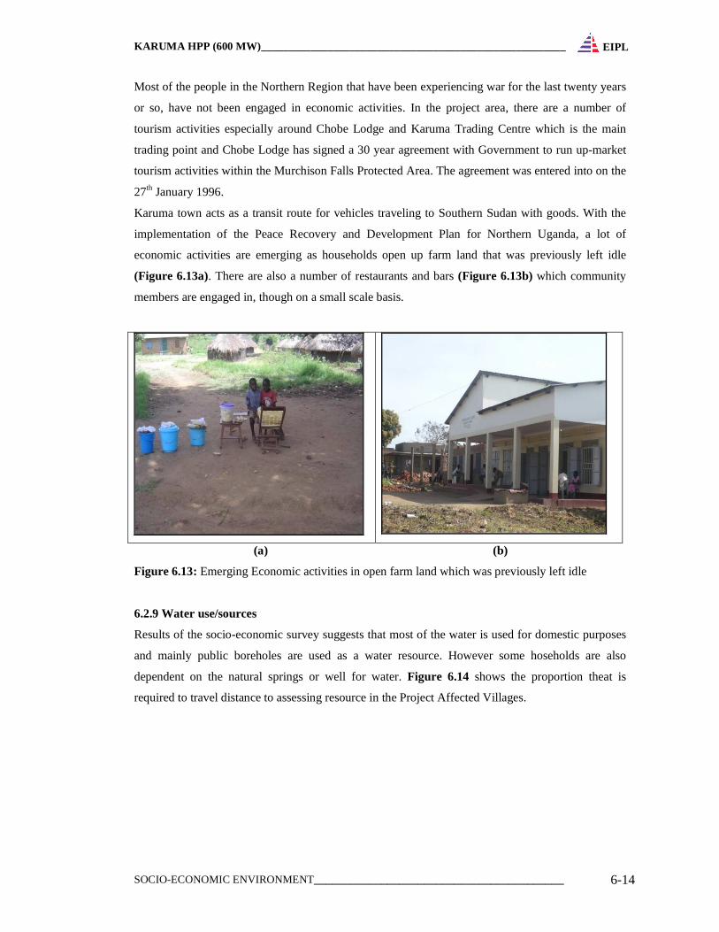
6.2.6.1 Land Holdings Size
Out of the 149 households interviewed 31% of them had less than one acre of land (Figure 6.12)
which means that these community members are chronically poor in terms of space, temporal and
magnitude dimensions.
Figure 6.12: Percentage distribution of landholding size in the Project Affected Villages of Karuma
HPP
In order to assess whether community members had alternative piece of land which they can utilize
in times of need, it is recorded that 53% of the respondents said they had pieces of land else where
while 41.6% said they did not have land elsewhere, 11.4% did not respond to this question.
6.2.7 Fishing
Although as a way of regulating the fishing activities that were already taking place within the
section falling under UWA, authority has signed a MoU with local community for accessing the
Nile River for fishing under the Karuma Permit Fishing Area. Also as a part of the agreement
between UWA and local communities, the UWA board has provide a exclusive fishing rights along
a 14 mile stretch in Chobe area (seven on either side of Chobe Lodge). However, stakeholder
discussions findings from the socio-economic revealed that only a minority group of people are
engaged in fishing and that returns to income are not as significant as other activities like crop
husbandry.
6.2.8 Trading centres
KARUMA HPP (600 MW)_______________________________________________________
SOCIO-ECONOMIC ENVIRONMENT_________________________________________ 6-14
EIPL
Most of the people in the Northern Region that have been experiencing war for the last twenty years
or so, have not been engaged in economic activities. In the project area, there are a number of
tourism activities especially around Chobe Lodge and Karuma Trading Centre which is the main
trading point and Chobe Lodge has signed a 30 year agreement with Government to run up-market
tourism activities within the Murchison Falls Protected Area. The agreement was entered into on the
27th January 1996.
Karuma town acts as a transit route for vehicles traveling to Southern Sudan with goods. With the
implementation of the Peace Recovery and Development Plan for Northern Uganda, a lot of
economic activities are emerging as households open up farm land that was previously left idle
(Figure 6.13a). There are also a number of restaurants and bars (Figure 6.13b) which community
members are engaged in, though on a small scale basis.
(a) (b)
Figure 6.13: Emerging Economic activities in open farm land which was previously left idle
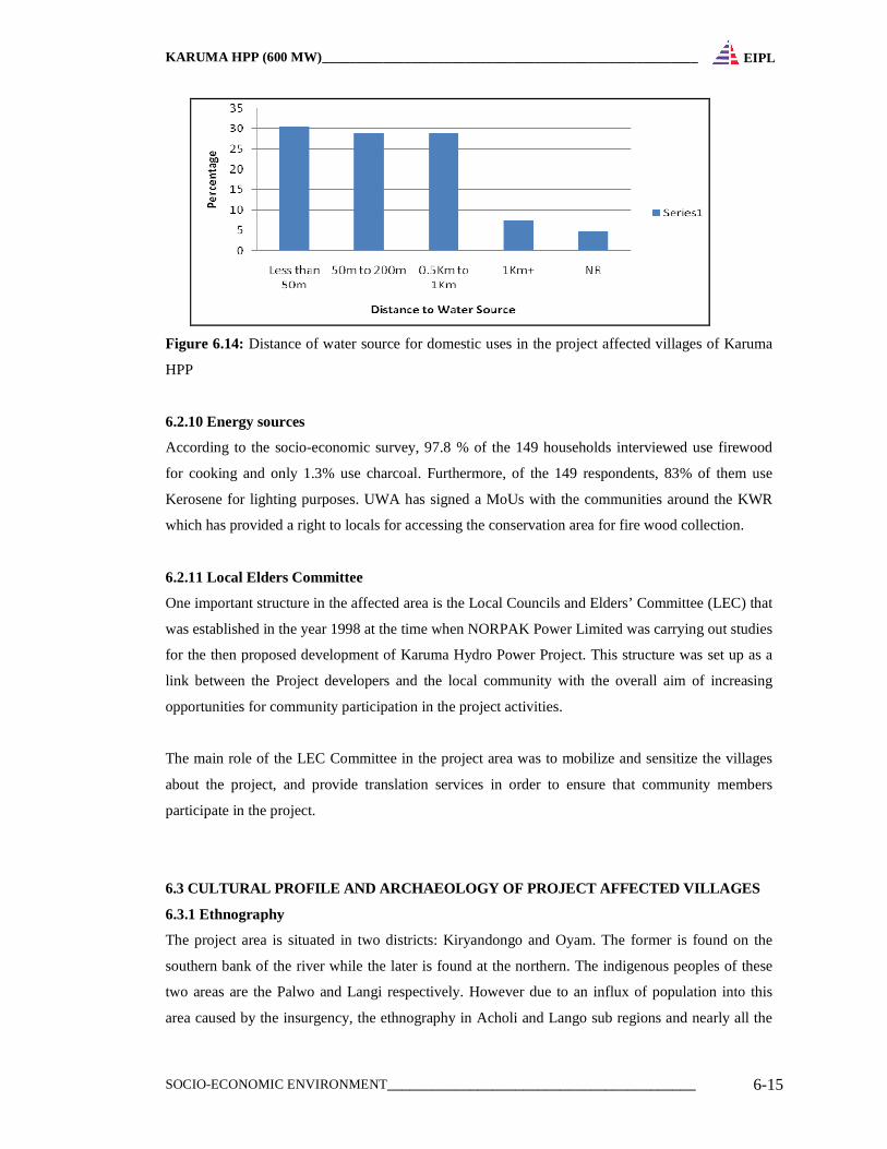
6.2.9 Water use/sources
Results of the socio-economic survey suggests that most of the water is used for domestic purposes
and mainly public boreholes are used as a water resource. However some hoseholds are also
dependent on the natural springs or well for water. Figure 6.14 shows the proportion theat is
required to travel distance to assessing resource in the Project Affected Villages.
KARUMA HPP (600 MW)_______________________________________________________
SOCIO-ECONOMIC ENVIRONMENT_________________________________________ 6-15
EIPL
Figure 6.14: Distance of water source for domestic uses in the project affected villages of Karuma
HPP
6.2.10 Energy sources
According to the socio-economic survey, 97.8 % of the 149 households interviewed use firewood
for cooking and only 1.3% use charcoal. Furthermore, of the 149 respondents, 83% of them use
Kerosene for lighting purposes. UWA has signed a MoUs with the communities around the KWR
which has provided a right to locals for accessing the conservation area for fire wood collection.
6.2.11 Local Elders Committee
One important structure in the affected area is the Local Councils and Elders’ Committee (LEC) that
was established in the year 1998 at the time when NORPAK Power Limited was carrying out studies
for the then proposed development of Karuma Hydro Power Project. This structure was set up as a
link between the Project developers and the local community with the overall aim of increasing
opportunities for community participation in the project activities.
The main role of the LEC Committee in the project area was to mobilize and sensitize the villages
about the project, and provide translation services in order to ensure that community members
participate in the project.
6.3 CULTURAL PROFILE AND ARCHAEOLOGY OF PROJECT AFF ECTED VILLAGES
6.3.1 Ethnography
The project area is situated in two districts: Kiryandongo and Oyam. The former is found on the
southern bank of the river while the later is found at the northern. The indigenous peoples of these
two areas are the Palwo and Langi respectively. However due to an influx of population into this
area caused by the insurgency, the ethnography in Acholi and Lango sub regions and nearly all the
KARUMA HPP (600 MW)_______________________________________________________
SOCIO-ECONOMIC ENVIRONMENT_________________________________________ 6-16
EIPL
major tribes at Uganda are found here now of all the tribes residing in the area there is a higher
proportion of a person from the Acholi ethnic group.
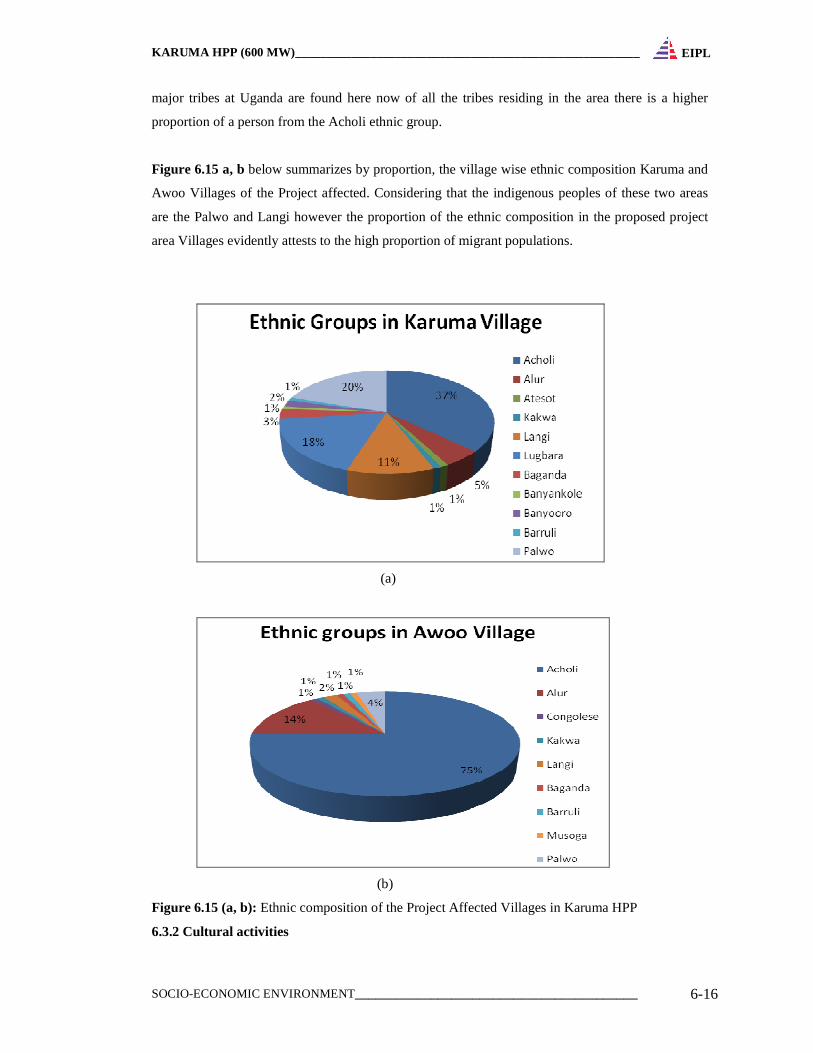
Figure 6.15 a, b below summarizes by proportion, the village wise ethnic composition Karuma and
Awoo Villages of the Project affected. Considering that the indigenous peoples of these two areas
are the Palwo and Langi however the proportion of the ethnic composition in the proposed project
area Villages evidently attests to the high proportion of migrant populations.
(a)
(b)
Figure 6.15 (a, b): Ethnic composition of the Project Affected Villages in Karuma HPP
6.3.2 Cultural activities
KARUMA HPP (600 MW)_______________________________________________________
SOCIO-ECONOMIC ENVIRONMENT_________________________________________ 6-17
EIPL
Traditionally, the Palwo tribesmen who settled in this area were proud hunters and cerebrated
fishermen. Hunting and fishing was a major source of livelihood. They practiced hunting as an art,
made remarkable animal snaring tools and techniques only peculiar to them aided by divine spiritual
intervention. They also practiced farming and hand craft activities to a lesser extent. However, the
traditional activity of hunting has since dwindled, if not completely faded, following government
policy that outlawed poaching around the wildlife reserve. There is also some commerce done at
Karuma trading center near the road before the bridge and persons around the area have also
resorted to cultivation has mainly growing cassava, maize beans and vegetables for their
subsistence.
The communities at the northern bank traditionally practice some cultivation, fishing and pottery
along the river bank. On the spiritual cultural front, they had traditional practices that included
purification rituals known as Kayo Chogo, and Lamo two.
6.3.3 Cultural values and sites
The cultural heritage in the project area is predominantly that of the Luo ethnic people. The Palwo is
a cluster of the Luo ethnicity and is the tribe that settled in the area around 1856 when the Luo
ancestors conquered the Chwezi and settled in the area. The Palwo have three outstanding clans
(kaka) that is, Pa wi, Awora, Pajab. The three major clans are further subdivided into over 49 other
clans.
Traditionally the Palwo were spiritual people and had a great attachment to the river, most
communities that settled along the river had particular spots at the river bank that were sacred sites
where certain rituals were carried out. The river was and still is so important to the locals since it
was the prime source of water for domestic use and fish to supplement their food diet. The cultural
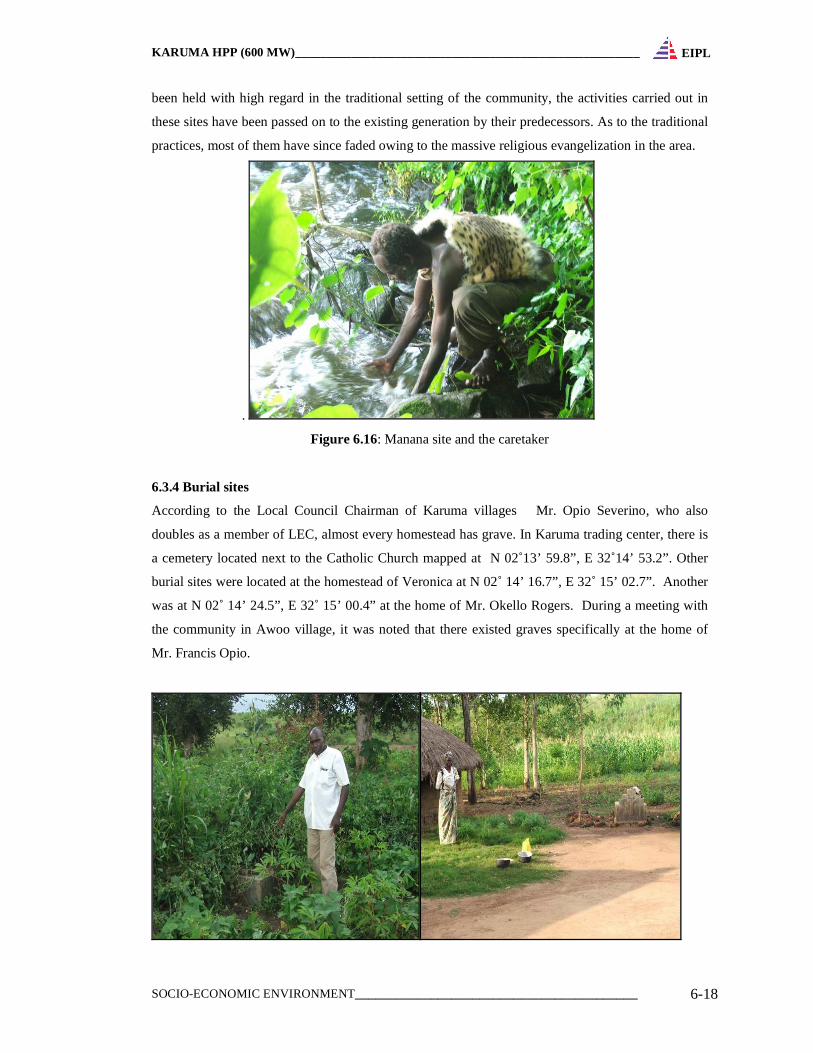
rituals included ousting evil spirits, thanks giving and attainment of blessings.
In the past all the clan had shrines referred to as Abila. However spiritual spots along the river is the
Manana shrine mapped at elevation of 3505 ft, N 02˚ 14’ 69.8”; E 32˚ 15’11.2” The site is
characterized by natural features of trees and rocks by the river bank, used by the Manana clan for
rain making, spiritual healing and other ritual activities. The other is Pajira located at elevation
3364ft, N 02˚ 15’ 19.6”, E 32˚ 15’ 61.7”. Then there is another site at the Musurubene at elevation
of 3352ft, N 02˚ 15’ 15.8” E 32˚ 15’ 61.3”. There is also a site south of the Musurebene known as
the Pataka site. At Awoo village Obel Quirino a traditional practioner testified that the Acholi have
cultural attachment to rivers and have own shrines in their homes where they conduct their rituals.
On the northern bank in the village of Nora, cultural valued sites were identified to be around the
river banks. One of the sites was identified by an elder Mr. Mzee. The other valued spot of cultural
significance in the northern bank is known as Buru Lobo. This is a clay mining spot which is
evidence of the traditional activity of pottery. These cultural sites bare a historical potent and have
KARUMA HPP (600 MW)_______________________________________________________
SOCIO-ECONOMIC ENVIRONMENT_________________________________________ 6-18
EIPL
been held with high regard in the traditional setting of the community, the activities carried out in
these sites have been passed on to the existing generation by their predecessors. As to the traditional
practices, most of them have since faded owing to the massive religious evangelization in the area.
.
Figure 6.16: Manana site and the caretaker
6.3.4 Burial sites
According to the Local Council Chairman of Karuma villages Mr. Opio Severino, who also
doubles as a member of LEC, almost every homestead has grave. In Karuma trading center, there is
a cemetery located next to the Catholic Church mapped at N 02˚13’ 59.8”, E 32˚14’ 53.2”. Other
burial sites were located at the homestead of Veronica at N 02˚ 14’ 16.7”, E 32˚ 15’ 02.7”. Another
was at N 02˚ 14’ 24.5”, E 32˚ 15’ 00.4” at the home of Mr. Okello Rogers. During a meeting with
the community in Awoo village, it was noted that there existed graves specifically at the home of
Mr. Francis Opio.
KARUMA HPP (600 MW)_______________________________________________________
SOCIO-ECONOMIC ENVIRONMENT_________________________________________ 6-19
EIPL
Figure 6.17: Burial point at N:02˚14’14.7”, E:32˚15’00.2”, next is Veronica at N 02˚ 14’ 16.7”, E
32˚ 15’ 02.7”
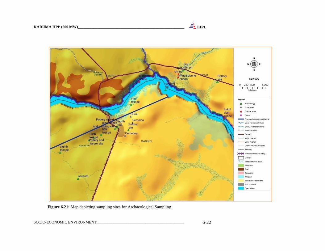
6.3.5 Archaeology of the Project area
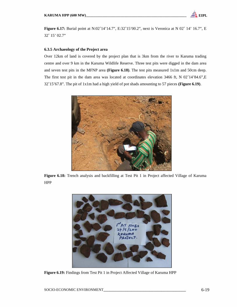
Over 12km of land is covered by the project plan that is 3km from the river to Karuma trading
centre and over 9 km in the Karuma Wildlife Reserve. Three test pits were digged in the dam area
and seven test pits in the MFNP area (Figure 6.18). The test pits measured 1x1m and 50cm deep.
The first test pit in the dam area was located at coordinates elevation 3466 ft, N 02˚14’84.6”,E
32˚15’67.8”. The pit of 1x1m had a high yield of pot shads amounting to 57 pieces (Figure 6.19).
Figure 6.18: Trench analysis and backfilling at Test Pit 1 in Project affected Village of Karuma
HPP
Figure 6.19: Findings from Test Pit 1 in Project Affected Village of Karuma HPP
KARUMA HPP (600 MW)_______________________________________________________
SOCIO-ECONOMIC ENVIRONMENT_________________________________________ 6-20
EIPL
The second pit was located at elevation 3527ft, N 02˚ 14’59.6” and E 32˚ 15’45.1”. This pit had a
low yield of pot shad but plenty of gravel and small pebbles (stones). The third test pit was at
elevation 3439 ft, N 02˚ 14’40.3”, E 32˚15’00.7”. This pit was not productive in terms of
archaeological finds as it had neither shads nor worked stones but soils. The fourth test was dug very
close to the road in the KWR at elevation of 1047m, N 02˚14’11.3”, E 32˚14’43.4”. The pit was
characterized by dark humid soil at the top and reddish clay at the lower part of the pit. Apart from
recent materials like plastic pages and bottle tops we recovered a few roulette shads at the upper
context was covered.
More test pits were sank at N: 02˚14’01.5”, E: 32˚14’22.2”, N: 02˚13’54.3”, E: 32˚14’06.7”, N:
02˚13’48.5”, E: 32˚13’52.9” and N: 02˚13’38.3”, E: 32˚13’29.5”. Most of the finds from the
excavations belonged to the late Iron Age period.
Archaeological features of pottery were also found at GPS coordinates N: 02˚14’698’’, E: 32˚ 15’
112”, elevation 3505 ft. from the Manana shrine. Pottery site in the school compound of Karuma
Primary School was mapped at GPS: elevation: 1053m, N: 02˚14’07.5”, E: 32˚14’57.5”. The site
was characterized by roulette pottery scatters exposed in the middle of the school compound without
grass cover. Another archaeological site was recorded at GPS; N: 02˚13’57.7”, E: 32˚14’13.1”. This
site was characterized by pottery and a possible tuyere. The team also recorded a fairly significant
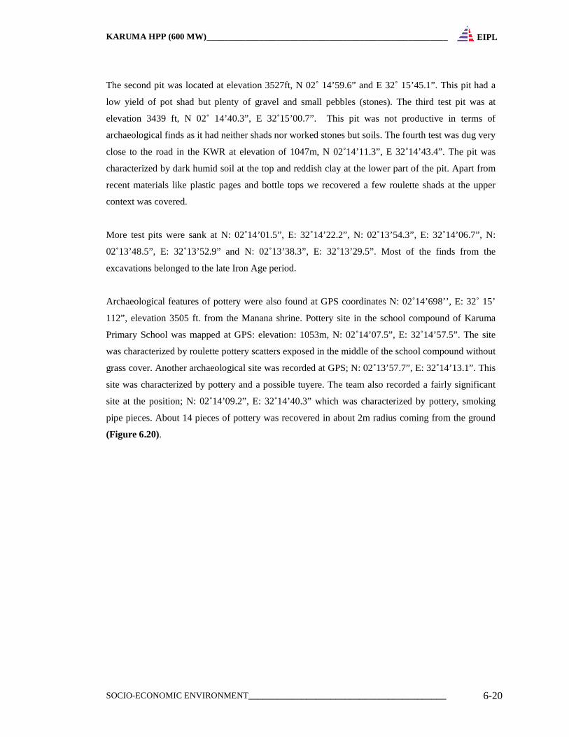
site at the position; N: 02˚14’09.2”, E: 32˚14’40.3” which was characterized by pottery, smoking
pipe pieces. About 14 pieces of pottery was recovered in about 2m radius coming from the ground
(Figure 6.20).
KARUMA HPP (600 MW)_______________________________________________________
SOCIO-ECONOMIC ENVIRONMENT_________________________________________ 6-21
EIPL
Figure 6.20: Findings from the Test Pit at N: 02˚14’09.2”, E: 032˚14’40.3”
6.3.5.1 Significance
The evidence of time and the contributions of all periods should be respected in conservation. The
material of a particular period may be obscured or removed if assessment shows that this would not
diminish the cultural heritage value of the place. In these circumstances such material should be
documented before it is obscured or removed. The roulette pottery types belong to the later Iron Age
period and very much still in use in most parts of the area and the country at large, however not
much information could be analyzed since they were not in situ. The results of nine test pits in the
area at different coordinates yielded only a few pottery shads in very few numbers, apart from the
first test pit with about 57 shads. The later Iron Age pottery type dominated most of the recovered
find. This means that, archaeological significance of most of the sites is low as the local people still
make the above pottery type.
However, it is important to note that, two sites are very useful and significant and need to be
investigated further to provide usable information about the Palwo people. Site one which had a
very high pottery concentration and the site at coordinate; N: 02˚14’09.2, E: 032˚14’40.3” which
yielded a wide range of archaeological material should be subjected to further investigation to try
and recover more data.
KARUMA HPP (600 MW)_______________________________________________________
SOCIO-ECONOMIC ENVIRONMENT_________________________________________ 6-22
EIPL
Figure 6.21: Map depicting sampling sites for Archaeological Sampling
KARUMA HPP (600 MW)_______________________________________________________
SOCIO-ECONOMIC ENVIRONMENT_________________________________________ 6-23
EIPL
6.3.6 Tourism
Karuma Hydro Power project falls within Karuma Wildlife Reserve and in vicinity of Murchison
Fall National Park and includes landscapes that are of tourist and cultural value. On the whole,
Murchison Falls Protected Area where the Karuma Wildlife Reserve falls is endowed with unique
and special features and attributes of local, national and international significance. Notable are
Murchison Falls on the River Nile which is an icon of national and exhilarating visitor experience.
Murchison Falls Protected Area has a rich cultural heritage manifested by historical stone-age
settlements along the Nile and is significant for domestic education and recreation function
particularly benefiting school children, university students and wildlife club members. According
the Murchison General Management Plan, the protected area has been divided into zones which
prescribe priority uses to which various geographical areas of the protected area should be put. The
Falls Zone is proposed for inscription on the World Heritage site with tourism activities including
walking safaris, fly camping and sport fishing. The Intensive Tourism Zone comprises of two parts.
The Western Tourism Area that will offer boat trips into the Nile Delta from Delta Point, walking
safaris along Tanyi and Nyamsika Rivers and the traditional game drives in the Buligi circuit. The
second area, the Chobe Tourism Area which accommodate a campsite on the South Bank of the
Nile within Karuma Wildlife Reserve close to Gwara Gate and the Chobe Lodge. Chobe Lodge has
signed a 30 year agreement with Government to run up-market tourism activities within the
Murchison Falls Protected Area. The agreement was entered into on the 27th January 1996. The
main tourism opportunities include non-concession sport fishing.
Although Uganda Wildlife Authority (UWA) has incurs significant expenditure in managing KWR
and the area is used for fire wood collection by residing communities around the reserve as per
MoUs signed with UWA, the Karuma Wildlife Reserve does not currently generate any revenue to
UWA. This is because the vegetation inside KWR is often thick, infested with tsetse flies and not
conducive to game viewing and also the wildlife populations are low. Thus visitors pass this area en-
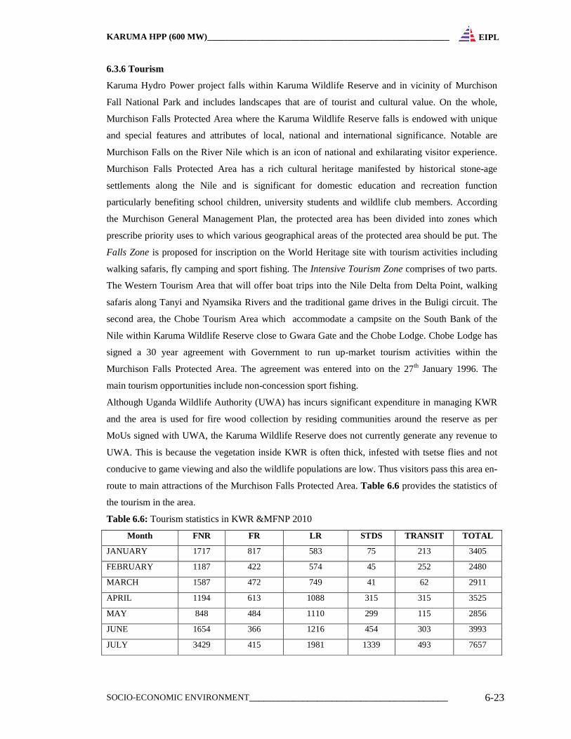
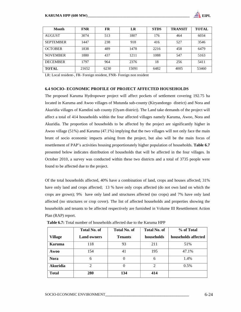
route to main attractions of the Murchison Falls Protected Area. Table 6.6 provides the statistics of
the tourism in the area.
Table 6.6: Tourism statistics in KWR &MFNP 2010
Month FNR FR LR STDS TRANSIT TOTAL
JANUARY 1717 817 583 75 213 3405
FEBRUARY 1187 422 574 45 252 2480
MARCH 1587 472 749 41 62 2911
APRIL 1194 613 1088 315 315 3525
MAY 848 484 1110 299 115 2856
JUNE 1654 366 1216 454 303 3993
JULY 3429 415 1981 1339 493 7657
KARUMA HPP (600 MW)_______________________________________________________
SOCIO-ECONOMIC ENVIRONMENT_________________________________________ 6-24
EIPL
Month FNR FR LR STDS TRANSIT TOTAL
AUGUST 3074 513 1807 176 464 6034
SEPTEMBER 1447 238 918 416 527 3546
OCTOBER 1838 489 1478 2216 458 6479
NOVEMBER 1880 437 1211 1088 547 5163
DECEMBER 1797 964 2376 18 256 5411
TOTAL 21652 6230 15091 6482 4005 53460
LR: Local resident-, FR- Foreign resident, FNR- Foreign non resident
6.4 SOCIO- ECONOMIC PROFILE OF PROJECT AFFECTED HOU SEHOLDS
The proposed Karuma Hydropower project will affect pockets of settlement covering 192.75 ha
located in Karuma and Awoo villages of Mutunda sub-county (Kiryandongo district) and Nora and
Akuridia villages of Kamdini sub county (Oyam district). The Land take demands of the project will
affect a total of 414 households within the four affected villages namely Karuma, Awoo, Nora and
Akuridia. The proportion of households to be affected by the project are significantly higher in
Awoo village (51%) and Karuma (47.1%) implying that the two villages will not only face the main
brunt of socio economic impacts arising from the project, but also will be the main focus of
resettlement of PAP’s activities housing proportionately higher population of households. Table 6.7
presented below indicates distribution of households that will be affected in the four villages. In
October 2010, a survey was conducted within these two districts and a total of 3735 people were
found to be affected due to the project.
Of the total households affected, 40% have a combination of land, crops and houses affected; 31%
have only land and crops affected; 13 % have only crops affected (do not own land on which the
crops are grown); 9% have only land and structures affected (no crops) and 7% have only land
affected (no structures or crop cover). The list of affected households and properties showing the
households and tenants to be affected respectively are furnished in Volume III Resettlement Action
Plan (RAP) report.
Table 6.7: Total number of households affected due to the Karuma HPP
Village
Total No. of
Land owners
Total No. of
Tenants
Total No. of
households
% of Total
households affected
Karuma 118 93 211 51%
Awoo 154 41 195 47.1%
Nora 6 0 6 1.4%
Akuridia 2 0 2 0.5%
Total 280 134 414
KARUMA HPP (600 MW)_______________________________________________________
SOCIO-ECONOMIC ENVIRONMENT_________________________________________ 6-25
EIPL
6.4.1 Ethnography
The project area is situated in two districts: Kiryandongo and Oyam. The former is found on the left
bank of the river while the later is found at the right bank. The indigenous peoples of these two areas
are the Palwo and Langi respectively. However, due to an influx of population into this area caused
by the insurgency that affected much of the Acholi and Lango sub regions, nearly all the major
tribes in Uganda are found here. Table 6.8 below summarizes by proportion, the ethnic composition
of the Project affected households. Considering that the indigenous peoples of these two areas are
the Palwo and Langi, the varirty and proportion of the ethnic composition in the proposed project
area evidently attests to the high proportion of migrant populations. There is a higher proportion of
people from the Acholi ethnic group in all the affected.
Table 6.8: Ethnicity in the affected household due to the Karuma HPP
Village Acholi Alur Ateso Congolese Kakwa Lango Lugbara Baganda Munyankole Munyoro Muruli Musoga Palwo Maddi
Karuma 45% 10% 1% 1% 1% 8% 13% 2% 1% 2% 1% 0% 14% 1%
Awoo 78% 14% 0% 0% 1% 2% 1% 0% 1% 0% 1% 1% 1% 0%
Nora 67% 33%
Akuridia 100
%
6.4.2 Household Size
Table 6.9 below shows the average household size for 2 of the villages with a greater proportion of
project affected household. Amongst the affected household, the average household size ranges from
9 – 10 members.
Table 6.9: Average household size in the most affected villages
Village Average household size
Karuma 10
Awoo 9
6.4.3 Population Structure by age and gender
A census of PAPs was conducted based on each household and a total of 3735 people were found to
be affected both directly and indirectly. Figure 6.22 describes the population structure of the
affected villages whereas; Figure 6.23 presents the population structure of the two dominant
villages Karuma and Awoo with higher number of affected household.
The population pyramids were derived from the census survey information gathered during the RAP
Social Survey. Although there are more females than males, the difference in population between
males and females is not very significant. Of the population of affected persons, there are 1869
males as against 1866 females.

KARUMA HPP (600 MW)_______________________________________________________
SOCIO-ECONOMIC ENVIRONMENT_________________________________________ 6-26
EIPL
The population pyramids shown in Figure 6.22 and Figure 6.23 indicate a significantly young
population. The population of persons 5 years and below and 6-17 years is significantly large. Table
6.10 provides a summary that highlights the proportion of children youth and adult working and
Elderly population in relation to the total population in the four affected villages. The data clearly
shows that much of the project area has a significantly large dependent population (children and
youth population) placing demands for Child and reproductive health facilities, education and
employment opportunities.
Table 6.10: Proportion of children, youth, adults and elderly amongst PAPs
Village Children (17 years
and below)
%Youth population
(18 – 29 years)
% Adults (30 -
49 years)
% Elderly (above
50 years)
Karuma 59% 19% 15% 7%
Awoo 56% 20% 16% 8%
Figure 6.22: Population structure of PAPs within the project affected villages (age & gender)
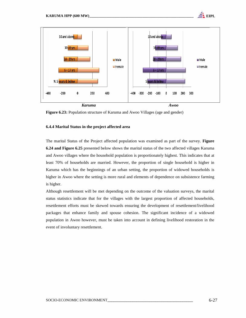
KARUMA HPP (600 MW)_______________________________________________________
SOCIO-ECONOMIC ENVIRONMENT_________________________________________ 6-27
EIPL
Karuma Awoo
Figure 6.23: Population structure of Karuma and Awoo Villages (age and gender)
6.4.4 Marital Status in the project affected area
The marital Status of the Project affected population was examined as part of the survey. Figure
6.24 and Figure 6.25 presented below shows the marital status of the two affected villages Karuma
and Awoo villages where the household population is proportionately highest. This indicates that at
least 70% of households are married. However, the proportion of single household is higher in
Karuma which has the beginnings of an urban setting, the proportion of widowed households is
higher in Awoo where the setting is more rural and elements of dependence on subsistence farming
is higher.
Although resettlement will be met depending on the outcome of the valuation surveys, the marital
status statistics indicate that for the villages with the largest proportion of affected households,
resettlement efforts must be skewed towards ensuring the development of resettlement/livelihood
packages that enhance family and spouse cohesion. The significant incidence of a widowed
population in Awoo however, must be taken into account in defining livelihood restoration in the
event of involuntary resettlement.
KARUMA HPP (600 MW)_______________________________________________________
SOCIO-ECONOMIC ENVIRONMENT_________________________________________ 6-28
EIPL
Figure 6.24: Marital Status in Karuma Village
Figure 6.25: Marital Status in Awoo Village
6.4. 5 Culture and Religion of the PAPS
Because of the multi ethnic composition of the people living in the project area, there are no distinct
cultural traits characteristic of the project area. Karuma town and village exhibit the characteristic of
a rural growth centre with the trading centre attracting modern behaviour. It is rather common to
find young people at the trading centre drinking and playing pool like as seen at the outskirts of
Kampala city.
The greatest proportion of the population of PAP’s is Catholics in Karuma, Awoo and Akuridia
having 56%, 72% and 100 % respectively. Table 6.11 below demonstrates this position.
KARUMA HPP (600 MW)_______________________________________________________
SOCIO-ECONOMIC ENVIRONMENT_________________________________________ 6-29
EIPL
Only in Nora where the population of PAPs is relatively small, is the population of Protestants
higher. However, there is fairly significant proportion of Muslims in Karuma (27%).
Table 6.11: Proportion of PAPs belonging to various Religious denominations.
Village Protestant Born again Catholic Muslim
Karuma 12% 5% 56% 27%
Awoo 18% 6% 72% 4%
Nora 50% 12% 38%
Akuridia 100%
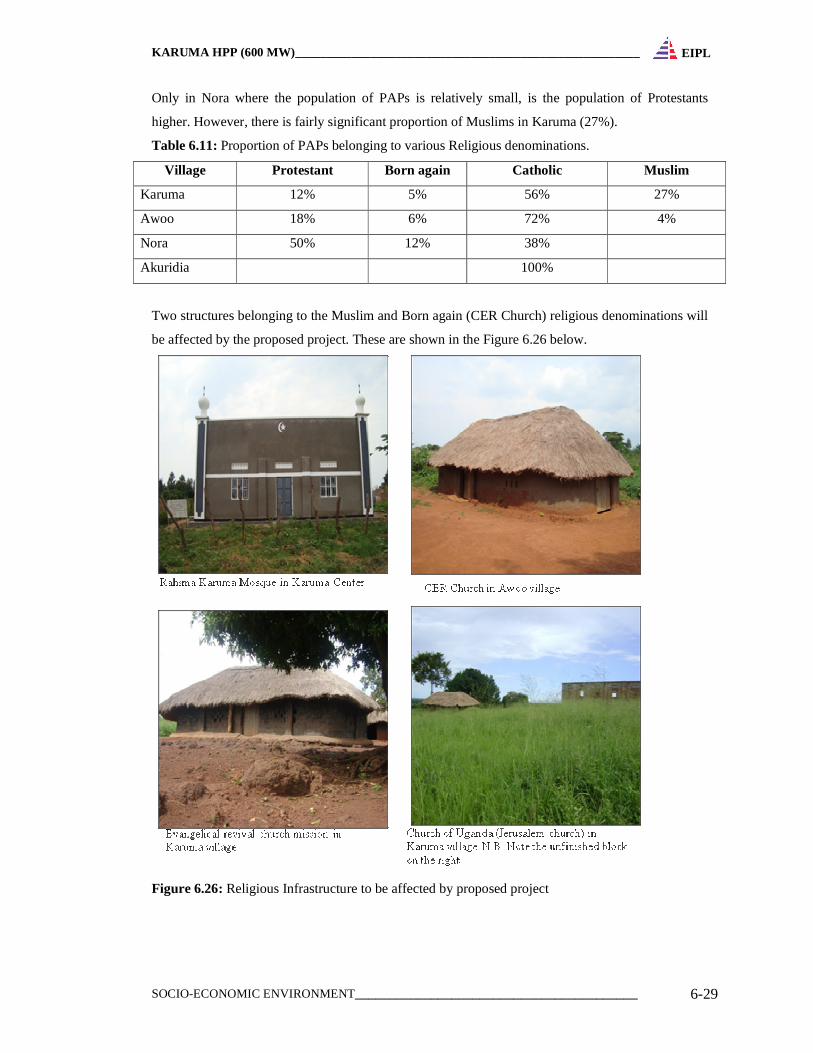
Two structures belonging to the Muslim and Born again (CER Church) religious denominations will
be affected by the proposed project. These are shown in the Figure 6.26 below.
Figure 6.26: Religious Infrastructure to be affected by proposed project
KARUMA HPP (600 MW)_______________________________________________________
SOCIO-ECONOMIC ENVIRONMENT_________________________________________ 6-30
EIPL
6.4.6 Male versus female headed households
All the affected households in Nora and Akuridia are male headed households. Table 6.12 below
summarizes the proportion of male to female headed households amongst PAPs interviewed. Over
all, there are more male than female headed households within the project area. But the proportion
of female headed households including widows is very significant particularly in Awoo and Karuma
most of them belongs to Internally Displaced Families coming from the Acholi sub region.
Table 6.12: Female versus male headed households
Village Male Female
Karuma 66% 34%
Awoo 60% 40%
6.4.7 Major Sources of Income
Many of the PAPs in four villages practice subsistence farming with exceptional dependence on
agriculture as a major factor in their daily livelihoods. From interviews held with PAPs, Table-6.13
below summarizes the various occupations of affected households
There is a significantly large population of household heads in Karuma depending on trade/business
(in household items, run shops, eating/drinking places) as a source of livelihood. Incomes from
properties especially house rentals also constitute one source of income particularly in Karuma
center. The proportion of PAPs in formal employment compared to the village population of PAPs
is only significant in Nora and Akuridia. This constitutes the population of absentee landlords found
in Nora and Akuridia. There are also public servants (notably teachers) and private sector/NGO
workers who own properties particularly in Awoo village and household heads in Awoo who derive
their incomes from retirement benefits and formal employment.
Table 6.13: Occupation of affected household heads
Village Public Service Peasants Business Others
Karuma 15 98 73 15
Awoo 21 166 6 12
Nora 3 2 1
Akuridia 2
It is observed that, over 90% of the land area in Nora and Akuridia are owned by absentee land
lords. Most of the land here is underutilized but with traces of evidence of modern developments
such as fish farms, orange orchards.
Despite being close to the Nile River, fishing is not a significant occupation amongst PAPs. Even for
households who reported engagement in fishing as a source of livelihood; they admit that fishing is
not a significant income generating activity compared to crop farming.
KARUMA HPP (600 MW)_______________________________________________________
SOCIO-ECONOMIC ENVIRONMENT_________________________________________ 6-31
EIPL
6.4.8 Major Sources of Energy
The project area has no supply of electricity. Biomass constitutes the major source of energy for
cooking while paraffin is the main source of fuel for lighting. However, Some PAPs especially
within Karuma Trading centre use petrol for running generators as well as motor vehicle use.
6.4.9 Water Facilities
Table 6.14 below summarizes the major sources of water and the percentage of PAPs that depend
on each source1. There is no water supply system for the entire project area and the sanitation system
is based on pit latrines. The majority of PAPs depend on borehole water. Despite proximity to the
river, the river water does not constitute a significant water source even in Awoo village that has a
long river bank line.
Table 6.14: Sources of water supply in the project affected area
Village Borehole Protected spring Unprotected spring River Tap
Karuma 83% 10% 1% 5% 1%
Awoo 93% 3% 0% 3% 1%
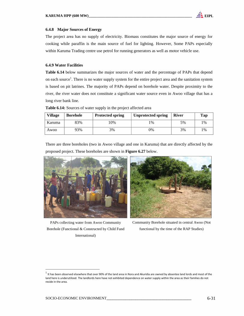
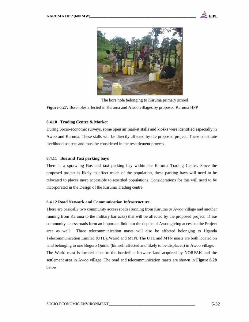
There are three boreholes (two in Awoo village and one in Karuma) that are directly affected by the
proposed project. These boreholes are shown in Figure 6.27 below.
PAPs collecting water from Awoo Community
Borehole (Functional & Constructed by Child Fund
International)
Community Borehole situated in central Awoo (Not
functional by the time of the RAP Studies)
1 It has been observed elsewhere that over 90% of the land area in Nora and Akuridia are owned by absentee land lords and most of the
land here is underutilized. The landlords here have not exhibited dependence on water supply within the area as their families do not
reside in the area.
KARUMA HPP (600 MW)_______________________________________________________
SOCIO-ECONOMIC ENVIRONMENT_________________________________________ 6-32
EIPL
The bore hole belonging to Karuma primary school
Figure 6.27: Boreholes affected in Karuma and Awoo villages by proposed Karuma HPP
6.4.10 Trading Centre & Market
During Socio-economic surveys, some open air market stalls and kiosks were identified especially in
Awoo and Karuma. These stalls will be directly affected by the proposed project. These constitute
livelihood sources and must be considered in the resettlement process.
6.4.11 Bus and Taxi parking bays
There is a sprawling Bus and taxi parking bay within the Karuma Trading Center. Since the
proposed project is likely to affect much of the population, these parking bays will need to be
relocated to places more accessible to resettled populations. Considerations for this will need to be
incorporated in the Design of the Karuma Trading centre.
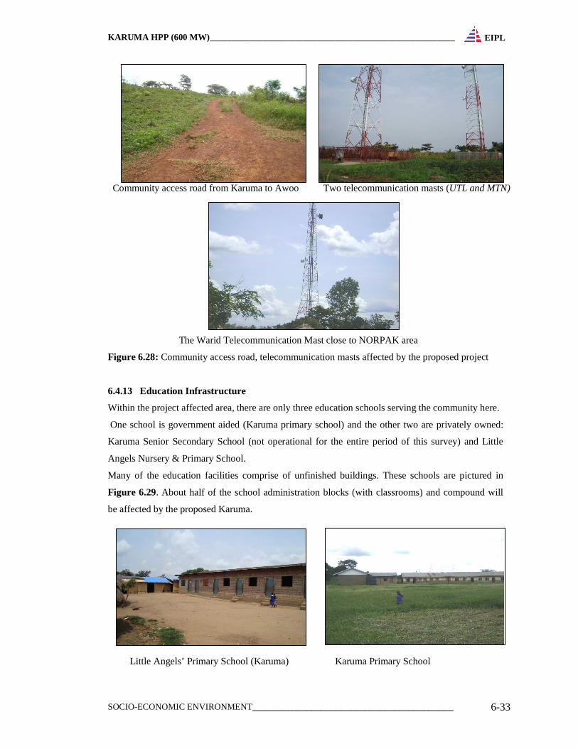
6.4.12 Road Network and Communication Infrastructure
There are basically two community access roads (running from Karuma to Awoo village and another
running from Karuma to the military barracks) that will be affected by the proposed project. These
community access roads form an important link into the depths of Awoo giving access to the Project
area as well. Three telecommunication masts will also be affected belonging to Uganda
Telecommunication Limited (UTL), Warid and MTN. The UTL and MTN masts are both located on
land belonging to one Bogoro Quinto (himself affected and likely to be displaced) in Awoo village.
The Warid mast is located close to the borderline between land acquired by NORPAK and the
settlement area in Awoo village. The road and telecommunication masts are shown in Figure 6.28
below
KARUMA HPP (600 MW)_______________________________________________________
SOCIO-ECONOMIC ENVIRONMENT_________________________________________ 6-33
EIPL
Community access road from Karuma to Awoo Two telecommunication masts (UTL and MTN)
The Warid Telecommunication Mast close to NORPAK area
Figure 6.28: Community access road, telecommunication masts affected by the proposed project
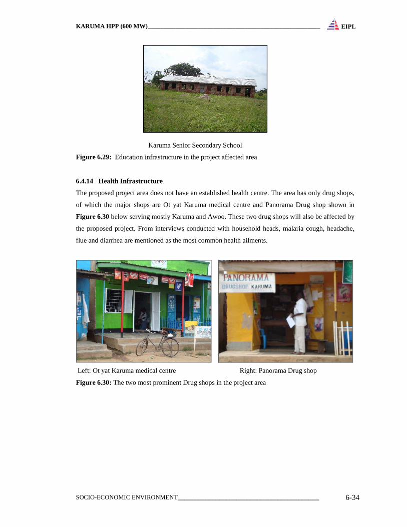
6.4.13 Education Infrastructure
Within the project affected area, there are only three education schools serving the community here.
One school is government aided (Karuma primary school) and the other two are privately owned:
Karuma Senior Secondary School (not operational for the entire period of this survey) and Little
Angels Nursery & Primary School.
Many of the education facilities comprise of unfinished buildings. These schools are pictured in
Figure 6.29. About half of the school administration blocks (with classrooms) and compound will
be affected by the proposed Karuma.
Little Angels’ Primary School (Karuma) Karuma Primary School
KARUMA HPP (600 MW)_______________________________________________________
SOCIO-ECONOMIC ENVIRONMENT_________________________________________ 6-34
EIPL
Karuma Senior Secondary School
Figure 6.29: Education infrastructure in the project affected area
6.4.14 Health Infrastructure
The proposed project area does not have an established health centre. The area has only drug shops,
of which the major shops are Ot yat Karuma medical centre and Panorama Drug shop shown in
Figure 6.30 below serving mostly Karuma and Awoo. These two drug shops will also be affected by
the proposed project. From interviews conducted with household heads, malaria cough, headache,
flue and diarrhea are mentioned as the most common health ailments.
Left: Ot yat Karuma medical centre Right: Panorama Drug shop
Figure 6.30: The two most prominent Drug shops in the project area