Embed Size (px)
Citation preview
Supporting Report II (Feasibility Study) Paper VI Hydraulic Modeling
The Study on Flood and Debris Flowin the Caspian Coastal Area focusing on
the Flood-hit Region in Golestan Province
VI - 24 CTI Engineering International Co., Ltd. JICA
CHAPTER 6 HYDRAULIC AND MORPHOLOGICAL MODELS
The hydraulic and morphological models are described herein.
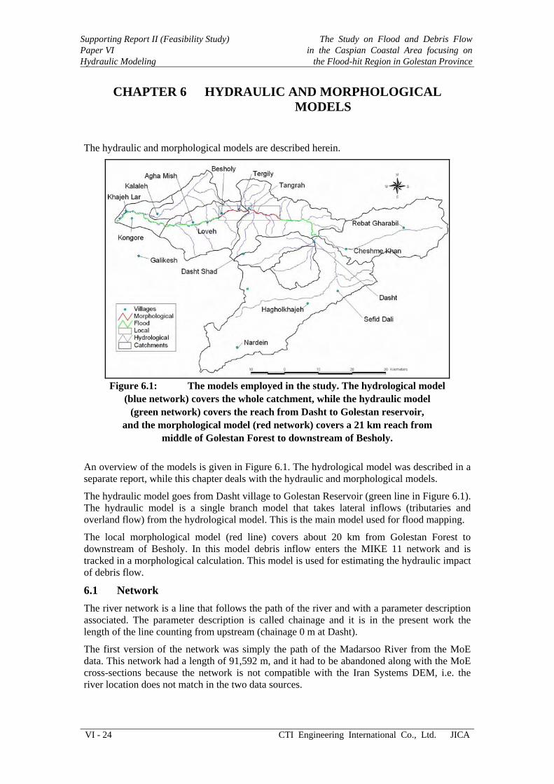
Figure 6.1: The models employed in the study. The hydrological model
(blue network) covers the whole catchment, while the hydraulic model (green network) covers the reach from Dasht to Golestan reservoir,
and the morphological model (red network) covers a 21 km reach from middle of Golestan Forest to downstream of Besholy.
An overview of the models is given in Figure 6.1. The hydrological model was described in a separate report, while this chapter deals with the hydraulic and morphological models.
The hydraulic model goes from Dasht village to Golestan Reservoir (green line in Figure 6.1). The hydraulic model is a single branch model that takes lateral inflows (tributaries and overland flow) from the hydrological model. This is the main model used for flood mapping.
The local morphological model (red line) covers about 20 km from Golestan Forest to downstream of Besholy. In this model debris inflow enters the MIKE 11 network and is tracked in a morphological calculation. This model is used for estimating the hydraulic impact of debris flow.
6.1 Network The river network is a line that follows the path of the river and with a parameter description associated. The parameter description is called chainage and it is in the present work the length of the line counting from upstream (chainage 0 m at Dasht).
The first version of the network was simply the path of the Madarsoo River from the MoE data. This network had a length of 91,592 m, and it had to be abandoned along with the MoE cross-sections because the network is not compatible with the Iran Systems DEM, i.e. the river location does not match in the two data sources.

The Study on Flood and Debris Flow in the Caspian Coastal Area focusing on the Flood-hit Region in Golestan Province
Supporting Report II (Feasibility Study)Paper VI
Hydraulic Modeling
JICA CTI Engineering International Co., Ltd. VI - 25
Figure 6.2: Network and cross-sections used for the overall hydraulic model,
extending from Dasht to Golestan reservoir.
Instead the river network was digitized from the Iran Systems DEM by essentially following the low point in the valley, which was also where the river will be located in the flood maps. This ensured compatibility between the data sources, and it resulted in a river network with a length of 72,609 m instead of the 91,592 m for the MoE data. The reason for this is that the river network digitized from the DEM represents the floodwaters rather than the meandering path of the river, which for flood mapping is actually more realistic.
6.2 Cross-sections The cross-section distance-level tables were extracted from the DEM and translated to an ASCII format that could be imported to MIKE 11.
0
200
400
600
800
1,000
1,200
0 10,000 20,000 30,000 40,000 50,000 60,000 70,000
MIKE 11 chainage (m)
Elev
atio
n (m
)
Minimum level (m)Maximum level (m)
TangrahTergily
Besholy
Loveh
Agha Mish
Kalaleh
Khajeh Lar
Dasht
Figure 6.3: Minimum and maximum bed level in all 553 cross-sections from upstream to downstream (also shown are the locations of villages in this network).

Supporting Report II (Feasibility Study) Paper VI Hydraulic Modeling
The Study on Flood and Debris Flowin the Caspian Coastal Area focusing on
the Flood-hit Region in Golestan Province
VI - 26 CTI Engineering International Co., Ltd. JICA
The cross-section lines were shown in Figure 6.2, while Figure 6.3 shows the minimum and maximum elevations in the cross-sections from Dasht to Golestan Reservoir. From the difference between minimum and maximum elevations we can see the steep gorge in Golestan Forest (upstream of Tangrah) and the terrace floodplain downstream of Kalaleh. Between Tangrah and Kalaleh the floodplain is fairly wide, which is also reflected in the cross-sections.
6.2 Boundary conditions The boundary conditions for the hydraulic model were extracted from the coupled MIKE 11/MIKE SHE model.
The hydraulic model starts at the Dasht village, which is handled by extracting the discharge from the first Q-point in the Madarsoo to a time-series with the inflow. This inflow is then the upstream inflow in the Madarsoo branch.
The tributaries are handled by extracting the discharge from the first Q-point upstream in the tributary and adding the lateral flow (Drain, Overland and Baseflow from MIKE SHE) into the downstream H-point in the tributary branch into a time-series file. A point source with this time-series at the junction now replaces the tributary. There are 26 such tributaries handled in this manner in the single branch MIKE 11 model.
The lateral flows from the MIKE SHE model divided into Drain, Overland and Baseflow are joining up with the Madarsoo down through the branch. These lateral flows are extracted from the result file into time-series and point sources are added to the chainage locations where these lateral flows join the Madarsoo. There are 86 of these lateral flows entering at H-points down through the Madarsoo.
Figure 6.4: Locations of boundary conditions divided into open boundaries,
tributary inflows and lateral inflows.
The Study on Flood and Debris Flow in the Caspian Coastal Area focusing on the Flood-hit Region in Golestan Province
Supporting Report II (Feasibility Study)Paper VI
Hydraulic Modeling
JICA CTI Engineering International Co., Ltd. VI - 27
The result is an inflow boundary condition at Dasht and a series of lateral and tributary inflows down through Madarsoo, as shown in Figure 6.4. The downstream boundary (reservoir water level) is described in the next section.
To make matters more complicated, the hydraulic model was defined on a different network (digitized from the DEM) than the hydrological model (MoE data and tributary network). Hence the inflows had to be translated to chainages in the hydraulic model from other chainages in the hydrological model, which was done by using the UTM coordinates for translation of the chainages, i.e. from chainage in hydrological model via UTM to chainage in hydraulic model.
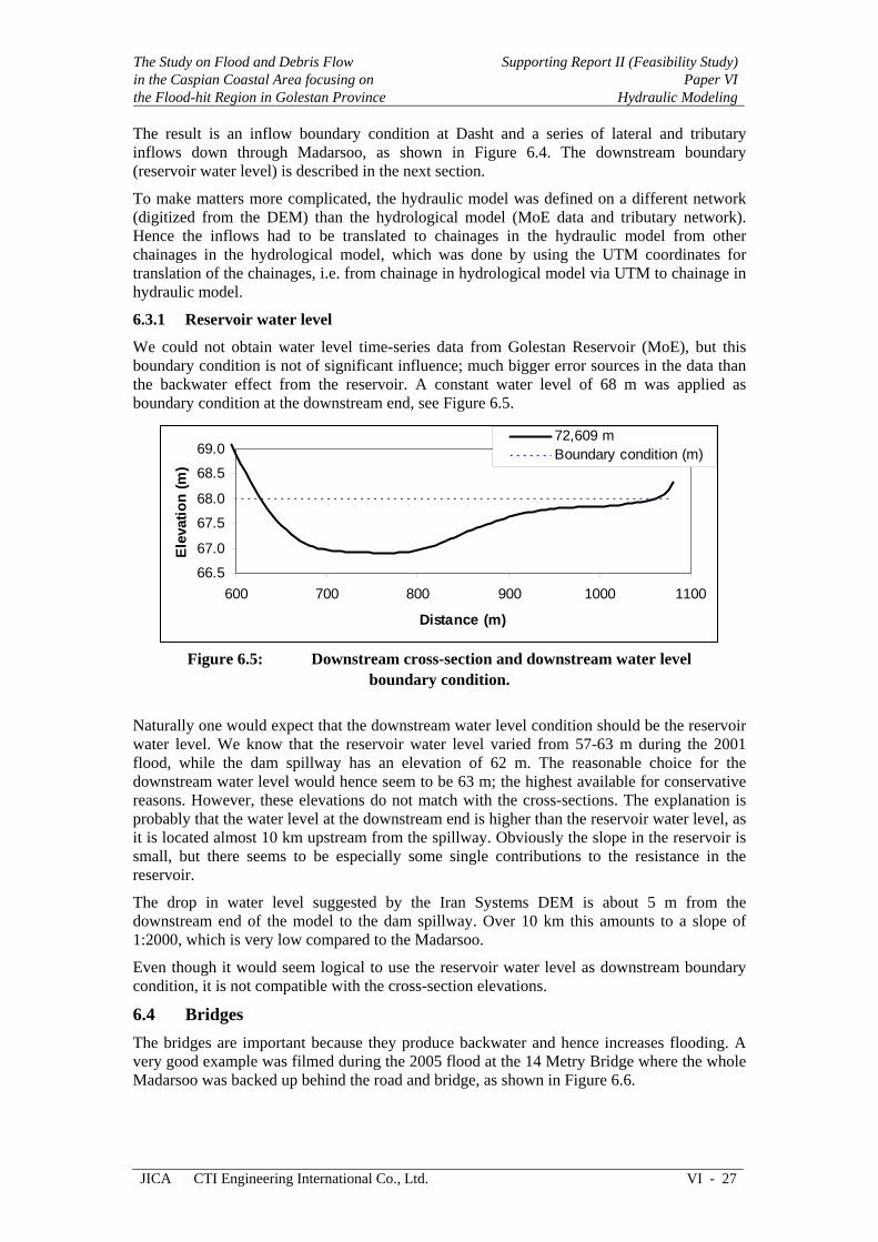
6.3.1 Reservoir water level
We could not obtain water level time-series data from Golestan Reservoir (MoE), but this boundary condition is not of significant influence; much bigger error sources in the data than the backwater effect from the reservoir. A constant water level of 68 m was applied as boundary condition at the downstream end, see Figure 6.5.
66.5
67.0
67.5
68.0
68.5
69.0
600 700 800 900 1000 1100
Distance (m)
Elev
atio
n (m
)
72,609 mBoundary condition (m)
Figure 6.5: Downstream cross-section and downstream water level
boundary condition.
Naturally one would expect that the downstream water level condition should be the reservoir water level. We know that the reservoir water level varied from 57-63 m during the 2001 flood, while the dam spillway has an elevation of 62 m. The reasonable choice for the downstream water level would hence seem to be 63 m; the highest available for conservative reasons. However, these elevations do not match with the cross-sections. The explanation is probably that the water level at the downstream end is higher than the reservoir water level, as it is located almost 10 km upstream from the spillway. Obviously the slope in the reservoir is small, but there seems to be especially some single contributions to the resistance in the reservoir.
The drop in water level suggested by the Iran Systems DEM is about 5 m from the downstream end of the model to the dam spillway. Over 10 km this amounts to a slope of 1:2000, which is very low compared to the Madarsoo.
Even though it would seem logical to use the reservoir water level as downstream boundary condition, it is not compatible with the cross-section elevations.
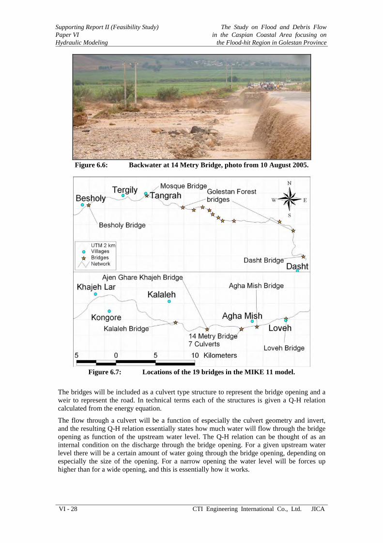
6.4 Bridges The bridges are important because they produce backwater and hence increases flooding. A very good example was filmed during the 2005 flood at the 14 Metry Bridge where the whole Madarsoo was backed up behind the road and bridge, as shown in Figure 6.6.
Supporting Report II (Feasibility Study) Paper VI Hydraulic Modeling
The Study on Flood and Debris Flowin the Caspian Coastal Area focusing on
the Flood-hit Region in Golestan Province
VI - 28 CTI Engineering International Co., Ltd. JICA
Figure 6.6: Backwater at 14 Metry Bridge, photo from 10 August 2005.
Figure 6.7: Locations of the 19 bridges in the MIKE 11 model.
The bridges will be included as a culvert type structure to represent the bridge opening and a weir to represent the road. In technical terms each of the structures is given a Q-H relation calculated from the energy equation.
The flow through a culvert will be a function of especially the culvert geometry and invert, and the resulting Q-H relation essentially states how much water will flow through the bridge opening as function of the upstream water level. The Q-H relation can be thought of as an internal condition on the discharge through the bridge opening. For a given upstream water level there will be a certain amount of water going through the bridge opening, depending on especially the size of the opening. For a narrow opening the water level will be forces up higher than for a wide opening, and this is essentially how it works.

The Study on Flood and Debris Flow in the Caspian Coastal Area focusing on the Flood-hit Region in Golestan Province
Supporting Report II (Feasibility Study)Paper VI
Hydraulic Modeling
JICA CTI Engineering International Co., Ltd. VI - 29
For the road overtopping a simple weir formula applies, which states how much water discharge will be flowing over the weir as function of the upstream water level. The invert and the width (function of water level) dictate the flow over the weir.
The Q-H relations for the culverts and weirs are applied in parallel such that each Q-H relation (structure) accounts for a fraction of the total discharge, and yield the total discharge in combination.
The bridges are defined with a UTM location (see Figure 6.7) from which we calculate a chainage by simply finding the closest point in the river network. A small utility program was written for figuring out the chainage locations depending on the UTM coordinates and the river network. For simplicity we will implement all the bridges as culverts (bridge openings) and weirs (overtopping). The difference between this and using e.g. the FHWA module is small compared to the inconsistencies in the elevation data.
Table 6.1: The 19 bridges included in the hydraulic model; road elevations and culvert inverts estimated from cross-sections.
ID Name Easting Northing Chainage Culvert Road 1 Dasht Bridge 413,151 4,131,958 670 959.0 960.5 2 Existing Bridge 411,851 4,135,224 5,734 870.5 872.0 3 Existing Bridge 410,110 4,136,366 7,998 801.5 803.0 4 Existing Bridge 404,351 4,136,462 14,258 663.7 665.2 5 Existing Bridge 402,920 4,136,521 15,713 630.5 632.0 6 Existing Bridge 402,379 4,136,895 16,379 625.5 627.0 7 Existing Bridge 401,667 4,137,329 17,321 594.5 596.0 8 Existing Bridge 401,261 4,137,839 18,000 591.0 592.5 9 Existing Bridge 400,387 4,138,203 18,971 590.5 592.0 10 Existing Bridge 399,274 4,137,854 20,223 564.5 566.0 11 Existing Bridge 397,872 4,138,109 21,700 542.5 544.0 12 Mosque Bridge 393,322 4,139,722 26,999 463.3 468.3 13 Besholy Bridge 385,928 4,138,501 35,336 355.0 360.0 14 Loveh Bridge 380,950 4,136,048 41,214 292.5 295.5 15 Agha Mish Bridge 377,245 4,135,204 45,150 247.0 249.0 16 14 Metry Bridge 375,326 4,134,825 47,121 226.5 234.7 17 7 Culverts 375,307 4,134,827 47,141 228.7 230.7 18 Ajen Ghare Khajeh 370,967 4,134,886 51,708 187.5 191.5 19 Kalaleh Bridge 366,977 4,135,630 56,401 152.0 159.0
The geometry parameters for each of the bridges are tabulated in Table 6.1.
6.5 Flow resistance calibration There are water level gauges in the area, but they all fail during the floods, so no water level data is available. Some flood markers were obtained in the project, but these were not particularly detailed. Therefore the model calibration had to be based on engineering judgment, and we used experience to set the Manning n value in the floodplain and river represented by the cross-sections to n=0.15 s/m1/3. There is very little vegetation on the floodplain (except in Golestan Forest), and the river channel itself has widened significantly since 2001. Quick Bird satellite images are available from which the river path can be accurately digitized, but these images are not compatible with the DEM that was provided for the project by Iran Systems. This DEM is not of a quality that would normally be required for flood mapping.

Supporting Report II (Feasibility Study) Paper VI Hydraulic Modeling
The Study on Flood and Debris Flowin the Caspian Coastal Area focusing on
the Flood-hit Region in Golestan Province
VI - 30 CTI Engineering International Co., Ltd. JICA
Figure 6.8: Flood marker comparison (older version of the 50 year flood map).
The flood markers cannot be used for calibration of the hydraulic model.
Flood markers were obtained in connection with interviewing people living in the Madarsoo basin, see Figure 6.8. However, many of the flood markers were not with depth recorded, and no markers were provided at the edge of flooding. In addition, many of the flood markers were on tributaries that are not included in the hydraulic model (inclusion would not help, as there are no cross-sections for the tributaries). Hence the flood markers cannot be used for calibration of the hydraulic model.
Also, it is clear that the DEM is not of a quality that allows such detailed determination of elevation and water depth at a specific location.
6.6 Local morphological model The local morphological model covers the 20,834 m reach shown in Figure 6.1. The network was extracted from the overall model in the chainage range 16,516 – 37,350 m.
Figure 6.9 shows the local model with its network, cross-sections, boundary conditions and debris inflow locations. The network, cross-sections and structures are identical to the overall model, except that only the local chainage reach 16,516 – 37,350 m is covered.
Figure 6.9: Local morphological model here shown with network,
cross-sections (same as for overall model), boundary conditions (same lateral inflows as overall model) and 11 sediment inflow locations
(F102B, F102, F03, F101B, F02, F01, T01, T03, T04, T06, T07).
Without the debris inflows and morphological mode this model would produce the same results, as the hydraulic model.
6.6.1 Local boundary conditions
The debris model has the standard upstream discharge and downstream water level conditions.

The Study on Flood and Debris Flow in the Caspian Coastal Area focusing on the Flood-hit Region in Golestan Province
Supporting Report II (Feasibility Study)Paper VI
Hydraulic Modeling
JICA CTI Engineering International Co., Ltd. VI - 31
0
500
1000
1500
2000
9-Aug 18:00 10-Aug00:00
10-Aug06:00
10-Aug12:00
10-Aug18:00
11-Aug00:00
11-Aug06:00
Time
Dis
char
ge (m
3/s)
Q 25 year
Q 50 year
Q 100 year
Figure 6.10: Inflow time-series for each of the considered events at the upstream
end of the local morphological model.
For the upstream boundary the discharge was extracted from the overall model and translated to a time-series file, which is then used in the boundary condition. The upstream discharge hydrographs for the 25, 50 and 100 year events are shown in Figure 6.10.
The downstream water level does not play a crucial role for the behavior of the model because of the steep slope of the Madarsoo in this reach. It would have been fully acceptable to just apply a constant water level (346 m), which was indeed used in earlier versions of the debris model. However, for the final debris model a rating curve was constructed from the overall hydraulic model and used as boundary condition. Figure 6.11 shows the rating curve; note how all the events fall exactly on this curve.
341
342
343
344
345
346
347
348
0 500 1000 1500 2000 2500
Discharge (m3/s)
Wat
er le
vel (
m)
H 25y
H 50y
H 100y
Curve f it
H = 0.1715 Q0.45 + 341.906 m
Figure 6.11: Rating curve at the downstream end of the debris model.
The same lateral flows apply to the local model, as for the overall model, though obviously only in the local model reach. Lateral flows outside of the local reach are not used.
6.6.2 Simulation period
The initial condition for the flood model was simply a small constant water depth (the easiest approach in MIKE 11). The debris model did not fair well with this because some initial disturbances happen while the water level profile adjusts, which is usually not wise in simulations where the bathymetry can change due to such disturbances. Therefore the debris model was started with the quasi-steady solution that MIKE 11 also offers as initial condition. The quasi-steady solver gives different results than the dynamic, so the simulation was started some time before the time period of interest to ensure that the transient part of the solution was gone. The production simulation period was hence selected to 9 Aug 6 pm – 11 Aug 6 am (36 hours).
Supporting Report II (Feasibility Study) Paper VI Hydraulic Modeling
The Study on Flood and Debris Flowin the Caspian Coastal Area focusing on
the Flood-hit Region in Golestan Province
VI - 32 CTI Engineering International Co., Ltd. JICA
The main reason for starting earlier is that we want to use the results for making animations. For the actual flood peak it matters not that the initial condition is slightly off compared to the dynamic solution. It is just for the graphical presentation.
6.6.3 Debris inflow source points
Debris inflow is specified for each debris inflow location with the inflow distributed over 5 cells, as explained in Chapter 5. As also mentioned earlier, the actual distribution in time of the debris inflow rate (m3/s) is not critical, as the local water inflows and therefore also reasonably the local debris inflow occurs before the bulk of floodwaters arrive from the headwaters.
6.6.4 Sediment transport modeling and calibration
To the knowledge of the DHI expert, there are no sediment samples available that were taken from debris deposits. However, the debris flows must be making significant contributions to the sediment budget for the area, and hence the debris particle sizes should be somewhat represented in the sediment data provided by JWRC (2004). It is reasonable to assume that the debris particle size is equal to the coarse fraction that is clearly identified in the sediment data, i.e. a grain size of 54 mm. In order to remain conservative in our assessment we will assume that there is none of the fine fraction (0.17 mm) in the debris flow. Hence the debris flow will be modeled as 54 mm cobbles.
The choice of Manning n=0.15 s/m1/3 is mostly based on experience and our impression of the river system. Most of this resistance is actually form resistance from trees, rocks, irregularities in the topography etc, and form resistance should not be counted in the sediment transport shear stress.
Under normal circumstances we would also resolve both the river channel and the floodplain, and then calculate the sediment transport in the river channel. For the present application this is not reasonable, as the debris will clearly be deposited and transported all over the inundated cross-section for flood conditions. Besides, no reliable cross-section data is available for the river channel itself.
The first test model was made with the Meyer-Peter formula, which is normally a fairly good choice for coarse sediment transported as bed-load. However, in MIKE 11 there is a modification of the Shields parameter used in the Meyer-Peter formula, which does not give good results when using the Manning n=0.15 s/m1/3 that we are using. The Meyer-Peter approach in MIKE 11 is aimed at the river channel sediment transport.
Instead of the Meyer-Peter formula we employ the Engelund-Hansen (1967) formula that does not have any special modifications in MIKE 11:
gC 5.22
05.0 θφ =
Where C is the Chezy number, C=h1/6/n. However, as stated earlier, it is not reasonable to have the full sediment transport because much of the flow resistance is form resistance.
The magnitude of the sediment transport influences for the dynamic development of the debris deposits and hence for the damming effect they produce.
The factor by which the sediment transport should be reduced can be estimated from the Engelund-Hansen sediment transport formula and engineering assumptions about the division between form and skin resistance. The Shields parameter is proportional to the square of the Manning n and C=h1/6/n, and hence the Engelund-Hansen formula yields that the sediment transport should be proportional to the Manning n to power 3. If we assume that form friction amounts to 50% of the resistance, we find that the sediment transport should be reduced to 0.53 = 0.125 compared to the default sediment transport calculated by MIKE 11 from the

The Study on Flood and Debris Flow in the Caspian Coastal Area focusing on the Flood-hit Region in Golestan Province
Supporting Report II (Feasibility Study)Paper VI
Hydraulic Modeling
JICA CTI Engineering International Co., Ltd. VI - 33
Engelund-Hansen formula and the total shear stress. Needless to say, the reduction factor is heavily dependent on the division between skin and form friction due to the exponent of 3; with 60% skin friction, the reduction factor becomes 0.216, and with 40% skin friction it is 0.064.
The sensitivity of the model to the sediment transport calibration parameter was tested by running simulations with factors of 0.1, 0.2 and 0.5. It was found from these simulations that the behavior is only mildly dependent on the calibration factor, which to the untrained modeler would seem odd. However, the morphology and hydraulics play together, and if lowering the calibration factor for the sediment transport, the water depth over the debris deposit simply becomes smaller, as the erosion of the deposit is slowed down by the reduced sediment transport. The result is a compensated increased sediment transport that pulls in the opposite direction of the lowering by the calibration factor, which gives the system reduced sensitivity to the sediment transport magnitude. This type of behavior is typical for morphological models, and the DHI expert is not at all surprised to find it here.
A calibration factor of 0.2 was applied on the sediment transport in the simulations.

Supporting Report II (Feasibility Study) Paper VI Hydraulic Modeling
The Study on Flood and Debris Flowin the Caspian Coastal Area focusing on
the Flood-hit Region in Golestan Province
VI - 34 CTI Engineering International Co., Ltd. JICA
CHAPTER 7 SCENARIO SIMULATIONS
7.1 Overall flood simulations 7.1.1 Flood maps and extent
The flood maps shown herein are divided into three parts for better graphical presentation.
Figure 7.1: Division into three parts, from left “Floodplain”, “Valley” and
“Golestan Forest”.
The flood maps are shown in the three (20 km by 11 km) areas shown in Figure 7.1. The flood maps in these three areas are plotted bottom to top instead of left to right, which allows much better representation of the solution on A4 (portrait) paper:
Lower (Floodplain): Easting 354-374 km, Northing 4,130-4,141 km
Middle (Valley): Easting 374-394 km, Northing 4,130-4,141 km
Upper (Golestan Forest): Easting 394-414 km, Northing 4,130-4,141 km
Each area is overlain with a 2 km UTM grid for reference. The flood maps are shown in Figures 7.2-4, while the flood extents are shown in Figure 7.5.
Table 7.1: Flooded area and volume in the flood maps. Event Area
(mill m2) Rel. Area (%)
Ave. width (m)
Volume (mill m3)
Rel. Vol. (%)
25 year 23.58 84.0 324.8 60.77 64.5 50 year 26.03 92.7 358.5 77.56 82.3 100 year 28.07 100.0 386.6 94.26 100.0
Table 7.1 shows the flooded area and volume corresponding to the maximum inundation. The flooded area does not vary significantly from the 25 to the 100 year event (16% smaller for 25 year), while the volume corresponding to maximum inundation is 35.5% smaller, i.e. the difference is not just in area, but also in flood depth, which should not be a surprise.

The Study on Flood and Debris Flow in the Caspian Coastal Area focusing on the Flood-hit Region in Golestan Province
Supporting Report II (Feasibility Study)Paper VI
Hydraulic Modeling
JICA CTI Engineering International Co., Ltd. VI - 35
Figure 7.2: Flood map for the 25 year event.
Supporting Report II (Feasibility Study) Paper VI Hydraulic Modeling
The Study on Flood and Debris Flowin the Caspian Coastal Area focusing on
the Flood-hit Region in Golestan Province
VI - 36 CTI Engineering International Co., Ltd. JICA
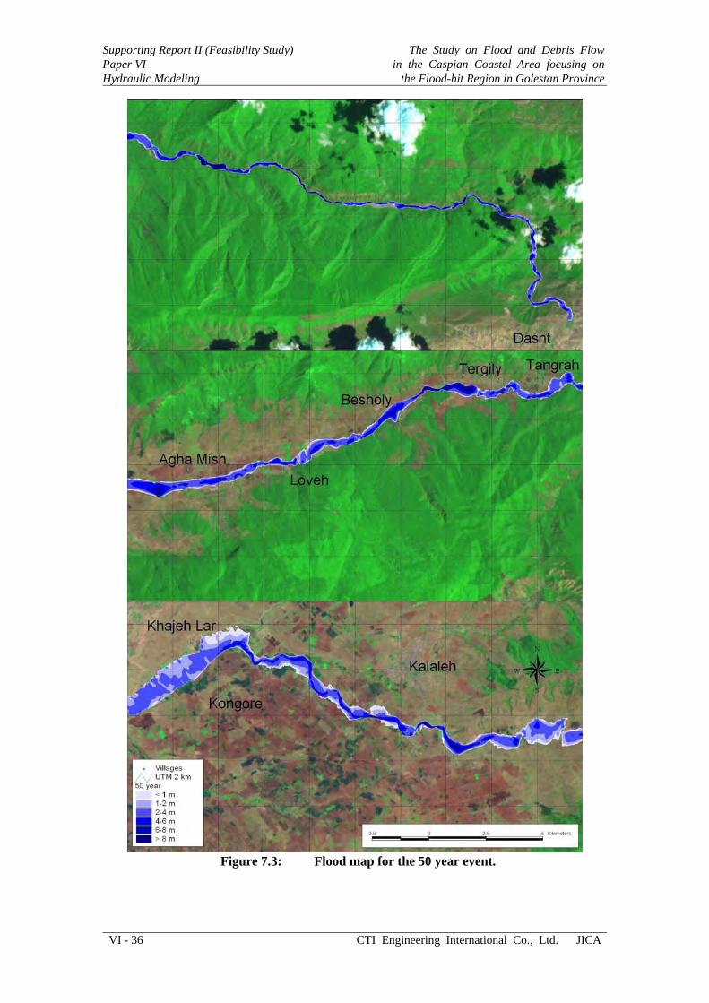
Figure 7.3: Flood map for the 50 year event.
The Study on Flood and Debris Flow in the Caspian Coastal Area focusing on the Flood-hit Region in Golestan Province
Supporting Report II (Feasibility Study)Paper VI
Hydraulic Modeling
JICA CTI Engineering International Co., Ltd. VI - 37
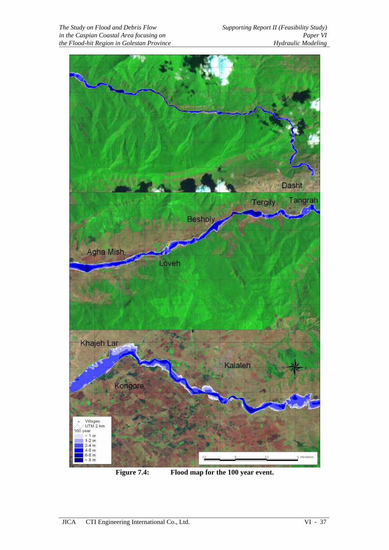
Figure 7.4: Flood map for the 100 year event.

Supporting Report II (Feasibility Study) Paper VI Hydraulic Modeling
The Study on Flood and Debris Flowin the Caspian Coastal Area focusing on
the Flood-hit Region in Golestan Province
VI - 38 CTI Engineering International Co., Ltd. JICA
Figure 7.5: Flood extent for each of the events.

The Study on Flood and Debris Flow in the Caspian Coastal Area focusing on the Flood-hit Region in Golestan Province
Supporting Report II (Feasibility Study)Paper VI
Hydraulic Modeling
JICA CTI Engineering International Co., Ltd. VI - 39
7.1.2 Animation of the 100 year flood
An animation of the 100 year flood can be found at www.jica-madarsoo-study.com, and the same animation is shown in the PowerPoint presentation made for this study.
Figure 7.6: Sequential development of the 100 year flood during 24 hours;
maximum inundation shown at the bottom.
The flood development is illustrated sequentially in Figure 7.6 by showing the flood map at 2-hour intervals during 24 hours.
7.2 Local debris model simulations Herein are presented results from the debris modeling.
7.2.1 Bed levels and water levels
Profiles of the maximum bed and water levels are shown in Figure 7.7 for the 100 year event with and without debris flow included. An animation is also given in the PowerPoint for the study.

Supporting Report II (Feasibility Study) Paper VI Hydraulic Modeling
The Study on Flood and Debris Flowin the Caspian Coastal Area focusing on
the Flood-hit Region in Golestan Province
VI - 40 CTI Engineering International Co., Ltd. JICA
520
530
540
550
560
570
580
20,000 20,500 21,000 21,500 22,000 22,500 23,000
Chainage (m)
Leve
l (m
)
100 debris
100 no debris
100 debris
100 no debrisF102B
F102
460
470
480
490
500
510
24,000 24,500 25,000 25,500 26,000 26,500 27,000
Chainage (m)
Leve
l (m
)
100 debris
100 no debris
100 debris
100 no debrisF03
F101BF02
F01
400
410
420
430
440
450
460
28,000 28,500 29,000 29,500 30,000 30,500 31,000
Chainage (m)
Leve
l (m
)
100 debris
100 no debris
100 debris
100 no debrisT01
T03
T04
340
350
360
370
380
390
400
32,000 33,000 34,000 35,000 36,000 37,000
Chainage (m)
Leve
l (m
)
100 debris
100 no debris
100 debris
100 no debrisT06
T07
Figure 7.7: Profile of simulated (100 year event) maximum water level and bed
level with and without debris flow included.
The Study on Flood and Debris Flow in the Caspian Coastal Area focusing on the Flood-hit Region in Golestan Province
Supporting Report II (Feasibility Study)Paper VI
Hydraulic Modeling
JICA CTI Engineering International Co., Ltd. VI - 41
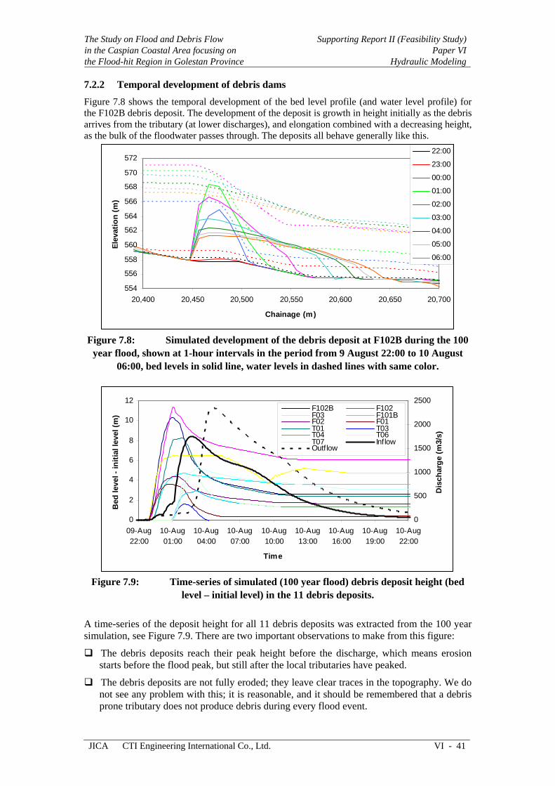
7.2.2 Temporal development of debris dams
Figure 7.8 shows the temporal development of the bed level profile (and water level profile) for the F102B debris deposit. The development of the deposit is growth in height initially as the debris arrives from the tributary (at lower discharges), and elongation combined with a decreasing height, as the bulk of the floodwater passes through. The deposits all behave generally like this.
554
556
558
560
562
564
566
568
570
572
20,400 20,450 20,500 20,550 20,600 20,650 20,700
Chainage (m)
Elev
atio
n (m
)
22:00
23:00
00:00
01:00
02:00
03:00
04:00
05:00
06:00
Figure 7.8: Simulated development of the debris deposit at F102B during the 100
year flood, shown at 1-hour intervals in the period from 9 August 22:00 to 10 August 06:00, bed levels in solid line, water levels in dashed lines with same color.
0
2
4
6
8
10
12
09-Aug22:00
10-Aug01:00
10-Aug04:00
10-Aug07:00
10-Aug10:00
10-Aug13:00
10-Aug16:00
10-Aug19:00
10-Aug22:00
Time
Bed
leve
l - in
itial
leve
l (m
)
0
500
1000
1500
2000
2500
Dis
char
ge (m
3/s)
F102B F102F03 F101BF02 F01T01 T03T04 T06T07 InflowOutflow
Figure 7.9: Time-series of simulated (100 year flood) debris deposit height (bed
level – initial level) in the 11 debris deposits.
A time-series of the deposit height for all 11 debris deposits was extracted from the 100 year simulation, see Figure 7.9. There are two important observations to make from this figure:
The debris deposits reach their peak height before the discharge, which means erosion starts before the flood peak, but still after the local tributaries have peaked.
The debris deposits are not fully eroded; they leave clear traces in the topography. We do not see any problem with this; it is reasonable, and it should be remembered that a debris prone tributary does not produce debris during every flood event.
Supporting Report II (Feasibility Study) Paper VI Hydraulic Modeling
The Study on Flood and Debris Flowin the Caspian Coastal Area focusing on
the Flood-hit Region in Golestan Province
VI - 42 CTI Engineering International Co., Ltd. JICA
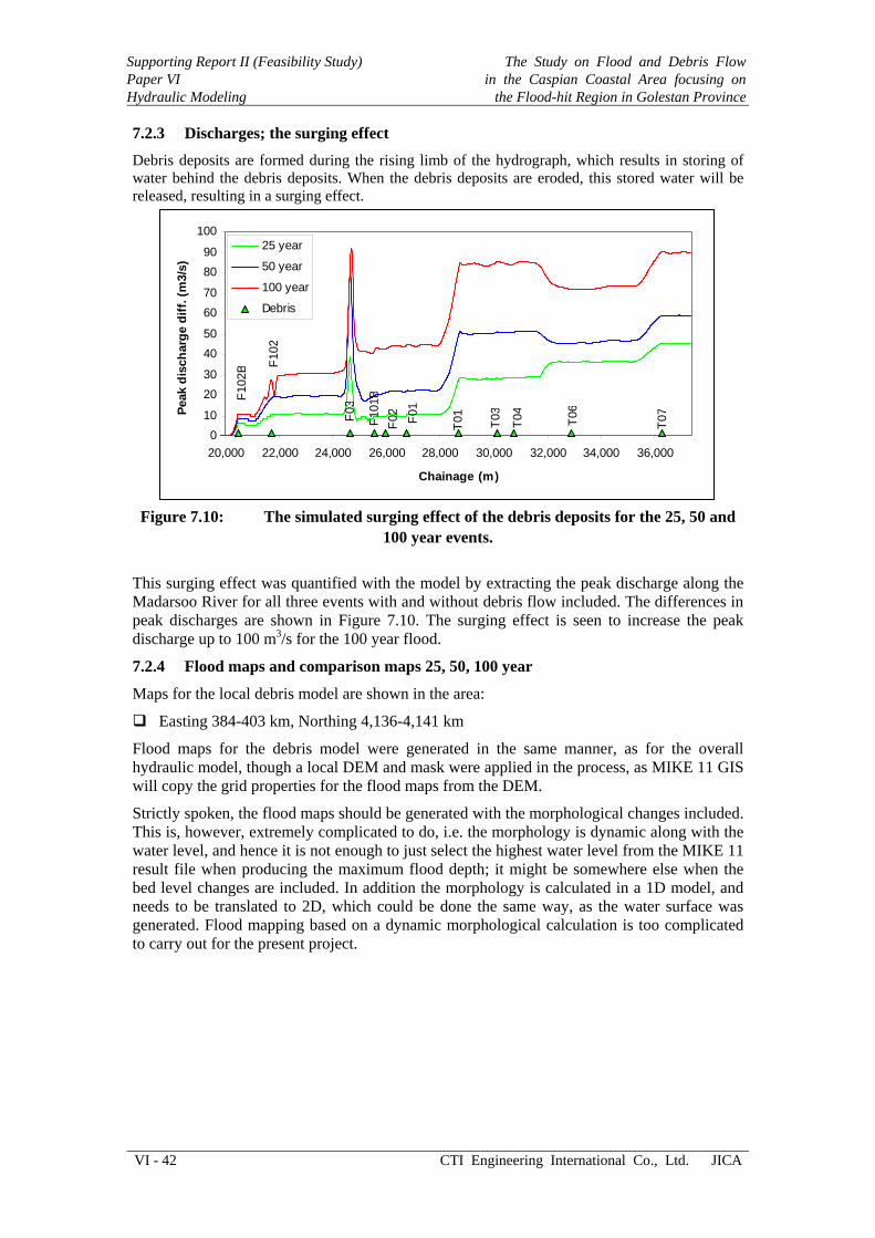
7.2.3 Discharges; the surging effect
Debris deposits are formed during the rising limb of the hydrograph, which results in storing of water behind the debris deposits. When the debris deposits are eroded, this stored water will be released, resulting in a surging effect.
010
2030
4050
6070
8090
100
20,000 22,000 24,000 26,000 28,000 30,000 32,000 34,000 36,000
Chainage (m)
Peak
dis
char
ge d
iff. (
m3/
s)
25 year
50 year
100 year
Debris
F102
B F102
F03
F101
BF0
2F0
1
T01
T03
T04
T06
T07
Figure 7.10: The simulated surging effect of the debris deposits for the 25, 50 and
100 year events.
This surging effect was quantified with the model by extracting the peak discharge along the Madarsoo River for all three events with and without debris flow included. The differences in peak discharges are shown in Figure 7.10. The surging effect is seen to increase the peak discharge up to 100 m3/s for the 100 year flood.
7.2.4 Flood maps and comparison maps 25, 50, 100 year
Maps for the local debris model are shown in the area:
Easting 384-403 km, Northing 4,136-4,141 km
Flood maps for the debris model were generated in the same manner, as for the overall hydraulic model, though a local DEM and mask were applied in the process, as MIKE 11 GIS will copy the grid properties for the flood maps from the DEM.
Strictly spoken, the flood maps should be generated with the morphological changes included. This is, however, extremely complicated to do, i.e. the morphology is dynamic along with the water level, and hence it is not enough to just select the highest water level from the MIKE 11 result file when producing the maximum flood depth; it might be somewhere else when the bed level changes are included. In addition the morphology is calculated in a 1D model, and needs to be translated to 2D, which could be done the same way, as the water surface was generated. Flood mapping based on a dynamic morphological calculation is too complicated to carry out for the present project.
The Study on Flood and Debris Flow in the Caspian Coastal Area focusing on the Flood-hit Region in Golestan Province
Supporting Report II (Feasibility Study)Paper VI
Hydraulic Modeling
JICA CTI Engineering International Co., Ltd. VI - 43
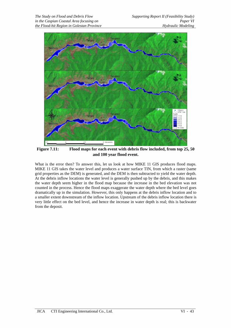
Figure 7.11: Flood maps for each event with debris flow included, from top 25, 50
and 100 year flood event. What is the error then? To answer this, let us look at how MIKE 11 GIS produces flood maps. MIKE 11 GIS takes the water level and produces a water surface TIN, from which a raster (same grid properties as the DEM) is generated, and the DEM is then subtracted to yield the water depth. At the debris inflow locations the water level is generally pushed up by the debris, and this makes the water depth seem higher in the flood map because the increase in the bed elevation was not counted in the process. Hence the flood maps exaggerate the water depth where the bed level goes dramatically up in the simulation. However, this only happens at the debris inflow location and to a smaller extent downstream of the inflow location. Upstream of the debris inflow location there is very little effect on the bed level, and hence the increase in water depth is real; this is backwater from the deposit.

Supporting Report II (Feasibility Study) Paper VI Hydraulic Modeling
The Study on Flood and Debris Flowin the Caspian Coastal Area focusing on
the Flood-hit Region in Golestan Province
VI - 44 CTI Engineering International Co., Ltd. JICA
Figure 7.12: Comparison maps (debris impact) for each flood event, from top 25,
50 and 100 year flood event.
The flood maps are shown in Figure 7.11 while the comparison maps are shown in Figure 7.12.
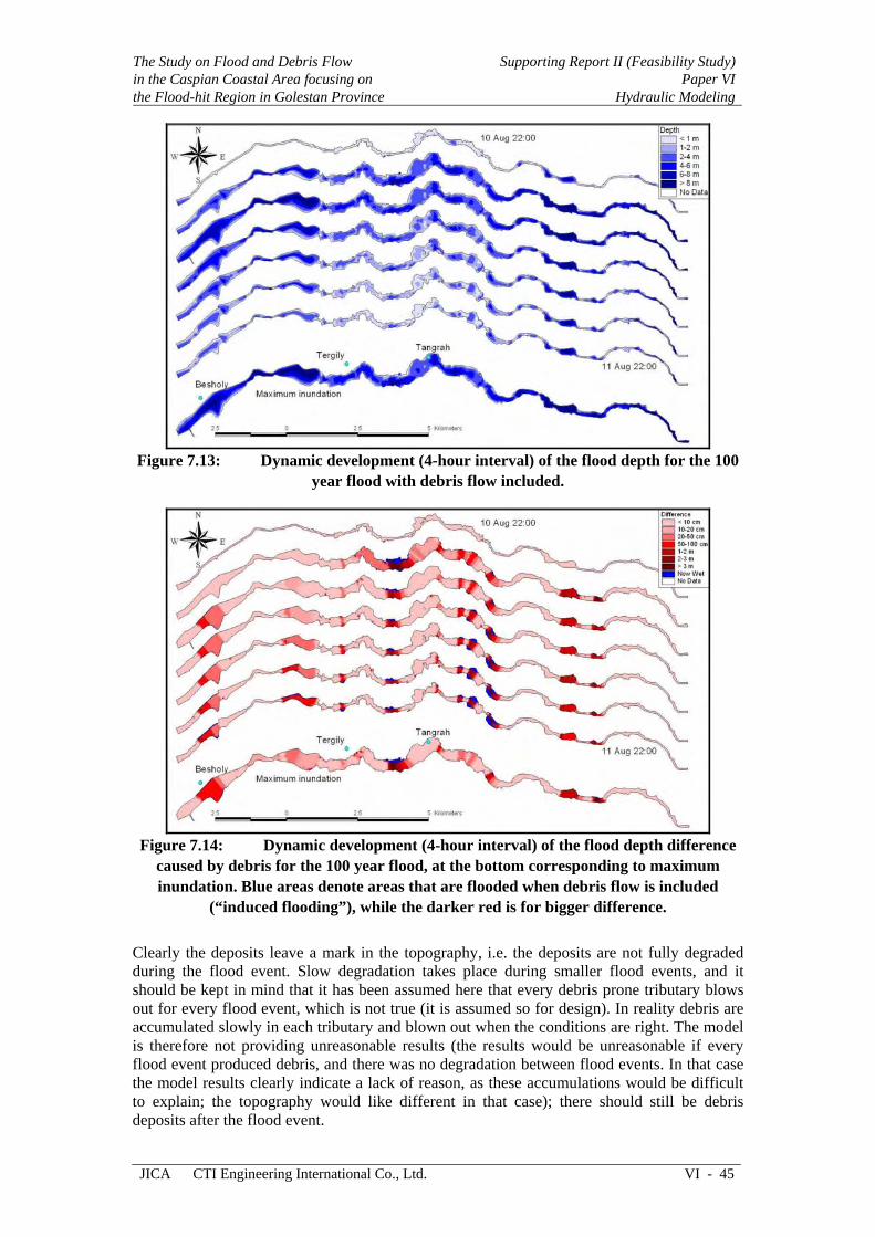
7.2.5 Animation of the 100 year flood
An animation of the 100 year flood is given in the PowerPoint presentation. Here we show the flood development as flood maps every 2 hours along with a comparison map showing the debris flow impact, see Figures 7.13-14.
Among other things it can be seen that some of the debris deposits are still there after the flood, see Figure 7.14. Blue areas show flooding that is present at the considered point in time with debris flow included, and not without.
The Study on Flood and Debris Flow in the Caspian Coastal Area focusing on the Flood-hit Region in Golestan Province
Supporting Report II (Feasibility Study)Paper VI
Hydraulic Modeling
JICA CTI Engineering International Co., Ltd. VI - 45
Figure 7.13: Dynamic development (4-hour interval) of the flood depth for the 100
year flood with debris flow included.
Figure 7.14: Dynamic development (4-hour interval) of the flood depth difference
caused by debris for the 100 year flood, at the bottom corresponding to maximum inundation. Blue areas denote areas that are flooded when debris flow is included
(“induced flooding”), while the darker red is for bigger difference.
Clearly the deposits leave a mark in the topography, i.e. the deposits are not fully degraded during the flood event. Slow degradation takes place during smaller flood events, and it should be kept in mind that it has been assumed here that every debris prone tributary blows out for every flood event, which is not true (it is assumed so for design). In reality debris are accumulated slowly in each tributary and blown out when the conditions are right. The model is therefore not providing unreasonable results (the results would be unreasonable if every flood event produced debris, and there was no degradation between flood events. In that case the model results clearly indicate a lack of reason, as these accumulations would be difficult to explain; the topography would like different in that case); there should still be debris deposits after the flood event.

Supporting Report II (Feasibility Study) Paper VI Hydraulic Modeling
The Study on Flood and Debris Flowin the Caspian Coastal Area focusing on
the Flood-hit Region in Golestan Province
VI - 46 CTI Engineering International Co., Ltd. JICA
7.2.6 Uncertainties in the morphological model
The behavior of the morphological model is obviously dependent on data and calibration parameters. There are many uncertainties:
Debris yield, calculated with an empirical formula. The calculated volumes combined with the valley geometry suggest that debris deposits with a height up to 5-10 m can be formed during a flood.
Debris gravel size and particle size distribution. The JWRC (2004) data suggests a 54 mm median grain size, while we have ignored finer material.
Magnitude of the sediment transport and threshold for sediment movement.
It has been assumed that all debris prone tributaries blow out during an event with the debris volume calculated from the Los Angeles formula.
We do not claim that the morphological model gives a perfect representation of the behavior, but the estimated hydraulic impact should be in the right order of magnitude.
For the present case there is not much doubt that uncertainties in the DEM and calibration parameters by far outweigh the uncertainties in the secondary phenomenon that the hydraulic impact of debris flow must be considered. Furthermore, debris flow was found to be of less importance for the floods, as the study progressed, and debris flow received less emphasis.
The Study on Flood and Debris Flow in the Caspian Coastal Area focusing on the Flood-hit Region in Golestan Province
Supporting Report II (Feasibility Study)Paper VI
Hydraulic Modeling
JICA CTI Engineering International Co., Ltd. VI - 47
CHAPTER 8 CONCLUSIONS
This is the Final Report for the Madarsoo River JICA study carried out by DHI in the periods January-February 2005, June 2005, August-September 2005 and January-February 2006.
The scope of work is given in Appendix B, and the conclusions are given in the same order as the scope.
8.1 Task 1: Obtain and review data The DEM (Digital Elevation Model) is the most important part of a study like this one. Initially an 85 m grid DEM (20 contours) was available, and this is not accurate enough for flood mapping. A DEM was to be generated by Iran Systems from the Quick Bird satellite images, but Iran Systems chose to use a topographical map instead, effectively delivering a DEM that is below the quality standard required for flood mapping, which has been emphasized and documented.
On 24 August 2005 the DEM from Iran Systems was received and quality checked. We found major problems with this DEM, especially in the downstream end where the terrace and incised floodplain were simply absent. Iran Systems promised to obtain more data in the downstream end and came back with a much improved DEM on 12 September 2005. This final DEM was used in the study.
Two satellite images were available for the study, an older coarse image (28.5 m pixel size) referred to in this report as “742”, and a new Quick Bird (60 cm pixel size) provided by Iran Systems. The Quick Bird image is very detailed, but for presentation in this report we preferred the “742” image because the Quick Bird is simply too detailed for the figures presented herein. The results were delivered in digital form, and it is recommended to use the Quick Bird images when using the results.
Two field trips were conducted by the DHI expert. On 11 February 2005 the DHI expert went to Madarsoo River with the JICA Team Leader, a driver and an interpreter to map all bridges along Madarsoo and to gather sediment information. A second field trip was conducted on August 14 2005 just 4 days after the 2005 flood (25 years return period) during which an additional bridge overlooked in the first field survey (Ajen Ghare Khajeh Bridge) was mapped and the downstream end confirmed to be river and not reservoir as earlier claimed by MoE.
A detailed dataset was available from MoE with cross-section lines given in AutoCAD format along with the path of the Madarsoo River and distance-level tables for the cross-sections. The MoE cross-sections sections were too narrow to house the flood extend, and they could not be combined with the DEM due to elevation inconsistencies. Therefore the MoE survey data has been discarded, though it should be stressed that it is discarded due to elevation incompatibilities, while the river location (horizontal) actually matches well with the Quick Bird satellite image. Cross-sections and path of the floodwater (MIKE 11 network) were defined from the Iran Systems DEM. Hence the whole model is based on the DEM, which is usually the smartest move in a situation with major data inconsistencies. 553 cross-sections were digitized and distance-level tables extracted with MIKE 11 GIS. Having taken this step, we also opted for defining the path of the floodwater instead of the meandering river, which is more realistic in a model designed for flood mapping. The model is hence a flood model, and should not be used for low flow, as it simply does not resolve the low flow channel.
Sediment particle size data was obtained from JWRC (2004). The analysis of this data was carried out in February 2005, and it was found that there were two dominant fractions of sediment in the Madarsoo, notably 0.17 mm sand and 54 mm gravel.

Supporting Report II (Feasibility Study) Paper VI Hydraulic Modeling
The Study on Flood and Debris Flowin the Caspian Coastal Area focusing on
the Flood-hit Region in Golestan Province
VI - 48 CTI Engineering International Co., Ltd. JICA
The final list of 19 bridges was compiled and geometry for each bridge estimated from pictures and cross-sections. Inverts were estimated from cross-sections extracted from the DEM to ensure elevation compatibility.
8.2 Task 2: Preliminary 1D Hydraulic Modeling This task was ended in February 2005. The work is not reported herein, as the preliminary model has since been replaced by the final and much more advanced model.
8.3 Task 3: Rainfall Runoff Modeling The hydrology was treated by the DHI hydrologist and the JICA team hydrologist in June 2005, and results were handed over to the DHI hydraulic modeling expert in August 2005. The hydrological results were translated into source points with inflow time-series (upstream inflow, tributary inflows and lateral inflows from runoff) for the single branch Madarsoo model used for flood mapping. Three scenarios were delivered and processed into the single branch model, namely floods with 25, 50 and 100 year return period.
The hydrological model results were translated to inflows and source points for the hydraulic and morphological models in order to allow stand-alone applications of these (without having to use the CPU intense MIKE SHE model).
8.4 Task 4: Tributary Sediment Supply Debris flow was treated by using an empirical relation for the debris yield, known as the Los Angeles District Debris Method. Debris volumes were estimated based on peak discharge, slope and drainage area for 11 tributaries selected from the criterion that a tributary with a history of debris flow is debris prone. These 11 tributaries are all in the Tangrah area with high rainfall intensity and slope. The Los Angeles District Debris Method yielded debris volumes ranging from 4,000-103,000 m3 during a flood, which matched with the anticipated volumes requires for having a significant hydraulic impact. The temporal variation of the debris inflow was determined from the hydrograph for each tributary to construct a distribution function in which the debris inflow is concentrated when the discharge is above 80% of the peak discharge, and proportional to the discharge minus 80% of the peak discharge. This concentrates the debris flow within a few hours. The timing of the debris flow and the Madarsoo hydrograph is very important, and it turned out that the debris flow will take place before the Madarsoo floodwaters arrive from upstream. This required assumptions about the longitudinal distribution of the debris to avoid unrealistic stacking of debris during a debris event when the sediment transport capacity is low in Madarsoo. The debris MIKE 11 model has 11 sediment source points at the locations where the debris prone tributaries join Madarsoo. It is stressed that the MIKE 11 model addresses the hydraulic effect of debris flow.
8.5 Task 5: 1D Hydraulic and Sediment Modeling Two MIKE 11 models were constructed to meet the objectives:
Hydraulic model covering the Madarsoo branch from Dasht to Golestan Reservoir
Morphological model from Golestan Forest to downstream of Besholy
The hydraulic model was used for generating the flood maps, while the local morphological model was used with debris inflow to determine the flooding impact of the debris.
The hydraulic model was constructed with the network digitized from the Iran Systems DEM, and 553 cross-sections extracted from this DEM along the Madarsoo, while boundary conditions were extracted from the hydrological model. The calibration of this model could only be carried out on an engineering judgment level, and we selected a Manning n=0.15 s/m1/3, which should be seen in the light that most of the cross-section is floodplain during the floods. The hydraulic model was applied for the 25, 50 and 100 year events, and flood maps were produced along with animations of the 100 year event.

The Study on Flood and Debris Flow in the Caspian Coastal Area focusing on the Flood-hit Region in Golestan Province
Supporting Report II (Feasibility Study)Paper VI
Hydraulic Modeling
JICA CTI Engineering International Co., Ltd. VI - 49
The morphological model covers a local reach from Golestan Forest to downstream of Besholy. The network was extracted from the hydraulic model, i.e. it is part of the hydraulic model network, and the cross-sections in the morphological reach apply. Boundary conditions were extracted from the overall model, while the same lateral inflows applied. In addition the model was morphological with updating of the river bathymetry, assuming 54 mm gravel, and debris inflows added as sediment inflow sources. The morphological model was applied for determining the hydraulic impact of the debris flow, and it was found that the impact on the flood extent was modest, while fairly large impacts were found on the flood depth.
Debris flow produces a secondary effect compared to the water flow. For the present case there is not much doubt that uncertainties in the DEM and calibration parameters by far outweigh the uncertainties in the debris flow. As the study progressed, debris flow received less emphasis.

Supporting Report II (Feasibility Study) Paper VI Hydraulic Modeling
The Study on Flood and Debris Flowin the Caspian Coastal Area focusing on
the Flood-hit Region in Golestan Province
VI - 50 CTI Engineering International Co., Ltd. JICA
REFERENCES
Takahashi, Tamotsu (1991) “Debris Flow”, IAHR Monograph, 1991
Tahara, Teruo (2005) “The result of basic study for topography and geology”, PowerPoint presentation given at MOJA on January 20, 2005.
US Army Corps of Engineers, Los Angeles District (2000) “Los Angeles District Method for Prediction of Debris Yield”
DHI (January 2005) “Madarsoo MIKE 11 flood and debris flow – Progress Report 1”
DHI (February 2005) “Madarsoo MIKE 11 flood and debris flow – Progress Report 2”
DHI (September 2005) “Madarsoo MIKE 11 flood and debris flow – Progress Report 3”
DHI (June 2005) “Status of the Hydrological modeling in the project ‘The Study on Flood and Debris Flow in the Caspian Coastal Area focusing on the Flood-hit Region in Golestan Province’”, Progress Report by Oluf Z. Jessen.
JWRC (2004) “Report of geo-technical study and stability of material, urgent plan for prevention of damage caused by flood in Gorgan River Basin”, in Farsi (data in English), Jahad Water and Watershed Management Research Company.
Engelund, F. & Hansen, E. (1967), “A monograph on sediment transport in alluvial streams”, Teknisk Forlag, Copenhagen
The Study on Flood and Debris Flow in the Caspian Coastal Area focusing on the Flood-hit Region in Golestan Province
Supporting Report II (Feasibility Study)Paper VI
Hydraulic Modeling
JICA CTI Engineering International Co., Ltd. VI - 51
LIST OF TERMS AND ABBREVIATIONS
DHI Formerly known as the “Danish Hydraulic Institute”, now just DHI Water & Environment, head office in Hørsholm, Denmark
MIKE 11 DHI’s 1-dimensional modeling system based on the Saint-Venant equations integrated over both depth and width of a river
MIKE 21 DHI’s 2-dimensional modeling system, depth-integrated Saint-Venant equations
MIKE SHE DHI’s hydrological modeling system
Cross-section Line that cuts through the river channel and sometimes also floodplain, usually perpen-dicular to the flow direction
Network The MIKE 11 system of branches and their connections
Grid cell size Cell size of the squares that define a grid in ArcView, e.g. 85 m means 85m x 85m cells
Chainage A parameter description coordinate running along a river
Branch A MIKE 11 branch is piecewise linear line with a parameter description called chainage associated with each point on the branch. A unique address in MIKE 11 can hence be given as “branch and chainage”.
Manning M The inverse of Manning n (M=1/n)
Manning n Resistance number used by MIKE 11 (n=1/M)
Source/sink point Any discharge added/subtracted to the MIKE 11 network not an open boundary.
Open boundary In MIKE 11 every end-point on a branch with no further connection is always an open boundary point. Such an open boundary must have a boundary condition assigned, which can be a water level, a discharge or a rating curve. One cannot specify both the water level and the discharge at an open boundary (only a relation through a rating curve).
Boundary condition Mathematical term for a condition imposed on a dependent variable at a boundary, such conditions are required for solving differential equations.
DEM Digital Elevation Model, a map containing elevations in an ordered stricture (grid)
Grid In ArcView a grid is a rectilinear grid that contains elevations in a spatial matrix with a grid origin, cell size and amount of cells. It is a data structure also used in MIKE 21.
Floodplain The plain adjacent to the river channel, which is only inundated for flood conditions
Flood mapping The process of mapping a flood in two dimensions, here based on water levels calculated with a 1-dimensional model and a 2-dimensional DEM
Structure General term in MIKE 11 used for weirs, culverts, bridges etc. Such structures are han-dled by using an energy equation that essentially expresses the discharge as function of the upstream and downstream water levels. The energy equation is used as an internal boundary condition for the discharge.
Continuity equation The conservation of mass expressed for water
Momentum equation Newton’s second law expressed for water
Energy equation An equation replacing the momentum equation for many structures in MIKE 11
ArcView ESRI’s GIS application, ArcView 3.3 is used throughout this project
Supporting Report II (Feasibility Study) Paper VI Hydraulic Modeling
The Study on Flood and Debris Flowin the Caspian Coastal Area focusing on
the Flood-hit Region in Golestan Province
VI - 52 CTI Engineering International Co., Ltd. JICA
GIS Geographic Information System
TIN Triangulated Irregular Network, a special data type found in ArcView
Shape Data type used in ArcView GIS, usually refers to points, lines and polygons
JICA Japanese International Cooperation Agency
Madarsoo The Madarsoo River, also with the old name “Doogh”, which is used in some maps
Golestan The Iranian province in which Madarsoo River basin is located
Golestan Forest Golestan Forest is a national forest located in the upstream Madarsoo valley
Q-point A point in the MIKE 11 network in which the discharge is calculated by solving the mo-mentum equation. Discharges and water levels are staggered in MIKE 11.
H-point A point in the MIKE 11 network in which the water level is calculated by solving the conti-nuity equation. Discharges and water levels are staggered in MIKE 11.
MoE Ministry of Energy (Iran)
MOJA Ministry Of Jihad and Agriculture (Iran)
Staggered grid Numerical allocation of dependent variables at different physical locations in a grid

SUPPORTING REPORT II (FEASIBILITY STUDY)
PAPER VII
Hazard Map Preparation


The Study on Flood and Debris Flow in the Caspian Coastal Area focusing on the Flood-hit Region in Golestan Province
Supporting Report II (Feasibility Study)Paper VII
Hazard Map Preparation
JICA CTI Engineering International Co., Ltd. VII - i
THE STUDY ON FLOOD AND DEBRIS FLOW IN THE CASPIAN COASTAL AREA
FOCUSING ON THE FLOOD-HIT REGION IN GOLESTAN PROVINCE
SUPPORTING REPORT II (FEASIBILITY STUDY)
PAPER VII HAZARD MAP PREPARATION
TABLE OF CONTENTS
Page
CHAPTER 1 HAZARD MAP ......................................................................... VII-1
1.1 Processes of Hazard Map Generation ......................................... VII-1
1.1.1 Simulation of Past Flood Disaster.................................. VII-1 1.1.2 Engineering Field Adjustment ....................................... VII-1 1.1.3 Hazard Map Generation ................................................. VII-2
1.2 Hazard Map Description ............................................................. VII-2
1.2.1 Lowland Plain ................................................................ VII-2 1.2.2 Valley Bottom Plain....................................................... VII-3 1.2.3 Mountain Gorge ............................................................. VII-4 1.2.4 Plateau Plain................................................................... VII-5
CHAPTER 2 EVACUATION ROUTE .......................................................... VII-6
2.1 Terjenly Evacuation Route.......................................................... VII-6
2.2 Tangrah Evacuation Route.......................................................... VII-7
2.3 Dasht Village Evacuation Route ................................................. VII-7
CHAPTER 3 EXPERT HAZARD MAP ........................................................ VII-9
Supporting Report II (Feasibility Study) Paper VII Hazard Map Preparation
The Study on Flood and Debris Flowin the Caspian Coastal Area focusing on
the Flood-hit Region in Golestan Province
VII - ii CTI Engineering International Co., Ltd. JICA
LIST OF FIGURES
Figure 1.1 Simulation Result of 100 Year Flood in Madarsoo River..................... VII-1
Figure 1.2 Engineering Field Adjustment in Gharavol_Haji_Tajy Village ........... VII-1
Figure 1.3 Hazard Map of 100 Year Flood Between Golestan Dam and Kalaleh Bridge................................................................................ VII-3
Figure 1.4 Hazard Map of 100 Year Flood Between Kalaleh Bridge and Loveh Village................................................................................. VII-4
Figure 1.5 Hazard Map of 100 Year Flood Between Loveh and Tangrah Village VII-4
Figure 2.1 Evacuation Route of Terjenly Town..................................................... VII-6
Figure 2.2 Evacuation Route of Tangrah Town ..................................................... VII-7
Figure 2.3 Evacuation Route of Dasht Village....................................................... VII-8
Figure 3.1 Land Collapse Hazard Map in Golestan Park Area .............................. VII-9
The Study on Flood and Debris Flow in the Caspian Coastal Area focusing on the Flood-hit Region in Golestan Province
Supporting Report II (Feasibility Study)Paper VII
Hazard Map Preparation
JICA CTI Engineering International Co., Ltd. VII - 1
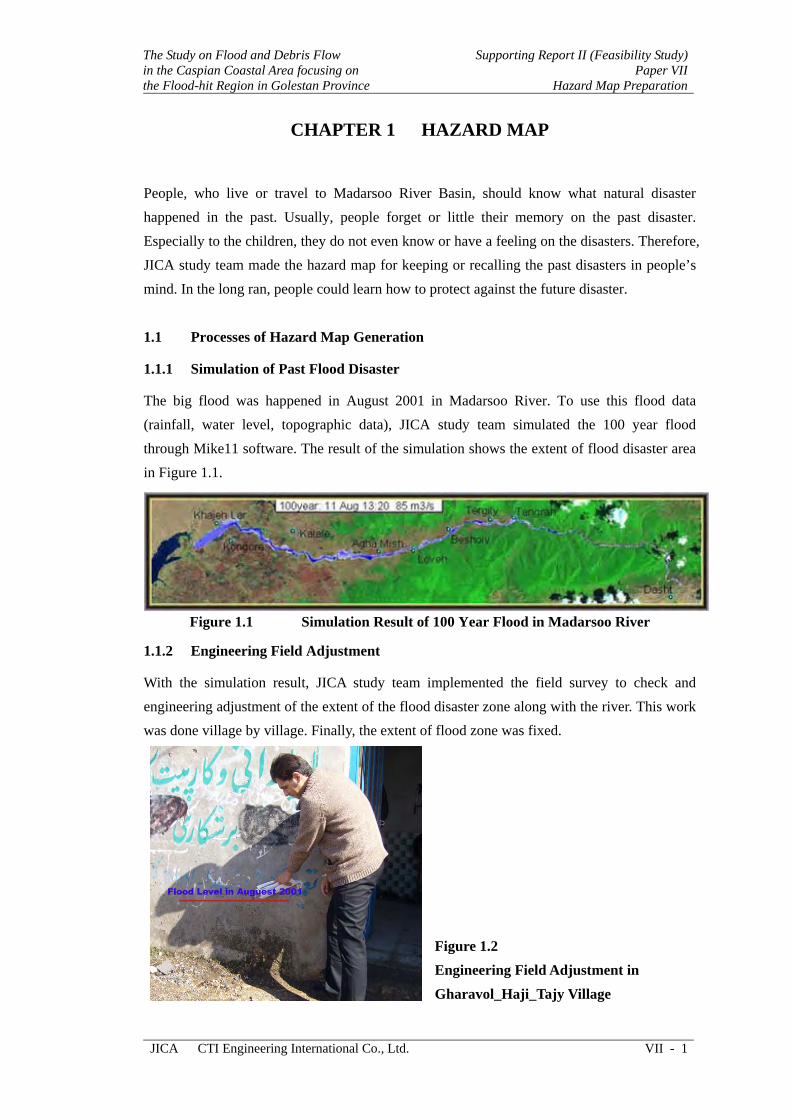
CHAPTER 1 HAZARD MAP
People, who live or travel to Madarsoo River Basin, should know what natural disaster happened in the past. Usually, people forget or little their memory on the past disaster. Especially to the children, they do not even know or have a feeling on the disasters. Therefore, JICA study team made the hazard map for keeping or recalling the past disasters in people’s mind. In the long ran, people could learn how to protect against the future disaster.
1.1 Processes of Hazard Map Generation
1.1.1 Simulation of Past Flood Disaster
The big flood was happened in August 2001 in Madarsoo River. To use this flood data (rainfall, water level, topographic data), JICA study team simulated the 100 year flood through Mike11 software. The result of the simulation shows the extent of flood disaster area in Figure 1.1.
Figure 1.1 Simulation Result of 100 Year Flood in Madarsoo River
1.1.2 Engineering Field Adjustment
With the simulation result, JICA study team implemented the field survey to check and engineering adjustment of the extent of the flood disaster zone along with the river. This work was done village by village. Finally, the extent of flood zone was fixed.
Figure 1.2 Engineering Field Adjustment in Gharavol_Haji_Tajy Village
Supporting Report II (Feasibility Study) Paper VII Hazard Map Preparation
The Study on Flood and Debris Flow in the Caspian Coastal Area focusing on
the Flood-hit Region in Golestan Province
VII - 2 CTI Engineering International Co., Ltd. JICA
1.1.3 Hazard Map Generation
To overlay the flood extent zone, topographic data and satellite images in GIS software, JICA study team generated the hazard map as shown in next session.
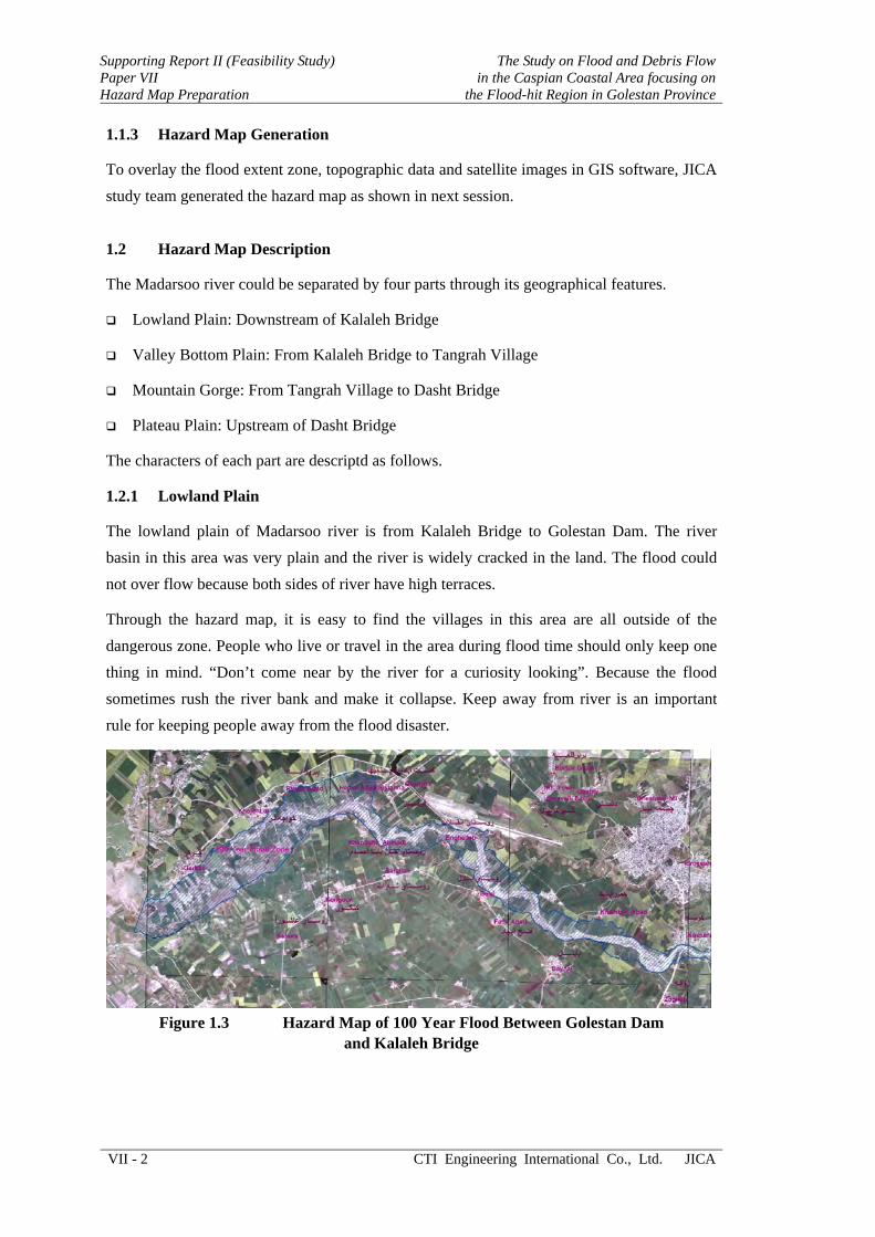
1.2 Hazard Map Description
The Madarsoo river could be separated by four parts through its geographical features.
Lowland Plain: Downstream of Kalaleh Bridge
Valley Bottom Plain: From Kalaleh Bridge to Tangrah Village
Mountain Gorge: From Tangrah Village to Dasht Bridge
Plateau Plain: Upstream of Dasht Bridge
The characters of each part are descriptd as follows.
1.2.1 Lowland Plain
The lowland plain of Madarsoo river is from Kalaleh Bridge to Golestan Dam. The river basin in this area was very plain and the river is widely cracked in the land. The flood could not over flow because both sides of river have high terraces.
Through the hazard map, it is easy to find the villages in this area are all outside of the dangerous zone. People who live or travel in the area during flood time should only keep one thing in mind. “Don’t come near by the river for a curiosity looking”. Because the flood sometimes rush the river bank and make it collapse. Keep away from river is an important rule for keeping people away from the flood disaster.
Figure 1.3 Hazard Map of 100 Year Flood Between Golestan Dam
and Kalaleh Bridge
The Study on Flood and Debris Flow in the Caspian Coastal Area focusing on the Flood-hit Region in Golestan Province
Supporting Report II (Feasibility Study)Paper VII
Hazard Map Preparation
JICA CTI Engineering International Co., Ltd. VII - 3
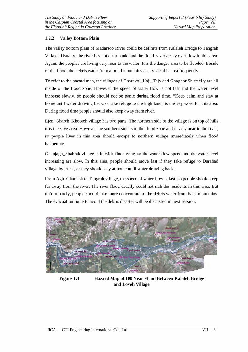
1.2.2 Valley Bottom Plain
The valley bottom plain of Madarsoo River could be definite from Kalaleh Bridge to Tangrah Village. Usually, the river has not clear bank, and the flood is very easy over flow in this area. Again, the peoples are living very near to the water. It is the danger area to be flooded. Beside of the flood, the debris water from around mountains also visits this area frequently.
To refer to the hazard map, the villages of Gharavol_Haji_Tajy and Ghoghor Shirmelly are all inside of the flood zone. However the speed of water flow is not fast and the water level increase slowly, so people should not be panic during flood time. “Keep calm and stay at home until water drawing back, or take refuge to the high land” is the key word for this area. During flood time people should also keep away from river.
Ejen_Ghareh_Khoojeh village has two parts. The northern side of the village is on top of hills, it is the save area. However the southern side is in the flood zone and is very near to the river, so people lives in this area should escape to northern village immediately when flood happening.
Ghanjagh_Shahrak village is in wide flood zone, so the water flow speed and the water level increasing are slow. In this area, people should move fast if they take refuge to Darabad village by truck, or they should stay at home until water drawing back.
From Agh_Ghamish to Tangrah village, the speed of water flow is fast, so people should keep far away from the river. The river flood usually could not rich the residents in this area. But unfortunately, people should take more concentrate to the debris water from back mountains. The evacuation route to avoid the debris disaster will be discussed in next session.
Figure 1.4 Hazard Map of 100 Year Flood Between Kalaleh Bridge
and Loveh Village
Supporting Report II (Feasibility Study) Paper VII Hazard Map Preparation
The Study on Flood and Debris Flow in the Caspian Coastal Area focusing on
the Flood-hit Region in Golestan Province
VII - 4 CTI Engineering International Co., Ltd. JICA
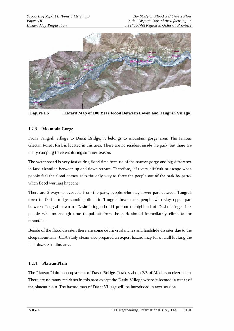
Figure 1.5 Hazard Map of 100 Year Flood Between Loveh and Tangrah Village
1.2.3 Mountain Gorge
From Tangrah village to Dasht Bridge, it belongs to mountain gorge area. The famous Glestan Forest Park is located in this area. There are no resident inside the park, but there are many camping travelers during summer season.
The water speed is very fast during flood time because of the narrow gorge and big difference in land elevation between up and down stream. Therefore, it is very difficult to escape when people feel the flood comes. It is the only way to force the people out of the park by patrol when flood warning happens.
There are 3 ways to evacuate from the park, people who stay lower part between Tangrah town to Dasht bridge should pullout to Tangrah town side; people who stay upper part between Tangrah town to Dasht bridge should pullout to highland of Dasht bridge side; people who no enough time to pullout from the park should immediately climb to the mountain.
Beside of the flood disaster, there are some debris-avalanches and landslide disaster due to the steep mountains. JICA study steam also prepared an expert hazard map for overall looking the land disaster in this area.
1.2.4 Plateau Plain
The Plateau Plain is on upstream of Dasht Bridge. It takes about 2/3 of Madarsoo river basin. There are no many residents in this area except the Dasht Village where it located in outlet of the plateau plain. The hazard map of Dasht Village will be introduced in next session.

The Study on Flood and Debris Flow in the Caspian Coastal Area focusing on the Flood-hit Region in Golestan Province
Supporting Report II (Feasibility Study)Paper VII
Hazard Map Preparation
JICA CTI Engineering International Co., Ltd. VII - 5
CHAPTER 2 EVACUATION ROUTE
Based on above analysis, Town of Terjenly, Tangrah and Dasht village should take refuge from both flood and debris when an evacuation order announced. Therefore JICA study team prepared the evacuation route maps for these 3 areas by using GIS tools. The maps are shown as follows.
2.1 Terjenly Evacuation Route
Terjenly village is covered by danger (red) zone which analyzed from land classification data. The town was separated to three parts by Branch Rivers. They are named as P1, P2 and P3. The safety zone are shown as yellow, they are named as A, B, and C.
During the flood, the evacuation route should follow the green arrow. P1 moves to A; P2 moves to B; P3 moves to C.
Figure 2.1 Evacuation Route of Terjenly Town

Supporting Report II (Feasibility Study) Paper VII Hazard Map Preparation
The Study on Flood and Debris Flow in the Caspian Coastal Area focusing on
the Flood-hit Region in Golestan Province
VII - 6 CTI Engineering International Co., Ltd. JICA
2.2 Tangrah Evacuation Route
Tangrah village is also covered by danger (red) zone. The village was separated to two parts by Tangrah river. It named as P1 and P2. The safety zones for better evacuation are named as A and B.
During the flood, the evacuation route should follow the green arrow. P1 moves to A; P2 moves to B.
Figure 2.2 Evacuation Route of Tangrah Town
2.3 Dasht Village Evacuation Route
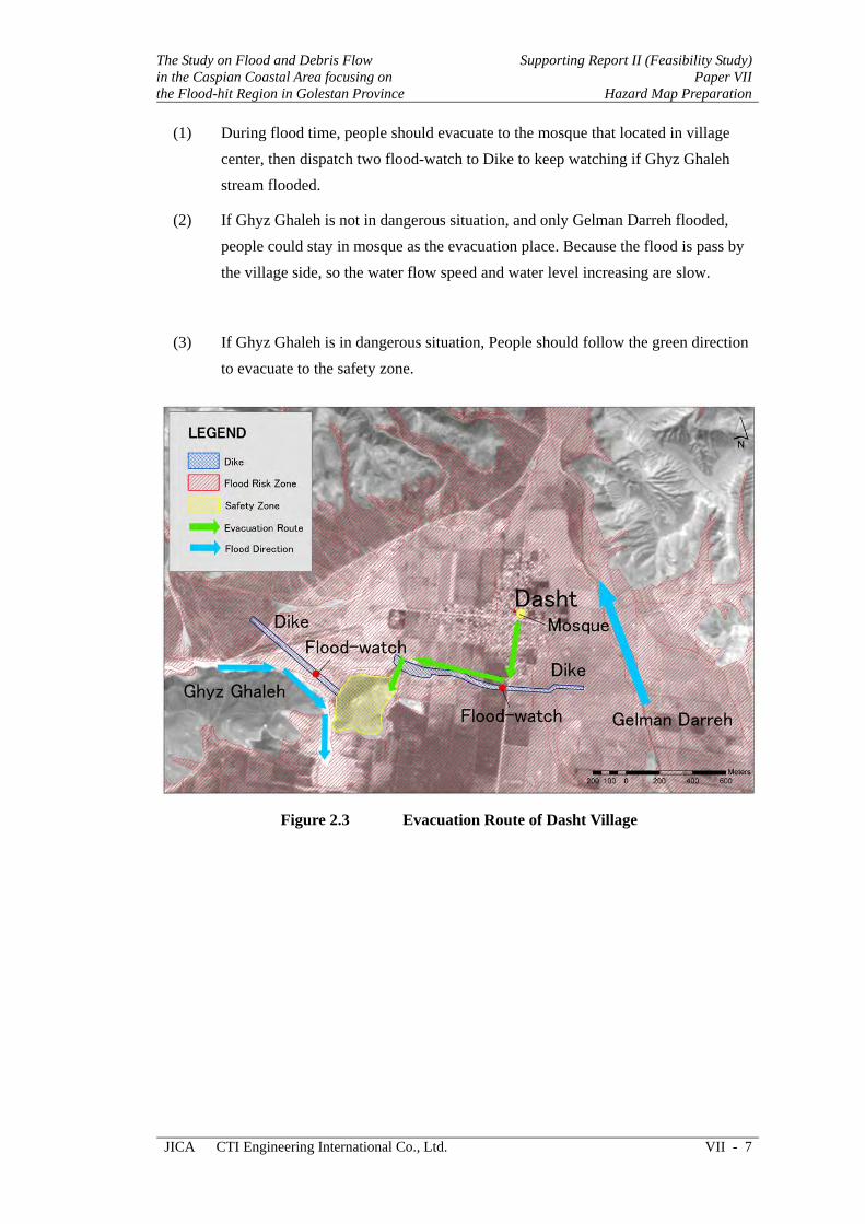
Dasht village is located in the lowest spot of the plateau plain. There are two flood streams around the village. Gelman Darreh stream flows through east of the village, it usually flooded because it owns a huge basin that could collect more rainfall water. Ghyz Ghaleh Stream comes from west of the village, the water stops by the polder dike system.
There is a hill on south-west village could be used as evacuation place. The evacuation rule for Dasht village should be as follows.
The Study on Flood and Debris Flow in the Caspian Coastal Area focusing on the Flood-hit Region in Golestan Province
Supporting Report II (Feasibility Study)Paper VII
Hazard Map Preparation
JICA CTI Engineering International Co., Ltd. VII - 7
(1) During flood time, people should evacuate to the mosque that located in village center, then dispatch two flood-watch to Dike to keep watching if Ghyz Ghaleh stream flooded.
(2) If Ghyz Ghaleh is not in dangerous situation, and only Gelman Darreh flooded, people could stay in mosque as the evacuation place. Because the flood is pass by the village side, so the water flow speed and water level increasing are slow.
(3) If Ghyz Ghaleh is in dangerous situation, People should follow the green direction to evacuate to the safety zone.
Figure 2.3 Evacuation Route of Dasht Village

Supporting Report II (Feasibility Study) Paper VII Hazard Map Preparation
The Study on Flood and Debris Flow in the Caspian Coastal Area focusing on
the Flood-hit Region in Golestan Province
VII - 8 CTI Engineering International Co., Ltd. JICA
CHAPTER 3 EXPERT HAZARD MAP
Beside of above Hazard and Evacuation Route Maps, JICA study team also prepared an Expert Hazard Map for mountain gorge area to show where are easy to cause landslide and debris happen. With this hazard map, River engineer, Landslide engineer and disaster prevention team could analysis the reason of debris and landslide disaster.
Figure 3.1 Land Collapse Hazard Map in Golestan Park Area
SUPPORTING REPORT II (FEASIBILITY STUDY)
PAPER VIII
Initial Environmental Examination for Priority
Project


The Study on Flood and Debris Flow in the Caspian Coastal Area focusing on the Flood-hit Region in Golestan Province
Supporting Report II (Feasibility Study)Paper VIII
Initial Environmental Examination for Priority Project
JICA CTI Engineering International Co., Ltd. VIII - i
THE STUDY ON FLOOD AND DEBRIS FLOW IN THE CASPIAN COASTAL AREA
FOCUSING ON THE FLOOD-HIT REGION IN GOLESTAN PROVINCE
SUPPORTING REPORT II (FEASIBILITY STUDY)
PAPER VIII INITIAL ENVIRONMENTAL EXAMINATION FOR PRIORITY PROJECT
TABLE OF CONTENTS
Page
CHAPTER 1 GENERALITIES .................................................................. VIII-1
CHAPTER 2 DESCRIPTION OF THE PROJECTS SITES................... VIII-4
2.1 Ghiz Ghaleh Sub-basin ........................................................... VIII-6
2.2 Dasht Sheikh Sub-basin .......................................................... VIII-7
2.3 Gelman Darreh Sub-basin....................................................... VIII-9
2.4 Golestan National Park in Middle Reaches of Madarsoo Basin at Sub-basin 5.......................................................................... VIII-10
2.5 Floodplain in Lower Reaches of Madarsoo Basin at Sub-basins 6 and 8 .............................................................. VIII-11
CHAPTER 3 DESCRIPTION OF THE PROJECTS ............................... VIII-12
CHAPTER 4 IMPACT EVALUATION .................................................... VIII-15
4.1 Negative Impacts (Adverse) of the Projects............................ VIII-15
4.1.1 Construction Phase..................................................... VIII-15 4.1.2 Operation/Maintenance Phase.................................... VIII-17
4.2 Positive Impacts (Beneficial) .................................................. VIII-17
4.2.1 Socio-economic Environment.................................... VIII-17 4.2.1 Natural Environment.................................................. VIII-17 4.2.2 Cultural Environment................................................. VIII-18 4.2.3 Projects with Non-structural Measures ...................... VIII-18
4.3 Result of Environmental Evaluation ....................................... VIII-19
Supporting Report II (Feasibility Study) Paper VIII Initial Environmental Examination for Priority Project
The Study on Flood and Debris Flowin the Caspian Coastal Area focusing on
the Flood-hit Region in Golestan Province
VIII - ii CTI Engineering International Co., Ltd. JICA
CHAPTER 5 ALTERNATIVES.................................................................. VIII-20
5.1 Without Project (no action)...................................................... VIII-20
5.2 Relocation of Village being Threaten by Sediment ................. VIII-20
5.3 Decisions and Nomination of Alternative................................ VIII-21
CHAPTER 6 IMPACT MITIGATION ...................................................... VIII-23
6.1 Mitigation and Precautions for Construction Phase................. VIII-23
6.2 Mitigation and Precautions for Operation Phase ..................... VIII-23
CHAPTER 7 PUBLIC CONSULTATION MEETING............................. VIII-25
7.1 Sequence of Presentation ......................................................... VIII-25
7.2 Questions and Comments by Participants................................ VIII-30
7.3 Answers and Additional Explanation by Organizers (JICA Team, MOJA) ............................................................... VIII-31
7.4 Results of the Meeting ............................................................. VIII-31
CHAPTER 8 CONCLUSION AND RECOMMENDATIONS................. VIII-33
8.1 Conclusion ............................................................................... VIII-33
8.2 Recommendations.................................................................... VIII-33
8.3 Advisory points........................................................................ VIII-34
LIST OF TABLES
Table 2.1 Land Cover of Ghiz Ghaleh Sub-basin .............................................. VIII-7
Table 2.2 Land Cover of Dasht Sheikh Sub-basin ............................................. VIII-8
Table 2.3 Land Cover of Gelman Darreh Sub-basin.......................................... VIII-9
LIST OF FIGURES
Figure 2.1 Satellite Image of Madarsoo River Basin with Topographic Categorization .................................................................................... VIII-5
Figure 2.2 Longitudinal Profile of the Madarsoo River (Mainstream) ............... VIII-5
Figure 2.3 Madarsoo River Basin with its Sub-basins ........................................ VIII-6
Figure 3.1 Situation of the Breached Dam in Ghiz Ghaleh Sub-basin at Upperstream of Dasht Village........................................................ VIII-13
Figure 3.2 Situation of Madarsoo River Bank at Downstream of Dasht Village ................................................................................. VIII-13
Figure 7.1 Proposed Arrangement of River Restoration Plan ..................................... VIII-26
The Study on Flood and Debris Flow in the Caspian Coastal Area focusing on the Flood-hit Region in Golestan Province
Supporting Report II (Feasibility Study)Paper VIII
Initial Environmental Examination for Priority Project
JICA CTI Engineering International Co., Ltd. VIII - 1
CHAPTER 1 GENERALITIES
Note: This Initial Environmental Examination (IEE) has been prepared as part of Feasibility Study (FS) conducted by Japan International Cooperation Agency (JICA) Study Team on priority projects. Thus it should be read in couple with the Feasibility Study Report (FS/R), and other materials such as Interim Report (master plan) prepared by JICA study team, chiefly available at URL: http://www.jica-madarsoo-study.com/ and the relevant links.
Review of reports and other materials prepared by Ministry of Jihad-e-Agriculture (MOJA), Ministry of Energy (MOE) and the Ministry of Road and Transportation (MORT) for their projects in the area is also recommended. Most of these reports and materials are available in the office of flood mitigation coordination committee with the contact number given below: Telephone: (0171) 4422592 Fax: (0171) 4422592
For receiving advise and discussing environmental issues relating to the project area, General Directorate of Environment in Golestan province can be approached at following numbers: Telephone: (0171) 5524461 Fax: (0171) 5524561
Any matter related to sites of historical, cultural and religious importance, could be discussed with General Directorate of Cultural Heritage and Tourism Organization at number below:
Telephone: (0171) 2241868 Fax: (0171) 2241180
Website: http://www.gorganmiras.org
Initial Environmental Examination (IEE) refers to initial examination for estimating probable environmental impacts in order to ascertain whether a full-scale examination of impacts, i.e., an Environmental Impact Assessment (EIA) is required or not. Generally IEE is carried out over a short period with a limited budget and use of existing data coupled with simple field surveys. Experience of environment specialist in similar project is also of great help.
Major components of IEE include identification of project outline and of site environmental conditions (project explanation and site description), preliminary assessment of project’s environmental impacts, and evaluation whether Environmental Impact Assessment (EIA) is required for the project or not. Environmental impact refers to effect of project on natural (air, water, soil, vegetation, wildlife), social-economic (population, economic activities, income, employment, institution, infrastructures), and cultural (historical/cultural asset) environments. As a basic concept, both negative (adverse) and positive (beneficial) impacts are identified and evaluated. A project with no/least negative impact on natural, socio-economic, and cultural environments, or with reversible impact, is environmentally rational, thus can be implemented.
The IEE describe herein was conducted to determine the environmental soundness of priority projects proposed by JICA team for Feasibility Study, in Madarsoo River Basin. Details of priority projects are provided in fore-coming sections.
Project title: The Study on Flood and Debris Flow in the Caspian Coastal Area Focusing on the Flood-Hit Region in Golestan Province in the Islamic Republic of Iran

Supporting Report II (Feasibility Study) Paper VIII Initial Environmental Examination for Priority Project
The Study on Flood and Debris Flow in the Caspian Coastal Area focusing on
the Flood-hit Region in Golestan Province
VIII - 2 CTI Engineering International Co., Ltd. JICA
Project proponent: Deputy for Watershed Management, Forest, Range and Watershed Management Organization, Ministry of Jihad-e-Agriculture, Islamic Republic of Iran
Environmental categorization and its reason
Category: B
Reason: The project is classified into Category B basing on output of Environmental Scoping and result of Initial Environmental Examination for the Master Plan, which revealed that all probable impacts could be mitigated by adopting proper construction methods and precautionary measures. Moreover careful examination of the projects components indicates that all are environment-friendly, contributing to sustainable utilization of natural resources and ensuring safety of inhabitants.
Laws, Regulations and Guidelines under which the IEE has been conducted
Article 50 of current Constitution of the Islamic Republic of Iran
Law of Fourth Five-year Socio-economic and Cultural development Plan of the Islamic Republic of Iran- 2004
Islamic Punishment Law (Taazirat)- 2003
Regulation Concerning the Requirement of Environmental Impact Assessment in Developmental projects. Department of the Environment - 1994
Environmental Guidelines and Standards. Department of the Environment- 2003
Management and Planning Organization. Guidelines for Environmental Assessment of River Engineering Projects- 1999
Japan International Cooperation Agency. Guidelines for Environmental and Social Consideration- 2004.
To enrich the IEE, spirit of international norms, treaties and conventions, such as United Nations Conference on Environment and Development (Agenda 21 of Earth Summit- Rio 1992) was infused into it. Principles of Japanese Official Development Assistance (ODA) were also observed.
Aims of IEE for the Priority Projects
In principle the IEE aimed to:
(1) Describe present conditions of sites of priority projects
(2) Present outline of the projects
(3) Predict/assess potential environmental impacts (adverse and beneficial) of the projects
(4) Provide measures/guidance for mitigating adverse impacts and enhancing the beneficial impacts of the projects
(5) Holding public consultation meetings to disclose the projects information and encourage people participation in projects activities. These issues are emphasized by JICA to ensure transparency and accountability, as well as to solicit active participation of local people in project activities, through which sustainability of development is guaranteed.
Purpose of the projects
(i) Consolidate sediment in river channel, particularly on upstream of Dasht village, to retard its spread and reduce its damages to rangeland, farmland, and
The Study on Flood and Debris Flow in the Caspian Coastal Area focusing on the Flood-hit Region in Golestan Province
Supporting Report II (Feasibility Study)Paper VIII
Initial Environmental Examination for Priority Project
JICA CTI Engineering International Co., Ltd. VIII - 3
infrastructures at downstream, through restoration of dam breached by flood in the year 2001
(ii) Bringing-about increment in groundwater recharge through delay in flood passage and water holding phenomena of sediment
(iii) Stabilize bank of Madarsoo river at downstream of Dasht village to reduce soil erosion and land degradation
(iv) Provide timely disaster warning to people and urge them to leave the area, thereby saving public lives and movable assets.
(v) Distribute hazard maps to people and relief agencies, showing them the proper routes for reaching to safe places, when disaster occurs.

Supporting Report II (Feasibility Study) Paper VIII Initial Environmental Examination for Priority Project
The Study on Flood and Debris Flow in the Caspian Coastal Area focusing on
the Flood-hit Region in Golestan Province
VIII - 4 CTI Engineering International Co., Ltd. JICA
CHAPTER 2 DESCRIPTION OF THE PROJECTS SITES
Among the projects formulated by JICA Study Team through the Master Plan Study, three projects were prioritized based on their urgent needs for implementation (see JICA interim report, September- 2005 for details). As a part of Feasibility Study on these priority projects, this Initial Environmental Examination (IEE) was conducted to justify the environmental soundness of the projects and clarify their overall merits for the area. The priority projects are of two categories; here refer to projects with structural measures and projects with non-structural measures, which are explained in detail in next section under title of Description of the Projects. The projects will be implemented in different sub-basins of Madarsoo river basin, each having its own particular characteristics, as outlined below:
Overview of entire Madarsoo river basin However detailed information and data for entire Madarsoo river basin are provided in JICA Interim Report (master plan)- 2005 (particularly in IEE report for master plan), once again overview of pronounced features of the basin is provided hereunder, to contribute in better understanding of situation of sites designated for priority projects.
From topographical viewpoint Madarsoo River Basin is categorized into three parts, as mentioned below and shown in Figure 2.1.
(1) Mountain and highland area of headwaters
This area encompasses the rangelands and farmlands in which mostly dry farming is practiced. Due to over-grazing, the vegetation cover is poor, and soil erosion by gullies and rills occurs all over the headwaters. Such erosion in the headwaters results in accelerating disastrous force during floods by supplying eroded soils and debris to the downstream areas.
(2) Steep valley of middle reaches
The river channel in middle reaches is the steepest part over the entire stretch of the Madarsoo River. Arterial road connecting to Mashhad and the river course cross each other frequently in the reaches. Under such situations floodwater may destroy the related structures, bridges and road embankment. Furthermore, people visiting the Golestan National park may encounter the disaster of flashflood caused by local downpour, particularly in tourist season (July-August).
(3) Alluvial plain and hills of lower reaches
In the lower reaches, agricultural land extends over the floodplains, and villages scatter along the river course. In some parts lots of houses encroach on the river course so that the damage potential in human lives as well as private assets will increase against floods.
The river channel of the Madarsoo mainstream is steep with a slope ranging from 1/50 (2 %) to 1/150 (0.7%) as illustrated in Figure 2.2. In particular the channel of middle reaches, which are located in the national park of the Golestan Forest, is the steepest portion along the mainstream. In the 2001 flood, disastrous flashflood washed away hundreds tourists and campers who visited to the national park, and finally killed three hundreds of them.
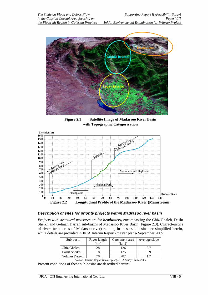
The Study on Flood and Debris Flow in the Caspian Coastal Area focusing on the Flood-hit Region in Golestan Province
Supporting Report II (Feasibility Study)Paper VIII
Initial Environmental Examination for Priority Project
JICA CTI Engineering International Co., Ltd. VIII - 5
Headwaters
Middle Reaches
Lower Reaches
Figure 2.1 Satellite Image of Madarsoo River Basin
with Topographic Categorization
Figure 2.2 Longitudinal Profile of the Madarsoo River (Mainstream)
Description of sites for priority projects within Madrasoo river basin Projects with structural measures are for headwaters, encompassing the Ghiz Ghaleh, Dasht Sheikh and Gelman Darreh sub-basins of Madarsoo River Basin (Figure 2.3). Characteristics of rivers (tributaries of Madarsoo river) running in these sub-basins are simplified herein, while details are provided in JICA Interim Report (master plan)- September 2005.
Sub-basin River length(km)
Catchment area(km2)
Average slope
Ghiz Ghaleh 28 126 2.7 Dasht Sheikh 18 125 3.9 Gelman Darreh 70 787 1.7
Source: Interim Report (master plan), JICA Study Team- 2005 Present conditions of these sub-basins are described herein:

Supporting Report II (Feasibility Study) Paper VIII Initial Environmental Examination for Priority Project
The Study on Flood and Debris Flow in the Caspian Coastal Area focusing on
the Flood-hit Region in Golestan Province
VIII - 6 CTI Engineering International Co., Ltd. JICA
2.1 Ghiz Ghaleh Sub-basin The Ghiz Ghaleh sub-basin with an area of 126 km2 is suited in administrative boundary of Semnan and Khorasan provinces. About 50% of the area of this sub-basin occurs in Golestan National Park, which is under authority of Department of the Environment of Iran.
Climate and setting
Average annual rainfall is about 305 mm, mean annual temperature is 10.7 ℃, and climate is of cool semi-dry type. Average elevation is 1600 m, and average slope is 16.8% with an east-west direction. Drain-ability of the basin ranges from moderate to very good.
Geology The geology of Ghiz Ghaleh sub-basin is comprised of sediments and rocks belonging to Pre-Cambrian, Jurassic, Cretaceous, and Quaternary periods. The materials consist of limestone, shale, quartz, marl, conglomerate, and loess.
Geo-morphology Major landforms in this sub-basin are Mountain, Hill, and Terraces. The terraces are mainly composed of loess- materials apparently transported by wind and deposited in the area.
Soil and land Most of soils are deep to moderately deep, medium texture, having high percentage of gravel and stone with rock outcrops in some localities. Most of soils are sandy loam, sandy clay and silt occurring on step slopes. However most of lands are under natural vegetation (rangeland and forest) as well used for cultivation, they have limitation such as steep slope, high % of gravel and stone, rock outcrop, erosion, and undulation, which reduce their productivity, and affect their suitability for large scale agriculture.
Erosion Major forms of erosion are sheet, rill, bank, channel, and gully. In some localities sign of landslide is also seen. Channel and sheet erosion are the most common form.
Figure 2.3 Madarsoo River Basin with its Sub-basins

The Study on Flood and Debris Flow in the Caspian Coastal Area focusing on the Flood-hit Region in Golestan Province
Supporting Report II (Feasibility Study)Paper VIII
Initial Environmental Examination for Priority Project
JICA CTI Engineering International Co., Ltd. VIII - 7
Land cover Natural vegetation in low elevation areas is mainly comprised of shrubs (Artemisia) and grasses (Stipa), while in high elevation Quercus (oak) and Juniperus (Juniper) trees are seen. Information for natural vegetation and land cover of Ghiz Ghaleh basin is given in Table 2.1.
Table 2.1 Land Cover of Ghiz Ghaleh Sub-basin Type Cover Area (ha) % Of total area Remarks
Meadow Cynadon + Carex 202 1.6 Bush-land Artemisia + Stipa 5,972 47.4 Rangeland Festuca + Stipa 806 6.4 Woodland Juniperus + Artemisia 415 3.3 Most part protected Forest Quercus + Carpinus 1777 14.1 Most part protected Cultivation Wheat, barley, and
sunflower 2873 22.8
Rock-outcrop Limestone, sandstone, conglomerate
328 2.6
Others Villages + bare lands 227 1.8 Include infrastructuresTotal 12600 100
Sources: Report of Ghiz Ghaleh Basin, Golestan Provincial Jihad-e-Agriculture Organization- 2003 Interim Report (master plan), JICA Study Team- 2005
Wildlife Some of animals usually roaming in the basin are bear, wild sheep, wild goat, rabbit, rate, porcupine and sable. Birds such as partridge, eagle, falcon and pigeon, as well reptiles such as snake and scorpion are commonly seen in the area.
Cultural/historical/religious site Ghiz Ghaleh castle of historical value exist in this sub-basin, but is far from construction site, thus implementation of the projects has no any impact on it.
Socio-economy Total number of households in this sub-basin is 293, having a population of 1422 inhabitants, who live in Dasht Shad village. Population density in the area is 10.6 persons/km2. Male to female ratio is 0.95, means 95 males against 100 females. About 92% of population is able to read and write, and literacy rate for male and female is 95% and 89%, respectively. Average annual population growth rate is about at 1.5%.
Main infrastructures in the area are primary and secondary schools, mosque, medical clinic, sanitary office, telephone office and library. It should be noted that lives of inhabitants are not directly subjected to flood disaster, but large flood damages their farmland, as did the flood in the year 2001. For more information see Attachments of this IEE report.
2.2 Dasht Sheikh Sub-basin Dasht Sheik sub-basin with an area of 125 km2 occurs in Khorasan province, and has the following characteristics:
Climate and setting
Average annual rainfall is about 256 mm, mean annual temperature is 11.6 ℃, and climate is of cool semi-dry type. Average elevation is 1327 m, and average slope is 14.1% with north direction. Drain-ability of the basin is good therefore one permanent and several seasonal springs exist in this area.

Supporting Report II (Feasibility Study) Paper VIII Initial Environmental Examination for Priority Project
The Study on Flood and Debris Flow in the Caspian Coastal Area focusing on
the Flood-hit Region in Golestan Province
VIII - 8 CTI Engineering International Co., Ltd. JICA
Geology The geology of Dasht Sheikh sub-basin is composed of limestone, sandstone, shale, marl, conglomerate and loess, belonging to Jurassic, Cretaceous, and Quaternary periods.
Geo-morphology Major landforms in this sub-basin are Mountain, Hill, Upper terraces and Floodplain.
Soil and land Most of soils are shallow to moderately deep, medium to heavy texture, having high percentage of gravel and stone, and subjected to erosion, salinity and flood. Soils occurring on moderate to steep slopes contain high percentage of silt and sand and low amount of organic matter. Lands on elevated areas are usually under natural vegetation (rangeland), while dry farming and irrigated agriculture are commonly practiced on terraces and in floodplain.
Erosion Main forms of erosion in this sub-basin are sheet, rill and gully erosion.
Land cover Land cover of Dasht Sheikh Sub-basin is simplified in Table 2.1 below.
Table 2.2 Land Cover of Dasht Sheikh Sub-basin Type Area (ha) % Of total Remark
Halophyte 346 2.7 Shrub-land 8,877 71.1 Mostly of Artemisia species Bush-land 314 2.5 Grassland 168 1.3 Cultivation 3,226 18.6 Some portion irrigated Others 469 3.8 Residential area and bare lands
Total 12,500 100 Sources: Report of Dasht Sheikh Basin, Golestan Provincial Jihad-e-Agriculture Organization- 2003 Interim Report (master plan), JICA Study Team- 2005
Wildlife Animal such as wild pig, bear, wolf, jackal, fox, rabbit, rate, and snake, as well birds such as pigeon and partridge are commonly seen in the area.
Cultural/historical/religious site Mausoleum of Imam Zadeh Daniel of religious, historical and cultural values exist in this sub-basin, but is from construction site, thus implementation of the projects has no impact on it.
Socio-economy. Two villages of Dasht and Bidak are in this sub-basin, with total household number of 377, and total population of 1,523 inhabitants. Population density in the area is 12.5 persons/km2.
Male to female ratio is 1.2, means for each 120 male there are 100 females. About 90% of the population can read and write, and literacy rate for male and female is 81% and 78%, respectively. Widely available infrastructure/public facilities are primary, secondary and high schools, medical clinic, sanitary office, telephone office, common bath, mosque, playground, sundry shop, and bakery. For detail see the Attachments of this IEE report.
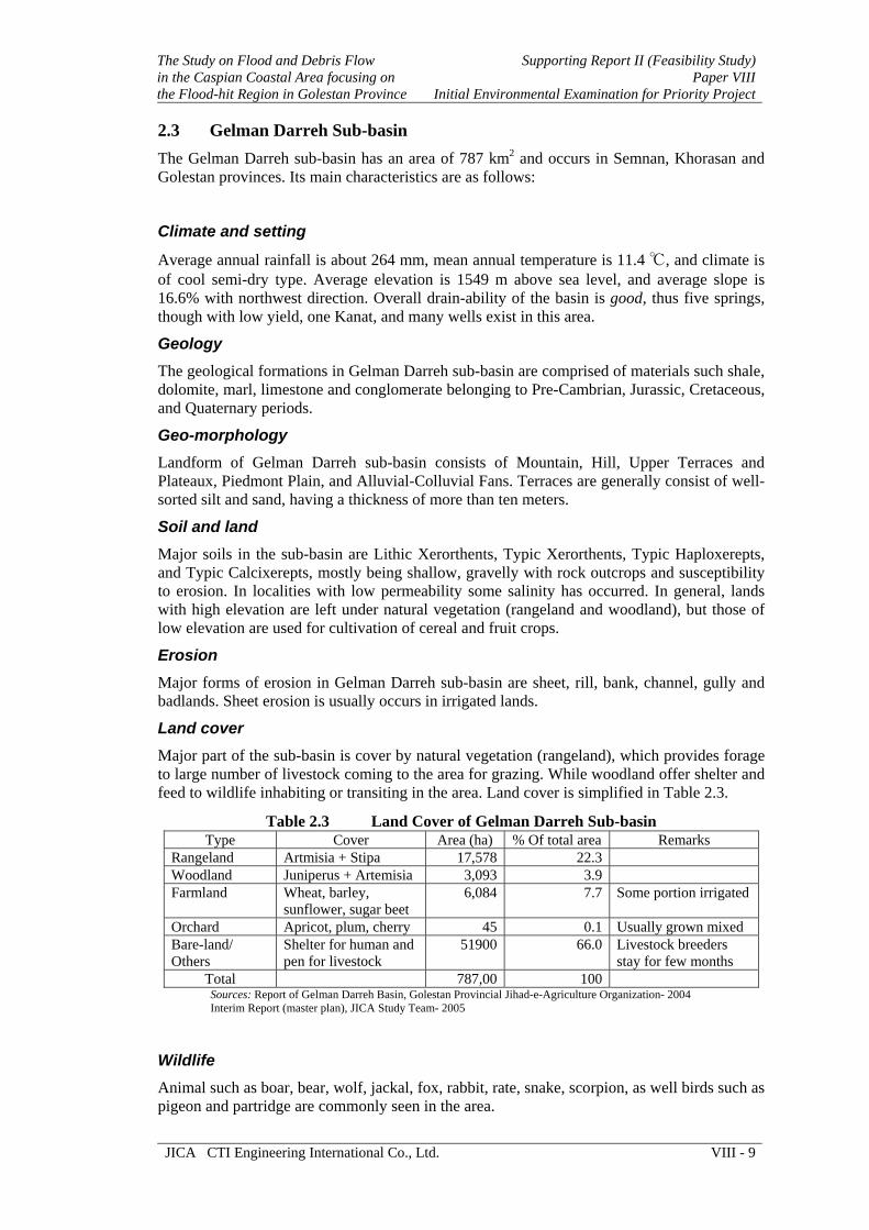
The Study on Flood and Debris Flow in the Caspian Coastal Area focusing on the Flood-hit Region in Golestan Province
Supporting Report II (Feasibility Study)Paper VIII
Initial Environmental Examination for Priority Project
JICA CTI Engineering International Co., Ltd. VIII - 9
2.3 Gelman Darreh Sub-basin The Gelman Darreh sub-basin has an area of 787 km2 and occurs in Semnan, Khorasan and Golestan provinces. Its main characteristics are as follows:
Climate and setting
Average annual rainfall is about 264 mm, mean annual temperature is 11.4 ℃, and climate is of cool semi-dry type. Average elevation is 1549 m above sea level, and average slope is 16.6% with northwest direction. Overall drain-ability of the basin is good, thus five springs, though with low yield, one Kanat, and many wells exist in this area.
Geology The geological formations in Gelman Darreh sub-basin are comprised of materials such shale, dolomite, marl, limestone and conglomerate belonging to Pre-Cambrian, Jurassic, Cretaceous, and Quaternary periods.
Geo-morphology Landform of Gelman Darreh sub-basin consists of Mountain, Hill, Upper Terraces and Plateaux, Piedmont Plain, and Alluvial-Colluvial Fans. Terraces are generally consist of well-sorted silt and sand, having a thickness of more than ten meters.
Soil and land Major soils in the sub-basin are Lithic Xerorthents, Typic Xerorthents, Typic Haploxerepts, and Typic Calcixerepts, mostly being shallow, gravelly with rock outcrops and susceptibility to erosion. In localities with low permeability some salinity has occurred. In general, lands with high elevation are left under natural vegetation (rangeland and woodland), but those of low elevation are used for cultivation of cereal and fruit crops.
Erosion Major forms of erosion in Gelman Darreh sub-basin are sheet, rill, bank, channel, gully and badlands. Sheet erosion is usually occurs in irrigated lands.
Land cover Major part of the sub-basin is cover by natural vegetation (rangeland), which provides forage to large number of livestock coming to the area for grazing. While woodland offer shelter and feed to wildlife inhabiting or transiting in the area. Land cover is simplified in Table 2.3.
Table 2.3 Land Cover of Gelman Darreh Sub-basin Type Cover Area (ha) % Of total area Remarks
Rangeland Artmisia + Stipa 17,578 22.3 Woodland Juniperus + Artemisia 3,093 3.9 Farmland Wheat, barley,
sunflower, sugar beet 6,084 7.7 Some portion irrigated
Orchard Apricot, plum, cherry 45 0.1 Usually grown mixed Bare-land/ Others
Shelter for human and pen for livestock
51900 66.0 Livestock breeders stay for few months
Total 787,00 100 Sources: Report of Gelman Darreh Basin, Golestan Provincial Jihad-e-Agriculture Organization- 2004 Interim Report (master plan), JICA Study Team- 2005
Wildlife Animal such as boar, bear, wolf, jackal, fox, rabbit, rate, snake, scorpion, as well birds such as pigeon and partridge are commonly seen in the area.
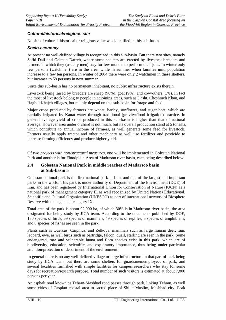
Supporting Report II (Feasibility Study) Paper VIII Initial Environmental Examination for Priority Project
The Study on Flood and Debris Flow in the Caspian Coastal Area focusing on
the Flood-hit Region in Golestan Province
VIII - 10 CTI Engineering International Co., Ltd. JICA
Cultural/historical/religious site No site of cultural, historical or religious value was identified in this sub-basin.
Socio-economy. At present no well-defined village is recognized in this sub-basin. But there two sites, namely Safid Dali and Gelman Darreh, where some shelters are erected by livestock breeders and farmers in which they (usually men) stay for few months to perform their jobs. In winter only few persons (watchmen) are in the area, while in summer when families unit, population increase to a few ten persons. In winter of 2004 there were only 2 watchmen in these shelters, but increase to 59 persons in next summer.
Since this sub-basin has no permanent inhabitant, no public infrastructure exists therein.
Livestock being raised by breeders are sheep (90%), goat (9%), and cow/others (1%). In fact the most of livestock belong to people in adjoining areas, such as Dasht, Cheshmeh Khan, and Haghol Khajeh villages, but mainly depend on this sub-basin for forage and feed.
Major crops produced by farmers are wheat, barley, sunflower, and sugar beet, which are partially irrigated by Kanat water through traditional (gravity/flood irrigation) practice. In general average yield of crops produced in this sub-basin is higher than that of national average. However area under orchard is not much, but its overall production stand at 5 tons/ha, which contribute to annual income of farmers, as well generate some feed for livestock. Farmers usually apply tractor and other machinery as well use fertilizer and pesticide to increase farming efficiency and produce higher yield.
Of two projects with non-structural measures, one will be implemented in Golestan National Park and another is for Floodplain Area of Madrasoo river basin, each being described below:
2.4 Golestan National Park in middle reaches of Madarsoo basin at Sub-basin 5
Golestan national park is the first national park in Iran, and one of the largest and important parks in the world. This park is under authority of Department of the Environment (DOE) of Iran, and has been registered by International Union for Conservation of Nature (IUCN) as a national park of management category II, as well recognized by United Nations Educational, Scientific and Cultural Organization (UNESCO) as part of international network of Biosphere Reserve with management category IX.
Total area of the park is about 92,000 ha, of which 30% is in Madrasoo river basin, the area designated for being study by JICA team. According to the documents published by DOE, 150 species of birds, 69 species of mammals, 49 species of reptiles, 5 species of amphibians, and 8 species of fishes are seen in the park.
Plants such as Quercus, Carpinus, and Zelkova; mammals such as large Iranian deer, ram, leopard, ewe, as well birds such as partridge, falcon, quail, starling are seen in the park. Some endangered, rare and vulnerable fauna and flora species exist in this park, which are of biodiversity, education, scientific, and exploratory importance, thus being under particular attention/protection of department of the environment.
In general there is no any well-defined village or large infrastructure in that part of park being study by JICA team, but there are some shelters for guardsmen/employees of park, and several localities furnished with simple facilities for camper/researchers who stay for some days for recreation/research purpose. Total number of such visitors is estimated at about 7,800 persons per year.
An asphalt road known as Tehran-Mashhad road passes through park, linking Tehran, as well some cities of Caspian coastal area to sacred place of Shiite Muslim, Mashhad city. Peak

The Study on Flood and Debris Flow in the Caspian Coastal Area focusing on the Flood-hit Region in Golestan Province
Supporting Report II (Feasibility Study)Paper VIII
Initial Environmental Examination for Priority Project
JICA CTI Engineering International Co., Ltd. VIII - 11
traffic density of road under normal condition is estimated at 25,000 automobile units/day. In the park road runs parallel to Madarsoo river and in some localities it goes through narrow passages (valleys), which increases risk of damage to trafficker in case of flood occurrence.
2.5 Floodplain in Lower Reaches of Madarsoo Basin at Sub-basins 6 and 8 These sub-basins are extended at lower reaches of Madarsoo basin, encompassing floodplain, which covers vast agricultural lands and houses scattered villages along the river course.
However the plain is subjected to frequent flood/submergence with high risk for loss of properties and lives, fertile soils and availability of water for farming have encouraged the people to settle near the river course and undertake agriculture/livestock raising activities. From geological viewpoint the plain is composed of unconsolidated deposits mostly consist of silt, sand and gravel with an average thickness of about 50 meters. Its slope ranges between 0 to 3%, depending on situation of terrains. Soils are of heavy to very heavy texture and largely under irrigated crops such as rice, cotton, wheat, and some vegetables. Sheet erosion on farming area and bank erosion at river course, together with soil salinity and water logging at some localities are common the negative factors in floodplain.

Supporting Report II (Feasibility Study) Paper VIII Initial Environmental Examination for Priority Project
The Study on Flood and Debris Flow in the Caspian Coastal Area focusing on
the Flood-hit Region in Golestan Province
VIII - 12 CTI Engineering International Co., Ltd. JICA
CHAPTER 3 DESCRIPTION OF THE PROJECTS
Among projects formulated by Japan International Cooperation Agency (JICA) Study Team, through conduction of Master Plan Study, three projects have been selected as Priority Projects, based on their urgency/efficiency for retarding spread of sediment/expansion of erosion, as well as reducing lives (human and livestock) causalities. Outlines of these priority projects are given here, while details are provided in JICA Interim Report (master plan)- 2005, and Feasibility Report- 2006.
Project 1 Restoration of Breached Dam for Sediment Control at Upstream, and Stabilization of Madarsoo Riverbank at Downstream of Dasht Village (project for headwaters)
In 1980s the Natural Resources General Office of the Ministry of Jihad-e-Agriculture (then ministry of agriculture) constructed an earth dam in Ghiz Ghaleh sub-basin at about 4.5 km upstream of Dasht village. This dam for longs contributed in watershed conservation and provided benefits to inhabitants and wildlife in the area through:
Sediment control
Retention of surface runoff and thereby recharge of groundwater
Provision of drinking water to domestic livestock and wildlife
Provision of water to nurseries/banquette cut in its vicinity
Contribution in flood control
But a huge flood in the year 2001 breached the dam and damaged its spillway, leaving it un-functional with a large amount of sediment in and around of its site.
The Dam had been founded on hard rock at right bank, on sand and gravel layers at middle and on debris accumulation at left bank. The dam was constructed with earth fill. Spillway was provided at left bank with excavated channel. At right bank was provided with excavated channel for intake to supply water for banquette cut on hillside.
At field survey time in November 2004, there were many traces of erosion along the top of dam, which suggested that water had flowed over the top. The dam was widely opened at the boundary of foundation between rock and riverbed materials. Sediment accumulated in reservoir is vulnerable and could be transported to downstream by runoff water. Figure 3.1 shows situation of the breached dam.
Causes of the dam breached were supposed to be as followings:
(1) Overtopping of river flow
Being caused by shortage of spillway capacity, which was forced by blocking of plant trunks and sediment flashed out from the valley located at the entrance of the spillway, or by the design capacity itself.
(2) Piping through the embankment or riverbed
Most probably this phenomena has also played a role in destruction of the dam.
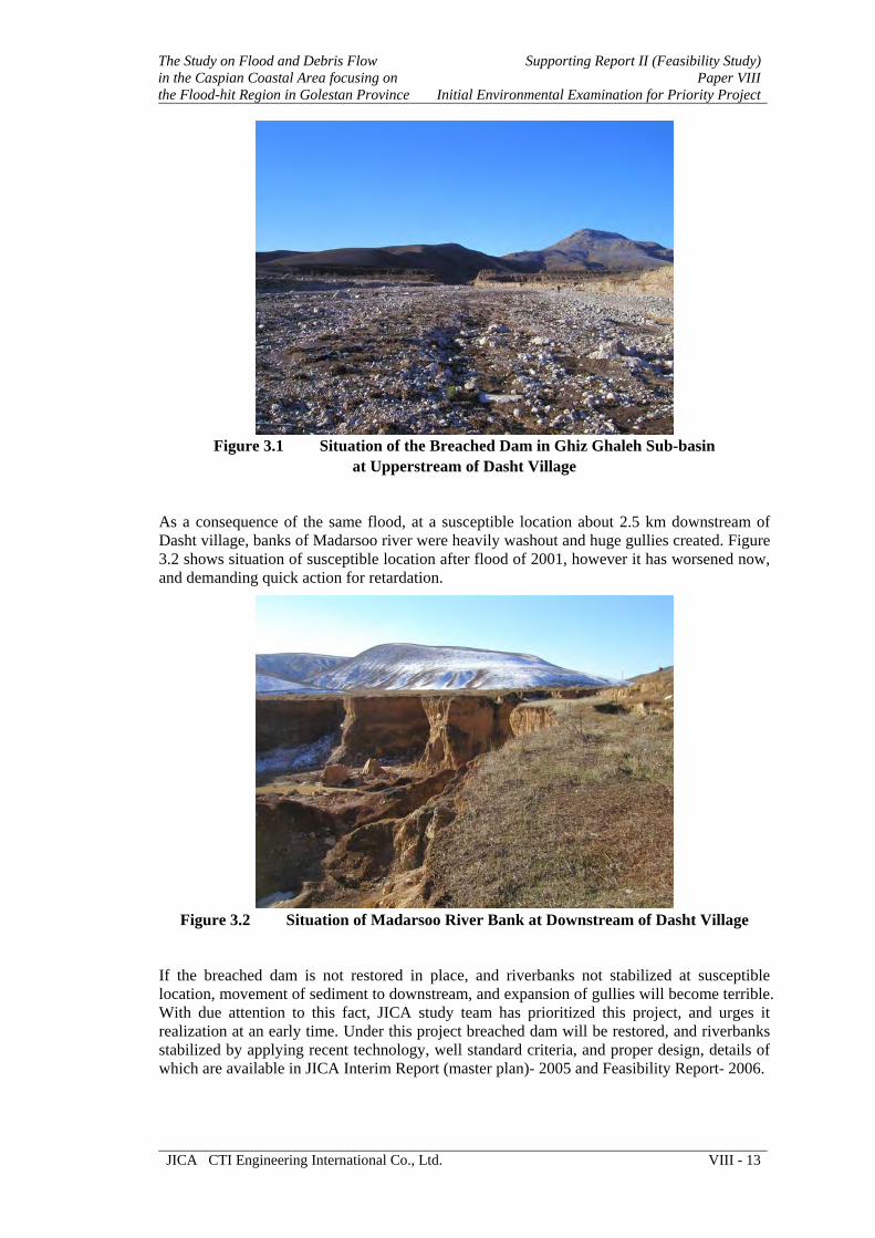
The Study on Flood and Debris Flow in the Caspian Coastal Area focusing on the Flood-hit Region in Golestan Province
Supporting Report II (Feasibility Study)Paper VIII
Initial Environmental Examination for Priority Project
JICA CTI Engineering International Co., Ltd. VIII - 13
Figure 3.1 Situation of the Breached Dam in Ghiz Ghaleh Sub-basin
at Upperstream of Dasht Village
As a consequence of the same flood, at a susceptible location about 2.5 km downstream of Dasht village, banks of Madarsoo river were heavily washout and huge gullies created. Figure 3.2 shows situation of susceptible location after flood of 2001, however it has worsened now, and demanding quick action for retardation.
Figure 3.2 Situation of Madarsoo River Bank at Downstream of Dasht Village
If the breached dam is not restored in place, and riverbanks not stabilized at susceptible location, movement of sediment to downstream, and expansion of gullies will become terrible. With due attention to this fact, JICA study team has prioritized this project, and urges it realization at an early time. Under this project breached dam will be restored, and riverbanks stabilized by applying recent technology, well standard criteria, and proper design, details of which are available in JICA Interim Report (master plan)- 2005 and Feasibility Report- 2006.

Supporting Report II (Feasibility Study) Paper VIII Initial Environmental Examination for Priority Project
The Study on Flood and Debris Flow in the Caspian Coastal Area focusing on
the Flood-hit Region in Golestan Province
VIII - 14 CTI Engineering International Co., Ltd. JICA
Project 2 Establishment of Flood Forecasting, Warning and Evacuating Systems for Golestan National Park (middle reaches)
This project for establishment of flood forecasting and warning system aims at minimization of flood causalities and damages to people transiting/camping in the area. The system is comprised of telemetry, transmission and warning instrument/devices, being installed at suitable points in accordance to needs and appropriateness for information dissemination. Because the system is established to disseminate reliable early flood warning to people and encouraging them to evacuate, entrance and exist sides of park have been recognized as rational points for installation of the instrument/devices. In order to reduce volume of the construction works, and lessen economic burden on proponents, this project would utilize the existing equipment and facilities as much as possible. At normal time the system would supply climatic data/information to its center for being used in weather broadcasting, according to which the campers may plan/arrange their visit to the area.
Initially a center for this system is established at water resources department of Mazandaran-Golestan Regional Water Board in Gorgan, which would process the data and transfer flood related information to Provincial Disaster Management Center for being announce to relevant agencies in the form of flood warning and evacuation order. Upon receiving such message, the police shall close the entrance of park at both sides, with patrol car asking people to leave the area.
Project 3 Publication of Flood and Debris Flow Hazard Maps (lower reaches)
This project aims to produce and publish a hazard map, which will be effective in disaster management, since it indicates spatial risk distribution of disaster. Under this projects, reliable information/data on topography, geomorphology, geology, hydrometeorology, and historical records are justified and used to identified and delineate hazardous areas through application of Geographic Information Systems (GIS). The furnished hazard map in general contains information on the probable extent of flood inundation, and the evacuation route and sites to be taken during floods. Upon completion it will be printed in bulk quantities and distributed among people in hazardous locations, as well as among institution/organizations dealing with disaster management in the area (including non-governmental organization/relief agencies).
Basically this project is of preparatory, advisory and precautionary type, involving no structural measure, but efficient in enriching public knowledge on natural disasters at normal condition and saving their lives in disastrous situation. It also matches efforts of State Corp of Unexpected Events, which disseminate materials to promote public knowledge/understanding on disaster and prepare them for coping with crises of unexpected events.
Further detail information, technical specifications and schematic design of these projects are available in JICA Interim Report (master plan)- 2005, and Feasibility Report- 2006.

The Study on Flood and Debris Flow in the Caspian Coastal Area focusing on the Flood-hit Region in Golestan Province
Supporting Report II (Feasibility Study)Paper VIII
Initial Environmental Examination for Priority Project
JICA CTI Engineering International Co., Ltd. VIII - 15
CHAPTER 4 IMPACT EVALUATION
Projects with structural measures
Project 1 Restoration of Breached Dam for Sediment Control at Upstream, and Stabilization of Madarsoo Riverbank at Downstream of Dasht Village (project for headwaters)
Projects with non-structural measures
Project 2 Establishment of Flood Forecasting, Warning and Evacuating Systems for Golestan National Park (middle reaches)
Project 3 Publication of Flood and Debris Flow Hazard Maps (lower reaches)
Environmental Impacts of Project with structural measures The project with structural measures involves construction works for restoration of the breached dam, as well for stabilization of riverbank. Since construction activities of both cases are more or less similar, their overall impacts (adverse and beneficial) are collectively discussed herein.
4.1 Negative Impacts (adverse) of the Projects
4.1.1 Construction Phase It is obvious that any construction activity insert some adverse impacts on natural, social and cultural environment. As movement of machinery to carry equipment and materials, as well operation of machinery to fulfill construction tasks, generate noise, smoke and dust, bringing-about noise and air pollutions, as well produce vibration.
As a results of construction activities, amount of soil particles in water will increases, affecting the turbidity and quality of water.
Discarded oil and fuel leakage from machinery will also cause soil contamination and land deterioration
A camp termed as construction camp is to be set in vicinity of the construction sites for the project employees, including guard/watchman. People residing in these comps would generate solid waste and sewage. Solid wastes usually produce odor, attract insects (mosquito/parasites) and serve them as a breeding ground, thus leading to air, soil and water contaminations in the area.
Natural vegetation in construction sites is unavoidably removed to create space for establishment of construction camp, structures and relevant facilities, affecting the natural environment.
(1) Impact on socio-economic environment
The noise and air pollutions could affect the health of people, particularly elderly persons and children in the area, imposing medical expenses on them. With increase in number of ill persons, number of absentees from work increases, leading to decline in production. Since most of people are farmers, if not attend the work to fulfill the farming tasks at proper time, reduction in amount of agriculture product is probable.

Supporting Report II (Feasibility Study) Paper VIII Initial Environmental Examination for Priority Project
The Study on Flood and Debris Flow in the Caspian Coastal Area focusing on
the Flood-hit Region in Golestan Province
VIII - 16 CTI Engineering International Co., Ltd. JICA
Since the construction crew, including workers and machine operators are directly subjected to noise and air pollution as well as vibration generated by machinery, they face more health risk, including injuries. Prolong subjection to pollution and vibration coupled with accidental injuries will threat health of the construction crew, and could cost them money for treatment and recovery.
Any decline in water quality will have not only affect the people, but also the livestock utilizing the water source. Human and livestock illness is a negative socio-economic impact. Because in both cases people must spends for recovery.
Solid waste generated in construction camp, if not properly collected and regularly disposed, will attract insect (mosquito/parasites) and create an unsanitary situation, being problematic to the society.
Removal of natural vegetation to create space for establishing construction camp and structures, as well as trampling of vegetation by man and machinery engaged in project works, cause reduction in greenery in the area. Since man is benefited from plants through utilization of fresh air/enjoyment of beautiful scenery, and livestock feed on vegetation to gain weight, any reduction in vegetation density is considered as a disadvantage to socio-economic environment.
(2) Impact on natural environment
Prolong noise pollution is troublesome to wildlife, particularly at mating time, when animal need comfort for successful procreation. Air pollution can wither the sensitive wild plants (flowers) and suppress their normal reproduction. With less procreation and low production, population of fauna and flora in the area may decrease, inserting adverse impacts on the ecosystem.
Establishment of construction camp and mobilization of machinery for project works will alter natural atmosphere, chasing wildlife or blocking their transit in the area. With less possibility for movement, the predatory creatures will find less chance to prey, thus less food and low potential for procreation of animal. This could create an unbalanced situation in ecosystem, through alteration in population/variety of animals.
Since water sources in the area are commonly used by wildlife, any decrease in water quality would have negative impacts on health and procreation of these creatures. With decrease in water quality, population of aquatic organisms declines, deranging food chain and population pyramid in ecosystem. With decline in water quality, population of sensitive creatures, such as planktons (food source for fish/amphibian) decreases. With decrease in food source, population of fish/amphibian declines, affecting the population and reproduction ability of predatory birds, which mostly feed on aquatic creatures, such fish and amphibian.
Discarded oil and fuel leakage from machinery contaminate the soils and insert negative impacts on soil micro and macro organisms. Activity of microorganism highly contributes in increment of soil fertility and land productivity. Since microorganisms breakdown the litter and other decayed materials to generate some nutrients, which are absorbed by plants for attaining vigor growth. Earthworm, beetle, and other soil macro-organisms play important roles in removal of soil compaction and increment in land infiltration rate, thus creating favorable condition for plant growth, on which wildlife feeds. With soil this beneficial cycle is interrupted, leading to deterioration in environmental status of the area.
Insects attracted by solid waste, may multiply their population and establish themselves in the area as plant/animal parasites, threatening the health and beauty of natural elements.

The Study on Flood and Debris Flow in the Caspian Coastal Area focusing on the Flood-hit Region in Golestan Province
Supporting Report II (Feasibility Study)Paper VIII
Initial Environmental Examination for Priority Project
JICA CTI Engineering International Co., Ltd. VIII - 17
Natural vegetation in construction sites is unavoidably removed to create space for establishment of construction camp, structures and relevant facilities, affecting the natural environment. Since most wild animals feed on natural plants, with decrease in plant density wildlife will suffer.
(3) Impact on cultural environment
Since there is no any site/object of historic, cultural or religious importance immediately near the construction sites, thus project has no any direct negative impacts on cultural environment. But if soil particles (sediment) is not fixed in place, they may blown up by wind, get suspended in the air and travel a long distance, and finally settle on cultural assets, inserting negative impacts on them.
4.1.2 Operation/Maintenance Phase The structures established for sediment control and stabilization of riverbank, involves no specific operation/maintenance works, thus inducing no negative impact on socio-economic, natural, or cultural environments. Project authorities routinely inspect the structures to identify abnormalities (if any) and remove them through the most suitable repair works.
4.2 Positive Impacts (beneficial)
4.2.1 Socio-economic environment With restoration of the breached dam, movement of soil materials will decrease, thus sediment damage to lands and infrastructures such as road, bridge, canal, and dam at downstream is reduced. This will significantly contribute in public safety, and longevity of infrastructures, bringing-about socio-economic benefit.
If no dam, sediment is spread by water in the area, and blown up by wind in dry season, creating a dusty atmosphere with polluted air. Dust in the air not only insert negative impact on human health, but also in windy hours will cause reduction in vision of vehicle drivers leading to traffic accident and human causality. In both the cases man must spend money for recovery and getting back to normal condition.
When wind cease, soil particles suspended in air will settle on vehicles, telecommunication instruments, water conveyance and storage facilities, and other infrastructures in the area, making the maintenance of such commodities difficult and expensive. Malfunctioning of any infrastructure is nuisance to society.
It should be noted that the fine particles in air could travel several kilometers by wind, and insert their negative impacts even out of the project area.
To avoid/reduce these problems, and decrease their damages to society, restoration of breached dam, through which sediment is control (fixed in place) is much beneficial.
The dam wall will reduce the velocity of runoff, and the sediment retained behind the dam will hold large volume of water, contributing to groundwater recharge. With larger volume of groundwater, there will be more water available for sanitary and cultivation purposes, both being beneficial to people in the area.
4.2.1 Natural environment If dam for sediment control is not established, soil materials will move to downstream and burry seedlings of natural plants and hinder their growth. With sediments control, natural vegetation finds more opportunity for growth and enhancement of natural environment. With establishment/expansion of natural vegetation, infiltration rate of land increases to promote groundwater recharge. With more availability of ground- water, deep-rooted trees will have vigor growth. Vigorous vegetation plays important role in erosion control and sediment
Supporting Report II (Feasibility Study) Paper VIII Initial Environmental Examination for Priority Project
The Study on Flood and Debris Flow in the Caspian Coastal Area focusing on
the Flood-hit Region in Golestan Province
VIII - 18 CTI Engineering International Co., Ltd. JICA
retention, thus reducing amount of soil loss and lowering rate of land deterioration, contributing to conservation of the environment.
With more availability of water and vegetation, herbivorous animals are attracted to the area, followed by carnivorous predators, to enrich the biodiversity of the area. A nature environment with high biodiversity rate is highly pleasant and appreciable.
With sediment control water quality is not much affected, thus better living condition for fish and other aquatic organism, hence more food for predatory birds feeding on such creatures. Existence of bird will contribute to natural beauty and attraction of nature (birds) lovers to the area.
4.2.2 Cultural environment By fixing soil materials (sediment), no site/object of historic, cultural, or religious importance is affected at downstream by particles moving with water. Since fine particles in the air (dust) could settle on such site/object, when wind cease, less dust in atmosphere is desirable, and this can be realized through restoration of breached dam and fixation of sediment in place.
4.2.3 Projects with non-structural measures Project 2 Establishment of Flood Forecasting, Warning and Evacuating Systems for
Golestan National Park (middle reaches)
This project has no significant negative (adverse) impact on socio-economic, natural, or cultural environments. Because it involves no large construction work, but largely improves/upgrade existing systems and utilize them in more efficient manners. Establishment of new instrument/devices is performed with less disturbance of the environment.
Followings are among the positive (beneficial) impacts of this project:
The project will ensure safety of people and increase their confidence in economic activities, by providing them early and reliable disaster related information. Basing on the timely information people would have time to relocate their movable assets and leave the area before being hit by disaster (flood)
At normal time the project will routinely provide weather information to people through broadcasting media, based on which them may plan own daily activities. When forecast of bad weather people can get ready to leave the area immediately upon announcement of emergency situation
With availability of an accurate and efficient forecasting and warning systems, larger number of tourists are encourage to visit the area, contributing to its economic status.
Project 3 Publication of Flood and Debris Flow Hazard Maps (lower reaches)
This project involves no any construction work, thus not any negative (adverse) impact on socio-economic, natural, or cultural environments. While it’s positive (beneficial) impacts are:
This project is highly beneficial and efficient in enriching public knowledge on natural disasters at normal condition and saving their lives in disastrous situation. It also matches the efforts of State Corp of Unexpected Events, which disseminate materials to promote public knowledge and understanding on disasters, and prepare them for coping with crises of unexpected events.
The Study on Flood and Debris Flow in the Caspian Coastal Area focusing on the Flood-hit Region in Golestan Province
Supporting Report II (Feasibility Study)Paper VIII
Initial Environmental Examination for Priority Project
JICA CTI Engineering International Co., Ltd. VIII - 19
The project is of preparatory, advisory and precautionary type, having no structural measure, aware residents on extent of flood inundation zone, and indicates them proper routes to evacuation, as well and safe places to refuge during disaster (flood) period.
At normal situation hazard map could be used as a guide for urban development and land use planning, reflecting its multipurpose nature and economic efficiency.
However the main aim of hazard map is to facilitate evacuation of people through safe routes to safe places for nullifying/minimizing causalities during disaster. At normal time it can also be used for disaster training and educational purposes in order to increase public knowledge on natural disasters, ensure their quick response and enhance their evacuation capability.
It should be noted that the operation/maintenance of project 2, and project 3 is very simple, with no any negative (adverse) impact on socio-economic, natural, or cultural environments.
4.3 Result of Environmental Evaluation Overall Impact Each individual project results in direct and indirect impacts. Cumulative impacts are the aggregates of direct and d indirect impacts, which could be negative (adverse) or positive (beneficial). Assessment of cumulative impact is important in judging the environmental soundness of the projects.
Based on impact evaluation discussed above, and considering the opinion of inhabitants of the area, known during the field village surveys and through holding public consultation meeting, it can be mentioned that- the priority projects formulated by JICA study team, have some negative (adverse) impacts on socio-economic, natural, and cultural environment. But these impacts are temporary, mostly at construction phase, and reversible. Therefore projects are realized as environmentally sound, socially acceptable, thus endorsed for execution.

Supporting Report II (Feasibility Study) Paper VIII Initial Environmental Examination for Priority Project
The Study on Flood and Debris Flow in the Caspian Coastal Area focusing on
the Flood-hit Region in Golestan Province
VIII - 20 CTI Engineering International Co., Ltd. JICA
CHAPTER 5 ALTERNATIVES
After careful environmental examination and analysis of social situation, two options, namely without project (no action) and relocation of village threaten by disasters (sediment), were identified as discussable alternatives:
5.1 Without Project (no action) Without project the natural, socio-economic, natural, and historic cultural environments are affected as stipulated below:
With spread of soil particles (sediment) in the area, on dry season particularly at windy hours, there would be more dust in the atmosphere, causing air pollution to affect large number of people in a wider range
With time sediment will damage the road, bridge, and other social infrastructures, reducing their service providing capability and creating nuisance situation
Sediment is transported by flash water and deposited in water conveyance facility (canal) and dam reservoirs at downstream, decreasing their capacity, efficiency and lifespan
With threat of disasters (sediment deposition), investors find no incentive to invest in business activities in the area, leaving inhabitants under unemployment stress, affecting their health and happiness
Sediment will largely spread in the area, reaching to farmland, orchard, livestock, and other economic establishments to damage them and reduce their productivity
Sediment spreading on natural lands suppress growth of natural plants by damaging their seedlings at early growth stage, thus causing reduction in vegetation density
Soil particles (sediment) moving by water/wind would settle on site/object of historical, cultural and religious importance to affect their physical appearance or burry them
Protecting citizens against disasters and caring for God-gifted natural resources are among tasks (action) of the Islamic government, being opposite to “no action” option
Throughout the village survey (using questionnaire) conducted by JICA study team during October 2004 – September 2005, the inhabitants clearly requested for execution of projects and expressed their willingness to cooperate in realization of projects in the area
In Public Consultation Meeting held on January 30, 2006 in the prime-area of priority projects, people did not support the “no action” option
Considering the points mentioned above, without project (no action) alternative is irrational, thus discarded.
5.2 Relocation of Village being Threaten by Sediment As mentioned earlier Dasht village is directly threatened by disasters (sediment). In case of relocation option this village must be entirely removed and settled in a safer area, to convince the people that authorities are concerned about their safety and economic activities. While relocation is not a suitable and wised decision to take, due to following reasons:
Relocation is an expensive, complicated undertaking not involving only technical but also legal, political (administrative), social, environmental, religious and even spiritual (emotional) issues. Because deceased persons of the village are buried in its graveyard, where the inhabitants visit weekly (usually Thursday) as a religious norm to pay respect to their beloved relatives being buried therein. With relocation this spiritual (emotional)
The Study on Flood and Debris Flow in the Caspian Coastal Area focusing on the Flood-hit Region in Golestan Province
Supporting Report II (Feasibility Study)Paper VIII
Initial Environmental Examination for Priority Project
JICA CTI Engineering International Co., Ltd. VIII - 21
contact will be disturbed, bringing-about an adverse impact, which could be termed as spiritual impact of the project. Since it is difficult to grasp and extent/severity of this impact for mitigation, avoiding its occurrence is much wised.
Large amount of money, particularly after flood of 2001 has been spent to furnish the village with communication road, educational, sanitary, telephone service and other social infrastructures, to meet the basic human needs
After flood a large and well-architecture mosque (religious site) has been established in the area, serving not only praying purpose, but also used as place for gathering and discussing the village matter, including projects issues. Abolishing/destructing religious establishment (mosque) is not acceptable by society and the Islamic doctrine
With relocation large amount of money and huge volume of energy is dissipated
Land acquisition for establishing new village, involves long legal process for securing the necessary documents and obtaining construction permit. After land acquisition (if realized), construction works would proceed for many years, inserting not only heavy economic burden on society, but also cause significant damages to the environment. Of which generation of noise, smoke, dust, domestic waste, acceleration of soil erosion, and land deterioration are to be pointed out.
Results of village survey and public consultation meeting indicate that the inhabitants are not agree with relocation option, and determine to demand huge compensation for their land and real estates, if relocation option is negotiated, to kill the idea. It should be noted that arable lands belonging to village are fertile and productivity, being partly irrigated by spring water of good quality.
Relocation due to its social/legal complicity, economic burden and environmental damages is judge as irrational and unacceptable option, thus discarded.
5.3 Decisions and Nomination of Alternative Ultimately the “with project” option is judged as rational and acceptable for realization. Thus projects formulated by JICA Study Team are endorses for implementation. Because the projects are fit to the area, and possessing desirable characteristics such as:
i) Simple, of small scale, having least adverse impacts on environment, but efficient in reducing the sedimentation and erosion rates
ii) Efficient in preventing human causality and capable of reducing damages to people assets and social infrastructures in disastrous time
iii) Socially acceptable, and generate various benefits to local people, such as protection of farmland/rangeland and contribution in groundwater recharge, which are important for agriculture/livestock activities
iv) Some of local people will get engaged in project works (construction), thereby overcoming unemployment and gaining cash for livelihood
v) Realization of projects would have technical merit for the area. Because during implementation people will observe the construction machinery/equipment, thereby gain knowledge on construction method and become aware of cooperation spirit required for realizing a project.
vi) With project option is important for enhancing natural environment of the area, because it provide more opportunity to vegetation for growth
vii) Wildlife feeding on natural vegetation, would gain sufficient energy and mood for procreation, attracting the predatory carnivorous animals, to enrich the biodiversity and promote environmental status of the area

Supporting Report II (Feasibility Study) Paper VIII Initial Environmental Examination for Priority Project
The Study on Flood and Debris Flow in the Caspian Coastal Area focusing on
the Flood-hit Region in Golestan Province
VIII - 22 CTI Engineering International Co., Ltd. JICA
viii) With execution of project, site/objects with historic, cultural, and religious importance are protected against disasters (sediment), serving the conservation of culture of the nation
ix) People in the area do not support without project (no action) alternative
x) Since people basically are not happy with relocation alternative, negotiating compensation matter, and reaching a reasonable agreement with each individual seems impossible. Moreover prolong negotiation would delay the execution of mitigation works, providing time and opportunity to disastrous agents (sediment, erosion) for worsening the situation and increasing the cost of recovery at action time.

The Study on Flood and Debris Flow in the Caspian Coastal Area focusing on the Flood-hit Region in Golestan Province
Supporting Report II (Feasibility Study)Paper VIII
Initial Environmental Examination for Priority Project
JICA CTI Engineering International Co., Ltd. VIII - 23
CHAPTER 6 IMPACT MITIGATION
6.1 Mitigation and Precautions for Construction Phase Since negative impacts of project with structural measures prevail only in construction phase, and upon completion of this phase the impacts are nullified, mitigation measures/precautions to be followed during the construction phase are provided hereunder.
(1) From environmental point of view, the project is advised to dispose its waste materials in designated “Dumping Sites”, where dumping is legally permitted. For this purpose, project should contact the provincial governments of North Khorasan, Semnan and Golestan to inquire about existing legal dumping sites, and use the most appropriate one, by considering distance/time for transport, availability of proper access road, and least disturbance to public. After receiving permission from relevant authorities, waste materials generated in construction sites must be transported there and dumped properly. Piling-up of waste materials may be done throughout working period (day/night), but their transportation is performed only at daytime to cause least disturbance of people and wildlife in the area. Wherever possible, special roads could be constructed for waste transportation purpose.
(2) A concrete receptacle should be constructed below ground surface for depositing used oil and other similar wastes generated by machineries operating in construction sites. Then the materials collected therein are disposed in suitable places in an appropriate manner.
(3) Solid waste generated by employees shall be properly collected, packed and transported to dumping sites. The liquid waste is collected in septic tanks and then disposed in suitable places in an appropriate manner.
(4) Construction crew is advised to wear mouth/nose mask and earplug in working period for being safeguard against air and noise pollutions.
(5) Avoid construction works at windy hours to minimize the air pollution by dust/smoke
(6) Moisten the area before starting works to reduce dispersion of dust in the area
(7) Implement machineries having noise generation/vibration within the standard limit, not the aged and polluter ones.
(8) Do not remove much material (sand/gravel) from riverbed for use in establishment of structures, because this may bring-about changes in hydro-morphology of the area.
(9) However no site of historical/cultural or religious importance is identified in construction areas, the employees whenever face any unusual object, should report it to project authorities immediately.
(10) Make the territory of construction site clear on the ground, and establish signboard in suitable places to discourage the entry of people into the area, because operating machines may harm them.
6.2 Mitigation and Precautions for Operation Phase In principle, the structures after establishment involves no significant operation work, but need some periodically inspection to make sure they are in good condition. In this connection the following points are advised:
(a) In case of appearance of any crack (even small) in dam structure, repair works should immediately be undertaken (not tomorrow and tomorrow) to prevent malfunctioning of

Supporting Report II (Feasibility Study) Paper VIII Initial Environmental Examination for Priority Project
The Study on Flood and Debris Flow in the Caspian Coastal Area focusing on
the Flood-hit Region in Golestan Province
VIII - 24 CTI Engineering International Co., Ltd. JICA
dams and its facilities, as well as to ensure public about proper operation and efficiency of the erected structures.
(b) In rainy season inspection of structures should be more frequent to grasp any malfunction at its earlier time, and take action for removing the problem.
(c) Some fast growing plants should be grown around the structure sites not only to replace the vegetation destroyed as a result of construction works, but also to improve the overall status of natural environment.

The Study on Flood and Debris Flow in the Caspian Coastal Area focusing on the Flood-hit Region in Golestan Province
Supporting Report II (Feasibility Study)Paper VIII
Initial Environmental Examination for Priority Project
JICA CTI Engineering International Co., Ltd. VIII - 25
CHAPTER 7 PUBLIC CONSULTATION MEETING
In accordance with JICA Guidelines for Environmental and Social Considerations- 2004, and in line with international norm for project formulation, and consideration of Islamic doctrine, which encourages consultation/exchange of view in important affairs, the public consultation meeting was held, with following particulars:
Title: Public consultation meeting for explanation of outcome of initial
environmental examination on priority projects Organizers: Counterpart personnel of Golestan and North Khorasan provincial
Jihad-e-Agriculture organizations, and JICA study team Venue: Field office of watershed management department of North
Khorasan provincial Jihad-e-Agriculture organization, located in Dasht village
Date/time: January 30, 2006. Monday 10:00-12:15 Total Number of participant: 36 persons, comprising of members of Rural Islamic Council,
village chief, farmers, livestock breeders, shop keepers and ordinary people of Daht village.
Main Presenter: Gholamhossein SHOKOHIFARD, expert for Environmental and
Social Considerations, JICA Study Team Sub Speakers: Kanehiro MORISHITA, leader of JICA team; Kenji TOYOTA,
expert for structural design and cost estimate, JICA team; Mohamadreza PARSAMEHR, head of division for study and technical support, Golestan provincial Jihad-e-Agriculture organization.
Atmosphere of the meeting When presentation was going on, the participants were quite and
carefully listing words of the speaker, but during question and answer time, they were very noisy and arguing with each other, using the time inefficiently. Consequently the in-charge person reminded them to be quite, talk one by one, and do not interrupt each other.
Note: However on the day of public consultation meeting, there was a
funeral ceremony in mosque of Dasht village, but people largely participated in the meeting. This indicates their concern/interest on fate of projects, and their willingness to cooperate with development activities at any time.
7.1 Sequence of Presentation (1) Opening speech by the counterpart
At beginning of meeting Mr. Parsamehr welcome the participants, briefly explain objective of the meeting, and introduced members of JICA team to the people.
(2) Mr. Toyota, explained outline of projects with structural measures, through an interpreter. By showing some slides (Power Point) he indicated layout of structural measures proposed in JICA Master plan, as well explained the criteria for selecting priority projects for conducting Feasibility Study on them. He also showed some

Supporting Report II (Feasibility Study) Paper VIII Initial Environmental Examination for Priority Project
The Study on Flood and Debris Flow in the Caspian Coastal Area focusing on
the Flood-hit Region in Golestan Province
VIII - 26 CTI Engineering International Co., Ltd. JICA
pictures from Sabo works in Japan, and emphasized on efficiency of such structures in watershed management activities. Contents of two of the slides shown by Mr. Toyata are presented below:
Figure 7.1 Proposed Arrangement of River Restoration Plan
Box 7.1 Selection of Priority Project(s) from the Master Plan Study
Selection Criteria: 1. Project(s) being located in the most seriously damaged area; 2. 2.Project(s) bringing the project effects to save human lives and/or to improve
worsening conditions for a short period; 3. 3.Project(s) having high economic efficiency for mitigation of flood damages
and saving human lives and 4. 4.Project(s) having suitable and essential themes on technology transfer Note: The on-going projects(s) and project(s) that preliminary designing was completed by the agency concerned shall not be included in the selection.
(3) Shokohifard presented outcome of Initial Environmental Examination (IEE) conducted on priority projects. However he showed his slide with English writing, but explained them directly in Persian (Farsi), as a native member of JICA study team. Contents of some of the slides presented in public consultation meeting are reflected hereunder in their original status:

The Study on Flood and Debris Flow in the Caspian Coastal Area focusing on the Flood-hit Region in Golestan Province
Supporting Report II (Feasibility Study)Paper VIII
Initial Environmental Examination for Priority Project
JICA CTI Engineering International Co., Ltd. VIII - 27
PPuubblliicc CCoonnssuullttaattiioonn MMeeeettiinngg iinn tthhee SSttuuddyy AArreeaa EExxppllaannaattiioonn ooff OOuuttccoommee ooff tthhee IInniittiiaall EEnnvviirroonnmmeennttaall EExxaammiinnaattiioonn ((IIEEEE)) CCoonndduucctteedd oonn PPrriioorriittyy PPrroojjeeccttss FFoorrmmuullaatteedd bbyy JJIICCAA SSttuuddyy TTeeaamm FFoorr MMaaddaarrssoooo RRiivveerr BBaassiinn JJaannuuaarryy 3300,, 22000066 IInnttrroodduuccttiioonnMMaaddaarrssoooo RRiivveerr bbaassiinn iiss oonnee ooff ddiissaasstteerr pprroonnee bbaassiinnss iinn CCaassppiiaann rreeggiioonn,, wwhhiicchh ssuuffffeerreedd hheeaavvyy ddaammaaggeess ffrroomm ffllooooddss ooccccuurrrreedd iinn 22000011 aanndd 22000022.. SSoommee ooff ddaammaaggeess aarree iinnddiiccaatteedd hheerreeiinn.. DDaammaaggeess ooff FFlloooodd iinn tthhee yyeeaarr 22000011 RRooaadd ddeemmoolliisshheedd 119944 kkmm
FFaarrmmss aanndd oorrcchhaarrddss ddeemmoolliisshheedd 1155000000 hhaa PPeeooppllee wwoouunnddeedd 220000 ppeerrssoonnss PPeeooppllee kkiilllleedd aanndd mmiissssiinngg 440000 ppeerrssoonnss LLiivveessttoocckk lloosstt 66000000 hheeaaddss FFoorreesstt ddeemmoolliisshheedd 55550000 hhaa RRaannggeellaanndd ddeemmoolliisshheedd 1100000000 hhaa VVeehhiicclleess ddeessttrrooyyeedd 113300 uunniittss BBuuiillddiinngg ddeemmoolliisshheedd 33000000 uunniittss TTeelleepphhoonnee ooffffiiccee ddeemmoolliisshheedd 77 uunniittss EEssttiimmaatteedd EEccoonnoommiicc DDaammaaggeess 558800 bbiilllliioonn RRiiaallss
EEmmoottiioonnaall MMaatttteerrPPssyycchhoollooggiiccaall ddaammaaggeess aanndd ssttrreessss ttoo ppeeooppllee,, wwhhiicchh ttaakkeess lloonngg ttiimmee ttoo rreeccoovveerr aallssoo sshhoouulldd bbee nnootteedd.. AAfftteerr FFllooooddAAfftteerr tthhee ddiissaassttrroouuss ffllooooddss,, tthhee GGoovveerrnnmmeenntt ooff tthhee IIssllaammiicc RReeppuubblliicc ooff IIrraann,, rreeqquueesstteedd JJaappaann IInntteerrnnaattiioonnaall CCooooppeerraattiioonn AAggeennccyy ((JJIICCAA)) ttoo uunnddeerrttaakkee aa DDeevveellooppmmeenntt SSttuuddyy iinn MMaaddaarrssoooo bbaassiinn,, aanndd ffoorrmmuullaattee aann eeffffiicciieenntt aanndd rreeaalliissttiicc ddiissaasstteerr mmiittiiggaattiioonn MMaatteerr PPllaann ((MM//PP)) ffoorr tthhee aarreeaa,, aass wweellll ccoonndduucctt FFeeaassiibbiilliittyy SSttuuddyy ((FFSS)) oonn pprriioorriittiizzeedd pprroojjeeccttss.. JJIICCAA UUnnddeerrttaakkiinngg CCoonndduuccttiinngg EEnnvviirroonnmmeennttaall aanndd SSoocciiaall CCoonnssiiddeerraattiioonnss ssttuuddyy,, aanndd eevvaalluuaattiioonn ooff eennvviirroonnmmeennttaall iimmppaaccttss ooff tthhee pprroojjeeccttss wweerree aallssoo aammoonngg uunnddeerrttaakkiinnggss ooff JJIICCAA.. AAccccoorrddiinnggllyy,, tthhee IInniittiiaall EEnnvviirroonnmmeennttaall EExxaammiinnaattiioonn ((IIEEEE)) wwaass ccoonndduucctteedd dduurriinngg tthhee MMPP aanndd FFSS pphhaasseess.. IIEEEE bbeeiinngg ddiissccuusssseedd hheerree wwaass

Supporting Report II (Feasibility Study) Paper VIII Initial Environmental Examination for Priority Project
The Study on Flood and Debris Flow in the Caspian Coastal Area focusing on
the Flood-hit Region in Golestan Province
VIII - 28 CTI Engineering International Co., Ltd. JICA
ccoonndduucctteedd oonn pprriioorriittyy pprroojjeeccttss dduurriinngg FFSS pphhaassee.. TThhee SSttuuddyy AArreeaa iiss
MMaaddaarrssoooo RRiivveerr BBaassiinn wwiitthh aa ttoottaall aarreeaa ooff 223366,,440000 hhaa,, bbeeiinngg ddiivviiddeedd iinnttoo 88 ssuubb--bbaassiinnss aass sshhoowwnn iinn tthhee mmaapp
TThhee PPrriioorriittyy PPrroojjeeccttssAAmmoonngg pprroojjeeccttss ffoorrmmuullaatteedd bbyy JJIICCAA SSttuuddyy TTeeaamm,, tthhrroouugghh ccoonndduuccttiioonn ooff MMaasstteerr PPllaann SSttuuddyy,, tthhrreeee pprroojjeeccttss hhaavvee bbeeeenn sseelleecctteedd aass PPrriioorriittyy PPrroojjeeccttss,, bbaasseedd oonn tthheeiirr uurrggeennccyy//eeffffiicciieennccyy ffoorr ddiissaasstteerr mmiittiiggaattiioonn.. PPrroojjeecctt 11RReessttoorraattiioonn ooff BBrreeaacchheedd DDaamm ffoorr SSeeddiimmeenntt CCoonnttrrooll aatt UUppssttrreeaamm,, aanndd SSttaabbiilliizzaattiioonn ooff MMaaddaarrssoooo RRiivveerrbbaannkk aatt DDoowwnnssttrreeaamm ooff

The Study on Flood and Debris Flow in the Caspian Coastal Area focusing on the Flood-hit Region in Golestan Province
Supporting Report II (Feasibility Study)Paper VIII
Initial Environmental Examination for Priority Project
JICA CTI Engineering International Co., Ltd. VIII - 29
DDaasshhtt VViillllaaggee ((pprroojjeecctt ffoorr hheeaaddwwaatteerrss)) PPrroojjeecctt 22EEssttaabblliisshhmmeenntt ooff FFlloooodd FFoorreeccaassttiinngg,, WWaarrnniinngg aanndd EEvvaaccuuaattiinngg SSyysstteemmss ffoorr GGoolleessttaann NNaattiioonnaall PPaarrkk ((mmiiddddllee rreeaacchheess)) PPrroojjeecctt 33PPuubblliiccaattiioonn ooff FFlloooodd aanndd DDeebbrriiss FFllooww HHaazzaarrdd MMaappss ((lloowweerr rreeaacchheess)) IImmppaaccttss ooff tthhee PPrroojjeeccttssOOvveerraallll IImmppaacctt EEaacchh iinnddiivviidduuaall pprroojjeecctt iinnsseerrttss ssoommee ddiirreecctt oorr iinnddiirreecctt iimmppaaccttss oonn tthhee eennvviirroonnmmeenntt,, wwhhiicchh ccoouulldd bbee ppoossiittiivvee oorr nneeggaattiivvee.. CCuummuullaattiivvee iimmppaacctt iiss aaggggrreeggaatteess ooff tthheessee iimmppaaccttss.. AAnndd AAsssseessssmmeenntt ooff ccuummuullaattiivvee iimmppaacctt iiss iimmppoorrttaanntt iinn jjuuddggiinngg tthhee eennvviirroonnmmeennttaall ssoouunnddnneessss ooff pprroojjeeccttss.. NNeeggaattiivvee ((aaddvveerrssee)) IImmppaaccttss ooff PPrroojjeecctt 11TThhiiss pprroojjeeccttss iinnvvoollvveess ssoommee ccoonnssttrruuccttiioonn wwoorrkkss,, aanndd aannyy ccoonnssttrruuccttiioonn aaccttiivviittyy ccoouulldd iinnsseerrtt ssoommee aaddvveerrssee iimmppaaccttss oonn nnaattuurraall,, ssoocciiaall,, aanndd ccuullttuurraall eennvviirroonnmmeennttss.. AAss mmoovveemmeenntt ooff mmaacchhiinneerryy ttoo ccaarrrryy eeqquuiippmmeenntt aanndd mmaatteerriiaallss,, aass wweellll ooppeerraattiioonn ooff mmaacchhiinneerryy ttoo ffuullffiillll tthhee ccoonnssttrruuccttiioonn ttaasskkss,, ggeenneerraattee nnooiissee aanndd ssmmookkee aanndd dduusstt,, lleeaaddiinngg ttoo nnooiissee aanndd aaiirr ppoolllluuttiioonnss.. NNeeggaattiivvee ((aaddvveerrssee)) IImmppaaccttss ooff PPrroojjeecctt 11AAss aa rreessuulltt ooff ccoonnssttrruuccttiioonn aaccttiivviittiieess,, aammoouunntt ooff ssooiill ppaarrttiicclleess iinn wwaatteerr iinnccrreeaasseess,, aaffffeeccttiinngg tthhee ttuurrbbiiddiittyy//qquuaalliittyy ooff wwaatteerr ssoouurrcceess iinn tthhee aarreeaa.. SSiinnccee wwaatteerr ssoouurrcceess aarree ccoommmmoonnllyy uusseedd bbyy ddoommeessttiicc aanniimmaallss aanndd wwiillddlliiffee,, aannyy ddeeccrreeaassee iinn wwaatteerr qquuaalliittyy wwoouulldd hhaavvee nneeggaattiivvee iimmppaaccttss oonn hheeaalltthh aanndd pprrooccrreeaattiioonn ooff tthheessee ccrreeaattuurreess.. NNeeggaattiivvee ((aaddvveerrssee)) IImmppaaccttss ooff PPrroojjeecctt 11DDiissccaarrddeedd ooiill,, aanndd ffuueell lleeaakkaaggee ffrroomm mmaacchhiinneerryy wwoouulldd aallssoo ccaauussee ssooiill ccoonnttaammiinnaattiioonn,, wwhhiicchh aaffffeeccttss tthhee ssooiill oorrggaanniissmmss.. EEmmppllooyyeeeess wwoorrkkiinngg wwoouulldd ggeenneerraattee ssoommee ssoolliidd wwaassttee aanndd sseewwaaggee,, rreeqquuiirriinngg rreegguullaarr ddiissppoossaall.. IIff ssuucchh mmaatteerriiaallss aarree nnoott pprrooppeerrllyy ccoolllleecctteedd aanndd ddiissccaarrddeedd,, tthheeyy wwoouulldd ccaauussee eennvviirroonnmmeennttaall pprroobblleemmss.. PPoossiittiivvee ((bbeenneeffiicciiaall)) IImmppaaccttss ooff PPrroojjeecctt 11WWiitthh rreessttoorraattiioonn ooff tthhee bbrreeaacchheedd ddaamm,, mmoovveemmeenntt ooff ssooiill mmaatteerriiaallss wwiillll ddeeccrreeaassee,, tthhuuss sseeddiimmeenntt ddaammaaggee ttoo llaannddss aanndd iinnffrraassttrruuccttuurreess ((bbrriiddggee,, ccaannaall,, ddaamm)) aatt ddoowwnnssttrreeaamm iiss rreedduucceedd.. TThhiiss wwiillll ccoonnttrriibbuuttee iinn ppuubblliicc ssaaffeettyy aanndd lloonnggeevviittyy ooff iinnffrraassttrruuccttuurreess,, bbrriinnggiinngg--aabboouutt ssoocciioo--eeccoonnoommiicc bbeenneeffiittss.. PPoossiittiivvee ((bbeenneeffiicciiaall)) IImmppaaccttss ooff PPrroojjeecctt 11SSttaabbiilliizzaattiioonn ooff rriivveerrbbaannkkss wwiillll hhiinnddeerr eennllaarrggeemmeenntt ooff bbaannkk eerroossiioonn,, ccoonnttrriibbuuttee iinn ssooiill ccoonnsseerrvvaattiioonn aanndd llaanndd iimmpprroovveemmeenntt aatt bbootthh ssiiddeess ooff rriivveerr ccoouurrssee.. WWiitthh bbaannkk ssttaabbiilliizzaattiioonn,, nnaattuurraall vveeggeettaattiioonn ffiinnddss ssuuiittaabbllee ggrroouunndd ttoo ggrrooww aanndd eessttaabblliisshh iittsseellff.. PPoossiittiivvee ((bbeenneeffiicciiaall)) IImmppaaccttss ooff PPrroojjeecctt 11SSttaabbiilliizzaattiioonn ooff rriivveerrbbaannkkss wwiillll hhiinnddeerr eennllaarrggeemmeenntt ooff bbaannkk eerroossiioonn,, ccoonnttrriibbuuttee iinn
Supporting Report II (Feasibility Study) Paper VIII Initial Environmental Examination for Priority Project
The Study on Flood and Debris Flow in the Caspian Coastal Area focusing on
the Flood-hit Region in Golestan Province
VIII - 30 CTI Engineering International Co., Ltd. JICA
ssooiill ccoonnsseerrvvaattiioonn aanndd llaanndd iimmpprroovveemmeenntt aatt bbootthh ssiiddeess ooff rriivveerr ccoouurrssee.. WWiitthh bbaannkk ssttaabbiilliizzaattiioonn,, nnaattuurraall vveeggeettaattiioonn ffiinnddss ssuuiittaabbllee ggrroouunndd ttoo ggrrooww aanndd eessttaabblliisshh iittsseellff..
Similarly negative (adverse) and positive (beneficial) impacts of project 2 and project 3 were described by showing the relevant slides. And then alternatives to projects were mentioned as:
AAlltteerrnnaattiivveess ttoo tthheessee PPrroojjeeccttss11)) NNoo AAccttiioonn ((WWiitthhoouutt pprroojjeecctt)) AAlltteerrnnaattiivvee IInn ggeenneerraall,, wwiitthhoouutt pprroojjeecctt tthhee nnaattuurraall,, ssoocciioo-- eeccoonnoommiicc,, aanndd ccuullttuurraall//hhiissttoorriiccaall eennvviirroonnmmeennttss wwiillll rreemmaaiinn ssuubbjjeecctteedd ttoo sseeddiimmeenntt//eerroossiioonn hhaazzaarrdd,, aanndd ppeeooppllee lliivveess aanndd pprrooppeerrttiieess tthhrreeaatteenn bbyy fflloooodd ddiissaasstteerrss.. SSoo tthhiiss aalltteerrnnaattiivvee iiss nnoott rraattiioonnaall.. AAlltteerrnnaattiivveess ttoo tthheessee PPrroojjeeccttss22)) RReellooccaattiioonn ooff vviillllaaggee bbeeiinngg tthhrreeaatteenn bbyy sseeddiimmeenntt RReellooccaattiioonn iiss aann eexxppeennssiivvee,, ccoommpplliiccaatteedd uunnddeerrttaakkiinngg nnoott iinnvvoollvviinngg oonnllyy tteecchhnniiccaall bbuutt aallssoo lleeggaall,, ppoolliittiiccaall ((aaddmmiinniissttrraattiivvee)),, ssoocciiaall,, eennvviirroonnmmeennttaall,, rreelliiggiioouuss aanndd eevveenn ssppiirriittuuaall aass wweellll eemmoottiioonnaall iissssuueess.. DDiissaaddvvaannttaaggee ooff RReellooccaattiioonn AAlltteerrnnaattiivveeLLaarrggee aammoouunntt ooff mmoonneeyy,, ppaarrttiiccuullaarrllyy aafftteerr fflloooodd ooff 22000011 hhaass ssppeenntt ttoo ffuurrnniisshh tthhee vviillllaaggee wwiitthh eedduuccaattiioonnaall,, ssaanniittaarryy aanndd bbaassiicc hhuummaann nneeeeddss iinnffrraassttrruuccttuurreess.. WWiitthh rreellooccaattiioonn hhuuggee aammoouunntt ooff mmoonneeyy aanndd hhuunngg vvoolluummee ooff eenneerrggyy iiss ddiissssiippaatteedd CCoonncclluussiioonn ooff tthhee IInniittiiaall EEnnvviirroonnmmeennttaall EExxaammiinnaattiioonn ((IIEEEE))BBaasseedd oonn tthhee IIEEEE,, iitt ccaann bbee ccoonncclluuddeedd tthhaatt tthhee pprriioorriittyy pprroojjeeccttss ffoorrmmuullaatteedd bbyy JJIICCAA SSttuuddyy TTeeaamm,, hhaavvee lliittttllee iimmppaaccttss oonn tthhee eennvviirroonnmmeenntt.. BBuutt tthheessee iimmppaacctt aarree tteemmppoorraarryy aanndd rreevveerrssiibbllee.. TThhuuss pprroojjeecctt aarree rreeccttiiffiieedd ffoorr iimmpplleemmeennttaattiioonn,, bbyy ppaayyiinngg ccaarreeffuull aatttteennttiioonn ttoo eennvviirroonnmmeennttaall iissssuueess..
7.2 Questions and Comments by Participants After presentation by Shokohifard, which lasted for about 45 minutes, question and answer session begin, with the question from participants. Since most of the questions and issues raised in the meeting were more or less similar, of which only significant ones are listed below:
(a) Past floods had imposed economic and psychological damage to people, and now almost every year we have flood, in this context whether JICA projects can efficiently protect us against disasters?
(b) Realization of long term and important projects proposed by JICA study team would take about 25 years time, while we are frequently threatened by disasters. Therefore we request for early implementation of such projects, which grantees our safety.
(c) You (JICA team) explained that you want to established a small dam for sediment control, but we (participants) think a relatively larger multipurpose (sediment control and water storage) dam is more beneficial to village
(d) We are mostly farmers, depending arable lands for livelihood, with construction of structures some parts of our agricultural lands could be affected, the project should consider proper compensation for the affected lands. Structural design (canal, dam) with least impact on agricultural lands are more appreciated.

The Study on Flood and Debris Flow in the Caspian Coastal Area focusing on the Flood-hit Region in Golestan Province
Supporting Report II (Feasibility Study)Paper VIII
Initial Environmental Examination for Priority Project
JICA CTI Engineering International Co., Ltd. VIII - 31
(e) The dam in Ghiz Ghaleh sub-basin, which was breached by flood of 2001, was an earth dam, means earth dam is not suitable for such a susceptible site. So we think it is better to construct a concrete dam with proper spillway, rather than an earth dam
(f) In designing canal or any other water diversion/conveyance facilities, pay careful attention to distribution of our agricultural lands, because we expect least disturbance of our land and farming activities by the projects.
7.3 Answers and Additional Explanation by Organizers (JICA Team, MOJA) JICA team together with counterparts from Golestan and North Khorasan provincial Jihad-e-Agriculture organizations, answered the question and provided more details to participants, as briefed below:
After the flood a huge dike has been establish to project the village against flood, it is a good structure and for the time being it will serve the purpose
Yes our target year for large projects is 2025, which you considering it too long period, therefore besides large and long term projects, we have also proposed some small and quick projects to increase the safety of people in disaster time
However you like to have big and strong (concrete) structures, but formulation of any project involves technical/engineering, economic/financial, and environmental aspects. Means project from technical, economic and environmental viewpoints must be evaluated, if judged rational, the endorsed for implementation.
At the time of implementation, if project affect your agricultural lands, the proponents certainly will negotiate compensation matter with you to reach an agreement
Flood in the year 2001, was an unexpected one in history of the area, and occurrence of such huge flood in near future is not probable. Therefore constructing a large concrete dam by taking long time and spending huge amount of money is not rational. Furthermore considering the geo-morphology topographic condition and discharge amount of Ghiz Ghaleh River, no lager dam can confidently be recommended. Thus we have proposed small earth time, suiting the area.
Final design of proposed canal/water conveyance facilities depends on realization of projects formulated by Iranian sides. If they implement those projects, then our design should be reviewed and updated to mach the situation.
7.4 Results of the Meeting After the meeting, JICA team and counterparts from Golestan and North Khorasan provincial Jihad-e-Agriculture organizations, had a working lunch in a nearby restaurant to extract the essence of the public consultation meeting. After some discussion they collectively agreed on following points:
In general, people in the area are interested in JICA projects and wish for their early realization
However some of them are anxious about fate of agricultural land, which could be affected as a consequence of construction of structures, but disagree with no action and relocation of village alternatives
They realized the importance of projects of Flood Warning and Hazard Map for evacuation during the disaster, as well as their merit in normal time
Project for Stabilization of Riverbank was attractive to them, since further expansion of gully may lead to land deterioration

Supporting Report II (Feasibility Study) Paper VIII Initial Environmental Examination for Priority Project
The Study on Flood and Debris Flow in the Caspian Coastal Area focusing on
the Flood-hit Region in Golestan Province
VIII - 32 CTI Engineering International Co., Ltd. JICA
They suggested construction of large reservoir dam, because they like to have irrigated agriculture, and thereby more income
They understood the negative (adverse) and positive (beneficial) impacts of the projects, and felt with project alternative is rational.

The Study on Flood and Debris Flow in the Caspian Coastal Area focusing on the Flood-hit Region in Golestan Province
Supporting Report II (Feasibility Study)Paper VIII
Initial Environmental Examination for Priority Project
JICA CTI Engineering International Co., Ltd. VIII - 33
CHAPTER 8 CONCLUSION AND RECOMMENDATIONS
8.1 Conclusion Based on above mentioned explanation and discussions and referring to available document and evidences, it is concluded that- none of the projects formulated by the Japan International Cooperation Agency (JICA) Study Team require further full-scale environmental study-Environmental Impact Assessment (EIA). Thus they are endorsed for implementation, with condition that the proponent/executors pay attention to following recommendations and fully observe them. This conclusion is in line with environmental guidelines published by Department of the Environment (DOE), as well as guidelines of the Japan International Cooperation Agency (JICA), which state projects with environmental category B, and of watershed management nature are considered as environment-friendly, thus requiring no EIA.
With project alternative was realized much environmentally sound and socially acceptable, as compared to without project (no action), and relocation of village, thus endorsed for execution.
Iran is included in world’s 10-top disastrous countries, as 70% of the country is prone to earthquake, and 50% to flood. In total 90% of population is subjected to cumulative disasters of natural events (earthquake and flood), making the statesmen unable/unsuccessful in disaster management task. Furthermore in this fragile circumstance the status/responsibility of people in disaster management/mitigation is not defined. Therefore systematic and realistic disaster management/mitigation approaches need to be establish, involving coordination of state agencies and participation of local people. The caption project could pave foundation for such activities, and serve as a road map to conservation and enhancement of socio-economic, natural, and cultural environments in the country over a long time period.
8.2 Recommendations (1) Involve knowledgeable and experienced environmental specialists in all activities of the
projects and follow their suggestion and advices
(2) In case of any abnormality immediately inform the relevant organization/institutes and seek their advise and assist in solving the problem. Much relevant institutions are:
(3) Department of the Environment and/or its General Directorate in Golestan, Khorasan and Semnan provinces
(4) Cultural Heritage and Tourism Organization and/or its General Directorate in Golestan, Khorasan and Semnan provinces
(5) Natural Resources General Office in Golestan, Khorasan and Semnan provinces
(6) Ministry of Energy and/or its Regional Water Board in Golestan, Khorasan and Semnan provinces
(7) Encourage participation of local people, collaboration of governmental agencies and provincial governments for realizing the project
(8) Engage the local people in construction works as much as possible, to create job in the area, and thereby gain continuous public support for the project.
(9) According to regulation of Cultural Heritage and Tourism Organization, any construction activity/material must be at least 50 m away from site of cultural, historical and religious importance. Project is strongly recommended to follow this instruction, as well quickly contact the nearest of the organization, whenever face any strange object.

Supporting Report II (Feasibility Study) Paper VIII Initial Environmental Examination for Priority Project
The Study on Flood and Debris Flow in the Caspian Coastal Area focusing on
the Flood-hit Region in Golestan Province
VIII - 34 CTI Engineering International Co., Ltd. JICA
8.3 Advisory points Some advisory points are provided hereunder, which should be considered and realized over a long period to conserve and enhance the environmental status of the area:
(1) Create balanced grazing system
The result of village survey conducted by JICA Study Team (October 2004-September 2006) indicates that of livestock in the project area, 80% is sheep and 20% goats. Browsing animals (goat) prefer the leafy tops of shrubs. These animals are relatively insusceptible to infection by parasites found on heavily grazed grasslands. By contrast, grazers (sheep) tend to consume ground-level grasses and leafy plants. A poor balance between browsers and grazers can lead to a detrimental change in forage mix. For example too many grazers can diminished the number and populations of herbaceous plant species and allow woody plants to become dominant. A balanced mix of browser (goat) and grazer (sheep) animals helps to maintain a diversity of plants species and spread forage pressure more evenly. A balanced grazing system also increases overall productivity of rangelands, which is important in erosion control.
(2) Avoid overgrazing
Overgrazing can lead to soil erosion and decrease soil fertility through a reduction in density of vegetation and associated organic matter. Overgrazed soils are also more prone to water and wind erosion.
(3) Emphasis on timeliness of grazing
Timing of rangeland use can also contribute to soil erosion. Dry-season grazing can benefit the terrain by breaking up crusted soil and working seeds into the ground. Nonetheless, considerable soil compaction can result when herds graze on moist soil. Soil compaction reduces the ability of soil to absorb moisture and result in increased erosion from water runoff during the rainy season.
(4) Establishment of no grazing block
Establish a no grazing block in rangeland for natural production of seeds and its dispersion by water/wind in bare localities to encourage vegetation expansion and hence contribute in rangeland improvement
(5) Distribution of grass seeds
Produce seeds of suitable grasses in research stations under control condition, given those seeds to livestock breeders (shepherd) and ask them to distribute the seeds in bare localities, while moving in rangeland. By such activities suitable grasses would propagate to bring-about increase in rangeland production and decrease in soil erosion rate in the area.