Embed Size (px)
Citation preview
Kahului Airport Master Plan Update 6-1
CHAPTER 6
MASTER PLAN
6.1 OVERVIEW
This chapter presents the recommended MP for
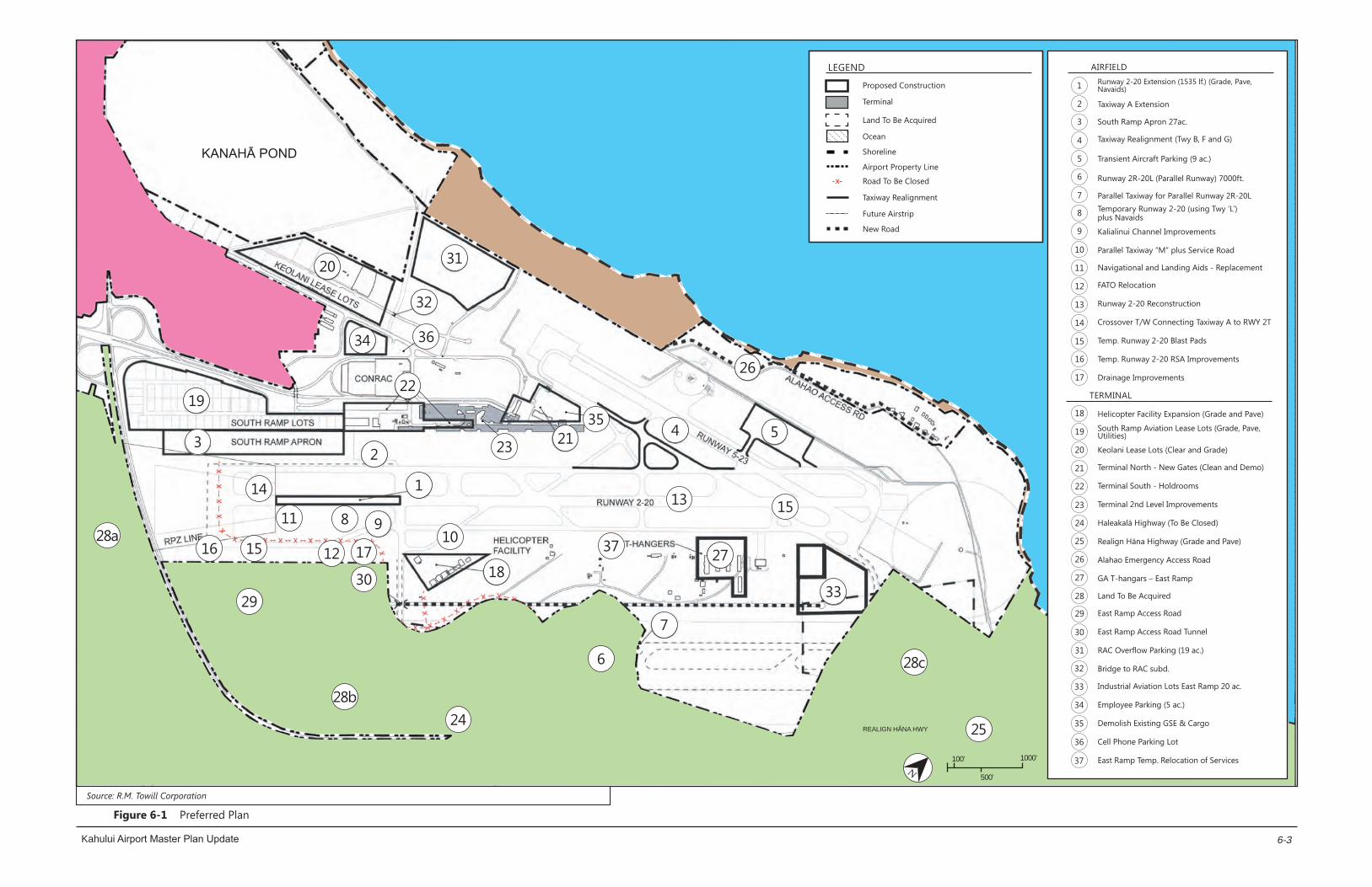
OGG. See Figure 6-1. The Plan identifies long-term
airfield and terminal area improvements needed to
meet forecast aviation demand and operational
requirements. It represents a guide for airport
development through the year 2035 and indicates
possible improvements beyond that date for which
land should be reserved.
The recommended OGG MP is the result of a
diligent process of study, interaction, and evaluation
with OGG users and the general public. Preliminary
MP recommendations were prepared based on the
comments received on the development concepts
presented in Chapter 5. These preliminary
recommendations were presented to and discussed
with the OGG Technical Advisory Committee, the
OGG Citizens’ Advisory Committee, and the public at
informational meetings held by the DOTA. The
preliminary recommendations were further refined
into the detailed plans presented in this chapter
after review by the DOTA, FAA, OGG Technical and
Citizens’ Advisory Committees, and public.
6.2 LAND USE ADJUSTMENTS
This section describes and illustrates the major land
uses proposed within the OGG property. It also
identifies the changes in State and County land use
designations that will be required to implement the
OGG MP recommendations. The land use
designations take into account existing and planned
uses for the airfield and terminal areas. Additionally,
this section identifies lands required for other
aviation/non-aviation facilities and airport support
activities. The future land use area allocations are
based on the projected demands and requirements
described in Chapter 3 of this report.
Kahului Airport Master Plan Update 6-2
6.2.1 AIRPORT BOUNDARY
The recommended OGG MP shown in Figure 6-1 on
Page 6-3 identifies the areas needed for the
proposed land uses through the year 2035. The
most significant land use changes proposed are the
development of a parallel Runway 2R-20L on the
east side of OGG, the extension of Runway 2-20 and
a new airport access road on the west side of the
OGG. The recommended plan also provides
additional space and/or facilities for passenger
terminal, air cargo, GA, commercial aviation, FBOs,
ground transportation operator baseyards, bulk jet
fuel storage, and other support activities.
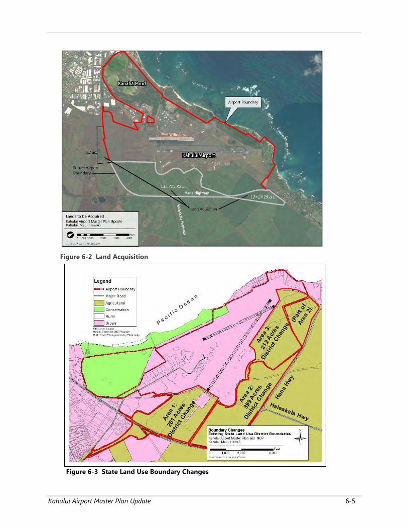
The recommended OGG MP implementation will
require the acquisition of additional land, particularly
for the construction of the parallel runway, as shown
in Figure 6-2 for the ultimate airport development.
The description-purpose and acreage of the
recommended acquisitions are presented in Table
6-1.
Table 6-1 Table of Land Acquisition
6.2.2 RUNWAY 2-20 EXTENSION
The proposed 1,535 ft. extension of Runway 2-20 to
the south is located entirely within the existing OGG
boundary. Approximately 13 acres of additional land,
extending across Hāna Highway will be required for
the RPZ. See Figure 6-2 on Page 6-5.
6.2.3 EAST OF PRESENT AIRPORT
BOUNDARY
Construction of the new Runway 2R-20L that is
parallel with Runway 2-20 would require land
acquisition of approximately 315.8 acres to the east
of the present OGG boundary. The proposed parallel
runway would be 7,000 ft. long by 150 ft. wide, with
2,500-ft. long precision instrument RPZs at both
ends. The land acquisition will also extend to the
east of the Hāna Highway to develop the parallel
runway and required realignment of the highway
near the north end of the parallel runway.
Consideration should also be given to acquiring land
north of the proposed parallel runway all the way to
the shoreline. The recommended acquisition
includes several homes in East Spreckelsville that
would be adversely affected by aircraft operations
on the proposed parallel runway.
Approximately 90+ acres of land, south of Hāna
Highway, should be acquired or an avigation
easement obtained, for the recommended 2,500-ft.
long precision instrument RPZ.
6.2.4 KANAHĀ POND STATE WILDLIFE
SANCTUARY
Day-to-day operations of the Kanahā Pond State
Wildlife Sanctuary located southwest of Runway 5-
23, will continue to be managed by the DLNR. See
Figure 6-3 on Page 6-5. Sanctuary management and
operations will continue to operate within the terms
and conditions of the executed MOU between the
DLNR, DOTA, and FAA.
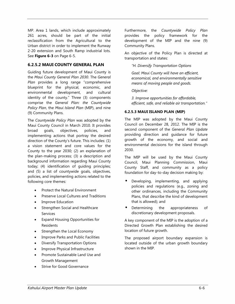
6.2.5 STATE AND COUNTY LAND USE
6.2.5.1 STATE LAND USE DISTRICT
All lands within the State of Hawai‘i are classified as
an Agricultural, Conservation, Rural, or Urban district
by the State LUC. Airport land uses are generally
characterized as industrial uses and therefore
require an “Urban” district classification. The existing
and proposed State land use district classifications
are shown in Figure 6-3 on Page 6-5. Approximately
872 acres will need to be reclassified from the
Agricultural to Urban district to implement the
recommended OGG
LAND ID DESCRIPTION APPROX.
AREA (Ac.)
L-1 Development of portions
of Parallel Runway 2R
RPZ, Connecting
Taxiways, Navaids, RSA,
and East Ramp Access
Road.
315.82
L-2 Development of portion
of Parallel Runway 20L,
Connecting Taxiways,
Navaids, RSA, RPZ, and
Hāna Highway
Realignment.
24.15
TOTAL (acres)/1 339.97
1 Hāna Highway RPZ = 13.87 ac. To be acquired
N100’
500’
1000’
37
34 36
30
1216 15
14
17
29
28b
28a
24
23
22
20
18
10
19
2
1
98
7
6
27
1513
33
28c
25
11
21 4 5
26
32
31
3
Proposed Construction
Terminal
Land To Be Acquired
Ocean
Shoreline
Airport Property Line
Road To Be Closed
Taxiway Realignment
Future Airstrip
New Road
Runway 2-20 Extension (1535 lf.) (Grade, Pave, Navaids)
Taxiway A Extension
South Ramp Apron 27ac.
Taxiway Realignment (Twy B, F and G)
Transient Aircraft Parking (9 ac.)
Runway 2R-20L (Parallel Runway) 7000ft.
Parallel Taxiway for Parallel Runway 2R-20LTemporary Runway 2-20 (using Twy ‘L’) plus Navaids
Kalialinui Channel Improvements
Parallel Taxiway “M” plus Service Road
Navigational and Landing Aids - Replacement
FATO Relocation
Runway 2-20 Reconstruction
Crossover T/W Connecting Taxiway A to RWY 2T
Temp. Runway 2-20 Blast Pads
Temp. Runway 2-20 RSA Improvements
Drainage Improvements
1
2
3
4
5
6
7
8
9
10
11
12
13
14
15
16
17
18
19
20
21
22
23
24
25
26
27
28
29
30
32
33
34
35
36
37
31
Helicopter Facility Expansion (Grade and Pave)
South Ramp Aviation Lease Lots (Grade, Pave, Utilities)
Keolani Lease Lots (Clear and Grade)
Terminal North - New Gates (Clean and Demo)
Terminal South - Holdrooms
Terminal 2nd Level Improvements
Haleakalā Highway (To Be Closed)
Realign Hāna Highway (Grade and Pave)
Alahao Emergency Access Road
GA T-hangars – East Ramp
Land To Be Acquired
East Ramp Access Road
East Ramp Access Road Tunnel
RAC Overflow Parking (19 ac.)
Bridge to RAC subd.
Industrial Aviation Lots East Ramp 20 ac.
Employee Parking (5 ac.)
Demolish Existing GSE & Cargo
Cell Phone Parking Lot
East Ramp Temp. Relocation of Services
AIRFIELDLEGEND
TERMINAL
35
KANAHĀ POND
REALIGN HĀNA HWY
X
Kahului Airport Master Plan Update
Source: R.M. Towill Corporation
6-3
Figure 6-1 Preferred Plan

Kahului Airport Master Plan Update 6-4
Page Left Blank Intentionally
Kahului Airport Master Plan Update 6-5
Figure 6-2 Land Acquisition
Figure 6-3 State Land Use Boundary Changes
Kahului Airport Master Plan Update 6-6
MP. Area 1 lands, which include approximately
261 acres, should be part of the initial
reclassification from the Agricultural to the
Urban district in order to implement the Runway
2-20 extension and South Ramp industrial lots.
See Figure 6-3 on Page 6-5.
6.2.5.2 MAUI COUNTY GENERAL PLAN
Guiding future development of Maui County is
the Maui County General Plan 2030. The General
Plan provides a long range “comprehensive
blueprint for the physical, economic, and
environmental development, and cultural
identity of the county.” Three (3) components
comprise the General Plan: the Countywide
Policy Plan, the Maui Island Plan (MIP), and nine
(9) Community Plans.
The Countywide Policy Plan was adopted by the
Maui County Council in March 2010. It provides
broad goals, objectives, policies, and
implementing actions that portray the desired
direction of the County’s future. This includes: (1)
a vision statement and core values for the
County to the year 2030; (2) an explanation of
the plan-making process; (3) a description and
background information regarding Maui County
today; (4) identification of guiding principles;
and (5) a list of countywide goals, objectives,
policies, and implementing actions related to the
following core themes:
Protect the Natural Environment
Preserve Local Cultures and Traditions
Improve Education
Strengthen Social and Healthcare
Services
Expand Housing Opportunities for
Residents
Strengthen the Local Economy
Improve Parks and Public Facilities
Diversify Transportation Options
Improve Physical Infrastructure
Promote Sustainable Land Use and
Growth Management
Strive for Good Governance
Furthermore, the Countywide Policy Plan
provides the policy framework for the
development of the MIP and the nine (9)
Community Plans.
An objective of the Policy Plan is directed at
transportation and states:
“H. Diversify Transportation Options
Goal: Maui County will have an efficient,
economical, and environmentally sensitive
means of moving people and goods.
Objective:
3. Improve opportunities for affordable,
efficient, safe, and reliable air transportation.”
6.2.5.3 MAUI ISLAND PLAN (MIP)
The MIP was adopted by the Maui County
Council on December 28, 2012. The MIP is the
second component of the General Plan Update
providing direction and guidance for future
growth of the economy, and social and
environmental decisions for the island through
2030.
The MIP will be used by the Maui County
Council, Maui Planning Commission, Maui
County Staff, and community as a policy
foundation for day-to-day decision making by:
• Developing, implementing, and applying
policies and regulations (e.g., zoning and
other ordinances, including the Community
Plans, that describe the kind of development
that is allowed); and
• Determining the appropriateness of
discretionary development proposals.
A key component of the MIP is the adoption of a
Directed Growth Plan establishing the desired
location of future growth.
The proposed airport boundary expansion is
located outside of the urban growth boundary
shown in the MIP.
Kahului Airport Master Plan Update 6-7
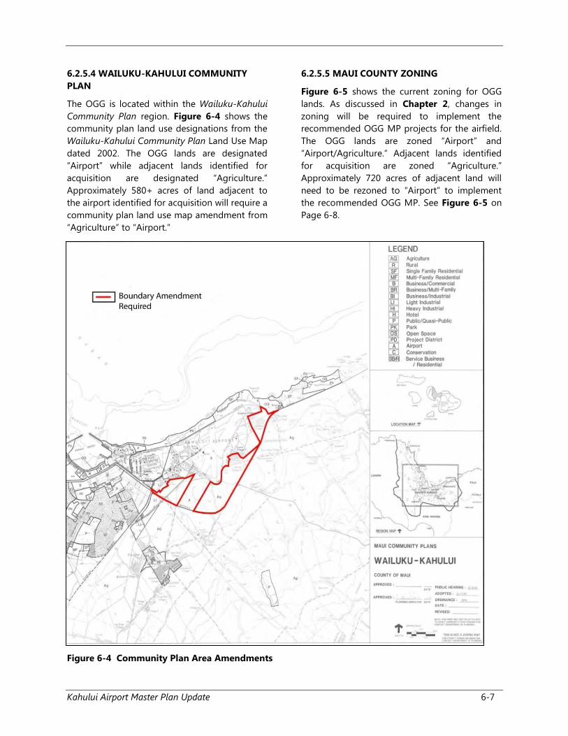
6.2.5.4 WAILUKU-KAHULUI COMMUNITY
PLAN
The OGG is located within the Wailuku-Kahului
Community Plan region. Figure 6-4 shows the
community plan land use designations from the
Wailuku-Kahului Community Plan Land Use Map
dated 2002. The OGG lands are designated
“Airport” while adjacent lands identified for
acquisition are designated “Agriculture.”
Approximately 580+ acres of land adjacent to
the airport identified for acquisition will require a
community plan land use map amendment from
“Agriculture” to “Airport.”
6.2.5.5 MAUI COUNTY ZONING
Figure 6-5 shows the current zoning for OGG
lands. As discussed in Chapter 2, changes in
zoning will be required to implement the
recommended OGG MP projects for the airfield.
The OGG lands are zoned “Airport” and
“Airport/Agriculture.” Adjacent lands identified
for acquisition are zoned “Agriculture.”
Approximately 720 acres of adjacent land will
need to be rezoned to “Airport” to implement
the recommended OGG MP. See Figure 6-5 on
Page 6-8.
Figure 6-4 Community Plan Area Amendments
Kahului Airport Master Plan Update 6-8
Figure 6-5 County Zone Change Areas
AREA ID ACREAGE
1 86
2 100
3 43
4 165
5 84
6 55
7 141
8 46
Total (ac.) 720
Kahului Airport Master Plan Update 6-9
6.3 AIRFIELD
The runways, taxiways, holding apron areas,
shoulders, blast pads, NAVAIDS, associated
RSAs, and RPZs are shown in Figure 6-1 on
Page 6-5. The recommended airfield
improvements include the proposed 1,535 ft.
Runway 2-20 extension, proposed Taxiway “L” to
a temporary 7,000 ft. runway with parallel and
connecting taxiways, a new parallel 7,000 ft.
Runway 2R-20L, and taxiway improvements.
These projects will accommodate forecast
activity through the 20-year planning period of
this recommended OGG MP. The recommended
improvements are described below.
6.3.1 RUNWAY 2-20
Runway 2-20 is planned for a maximum length
of 8,530 ft. with no change to its present 150-ft.
width. See Figure 6-1. To establish the 8,530-ft.
length, the runway will be extended 1,535 ft.
south of Runway 2 of the present Runway 2-20.
The recommended runway length provides
additional length for essentially unrestricted
overseas passenger aircraft operations without
weight penalties to the U. S. West Coast and
some Midwest destinations such as Chicago,
Dallas, and Denver. A 1,000-ft. long by 500-ft.
wide RSA is recommended to the south of the
extended Runway 2 threshold and north of the
existing Runway 20 threshold. Additional
taxiways are also recommended for this runway
to facilitate aircraft ground movement and
reduce aircraft delay times, particularly during
periods of peak activity.
6.3.2 TAXIWAY “L” AND TEMPORARY
RUNWAY
Taxiway “L” will be developed parallel and east
for the entire length of Runway 2-20. The
proposed taxiway will be developed in phases,
first to facilitate the reconstruction of Runway 2-
20 by serving as a temporary runway, and
secondly as a taxiway that extends the entire
length of Runway 2-20. The taxiway should be
built to accommodate aircraft in ADG IV and V
with runway-taxiway separation of 400 ft. During
the period when the taxiway serves as a
temporary runway navigational aids will be
required. Utilization of an existing taxiway
(Taxiway “L” as referenced in this MP) is
considered a cost efficient alternative to closing
the primary runway. The use of Taxiway “L” will,
however, require the following actions during
the period that the Runway 2-20 reconstruction
takes place:
• Extending the taxiway to 7,000 ft. with all
required navigational aids and airfield
lighting
• Developing a parallel taxiway east of
Taxiway “L”
• Accommodating a service road east of the
taxiway
• Relocating some helicopter operations and
final approach and takeoff area (FATO)
• Relocating GA facilities and aircraft
• Relocating GA tie downs
• Moving existing fuel facilities
• Developing a Taxiway “A” connection
• Improving a drainage ditch
• Closing Haleakalā Highway
It is anticipated that once the reconstruction is
completed, services and functions that were
located on the east ramp will be returned to
their former locations.
6.3.3 RUNWAY 2R-20L (PARALLEL
RUNWAY)
A 7,000 ft. long, 150 ft. wide parallel Runway 2R-
20L is recommended 2,500 ft. to the east
(centerline-to-centerline separation) of the
existing Runway 2-20. See Figure 6-1 on Page
6-5. The 7,000 ft. long runway would
accommodate take-off and landing of flights
from the West Coast of the United States. The
centerline-to-centerline runway separation will
allow for simultaneous VFR operations by heavy
aircraft (e.g., B-737, B-757, B-767, and B-777) as
well as some staggered parallel instrument
Kahului Airport Master Plan Update 6-10
operations under certain conditions and with
precision instrument landing systems on both
runways. A 1,000 ft. long by 500 ft. wide RSA
area should be provided beyond both ends of
this runway. Land acquisition is proposed only
during the planning period for the purpose of
preserving future development options and to
prevent airport incompatible uses from being
developed on lands adjacent to the airport.
6.3.4 RUNWAY 5-23
Runway 5-23 will continue to operate ‘as-is’
without any changes to its 4,990 ft. length and
150 ft. width. See Figure 6-1 on Page 6-5. The
runway will continue to be a non-precision-non-
instrument runway that is used by GA and
commuter/air taxi aircraft.
6.3.5 BUILDING RESTRICTION LINES
AND OBJECT FREE ZONES
The recommended OGG MP retains the BRL at
1,000 ft. to the west and 750 ft. to the east of the
centerline of existing Runway 2-20. The BRLs
would extend past the ends of the runways to
the point where they intersect the new RPZs that
would accommodate the runway extensions.
Both of these provisions are consistent with
current FAA recommendations.
The OGG MP also recommends the
establishment of a BRL of at least 750 ft. to the
east and west of the centerline of the future
parallel Runway 2R-20L.
The existing BRL for Runway 5-23 is situated 553
ft. on either side of the runway centerline and
the plan recommends that this be retained. The
existing ground transportation support buildings
that are within the RPZ for Runway 5 should be
relocated to comply with the latest FAA criteria.
6.3.6 TAXIWAYS
The recommended 1,535 ft. extension of Runway
2-20, construction of the 7,000 ft. parallel
Runway 2R-20L, and other recommended
projects will require the development of new
and extended taxiways to provide access to and
from the airfield as shown on Figure 6-1 on
Page 6-5. A proposed Taxiway “L” (proposed
temporary runway) and Taxiway “A” are
recommended to be located south to the
proposed extended end of Runway 2. New entry
exit taxiways are proposed to connect the
extended Runway 2-20 to Taxiway “A” and “L.”
Taxiway “F” will be extended northeast of
Taxiway “A” at the end of Runway 5 to provide a
full-length parallel taxiway on the southeast side
of Runway 5-23. A centerline separation distance
of 400 ft. is recommended between the taxiway
and the centerline of Runway 5-23 to
accommodate Group III aircraft (e.g., B-717 and
B-737). These aircraft use the runway on an
infrequent basis when Runway 2-20 is not
available for use. Additional entry and exit
taxiways are recommended which would include
portions of the connecting taxiways that would
accompany the proposed parallel runway.
New taxiways should be constructed to connect:
(1) the future parallel runway and associated
taxiways to the existing airfield, (2) the large
transient aircraft parking apron to Taxiway “A,”
and (3) the future GA and commercial aviation
areas to the extended Taxiway “G.” Additional
taxiway fillets are recommended near the
runway taxiway intersections to expedite aircraft
movement onto the exit taxiways. The exact
dimensions and placement of these fillets are to
be determined during the design phase.
The taxiways serving air carrier aircraft should be
75 ft. wide. A width of 35 ft. should be
considered for taxiways serving areas such as the
GA area east of Runway 2-20 which would be
used only by small aircraft (i.e., those with gross
weights of 12,500 lbs or less).
6.3.7 APRONS
A new approximately 27 acre apron is proposed
to serve the new industrial lots on the South
Ramp. Future tenants of these lots will provide
services or uses requiring direct airfield and
apron access. A new, approximately one (1) acre,
apron will be needed to service additional gates
on the north end of the passenger terminal
discussed in Section 6.4.1. This would include
extending the existing apron over the existing
bus parking. A holding apron is also
Kahului Airport Master Plan Update 6-11
recommended between the proposed extended
Taxiway “L” and the proposed parallel Runway
2R-20L. It would be similar in size to the new
extended South Ramp apron. A transient aircraft
parking apron is proposed near the intersection
of Runway 2-20 and Runway 5-23. It would be
approximately 9.5 acres and include paved
connections to Taxiway “A” and Runway 5-23.
6.3.8 NAVIGATION AND LANDING
AIDS
Existing NAVAIDS under the purview of the FAA
are proposed for continued uninterrupted
operations. They include runway and taxiway
lighting, precision instrument approach system,
glide slope facility, middle marker, and high and
MALSR approach lights, clear zone of 1,000 ft.
for the VORTAC, clear zone of 1,500 ft. for the
ASR east of Runway 2-20 to protect the facility
from encroachment by structures or other
objects that could adversely impact the radar.
Similar facilities are proposed for the parallel
Runway 2R-20L.
For the Runway 2 extension, new navigational
aids will be placed along the 1,540 ft. extension
which will include relocated VASI-4, Glide Slope
Facility, Wind Sock, and Runway End Indicator
Lights (REIL). At the ends of the future parallel
runway and extending 2500 ft., future MALSR
approach lights and a Middle Marker will be also
be constructed . Runway 20 would continue to
utilize PAPI-4 and Runway 5-23 will continue
with current navigational aids.
6.4 TERMINAL AREA PLAN
This section describes the terminal projects
recommended for the OGG. See Figure 6-6 on
Page 6-13. These include the passenger terminal,
commuter air taxi terminal, air cargo facilities,
ground transportation subdivision, bulk fuel
storage tanks, new CONRAC facilities, new
aviation lease lots, and other facilities. The
projects described should be phased to ensure
that they are constructed only as needed and
that their construction does not disrupt on-
going OGG operations.
6.4.1 PASSENGER TERMINAL
The 20 existing aircraft parking positions
fronting the passenger terminal are currently
insufficient to support projected aircraft
operations through the year 2035. Of the 20
aircraft parking positions only 13 parking
positions are sized for operations by three (3)
inter-island and 10 overseas aircraft. Additional
parking spaces are required to support projected
additional flights preventing gate shortages
currently affecting operations. In addition, the
DOTA and the air carriers should coordinate the
reassignment of gates and facilitate the re-
marking of the ramp to further maximize the use
of the aircraft parking ramp.
Terminal – North-end Expansion. The north
end second level of the terminal currently
houses 23 departure gates, gates 17-39, with
nine (9) aircraft parking positions. Expansion in
this area is constrained by the runways and
taxiways to the north. Space could be provided
for two (2) additional air carrier aircraft parking
positions on the apron to the north for
expansion beyond the 2035 planning period.
With the relocation of the air cargo, GSE, car
rental customer windows, and customer pick-up
area, this area would be available for additional
terminal functions – aircraft parking positions
and/or additional terminal holding areas. See
Figure 6-6. An additional exit from the north
end to the baggage claim area is proposed.
Terminal – South-end Expansion. There are six
(6) holdrooms on the second level of the
terminal that service gates 1–16. See Figure 6-6
on Page 6-13. There are four (4) aircraft parking
positions available (one (1) inter-island and three
(3) overseas). The utility of the gates are limited
by the size of the holdrooms (holding area),
where each holdroom is nearly one-half of the
area provided by gates 17-39. The holdrooms
are proposed to be tripled in size by building
over the ground-level vehicular access way and
connecting with the terminal building footprint
on the other side. Currently, Building 345 with a
combined footprint of approximately 21,780 s.f.
contains three (3) holdrooms, Gates 2-7, two (2)
ticketing areas, a U. S. Department of Agriculture
Kahului Airport Master Plan Update 6-12
(USDA) Inspection station, and two (2)
restrooms. Building 341 with a combined
footprint of 22,740 s.f. contains three (3)
holdrooms, Gates 9-15, two (2) ticketing areas,
an ice cream shop, two (2) restrooms, and two
(2) airline offices. The walkway that connects the
two (2) buildings would be doubled from its
current footprint of approximately 5,830 s.f. The
total expansion would be approximately two (2)
acres. It is possible that a few additional aircraft
parking positions will be required infrequently
during extremely busy periods by the end of the
planning period due to future airline scheduling
practices, overlapping of inter-island and
overseas peak hours, and turnaround time for
overseas flights. To address this, the
recommended OGG MP preserves space to the
south of the existing aircraft parking apron and
recommends additional gates to support the
planned increase in Hawaiian Airlines flights. The
recommended OGG MP accommodates power-
in/push back operations at each aircraft parking
position.
Extension of the terminal building to the south
over the existing air cargo and ASIF facility is
proposed once the South Ramp is developed.
The terminal extension to the south would
support more passenger holding areas and
gates to serve additional aircraft. This may be
done at a later phase and would have a potential
area of approximately eight (8) acres. When
completed, the ASIF and air cargo buildings will
be relocated to the industrial lots on the South
Ramp.
Terminal – Relocation of Art Work. The
existing statue of Maui the Sun God is proposed
to be relocated from its current position
adjacent to the security check-point to the
baggage claim area (where the current skylight
is located).
6.4.2 COMMUTER AIRLINE FACILITIES
The existing commuter terminal and ramp
facilities would continue as currently configured.
Terminal facilities for four (4) airlines are
recommended and would accommodate the
following: passenger ticketing and check-in,
baggage claim, waiting area, airline operations,
restrooms, and concessions. Approximately
10,000 s.f. of building area will be allocated
along with space for approximately 100+
vehicles or three (3) acres of parking for
customers.
6.4.3 U.S. POSTAL SERVICE FACILITIES
The USPS owns and operates facilities located on
a five (5) acre parcel of land adjacent to Keolani
Place. The utilities needed to serve this site are
already in place. The disadvantage of this
location is that the USPS will not have direct
access to the aircraft ramp once the new airport
access road is completed. Access will be via the
public roads. The USPS will be offered the option
to relocate to the new aviation lease lots in the
South Ramp to allow the organization to have
direct access to aircraft. A decision on the
relocation is pending, but USPS would likely
occupy approximately three (3) acres based on
the offer of an improved site. If USPS decides to
move, the existing five (5) acre area would be
used for employee parking and a cell phone
waiting lot.
6.4.4 AIR CARGO AND ASIF
FACILITIES
In 2007, new air cargo facilities were developed
south of the main passenger terminal primarily
for cargo carried by passenger aircraft. The total
area of the air cargo and ASIF facility is
approximately 3.6 acres. The area includes space
for vehicle circulation, stockpiling of cargo, and
parking. This cargo is often referred to as belly-
cargo because it is carried in the bellies of
passenger aircraft. Cargo carried by all-cargo
aircraft (such as Aloha Air Cargo and other all-
cargo carriers) are typically referred to as hold-
cargo and is also being handled there. With the
development of the South Ramp, the two
facilities should be relocated to this location,
thus freeing space for terminal expansion.
3
19
34
22 23
21
32
31
35
20
N100’
200’
1000’
3 South Ramp Apron 27ac.
LEGEND
AIRFIELD
TERMINAL
Proposed Construction
Terminal & CONRAC
Demolished Buildings
Ocean
Shoreline
Airport Property Line
South Ramp Aviation Lease Lots (Grade, Pave, Utilities)
Keolani Lease Lots (Clear and Grade)
New Gates North - End
Termianl Holdrooms - South
Terminal 2nd Level Improvements
RAC Overflow Parking (19 ac.)
Kalialinui Bridge at RAC
Employee Parking (5 ac.)
Demolish Existing GSE, Cargo
Cell Phone Parking Lot
19
20
21
22
23
31
32
34
35
36
KANAHĀ POND
Kahului Airport Master Plan Update 6-13
Figure 6-6 Preferred Terminal Plan - North and South
Source: R.M. Towill Corporation
Kahului Airport Master Plan Update 6-14
Page Left Blank Intentionally
Kahului Airport Master Plan Update 6-15
6.4.5 FUEL STORAGE AND LOADING
FACILITIES
The bulk fuel storage facilities at the OGG are
located west of Keolani Place, adjacent of
Kalialinui Drainage Channel. Fuel will be trucked
from the storage tanks to the apron over the
near term, but the OGG MP calls for a fuel
pipeline to be installed between the storage
tanks and the south end of the air passenger
terminal building.
6.4.6 AIRLINE GROUND EQUIPMENT
MAINTENANCE FACILITIES
The recommended OGG MP envisions much of
the ground equipment maintenance work
continuing to be done in the airlines’ individual
bays beneath the passenger holding rooms.
However, additional space is needed for more
extensive maintenance work. The OGG MP
designates one (1) of the aviation lease lots in
the South Ramp (approximately 0.6 acre) for this
use. The existing GSE Building will be
demolished to make way for the proposed north
end terminal expansion.
6.4.7 STATE DOT AIRPORT
MAINTENANCE FACILITIES
The DOTA maintenance baseyard is planned to
remain in its present location throughout the
planning period.
6.4.8 SOUTH RAMP – AVIATION
LEASE LOTS
The OGG MP reserves approximately 42 acres
adjacent to the South Ramp for aviation uses
such as: USPS, bulk fuel storage, GSE, air cargo
expansion, freight forwarders and handlers (e.g.,
UPS and FedEx), fixed base operators, etc. This
area can be subdivided into lots ranging from
one-half (0.5) acre to five (5) acres. The total
available area for future leases is 41+ acres.
Approximately 27 acres of new apron space will
be provided to serve these lots. See Figure 6-7
on Page 6-16.
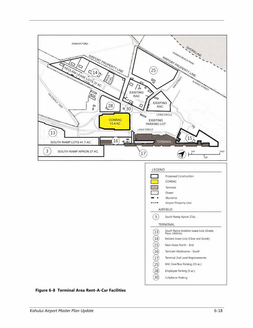
6.4.9 CONSOLIDATED RENT-A-CAR
(CONRAC)
This new facility (in progress) will provide for the
following RAC functions: ready-return, quick
turn-around (plus fueling), and customer service
desks. Maintenance facilities are to be located in
the Keolani Place lease lots. Overflow parking
which currently occupies over 30 acres of space
northwest of the existing ground transportation
subdivision could be distributed north of the
Keolani Place lease lots in a 19 acre area and in
the South Ramp industrial lots. As discussed
previously, there are seven (7) RAC companies
located at the OGG: Alamo, Avis, Budget, DTG
Operations Inc., Enterprise, Hertz, and National.
See Figure 6-8 on Page 6-18. The following
acreages reflect each RAC companies parking
and garage/service station facilities uses only
within the existing ground transportation
subdivision. As previously discussed, these RAC
operations will be relocated at the Keolani Place
lease lots location. Other facilities such as
customer service areas will be located in the
CONRAC facility. Alamo has approximately three
(3) acres, Avis has two (2) acres, Budget has two
and a half (2.5) acres, Enterprise has two (2)
acres, Hertz has three (3) acres, and National has
one-half (0.5) acre. Dollar and Thrifty are owned
and operated by DTG Operations, Inc. Therefore,
they would share the same facilities including a
garage and parking in the proposed Keolani
lease lots. Their existing space is approximately
four (4) acres.
In summary, the existing RAC spaces off of
Koeheke Street would need to be consolidated
and functions, except maintenance, would be in
the new multi-level CONRAC facility south of the
existing public parking lot. Actual space leased
to each company would need to be determined
at a later date.
Kahului Airport Master Plan Update 6-16
Figure 6-7 Terminal Area –South Ramp
6.4.10 EAST-SIDE TERMINAL
FACILITIES
6.4.10.1 GENERAL AVIATION
The recommended OGG MP proposes the
continued operation of existing GA facilities east
of Runway 2-20 to accommodate the 35 based
fixed-wing aircraft as well as itinerant fixed-wing
aircraft.
The construction of two (2) additional T-hangars
for GA, approximately 12,000 s.f. in size are
recommended. The recommended OGG MP also
provides space for individual executive-type
hangars to be developed by lessees, as needed,
and for future expansion.
Each lot would have access to both the airfield
and roadway system. Space should also be
provided within each lease lot for automobile
parking for employees and visitors. The DOTAs
current property development standards call for
two (2) acre minimum lot sizes for commercial
aviation and FBO lots. However, in order to meet
the needs of the small GA operators in the State,
it is recommended that the subdivision layout
provide some one (1) acre lease lots. The lease
lots should be assigned so that GA operators
who need a larger area can lease contiguous
parcels. The recommended OGG MP provides
space in the GA area for a future aircraft wash
rack. A pilots’ lounge or ready room could be
provided within a FBOs hangar and office
building at the end of a row of hangars. Apron
lighting should be provided in the general
aviation apron and hangar area. New taxiways
would be provided to connect the expanded GA
aircraft apron and hangar areas. East Ramp
project elements are identified in Figure 6-9 on
Page 6-19.
6.4.10.2 AIR CARGO FACILITIES
A second new air cargo area is proposed in the
recommended OGG MP and situated at the
northern end of the East Ramp. A four (4) acre
area that is part of the proposed new East Ramp
lease lots will be made available to air cargo
operators for their facilities. Unlike the air cargo
facilities proposed for the western side of the
OGG, these are intended for use by all cargo
aircraft. Initially, access to the new facilities
would be via existing roads; ultimately this area
Kahului Airport Master Plan Update 6-17
would be serviced by the proposed new East
Ramp spine road.
6.4.10.3 HELICOPTER FACILITIES
The existing helicopter facilities are poorly
situated with respect to apron surveillance from
the FAA ATCT. Its present location will place it
between two (2) active runways once the
recommended parallel Runway 2R-20L is
constructed. This would increase the frequency
of undesirable interactions between helicopter
and fixed-wing aircraft operations.
Consequently, relocation of these facilities is
recommended. A number of OGG locations were
evaluated during the master planning process,
but all had significant limitations. These
limitations included increased cross-runway
overflights, proximity to nearby residential or
recreational areas, and limited land area. In view
of the foregoing, it is recommended that most
facilities supporting helicopter operations
eventually be relocated to a new site outside the
existing OGG boundary. Possible locations
include a site on the eastern side of Hāna
Highway near its intersection with Haleakalā
Highway. The exact size and location of these
new helicopter facilities should be determined
after further study.
6.4.10.4 MILITARY OPERATIONS
Several times each year the OGG is used by
groups of large military transport aircraft and
helicopters. It is proposed that these aircraft use
the itinerant apron that is part of the East Ramp
or the vacant 20 acres north of the GA facilities.
The DOTA should cooperate with the U. S.
Department of Defense (DOD) to provide a
facility that is suitable for use as a temporary
troop shelter transportation coordination office
adjacent to the transient aircraft parking apron.
6.4.10.5 FAA AIRPORT TRAFFIC CONTROL
TOWER
The FAA ATCT adjacent to the East Ramp is
adequate with two (2) exceptions. The first
exception is that hangers in the helicopter
operating area at the southern end of the East
Ramp obstruct FAA ATCT views of the apron.
The relocation of the FATO area should alleviate
this situation. The second is that the passenger
terminal obscures the FAA ATCT views of the
western end of Runway 5-23 and the connecting
taxiway. Aircraft operating procedures have been
developed to deal with the restricted visibility.
The tower has adequate communication and
utility links and requires no further improvement
within the time frame of this MP.
Kahului Airport Master Plan Update 6-18
Figure 6-8 Terminal Area Rent-A-Car Facilities

Kahului Airport Master Plan Update 6-19
Figure 6-9 East Ramp Plan
Kahului Airport Master Plan Update 6-20
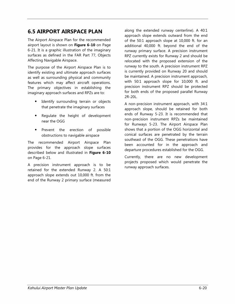
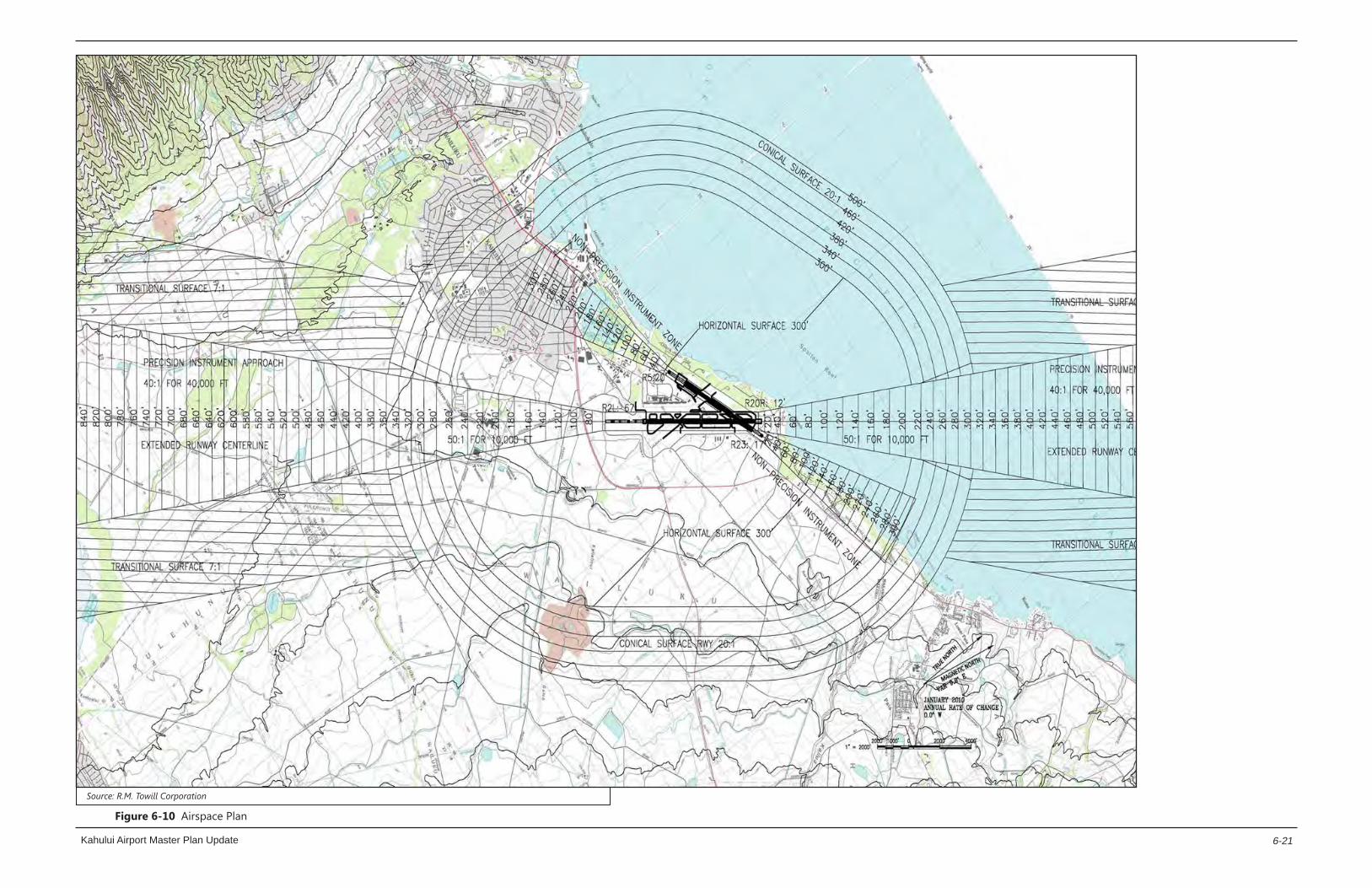
6.5 AIRPORT AIRSPACE PLAN
The Airport Airspace Plan for the recommended
airport layout is shown on Figure 6-10 on Page
6-21. It is a graphic illustration of the imaginary
surfaces as defined in the FAR Part 77, Objects
Affecting Navigable Airspace.
The purpose of the Airport Airspace Plan is to
identify existing and ultimate approach surfaces
as well as surrounding physical and community
features which may affect aircraft operations.
The primary objectives in establishing the
imaginary approach surfaces and RPZs are to:
• Identify surrounding terrain or objects
that penetrate the imaginary surfaces
• Regulate the height of development
near the OGG
• Prevent the erection of possible
obstructions to navigable airspace
The recommended Airport Airspace Plan
provides for the approach slope surfaces
described below and illustrated in Figure 6-10
on Page 6-21.
A precision instrument approach is to be
retained for the extended Runway 2. A 50:1
approach slope extends out 10,000 ft. from the
end of the Runway 2 primary surface (measured
along the extended runway centerline). A 40:1
approach slope extends outward from the end
of the 50:1 approach slope at 10,000 ft. for an
additional 40,000 ft. beyond the end of the
runway primary surface. A precision instrument
RPZ currently exists for Runway 2 and should be
relocated with the proposed extension of the
runway to the south. A precision instrument RPZ
is currently provided on Runway 20 and should
be maintained. A precision instrument approach,
with 50:1 approach slope for 10,000 ft. and
precision instrument RPZ should be protected
for both ends of the proposed parallel Runway
2R-20L.
A non-precision instrument approach, with 34:1
approach slope, should be retained for both
ends of Runway 5-23. It is recommended that
non-precision instrument RPZs be maintained
for Runways 5-23. The Airport Airspace Plan
shows that a portion of the OGG horizontal and
conical surfaces are penetrated by the terrain
southeast of the OGG. These penetrations have
been accounted for in the approach and
departure procedures established for the OGG.
Currently, there are no new development
projects proposed which would penetrate the
runway approach surfaces.
Kahului Airport Master Plan Update
Figure 6-10 Airspace Plan
Source: R.M. Towill Corporation
6-21

Kahului Airport Master Plan Update 6-22
Page Left Blank Intentionally
Kahului Airport Master Plan Update 6-23
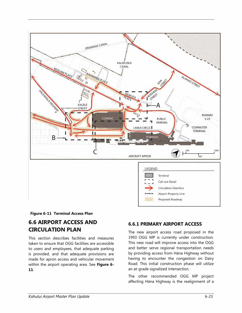
Figure 6-11 Terminal Access Plan
6.6 AIRPORT ACCESS AND
CIRCULATION PLAN
This section describes facilities and measures
taken to ensure that OGG facilities are accessible
to users and employees, that adequate parking
is provided, and that adequate provisions are
made for apron access and vehicular movement
within the airport operating area. See Figure 6-
11.
6.6.1 PRIMARY AIRPORT ACCESS
The new airport access road proposed in the
1993 OGG MP is currently under construction.
This new road will improve access into the OGG
and better serve regional transportation needs
by providing access from Hāna Highway without
having to encounter the congestion on Dairy
Road. This initial construction phase will utilize
an at-grade signalized intersection.
The other recommended OGG MP project
affecting Hāna Highway is the realignment of a
Kahului Airport Master Plan Update 6-24
portion of the Highway adjacent to the
northeastern corner of the OGG. A new highway
alignment is needed to keep the RPZ, associated
with the proposed parallel Runway 2R-20L,
entirely within the OGG property. The land for
the realignment must be acquired from A&B.,
which uses the land for sugarcane cultivation.
Due to the relatively low volume of traffic that is
generated by existing and proposed uses on the
eastern side of Runway 2-20, the existing
roadways serving that area are adequate.
However, Haleakalā Highway will need to be
closed to through-traffic when Runway 2-20 is
extended to the south. Access from Hāna
Highway to the East Ramp facilities can continue
on the existing roadways, Kala Street and the
remnant of Haleakalā Highway, until the
proposed parallel Runway 2R-20L is constructed.
At that time, a new access road must be
constructed between, and generally parallel to,
the runways.
Because the majority of the traffic to and from
the facilities planned for this area is from the
Kahului side of the OGG, the recommended
OGG MP Update calls for the construction of a
spine road to intersect Hāna Highway at the
south end of the East Ramp near the existing
intersection with Pulehu Road. The
recommendations in this OGG MP Update does
not propose connecting the spine road to the
external road network at its northern end due to
the relatively low volume of traffic that is
anticipated to and from the north and east, and
the high cost of tunneling beneath the
connecting taxiways.
6.6.2 OTHER ON-AIRPORT PUBLIC
ROADS
The recommendations in this OGG MP Update
propose the construction of new internal
roadways to serve new and/or reconfigured
development. The areas that would be served by
these new roads include the additional lots for
ground transportation operators, bulk fuel
storage facilities, the South Ramp lease lots, and
the lease lots along the northwestern side of
Keolani Place. These streets should meet
commercial development quality standards with
curbs, lighting, sidewalks and a storm drain
system. They should be designed to
accommodate moderate traffic volumes with a
design speed of 25 miles per hour (mph). Most
of the traffic on these roads will consist of
passenger cars, vans, buses, trucks, and other
vehicles. The roadway geometrics and pavement
should be designed accordingly.
6.6.3 ON-AIRPORT SERVICE ROADS
In addition to public streets, the
recommendations in this OGG MP Update also
call for the construction of new internal service
roads. These include a new perimeter road
fronting the south end of Runway 5, and
additional service roads to the new facilities. A
service road should be constructed linking the
South Ramp lease lots with the new Airport
Access Road which is under construction. The
volume of traffic moving along this road will be
low throughout the planning period and
anticipated speeds will be well below 25 mph.
The pavement geometry, load carrying
capability, vertical grades, and vertical clearances
at the grade separated underpass beneath the
proposed Airport Access Road should be
designed and constructed with these
requirements in mind.
When Runway 2-20 is extended, the portion of
Haleakalā Highway west of the runway will
terminate at the proposed new South Ramp
lease lots. Public access to the cargo buildings
will be provided from the south via the new
access road. The apron storage areas on one (1)
side of each cargo building will be included
within the OGG operating area.
6.6.4 VEHICLE PARKING
As discussed in Chapter 4, preliminary
calculations indicate that additional vehicular
parking may be needed near the main passenger
terminal if present vehicle usage rates continue
and passenger volumes increase as forecasted.
This airport parking deficiency may not appear
for well over a decade. However, there are many
factors that could exacerbate the parking
shortfall even further. It is acknowledged,
Kahului Airport Master Plan Update 6-25
however, that on occasional peak periods, the
existing parking facilities are utilized to the limit.
Because of this, construction of additional
parking spaces to increase capacity before 2017
was not recommended. Instead, the
recommended course of action is to develop the
CONRAC and reserve land south of the existing
parking lot for possible future development of
additional parking facilities.
It has been recommended that all employee
parking be relocated to the former USPS site.
Thus, the parking lot to the north will be
completely available to the public. The DOTA
should monitor parking lot usage on an annual
basis using data collected by the parking lot
concessionaire. The data should be reviewed at
least every other year and the DOTA should
begin developing plans for additional facilities
when daily use of the existing facilities exceeds
80% of capacity more than seven (7) times in any
one (1) year. In addition, the development of an
employee parking lot should be considered. This
lot can be located west of Lanui Circle.
6.7 GROUND TRANSPORTATION
FACILITIES
Concentrating all of the RAC customer service
operations in one (1) location at the OGG will
assist passengers with finding the facilities and
simplify transport between the passenger
terminal and baseyards. It is recommended that
the existing subdivision be expanded southward
across Kalialinui Gulch. From an operational
standpoint, the preferred arrangement would be
to extend Mokuea Place across Kalialinui Gulch.
A portion of the land in the area south of the
gulch has already been improved, and all of the
existing lots are currently leased for various
purposes. The future development of ground
transportation lots in this area must be done in
two (2) increments, with each increment on
either side of the existing improved lots. In order
to ensure the availability of land needed for this,
the renegotiation of lot leases presently used for
non-airport related will allow the DOTA to
terminate the leases if/when the land is
determined to be needed for airport purposes.
The terms of renegotiated leases within the
ground transportation development lots will
provide sufficient advance notification of lease
termination to avoid undue disruption to the
lessees who may be required to relocate.
Existing tenants who might be affected by this
policy include the Coral Factory, Enterprise, and
Roberts Hawai‘i. The future Keolani Place lease
lots will have approximately 37 acres of available
space for the relocated ground transportation
uses. As discussed, it is also recommended that
the ground transportation facilities within the
RPZ for Runway 5 be relocated to the CONRAC
and/or Keolani Place lease lots.
Lastly, some of the existing structures that are
outside of the future and existing BRL and RPZ
could potentially be retained by the airport for
other uses. An additional 19 acres west of the
RAC subdivision is proposed for the future
development of RAC overflow parking.
6.8 UTILITIES
The existing utility systems are currently
adequate to meet current demands; however, as
the improvements described above are
implemented, specific utilities will need to be
upgraded to meet the anticipated demand.
With the rise in electrical costs, the DOTA is
exploring the feasibility of further expanding
renewable energy generation at the OGG to
reduce its operational costs. The DOTA has
specifically explored the use of additional solar
panels to generate electricity and have
commissioned studies for its implementation.
Currently OGG has installed 3,420 solar panels
on the roof of the passenger terminal and is
awaiting approval from the Maui Electric
Company to inter-connect with the electrical
utility grid.
6.9 PROJECT COST ESTIMATE
Project costs are shown in Table 6-2 on Page 6-
26. Estimates are in 2015 dollars. The total
amounts include cost of construction,
contractors overhead, design services, and
contingency to account for unanticipated costs.
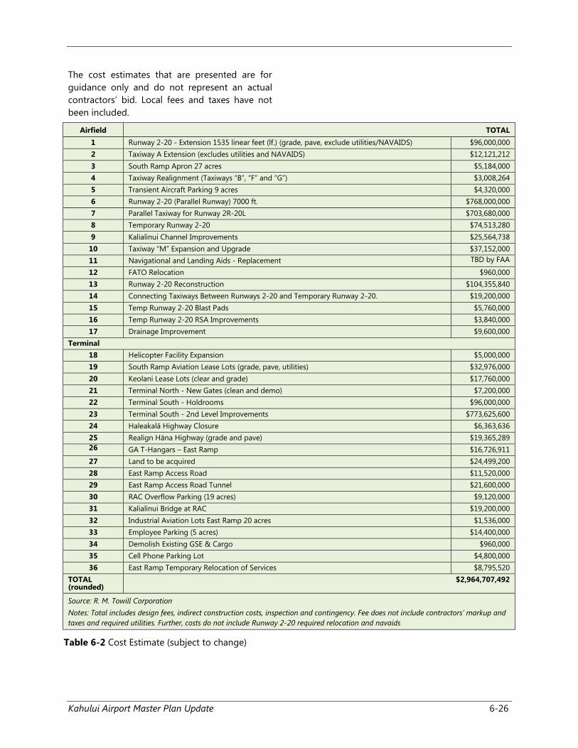
Kahului Airport Master Plan Update 6-26
The cost estimates that are presented are for
guidance only and do not represent an actual
contractors’ bid. Local fees and taxes have not
been included.
Airfield TOTAL
1 Runway 2-20 - Extension 1535 linear feet (lf.) (grade, pave, exclude utilities/NAVAIDS) $96,000,000
2 Taxiway A Extension (excludes utilities and NAVAIDS) $12,121,212
3 South Ramp Apron 27 acres $5,184,000
4 Taxiway Realignment (Taxiways “B”, “F” and “G”) $3,008,264
5 Transient Aircraft Parking 9 acres $4,320,000
6 Runway 2-20 (Parallel Runway) 7000 ft. $768,000,000
7 Parallel Taxiway for Runway 2R-20L $703,680,000
8 Temporary Runway 2-20 $74,513,280
9 Kalialinui Channel Improvements $25,564,738
10 Taxiway “M” Expansion and Upgrade $37,152,000
11 Navigational and Landing Aids - Replacement TBD by FAA
12 FATO Relocation $960,000
13 Runway 2-20 Reconstruction $104,355,840
14 Connecting Taxiways Between Runways 2-20 and Temporary Runway 2-20. $19,200,000
15 Temp Runway 2-20 Blast Pads $5,760,000
16 Temp Runway 2-20 RSA Improvements $3,840,000
17 Drainage Improvement $9,600,000
Terminal
18 Helicopter Facility Expansion $5,000,000
19 South Ramp Aviation Lease Lots (grade, pave, utilities) $32,976,000
20 Keolani Lease Lots (clear and grade) $17,760,000
21 Terminal North - New Gates (clean and demo) $7,200,000
22 Terminal South - Holdrooms $96,000,000
23 Terminal South - 2nd Level Improvements $773,625,600
24 Haleakalā Highway Closure $6,363,636
25 Realign Hāna Highway (grade and pave) $19,365,289
26 GA T-Hangars – East Ramp $16,726,911
27 Land to be acquired $24,499,200
28 East Ramp Access Road $11,520,000
29 East Ramp Access Road Tunnel $21,600,000
30 RAC Overflow Parking (19 acres) $9,120,000
31 Kalialinui Bridge at RAC $19,200,000
32 Industrial Aviation Lots East Ramp 20 acres $1,536,000
33 Employee Parking (5 acres) $14,400,000
34 Demolish Existing GSE & Cargo $960,000
35 Cell Phone Parking Lot $4,800,000
36 East Ramp Temporary Relocation of Services $8,795,520
TOTAL (rounded)
$2,964,707,492
Source: R. M. Towill Corporation
Notes: Total includes design fees, indirect construction costs, inspection and contingency. Fee does not include contractors’ markup and
taxes and required utilities. Further, costs do not include Runway 2-20 required relocation and navaids
Table 6-2 Cost Estimate (subject to change)