Embed Size (px)
Citation preview

CHAPTER 7 LAND DIVISION AND SUBDIVISION
7.01 Introduction 7.02 Definitions 7.03 General Provisions 7.04 Procedure 7.05 Development Plan 7.06 Preliminary Plat 7.07 Final Plat 7.08 Certified Survey Map 7.09 Design Standards 7.10 Required Improvements 7.11 Construction 7.12 Developer’s Maintenance Responsibility 7.13 Fees 7.14 Variances and Exceptions 7.15 Violations Exhibit A Special Lowland Flood Area Map
7.01 Introduction.
(1) The purpose of this ordinance is to regulate and control the division of land within the limits of the Town of Spring Green, Sauk County, Wisconsin, in order to accomplish all of the following purposes:
(a) Promoting the public health, safety and general welfare of the
residents of the Town of Spring Green.
(b) Supplementing county, state and federal land division controls to implement any Town comprehensive plan, master plan or other land use plans.
(c) Enforcing the goals and policies set forth in any Town of Spring Green Comprehensive Plan, master plan or other land use plans.
(d) Promoting the planned and orderly layout and use of the land in the Town of Spring Green.
(e) Encouraging the most appropriate use of the land throughout the Town of Spring Green.
(f) Furthering the orderly division of large tracts into smaller parcels of land with reasonable consideration of the present character of the Town of Spring Green and its environment.
1

(g) Providing the best possible environment for human habitation in the Town of Spring Green.
(h) Ensuring the design of the street system will not have a negative long-term effect on neighborhood quality, traffic flow and safety in the Town of Spring Green.
(i) Securing safety from fire, flooding and other dangers in the Town of Spring Green.
(j) Conserving the value of prime agricultural soils in the Town of Spring Green.
(k) Providing for the conservation of the agriculturally important lands in the Town of Spring Green by minimizing conflicting land uses.
(l) Promoting the rural and agricultural character scenic vistas and natural beauty of the Town of Spring Green.
(m) Facilitating the adequate provision of transportation, water, sewage, health, education, recreation and other public requirements in the Town of Spring Green.
(2) Abrogation and Greater Restrictions. It is not intended by this ordinance to repeal, abrogate, annul, impair or interfere with any existing easements, covenants, agreements, rules, regulations or permits previously adopted or issued pursuant to law. However, where this ordinance imposes greater restrictions, the provisions of this ordinance shall govern.
(3) Interpretation. In their interpretation and application, the provisions of
this ordinance shall be held to be minimum requirements, shall be liberally construed in favor of the Town and shall not be deemed a limitation or repeal of any other power granted by the Wisconsin Statutes.
(4) Repeal. All other ordinances or parts of ordinances of the Town
inconsistent or conflicting with this ordinance, to the extent of inconsistency only, are hereby repealed.
(5) Title. This ordinance shall be known as, referred to or cited as the "Land
Division and Subdivision Ordinance." (6) Authority. These regulations are adopted under the authority granted by
chapter 236.45, Wis. Stat.; chapter 60.22, Wis. Stat.; chapter 61.34(1) Wis Stat.
2

(7) Severability. If any section, provision or portion of this ordinance is adjudged invalid by a court of competent jurisdiction, the remainder of the ordinance shall not be affected thereby.
(8) Jurisdiction. Jurisdiction of these regulations shall include all lands within
the limits of the Town of Spring Green.
7.02 Definitions. For the purpose of this chapter, the following definitions shall be used:
(1) Access Easement. A privately owned and maintained easement for ingress and egress, for the purpose of granting to all owners and their occupants, agents, employees, guests, licensees, and invitees vehicular and pedestrian access across property which abuts a public right-of-way. The access easement may not provide ingress and egress access for more than three lots. The general use and maintenance of the access easement that runs with the land and is recorded with Sauk County Register of Deeds.
(2) Building Envelope. The area within which structures are permitted to be
built on a Lot, as defined by the existing ground level, all applicable setback, side yard and rear yard requirements (notwithstanding any variances, special exceptions, or special or conditional uses in effect) and any Land Use Plan and Town Ordinances adopted by the Town.
(3) Building Setback Line. A line parallel to a lot line and at a distance from
the lot line to comply with the yard requirements of Sauk County Zoning Ordinance or Village of Spring Green Extraterritorial Zoning Code.
(4) Certified Survey Map. A map of a land division of not more than 3 lots,
not a subdivision, prepared in accordance with chapter 236.34, Wis. Stat. and in full compliance with the applicable provision of this ordinance. A certified survey map has the same legal force and effect as a subdivision plat.
(5) Comprehensive Plan. The community plan which has been developed and
adopted by the Town of Spring Green, Sauk County, Wisconsin, in accordance with chapter 59.69(2) or (3), 60.22(2) or (3) or 66.1001, Wis. Stat.
(6) Condominium. Condominium means property subject to a condominium
declaration established under chapter 703, Wis. Stat. (7) Dark Sky Compliance. To reduce or prevent glare and light trespass, the
conservation of energy and the promotion of safety and security. (8) Days. References the number of calendar days.
3

(9) Development. A subdivision, condominium, land division or other proposed change of use of land or construction on land.
(10) Development Plan. A general site analysis for a contiguous area of land
under control of a subdivider(s) at the time of submission for review. The plan specifies and illustrates the location, relationship and nature of all uses, easements, streets and common open spaces.
(11) Drainage Way. A manmade improvement intended to convey water
within or through a subdivision during periods of high runoff. Drainage ways will normally be dry for long periods of time. Drainage ways are usually privately owned and protected by easements; however, some major drainage ways may be dedicated to the public. Drainage ways may also be called drainage swales or grass waterways.
(12) Dwelling Unit. A structure or that part of a structure which is used or
intended to be used as a home, residence or sleeping place by one person or by two or more persons maintaining a common household, to the exclusion of all others.
(13) Easement. The area of land set aside, over or through which a liberty,
privilege or advantage in land, distinct from ownership of the land, is granted to the public or some particular person or part of the public.
(14) Extraterritorial Plat Approval Jurisdiction. The unincorporated area within
one and one-half (1-1/2) miles of a fourth-class city or a village and within three (3) miles of all other cities. Refer to the Zoning Map in Extraterritorial, Village of Spring Green, WI, found in the Village of Spring Green Zoning Ordinance.
(15) Final Plat. A map prepared for the purpose of dividing larger parcels into
smaller lots and conveying these lots. The map shall be prepared in accordance with requirements chapter 236, Wis. Stats., Sauk County Land Division and Subdivision Ordinance and this chapter.
(16) Flood Plain Area. Those areas in maps or studies designated in the Sauk
County Floodplain Zoning Ordinance or areas that may be flooded by a regional flood (as defined in the Sauk County Floodplain Zoning Ordinance) based upon actual field conditions.
(17) Freeze Thaw Cycle. The period of time from November 1 to May 1.
(18) Improvement. Construction, building or materials that are or may be to
the benefit of the public including, but not limited to, roads, streets, erosion control measures, storm water management measures, parkways, public access, paths, buffer strips, etc.
4

(19) Land Division. Any division of a parcel of land where the act of division
creates a new lot of less than 35 contiguous acres, excluding one quarter (1/4) of one quarter (1/4) section parcels as defined by the original Public Land Survey System.
(20) Lot. A parcel of land occupied by or designed to provide space necessary
for one main building and its accessory buildings or uses that abuts a publicly dedicated street. A lot shall be created by a subdivision plat, or certified survey map, or a parcel described in a conveyance recorded with the Sauk County Register of Deeds, which complies with the minimum size requirements pursuant to the applicable zoning district designation in effect at the time of the land division or recording of the conveyance, or local ordinance. No land included in any street, highway, or railroad right-of-way shall be included when computing the area for minimum lot sizes. No street, highway, easement, railroad right-of-way, river, stream or water body shall constitute a break in contiguity.
(21) Lot, Corner. A lot abutting 2 or more streets at their intersection provided
that the corner of such intersection shall have an angle of 135° or less, measured on the lot size.
(22) Lot, Double Frontage. A lot, other than a corner lot, with frontage on
more than one street. Double frontage lots shall normally be deemed to have 2 front yards and 2 side yards and no rear yard. Double frontage lots shall not generally be permitted unless the lot abuts an arterial or highway . Double frontage abutting arterial or highway should restrict direct access to the arterial or highway by means of a planting buffer or some other acceptable access buffering measure.
(23) Lot, Reverse Frontage. A corner lot with no provision for extra width to
permit side yard to be same as front yards on that side.
(24) Native Canopy Trees and Shrubs. The following tree and shrub species are considered native to Southern/South Central Wisconsin:
Genus/Species Common Name TypeAbies balsamea Balsam Fir Tree Acer rubrum Red Maple Tree Acer saccharum Sugar Maple Tree Acer nigrum Black Maple Tree Aesculus glabra Ohio Buckeye Tree Amelanchier arborea Juneberry Shrub Betula lenta Sweet/Black Birch Tree Betula alleghaniensis Yellow Birch Tree Betula nigra River Birch Tree
5

Betula papyrifera Paper Birch Tree Carya ovata Shagbark Hickory Tree Carya cordiformis Bitternut / Yellowbud Hickory Tree Carpinus caroliniana American Hornbeam /
Musclewood Tree
Castanea dentata Chestnut Tree Celtis occidentalis Hackberry Tree Cercis canadensis Redbud Tree Cornus alternifolia Pagoda Dogwood Shrub Cornus amomum Silky Dogwood Shrub Cornus racemosa Gray Dogwood Shrub Cornus rugosa Round-leaved Dogwood Shrub Cornus stolonifera Red-osier Dogwood Shrub Corylus Americana American h\Hazelnut Shrub Crataegus spp Hawthorn Shrub Euonymus atropurpureus Wahoo Shrub Fagus grandifolia American Beech Tree Gleditsia triacanthos Honey Locust Tree Gymnocladus dioica Kentucky Coffeetree Tree Halesia monticola Mountain Silverbell Tree Hamamelis virginiana Witch Hazel Shrub Ilex verticillata Winterberry Shrub Juglans cinerea Butternut Tree Juglans nigra Black Walnut Tree Juniperus communis Common Juniper Shrub Juniperus horizontalis Trailing Juniper Shrub Juniperus virginiana Red Cedar Tree Nemopanthus mucronata Mountain Holly Shrub Ostrya virginiana Ironwood / American
Hophornbeam Tree
Physocarpus opulifolius Ninebark Shrub Picea glauca White Spruce Tree Picea mariana Black Spruce Tree Pinus banksiana Jack Pine Tree Pinus resinosa Red Pine Tree Pinus strobus White Pine Tree Platanus occidentalis Sycamore / American Planetree Tree Populus deltoides Cottonwood Tree Populus grandidentata Bigtooth Aspen Tree Populus tremuloides Trembling Aspen Tree Prunus serotina Black Cherry Tree Prunus pensylvanica Pin Cherry Tree Prunus pumila Sand Cherry Shrub Prunus virginiana Choke Cherry Shrub Pyrus floribunda Purple Chokeberry Shrub Pyrus melanocarpa Black Chokeberry Shrub
6
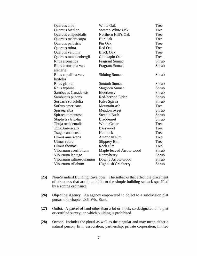
Quercus alba White Oak Tree Quercus bicolor Swamp White Oak Tree Quercus ellipsoidalis Northern Hill’s Oak Tree Quercus macrocarpa Bur Oak Tree Quercus palustris Pin Oak Tree Quercus rubra Red Oak Tree Quercus velutina Black Oak Tree Quercus muehlenbergii Chinkapin Oak Tree Rhus aromatica Fragrant Sumac Shrub Rhus aromatica var. arenaria
Fragrant Sumac Shrub
Rhus copallina var. latifolia
Shining Sumac Shrub
Rhus glabra Smooth Sumac Shrub Rhus typhina Staghorn Sumac Shrub Sambucus Canadensis Elderberry Shrub Sambucus pubens Red-berried Elder Shrub Sorbaria sorbifolia False Spirea Shrub Sorbus americana Mountain-ash Tree Spiraea alba Meadowsweet Shrub Spiraea tomentosa Steeple Bush Shrub Staphylea trifolia Bladdernut Shrub Thuja occidentalis White Cedar Tree Tilia Americana Basswood Tree Tsuga canadensis Hemlock Tree Ulmus americana American Elm Tree Ulmus rubra Slippery Elm Tree Ulmus thomasi Rock Elm Tree Viburnum acerifolium Maple-leaved Arrow-wood Shrub Viburnum lentago Nannyberry Shrub Viburnum rafinesquianum Downy Arrow-wood Shrub Viburnum trilobum Highbush Cranberry Shrub
(25) Non-Standard Building Envelopes. The setbacks that affect the placement of structures that are in addition to the simple building setback specified by a zoning ordinance.
(26) Objecting Agency. An agency empowered to object to a subdivision plat
pursuant to chapter 236, Wis. Stats.
(27) Outlot. A parcel of land other than a lot or block, so designated on a plat or certified survey, on which building is prohibited.
(28) Owner. Includes the plural as well as the singular and may mean either a
natural person, firm, association, partnership, private corporation, limited
7

liability company, public or quasi-public corporation, or combination of these, having any pecuniary interest in lands regulated by this chapter.
(29) Parcel. A contiguous quantity of land in the possession of an owner,
single or common interest. No street, highway, easement, railroad right-of-way, river, stream or water body shall constitute a break in contiguity. Also referred to as a lot.
(30) Plan Commission. The Town Plan Commission. (31) Plat. This term includes a map of a subdivision or land division that
creates 4 or more parcels or building sites.
(32) Preliminary Plat. A map showing the salient features of a proposed subdivision submitted to an approving authority for purposes of preliminary consideration. A preliminary plat precisely describes the location and exterior boundaries of the parcel proposed to be divided, and shows the approximate location of lots and other improvements. A subdivider is required to submit a preliminary plat for all condominiums.
(33) Public Improvements. Required improvements within a subdivision or
other land division that are for the public benefit, including, but not limited to, streets, storm water management improvements, erosion control improvements, buffer strips and utility improvements.
(34) Public Way. Any public road, street, highway, walkway, drainage way or
part thereof.
(35) Replat. The process of changing, or the map or plat, which changes the boundaries of a recorded subdivision plat, certified survey map or part thereof. The division of a large block, lot or outlot within a recorded subdivision plat or certified survey map without changing the exterior boundaries of said block, lot or outlot is not a replat.
(36) Sanitary District. Refers to the Prairie Sanitary District in the Town. (37) Shorelands. Those lands within the following distances: one thousand
(1,000) feet from the ordinary high-water mark of navigable lakes, ponds and flowages or three hundred (300) feet from the ordinary high-water mark of navigable streams or to the landward side of the floodplain, whichever is greater.
(38) Special Lowland Flood Area. Those areas outside of the Flood Plain Area
that experienced extensive ground water and surface water flooding during the 2008 flood. These areas have been mapped by the Town and are part of the Town of Spring Green Special Lowland Flood Area map.
8

(39) Streets. A public way or right-of-way that provides vehicular and
pedestrian access to parcels of land where general use and maintenance of such right-of-way is governed by the appropriate unit of government.
(a) Arterial Streets and Highways. Streets, which provide for rapid
movement of concentrated volumes of traffic over relatively long distances between activity areas.
(i) Principal Arterials. Streets serving the major interstate and inter regional traffic corridors. These routes provide the highest level of mobility under a high degree of access control.
(ii) Primary Arterials. Streets serving major regions or connecting several cities while also serving as an inter community corridor within a designated area. These routes provide for a high degree of mobility under a high degree of access control.
(iii) Standard Arterial. Streets that provide for intermediate trips, thus serving through traffic movement of feeding traffic to primary and principal arterials from lower activity areas not served by such routes.
(40) Collector Streets. Streets, which provide for moderate speed movement within large areas and provide more directness of routing and higher capacity than other local streets, receive higher volumes of traffic to be distributed from or collected towards nearby arterial streets. (a) Local Streets. Street designed for low speeds and volumes which
provide access from low traffic generating areas to collector and arterial streets.
(b) Marginal Access Streets. Streets which are parallel and adjacent to arterial streets and which provide access to abutting properties.
(c) Alleys. Streets, which provide secondary means of access for vehicular services to the back or side of property otherwise abutting a street.
(d) Cul-de-sacs. Streets closed at one end with turnarounds.
(e) Dead End Streets. Streets closed at one end without turnarounds.
(41) Storm Water Retention/Detention Facility. A facility such as a pond specifically designed to capture, store and then slowly release storm water runoff.
9

(42) Subdivider. Any person, firm or corporation and/or their designated agent
initiating the creation of a land division resulting in a subdivision, certified survey map, condominium plat or other land division.
(43) Subdivision. The division of a lot, parcel, tract or one-quarter (1/4) of one
quarter (1/4) section by the owner thereof or their agent, for the purpose of transfer of ownership or building development, where the act of division creates four (4) or more lots, or where the act of division creates four (4) or more lots by successive division within a five year period.
(a) Class I Subdivision. A subdivision which consists of fewer than ten
(10) lots and includes all contiguous lands under one ownership.
(b) Class II Subdivision. A subdivision which consists of fewer than twenty-five (25) lots.
(c) Class III Subdivision. A subdivision which consists of twenty-five (25) or more lots.
(44) Town. Town of Spring Green, Sauk County, Wisconsin.
7.03 General Provisions.
(1) The provisions of this ordinance, as they apply to divisions of parcels of land into less than 3 lots, shall not apply to:
(a) Transfers of interests in land by will or pursuant to court order.
(b) Leases for a term not to exceed ten (10) years, mortgages or
easement. (c) Sale or exchange of parcels of land between owners of adjoining
property if additional lots are not thereby created and the lots resulting are not reduced below the minimum size required by these regulations, the Sauk County Zoning Ordinance, Village of Spring Green Extraterritorial Zoning Code, or other applicable laws or ordinances.
(2) Compliance. No person shall divide any land located within the
jurisdictional limits of these regulations, which results in, or for the purposes of, creating a subdivision, land division or a replat as defined herein. In addition, no person shall create a condominium without complying with the requirements of this ordinance. No such subdivision, land division or replat shall be entitled to be recorded; and no street shall be laid out or improvements made to land without compliance with all requirements of this ordinance and the following:
10

(a) The provisions of chapter 236, Wis. Stats. (b) The rules of the Department of Commerce contained in the
Wisconsin Administrative Code for subdivisions not served by public sewer.
(c) The rules of the Wisconsin State Department of Transportation,
contained in chapter Trans. 233 of the Wisconsin Administrative Code for subdivisions which abut the state trunk highway or connecting street.
(d) The rules of the Wisconsin Department of Natural Resources
contained in chapter NR 116 of the Wisconsin Administrative Code for Flood Plain Management.
(e) The duly approved Comprehensive Plan of the Town and all other
applicable ordinances of the Town. (f) No land division, parcel or lot shall be created unless it has existing,
safe access to a street for ingress and egress of regular traffic and emergency vehicles as described in Town Driveway and Private Roads Ordinance.
(g) Applicable county, town or village extraterritorial ordinances,
including storm water and erosion control ordinances. (h) Any land division of a parcel of land where that act of division
creates a new lot, shall be surveyed and a certified survey map or subdivision plat shall be prepared in accordance with the provision set forth in chapter 236, Wis. Stat.
(i) That the net minimum lot size shall be not less that 1 acre.
(3) Guidelines for Reviewing Land Divisions. The following are guidelines
for reviewing submissions under this ordinance. Nothing in this title shall prevent the Town Board from developing and applying such additional guidelines and review criteria that the Town Board, in its sole discretion, determines appropriate.
(a) Land divisions should be consistent with the goals and objectives set
forth in the Comprehensive Plan. (b) Land divisions should promote an organized development pattern
which will minimize conflicting land uses.
11

(c) Land divisions should provide an orderly and sustainable pattern to allow for efficient and economical public services.
(d) Land divisions should be compatible with the character, size and
quality of development of nearby and adjoining properties.
(e) Land divisions should be planned for and protect, to the extent possible, environmentally sensitive lands, habitat and wildlife.
(4) Dedication of Lands.
(a) Public Ways. Whenever a tract of land to be developed embraces all or any part of a street, drainage way or other public way which has been designated as such in the Comprehensive Plan of the Town, said public way shall be made a part of the plat and dedicated in the locations and dimensions indicated on said plat or map and as set forth in this ordinance. If streets are to be dedicated to the Town, the dedication of street right-of-way shall not create a commitment on the part of Town to construct, improve or maintain any roadbed placed upon said right-of-way. Acceptance of any street, road or highway shall require compliance with the design and construction standards of the Town.
(b) Public Lands. Whenever a proposed playground, park or other
public land, other than streets or drainage ways, that may be designated in the Comprehensive Plan or other planning document of the Town, is embraced, all or in part, in a parcel of land to be subdivided, these proposed public lands shall be made a part of the plat and shall be dedicated to the public by the subdivider.
(c) Dedication Calculation. When land within the Town is divided for
the purpose of a subdivision, a parkland dedication of 1,450 square feet of land per dwelling unit (land parcel) will be required for parkland. Whenever a proposed playground, park, or other public area, other than streets or drainage ways, designated in the Comprehensive Plan or any other planning document of the Town is embraced, all or in part, in the tract of land to be divided, these lands shall be made part of the required land dedication. The Town Board and Plan Commission shall have joint authority to determine the suitability and adequacy of parklands proposed for dedication. Drainage ways, wetlands, public or private easements, or areas reserved for streets shall not be considered as satisfying land dedication requirements.
12

(d) Dedication to the Town. Land dedicated for public purposes within the Town shall be conveyed to the Town at the time the Final Plat is approved, if required.
(e) Access to Dedicated Land. All dedicated land shall have frontage on
a public street and shall have unrestricted public access.
(f) Fee in Lieu of Land. Where the dedication of land under sec. 7.03(4) would result in lands which would not be useful or appropriate to the Town, the Town may stipulate to the owner an equitable means for making a cash payment in lieu thereof. The amount of such payments shall be determined as follows: the number of proposed dwelling units in the subdivision shall be multiplied by 1,450; the resulting product shall be divided by 43,500; the resulting quotients shall be multiplied by the most recent equalized value of a buildable acre of land within the proposed development. The requirements of sec. 7.03 may be satisfied by a combination of land dedication and fee payments with the approval of the Town Board. Fees paid to the Town under this requirement shall be used as provided by law.
(5) Required Improvements.
(a) Monuments. The subdivision shall be monumented as required by chapter 236.15, Wis. Stat. and by the Sauk County ordinances, which are hereby adopted by reference.
(b) Street and Utilities. The dedication of street right-of-way shall not
create a commitment on the part of the Town to construct, improve or maintain any roadbed or required utilities placed upon said right-of-way. Acceptance of any street, road or highway shall require compliance with the design and construction standards of the Town. The width of any dedicated street right-of-way shall be sixty-six (66) feet unless a wider right-of-way is requested by the proper highway authority, in which case, the wider right-of-way shall be dedicated. Right-of-ways less than sixty-six (66) feet are prohibited, except as approved in writing by the Town upon their finding that a wider right-of-way is unnecessary or impractical to achieve.
(c) The following is a list of public improvements that may be required
as conditions of approval for each subdivision or land division:
(i) Water and sanitary sewer mains and laterals to the lot lines where connections to any existing system can reasonably be provided.
13

(ii) Streets graded to full width and roadway graded to subgrades.
(iii) Adequate facilities to provide surface water drainage.
(iv) Final grade and subgrade materials.
(v) Final surface.
(vi) Pedestrian/Bicycle Ways.
(vii) Drainage structures/bridges.
(viii) Railroad crossing grade improvements.
(ix) Street lighting, if required.
(x) Pavement marking and regulatory signs.
(xi) Street signs.
(xii) Emergency service signs.
(d) The adequacy of any public improvements shall be subject to approval of the Town.
(e) Before final approval of any land division, the subdivider shall enter
into an agreement with the Town to install the required public improvements and shall file with the development agreement an irrevocable letter of credit or other appropriate sureties meeting the approval of the Town, equal to 125% of the estimated cost of the public improvements. Public improvement cost estimates shall be made by the subdivider, reviewed by the Town Engineer and must be approved by the Board.
(f) Improvements must be installed in accordance with a timeline
established in a development agreement. If the completion date of the public improvements is not set forth in a development agreement, the improvements shall be completed within one year of the date of the recording of the final plat, except that the surface course of asphalt shall be completed after one freeze-thaw cycle but no later than July 1 after the freeze-thaw cycle.
(g) Plans and specifications for public improvements shall be reviewed
and approved by the Town Engineer, in writing, prior to:
(i) Commencement of construction,
14

(ii) Submission of the final plat, and,
(iii) The development agreement has been fully executed along with the letter of credit or other appropriate sureties are in full force and effect.
(h) Contract specifications for the construction of public improvements
shall be subject to the prior written approval of the Town Engineer in accordance with Town standards and specifications.
(i) Governmental units to which these bond and contract provisions
apply may file, in lieu of said contract and bond, a letter from officers authorized to act on their behalf agreeing to comply with the provisions of this section.
(j) The subdivider shall provide a bond or other sufficient surety
guaranteeing that all survey monuments shall be placed in accordance with the requirements of chapter 236.15, Wis. Stat. and the Sauk County ordinances.
(k) Prior to the acceptance of a final plat or development plan, the
subdivider shall furnish, when required by the Town, a consent and waiver of the statutory provisions for special assessments for the installation of public improvements and all other utilities, which shall be in a form approved by the Town, pursuant to chapter 66, Wis. Stats., and shall be recorded in the office of the Register of Deeds in the same manner as a lis pendens. Such consent and waiver shall provide that the installation of such services shall be made at the discretion of the Board.
(6) Land Suitability. No land shall be divided or developed for use which is
held unsuitable for such use by the Town for reason of flooding, inadequate drainage, adverse soil or rock formation, unfavorable topography or any other feature likely to be harmful to the health, safety or welfare of the future residents of the proposed subdivision or of the community. The Town, in applying the provisions of this subsection, shall, in writing, recite the particular facts upon which it bases its conclusion that the land is not suitable for residential use and afford the subdivider an opportunity to present evidence regarding such unsuitability if he so desires. Thereafter, the Town may affirm, modify or withdraw its determination of unsuitability. The Town shall determine land suitability at the time of the pre-application or at the time of considering a preliminary plat. The subdivider shall furnish such maps, data and information as may be necessary to make a determination of land suitability. Land that may not be suitable for development includes, but is not necessarily limited to:
15

(a) Land set forth as flood hazard areas in maps and studies on file with Sauk County and referenced in the Sauk County Floodplain Zoning Ordinance.
(b) Land that has a history of major storm water and ground water flooding.
(c) Land with slopes greater than 20% as delineated in Comprehensive Plan.
(d) Land with environmentally sensitive areas as set forth in the Comprehensive Plan and reference the Wisconsin Natural Heritage Inventory.
(e) Land upon which development could adversely impact cultural resources and natural resources as delineated in the Comprehensive Plan.
(f) Land with grade or other conditions which make the land unsuitable for an on site septic system.
(7) Appeals. Any person aggrieved by an objection to a plat or development
plan or a failure to approve a plat or development plan may appeal therefrom, as provided in chapter 236.13(5), Wis. Stat.
7.04 Procedure.
(1) Preliminary Consultation. Prior to the filing of an application for the approval of a preliminary plat, the subdivider shall consult with the Plan Commission Chair, a representative from Sauk County, and/or Village of Spring Green, if within the Extraterritorial Plat Approval Jurisdiction, in order to obtain advice and assistance. For the preliminary consultation, the subdivider shall submit a location map showing the relationship of the proposed subdivision to traffic arteries and existing community facilities. This consultation is intended to inform the subdivider of the purpose and objectives of these regulations, the land use plan, Comprehensive Plan, and other applicable town, village and county ordinances and to otherwise assist the subdivider in planning the development. In so doing, both the subdivider and the Town may reach mutual conclusions regarding the general objectives of the proposed development and its possible effects on the neighborhood and community. The subdivider will gain a better understanding of the subsequent required procedures.
(2) Development Plan. A development plan is to be used for the purpose of
generating information and to allow analysis of major developmental proposals. A development plan shall be required of all subdivisions and
16

condominium plats. The development plan shall be presented to the Plan Commission for consideration before the preliminary plat process begins.
(3) Preliminary Plat Approval Within the Town. A preliminary plat shall be
required for all subdivisions. A subdivider may also utilize a plat in the creation of 3 or less lots. The subdivider shall prepare a preliminary plat and submit an application in accordance with chapter 236, Wis. Stat. and sec. 7.06 of this ordinance. The subdivider shall file 10 copies of the preliminary plat with the Town. The Plan Commission, within 60 days of the date of the filing, shall recommend that the Town Board approve, conditionally approve, or reject the plat or plan, unless the statutory time for preliminary plat review is extended by mutual agreement with the subdivider. If the Plan Commission does not provide a recommendation to the Town Board within the 60 days (or within an extended period of time if such time is extended by mutual agreement with the subdivider), the Town Board may act without the Plan Commission’s recommendation. The Town Board shall act within 90 days of the date of the filing of the preliminary plat unless that time is extended by mutual agreement with the subdivider. Failure of the Town Board to act within 90 days shall constitute an approval unless the time is extended by mutual agreement with the subdivider. The Town Board shall return one copy of the plat or plan to the subdivider with the date and action endorsed thereon and, if approved conditionally or rejected, a letter setting forth the conditions of approval or the reasons for rejection shall accompany the plat or plan. One copy each of the plat or plan and letter shall be placed in the Town Board's permanent files. Approval or conditional approval of a preliminary plat or plan shall not constitute automatic approval of the final plat or plan, except that if the final plat or plan is submitted within 24 months of preliminary plat or plan approval and conforms substantially with the preliminary plat layout as indicated in chapter 236.11(1)(b), Wis. Stat., the final plat or plan shall be entitled to approval with respect to such layout. The preliminary plat or plan shall be deemed an expression of approval or conditional approval of the layout submitted as a guide to the preparation of the final plat or plan which will be subject to further consideration by the Plan Commission and the Town Board at the time of its submission. The applicant needs to provide a completed application with all design recommendations that have been agreed to, as well as providing necessary documentation. The Plan Commission has the right to deny approval of the Preliminary Plat application if the Town Engineer is not satisfied with the completion of the necessary documents. Any change, modification, or addition to the preliminary plat after it is filed with the Town shall constitute the filing of a new preliminary plat and the running of new time periods for review.
17

(4) Referral to Other Agencies. The subdivider shall refer the Preliminary Plat and letter of application following guidelines set forth in chapter 236.12, Wis. Stat.
(5) Final Plat Approval within the Town. The subdivider shall prepare a final plat and submit a final application in accordance with sec. 7.07 of this ordinance. The subdivider shall file the 10 copies of the final plat or plan with the Town. The Plan Commission, within 30 days of the date of the filing of a final plat with the Town, shall recommend that the Town Board approve, or reject the plat, unless such time is extended by mutual agreement with the subdivider. The Town Board, within 30 days of receiving the recommendation of the Plan Commission, shall approve or reject such plat unless the time is extended by mutual agreement with the subdivider. If the Plan Commission does not provide a recommendation to the Town Board within the 30 days (or within an extended period of time if such time is extended by mutual agreement with the subdivider) the Town Board may act without the Plan Commission’s recommendation. If the plat is rejected, the Town Board shall state the reasons in the minutes of the meeting and a written statement of the reasons forwarded to the subdivider. The Town Board may not inscribe its approval on the final plat or plan unless the subdivider certifies that the copies were forwarded to objecting agencies as required herein, the date thereof, and that no objections have been filed within 20 days or, if filed, have been met. Upon failure of the Town to act within 60 days, the time having not been extended and no unsatisfied objections having been filed, the plat or plan shall be deemed approved. Any change, modification or addition to the final plat after it is filed with the Town shall constitute the filing of a new final plat and the running of new time periods for review.
After the Town Board has approved the final plat and before construction can begin, the plat shall be recorded with the Register of Deeds. The Register of Deeds cannot record the plat unless it is offered within six (6) months from the date of the last approval or 24 months after the first approval, in accordance with chapter 236.25(2)(b), Wis. Stat. (a) Plat Approval Procedure. As part of the approval process, the Town
Board shall first have a motion approving or rejecting the developer’s agreement and letter of credit. The Town Board shall then have a separate motion approving or rejecting the final plat. If the Town Board rejects the developer’s agreement or letter of credit it shall then be a condition for rejecting the final plat.
(6) Replat or Replan. When it is proposed to replat a recorded subdivision, or
part thereof, so as to change the boundaries of a recorded subdivision, or part thereof, the subdivider or person wishing to replat shall vacate or alter the recorded plat as provided in chapter 236.40 through 236.44 Wis. Stat.
18

The subdivider, or person wishing to replat, shall then proceed as specified in sec. 7.04(1) through (5). The Town shall also approve of all changes to a condominium layout or design.
(7) Certified Survey Maps. The certified map shall be submitted in
accordance with sec. 7.08 of this ordinance. The Plan Commission shall review the map for conformance with this ordinance and all ordinances, rules, regulations, Comprehensive Plan and other applicable ordinances. The Plan Commission shall, within 60 days from the date of filing of the map, recommend approval, conditional approval or rejection of the map, and shall transmit the map along with its recommendations to the Town Board, unless such time is extended by agreement with the subdivider. The Town Board shall approve, approve conditionally or reject such map within 30 days from the date of filing of the map unless the time is extended by agreement with the subdivider. If the map is rejected, the reason shall be stated in the minutes of the meeting and a written statement forwarded to the subdivider. If the map is approved, the Town Board shall direct the Town Chair to so certify on the face of the original map and return the map to the subdivider.
7.05 Development Plan.
(1) General Provisions. A development plan, when required, shall address the broader issues of development and land use in and around any proposed subdivision. The data used to prepare the development plan may be obtained from readily available sources (i.e., U.S.G.S., N.R.C.S., D.A.T.C.P., DNR, Town, etc.), rather than from detailed field investigations. However, the subdivider is expected to prepare a comprehensive presentation of the information required. As a minimum, the area to be included in a development plan shall include all contiguous lands owned, leased, optioned or otherwise under the control of the subdivider, plus those adjacent areas specified in this section. The following data shall be presented and analyzed in a development plan: (a) Geographical Information. Boundaries of the subdivider’s property,
and boundaries of the proposed subdivision, if different; ownership and location of all adjacent properties (excluding public rights-of-ways and streams less than three hundred (300) feet wide); location and name of all public rights-of-way and publicly owned lands within one thousand (1,000) feet of any property boundary; location, size and ownership of all public utilities within three hundred (300) feet of property.
(b) Natural Features. Soil conditions, including hydric soils and rock outcrops; general topography and delineation of all areas with slopes over twelve percent (12%); geology, including approximate depth to
19

bedrock, and ground water resources (depth, quality and quantity); location and names of all streams, lakes, flood plains and flood hazard areas within one thousand (1,000) feet of property; vegetative cover on the property and all contiguous properties.
(c) Cultural features: Existing zoning of the property and all contiguous
properties; all existing easements on the property; the boundary of any unit of government within one thousand (1,000) feet of the property; location of any airport, solid waste disposal site, sewage treatment facility, water treatment plant, school, cemetery, or other significant cultural feature within one thousand (1,000) feet of the property.
(d) Development proposal. Approximate density and type of
development; proposed land use(s); approximate lot sizes (minimum, maximum and average); approximate location and size of all streets, public dedications and utilities proposed; proposed filling, grading, lagooning, dredging and/or flood proofing; anticipated timing of the development; where appropriate, the subdvider may wish to obtain and attach the comments of affected agencies, groups and/or individuals.
(e) Form of presentation. The methods used by the subdivider to prepare and present the development plan shall be governed by the Agency’s need for a clear, concise description of the proposed development.
7.06 Preliminary Plat.
(1) General Provisions. A preliminary plat plan shall be required for all subdivisions and shall be based upon a survey by a registered land surveyor and the plat prepared on tracing cloth or paper of good quality at a scale of not more than 100 feet to the inch.
(2) Plat Plan Data. All preliminary plats and plans shall show correctly on the
face the following information:
(a) Date, graphic scale and north point.
(b) Name of the proposed subdivision.
(c) Name, address and telephone number of the landowner, subdivider and person to be contacted regarding the plat.
(d) Location of the proposed subdivision by legal description and indication on township map(s).
20

(e) A scaled drawing of the exterior boundaries of the proposed subdivision referenced to a corner established in the U.S. Public Land Survey, and the total acreage encompassed thereby.
(f) Location and names of adjacent subdivisions, parks and cemeteries.
(g) Location, dimensions and names of all existing easements and rights-of-way within or adjacent to the proposed subdivision.
(h) Location, dimensions and names of all proposed streets, rights-of-way and easements within or adjacent to the proposed subdivision. Street names shall not use existing names and must conform to Sauk County Land Division and Subdivision Ordinance, street naming standards and standards stated in sec 7.09 (1)(g). All names must be approved by the Town.
(i) Locations of all existing property boundary lines, lot line structures, drives, streams and watercourses, wetlands, grasslands, marshes, rock outcrops, wooded areas, railroad tracks, areas of known habitat and other similar significant features within the tract being subdivided or immediately adjacent thereto.
(j) Location and water elevations of all streams and watercourses, lakes, marshes and flowages within one thousand (1,000) feet of the proposed subdivision at the date of the survey and approximate high and low water elevations, all referred to North American Vertical Datum 1988 (NAVD88).
(k) Delineation of flood plain (as filed with Sauk County and referenced in the Sauk County Floodplain Zoning Ordinance) and zoning boundaries within and adjacent to the proposed subdivision.
(l) On-site sewage disposal suitability, including soil suitability, depth to ground water and bedrock, and slope.
(m) Source and availability of potable water supplies.
(n) Location and approximate dimensions of any sites to be preserved or dedicated pursuant to sec 7.03 (4) of this ordinance.
(o) Approximate dimensions of all lots, and proposed lot and block numbers.
(p) Contours at vertical intervals of not more than 2 feet. Elevations shall be marked on such contours based on North American Vertical Datum 1988 (NAVD88). Areas where slopes exceed 12% and 20% should be appropriately shaded.
21

(q) Approximate radii of all curves. (r) Municipal jurisdictional boundaries and extraterritorial zoning
boundaries.
(s) Any proposed lake, stream or drainage way access with a small drawing clearly indicating the location of the proposed subdivision in relation to the access.
(t) Any proposed lake, stream or drainage way improvement or
relocation. (u) At least two permanent benchmarks shall be located in the
immediate vicinity of the plat referrenced to North American Vertical Datum 1988 (NAVD88).
(v) Location, size and invert elevation of any existing sanitary or storm
sewers, culverts and drain pipes, the location of manholes, catch-basins, hydrants, electric and communication facilities, whether overhead or underground, and the location and size of any existing water and gas mains within the exterior boundaries of the plat or immediately adjacent thereto, if within an urban service area. If no sewers or water mains are located on or immediately adjacent to the tract, the nearest such sewers or water mains that may reasonably be extended to serve the tract shall be indicated by their direction and distance from the tract, size and invert elevations.
(w) Soil types and their boundaries, on the operational soil survey maps
prepared by the U.S. Department of Agriculture, Natural Resources Conservation Service showing areas of differing soil productivity and delineated with reference to prime farm soils as shown in the Comprehensive Plan.
(x) Existing and Future Land Use, to identify any existing or future
incompatibility in use and to identify the potential need for mitigation.
(y) On the same or different plats, plans or maps, the following:
(i) Existing cemeteries, historical and archeological and other such sites identified in the Comprehensive Plan, registered historical and archeological sites, including any reference to the areas included in the proposed plat or plan and any sites referenced in the Wisconsin Archeological and Historical Resource Database (WisAHRD).
22

(ii) An indication of the level of tree clearing and show the trees that will be preserved.
(iii) Types of soils and their classification as shown in the
Comprehensive Plan. (iv) A current aerial photo showing the locations of existing
buildings within ½ mile of the proposal. (v) An indication of how the land is classified under each of
these areas as set forth in the Comprehensive Plan: (1) Septic suitability.
(2) Environmentally sensitive.
(3) Dam breach.
(4) Prime farmland.
(5) Slope delineation.
(6) Soils classification.
(7) Land capability.
(8) Community resources. (vi) Depth to ground water be identified using a 300 foot spaced
grid across the plat. (vii) Information as to whether driveway(s) for any access to the
plat or plan will be constructed prior to or after sale of the land, if applicable, as in the creation of a non-exclusive easement.
(viii) Non-standard building envelopes.
(3) Supporting Documents. The following documents must be submitted in
draft or preliminary form along with the preliminary plat or plan. The items shall be submitted to the Town Clerk for distribution to the Plan Commission, Town Attorney and Town Engineer at least 20 days before the Plan Commission meeting at which the preliminary plat or plan will be considered. The Town Clerk will provide the subdivider with the number of copies to be submitted.
23

(a) Street Plans and Profiles. Street plans and profiles showing existing ground surface and proposed and established street grades, including extensions for a reasonable distance beyond the limits of the proposed subdivision or condominium, unless waived by the Plan Commission.
(b) Testing. The Plan Commission may require that borings and
soundings be made in specified areas to ascertain subsurface soil, rock and water conditions, including depth to bedrock and depth to ground water table.
(c) Environmental Checklist. Submission of an environmental checklist
on a form provided by the Town. (d) Affidavit. The surveyor preparing the preliminary plat shall certify
on the face of the plat or plan that it is a correct representation of all existing land divisions and features as required in chapter 236, Wis. Stat., and that he has fully complied with the provisions of this ordinance.
(e) Areas of Potential Flooding.
(i) When a proposed subdivision or condominium is located in an area where flooding or potential flooding may be a hazard due to flooding or breach of a dam, the subdivider shall submit a flood study prepared by a Wisconsin Registered Professional Engineer using the floodplain maps and studies referenced in the Sauk County Floodplain Zoning Ordinance. The study shall establish the 100 year flood elevation and the relationship of the proposed development to the flood hazard area.
(ii) Where a proposed land division or development includes areas
delineated as flood plain areas as set forth in this section, the subdivider shall comply with the standards set forth in the Sauk County Floodplain Zoning Ordinance.
(f) Private Water and/or Sewage Disposal. Unless specifically
exempted from this requirement elsewhere in this ordinance, all subdivision and condominium proposals where private water and/or sewage disposal systems are to be used shall be accompanied by certifications and/or reports that satisfy the following criteria:
(i) Describing the probable depth, cost and yield of private wells.
This report shall be based on competent scientific investigation and shall include the sources of all data used in the preparation of the report.
24

(ii) Describing the soil conditions existing on the site as applicable
to on-site waste disposal. A soils report shall accompany all subdivision proposals.
(g) Preliminary Stormwater Management Plan. (h) Engineering report that shall detail traffic impacts.
7.07 Final Plat.
(1) General Provisions. A final plat prepared by a registered land surveyor shall be required for all subdivisions and condominiums. A subdivision final plat shall comply in all respects with the requirements of chapter 236.20, Wis. Stat. The final plat may, if permitted by the Town Board, constitute only that portion of the approved preliminary plat which the subdivider proposed to record or develop at that time. If the final plat is not submitted within 24 months of the last required approval of the preliminary plat, the Town Board may refuse to approve the final plat as required in chapter 236.11(1)(b), Wis. Stat.
(2) Plat Data. The plat plan shall show correctly on its face, in addition to the
information required by chapter 236.20, Wis. Stat. the following: (a) Exact length and bearing of right-of-way lines of all streets. (b) Exact street width along the line of any obliquely intersecting street. (c) Exact location and description of street lighting and lighting utility
easements. (d) Railroad rights-of-way within and abutting the plat. (e) All lands reserved for future public acquisition or reserved for the
common use of property owners within the plat. (f) Special restrictions required by the Town Board relating to access
control along public ways or provisions for buffer strips.
(g) Non-standard building envelopes.
(3) Supporting Documents. The following documents must be submitted, in final form, along with the final plat or plan: (a) Deed Restrictions. The Town Board shall require that all deed
restrictions and covenants be filed with the final plat or plan.
25

(b) Property Owners Association. The Town Board shall require the
legal instruments creating a property owners association for the ownership and/or maintenance of common lands be filed with the final plat or plan.
(c) Certificates. All final plats shall provide all the certificates required
by chapter 236.21, Wis. Stat.; and, in addition, the surveyor shall certify that he has fully complied with all the provisions of this ordinance.
(d) Developer’s Agreement. This is a standard document provided by
the Town, negotiated and accepted by the subdivider. (e) Stormwater Management Plan, as approved by the Town Engineer. (f) Erosion Control Plan, as approved by the Town Engineer and other
appropriate approval agencies. (g) Grading Plan. Drainage arrows at all lot lines showing the direction
of drainage upon final grading of the land. (h) Letter of Credit or other surety approved by the Town.
(i) Ten copies of final public improvement plans and specifications. (j) With regard to condominiums, the actual identification of the
different units for tax assessment purposes. (4) Survey Requirements.
(a) Examination. The Town Board or its agent shall examine all final plats and plans within the Town and may check for the accuracy and closure of the survey, the proper kind and location of monuments, and legibility and completeness of the drawing.
(b) Plat or Development Location. Where the plat or development is
located within a quarter section, the corners of which have been relocated, monumented and coordinated by the Town, the tie required by chapter 236.20(3)(b), Wis. Stat. shall be expressed in terms of grid bearing and distance; and the material and Sauk County Coordinates NAD83(97) of the monument marking the relocated section or quarter corner to which the plat is tied shall be indicated on the plat. The grid bearing and distance of the tie shall be determined by a closed survey meeting the error of closure herein specified for the survey of the exterior boundaries of the subdivision.
26

(c) Surveying and Monumenting. All final plats shall meet all the
survey and monument requirements of chapter 236.15, Wis. Stat. and the standards of the Sauk County Surveyor. Maximum error of closure before adjustment of the survey of the exterior boundaries of the subdivision shall not exceed, in horizontal distance or position, the ratio of one part in ten thousand (1:10,000), nor in azimuth, four second of arc per interior angle. The survey of the exterior boundary shall be adjusted to form a closed geometric figure.
7.08 Certified Survey Map.
(1) General. When a subdivider proposes any land division other than a subdivision or condominium, the subdivider shall submit a CSM prepared by a registered land surveyor in accordance with chapter 236.34, Wis. Stat. and this ordinance.
(2) Additional Information. The CSM shall also show the following
information correctly on its face as described in chapter 236, Wis. Stats.:
(a) The name and address of the individual or entity dividing the lands. (b) Date, scale (not more than 500 feet to 1 inch) and north arrow. (c) A legal description as required by chapter 236.34, Wis. Stat. (d) The locations, rights-of-way widths and names of existing or
proposed driveways, roads, streets, alleys or other public ways; easements, and railroad and utility rights-of-way included within or adjacent to the proposed land division.
(e) The location of an existing on-site private sewage system and
provide adequate room for a backup system. (f) Land Features. All existing property lines, structures, drives and
watercourses. (g) Jurisdictional boundaries. Show municipal boundaries and
extraterritorial zoning boundaries. (h) Future Land. All lands reserved for future acquisition. (i) Lot Size. Square footage or acreage for each lot or parcel.
27

(j) When dedication of lands is required, an owner’s certification of dedication prepared in accordance with chapter 236.34, Wis. Stat., approved by the full governing body on the accepting jurisdiction.
(k) Proof of compliance with chapter Trans. 233 of the Wisconsin
Administrative Code where applicable. (l) Non-Standard Building Envelope. (m) Stormwater Management Plan, if required by the Town Engineer.
(3) Supporting Documents. The subdivider shall submit the following documents when filing the CSM:
(a) Setbacks. Document showing the parcel boundaries from the CSM
and setbacks or building lines required by the Plan Commission. (b) Elevations. Document showing the parcel boundaries from the CSM
with elevation markings in 2’ intervals, with areas with gradients greater than 12-20% shaded, utilizing North American Vertical Datum, 1988 (NAVD88).
(c) Covenants and Restrictions. All restrictive covenants to be recorded
for the proposed CSM. (d) Zoning. Existing zoning on and adjacent to the proposed land
division. (e) On the same document or a separate document, the following:
(i) The entire area contiguous to the proposed CSM owned or
controlled by the subdivider shall be included on the preliminary plat even though only a portion of said area is proposed for immediate development. The Town Board may waive this requirement where it is unnecessary to fulfill the purposes and intent of this ordinance and undue hardship would result from strict application thereof.
(ii) Areas of differing soil productivity shall be delineated with
reference to prime farm soils, as shown in the Comprehensive Plan.
(iii) All natural features such as woodlands, wetlands, grasslands,
flood plains and areas of known habitat.
28

(iv) Cemeteries, historical or archeological sites identified in the Comprehensive Plan, registered historical and archeological sites, any sites referenced in the Wisconsin Archeological and Historical Resource Database (WisAHRD), and drainage ditches and other features pertinent to proper division.
(v) A current aerial photo showing the locations of existing
buildings within ½ mile of the proposal. (vi) An indication of how the land is classified under each of
these areas as set forth in the Comprehensive Plan:
(1) Septic suitability.
(2) Environmentally sensitive.
(3) Dam breach.
(4) Prime farmland.
(5) Slope delineation.
(6) Soils classification.
(7) Land capability.
(8) Community resources. (vii) Information as to whether driveway(s) for any access to the
plat or plan will be constructed prior to or after sale of the land, if applicable, as in the creation of a non-exclusive easement.
(viii) An indication of the level of tree clearing and show the trees
that will be preserved.
(f) Certificates. The surveyor shall certify on the face of the CSM full compliance with all of the provisions of this ordinance. The Town Board, after a recommendation by the reviewing agencies, shall certify its approval on the face of the CSM. In addition, dedication of streets and other public areas shall require the owner’s certificate and the mortgagees’ certificate in substantially the same form as required by chapter 236.21(2)(a), Wis. Stat.
(g) Title Evidence. In the discretion of the Town, endorsement to
previously submitted title evidence, certified within seven (7) days,
29

to establish current ownership interests and required signatures on the CSM.
(h) Any existing or planned erosion control measures and all cuts and
fills and grading plans.
(4) Recordation. The subdivider shall record the CSM with the Register of Deeds within six (6) months of its approval by the Town Board and any other approving agencies. Failure to do so shall necessitate a new review and reapproval of the CSM by the Town Board.
(5) Certified Survey Maps shall comply with the design standards set forth in
chapter 236, Wis. Stat, Sauk County Land Division and Subdivision Ordinance, local ordinances and sec. 7.09 of this ordinance.
7.09 Design Standards. (1) Street Arrangement.
(a) General Provisions. In any new subdivision, condominium or land division, the street layout shall conform to the arrangement, width and location that may be indicated in the Comprehensive Plan. In areas for which such plan has not been completed, the street layout shall recognize the functional classification of the various types of streets and shall be developed and located in proper relation to existing and proposed streets, to the topography, to such natural features as streams and tree growth, to public convenience and safety, to the proposed use of the land to be served by such streets, and to the most advantageous development of adjoining areas. The development shall be designed so as to provide satisfactory access to a public street. The dedication of street right-of-way shall not create a commitment on the part of Town to construct, improve or maintain any roadbed placed upon said right-of-way. Acceptance of any street, road or highway for maintenance purposes shall require compliance with the design and construction standards of the Town and those of the applicable highway maintenance authority. The width of any dedicated street right-of-way shall be sixty-six (66) feet unless a wider right-of-way is requested by the proper highway authority, in which case, the wider right-of-way shall be dedicated. Right-of-ways less than sixty-six (66) feet are prohibited, except as approved in writing by the Town upon their finding that a wider right-of-way is unnecessary or impractical to achieve.
(b) Collector Streets. Collector streets shall be arranged so as to provide
ready collection and conveyance of traffic from the development to arterial streets and shall be properly related to special traffic
30

generators such as schools, churches and shopping centers and other concentrations of population and to the major streets into which they feed.
(c) Local Streets. Minor streets shall be arranged to conform to the
topography, to discourage use by through traffic, to permit the design of efficient storm and sanitary sewerage systems, and to require the minimum street area necessary to provide safe and convenient access to abutting property.
(d) Proposed Streets. Proposed streets shall extend to the boundary lines
of the tract being developed unless prevented by topography or other physical conditions or unless, in the opinion of the Town Board, such extension is not necessary or desirable for the coordination of the layout of the development or land division or for the advantageous development of the adjacent tracts.
(e) Reserve Strips. Reserve strips shall not be provided in any
development to control access to streets or alleys, except where control of such strips is placed with the Town under conditions approved by the Town Board.
(f) Alleys. Alleys may be provided in commercial and industrial
districts for off-street loading and service access, but shall not be approved in residential districts. Dead-end alleys shall not be approved and alleys shall not connect to a major thoroughfare.
(g) Street Names. Street names shall not duplicate or be similar to
existing street names and existing street names shall be projected wherever possible, see sec. 7.06(2)(h).
(2) Limited Access Highway and Railroad Right-of-Way Treatment.
Whenever the proposed development contains or is adjacent to a limited access highway or railroad right-of-way, the design shall provide the following treatment: (a) When development or lots back upon the right-of-way of an existing
or proposed arterial or a railroad, a buffer strip at least 40 feet in depth shall be provided adjacent to the arterial or railroad in addition to all other setback or lot line requirements. This buffer strip shall be a part of the platted lots, but shall have the following restriction lettered on the face of the plat: "This strip reserved for the planting of trees and shrubs and the building of structures hereon is prohibited." Plantings shall follow the guidelines outlined in 7.10(11) Buffer Strips, of the ordinance.
31

(b) Streets parallel to an arterial or railroad right-of-way, when intersecting an arterial street and highway or collector street which crosses said railroad or arterial, shall be located at a minimum distance of 250 feet from said highway or railroad right-of-way.
(c) Local streets immediately adjacent and parallel to railroad rights-of-
way shall be avoided and location of minor streets immediately adjacent to arterial streets and highways and to railroad rights-of-way shall be avoided in residential areas.
(3) Street Design Standards. The minimum right-of-way and roadway width
of all proposed streets, alleys and ways shall be as specified as follows:
(a) Street Widths. Pavement Width
R.O.W. Width (Edge of Pavement to Type of Street To Be Dedicated Edge of Pavement) Arterial Streets 80 feet 44 to 48 feet Collector Streets 66 feet 22 to 32 feet Local Streets 66 feet 22 to 24 feet Alleys 20 feet 20 feet Pedestrian/Bicycle 20 feet 10 feet Ways
(b) Cul-de-sacs. Cul-de-sac streets designed to have one end permanently closed shall not exceed 1,320 feet in length. All cul-de-sac streets designed to have one end permanently closed shall terminate in a circular turn-around having a minimum right-of-way radius of 60 feet and a minimum edge of road radius of 45 feet.
(c) Temporary Dead-ends or Cul-de-sacs. (Maximum length of 800
feet).
(i) No temporary turnaround is required if the street only serves one lot depth or width.
(ii) A temporary tee turnaround is required if the distance from
the centerline of intersection to far lot line of last lot of construction phase is 400 feet or less. The tee turnaround shall have a minimum width of 24 feet, a minimum transverse length of 60 feet, a minimum radius of 10 feet and surfacing shall be done in accordance with plans and standard specifications approved by the Town, and by the Sauk County Highway Department where County approval is required.
32

(iii) A temporary circular turnaround is required when not visible
from the intersection or when the distance is greater than 400 feet but not greater than 800 feet from the centerline of the intersection to the far lot line of the last lot in the construction phase. The circular turnaround shall have a minimum radius of 40 feet and surfacing shall be done in accordance with plans and standard specifications approved by the Town, and by the Sauk County Highway Department where County approval is required. The Town Engineer shall determine whether the temporary turnaround required will be in the design of a tee or circle.
(d) Street Grades. Unless necessitated by exceptional topography
subject to the approval of the Town Board, the maximum centerline grade of any street or public way shall not exceed the following:
(i) Arterial Streets. 6%
(ii) Collector Streets. 7%
(iii) Local Streets, Alleys and Marginal Access Streets. 10%
(iv) Pedestrian/Bicycle Ways. 12% unless steps of acceptable design are provided.
The grade of any street shall in no case exceed the maximum grade as specified in the current Wisconsin Department of Transportation, Facilities Development Maunal. The minimum ditch grade shall not be less than ½ of one percent (0.5%) or approved by the Town Engineer. Street grades shall be established wherever practicable so as to avoid excessive grading, the excessive removal of ground cover or tree growth, and general leveling of the topography. All changes in street grades shall be connected by vertical curves following the specification outlined in the Wisconsin Department of Transportation, Facilities Development Manual, FDM 11-10-5 Attachment 3 Stopping Sight Distance for Crest Vertical Curves.
(e) Half Streets. Where an existing dedicated or platted half street is
adjacent to the tract being divided, the other half of the street shall be dedicated by the subdivider. The platting of half streets should be avoided where possible.
(f) Typical Sections. The Typical Sections of Town roads in the
appropriate section as depicted in the current State of Wisconsin
33

Department of Transportation Facilities Development Manual. The Town Engineer will determine the appropriate section.
(i) The sub-grade material may require placement of geotextile
between the sub-grade and the sub-base interface. The requirement for the use of geotextile material will be determined by the Town Engineer.
(4) Street Intersections.
(a) Streets shall intersect each other at nearly right angles as topography and other limiting factors of good design permit.
(b) The number of streets converging at one intersection shall be
reduced to a minimum, preferably not more than 2. (c) The number of intersections along arterials shall be held to a
minimum. Wherever practicable, the distance between such intersections shall not be less than 600 feet.
(d) Property lines at street intersections shall be rounded with a
minimum radius of 15 feet or of a greater radius when required by the Town Board, or shall be cut off by a straight line through the points of tangency of an arc having a radius of 15 feet.
(e) Local streets shall not necessarily continue across arterial or
collector streets, but if the centerline of such local streets approach the arterial or collector streets from opposite sides within 150 feet of each other, measured along the centerline of the arterial or collector street, then the location shall be so adjusted that the adjoinment across the arterial or collector street is continuous, and a jog is avoided.
(f) Street grade shall not exceed 5 percent for 75 feet from the
intersection.
(g) Establish Clear Visions Areas in all zones on all corners adjacent to the intersection of two streets, or of a street and railroad, within the triangle formed be the street property lines, ignoring any corner radius, and a line drawn between points located on such property lines at 30 feet from the intersection thereof, there shall be no fence, wall, hedge, or any other obstruction to vision between the height of two (2) feet and eight (8) feet above the level of the pavement.
(5) Blocks.
34
(a) General Provisions. The widths, lengths and shapes of blocks shall be suited to the planned use of the land; the zoning requirements; the need for convenient access; control and safety of street traffic; and the limitations and opportunities of topography.
(b) Length. Blocks in residential areas shall not, as a general rule, be
less than 500 feet nor more than 1,200 feet in length unless otherwise dictated by exceptional topography or other limiting factors of good design.
(c) Pedestrian/Bicycle Ways. Pedestrian ways not less than 10 feet in
width may be required near the center and entirely across any block over 900 feet in length where deemed essential by the Town Board to provide adequate pedestrian circulation or access to schools, shopping center, churches or transportation facilities.
(d) Width. Blocks shall have sufficient width to provide for 2 tiers of
lots of appropriate depth except where otherwise required to separate residential development from through traffic. Width of lots or parcels reserved or laid out shall be adequate to provide for off-street service and parking required by the use contemplated and the area zoning restrictions for such use.
(6) Lots.
(a) General Provisions. The size, shape and orientation of lots shall be appropriate for the location of the subdivision and for the type of development and use contemplated. The lots should be designed to provide an aesthetically pleasing building site and a proper architectural setting for the buildings contemplated. However, no lot, land division, parcel or tract shall be created or sold unless it is accessible to a public street. Furthermore, every lot within a subdivision shall front on a publicly dedicated and improved street, or access easement for a distance of at least forty (40) feet, provided that the lot width at the building set back line complies with the Sauk County zoning regulations. Every lot, land division, parcel or tract not located within a subdivision shall front on a publicly dedicated street for at least forty (40) feet, unless a lesser frontage is approved in writing by the Town and is in conformance with the Sauk County Land Division and Subdivision Ordinance and allows for a building footprint adequate to meet the requirements of the Restrictive Covenants and the Sauk County Zoning Ordinance.
(b) Side Lot Lines. Side lot lines shall be, within reason, at right angles
to straight street lines or radial to curved street lines on which the
35

lots face. Lot lines shall follow municipal boundary lines rather than cross them.
(c) Double Frontage and Reverse Frontage Lots. Double frontage and
reverse frontage lots shall be prohibited except where necessary to provide separation of residential development from through traffic or to overcome specific disadvantages of topography and orientation.
(d) Access. Lots shall front or abut on a public street for at least forty
(40) feet. An exception may be granted by the Town Board if the creation of an access easement is deemed appropriate and follow guidelines in Sauk County Land Division and Subdivision Ordinance and Town Driveway and Private Roads Ordinance. Any lot, land division, parcel or tract granted this exception shall front on an access easement for at least forty (40) feet.
(e) Minimum lot size shall be 1 acre (43,560 square feet) in size or
greater to meet Sauk County or Village of Spring Green Extraterritorial applicable zoning.
(f) Lots with existing slopes of 20% or higher will require any building
to be set back at least 30 feet from the start of the 20% slope to reduce the possibility of erosion. This setback shall be part of the non-standard building envelope as shown on the plat or CSM.
(g) Lowest Opening Elevation (LOE). A grading plan for any
development showing grades at lot corners and indicating a LOE for any proposed structure. The LOE shall be 1 foot above the lowest lot corner and/or 2 feet above any Base Flooding Elevation (BFE) required in the Sauk County Floodplain Zoning Ordinance or identified on the Town of Spring Green Special Lowland Flood Area map.
(7) Easements.
(a) Utility Easements. The Town Board shall require utility easements of widths deemed adequate for the intended purpose where necessary or advisable for electric power and communication poles, wires and conduits; storm and sanitary sewers; and gas, water and other utility lines. The Town Board will take into consideration the recommendations of the appropriate utility agencies serving the Town when requiring utility easements.
(b) Drainage Easements. Where a subdivision, condominium or land
division is traversed by a watercourse, drainage way, channel or stream, or low area, an adequate drainage way width, alignment and
36

improvement of such drainage way or easement shall be subject to the approval of the Town Board; and parallel streets or parkways may be required in connection therewith. Where necessary, stormwater drainage shall be maintained by landscaped open channels of adequate size and grade to hydraulically accommodate maximum potential volumes of flow. These design details are subject to review and approval by the Town Engineer.
(8) Public Sites and Open Spaces. In the design of the plat, condominium or
certified survey map, due consideration shall be given to the reservation of suitable sites of adequate area for future schools, parks, playgrounds, drainage ways and other public purposes. If designated in the Comprehensive Plan, such areas shall be made a part of the plat or certified survey map. If not so designated, consideration shall be given in the location of such sites to the preservation of scenic and historic sites, stands of trees, marshes, lakes and ponds, watercourse, watersheds and ravines.
(9) Tree Removal. The only trees that may be removed from the developed
area are the minimum amount necessary for buildings, driveways, sanitary sewer, wells, roads, stormwater improvements, utilities, safety and yards. Guidelines provided by the Wisconsin Department of Natural Resources, Bureau of Forestry, and Firewise program are recommended.
(10) Non-agricultural development shall be located on the least productive area
of the land suitable for development based on maps provided in the Comprehensive Plan.
(11) The proposed improvements shall not disturb any existing cemetery,
historical or archeological sites identified in the Comprehensive Plan, or registered historical or archeological site.
(12) All necessary measures shall be taken to ensure that endangered and
threatened species on a proposed site will be protected. The Wisconsin Department of Natural Resources, Natural Heritage Inventory is one resource that should be referenced.
(13) New roads and utility transmission lines must be located and constructed
in a manner that minimizes impact on prime farmland and other natural resources. Good site planning will preserve the natural view, protect erodible slopes, preserve woodlands, protect wildlife habitat and have development sites be landscaped to blend with the surrounding area.
7.10 Required Improvements.
37

(1) Responsibility for Improvements. The applicant for approval of every development shall be responsible for the design, construction and installation of all required and agreed upon improvements which serve land division at their full cost and expense, except where the Town Board agrees to do any such work. However, with respect to any improvement serving a development constructed or installed by the Town, the cost thereof shall be charged to the benefited property through special assessments, payable over a term of years and at an interest rate established by the Town Board within its jurisdiction and as otherwise provided in the development agreement. The Town may also collect the cost by any other method allowed by law.
(2) Survey Monuments. The subdivider shall install survey monuments
placed in accordance with the requirements of chapter 236.15, Wis. Stat., and Sauk County Land Division and Subdivision Ordinance.
(3) Grading. After the installation of temporary block corner monuments by
the subdivider and approval of street grades by the Town Board, the subdivider shall grade the full width of the right-of-way of all streets proposed to be dedicated in accordance with plans and standard specifications approved by the Town Board. The subdivider shall grade the roadbeds in the street rights-of-way to subgrade.
(4) Surfacing. After the installation of all utility and stormwater drainage
improvements, the subdivider shall provide for surfacing all roadways in streets proposed to be dedicated to the widths prescribed by these regulations in the Comprehensive Plan. Said surfacing shall be done in accordance with plans and standard specifications approved by the Town, and by the Sauk County Highway Department where County approval is required.
(5) Curb and Gutter. If required for stormwater purposes, the subdivider shall
provide concrete curb and gutter on all streets in accordance with plans and specifications approved by the Town Board.
(6) Lighting. If required, the subdivider shall install dark sky compliant
lighting to illuminate major intersections where safety is an issue. (7) Pedestrian/Bicycle Ways.
(a) Pedestrian Ways may be required by the Town Board within a 2 mile radius of schools, commercial areas and other places of public assemblage and the Town Board may require the construction of sidewalks in locations other than those required under the preceding provisions of this ordinance if such walks are necessary, in their opinion, for safe and adequate pedestrian circulation.
38

(b) Alternative pedestrian/bicycle ways may be approved in lieu of
sidewalks where the proposed alternative pedestrian/bicycle ways are constructed of all-weather material, are dedicated to the Town, or are owned and maintained by a properly registered homeowners association and have frontage on each parcel otherwise required to be provided with a sidewalk.
(8) Public Sanitary Sewerage. In all development in or adjacent to the
sanitary sewer district, if capacity allows, the subdivider shall provide sanitary sewers in such a manner as to make adequate sanitary sewerage service available to the development. The size, type and installation of all sanitary sewers proposed to be constructed shall be in accordance with plans and specifications approved by the Town Board.
(9) Private Sanitary Sewerage. Development outside the sanitary sewer
district may be served by private sewage disposal systems if public sewer facilities are not available. Private sewage disposal systems shall comply with chapters Comm 83, 85, Wis. Admin. Code and the Sauk County Private Sewage System Ordinance.
(10) Stormwater Management. The subdivider shall provide stormwater
drainage facilities which may include curb and gutter, catch basins and inlets, storm sewers, road ditches and open channels, as are necessary. Storm sewers shall be of adequate size and grade to hydraulically accommodate the ten year frequency storm; culverts shall be designed to accommodate the ten year frequency storm and shall be sized so that the 25 year frequency storm does not cause flooding of the adjacent roadway. Upon the approval of the Town Engineer, stormwater swales and ditches may be sized for 25 to 100 year frequency storms, depending upon the estimated amount of damage that would be incurred by adjacent properties if flooding did occur. Storm drainage facilities shall be designed to minimize hazards to life or property, and the size, type and installation of all stormwater drains and sewers proposed to be constructed shall comply with the plans and specifications approved by the Town Board, upon recommendation of the Town Engineer. It is required that a subdivider be responsible for all storm water management features that are required by their respective development.
(a) Stormwater Management. Whenever it is planned to disturb 1 acre
or more and/or the Town Engineer determines that the proposed development will be likely to increase stormwater runoff and/or sediment transport from the land above the levels existing prior to any development, the subdivider shall submit a stormwater management plan in compliance with NR 216 and NR 151.
39

(b) Stormwater Retention/Detention Facilities. Whenever such facilities are required, there shall be a preference that they be located near a public right-of-way to provide ease of access for inspection and maintenance. These facilities shall be dedicated outlots that have shared ownership with all the lots that they serve. The creation of a homeowners association would be required to provide for maintenance of said facilities. If the Town is required to provide maintenance of said facilities, any costs would be assessed back to the properties that the facilities service.
(c) Landscape Approvals. Every detention/retention basin, road ditch or
open channel required or approved under this subsection will require the planting of grasses, wild flowers, other vegetation or any combination thereof as it determines reasonable and necessary to promote the function, maintenance and aesthetic characteristics of such facilities.
(11) Buffer Strips. An area of transition between adjacent, conflicting zoning
or land development that is intended to protect and preserve the general characteristics and overall appearance of the natural landscape and built environment. It is to mitigate or substantially minimize land use impacts and promote visual and physical compatibility between neighboring areas. When industrial or related use abuts residential use, an effective year-round visual screen shall be required and when commercial or related use abuts residential use, an effective year-round visual screen may be required. A buffer area may be required by the Town as a condition of Preliminary Plat or Certified Survey Map approval of any development. Buffer areas shall range from between 40 feet to 100 feet wide and shall be located in an outlot or easement along the property line of the differing uses. The Town shall determine the specific width based upon individual site conditions in order to achieve the intent of this section. The Town’s determination shall include, but is not necessarily limited to, the following criteria: (a) Neighborhood compatibility, within 1000 feet.
(b) Project and property size.
(c) Zoning density of the proposal and surrounding developments.
(d) Type and configuration of native vegetation on site.
(e) Identify current and future impacts of the project.
Buffer strips shall be reviewed using the following criteria:
40

(a) Existence of natural features such as existing vegetation, streams, wetlands, etc. that provides an effective screen between the proposed development and the existing development. Natural features and vegetation, as far as practicable, shall remain untouched during construction activity. This area shall contain extensive vegetation that consists of trees, bushes, and ground cover and shall be preserved.
(b) An area where a portion of the existing vegetation on site is saved and/or supplemented with additional landscaping. This shall also include sites that contain minimum landscaping, e.g., no trees or other significant vegetation.
(c) Level of screening required between incompatible uses, around particular visually objectionable structures and between certain uses to provide separation and to reduce the impact of noise, debris, undesirable lighting or visual impact to adjacent properties.
(d) The preferred plantings shall include a variety of Native Canopy Trees and Shrubs. The selection of plant material shall allow for a mix of evergreen trees, large shade trees, small trees, and large and small shrubs to provide variable height and seasonal color. Evergreen trees are particularly useful since they create a year round opaque screening element. For opaque screening, evergreen may be planted in combination with deciduous plant material and shall be planted in at least two alternating rows.
(e) Based on the level of desired screening, the Town may require buffer plans to include dimensions, and all sight triangles; location, height and grading details of proposed berms; height, type and location of existing and proposed walls or fences; schedule of planting materials including location, species, spacing, caliper, height, quantities and installation details of trees, shrubs and ground cover.
Maintenance of the buffer area shall be the responsibility of the subdivider, Homeowners Association, or Lot owner. If the Town is required to provide maintenance of said facilities, any costs would be assessed back to the properties that the facilities service.
(12) Other Utilities. No electrical or telephone service shall be located on
overhead poles except where underground placement is not possible due to exceptional topography or other physical barrier. Plans indicating the proposed location of all gas, electrical power and telephone distribution and transmission lines required to service the plat shall be approved by the Town Board and such map shall be filed with the Town.
7.11 Construction.
41

(1) Commencement. No construction or installation of improvements shall
commence in a proposed development until the final plat or certified survey map has been approved and recorded with the Sauk County Register of Deeds, a Subdivision Development Permit has been issued and the Town Engineer is satisfied that all other permits and approvals have been obtained from other authorities.
(2) Permits.
(a) No building permit shall be issued until the following improvements
are installed, when applicable, to the written approval of the Town Engineer:
(i) All final grading completed based on the grading plan. (ii) An affidavit is provided that each lot corner elevation is
established and recorded by a registered licensed surveyor. (iii) All underground utilities, including water and sewer,
installed. (iv) All adequate stormwater and or buffer strip improvements. (v) A hard surface roadway allowing sufficient access for
emergency service vehicles. (vi) The final plat or certified survey map is approved and
recorded.
(b) No occupancy permit shall be issued until all improvements within the development are completed and approved, with the exception of the surface coat of asphalt, which shall be completed after a freeze-thaw cycle.
(3) Plans. The following plans and accompanying construction specifications
shall be required by the Town Engineer before authorization of construction or installation of improvements:
(a) Street plans and profiles showing existing and proposed grades,
elevations and cross-sections of required improvements, North American Vertical Datum 1988 (NAVD88).
(b) If applicable, sanitary sewer plans and profiles showing the
locations, grades, sizes, elevations and materials of required facilities.
42

(c) If applicable, erosion control and stormwater management plans and
profiles showing the locations, grades, sizes, stormwater cross-sections, elevations and materials of required facilities.
(d) If applicable, planting plans showing the locations, age and species
of any required trees. (e) Additional special plans, permits or information as required; where
required by State agencies, such plans shall be approved by such agencies prior to the commencement of construction.
(4) Inspection. The subdivider, prior to commencing any work within the
subdivision, shall make arrangements with the Town Engineer to provide for adequate inspection. The Town Engineer shall inspect and approve all completed work prior to the release of the sureties. All street subgrades must be proof-rolled in the presence of the Town Engineer before gravel base is spread and before asphalt paving is completed.
(5) Construction Site Erosion Control. The subdivider shall cause all grading,
excavations, open cuts, side slopes and other land surface disturbances to be so mulched, seeded, sodded or otherwise protected that erosion, siltation, sedimentation and washing are prevented in accordance with the plans and specifications approved by the Town Board. In addition: (a) Temporary vegetation and mulching shall be used to protect critical
areas, and permanent vegetation shall be installed as soon as practical.
(b) Construction at any given time shall be confined to the smallest
practical area and for the shortest practical period of time. (c) Sediment basins shall be installed and maintained at all drainage
ways to trap, remove and prevent sediment and debris from being washed outside the area being developed.
(6) Protecting Existing Flora. The subdivider shall make every effort to
protect and retain all existing trees, shrubbery, vines and grasses not actually lying in public roadways, drainage ways, building foundation sites, private driveways, soil absorption waste disposal areas, paths and trails. Such trees are to be protected and preserved during construction in accordance with sound conservation practices, including the preservation of trees by well islands or retaining walls whenever abutting grades are altered.
43
(7) Construction in Flood Hazard Areas. All construction in flood hazard areas shall comply with the Sauk County Floodplain Zoning Ordinance.
7.12 Developer’s Maintenance Responsibility.
(1) In addition to all other requirements of this ordinance and the development agreement, the subdivider shall be responsible for the maintenance of all improvements within the development for a period of one year from the date of final acceptance of the final improvement. It shall be the responsibility of the subdivider to make any repairs necessary to such improvements upon complaint from the Town or from the owners of the development during this maintenance period. Failure of the subdivider to make the necessary repairs within fifteen (15) days shall allow, but not require, the Town to make the repairs. To ensure compliance with this provision, the Board shall require a money deposit or other assurance that repairs made by the Town shall be promptly paid and in no event shall be paid later than fifteen (15) days from the date on which an itemized statement of costs incurred is presented to subdivider. (a) The Plan Commission shall not recommend dedication of required
public improvements nor shall the Plan Commission recommend release nor reduction of a performance bond until the applicant’s engineer or surveyor has certified to the Plan Commission, through a detailed “as built” set of drawings, containing all the information required by the Plan Commission.
(b) A performance bond may be reduced upon actual dedication and
acceptance of the public improvements and then only to the ratio that the public improvement dedication bears to the total public improvements. In no event shall a performance bond be reduced below twenty-five (25) percent of the principal amount prior to final acceptance of all items covered under the bond.
(c) Acceptance of formal offers of dedication of public ways, easements,
and parks shall be by formal action of the Town Board. Such action shall be in the form of a resolution recommended by the Plan Commission to the Town Board.
7.13 Fees.
(1) General Provisions. The subdivider shall pay the Town all fees , including legal, and engineering review and inspection fees, as hereinafter required before being entitled to record a plat or certified survey map or condominium plat.
44

(2) Preliminary Plat and Plan and Certified Survey Map (CSM) Review Fee. The subdivider shall pay an administrative fee to be determined by the Town in a fee schedule to reimburse the Town for the cost of any administrative or fiscal work which may be undertaken by the Town in connection with the preliminary plat, plan or CSM. The fee shall be paid to the Town Clerk at the time of first application for approval of any preliminary plat, plan or CSM. A reapplication fee to be determined by the Town in a fee schedule shall be paid to the Town Clerk at the time of reapplication or resubmittal of a revised preliminary plat, plan or revised CSM which has previously been reviewed.
(3) Final Plat Review Fee. The subdivider shall pay an administrative fee in
an amount to be determined by the Town in a fee schedule to the Town for the cost of any administrative or fiscal work which may be undertaken by the Town in connection with the plat or plan. The fee shall be paid to the Town Clerk at the time of first application for approval of any final plat or plan. A reapplication fee in an amount to be determined by the Town in a fee schedule shall be paid to the Town Clerk at the time of reapplication or resubmittal of a revised final plat or plan for final approval which has previously been reviewed.
(4) All engineering work, legal costs and additional administrative costs
incurred by the Town in connection with the preliminary plat or CSM review shall be invoiced to, and separately paid by, the subdivider. Subdivider shall escrow a minimum of $500.00 per lot, up to a maximum of $5,000.00 with the Town to cover these expenses. If the initial escrow is depleted below $500.00, the subdivider shall refund to escrow to an amount acceptable to the Town, but not to exceed $5,000.00.
7.14 Variances and Exceptions.
(1) Where, in the judgment of the Town Board, on the recommendation of the Plan Commission, it would be inappropriate to apply literally the provisions of this ordinance because exceptional or undue hardship would result, the Town Board may waive or modify any requirements to the extent deemed just and proper. Application for any such variance shall be made in writing by the subdivider at the time when the preliminary plat is filed for consideration, stating fully all facts relied upon by the petitioner, and shall be supplemented with maps, plans or other additional data which may aid the Plan Commission and Town Board in the analysis of the proposed project.
(2) The Plan Commission shall not recommend nor shall the Town Board grant variations or exceptions to the regulations of this Ordinance unless it shall make findings based upon the evidence presented to it in each specific case that:
45

(a) The granting of the variance will not be detrimental to the public
safety, health or welfare or injurious to other property or improvements in the neighborhood in which the property is located.
(b) The conditions upon which the request for a variance is based are
unique to the property for which the variation is sought and are not applicable generally to other property.
(c) Because of the particular physical surroundings, shape or
topographical conditions of the specific property involved, a particular hardship to the owner would result, as distinguished from mere inconvenience, financial hardship, or self-imposed hardship, if the strict letter of the regulations were carried out.
(3) Any recommendations by the Plan Commission shall be transmitted to the
Town Board. The Town Board, if it approves of the variance, shall do so by motion or resolution and instruct the Town Clerk to notify the Plan Commission and the subdivider.
(4) Such relief shall be granted without detriment to the public good, without
impairing the intent and purpose of this ordinance or the desirable general development of the Town in accordance with the Comprehensive Plan or component thereof, this ordinance, or Sauk County Zoning Ordinance. A majority vote of the entire membership of the Town Board shall be required to grant any modification of this ordinance, and the reasons shall be entered in the minutes of the Board.
7.15 Violations.
(1) It shall be unlawful to build upon, divide, convey, record or monument any land in violation of this ordinance or the Wisconsin Statutes and no person shall be issued any Subdivision Development Permit by the Town authorizing the building on, or improvement of, any subdivision, land division or replat with the jurisdiction of this ordinance not of record as of the effective date of this Code until the provisions and requirements of this ordinance have been fully met. The Town may institute appropriate action or proceedings to enjoin violations of this ordinance or the applicable Wisconsin Statutes and may enforce the ordinance in accordance with the Town’s ordinances or in any other matter allowed by law.
Exhibit A Special Lowland Flooding Area Map.
46