Embed Size (px)
Citation preview
CHAPTER 7: Synthesis and Main Conclusions
188
7-1 Mass balance of the Alborz Mountains
Convergence between the Arabian and Eurasian plates since the Latest Cretaceous-Early Tertiary has
resulted in the closure of the Neo-Tethys Ocean and peripheral basins (Berberian & King, 1981; Berberian,
1983; Sengor, 1990; Ziegler, 2001). The long-term average rate of convergence between these continents has
been 32 ± 2mm/yr since 56 Ma (McQuarrie et al., 2003). It is 22-25 mm/yr in the present time (Vernant et
al., 2004a). Convergence has been accommodated by subduction, plateau building and mountain building in
the Turkish-Iranian region. Significant uplift of this area started after the Burdigalian, and has resulted in the
construction of a 1.5-2 km high plateau. At the northern end of this plateau, the Alborz Mountains currently
take up 5 ± 2 mm/yr of the shortening between Arabia and Eurasia. This mountain belt started forming
around the Eocene-Oligocene transition, and it has been a major feature of the regional tectonics ever since.
Using data contained in this thesis, a simple mass balance of the mountain belt can be calculated.
Assuming a uniform rate of shortening across the Alborz Mountains of 5 ± 2 mm/yr (Vernant et al.,
2004b) along the 800 km length of the mountain belt, observing that the thickness of the seismogenic layer is
20-30 km in the Alborz (Tatar et al., 2007), and working with a crustal density of 2.7 t/m3, the tectonic flux
into the mountain belt is 130-454 Mt/yr. This tectonic influx competes with the erosional removal of
sediment from the mountain belt
Over the past decades, the suspended sediment erosion rate has been 0.21 mm/yr over 61% of the
mountain belt covered by hydrometric stations. Extrapolating to the full surface area of the Alborz
Mountains, and adding 15% bedload to measured suspended loads gives a total erosional mass flux from the
mountain belt of 55 Mt/yr.
Apatite fission track cooling ages can be used to estimate long-term average erosion rates on time
scales required to remove about 4 to 6 kilometres of overburden. Throughout the Alborz Mountains, a strong
clustering of cooling ages around 16 Ma has been found, implying average exhumation rates of 0.25-0.37
mm/yr since that time. Some parts of the mountain belt have cooled through the AFT annealing zone well
before the Middle Miocene, and average exhumation rates for the integral Alborz Mountains will be
somewhat lower than the range indicated above. In any case, there is a striking similarity between erosion
rates in the past decades and exhumation rates over millions of years, indicating that the modern erosional
mass flux may be extrapolated to geological time scales.
From these simple estimates, it transpires that there is a fundamental difference between the amounts
of material that are transported into the mountain belt by tectonic processes, and removed by geomorphic
processes. The erosional efflux is about half the tectonic influx at best, and likely much less. In other words,
the Alborz Mountains are growing. Given the similarity of short-term and long-term erosion rates in the
mountain belt and the steady convergence rates in the Arabia-Eurasia collision zone, it is likely that this
statement holds over geological time scales. This may appear to be a trivial finding at first glance, given that
there is a mountain belt at present, and there wasn’t 40 million years ago, but the crucial point is that at
Rezaeian M., 2008, Coupled tectonics, erosion and climate in the Alborz Mountains, Iran. PhD thesis, University of Cambridge; 219 p.
Rezaeian M., 2008, Coupled tectonics, erosion and climate in the Alborz Mountains, Iran. PhD thesis, University of Cambridge; 219 p.

CHAPTER 7: Synthesis and Main Conclusions
189
3x101
4x101
5x101
107
0.0
0.1
0.2
0.3
0.4
0.5
0.6
Ero
sio
n r
ate
(m
m/y
r)
Log time (yr)
present the Alborz Mountains are not at steady state. Instead, the mountain belt is expanding, and this is
likely to continue unless tectonic rates diminish significantly, or geomorphic rates increase similarly.
Fig. 7.1: Erosion rates in the Alborz Mountains estimated over different time intervals from decades
to millions of years, from hydrometric data, AHe, and AFT data (dark to light grey, respectively). Bars show
2σ time and rate intervals for each data set.
These simple calculations can be taken one step further, to see if current shortening rates across the
mountain belt can be representative of the full era of mountain building. If mountain building has started
around 32 Ma, then constant shortening at 5 ± 2 mm/yr would have resulted in a total shortening of 160 ± 64
km. Shortening has resulted in thickening of the crust, and erosion. Now consider a cross section of the
mountain belt as it is today. If it is assumed that the area was flat and at sea level before onset of mountain
building, then the construction of a mountain belt with a width of 100 km, a central ridge pole at 4km, a
straight north flank descending to sea level, and a straight south flank descending to 1.5 km asl, represents an
increase of cross sectional area by 237.5 km2. The current average erosion rate (0.21 mm/yr) drives a loss of
cross sectional area of 21 m2/yr. Thermochronometric data suggests that average erosion rates over the past
16 million years may have been slightly higher, say 0.3 mm/yr (the average AFT and AHe ages imply that
sampled rocks were exhumed through the upper 4-6 and 1.5-2.5 km of crust around 15.8±0.6 and 7.0±0.3 Ma,
respectively, which results in exhumation rates of 0.31±0.06, and 0.29±0.08 mm/yr), resulting in a cross
sectional loss of 30 m2/yr. Sustained erosion at these rates since onset of mountain building, around 32 Ma,
would have resulted in a total erosion depth of 6.7-9.6 km, or a loss of cross section area of 670-960 km2.
The sum of the eroded cross section and the topographic cross section is 907.5-1197.5 km2. If the
seismogenic layer is 20 km thick, then this cross sectional change represents a shortening by about 45-60 km.
If the seismogenic layer is 30 km thick, then the equivalent range is 30-45 km. Full isostatic compensation of
the topographic load (which is unlikely according to Bouguer gravity data, e.g., Dehghani & Makris, 1984)
would be achieved by a root with an average thickness of about 10.7 km over the width of the mountain belt.
A root of this size would double the sum of present and eroded cross sectional areas to about 1975-2270 km2.
This is equivalent to the shortening of a 20 km or a 30 km thick layer by 100-115 km, and 65-75 km,
Rezaeian M., 2008, Coupled tectonics, erosion and climate in the Alborz Mountains, Iran. PhD thesis, University of Cambridge; 219 p.

CHAPTER 7: Synthesis and Main Conclusions
190
respectively. If this amount of shortening was achieved over 32 My, then the average rate of shortening
across the mountain belt was 1.4-3.6 mm/yr. This is well short of the current rate of 5 mm/yr, although the
maximum rate allowed by the estimates is within the range of errors of the GPS measurements.
Thus, it is possible that, averaged over their life span, the Alborz Mountains have been less
significant in taking up strain within the Arabia-Eurasia collision zone than they are at present. This would
not exclude the possibility that at times the past rate of shortening across the mountain belt has been as high
as, or higher than the present rate. Such a variation of the local shortening rate within the broader context of a
roughly constant rate of convergence of Arabia and Eurasia sustained over tens of millions of years
(McQuarrie et al., 2003) would require that deformation has jumped between locations within the collision
zone. Alternatively, the deficit between the required and observed shortening may have been absorbed by
lateral displacements and extrusion of material by strike-slip faulting within the mountain belt. Major faults
in the Alborz Mountains have a strike-slip component and this mechanism undoubtedly is an important
component of the deformation.
It is likely that both strain relocation and lateral extrusion have played over the history of the
mountain belt (e.g., Hollingsworth et al., in press). A full evaluation of their roles would require the
quantification of deformation patterns and exhumation rates outside the Alborz Mountains.
7-2 Erosion and exhumation patterns
Erosion is not uniformly distributed across the Alborz Mountains. There is a general trend from low
erosion rates in the east to high erosion rates in the west. More remarkably, erosion rates are higher in the
south flank of the mountain belt than in the north, with the exception of a series of small, fast eroding
catchments in the NW ranges merging into the Talesh. This is in strong contrast with expectations based on
precipitation patterns across the mountain belt. The Alborz Mountains have a wet north flank and a (semi)
arid south flank, and stream power is distributed even more asymmetrically. It is clear that climate is not, at
present, the primary control over erosion. This is because erosion rates in the steep and wet north flank of the
mountain belt are suppressed by the strength of rocks at the surface, and the effects of dense vegetation cover.
In the south flank of the mountain belt, strong rocks have limited coverage, and the vegetation
density is low, permitting whatever runoff that occurs to erode efficiently and in proportion to the local slope.
Therefore, the pattern of erosion on the scale of the mountain belt is set by the erodibility of the substrate
rather than the erosivity of the climate and its derivatives.
Catchments in the south flank that are particularly prone to erosion are dominated by weak and
weakly consolidated volcaniclastic and clastic rocks that are part of a Cenozoic basin fill with a total
thickness of many kilometres. If these rocks permit high erosion rates at present, then there is no reason to
believe that they would not have done so in the past. The northern edge of this basin, which had its prime
during the Eocene, was defined by a set of E-W trending normal faults located within the axial zone of the
present Alborz Mountains. To the north was a topographic high that has not had a thick Cenozoic cover.
Rezaeian M., 2008, Coupled tectonics, erosion and climate in the Alborz Mountains, Iran. PhD thesis, University of Cambridge; 219 p.
CHAPTER 7: Synthesis and Main Conclusions
191
Thermochronometric data indicate that this Eocene paleotopography has played a fundamental role in
the subsequent evolution of the mountain belt. After local compression started, likely in the latest Eocene, the
paleotopographic high turned into the north flank of the mountain belt. There, exposure of strong, old (meta)
sediments has prevented fast erosion and exhumation progressed at a slow pace. Meanwhile, the northern
edge of the Eocene extensional basin was converted into the south flank of the mountain belt. There, uplift
and exposure of weak sedimentary substrates permitted relatively high erosion rates. Exhumation rates have
been consistently higher in the southern Alborz than in the northern Alborz, principally as a result of this
geological control.
It is likely that this erosional dichotomy will persist until the Paleogene sediments have been
removed from the orogenic stack, and underlying harder rocks have become exposed in the south flank of the
mountain belt. Recycling of foreland deposits resulting from the rapid erosion of these sediments back into
the mountain belt by frontal accretion may prolong this effect.
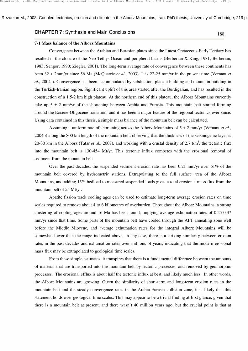
Fig. 7.2: Spatial distribution of (a) decadal erosion, and (b) exhumation in the Alborz Mountains.
Modern erosion has been estimated from 87 stations, operated by TAMAB. The grid is shown at 1 km
resolution with a 15 km diameter smoothing mean applied. The exhumation pattern has been extrapolated
form 40 AFT ages.
(a)
(b)
Rezaeian M., 2008, Coupled tectonics, erosion and climate in the Alborz Mountains, Iran. PhD thesis, University of Cambridge; 219 p.
CHAPTER 7: Synthesis and Main Conclusions
192
7-3 Seasonality of erosion and pulsed exhumation
Rates of erosion have varied cyclically on geomorphic and geological time scales. Strong annual
variations of erosion rate have been observed throughout the mountain belt. In the southern and central
Alborz, these variations are caused by the combined effects of enhanced mechanical weathering of friable
rocks in winter and the optimization of stream power in spring by addition of snow melt runoff to seasonal
rainfall. In the northwest Alborz seasonal variations in erosion rate are associated with the trapping of
sediment mobilized by strong summer runoff, and the optimization of stream power in autumn by addition of
base flow to seasonal runoff. In other words, it is a very specific set of circumstances, not captured in bulk
annual statistics, that gives rise to high erosional fluxes from the mountain belt. The mechanisms of erosion
in the Alborz Mountains are largely decoupled from gross attributes of the climate, such as average annual
precipitation or temperature. It is the variability of these attributes on sub- and inter-annual time scales that
matters.
Temporal variations of the exhumation rates and erosional fluxes from mountain belts are commonly
evaluated in the context of gross attributes of climate. True enough, changes in mountain belt erosion on
geological time scales appear to have coincided with changes in climate, normally expressed in terms of
shifts in annual precipitation or temperature. In the Alborz Mountains for example, pulsed exhumation
appears to have coincided with a dramatic cooling at the Eocene-Oligocene transition, the Middle Miocene
climate optimum, and progressive cooling and aridification since the Early Pliocene. However, it may have
been shifts in the annual variability of climate attributes, rather than the changes of the annual means of these
attributes, that have caused erosion rates to change. At present, low winter temperatures are the key to high
erosion rates in much of the Alborz Mountains. This may be true for much of the Plio-Pleistocene
exhumation pulse. However, it can not have been the root cause of fast exhumation during the Middle
Miocene. Instead, the mechanism that now drives erosion in the wet northwest corner of the mountain belt
may have been prevalent at that time. Precipitation and temperature, and more importantly their variability,
are independent controls on erosion. The annual statistics of both have to be considered in attempts to explain
the geological record of exhumation along active plate boundaries.
7-4 Kinematics of the Alborz Mountains
Pre-existing structure and the geomechanical properties of the substrate have combined with climate
and erosion to determine the structural and topographic evolution of the Alborz Mountains. I interpret the
differences in topographic attributes combined with the position and character of major structures and
changes of crustal thickness as indicative of a gradient in the shortening across the mountain belt from south
to north.
The north Alborz has a relatively low average elevation but high slope and relief. Decadal erosion
rates are low, and do not correlate with topographic attributes. The range is bounded by steep thrusts and
there is evidence of geologically recent propagation of the deformation front. This part of the mountain belt
Rezaeian M., 2008, Coupled tectonics, erosion and climate in the Alborz Mountains, Iran. PhD thesis, University of Cambridge; 219 p.
CHAPTER 7: Synthesis and Main Conclusions
193
has a marked Bouguer gravity anomaly, indicating a total crustal thickness of <35 km (Dehghani & Makris,
1984). Conversely, the southern Alborz have a higher average altitude and lower topographic slopes and
relief. Erosion rates are higher, and correlated with topographic attributes. Exhumation rates have been high
right up to the southern mountain front, implying that exhumation has been on the same set of structures for a
geologically significant amount of time. Crustal thickness in southernmost central Alborz has been estimated
using teleseismic receiver functions at 45- 49 km (Doloei & Roberts, 2003; Sodoudi et al., 2004).
There is one additional difference between the range flanks. The north flank of the Alborz has been
affected by a dramatic base-level fall in the south Caspian Basin which may have had a substantial impact on
the topography and the kinematics of the Khazar and North Alborz faults at the northern range front. The sea
level in the Caspian Basin dropped by about 600m in the Late Messinian. In the Early Pliocene the total area
of the Caspian Sea was reduced to half its present size, coinciding with a similar eustatic sea level fall and the
desiccation of the Mediterranean Sea between 5.96 and 5.33 Ma. This allowed the main paleo-deltas to
prograde into the South Caspian basin from margins (Reynolds et al., 1998; Zobakov, 2001; Smith-Rouch,
2006), and may have driven rapid valley erosion in the northern Alborz. It is unlikely that this effect was felt
in the south flank of the mountain belt.
Returning now to the paradigm of the critical wedge, crustal thickening and mountain building in the
Alborz has resulted from frontal accretion combined with internal deformation to achieve a topographic slope
at equilibrium with frictional stresses along the basal thrust fault. In the north Alborz topographic growth has
been driven by underplating of the South Caspian plate beneath the overriding plate of Central Iranian
Plateau. In contrast, frontal accretion may have dominated in the southern flank. The along-strike gradient in
the topography of the mountain belt may reflect the state to which these processes have advanced.
The east Alborz have a shallow topography with a prominent asymmetry between the range flanks
(Fig. 1.9 a & b). Sitting within an oblique convergence field, this part of the mountain belt may be in an early
stage of development of the wedge above the downing Caspian plate (pro-wedge). The north flank has a low
taper of 1.7º, whereas south flank in the overriding Central Iranian Plateau plate (retro-wedge) is steeper with
a taper of 4.6º, at the high end of values observed elsewhere.
With increasing convergence, crucial thickening leads to a reduction of the lower crust viscosity,
which results in decreasing the topographic asymmetry, higher mountain elevations (Willett, 1999), and an
increasing angle of the pro-wedge (Naylor et al., 2005). The central-western Alborz with a trend
perpendicular to the Arabian-Eurasian collision zone stress field (NNE-SSW) absorbs the highest rate of
compression convergence. The topographic cross section of the central Alborz (Fig.1.9 c) displays a highly
elevated, symmetric wedge. An extensional component has been recorded in the south central Alborz (Ritz et
al., 2006) (chapter1), which could be due to gravity spreading of the steepened wedge.
The wedge geometry is getting increasingly complicated from the central to the west Alborz. A major
northward tectonic vergence has been recorded in several locations in the centre and south-west of the
Rezaeian M., 2008, Coupled tectonics, erosion and climate in the Alborz Mountains, Iran. PhD thesis, University of Cambridge; 219 p.
CHAPTER 7: Synthesis and Main Conclusions
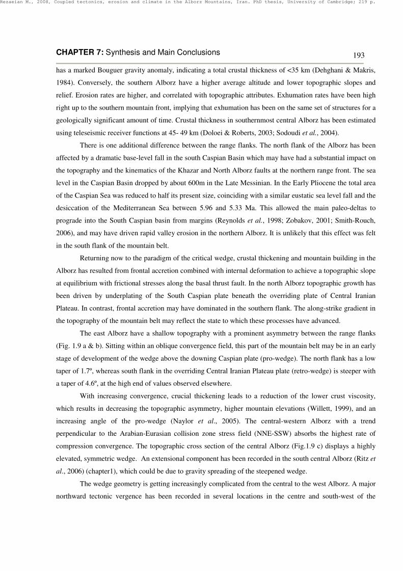
194
mountain belt (e.g., Annells et al., 1975; Geological Survey of Iran, 1987; 2003; Guest et al., 2006b; 2007;
Ballato et al., 2008). See Figures 7.3, 7.4, and 7.5.
Fig. 7.3: Schematic diagram for the geological evolution of a foreland basin located in SE Tehran.
Tectono-sedimentary evolution of the basin has been depicted since Middle Miocene (after: Ballato et al.,
2008).
Fig. 7.4: Schematic diagram for the geological evolution of Taleqan-Alamut basins in west Alborz.
The main active north verging thrust of Takieh resulted in displacement of the Eocene Karaj Formation over
the younger Miocene formations. a) The onset of contraction in the Mid-Miocene coincided with a final
marine regression and deposition of terrestrial Upper Red Formation; dragged growth strata along the S
margin of the Taleqan basin reflect the N verging tectonic force. b) The present landscape resulted from uplift
along the active margins of the mountain belt and consequent erosional down cutting by the Taleqan and
Alamut rivers (after: Guest et al., 2007).
Rezaeian M., 2008, Coupled tectonics, erosion and climate in the Alborz Mountains, Iran. PhD thesis, University of Cambridge; 219 p.

CHAPTER 7: Synthesis and Main Conclusions
195
Fig. 7.5: Dragged conglomeratic strata of Miocene age slope down to the valley along the S margin
of the Taleqan basin. (a) High angle beds in the south margin of the valley in the vicinity of the main thrust.
(b) Less steep strata sloping down to the middle of the Taleqan valley.
Fig. 7.6 (a & b) displays an overturned anticline cored by Early Miocene carbonates of Qom
Formation and flanked by Mid-Miocene Upper Red Formation in south-central Alborz. The early Oligocene,
Lower Red Formation may have operated as a decollement horizon.
This tectonic influx towards hinterland of the Alborz has widened the retro-side of the mountain
significantly, after deposition of the Qom Formation, and as recent as the Middle to Late Miocene. Guest et
al. (2007) and Ballato et al. (2008) have constrained the propagation timing of these structures with opposite
tectonic vergence (S-N) as Mid-Miocene (Fig. 7.3 & 7.4).
Widening of the retro-side of the Alborz Mountains from the centre to the west can not be explained
by steepening of the wedge in the absence of erosion. Importantly, these structures in the south west Alborz
do not propagate from the mountain to the foreland basins, but vice versa. This has given rise to the formation
of new mountain range to the south of the western Alborz sensu stricto. This younger range has started
growing since the Middle Miocene coinciding with uplift and emergence across the Iranian Plateau and the
Zagros Mountains.
Since the Middle Miocene to recent time, clastic sediments of the molasse-type, derived from the
uplifting Zagros Mountains, show a typical coarsening upward evolution from marine-to-continental clastics
(Hessami, 2002; Molnario et al., 2005). In Early Miocene time, Cretaceous carbonate clasts derived from the
hanging wall of the Main Zagros Fault contributed a main component in the conglomerate prograding from
NE to SW of the Zagros. It represents mountain building and subaerial topography in the earliest collision-
related shortening and foreland-basin evolution in the Iranian segment of the Arabia-Eurasia collision zone
(Fakhari et al., 2008). It is assumed that the impacts on the central-west Alborz were more effective than on
other parts of the mountain belt due to co-linearity and proximity to the active Zagros deformation zone.
(a) (b)
Rezaeian M., 2008, Coupled tectonics, erosion and climate in the Alborz Mountains, Iran. PhD thesis, University of Cambridge; 219 p.

CHAPTER 7: Synthesis and Main Conclusions
196
Fig. 7.6: Two N-S sections reveal a north verging anticline in the south-central Alborz, SE Tehran. Qom
Formation carbonates have deformed in the core of the anticline in (a) and (b). The anticline is partly flanked
by Upper Red Formation in (a). Location is about: 52.2º E-35.5º N.
Modelling of the thermo-mechanical evolution of compressional orogens clearly demonstrates that
the highest exhumation rates are found in regions of maximum topography near the core of the orogen;
however, the most deeply exhumed rocks are found in the retro-wedge, where crustal-scale faults
accommodate most of the shortening within the wedge (Batt & Braun, 1997; Naylor & Sinclair, 2007) (Fig.
7.7).
On the basis of the wedge geometry of the Alborz (Chapter 1), a general flux from pro- to retro-side
has developed a typical asymmetric form in eastern Alborz, double-asymmetric in west and single
South North
North South
(a)
(b)
Rezaeian M., 2008, Coupled tectonics, erosion and climate in the Alborz Mountains, Iran. PhD thesis, University of Cambridge; 219 p.
CHAPTER 7: Synthesis and Main Conclusions
197
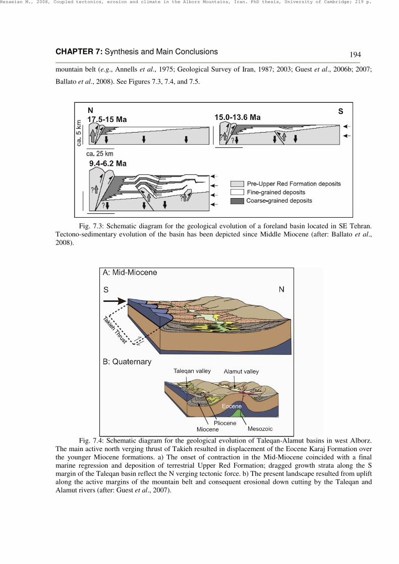
asymmetric in northwest. The partially-reset AFT populations in the northeast Alborz (See Section 2-2-15-5-
1) signal a minimal modification of topography by Tertiary tectonic perturbations. In terms of wedge
dynamics, this can be explained by horizontal trajectories of the material flux from pro-side to retro-side (Fig.
7.7).
Fig.7.7: Rock trajectories from pro-side to retro-side of a critical wedge, in which individual
trajectories demonstrate distinct periods of horizontal motion, quiescence and rapid uplift (Naylor & Sinclair,
2007).
In this scenario, material advected into the NE Alborz has never been buried below the partial
annealing zone (depth >4-6 km) since the Mesozoic, and escaped major subsidence and subsequent
exhumation which influenced the rest of the mountain belt; instead, the horizontal rock trajectories in the
northern Alborz have kept them away from any heating. In contrast, rocks in high elevated part of the
mountain belt, were deeply buried and heated up at depth. They were uplifted and exposed around the divide
and in the southern flank after being fully-reset.
A gradient in uplift rates may explain the AFT age-elevation correlation in the Alborz Mountains
(See section 2-2-16). It is well correlated with the Alborz wedge geometry. A north-south gradient in uplift
rate, inferred from modern and paleo-topography, is compatible with the asymmetric geometry of the Alborz
critical wedge, in which material in the pro-side has been less uplifted than the retro-side.
Whipple and Meade (2004) have demonstrated that steady state orogen width, cross-sectional area,
and topographic relief are equally controlled by the inverse of the erosional efficiency (climate and rock
properties) and the accretionary flux (tectonic). The Alborz Mountains may provide an example of enhanced
retro-wedge erosion, comparable with their model in which an increase in erosional efficiency on the retro-
wedge (south flank of the Alborz) is combined with a decrease on the pro-wedge (north flank) (Fig. 7.8). This
model suggests that it is possible that wedge size and topographic relief remain constant, despite the
accelerated rate of erosion on the retro-wedge (Whipple & Meade, 2004).
Modelling results such as these confirm the importance of substrate strength as a major control on erosion,
and therefore on the kinematics of orogenic wedges. The Alborz may the first case for which this has been
systematically demonstrated in a geological example.
Rezaeian M., 2008, Coupled tectonics, erosion and climate in the Alborz Mountains, Iran. PhD thesis, University of Cambridge; 219 p.

CHAPTER 7: Synthesis and Main Conclusions
198
Fig 7.8: Internal velocity field and integrated particle trajectories for the case in which efficiency of
erosion on the pro-wedge and retro-wedge sides of the orogen are not equal, and erosion patterns are uniform.
Resistant pro-wedge and weak retro-wedge. Dots along particle trajectories demarcate 1 My time intervals,
relative erosion rates are plotted as height above the surface (dashed lines), zone of downward particle
velocities (active burial) is shaded grey, particle paths are not computed within the black-shaded wedge tip
(after: Whipple & Meade, 2004).
Rezaeian M., 2008, Coupled tectonics, erosion and climate in the Alborz Mountains, Iran. PhD thesis, University of Cambridge; 219 p.


![Aspect Ratio Controlled Synthesis of Gold NanorodsAspect Ratio Controlled Synthesis of Gold Nanorods 1147 Korean J. Chem. Eng.(Vol. 20, No. 6) about 1,400nm [Chang et al., 1997]. CONCLUSIONS](https://img.pdfslide.net/doc/110x75/60f46165df3bd54c1605674d/aspect-ratio-controlled-synthesis-of-gold-nanorods-aspect-ratio-controlled-synthesis.jpg)