Embed Size (px)
Citation preview

9-1
Chapter 9: Natural Resources
A. INTRODUCTION This chapter examines the potential impacts from the Proposed Actions on natural resources and floodplains within an approximately 95-block area of the East Harlem neighborhood of Manhattan (the Project Area).
This chapter describes:
• The regulatory programs that protect floodplains and natural resources (e.g., groundwater, wildlife, and threatened or endangered species);
• The current condition of the floodplain and natural resources within the natural resources study area (e.g., groundwater, ecological communities, wildlife, and threatened or endangered species and species of special concern);
• The floodplain and natural resources conditions in the future without the Proposed Actions (the No Action Condition);
• The potential impacts of the Proposed Actions on the floodplain and natural resources (the With Action Condition); and
• The measures that would be developed, as necessary, to mitigate and/or reduce any of the Proposed Actions’ potential significant adverse effects on natural resources and floodplains.
PRINCIPAL CONCLUSIONS
The analysis finds that the Proposed Actions would not result in significant adverse impacts to natural resources.
Projected development resulting from the Proposed Actions would not adversely affect the floodplain, or increase flooding within or adjacent to the Project Area. Projected development sites would comply with New York City Building Codes for construction within the 100-year and 500-year floodplains.
The Proposed Actions would not result in significant adverse impacts to groundwater resources. Projected development sites would implement measures developed on the basis of further environmental investigation to minimize adverse impacts to the environment, such as (E) Designations or as part of Land Disposition Agreements (LDA) for City-owned properties, as detailed in Chapter 10, “Hazardous Materials.” In addition, construction of any subsurface stormwater source control best management practices (BMPs), as described in Chapter 11, “Water and Sewer Infrastructure,” would not result in significant adverse impacts to the direction of groundwater flow toward the Harlem River.
Any development anticipated under the reasonable worst-case development scenario (RWCDS) associated with the Proposed Actions would result in the disturbance of paved road/paths, mowed lawns with trees, urban vacant lots, and urban structure exterior habitats. These

East Harlem Rezoning
9-2
ecological communities provide limited habitats to wildlife apart from those species common to urban areas. While loss of these habitats may affect individual wildlife unable to find suitable available habitats in the vicinity of the study area, it was found that any potential loss would not constitute significant adverse impacts to populations of affected species within the New York City metropolitan region.
B. METHODOLOGY
STUDY AREA
The study area for natural resources is the same as that for the Project Area, as described in Chapter 1, “Project Description,” and indicated in Figure 1-1.
Existing conditions of natural resources within the natural resources study area were characterized using existing information such as:
• The Information, Planning, and Consultation (IPaC) system for federally threatened and endangered species;
• The New York State Department of Environmental Conservation (NYSDEC) Nature Explorer for records of federally and state-listed species;
• 2000–2005 New York State Breeding Bird Atlas results; • 1990–1999 New York State Herp Atlas; • Federal Emergency Management Agency (FEMA) Preliminary Floodplain Insurance Rate
Maps (PFIRMs); • United States Fish and Wildlife Service (USFWS) National Wetland Inventory (NWI) maps; • NYSDEC wetland maps; and • NYSDEC Environmental Resource Mapper.
The Future without the Proposed Actions, or No Action Condition, assumes that natural resources within the study area would remain largely unchanged from existing conditions.
The Proposed Actions would result in a series of land use actions within a highly urbanized neighborhood that would have limited potential to adversely affect natural resources. Potential impacts to natural resources resulting from the Proposed Actions were assessed by considering the effects at the projected development sites on vegetation, groundwater, and wildlife (including federally and state-listed species) from temporary and permanent land disturbance, tree removal, and disturbances to wildlife due to changes in human activity.
REGULATORY CONTEXT
The following sections identify the federal, state, and city legislation and regulatory programs that pertain to activities in floodplains, groundwater, wildlife, and the protection of species of special concern that would apply to the Proposed Actions.
FEDERAL
National Flood Insurance Act of 1968 (44 CFR § 59) The National Flood Insurance Act of 1968 established the National Flood Insurance Program (NFIP) which makes flood insurance available to property owners in areas at risk for flooding,
Chapter 9: Natural Resources
9-3
known as Special Flood Hazard Areas (SFHAs), provided that the local government adopts ordinances to restrict development in floodplains in an effort to reduce future flood damages. The NFIP, which is administered by the Federal Emergency Management Administration (FEMA), is a voluntary program to encourage municipalities to implement responsible floodplain management programs. An SFHA is typically established through the completion of a flood insurance study (FIS), which is a hydraulic study undertaken to establish the elevation to which the base flood (defined as a flood with a one-percent probability of occurring in any given year, also commonly called a “100-year flood”) will rise. The limits of the flood plain, as defined by the base flood, are then presented on flood insurance rate maps (FIRMs), which establish the SFHAs. As a result of later amendments to the National Flood Insurance Act (and in particular, the Flood Disaster Protection Act of 1973), flood insurance is now mandatory for all properties within a SFHA.
Clean Water Act (33 USC §§ 1251 to 1387) The objective of the Clean Water Act, also known as the Federal Water Pollution Control Act, is to restore and maintain the chemical, physical, and biological integrity of the waters of the United States. It regulates point sources of water pollution, such as discharges of municipal sewage, industrial wastewater, and stormwater runoff; the discharge of dredged or fill material into navigable waters and other waters; and non-point source pollution (e.g., runoff from streets, construction sites, etc.) that enter water bodies from sources other than the end of a pipe. Applicants for discharges to navigable waters in New York must obtain a Water Quality Certificate from NYSDEC.
Endangered Species Act of 1973 (16 USC §§ 1531 to 1544) The Endangered Species Act of 1973 recognizes that endangered species of wildlife and plants are of aesthetic, ecological, educational, historical, recreational, and scientific value to the nation and its people. The Act prohibits the importation, exportation, taking, possession, and other activities involving illegally taken species covered under the Act, and interstate or foreign commercial activities. The Act also provides for the protection of critical habitats on which endangered or threatened species depend for survival.
Migratory Bird Treaty Act (50 CFR 10, 20, 21, EO 13186) The Migratory Bird Treaty Act (MBTA) of 1918 was implemented following the 1916 convention between the U.S. and Great Britain (on behalf of Canada) for the protection of birds migrating between the U.S. and Canada. Subsequent amendments implemented treaties between the U.S. and Mexico, Japan, and the former Soviet Union. The MBTA makes it unlawful to pursue, hunt, take, capture, kill, or sell birds listed therein. Over 800 species are currently protected under the Act. The statute applies equally to both live and dead birds, and grants full protection to any bird parts, including feathers, eggs, and nests.
NEW YORK STATE
Endangered and Threatened Species of Fish and Wildlife; Species of Special Concern (ECL, Sections 11-0535[1]-[2], 11-0536[2], [4], Implementing Regulations 6 NYCRR Part 182) The Endangered and Threatened Species of Fish and Wildlife, Species of Special Concern Regulations prohibit the taking, import, transport, possession, or selling of any endangered or threatened species of fish or wildlife, or any hide, or other part of these species as listed in 6 NYCRR §182.6.

East Harlem Rezoning
9-4
State Pollutant Discharge Elimination System (ECL Article 3, Title 3; Article 15; Article 17, Titles 3, 5, 7, 8; Article 21; Article 70, Title 1; Article 71, Title 19; Implementing Regulations 6 NYCRR Articles 2, 3). Title 8 of Article 17, Environmental Conservation Law (ECL), Water Pollution Control, authorized the creation of SPDES to regulate discharges to New York State’s waters pursuant to a delegation by the U.S. Environmental Protection Agency (EPA) to New York State of permitting authority pursuant to the Clean Water Act. Activities requiring a State Pollutant Discharge Elimination System (SPDES) permit include point source discharges of wastewater into surface or groundwater of the state, constructing or operating a disposal system (sewage treatment plant), discharge of stormwater, and construction activities that disturb one or more acres.
NEW YORK CITY
Flood Resilience Zoning Text, Article VI, Chapter 4 of the Zoning Resolution The Flood Text adopted by City Council on October 9, 2013 enables and encourages flood resilient building construction throughout the 100-year floodplain. The Flood Text modified zoning to remove regulatory barriers that hindered or prevented the reconstruction of storm-damaged properties by enabling new and existing buildings to comply with new, higher flood elevations issued by VEMA, and to comply with new requirements in the New York City Building Code. It also introduced regulations to mitigate potential negative effects of flood resilient construction in the public realm.
New York City Local Law 3 (NYCRR Chapter 5) Local Law 3 of 2010 amended Section 18-107 of the Administrative Code of the City of New York and codifies the New York City Department of Parks and Recreation’s (NYC Parks) ability to regulate the replacement of trees on or within jurisdiction of NYC Parks, which includes all trees growing in the public right-of-way and on land mapped as City parkland. The law requires permits from NYC Parks for the removal of trees within NYC Parks jurisdiction and requires replacement of trees that are removed. The law protects against the unauthorized removal, destruction, irreparable damage, and injury to trees under the jurisdiction of NYC Parks.
C. EXISTING CONDITIONS The natural resources study area is located within the urban landscape of the East Harlem neighborhood in Manhattan. Natural resources are limited throughout the study area, and consist primarily of street trees, mowed lawn, and vegetation in vacant lots. On the basis of the NYSDEC tidal and freshwater maps and NWI maps, there are no NYSDEC-classified surface waters, no NYSDEC-regulated wetlands, and no wetlands mapped by the NWI within the study area. Therefore, these resources are not characterized and potential impacts to these resources are not assessed below.
FLOODPLAINS
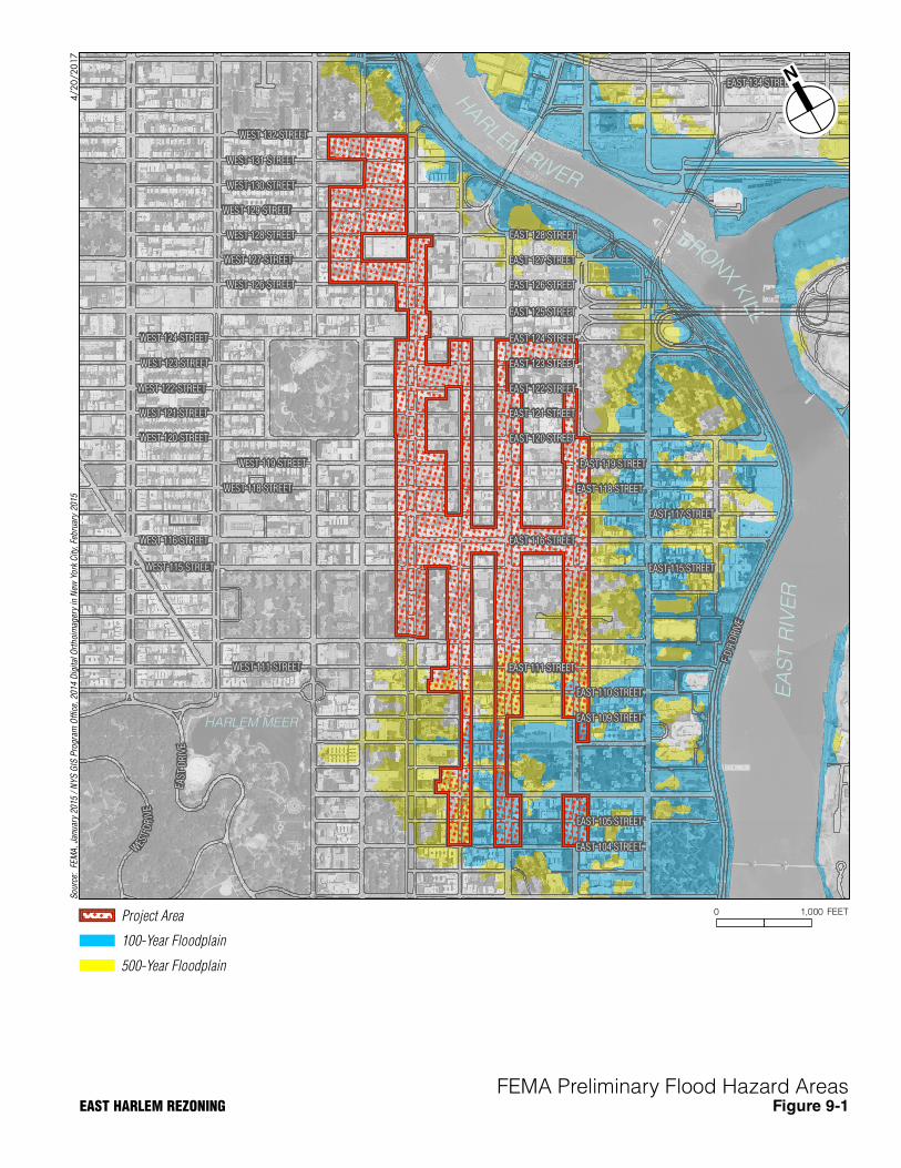
FEMA released preliminary FIRMs on December 5, 2013, and revised preliminary FIRMs on January 30, 2015, that precede the future publication of new, duly adopted, and final FIRMs. The preliminary FIRMs represent the Best Available Flood Hazard Data at this time. FEMA

Chapter 9: Natural Resources
9-5
encourages communities to use the preliminary FIRMs when making decisions about floodplain management until final maps are available.
Much of the natural resources study area along Second Avenue falls within the 500-year floodplain (this is Zone X, the area with a 0.2 percent probability of flooding each year; see Figure 9-1). South of East 112th Street, the study area falls within either the 100-year floodplain (Zone AE, with the 100-year flood elevation of 12 feet North American Vertical Datum [NAVD88], the area with a 1 percent probability of flooding each year). A small portion of the study area in the vicinity of West 132nd Street and Park Avenue falls within the 500-year floodplain.
GROUNDWATER
As discussed in Chapter 10, “Hazardous Materials,” groundwater is anticipated to be approximately 10 to 15 feet below grade and is likely to flow in a general easterly direction toward the Harlem River. Actual groundwater depth and flow direction may be influenced by other factors, such as subway lines, utilities, and basements. Groundwater in Manhattan is not used as a source of potable water.
TERRESTRIAL RESOURCES
ECOLOGICAL COMMUNITIES
The natural resources study area is located within the urban landscape of East Harlem, Manhattan. As such, the ecological communities consist of manicured lawns, paved city streets, and exteriors of urban buildings that would fall under the “Terrestrial Cultural” communities defined by Edinger et al. (2014), including paved road/paths,1 urban structure exteriors,2 urban vacant lots,3 and mowed lawns with trees.4 Vegetation would be sparse except for species growing in cracks in the pavement, plants and vines growing on the exteriors of buildings, and street trees growing in tree pits within the sidewalks.
1 Edinger et al. (2014) define this community as “a road or pathway that is paved with asphalt, concrete,
brick, stone, etc. There may be sparse vegetation rooted in cracks in the paved surface.” 2 Edinger et al. (2014)define this community as “the exterior surfaces of metal, wood, or concrete
structures (such as commercial buildings, apartment buildings, houses, bridges) or any structural surface composed of inorganic materials (glass, plastics, etc.) in an urban or densely populated suburban area. These sites may be sparsely vegetated with lichens, mosses, and terrestrial algae; occasionally vascular plants may grow in cracks. Nooks and crannies may provide nesting habitats for birds and insects and roosting sites for bats.”
3 Edinger et al. (2014) define this community as “an open site in a developed urban area that has been cleared either for construction or following the demolition of a building. Vegetation may be sparse, with large areas of exposed soil, and often with rubble or other debris.”
4 Edinger et al. (2014) define this community as “residential, recreational, or commercial land in which the groundcover is dominated by clipped grasses and forbs, and is shaded by at least 30 percent of trees. Ornamental and/or native shrubs may be present, usually with less than 50 percent cover. The groundcover is maintained by mowing and broadleaf herbicide application.”
EAST 127 STREET
EAST 128 STREET
EAST 123 STREET
EAST 121 STREET
EAST 111 STREET
EAST 120 STREET
EAST 125 STREET
EAST 126 STREET
EAST 122 STREET
EAST 116 STREET
EAST 124 STREET
EAST 117 STREET
EAST 115 STREET
EAS
TD
RIV
E
WEST 115 STREET
EAST 118 STREET
EAST 105 STREET
EAST 110 STREET
EAST 104 STREET
EAST 119 STREET
EAST 109 STREET
WEST 129 STREET
W
EST
DR
IVE
FD
RD
RIVE
EAST 134 STREET
WEST 124 STREET
WEST 116 STREET
WEST 120 STREET
WEST 123 STREET
WEST 121 STREET
WEST 122 STREET
WEST 119 STREET
WEST 111 STREET
WEST 128 STREET
WEST 118 STREET
WEST 131 STREET
WEST 127 STREET
WEST 130 STREET
WEST 126 STREET
WEST 132 STREET
EA
ST R
IVE
R
BRONXKILL
H
ARLEMRIVER
HARLEM MEER
4/20
/20
17
0 1,000 FEETProject Area
100-Year Floodplain
500-Year Floodplain
So
urce
: F
EM
A,
Janu
ary
2015
/ N
YS
GIS
Pro
gram
Off
ice,
20
14 D
igit
al O
rth
oim
ager
y in
New
Yo
rk C
ity,
Feb
ruar
y 20
15
FEMA Preliminary Flood Hazard AreasEAST HARLEM REZONING Figure 9-1
East Harlem Rezoning
9-6
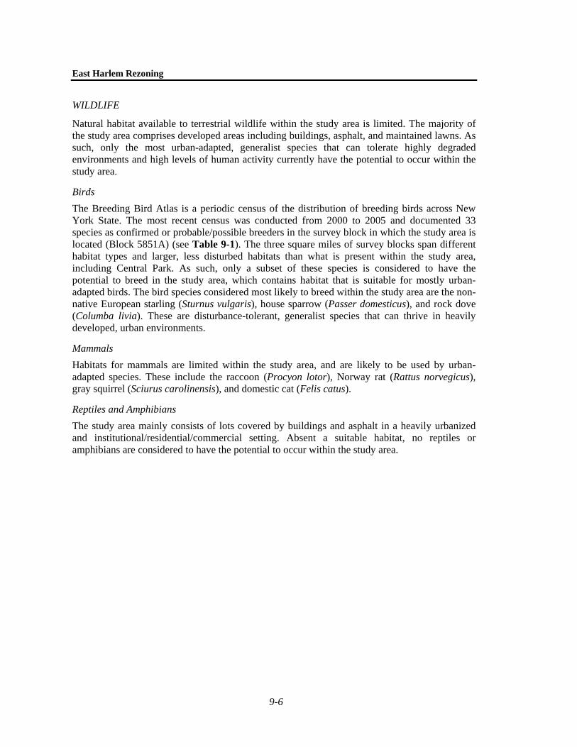
WILDLIFE
Natural habitat available to terrestrial wildlife within the study area is limited. The majority of the study area comprises developed areas including buildings, asphalt, and maintained lawns. As such, only the most urban-adapted, generalist species that can tolerate highly degraded environments and high levels of human activity currently have the potential to occur within the study area.
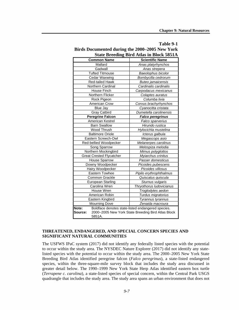
Birds The Breeding Bird Atlas is a periodic census of the distribution of breeding birds across New York State. The most recent census was conducted from 2000 to 2005 and documented 33 species as confirmed or probable/possible breeders in the survey block in which the study area is located (Block 5851A) (see Table 9-1). The three square miles of survey blocks span different habitat types and larger, less disturbed habitats than what is present within the study area, including Central Park. As such, only a subset of these species is considered to have the potential to breed in the study area, which contains habitat that is suitable for mostly urban-adapted birds. The bird species considered most likely to breed within the study area are the non-native European starling (Sturnus vulgaris), house sparrow (Passer domesticus), and rock dove (Columba livia). These are disturbance-tolerant, generalist species that can thrive in heavily developed, urban environments.
Mammals Habitats for mammals are limited within the study area, and are likely to be used by urban-adapted species. These include the raccoon (Procyon lotor), Norway rat (Rattus norvegicus), gray squirrel (Sciurus carolinensis), and domestic cat (Felis catus).
Reptiles and Amphibians The study area mainly consists of lots covered by buildings and asphalt in a heavily urbanized and institutional/residential/commercial setting. Absent a suitable habitat, no reptiles or amphibians are considered to have the potential to occur within the study area.
Chapter 9: Natural Resources
9-7
Table 9-1 Birds Documented during the 2000–2005 New York
State Breeding Bird Atlas in Block 5851A Common Name Scientific Name
Mallard Anas platyrhynchos Gadwall Anas strepera
Tufted Titmouse Baeolophus bicolor Cedar Waxwing Bombycilla cedrorum Red-tailed Hawk Buteo jamaicensis
Northern Cardinal Cardinalis cardinalis House Finch Carpodacus mexicanus
Northern Flicker Colaptes auratus Rock Pigeon Columba livia
American Crow Corvus brachyrhynchos Blue Jay Cyanocitta cristata
Gray Catbird Dumetella carolinensis Peregrine Falcon Falco peregrinus American Kestrel Falco sparverius
Barn Swallow Hirundo rustica Wood Thrush Hylocichla mustelina
Baltimore Oriole Icterus galbula Eastern Screech-Owl Megascops asio
Red-bellied Woodpecker Melanerpes carolinus Song Sparrow Melospiza melodia
Northern Mockingbird Mimus polyglottos Great Crested Flycatcher Myiarchus crinitus
House Sparrow Passer domesticus Downy Woodpecker Picoides pubescens Hairy Woodpecker Picoides villosus Eastern Towhee Pipilo erythrophthalmus Common Grackle Quiscalus quiscula European Starling Sturnus vulgaris
Carolina Wren Thryothorus ludovicianus House Wren Troglodytes aedon
American Robin Turdus migratorius Eastern Kingbird Tyrannus tyrannus Mourning Dove Zenaida macroura
Note: Boldface denotes state-listed endangered species. Source: 2000–2005 New York State Breeding Bird Atlas Block
5851A.
THREATENED, ENDANGERED, AND SPECIAL CONCERN SPECIES AND SIGNIFICANT NATURAL COMMUNITIES
The USFWS IPaC system (2017) did not identify any federally listed species with the potential to occur within the study area. The NYSDEC Nature Explorer (2017) did not identify any state-listed species with the potential to occur within the study area. The 2000–2005 New York State Breeding Bird Atlas identified peregrine falcon (Falco peregrinus), a state-listed endangered species, within the three-square-mile survey block that includes the study area discussed in greater detail below. The 1990–1999 New York State Herp Atlas identified eastern box turtle (Terrapene c. carolina), a state-listed species of special concern, within the Central Park USGS quadrangle that includes the study area. The study area spans an urban environment that does not
East Harlem Rezoning
9-8
provide suitable habitat for eastern box turtles. The NYSDEC Nature Explorer (2017) did not identify eastern box turtle as occurring within the study area. Eastern box turtles are not considered to have the potential to occur within the study area.
PEREGRINE FALCON
The peregrine falcon (Falco peregrinus) is a state-listed endangered species. Peregrine falcon populations in New York have grown dramatically since the 1980s, and the species’ status is expected to be downgraded from endangered to threatened in the next revision of the state list (Loucks 2008). Peregrine falcons nest on cliff ledges, man-made platforms, bridges, and other tall, artificial structures. In New York City, nesting is almost exclusively atop bridge towers and buildings (NYSDEC 2011). Peregrine falcons primarily feed on birds, particularly waterfowl (White et al. 2002). The study area falls within the same three-square-mile survey block (5851A) as The Riverside Church, a nesting site for peregrine falcons. The Riverside Church is located in the Morningside Heights neighborhood across town from the study area, and this nesting site would not be affected by the Proposed Actions. The NYSDEC Nature Explorer (2017) did not identify peregrine falcon as occurring within the study area. The study area does not provide suitable nesting habitat, but peregrine falcons nesting elsewhere may hunt for prey in the study area.
D. THE FUTURE WITHOUT THE PROPOSED ACTIONS In the Future without the Proposed Actions (No Action Condition), the identified projected development sites are assumed to either remain unchanged from existing conditions, or become occupied by uses that are as‐of‐right under existing zoning and reflect current trends if they are vacant, occupied by vacant buildings, or occupied by low-intensity uses that are deemed likely to support more active uses. No significant changes to natural resources are anticipated.
E. THE FUTURE WITH THE PROPOSED ACTIONS
FLOODPLAINS
As discussed under “Existing Conditions,” a portion of the study area, particularly in the southern portion, is within either the 100-year or 500-year floodplain. New York City is affected by local flooding (e.g., flooding of inland portions of the city from short-term, high-intensity rain evens in areas with poor drainage), fluvial flooding (rivers and streams overflowing their banks), and coastal flooding (e.g., long and short wave surges that affect the City’s shorelines along the Atlantic Ocean and tidally influenced rivers and straights such as the Hudson River, Harlem River, and East River). Because the floodplain within New York City is controlled by astronomic tide and meteorological forces (e.g., nor’easters and hurricanes) and not by fluvial flooding, the projected development sites would not have the potential to adversely affect the floodplain or result in increased coastal flooding within or adjacent to the study area.
Any development anticipated under the RWCDS associated with the Proposed Actions would comply with applicable New York City Building Codes and FEMA requirements regarding non-residential and residential structures within the 100-year and 500-year floodplains and would incorporate sea level rise resilience measures into the design of building structures in order to minimize losses due to flooding.
Chapter 9: Natural Resources
9-9
GROUNDWATER
As discussed under “Existing Conditions,” because groundwater in Manhattan is not used as a source of potable water, development would not have the potential to affect drinking water supplies. A hazardous materials assessment identified potential historical and present sources of contamination on projected development sites within the study area (see Chapter 10, “Hazardous Materials”). Further environmental investigation would be required prior to development by placing (E) Designations on privately owned land or LDA for City-owned property. Additionally, construction-phase health and safety plans are required to address known concerns and contingencies should unexpected contamination be encountered.
As discussed in Chapter 11, “Water and Sewer Infrastructure,” increases in impervious surfaces from the proposed development sites would increase stormwater runoff to the combined sewer system serving the study area. Increased development, particularly residential development, would result in increased sanitary sewage to the combined sewer system. These increased flows could be discharged as a combined sewer overflow (CSO) to the East River during heavy rainfall. In order to prevent a CSO, developers would be required to incorporate BMPs at each development site to limit stormwater from the site to the sewer system. BMPs include subsurface detention infiltration, which retain stormwater belowground. Subsurface detention systems would have the potential to modify groundwater flow patterns in the immediate vicinity of the system, but groundwater discharge to the Harlem River would not be adversely affected. Groundwater would be expected to flower around the outside of the system and continue on the original direction of flow thereafter.
If dewatering is required for construction of developments resulting from the Proposed Actions, treatment of the groundwater may be required before discharge to the municipal sanitary or storm sewer in accordance with New York City Department of Environmental Protection (DEP) and NYSDEC requirements.
Therefore, the Proposed Actions would not have the potential to adversely affect groundwater.
TERRESTRIAL RESOURCES
ECOLOGICAL COMMUNITIES
As discussed under “Existing Conditions,” ecological communities within the study area are limited to mowed lawns with trees, urban structure exteriors, urban vacant lots, and paved road/path communities. These ecological communities, in addition to being common throughout the region, are defined by human disturbance and provide limited habitat value to wildlife in the area. Construction on projected development sites as a result of the Proposed Actions would result in disturbance to vegetated ecological communities common to the urban environment. In addition, some street trees and other trees may be removed as a result of the projected development. Rezoning and street tree replacement protocols would result in the replacement and addition of any trees lost due to construction. All work would be performed in compliance with Local Law 3 of 2010 and NYC Parks’ Tree Protection Protocol, to minimize potential adverse impacts. All required replacement and/or restitution for removed trees would be provided in compliance with Local Law 3 and Chapter 5 of Title 56 of the Rules of the City of New York.
Therefore, the Proposed Actions would not result in significant adverse impacts to ecological communities.

East Harlem Rezoning
9-10
WILDLIFE
Projected development resulting from the Proposed Actions would not have significant adverse impacts to wildlife at either the individual or population level. Only urban-adapted, generalist species can tolerate the highly degraded environments and high levels of human activity currently present within the study area. Terrestrial wildlife habitats within the study area are presently limited to mowed lawns with trees, urban structure exteriors, urban vacant lots, and paved road/path communities in a highly urbanized setting. Loss of some of this habitat may adversely affect individual wildlife unable to find suitable available habitats in the vicinity of the study area. Loss of individuals of these common species would not result in significant adverse impact to populations of these species within the New York City metropolitan region. Therefore, construction activities would not eliminate any high quality or valuable habitats for wildlife, and would not adversely affect wildlife within the area.
Indirect impacts to wildlife due to noise from construction would be minimal as urban-tolerant species are acclimated to the increased noise of an urban environment. As disturbance from construction activities would be temporary, any wildlife individuals that may be displaced from the site during project construction would be expected to easily move to an alternative habitat.
Overall, the Proposed Actions would not have significant adverse impacts to wildlife at the individual or population level.
THREATENED, ENDANGERED, AND SPECIAL CONCERN SPECIES AND SIGNIFICANT NATURAL COMMUNITIES
As discussed under “Existing Conditions,” there are no federal- or state-listed endangered, threatened, and special concern species, or significant natural communities considered to have the potential to occur or are known to occur within the study area. Therefore, the Proposed Actions would have no significant adverse impacts to threatened, endangered, and special concern species or significant natural communities.
F. REFERENCES Edinger, G.J., D.J. Evans, S. Gebauer, T.G. Howard, D.M. Hunt, and A.M. Olivero, eds. 2014.
Ecological Communities of New York State. Second Edition. Albany, NY: New York Natural Heritage Program, New York State Department of Environmental Conservation. http://www.dec.ny.gov/docs/wildlife_pdf/ecocomm2014.pdf.
Loucks, B.A. 2008. “Peregrine Falcon, Falco Peregrinus.” In The Second Atlas of Breeding Birds in New York State, K. McGowan and K. Corwin, 210–11. Ithaca, NY: Cornell University Press.
NYSDEC. 2011. “Peregrine Falcon Fact Sheet.” New York State Department of Environmental Conservation. www.dec.ny.gov/animals/7294.html.
White, Clayton M., Nancy J. Clum, Tom J. Cade, and W. Grainger Hunt. 2002. “Peregrine Falcon (Falco Peregrinus).” In The Birds of North America Online, A. Poole. Ithaca, NY: Cornell Lab of Ornithology. http://bna.birds.cornell.edu/bna/species/ 660doi:10.2173/bna.660.