Embed Size (px)
Citation preview
387
CHAPTER 9
PALAEOGEOGRAPHIC RECONSTRUCTION
9.1. Introduction
This chapter discusses models of glaciation proposed by previous workers in
the context of results from the current study, before attempting a reconstruction
of the glacial history. Suggested correlations with tills from neighbouring areas
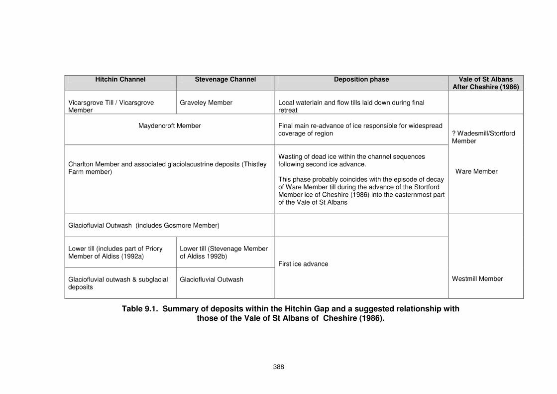
are summarised in Table 9.1.
9.2 Prior to Glaciation There is little doubt that glacial activity during the Anglian was responsible for
major erosion of the Chalk escarpment, as suggested by Clayton (2000). The
greatest amount of scarp erosion occurred in the extreme east of the study
area, gradually diminishing to the southwest - Hitchin marking the position of
minimum scarp retreat. The position of the crest of the escarpment was
displaced by between 10 and 26 km to the southeast, the base of the chalk
being set back by between 5 and 8 km. The height of the scarp was reduced by
up to 10 m (Clayton, 2000).
The presence of the pre-Anglian Clay-with-Flints and the lack of glacial deposits
suggests that the ice did not overtop the Chilterns to the southwest of Hitchin,
although it is likely that minor erosion of the scarp face occurred. Some authors
attribute the formation of a bench feature of Chalk Marl along the northwest face
of the scarp to glacial erosion (Wooldridge & Smetham, 1931).
The course of the Channel at Hitchin may represent the position of a preglacial
chalk stream. Subsequently, a weakness in the scarp at this point was
exploited by the ice and a subglacial stream passed through the escarpment
causing deep erosion of the Hitchin Channel. The Stevenage Valley probably
represented a left bank tributary of the proto-Thames (Hill, 1912; Hopson et al.,
1996). It is unknown whether this valley extended to, or breached, the pre-
glacial scarp, and thus it is unclear whether ice approaching the Chilterns would
have first moved down the Stevenage Valley as proposed by Hopson et al.
(1996) or the Hitchin Valley. However, only the Hitchin Channel has been
deepened by subglacial erosion (Hopson et al.,1996).
388
Hitchin Channel Stevenage Channel Deposition phase Vale of St Albans After Cheshire (1986)
Vicarsgrove Till / Vicarsgrove Member
Graveley Member
Local waterlain and flow tills laid down during final retreat
Maydencroft Member
Final main re-advance of ice responsible for widespread coverage of region
Charlton Member and associated glaciolacustrine deposits (Thistley Farm member)
Wasting of dead ice within the channel sequences following second ice advance. This phase probably coincides with the episode of decay of Ware Member till during the advance of the Stortford Member ice of Cheshire (1986) into the easternmost part of the Vale of St Albans
? Wadesmill/Stortford Member Ware Member
Glaciofluvial Outwash (includes Gosmore Member)
Lower till (includes part of Priory Member of Aldiss (1992a)
Lower till (Stevenage Member of Aldiss 1992b)
Glaciofluvial outwash & subglacial deposits
Glaciofluvial Outwash
First ice advance
Westmill Member
Table 9.1. Summary of deposits within the Hitchin Gap and a suggested relationship with those of the Vale of St Albans of Cheshire (1986).
389
A series of drift-filled depressions beneath the Rivers Ivel and Ouse to the north
can be traced as far north as Huntingdon and may follow the course of a pre-
Anglian river (Horton,1970; Langford, 1999). Langford (1999) also suggested
that the Edworth and Hatley Channels (section 3.8.5) may have formed part of
this drainage system leading eventually to the Wash. The depressions were
considered by Horton (1970) to represent the course of the buried channel and
it is suggested by Hopson et al. (1996) that these form a continuation of the
Hitchin Channel.
9.3. Glacial History
The lower tills within the Hitchin Channel, and possibly the Stevenage Channel,
were laid down during an early advance. Those within the Hitchin Channel
(including the Langley Till) are investigated in this report. Hopson (1992)
reported a lower till within the Stevenage Channel (Stevenage Till) although no
samples were made available during the course of this study. These tills may
represent an ice lobe that extended south of the main ice sheet advancing from
north-northeast, and do not extend beyond the southern end of the Hitchin
Channel. A retreat (of unknown duration) is then indicated by substantial
quantities of overlying glaciofluvial sands and gravels. Tills found above these
glaciofluvial deposits in the channel sequences are correlated with the earliest
till in the Vale of St Albans (Ware Till).
The current study has shown that it is possible to divide tills found north of
Hitchin into those lying to the west of Milton Bryan and those found elsewhere.
Division is based on variations in the acid-soluble contents and the flint/quartz
ratios. This difference is considered to be due to variations in the amounts of
chalk contained within the tills. To explain these findings, together with the
macrofabrics found in the west of the study area (Site 30) - two equally probable
scenarios are suggested, as discussed below.
a) Ice advance from a north to northeasterly direction. There is overwhelming evidence within the study area of at least one advance
of ice from a direction between the north and northeast. With the exception of
tills in the western part of the study area, north of the Chalk scarp they are
390
chalk-rich, suggesting that they have moved across extensive tracts of Chalk
bedrock to the north or northeast. The chalk rafts found at Therfield are
believed to have been formed by ice approaching the area from the north
(Hopson, 1995), as is the ice push structure at Holwell described by Hopson
(1992). Clayton (1979) claims “a large erratic mass of Kimmeridge and Ampthill
clay southeast of Biggleswade can only have been transported from the north or
the northeast”. Further evidence of an advance from this direction is the
presence of non-durable Red Chalk, derived from the Wash, Lincolnshire or
east Yorkshire, in tills throughout the study area.
The model proposed by Perrin et al. (1979) was of a single advance of Scottish
ice moving down the western margin of the North Sea basin to a position north
of the Wash. From here it spread out in a radial pattern across central East
Anglia. This forms the “traditional” view described by Gibbard (in Clark et al.,
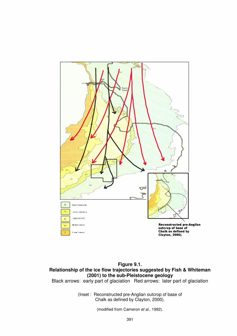
2004). An alternative model suggested by Fish (2000) and Fish & Whiteman
(2001) who, like Baden-Powell (1948) and West & Donner (1956), recognised
both an upper paler (chalkier) and a lower darker till (Section 3.17.3), also
invoked a single ice advance. They believed the lower till was laid down by ice
that flowed south through Yorkshire and Lincolnshire before fanning out over
East Anglia and the upper till followed a similar pattern but with the locus of ice
flow shifted eastwards (Chapter 3 - Figure 3.10). During the later phase of this
glaciation, flow was increasingly over the Chalk of the eastern part of England
and the North Sea Basin. This would result in early ice moving into the study
area from the north followed by later ice from the north to northeast. The
variation in lithological content of tills north of the Hitchin Gap may be due to
these different trajectories shown in Figure 9.1. Ice entering the west of the
study area following the trajectory of the earliest advance in Figure 9.1 would
move over a smaller outcrop of Chalk at a greater distance from the study area,
depositing a till with a low chalk and flint content, such as is seen at Sites 27 –
30. In this case the tills in these sites may be representative of the lower till
suggested by Fish (2000). Ice entering the east of the study area would pass
over the greatest distance of Chalk bedrock, depositing chalk-rich tills.
Only two macrofabrics were obtained from the central and eastern areas north
of the escarpment, at Sites 16 (Moggerhanger) and 22 (Cockayne Hatley).
391
Figure 9.1. Relationship of the ice flow trajectories suggested by Fish & Whiteman
(2001) to the sub-Pleistocene geology Black arrows: early part of glaciation Red arrows: later part of glaciation
(Inset : Reconstructed pre-Anglian outcrop of base of Chalk as defined by Clayton, 2000).
(modified from Cameron et al., 1992).

392
Only the fabric at Moggerhanger recorded a NNE/SSW clast alignment.
However, despite showing the highest vector magnitude in this study (70%), this
till was deposited on sloping ground and is interpreted as a slumped or flow till
(Section 6.6.2). This is likely to have modified the original till fabric.
Very few macrofabric analyses have been carried out in the area lying west of
Milton Bryan, although measurements made at Bedford (TL044519) of 040/220o
and Meppershall (TL157374) of 050/230o by West & Donner (1956) can
perhaps best be explained by ice moving from the northeast. At Site 30 (Heath
and Reach) fabrics may record the path of this ice sheet as it was deflected by
the Chalk scarp along a ENE – WSW to east-west direction into the Vale of
Aylesbury.
In this model lithologies from the northwest would be of secondary derivation
transported by rivers (such as the Bytham) into the path of the ice sheet from
the north – northeast.
b) Ice advance from a direction between northwest and NNE.
An alternative hypothesis is that ice also entered the study area from a more
westerly direction. The trajectory of this ice would follow that of the initial
advance of Baden-Powell (1948) and West & Donner (1956) (shown in Figures
3.7 and 3.8 respectively). The suggested coverage of this ice in the study area
is shown in Figure 9.3. The above authors considered this ice reached the east
coast and extended south to Hertford, depositing the Lowestoft Till and,
according to West & Donner (1956), the Lower Boulder Clay of Hollingworth &
Taylor (1946) near Northampton. The eastern limit of the Thrussington Till,
deposited as part of the Wolstonian Glaciation of Shotton (1953), is unknown
(Rice & Douglas, 1991). However, it is possibly the equivalent of the Lower
Boulder Clay of Hollingworth & Taylor (1946) and has been recognised at
Witham on the Hill by Fish (2000). This till is composed of mainly Triassic
material, although Rice (1981) described it as a chalky grey till at Dunton
Bassett immediately south of Leicester. Perrin et al. (1979) dismissed the idea
of northwesterly ice entering East Anglia, suggesting instead that the tills of
Leicestershire, Lincolnshire and East Anglia were all deposited by a single ice
sheet advancing through the Wash.
393
Rose (1992, 1994 and in Clark et al., 2004) proposed a revision to the
“traditional model” of ice advance described in a) above. This involved a
revision of the idea that Pennine ice, responsible for deposition of both the
Thrussington Till and the Lower Till at Northampton, formed an early part of the
Lowestoft Glaciation. Rose (in Clark et al., 2004) reported a Lower Till in
Buckinghamshire, correlated with that of Hollingworth & Taylor (1946). He
considered an advance from the northwest to precede that from the northeast,
the two being attributed to different marine isotope stages (see below). The
later advance was shown to extend west to the south Midlands. However, Rose
(in Clark et al., 2004) considered the lithologies of the tills deposited in both of
these advances to be indistinguishable, making the identification of an eastern
limit difficult. Nevertheless, Rose (1992, 1994, 2007) suggested that the earlier
advance extended across the whole of East Anglia to the east coast, though in
Clark et al. (2004) he suggested a more limited extent, possibly halting at the
Chalk scarp along a line running between Luton and north Norfolk.
It is possible that evidence of this advance is found in the west of the study
area. This study has shown that the western tills possess different lithological
characteristics to those in the east, with lower flint/quartz ratios and less acid-
soluble material. Erratics, including Triassic sandstone and crystalline rocks
from Charnwood, may have been brought into the western part of the study
area by ice from the northwest - NNW. Fabrics obtained from Site 30 (Heath
and Reach) indicate a clast alignment in an ENE-WSW direction. These could
represent a transverse fabric resulting from either the ice sheet moving across
the Oxford Clay/Lower Greensand boundary, or the ice front to the south
encountering the Chalk scarp. If ice of a more northwestern provenance did
enter the study area, evidence of it is not apparent east of Milton Bryan. The
subsequent (main) ice advance through the Wash could have assimilated the
earlier tills and re-deposited them as a homogeneous mixture of material from
both the northeast-NNE and northwest-NNW. The tills deposited across the
northeastern part of the study area are chalk-rich, deposited by ice that passed
over the easily eroded Chalk bedrock. However, incorporation of the chalk-free
tills from northwest - NNW of the study area would reduce the chalk content of
the material finally deposited in the west of the study area.
394
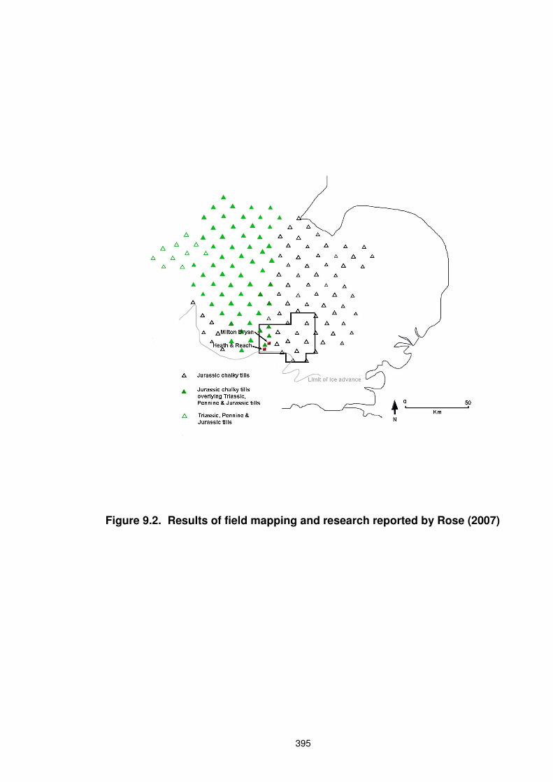
As a result of field mapping and research undertaken since the publication of
Perrin et al. (1979), Rose (2007) published map (reproduced in part in Figure
9.2 in relation to the current study area) showing areas where the various tills
have been identified. Triassic, Pennine and Jurassic tills from the northwest are
seen to reach a limit just east of Site 30 at Heath and Reach, rather than to
continue across the whole of East Anglia. This situation is supported in part by
the findings of the current study, in that greater amounts of Jurassic material
and less chalk is seen in the Heath and Reach area, together with a greater
amount of Triassic material.
Further stratigraphic evidence is required before any resolution of these two
scenarios can be attempted.
9.4. Timing of advances
As mentioned in Section 9.3 (a) an early ice advance into the Hitchin Gap may
have taken the form of a lobe extending south of the main ice sheet advancing
from the north-northeast. The overlying glaciofluvial deposits mark a retreat
before a further advance from a similar direction. In the event of a
northwesterly ice sheet entering the west of the study area as proposed in
Section 9.3 (b), it is uncertain whether this would have occurred during, before
or after the initial glaciation of the Hitchin Gap.
Previous researchers claim that any advance into the region from the northwest
preceded that from the northeast. Early work (Baden-Powell, 1948; West &
Donner,1956) considered the Lowestoft Glaciation to be followed by the
Hoxnian interglacial, followed in turn by the advance of the Gipping ice sheet,
leading to correlation of the Lowestoft Glaciation with the Elsterian (MIS 12) and
the Gipping Glaciation with the Saale (MIS 10). However, to date no evidence
of interglacial deposits has been discovered between these tills (Fish, 2000).
The Thrussington Till, seen to the west of the study area, formed an early part
of The ‘Wolstonian’ Glaciation of Shotton (1983a). This was correlated with the
Gipping, although Perrin et al. (1979) equated the chalky till (Oadby Till) at the
top of this sequence with the main till sheet in East Anglia, believed to originate
in MIS12. Recent studies by Rose (in Clark et al. 2004) and Rose (2007)
395
Figure 9.2. Results of field mapping and research reported by Rose (2007)

396
consider the Lowestoft Till to have been deposited over two marine isotope
stages – MIS 12 and 10, the Thrussington Till forming a major part of the MIS
12 advance. He believed that the advance from the northeast occurred during
Stage 10, although this is controversial (Gibbard, in Clark et al. 2004).
Thus, if two separate ice advances are responsible for tills found within the
study area as proposed in Section 9.3 (b), that from the northwest-NNW could
have preceded that from the northeast. Stresses operating within an ice sheet
advancing over previously deposited till would modify or destroy the pre-existing
fabric. So if ice from the northeast over-ran till laid down by the earlier
northwestern ice, it may have created the northeast-southwest to east-west
macrofabrics noted by West & Donner (1956) (Section 9.3 a) and found at Site
30 (Heath & Reach) of the current study. This suggests that the two advances
were separated by a non-glacial interval, but one of unknown duration.
It is of course, entirely possible that ice sheets from both these directions were
active at the same time –further stratigraphic evidence is required to resolve this
issue.
If a single advance was responsible for tills found both in the east and west of
the study area (Section 9.3a), the pattern of advance would be that suggested
by Fish and Whiteman (2001). The earliest ice reaching the west of the study
area, following the trajectories shown by the black arrows in Figure 9.1, would
deposit a till with low chalk content. This would then be overrun by ice moving
along the trajectory shown in red.
The later tills of northeastern provenance present within the Hitchin Gap show
associations with Cheshire’s Ware Member; the earliest till of the Vale of St
Albans. This till-type is also found on the interfluves in the Hitchin Gap and it is
likely that it was during this advance that ice blanketed the study area (with the
exception of the Chiltern Hills southwest of Hitchin) and advanced into the
Hitchin Gap. It is not known whether the ice passed through the Gap to reach
the Vale of St Albans from the north, or whether, as Cheshire (1986) suggests,
the ice curved around the North Hertfordshire Chalklands to enter the Vale from
the northeast. Lack of similarity between higher tills at the southern end of the
397
Hitchin Channel and those found in the Lower Beane Valley (Section 7.4)
suggest the latter to be the case.
9.5. Discussion
Very little is known about the first advance into the Hitchin Gap, except that
considerable subglacial erosion occurred within the Hitchin channel. If it took
the form of a lobe of ice this erosion would suggest that the main ice sheet lay a
short distance to the north, meltwaters being funnelled into the Gap.
No evidence was found in this study of the two layers of till suggested by
Baden-Powell (1948), West and Donner (1956) and Fish & Whiteman (2001),
although north of Hitchin with a few exceptions, samples were obtained from
tills at most 2 to 3 m thick where vertical compositional variations due to
provenance changes would have been difficult to detect.
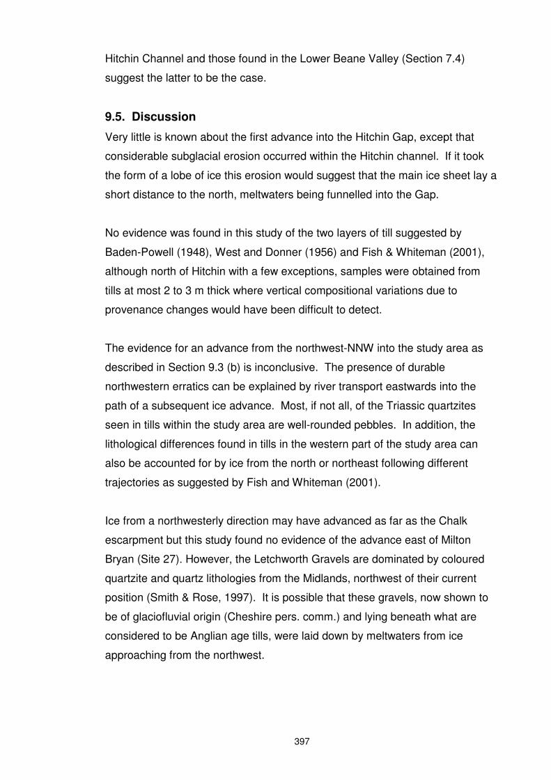
The evidence for an advance from the northwest-NNW into the study area as
described in Section 9.3 (b) is inconclusive. The presence of durable
northwestern erratics can be explained by river transport eastwards into the
path of a subsequent ice advance. Most, if not all, of the Triassic quartzites
seen in tills within the study area are well-rounded pebbles. In addition, the
lithological differences found in tills in the western part of the study area can
also be accounted for by ice from the north or northeast following different
trajectories as suggested by Fish and Whiteman (2001).
Ice from a northwesterly direction may have advanced as far as the Chalk
escarpment but this study found no evidence of the advance east of Milton
Bryan (Site 27). However, the Letchworth Gravels are dominated by coloured
quartzite and quartz lithologies from the Midlands, northwest of their current
position (Smith & Rose, 1997). It is possible that these gravels, now shown to
be of glaciofluvial origin (Cheshire pers. comm.) and lying beneath what are
considered to be Anglian age tills, were laid down by meltwaters from ice
approaching from the northwest.
398
9.6. Reconstruction of glacial events
The following reconstructions are proposed based on the alternative scenarios
given in Section 9.3. As described above, an interval of unknown duration is
likely to have occurred between any possible advances of the northwesterly ice
and those from the northeast, although the possibility of simultaneous
encroachment of ice from both directions cannot be dismissed. Figures 9.3 to
9.5 show coverage of the study area during the advances discussed below.
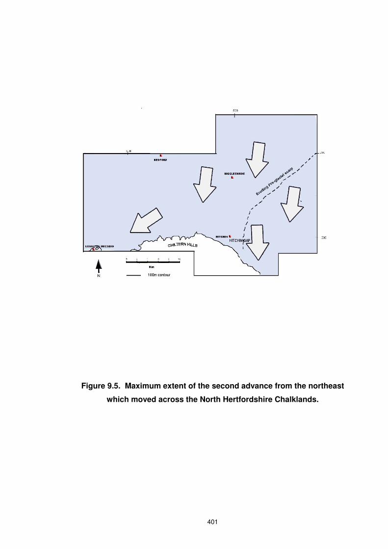
1. Model proposing a single ice advance from the north to northeast.
Movement of ice into the study area from the north-northeast (Figure 9.4) may
have resulted initially in an ice lobe extending south of the main ice mass down
the Ivel valley as suggested by Horton (1970). No evidence has been found to
support this, except that the only examples of lower tills attributable to this early
advance from the north-northeast within the study area are those within the
buried channels. However, later ice from this direction could have obliterated
evidence of the first where not protected by a thickness of outwash sands and
gravels, as in the Hitchin and Stevenage Channels. Ice following the
easternmost trajectories of the later part of the advance (Figure 9.1), passed
over greater distances of Chalk bedrock, depositing tills in the east that are
richer in chalk and flint than those in the west.
Meltwater from an approaching ice sheet may have travelled down the pre-
glacial Ouse/Ivel Valleys as suggested by Horton (1970), eroding or enlarging
the gap in the Lower Greensand at Sandy and continuing south to Hitchin
(Hopson et al., 1996). As the ice moved into the study area from the northeast,
proglacial streams would have been directed to the southwest by the line of the
Chalk escarpment. The course of the Hatley Channel of Edmonds & Dinham
(1965) approximately coincides with that of the pre-Anglian Chalk scarp shown
on Figures 9.3 and 9.4a. It is possible, therefore, that this represents a former
ice marginal drainage channel directing flow towards the Hitchin Gap.
Glaciofluvial water entering the Hitchin Gap flowed through either one, or both,
of the Stevenage and Hitchin Valleys to reach the Vale of St Albans via the
Lower Beane Valley. Smaller quantities of glaciofluvial deposits exist at the
base of the Stevenage Channel, suggesting the Hitchin Channel was the main
drainage route.
399
Fig
ure
9.3
. L
ike
ly e
xte
nt
of
a p
os
sib
le ic
e a
dv
an
ce
fro
m t
he
no
rth
we
st-
NN
W.

400
Figure 9.4. a. Maximum extent of first advance from the northeast into the Hitchin Gap.
b. Retreat of ice (extent uncertain).
401
Figure 9.5. Maximum extent of the second advance from the northeast
which moved across the North Hertfordshire Chalklands.
402
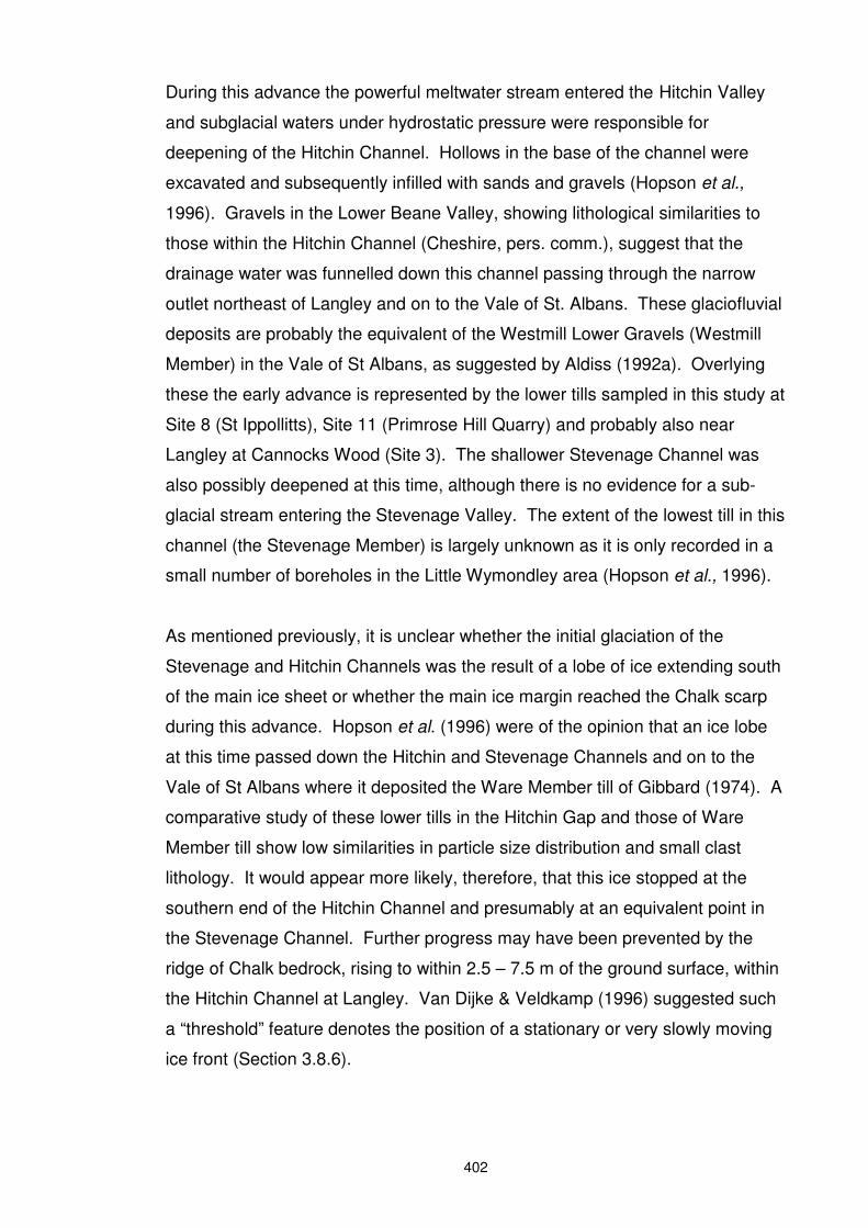
During this advance the powerful meltwater stream entered the Hitchin Valley
and subglacial waters under hydrostatic pressure were responsible for
deepening of the Hitchin Channel. Hollows in the base of the channel were
excavated and subsequently infilled with sands and gravels (Hopson et al.,
1996). Gravels in the Lower Beane Valley, showing lithological similarities to
those within the Hitchin Channel (Cheshire, pers. comm.), suggest that the
drainage water was funnelled down this channel passing through the narrow
outlet northeast of Langley and on to the Vale of St. Albans. These glaciofluvial
deposits are probably the equivalent of the Westmill Lower Gravels (Westmill
Member) in the Vale of St Albans, as suggested by Aldiss (1992a). Overlying
these the early advance is represented by the lower tills sampled in this study at
Site 8 (St Ippollitts), Site 11 (Primrose Hill Quarry) and probably also near
Langley at Cannocks Wood (Site 3). The shallower Stevenage Channel was
also possibly deepened at this time, although there is no evidence for a sub-
glacial stream entering the Stevenage Valley. The extent of the lowest till in this
channel (the Stevenage Member) is largely unknown as it is only recorded in a
small number of boreholes in the Little Wymondley area (Hopson et al., 1996).
As mentioned previously, it is unclear whether the initial glaciation of the
Stevenage and Hitchin Channels was the result of a lobe of ice extending south
of the main ice sheet or whether the main ice margin reached the Chalk scarp
during this advance. Hopson et al. (1996) were of the opinion that an ice lobe
at this time passed down the Hitchin and Stevenage Channels and on to the
Vale of St Albans where it deposited the Ware Member till of Gibbard (1974). A
comparative study of these lower tills in the Hitchin Gap and those of Ware
Member till show low similarities in particle size distribution and small clast
lithology. It would appear more likely, therefore, that this ice stopped at the
southern end of the Hitchin Channel and presumably at an equivalent point in
the Stevenage Channel. Further progress may have been prevented by the
ridge of Chalk bedrock, rising to within 2.5 – 7.5 m of the ground surface, within
the Hitchin Channel at Langley. Van Dijke & Veldkamp (1996) suggested such
a “threshold” feature denotes the position of a stationary or very slowly moving
ice front (Section 3.8.6).

403
No evidence remains of tills from the initial advance from the north - northeast
within the study area north of the escarpment, possibly because a subsequent
re-advance may have removed or assimilated pre-existing till. Following
deposition of the lower tills by ice from the north-northeast, Hopson et al. (1996)
speculated that a climatic amelioration occurred, but the extent of any retreat
remains uncertain. However, large quantities of subglacial and/or glaciofluvial
deposits were subsequently laid down at the base of the Hitchin Channel
leaving only small pockets of the lower till at Hitchin and Langley.
A re-advance of the ice into the channels then followed. This is evidenced by
the Charlton Member of Aldiss (1992a). Deposits found at similar altitudes to
this till have been shown in this study to possess similarities to Cheshire’s Ware
Member till. For this reason it is the Charlton Member that is considered to be
related to the advance responsible for the Ware Member in the Vale of St
Albans, thought to have approached the Vale from a northeasterly direction.
The Charlton Member is interleaved with glaciolacustrine deposits and the tills
at Sites 1 (Knebworth Park), 2 (Norton Green) and 3 (Cannocks Wood) are
shown in Chapter 6 to be melt-out, flow or slumped tills. It is possible, as
suggested by Hopson et al. (1996), that the presence of beds of clay and fine
silt indicate the presence of small proglacial lakes within both the Stevenage
and Hitchin Channels into which waterlain and flow tills were deposited. They
considered that, as the ice which deposited the Stevenage Member retreated
along the Channel, hydrostatic pressure was reduced and the water formed
lakes as it was unable to escape over the threshold at Langley. However,
Cheshire (1986) speculated that at the end of the Ware Member advance a
body of dead ice remained in the Vale of St Albans and formed a barrier to the
expansion of the Stortford Member ice. It is possible that a body of stagnant
Charlton Member ice (equivalent of the Ware Member) may have remained in
the Hitchin Gap at this time. Thus, the glaciolacustrine deposits and waterlain
tills may have been deposited from the decaying body of dead ice and
associated lakes within the channels following the second (Charlton Till)
advance of ice into the Stevenage and Hitchin Channels.
The extensive glaciofluvial deposits at Primrose Hill Quarry (Site 11) suggest
deposition during a minor retreat of the ice front (Figure 9.4b), which was
404
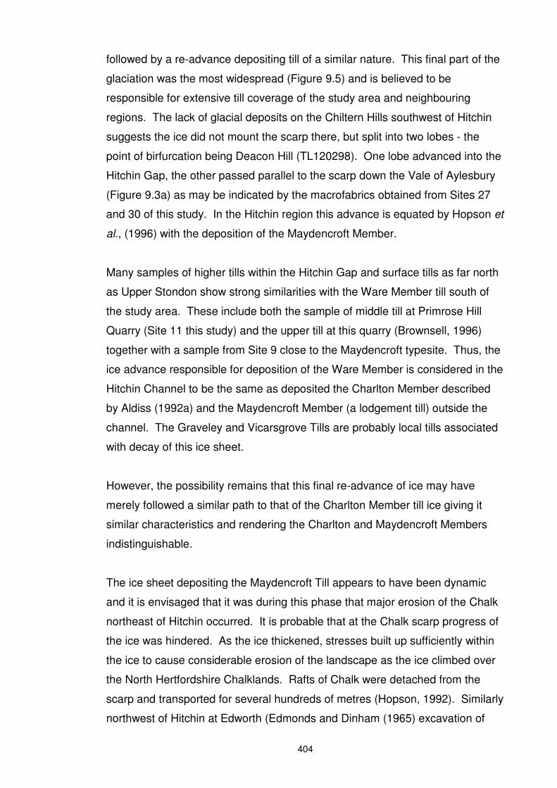
followed by a re-advance depositing till of a similar nature. This final part of the
glaciation was the most widespread (Figure 9.5) and is believed to be
responsible for extensive till coverage of the study area and neighbouring
regions. The lack of glacial deposits on the Chiltern Hills southwest of Hitchin
suggests the ice did not mount the scarp there, but split into two lobes - the
point of birfurcation being Deacon Hill (TL120298). One lobe advanced into the
Hitchin Gap, the other passed parallel to the scarp down the Vale of Aylesbury
(Figure 9.3a) as may be indicated by the macrofabrics obtained from Sites 27
and 30 of this study. In the Hitchin region this advance is equated by Hopson et
al., (1996) with the deposition of the Maydencroft Member.
Many samples of higher tills within the Hitchin Gap and surface tills as far north
as Upper Stondon show strong similarities with the Ware Member till south of
the study area. These include both the sample of middle till at Primrose Hill
Quarry (Site 11 this study) and the upper till at this quarry (Brownsell, 1996)
together with a sample from Site 9 close to the Maydencroft typesite. Thus, the
ice advance responsible for deposition of the Ware Member is considered in the
Hitchin Channel to be the same as deposited the Charlton Member described
by Aldiss (1992a) and the Maydencroft Member (a lodgement till) outside the
channel. The Graveley and Vicarsgrove Tills are probably local tills associated
with decay of this ice sheet.
However, the possibility remains that this final re-advance of ice may have
merely followed a similar path to that of the Charlton Member till ice giving it
similar characteristics and rendering the Charlton and Maydencroft Members
indistinguishable.
The ice sheet depositing the Maydencroft Till appears to have been dynamic
and it is envisaged that it was during this phase that major erosion of the Chalk
northeast of Hitchin occurred. It is probable that at the Chalk scarp progress of
the ice was hindered. As the ice thickened, stresses built up sufficiently within
the ice to cause considerable erosion of the landscape as the ice climbed over
the North Hertfordshire Chalklands. Rafts of Chalk were detached from the
scarp and transported for several hundreds of metres (Hopson, 1992). Similarly
northwest of Hitchin at Edworth (Edmonds and Dinham (1965) excavation of
405
clay bedrock resulted in re-deposition of clay rafts some distance away. Rafting
of till may be also indicated at Baldock (Site 10, this study).
According to Cheshire (1986) this ice probably extended east of the study area,
taking a curved path around the high ground before turning to enter the Vale of
St Albans. Ice approached the Lower Beane Valley from the northeast across
the Chalklands and may have also entered the Stevenage Channel from a
northeasterly direction. The Stevenage Channel is therefore likely to have been
blocked south of the junction with the Hitchin Channel, trapping the southerly
flowing meltwaters and forming the proglacial lakes mentioned above.
To the north of the Hitchin Gap, large quantities of till were deposited on the
Northeastern Plateau blanketing the pre-existing topography. Only one
massive till is present here, up to 67 m thick in boreholes at Hatley (Section
3.6.2.), perhaps indicating that the main ice mass had remained present
throughout the two or more ice advances identified further south. To the east of
the study area, three further minor re-advances occurred, each originating from
the main ice mass northeast of the study area (Cheshire, 1986). This same ice
mass was also responsible for widespread lodgement tills forming the
Blakenham Member in Suffolk Allen (1983) and the Great Waltham Member in
Essex (Whiteman, 1987).
2. Model proposing an advance from the northwest-NNW.
An early ice advance from the northwest-NNW may have encroached into the
western part of the study area, depositing chalk-free tills. This glaciation may
have extended no more than a few kilometres east of Milton Bryan. The
Letchworth Gravels (Section 3.5) may represent a remnant of the outwash of
such an advance. If fabrics at Site 30 (Heath and Reach) represent the re-
orientation of clasts within the ice during the second (northeasterly or north-
northeasterly) advance, then a retreat of ice from a northwestern direction prior
to its arrival is suggested. There is no indication that this early ice surmounted
the Chalk scarp.
The subsequent advance from the northeast may have either followed after an
interval of uncertain duration or the two advances could have formed part of a
406
single glacial event. Either way, tills in the west of the study area comprise a
mixture of both northeastern and northwestern debris. The lack of chalk within
ice from the northwest or NNW would have diluted the acid–soluble content of
the final till.
9.7. Post glacial events
The Hoxnian interglacial followed the final retreat of ice from the study area.
Remnants of the Hoxnian land surface are to be found across the
Stevenage/Hitchin area, where up to 8.5 m of terrestrial deposits include
organic rich clays and peats (Hopson et al.,1996). These deposits survive in
numerous small depressions in the glacial sediments, thought to represent
‘kettle-holes” formed in dead ice within the channel fill sequence.
9.8. Regional stratigraphic correlations
Tentative correlations with stratigraphies of neighbouring areas are shown in
Table 9.1.
The first advance into the Hitchin Gap from the north-northeast appears to be
earlier than the first ice seen in the Vale of St Albans. However, the only
deposits separating tills of this earlier advance from the overlying tills are ~16 m
of outwash deposits seen in the Hitchin Channel. It may be therefore, that as
suggested above, the first advance from the northeast was of a lobe ahead of
the main ice sheet and that this followed the pre-glacial river Ivel/Ouse valleys
south to penetrate the Hitchin Gap.
The overlying tills (Charlton Member), may have been deposited at the same
time as the Ware Member. At Primrose Hill Quarry, up to 10 m of the Lower
Holwell Sands lie above the Charlton Member but below the Maydencroft
Member. A similar stratigraphy exists in the Vale of St Albans where deposition
of the Ware Member is interrupted by sands and gravels laid down by a south-
flowing outwash river. Thus, it is believed here that the Maydencroft lodgement
till, in common with other surface lodgement tills seen across the study area can
be equated with a later part of the Ware Member. However an alternative
scenario is that the Maydencroft till was contemporaneous with one of
Cheshire’s later advances, i.e the Stortford or Wadesmill Member. Tills

407
representative of these members lie a distance to the northeast of those
investigated in this study and would not necessarily have arrived via the same
path, so that they would not exhibit similar lithological characteristics to those
seen by Cheshire.

![Chapter 18...Chapter 18 Reconstruction: North & South. APUSH PowerPoint #5.2 (Part 1 of 2) Unit #5 Chapter 14 –“Reconstruction” [1865-1877] BFW Textbook TOPIC 18 –Reconstruction:](https://img.pdfslide.net/doc/110x75/5e670307e411093306511d4f/chapter-18-chapter-18-reconstruction-north-south-apush-powerpoint-52.jpg)