Embed Size (px)
Citation preview

CHAPTER I11
METHODOLOGY
RESEARCEI INTENT
The purpose of t h i s s t u d y i s t o document t h e changes i n a d j a c e n t
landowner p e r c e p t i o n a b o u t c o n v e r t e d r a i l r o a d t r a i l s . The main f o c u s is
p l a c e d on comparing c u r r e n t owner a t t i t u d e s w i t h t h e i r c o n c e r n s b e f o r e
t r a i l development . Some of t h e f a c t o r s t h a t impac t a d j a c e n t p r o p e r t y
a r e e x a m i n e d , s u c h a s crime a n d p r o p e r t y v a l u a t i o n . S u p p o r t i n g
i n f o r m a t i o n i s g a t h e r e d from p r o f e s s i o n a l s i n t h e i r f i e l d of knowledge.
G r o u p s c o n t a c t e d i n c l u d e t r a i l managers , c o n s e r v a t i o n o f f i c e r s , l a w
en fo rcemen t a g e n t s , coun ty c o m m i s s i o n e r s , a p p r a i s e r s f r o m c i t y a n d
coun ty o f f i c e s , and r e a l e s t a t e a g e n t s .
T h i s r e s e a r c h i s a n i n d e p t h s t u d y o f two s e l e c t e d t r a i l s , r a t h e r
t h a n a random s e l e c t i o n of t h e t o t a l 158 r a i l - t r a i l s i n t h e U n i t e d
S t a t e s . T h i s a p p r o a c h i s e m p l o y e d b e c a u s e o f t h e r e s t r a i n t s o f
a v a i l a b l e time and r e s o u r c e s , and t h e d i f f i c u l t y i n i d e n t i f y i n g a l l
landowners a d j a c e n t t o t h e p o t e n t i a l t r a i l s i t e s . Due t o t h i s f o c u s ,
t h e c o n c l u s i o n s drawn a b o u t t h e s i tes i n t h i s s t u d y may n o t re f lec t t h e
c o n d i t i o n s i n a l l t r a i l s a c r o s s t h e c o u n t r y .
24

The f o l l o w i n g a c t i v i t i e s were comple ted i n o r d e r t o o b t a i n t h e
r e s u l t s f o r t h i s s t u d y :
1.
2.
3 .
4 .
5.
6 .
7 .
8 .
9 .
10.
11.
12.
S e l e c t i o n o f two s t u d y s i t e s based o n i n f o r m a t i o n g a t h e r e d from r a i l - t r a i l s i n f o u r n o r t h - c e n t r a l s ta tes .
The r e s e a r c h o f t h e p h y s i c a l c h a r a c t e r i s t i c s and h i s t o r i c a l background of t h e two si tes.
Development of owner q u e s t i o n n a i r e and c o v e r l e t t e r , and i n t e r v i e w forms f o r t h e p r o f e s s i o n a l s .
A p p r o v a l o f q u e s t i o n n a i r e and c o v e r l e t t e r by t h e Human S u b j e c t s Committee.
P r e t e s t i n g of q u e s t i o n n a i r e and s u b s e q u e n t r e v i s i o n s .
I d e n t i f i c a t i o n of a d j a c e n t landowners and p r o f e s s i o n a l s from bo th t r a i l s .
Random s e l e c t i o n o f l a n d o w n e r s t o b e c o n t a c t e d i n t h e s u r v e y .
Sending advance n o t i f i c a t i o n which e x p l a i n s t h e s t u d y , t o t h e s e l e c t e d landowners .
Conduct ing t h e phone s u r v e y of owners and p r o f e s s i o n a l s .
S e n d i n g f o l l o w - u p q u e s t i o n n a i r e s t o owners who were n o t c o n t a c t e d by phone.
T r a n s f e r r i n g i n f o r m a t i o n f r o m q u e s t i o n n a i r e s t o c o d i n g s h e e t s f o r i n p u t i n t o t h e compute r ,
I n t e r p r e t a t i o n and a n a l y s i s of d a t a f rom t h e computer .
OPERATIONAL DEFINITIONS
I n o r d e r t o c l a r i f y t h e i n f o r m a t i o n p r e s e n t e d i n t h i s s t u d y , t h e
f o l l o w i n g d e f i n i t i o n s w i l l a p p l y :
Abandoned R a i l r o a d Right-of-way (ROW) - A ROW which h a s r e c e i v e d a p p r o v a l f o r abandonment by t h e I n t e r s t a t e Commerce Commission, t h e f e d e r a l c o u r t , or any o t h e r gove rnmen ta l agency h a v i n g j u r i s d i c t i o n o v e r r a i l r o a d p r o p e r t y ,
C o n v e r t e d R a i l r o a d T r a i l o r R a i l - T r a i l - An abandoned r a i l r o a d r ight-of-way which was a c q u i r e d and deve loped as a r e c r e a t i o n a l or mul t i -pu rpose t ra i l .
25

Smal l R e s i d e n t i a l - P r i v a t e p r o p e r t y l e s s t h a n 3.5 acres which is used p r i m a r i l y as a p l a c e of r e s i d e n c e .
La rge R e s i d e n t i a l - P r i v a t e p r o p e r t y 3.5 t o 36 acres which i s u s e d p r i m a r i l y a s a p l a c e of r e s i d e n c e b u t may a l s o i n c l u d e some fa rmland o r a commerc ia l b u s i n e s s .
Commercial - P r i v a t e p r o p e r t y which i s used i n t h e b u y i n g , s e l l i n g , o r p r o d u c t i o n of g o o d s o r s e r v i c e s e x c l u d i n g f a rming .
Farmland - P r i v a t e p r o p e r t y which i s used f o r c r o p l a n d o r p a s t u r e , b u t may a l s o be used as a p l a c e of r e s i d e n c e .
Landowner - Owner, r e n t e r , o r manager of p r i v a t e p r o p e r t y , c h u r c h l a n d , homeowner a s s o c i a t i o n , or a s c h o o l d i s t r i c t .
SITE SELECI'ION
The s i t e s e l e c t i o n p r o c e s s i s based on i n f o r m a t i o n g a t h e r e d a b o u t
r a i l - t r a i l s i n f o u r n o r t h - c e n t r a l s ta tes : Iowa, I l l i n o i s , Wiscons in ,
and Minnesota . These s t a t e s o f f e r e d s e v e r a l a d v a n t a g e s , As i n d i c a t e d
i n F i g u r e 2.4 , a b o u t o n e - t h i r d o f a l l r a i l - t r a i l s are l o c a t e d i n t h i s
area, I n a d d i t i o n , many o f t h e s e t r a i l s have been e s t a b l i s h e d f o r a
number of years. Also a v a i l a b l e are s t a t e and l o c a l a g e n c i e s w i t h
a c t i v e r a i l - t r a i l programs. And f i n a l l y , t h i s r e g i o n is c lose and
a c c e s s i b l e f o r eas ie r d a t a c o l l e c t i o n .
The s e l e c t i o n of two s i t e s i n Minneso ta , t h e Root R i v e r and t h e
Luce L i n e T r a i l s , i s based on t h e f o l l o w i n g c r i t e r i a :
1. Developed t r a i l s i n c u r r e n t u s e which are c o n v e r t e d f rom abandoned r a i l r o a d r igh ts -of -way.
2. T r a i l s t h a t are a d j a c e n t t o v a r i o u s t y p e s of l a n d u s a g e s u c h as s u b u r b a n , a g r i c u l t u r a l , commercial, a n d s c e n i c r u r a l areas,
3. The w i l l i n g n e s s o f t h e M i n n e s o t a Depar tment of N a t u r a l R e s o u r c e s (DNR) t o p r o v i d e r e s o u r c e s i n t h e c o m p l e t i o n of t h e s t u d y .
26

P
4 . Documentat ion of t h e o p p o s i t i o n o r t h e conce rn of l andowners p r e v i o u s t o t r a i l c o n v e r s i o n . I n t h e case of t h e Root R i v e r T r a i l , a s t u d y on landowner a t t i t u d e s had been comple t ed p r i o r t o i t s development .
BACKGROUND OF T R A I L SITES
T h i s s e c t i o n d e s c r i b e s t h e p h y s i c a l c h a r a c t e r i s t i c s and t h e
h i s t o r i c a l background o f t h e two t r a i l s . B o t h t r a i l s a r e r a t h e r
d i s t i n c t i v e and r e p r e s e n t an o p p o r t u n i t y f o r compar ison .
Root R i v e r T r a i l
P h y s i c a l D e s c r i p t i o n , The Root R i v e r T r a i l i s l o c a t e d i n a n
u n g l a c i a t e d a r e a o f s o u t h e a s t e r n Minneso ta i n F i l l m o r e and Hous ton
C o u n t i e s ( F i g . 3.1 Root R i v e r Tra i l L o c a t i o n Map). The 35-mile t r a i l ,
which p a r a l l e l s l i m e s t o n e b l u f f s a l o n g t h e Root R i v e r and Watson Creek ,
o f f e r a v a r i e t y of v i s u a l e x p e r i e n c e s . The t r a i l passes t h r o u g h t h e
r o l l i n g u p l a n d s , t h e t r a n s i t i o n zone between up land and v a l l e y , and t h e
v a l l e y f l o o r envi ronment ( F i g . 3 .2 R o l l i n g Farmland; F i g . 3.3 T r a i l
Along R i v e r ; F i g . 3.4 R a i l r o a d Grade C u t ) . P o r t i o n s of R i c h a r d J.
Dorer Memorial Hardwood F o r e s t a l o n g w i t h L o s t Lake S t a t e Game Refuge
a r e a d j a c e n t t o t h e r ight-of-way. The Root R i v e r T r a i l i s one o f t h e
most s c e n i c r o u t e s i n Minnesota (Minneso ta DNR, 1979-1980, 1987) .
Although t h e r a i l r o a d ROW was purchased by t h e s t a t e e i g h t years
a g o , o n l y 11 miles from Lanesboro t o F o u n t a i n have a paved s u r f a c e . The
p o r t i o n east of Lanesboro is unde r c o n s t r u c t i o n and s h o u l d be comple ted
i n l a t e f a l l o f 1988 ( P a u l s o n , 1988). Because t h e e a s t e r n s e c t i o n h a s
e n c o u n t e r e d f ewer u s e r s , t h i s s t u d y w i l l be l i m i t e d t o t h e w e s t e r n 11-
mile s e c t i o n (F ig . 3 .5 Root R i v e r T r a i l Survey Area). T h i s i n c l u d e s t h e
downtown b u s i n e s s e s i n Lanesboro t h a t are a d j a c e n t t o the paved t r a i l .
27

Figure 3.1 Root River Trail Location Map L o c a t i o n of Root River T r a i l i n s o u t h e a s t e r n Yinneso ta (Genera t ed from Minnesota D N R , 1987) .
Figure 3.2 Rolling Farmland t h e Root R ive r T r a i l n e a r F o u n t a i n .
A g r i c u l t u r a l l a n d a l o n g t h e w e s t e r n end of
28

Figure 3.3 Trail Along River S c e n i c t r a i l f o l l o w i n g t h e S o u t h Branch of t h e Root River between Lanesboro and F o u n t a i n .
Figure 3.4 Railroad Grade Cut t h e Root River T r a i l .
Old r a i l r o a d g r a d e c u t n e a r L a n e s b o r o on
29

3
Figure 3.5 Survey Area of t h e Root River T ra i l from Lanesboro t o nea r F o u n t a i n (Generated from Minnesota D N R , 1987).
Root River T r a i l Survey Area
30

The h e a d q u a r t e r s f o r t h e Root R i v e r T r a i l i s l o c a t e d i n h i s t o r i c
Lanesboro , a small a g r i c u l t u r a l b a s e d communi ty o f 900. A l t h o u g h
t o u r i s m h a s n o t r e a c h e d i t s p o t e n t i a l , it i s a small, b u t growing
i n d u s t r y , S e v e r a l b u i l d i n g s i n town are l i s t e d on t h e N a t i o n a l R e g i s t e r
of H i s t o r i c P l a c e s . The Lanesboro Community Club and s e v e r a l l o c a l
b u s i n e s s e s promote t h e t r a i l and o t h e r r e c r e a t i o n a l o p p o r t u n i t i e s as an
a t t r a c t i o n f o r d rawing v i s i t o r s ( F i g . 3.6 Bed & B r e a k f a s t s ; F i g . 3.7
Lanesboro Brochure) ( H i s t o r i c B l u f f Count ry Bed & B r e a k f a s t A s s o c i a t i o n )
(Lanesboro Community C lub) .
~- ~~ ~~~
Six Bed & Breakfasts welcome you to
Historic Bluff Country Irs life
in the slow lane, rocking on a porch, listening to the birds, smelling the flowers,
watching the stars, D this unglaciated or exploring area.
You'll enloy an unique B&8 exper- ience in Southeastern Minnesota's Historic Bluff Count w . . . fishing for trout or bass in our many streams. biking or hiking on one of the winding trails. canoeing. sight- seeing. or antiquing. Tour the countryside. or go underground in either of the two caves open to
Step bock in time with an Amlsh tour. or visit any of Historic Bluff Country's many museums (Steam Engines. Laura Ingalls Wilder Site. History Centre)
the public.
In one of these Historic Bluff Countv a&B s you re sure to fmd the aCCommodotionS to fit your needs-from a country cottage with outdoor privy to a modern farm home. from art noveau to Victonan spiendor
Historic Bluff Count ry... Famous for its
Bed & Breakfasts!
B E D & . B R E A K F A S T W H O L E H O U S E R E N T A L
L O C A T E D ON ROOT RIVER & TRAIL Carrolton Counlry Inn IS a ore '882 cenruiy larm home, completely restored and nesua among nlils in an open valley near Meswro. The nine room rural retreat IS situated on 389 acres. overlooking the Roo1 Rlver and the Root River Slate Trail Rent :he enure nome. or lust a room. Enjoy a closeness IO nahrre. Carrollon Country Cottage 15 !he otace far people favoring a relaxea bacX-Io.0asIcs lifestyle. Return to nature in [h's 1800's cartage for the expenence 01 outdoor plumaing. outdwrprlvy and Outdoor hint
CARROLTON COUNTRY INN CARROLTON COUNTRY COTTAGE
R.R. 2. B O X 139 UNE580RO. MN 55949
WTi 467.2257 IFNOANSWER.CAUAGI I INUlEM
INNKEEPERS. CFARLES am GLORIA RUEN O P m A U Y E P R
&RLpQBPClH OUlTBY PMW
Listed on National Register of f i t o n c Places
Grncious Victorinrr Living Located an Historic iilnesbora.
the blinnaofa bid/ region on thr Rwt R i r n .
Breakfast w t h us Ercsilenf dining ~n arm
For Reservations:
S C A M L A N HOUSE 70s Parkrvav So.
Lanesboro, &IN 55949 Phone 607) 467-2133
Pmpnclorr Genc. \lam and K v s t c n L l c n i i n ~
Figure 3.6 Bed 8 Breakfasts A d v e r t i z i n g f o r two Lanesboro Bed & B r e a k f a s t s t h a t promote t h e s c e n i c a r e a a n d t h e Roo t R i v e r T r a i l ( H i s t o r i c B l u f f Country Bed & B r e a k f a s t A s s o c i a t i o n ) .
31

Historic I Lanesboro I
SPECIAL EYEKIS ART IN THE PARK
An & Cralt Exhlblt & Sale on Father's Day BUFFALO BILL DAYS
Celebrated the llrst weekend In AUQUII
OVERNIGHT ACCOMMODATIONS
Depending upon Iha season and your Interests, Lanesboro can ollar camping and lrallar 1aclIlt1as, cabins, and a bed and blOakl8SI I.Clllty.
FOOD
Plcnlcr. pizza. drlv4.ln dining, lemlly sly14 end pourmot dlnnora ar4 011 available.
OF HISTORIC OR RECREATIONAL m s T
LANESBORO DAM, constructed In 1868, Is known for Its stone constructlon. An observation deck provldas a close-up view 01 l h l l landmark. The church hill and the brldgo near tho Musaum provlda excellent vantago polnts lor slQhtsealng and picture taking.
MUNICIPAL POWER PLANT Is producing electrlcily lor Lanesboro.
SYLVAN PARK I s located In Ihe center 01 town. Picnic lacilll ies with shelters. electricity. and bathrooms are available. Camping facilltles provide sites lor tent3 and trailers. Electric hook-ups and a dumping slation make your camping easier. Two Ilghted. regulation size tennis courts are close at hand. Fishing In the pond or along the Root River can provide a trout lor your dinner.
THE ROOT RIVER TRAIL winds 111 way along Ihe former railroad bed IlOm Fountaln thru Lanesboro to Money Creek. Leisurely hlklng or skiing along the trall with i t s rivers, b lu l ls, prairies and hard- wood forests provides you with the sense 0 1 this country
CEDAR CLIFF OVERLOOK Is Iocaled at the top of (he north blul l and provides an excellent view 01 downtown Lanesboro and Ihe entire valley.
R E C R E A T I O N A L OPPORTUNIT IES abound, and equipment U n be rented.
LANESBOROATIRACnONS
LANESBORO STATE FISH HATCHERY IS
located about 2 miles southwest 01 Lanesboro 011 Highway 1 6 . Over 90% 01 all l rou l stocked in Minnesola coma lrom thls hatchery which I S the Iormer Duschee Mlll site. Maps are available lor tiout streams m the area.
THE FOREST RESOURCE CENTER is a private non-prolit corporation located 6 miles nofth 0 1 LaneSborO an a blufl above the nonh branch 01 the Root Rlver. The Center provider hiking trails, lorest demonstration, and a bat condominium. Travel Highway 250, 2% m11ms nonh, turn we~t i1e l r at the sign and go 3 miles to the entrance).
Figure 3.7 Lanesboro Brochure Brochure d e s c r i b i n g t h e s i g h t s e e i n g a t t r a c t i o n s and t h e r e c r e a t i o n o p p o r t u n i t i e s i n t h e h i s t o r i c Lanesboro a rea (Lanesboro Community C l u b ) ,
H i s t o r i c a l P e r s p e c t i v e . The abandoned r a i l r o a d r igh t -of -way and
t h e s c e n i c q u a l i t y o f t h e v a l l e y have h i s t o r i c s i g n i f i c a n c e f o r t h e Root
R i v e r T r a i l and t h e V i l l a g e o f Lanesboro ( F i g . 3.8 1879 Lanesboro , F i g .
3 .9 H i s t o r i c Main S t r e e t ) . T h e S o u t h e r n Minneso ta R a i l r o a d was
comple t ed t h r o u g h L a n e s b o r o i n 1 8 6 8 , t h e same y e a r t h e town was
i n c o r p o r a t e d . As i n many o t h e r communi t ies i n t h e mid-west a t t h a t
t ime, t h e r a i l r o a d was t h e main l i n e o f communicat ion w i t h t h e o u t s i d e
wor ld . One l o c o m o t i v e , named t h e "Pusher" was s t a t i o n e d i n Lanesboro t o
h e l p t r a i n s o u t of t h e v a l l e y and o n t o t h e p r a i r i e (Drake , 1969) .
32

Figure 3.8 1879 Lanesboro Sird's-eye view of Lanesboro and s u r r J L c o u n t r y s i d e i n 1879 (Drake, 1969).
Figure 3.9 Historic Main Street H i s t o r i c v i e w of t h e downtown commercial a re i n L a n e s b o r o ( R e p r o d u c e d P o s t C a r d by B u e , S t u d i o A n t i q u e s , L a n e s b o r o ) .
33
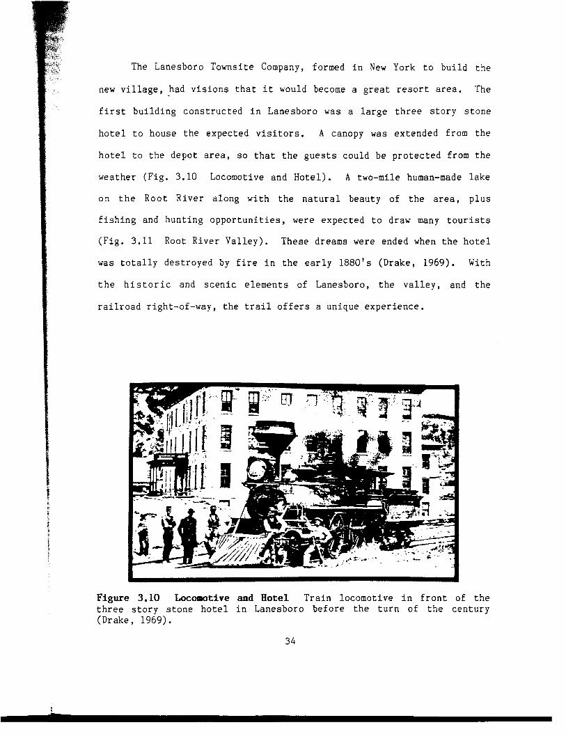
The Lanesboro Towns i t e Company, formed i n New York t o b u i l d t h e
new v i l l a g e , had v i s i o n s t h a t it would become a g r e a t r e s o r t area. The
f i r s t b u i l d i n g c o n s t r u c t e d i n Lanesboro was a l a r g e t h r e e s t o r y s t o n e
h o t e l t o house t h e expec ted v i s i t o r s . A canopy was e x t e n d e d f rom t h e
h o t e l t o t h e d e p o t area, s o t h a t t h e g u e s t s cou ld be p r o t e c t e d from t h e
wea the r ( F i g . 3.10 Locomotive and H o t e l ) . A two-mile human-made l a k e
o n t h e R o o t R i v e r a l o n g w i t h t h e n a t u r a l beau ty o f t h e area, p l u s
f i s h i n g and h u n t i n g o p p o r t u n i t i e s , were e x p e c t e d t o draw many t o u r i s t s
( F i g . 3.11 Root R i v e r V a l l e y ) . These dreams were ended when t h e h o t e l
was t o t a l l y d e s t r o y e d by f i r e i n t h e early 1880's (Drake , 1969). With
t h e h i s t o r i c and s c e n i c e l e m e n t s o f Lanesboro , t h e v a l l e y , and t h e
r a i l r o a d r igh t -of -way, t h e t r a i l o f f e r s a un ique e x p e r i e n c e .
Figure 3.10 Locomotive and Bote1 T r a i n locomot ive i n f r o n t of t h e t h r e e s t o r y s t o n e h o t e l i n Lanesboro b e f o r e t h e t u r n o f t h e c e n t u r y (Drake , 1969) .
34

Figure 3.11 Root River Valley H i s t o r i c v i e w of t h e r a i l r o a d a n d s t o n e dam and f a l l s i n t h e Root R i v e r Valley s o u t h o f Lanesboro (Reproduced P o s t Card by B u e , S t u d i o A n t i q u e s , L a n e s b o r o ) .
Conver s ion P r o c e s s . I n 1979, t h e Ch icago , Vi lwaukee , S t . P a u l and
P a c i f i c R a i l r o a d abandoned a 100-mile s t r e t c h f rom t h e M i s s i s s i p p i R i v e r
t o Ramsey J u n c t i o n , a p o i n t f i v e miles n o r t h of A u s t i n . T h i s i n c l u d e d a
50-mile t r a c k t h r o u g h t h e Roo t R i v e r V a l l e y . C o n t r o v e r s y o v e r t h e
Y i n n e s o t a D V R ' s a t t e m p t t o p u r c h a s e a n d d e v e l o p t h e r i g h t - o f - w a y ,
r e s u l t e d i n t h e Yilwaukee Road C o r r i d o r S tudy and a p u b l i c h e a r i n g on
t h e proposed a c q u i s i t i o n . T h i s s t u d y , comple t ed i n J a n u a r y o f 1980,
c o n s i s t e d o f n i n e t e c h n i c a l a p p e n d i c e s , a s o c i a l and p h y s i c a l i n v e n t o r y ,
and a summary o f a l t e r n a t i v e a n a l y s e s and r e c o m m e n d a t i o n s . I s s u e s
c o v e r e d i n c l u d e d t h e impac t o f t h e t r a i l o n a d j a c e n t l a n d , l o c a l law
en fo rcemen t p rob lems , and t h e need f o r a d d i t i o n a l t r a i l r e c r e a t i o n
( Y i n n e s o t a D N R , R R S W ) . 35
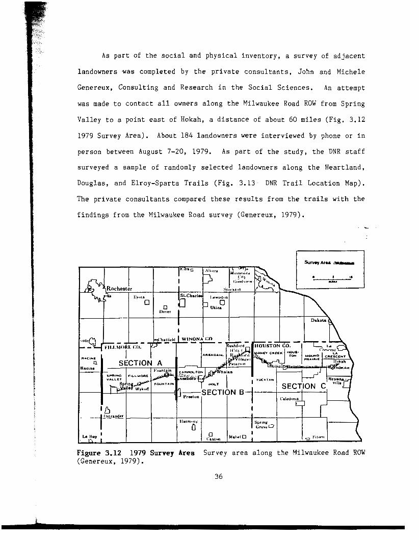
As p a r t of the s o c i a l and p h y s i c a l i n v e n t o r y , a s u r v e y of a d j a c e n t
l andowners was comple ted by t h e p r i v a t e c o n s u l t a n t s , John and Miche le
Genereux, C o n s u l t i n g and R e s e a r c h i n t h e S o c i a l S c i e n c e s . An a t t e m p t
was made t o c o n t a c t a l l owners a l o n g t h e Milwaukee Road ROW from S p r i n g
V a l l e y t o a p o i n t east o f Hokah, a d i s t a n c e of a b o u t 60 miles ( F i g . 3.12
1979 Survey A r e a ) , About 184 l andowners were i n t e r v i e w e d by phone o r i n
p e r s o n between August 7-20, 1979. As p a r t o f t h e s t u d y , t h e DNR s t a f f
su rveyed a sample of randomly s e l e c t e d landowners a l o n g t h e H e a r t l a n d ,
Doug las , and E l r o y - S p a r t a T r a i l s ( F i g . 3.13 DNR T r a i l L o c a t i o n Map).
The p r i v a t e c o n s u l t a n t s compared t h e s e r e s u l t s from t h e t r a i l s wi th t h e
f i n d i n g s f rom t h e Milwaukee Road s u r v e y (Genereux , 1979) . - L
Figure 3.12 (Genereux , 1979) .
1979 Survey Area Survey area a l o n g t h e Milwaukee Road ROW
36

n Location of Trails
--l Michtgan
I Wiscnnsin . . .-
N D S D
Minnesota
Iowa i Mllwaukae Road ROW 60 mllas
i
L
Figure 3.13 L o c a t i o n o f t h e Milwaukee Road ROW and t h e H e a r t l a n d , Doug las , and E l r o y - S p a r t a T r a i l s ( M i n n e s o t a D N R ,
DNR Trail Location Map
1979-1980).
Some of t h e f i n d i n g s f rom t h e two s u r v e y s i n c l u d e t h e f o l l o w i n g
s t a t e m e n t s (Genereux, 1979) :
1. T h r e e - f o u r t h s o f t h e r e s p o n d e n t s are opposed t o d e v e l o p i n g t h e Root R i v e r T r a i l . Al though v a r y i n g i n some areas, b o t h r u r a l and u r b a n l andowners g e n e r a l l y oppose t h i s p r o j e c t .
2, Types of l a n d u s e a l o n g t h e Milwaukee Road ROW i n c l u d e :
25% Urban ( t o w n s ) 60% R u r a l , f a r m 2% State-owned 12% R u r a l , non-farm
3. Most o f t h e owners (88%) i n t h e Milwaukee Road s u r v e y would p u r c h a s e t h e r ight-of-way a d j a c e n t t o t h e i r p r o p e r t y , i f t h e p r i c e was r i g h t .
4 . A m a j o r i t y o f t h e l a n d o w n e r s (68%) do n o t t r u s t t h e DNR t o m a i n t a i n t h e proposed Root R i v e r T r a i l .
37

5. L a n d o w n e r s i n t h e Milwaukee Road s u r v e y a n t i c i p a t e more problems t h a n have been e x p e r i e n c e d by t h e owners a l o n g t h e
- H e a r t l a n d , Doug las , and E l r o y - S p a r t a T r a i l s . T h i s i s more e v i d e n t on i s s u e s s u c h as: vanda l i sm, f e n c e m a i n t e n a n c e , t r a i l management, l o c a l u s e o f t r a i l , and economic b e n e f i t s o f t r a i l s . ( T a b l e 3.1 Owner Responses i n DNR S t u d y ) .
6. Analyz ing d a t a on a t o w n s h i p b a s i s , i n d i c a t e s t h a t owners between Lanesboro and Rushfo rd may b e l e s s i n c l i n e d t o s t r o n g l y oppose n e g o t i a t i n g w i t h t h e DNR a b o u t t h e t r a i l . A m a j o r i t y o f t h e s e owners oppose t h i s p r o j e c t , b u t t h e y have fewer l a n d u s e problems t h a n o t h e r s e c t i o n s a l o n g t h e ROW.
According t o t h e r e p o r t , t h e p r o b l e m s s t a t e d by l a n d o w n e r s
a d j a c e n t t o t h e t h r e e e x i s t i n g t r a i l s , are c o n c e r n s r a t h e r t h a n a c t u a l ,
n e g a t i v e e x p e r i e n c e s , A n t i c i p a t e d problems o f l a n d o w n e r s a l o n g t h e
Milwaukee Road r ight-of-way a r e based on t h e i r m i s t r u s t o f t h e DNR and
t h e b e l i e f t h a t t h e t r a i l w i l l e x a s p e r a t e t h e e x i s t i n g r a i l r o a d r e l a t e h
p r o b l e m s . Many l a n d o w n e r s f e e l t h a t t h e r i g h t - o f - w a y s h o u l d be
c o n s i d e r e d f o r f a rmland b e f o r e any o t h e r t y p e s of u s e s (Genereux , 1979) .
Although t h e compar ison between t h e e x i s t i n g and t h e p roposed t r a i l s are
i n t e r e s t i n g , t r a i l s have i n d i v i d u a l c h a r a c t e r and changes i n landowner
a t t i t u d e s ove r time are d i f f i c u l t t o a n t i c i p a t e .
I n a n o t h e r s e c t i o n o f t h e s o c i a l and p h y s i c a l i n v e n t o r y , t h e DNR
s t a f f i n t e r v i e w e d o v e r t h e phone law enfo rcemen t a g e n t s a l o n g t h e
H e a r t l a n d , Douglas , and E l r o y - S p a r t a T r a i l s . The s h e r i f f s had r e c e i v e d
o n l y a small number of c o m p l a i n t s a b o u t t h e t r a i l s and none were s e r i o u s
i n n a t u r e (Minnesota D N R , 1979-1980).
T h e r e s u l t o f t h e M i l w a u k e e R o a d C o r r i d o r S t u d y w a s a
recommendat ion t h a t t h e DNR a c q u i r e 35 miles o f t h e r ight-of-way f rom
F o u n t a i n t o Money Creek Woods east o f Rushford and a f i v e - m i l e s e c t i o n
n e a r Hokah. The p u b l i c h e a r i n g s h e l d i n Rushford i n March o f 1980,
38

"ROW should %e k e p t f o r r a i l r o a d " Milwaukee Road: Segments A & C 6 3%
Urban 44% Segment B 48%
"Loss of r a i l r o a d s e r v i c e h a s h u r t t h e community" Minnesota T r a i l s : 20% Sparta-Elroy: 26%
______ ~~~~~~~~~ ~~~ ~ _ _ ~ ~ ~ ~ ~ ~ ~ ~~
"If t h e r e were a t r a i l i n t h i s a r e a , l o c a l people would Milwaukee Road: use it" Segments A & C 32%
Segment B 38% Urban 38%
"Local people use and enjoy t h i s t r a i l " Minnesota T r a i l s : 95% Sparta-Elroy: 78%
"If a t r a i l were b u i l t , i t wouldn ' t be long before my Milwaukee Road: l a n d would be f u l l of weeds" Segments A & C 5 3%
Segment B 38% Urban 49%
"DNR does an e x c e l l e n t j o b of weed c o n t r o l " Minnesota T r a i l s : 52% Spar ta -El roy: 41%
Milwaukee Road: ____________________--------------------------------------------------------- "DNR could be t r u s t e d t o manage a t r a i l "
Segments A & C 10% Segment B 14% Urban 27%
"DNR does an e x c e l l e n t j o b of managing t h e t r a i l " Minnesota T r a i l s : 90% Sparta-Elroy: 67% ---- __---I--_-_-----------------------------
"I t r u s t t h e DNR t o main ta in fences" Milwaukee Road: Segments A & C 104 Segment B 19% Urban 8%
"DNR keeps up i t s end of t h e barga in about fenc ing" Minnesota T r a i l s : 46% Spar ta -El roy: 72% --------- _________________-______________I_______-------
"The t r a i l would mean more vandal ism and o t h e r crimes" Milwaukee Road: Segments A & C 87% Segment B 68% Urban 69%
" T r a i l u s e r s steal" Minnesota T r a i l s : 3% Spar ta -El roy: 6%
"Summer u s e r s t r e s p a s s " Minnesota T r a i l s : 5% Sparta-Elroy: 33%
"Winter u s e r s t r e s p a s s " Minnesota T r a i l s : 30% Sparta-Elroy: 39%
"DNR p a t r o l s t h e t r a i l enough t o c o n t r o l users" Minnesota T r a i l s : 52% Spar ta -El roy: 54%
" A t r a i l would be a bonus f o r l o c a l bus iness" Milwaukee Road: Segments A & C 16% Segment B 14% Urban 16%
"Having a t r a i l h a s b e n e f i t e d t h e l o c a l economy" Minnesota T r a i l s : 69% Sparta-Elroy: 72%
T a b l e 3.1 Owner Responses in DNR Study Comparison of landowner responses between the Milwaukee Road and the DNR Trails (Genereux, 1979).
39

g e n e r a t e d a R e p o r t o f t h e Hea r ing Examiner t o t h e DNR Commissioner
(Minnesota DNR, RRSTMP). Dur ing t h e h e a r i n g s , t h e f o l l o w i n g i n d i v i d u a l s
o r g r o u p s which have a b e a r i n g on t h i s s t u d y , stated t h e i r o p p o s i t i o n t o
t h e t r a i l (OHESM, 1980):
1. Nine l andowners between F o u n t a i n and Lanesboro 2. Houston County Commissioner r e p r e s e n t i n g t h e A s s o c i a t i o n o f
Minnesota C o u n t i e s , District Nine (11 s o u t h e a s t e r n c o u n t i e s ) 3. F i l l m o r e County S h e r i f f - Expressed c o n c e r n a b o u t p o t e n t i a l
problems r a t h e r t h a n o p p o s i t i o n t o t h e t r a i l .
The f o l l o w i n g g r o u p s s u p p o r t e d t h e t r a i l :
1. Lanesboro Community C lub 2 . Lanesboro C i t y C o u n c i l - The c o u n c i l s u p p o r t e d t h e t r a i l i n
w r i t i n g , b u t d i d n o t t e s t i f y a t t h e h e a r i n g s (Blomer, 1988).
T h e C o m m i s s i o n e r o f N a t u r a l R e s o u r c e s , a u t h o r i z e d by the'
L e g i s l a t u r e i n 1979, t o d e t e r m i n e t h e a c q u i s i t i o n o f t h e Root R i v e r
Right-of-Way, d e c i d e d i n A p r i l o f 1980 t o proceed w i t h t h e p u r c h a s e of
4 9 miles. F i f t e e n miles n e a r A u s t i n was e s t a b l i s h e d a s a S t a t e
S c i e n t i f i c and N a t u r a l Area and 35 miles o f t h e most s c e n i c d i s t a n c e was
set a s i d e f o r t h e Root R i v e r T r a i l (Minnesota D N R , RRSTMP).
The c o n t r o v e r s y o v e r t h e proposed Root R i v e r T r a i l i n i t i a t e d
s e v e r a l g r o u p s i n t e r e s t e d i n e i t h e r promot ing o r d e f e a t i n g t h e t r a i l
(Minneso ta D N R , RRSTMP).
T r a i l A l l i a n c e s f rom Lanesboro , Hous ton , and A u s t i n , t e s t i f i e d i n f a v o r o f t h e t r a i l a t t h e p u b l i c h e a r i n g s .
The C i t i z e n s R i g h t t o P u r c h a s e P r o p e r t y , I n c c o n s i s t e d m o s t l y o f a d j a c e n t l andowners opposed t o t h e t r a i l a n d s u p p o r t e d t h e i r a c q u i s i t i o n o f t h e r ight-of-way f o r p e r s o n a l u se .
Lanesboro Community C lub which e x i s t e d p r i o r t o t r a i l a c q u i s i t i o n , s u p p o r t e d t h e t r a i l .
Lanesboro T r a i l C lub was formed i n 1982 a f t e r t h e a c q u i s i t i o n i n o r d e r t o r e p r e s e n t t h e t r a i l u s e r s i n t h e Lanesboro area.
40

Luce L i n e T r a i l
P h y s i c a l D e s c r i p t i o n . The Luce L i n e T r a i l ROW, l o c a t e d i n c e n t r a l
Minneso ta , e x t e n d s from Plymouth , a Minneapo l i s s u b u r b , west t o Clara
C i t y , a d i s t a n c e of 97 miles ( F i g . 3.14 Luce L i n e T r a i l L o c a t i o n Map).
A h a r d pack l i m e s t o n e s u r f a c e h a s been p l a c e d on t h e f i r s t 30 miles t o
Wins ted . The r ema inde r of t h e t r a i l t o t h e west h a s been c l e a r e d and
s u r f a c e d graded (Minnesota D N R , 1986).
For t h i s s t u d y , o n l y t h e e a s t e r n 19-mile s e c t i o n from Plymouth t o
Water town, i s i n c l u d e d i n t h e s u r v e y ( F i g . 3.15 Luce L i n e T r a i l Su rvey
Area). Land u s e a l o n g t h i s s e c t i o n r a n g e s from r e s i d e n t i a l i n Wayzata
and Orono t o f a rmland i n C a r v e r and w e s t e r n Hennepin C o u n t i e s ( F i g . 3.16
R e s i d e n t i a l Area ; F i g . 3.17 E s t a t e L o t ; F i g . 3.18 Farmland By T r a i l ) .
LUCE LINE TRAIL
Figure 3.14 Luce Line Trail Location Map L o c a t i o n of Luce L i n e T r a i l f rom Plymouth t o Clara C i t y i n c e n t r a l M i n n e s o t a ( G e n e r a t e d f r o m Minneso ta DNR, 1986) .
4 1
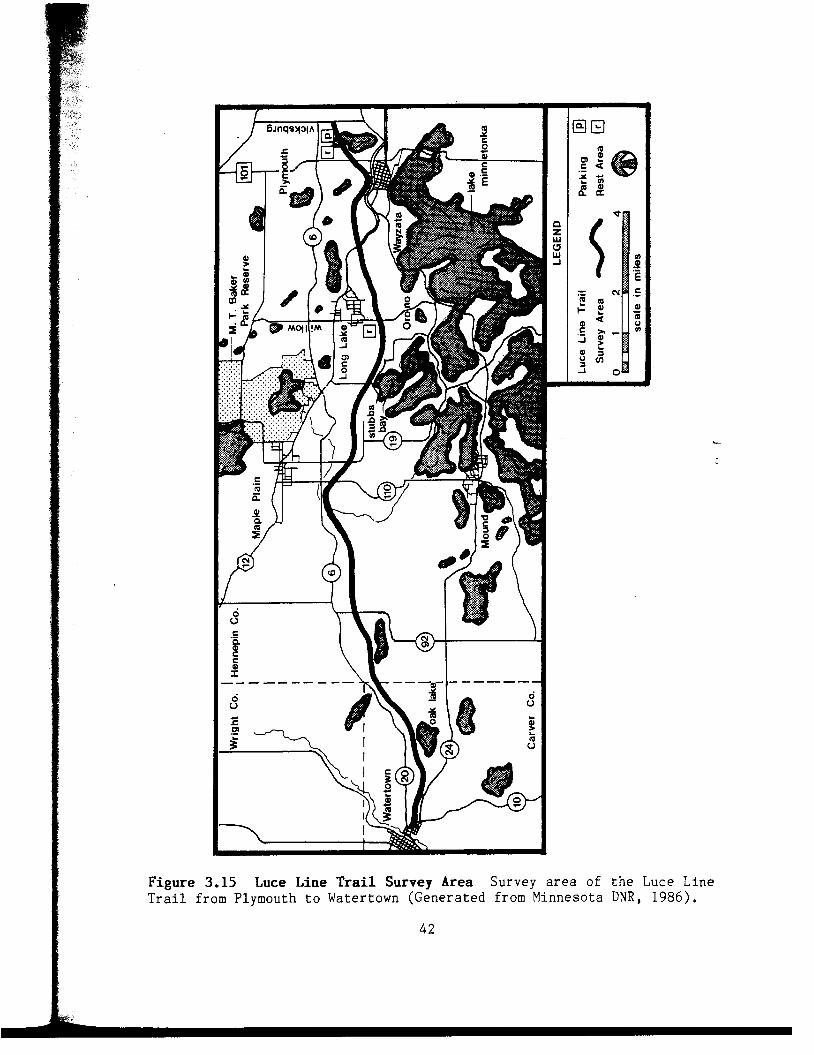
Figure 3.15 Luce Line T r a i l Survey Area Survey area of t h e Luce L i n e T r a i l f rom Plymouth t o Watertown (Genera t ed from Minnesota DNR, 1986).
42

Figure 3.16 a l o n g t h e Luce L i n e T r a i l .
Residential Area Suburban r e s i d e n t i a l area n e a r S t u b b s Bay ,-
Figure 3.17 Estate Lot L a r g e r e s i d e n t i a l house l o c a t e d on a n e s t a t e l o t by t h e Luce L i n e T r a i l a t Orono.
43

Figure 3.18 Farmland Near Trail A g r i c u l t u r a l l a n d a l o n g t h e Luce L i n e - T r a i l i n w e s t e r n Hennepin County.
The p h y s i c a l l a n d f e a t u r e s a re a l s o v a r i e d i n t h e s u r v e y a rea .
P o s i t i o n e d a l o n g t h e Luce L i n e T r a i l are l a k e s , woods, c r e e k s , m a r s h e s ,
and t amarack swamps ( F i g . 3.19 Woods Along T r a i l ; F i g . 3 .20 Oak L a k e ) .
Many of t h e s e water f e a t u r e s a re s c a t t e r e d t h r o u g h o u t t h e r e s i d e n t i a l
areas. The topography f o r t h e most part is f l a t on t h e e a s t e r n s e c t i o n
and becomes s l i g h t l y r o l l i n g i n t h e c e n t r a l and w e s t e r n p o r t i o n s of t h e
s u r v e y a rea f rom Orono t o Watertown.
S e v e r a l b r i d g e s a n d u n d e r p a s s e s t r a v e r s e t h e m a j o r r o a d s ,
r a i l r o a d t r a c k s , and water f e a t u r e s . Most of t h e m i n o r r o a d s a r e
c r o s s e d on-grade, b u t s t o p s i g n s a re p o s t e d on t h e t r a i l f o r t h e s a f e t y
o f t h e u s e r s ( F i g . 3 .21 Road B r i d g e ; F i g . 3.22 T r a i l C r o s s i n g ) .
44

Figure 3.19 Woods Along T r a i l The Luce L i n e T r a i l p a s s i n g t h r o u g h a - wooded a r e a i n w e s t e r n Hennepin County.
. , . . . . .
. . , . ..
Figure 3.20 Oak Lake V i e w of Oak Lake from t h e Luce L i n e T r a i l n e a r Watertown i n Carve r County.
45

Figure 3.21 Road Bridge Carver Co Rd 10 c r o s s i n g t h e Luce Line T r a i l a t Kater town.
-
Figure 3.22 Trail Crossing On-grade t r a i l c r o s s i n g a t Old Long Lake Road nea r Wayzata. T r a i l u s e r s y i e l d t o t h e s t r e e t t r a f f i c a t t h e s e i n t e r s e c t i o n s .
46

The Luce L i n e i s one of t h e most h e a v i l y used t ra i l s i n t h e s t a t e .
As shown i n - F i g . 3.23 Use o f Minneso ta T r a i l s , m o n i t o r i n g of t h i s t r a i l
f rom 1981-84 i n d i c a t e s a p p r o x i m a t e l y 5 4 , 0 0 0 u s e r o c c a s i o n s d u r i n g e a c h
summer. T h i s i s t h e same as t h e combined use on t h e H e a r t l a n d , S a k a t a h
S i n g i n g Hills, and t h e Douglas S t a t e T r a i l s f o r t h i s p e r i o d (Minneso ta
D N R , 1984) . S u r v e y s i n r e c e n t years i n d i c a t e t h e number o f u s e r
o c c a s i o n s d u r i n g t h e summer h a s i n c r e a s e d t o 70,000 p l u s on t h e f i r s t 30
miles (Schmidt , 1988).
Use of Existinq Trails
The DNR has monitored summer use on four state trails through on-site counting and surveys of users. Two trolls, the
Luce Line which runs from suburban Minneapolis to Winsted,
and the Heartland which connects Park Rapids and Walker in
northern Minnesota, have been monitored since the summer of
1980. The other two, the Sakatah Singing Hills which connects
Faribault and Mmkato, and the Douglas just outside of
Rochester, have been monitored since the summer of 1981.
The preliminary findings of the monitoring program show that
during the summer:
- approximately 54,000 user occasions took place on the
Luce Line State Trail;
Heartland State Troil;
Sakatah Singing H i l l s State Troil;
- approximately 37,000 user occasions took place on the
- approximately 5,000 user occasions took place on the
- approximately 13,000 user occasions took ploce an the
Douglas State Troil; approximately 58 percent of all summer use was by bi-
cyclists.
-
Figure 3.23 Use of Winnesota Trails P r e l i m i n a r y f i n d i n g s of a m o n i t o r i n g program o n t h e summer u s e of f o u r s t a t e t r a i l s i n Minneso ta (Minneso ta DNR, 1984) .
47

H i s t o r i c a l P e r s p e c t i v e . The Luce L i n e T r a i l t a k e s i t s name f rom
W . L. L u c e - a n d t h e r a i l w a y l i n e h e s t a r t e d i n 1902. T h i s l i n e , which
r a n f rom Minneapo l i s t o Brook ings , Sou th Dakota , e v e n t u a l l y became known
a s t h e Luce Electr ic S h o r t L i n e Ra i lway , Because of f i n a n c i a l p roblems
i n 1927, t h e l i n e was t e r m i n a t e d i n Gluek , Minneso ta . The Ch icago and
Nor thwes te rn R a i l r o a d e v e n t u a l l y pu rchased and owned t h e r ight-of-way
u n t i l i t s abandonment i n 1971 (Minneso ta D N R , 1986) .
Conver s ion P r o c e s s . I n 1973, t h e Minnesota L e g i s l a t u r e a u t h o r i z e d
t h e Commissioner of N a t u r a l R e s o u r c e s t o e s t a b l i s h , d e v e l o p , m a i n t a i n ,
and o p e r a t e t h e Luce L i n e T r a i l . B e f o r e a c q u i s i t i o n o f any l a n d c o u l d
t a k e p l a c e , t h e c o m m i s s i o n e r was r e q u i r e d t o d e v e l o p a management
program and conduc t p u b l i c h e a r i n g s on t h i s proposed program. I n c l u d e d
-
i n t h i s p l a n were s e c t i o n s on f e n c i n g t o p r o t e c t t h e a d j a c e n t l andowners
and on main tenance f o r a l i t t e r f r e e t r a i l (Minnesota D N R , 1 9 7 3 ) .
P u b l i c h e a r i n g s were conduc ted a t s i x communi t ies a l o n g t h e t r a i l
f rom September 20 t o November 15, 1973. The pu rpose of t h e h e a r i n g s
were t o in fo rm and r e c e i v e f e e d b a c k from t h e p u b l i c on t h e management
program. It was n o t i n t e n d e d as a forum t o d e b a t e t h e i s s u e o f t h e
e x i s t e n c e a n d c r e a t i o n o f t h e t r a i l . C o n c l u s i o n s drawn from t h e
r e c o r d i n g s o f t h e f i r s t two h e a r i n g s h e l d i n Orono and Water town a p p l y
t o t h i s s t u d y (Minneso ta D N R , 1973) .
1. About 50% of t h e 31 s p e a k e r s a t t h e Orono Hear ing s t a t e d t h e i r o p p o s i t i o n t o e i t h e r snowmobiles o r m o t o r c y c l e s on t h e t r a i l . Many were v o c a l i n s t a t i n g c u r r e n t problems o f t r e s p a s s i n g and n o i s e a s s o c i a t e d w i t h motor v e h i c l e s i n t h e abandoned r i g h t - o f - way. Some q u e s t i o n e d t h e D N R ' s a b i l i t y t o p o l i c e t h e t r a i l when l o c a l law en fo rcemen t a g e n c i e s d i d n o t c o n t r o l t h e p r o b l e m . P a r t i c i p a n t s were conce rned w i t h t h e u s e s and t h e a b u s e s o f t h e p r o p o s e d t r a i l . Some i n d i v i d u a l s e x p r e s s e d o p p o s i t i o n t o snowmobiles a t t h e Watertown H e a r i n g , b u t i t was n o t as v o c a l .
4 8

2 .
3 .
4 .
5.
A t
C o n c l u s i o n s may be drawn t h a t o p p o s i t i o n t o motor v e h i c l e s may r e f l ec t some o p p o s i t i o n t o t h e t r a i l i t s e l f , a l t h o u g h n o o n e s t a t e d t h a t fac t .
Four o u t of 58 s p e a k e r s a t t h e two h e a r i n g s s t a t e d t h e i r a p p r o v a l o f t h e proposed t r a i l . Based on t h e t y p e s of q u e s t i o n s a sked d u r i n g t h e h e a r i n g s , o t h e r i n d i v i d u a l s s u p p o r t e d t h e t r a i l , e s p e c i a l l y a t t h e Orono Hear ing .
Approximately 20% o f t h e s p e a k e r s a t t h e two h e a r i n g s s t a t e d t h e i r s u p p o r t o f snowmobiles on t h e proposed t r a i l . It i s assumed t h e y s u p p o r t e d t h e c r e a t i o n o f t h e t r a i l .
O p p o s i t i o n t o t h e t r a i l was more e v i d e n t a t t h e Watertown Hear ing . S e v e r a l q u e s t i o n s c h a l l e n g e d t h e c r e a t i o n of t h e t r a i l . One a sked i f s e v e r e o p p o s i t i o n were e n c o u n t e r e d a t a l l t h e m e e t i n g s , would t h e t r a i l be deve loped? Another f e l t t h a t r u r a l C a r v e r County was s u p p o r t i n g t h e r e c r e a t i o n f o r u r b a n Hennepin County. O t h e r s q u e s t i o n e d t h e expense o f t h e t r a i l , g a p s i n t h e r i g h t - o f - w a y t h r o u g h s e v e r a l c o m m u n i t i e s , a d v e r s e p o s s e s s i o n by some l andowners , and t h e i n t e n t i o n s o f t h e s t a t e t o condemn a d d i t i o n a l l a n d a l o n g t h e r ight-of-way. And f i n a l l y , one p e r s o n a s k i n g a b o u t t h e i n c r e a s e i n t a x e s due t o t h e "amenity" o f l i v i n g n e x t t o the' t r a i l s t a t e d , "...we bought i t ( l a n d n e x t t o a l a k e ) f o r p r i v a c y and pa id d e a r l y f o r i t and now w e ' l l pay d e a r l y f o r t h a t p r i v a c y t o be invaded . . .It
Based on t h e t y p e s of q u e s t i o n s a sked a t b o t h h e a r i n g s , s e v e r a l i n d i v i d u a l s were uncommitted and s i m p l y wanted t o know how t h e i r p r o p e r t y was g o i n g t o be a f f e c t e d .
Most o f t h e o p p o s i t i o n t o t h e t r a i l o c c u r r e d west o f Water town.
t h e t h i r d h e a r i n g i n S i l v e r Lake , a t r a i l a d v o c a t e s t a t e d t h a t 90% of
t he p e o p l e a t t e n d i n g t h e h e a r i n g were opposed t o t h e t r a i l , T h i s
o p p o s i t i o n was based i n t h e b e l i e f t h a t b i g government was i n f r i n g i n g on
t h e r i g h t s o f a d j a c e n t landowners and t h a t most of t h e r igh t -of -way
c o u l d be c o n v e r t e d t o p r o d u c t i v e f a rmland (Schmid t , 1988) (Minneso ta
D N R , 1973) (Kern , 1977) .
A m a j o r i t y of t h e r ight-of-way f rom Plymouth t o Clara C i t y was
purchased i n 1974-75 and was d e s i g n a t e d as a t r a i l i n 1976. S e c t i o n s o f
t h e t r a i l t h r o u g h some of t h e communi t ies , have been pu rchased i n l a t e r
49

y e a r s . A t t h e p r e s e n t time, t h e r ight-of-way west of Cosmos is i n doub t
and may be- s o l d b a c k t o t h e a d j a c e n t l a n d o w n e r s ( C o l l i n s , 1 9 8 8 )
(Minneso ta DNR, 1986) .
O p p o s i t i o n t o moto r i zed v e h i c l e s and o t h e r c o n c e r n s e x p r e s s e d a t
t h e Orono H e a r i n g s i n 1973 was a r e s u l t o f u n r e g u l a t e d u s e a l o n g t h e
abandoned r ight-of-way p r i o r t o DNR c o n t r o l . But i n 1982, a f t e r s i x
years of u s e a l o n g t h e comple ted 30 mile s t r e t c h , many r e s i d e n t s were
s a t i s f i e d w i t h t h e o u t c o m e . R i c h a r d S t e r n e r o f Winsted who was
o r i g i n a l l y opposed t o t h e t r a i l s ta tes . . . "The p e o p l e I t a l k t o who l i v e
a l o n g t h e t r a i l a re q u i t e p l e a s e d . I had mixed emot ions p r i o r t o t h i s
time, b u t I ' v e changed my mind comple te ly . ' ' Wayzata Mayor B i l l Humphrey
s a i d , " A few p e o p l e spoke up ( p r i o r t o t r a i l development ) and s a i d they-
d i d n ' t want peop le r u n n i n g a d j a c e n t t o t h e i r b a c k y a r d s , But I h a v e n ' t
h e a r d much t h e l a s t few y e a r s . I t h i n k most p e o p l e e n j o y it." Kermit
E i s i n g e r s a i d t h a t b e f o r e t h e t r a i l was d e v e l o p e d , t h e r e were problems
w i t h n o i s e and l i t t e r , "But once i t was fu1l.y deve loped ... I t h i n k i t ' s
been p r e t t y wel l used as i t was i n t e n d e d t o b e , " h e s t a t e d (Appendix H:
Newspaper Articles) ( B r a c k i n , 1982:22) .
Many landowners west o f Wins ted are s t i l l opposed t o t h e t r a i l .
R e c r e a t i o n s u p p o r t e r s b e l i e v e t h a t t h e i r a t t i t u d e s would change i f t h e
t r a i l was comple ted w i t h a l i m e s t o n e s u r f a c e . O the r t r a i l p r o p o n e n t s
s t a t e t h a t f a rmer a t t i t u d e s w i l l be d i f f i c u l t t o change as l o n g as t h e y
t h i n k t h e t r a i l h u r t s them f i n a n c i a l l y ( B r a c k i n , 1982) .
DEVELOPHENT OF QUESTIONNAIRE / INTERVIEW FORMS
The d a t a f o r t h i s s t u d y was c o l l e c t e d by u s i n g t h e t e l e p h o n e
s u r v e y method. T h e r e a re s e v e r a l r e a s o n s f o r employing t h i s t e c h n i q u e .
50
F i r s t , a c c o r d i n g t o Di l lman (1978) , t h e t e l e p h o n e s u r v e y approach was an
a c c e p t a b l e -method f o r g a t h e r i n g r e s e a r c h i n f o r m a t i o n . S e c o n d , t h e
Minneso ta Department o f N a t u r a l R e s o u r c e s i n S t . P a u l o f f e r e d t h e u s e of
o f f i c e space and a t e l e p h o n e WATS l i n e . T h i r d , t h e s p e e d o f d a t a
c o l l e c t i o n w i t h a t e l e p h o n e s u r v e y was d e s i r a b l e . And f i n a l l y , due t o a
l i m i t e d t e s t i n g p o p u l a t i o n on one o f t h e t r a i l s , a h i g h r e s p o n s e ra te
was needed f o r t h e s t u d y . The t e l e p h o n e s u r v e y o f f e r e d t h e b e s t o p t i o n
f o r c o n t a c t i n g more p a r t i c i p a n t s .
The landowner q u e s t i o n n a i r e and t h e i n t e r v i e w fo rms a re based on
f o u r s o u r c e s of i n f o r m a t i o n . F i r s t , t h e landowner q u e s t i o n n a i r e and t h e
t r a n s c r i p t of t h e t e l e p h o n e s u r v e y s w i t h l a w en fo rcemen t a g e n t s f rom t h e
Milwaukee Road C o r r i d o r S tudy (Minneso ta D N R , 1979-1980). Second, t he -
t r a i l n e i g h b o r and t r a i l u s e r q u e s t i o n n a i r e s from t h e s t u d y a t t h e E a s t
Bay Reg iona l P a r k Dis t r ic t , Oakland , C a l i f o r n i a (EBRPD, 1978) . T h i r d ,
t h e q u e s t i o n n a i r e o f r e s i d e n t s and r e a l e s t a t e a g e n t s f rom t h e s t u d y on
t h e Burke-Gilman T r a i l ( S e a t t l e E n g i n e e r i n g Depar tmen t , 1 9 8 6 ) . And
f i n a l l y , t h e examples of c o v e r l e t t e r s and q u e s t i o n n a i r e s i n Mail and
Telephone Surveys : The T o t a l Des ign Method (1978) by Di l lman.
A f t e r development of t h e landowner q u e s t i o n n a i r e , t he i n s t r u m e n t
was p r e t e s t e d i n a n i n t e r v i e w f o r m a t f i r s t on Dennis Law, P r o f e s s o r of
Landscape A r c h i t e c t u r e a t Kansas S t a t e U n i v e r s i t y . P r o f e s s o r Law was
s e l e c t e d because of h i s owner sh ip of p r o p e r t y a d j a c e n t t o a proposed
t r a i l i n Manha t t an , Kansas , The q u e s t i o n n a i r e was r e v i s e d a n d was
s u b m i t t e d a l o n g w i t h a n advance l e t t e r t o t h e C o l l e g e of A r c h i t e c t u r e
a n d D e s i g n ' s Human S u b j e c t C o m m i t t e e f o r a p p r o v a l . After some
r e v i s i o n s , a p p r o v a l was g r a n t e d and t h e q u e s t i o n n a i r e was p r e t e s t e d by
51

phone on f i v e landowners a d j a c e n t t o the Douglas and H e a r t l a n d T r a i l s i n
Minnesota . -Names of t h e l andowners were o b t a i n e d from t h e Minnesota DNR
i n c o n n e c t i o n w i t h a p r e v i o u s s t u d y . Af t e r m i n o r r e v i s i o n s t h e
q u e s t i o n n a i r e was r e a d y f o r d a t a c o l l e c t i o n (Appendix B: Landowner
Q u e s t i o n n a i r e - Telephone Survey ; Appendix D: Human S u b j e c t s Committee
Approva l ) .
The i n t e r v i e w fo rms f o r t h e p r o f e s s i o n a l s were a l s o d e v e l o p e d , b u t
were n o t p r e t e s t e d o r s u b m i t t e d t o t h e Human S u b j e c t s Committee. The
i n f o r m a t i o n g a t h e r e d f rom t h e s e p r o f e s s i o n a l s on t h e i s s u e s o f t r a i l
d e s i r a b i l i t y , crime, and a d j a c e n t p r o p e r t y v a l u a t i o n , a r e c o n s i d e r e d
p u b l i c knowledge and w i t h i n t h e s c o p e of t h e i r d u t i e s (Appendix G :
I n t e r v i e w Forms) . - -
DATA OOJLECTION
C h a r l i e R e g n i e r , R e s e a r c h A n a l y s t w i t h t h e Minneso ta DNR, compl ied
a l i s t o f landowners a l o n g t h e two t r a i l s . Owner names f rom t h e Root
R i v e r were g a t h e r e d from t h e F i l l m o r e County Atlas and P l a t Book 1983-85
and from Deborah E r i c k s o n , A s s i s t a n t C l e r k f o r Lanesboro . Names from
t h e Luce L i n e T r a i l were compi led f rom t h e 1984 Carve r County Alas P l a t
Book and from t h e t a x r o l l s a t t h e Hennepin County Government C e n t e r .
F o r Hennepin County , h a l f s e c t i o n maps were used t o o b t a i n s e c t i o n ,
t ownsh ip , r a n g e , q u a r t e r - q u a r t e r , and p r o p e r t y i d e n t i f i c a t i o n numbers
f o r t h e a d j a c e n t p r o p e r t y . These numbers were e n t e r e d i n t o a computer
t e r m i n a l and t h e names and a d d r e s s e s were r e c o r d e d (Appendix E: Owner
I d e n t i f i c a t i o n P r o c e s s ) . A d d i t i o n a l names and phone numbers were
compi led from t h e Milwaukee C o r r i d o r S t u d y and f rom f o u r phone books:
t h e Ace, R o c h e s t e r , C o n t e l and M i n n e a p o l i s D i r e c t o r i e s .
52

T h i s p r o c e s s i d e n t i f i e d 31 p r i v a t e landowners a l o n g t h e Root R i v e r
and 227 names from t h e Luce L ine . P u b l i c l a n d owned by t h e s t a t e ,
c o u n t y , o r c i t y were e l i m i n a t e d w i t h t h e e x c e p t i o n of s c h o o l d i s t r i c t s .
Landowners , r e n t e r s , and managers o f p r i v a t e l a n d , c h u r c h p r o p e r t y ,
s c h o o l d i s t r i c t s , p r i v a t e c o u n t r y c l u b s , or p r o p e r t y h e l d by companies ,
p a r t n e r s h i p s , o r homeowner a s s o c i a t i o n s were i n c l u d e d i n t h e l i s t . Only
one p e r s o n f o r e a c h p r o p e r t y was t o b e su rveyed . P a r t i c i p a n t s owning
more t h a n one p i e c e of p r o p e r t y were i n t e r v i e w o n l y once .
Due t o t h e number o f n a m e s , t h e e n t i r e Root R i v e r l i s t was
i n c l u d e d i n t h e s u r v e y , b u t i t was d e c i d e d t o u s e o n l y 27.5% o f t h e
owners a l o n g t h e Luce L i n e . Names were s e l e c t e d randomly u s i n g t h e
compute r , Each name on t h e l ist was d e s i g n a t e d a number f rom 1 t o 227.-
The s o r t f u n c t i o n on L o t u s 1-2-3 randomly s o r t e d t h i s l i s t of numbers ,
The f i r s t 62 number/names (27 .5%) were s e l e c t e d f o r t h e s u r v e y .
The advance l e t t e r was s e n t t o 84 of t h e t o t a l 93 names (Appendix
A : Advance L e t t e r ) . Nine a d d r e s s e s were n o t i d e n t i f i e d f r o m t h e
a v a i l a b l e s o u r c e s . I t was a n t i c i p a t e d t h a t t h e s e a d d r e s s e s and phone
numbers would be o b t a i n e d d u r i n g t h e s u r v e y from n e i g h b o r i n g l andowners .
The pu rpose o f t h e advance l e t t e r was t o i n f o r m t h e s u b j e c t s o f t h e
s u r v e y and i t s g o a l s and t o i n c r e a s e p a r t i c i p a t i o n i n t h e s t u d y .
The b u l k o f t h e s u r v e y was conduc ted by phone i n t h e o f f i c e s o f
t h e Minnesota DNR, S t . P a u l d u r i n g t h e week o f A p r i l 11-16, 1988. Some
o f t h e c a l l s were made t h e f o l l o w i n g week from Manha t t an , Kansas , Most
o f t h e phone c a l l s were p l a c e d from 9:OO am t o 9:OO pm. P a r t i c i p a n t s
n o t a b l e t o t a l k d u r i n g t h e i n i t i a l c o n t a c t were c a l l e d a t a l a t e r
p r e a r r a n g e d time, Nine l andowners who were n o t r e a c h e d by phone were
53
s e n t a c o v e r l e t t e r and a q u e s t i o n n a i r e which was approved t h r o u g h t h e
Human S u b j e c t s Committee. The p a r t i c i p a n t s were r e q u e s t e d t o r e t u r n t h e
q u e s t i o n n a i r e w i t h i n two weeks. The s u r v e y of l andowners was comple ted
o n May 10, 1988 (Appendix C: Cover L e t t e r & Landowner Q u e s t i o n n a i r e -
Mail Survey ; Appendix D: Human S u b j e c t s Committee Approval ) .
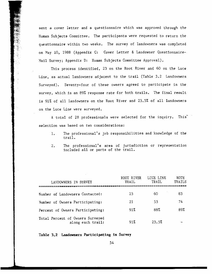
T h i s p r o c e s s i d e n t i f i e d , 2 3 o n t h e Root R i v e r and 60 on t h e Luce
L i n e , as a c t u a l landowners a d j a c e n t t o t h e t r a i l ( T a b l e 3.2 Landowners
Surveyed) . Seventy- four o f t h e s e owners a g r e e d t o p a r t i c i p a t e i n t h e
s u r v e y , which i s a n 89% r e s p o n s e ra te f o r b o t h t ra i l s . The f i n a l r e s u l t
i s 91% o f a l l landowners on t h e Root R i v e r and 23.5% o f a l l l andowners
o n t h e Luce L i n e were su rveyed .
A t o t a l of 28 p r o f e s s i o n a l s were s e l e c t e d f o r t h e i n q u i r y . This -
s e l e c t i o n was based on two c o n s i d e r a t i o n s :
1. The p r o f e s s i o n a l ' s j o b r e s p o n s i b i l i t i e s and knowledge o f t h e t r a i l .
2. The p r o f e s s i o n a l ' s area of j u r i s d i c t i o n or r e p r e s e n t a t i o n i n c l u d e d a l l o r p a r t s of t h e t r a i l .
Number of Landowners C o n t a c t e d : 2 3 60 8 3
Number of Owners P a r t i c i p a t i n g : 21 53 74
P e r c e n t of Owners P a r t i c i p a t i n g : 91% 88% 89%
T o t a l P e r c e n t of Owners Surveyed a l o n g e a c h t r a i l : 91% 23.5% -
Table 3.2 Landowners Participating i n Survey
5 4

The DNR s t a f f a s s i s t e d i n i d e n t i f y i n g t h e s e v e n t r a i l mangers and
c o n s e r v a t i o n o f f i c e r s a s s i g n e d t o t h e Root River and Luce L i n e Trai ls .
The e i g h t law enfo rcemen t j u r i s d i c t i o n s and t h e names of t h e p o l i c e
r e p r e s e n t a t i v e s were g a t h e r e d from phone books , t h e DNR s t a f f , and o t h e r
p o l i c e p e r s o n n e l , L a w e n f o r c e m e n t a g e n t s who p a r t i c i p a t e d i n t h e
i n q u i r y i n c l u d e d a s h e r i f f , a c a p t a i n , p o l i c e c h i e f s , and o f f i c e r s . The
s t a f f a t t h e coun ty c o u r t h o u s e s h e l p e d t o i d e n t i f y t h e t h r e e c o u n t y
commiss ione r s t h a t r e p r e s e n t e d t h e d i s t r i c t s a f f e c t e d by t h e t ra i l s .
The names o f f i v e a p p r a i s e r s from coun ty o r c i t y d e p a r t m e n t s were
o b t a i n e d t h r o u g h t h e l o c a l a d m i n i s t r a t i v e o f f i c e s . F i v e rea l e s t a t e
a g e n t s were selected from phone books based on t h e i r p r o x i m i t y t o t h e
t r a i l and i n f o r m a t i o n g a t h e r e d from o t h e r p r o f e s s i o n a l s . -
The i n q u i r y was conduc ted i n A p r i l and Oc tobe r of 1988. The two !I
t r a i l managers were i n t e r v i e w e d i n p e r s o n a t t h e Minneso ta DNR o f f i c e s
i n R o c h e s t e r and S t . P a u l . The o t h e r 26 p r o f e s s i o n a l s were c o n t a c t e d by
J
phone from S t . P a u l and from Manha t t an , Kansas .
ANALYSIS OF THE DATA
A f t e r t h e owner su rvey p r o c e s s was comple t ed , t h e i n f o r m a t i o n from I1
t h e q u e s t i o n n a i r e was t r a n s f e r r e d t o c o d i n g s h e e t s . The s u r v e y r e q u i r e d
114 c o l u m n s o f d a t a or two - 80 column wide c o d i n g s h e e t s . Each
p a r t i c i p a n t was a s s i g n e d a number t o p r o t e c t t h e i r anonymity and f o r
ease of t a b u l a t i o n . I n a d d i t i o n , e v e r y answer was a l s o r e p r e s e n t e d by a
numer i c d e s i g n a t i o n which was one t o f o u r columns w i d e . One l i n e of
d a t a r e p r e s e n t e d a l l t h e i n f o r m a t i o n from one q u e s t i o n n a i r e .
The raw d a t a f rom t h e c o d i n g s h e e t s was e n t e r e d t h r o u g h a computer
t e r m i n a l i n t o a f i l e i n t h e Harris System. John Boyer , P r o f e s s o r of
5 5
i

S t a t i s t i c s a t Kansas S t a t e U n i v e r s i t y , programmed t h e d a t a i n t o t h e
U n i v e r s i t y -based SAS program. The o u t p u t was r e c o r d e d i n c h a r t form
i n d i c a t i n g t h e numbers and p e r c e n t a g e s of v a r i o u s p o p u l a t i o n ' s r e s p o n s e s
t o e a c h q u e s t i o n . The r e s u l t s of t h e s t u d y were r e a d y f o r a n a l y s i s .
LIWITATIONS OF THE STUDY
T h i s s t u d y r e p r e s e n t s t h e a t t i t u d e s o f l andowners on a s e c t i o n o f
two t r a i l s i n M i n n e s o t a . T h i s d o e s n o t n e c e s s a r i l y r e f l e c t t h e
a t t i t u d e s of a l l landowners a d j a c e n t t o t r a i l s i n Minneso ta o r i n t h e
res t o f t h e c o u n t r y . Each t r a i l h a s a n i n d i v i d u a l c h a r a c t e r and c h a n g e s
i n l a n d o w n e r a t t i t u d e s are somet imes d i f f i c u l t t o a n t i c i p a t e . But
g e n e r a l c o n c l u s i o n s may be drawn f rom t h e s e r e s u l t s . - Although t h e Root R i v e r T r a i l r ight-of-way h a s been owned by t h e
s t a t e f o r e i g h t years, o n l y 11 o u t o f t h e t o t a l 35 miles have been
paved. T h i s s t u d y is l i m i t e d t o t h e paved s e c t i o n o f t h e t r a i l , and
t h a t d i s t a n c e h a s been s u r f a c e d o n l y i n t h e l a s t two years. Use o f t h e
t r a i l h a s n o t r eached i t s peak , and t h e f u l l impac t may n o t be f e l t .
A d d i t i o n a l time may be needed f o r owners t o e x p e r i e n c e a l l t h e b e n e f i t s
and d i s a d v a n t a g e s . P r e v i o u s r e s e a r c h compi l ed on t h e Root R i v e r e i g h t
y e a r s ago , su rveyed t h e e n t i r e 60 miles o f abandoned t r a c k , as compared
w i t h t h i s s t u d i e s s h o r t e r d i s t a n c e . Compar isons between t h e two s t u d y ' s
may be d i f f i c u l t .
Only t h e f i r s t 19 miles were su rveyed on t h e Luce L i n e T r a i l ,
T h i s s t u d y may n o t r e p r e s e n t landowner a t t i t u d e s on t h e w e s t e r n p o r t i o n
o f t h e t r a i l , where p a s t o p p o s i t i o n was g r e a t e r .
P a r t i c i p a n t s were a s k e d t o recal l t h e i r a t t i t u d e s b e f o r e t h e
c o n s t r u c t i o n o f t h e t r a i l , 8 t o 14 y e a r s ago . F o r t h i s s t u d y , i t is
56

assumed t h a t t h e r e s p o n d e n t s are t r u t h f u l and c a n a c c u r a t e l y remember
t h e i r p a s t o p i n i o n s . S e v e r a l p o i n t s h e l p t o s t r e n g t h e n t h i s a s sumpt ion :
1. Only l andowners who owned p r o p e r t y a d j a c e n t t o t h e t r a i l b e f o r e c o n v e r s i o n , are asked a b o u t t h e i r p a s t c o n c e r n s .
2. These owners were d i r e c t l y a f f e c t e d by t h e proposed t r a i l and most had s t r o n g f e e l i n g s . Recall was easier .
3 . P a s t c o n c e r n s o f owners are conf i rmed i n h e a r i n g t e s t i m o n y , newspaper a r t i c l e s , and i n i n t e r v i e w s w i t h p r o f e s s i o n a l s ,
4 . T h i s su rvey documents landowner a t t i t u d e s and b e l i e f s and n o t t h e p r e c i s e f a c t u a l a c c o u n t .
I n a d d i t i o n , t h i s s t u d y a l s o assumes t h e p a r t i c i p a n t u n d e r s t o o d
t h e q u e s t i o n s and answered c o r r e c t l y . E f f o r t s were made t o minimize
t h i s p r o b l e m . The q u e s t i o n n a i r e was p r e t e s t e d f o r c l a r i t y a n d
o r g a n i z a t i o n . Most owners r e c e i v e d a n advance l e t t e r e x p l a i n i n g the’
s t u d y . T h e t e l e p h o n e s u r v e y a p p r o a c h a l l o w e d p a r t i c i p a n t s a n
o p p o r t u n i t y t o a s k q u e s t i o n s and a v o i d c o n f u s i o n . And t h e p a r t i c i p a n t s
a l s o had t h e o p t i o n o f r e f u s i n g t o answer any o r a l l q u e s t i o n s .
With t h e phone s u r v e y method, i t i s p o s s i b l e t h a t p e r s o n a l c o n t a c t
w i t h t h e i n t e r v i e w e r may i n f l u e n c e some r e s p o n d e n t s . Again , measu res
were t a k e n t o minimize t h e problem. A s t a n d a r d s c r i p t was f o l l o w e d
t h r o u g h o u t t h e su rvey and t h e i n t e r v i e w s were conduc ted i n a c o n s i s t e n t ,
n e u t r a l manner. No a t t e m p t was made t o sway any p a r t i c i p a n t s o p i n i o n .
I n a d d i t i o n , t h e p r e t e s t i n g o f t h e q u e s t i o n n a i r e a l s o h e l p e d t o
e l i m i n a t e l e a d i n g q u e s t i o n s .
The l andowners , who were n o t c o n t a c t e d by phone, r e c e i v e d a c o v e r
l e t t e r and q u e s t i o n n a i r e t h r o u g h t h e mail. Although t h e s u r v e y was t h e
same, t h e s e p a r t i c i p a n t s may r e spond d i f f e r e n t l y . But t h i s number o n l y
r e p r e s e n t s 5% of t h e t o t a l r e s p o n d e n t s .
57

The time o f year t h e s u r v e y i s conduc ted , may i n f l u e n c e some
r e s p o n d e n t s ; T h i s s u r v e y was t a k e n i n mid-Apr i l , which i s b e f o r e heavy
summer u s e , b u t a f t e r w i n t e r u s e r c o n f l i c t s . Responden t s may r e c a l l
w i n t e r problems o r b e n e f i t s o v e r summer time use .
And f i n a l l y , t h i s s t u d y r e f l ec t s t h e c u r r e n t a t t i t u d e s and b e l i e f s
of landowners . These o p i n i o n s may change o v e r time, e s p e c i a l l y i f t h e i r
c o n c e r n s a re n o t r e a l i z e d , o r i f new o r e x i s t i n g problems i n c r e a s e .
58