Embed Size (px)
Citation preview

CHAPTER-IV PATTERN OF RURAL-URBAN INTERACTION

CHAPTER IV
PATTERN OF RURAL-URBAN INTERACTION
4.1 Introduction
Process of urbanisation m the region involves the interaction of the internal and
external forces that bring out the changes from a traditional agrarian society to more
modem and urbanised form. This is a continuous process that is not only changing the
physical landscape, but also the economic and social environment of the neighbouring
areas surrounding the city.
The interaction comes into existence when rural and urban areas mutually act and
react, adapt and adjust in terms of a systematic relationship. Socio-economic
disparities play an important role in shaping the pattern of rural-urban interaction.The
type of interaction occurring between the rural and urban areas and their relative
magnitudes are predicated upon the degree of socio-economic disparity existing
between the two ostensibly contrasting regions i.e. "greater the spatial disparities. the
larger the flows and interactions".
The functions of the urban settlements constitute the main unifying bonds between the
people of the town and zone of influence. They are conspicuous by virtue of their
services. which they perform for rural inhabitants. By virtue of their distinct location
and layout, the urban centres form a socio-economic hub for the surrounding region,
disseminating cultural influence and acting. as collecting and distributing centres of
regional produce.
The close relationship between rural and urban areas has been evinced in the daily
quick delivery of perishable goods like milk and vegetable to the town dwellers.
however such close ties depend upon the facilities of transport. The commuter
relations between the urban places as centres of employment and the rural areas as the
residences of the employees are another link between urban centres and their
hinterland. Urban centres as regional administrative head quarter constitute another
reason for the link between the town and the country.
The intensity of rural-urban interaction has been increasing with decreasing size of
land holdings in rural areas and declining share of absorption of labour force in
149

agric~ltural activities for other alternative jobs leading to greater interaction. On the
other hand, employment opportunities in the cities attract rural folk for greater scope
of employment, income and other facilities of urban areas.
The city stimulates rural economy through the provision of services, facilities and
markets for agricultural products, as well as absorbs surplus labour as agriculture
production become more labour efficient.
It is therefore apparent that town and villages are interdependent and cannot be
studied in isolation. Moreover, it is true that each of them have an independent
location and functional structure. These two should be studied together as part of the
same continuum. Cities act as catalysts in introducing new innovations in rural areas
although the process of change is slow but nonetheless inevitable. Many rural
settlements at the fringe of urban centres are urban or rural just because the municipal
limits do or don't include them. The impact of the city on these settlements needs to
be studied deeply. In the process of urbanisation, interaction and relations among the
rural and urban areas are noticeable in the region. The variety and amount of nodal
services are increasing and becoming more complex. The processing and
manufacturing (secondary) activities are being added to rural areas. The impulses.
which these changes generate, are not restricted to towns only, but also carried into
the countryside as well.
The urban centres affect both the character and structure (of the households) in rural
settlements especially their occupational structure. social structure (education. sex
ratio), consumer behaviour patterns, shopping pattern, changing attitude towards rural
way of life etc.
It is important to mention that the type and intensity of interaction between urban and
surrounding rural areas is governed by a variety of factors. The physiography. and the
productivity of the region, socio-economic s~ of the population nature and
functional character of the city are some of the main factors. All these factors play an
important role in governing the pattern of rural-urban interaction. However, it is
observed that the internal dynamics and the interaction patterns governing the small
towns and cities in the hierarchy are different than those operating in the metropolis or
mega polis. For instance, the migration pattern to an intermediate town is different
150

from that of the metropolis; similarly the economic (trade and commerce) and socio
cultural bonds are structured differently.
People in the adjacent rural areas avail employment opportunities in the city and are
engaged in different kinds of non-agricultural activities. Moreover, people from the
surrounding rural areas migrate to the city and suburbs for better scope of
employment, income and attraction of urban facilities and urban way of life.
Studying rural-urban linkages is very important as it provides the basis for measures
that can improve both rural and urban environments. If well managed the interaction
between towns and countryside are the basis for a balanced regional development,
which is economically, socially and environmentally sustainable.
It is felt that, the interaction pattern of the settlements in terms of commutation of the
inhabitants to the city and other neighbouring areas for various goods and services
need to be studied in detail to analyse the relationship that exist among the settlements
in general and with the Haridwar City in particular. The study of interaction of the
settlements with the city gives clear understanding of the role ofthe city in the overall
development of the region and presence of gaps. It helps to identify the nodes for
further planning and development of the region. Thus, it would be interesting to study.
examine and analyse the cumulative effects of the city-region relationship and
interactions.
4.2 Objectives
Against this backdrop, an attempt is made in the present chapter to examine the
pattern of linkages of surrounding settlements among themselves and with the ·city.
The main objectives ofthepresent chapter are:
•!• To observe and understand the pattern of rural-urban interaction based on
Zipf's Gravity model.
•!• To observe and understand the pattern of interaction and interdependence of
rural settlements among themselves and the degree of interaction of these
settlements with the city.
•:• To calculate an overall interaction index measuring the intensity of interaction
of rural settlements with the city.
151
Although there are several aspects of the rural-urban interaction, however. the present
study is confined to some specific aspects of immediate relevance and significance i.e.
demographic, social and economic characteristics and changes in quality of life. An
attempt has been made to identifY the differences in the nature of rural-urban linkages
in different villages through the pattern of flow of goods and services in terms of
lower order goods and services like grocery, green grocery, fuel, services 'Of barber,
tailor and cobbler etc and higher order goods like jewellery, leather goods etc. and
services like health, education etc.
The chapter is divided in five sections. The first section is introductory in nature; in
the second section, the pattern of interaction is measured Qn the basis of theoretical
models based on secondary observations. In the third section, an attempt is made to
examine the pattern of interaction .of villages with the city based on the field
observations. This section is further divided into sub-sections and deals with the
dependence of city on villages for various types of goods and services. This section
gives detailed pattern of interaction and is further divided into general, economic,
social, service delivery and organisational linkages.
In the forth section, intensity of interaction of villages with the city has also been
worked out by calculating the interaction index of all the sample villages based on the
level of facilities and type of interaction.
Fifth and final section of the chapter examines the general dependency of city on the
surrounding rural areas for various types of goods and services.
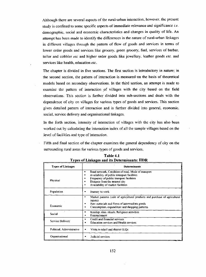
Table 4.1 T lypes o fL' ka 10 tees an d. D ItS etermmants: HDR
Types of Linkages Determinants . Road network. Condition of road. Mode of transport . Availability of public transport facilities . Frequency of public transport facilities Physical . Distance from the nearest city . Availability of market facilities
Population . Journey to work
. Market patterns (sale of agricultural products and purchase of agricultural inputs) · . Raw materials and flows of intermediate goods
Economic . Consumption. expenditure and shopping patterns . Kinship. rjtes. rituals. Religious activities Social . Entertainment . Credit and financial services Service Deliver~y . Education services and Health services
Political. Admi'!istrative . Visits to tehsil and district H.Qs
Organisational . Judicial services
152

4.3 Pattern of Rural-Urban Interaction (Based on Secondary Observations)
4.3.1 Gravity Model: A Concept
For decades. social scientists have been using a modified version of Newton's Law of
Gravitation to predict movement of people. information. and commodities between
cities and e\'en continents. The gravity model, as social scientists refer to the modified
law of gravitation, takes into account the population size of two places and their
distance. Since larger places attract people, ideas, and commodities more than smaller
places and places closer together have a greater attraction. the gravity model
incorporates these two features (population and distance).
Gravity Model is a mathematical model based on an analogy with Newton's
gravitational law which has been used to account for aggregate human behaviours
related to spatial interaction, mainly migration, traffic flows and shopping activities.
Newton's law states that the attractive force between two bodies is directly related to
their size and inversely related to the distance between them.
Thus, the interaction between settlements is measured using 'Gravity Model· concept.
(Zipf, G .K 1, 1949 and Llyod and Dikens2• 1972). It states that the magnitude of
movement between any two settlements will be directly proportional to the product of
their 'mass' and inversely proportional to the distance between them.
lu = K p
k&b
Population of I & 1 .
Constants
George Zipfs P; P/D;j hypothesis is probably the most widely accepted form of the
gravity model. Migration between two cities i and j is proportional to the product of
the two cities' populations and inversely proportional to the intervening distance.
The relative strength of a bond between two places is determined by multiplying the
population of city 'r by the population of city 'r and then dividing the product by the
distance between the two cities squared.
Population 1 x Population 2
The Gravity Model Distance 2
153

Many scholars have attempted to develop theoretical models of city region on the
basis of spatial interactions of population of urban centers and their retail trade and
other economic activities. An example of such studies is one by Illeris3 who used a
gravity model to measure the interaction between the centers and their surrounding
areas. In a similar way Park:l used Reilly' s5 Law of Gravitation in I 929-30 to define
service areas of cities taking newspaper circulation as the criterion. Another type of
effort in this line has been made to find the optimum location of hinterland
boundaries. Such an approach has been used by Y eates6 who uses a linear
programming function for deriving the boundaries of school district in U.S.A.
although this type of study does have limitations in defining boundaries properly. It
has significance in the fact that it helps to formulate a generalised picture of
hinterland and city-region boundary.
However, in the present study a pre-delineated Haridwar Development Region has
been taken and an attempt is made to work out the existing pattern of interaction.
4.3.1 (i) Data Source
The population data used for deriving the interaction pattern has been taken from
District Census Handbook and Town Directories of Census of India volumes, and the
distances between the settlements have been measured from the Survey of India
topographical sheets (I :50000). It is essential to mention that direct inter-settlement
distance have been calculated rather than along the highways and other transport
lines.
4.3.1 (ii) Methodology
For studying the interaction pattern among the settlements the Gravity Model is used
taking into consideration the location of all the rural and urban settlements in the
study area. For analysing the intensity of interaction of settlements with each other,
interaction index is derived by multiplying the population of each settlement with the
population of other and then dividing it with the square of the distance separating
them. This exercise has been done for each settlement and thus an index is worked
out, which shows the intensity of interaction of each settlement. Based on the above
assumption, the interaction values between one settlement and all the other centers
have been drawn on the basis of the potentials secured by each centre. It is observed
154

that the values of isopotential lines go on decreasing in all directions as the distance
from the city increases.
The break point concept is also utilized to find out the breaking points of interaction
between Haridwar and all the other settlements
Kilometers from A to B, Where, A is main urban centre (Haridwar). B= next
settlement
I+
4.3.2 Total Interaction Index
Population of A
Population of B
Total interaction index is worked out by measuring the square of the distance of each
settlement with other and dividing it with the product of their population. This
exercise is done for all the fifty (habited) rural settlements and four urban centres viz.
Haridwar, BHEL, Rishikesh and Munni-Ki-Reti ~f the region and a composite index
is derived.
Five levels of interaction of settlements have been worked out on the basis of the
scores of these settlements. It is observed that there are wide variations in the index
values. It ranges from 0.98 (in lakhs) in Kalanzara Block to 7918 in Haridwar. The
· co-efficient of variation of interaction index is very high (251.97 percent) among the
settlements.
4.3.2 (i) First Order
The settlements in this category have interaction scores below 150. The score range
from 0.98 for Kalanzara Block to 13 7. 78 of Jiapota. There are twenty-four rural
settlements in this level. Out of the total settlements. 12 are located in Haridwar tehsil
while I 0 are from Rishikesh tehsil.
4.3.2 (ii) Second Order
The interaction scores of settlements in this category ranges from 150 to 250. There
are 12 settlements in this category. All the settlements in this class ranges from 10-15
kms from the city centre except Tapovan village. Out of the total twelve settlements
in this category. six are located in Haridwar tehsil while five are located in Rishikesh
tehsil and the remaining one village is located in Narendranagar tehsil of Garhwal
district.
155

Table 4.2 Number of Settlements in each Hierarchical order:
Total Interaction Index Hierarchical Order No. of Settlements
First order (Below 150) 24
Second order ( 151-250) 12
Third order(251-500) 7
Fourth order (50 1-1 000) 8
Fifth order ( 1000 & above) 3
Total 54
Source: Census oflnd1a 1971-200 I.
4.3.2 (iii) Third Order
There are seven settlements in this class. The interaction score ranges from 303 in
Dadoopur Govindpur to 499.77 in Sarai. All the settlements in this category are
within I2 km from the nearest city (except Jonk village, which is located 25 km away
from Haridwar, which it is located adjacent to Rishikesh city). Out of the total seven
settlements in this class, six are located in Haridwar tehsil and village Jonk is located __
in Kotdwara tehsil ofPauri-Garhwal district.
4.3.2 (iv) Fourth Order
This hierarchical order contains settlements having interaction scores varying from
500 to I 000. Eight settlements are covered under this class. These are Dhal~ala, I
Bhadarabad, Bhagtanpur Abidpur, Jageetpur, Munni-ki-Reti, Salempur Mahdood.
Aslampur Begum and Jamalpur Kalan. Six out the total eight settlements in this
category are located in Haridwar tehsil while two settlements, Munni-ki-Reti and
Dhalwala are from Narendranagar tehsil of Tehri-Garhwal district. Munni-Ki-Reti
categorised as urban by the Census of India, while the population of the other village
is Dhalwala exceeds 10000 in the year 200 I, which explains its high score.
4.3.2 (v) Fifth Order
The fifth hierarchical order ranges from 1000 and above score. There are only three
settlements in this order. All these settlements are urban viz. BHEL, Haridwar and
Rishikesh and have very high population which leads to their high scores.
156

4.3.3 Haridwar Interaction Index
For analysing the interaction pattern of settlements with Haridwar dty, interaction
index for all the other settlements is calculated with Haridwar city. The settlements
are then arranged into a five-order hierarchy on the basis of the index values scored
by each settlement (Map 4.1).
The table 4.3 shows that there are great variations in the score of settlements. The co
efficient of.variation is 528.44. The score ranges from 0.21 in Kalanzara Block to
5716.13 in BHEL.
4.3.3 (i) First Order
The score in this class ranges from 0.21 in Kalanzara block to 23.26 in village
Ruhalki Kishanpur. There are thirty-two settlements in this class. Out of the total
settlements, sixteen villages are located in Haridwar tehsil, ten in Rishikesh tehsil,
four in Narendranagar tehsil ofTehri-Garhwal district and remaining one in Kotdwara
tehsil of Pauri-Garhwal district. All these settlements are located at a distance of more
than 7 km from the city.
Table 4.3 Number of Settlements in Different Hierarchical Order:
Haridwar Interaction Index Hierarchical Order No. of Settlements
First order (Below 23.50) 32
Second order (26.53-69.42) II
Third order ( 77.32-126.90) 7
Fourth order ( 158.34-396.36) 3
Fifth order (5716.13 & above) I
Total 54
Source: Census oflnd1a. 1971-2001.
4.3.3 (ii) Second Order
The interaction score in this class ranges from 26.53 in Missarpur Mustakam to 69.42
in Gadowali village. There are eleven settlements in this category. All the settlements
are located within 6 to I l k.ms distance from the city. Analysis of the data shows that
out of the total eleven settlements. nine are located in Haridwar tehsil while remaining
two are in Rishikesh tehsil.
157

Level of Interaction with Haridwar City
(2001)
Reserve forest
District Tehri-Garhwal
Reserve forest
District Haridwar
Source: Topographical Sheet. Survey oflndia & Census of India 2001.
157-A
Map4.1
LE:GE~D
Map t :nit Hierarchical Onle
First
Second
- Third - Fourth
- Fifth
U Uninhabited

4.3.3 (iii) Third Order
The score of setdements in third hierarchical order ranges from 77.32 in village
Haripur Kalan to 126.90 in Rishikesh. There are seven settlements in this category.
These are Haripur Kalan. Salempur Mehdood. Rawali Mehdood. Sitapur Majra
Jwalapur, Bahadarpur Jat. Sarai and Rishikesh. All the settlements except Rishikesh
are located within 7 to 8.5 km from the city. Rishikesh is the only urban centre in this
order.
4.3.3 (iv) Fourth Order
The score of settlements in this class ranges from 1 58.34 to 396.36. There are only
three settlements in this category. These are Jamalpur Kalan, Bhagtanpur Abidpur and
Jageetpur. All these settlements are located in Haridwar tehsil and are within 10 km.
distance zone from the city. In case of Jagjeetpur and Jamalpur Kalan, the distance
determines interaction while in Bhagtanpur Abidpur. population determines the same.
4.3.3 (v) Fifth Order
There is only one settlement, i.e., BHEL in this category. It has the interaction score
of 5716.13. Very high population and low distance is the determining factor for the
highest interaction with the Haridwar city. It is located at a distance of 3.1 km from
'the Haridwar. There is wide gap between score of BHEL and next settlement i.e.,
Jageetpur.
BHEL has highest interaction with Haridwar, Jagjeetpur. Jamalpur Kalan. Sitapur
Mazra Jwalapur, Bagtanpur Abidpur and Sarai. All these settlements are located
within 5 kms from BHEL (ITS)
4.3.4 Rural Interaction Index
Analysing the Total and Haridwar Interaction index it is realised that there is a wide
gap in the scores obtained by the rural and urban settlements. Hence, to have a more
balanced index score and to understand interaction of rural settlements among
themselves an attempt is made to measure the Rural Interaction lndex.ln this exercise,
the interaction of all the rural settlements (fifty inhabited villages) has been calculated
by excluding the urban centres.
158

Table.4.4 Number of Settlements in eacb Hierarchical Order:
Rural Interaction Index
Hierarchical Order No. of Settlements
First order {Below 100) 25
Second order ( 10 1-200) 13
Third order (201-500) 8
Fourth order (501-700) 3
Fifth order (700 & above) I
Total 50•
Source: Census oflnd1a. 1971-2001. *Excluding urban settlements and uninhabited villages
The index score in this case varies from 0.67 in Kalanzara Block to 797 in
Bahadrabad. Table 4.4 shows that there are less variations in the rural interaction
index as compared to that of total interaction index (including both rural and urban
settlements) as there are not much variation in population. This index also categorised
the settlements into five hierarchical orders.
4.3.4 (i) First Order
This class has interaction score below I 00. It ranges from 0.67 in Kalanzara Block to
99.I5 in Tapovan. There are twenty-five settlements in this category; thirteen ofthese
settlements are located in Haridwar while eight are in Rishikesh tehsil of Dehradun
district and remaining four in Narendranagar tehsil ofTehri-Garhwal district.
4.3.4 (ii) Second Order
This level has interaction scores from I 00.0 I to 200. It ranges from III.69 m
Garhimay Chak to I90.88 in Pratitnagar: both of these villages are located in
Rishikesh tehsil. There are thirteen settlements in this category, out of which six in
Haridwar tehsil, six are in Dehradun tehsil and one is located in Kotdwara tehsil of
Pauri-Garhwal district.
4.3.4 (iii) Third Order
There are eight settlements having scores from 200 to 500. All the settlements in this
category are located in Haridwar tehsil: four of these settlements are located in 5-10
km zones while the remaining five are located in I O-I5 km zones.
159

4.3.4 (iv) Fourth Order
The interaction score of settlements in this class ranges from 500.0 I to 700. There are
only three settlements in this order. These are Aslampur Begumpur. Bhagtanpur
Abidpur and Salempur Mehdood.
4.3.4 (v) Fifth Order
The interaction score of settlements in this order ranges from 700 and above. There is
only one settlement at the apex i.e. Bahadarabad. Its score value is 796.92 and it has a
population of 6116. Bahadarabad has highest interaction with Aslampur Begum
followed by Salempur Mehdood. The six settlements with which Bahadarabad has
highest interaction are all located in immediate proximity ofthis village.
4.4 Pattern of Rurai-U rban Interaction (Based on Field Observations)
It is observed from the above analysis that measuring the level of interaction of the
settlements based on the theoretical model portrays only a broad pattern of the
interrelationship between settlements. as the above mentioned concept is based on
only two factors i.e., distance and population. Moreover, the existing physical
distance considered in this analysis is aerial and not measured along the transport
radials and this distorts the analysis especially in the region with vast physiographic
variations. However. field observations show that the process is far more complex
than observed using gravity model. Various other physical. social. cultural and
economic factors play an important role in determining the linkages among
settlements. Hence, in the following part of the chapter. an attempt is made to explore
the pattern and intensity of interaction among settlements based on the field
observations.
4.4.1 Physical Linkages- Determinants of Rural-Urban Interaction
Before studying the existing rural-urban linkages in HDR. it is essential to understand
the existing physical linkages and factors that determine the pattern and type of rural
urban interaction in the region. As was also stated earlier. the region is spread from
the southern tip of (Ganga Basin) !esser Himalayas and extends into the Bhabar and
Ganga Plain. The region has vast physiographic variations. The northern part of the
160

study area has hilly terrain and the southern partlies in the foothills of Shiwaliks and
Chandi hills. Considerable part of the region also lies in the Bhabhar and Tarai.
The existing physical linkages include road networks, railroad networks. availability
of public transport facilities. principal means of transport available and travel cost.
The condition of roads especially those connecting the rural settlements with the city
and the frequency and cost of public transport available on these transports radials are
very important in determining the existing physical linkages. These linkages are
governing both the types as well as pattern of linkages in the region.
4.4.1 (i) Traffic and Transportation Radials
The existing circulation pattern of the region is pertained to its physical constraints
and haphazard linear development. The development of the region including the two
cities has been sandwiched between the hills and the river and consequently the
transport network has been oriented in linear shape from north-east to south-west
direction. The development of the region has been sub-divided by different land use
pockets. State highways are the principal regional roads and are discussed below
(Map 4.2).
• NH-58 links Haridwar to Delhi m south-west direction and Nitipass in
northeast direction:
• Nazibabad road links Haridwar to Nazibabad and Bijnor in the east side; '
• Laksar road links Haridwar to Laksar in the south eastern side;
• Rishikesh road links Haridwar to Rishikesh and Dehradun.
The railway network comprises the northern railway linking Haridwar to Dehradun in
north-west and Rishikesh in north. It connects Haridwar to Delhi in southern-side.
There are four regional highways that link majority of rural settlements to their
nearest city. Thirty-five out of the total sixty settlements (seven of the total nine
sample villages) are accessible through the above mentioned highways, while
remaining twenty-seven are linked to these highways through village roads.
Table 4.5 shows that 35 rural settlements are linked to the city with good conditioned
metalled roads while the remaining villages have some proportion of kutcha!semi
pucca (semi-metalled) seasonal roads linking with the highway or directly with the
city.
161
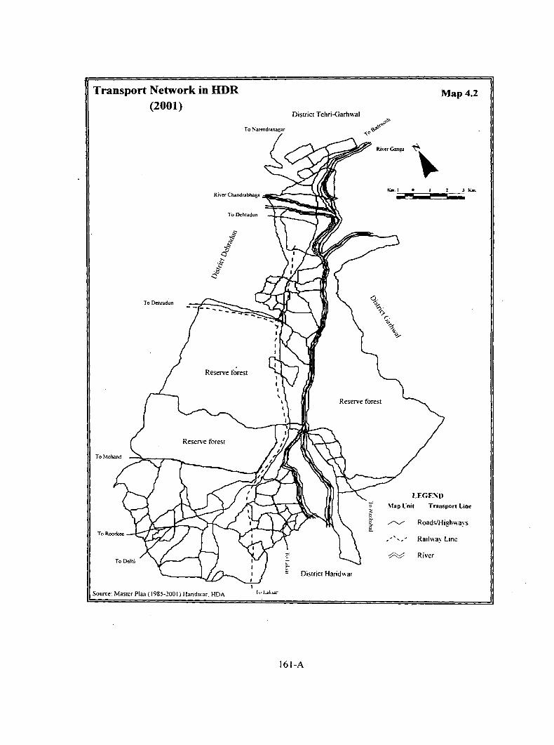
Transport Network in HDR (2001)
District Tehri-Garhwal
To ~arendranagar
To Dehradun
To Dehradun
Reserve forest
Reserve forest
r-~ District Haridwar
Source: Master Plan ( 1985-1001) Haridwar. HDA
161-A
Map4.2
LEGE~D
\lap l·nit Transport Lin.,
~ Roads/Highways
,, ,, ' Railway Line
-:P:::::;/ River

Almost all the villages in the region are within the range of 16 kms from the nearest
city either of Haridwar or Rishikesh. Out of the totai 319 households surveyed in nine
villages. it is observed that all the households are in close touch with the city.
Table 4.5 Number of Villages Accessible to the City (by different type of roads)
Tehsils Highway Metalled Road Partial Un-metalled
Haridwar 24 19 15
Rishikesh 6 7 5
Narendranagar 5 0 0
Kotdwara 0 1 0
HDR 35 27 20 Source: F1eld Survey (2003)
The intra-city transport network is a part of inter-city regional system. The major
roads meeting the travel needs are Station Road, Kankhal Road. Bypass Road. Hill
By-pass. Rishikesh Road and Sapt-Rishi Road. These roads radiate from the principal_
road corridor of NH-58 at the staggered locations. The orbital circulation is totally
missing, putting the total strain on highways. The high-density areas developed along
the Station road, Kankhal Road and Rishikesh Road has further, aggravated the traffic
problems. The Station Road being the spine of urban road network system has the
highest development of mixed land use pattern along the road. The Bypass Road and
Hill By-pass Road are almost parallel to the Station Road and the railway-line.
4.4.1 (ii) Availability of Public Transport Facilities
Apart from the good condition/all season roads. availability of public transport facility
at lower travel fare and its frequency is an important factor determining urban-rural
linkages. The availability of public transport facility ensures greater interaction with
the city. It is observed that use of public transport facilities is very significant in the
study area.
Public transport facility includes the facilities provided by the government as well as
the intermediate means of transport i.e. auto. Vikarm. (shared three ·wheeler) cvcle -- . -rickshaw (local name for three wheeled vehicle) and mini bus.
It is observed that the availability of public transport facility that caters to the needs of
the surrounding rural population is negligible in the study area. Government buses ply
162

and thus carter to rural settlements located mainly along the highway. Moreover, their
frequency is low and also don't entertain the local population for shorter distances.
These buses do not have stops near the villages and so they pick up and drop the
passengers at their request. Hence, the intermediate modes of transport like Vikarm,
Auto, Mini Bus and Jugaad (a temporary arrangement) are important vehicles that
cater to the needs of the adjoining rural areas.
Vikarm is an important mode of transport on all major roads especially on Rishikesh
Haridwar, Haridwar-Nazibabad, Haridwar-Laksar and Haridwar-Roorkee highway,
i.e., in Ghuntiyani, Dhalwala, Bhattowala, Kangri and Pratitnagar villages. i.e., five
out of the total nine villages depend on Vikarm: Jiapota and Jagjeetpur villages mainly
use mini bus, while 'Jugaad' caters to the travel needs of Puranpur, however, m
Rani pur no particular type of public transport facility is available.
4.4.1 (iii) Principal Modes of Transport used to Travel to the City
Vikarm: It is a three-wheeler with a seating capacity of I 0 people. It is a chartereq .
/shared auto that charges according to the distance/per person. It is one of the most
important mode of public transport in the study area about 65.5 percent of population
is dependent on this mode of transport for travelling to and from the city.
All the villages situated along the important transport radials like Kangri. Bhattowala,
Pratitnagar, Dhalwala. Ghungtiyani villages are approachable through Vikarm.
Mini Bus: In Jagjeetpur and Jiapota villages mini bus with a seating capacity of about
25 persons is an important mode of public transport. It charges Rs.3/- per person for
each trip from the city to any village on Laksar road up to a distance of 6 kms. Hence,
it is the cheapest and frequently available mode of public transport.
Jugaad: A temporary arrangement with a diesel engine attached to a trolley is an
important mode of transport available in all the villages of Haridwar tehsil especially
the villages located in the interior (away from the city as well as the highway). All
the Kutcha (un-metalled) and seasonal roads have this mode of transport. This
temporary arrangement has a seating capacity of about 15-20 persons. Advantage with
this type of arrangement as the name suggests is that the engine and trolley can be
attached or detached for other uses as and when required. Trolley with big tyres has
163

an advantage over other vehicle on the kutch/semi-pucca (semi-metalled) seasonal
roads. Puranpur and other villages in the south-western part of the study area are
connected with the city only through these temporary arrangements. otherwise people
have to manage with their own private vehicles.
Other modes of transports like cycle-rickshaw. auto-rickshaw are also available in the
region. These modes of transport are usually used by the people of villages located
nearer to the city especially for shorter distances. However, these modes of transport
are more expensive and hence are used by very low (1.38) percent population. Horse
carts are also used in some parts but they are not very popular these days and percent
population dependent on this mode of transport is minuscule.
Field observations have confirmed that the availability oftransport is one of the most
impo~nt determining factors of rural-urban interaction. The availability of public
transport facilities and its frequency play an important role in the study area,
especially in the villages far from the city.
Analysis of the percent share of various modes of transport (both public and private)
shows that the public transport facilities play an important role in linking the rural
settlements with the cities of study area. Even in public transport, the role of
intermediate transport modes is very significant. As mentioned earlier, the
government transport facilities are negligible (it is used by less than 0.05 percent)
Table 4.6 shows that about 41 percent of households use intermediate transport
followed by, two wheelers (27.5 percent) and cycle (20.8 percent) for commodity to
the city while the remaining 8. 7 percent travel to the city on foot from the neighboring
areas.
Settlement-wise analysis shows that the use of intermediate transport is highest in
village Pratitnagar (86.6 percent) followed by Bhattowala (53.3 percent), Kangri (52.9
percent). Ghungtiyani Talli (52.9 percent) and Jiapota (44.4 percent) villages. All
these villages (except Bhattowala) are situated along the highway and so have
comparatively better transport facilities.
On the other hand. the share of public transport is nil in viilage Ranipur. Similarly,
village Jagjeetpur is located adjacent to the urban boundary and the main market is
about 2 kms from the village. No public transport facilities are available on this road
164

as it is not profitable to ply on shorter distances and thus majority of population has to
depend on private vehicles for visiting the city.
About 80 percent households in Ranipur and 91.4 percent households in Jagjeetpur
villages travel to the city by cycle or two wheelers.
Table 4.6 Modes of Transport Used in Sample Villages
In Percent
Sample Foot Cycle Two Four Public Others Total Villages wheeler wheeler transport
(Car) Rani pur 13.3 40.0 40.0 6.7 0.0 0.0 100.0 Dhalwala 27 .9 11 .8 20.6 0.0 39.7 0.0 100.0 Jagjeetpur 2.5 39.2 53.2 0.0 5.1 0.0 100.0
Inner Zone 14.2 27.7 38.3 0.6 19.1 0.0 100.0 Ghungtiyanni 29.4 11.8 5.9 0.0 52.9 0.0 100.0 Kangri 0.0 29 .4 17.6 0.0 52.9 0.0 100.0 Jiapota 3.7 25.9 18.5 0.0 44.4 7.4 100.0 Middle Zone 9.8 23.0 14.8 0.0 49.1 3.3 100.0 Bhattowala 6.7 0.0 33.3 6.7 53.3 0.0 100.0 Pratitnagar 0.0 0.0 9.0 4.5 86.6 0.0 100.0 Puranpur 0.0 31.7 31.7 0.0 36.6 0.0 100.0 Outer Zone 0.8 10.6 19.5 3.3 65.9 0.0 100.0 HDR 8.7 20.8 27.5 1.4 41.0 0.6 100.0
Source: F1eld Survey (2003)
It is striking to observe that as much as 27.9 percent households of Dhalwala and 29.4
percent households of Ghungtiyani travel to the city on foot and, this is mainly on
account of two reasons. Most of the households in both the villages are located on hill
slopes and the people from hilly region are used to walking for a longer distance,
hence travelling to the city on foot is not difficult for them. Further, the market is very
close to the village which enables the population to reach the city on foot without any
difficult.
Figure- 4.1 Modes of Transport Used to Travel to the City
0.6 8.7
41
0 Foot • Cycle 0 Two wheeler
0 Four wheeler • Public transp ort Others
165

In case of Pratitnagar and Puranpur villages, the percent of population visiting to the
city on foot is nil because the distance from the viHage to the nearest city is not iess
than 8 to 12 kms and thus it is not possible to cover the distance on foot.
4.4.1 (iv) Cost of Travel to the City
The distance variable is frequently used to measure the intensity and pattern of
interaction among settlements. However, it is realised that this variable may not be
significant in all the cases in determining the interaction pattern. For example. a
village may be located only 3 Kms. from city, and yet access to the market may be
more difficult than for a village located 8-10 Kms. away, if the later has good road
condition, availability of cheap public transport facilities at regular intervals.
Hence, it can be analysed that not only the intervening road distance but many other
institutional factors also influences the pattern and degree of interaction.
The total travel cost of commuting to the city is computed by summing the total -
money spent by the villager to reach the city. It is one of the most important
determinants influencing the interaction pattern, especially for less expensive lower
order goods and services. The travelling cost varies not only according to the distance
from the city but also depends upon the mode of transport used. Thus, the cost is
worked out for two types of modes i.e., public transport and the private transport. It is
observed that the use of public transport facilities has highest share in the study area.
Hence, the focus is mainly on the intermediate mode of public transport facilities and
two wheelers as the private mode of travel, used by the people to visit the city. The
percent of households using four wheelers to visit the city is almost negligible ( 1.4
percent).
4.4.1 (iv-a) Travel Cost by Public Transport
Intermediate form of public transport is used by about 41.6 percent of households, is
comparatively cheaper than the private vehicles. The villages are categorised into
three zones on the basis of road distance and each zone has three villages.
Inner Zone- Most of the population of this zone depends upon the nearest city for
their basic needs. All the villages in this zone are less than 5 kms from the nearest
city. All the three villages share common boundary with the city but in some cases the
166

distance to the city varies within the village itself. Two of these villages (Rani pur and
Jagjeetpur) are nearer to Haridwar City while village Dhalwala is located adjacent to
Rishikesh city. It is observed that people spend between Rs. 3 to 5 per person to
reach the nearest city. However, it varies from village to village and with type and
mode of transport available and used by the rural people.
In case of Dhalwala village. connectivity (accessibility) in tenns of availability as
well as frequency of public transport is very good. Hence, people have to spend only
Rs. 3/- per one side travel (Rs. 6/- per trip). On other hand, in case of Ranipur,
although the distance is only 2 km but they do not have cheap public transport. as
Vikarm (the cheapest mode of transport) are not available from this village. The only
mode of transport is cycle Rickshaw that costs Rs. 5 to 8 per side. Similarly. in case
of Jagjeetpur also it costs about Rs.3/- (for one side) if Vikarm is used and Rs. 8/- to
10/- if cycle Rickhshaw is used to reach the city. In case of private modes of transport,
the travel cost comes to around two to three rupees for reaching the city that is
comparatively cheaper than the travel cost if public mode oftransport is used.
Middle Zone: All the villages in this zone are located at a distance of about 5 to I 0
kms from the city. These are Kangri. Jiapota and Ghungtyani Talli: all the three
villages are located along the highway. However. in case of Kangri and Ghungtiyani,
distance of I km is to be covered on foot from village to reach the highway from
where public transport is available. On the other hand. Jiapota village is located along
the highway so public transports are available within walking distance. Moreover,
frequency of public transport facilities is satisfactory in village Jiapota. followed by
village Kangri while village Ghungtiyani has relatively lower frequency.
Villagers spend about Rs. 5-8 on one side fare for visiting to the city. hence: a trip to
the city cost around Rs. I 0- I 5~ Vikarm is the most important mode of transport
followed by private mini buses. especially in Jiapota where it is the only available
public transport.
In all the three villages of this zone. villagers spend about Rs. 5 to 8 (same as in
pubiic transport) if they use two wheelers (private mode of transport) to visit the city.
Outer Zone: The outer zone covers villages that are more than I 0 kms. from the city.
This zone again has three villages. These are Puranpur. Bhattowala and Pratitnagar
167

villages. Village Puranpur ts m Haridwar tehsil while the other two villages are
located in Rishikesh tehsil.
Field observations show that both Puranpur and Bhattowala villages are about 5 and 3
kms away from the highway, respectively, while Pratitnagar is located along
Haridwar-Rishikesh highway. The road connecting village Puranpur and Bhattowala
to the highway is semi-Pucca and seasonal. The condition of the road is not motorable
during the rainy season.
Villagers spend about Rs.l 0- t 5 as one side fare to reach the nearest city. People from
Puranpur usually visit Haridwar while inhabitants of Bhattowala village prefer
Rishikesh. Pratitnagar has a better option. as it is located equidistance (14 Kms.)
from both Rishikesh and Haridwar cities. However, it has a well developed market
within the village. But villagers visits Rishikesh or Haridwar according to their
requirements, especially for higher order goods and services. Field observations show
that major share of population (86.6 percent) depend on public mode of transport
especially Vikarm or government buses in some cases. The reason being these
villages are located on the highway where the public transport is easily available,
secondly it is comparatively cheaper than using two wheelers as the single side trip to
city costs more than Rs.l5/- by two wheelers while the cost for public transport is
between Rs.8 tolO only.
It is observed that. if only one member of the family travels to the city they prefer
public transport while on the other hand they prefer to use their personal conveyance
when family move in group.
Analysing the mode of transport and travel cost from various settlements to the city
one observes that, public transport is relatively cheaper and most popular in all the
settlements that are located farther from the city, while two wheelers (cycles, scooters
and bikes) are used more frequently in the villages that are nearer to the city.
This pattern of use of various mode of transport also corresponds to the cost of travel
by the two different modes of travel. It is cheaper to use personal vehicles especially
two wheelers for shorter distances while public mode of travel is more economic and J
convenient for villages situated more than 5 kms from the city.
168

4.4.1 (v) Availability of Marketing Facilities
The development of market or establishment of shops in the villages is also governed
by the distance from the city. highways and the demand of the residents of that
village. In the villages that are relatively far from the city like Puranpur and
Bhattowala villages, shops for essential items have come up in the village. Majority of
people depend on them, as it is not cost effective to travel to the city for small and
lower order goods and services. However. people who have to travel to the city for
other purposes, especially, for work, depend on the city for these lower level of goods
and services as they need not spend extra for the journey and they get more choice
and variety in quality at relatively lower prices in the city.
While on the other hand, although the number of shops are more in the villages nearer
to the city and have relatively developed and well established market. still people do
not depend cent percent on these shops for their day to day requirements because city
is close and they can even walk to the city to fulfill their needs. Hence, it is more cost
effective, as they do not have to spend on fare while they get more varieties at
comparatively cheaper rates.
4.4.1 (vi) Access to Primary and Secondary Market
Two types of marketing pattern are basically found in rural regions that is primary and
secondary market facilities. A primary market is a periodic market where buyers and
sellers assemble generally once a week to trade agricultural products. products of
rural industries and other consumer goods etc. Sellers operate from mobile shops. the
number of traders in such market ranges from 500 to 2000. These markets are very
important for rural population. Variety of goods and services are available at these
periodic markets. Weekly markets are known as Haat in the region. These weekly
Haats are held in Jagjeetpur and Pratitnagar villages of HDR. Around 22.20 percent
of settlements have weekly markets within the village while again 22.20 percent
households avails these services within 2 kms range from the village. It shows that
around 45 percent of the households have the facility of weekly markets within 2 kms
range, while the remaining (55 percent) have to travel more than 5 kms to avail this
facility.
169

A secondary market is larger than a primary market. and in contrast. businesses are
housed in permanent structures, and transactions are daily. Wholesale trade and
stocking of goods are normal features o(a secondary market. Sometimes primary
market also functions as a periodic market. Access of villagers to the secondary
market is obviously lower than that to primary markets.
After studying the availability of shops and various establishments, and their nature in
the villages, it is observed that in almost all the villages majority of shops are of
general category like, basic needs, daily essential goods and services like grocery, atta
chakki (floor mill), variety store, tea stall, barber, tailor, cycle repair etc.
It is also observed that in the villages near to the city, the establishments are
permanent, larger and more organised, while in far off villages the structure is
temporary/semi-pucca, small and unorganised. It is observed in these villages that one
shop has variety of goods i.e. grocery, confectionary, cosmetic, footwear, stationary
and in some cases even tea stall. All these goods are available under one roof.
Village-wise analysis of these establishments shows that, on an average there are 2.8
shops per hundred population. However, there are variations among the settlements.
It ranges from 0.2 shops for every hundred population in village Bhattowala to about
6 shops in Pratitnagar.
It is noticed that in case of Rani pur village. although there are I 0 shops but nine of
these are located along the highway and do not cater to the local population. Most of
the shops sell eatables. wine and beer that cater to the needs of the floating
population. There is only one multi purpose shop that caters to the needs of the
village.
Apart from these permanent establishments various vendors are functioning to meet
the needs of inhabitants in these villages. These ~awkers sell a variety of things like
vegetable. fruit. essential items like footwear. cloth. repair of cookers, gas. umbrella
and eatables etc. They do not visit a particular village regularly, their visits are very
irregular and uncertain. and usually come on bicycles or tricycles or 'Redis' and cover I
various villages in a day.
170
/
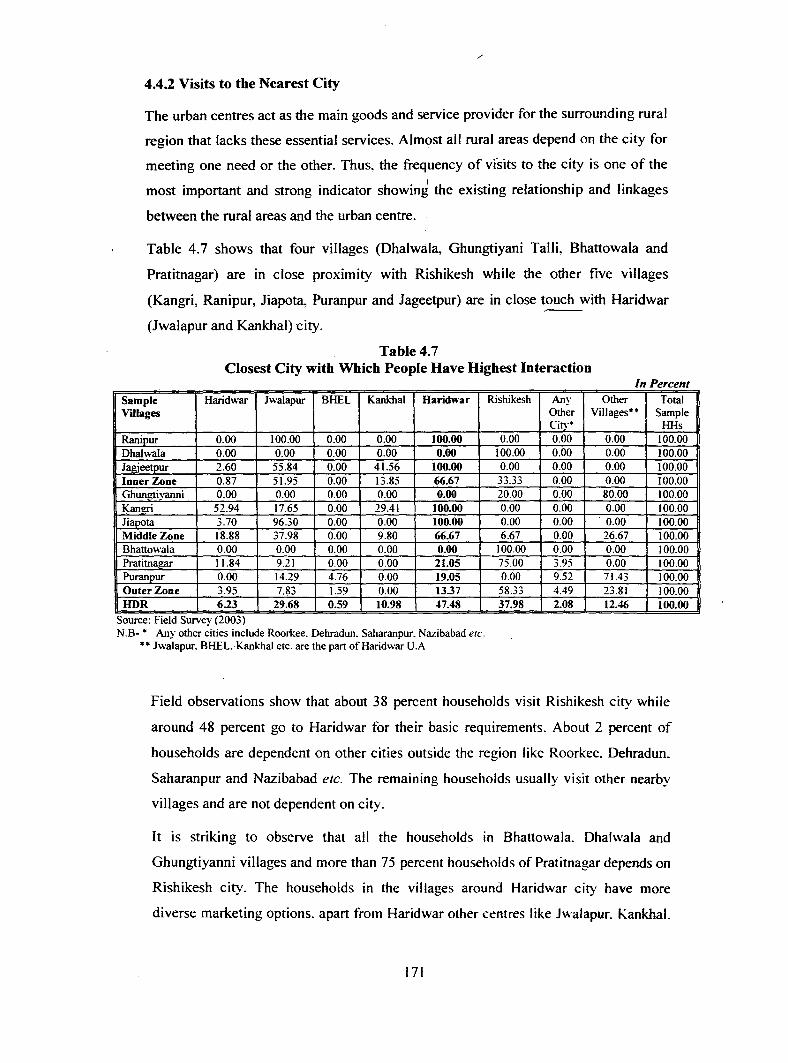
4.4.2 Visits to the Nearest City
The urban centres act as the main goods and service provider for the surrounding rural
region that lacks these essential services. Almost all rural areas depend on the city for '
meeting one need or the other. Thus. the frequency of vfsits to the city is one of the I
most important and strong indicator showing the existing relationship and linkages
between the rural areas and the urban centre.
Table 4.7 shows that four villages (Dhalwala, Ghungtiyani Talli, Bhattowala and
Pratitnagar) are in close proximity with Rishikesh while the other five villages
(Kangri, Ranipur, Jiapota, Puranpur and Jageetpur) are in close touch with Haridwar
(Jwalapur and Kankhal) city.
Table4.7 Closest City with Which People Have Highest Interaction
In Percent Sample Haridwar Jwalapur BHEL Kankhal Haridwar Rishikesh Any Other Total Villages Other Villages** Sample
Citv* HHs Rani pur 0.00 100.00 0.00 0.00 100.00 0.00 0.00 0.00 100.00 Dhalwala 0.00 0.00 0.00 0.00 0.00 100.00 0.00 0.00 100.00 Jagjeetpur 2.60 55.84 0.00 41.56 100.00 0.00 0.00 0.00 100.00 Inner Zone 0.87 51.95 0.00 13.85 66.67 33.33 0.00 0.00 100.00 Ghungtivanni 0.00 0.00 0.00 0.00 0.00 20.00 0.00 80.00 100.00 Kangri 52.94 17.65 0.00 29.41 100.00 0.00 0.00 0.00 100.00 Jiapota 3.70 96.30 0.00 0.00 100.00 0.00 0.00 . 0.00 100.00 Middle Zone 18.88 37.98 0.00 9.80 66.67 6.67 0.00 26.67 100.00 Bhattowala 0.00 0.00 0.00 0.00 0.00 100.00 0.00 0.00 100.00 Pratitnagar 11.84 9.21 0.00 0.00 21.05 75.00 3.95 0.00 100.00 Puranpur 0.00 14.29 4.76 0.00 19.05 0.00 9.52 71.43 100.00 Outer Zone 3.95 7.83 1.59 0.00 13.37 58.33 4.49 23.81 100.00 HDR 6.23 29.68 0.59 10.98 47.48 37.98 2.08 12.46 100.00
~ Source: field Survey (200..>) N.B- * Any other cities include Roorkee. Dehradun. Saharanpur. Nazibabad etc.
** Jwalapur. BHEL-Kankhal etc. are the part ofHaridwar U.A
Field observations show that about 38 percent households visit Rishikesh city while
around 48 percent go to Haridwar for their basic requirements. About 2 percent of
households are dependent on other cities outside the region like Roorkee. Dehradun.
Saharanpur and Nazibabad etc. The remaining households usually visit other nearby
villages and are not dependent on city.
It is striking to observe that all the households in Bhattowala. Dhalwala and
Ghungtiyanni villages and more than 75 percent households of Pratitnagar depends on
Rishikesh city. The households in the villages around Haridwar city have more
diverse marketing options. apart from Haridwar other centres like Jwalapur. Kankhal.
171

Bahadarabad and BHEL are more preferred markets for the local residents. Moreover.
the residents of villages surrounding Haridwar prefer Jwalapur and Kankhal as
compared to Haridwar which is considered relatively costlier and specialised m
catering to the floating (tourist) population. Cent percent households of village
Ranipur, 96.3 percent of Jiapota villages and 56 percent households of Jagjeetpur
village visit Jwalapur for their day to day needs. However in Kangri village majority
(52.94 percent) of households prefer Haridwar.
Analysis of the data shows that only 19 percent of households of Puranpur village
visit Haridwar, while as much as 71.4 percent household prefer other villages i.e.
Bahadarabad for their basic requirements. It is also noticed that as much as 9.5
percent of households of this village also visit other city, Roorkee which is (21 kms)
relatively far from the village. Roorkee was tehsil H.Qs prior to 1986 when Haridwar
was made the tehsil H.Qs of these villages but it is observed that these people have
maintained their preference in terms of shopping pattern to this urban centre
especially for higher order services like healthcare and other facilities like jewellery~·
clothes, textile, leather goods etc.
Relatively developed rural settlements around the cities can further be developed as
growth centres (as satellite towns) to release the pressure from the tw{) cities.
Field observation show that Shyampur. Dhalwala and Tapovan villages are relatively
more developed villages near Rishikesh City where people go for all types of day to
day needs. Similarly, Bhardarabad (Block H.Qs), Jagjeetpur, Shyampur Nuabad
villages can be developed as a growth centres around Haridwar City.
4.4.2 (i) Distance to the City
Analysis of the data (Table 4.8) shows that about 40.6 percent of households have to
travel less than 2 kms to reach the nearest bty and almost 59.4 percent travel less than
5 kms.
Table 4.8 astance c overe v ample onse 0 s or asac e d b s 11 H h ld ti B . N ed s
Distance Traveled Percent Households · Less than 2 kms. 40.6 :!.1-5.0 kms. 18.9 SJJI-1 0.00 kms. 15.2 10.01 Kms. and ab<wc 25.2 HDR 100.00
- , Source. tu:ld Survc~ (2()()_,)
172

However, 25.2 percent of household covers the distance of more than 10 kms to reach
the nearest city. The villages situated in close proximity to the city are Dhalwala.
Ranipur and Jagjeetpur while the villages situated relatively farthest are Ghungtiyani,
Kangri, Jiapota, Pratitnagar, Bhattowala and Puranpur villages. respectively.
Table 4.9 Distribution of Villages According to the Distance from the City
Distance Zone Villages No. of Villa~es Inner Zone (Less than 5 km) Dhalwala. Ranipur. Jagjeetpur 3
Middle Zone (5-10 km) Jiapota. Ghungtiyani, Kangri 3
Outer Zone (10-15 km) Bhattowala.Puranpur, Pratitnagar 3
Source: F1eld Survey (2003)
It is examined that on an average the households of Kangri, Bhattowala, Pratitnagar1
have to travel 8 tolO kms because these villages are situated farthest from the city. Of
these four villages, Pratitnagar and Kangri villages are located on the highway. while
Bhattowala and Puranpur village are about 3 and 9 kms away from the highway_
respectively. Analysis of the data shows that- 10 percent of households travel more
than 20 kms. for their basic needs (for higher order goods/services).
Finally, it can be concluded that the existing road distance is one of the most
important factor in determining the pattern of interaction. However, other factors like
condition of roads, transport facilities and travel cost are also play significant to
determine the linkages between two places.
4.4.2 (ii) Frequency of Visits to the City
It is observed that apart from the distance of the village to the city, frequency of visits
to the city is affected by various factors. for example. if the village or nearby village
have sufficient market facilities. then the villagers need not have to travel to the
market in the city daily especially for their day to day basic needs if the village does
not have sufficient shops (as the case in Ranipur village) the people are compelled to
travel all the way to the city even for basic necessities. Similarly. good condition and
1 Travelling longer distances for a particular commodity does not mean that It is not availahle in the close proximity. It signifies the ability and urge of the consumer for better goo..:!- and services and thus tra' clling to a longer distance for fulfilling their basic requirements.
173

all weather metalled roads. availability of frequent public transport also encourages
the frequency of visits to the city:
The frequency of vrsit to the city has been categorised into seven types. It starts from
daily visits to bi-weekly, weekly, fortnightly, bi-monthly, and lastly occasional visit -"-for rare or special shopping for some occasions. ceremonies, functions, fairs. festivals
family get together etc.
As mentioned earlier, the surrounding villages are in close touch with the city. Table
4.10 shows that more than half of the household (52.7 percent) visit the city daily
while around 15 percent of households travel to the city at least once a week, while
17.20 percent travel at reast twice a week. Hence, about 85 percent of the households
visit the city at least once a week.
Zone-wise analysis of the frequency of visits to the city shows wide variations. It is
observed that the villages of the inner distance zone have highest frequency of visits
followed by the middle and outer zones, respectively. However, the frequency
decreases from the inner to the outer zone, which clearly shows the distance decay
effect.
Analysis of the data shows that cent percent households of Rani pur village commute
. to the city daily followed by Jagjeetpur and Ghungtiyani Talli villages. On the other
hand, only 13.8 percent households commute to the city daily in Pratitinagar followed
by Puranpur. Dhalwala and Bhattowala villages. In case of Rani pur (located adjacent
to the urban boundary) people are dependent on the city for all most all their basic
requirements as there is no local market within the village while in case of Jagjeetpur
village people prefer to visit the city for all higher orders goods and services as they
find more varieties in the city, at comparatively cheaper rates, after travelling about 1
km (as this village is adjacent to the city).
Settlement -wise analysis of the frequency of visits to the city shows that cent percent
population of Ranipur village travel to the city daily, followed by Jagjeetpur (72.7
percent). On the other hand. only 13.8 percent households of Pratitnagar and 38.5
percent households of Puranpur villages travel to the city daily. In case of Ranipur
village, the frequency of visit to the city is highest because the villages do not have
any market facilities. even the shops for basic needs such as that of groceries are not
available in the village. Hence. the people of this village have to go to the nearest
174
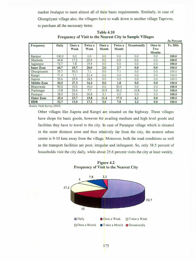
market Jwalapur to meet almost all of their basic requirements. Similarly, in case of
Ghungtiyani village also, the villagers have to walk down to another village Tapovon,
to purchase all the necessary items.
Table 4.10 Frequency of Visit to the Nearest City in Sample Villages
/ / In Percent
Frequency Daily Once a Twice a Once a Twice a Occasionally Once in To.HHs Week Week Month Month Two
Months Rani pur 100.0 0.0 0.0 0.0 0.0 0.0 0.0 100.0 Dhalwala 44.8 17.2 25 .9 5.2 6.9 0.0 0.0 100.0 Jagjeetpur 72.7 7.8 19.5 0.0 0.0 0.0 0.0 100.0 Inner Zone 64.7 10.7 20.0 2.0 2.7 0.0 0.0 100.0 Ghungtiyanni 35 .7 50.0 7.1 0.0 7.1 0.0 0.0 100.0 Kangri 71.4 7.1 21.4 0.0 0.0 0.0 0.0 100.0 Jiapota 55 .6 25.9 18.5 0.0 0.0 0.0 0.0 100.0 Middle Zone 54.5 27.3 16.4 0.0 1.8 0.0 0.0 100.0 Bhattowala 50.0 10.0 10.0 0.0 30.0 0.0 0.0 100.0 Pratitnagar 13 .8 24.6 7.7 16.9 26.2 10.8 0.0 100.0 Puranpur 38.5 25.6 30.8 5.1 0.0 0.0 0.0 100.0 Outer Zone 25.4 23.7 15.8 11.4 17.5 6.1 0.0 100.0 HDR 52.7 15.0 17.2 5.0 7.8 2.2 0.0 100.0
Source: Field Survey (2003)
Other villages like Jiapota and Kangri are situated on the highway. These villages
have shops for basic goods, however for availing medium and high level goods and
facilities they have to travel to the city. In case of Puranpur village which is situated
in the outer distance zone and thus relatively far from the city, the nearest urban
centre is 9-10 kms away from the village. Moreover, both the road conditions as well
as the transport facilities are poor, irregular and infrequent. So, only 38.5 percent of
households visit the city daily, while about 25.6 percent visits the city at least weekly.
Figure 4.2 Frequency of Visit to the Nearest City
7.8 2.2
17.2
52.7
0 Daily • Once a Week 0 Twice a Week
0 Once a Month • Twice a Month Occasionally
175

On the other hand, in Pratitnagar I 3.8 percent household visit the city daily as it has
its own well developed market and so the population travels to the city only for ,-availing higher order goods and services.
Hence. it can be concluded that there are various factors that play significant role in
governing the visits of the village population to the city.
Thus, some of the important factors determining the rural-urban linkages identified
during the field observations are availability of shops, market within the village,
distance to the city, condition of the road, availability of public transport at affordable
rate, frequency of public transport facilities etc.
4.4.2 (iii) Average Journey Time Spent from Home to the City
Average journey time signifies the time spent on travelling by the consumers from
their place of residence to the city, especially to the market. This is one way time
spent to reach the city. The average journey time spent by the population from their
respective villages to the nearest city is categorised into four classes. i.e. Class- I (less
than 15 minutes), Class-II (15 to 30 minutes). Class-III (30 to 45 minutes) and Class
IV (more than 45 'minutes). Field observations reveal that the households from all the
settlements can reach the city within 60 minutes.
Class-/ (Less than 15 minutes)
It is observed from the analysis that around 18 percent households spen<!t!ess than 15
minutes to travel to the city. However, the zone and settlement-wise analysis shows
wide variations. Zone-wise analysis shows that the households from the inner zone
spend relatively less time to reach the city as compared to the middle and outer zones.
Settlement-wise analysis show that around 40 percent households of Dhalwala and
Ranipur villages and 35 percent households of Jagjeetpur village spend less than 15
minutes to travel to the city. All these settlements are in the inner zone and are located
adjacent to the city.
Class-II (1 5-30 Minutes)
This class has highest percent of population. About 42 percent of households spend
between 15 to 30 minutes to travel to their nearest city. The highest percent
households are in village Kangri followed by Jagjeetpur, Jiapota. Ranipur. Dhawlala
176

and Ghungtiyani Talli villages. The least percent of households in this category are
from Puranpur and Pratitnagar villages as both the settlements are situated at a
distance of more than 1 0 kms. from the city.
Table 4.11 Average Journey Time Spent from village to the City in Sample Villages
In Percent
Sample Lessthan 15 15-30 30-45 4~0 Above60 To. HHs Villaees minutes minutes minutes minutes minutes Rani pur 40.0 60.0 0.0 0.0 0.0 100.0 Dhalwala 39.7 58.6 1.7 0.0 0.0 100.0 Jagjeetpur 35.1 63.6 1.3 0.0 0.0 100.0 Inner Zone 37.3 61.3 1.3 0.0 0.0 100.0 Ghumttivanni 14.3 57.1 28.6 0.0 0.0 100.0 Kangri 0.0 78.6 14.3 7.1 0.0 100.0 Jiapota 0.0 63.0 37.0 0.0 0.0 100.0 Middle Zone 3.6 65.5 29.1 1.8 0.0 100.0 Bhattowala 0.0 20.0 70.0 10.0 0.0 100.0 Pratitnagar 0.0 1.5 96.9 1.5 0.0 100.0 Puranpur 0.0 7.7 71.8 15.4 5.1 100.0 Outer Zone 0.0 5.3 86.0 7.0 1.7 100.0 HDR 18.2 42.0 36.4 2.8 0.6 100.0
Source: field Survey (2003)
Class-III (30-45 minutes)
This category has second largest share of households. Table 4.11 shows that about
36.4 percent households visiting the city spend around 30-45 minutes to reach the
city. On the other hand. there are as many as five villages namely Kangri.
Bhattowala, Pratitnagar, Jiapota and Puranpur villages where journey time for cent
percent household is more than 15 minutes. All these villages are far and people
cannot commute on foot. Majority of households of the outer zone spend more than
30 minutes to reach the nearest market in the city.
Class-IV (Above 45 minutes)
Field observations reveal that only 3.4 percent households spend more than 45
minutes and only 0.6 household spend more than one hour to reach the city. The
highest share in this category is from Puranpur village followed by village
Bhattowala. both of these villages are situated .not only far from the city but are also
located in the interior away from the highway and don't have metalled roads.
Moreover. the availability of public transport from these villages to the city is less
frequent and irregular.
177

In case of Dhalwala village which is located adjacent to urban boundary, 60 percent
households spend almost half an hour to reach the city because large population prefer
to travel on foot on account of smaller distance. Similarly in Ghungtiyani Talli village
that is located 5 krns away from the city, about 86 percent household spend more than
15 to 30 minutes to reach the city as about 30 percent households travel to the city on
foot.
Table 4.3 Average Journey Time Spent to Reach the City
36.4
0 < 15 minutes 0 15-30 minutes 0 30-45 minutes
0 45-60 m inutes • > 60 minutes
Thus, it can be concluded that in both Dhalwala and Ghungtiyani Talli villages, mode
of transport plays more important role than distance traveled, while in case of
Puranpur, Bhattowala and Pratitnagar villages, distance covered, availability of
transport facilities (in terms of frequency) and road conditions play an important role
in determining the time spent by the households to reach the city.
From the above observations the general pattern of interaction of the rural settlements
with the city, their frequency of visit, average distance traveled, time spe~~o reach
the city, mode of transport used, travel cost, etc has been analysed. However, in the
following part of the present chapter, an attempt is made to examine the pattern of
interaction (linkage) among the rural settlements and with the two cities on the basis
of the order (level) of facilities and purpose (type) of interaction for which the
households travel to the city.
178

4.4.3 Interaction Based on Level of Facilities (Goods/Services)
As studied earlier that there exist inequalities and disparities in the availability of
facilities in any area and these inequalities gives rise to the linkages or interactions
between the two centres.
It is generally assumed that the basic facilities are available in the rural settlements
and so it is the higher order goods and services for which the people depend on the
city. In the present chapter, an attempt has been made to categorise various goods and
services into four classes viz. lower order goods, lower order services and higher order
goods and services,
This classification of goods and services into various levels was made on the basis of
the importance of the facilities. Goods like grocery, green grocery, cereals. cooking
fuels and stationary items are categorised as lower order goods. While basic services
like services of cobbler, barber, studio and tailor are categories as lower order
services.
Similarly, goods and services, which are important but are not available in small
centres as they need larger threshold to survive are categorised as higher order goods
an'd services. These are goods like textiles, leather, jewellery, inputs used m
agriculture and services like health, higher education; sale and processing of
agriculture produce. banks, administrative services and social facilities etc.
Criterion of Classification of level of Facilities·
Various goods and services were classified into higher or lower level on the basis of
following factors (cost. importance and frequency of use)
• Scarcity in terms of availability
• Importance and frequency of use in day to day life
• Cost of the item or facility
• Threshold of the facility
The goods were arranged in hierarchical structure. fi"om ordinary consumption items
of daily use like grocery (cereals, pulses etc.) and green grocery to expensive and less
frequently required articles like leather items, textiles and jewellery.
179

Similarly, the services such as-repair of cycles. barber. tailor were categorised into
lower order services while the services that cost more and are required less frequently
such as health care services, higher education. financial, entertainment etc are
classified into higher order services.
4.4.3 (i) Interaction for Lower Order Goods
Analysis of the data of dependency and pattern of travel of population to the city for
lower order goods shows that an average of 23.26 percent households in the region
are dependent on the city for these lower order goods. However, the percent of
households dependent on city for basic goods shows wide inter-zonal and inter
settlement variations. It ranges from 88 percent in Ranipur village of the inner zone
to 3.59 percent in village Puranpur in outer zone.
Physiographic location of Ranipur village discourages development of infrastructure
facilities in the village. Although it is engulfed by BHEL on one side and Haridwar
city on the other but as the canal forms the boundary of the village and the city. the
development of the village towards the city is restricted. Location of BHEL on the
one side also discourage its development as industrial township is self
dependent/independent do not encourage infiltration by the villages. Location of PAC
camp on the boundary between the village on one side and BHEL on the other side
further discourages the development of the village on this side.
Field observations shows that there is lack of market facilities for basic requirement in
Ranipur village and hence people visit to the city for various goods and services. They
either depend on the weekly Haat in BHEL or travel to the nearest market in Jwalapur
for even ordinary consumption items like green grocery, grocery, flour mill and fuel
for cooking etc. Moreover, there is tendency among the villagers to out-migrate
especially the younger generation which has discouraged growth of any marketing
facilities within the village and hence people have to ultimately visit the city for their
basic requirements.
On the other hand, 3.69 percent households of Pratitnagar and 3.6 percent households
in Puranpur villages and 4 percent in Bhattowala village depend on the city for their
day to day requirements. All these three villages are located in the outer zone. \
180

Table 4.12 Population Dependent on City for Various Orders of Goods and Services
In Percent
Sample Villages LOG LOS HOG HOS Rani pur 88.00 100.00 82.14 73.33 Dhalwala 34.48 22.41 83.35 67.19 Jagjeetpur 24.68 11.69 82.02 64.23 Ghungtivani 38.57 23.21 76.19 57.40 Kangri 28.57 37.49 86.39 61.22 Jiapota 20.00 13.89 77.72 50.92 Bhattowala 4.00 25.00 50.00 57.38 Pratitnagar 3.69 1.92 54.06 57.52 Puranpur 3.59 3.85 44.35 49.59 HDR 23.26 17.95 70.16 60.78 Co-efficient of Variation 122.08 140.00 40.80 31.81
LOG/LOS= Lower Order Goods/Serv1ces. HOG/HOS = H1gher Order Goods/Serv1ces Source: Field Survey (2003)
/
In Puranpur and Bhattowala villages, the higher cost of travel on account of longer
distance discourages population to travel to the city for their requirements. Hence,
most of the households depend on the shops within the village or other nearby
villages. About 20 percent households of Puranpur and 60 percent of Bhattowala
depend on Bahadarabad and Shyampur villages respectively, for daily requirements.
The percent figures for Puranpur village are lower because majority of households use
wood as fuel for cooking and thus depend on jungle for firewood while in village
Bhattowala 80 percent of households uses LPG cylinders which are available in
nearby village Shyampur. Hence. dependency on other village is more in case of
Bhattowala village.
In Pratitnagar, the dependency of population on the city for basic requirement is very
low as the village itself has a well developed market facility. Moreover, the city is far
and there are not many variations in per unit cost of commodities available in the
village and in the city. so they need not travel to the city for their basic necessities.
Village-wise analysis shows that there are great variations in the dependency of the
villages on the city for lower order goods. The co-efficient of variation for these
goods is 122.
4.4.3 (ii) Interaction for Lower Order Services
The lower order services constitute the basic requirements like the services of barber,
tailor. cobbler and facility of the studio. Around 18 percent households visit to the
c.ity for lower order services. The lower order services also show wide inter-zonal and
181

inter-settlement variations. It varies from 100 in Ranipur of the inner zone to 1.9
percent in Pratitnagar and 3.85 percent in Puranpur village of the outer zone.
Zone-wise analysis shows gradient pattern in the percent households visiting the city
for lower order services. The data shows that the inner zone has highest percent of
households visiting the city for lower order services followed by the middle and outer
zone. This again shows the importance of distance as an important determining factor
for the lower order services.
Settlement-wise analysis shows that non-availability of services in Ranipur village
compels the people to visit the city even for the basic services of barber and cobbler.
Similarly, Puranpur village also lacks in basic services but due to longer distance from
the city residents avail these facilities from nearby village Bahadarabad.
'It is observed that in Bhattowala, Ghungtiyani and Puranpur villages, large proportion
of population is dependent on near-by villages Shyampur, Tapovan and Bahadarabad.
respectively for these services. It is noticed that in three settlements i.e .. Jagjeetp~r.
Jiapota and Dhalwala. all the lower order facilities are available within the village yet
considerable percent of population travel to the city for these, because of shorter
distance. On the other hand, in Pratinagar all these services are available within the
village and thus only 1.9 percent households travel to the city for these services.
Settlement-wise analysis confirms great variations among settlements. The
co-efficient of variation in dependency of the settlements on the city for lower order
services is 140.
4.4.3 (iii) Interaction for Higher Order Goods
The higher order goods constitute the items like textile, readymade garments. leather
goods, jewellery and inputs us.ed in agriculture. All these articles are either relatively
costly or are used less frequently or both and hence may not be available in all the
rural settlements.
Table 4.12 shows that as much as 70.2 percent households travel to the city for this
level of goods. However, inter-zonal as well as inter-settlement variations are
observed in the region. Zone-wise analysis shows that the settlements in inner zone
have in highest percent of households dependent on the city for the above mentioned
higher order goods.
182

Settlement-wise analysis shows that among settlements the percent is highest (86.4
percent) in village Kangri.
However, it is observed that the variation is not large i.e. there is not much disparity
in terms of percent households dependent on city for higher goods in the sample
villages. It varies from lowest percent (44.3 perent) in Puranpur village to highest
percent (86.4 percent) in Kangri village. Both these villages are in the middle zone
which clearly shows the existing intra-zonal variations. The highest percent of
households dependent on the city in Kangri village is on account of absence of any
other developed village or growth centre in this part of the study area; hence most of
the settlements located on the right bank of Ganga river depend on Haridwar city for
all their requirements.
The co-efficient of variation for higher level of goods is 40.8. In six out of the nine
sample villages, more than 75 percent households travel to the city for higher order
goods and services. In remaining two villages, i.e. Bhattowala and Puranpur distance
to the city is again one of the most important determining factors for lower
dependency on city. Moreover, in both the cases near-by developed villages
(Shyampur and Bahadarabad) play an important role in catering the needs of the
population. On the other hand, in Pratitnagar almost 42.5 percent households buy the
goods from the village. although it has a well developed market facilities.
The analysis ofthe data shows that the co-efficient of variation is relatively lower for
higher order goods and services as compared t9 the co-efficient of variation for lower
order goods and services.
4.4.3 (iv) Interaction for Higher Order Services
The expensive and less frequently used services which are very essential for the
population are categorised as the higher order services. It includes facilities like
higher education. secondary and tertiary health care. financial institutions like services
of banks and credit societies. Social facilities like visits to the city for religious
purposes. entertainment. cultural services. administrative and organisational services
like services of tehsil. district and judicial services are also included in this category.
Other important variable is dependency of the rural population on the city for
livelihood. An average of about 61 percent households depend~ on the city for higher r
183
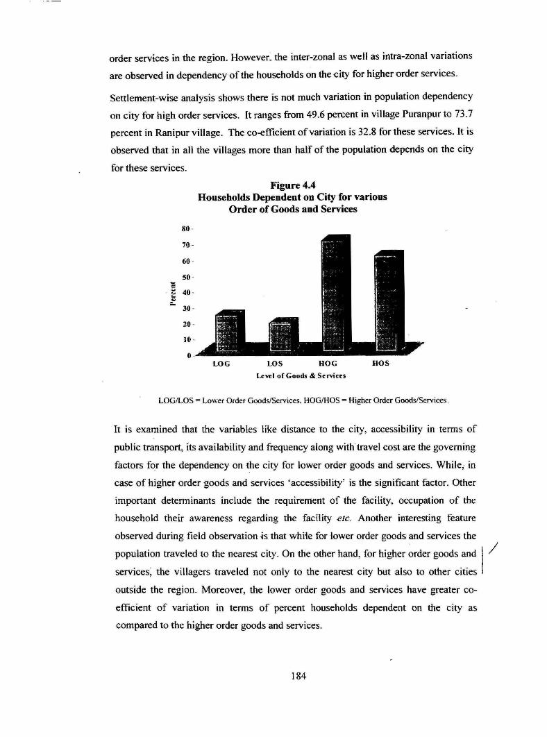
order services in the region. However: the inter-zonal as well as intra-zonal variations
are observed in dependency of the households on the dty for higher urder services.
Settlement-wise analysis shows there is not much variation in population dependency
on city for high order services. It ranges from 49.6 percent in village Puranpur to 73.7
percent in Ranipur village. The co-efficient of variation is 32.8 for these services. It is
observed that in all the villages more than half of the population depends on the city
for these services.
80 .
0
Figure 4.4 Households Dependent on City for various
Order of Goods and Services
LOG LOS HOG HOS
Level of Goods & Services
LOG/LOS= Lower Order Goods/Services. HOG!HOS =Higher Order Goods/Services.
It is examined that the variables like distance to the city, accessibility in terms of
public transport, its availability and frequency along with travel cost are the governing
factors for the dependency on the city for lower order goods and services. While; in
case of higher order goods and services 'accessibility' is the significant factor. Other
important determinants include the requirement of the facility, occupation of the
household their awareness regarding the facility etc. Another interesting feature
observed during field observation -is that whiie for lower order goods and services the
population traveled to the nearest city. On the other hand, for higher order goods and I / services; the villagers traveled not only to the nearest city but also to other cities
outside the region. Moreover, the lower order goods and services have greater co
efficient of variation in terms of percent households dependent on the city as
compared to the higher order goods and services.
184

4.4.4 Interaction Based on Type of Facilities
Classification of major linkage types
As discussed earlier. the type and intensity of interaction between the urban and the
adjoining rural areas is governed by variety of factors. Accessibility in terms of road
distance, condition of road. mode of transport. availability of public transport
facilities, travel cost are important determinants. However, it is observed that other
factors like the physiography and productivity of the region (land), socio-economic
status of the population of the umland along with size, nature and functional character
of the city also plays an important role in governing the pattern and type of interaction
between two centres.
Moreover, it is observed that the type and pattern of interaction governing the small
towns or cities are different than those operating at the metropolis or megapolis.
Similarly, the functional nature of the city plays an important role in the pattern of
interaction with neighbouring rural settlements.
Taking into account the above factors, it has been attempted in the section to examine
various types of linkages existing between the rural and urban settlements of the
region.
We have categorised the different linkages into six types- these are physical linkages.
population movement linkages, economic linkages, social interaction linkages, service
delivery linkages. political. administrative and organisational linkages etc.
4.4.4 (i) Population Movement Linkages
It includes the percent of households (head of the household) that commute to the city
daily for work. This daily travel is either for services which includes both
government and private services and other self employment activities in the formal as
well as informal sector.
As discussed earlier. the two religious cities (Haridwar and Rishikesh) entertain large
floating population. Moreover. after the formation of Uttaranchal as separate state.
the region has tremendous potential for growth. The study area is considered most
suitable tor developing many infrastructural facilities including industries, as the
region ~~ one of the tcw stretches of plain areas available in the State. The State
authorities arc planning to encourage industrial development in the region. Hence,
185

these development activities are expected to provide immense potential in terms of
job opportunities in the region.
Table 4.13 Households Dependent on City for Various Facilities
In Percent U Distance
Zone Villages Economic Education Health Social Financial Administrative
Dhalwala 60.00 74.47 98.30 67.20 29.31 65.52 Cl Rani pur 76.47 100.00 100.00 80.00 13.33 86.67 c ..:
Jagjeetpur 41.41 30.00 94.81 48.70 0.00 94.81
.. Gungtiyani 52.38 63.64 .64.30 28.60 42.86 85.71 :a Kangri 37.50 50.00 100.00 35.70 28.57 64.29 ::· ~ Jiyapota 40.00 10.00 92.60 40.70 0.00 98.00
t Bhattowala 33.33 25.00 90.00 50.00 20.00 90.0
:; Pratitnag_ar 10.45 25.93 89.2 66.2 27.7 73.85 c Puranpur 17.07 29.63 58.98 46.80 28.21 83.70
fiDR 38.12 37.40 88.70 55.49 16.60 79.31
Co-efficient of
Variation 51.03 67.79 17.45 32.16 59.77 13.49
mrce: Field Survey (2003)
Field observations show that 38.12 percent households of the surrounding villages
depend on the city for livelihood. However, further analysis of the data shows wide
inter-zonal and inter-settlement variations. Analysis of the data shows that the
settlements of inner zone have highest percent of households dependent on the city
followed by the settlements in the middle and outer zones.
100.
90·
80-
70-
60-c "' 50-... .. :: 40-
30-
20-
10-
0 F.co.
Figure 4.5 Households Dependent on City for
Various Facilities
Fdn. Health Social
Type of Facilities
Fin. Adm.
Note: Eco. - Economic, Edn.-Education, Fin. - Financial and Adm.-Administrative
186

Settlements-wise analysis shows that the dependency of rural population on the city
for work ranges from 10.45 percent in Pratitnagar in the outer zone to 76.5 percent in
Rani pur village in inner zone. More than 50 percent. households of three villages vi=.
Dhalwala, Ghungtiyani and Ranipur villages visit to the city for work. followed by
more than 40 percent in Jagjeetpur and Jiapota villages. On the other hand, the
percent households travelling to the city for work is relatively lower in Kangri,
Bhattowala and Puranpur villages, as majority of population of these villages is
engaged in Primary activities especially agriculture and allied activities.
In Pratitnagar, only 10.45 percent households are dependent on city while 89.65
percent households work within the village. Majority of population of the village are
employed in two major sub-categories of the tertiary sector, one is services mainly in
Army (as cantonment is located in the village) and secondly, self employed or
business, where shops (within the village) forms the highest share.
City wise Dependency
City-wise dependency of the rural settlements show that out of the total households
dependent directly on city for economic activities 57.32 percent are dependent on
Haridwar city while 33 percent visit Rishikesh, the remaining 9.58 percent depends
on other cities like Roorkee, Dehradun and Saharanpur etc.
Analysis of the data shows that there is a general trend of population usually
depending on nearest city for work. For example. inhabitants from villages like
Kangri. Jiapota. Jagjeetpur and Ranipur commute to Haridwar for work while people
from Ghungtyani and Dhalwala villages commute to Rishikesh. In Pratitnagar, 42.8
percent of inhabitants go to Haridwar while 43 percent visit Rishikesh and remaining
14.3 percent travels to Dehradun for work.
4.4.4 (ii) Service Delivery Linkages
City acts as the major service delivery centre not only for its own population but also
for the surrounding rural settlements. which lack the major services especially higher
order facilities like medical. education financial etc. )
187

(a) Interaction for Education Facilities
Availability of education facilities is satisfactory in almost all the villages except
Kangri, Bhattowala and Ghungtiya_ni Talli villages. People travel to less than 2 kms.
to avail education facilities in all villages except the above mentioned villages.
Table 4.14 shows that about 77 percent of households avail education facilities. while
23 percent do not avail education facilities anywhere. Out of the total population
availing this facility, 62.6 percent use the facility within the village (51.63 percent) or
nearby village (10.98 percent) while remaining 37.40 percent travel to the city for
education. Students availing facility within the village and from other villages include
primary and high school education in government and public schools. On the other
hand, education facility in city includes mainly education in public schools and higher
or technical and professional education in various institutes.
City-wise dependency for education facilities in the region shows that students in
Bhattowala, Dhalwala, Ghungtiyani villages and also some students from Pratitnagar
avail education facilities from Rishikesh. While villages like Jiapota, Jagjeetpur,
Ranipur and Puranpur use education facilities in Hardiwar {including Jwalapur,
KankhaL BHEL and Bahadarabad1 Out ofthe total population dependent on the cities
for education about 43.48 percent is dependent on Haridwar, and 50.00 percent on
Rishikesh and remaining 6.52 percent on other cities like Dehradun. Roorkee. Delhi.
Tehri and Pauri. Field observations reveal that villagers prefer Dehradun. Roorkee
and Delhi for higher education.
Settlement-wise analysis for availability of education facilities shows that all the
sample villages except Ghungtiyani Talli and Ranipur villages have at least one
primary school and Anganwadis within the village. Similarly, Dhalwala, Pratitnagar
and Jagjeetpur villages have high school facility and two villages i.e. Dhalwala and
Pratitnagar have secondary school facility within the village while all the other
villages (Ranipur, Kangri, Jiapota, Bhattowala, Puranpur and Ghungityani) have high
school and intermediate school within the range of 5 kms from the village.
However, there is no primary level education in Ghungtiyani Talli village and the
students have to travel to a neart/ village Tapovan at a distance of2 kms. Similarly, in ----...,
Bhattowala village students have to walk about 2 to 3 kms for availing high and
senior secondary school education facilities in another village. Garhiway chak.
188

However, during rainy season. the direct un-metalled road is flooded with water and
the children have to cover I 0 kms distance to reach the school. Ghungtiyani Talli
village has also to face such problem during rainy season.
Table 4.14 City-wise Dependency for Education Facilities
In Percent
Sample Haridwar Rishikesh Within Other Other A\·ailing :"ot Total Villages Village Village Citv facilitv Availin_g Rani pur 100.00 0.00 0.00 0.00 0.00 73.33 26.67 100.00 Dhalwala 0.00 70.21 25.53 0.00 4.26 81.03 18.97 100.00 J agj ee!l>_ur 30.51 0.00 67.80 1.69 0.00 76.62 23.38 100.00 Inner Zone 24.79 28.21 44.44 0.85 1.71 78.00 22.00 100.00 Ghungtiyanni 0.00 0.00 60.00 40.00 0.00 71.43 28.57 100.00 Kangri 50.00 0.00 40.00 10.00 0.00 71.43 28.57 100.00 Jiapota 10.00 0.00 45.00 45.00 0.00 74.07 25.93 100.00 Middle Zone 17.50 0.00 47.50 35.00 0.00 72.73 27.27 100.00 Bhattowala 0.00 25.00 0.00 75.00 0.00 80.00 20.00 100.00 Pratitnagar 0.00 20.37 74.07 0.00 5.56 83.08 16.92 100.00 Puranpur 14.81 0.00 59.26 22.22 3.70 69.23 30.77 100.00 Outer Zone 4.49 14.61 62.92 13.48 4.49 78.07 21.93 100.00 HDR 16.26 18.70 51.63 10.98 2.44 77.12 22.88 100.00
Source: Field Survey (2003)
In Kangri village, children have to travel 1.5 km to other villages like, Gajiwali and
Shyampur for their high school and senior secondary education. Similarly. village
Ranipur has no school within the village but Jwalapur being (southern part of
Haridwar city) at a distance of only 2 kms, children have to commute to the area for
all types of education facilities.
Thus, the availability of education facility is satisfactory in almost all the villages as
even the high school and intermediate schools are within 5 kms distance from the
villages. However. in some villages accessibility in terms of road condition especially
during rainy season and availability of cheap public transport facility and its
frequency are not Satisfactory.
It is interesting to observe that although the availability of educational facilities JS
satisfactory in the villages yet as much as 37.40 percent households (Table-4.13) avail
the education facilities in the cities. However, there are inter-zonal and inter
settlement variations in tern1s of dependency on the city for education facilities. Zone
wise analysis sho\\-~ that the inner zone has highest percent of students availing the
education facilities from the city followed by middle and outer zone. respectively.
Settlernent-wi~ analysis shows that the percent of students dependent on city ranges
189

from I 0 percent in Jiapota village in the middle zone to almost cent percent m
Ranipur village and about 75 percent in Dhalwala village of the inner zone.
It is observed that more than 50 percent school going population of Kangri and
Ghungtiyani villages of the middle zone and Dhalwala and Rani pur villages of inner
zone visit to the city while more than 50 pereent population of Pratitnagar. Puranpur
(of the outer zone) and Jagjeetpur village (inner zone), use the education facility
within the village.
(b) Interaction for Healthcare Facilities
Analysis of the data shows that the availability of public health facilities is
unsatisfactory in the region. It is observed that although all the villages have weekly
visits by community health workers and auxiliary nursing midwife (ANM). However,
these visits are very short and irregular. The field visit to various dispensaries and
health centres showed pathetic conditions in terms of buildings, availability of the
doctors as well as the medicines.
Hence, most of the people depend on private health facilities and sometimes are at the
mercy of quacks. Field observations show that these so called medical practitioners do
not have any registration or in many cases even no knowledge of science or medicine.
The miniscule population that avail Government health care facilities, is at the district
hospital.
Table 4.15 City-wise Dependency for Health Facilities
In Percent Sample Haridwar Rishikesh Within Other Other Total Villaees Villa2:e Villa!!:e Citv Rani pur 100.0 0.0 0.0 0.0 0.0 100.00 Dhalwala 0.0 98.3 1.7 0.0 0.0 100.00 Jagjeetpur 94.8 0.0 5.2 0.0 0.0 100.00 Inner Zone 64.9 32.8 2.3 0.0 0.0 100.00 Ghungtivanni 0.0 64.3 0.0 35.7 0.0 100.00 Kangri 100.0 0.0 0.0 0.0 0.0 100.00 Jiapota 92.6 0.0 0.0 7.4 0.0 100.00 Middle Zone 64.2 21.4 0.0 14.4 0.0 100.00 Bhattowala 0.0 90.0 0.0 10.0 0.0 100.00 Pratitnagar 13.8 67.7 4.6 6.2 7.7 100.00 Puranpur 10.3 0.0 0.0 41.0 48.7 100.00 Outer Zone 8.0 52.6 1.5 19.1 18.8 100.00 HDR 43.9 37.3 2.5 8.8 7.5 100.00
Source: Fteld Survey (2003)
190

Four villages namely Kangri, Jiapota. Ranipur and Jagjeetpur depend on Haridwar
while Bhattowala. Dhalwala, Ghungtiyani and Pratitnagar villages depend on
Rishikesh for almost all type of health services.
Analysis of the data in table 4.15 shows that about 11.3 percent households avail the
facility either in the village or visit any other near-by villages, while the remaining
88.7 percent visit the city to avail various types of health care facilities (Table 4.13).
It is interesting to observe that about 41 percent households of Puranpur village are
dependent on Block H.Qs Bahadarabad for primary health, similarly 35.7 percent
households of Ghungtiyani visit Tapovan and 10 percent population of Bhattowala
and 6.2 percent population of Pratitnagar avail the health services in Shyampur
village. Thus, these three villages i.e.; Bahadarabad, Tapovan and Shyampur have
relatively well developed health facilities and most rural settlements of the
surrounding region depend on these villages for health care facilities. However, most
of the health facilities in these villages are private.
Table 4.16 shows that out of the total population availing health care facility in the
city 13.59 percent visit to avail primary health care services, 42.05 visits for
secondary and 44.36 percent avail tertiary health care facilities in the city.
Table 4.16 Dependency on City for various Types of Health Facilities
In Percent Sample Villages Primarv Secondary Tertiarv Total Rani pur ..,.., ""., ..,.., .,.., .,.., ..,..,
100.00 .).) . .).) .).) . .).) .).) . .).)
Dhalwala 20.90 39.55 39.55 100.00 Jagjeetpur 13.66 40.37 45.96 100.00 Inner Zone 19.12 39.12 41.76 100.00 Gungtiyani 22.22 38.89 38.89 100.00 Kamrri 17.24 37.93 44.83 100.00 Jiyapota 1.92 46.15 51.92 100.00 MidleZone 11.97 41.88 46.15 100.00 Bhattowala 29.63 37.04
.,.., ..,.., 100.00 .).) . .).)
Pratitnagar 2.34 48.44 49.22 100.00 Puranpur 5.00 46."'5 48.75 100.00 Outer Zone 6.38 46.38 47.23 100.00 HDR 13.58 42.05 44.36 100.00
Source: Fteld Survey 12003)
It is striking to note that only 2.5 percent of the total sample households use the health
facilities within the villa1!cs and it includes both the private and aovernment health - b
care facilities. While 8.8 percent households visit other villages. On the other hand,
191
about 43.90 percent of population travels to Haridwar and 37.30 percent to Rishikesh
to avail health services. remaining 7.50 percent go to other cities like Roorkee,
Saharanpur, Dehradun etc. Thus. the three cities cater to the needs of health servies of
about 88.7 percent of households of the region.
It is observed that cent percent population of Kangri and Ranipur villages depend on
the city for all types of healthcare facilities because there are no health facilities
available within these villages.
4.4.4 (iii) Agricultural Inputs and Sale of Agricultural Products
One of the most important services provided by the city to the rural folks is for inputs
used in agriculture like seeds. fertilizers, insecticides, pesticides. agricultural
implements and its repair etc. On the other hand, city also serves as an important
market for agricultural products.
Thus, dependency of farmers on city for purchase of agricultural inputs and for
marketing of agricultural products is an important form of linkages/relationship,
which affects and stimulates various other types of interactions.
It is observed from the field analysis that about 32.81 percent of the total farming
households depend on the city for purchasing agricultural inputs and selling the
agricultural products. However. the percent of farmers dependent on the city for
purchase of agricultural inputs is relatively lower (20.14 percent) than that for
marketing of agricultural products (42.79 percent). This is on account of the reason
that agricultural inputs are easily available within or in nearby villages and Block
H.Qs. Moreover. there are not much price differences in agricultural inputs available
in village and the city while there is considerable priCe gap in the prices of
agricultural products. Thus, it is observed that in almost all the villages, percent
farmers travelling to the city for marketing of agricultural products are greater than
those visiting for purchasing of agricultural inputs except in Kangri and Ghungtiyani
villages. It is observed that in Ghungtiyani village, the size of land holding is very
small and agricultural outputs are used for self consumption and the surplus, if any, is
sold within the village. However, both the services show wide inter-zonal as well as
inter settlement variations.
192
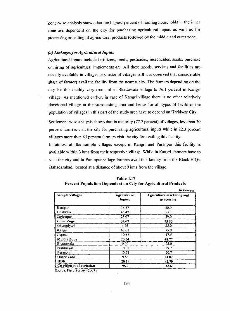
Zone-wise analysis shows that the highest percent of farming households in the inner
zone are dependent on the city for purchasing agricultural inputs as well as for
processing or selling of agricultural products followed by the middle and outer zone.
(a) Linkages for Agricultural Inputs
Agricultural inputs include fertilizers, seeds, pesticides, insecticides. seeds. purchase
or hiring of agricultural implements etc. All these goods. services and facilities are
usually available in villages or cluster of villages still it is observed that considerable
share of farmers avail the facility from the nearest city. The farmers depending on the
city for this facility vary from nil in Bhattowala village to 76.1 percent in Kangri
village. As mentioned earlier, in case of Kangri village there is no other relatively
developed village in the surrounding area and hence for all types of facilities the
population of villages in this part of the study area have to depend on Haridwar City.
Settlement-wise analysis shows that in majority (77.7 percent) of villages, less than 30
percent farmers visit the city for purchasing agricultural inputs while in 22.3 percent
villages more than 45 percent farmers visit the city for availing this facility.
In almost all the sample villages except in Kangri and Puranpur this facility is
available within 3 kms from their respective village. While in Kangri, farmers have to
visit the city and in Puranpur village farmers avail this facility from the Block H.Qs,
Bahadarabad. located at a distance of about 9 kms from the village.
Table 4.17 Percent Population Dependent on City for Agricultural Products
In Percent Sample Villages Agriculture Agriculture marketing and
Inputs processing
Rani pur 28.57 50.0 Dhalwala 45.47 53.3 Jagjeetpur 28.07 59.0 Inner Zone 34.67 55.90 Ghungtiyani 4.76 25.0 Kangri 67.01 75.0 Jiapota 10.88 47.5 Middle Zone 23.64 48.77 Bhattowala 0.00 25.0 Pratitnagar 10.08 29.7 Puranpur 10.71 20.7 Outer Zone 9.65 24.02 HDR 20.14 42.79 Co-efficient of variation 95.7 43.6
Source: FJeld Survey ( 2003 i
193
(b) Linkages for Marketing Agricultural Products
Marketing of agricultural products include all types of output from the farm. It
includes grains, oil seeds. vegetables, fruits. flowers. sugarcane etc. About 42.79
percent farmers are dependent on the city for marketing of their agricultural products
to the city while remaining either sell their products within the village or sell it in
some other villages.
Again, there are zones-wise as well as settlement-wise variations in percent farmers
travelling to the city for selling agricultural products. Table 4.17 shows that it varies
from 20.7 percent in Puranpur village to 75 percent in village Kangri. It is observed
that percent farmers visiting city is greater in villages located closer to the city as
compared to villages situated relatively far from the city. The percent share of farmers
travelling to the city is very low in Bhattowala, Ghungtiyani, Pratitnagar and Puranpur
villages. On the other hand, it is high in Jagjeetpur, Ranipur and Dhalwala villages.
However, Kangri and Jiapota villages are exceptions, even though these villages are
about 8 kms i.e. in the middle zone in terms of distance but still significant percent
share of farmers sell their products in the city, as there is no primary market or other
facilities within or near by villages and existing gap in prices lure the farmers to sell
their products in the city. Good road conditions further accelerate and encourage
them to travel to the city. as both the villages are located along the highway.
Another important feature observed is that the agricultural input has greater co
efficient of variation in terms of percent farmer households dependent on the city as
compared to the percent farmers dependent for sale and processing of agricultural
produce which shows relatively lower co-efficient of variation.
4.4.4 (iv) Political, Administrative and Organisational Unkages
These types of linkages are very important in studying the pattern of existing rural
urban relationship. Travel to the city is inevitable for administrative services as the
city also represents the tehsil and district HQs. Although the frequency of the visit to
the city varies but people do travel to the city to avail facilities of tehsil for land
records, revenues, registries; to court for judicial services, domicile and other type of
certificates etc.
194

In the region. about 79.31 percent households visit the city (in the last six months) for
administrative services. Relatively lesser inter-zonal and inter-settlement variations
are observed for these ser-Vices. However. it ranges from 64.29 per<:ent in Kangri to 98
percent in village Jiapota. The co-efficient to variation is very less i.e. 13.49 for
administrative or organisational services, as most of the households in the reg1on
travel to the city for availing any of the above mentioned services.
4.4.4 (v) Financial Facilities
Two types of banks usually operate in rural areas; they are commercial banks or
specialised banks.
Commercial banks accept deposits and advance loans. Specialised banks such as
agricultural development bank generally advance loans only to fanners.
It is observed that four out of the total nine villages have banking facilities within the
village while in the remaining five villages, four have this facility within 5 kms from -
the village and only one village Puranpur has nearest bank at a distance of about 10
kms from the village. Field observations show that 85 percent of households have
banking facilities within walking distance of 3 k.ms from the village. Hence,
dependency of these villages on the city for financial purposes is comparatively low.
It is observed that about 16.60 percent households use banking facilities in the city,
while the remaining households either avail this facility in the village or in the nearby
village. There are variations among settlements in using banking facilities in the city.
It varies from nil percent in Jagjeetpur and Jiapota villages to 42.86 percent in
Ghungtiyani village. Both the villages are located in the middle distance zone. About,
29 percent households of village Dhalwala and 28 percent households of Pratitnagar
use banking facility in the city although both the settlements have the facility within
the village.
4.4.4 (vi) Social Interaction
Social interaction linkages include visiting patterns of the rural population to the city
for social gathering, meeting relatives. kins and friends. visits to the city for religious
activities (rites, rituals. fairs. festivals. bathin2: occasions as both Haridwar and
Rishikesh are religious centres) and for entertainments (cinema, theatre. circus etc.)
195

(a) Religious Activities
As mentioned earlier Haridwar and Rishikesh are well known Hindu pilgrim centre.
obviously large population from surrounding villages visit the city for religious
activities, like fairs. festivals, major bathing occasions and for rites and rituals.
It is observed that 94.04 percent households visit the city for religious ceremonies, of
which 56.67 percent prefer exclusively Haridwar followed by Rishikesh (16 percent),
while 15.33 percent inhabitants visit both Haridwar and Rishikesh depending on the
nature of occasions. On the other hand, the remaining 6 percent households visit
Roorkee, and majority of them are Muslims who visit the Piran Kaliar (a famous
muslim shrine near Roorkee ). About 6 percent households do not go to any city for
these activities.
(b) Entertainment Linkages
Rural inhabitants· visit the city for various types of entertainment activities like
cinema, theatre, circus or sometimes exhibitions held in the city. Visits to the city for
these purposes determine the entertainment linkages.
Analysis of the data shows that only 32.30 percent households visits the city for
entertainment, while 67.70 percent do not go anywhere for entertainment.
It is interesting that majority of rural population considered cinema as the major
source of entertainment. But with the availability of T.V. sets in almost every home
and cable connections. dish antennas and VCDs in every village, the inhabitants do
not prefer to go to movie halls in the city. Rather they prefer to watch them on
VCR!VCD which are available in almost all the villages.
However, settlement-wise analysis shows variations, it ranges from 20 percent in
Bhattowala to 57.14 in Kangri village. It is observed that villages that are relatively
nearer to the city (Dhalwala, Ranipur and Jagjeetpur) have a comparatively larger
percent population visiting the city for entertainment as compared to the villages
Bhattowala, Pratitnagar and Puranpur that are far villages of the outer zone.
196

(c) Social Gathering
Social linkages mean maintaining social ties with the population in the city. social
gatherings. visits to meet relatives. friends. attend ceremonies. functions and
marriages etc.
About 55.50 percent of rural households from the surrounding region has social links
with the city while 44.50 percent have social relations only within or in near-by
villages. However, the percent of households visiting the city for social gatherings
varies from village to village. It ranges from 28.60 percent in Ghungtiyani to 80
percent in Rani pur village.
4.4.5 Overall Interaction Index
An overall interaction index is calculated showing the intensity of interaction of
villages with the city based on the above variables discussed types of linkages in the
chapter. (Based on various order of goods and services and types of linkages). The
index is calculated using all the above-discussed variables, these variables are
standardised and assigned weights. The interaction index is calculated to have a single
score for each settlement by combining various types of facilities for which tbe rural
areas are dependent on the city. In all. 20 sub-types of goods and services have been
identified under four major heads (Table 4.18).
Taking into consideration the type of facilities their importance in terms of use. each
facility/sub-facility is assigned weights. The weights are assigned out of the total
value as hundred. The weighting diagram of index of interaction is shown in table
4.18. Amongst the major facilities the highest weights are assigned to higher order
goods and services. These individual values are summed up to derive a single
composite score. The sample villages are then categorised as having high. medium
and low level of interaction based on the scores in the interaction index.
197

Table 4.18 Weights Assigned to Various level of Goods and Services
for Calculating Interaction Index
Level of Goods & Purpose of Visit Weights Sub-Weights Services Lower Order Goods Grocery I
Green grocery I Flour mill 5 I Fuel 1 Stationary I
Lower Order Services Barber I Tailor I Cobbler 5
I Studio 2
Higher Order Goods Tell:tiles 10 Leather goods 10 Purchase of Agricultural Inputs 40
10 Jewellery 10
Higher Order Services Education 10 Health 10 Sale of Agricultural Products 10 Financial 40 3 Administative 3 Social 2 Religious 2 Economic (Occupational Dependency) 10 10
Source: F1eld Survey (2003)
4.4.5 (i) High Level of Interaction
-·
Four of the nine villages have high level of interaction with the city. Ranipur has
highest interaction followed by Dhalwala and Jagjeetpur villages. These three villages
are located in the inner distance zone and are adjacent to the urban boundary, while
Kangri village is located 8 kms from the city along the Haridwar-Nazibabad highway.
Village Ranipur is engulfed by Haridwar and BHEL on the one side and Bahadarabad
(block HQs) on the other. It lies adjacent to the Bahadarabad industrial unit which is
being developed and encouraged as an industrial centre. Ranipur village lacks in
basic facilities like hospital, primary school, shops or market for basic items. Hence,
people are dependent on the city for all their needs from lower order goods and
services like ~ocery. stationary, tailor, barber to higher order goods and services like
leather items, jewellery, utensils, health care, education and banking facilities.
Moreover, the city is only 2 kms from the village and more than 75 percent heads of
households are engaged in economic activities outside the village. The BHEL
198

Industrial Township was carved out from this village and the land of the inhabitants
was acquired in 1960 and jobs were given to the villagers as compensation for their
acquired land. Also industrial development is taking place in surrounding villages
that has led to increased share of workers in secondary sector. Finally. it can be
analysed that Ranipur village has highest intensity of interaction with the city.
Table 4.19 Level of Interaction in Sample Villages
Level of Interaction Villages
High Ranipur. Dhalwala, Jagjeetpu and Kangri
·Medium Jiapota and Ghungtiyani Talli
Low Bhattowala, Pratitnagar and Puranpur
Source: F1eld Survey {2003)
In Dhalwala and Jagjeetpur villages too. the intensity of interaction and relationship is
very high as both the villages are located adjacent to Rishikesh and Haridwar.
respectively. Hence, the influence of the city is relatively higher. On one hand, the
rural population utilises the job opportunities provided by the city which further
increases the interaction with the city. Moreover. these villages provide cheap land for
residential and commercial activities to the people who cannot afford high prices and
rents in the city.
Both the villages partly fulfill the criteria of urban as per the census definition i.e.
population of the village is more than 5000 persons, population density is more than
400 person per sq. km. and more than 75 percent population is engaged in non
agricultural activities. These villages have a well developed market facilities, schools
and private health care facilities and bank. In spite of this, large proportion of
population prefers to visit the city for all type of facilities.
In case of Kangri village, the level of interaction is very high on account of non
availability of basic facilities like education. healthcare and market facilities in and
around the village, which can cater to all the needs of the villages. Therefore, the
village is totally depended on the nearest city. Haridwar. Secondly. this village is
located on the state highway and has satisfactory availability of public transport
facilities. Moreover. about 52 percent population of the village is engaged in city
based non-agricultural activities and about 37.5 percent workers travel to the city
daily for work (Table 4.13).
199

Fig 4. 6
TYPES OF INTERACTION BETWEEN CITY & SURROUNDING AREAS
........ . . . . .. . . . .
\ ,.. . . .
I • • • • • • • . . c
. . . . . . . l•:t" . . . .
I ........ .. . . . .. . . .
In
T . " .......
y I
.,. ....... . . .
-. . .
.... . . . . . . . .
Physical Linkages Road Network Condition of road Mode of transport Availability of public/private transport Distance from the city Market facility
PHYSICA L LI NKAGES
POPULATION LINKAGES
ECONOMI LI NI\. AGES
SOCIAL u iNKAGES
SERVICES LI NKAGES
POLITI CAL & ADM. LINKAGES
~
Population Linkages Journey to work Other travels Economic Linkages Market pattern
. ........ . . . . . . . . . . . . . ......... . . . . . . . . . . . . . . . ....... . . . . . . . .......
...... ·: . . . . . . . . . . . . . . . ........
' '
' ... ~
~
... ~
41111
... 41111
I '
/ . ~
Flows of raw materials & intermediate goods Capital flows Consumption & shopping pattern
200
'. '· Surrounding
' ' areas
' ' . • ... ... '. ' ' ~~., ....... • ~ L • ' •
• ' ' ' • \ ). \ ... \ \
41111 ~··········· ·. \ ... \ \ \
I ...
... I ~······ · · · · · · I I ... I I
I ... . • ... I I I .. ~ ............ .I I
I I I
I / •
... ~ . I ~ · / . ... . ~············
/ / Surrounding areas
/ / , /
Social Linkages Kin$ship, Rites & Rituals Religious activities & Entertainment Service Delivery Linkages Credit & Financial Education & Health Political, Administrative & Organizational Linkages Tehsil , District head quarters , Judicial services and other services

Thus. Ranipur. Dhalwala. Kangri and Jagjeetpur villages are categorised as villages
having high intensity of interaction with the city.
4.4.5 (ii) Medium Level of Interaction
Two villages, namely, Ghungtiyani Talti and Jiapota are categorised as having
medium level of interaction with the city. Both the villages are located in the middle
zone and are on the highways. Village Ghungtiyani Talli is located along Rishikesh
Devprayag highway and Jiapota village on Haridwar- Laksar highway.
It is observed that both the villages have basic facilities of education, health and
banking within or near the village. white for higher order goods and services they
have to travel to the nearest city.
In case of Ghungtiyani. this village is situated about 5 kms from Rishikesh city and
has medium level of interaction with the city. Field observations reveal that the
village lacks all the basic facilities like market facilities, shops for basic requireme!lts
and services like health and education, however, all these facilities are available in the
near-by village Tapovan. Therefore, a medium level of interaction is found between
the village Ghungtiyani Talli and the nearest city (Rishikesh). The village has only
35.5 percent population engaged in primary activities while 64.5 percent population is
engaged in non-agricultural activities. The population in primary sector has been
decreasing since 1971 while the share of population engaged in non-agricultural
activities is increasing steadily. More and more percent of population is looking
towards the city for employment opportunities.
Analysis of the field data shows that in case of Jiapota village, comparatively longer
distance, infrequent availability of public transport, no direct transport facility to the
city and higher travel cost has resulted in medium level of interaction with the city.
While on the other hand, in case of Ghungtiyani Talli village, availability of almost all
the goods and services in the nearby village Tapovon has led to the medium level of
interaction with the city.
It can be concluded from the above analysis that the presence of alternative growth
centres where aU types of facilities required by the population are available, can
reduce the pressure and dependency of the rural settlements on the city.

4.4.5 (iii) Low Level of Interaction
Field observations have contir:med that the distance play determining role in rural
urban linkages. Analysis of the data shows that three villages (Bhattowala. Puranpur
and Pratitnagar) have low intensity of interaction with the city. It means that
frequency of visits and dependency on the city is relatively lower and it is mainly for
higher order goods and services that are not available within or in nearby villages.
Analysis of the data shows that all these settlements are located more than 1 0
kilometers from the city. Pratitnagar is situated along the Haridwar-Rishikesh
highway. It is equidistance both from Haridwar and Rishikesh. On the other hand,
Bhattowala and Puranpur villages are located at a distance of, 3 and 9 kms interior,
away from main road, respectively. This stretch of road is un-metalled and seasonal.
There is no direct public transport facility available from these villages to the city.
People of Bhattowala village have to cover this distance, (from village to the
highway) on foot or use private mode of transport to reach the highway from where
public (intermediate) transport is available; while for Puranpur village, a temporary
arrangement known as 'Jugaad' is available to reach Bahadarabad from where other
modes oftransport are available to reach the city'. In both the villages, the availability
of transport facility to reach the city is unsatisfactory, infrequent and hence not
dependable.
Thus, it can be concluded that accessibility is very poor which leads to lower level of
interaction of these villages with the city. Both these villages lack basic facilities of
health, education and financial (bank and credit) services but still the frequency of
visit to the city is low because majority of inhabitants in both the villages visit other
near by villages for essential items and depend on the city only for occasional and
especially for purchasing high order goods and services and for services that are not
available even in the near-by villages. Moreover, both these villages Bhattowala (64
percent) and Puranpur (66. 7 percent) have significant percent of households engaged
in agricultural activities.
Majority of population of Bhattowala village depends on another near-by village
Shyampur, while people in Puranpur village rely on the Block H.Q. Bahadarabad for
all types of facilities. Both these villages (Shyampur and Bahadarabad) are well
202

developed with all the facilities available within the village and have comparatively
better accessibility in terms of transport facilities.
Pratitnagar has an altogether different reason for having low level of interaction with
any of the cities. It has high population growth. very well developed market facilities
(It has about 400 shops of all varieties). All t)rpes of goods and services and facilities
are available within the village and so even if accessibility in terms of intermediate
mode of transport is available, the villagers visit to the city only to avail very high
order goods and services or for occasional shopping. The village has more than 82
percent of workers engaged in non-agricultural activities within the village. Only 10
percent of inhabitants are dependent on the city and commute daily for work.
Raiwala cantonment is located adjacent to the village which provides employment
opportunities and also influences the economy of the village. Most of the shops and
other business establishments cater to the population in the cantonment as it is the
only nearest market. The cantonment is dependent on the village for all types of basic
necessities like groceries, Dairy products, vegetables and other requirements etc.
The village has well-developed infrastructural facilities and sufficient employment
opportunities within the village.
Analysis of the data on dependency of the villages on the city has shown that if the
basic facilities are provided within the villages then the frequency of visit to the city
can decrease significantly which on the other hand, can help to ease the pressure on
the two sprawling cities. As it is not possible to provide the entire infrastructure and
other facilities in each village; hence, it is suggested to develop certain villages as
growth centres.
On the basis of the pattern and intensity of interaction of settlements among
themselves five rural settlements are identified as growth centres during the study.
These are Shyampur Nuabad, Bahadarabad, Jagjeetpur, Shyampur and Tapovan. All
the above villages are relatively more developed have basic facilities of health,
education, finance etc. and thus can be developed as growth centers for the region
(Map4.3).
203
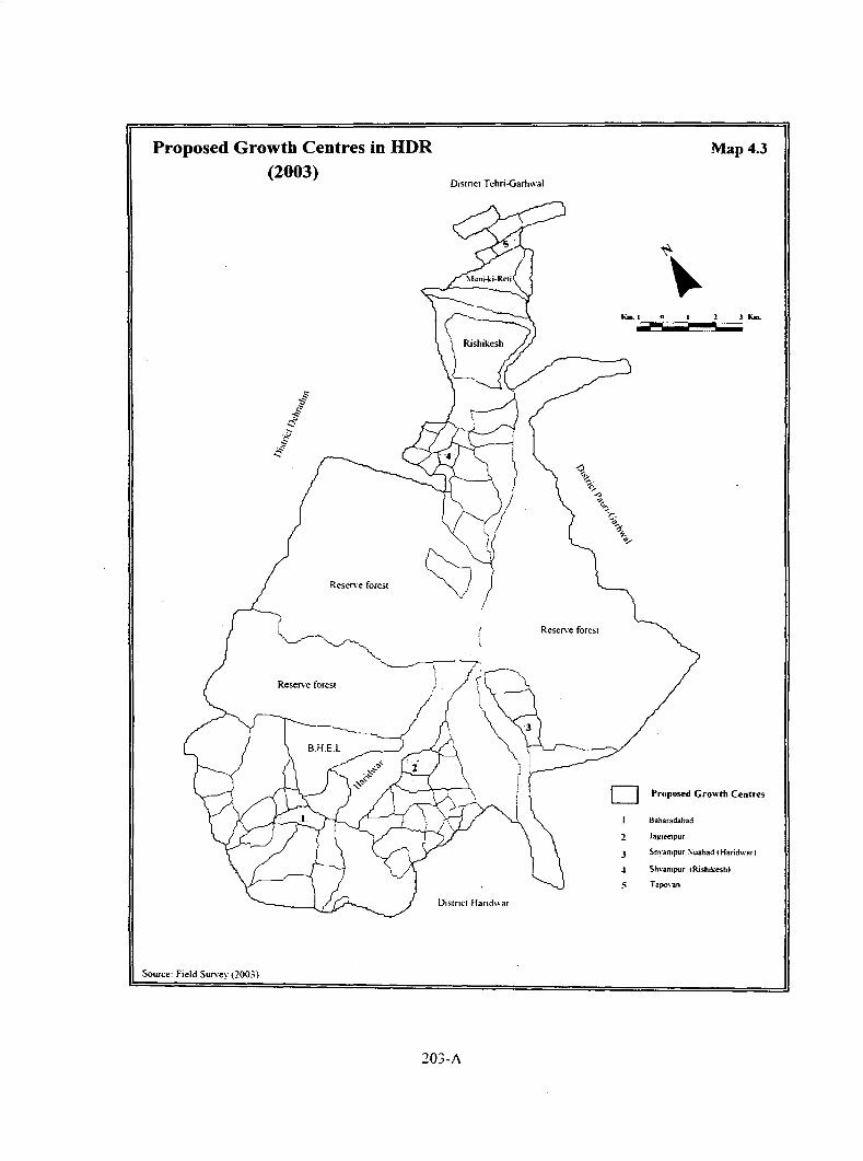
Proposed Growth Centres in HDR (2003)
Reserve forest
Reserve forest
Source: Field Survey (2003)
District Tehri-Garhwal
Reserve forest
Disrncr Hand\,ar
203-A
Map 4.3
D Proposed Growth Centres
Baharadabad
2 Ja!f_leetpur
3 Shyampur ~uabad f Haridwan
.J Shvampur !Rishikeshl
5 TapO\·an

4.4.6 Interdependence of Level of Interaction and Its Determinants
After calculating the interaction index for sample households in the study area. an
attempt has been made to determine the relationship among the interaction index and
its determinants (factors affecting the level of interaction). For this analysis. I 7
variables have been selected and simple correlation co-efficients have been worked
out. Table 4.20 shows that interaction index (intensity of interaction) has negative
correlation with distance from the city and this relation is highly significant at 5
percent level. It implies that the distance from the city plays an important role in
determining the level of interaction between two settlements. The areas located near
the city have higher interaction with the city as compared to the villages located
comparatively far from the city.
Level of interaction is negatively correlated with the travel cost or money spent in
each trip to the city, and this relationship is highly significant at 1 percent level. This
shows that the amount spent to reach the city is also an important determinant of
interaction. The higher the money spent in each trip the lower will be the level--of
interaction between two settlements and vice versa. This is more true for lower order
goods and services as the cost of these goods is relatively low and thus extra
expenditure on travel will further increase the cost and hence it would not be
beneficial for people to travel for longer distances for these items. Thus, it is observed
that accessibility in terms of distance as well as travel cost are the two important
factors governing the level of interaction between settlements. Level of interaction has
positive correlation with sex ratio but this relationship is not significant.
Level of interaction has negative correlation with percent population engaged in
agricultural activities. It implies that in the settlements having higher linkages with
the city, the percent population engaged in agricultural activities is lower and vice
versa.
Level of interaction has positive correlation with percent population engaged in non
agricultural activities. It implies that the areas having relatively higher interaction
with the city have comparatively higher percent population engaged in non
agricultural activities. It shows that influence of the city and of urbanisation on the
settlements having higher interaction with the city is greater than on the areas having
comparatively lower interaction.
204

Table 4.20 Interdependence of Level of Interaction and Its Determinants
Index GR Den SR WPR
Index I
Gl{ 0.217 I
Den -0.039 0.194 I
SR -0.46 -0.559 -0.271 I
WPI{ 0.168. 0.399 -0.487 -0.583 I
Agri -0.478 -O.IOo -0.46o -0.001 0.553
Non_Agri 0.478 0.101> 0.466 0.001 -0.553
Supp_Occ -0.092 -0.231 -0.227 .()()47 0.1!\4
c:_occ .729•• 0.003 -0.48 .()()01 0.159
llil·_ On· .720 .. 0.166 0.171 -.792•• 0.331
I'CE 0072 -0.373 0.147 .729** -.917 ..
Grad 0.116 -0.122 0.508 0.272 -.761**
Tni 0.405 0.019 0.411 0.156 -.738**
llnth O.'ill4 -0215 0.294 0 172 -0.(109
l'ucru -0.117(1 -O.N 0.337 ()2<)2 •.695•• ··-
Slnl"~l (I -Ill -11 Oll2 0.208 -0.217 0.068 ______ ... _ lli~t -.8•11•• -11 123 -11215 0.521 -0.054
T_(·n\l -.?H•• -O.t24 -0.175 0 374 -0.082
Sotm.:c t\·nsus or India and field ohscrvation
• and •• arc ;.tgtHtkant at lUll %and 0.05 %, level of significance level.
i\'11/t•:
lndC\ - l.ci'CI of interaction < iH • < i1111 th rate I kll · "''fllllilllllll d,·n<it~ SR -\n ra11o WI'R - Wor~ participation ratio Agri ·'!!,,Workers in agriculture m:tivities Non_agri • '!!,, Workers in non-agriculture nctivitics Supp __ occ • oy,, llouscholds huving ~upplcmentnry occupation t ·_<lee • 'X.l'hnngc in occupation
Agri Non Supp_ C_Occ Div Agri Occ Occ
I
-1.00** I
0 195 -0.195 I
-0.413 0.413 -0.048 I
-0.147 0.147 0 194 0.335 I
-0.504 0.504 -0.169 0.077 -0.434
-O.oo2 0.062 -.697** O.oJI -0.185
-0.!\41 0.641 -0.309 ()181 0.136
-.XI> I** .861** 0.125 0.515 0.251
-.682** .682** -0.199 0.102 -0.163
-0.575 0.575 014 0.414 0.291
0.428 -0.428 0.276 -0.554 -.814 ..
0.384 -0.384 0.57 -0.548 -0.574
Div _ Occ- Level of occuplllionnl diversification PC I'- Average monthly per capita expenditure Urad - Percent graduates Toi -'X, llouseholds having closed toilet li1cilities Bath - •y,, llouseholds having hnthromn li1cilities l'ucca-% llouscholds having pucca houses Storey - % llouseholds having multistory Dist- Distance from the village to the city T_cos\- Travel cost to reach the city
205
PCE Grad Toi
I
.693** I
.759** .734** I
0.59 0.46 0.653
0.591 .723** 0.406
-0.187 ().()35 -0.157
0.089 -0.278 -0.462
0.102 -0.396 -0.342
Bath Pucca Storey Dist T_Cost
I
0.575 I
0.536 0.306 I
-0.457 -0.026 -0.337 I
-0.317 -0.042 -0.367 .913** I

The interaction index has negative correlation with percent area under cultivation. It is
noticed that the settlements having higher interaction with the city. have
comparatively lower percent area under cultivation. putting more and more land under
non-agricultural uses. like. residential. commercial and industrial.
The level of interaction has positive correlation with average monthly per capita
expenditure of each household. It implies that the settlements having higher
interaction with the city have comparatively higher per capita expenditure (PCE). This
relationship confirms the impact of the city. influence of urbanisation and urban way
of life on rural population in the settlements. The higher interaction of the villages
with the city influences the attitude of the rural population. They appreciate the
modem and urban way of life, become more interested in non-agricultural activities.
Moreover, the increasing land prices and decreasing land holding lure the farmers to
sell their land, and accept non-agricultural occupations. Increased impact of the city,
sale of land and population growth in the region has decreased the cultivated land.
4.5 Dependency of Urban Areas on Surrounding Rural Region: A Case Study of
Haridwar City
The city is dependent on surrounding villages for a variety of goods and services. The
rural area provides food grain. dairy products, animal products like eggs & meat,
flowers. fruits and vegetables. fodder for animals. building, construction materials and
other goods to the city. The city also depends on the surrounding areas for raw
materials for industries, finished goods from cottage industries in the villages, other
consumable items.
In this section, an attempt is made to examine the dependency of Haridwar city on the
surrounding rural region. Haridwar city entertains more than 5 million floating
population every year. So. the surrounding rural areas not only cater to the needs of
the inhabitants of the city alone but also of the population visiting the city on various
occasions round the year.
After listing of all the establishments of the city, about 150 establishments showing
dependency on the rural settlements for variety of goods and services were selected
for the analysis.
206
4.5.1 Dependency on Rural Settlements for Milk and Agricultural Products
There are about 150 registered dairies in the city. out of these 8 milk dairies and milk
collectors were interviewed at various locations in the city. It was analysed that the
total demand of milk in the city is about 95.000 liters per day. However. the demand
of milk ranges 1,10,000 liters in summer season to 80,000 liters in winter season.
Almost all the villages of the region supplies milk to the city. However. there are
inter-settlement variations in quantity of milk supplied to the city. Analysis of the
dependency of the city on the surrounding rural region for milk and other milk
products shows that, as the demand of these goods is very high, the adjoining region
alone is not able to fulfill this demand and hence the milk is supplied to the city from
as far as 50 kms distance. Field observations show that the study region contributes
only a small proportion {11.21 percent) and most of the milk comes from distance
places.
However, most of the milk from this study region comes from Kangri. Shyampur and
Gajiwali in south-east, Jagj~etpur. Ranipur. Jiapota in the south and Puranpur.
Salem pur Mehdood and Rawali Mehdood in south-west part of the region.
Field observations also reveal that a significant proportion of milk supply also comes
from the forest villages located in the study area. Majority of population in these
villages constitutes of Gujjar population who have traditional occupation of keeping
livestock.
Dependency of City for Poultry, Vegetables, Cereals, Flowers, etc.
As discussed earlier, the Haridwar city is sacred place of Hindus and hence the sale of
liquor and animal products like eggs. meat etc. is prohibited in the city. However.
field observations revealed that they are consumed in significant proportion in the
city. Thus, the surrounding rural villages cater to the demand of these items for the
city. Liquor shops located in Jagjeetpur. Bahadarbad. Ranipur and Pratitnagar villages
have significant proportion of sales for the city. Similarly, a number of poultry farms
located especially in the villages in Rishikesh tehsil caters to the demand of eggs and
meat for the residents of the city.
The city also depends on the surrounding rural region for seasonal vegetables. The
district vegetable mandi itself is located in Sitapur Majra village south of Haridwar
city. Field observations reveal that although most of the vegetables come from as far
207

as Himachal Pradesh and hill districts of Uttaranchal. however, about 5.5 percent of
the vegetables auctioned in the mandi daily come from the villages in the study region
(Table 4.21). Most of these are seasonal vegetables like raddish, cauliflower. tomato,
gourds, peas, beans, onion etc.
Dependency o Goods/Services
Milk & milk products
Cereals
Vegetables
Flowers
Commercial vehicles
Building/construction materials
ity on ora Areaso Table 4.21
fC' R fiiDR Percent Demand
11.21
6.30
5.50
2.00
23.00
48.58
Finished products from small-scale industry 68.64
Source: F1eld survey (2003)
Survey of the wholesale cereal market located in Jwalapur shows that about 6.30
percent of the total cereals is supplied by the villages of the region, while the
remaining comes from the rural areas beyond the region. The main cereals are wheat,
maize, paddy etc.
As mentioned earlier, Haridwar is an important Hindu religious center of the country,
hence, the demand for flowers is very high. The region provides only a marginal share
(2 percent) which comes from the villages located along Haridwar-Laksar highway.
These are Jagjeetpur, Missarpur Ahatmali, Devpur Mustakam, Garowali. Ajeetpur
villages etc. all these villages have fertile soils and better surface irrigation facilities.
Thus. the irrigation facilities and location of these villages along the highway
facilitate floriculture in these villages.
Fodder for Livestock
Field observations reveal that the city is also dependent on the rural areas for fodder.
About 90 percent of the total demand of fodder for the livestock population of the city
comes from the region. Rani pur, Jagjeetpur, Jiapota, Kangri are the main villages that
caters to most of this demand of green fodder, hay etc.
208

4.5.2 Dependency for Labour
The city provides great employment opportunities for the surrounding rural region. It
is dependent on the rural areas for both skilled and unskilled labour. Field
observations show that most of the skilled labour comes from Ranipur. Jagjeetpur.
Bahadarabad, Rawali Mehdood villages while un~killed labour comes from almost all
the villages of the region located adjacent to the city and along major highways. Most
of the skilled labourers work in industries, restaurants, automobile and repair shops
. etc. while the unskilled labourers are employed mainly in construction activities come
from the villages located adjacent to the urban boundary or from villages along the
highway as it is easier for them to commute to the city for work. Field observations
show that most of these labourers are from Jagjeetpur. Jiapota, Missarpur. Kangri.
Bahadarabad, Sitapur, Rawali Mehdood etc.
Moreover, majority of people working in informal sector, especially the hawkers.
vendors, shopkeepers of temporary shops, built during the fairs and bathing occasions
are also from the rural areas of the region.
4.5.3 Dependency for Commercial Vehicles
Apart from being an important religious center and transit point for transfer of goods
to and from the hills. the city is also the starting point of the 'Char Dham Yatra' in the
hills. Hence. the demand for commercial vehicles like tractors and trolleys. trucks.
buses, cars, lorries etc is very high. Field observations show that about 23 percent of
commercial vehicles are provided by the inhabitants of surrounding rural region.
The rural people especially the farmers of villages adjoining the city have sold land
and invested in the commercial vehicles which can be observed by the fact that about
2 percent of the households in the villages of the inner zone have commercial
vehicles.
4.5.4 Dependency for Building/construction Materials
Field observations reveal that the building and construction activities have shown
significant increase after the formation of HDR. Haridwar as district HQs and more
recently formation of Uttaranchal as a separate state. The city has great demand for
bricks, cement!- concrete. sand etc. Since. most of the brick kilns and stone crushers
209

have been shifted out of the city. hence. dependency of the city on the surrounding
rural region has gone very high.
Field observations show that about 49 percent of the demand of the city of all the
construction materials is provided by the region while the remaining -comes from the
rural region ofNazibabad, Bijnor and Roorkee tehsils.
The city also depends on the surrounding area for bamboo, 'phoose ' san and 'baan'
used for making ropes etc. It comes from the villages located along the Ganga river
and seasonal rivulets like Rani Rao, Pathri Rao. Majority of supply is from Puranpur,
Salampur Mehdood, Ajeetpur, Devpur Mustkam. Kangri etc where large area along
these river channels supports growth of this grass.
4.5.5 Location of Various other Activities
During the field survey it is observed that the city uses the surrounding rural area for
activities which need more space and are not conducive in the urban environment.
Hence, their activities are preferred to be located in the rural areas where the land
price and rental value is relatively cheaper.
Field observations show that these type of activities are already coming up in the
villages surrounding the city. One sewerage treatment plant located in Jagjeetpur
village is already working while the other in Sarai village is under proposal. Numbers
of godowns. warehouses, automobile service centres are located in villages of the
inner zone and also in villages located along the highway as these locations provide
easy accessibility to the city. These activities are mainly concentrated in Jagjeetpur.
Sitapur Majra, Bahadarabad, Ranipur. Haripur Kalan villages along Haridwar-Delhi
and Haridwar-Rishikesh Highway.
4.5.6 Raw Materials and Finished Products
The city is dependent on the rural industries which provide various industrial goods
and raw materials to the city. Field observations show that small scale and household
industries, making toys. 'Kawar ', 'Doona '. sweet boxes, Ganga Jali are located in the
surrounding rural areas of the region and cater to the demand of the city.
210
Haridwar beino relioious center. the demand of such items is very high and about 0 0 .
69 percent of the demand of the city is fulfill by the surrounding region while the .-·~
remaining items come either from the city or from the rural areas beyond the region.
4.5. 7 Dependency of City for Education Facilities
As discussed earlier. it has been noticed during the field survey that most of the
education institutions especially the public schools are shifting to the surrounding
rural areas adjacent to the city. As these institutes are becoming more sepcialised and
offer a variety of other extra curricular activities like horse riding, swimming, skating
and also day boarding or hostel facilities along with academic curriculum and hence
they require large area to meet these demands. As large areas and vacant land is not
available within the city. Hence, these institutes are shifted to the surrounding rural
region especially the inner and middle zone where the land value is relatively lower in
these areas. Five out of the total twenty senior secondary and high schools in
Haridwar city are located in the rural areas. and three have already purchased land al)d
are planning to shift to these rural areas in near future. The most preferred villages for
these institutions are Jagjeetpur, Devpur Ahatmali, in the south-east, Bahadarabad.
Sitapur Majra in the south and Haripur Kalan in the north of Haridwar city. All these
villages area adjacent to urban boundary or along major highway which provide easy . accessibility. Two schools are surveyed and it is observed that about 92 percent of the
students enrolled are from the urban areas.
All these schools were located in the city earlier and have moved out only after the
formation ofthe region.
4.5.8 Development of Residential Colonies
The population of the city has increased tremendously since 1970's. The population
density of the city has increased from 6656 to 11635 persons per square kms. in 1971-
200 l. Thus,. it is observed that increase in population of the city has resulted m
increase in demand of land, which leads to rise in land prices and rental values.
As land is a fixed resource. thus increase in demand for more houses and resulted rise
in land prices has led to the expansion (over-spilling) of the city towards the
surrounding rural areas.
Field observations show number of residential colonies are coming up in villages
adjacent to the urban boundary. lt is observed that the distinctions between the rural
211

and urban areas are invisible in these areas. The villages which are serving as
absorbing areas of the over spilling city are Jagjeetpur, Devpur Ahatmali, Jamalpur in
south-east; Sitapur Majra, Bahadarabad, Jamalpur Kurd and Sultanpur Majra in
southern part and Haripur kalan in the north of the city. Similar development is also
seen in Roshanbad in the west of the city where the residential colony is developed
for the government officials. Field observation showed development of three such
new residential colonies in Devpur Mustakam village where majority of people
belong to old part of the city.
Hence, it can be concluded that the city is dependent on the surrounding rural areas
not only for agricultural products, labour etc but also for relatively cheap land for
residential and other commercial purposes to meet the needs of its growing
population.
4.6 Summary
The spatial pattern of interaction of the settlements in the region is measured on the
basis of Zipfs Gravity Model. However, as the level of interaction of settlements
based on this portrays only a broad pattern of the interrelationship between
settlements as it is considers only two factors distance and population. Hence to have ----further understanding of the pattern and intensity of interaction of the settlements in
the region, the commutation pattern of the rural inhabitants to the city and other
settlements for various goods and services has been studied using the primary data
collected during the field survey.
The existing network of the region has developed into a linear form from north-east to
south-west direction because of physical constraints, as the region is surrounded by
lesser Himalayas in the north and Shiwaliks in the west and east.
Analysis shows that the private conveyances used by the population are the most
important mode of transport for travelling to the city. However, the Government
facilities are negligible.
The cost of travel by private conveyance to the city is cheaper for shorter distance
while the public means of transport is more cost effective for longer distances.
212
About 40.6 percent households have to travel less than 2 kms to reach the city while
about 25.2 percent cover more than I 0 kms. About 60 percent of households visit to
the city at least once a week.
Dependency of the rural settlements on city for various facilities shows that highest
percent (88. 70) of households are dependent on city for healthcare services followed
by administrative facilities (79.31 percent) and social facilities (55.50 percent). About
38 percent of population commutes to the city for work. However, vast inter zonal and
intra zonal variation are observed
The co-efficient of variation is high for lower order goods and services as compared
to the co-efficient of variation for higher order goods and services.
Analysis of various types of linkages also shows wide inter-settlement variations.
However, the co-efficient of variation is highest in dependency on city for education
facilities, followed by the financial and economic linkages. On the other hand,
dependency on the city for healthcare facilities. administrative. sociaL religious and
entertainment services has relatively lower co-efficient of variation.
Field observations reveal the interdependency and relationship of the inhabitants of
the villages with the city for various types of goods and services shows that various
types of interactions are mutually inter-related and inter connected and affects each
other.·
Accessibility in terms of distance is an important determining factor for intensity of
interaction (between any two centres) especially for lower order goods and services.
However, physical factors like condition of roads, availability and frequency of public
transport facility, and economic factors like travel cost. inequality and disparities in
availability of goods and services. quality and variety of facilities available.
affordability and awareness of the population are other important factors determining
the level of interaction. These factors are more important in case of higher order
goods and services.
Analysis shows that the availability of marketing facilities within or in the nearby
villages and distance are important factors in gO\ cming the pattern of interaction.
They also influence the frequency and mode of transport used to travel to the city. The
frequency of visit to the city has positive relationship with the distance from the city
and modes of public transport facilities.
213
The dependency of rural population on the city varies for various facilities. The
highest co-efficient of variation for education, financial services and work and also
higher percent of households in the settlements of the inner distance zone depending
on the city for these services clearly shows greater impact (role) of the city on the
settlements that are closer to the city and thus importance of distance as the important
determining factor. Another reason is availability of all basic requirements within or
in the nearby villages. On the other hand, the co-efficient of variation is relatively
lower for health services. Analysis of the data has shown that the rural settlements in
the region have unsatisfactory health care services, moreover the government health
services are almost negligible and hence most of the population in all the rural
settlements irrespective of the differences in accessibility, occupation structure, class
and income levels depend on private health care services in the city. Analysis shows
that the presence of alternative growth centres where the required facilities can be
accessible for all the requirements of the rural population can reduce the pressure and
dependency of the inhabitants ofthe rural settlements on the city.
Inter-relationship of the intensity of interaction and its determinants shows that the
interaction has negative relationship with distance. travel cost. percent population
engaged in primary activities and percent area under cultivation while on the other
hand. sex ratio, percent population in non-agricultural activities and per capita
expenditure have positive relationship with the intensity of interaction.
The city is dependent on surrounding villages for a variety of goods and services. The
study reveal that Haridwar city is dependent on its surrounding villages for food
grains. dairy products. animal products. flowers, vegetables, fodder for animals.
build~g, co~uction materials etc. It also depends on the surrounding areas for raw
materials and intermediary products for industries. finished goods from cottage
industries of the villages and other consumable items.
The surrounding rural region also provides labour (skilled and unskilled) to the city in
various sectors. Most of the labours com~ from the villages located adjacent the ,--..., .....__
urban boundaries and along the highways.
Various education institutes are also shifting from the congested area of the city to the
surrounding rural region.
214

Many activities which are not conducive in urban environment or needs more space
are located in rural areas.
The surrounding rural area also serves as dumping ground for solid and liquid waste
disposal ofthe city. In some villages the facilities like godowns, warehouses. working
units and small scale industries are coming up. Many residential colonies have come
up in villages adjacent to the city.
1 Zipf, G.K (1949), 'Human Behavior and the Principal of Least Effort: An Introduction to Human Ecology', Addison-Wesley, Cambridge, Mass.
2 Llyod P.E and Peter Dickens, (1972) Location in Space: A Theoritical approach to economic geography, Harper and Row, 1972, New York.
Carrothers, G. A. P, (1956) 'An Historical Review of the Gravity and Potential Concept of Human Interaction' Journal of American Institute of Planners, Volume 24, pp. 94-102.
' Illeris Seven, 'Funktionella Regioner in Denmark Omkving 1960'. in Geografisk Tidsskrift, LXVI (1967), pp. 225-251, as discussed by Berry and Horton in Geographic Perspectives on· Urban Systems, (Englewood Cliffs, M.J Prentice Hall inc., 1970), pp.200-205.
4 Park, Robert E (1929). Urbanisation as Measured by Newkaper Circulation', American Journal of Sociology. Vol. 35, July, pp.60-79.
5 Reilly, William J. (1929) 'Methods for the study of Retail Relationship'. University of Texas 'Bulletin, No. 2944, pp.I-50.
6 Yeates, M. H (1968). ·Introduction to Quantitative Analysis in Economic Geography'Mc Graw Hill, New York.
215


![Craftingeek* pattern [ Corazón básico ] · Craftingeek*pattern [ Corazón básico ] Craftingeek*pattern [ Corazón básico ] Craftingeek*pattern [ Corazón básico ]](https://img.pdfslide.net/doc/110x75/5f04cca07e708231d40fc3ea/craftingeek-pattern-corazn-bsico-craftingeekpattern-corazn-bsico.jpg)