Embed Size (px)
Citation preview
CHAPTER - IV
Geology
95
GEOLOGY
General Statement
The geology of Bharatpur district has been studied in detail (Heron 1917,
1922; Fermor,1930; Pascoe,1965; Iqbaluddin et al.,1978; Parsad,1984;
Singh,1982,1985,1991. Geological information of Aligarh and Mathura
districts is rudimentary, Bajpai and Gokhale (1986); Khan & Joshi (1985);
Khan et.al. (1987); Anon (1993) and Iqbaluddin (1996b) provided brief
account of geology, but no published geological map is available for Aligarh
and Mathura districts. The geological map of Bharatpur district has been
published by Geological Survey of India (Anon, 1978).
The study area presents highly diverse rock types ranging from Precambrian
metasediments to recent alluvial cover. The part of study area in Bharatpur
district is technically, structurally and lithologically very complex and had
attracted many workers (Heron, 1917,1922; Fermor,1930; Pascoe,1965;
Iqbaluddin et al.,1978; Parsad,1984; Singh,1982,1985,1991). It comprises
rocks of Delhi Supergroup, Vindhyan Supergroup and Recent Quaternary
sediments. The Vindhyan rocks are exposed in the eastern part of the
Bharatpur district. The Great Boundary fault strikes NE-SW and passes
through Bayana and Rupbas tahsils. The Delhi rocks are wide spread in the
Bharatpur district and the best exposures are found near Bayana town in the
Bayana basin. Bayana basin extends as an isolated sequence of outcrops from
Bayana in the southeast to Nithar in the northwest over a strike length of
about 31 kms. The rock belonging to the Delhi Supergroup are also exposed
96
in the northern part of the district in Kaman, Parahi and Deeg tahsils. The
Aligarh, Mathura and central part of Bharatpur district presents almost a
uniform alluvial plain. The depth to bed rock has been reported at >30 m in
Bharatpur (Aggarwal, 1982), and 340 meters at Aligarh (Anon, 1977).
The stratigraphic sequence of the study area in Bharatpur district was
established by Heron (1917). He used the term "Purana Group" and "Delhi
System" and described the Bayana Basin under Alwar Series and divided it
into five distinct stages namely, Nithar stage, Badalgarh stage, Bayana stage,
Damdama stage and Weir stage, in descending order of antiquity. Pascoe
(1965) adopted the classification proposed by Heron (1917). Singh (1982;
1985; 1991) carried out detailed mapping in the Bayana Basin and proposed a
new stratigraphic succession. According to him basement rocks comprise Pre-
Delhi metasediments and metabasites and are overlain by Railo Group, the
oldest lithologic unit of Delhis in the area is the Railo Group, it is overlain by
AJwar Group and the Ajabgarh Group, which are separated by
unconformities, in Bharatpur district.
The rocks belonging to Vindhyan Supergroup have also been reported from
Bharatpur district in the south-eastern part. The exposures correspond to the
Rewa and Bhander groups represented by Lower Rewa Sandstone,
Gannurgarh Shales and Upper Bhander Sandstone. The Delhi Supergroup and
Vindhyan Supergroup in Bharatpur district are separated by Great Boundary
Fault striking NE-SW. The rocks of Delhi Supergroup lie to the northwest of
the fault and those of Vindhyan Supergroup to southeast of it.
97
The deposition of terrigenous elastics in the negative tectonic topography
during the Quaternary period is represented by the Older Alluvium Group,
Newer Alluvium Group and Recent Alluvium Group. The elastics were
supplied from the newly risen mountains of Himalayas in the north and
Vindhyan Plateau in the south.
Table - 15 presents the generalized stratigraphic succession of the study area
and Table - 16 presents the lithostratigraphic sequence of the Bayana Basin.
For purpose of Land System Studies the stratigraphy is presented under two
subheads, namely basement rocks and Quaternary Cover sediments.
98
Table -15 Stratigraphic sequence of the study area covering Aligarh, Mathura
and Bharatpur districts
Super Group Group Formation Quaternary Recent Alluvium Group -Banganga Recent Alluvium Formation
-Bharatpur Loam Deposit
-Yamuna Recent Alluvial Formation (YRA)
Newer Allmium Group -Yamuna Terrace Allmial Formation (YTA)
Vindhyan Super Group Bhander Group
Delhi Super Group
Older Alluvium Group -Aligarh Older Allmial Formation (AOA)
-Varanasi Older Allmial Formation (AOA)
UNCONFORMITY
- Upper Bhander Sandstone
- Gannurgarh Shales
Rewa Group
Ajabgarh Group
Ahvar Group
Railo Group
- Lower Rewa Sandstone
UNCONFORMITY
- Arauli Formation
- Bhakrol Formation
- Weir Formation
- Kushalgarh Formation
DISCONFORMITY
- Damdama Formation
- Bayana Formation
- Badalgarh Formation
- Jogipura Formation
UNCONFORMITY'
- Jahaz-Govindpura Volcanics
- Nithar Formation
UNCONFORMITY
Pre Delhi
Basement Rocks
99
Pre-Delhi Rocks
The basement rocks corresponding to Pre-Delhi's are exposed all along the
southern margin of the Bayana basin over which Delhi rocks lie
unconformably (Singh, 1982). The Pre-Delhi rock include schists, phyllites,
minor quartzite's and highly altered basic rocks (probably volcanics) which
have been cut by basic dyke e.g. near Madpur (Singh,1982). The
metasediments which have been described as Pre-Delhi by Singh (1982)
possibly represents the Delhi metamorphics (?) older than Bayana sequence.
Basement rocks are exposed in the areas, north of Bareja, south of Mangrain,
south of Tharhi Bat, north of Ballabgarh, near Gharri, Nithar and Aund.
Delhi Supergroup
The metasedimentary sequence referable to the middle Proterozoic, resting
over the Pre-Aravallis in the northeastern Rajasthan has been referred to as
Delhi Supergroup. The rocks of the Delhi Supergroup have been divided into
Railo, Alwar and Ajabgarh Groups in the Bharatpur district of Rajasthan
(Singh,1977,1982a,1982b).
The quartzite interbedded with phyllite and schists have been mapped as
Ajabgarh Group which are exposed in the Lalsot hills and continues
northwards as isolated hills around Kaman and Pahari areas of Bharatpur
100
district. These represent the northern most extension of Delhi Supergroup, the
distal exposures are seen around Barasana-Nandgaon in Mathura district and
around Dungrawan in Gurgaon district of Haryana, which continues
northwards into the Union Territory of Delhi.
The volcano-sedimentary sequence exposed in the Bayana basin which has
been correlated with the Railo and the Alwar groups by Singh (1982,1988)
deserve younger stratigraphic status than Ajabgarh Group. However the
stratigraphic nomenclature adopted by GSI (Anon, 1978) for the rocks of the
Mathura quadrangle (54 E) have been retained in the present write-up.
Lalsot Basin
The Lalsot basin extended from Lalsot in the south to Barsana-Nandgaon and
Pahari in the north-east. The rocks of the Lalsot basin represent Ajabgarh
sedimentation of the Delhi Supergroup. The beginning of the Ajabgarh was
characterized by regional down warping and eliminating interbasin barriers as
a result of which vast basin developed which extended upto Bharatpur in the
east and Barsana-Goverdhan and Pahari in the north-east, it continued
northwards through Haryana into the State of Delhi. This basin received
sediments in multi-lagoonal tidal flats. In the Lalsot basin the rocks referable
to Pratapgarh Formation of Alwar Group and Bharkol Formation of Ajabgarh
Group are exposed in Lalsot hills, around Kaman and west of Pahari. Isolated
outcrops are seen west of Sewar in Bharatpur District.
101
Alwar Group
An assemblage of quartzite, arkose, schists and conglomerate metamorphosed
to green schist facies, resting over Railo Group in the type area was assigned
to Alwar Group by Sant et al., (1980). The Alwar Group of rocks based on
lithological inhomogeniety between lower coarse elastics and upper
orthoquartzite sequence and the middle argillaceous metasediments in the
type area was divided into Rajgarh, Kakarawali and Partabgarh formations by
Sant etal., (1980).
In Bharatpur a domal outcrop of feldspathic sandstone and orthoquartzite
exposed between Kaman and Pahari has been assigned Partapgarh Formation
of Alwar Group (Anon, 1978). The rocks of Partapgarh Formation are
developed into northwesterly elongated dome. The outcrop is smooth,
rounded extending over a length of about 10 km, from west of Kaman
towards Pahari. The beds are having moderate to steep dips in a doubly
plunging anticline, which is plunging 45° towards south-east and 40° towards
north-west. The quartzite is dark gray, medium to coarse grained, moderately
sorted, comprising quartz, feldspar and magnetite grains, which are cemented
by siliceous and carbonaceous cement.
In thin sections the rock shows well rounded to very well rounded grains of
quartz, which are inequigranular and are cemented with carbonaceous
cement, the presence of chert in thin sections is reported in significant
amount. The quartz grain show symmetrical extinction in cross section. The
other minor constituents include feldspars, micas, opaque and tourmaline.
102
Intercalated with the feldspathic sandstone are orthoquartzite and dark green
bands. The rock which is dark in color comprise quartz, feldspars, micas and
iron oxide which are floating in a salt and pepper matrix of sericite and
quartz. The sericite flakes appear to be alternating along two well defined
cleavage sets of feldspar. The dark green rock occur as 1 - 2 meter thick
bands intercalated with feldspathic sandstone.
In the Bayana basin Singh (1982b) has considered the Nithar Formation and
Jahaz-Govindpura volcanics as representative of Railo Group and the
overlying rocks of Damdama, Budgaon, Jogipura formations as representative
of the Alwar Group in the Bharatpur District of Rajasthan. However in the
present write-up, the rocks of the Bayana basin are considered younger in
stratigraphy to the Railo, Alwar and Ajabgarh Groups and hence they have
been delt with as separate unit under Bayana Basin.
Ajabgarh Group
The dominantly argillaceous sequence with the subordinate calcareous and
arenaceous silici-clastics developed around Ajabgarh in the Alwar district and
regionally metamorphosed to green schist facies was mapped as Ajabgarh
Series (Heron, 1935). Following norms of stratigraphic classification (Anon,
1971) the Ajabgarh Series was redesignated as Ajabgarh Group (Sant et al.,
1980). The Ajabgarh Group has been divided into Kushalgarh Formation,
Thana Ghazi Formation, Ajabgarh Formation, Arauli Formation and Bharkol
Formation by Sant et al.(1980) in the type area of Alwar district.
103
In the Lalsot hills and further north in Kaman and Pahari areas of the
Bharatpur district, the quartzite interbedded with phyllite and schist have been
assigned to Bharkol Formation of Ajabgarh Group. The deposition of Alwar
Group which took place in isolated basins was followed by Ajabgarh
sedimentation which was herald by wide spread downwarping resulting in
submergence of interbasinal barriers of Alwar times and the unified single
basin developed (Singh, 1988), which was possibly transgressive and resulted
in the deposition of a thick sequence of argillites interbedded with arenites
and minor carbonates. The sedimentation took place in multilagoonal tidal
flats which was at places interrupted by sub-aqueous/ sub-aerial volcanism
(Heron,1917;Singh,1988).
In the Bharatpur district the quartzites interbedded with phyllites have been
mapped as Bharkol Formation, isolated outcrops have been reported from
west of Bharatpur at Sindholi, further north the outcrops are seen around
Kaman and Pahari. The most interesting and instructive outcrop of Ajabgarh
Group is seen north of Aund which extends as narrow ridge connecting the
Bayana sub-basin with Lalsot Hills. The stratigraphic position of the ridge
which extends from Morra in Sawai Madhopur district to Aund in Bharatpur
district has been a subject of debate. Hacket (1881) referred it to the Weir
stage of the Bayana Basin and Heron (1917) was inclined to consider it part
of Nithar stage, Singh (1988) assigned these rocks to Ajabgarh Group which
extended from Aund to Morra as a steeply dipping ridge punctuated at places
by gaps which possibly represent wrench fault tectonics. West of Morra these
rocks form gently dipping plateau overlooking the rocks of Lalsot hills.
104
On examination of rocks of the Bayana sub-basin and Ajabgarh Group of
Lalsot hills it was found that there is no similarity of the Morra ridge with the
volcano-sedimentary assemblage of the Bayana sub-basin. The dark gray and
purple quartzite with argillaceous band of the Morra ridge are lithologically
and structurally different from the pale colored and purely siliceous Weir
quartzite and with Nithar quartzite with which they exliibit discordance of
dips. The rocks of Nithar and Weir formations are characterized by moderate
dips of 30° to 40° towards NNE to North, whereas the Ajabgarh quartzite of
Morra ridge which continues upto Aund (with local gaps caused by wrench
faults) is having a general NE-SW trends dipping sub-vertically to steeply
towards NW. Local overturning due to wrench fault tectonics has been
recorded in the Morra ridge quartzite.
Along the base of Ajabgarh quartzite in the area a pre-Delhi unconformity is
concealed, which is locally exposed at places between Morra and Aund. At
Khondra the schists and phyllite dipping 50° towards ESE possibly represents
the pre-Delhi rocks which were earlier referred to as Aravalli System (Heron,
1917) and pre-Delhi (SinghJ 988). It appears logical to refer the pre-Delhi
rocks to the Bhilwara Supergroup of Rajasthan. The exposures are so few and
so much discontinuous that it is not possible at this stage of our work to
suggest group or formational status for these pre-Delhi rocks within the
Bhilwara Supergroup. From my earlier experience with the Aravalli rocks of
Rajasthan, I am convinced that metasedimentary sequence at Kondra is not
Aravalli.
105
The unconformity between the Pre-Delhi and the Ajabgarh Group between
Morra and Aund is defined by paleosols which are developed as pure
hardened pipe clay slightly mottled pale purple and pink. West of Morra the
Ajabgarh rocks are folded into anticlines and synclines, north of Kamalpur
near Dhawain the paleosols have developed into talcose bands which provide
steatite deposit of Morra and Dhawain. Thus, it will be seen that the paleosols
which are present as clay at Kondra have been metamorphosed as talcose
schist at the base of the Ajabgarh quartzite. These paleosols define the
unconformity between the Ajabgarh and the Pre-Delhi. From the nature of the
unconformity it can be seen that the Delhi sediments were deposited over the
peneplained basement in the Bharatpur district, whereas the rocks of Bayana
basin were deposited in a technically active and geomorphologically
inhomogenous environments. It is therefore considered desirable in the
present write-up to separate the rocks of the Bayana basin from the older
sequence of the Ajabgarh Group of Lalsot hills and their northern extension in
Pahari and Kaman in Bharatpur district and at Barsana in Mathura district.
Bharkol Formation
The quartzite's of the Lalsot hills continued north-eastward through
Govindgarh to Pahari and between east of Nagar to Barsana and Goverdhan
in Mathura district, whence from northwards the rocks of Delhi Supergroup
pass under the cover of the Indo-Gangetic alluvium. These quartzites have
been mapped under Bharkol Formation of Ajabgarh Group (Anon, 1978). The
quartzite occur as NE-SW trending ridges around Kaman and the ranges west
106
of Pahari. The quartzite is dark gray to light gray in color, thinly bedded with
intercalation's of phyllite and graphitic mica schist. The quartzite is medium
to coarse grained comprising dominantly of quartz; micas and magnetite
occur as minor accessories. The quartz grains are equant in thin sections, the
grains are devoid of any preferred orientation. The grain contacts are sutured
which at many places have undergone pressure solution resulting in
development of straight elongated contacts characterized by triple point
junctions. A characteristic feature of this triple point contacts is development
of seams along the contacts of the material which has escaped solution action.
The removal of material is clearly brought out by seams of silica and
insoluble residues which occur with optical discontinuity with the adjacent
grains of quartz. The general paucity of undulose extinction in the quartz
grains point that lithostatic stresses were dominant during the recrystallization
history of the Bharkol Formation in Kaman area.
Intercalated with the quartzite, a meter and less thick partings of
carbonaceous phyllite, phyllite and graphite mica schist are seen in the area
around Kaman-Pahari road (Fig. 5). The schist has three prominent set of
planar tectonic anisotropy. The bedding is defined by Q and M bands. The
foliation is defined by preferred orientation of the micaceous minerals, sericite
and graphite and elongation of quartz grains. This foliation is the regional
foliation and is sub-parallel to stratification. Besides, a crenulation foliation is
developed in which the earlier formed foliation has been puckered and the
crenulation cleavage has developed at high angle to the Si planes in rock. It is
defined by rotation of quartz grains and development of incipient planar
tectonic anisotropy which is cutting across So and M and Q domains (Si), this
107
later foliation in thin section is present as S2 planes. The development of
snow ball structure in garnet is also seen in thin sections which indicate its
syntectonic nature.
Bayana Basin
Bayana basin extends as an isolated sequence of outcrops from Bayana in the
southeast to Nithar in the northwest over a strike length of about 31 Km. It
represents a volcano-sedimentary assemblage which is separated from Delhis
by a narrow gap of about 2 km alluvial cover in the northwest and from the
Vindhyans by the Great Boundary Fault in the southeast. Structurally the
Bayana rocks are different from the Delhi's and follow a general NW-SE
strike in contrast to the north easterly trends of Delhis. The dip of Bayana
sedimentary sequence is low to moderate, the average dip being 20° in
contrast to the moderate to steep dips of Delhi metasediments as seen in
Lalsot hills. The Bayana rocks differ from the adjacent Vindhyans which are
sub-honzontally to gently dipping.
The Bayana basin is lithologicaPy, structurally and morphotectonically
different from the Vindhyans in the south and Delhis in the west, possibly it is
a younger rifted basin than the Delhis. The importance of Bayana basin lies in
its volcano-sedimentary assemblage which may provide an opportunity to
understand the crustal evolution of the Gondwanic Crust during the waning
phase of the Proterozoic. The gray areas of the Bayana basin are its
geochemistary and geochronology.
108
The igneous episodes that took place in the Vindhyan basin have been
recorded from Jungel (Son Valley, U.P.), Majhgawan (MP.) and Khairmalia
volcanics (Rajasthan). It is likely that the volcano-sedimentary sequence of
Bayana might represent an extended phase of the igneous episodes of the
Vindhyan basin in Bharatpur district, Rajasthan (?).
The three major paleo-volcanic centers represented by Jungel volcanics in the
Son Valley, Khairmalia volcanics in Chittorgarh and Bayana volcanics in
Bharatpur, Rajasthan show peribasinal association with Vindhyan rocks. The
structural trends of the rocks of Delhi and Vindhyan Supergroups represent
NE-SW trend but the rocks of Bayana basin show a NW-SE trend.
Heron's regional mapping of the Vindhyan basin was constrained by the
concept that the Great Boundary Fault was the limit of Vindhyan
sedimentation. Any rock to the north of the Great Boundary Fault was not
included in the Vindhyans and in the regional context was assigned a pre-
Vindhyan in the stratigraphy of Rajasthan. Revised mapping of Vindhyans in
Rajasthan by Geological Survey of India in 1963-64 indicated the presence of
Vindhyan rocks to the north of Great Boundary Fault in Chittorgarh district, it
was suggested that the Great Boundary Fault was not the limit of deposition
(Iqbaluddin,1964). Later Balmiki Prasad and others substantiated that
Vindhyan sedimentation extends to the north of Great Boundary Fault (see
Iqbaluddin et. al.,1978; Prasad,1984). If the Bayana rocks are seen in the
context that Vindhyan sedimentation extended north of the Great Boundary
Fault, perhaps flexibility in modeling the volcano-sedimentary assemblage of
109
the Bayana basin will be available and their lithological, metamorphic and
tectonic inhomogeniety with Delhi Supergroup can be understood.
The rocks of Bayana basin were deposited in a rifted basin whose boundaries
were defined by the Great Boundary Fault in the southeast and Barsana
lineament in the northwest. The volcano-sedimentary assemblage of the
Bayana basin was initially conceived to be restricted from Bayana in the east
and Nithar and Aund in the west. In the present write-up the carbonaceous
shale which are gently to sub-horizontally dipping and have been folded along
NW-SE trending axis, mapped as Arauli Formation in the area south-west of
Kunher and west of Deeg (Anon, 1978) have been included in the Bayana
basin. The lithostratigraphic nomenclature proposed by Singh (1982) has been
followed in the present write-up and the nomenclature proposed by Anon
(1978) for the sediments of Kumher and Deeg has been adopted and Arauli
Formation has been given the youngest stratigraphic position in the rocks of
Bayana Basin. It is proposed that the rocks of Bayana basin be included as
Bayana Group which has been tentatively accommodated as a youngest
Group in the Delhi Supergroup of Rajasthan to facilitate description of
lithotypes.
Bayana Group
The volcano-sedimentary assemblage deposited in the rifted basin bounded
by Great Boundary Fault in the southeast and Barsana lineament in the
northwest has been assigned to as Bayana Group. The sequence which was
110
mapped as Delhi Supergroup in the Bayana basin extending from Bayana to
Aund and Arauli Fonnation in the Kumher and Deeg areas of Bharatpur have
been included in the Bayana Group. The Bayana Group comprise in
ascending order of antiquity :
Arauli Formation ,
Weir Formation ,
Damdama Formation,
Bayana Formation,
Badalgarh Formation, Bayana Group
Jogipura Fonnation,
Jahaz-Govindpura Formation,
Nithar Fonnation .
Nithar Formation
The basal sequence of the Bayana Group has been designated as Nithar
Formation following Singh (1985). The Nithar Fonnation comprise
conglomerate and quartzite. The rocks of Nithar Fonnation are exposed as
isolated hills from Kliankhera to katariapura and Aund, from the south of
Nagla Gothia to Ghatri and around Rewalpura and Khareri in the Bayana
tahsil of Bharatpur district. The maximum thickness of Nithar Formation is
estimated to be around 200 m (Singh, 1985). The discordance of the Bayana
Group with the underlying sequence of Ajabgarh Group is clearly brought out
by the quartzite of the Nithar Formation at Aund, which exhibit structural
I l l
discordance with the pebbly quartzites of the Bharkol Formation of the
Ajabgarh Group.
The conglomerates of Nithar Formation are best developed at Nithar and
Aund. The phenoclasts are rounded, comprise gray and white quartzite, range
in size from 5 - 4 0 cms and show moderate sphericity. The phenoclasts are
coarser in the west and finer in the east. The framework is disrupted and there
is no preferred fabric in the elastics. The interspaces are filled with coarse
sand and quartz gravel. The sorting is poor and conglomerate appear to have
been deposited by sudden loss in the energy of the transporting currents. The
bedding in the conglomerate is defined by alternation of conglomerate and
quartzite bands and at places by grain size variation in the phenoclasts
population.
The basal conglomerate of the Nithar Formation is overlain by quartzite. The
quartzite is gritty, at places pebbly and conglomeratic. Locally feldspathic
bands are prominent within the quartzite sequence, It is white to gray in color,
fine to coarse grained, moderately sorted to well sorted. The rounding of the
clasts is highly variable from angular to sub-angular, some grains are sub-
rounded to well rounded, which suggest bimodal source for elastics. At
Ghatri the most illustrative section of quartzite of Nithar Formation is
exposed where it exhibit a thickness of 20 m.
The quartzite comprises dominantly of quartz and minor amount of K-
feldspar, sericite and muscovite occur as accessory minerals. The quartzite
show well developed bedding, the beds are characterized by internal
112
organization, exhibited as planar and trough cross bedding. Convolute
bedding and ripple marks are common in the quartzite.
Jahaz-Govindpura Formation
The volcanosedimentary assemblage conformably overling the quartzite of
Nithar Formation has been mapped as Jahaz-Govindpura Formation (Singh,
1982). The volcanics and volcani-clastics occur as interstratified sequence in
the Jahaz-Govindpura area of the Bayana basin which represent one of the
most Illustrative section of continental rifting in the Bayana basin. The
volcanics are divisible into three units (Banerjee and Singh, 1976,1977). The
lower unit of Jahaz-Govindpura Volcanics is characterized by quite eruption,
the middle member represent highly explosive phase and the upper member
again represent a quite phase. The formation has attained considerable
thickness in Govindpura-Hathori anticline. The rocks of the Jahaz-
Govindpura Volcanics Formation comprise basaltic flows, pyroclastics, flow
breccia and inter beds of quartzite. The volcanics are intermittently seen from
Nithar in the west, Govindpura, Jogipura, Khankhera and Rewalpura in the
east. The most extensive and illustrative section of the volcanics is seen along
the road from Ballabgarh to Hathori. Excellent development of the volcanic
sequence is seen in the valley extending from Jahaz to Ghotia surrounded by
the quartzite ridges which form a natural fortification for the volcanic
outcrops around Jahaz. West of Hathori the volcanics are ubiquitously seen
upto north of Gharri where the quartzites of the Weir Formation forms an
enveloping boundary for Jahaz-Govindpura Volcanics.
113
A total of 18 flows from Jahaz-Govindpura volcanics have been reported
(Singh, 1982; Banarjee and Singh, 1976,1977). Based on eruptive tectonics the
Jahaz-Govindpura Volcanics have been separated into three units namely,
lower, middle and upper. The lower unit is reported to have seven flows
characterized by quite eruption, comprising basalts which are amygdolidal
and vesicular, fine grained, dark gray to green in color, the basalt is
intercalated with volcani-clastics which are ferrugenious at places. The
middle unit is reported to have three to five flows with intercalation of
agglomerate characterized with spatter pyroclastics, breccia, tuff which are
bedded and silicified by chert. Intercalations of shale and quartzite are
common in the middle unit. The agglomerate comprise bombs and lapillies of
variable shape and sizes. Peals tear are seen beside bombs and blocks. The
bombs are at places showing accretionary characteristics indicated by
presence of concentric rings of tuffs around the bombs as seen in Hathon
section.
The upper most member indicate eruption in quite phase. Singh (1982) has
reported eight flows comprising massive vesicular and amygdoloidal basalt.
Flow breccia and tuff which are welded and silicified with intercalation of
chert and quartzite are recorded f om the Jahaz area. The flows are both of
"Pahoehoe" and "Aa" type. The Pahoehoe type are characterized by smooth
rolling surfaces, showing exfoliation and spheroidal weathering, the Aa type
occur associated with volcanic breccia exhibit rough surfaces and are
generally associated with big irregular vesicles. The Aa type flows are
common in Govindpura, Jogipura section and northeast of Jahaz.
114
The mineralogical constituents include plagioclase, pyroxene, hornblende,
olivine and iron oxide. Epidote, chlorite, sericite, secondary cryptocrystalline
quartz and calcite are present in the groundmass, devitrified glass is seen in
chilled basalt and tuffs. Texturally, these rocks are microgranular,
hypidiomorphic, intergranular, porphyritic and sub-ophitic to ophitic in
nature.
The volcanism seen in the Govindpura-Jogipura section in time sequence has
been equated with the Jahaz-Hathori volcanism (Singh, 1982). It has
eventually led to the erroneous interpretation for the stratigraphy; these are
possibly representing two different episodes of volcanism. The Govindpura-
Jogipura paleo-volcanic center contributed volcanics at the top of the Nithar
Formation and the Jahaz-Hathori paleo-volcanic center contributed volcanics
above the Ballabgarh Formation. The stratigraphic assignment of the rocks by
Singh (1982) above the volcanics to Jogipura Formation from Khagri to north
of Hathori appears to be erroneous. However in the present image
interpretation, the stratigraphy proposed in the geological map of the
Geological Survey of India (Singh,1982) in respect of Bayana basin has been
accepted for land system study.
Jogipura Formation
The sedimentary sequence comprising quartzite and conglomerate resting
with an unconformity over the Jahaz-Govindpura volcanics has been assigned
to Jogipura Formation (Singh,!982). The quartzite extending from south of
115
Bagrain to northeast of Govindpura resting over the volcanics in the
Govindpura-Jogipura area and northwest of Nithar and the conglomerate
horizon which overlie the volcanics in the area north of Hathori have been
assigned as members of Jogipura Formation. The conglomerate horizon
continues from Sita Kund towards southeast and shows facies change to
quartzite which continues upto north of Khagreri as a continuos band trending
northwest-southeast. East of Khagreri the continuity of the Jogipura
Formation is punctuated by a fault. The rocks of Jogipura Formation have
been mapped near Marpur and south of Alapuri in the Bayana syncline
(Singh, 1982). Beyond the railway line the continuity of the outcrops is lost
under the alluvial cover of Gambhir river in Bayana Tahsil.
a. Quartzite
The quartzite of the Jogipura Formation is at places arkosic and feldspathic
with intercalation's of the micaceous sandstone. Locally ferrugenous staining
has given pink color to the quartzite. It is well bedded, locally pebbly, the
pebbles comprise white quartz, jasper, slates, tuff and basic lava. The size of
phenoclasts vary from few mm to 15 cm, these are rounded. The framework
of the quartzite comprise quartz, feldspar, mica and opaques. Feldspars are
generally pink, the quartz grains are rounded to sub-angular and are set in a
matrix of fine feldspar, sericite and muscovite. Feldspars are generally
altered, blue tourmaline and minor zircon are accessory, beside grains of iron
oxide and iron coating along grain boundaries are common. The
intercalation's of conglomerates are seen within the quartzite. The bedding
with internal organization is common, cross beds are well preserved, bedding
116
plane inhomogenieties such as ripple marks, shrinkage cracks and foam
impressions are seen at some places in the quartzite of Jogipura Formation.
b. Sita Conglomerate
West of Sita Kund the Jogipura Formation is represented by conglomerate
horizon which is persistent and rests over the volcanics north of Hathori. The
conglomerate occurs above the pink quartzite of the Jogipura Formation. The
pebbles of the conglomerate are well rounded, the phenoclasts comprise gray
and pink quartzite with white quartz, jasper, basalt, tuff, slates. Near Maria
insitu accumulation of mica schist derived from underlying Pre-Delhi rocks
(Bhilwara Supergroup ?) have been reported by Singh (1982). The
phenoclasts range in size from 2 cm to 10 cm, some of which are as large as 1
m. The average size is around 10 cms. The phenoclasts are set in a coarse
gravely matrix of quartz, the interspaces are filled with ferrugenous and
siliceous cement. In stratigraphy the Sita Conglomerate and its eastern
extension, developed as Jogipura quartzite, might represent a younger event
in the sedimentary evolution of the Bayana basin than the Jogipura quartzite
mapped south of Bagrain and around Madhopur and south of Alapuri.
Badalgarh Formation
A sequence of variegated arenites resting over the Jogipura Formation has
been mapped as Badalgarh Formation. It comprise thinly bedded feldspathic
quartzite, ferrugenous sandstone, arkose, pink quartzite and intercalation's of
schist. The rocks of the Badalgarh Formation are divisible into two units
117
namely Bagrain Sandstone and Alapuri Quartzite. The lower Bagrain
Sandstone is characterized by dominance of metastable and labile
components in the clastic population. The upper, Alapuri Quartzite is
characteristically orthoquartzite and conglomeratic in nature.
a. Bagrain Sandstone
The type area of Bagrain Sandstone is the section exposed in the Bagrain
village. The arenites comprise tuffaceous, micaceous and feldspathic
sandstone, arkose, feldspathic quartzite and shale. The Bagrain Sandstone is
medium grain, well bedded, comprising of well rounded equant grains of
quartz and sub-rounded grains of feldspar; jasper, muscovite, magnetite, etc.
are common accessories; tourmaline in several varieties of blue, olive, lemon,
yellow, brown, etc. are present. Quartz grains constitute about 50% of clastic
population and are set in a fine grained matrix of sericite and quartz. Micro-
cross bedding is seen in the sandstone, ripple marks are rare, sparsely
distributed shale discs have been reported from Bagrain Sandstone of the
Badalgarh Formation by Singh (1982).
b. Alapuri Quartzite
Alapuri Quartzite overlies the Bagrain Sandstone, the contact between the
two is conformable, and lithologically sharp. The Alapuri quartzite is coarse
grain, gray in color comprising quartz; jasper and magnetite occur as common
accessories. The quartzite is massive, bedding is generally well developed,
ripple marked and cross bedded. Mineralogically, it is composed of
inequigranular, perfectly rounded to sub-rounded grains of quartz and few
rock fragments set in a matrix of quartz and fine flakes of sericite. The
118
phenoclasts of jasper, quartzite and chert are seen in some bands which occur
as intercalation's. This unit shows sharp contact with the overlying Mortalab
Quartzite in the western part and gradational contact in the eastern part.
Bavana Formation
The thick sequence of orthoquartzite overlain by alternating beds of
petromictic conglomerate and quartz arenite resting conformably over the
Alapuri quartzite of Badalgarh Formation have been included in the Bayana
Formation of the Bayana Group. The lower quartzite unit has been given the
status of a member as Mortalab Quartzite and the upper sequence of
conglomerate alternating with quartz arenite has been designated as Mahloni
Conglomerate (Singh, 1982).
a. Mortalab Quartzite
It is essentially an orthoquartzite sequence which is prominently developed in
the Bayana syncline and attain a maximum thickness of about 450 meters in
the hinge zone of the Bayana syncline. The quartzite extends more or less as a
continuos sequence from Shergarh in the east to 5 Km southeast of Sita.
Locally the continuity is punctuated by faults across the strike. The Mortalab
Quartzite gradually pinches westwards, till its outcrops are lost 5 Km
southeast of Sita under the cover of overlying Mahloni Conglomerate-
Quartzite sequence. The quartzite is pink in eastern part and changes from
light pink to white towards the west. The quartzite is medium to fine grain,
well sorted, well bedded, cherty looking. The grains are rounded to well
119
rounded, in textural composition it varies from sublithic arenite to quartz
arenite. Mineralogically, quartz is the dominant mineral (monocrystalline and
polycrystalline quartz) followed by chert, metasedimentary lithics and
volcanic lithics in the framework. Muscovite, chlorite/biotite are distributed
randomly as accessory within the quartzite. At places in the quartzite buff
colored feldspar grains are also seen. Heavy minerals include tourmaline,
opaques, rutile and zircon. The sorting is generally good, labile components
constitute 5-10% of the rock. The weathered outcrops have rusty brown
coatings generally associated with ferrugenous staining, on the bedding
surface. The leached outcrops have brownish coating of dolomitic material
(calc-tufa ?). The quartzite beds are relatively thin at the base and thicken
upwards. Current bedding in the Mortalab Quartzite is seen only at places but
generally the beds are devoid of any internal organization. The quartzite is
highly jointed, the sub-horizontal joint sets are predominantly developed in
the escarpment face overlooking Shergarh. The fractures are tensile, the sub-
horizontal fracturing is generally associated with slight crushing and
brecciation along the fractured surface suggesting minor adjustments. The
Mortalab Quartzite strikes N70°W - S70°E and dips 33° N20E. The fault zone
trending N40°E -S40°W and dips 43° N50W is also reported near Shergarh
suggesting brittle failure.
b. Mahloni Conglomerate
Mortalab Quartzite is overlain by Mahloni Conglomerate, which occupies
significant area around Mahloni and comprise of interstratified sequence of
fanglomerate and ortho-quartzite. The fanglomerate occurs as polymict
conglomerate in which the framework is intact. The sorting is extremely poor,
120
the large phenoclasts as big as 1 m occur in association with gravel of size of
the peanut. The phenoclasts are generally large, 80% of phenoclasts are larger
than 15 cms and 40% of phenoclasts are larger than 30 cms. Dominantly the
conglomerate has phenoclasts of ortho-quartzite which are well bedded and at
places cross bedded. The phenoclasts are equant to oblate in shape, sub-
rounded to well rounded. Few pebbles of dark green color of volcanic origin
are also seen in the matrix. The matrix comprises coarse sandy to grity
admixture of quartz and feldspar. A few fragments of feldspar, chert and
jasper have also been noticed in the phenoclasts population. The isotropy in
the fabric of the phenoclasts is significant. The outcrop of the conglomerate
from a distance exhibit spectacular color banding of dark gray conglomeratic
bands and earthy brown quartzite bands. The Mahloni conglomerate strikes
N60°E - S60°W and dip varies from 45° to 49° N30W.
Lithologically quartz arenite of this member is very similar to Vindhyan
sandstone (Bhandar Sandstone) seen at Fatehpur Sikri and adjacent areas
south east of Bay ana.
On the basis of distinct lithocharacters the Bayana Formation can easily be
distinguished from upper and lower formations of Bayana Group.
The intercalated quartzite in the Maloni conglomerate are pink coarse grain
and pebbly and becomes grity in the upper stratigraphic levels. Locally
feldspar becomes dominant and the arenite approximate an arkose. The
conglomerate extends as a continuos horizon from Bayana in the east upto 1
121
Km east of Sitakund, whence from westwards the outcrop pinches out and is
overlain by Kanawar quartzite of the Damdama Formation.
The conglomerate sequence which is developed north of Bagrain and south of
Ghotia, juxtaposed with the volcanics, has been assigned to Mahloni
conglomerate by Singh (1982).
Damdama Formation
A sequence of conglomerate, orthoquartzite, feldspathic arenites with
inetrcalatory shales has been mapped as Damdama Formation after the village
Damdama. The lower unit is conglomerate, middle is quartz arenite and upper
is feldspathic sandstone, which have been given status of Umraind
conglomerate, Kanawar Quartzite and Lakhanpur sandstone by Singh (1982).
a. Umraind Conglomerate
The conglomerate horizon developed from west of Bayana to WSW of
Kherora as a wedge shaped outcrop resting over the Mahloni conglomerate
has been assigned as Umraind Conglomerate. The outcrop is seen from
Bayana to Imlia Biskhori, whence from upto Mahloni, the continuity of
outcrop is punctuated by faulting. North of Mahloni the outcrops are
intermittently seen upto Umraind (whence from the name for the
conglomerate member has been given) thereafter west of Umraind, the
conglomerate horizon is fault bounded and continues as a wedge between the
underlying Mahloni Conglomerate and overlying Kanawar Quartzite.
122
The separation of the Umraind Conglomerate from the underlying Mahloni
Conglomerate of Bayana Formation to an uninitiated geologist will appear
arbitrary.
The Umraind Conglomerate is poorly sorted, at places bedding is defined by
size variation of the phenoclasts which occur as pebble conglomerate, boulder
conglomerate and cobble conglomerate beds in vertical section. The
conglomerate predominantly has phenoclasts composed of quartzite and white
vein quartz, besides, its framework constituents have basic rocks, jasper,
shale, re-worked conglomerate, mica and tourmaline. The phenoclasts
population points to pre-Delhi and Jahaz-Govindpura Volcanics as possible
source rocks for Umraind Conglomerate. The matrix is variable in texture and
composition from place to place. It is quartzofeldspathic sand and granules
with admixture of micaceous constituents. The matrix is moderately rounded
and sorted, beds exhibit internal organization as co-set, cross beds which
suggest wave dominated environment. The thickness of the Umraind
Conglomerate is maximum in the eastern part which progressively wedge out
2 Km east of Sitakund.
b. Kanawar Quartzite
The quartzite sequence developed west of Kanawar, northwest of Bayana and
as a more or less continuos band from Bhagora to 1.5 Km east of Sita has
been mapped as Kanawar Quartzite. This unit is indistinguishable from the
Mortalab Quartzite of the underlying Bayana Formation. Singh (1982)
assigned it status of a member in the Damdama Formation because of its
younger position in the stratigraphy of the Bayana sub-basin. It comprise sub-
123
angular grains of quartz, which are coarse and are set in a matrix of quartz,
sencite, muscovite and feldspar. Feldspars are generally sericitized, rounded
and spherical clasts of tourmaline are common which occur in shade of blue,
orange and yellow. The quartzite is separated by sandstone which Singh
(1982) mapped as Lathanpur Sandstone on the basis of its quartzo-feldspathic
nature, and separated from Kanawar Quartzite. The Kanawar Quartzite is
well bedded, showing ripple marks and cross bedding, the thickness of the
cross bedded unit vary from few centimeters to over 1 meter; at places it
exhibits foresets and backset in the cross-bedded units.
c. Lakhanpur Sandstone
It represents the youngest member of the Damdama Formation. It comprise
feldspathic sandstone, which has intercalation's of quartz arenite and brown
shale. The sandstone being feldspathic is prone to easy weathering and
erosion, as a result the outcrop density of Lakhanpur Sandstone is low, the
member occurs as isolated outcrops between Baghora and 5 Km east of Sita.
The sandstone is thinly bedded, the bedding is defined by alternating layers of
feldspathic and micaceous bands. It is cross bedded and has ripple marks
which are developed as bedding plane inhomogenities. The Lakhanpur
Sandstone at places is overlain by shales and carbonaceous phyllites which
have been locally mapped north of Sita and northwest of Khairora. These
outcrops have been given status of Kushalgarh Formation by Singh (1982).
However author is inclined to include them as part of Lakhanpur Sandstone
which is reported to have inter bands of laminated brown shale near Khairora,
(Singh, 1982). The Kushalgarh Formation of Ajabgarh Group reported by
Singh (1982) has no validity in the stratigraphy of the Bayana Group.
124
Weir Formation
The rocks of Damdama Formation are overlain by quartzite which is white,
locally rusty brown due to ferrugenous staining. The quartzite is prominently
developed south of Weir, whence from the formation derives its name. It
forms sinuous ridge from Bhajuli in the east to east of Randhargarh. The
continuity of the outcrop is punctuated by transverse faults which are
geomorphologically expressed as wind gaps and saddles.
The quartzite is medium to coarse grained, moderately well sorted to well
sorted in nature, at places due to leaching the quartzite exhibit rough and
spongy surface which has deceptive appearance of trace fossils. The quartzite
exhibit bedding plane inhomogenities as ripple marks which are both
asymmetrical and symmetrical. The ripple index varies from 3 to 5. The
bedding is defined by color banding and grain size variation within the
quartzite. Generally the quartzite is having internal organization exhibited as
planar cross beds, locally it is massive, white and crystalline and can be used
as glass sand. Its use as ornamental stone has remained unexplored, in some
of the sections examined north of Hathori it shows excellent development and
can provide material which may be useful as building stone. Its ability to take
polish need to be explored.
The Weir Formation apparently appears to be end of Bayana basin but in the
present write-up the carbonaceous shale outcrops developed intermittently
between Weir and Deeg have been considered part of the Bayana basin
125
whose limits are defined by Great Boundary Fault in the south and Barsana
lineament in the north.
Arauli Formation
The rocks referred to as Arauli Formation (Anon, 1978) have been included as
younger sequence of the Bayana Group. Earlier the carbonaceous phyllite,
shales and slates exposed around Deeg, southwest of Kumher and west of
Kathena were assigned to Arauli Formation of Ajabgarh Group. The inclusion
of Arauli Formation in Bayana Group has been prompted by gentle to
moderate dips with little deformation in contrast to the pervasive and
penetrative north-easterly steeply dipping trends of the planar tectonic
anisotropy characteristic of Ajabgarh Group of the Delhi Supergroup. The
rocks of Arauli Formation in Bharatpur district are recorded from Hindupura,
southwest of Kumher and Deeg. The carbonaceous phyllite occur as isolated
hillocks, medium to dark gray in color, thinly bedded and exhibit fine parallel
lamination. Southwest of Deeg town the Carbonaceous shales have interbeds
of sandstone (Fig. 5). Sandstone is occurring as 1 meter and less thick
intercalation's with several joint sets, cross bedding and convolute lamination
are characteristically present within sandstone layer.
126
Vindhyan Supergroup
The rocks of Vindhyan Basin represents the northwestern extension of the
Karauli sequence in the district which has been studied in some detail (Heron,
1917). The Vindhyans in Bharatpur district are represented by the Rewa and
Bhander groups.
Rewa Group
The Rewa Group in Bharatpur district is represented by a sandstone which
forms low strike ridges from Nagal upto Baretha lake whence from
northwards the continuity of the outcrops has been punctuated by wrench
fault. The outcrops of the Rewa sandstone extend through Jatrauli along a NE
- SW strike upto right bank of Banganga river, whence from northeastwards
the Vindhyans go under alluvial cover. The sandstone developed in the
Bharatpur district as first bed of Vindhyan possibly represents the Upper
Rewa Sandstone. It occurs as northeast-southwest trending strike ridge. The
north western abutment of the Baretha lake represents the Rewa Sandstone
which is rusty brown in color well bedded arkose. The quartz grains are
medium to coarse grain, the feldspar is white to slightly pinkish which
constitutes 10-20% of the rock. The arkose is cemented by ferrugenous
cement. The development of the arkose possibly as the first bed of Vindhyan
in Bharatpur district reflects a mixed metamorphic and igneous provenance,
for the Vindhyan basement in Bharatpur.
127
In the sections the quartz grains are of two types namely, the metamorphic
quartz which is represented by grains having sutured boundaries with the
elastics, the other quartz is having clear grain boundaries with small
inclusions. The feldspars are generally sericitised. A few grains exhibit faintly
developed cross hatch twinning indicating the presence of microcline, within
the feldspar population, plagioclase grains are significantly absent in the
clasts of the Rewa sandstone. The cement is chert impregnated with hematite.
Ferrugeneous coatings along grain boundary outline are characteristically
present along the quartz grains.
Bhander Group
The Bhander Group is most conspicuously developed in the Rupbas Tahsil of
Bharatpur district, forming the plateau along the southeastern boundary of the
Bharatpur district. It occurs as natural fortification overlooking the plains of
Ghambhir river. The Bhander Group is represented by Ganurgarh Shale and
Upper Bhander Sandstone. The carbonate horizons associated with the
Bhander Group have not been recorded from the area. Though the sub
surface drilling carried out in the Banganga basin by Central Ground Water
Board has reported occurrence of a limestone horizon north of the Great
Boundary Fault in Bharatpur and adjoining areas (Mehta and Dhiman, 1980).
128
Ganurgarh Shale Formation
The outcrops of Ganurgarh Shale are not exposed. The sub-crops of shales
between the Rewa Sandstone and the Upper Bhander Sandstone are referable
to Ganurgarh Shale Formation, which are seen in well sections.
The Ganurgarh shales are sandy, bright and greenish in color, the thin
partings of sandstone are common in the Ganurgarh shale. The bedding being
dominant plane of fissibility in the Ganurgarh shales has given rise to flaggy
strata, which provides good aquifer zones in the villages located above the
Ganurgarh Shale horizon.
Upper Bhander Sandstone Formation
The Upper Bhander Sandstone form the surface of the plateau south of the
Gambhir river. It comprise medium to coarse grain, thin to thick bedded
sandstone, the sandstone is characteristically dark red with spots and splashes
of fawn. At places white to buff color sandstone beds are seen without any
staining. The sandstone is hard, compact, well bedded and come out in slabs
of suitable thickness and dimension.
As a result the red spotted Upper Bhander Sandstone is one of the most
extensively used building material in northern India. The architectural work of
Fatehpur Sikri, Agra, Delhi and former princely state of Bharatpur are
excellent examples of the full utilization of the Upper Bhander Sandstone as a
129
building resource. The Upper Bhander Sandstone is unimodal, fine grain, well
rounded and well sorted, comprising mostly of quartz as coarse elastics. The
paucity of the micaceous and sheet minerals has made this sandstone suitable
as building material. The red color is due to ferruginous cement which has
prevaded the rock.
The amenability of the Upper Bhander Sandstone to fine carving has open up
new opportunities to export it as a value added product. The local artisans of
Bharatpur district need to be encouraged under microlevel developmental
planning to exploit Upper Bhander Sandstone for export market.
Quaternary Supergroup
General Statement
The Quaternary' sediments of the study area forms part of the Indo-Gangetic
plain. These sediments were deposited over a basement formed by
Proterozoics of the Indian Shield in the southern part and the thrusted Tertiary
sediments in the northern part of the basin (Sastri et al.,1971; Rao,1973). The
Quaternary sediments comprising admixture of sand, silt and clay were
deposited in negative tectonic topography, which received sediments from the
rivers debouching both from the Vindhyan Upland in the south and newly
risen mountains of Himalaya in the north. The alluvium sand and gravel, that
filled the negative tectonic topography during the Quaternary period
130
constitute the vast alluvial plain. In the present study the Quaternary
sediments have been separated into three groups namely, Older Alluvium
Group, Newer Alluvium Group and Recent Alluvium Group in decending
order of antiquity based on transgressive spatial relationship and
superposition.
Older Alluvium Group
In the present study the Older Alluvium has been divided into two formations
namely, Varanasi Older Alluvial Formation (VOA) (Joshi & Bhartiya,1991;
Gupta & Gupta, 1992) which is Older Alluvium sensu-stricto (Krishnan,1982)
and Aligarh Older Alluvial Formation (AOA) (Iqbaluddin,1992). Aligarh
Older Alluvial Formation has been delineated as outliers within the Varanasi
Older Alluvial Formation (VOA). For the purpose of stratigraphic description
the Aligarh Older Alluvial Formation (AOA) and Varanasi Older Alluvial
Formation (VOA) have been grouped in the Older Alluvium Group.
Varanasi Older Alluvial Formation (VOA)
Varanasi Older Alluvial Formation is the base of Quaternary sediments in the
stud> area deposited over the eroded basement of Vindhyans and Delhi
Supergroup. The Varanasi Older Alluvial Formation has a thickness of about
276 m as indicated by sub-surface borehole logs (Anon,1994).
m
The elastics of this formation were deposited over the Delhi metasediments
and Upper Vindhyan rocks with a first order unconformity. This formation is
dominated by very fine sand elastics averaging 67.36% of he clastic
population. The examination of the available vertical sections indicate that the
upper most few meters thick mass of sediments are oxidized and show khaki
to brown color while the lower sediments are of gray color.
The sediments are characterized by lateral persistence uniformity of bedding
and unimodal as well as bimodal distribution of the elastics. The upper part of
the Varanasi Older Alluvial Formation is deficient in finer elastics. Fig. 2
shows the average percent of elastics in Varanasi Older Alluvial Formation.
The basal sediments of the VOA have been mostly derived from Vindhyan
uplands and represent a clastogenic assemblage of the southern provenance.
The quartz grains are subangular to well rounded and have high sphericity.
Synsedimentary washout, breaks in deposition and occurrence of sandy
sediments indicate deposition in closed shallow inland basin. The Caspian sea
is possibly the present day analog of the Quartenary sea of Varanasi Older
Alluvial Formation which received elastics from northern and southern
provenance's. The northern shore were encircled by high mountains of
Himalaya and the southern shore encompassed a low coast platformal
characters, where relief difference between the provenance and the
depositional areas was not of a very high order.
The sediment samples of Varanasi Older Alluvial Formation collected from
field were analyzed for their mineral composition. Quartz occur in abundance
132
(84.34%), feldspar, garnet and rock fragments are common. The rock
fragments are of siltstone, chert and phyllites. The other accessory minerals
are tremolite/actinolite, muscovite, biotite, hornblende, tourmaline, zircon,
rutile, opaques, sillimanite, apatite, kyanite, epidote and staurolite. Fig. 6
represents the mineralogenic population of VOA Formation.
The textural. granulometric analysis of sediments indicates that the sediments
in general are fine textured, the mean size (Mz) ranges from 5.26 4> to 3.4 <j).
The standard deviation (aj) values range between 1.31(f) to 2.54 <j) indicating
poorly sorted to very poorly sorted sediments, the skewness values are 0.52
to 0.70 suggesting strongly fine skewed and kurtosis values are 0.59 to 1.97
corresponding to very platykurtic to very leptokurtic elastics.
The VOA shows wide range of mean size which suggests variation in the
intensity of depositing currents, which is reflected in bimodal distribution of
the elastics (Visher,1969; Singh and Bhardwaj,1991). Poorly to very poorly
sorted nature of the sediments indicate variable depositing currents. The
skewness measures the degree of asymmetry as well as the "sign". The
granulometric results show positive skewness which indicates excess fine
material. Symmetrical distribution of sediments has Skewness value 0. All the
samples show asymmetrical distribution of sediments. Kurtosis is the
quantitative measure used to describe departure from normality. Few samples
show better sorting in the central part which are said to be leptokurtic while
the others show better sorting at tails which are said to be platykurtic.
1.13
The sand of Varanasi Older Alluvial Formation fall under the sub-litharenite
class (Folk's, 1980). The heavy mineral assemblage like kyanite, sillimanite,
staurolite, garnet, rutile, zircon, tourmaline, hornblende indicates possibly
mixed Himalayan and Indian Shield provenance's for Varanasi Older Alluvial
Formation (Khan and Rawat,1992; Gupta and Gupta,1992).
90 | 1
80
70
60
50
40
Fig. 6. Histogram showing mineral population in Varanasi Older Alluvial
Formation
134
Aligarh Older Alluvial Formation (AOA)
The Varanasi Older Alluvial Formation is overlain by channel fills and flood
plain deposits of north flowing palaeodrainage which emerged from Vindhyan
uplands and debouched in central depression around Meerut
(Iqbaluddin,1997). The deposits of the north flowing paleo-drainage represent
Aligarh Older Alluvial Formation (AOA), which were first recognized in
Aligarh District (Samdam,1990; Iqbaluddin,1992). The AOA lies as outlier
within the Varanasi Older Alluvial Formation (Fig. 5). The elastics of the
AOA rests with disconformity over the VOA. The AOA comprise clay, silt
and sand deposits in various proportions (Fig. 4) and vary in thickness from
few meters to over 20 meters. The unit of stratification varies from thin
bedding to fine laminations (McKee and Weir,1953). The beds have lateral
persistence and are characterized by compositional homogeneity over large
tracts. Paucity of coarse elastics in the AOA, distinguish it from the
underlying sandy horizons of VOA.
The mineralogenic constituents of AOA comprise quartz in abundance
(88.75%), feldspar, opaques and rock fragments are common. The accessory
minerals are muscovite, tourmaline, zircon, rutile and kaoline the mineral
species of AOA are less in number than VOA. Fig. 7 presents the
mineralogical composition of AOA.
The textural, granulometric analysis of (AOA) formation shows that the mean
size (Mz) range from 5.63 (j> to 4.63 <j>, standard deviation (CTI) varies from
2.34 <J) to 1.83 (|> indicating very poorly sorted to poorly sorted sediments,
135
skewness values are 0.73 to 0.28 corresponding to strongly fine skewed to
fine skewed and kurtosis values range from 0.99 to 0.48 which suggest
mesokurtic to very platykurtic elastics. The mean size of AOA is within
narrow size range suggesting that during the process of deposition, the
combined hydraulic factors (discharge, density, depth and velocity) attained
by the depositing current system and bed roughness were more or less alike
(Moss, 1963; Visher,1969). Positive values of skewness show asymmetrical
distribution of sediments. The kurtosis values show that the sediments are
better sorted in the tails. Fig. 4 shows the distribution of elastics in AOA.
136
90 T —
80 -
70
60 -
Fig. 5. Histogram showing mineral population in Aligarh Older Alluvial
Formation
137
Newer Alluvium Group
The term Newer Alluvium has been used in its original sense for the
sediments which occur along Yamuna river and its tributaries as Khadar
deposits (Krishnan,1982; Khan and Rawat,1992). This Newer Alluvium has
been assigned group status in the stratigraphy and has been included under
Newer Alluvium Group. The Newer Alluvium Group comprise terrace
deposits of the paleo-flood plain of Yamuna, which have been mapped as
Yamuna Terrace Alluvial Formation.
After deposition of AOA a new drainage system evolved leading to the
entrenchment the river Yamuna in the VOA (Joshi and Bhartiya,1991;Khan
and Rawat,1992). The Newer Alluvium is the third cycle of fluvial sediments
deposited in Ganga-Yamuna-Doab. The term Newer Alluvium was
introduced to describe the sediments of the paleo-flood plain of Ganga and its
tributary rivers. The flood plain deposits have been locally described as
khadar and consists of light colored mud, clay, silt and sand which
geomorphologically form terraces (Gupta and Gupta,1992; Thussu et al.,
1992) For the purpose of stratigraphic description the Newer Alluvium is
described as Yamuna Terrace Alluvial Formation in the study area.
138
Yamuna Terrace Alluvial Formation (YTA)
The paleo flood plain deposit of Yamuna which occur as linear stretch
between VOA and Recent flood plain of Yamuna have been mapped as YTA.
The development of YTA represents a period of rejuvenation when the river
possibly due to lowering of sea level cut through the earlier flood plain and
later started depositing silt and clay with admixture of sand. The sediments of
YTA are unoxidized, gray in color, varying in thickness from 4 to 10 m. The
bedding is defined by parallel laminations and climbing ripple laminations.
Kankar is developed in clay beds. Some lensoid fine sand bodies occur in
clay beds. These lensiod sand bodies occuring in clay have been described as
crevass splay deposits. These deposits resulted due to sudden fluctuation in
the current velocity eroding the clayey deposits and depositing fine sand in
lensoid shape.
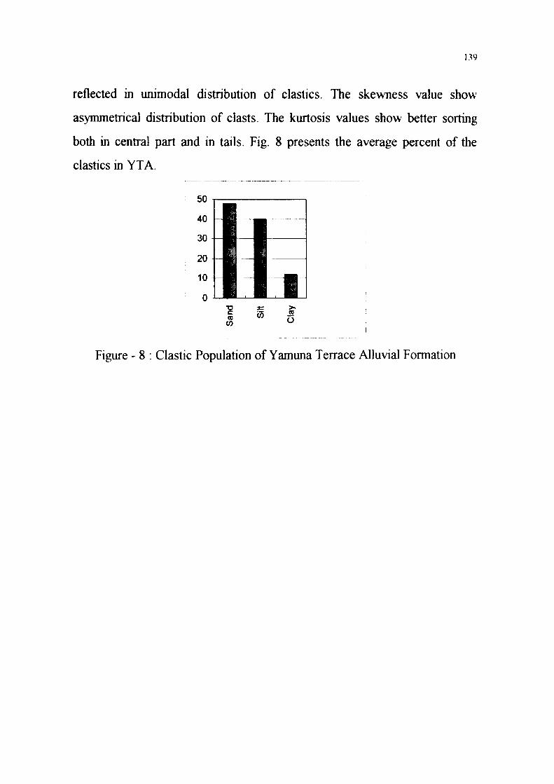
The mineral assemblage occuring in the YTA is quartz in abundance
(81.87%), rock fragments, felspars and garnet are common and
tremolite/actinolite, mica, hornblende, tourmaline, opaques, sillimanite,
kyanite, epidote, titanite occur as accessary minerals in YTA (Fig. 9). The
mineral species occuring in this formation are derived from Himalayan
provenance.
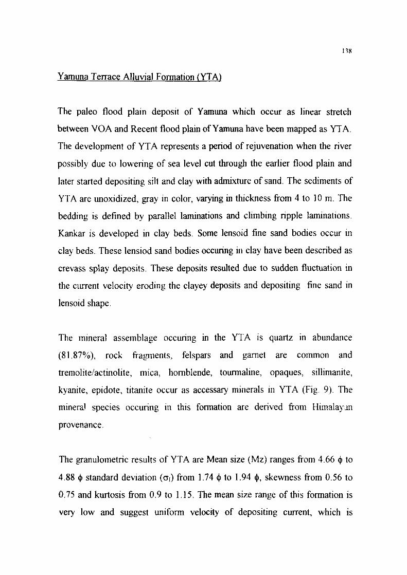
The granulomere results of YTA are Mean size (Mz) ranges from 4.66 <f> to
4.88 <j) standard deviation (GI) from 1.74 <J> to 1.94 <j>, skewness from 0.56 to
0.75 and kurtosis from 0.9 to 1.15. The mean size range of this formation is
very low and suggest uniform velocity of depositing current, which is
139
reflected in unimodal distribution of elastics. The skewness value show
asymmetrical distribution of clasts. The kurtosis values show better sorting
both in central part and in tails. Fig. 8 presents the average percent of the
elastics in YTA.
Figure - 8 : Clastic Population of Yamuna Terrace Alluvial Formation
140
DC
Figure - 9 : Mineralogenic Population of Yamuna Terrace Alluvial Formation
Recent Alluvium Group
The youngest sedimentary cycle has been mapped as Recent Alluvium Group
which comprise sand, silt and clay admixture developed along recent flood
plain of Yamuna and its tributaries.
141
The deposist of sand arid silt with admixture of clay and mud seen alongthe
recent flood plain of Yamuna have been assigned as Recent Alluvium Group.
It represents sedminets of post Glacial period roughly corresponding to
Mesolithic to present day. The sediments comprise loose unconsolidated
sand, silt and clay admixture deposited along the active flood plain of
Yamuna and its tributaries. The sediments of Recent Alluvium Group
comprise recent flood plain deposits which have been described as Yamuna
Recent Alluvial Formation in Aligarh and Mathura districts, Banganga Recent
Alluvial Formation and Bharatpur Loam Formation in Bharatpur district.
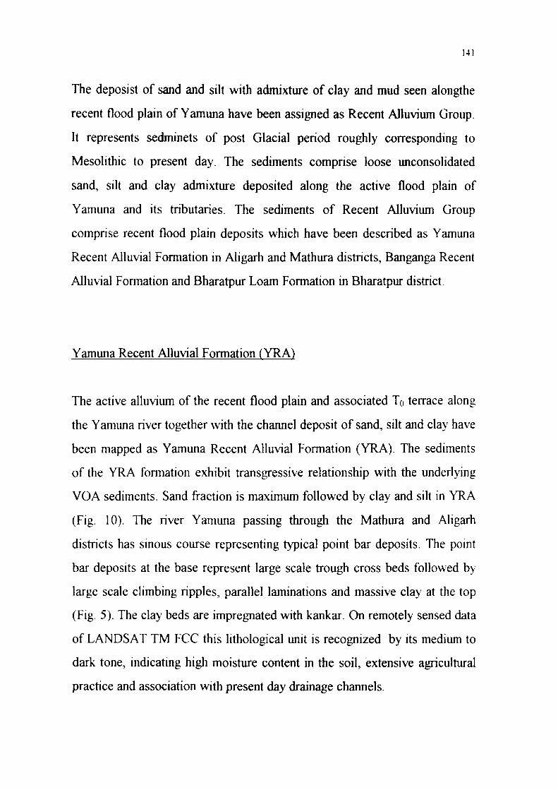
Yamuna Recent Alluvial Formation (YRA)
The active alluvium of the recent flood plain and associated T0 terrace along
the Yamuna river together with the channel deposit of sand, silt and clay have
been mapped as Yamuna Recent Alluvial Formation (YRA). The sediments
of the YRA fonnation exhibit transgressive relationship with the underlying
VOA sediments. Sand fraction is maximum followed by clay and silt in YRA
(Fig. 10). The river Yamuna passing through the Mathura and Aligarh
districts has sinous course representing typical point bar deposits. The point
bar deposits at the base represent large scale trough cross beds followed by
large scale climbing ripples, parallel laminations and massive clay at the top
(Fig. 5). The clay beds are impregnated with kankar. On remotely sensed data
of LANDSAT TM FCC this lithological unit is recognized by its medium to
dark tone, indicating high moisture content in the soil, extensive agricultural
practice and association with present day drainage channels.
142
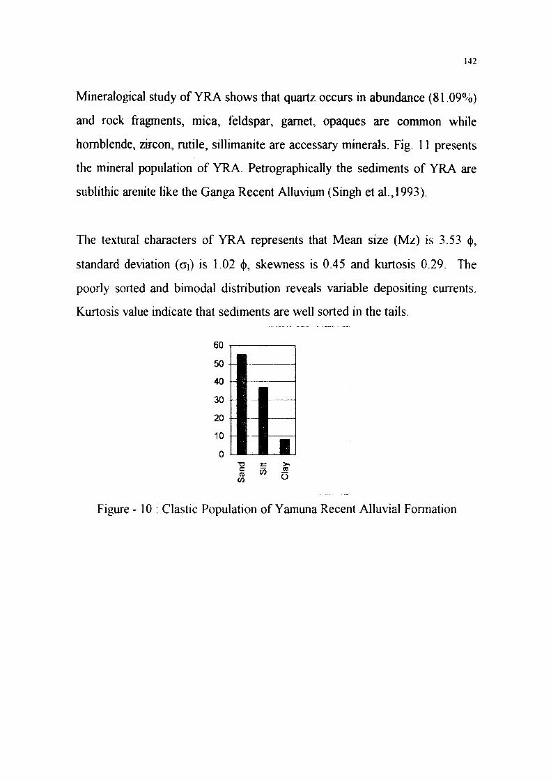
Mineralogical study of YRA shows that quartz occurs in abundance (81.09%)
and rock fragments, mica, feldspar, garnet, opaques are common while
hornblende, zircon, rutile, sillimanite are accessary minerals. Fig. 11 presents
the mineral population of YRA. Petrographically the sediments of YRA are
sublithic arenite like the Ganga Recent Alluvium (Singh et al.,1993).
The textural characters of YRA represents that Mean size (Mz) is 3.53 <(>,
standard deviation (d) is 1.02 <|>, skewness is 0.45 and kurtosis 0.29. The
poorly sorted and bimodal distribution reveals variable depositing currents.
Kurtosis value indicate that sediments are well sorted in the tails.
60
50
40
30
20
10
0
Figure -10 : Clastic Population of Yamuna Recent Alluvial Formation
143
90
80 \-\
70
60 M
50
40
30
20
10
CO CD 3 ~
o
o 0) J » » co
o o o o
CO
O CO
O
> o u tn 3
I .32
1 o
Zirc
a> TJ
Hor
nble
n S
Opa
qu V
Sill
jman
i J2
ock
Frag
men
a:
Figure - 1 1 : Mineralogic Population of Yamuna Recent Alluvial Formation
Bharatpur Loam Formation
This formation is charactenzed by mixture of aeolian and alluvial sediments
and is separated by a disconformity with Aligarh Older Alluvial Formation.
The sediments of Bharatpur Loam Formation have been derieved from
adjacent Alw ar district in the west and the provenence limit of this deposit is
possibly the Aravalli Orographic axis. This hthological unit is well developed
in Bharatpur district it pinches out and terminate west of Bharatpur town
making a hthological contact with Aligarh Older Alluvial Formation. The
144
Bharatpur Loam Formation exhibit overlap on Aligarh Older Alluvial
sediments. Its stratigraphic position is uncertain within Recent Alluvium
Group, for purpose of description it has been tentatively placed above
Yamuna Recent AlluvialFormation (YRA).
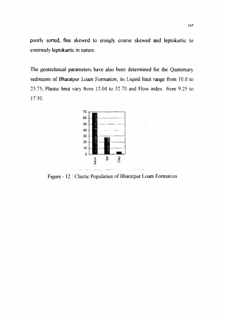
The sediments of this unit are predominantly sandy in nature, sub-angular to
sub-rounded. Granometrically these comprise 68% sand, 28% silt and 4%
clay (Fig. 12).
This lithological unit is identified on TM FCC data by its light to medium
tone, irregular lithological boundary outline, association with erosional and
structural hills belonging to Delhi and Vindhyan Supergroups, scanty
vegetation and low locked up moisture. This unit occupies a major part of the
Bharatpur district and extend from north to south adjacent to Aravalli hills
and Vindhyan plateau in the district.
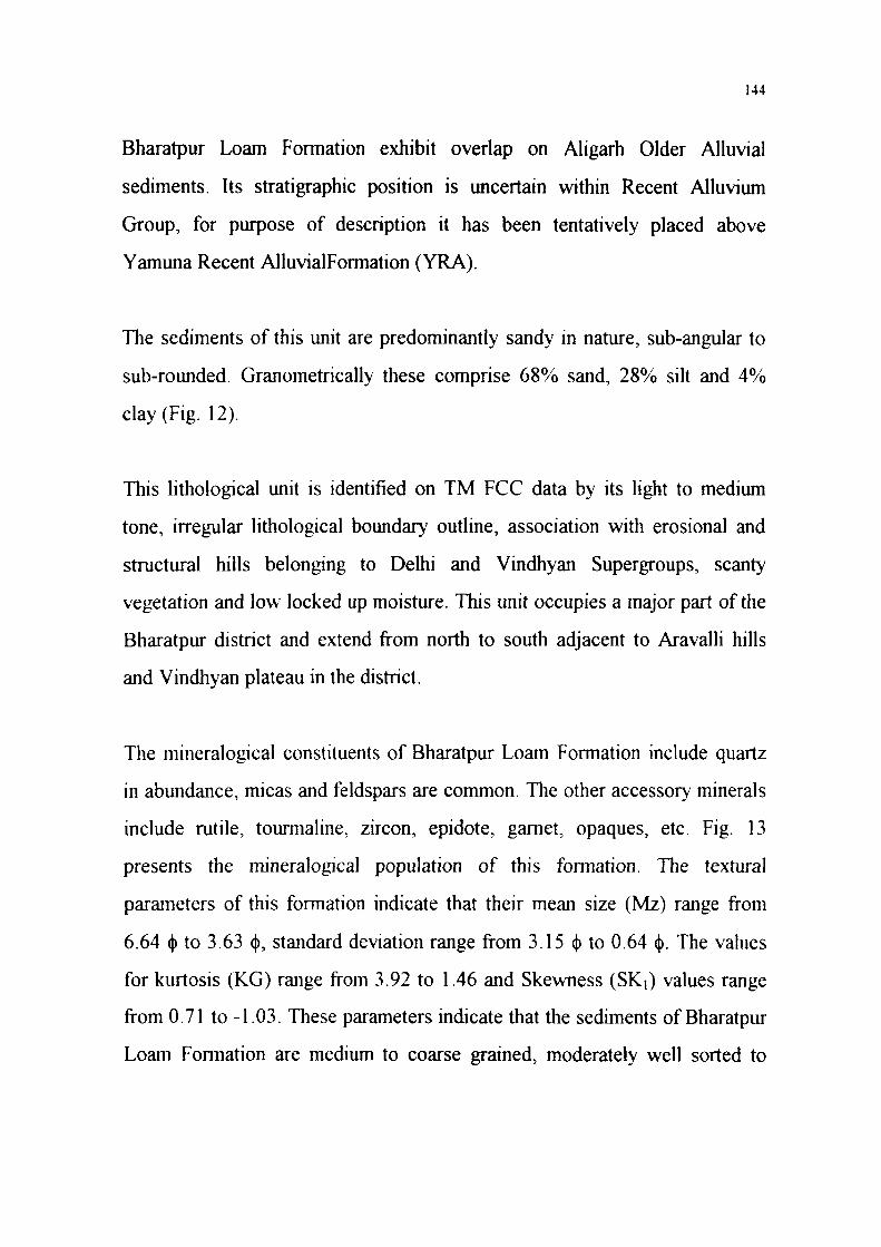
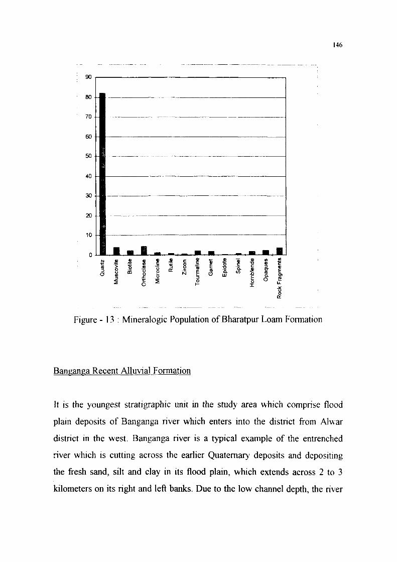
The mineralogical constituents of Bharatpur Loam Formation include quartz
in abundance, micas and feldspars are common. The other accessory minerals
include rutile, tourmaline, zircon, epidote, garnet, opaques, etc. Fig. 13
presents the mineralogical population of this formation. The texrural
parameters of this formation indicate that their mean size (Mz) range from
6.64 (J) to 3.63 (j), standard deviation range from 3.15 <j) to 0.64 <j). The values
for kurtosis (KG) range from 3.92 to 1.46 and Skewness (SKj) values range
from 0.71 to -1.03. These parameters indicate that the sediments of Bharatpur
Loam Formation are medium to coarse grained, moderately well sorted to
145
poorly sorted, fine skewed to srongly coarse skewed and leptokurtic to
extermely leptokurtic in nature.
The geotechnical parameters have also been determined for the Quaternary
sediments of Bharatpur Loam Formation, its Liquid limit range from 10.0 to
23.75, Plastic limit vary from 12.04 to 32.70 and Flow index from 9.25 to
17.50.
Figure - 12 : Clastic Population of Bharatpur Loam Formation
146
Figure - 13 : Mineralogic Population of Bharatpur Loam Formation
Banganga Recent Alluvial Formation
It is the youngest stratigraphic unit in the study area which comprise flood
plain deposits of Banganga river which enters into the district from Alwar
district in the west. Banganga river is a typical example of the entrenched
river which is cutting across the earlier Quaternary deposits and depositing
the fresh sand, silt and clay in its flood plain, which extends across 2 to 3
kilometers on its right and left banks. Due to the low channel depth, the river
147
causes frequent sheet flooding in the district during the monsoon season. The
Banganga Recent Alluvial Formation is referable to Recent Alluvial Group in
the Quaternary Stratigraphy of Indo-Gangetic plain.
The formation is recognized on the TM FCC by its light tone, first order
drainage channels joining the main Banganga river, abandoned/dry channels,
scars, low settlement density and scanty vegetation. This formation stretches
in a linear pattern from west to east along the course of river Banganga.
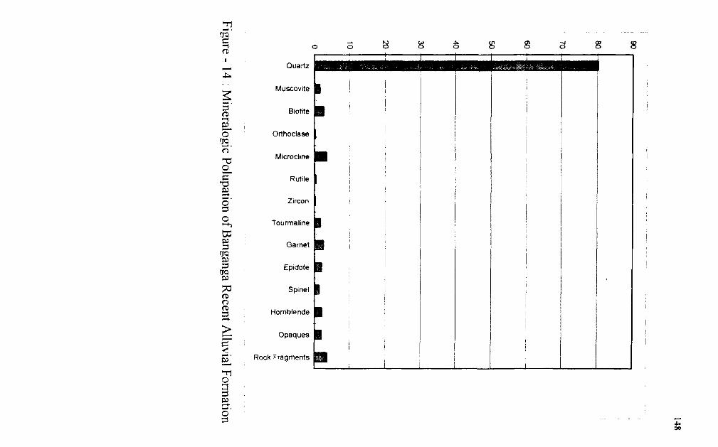
The mineralogical constituents of this formation include quartz in abundance,
micas and feldspars are common. The acessory minerals include tourmaline,
zircon, epidote, garnet, staurolite, spinel, opaques and rock fragments . Fig. 14
presents the mineralogical population of Banganga Recent Alluvial
Formation.
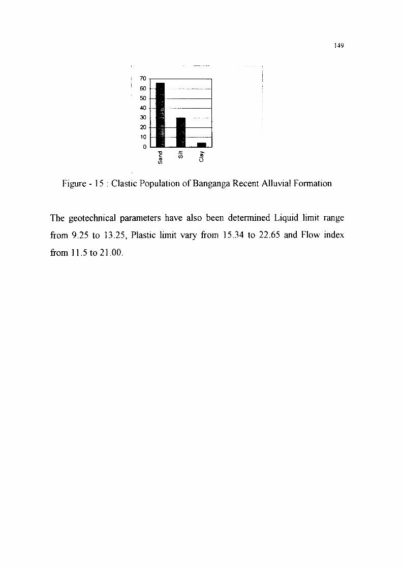
Granometrically these comprise 66% sand, 30% silt and 4% clay (Fig. 15).
The textural parameters of this formation indicate that their mean size (Mz)
range from 3.56 <() to 5.06 <j>, standard deviation range from 0.50 <J) to 1.34 §.
The values for kurtosis (KG) range from 0.83 to 4.81 and Skewness (SKi)
values range from 0.25 to - 0.02. These parameters indicate medium to fine
grained sand, moderately well sorted to poorly sorted, fine skewed to near
symmetrical and platykurtic to extermely leptokurtic nature of elastics in the
flood plain deposits of the river.
T l
I
3
a • I
o* <E. o
3
o 3
03
(IQ
CJQ 05
* J O o
j> 3 <
Tl o 03
o" 3
8 6 8 8 8 8
Quartz
Muscovite
Biotite
Orthodase
Microcline
Rutile
Zircon
Tourmaline
Garnet
Epidote
Spinel
Hornblende
Opaques
Rock Fragments
149
Figure - 15 : Clastic Population of Banganga Recent Alluvial Formation
The geotechnical parameters have also been determined Liquid limit range
from 9.25 to 13.25, Plastic limit vary from 15.34 to 22.65 and Flow index
from 11.5 to 21.00.
150
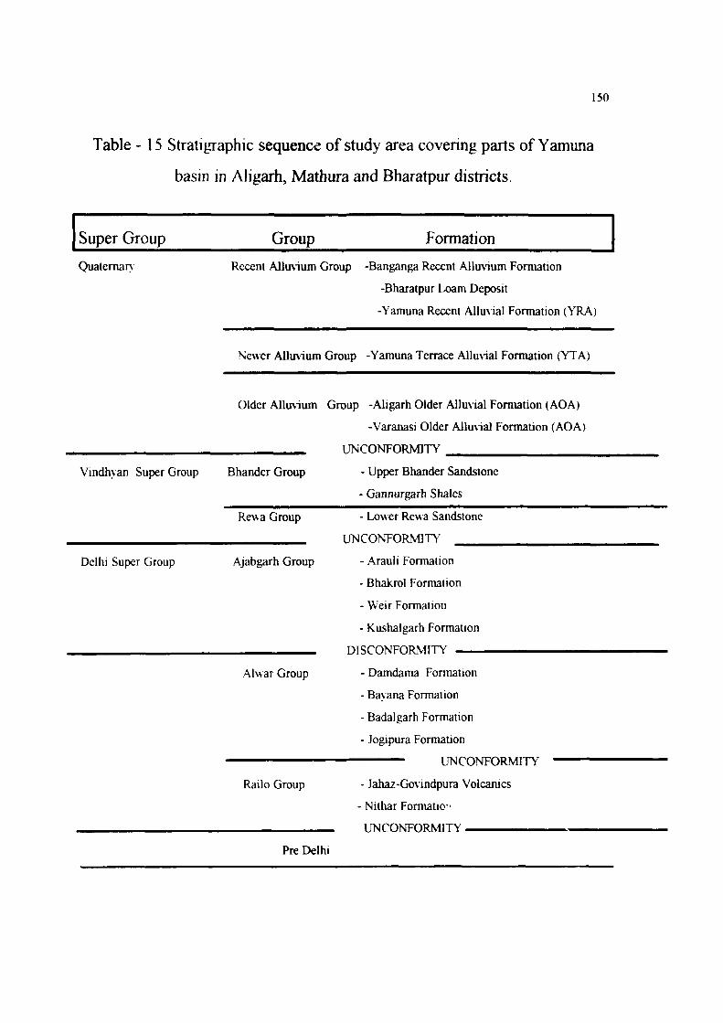
Table - 15 Stratigraphic sequence of study area covering parts of Yamuna
basin in Aligarh, Mathura and Bharatpur districts.
Super Group Group Formation Quaternary Recent Alluvium Group -Banganga Recent Alluvium Formation
-Bharatpur Loam Deposit
-Yamuna Recent Alluvial Formation (YRA)
Newer Alluvium Group -Yamuna Terrace Alluvial Formation (YTA)
Older Alluvium Group -Aligarh Older Alluvial Formation (AOA)
-Varanasi Older Alluvial Formation (AOA)
UNCONFORMITY
Vindhv an Super Group Bhander Group - Upper Bhander Sandstone
- Gannurgarh Shales
Rewa Group - Lower Rewa Sandstone
UNCONFORMITY
Delhi Super Group Ajabgarh Group - Arauli Formation
- Bhakrol Formation
- Weir Formation
- Kushalgarh Formation
DISCONFORMITY
Alwar Group - Damdama Formation
- Bavaria Formation
- Badalgarh Formation
- Jogipura Formation
UNCONFORMITY
Railo Group - Jahaz-Go\ indpura Volcanics
- Nithar Formation
UNCONFORMITY
Pre Delhi
151
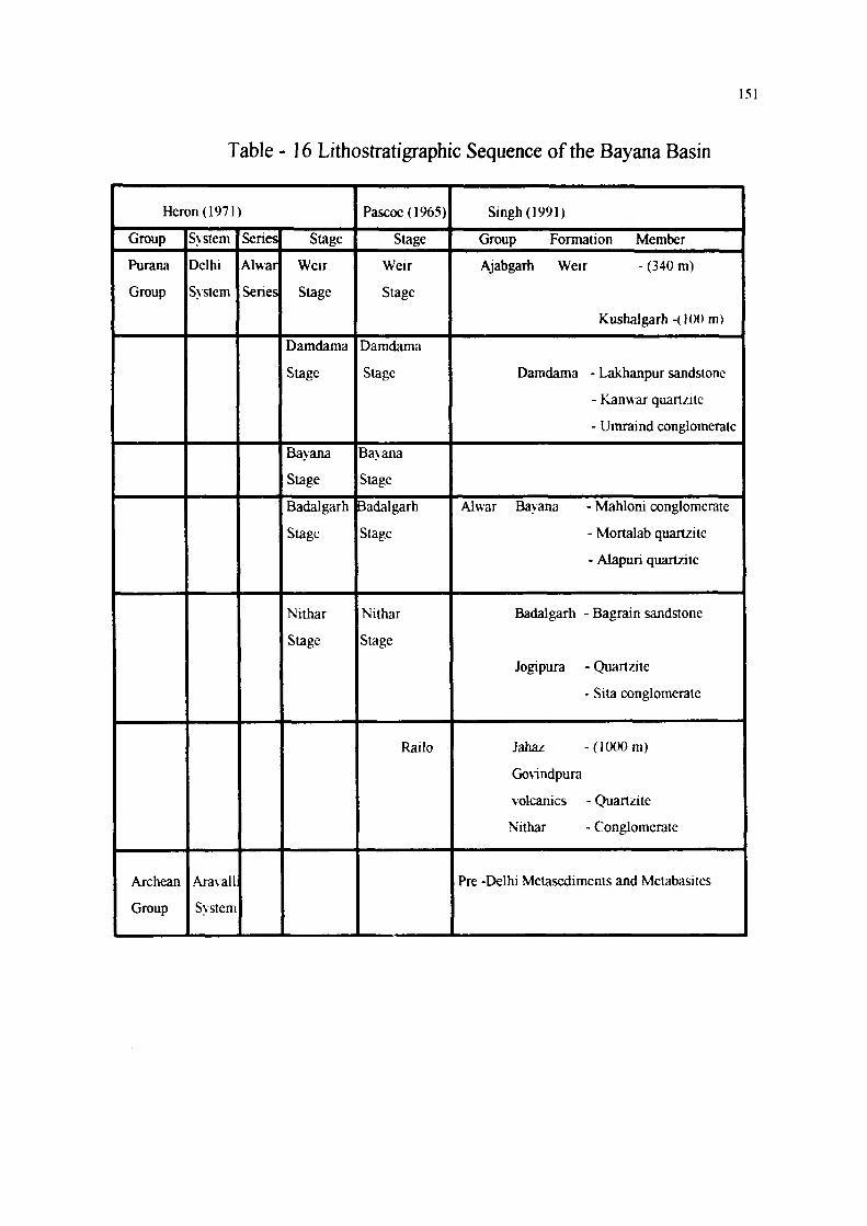
Table - 16 Lithostratigraphic Sequence of the Bayana Basin
Heron (1971)
Group
Purana
Group
Archean
Group
System
Delhi
System
Aravall
System
Series
Alwar
Series
Stage
Weir
Stage
Damdama
Stage
Bayana
Stage
Badalgarh
Stage
Nithar
Stage
Pascoe(1965)
Stage
Weir
Stage
Damdama
Stage
Bayana
Stage
Badalgarh
Stage
Nithar
Stage
Railo
Singh (1991)
Group Formation Member
Ajabgarh Weir - (340 m)
Kushalgarh-(lOOm)
Damdama - Lakhanpur sandstone
- Kanwar quartzitc
- Umraind conglomerate
Alwar Bayana - Mahloni conglomerate
- Mortalab quartzitc
- Alapuri quartzite
Badalgarh - Bagrain sandstone
Jogipura - Quartzite
- Sita conglomerate
Jahaz -(l(XX)m)
Go\indpura
volcanics - Quartzite
Nithar - Conglomerate
Pre -Delhi Metasediments and Metabasites


![(An Introduction To) Functional Programming · Increasingly using Clojure for the Model Using Scala for performance critical low-level infrastructure] - CEO, Railo Technologies, Inc](https://img.pdfslide.net/doc/110x75/5ed15a96b06c4265975b1667/an-introduction-to-functional-programming-increasingly-using-clojure-for-the-model.jpg)