Embed Size (px)
Citation preview

Characteristics of Isolated Convective Storms
Meteorology 515/815
Spring 2006
Christopher Meherin

Convective storms depend on the environment in which it grows
• Thermodynamic stability
• Vertical wind profiles
• Mesoscale forcing influences

How do forecasters identify conditions favoring convection?
• Balloon soundings
• Surface observations
• Satellites
• Radar
• Vertical profilers

Identifications allow forecasters
• Storm motion
• Longevity
• Potential severity

Storm dynamics is isolated to smaller scale features
• Individual thunderstorm cells
• Squall lines
Key components leading to convection are triggering
mechanisms
• Diurnal heating
• Frontal lifting

What is a convective cell?
• A region of strong updrafts (10 m*s-1)
• Horizontal cross section of 10-100 km2
• Extending in vertical through the most of the troposphere
• Updraft associated with precipitation easily seen on radar

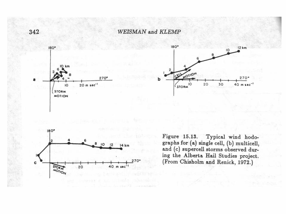
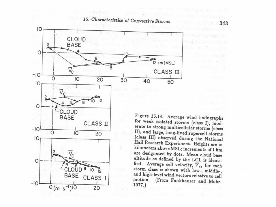
Types of convective cells
• Short lived single cell storm
• The mulitcell storm
• The supercell storm

Single cell storms
• Contains a single updraft
• Updraft brings air through troposphere producing– Liquid water– Ice
• Rain/ice become too heavy for updraft to support– Falls through updraft creating downdraft– Evaporational cooling accelerates downdraft– Outflow spreads horizontally cuts of updraft

Single cell storms (continued)
• Storm lasts typically 30 to 50 minutes
• Associated severe weather– High winds– Hail– Tornadoes are rare

Multicell storms
• Cluster of short-lived single cells
• Outflow triggers new updrafts to develop
• Wind shear gives storms longer life
• Associated severe weather– Flash flooding– Hail– Short lived tornadoes are possible


Supercell storms
• Evolves, often, from multicells
• Damaging winds (excess of 57 mph)
• Severe hail (> than 0.75”)
• Rotating updrafts
• Long lived tornadoes

Supercells dynamically different from ordinary convection
• After 1 hour radar echo moves in direction of wind shear vector
• Strongest reflectivity gradient located on southwest flank of storm
• Strong updraft forms
• Strom veers to right of mean wind
• Mature stage reached within 90 min
• Hook echo appears on southwest flank

Dynamical differences (continued)
• BWER indicates strong rotating updraft
• Tornado forms on edge of hook echo
• New mesocyclone/updraft can form
• Not all supercells go through this evolution, but many do

Physical mechanisms controlling convective storm growth
• Thermodynamic instability– Buoyancy
• Vertical wind shear influences forms convection takes– Single cell convection– Mulitcell convection– Supercell convection

Thermodynamic structure influences vertical acceleration
• Ways to access vertical acceleration
• Analysis of skew-t diagrams– Positive/negative buoyancy– Evaluation of lifted index– Calculation of BUOYANT ENERGY

Equation for buoyancy and vertical acceleration
• B represents buoyant energy of a parcel
• Theta(z) is temperature of a moist parcel
• Theta(z)bar is the environments temperature
• G is the gravitational acceleration
• Wmax is the vertical acceleration


Moist vs. dry layers
• Boundary layer moisture needed to support updraft growth
• Warm layer above boundary layer accelerate downdraft– Downbursts or microbursts occur when
updrafts are relatively week


Effects of wind shear
• Situation in which no wind shear exists– Outflow spreads horizontally – Potentially new cells cut off by cold pool
• Situation in which significant shear exists– Outflow does not cut off new cells– Outflow is down shear of new updraft

Two types of wind shear
• Unidirectional shear
• Curved shear

Unidirectional shear
• Wind shear vector is strait
• Wind shear vector increases– Pressure lowers on right/left flanks of original
updraft
Produces two new mesocyclones• Cyclonical mesocyclone
• Anitcyclonic mesocyclone

Curved shear
• Wind shear vector curves clockwise
• Strong shear settings – Lowering of pressures cause the right moving
storm to intensify– Left moving storm is suppressed