Embed Size (px)
Citation preview
Introduction
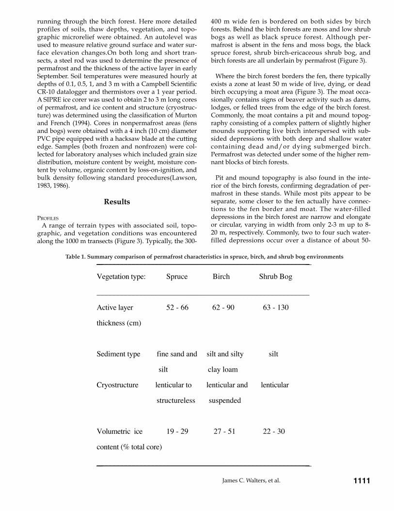
Recent investigations in the Tanana Flats of InteriorAlaska (Figure 1), have identified large areas ofunfrozen fen peatlands maintained by the discharge ofgroundwater through unfrozen gravels and silts(Racine and Walters, 1994). Where these unfrozen fensborder slightly higher birch forest, underlain by per-mafrost, there is widespread evidence of bank collapse,forest drowning, and moat formation, suggesting thedegradation of the permafrost underlying these forests(Figure 2). In contrast, where the fens border blackspruce forest and shrub bog, there is little evidence ofthermokarst. This study is a documentation of the evi-dence of preferential thawing of permafrost associatedwith birch forests and possible causes in relation to per-mafrost characteristics.
Because of the long and complex history of the TananaFlats in terms of both the surface and subsurface move-ment of glacial meltwater from the Alaska Range andthe present mean annual temperature of about -3.3¡C inthis area, we believe that permafrost conditions here areextremely dynamic. This is especially important in lightof projected climatic warming scenarios. The presentstudy is part of a larger project to investigate per-mafrost dynamics in the Tanana Flats. Our approach
includes an attempt to understand, classify, and mapthe landscape-scale pattern of permafrost distributionin relation to vegetation and near-surface sedimenttype.
Study area
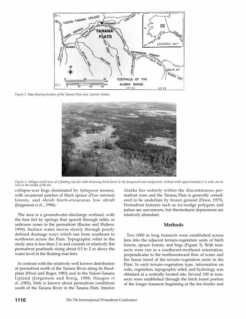
The Tanana Flats is situated on the distal slopes of alarge alluvial fan complex built out of the Alaska Rangeon the south (Figure 1). Climatic fluctuations during theQuaternary caused glacial expansion and recession inthe Alaska Range, which in turn built a broad slope ofcoalesced alluvial fans, pushing the Tanana River north-ward against the Yukon-Tanana Upland. The thickunconsolidated deposits of the fan complex document along and complicated record of alternating cycles of siltand gravel deposition and erosion along with the for-mation and destruction of permafrost (P�w� and Reger,1983).
The northwest portion of the Tanana Flats, where weconducted our studies, is dominated by thick (3 to 4 m)abandoned floodplain cover deposits and organic floa-ting-mat fens over gravel (Jorgenson et al., 1996).Common vegetation includes birch (Betula papyrifera)forests, alder (Alnus tenuifolia) shrub swamps, floating-mat fens dominated by buckbean (Menyanthes trifoliata),
Abstract
The Tanana Flats is a wetland region located on the distal slopes of an extensive alluvial fan complex built outof the Alaska Range. Vegetation in the Flats consists of a mosaic of fen, birch forest, black spruce forest, shrub,and bog. Permafrost is not present in the fen and bog areas, but it exists on the bordering forested or shrubareas 0.5 to 2 m above water level. Our studies show that permafrost in the Flats is relatively warm at -0.2 to -0.7¡C, and that the distribution and characteristics of permafrost are related to the geobotanical conditions at aspecific site. In general, permafrost is more ice rich and shows higher secondary porosity where finer-grainedsediments (silts) are abundant. These are environments characterized by birch forest vegetation. Permafrost inareas of birch forest appears more susceptible to thaw and is currently showing signs of extensive degradation.
James C. Walters, et al. 1109
CHARACTERISTICS OF PERMAFROST IN THE TANANA FLATS, INTERIOR ALASKA
James C. Walters1, Charles H. Racine2, M. Torre Jorgenson3
1. Department of Earth Science, University of Northern Iowa, Cedar Falls, Iowa 50614-0335, USAe-mail: [email protected]
2. U.S. Army Cold Regions Research and Engineering Laboratory, Hanover, New Hampshire 03755-1290, USAe-mail: [email protected]
3. Alaska Biological Research, Inc., P.O. Box 80410, Fairbanks, Alaska 99708, USAe-mail: [email protected]
collapse-scar bogs dominated by Sphagnum mosses,with occasional patches of black spruce (Picea mariana)forests, and shrub birch-ericaceous low shrub(Jorgenson et al.., 1996).
The area is a groundwater-discharge wetland, withthe fens fed by springs that upwell through taliks orunfrozen zones in the permafrost (Racine and Walters,1994). Surface water moves slowly through poorlydefined drainage ways which run from southeast tonorthwest across the Flats. Topographic relief in thestudy area is less than 2 m and consists of relatively flatpermafrost peatlands rising about 0.5 to 2 m above thewater level in the floating-mat fens.
In contrast with the relatively well known distributionof permafrost north of the Tanana River along its flood-plain (P�w� and Reger, 1983) and in the Yukon-TananaUpland (Jorgenson and Kreig, 1988; Haugen etal..,1982), little is known about permafrost conditionssouth of the Tanana River in the Tanana Flats. Interior
Alaska lies entirely within the discontinuous per-mafrost zone and the Tanana Flats is generally consid-ered to be underlain by frozen ground (P�w�, 1975).Permafrost features such as ice-wedge polygons andpalsas are uncommon, but thermokarst depressions arerelatively abundant.
Methods
Two 1000 m long transects were established acrossfens into the adjacent terrain-vegetation units of birchforests, spruce forests, and bogs (Figure 3). Both tran-sects were run in a southwest-northeast orientation,perpendicular to the northwestward flow of water andthe linear trend of the terrain-vegetation units in theFlats. In each terrain-vegetation type, information onsoils, vegetation, topographic relief, and hydrology wasobtained at a centrally located site. Several 100 m tran-sects were established through the birch forest portionof the longer transects beginning at the fen border and
The 7th International Permafrost Conference1110
Figure 1. Map showing location of the Tanana Flats area, Interior Alaska.
Figure 2. Oblique aerial view of a floating mat fen with drowning birch forest in the foreground and midground. Airboat trails approximately 2 m wide can beseen in the middle of the fen.
running through the birch forest. Here more detailedprofiles of soils, thaw depths, vegetation, and topo-graphic microrelief were obtained. An autolevel wasused to measure relative ground surface and water sur-face elevation changes.On both long and short tran-sects, a steel rod was used to determine the presence ofpermafrost and the thickness of the active layer in earlySeptember. Soil temperatures were measured hourly atdepths of 0.1, 0.5, 1, and 3 m with a Campbell ScientificCR-10 datalogger and thermistors over a 1 year period.A SIPRE ice corer was used to obtain 2 to 3 m long coresof permafrost, and ice content and structure (cryostruc-ture) was determined using the classification of Murtonand French (1994). Cores in nonpermafrost areas (fensand bogs) were obtained with a 4 inch (10 cm) diameterPVC pipe equipped with a hacksaw blade at the cuttingedge. Samples (both frozen and nonfrozen) were col-lected for laboratory analyses which included grain sizedistribution, moisture content by weight, moisture con-tent by volume, organic content by loss-on-ignition, andbulk density following standard procedures(Lawson,1983, 1986).
Results
PROFILES
A range of terrain types with associated soil, topo-graphic, and vegetation conditions was encounteredalong the 1000 m transects (Figure 3). Typically, the 300-
400 m wide fen is bordered on both sides by birchforests. Behind the birch forests are moss and low shrubbogs as well as black spruce forest. Although per-mafrost is absent in the fens and moss bogs, the blackspruce forest, shrub birch-ericaceous shrub bog, andbirch forests are all underlain by permafrost (Figure 3).
Where the birch forest borders the fen, there typicallyexists a zone at least 50 m wide of live, dying, or deadbirch occupying a moat area (Figure 3). The moat occa-sionally contains signs of beaver activity such as dams,lodges, or felled trees from the edge of the birch forest.Commonly, the moat contains a pit and mound topog-raphy consisting of a complex pattern of slightly highermounds supporting live birch interspersed with sub-sided depressions with both deep and shallow watercontaining dead and/or dying submerged birch.Permafrost was detected under some of the higher rem-nant blocks of birch forests.
Pit and mound topography is also found in the inte-rior of the birch forests, confirming degradation of per-mafrost in these stands. While most pits appear to beseparate, some closer to the fen actually have connec-tions to the fen border and moat. The water-filleddepressions in the birch forest are narrow and elongateor circular, varying in width from only 2-3 m up to 8-20 m, respectively. Commonly, two to four such water-filled depressions occur over a distance of about 50-
James C. Walters, et al. 1111
_______________________________________________________
Vegetation type: Spruce Birch Shrub Bog
_______________________________________________________
Active layer 52 - 66 62 - 90 63 - 130
thickness (cm)
Sediment type fine sand and silt and silty silt
silt clay loam
Cryostructure lenticular to lenticular and lenticular
structureless suspended
Volumetric ice 19 - 29 27 - 51 22 - 30
content (% total core)
_______________________________________________________
Table 1. Summary comparison of permafrost characteristics in spruce, birch, and shrub bog environments

75 m through the birch forest (Figure 3). The sides of thepits rise 0.3-1 m from a water or floating vegetation matsurface to the birch forest floor. In these pits, the wetorganic layer consisting of both birch forest peat andaccumulated floating mat vegetation is up to 1.5 mthick above silts. In the larger water-filled pits, no per-mafrost could be found to a depth of 2.5 m in lateAugust, whereas permafrost was encountered at adepth of 0.8-1 m in the adjacent birch forest (Figure 3).The thaw depth profile through the birch forest tends tomatch the surface mesotopography.
NEAR-SURFACE SEDIMENT AND PERMAFROST CRYOSTRUCTURE
Subsurface profiles in the terrain types along the tran-sects show an organic horizon underlain by silt or siltyclay loam above sand with a gravel layer at a depth of 3to 4 m (Figure 3). Organic horizons 0.75 to 1.5 m thickoccur in the fen and in the moss bog type environ-ments. In the case of the fens, the organic mat consistspredominantly of buckbean whose intertwined rootsand rhizomes form a dense network which floats and isusually capable of supporting a personÕs weight. Mossbogs are found in collapse scar environments and aredominated by Sphagnum. Organic horizons in birchforests and spruce forests range from 30 to 50 cmthick.Soils in these forested areas are histic pergelic
cryaquepts. In late August, the frost table is usuallylocated in the organic horizon or just below this in thesilt layer.
Permafrost cores provide information on ice contentsand structures in the near-surface frozen sediments(Figure 3 and Table 1). Fine-grained sediments, mostlysilts, sands, and silty clay loams, make up the mineralsoils in all of the cores, but the textural type variessomewhat in relation to the terrain-vegetation unit(Table 1).Sediment underlying areas of black spruce fo-rest has a greater amount of fine- to medium-grainedsand along with silt. In areas of shrub bog, the sedimentis mostly silt. In areas of birch forest, the underlyingsediment has a greater percent of silty clay loam andclay loam along with silt. This difference in sedimenttextures, in turn, corresponds to the amount of ice andtype of ice structures in the frozen sediments.Lenticular cryostructures are the most common type ofice structure in all of the cores (Figure 4A). Structurelesscryostructures, in which ice is contained in pore spacesand is not visible (Murton and French (1994), are asso-ciated with sand-size sediments (Figure 4B). Suchcryostructures are found in permafrost underlyingblack spruce forest. Suspended cryostructures are com-mon in the finest-grained sediments, the silty clay
The 7th International Permafrost Conference1112
Figure 3. Cross-sectional profile of a portion of a long transect across different terrain-vegetation units. Black triangles indicate locations of permafrost cores.Larger-scale profile presents a more detailed section through the birch forest showing surface topography and frost table profile (September 1995).

loams and clay loams underlying areas of birch forest(Figure 4C). The volume of ice in the permafrost isgreatest where the sediment is the finest. Thus, icemakes up less than about 20% by volume of the near-surface frozen sediments in areas of black spruce forestto more than 50% of the frozen sediments in areas ofbirch forest (Table 1).
Monitoring of permafrost temperatures with datalog-gers indicates that temperatures at 3 m depths in birchforests with degrading permafrost were maintained at anear constant temperature of -0.2¡C throughout theyear. In contrast, in the black spruce forest with stablepermafrost, temperatures at the 3 m depth varied from -0.2 to -0.7¡C annually.
PERMAFROST DEGRADATION
The extent of permafrost degradation was determinedby relating permafrost characteristics (cryostructures
and temperatures) to vegetation and terrain types alongthe transects and by mapping the distribution ofecosystems. Applying this procedure to the portion ofthe Tanana Flats managed by the U. S. Army at Ft.Wainwright (263,759 ha), Jorgenson et al.. (1996) deter-mined that 16% is unfrozen with no previous per-mafrost, 44% has stable permafrost, 9% is partiallydegraded, 25% is mostly degraded, and 6% has totallydegraded. They estimated that, when considering onlythat portion that currently has or has recently had per-mafrost, approximately 48% of the permafrost-domina-ted land has been affected by thermokarst development.
Some indication of rates of permafrost degradationcan be determined by comparing aerial photographs.Recent short term (less than 10 years) observations atsome locations in the Flats have revealed dramaticchanges. At one site of about 1.5 ha observed since 1989,there has been an almost total thawing of permafrost.At another site where we have constructed a 1 km transect, comparison of air photos from 1949 and1989 shows a decrease of approximately 24% in the areaunderlain by permafrost. Based on air photo interpreta-tion and our field observations over the last severalyears, we estimate that frozen ground along the mar-gins of these Òbirch islandsÓ has been degrading lateral-ly at approximately 0.5 to 1 m per year.
Discussion and conclusions
Thawing of permafrost beneath birch forests is occur-ring in the Tanana Flats of Interior Alaska. Degradationis greatest along the edges of birch forests where theyborder extensive fens. In the frozen silty sedimentsunderlying the birch forests, suspended and lenticularcryostructures are common, and the amount of thawsettlement after melting indicates there is as much as1.5 m of ice in the sediments. These cryostructures aretypical of aggradational ice formed at the top of the per-mafrost boundary but lack the vertical ice veins typical-ly found in cold permafrost.
Drowned forest and collapse features along wetland-upland borders are well known and have beendescribed by Drury (1956) and Luken and Billings(1983) in Interior Alaska and by Zoltai and Tarnocai(1975) in Canada. The thawing of permafrost banks bor-dering wetlands and other water bodies has been docu-mented by Drury (1956) as including the Òphenomenonof the advance of bog margins by thawing and under-mining the forest.ÓAlthough the occurrence of thaw hasbeen well documented in the Subarctic, the causes andecological effects of this thaw subsidence in terms ofsuccessional processes involving wetland formation,colonization, and infilling are poorly known (Sepp�l�,1986).
James C. Walters, et al. 1113
Figure 4. Permafrost cores showing typical cryostructures: (A) lenticularcryostructure in silt;(B) structureless cryostructure in fine-grained sand,grading to lenticular away from center of core where sediment becomes moresilty; and (C) suspended cryostructure consisting of angular blocks of siltyclay in ice. All cores are approximately 7 cm wide and have been allowed tothaw slightly in order to emphasize the features.

The process of permafrost thaw and bank collapseoccurring along wetland margins in the Tanana Flats isprobably due to a number of factors. The relativelywarm temperature of the permafrost (-0.2 to -0.7¡C)makes it very susceptible to thaw. These temperaturesare probably maintained by heat flow from groundwa-ter movement at depth. Another important factor is theheat transfer from the relatively warm surface waters ofthe fens (12 to 16¡C by August) to the adjacent per-mafrost underlying the forests.The influence of beaversis also important, since they cut birch trees which mayopen up the forests, and they create dams in moat areaswhich raise water levels and increase flow rates alongthe banks. The finding that the permafrost underlyingthe birch forests consists of clayey, ice-rich sedimentswhich are particularly susceptible to thaw subsidence isvery significant and explains why areas of birch forestare experiencing the greatest degree of degradation.
Higher temperatures in Interior Alaska over the lastseveral years (Osterkamp, 1983) may also be responsi-ble for accelerated degradation of permafrost andexpansion of wetlands in this area. Since the mid 1970s,there has been an increase of approximately 1 to 2¡C inmean annual air temperature in Alaska (Osterkamp,1983). Although long-term monitoring of permafrosttemperatures in the Tanana Flats has not been done,studies by Osterkamp (1994) at a site in the Chena River
floodplain near Fairbanks indicate that permafrost tem-peratures there have increased by about 1.5¡C from just1990 to 1993. We continue to map the landscape-scalepattern of permafrost distribution in the Tanana Flats inrelation to vegetation, near-surface sediments, and icevolume and have begun to monitor thermal conditionsin a variety of terrain-vegetation types. The lowlandbirch forests in the Tanana Flats may represent one ofthe most sensitive ecosystems in Interior Alaska interms of response to climatic change.
Acknowledgments
Support for this study was provided by the U.S.Department of Defense through the U.S. Army ColdRegions Research Engineering Laboratory. Personnel atFt. Wainwright, Alaska (U.S Army 6th InfantryDivision) assisted with logistics and field equipment.
The 7th International Permafrost Conference1114
References
Drury, W.H., Jr. (1956). Bog flats and physiographic processesin the Upper Kuskokwim River region, Alaska.Contributions of the Gray Herbarium (178 pp.).
Haugen, R.K., Slaughter, C.W., Howe, K.E., and Dingman,S.L. (1982). Hydrology and climatology of the Caribou-Poker Creeks Watershed, Alaska. U.S. Army Cold RegionsResearch and Engineering Laboratory, Report 82-26 (34 pp.)
Jorgenson, M.T. and Kreig, R.A. (1988). A model for mappingpermafrost distribution based on landscape componentmaps and climatic variables. In Proceedings 5th InternationalConference on Permafrost, Trondheim, Norway . TapirPublishers, Trondheim, pp. 176-183.
Jorgenson, M.T., Roth, J., Raynolds, M., Smith, M.D., Lentz,W., and Zusi-Cobb, A. L. (1996). An ecological land classifi-cation for Fort Wainwright, Alaska. Unpublished Report pre-pared for U.S. Army Cold Regions Research andEngineering Laboratory, Hanover, NH by AlaskaBiological Research, Inc., Fairbanks, Alaska (52 pp.)
Lawson, D.E. (1983). Ground ice in perennially frozen sedi-ments, northern Alaska.In Proceedings 4th InternationalConference on Permafrost, Fairbanks, Alaska. NationalAcademy Press, Washington, D.C., pp.695-700.
Lawson, D.E. (1986). Response of permafrost terrain to distur-bance: A synthesis of observations from northern Alaska,U.S.A. Arctic and Alpine Research, 18 (1), 1-17.
Luken, J.O. and Billings, W.D. (1983). Changes in bryophyteproduction associated with a thermokarst erosion cycle ina subarctic bog. Lindbergia, 9, 163-168.
Murton, J.B. and French, H.M. (1994). Cryostructures in per-mafrost, Tuktoyaktuk coastlands, western arctic Canada.Canadian Journal of Earth Sciences, 31 (4), 737-747.
Osterkamp, T.E. (1983). Response of Alaskan permafrost toclimate. In Proceedings 4th International Conference onPermafrost, Fairbanks, Alaska. National Academy Press,Washington, D.C., pp.145-152.
Osterkamp, T.E. (1994). Evidence for warming and thawing ofdiscontinuous permafrost in Alaska. EOS. Transactions ofthe American Geophysical Union, 75 (44, supplement), 85.
P�w�, T.L. (1975). Quaternary Geology of Alaska. U.S.Geological Survey Professional n Paper, 835 (145 pp.).
P�w� T.L. and Reger, R.D. (1983). Middle Tanana RiverValley, In P�w�, T. L. and Reger, R. D. (eds.), Guidebook 1:Richardson and Glenn Highways, Alaska. FourthInternational Conference on Permafrost, Alaska Division ofGeological and Geophysical Surveys, Fairbanks, pp. 5-45.
Racine, C.H. and Walters, J.C. (1994). Groundwater-dischargewetlands in the Tanana Flats, Interior Alaska, USA. Arcticand Alpine Research, 26 (4), 418-426.
Sepp�l�, M. (1986). The origin of palsas. Geografiska Annaler,68A (3), 141-147.
Zoltai, S.C. and Tarnocai, C. (1975). Perennially frozen peat-lands in the western arctic and subarctic of Canada.Canadian Journal of Earth Sciences, 12, 28-43.