Embed Size (px)
Citation preview

www.petrelrob.com
Characterization of Belloy, Kiskatinaw,and Debolt Water Disposal Zonesin the Montney Play Area, NEBC
Brad J. HayesPetrel Robertson Consulting Ltd.
Introduction
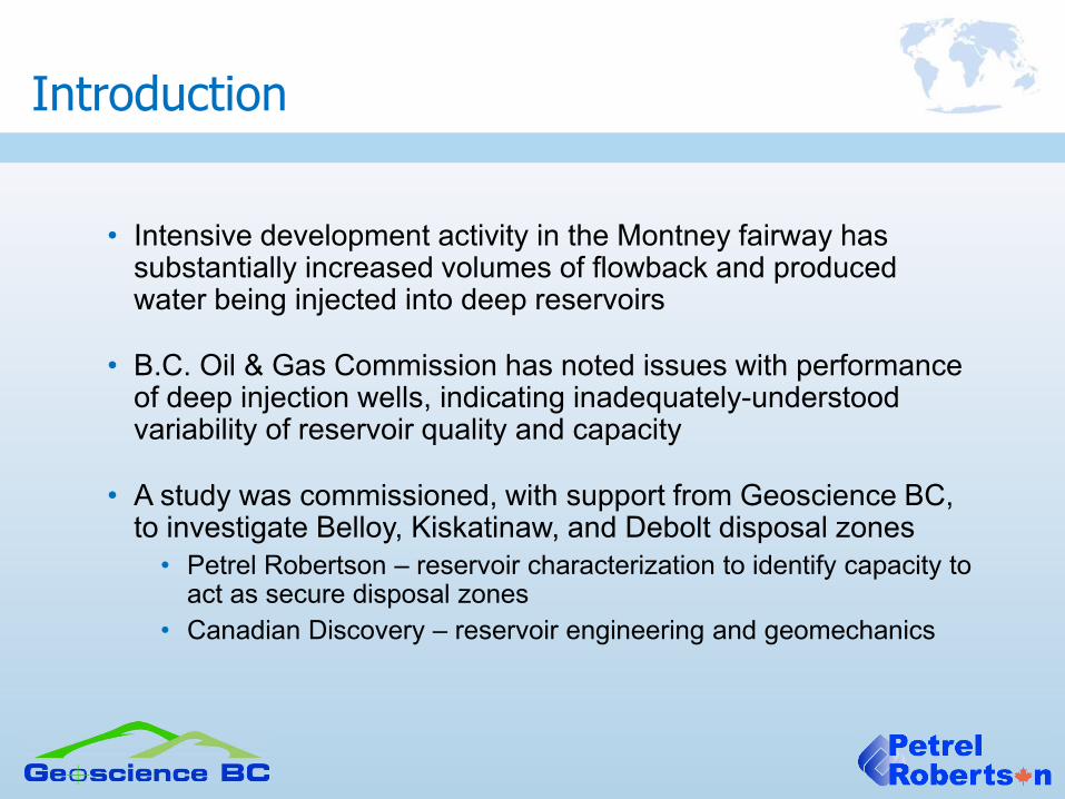
• Intensive development activity in the Montney fairway has substantially increased volumes of flowback and produced water being injected into deep reservoirs
• B.C. Oil & Gas Commission has noted issues with performance of deep injection wells, indicating inadequately-understood variability of reservoir quality and capacity
• A study was commissioned, with support from Geoscience BC, to investigate Belloy, Kiskatinaw, and Debolt disposal zones
• Petrel Robertson – reservoir characterization to identify capacity to act as secure disposal zones
• Canadian Discovery – reservoir engineering and geomechanics

Montney Play Fairway
• Most development is currently in the Peace River Block and northwestern Foothills areas
• Continued expansion taking place, although at a reduced pace in the current economic environment
BC Oil & Gas Commission

• OGC sees several important factors influencing the “favourability” of potential disposal zones
• Proximity to mapped faults / fractures / structures • Seismicity risks when large water volumes are injected?
• Hydrocarbon exploration / development potential in underlying reservoirs
• Risk in new wells drilled through high-pressure disposal zones?• Hydrocarbon exploration / development potential in bounding
formations that are expected to provide a seal to injected fluids –e.g., lower Montney just above Belloy
• Could development jeopardize seal integrity?• Proximity to existing production in the disposal formation
• Potential to reduce recovery factors?
• “Favourability” maps will be drawn to include these factors, in addition to reservoir quality
Disposal Zone Considerations
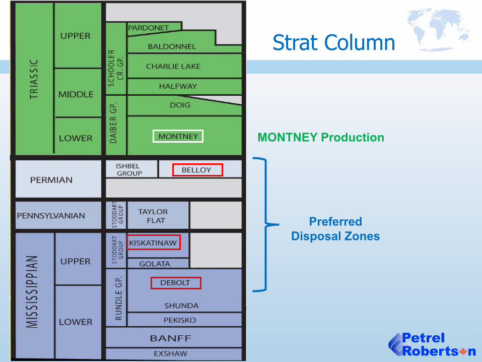
Strat Column
MONTNEY Production
PreferredDisposal Zones

Debolt Depositional Setting
• Carbonate ramps prograded regionally northwestward during Early Carboniferous (Mississippian) time
• Spectrum of proximal to distal carbonate ramp facies
• Dominantly limestones, locally and sub-regionally dolomitized
• Internal stratigraphy not well documented
Richards et al, 1994

Debolt Situation
• Xxx wells
• Very few penetrations in SW
• Gas pools and Blueberry oil pool in conventional Foothills fault traps
• Reservoir rock in the NW primarily in thin zones of fractured hydrothermal dolomites
• More substantial contribution from low-temperature dolomites in Blueberry area
Favourability map area

Debolt – Regional Dolomitization
• Regional, low-temperature, fabric-selective dolomites
• Focused in proximal ramp and shoal carbonates with good primary reservoir quality in upper 50m
• Continuous vuggy / moldic / intercrystalline porosity
Durocher and Al-Aasm, 1997

Debolt Structure
• Northwesterly Disturbed Belt structure a product of both Laramide and Antler orogenic episodes
• Structural features are taken from existing papers, reports, pool studies, and verified using structural elevations from wellbores
• Insufficient well control to define FSJ Graben structureswith confidence

Debolt Favourability
• Favourable area governed primarily by distribution of low-temperature dolomites in uppermost Debolt
• Many existing disposal wells are close to major faults

Stoddart-Belloy Setting
• Carboniferous – Permian subsidence of Fort St John Graben exerted profound influence on Stoddart Group and Belloy deposition
Barclay et al, 1990

Stoddart-Belloy Deposition
• Progressive subsidence in tensional (normal faulting) regime created huge accommodation space in the middle of the FSJ Graben throughout the Carboniferous
• Reduced influence by Belloy (Permian) time
Barclay et al, 1990
End Golata time
End Kiskatinaw time
End Taylor Flat time
End Belloy time
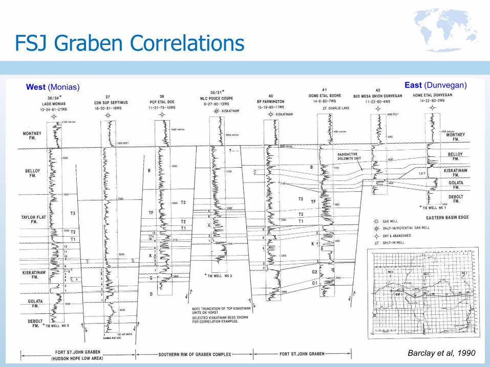
FSJ Graben Correlations
Barclay et al, 1990
West (Monias) East (Dunvegan)

Stoddart-Belloy Stratigraphy
Barclay et al, 2002
• Substantial and mappable reservoir quality in proximal Belloy and Kiskatinaw facies
• Belloy / Taylor Flat boundary difficult to pick regionally, particularly in basin centre

Kiskatinaw Situation
• Xxx wells• Very few penetrations in SW• In NW, the section is
extensively faulted and in distal, thinly-bedded facies, so has little reservoir capacity
• Existing production and best continuous reservoir quality in thick, quartzose sandstones,
• Deposited primarily in estuarine valley-fill and related environments
Favourability map area

Kiskatinaw Valley-Fill Reservoirs
• Sharply-defined estuarine valley-fill trends hostsubstantial reservoir-quality rock
• Quartzose sandstones, variably carbonate-cemented
Barclay et al, 2002

Kiskatinaw Structure
• Complex structural / stratigraphic relationships in Fort St John Graben
• Published fault trends provide some insights, but well control demonstrates abrupt thickness and stratigraphic changes that require detailed seismic work to resolve
DEPOSITIONAL LIMIT

Kiskatinaw Favourability
• Faulting and existing production restrict favourable areas
• Broad favourability trends require refinement with additional well control
ACID GAS DISPOSAL

Belloy Situation
• Xxx wells• Some penetrations in the far south,
but most are incomplete• In NW, the section is extensively
faulted and in distal, thinly-bedded facies, so has little reservoir capacity
• Regional structural / stratigraphic trap at Eagle-Stoddart
• Most other pools relatively small
Favourability map area

20
Belloy Biostratigraphy (Fossenier)
• Complex stratigraphic relationshipsnot resolvable without detailedbiostratigraphic analysis

Belloy Stratigraphy, Eagle-FSJ Area
• Complex intra-Belloy stratigraphic relationships
• Channelized reservoirs limit aquifer / disposal zone continuity
Leggett et al, 1993
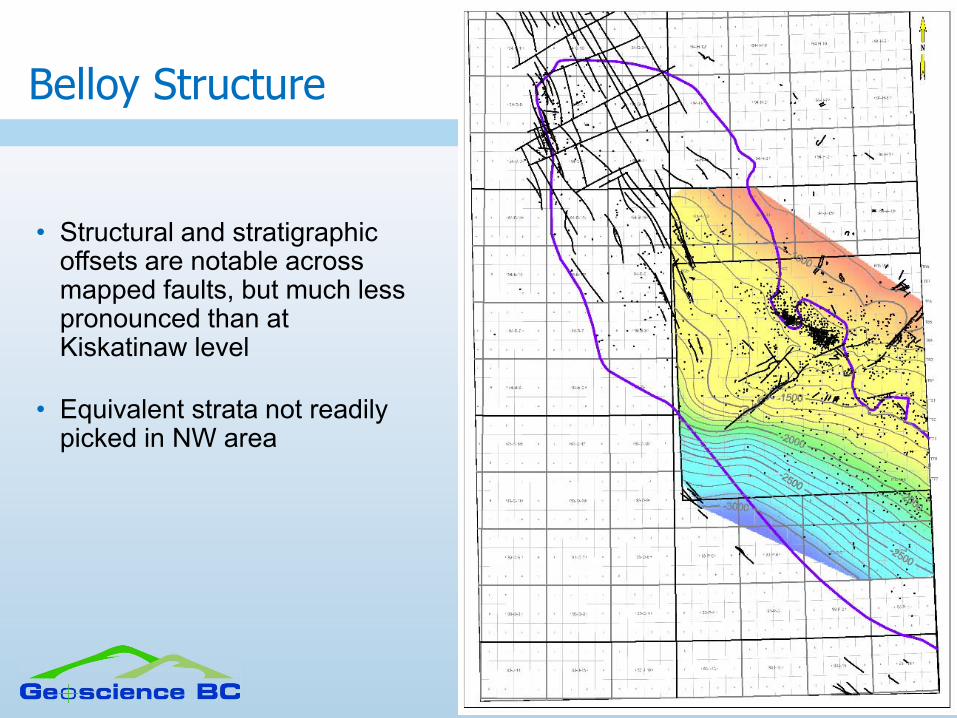
Belloy Structure
• Structural and stratigraphic offsets are notable across mapped faults, but much less pronounced than at Kiskatinaw level
• Equivalent strata not readily picked in NW area

Belloy Favourability
• Faulting and existing production restrict favourable areas
• Broad favourability trends require refinement with additional well control
ACID GAS DISPOSAL
WATER DISPOSAL

• Areas favourable for disposal are significantly restricted by reservoir quality, faulting, and existing production
• But many existing Debolt disposal wells are close to major Laramide thrust faults, and should yield data to support determination of risk arising from fault proximity
• Reservoir lithologies in all three formations are intricate blends of clastics and carbonates, and are difficult to characterize from logs
• Analysis of core and cuttings crucial to understanding reservoirs locally
• Development of lower Montney targets may pose risks to seal integrity for underlying disposal zones in SE and NW, and require further assessment
Summary and Conclusions

• Substantial disposal zone potential exists in shallower zones (e.g., Halfway Fm), but these would be penetrated by Montney development wells
• Reservoir engineering and geomechanical work should better define potential disposal zone capacity and risks
Summary and Conclusions

www.petrelrob.com
Characterization of Belloy, Kiskatinaw,and Debolt Water Disposal Zonesin the Montney Play Area, NEBC
Brad J. HayesPetrel Robertson Consulting Ltd.