Embed Size (px)
Citation preview
1
Dr. Sabine Christiansen for WWF Germany, 21 August 2009
Charlie-Gibbs Fracture Zone -
Experience on the identification of an OSPAR MPA in Areas Beyond National Jurisdiction and
application of the CBD ‘EBSA’ criteria for identifying ecologically or biologically significant
marine areas in need of protection (CBD COP IX Resolution IX/20) to the area
1. Background
Location
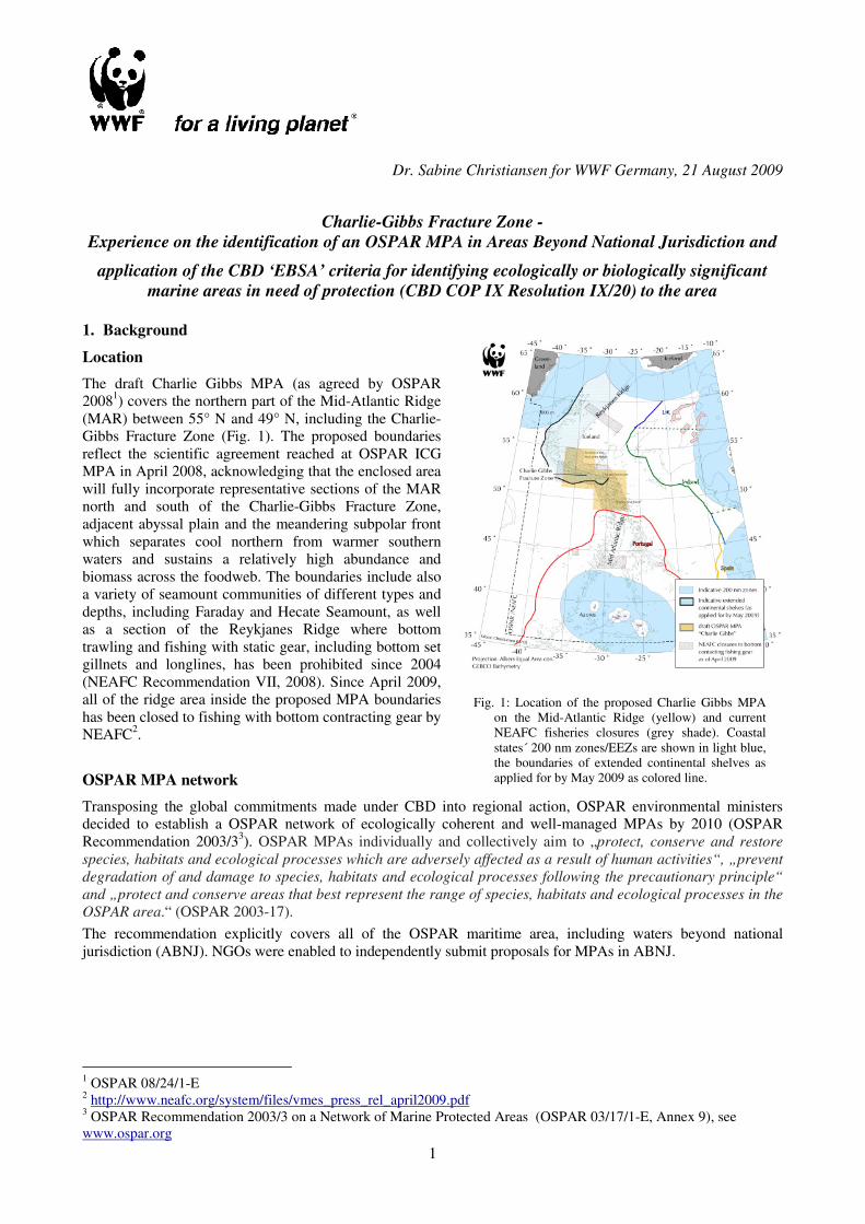
The draft Charlie Gibbs MPA (as agreed by OSPAR
20081) covers the northern part of the Mid-Atlantic Ridge
(MAR) between 55° N and 49° N, including the Charlie-
Gibbs Fracture Zone (Fig. 1). The proposed boundaries
reflect the scientific agreement reached at OSPAR ICG
MPA in April 2008, acknowledging that the enclosed area
will fully incorporate representative sections of the MAR
north and south of the Charlie-Gibbs Fracture Zone,
adjacent abyssal plain and the meandering subpolar front
which separates cool northern from warmer southern
waters and sustains a relatively high abundance and
biomass across the foodweb. The boundaries include also
a variety of seamount communities of different types and
depths, including Faraday and Hecate Seamount, as well
as a section of the Reykjanes Ridge where bottom
trawling and fishing with static gear, including bottom set
gillnets and longlines, has been prohibited since 2004
(NEAFC Recommendation VII, 2008). Since April 2009,
all of the ridge area inside the proposed MPA boundaries
has been closed to fishing with bottom contracting gear by
NEAFC2.
OSPAR MPA network
Transposing the global commitments made under CBD into regional action, OSPAR environmental ministers
decided to establish a OSPAR network of ecologically coherent and well-managed MPAs by 2010 (OSPAR
Recommendation 2003/33). OSPAR MPAs individually and collectively aim to „protect, conserve and restore
species, habitats and ecological processes which are adversely affected as a result of human activities“, „prevent
degradation of and damage to species, habitats and ecological processes following the precautionary principle“
and „protect and conserve areas that best represent the range of species, habitats and ecological processes in the
OSPAR area.“ (OSPAR 2003-17).
The recommendation explicitly covers all of the OSPAR maritime area, including waters beyond national
jurisdiction (ABNJ). NGOs were enabled to independently submit proposals for MPAs in ABNJ.
1 OSPAR 08/24/1-E
2 http://www.neafc.org/system/files/vmes_press_rel_april2009.pdf
3 OSPAR Recommendation 2003/3 on a Network of Marine Protected Areas (OSPAR 03/17/1-E, Annex 9), see
www.ospar.org
Fig. 1: Location of the proposed Charlie Gibbs MPA
on the Mid-Atlantic Ridge (yellow) and current
NEAFC fisheries closures (grey shade). Coastal
states´ 200 nm zones/EEZs are shown in light blue,
the boundaries of extended continental shelves as
applied for by May 2009 as colored line.
2
2. The elaboration process for the Charlie Gibbs MPA
Charlie Gibbs was the last of a series of five showcase proposals for marine protected areas beyond national
jurisdiction in the OSPAR area elaborated by WWF between 2000 and 20064. The other sites proposed, namely
part of the Rockall Bank, Josefine Bank, the BIOTRANS research area on the West European Basin abyssal plain
and the hydrothermal vent Rainbow, all lie in international waters, but with the seabed potentially falling onto the
extended continental shelves of coastal states.
Therefore, one of the motivations for the selection of the Charlie Gibbs Fracture Zone area on the Mid Atlantic
Ridge was to find a representative and biologically highly interesting area likely to fulfill the OSPAR site
selection criteria5 fully beyond national jurisdiction. Such a pilot MPA should be instrumental to testing and
developing further the selection process and all related OSPAR procedures as well as international governance
and management issues.
All actions taken by OSPAR until April 2009 have presumed that the area would not touch the extended
continental shelf of a coastal state. However, recently Iceland applied for its extended continental shelf boundaries
to be recognized, based on Art. 76 UNCLOS, as far south as 51.4° N, overlapping the northern part of the
proposed MPA (see Fig. 1).
Based on the OSPAR proforma for MPAs5, the first submission of WWFs Charlie Gibbs MPA proposal to the
working levels of OSPAR was elaborated in fall 2006. This first proposal was solely based on the scientific
literature published at that date, as well as the pre-publications to the media by the Census of Marine Life project
MAR-ECO (Patterns and Processes of the ecosystems of the northern mid-Atlantic6) from its first research
expedition to the area in 2004. The MAR-ECO investigations covered the distribution and abundance of
zooplankton, benthos, fish communities, as well as marine mammals and seabirds in several focal areas along the
Mid Atlantic Ridge, including the Charlie Gibbs Fracture Zone. These new results, together with the literature and
data compilation initiated by the project boosted the knowledge base for this remote area, previously known
mainly for the deepwater fishing activity taking place there since the 1970s (Clark et al. 2007).
After the presentation of the first WWF Charlie Gibbs MPA proposal in 2006, support was sought from
Contracting Parties, and by the next meeting in 2007, the Netherlands had decided to not only formally co-sponsor
the proposal but also to make available for one year a full position to foster the subject. This move generated the
support of the OSPAR MPA working group to request advice from ICES and a group of independant deepsea
scientists on the substance of the revised 2007 MPA proposal by January 2008. Also in January 2008, the special
volume compiling the results of the MARECO scientific expedition was published (Bergstad et al. 2008 and
related publications), which had not been available to WWF pre-print.
ICES checked whether the justifications for the area proposed met the OSPAR selection criteria and requested
that the new knowledge from the MAR-ECO project be included in the site proposal. Therefore, WWF made a
major revision of the proposal with all new knowledge included, which substantially broadend the basis for the
selection of the area. This revised proposal was subject to review by contracting parties and scientists in April
2008 (OSPAR ICG MPA) where it was concluded that it provided a sound scientific case for proposing the site to
be included in the OSPAR network of MPAs. In a parallel process, approximately the same area had been
proposed in a Germany-commissioned study by Roberts et al. , University of York. Therefore, a merged MPA
proposal was written to be presented to the OSPAR Commission meeting in June 2008. OSPAR 2008 considered
the proposal, now supported by France, The Netherlands and Portugal, and agreed that:
a. a comprehensive scientific case had been established for the CGFZ as a potential OSPAR MPA;
b. collectively Contracting Parties had expressed substantial political support for further work on the CGFZ
proposal;
c. the CGFZ is approved in principle as a potential MPA in areas beyond national jurisdiction (ABNJ) as a
component of the OSPAR network of MPAs, encompassing the seabed and the superjacent water column;
OSPAR 2008 also agreed a ‘road map’ with a view to considering the possible adoption of the CGFZ -MPA at the
OSPAR Ministerial Meeting in 2010.
4 all site descriptions and additional information can be found at http://www.ngo.grida.no/wwfneap/Projects/MPA.htm
(Promoting a Network of Marine Protected Areas Promoting a Network of Marine Protected Areas), see also
http://www.ngo.grida.no/wwfneap/Projects/Reports/WWF_NEA_HSMPA_Proposals.pdf (Marine Protected Areas in
Areas Beyond National Jurisdiction. Proposed High Seas MPAs in the North-East Atlantic (1998-2006)) 5 Guidelines for the Identification and Selection of Marine Protected Areas in the OSPAR Maritime Area (Reference
number: 2003-17), see www.ospar.org 6 see http://www.mar-eco.no
3
3. OSPAR MPA selection process
Other than the CBD EBSA criteria, the OSPAR criteria for identifying sites to be included in the OSPAR
network of ecologically coherent and well-managed MPAs include representativity among the ecological
criteria/considerations to be used in the first stage of site identification. To meet the aims of the OSPAR
MPA network representivity of natural characteristics is an important aspect in site selection (OSPAR 2006-
37).
The table in Annex 1 associates the ecological qualities of the Charlie Gibbs area with the criteria established
by OSPAR, CBD (EBSAs acc. COP 9 Decision IX/20 Annex I), and FAO (for vulnerable marine
ecosystems, FAO 2009). It is obvious that the Charlie Gibbs site proposal can satisfy all of the ecological
criteria set. However, this is strongly dependant on the scale of the analysis. The site nomination covers
approx. 300000 km2, a tiny fraction of this area being visited recently by one multidisciplinary scientific
expedition only, with very few other data available. Also historic landings of deepwater fish from the area
are primarily available only as unreviewed grey literature.
This shows that even in this relatively well documented and researched case, data constraints may not be
posed too high.
4. Views on data requirements
It is almost inevitable, that conflicting opinions will be heard on the requirements on data/literature quality
and quantity available. In the case of the Charlie Gibbs area, despite some support also, resistance to
nomination of the area based on the available scientific evidence came primarily from scientists,
argumenting for more science to be done before designation of the area. The government experts in the
OSPAR fora on the other hand were much more willing to accept data limitations and apply the
precautionary approach, as signed up for in CBD. Their basic request was to have a scientifically correct and
complete site description of a proposed MPA which appeared to be a relevant case for protection measures.
It can safely be assumed that the data quality and quantity available to justify potential MPAs in ABNJ can
always be questioned, with the possible exception of small hydrothermal vent fields. The degree of scientific
knowledge and understanding exponentially decreases with increasing distance from the coast and costs are
exploding. Therefore, it is also not likely that the knowledge base will significantly increase in the near
future.
Vice versa, the nomination and designation of MPAs has to be seen as a chance to raise funds for more
research and eventually monitoring. Therefore, rather than making a firm knowledge base the prerequisite
for site selection, the accumulation of knowledge on particular sites should be seen as an iterative process.
5. Effectiveness of the elaboration process
The WWF MPA proposals were meant to be showcases of different types of ecosystems in the North East
Atlantic being in need off spatial measures, and as such were not elaborated in a systematic way based on a
regional biodiversity classification system.
The hotspot approach is usually based on a pre-judgement of a likely conservation interest, or concrete
scientific knowledge of a site. Once a particular region of the ocean is considered for hosting a candidate
MPA area, the compilation of published literature and the establishment of contacts with scientists working
in the area is a straight forward process which is not very time consuming. It may be most effective to
commission the site description and data compilation to a (policy-experienced) scientist, where possible, to
tap immediately the most recent research results. OSPAR is usually requesting ICES to comment on the
scientific basis for MPAs proposed in ABNJ. However, the community of biological scientists working in
offshore pelagic and deep waters is very small, and it should be possible to establish a global scientific
advisory board for such questions.
7 Guidance on developing an ecologically coherent network of OSPAR marine protected areas (Reference number
2006-3), see www.ospar.org
4
6. Lessons learned
• The CBD EBSA criteria, like the OSPAR MPA criteria, can probably be applied to any site where some
level of knowledge exists. The criteria are very broad, and rather serve the identification of the site than
being instrumental to prioritising sites. As data availability and coverage will be very different for different
sites, expert judgement will still be required for selection.
• Both sets of criteria lack the dimension of threat from human activities, as inherent in the UNGA/FAO
vulnerable marine ecosystem approach (VME). This should be added as a prioritization criterion where
MPAs are an adequate measure.
• Concrete site proposals help to make progress with previously unprecedented governance and management
cases such as MPA identification in waters beyond national jurisdiction
• Early involvement of relevant scientists and scientific organisations can shorten the nomination process.
However, scientists have a different agenda and priorities and tools should be developed to make such
cooperation profitable for both sides (e.g. credit points for research grants).
• For NGOs it is paramount to seek support, if possible active engagement, from coastal states governments
early on in the process
• Particularly for pilot cases in a given region, the availability of scientific data and the ability to show
threats is crucial. Recent scientific observations add weight to the proposal, historic comparisons even
more. The level of information necessary might be lower in subsequent cases and further when applying
network approaches.
• Rather than prioritizing low-conflict sites, an acute threat from human activities subject to regulation
increases the urgency for action
• The spatial scale of proposed MPAs in ABNJ, and the temporal scale of deep sea ecosystem processes is
unlikely to be ever matched by adequate data coverage, and the precautionary approach needs to be
implemented. Therefore,
• Gaps in data coverage should not be an issue of primary concern in the first selection stage for network of
Marine Protected Areas in ABNJ. Rather, sites of interest qualifying under the CBD EBSA and network
criteria (COP 9 Decision IX/20 Annex I and II) should be used for designing a global map of sites of
interest, typified into different ecological groups of sites and allocated to the biogeographic realms
elaborated and published in the ‘GOODS report’ (UNESCO, 2009).
• In the absence of sufficient scientific data, MPAs should be selected for the global network based on
representativity and likelihood for occurrence of vulnerable marine ecosystems (sensu UNGA 61/105 and
FAO guidelines), rather than waiting for scientific evidence to accumulate. This is more cost-effective in
the short- and longterm.
• Designation of cross-regional transects could be an option for ensuring ecological coherence and
representation.
7. References
Bergstad, O.A., Falkenhaugh, T., Astthorsson, O.S., Byrkjedal, I., Gebruk, A.V., Piatkowski, U., Priede,
I.G., Santos, R.S., Vecchione, M., Lorance, P., Gordon, J.D.M., 2008. Towards improved understanding
of the diversity and abundance patterns of the mid-ocean ridge macro- and megafauna. Deep-Sea
Research II 55, 1-5.
Clark, M.R., Vinnichenko, V.I., Gordon, J.D.M., Beck-Bulat, G.Z., Kukharev, N.N., Kakora, A.F., 2007.
Large-scale distant-water trawl fisheries on seamounts. In: Pitcher, T.J., Morato, T., Hart, P.J.B., Clark,
M.R., Haggan, N., Santos, R.S. (Eds.), Seamounts: Ecology, Conservation and Management Blackwell
Publishing, Oxford, UK, pp. 361-399.
UNESCO 2009. Global Open Oceans and Deep Seabed (GOODS) – Biogeographic Classification. Paris,
UNESCO-IOC. (IOC Technical Series, 84.)
5
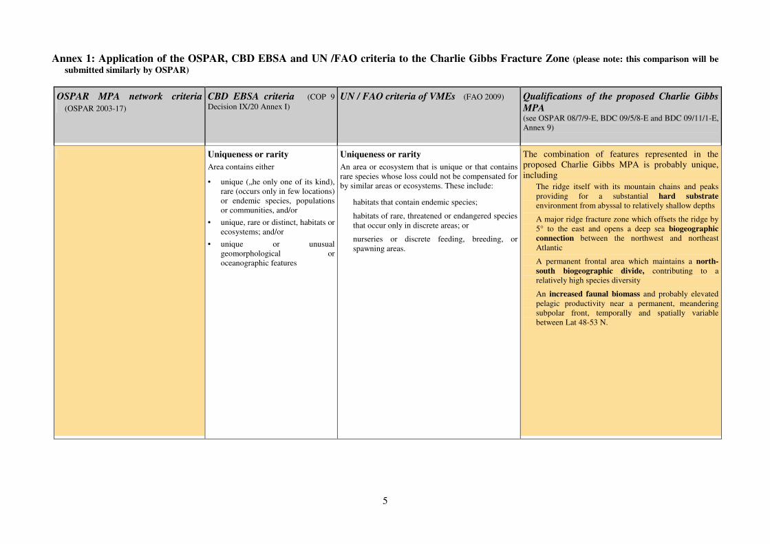
Annex 1: Application of the OSPAR, CBD EBSA and UN /FAO criteria to the Charlie Gibbs Fracture Zone (please note: this comparison will be
submitted similarly by OSPAR)
OSPAR MPA network criteria
�(OSPAR 2003-17)
CBD EBSA criteria �(COP 9
Decision IX/20 Annex I)
UN / FAO criteria of VMEs�(FAO 2009) Qualifications of the proposed Charlie Gibbs
MPA (see OSPAR 08/7/9-E, BDC 09/5/8-E and BDC 09/11/1-E,
Annex 9)
Uniqueness or rarity
Area contains either
• unique („he only one of its kind),
rare (occurs only in few locations)
or endemic species, populations
or communities, and/or
• unique, rare or distinct, habitats or
ecosystems; and/or
• unique or unusual
geomorphological or
oceanographic features
Uniqueness or rarity
An area or ecosystem that is unique or that contains
rare species whose loss could not be compensated for
by similar areas or ecosystems. These include:
� habitats that contain endemic species;
� habitats of rare, threatened or endangered species
that occur only in discrete areas; or
� nurseries or discrete feeding, breeding, or
spawning areas.
The combination of features represented in the
proposed Charlie Gibbs MPA is probably unique,
including
� The ridge itself with its mountain chains and peaks
providing for a substantial hard substrate
environment from abyssal to relatively shallow depths
� A major ridge fracture zone which offsets the ridge by
5° to the east and opens a deep sea biogeographic
connection between the northwest and northeast
Atlantic
� A permanent frontal area which maintains a north-
south biogeographic divide, contributing to a
relatively high species diversity
� An increased faunal biomass and probably elevated
pelagic productivity near a permanent, meandering
subpolar front, temporally and spatially variable
between Lat 48-53 N.
6
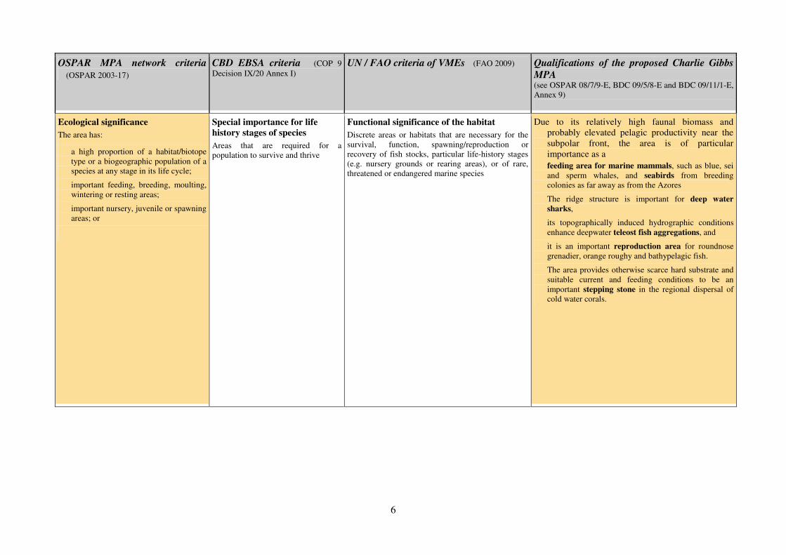
OSPAR MPA network criteria
�(OSPAR 2003-17)
CBD EBSA criteria �(COP 9
Decision IX/20 Annex I)
UN / FAO criteria of VMEs�(FAO 2009) Qualifications of the proposed Charlie Gibbs
MPA (see OSPAR 08/7/9-E, BDC 09/5/8-E and BDC 09/11/1-E,
Annex 9)
Ecological significance
The area has:
� a high proportion of a habitat/biotope
type or a biogeographic population of a
species at any stage in its life cycle;
� important feeding, breeding, moulting,
wintering or resting areas;
� important nursery, juvenile or spawning
areas; or
Special importance for life
history stages of species
Areas that are required for a
population to survive and thrive
Functional significance of the habitat
Discrete areas or habitats that are necessary for the
survival, function, spawning/reproduction or
recovery of fish stocks, particular life-history stages
(e.g. nursery grounds or rearing areas), or of rare,
threatened or endangered marine species
Due to its relatively high faunal biomass and
probably elevated pelagic productivity near the
subpolar front, the area is of particular
importance as a
� feeding area for marine mammals, such as blue, sei
and sperm whales, and seabirds from breeding
colonies as far away as from the Azores
� The ridge structure is important for deep water
sharks,
� its topographically induced hydrographic conditions
enhance deepwater teleost fish aggregations, and
� it is an important reproduction area for roundnose
grenadier, orange roughy and bathypelagic fish.
� The area provides otherwise scarce hard substrate and
suitable current and feeding conditions to be an
important stepping stone in the regional dispersal of
cold water corals.
7
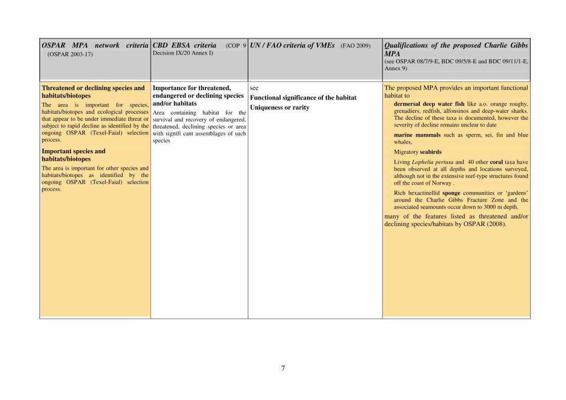
OSPAR MPA network criteria
�(OSPAR 2003-17)
CBD EBSA criteria �(COP 9
Decision IX/20 Annex I)
UN / FAO criteria of VMEs�(FAO 2009) Qualifications of the proposed Charlie Gibbs
MPA (see OSPAR 08/7/9-E, BDC 09/5/8-E and BDC 09/11/1-E,
Annex 9)
Threatened or declining species and
habitats/biotopes
The area is important for species,
habitats/biotopes and ecological processes
that appear to be under immediate threat or
subject to rapid decline as identified by the
ongoing OSPAR (Texel-Faial) selection
process.
Important species and
habitats/biotopes
The area is important for other species and
habitats/biotopes as identified by the
ongoing OSPAR (Texel-Faial) selection
process.
Importance for threatened,
endangered or declining species
and/or habitats
Area containing habitat for the
survival and recovery of endangered,
threatened, declining species or area
with signifi cant assemblages of such
species
see
Functional significance of the habitat
Uniqueness or rarity
The proposed MPA provides an important functional
habitat to � dermersal deep water fish like a.o. orange roughy,
grenadiers, redfish, alfonsinos and deep-water sharks.
The decline of these taxa is documented, however the
severity of decline remains unclear to date
� marine mammals such as sperm, sei, fin and blue
whales,
� Migratory seabirds
� Living Lophelia pertusa and 40 other coral taxa have
been observed at all depths and locations surveyed,
although not in the extensive reef-type structures found
off the coast of Norway .
� Rich hexactinellid sponge communities or ‘gardens’
around the Charlie Gibbs Fracture Zone and the
associated seamounts occur down to 3000 m depth.
many of the features listed as threatened and/or
declining species/habitats by OSPAR (2008).
8
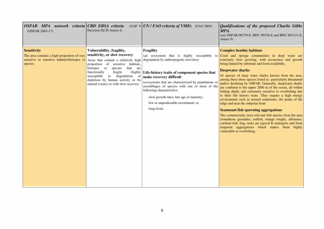
OSPAR MPA network criteria
�(OSPAR 2003-17)
CBD EBSA criteria �(COP 9
Decision IX/20 Annex I)
UN / FAO criteria of VMEs�(FAO 2009) Qualifications of the proposed Charlie Gibbs
MPA (see OSPAR 08/7/9-E, BDC 09/5/8-E and BDC 09/11/1-E,
Annex 9)
Sensitivity
The area contains a high proportion of very
sensitive or sensitive habitats/biotopes or
species.
Vulnerability, fragility,
sensitivity, or slow recovery
Areas that contain a relatively high
proportion of sensitive habitats,
biotopes or species that are
functionally fragile (highly
susceptible to degradation or
depletion by human activity or by
natural events) or with slow recovery
Fragility
(an ecosystem that is highly susceptible to
degradation by anthropogenic activities)
Life-history traits of component species that
make recovery difficult
(ecosystems that are characterized by populations or
assemblages of species with one or more of the
following characteristics:
� slow growth rates; late age of maturity;
� low or unpredictable recruitment; or
� long-lived.
Complex benthic habitats
Coral and sponge communities in deep water are
extremely slow growing, with occurrence and growth
being limited by substrate and food availabilty.
Deepwater sharks
44 species of deep water sharks known from the area,
among these three species listed as particularly threatened
and/or declining by OSPAR. Generally, deepwater sharks
are confined to the upper 2000 m of the ocean, all within
fishing depth, and extremely sensitive to overfishing due
to their life history traits. They require a high energy
environment such as around seamounts, the peaks of the
ridge and near the subpolar front.
Seamount fish spawning aggregations
The commercially most relevant fish species from the area
(roundnose grenadier, redfish, orange roughy, alfonsino,
cardinal fish, ling, tusk) are typical K-strategists and form
temporal aggregations which makes them highly
vulnerable to overfishing.
9
OSPAR MPA network criteria
�(OSPAR 2003-17)
CBD EBSA criteria �(COP 9
Decision IX/20 Annex I)
UN / FAO criteria of VMEs�(FAO 2009) Qualifications of the proposed Charlie Gibbs
MPA (see OSPAR 08/7/9-E, BDC 09/5/8-E and BDC 09/11/1-E,
Annex 9)
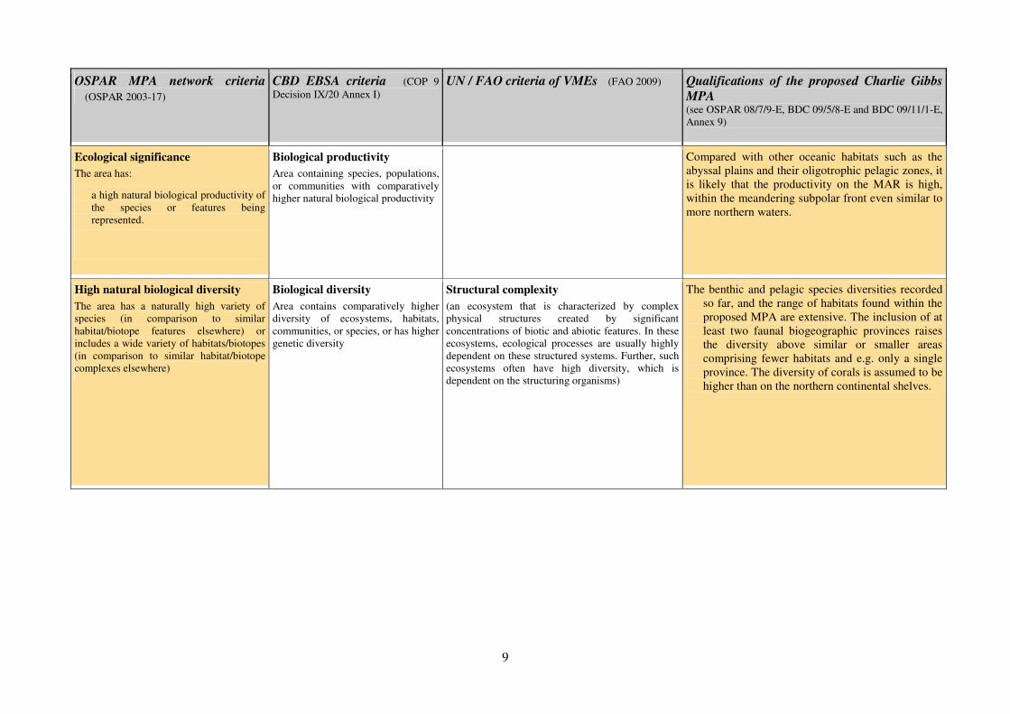
Ecological significance
The area has:
� a high natural biological productivity of
the species or features being
represented.
Biological productivity
Area containing species, populations,
or communities with comparatively
higher natural biological productivity
Compared with other oceanic habitats such as the
abyssal plains and their oligotrophic pelagic zones, it
is likely that the productivity on the MAR is high,
within the meandering subpolar front even similar to
more northern waters.
High natural biological diversity
The area has a naturally high variety of
species (in comparison to similar
habitat/biotope features elsewhere) or
includes a wide variety of habitats/biotopes
(in comparison to similar habitat/biotope
complexes elsewhere)
Biological diversity
Area contains comparatively higher
diversity of ecosystems, habitats,
communities, or species, or has higher
genetic diversity
Structural complexity
(an ecosystem that is characterized by complex
physical structures created by significant
concentrations of biotic and abiotic features. In these
ecosystems, ecological processes are usually highly
dependent on these structured systems. Further, such
ecosystems often have high diversity, which is
dependent on the structuring organisms)
The benthic and pelagic species diversities recorded
so far, and the range of habitats found within the
proposed MPA are extensive. The inclusion of at
least two faunal biogeographic provinces raises
the diversity above similar or smaller areas
comprising fewer habitats and e.g. only a single
province. The diversity of corals is assumed to be
higher than on the northern continental shelves.
10
OSPAR MPA network criteria
�(OSPAR 2003-17)
CBD EBSA criteria �(COP 9
Decision IX/20 Annex I)
UN / FAO criteria of VMEs�(FAO 2009) Qualifications of the proposed Charlie Gibbs
MPA (see OSPAR 08/7/9-E, BDC 09/5/8-E and BDC 09/11/1-E,
Annex 9)
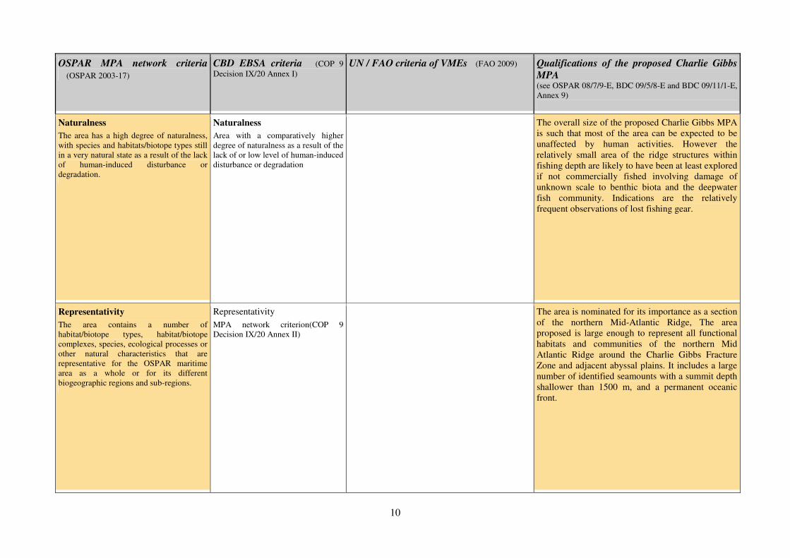
Naturalness
The area has a high degree of naturalness,
with species and habitats/biotope types still
in a very natural state as a result of the lack
of human-induced disturbance or
degradation.
Naturalness
Area with a comparatively higher
degree of naturalness as a result of the
lack of or low level of human-induced
disturbance or degradation
The overall size of the proposed Charlie Gibbs MPA
is such that most of the area can be expected to be
unaffected by human activities. However the
relatively small area of the ridge structures within
fishing depth are likely to have been at least explored
if not commercially fished involving damage of
unknown scale to benthic biota and the deepwater
fish community. Indications are the relatively
frequent observations of lost fishing gear.
Representativity
The area contains a number of
habitat/biotope types, habitat/biotope
complexes, species, ecological processes or
other natural characteristics that are
representative for the OSPAR maritime
area as a whole or for its different
biogeographic regions and sub-regions.
Representativity
MPA network criterion(COP 9
Decision IX/20 Annex II)
The area is nominated for its importance as a section
of the northern Mid-Atlantic Ridge, The area
proposed is large enough to represent all functional
habitats and communities of the northern Mid
Atlantic Ridge around the Charlie Gibbs Fracture
Zone and adjacent abyssal plains. It includes a large
number of identified seamounts with a summit depth
shallower than 1500 m, and a permanent oceanic
front.

1
Mauricio Galvez, WWF Chile, 29 July 2009
Applying the CBD ‘EBSA’ criteria for identifying ecologically or biologically
significant marine areas in need of protection (CBD COP IX Resolution IX/20)
to the Nazca and Salas y Gomez submarine ridges
1. Background
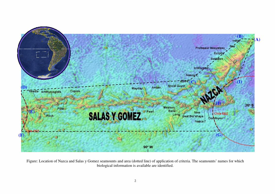
The Salas y Gomez and Nazca ridges are two sequential chains of submarine mountains of volcanic origin
located in the Southeastern Pacific Ocean, which together have an extension of 2,900 km. The Salas y Gomez
ridge lies in a west-east orientation localized between 23°42’ S and 29°12’ S and the 111°30’ W and 86°30’ W.
In its western end it intersects the East Pacific Rise inside the Chile insular EEZ (Easter Island) and its eastern
end adjoins to the western end of Nazca ridge.
The Nazca ridge spreads in a southwest-northeastern direction and is localized between the parallels 15°00’ S
and 26°09’ S and between the meridians 86°30’ W and 76°06’ W. In its southern end involves part of the Chile
insular EEZ (San Felix Island) and in its northern end is introduced all the way to the Peru-Chile subduction
zone (Peru EEZ).
The area beyond national jurisdiction under analysis covers about 1,246,608 km2, which represent approximately
5.04% of the international waters surface in the FAO area No. 87. Further, it contains about 110 seamounts with
summits between the sea surface level and 2,000 m depth (fishable depths), which represent some 41% of the
seamounts in the Southeastern Pacific Ocean. The area is a hotspot with one of the highest levels of marine
biological endemism (41.2% in fishes and 46.3% in invertebrates) in the World and also is considered a stepping
stone for some marine mammals (e.g., blue whale, Rodrigo Hucke-Gaete personal communication). It has been
described as recruitment and nursery area for swordfish (Xiphias gladius) (Yañez et al., 2004, 2006, 2009) and it
is part of the breeding zone described for Chilean jack mackerel (Trachurus murphyi) (Arcos et al., 2001; Anon.,
2007).
Until now the area has been subject of minor, localized and sporadic activities, like bottom fishing and
geological surveys and, therefore, a high degree of naturalness is expected for many seamounts into the area.
The area to which we have applied the criteria does not consider the zone inside the EEZ of Chile and Peru. It is
circumscribed by the polygon of vertexes and semi-curves (see Fig.):
(A) 79º 12' 27" W and 19º 11' 20" S;
(B) 81º 07' 24" W and 19º 11' 20" S;
(C) 85º 44' 56" W and 23º 08' 36" S;
(D) the northern intersection formed by the meridian 102º 34' 07" W and the arc
produced by EEZ of Salas y Gomez Island;
(E) the Eastern arc generated by EEZ of Salas y Gomez Island between the vertex (D)
and (F);
(F) the southern intersection formed by the meridian 104º 29' 45" W and the arc
produced by EEZ of Salas y Gomez Island;
(G) the southern intersection formed by the meridian 82º 30' 13" W and the arc
produced by EEZ of San Felix Island;
(H) the western arc generated by EEZ of San Felix Island between the vertex (G) and
(I);
(I) the northern intersection generated by the meridian 81º 26' 00" W and the arc
produced by EEZ of San Felix Island.
2
Figure: Location of Nazca and Salas y Gomez seamounts and area (dotted line) of application of criteria. The seamounts’ names for which
biological information is available are identified.
(A) (B)
(C)
(D)
(E)
(F) (G)
(H)
(I)
- 3 -
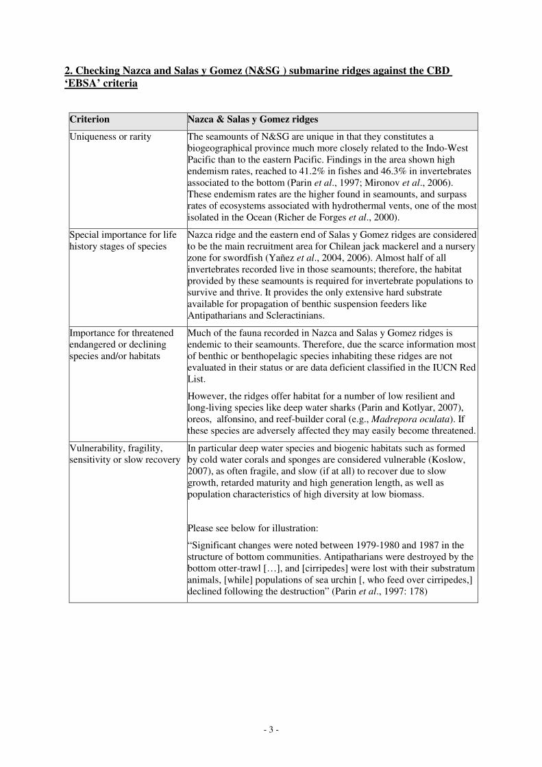
2. Checking Nazca and Salas y Gomez (N&SG ) submarine ridges against the CBD
‘EBSA’ criteria
Criterion Nazca & Salas y Gomez ridges
Uniqueness or rarity The seamounts of N&SG are unique in that they constitutes a
biogeographical province much more closely related to the Indo-West
Pacific than to the eastern Pacific. Findings in the area shown high
endemism rates, reached to 41.2% in fishes and 46.3% in invertebrates
associated to the bottom (Parin et al., 1997; Mironov et al., 2006).
These endemism rates are the higher found in seamounts, and surpass
rates of ecosystems associated with hydrothermal vents, one of the most
isolated in the Ocean (Richer de Forges et al., 2000).
Special importance for life
history stages of species
Nazca ridge and the eastern end of Salas y Gomez ridges are considered
to be the main recruitment area for Chilean jack mackerel and a nursery
zone for swordfish (Yañez et al., 2004, 2006). Almost half of all
invertebrates recorded live in those seamounts; therefore, the habitat
provided by these seamounts is required for invertebrate populations to
survive and thrive. It provides the only extensive hard substrate
available for propagation of benthic suspension feeders like
Antipatharians and Scleractinians.
Importance for threatened
endangered or declining
species and/or habitats
Much of the fauna recorded in Nazca and Salas y Gomez ridges is
endemic to their seamounts. Therefore, due the scarce information most
of benthic or benthopelagic species inhabiting these ridges are not
evaluated in their status or are data deficient classified in the IUCN Red
List.
However, the ridges offer habitat for a number of low resilient and
long-living species like deep water sharks (Parin and Kotlyar, 2007),
oreos, alfonsino, and reef-builder coral (e.g., Madrepora oculata). If
these species are adversely affected they may easily become threatened.
Vulnerability, fragility,
sensitivity or slow recovery
In particular deep water species and biogenic habitats such as formed
by cold water corals and sponges are considered vulnerable (Koslow,
2007), as often fragile, and slow (if at all) to recover due to slow
growth, retarded maturity and high generation length, as well as
population characteristics of high diversity at low biomass.
Please see below for illustration:
“Significant changes were noted between 1979-1980 and 1987 in the
structure of bottom communities. Antipatharians were destroyed by the
bottom otter-trawl […], and [cirripedes] were lost with their substratum
animals, [while] populations of sea urchin [, who feed over cirripedes,]
declined following the destruction” (Parin et al., 1997: 178)
- 4 -
Biological productivity Daneri et al (2000) have shown strong evidence that may support the
formation of Taylor columns over the seamounts of Nazca ridge, and
the occurrence of local upwelling process in Nazca area, making this
area particularly more productive than the surrounding South-eastern
Pacific Ocean.
The Nazca area is slightly influenced by the eastern boundary currents
of the South Pacific anticyclonic gyre. The Chile Current arises in the
Subantarctic region. Thus, it carries “equatorward”, along the coast of
Chile, Subantarctic Water. When it reaches approximately 20° S,
influenced by the southeast trade winds and coastal configuration, turns
westward, away from the coast influencing Nazca area with rich-
nutrients waters (Galvez, in press).
Biological diversity Few comprehensive studies have been conducted on the N&SG ridges.
Taking into account only the Russian research, we know that 192
species of benthopelagic and benthic invertebrates and 171 species of
fishes inhabit the 22 explored seamounts of the Nazca and Salas y
Gomez ridges (Parin et al., 1997). If we consider that the area comprise
at least 110 seamounts, then we can expect to discover a much higher
biodiversity. It is important to note that the bottom of Nazca and Salas y
Gomez ridges has not been biologically sampled. Elevations and depths
ranging from abyssal soft sediment plains and trenches to the hard
bottom peaks of seamounts and hills on the ridges may provide for an
extensive range of ecological niches.
Naturalness It can be assumed that most seamounts along the Nazca ridge were at
least explored once. There is evidence of sporadic deep fishing
(trawling and pots) by Russian and Chilean fleet (Galvez, in press)
There are indications that big branches of gorgonias were destroyed by
trawlers (Parin et al., 1997). However, from beyond fishing depth, no
significant human impacts are known. In the case of Salas y Gomez
ridge, most of the fishing activity carried out is on pelagic layer (Vega
et al., 2009). Only the former URSS scientific expeditions and Chilean
fishing fleet are know to fish in this area (Galvez, in press)..
3. Conclusion
WWF finds that the area under study fulfills the criteria adopted by the CBD. In applying the
criteria to what WWF had considered to be an ecologically and biologically significant area
before, we find that the criteria served their purpose well and cover the main aspects that
should be considered when identifying such areas.
- 5 -
4. Literature reviewed
Anon., 2007. Report from Chile on jack mackerel research and stock assessment. Paper SPRFMO-III-SWG-18
presented at Third Scientific Working Group of South pacific Regional Fisheries Organisation, 25-27 April 2007
in Reñaca, Chile [http://www.southpacificrfmo.org/third-swg-meeting/].
Anon. 2008. Update of data submitted to the Interim Secretariat: Canberra 2008. SPRFMO Interim Secretariat
Report. SPRFMO-VI-DIWG-10-Rev2. [http://www.southpacificrfmo.org/working-groups/public/sixth-d-and-
iwg-meeting/].
Arana, P. 2003. Experiencia chilena en faenas de pesca en aguas profundas y distantes: evolución y perspectivas.
In: E. Yáñez (ed.). Actividad pesquera y de acuicultura en Chile. Escuela de Ciencias del Mar, Pontificia
Universidad Católica de Valparaíso, pp. 57-79.
Arana, P. & V. Venturini. 1991. Investigaciones biológico-pesqueras de crustáceos en la cordillera de Nazca
(océano Pacífico suroriental). Informe Técnico de Pesca Chile, 47: 86 pp.
Arcos, D., L. Cubillos & S. Nuñez. 2001. The jack mackerel fishery and El Niño 1997-1998 effects off Chile.
Progress in Ocenography 49: 597-617.
Belyanina, T.N. 1989. Ichthyoplankton in the regions of the Nazca and Sala y Gomes submarine ridges. J.
Ichthyol., 29: 84-90.
Belyanina, T.N. 1990. Larvae and fingerlings of little-known benthic and benthopelagic fishes from the Nasca
and Salas y Gómez ridges. J. Ichthyol., 30(8): 1–11.
Bonatti, E., C.G.A. Harrison, D.E. Fisher, J. Honnorez, J.G. Schilling, J.J. Stipp & M. Zentilli. 1977. Easter
volcanic chain (Southeast Pacific): a mantle hot line. J. Geophys. Res., 82(17): 2457-2478.
Clark, J.G. & J. Dymond. 1977. Geochronology and petrochemistry of Easter and Sala y Gómez islands;
implications for the origin of the Sala y Gómez Ridge. J. Volcanol. Geoth. Res., 2(1): 29-48.
Clark, M., A. Rowden & A. Stocks. 2004. CenSeam: a global census on marine life on seamounts: a proposal for
a new CoML field project. [http://censeam.niwa.co.nz/science/censeam_proposal.pdf].
Daneri, G., V. Dellarossa, R. Quiñones, B. Jacob, P. Montero & O. Ulloa. 2000. Primary production and
community respiration in the Humboldt current system off Chile and associated oceanic areas. Mar. Ecol. Prog.
Ser., 197: 41-49.
Earth Reference Data and Models. 2007. Seamount catalog. Seamount Biogeosciences Network.
[http://earthref.org/cgi-bin/sc-s0-main.cgi].
Food and Agriculture Organisation, UN (FAO). 2007. FAO Fisheries Department, Fishery Information, Data and
Statistics Unit. FishStat Plus: Universal Software for fishery statistical time series. Version 2.3.2000.
Fuenzalida, R., J.L. Blanco & C. Vega. 2000. Fronteras de la corriente de Humboldt y masas de agua entre el
continente e isla de Pascua. Libro de Resúmenes: Taller sobre los resultados del crucero Cimar-Fiordo 5.
Valparaíso, pp. 24–32.
Gálvez, M. 2006. Sinopsis de ecosistemas marinos vulnerables y propuesta de cierre de áreas al arrastre de fondo
y redes de enmalle. Documento de Trabajo. Informe Técnico (R.Pesq.) Nº 069, Subsecretaría de Pesca,
Valparaíso, 36 pp.
Gálvez, M. 2007. Ecosistemas marinos vulnerables: ¿A la vuelta de la esquina? Rev. Chile Pesq., 171: 30-35.
Gálvez, M. (in press). Seamounts of Nazca and Salas y Gómez: a review for management and conservation
purposes. Special issue: “Deep Water Fishing off Latin America”. Lat. Am. J. Aquat. Res., 37(3).
Glynn, P.W. & J.S. Ault. 2000. A biogeographic analysis and review of the far eastern Pacific coral reef region.
Coral Reefs, 19: 1-23.
Haase, K.M., P. Stoffers & C.D. Garbe-Schonberg. 1997. The petrogenetic evolution of lavas from Easter Island
and neighboring seamounts, near-ridge hotspot volcanoes in the SE Pacific. J. Petrology, 38(6): 785-813.
Hubbs, C.L. 1959. Initial discoveries of fish faunas on seamounts and offshore banks in the Eastern Pacific. Pac.
Sci., 13: 311-316.
Koslow, T. 2007. The silent deep: the discovery, ecology and conservation of the deep sea. Chicago. The
University of Chicago Press, Chicago, 270 pp.
Lillo, S., R. Bahamonde, B. Leiva, M. Rojas, M.A. Barbieri, M. Donoso & R. Gili. 1999. Prospección del recuso
Orange roughy (Hoplosthetus spp.) y su fauna acompañante entre la I y X Región. Informe Final FIP Nº98-05.
[http://www.fip.cl/prog_recurso/1998/9805.htm].
Mammerickx, J. 1981. Depth anomalies in the Pacific: active, fossil and precursor. Earth Planet. Sci. Lett., 53:
147-157.
Mironov, A.N., T.N. Molodtsova & N.V. Parin. 2006. Soviet and Russian studies on seamount biology.
[http://www.isa.org.jm/en/scientific/workshops/2006/Mar06].
- 6 -
Moraga, J., A. Valle-Levinson & J. Olivares. 1999. Hydrography and geostrophy around Easter Island. Deep-Sea
Res I, 46: 715-731.
Naar, D.F., K. Johnson, D. Pyle, P. Wessel, R.A. Duncan & J. Mahoney. 2001. RAPA NUI 2001: Cruise report
for Leg 6 of the Drift expedition aboard the R/V Revelle. [http://www.soest.hawaii.edu/wessel/drft06rr/
drft06rr.report.html].
Naar, D.F., T.M. Kevin, P.W. Johnson & D. Pyle. 2002. Preliminary multibeam mapping and dredging results
along the Nazca ridge and Easter/Salas y Gómez chain. Eos Trans AGU, 83(4), Ocean Sciences Meet. Suppl,
Abstract OS32O-11.
O’Connor, J.M., P. Stoffers & M.O. McWilliams. 1995. Time-space mapping of Easter Chain volcanism. Earth
Planet. Sci. Lett., 136: 197-212.
Pakhorukov, N.P., A.B. Levin & O.N. Danilyuk. 2000. Distribution and behavior of Spiny lobster, Projasus
bahamondei on underwater Naska ridge (the Pacific Ocean). Ecologiya Morya (Ecología Marina), 50: 53-57.
Parin, N.V., A.N. Mironov & K.N. Nesis. 1997. Biology of the Nazca and Sala y Gómez submarine ridges, an
outpost of the Indo-West Pacific fauna in the Eastern Pacific Ocean: composition and distribution of the fauna,
its communities and history. In: A.V. Gebruk et al. (ed.). The biogeography of the oceans. Adv. Mar. Biol., 32:
145-242.
Parin, N.V. and A. N. Kotlyar. 2007. On Finding of Shark of the Genus Somniosus (Squalidae) at the Submarine
Ridge of Nazca (Southeastern Pacific). Journal of Ichthyology 47(8): 669–672.
Pitcher, T., T. Morato, P. Hart, M. Clark, N. Haggan & R. Santos (eds.). 2007. Seamounts: ecology, fisheries and
conservation. Oxford, Fish. Aquat. Res. Ser., 12: 536 pp.
Richer de Forges, B.; J.A. Koslow & G.C.B. Poore. 2000. Diversity and endemism of the benthic seamount
fauna in the southwest Pacific. Nature, 405: 944–947.
Rivera, J. & A. Mujica. 2004. Distribución horizontal de larvas de crustáceos decápodos capturadas entre
Caldera e isla de Pascua (Pacifico sudoriental), octubre de 1999. Invest. Mar., 32(2): 37-58.
Rogers, A.D. 1994. The biology of seamounts. Adv. Mar. Biol., 30: 305-350.
SeamountOnline 2007. SeamountOnline: An online information system for seamount biology.
[http://seamounts.sdsc.edu].
Shipboard Scientific Party. 2003. Site 1236. In: A.C. Mix, R. Tiedemann, P. Blum, et al. completar(eds.). Proc.
ODP, Init. Repts., 202: College Station, TX (Ocean Drilling Program). [http://www.-odp.tamu.edu/publications/
202_ir/volume/chapters/ir202_07.pdf].
Subsecretaría de Pesca (Subpesca). 2006. Cuota global anual de captura Alfonsino (Beryx splendens), año 2006.
Inf. Téc. (R.Pesq.) Nº117. Subsecretaría de Pesca, Valparaíso, noviembre de 2005, 28 pp.
Vega, R., R. Licandeo, G. Rosson & E. Yáñez. 2009. Species catch composition, length structure and
reproductive indices of swordfish (Xiphias gladius) at Easter Island zone. Lat. Am. J. Aquat. Res., 37(1): 83-95.
[http://www.scielo.cl/pdf/lajar/v37n1/art07.pdf]
Weinborn, J.A., P. Báez & A.Y. Radtchenko. 1992. Langostas en el Mar Presencial. Rev. Chile Pesq., 67: 21-24.
White, M. & C. Mohn. 2004. Seamounts: a review of physical processes and their influence on the seamount
ecosystem. OASIS report, University Hamburg, 40 pp. [http://www1.uni-hamburg.de/oasis//pages/publications/
oceanography.pdf].
Woods, M.T. & E.A. Okal. 1994. The structure of the Nazca Ridge and Sala y Gómez seamount chain from the
dispersion of Rayleigh waves. Geophys. J. Int., 117(1): 205-222.
Yáñez, E., C. Silva, J. Marabolí, F. Gómez, N. Silva, E. Morales, A. Bertrand, et al. Completar 2004.
Caracterización ecológica y pesquera de la cordillera de Nazca como área de crianza del Pez espada. Informe
Final, Proyecto FIP N° 2002–04: 389 pp.
Yáñez, E., C. Silva, N. Silva, A. Ordenes, F. Leiva, P. Rojas, J. Chong, et al. Completar 2006. Caracterización
ecológica y pesquera de la cordillera de Nazca como área de crianza del Pez espada, fase II. Informe Final,
Proyecto FIP N° 2004–34: 236 pp.
Yáñez, E., C. Silva, M. Barbieri1, A. Órdenes & R. Vega. 2009. Environmental conditions associated with
swordfish size compositions and catches off the Chilean coast. Lat. Am. J. Aquat. Res., 37(1): 71-81
[http://www.lajar.cl/pdf/imar/v37n1/Articulo_37_1_6.pdf].
1
Jennifer Smith, WWF Canada, 21 August 2009
Applying the CBD ‘EBSA’ criteria for identifying ecologically or biologically significant
marine areas in need of protection (CBD COP IX Resolution IX/20):
a case study on the Grand Banks
1. Introduction
Work done to date on the identification of areas of ecological and biological significance in the Northwest
Atlantic has consistently highlighted the area known as the Southeast Shoal, laying the groundwork for
recognition as an Ecologically and Biologically Significant Area (EBSA), and demonstrating the practical
utility of the CBD criteria for site selection. This brief document has been collated to serve as a case
study of the application of the CBD EBSA criteria to an interesting high seas/domestic open ocean
ecosystem. The consistent findings of scientists, government and NGOs demonstrate the utility of
the CBD criteria for this purpose.
Overview of the Southeast Shoal
The Southeast Shoal (also referred to as the “Southeast Shoal and Tail of the Grand Bank” and the
Southern Grand Bank”) is a shallow sandy plateau located on the southern Grand Bank, off the Atlantic
Canadian province of Newfoundland and Labrador. The Shoal is a relict beach habitat from the last
glacial advance; home to three relict beach populations (blue mussel, wedge clam, and capelin); an
important nursery area for yellowtail flounder, American plaice, and Atlantic cod (plaice and cod are
severely depleted); an important spawning area for capelin, and an important feeding area for many
cetaceans and seabirds (see Fuller and Myers 2004).
2. Progress toward assessing the Southeast Shoal on the basis of the CBD criteria
This document consolidates two instances where experts have assessed the Southeast Shoal for its
ecological and biological significance – one of which were structured to respond directly to the CBD
EBSA criteria.
Fuller, S.D. and R.A. Myers. 2004. The Southern Grand Bank: a marine protected area for the
world. WWF-Canada, Halifax. 99p.
In this 2004 report, Fuller and Myers document the properties of the southern Grand Bank and
specifically, the Southeast Shoal. Their report gathers data-based evidence for:
• The high productivity of the ecosystem, which has sustained exceptionally abundant and
commercially valuable marine life for centuries.
• The special importance of the area for the life history stages of several species: the region is
known as a spawning and feeding ground for many fish, birds and marine mammals.
• They also document the uniqueness/rarity of the area as a relict beach ecosystem containing unusual
offshore populations of blue mussel and wedge clam.
2
• The importance of the area for threatened and/or declining species, given the currently severely
altered state of the Northwest Atlantic ecosystem and the importance of the area as a nursery habitat
for cod, home to an offshore spawning population of capelin (an important forage species for
groundfish), a discrete population of humpback whales, and migrating leatherback and loggerhead
turtles.
• The deep sea, cold water coral species that are inherently vulnerable, fragile and slow to recover
from disturbance.
• The relative naturalness of this area in a region where intensive industrial fishing has led to large-
scale ecosystem collapse.
Templeman, N.D. 2007. Placentia Bay – Grand Banks Large Ocean Management Area Ecologically
and Biologically Significant Areas. Canadian Science Advisory Secretariat Research Document
2007/052.
Document abstract: The purpose of this report is to identify Ecologically and Biologically Significant
Areas (EBSAs) for the Placentia Bay-Grand Banks Large Ocean Management Area (PBGB LOMA)
based on the guidelines in CSAS Ecosystem Status Report 2004/006. The exercise was carried out using
information from several key documents that detailed ecosystem overview and status, fish distribution
and spawning, and single species assessment. Scientists in the Newfoundland Region also provided input
on those areas that they felt could be deemed significant based on their knowledge and experience. The
result of these exercises was the identification and description of 11 EBSAs and their significant features,
as well as a corresponding map.
Canada has developed a very closely aligned set of criteria for the identification of EBSAs in domestic
waters: in fact, Canada’s work on these criteria was one of the major sources for the CBD criteria. This
document predates the adoption of the final CBD criteria; however the criteria can be easily
‘crosswalked’.
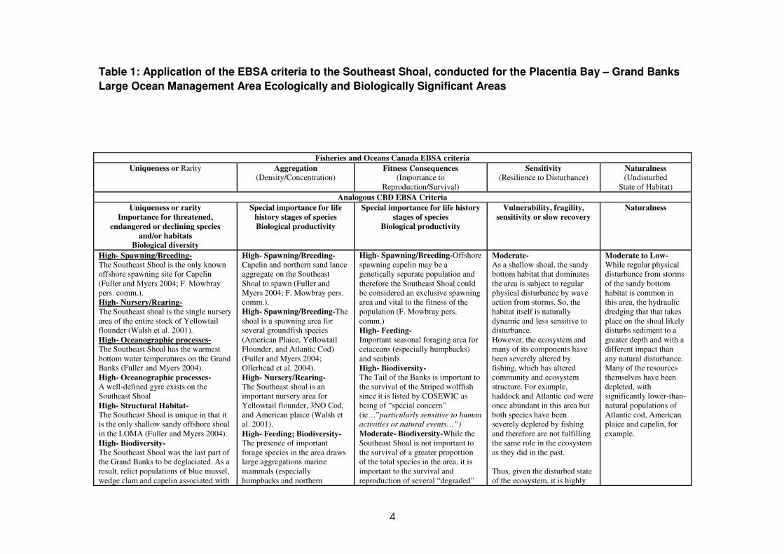
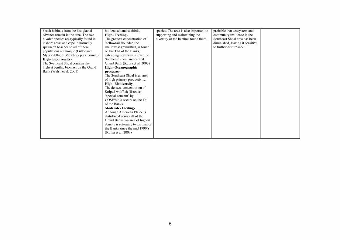
See table 1 for a point-form summary of the assessment of the Southeast Shoal on each criteria.
3. Conclusion
In order to provide perspective on the practicality and applicability of the EBSA Criteria, WWF-Canada
has collated and reviewed a number of assessments which have investigated the significance of the
Southeast Shoal and Tail of the Grand Banks, an area in the Northwest Atlantic off of the Canadian
province of Newfoundland and Labrador. This area straddles domestic and High Seas waters and has been
of great historical and present-day importance to many fishing countries. It may also hold one of the keys
to recovery of this highly degraded regional ecosystem.
Our review found that similar applications of the Criteria were consistent in highlighting this area as one
of the most significant in the region: we believe that this lends credence to the Criteria and their utility.
3
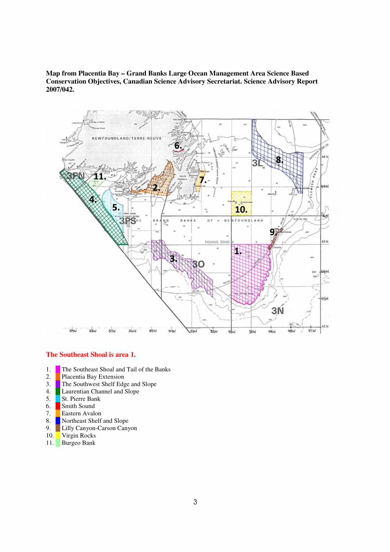
Map from Placentia Bay – Grand Banks Large Ocean Management Area Science Based
Conservation Objectives, Canadian Science Advisory Secretariat. Science Advisory Report
2007/042.
The Southeast Shoal is area 1.
1. █ The Southeast Shoal and Tail of the Banks
2. █ Placentia Bay Extension
3. █ The Southwest Shelf Edge and Slope
4. █ Laurentian Channel and Slope
5. █ St. Pierre Bank
6. █ Smith Sound
7. █ Eastern Avalon
8. █ Northeast Shelf and Slope
9. █ Lilly Canyon-Carson Canyon
10. █ Virgin Rocks
11. █ Burgeo Bank
4
Table 1: Application of the EBSA criteria to the Southeast Shoal, conducted for the Placentia Bay – Grand Banks
Large Ocean Management Area Ecologically and Biologically Significant Areas
Fisheries and Oceans Canada EBSA criteria
Uniqueness or Rarity Aggregation (Density/Concentration)
Fitness Consequences (Importance to
Reproduction/Survival)
Sensitivity (Resilience to Disturbance)
Naturalness (Undisturbed
State of Habitat)
Analogous CBD EBSA Criteria
Uniqueness or rarity
Importance for threatened,
endangered or declining species
and/or habitats
Biological diversity
Special importance for life
history stages of species
Biological productivity
Special importance for life history
stages of species
Biological productivity
Vulnerability, fragility,
sensitivity or slow recovery
Naturalness
High- Spawning/Breeding- The Southeast Shoal is the only known
offshore spawning site for Capelin
(Fuller and Myers 2004; F. Mowbray
pers. comm.).
High- Nursery/Rearing- The Southeast shoal is the single nursery
area of the entire stock of Yellowtail
flounder (Walsh et al. 2001).
High- Oceanographic processes- The Southeast Shoal has the warmest
bottom water temperatures on the Grand
Banks (Fuller and Myers 2004).
High- Oceanographic processes- A well-defined gyre exists on the
Southeast Shoal
High- Structural Habitat- The Southeast Shoal is unique in that it
is the only shallow sandy offshore shoal
in the LOMA (Fuller and Myers 2004).
High- Biodiversity- The Southeast Shoal was the last part of
the Grand Banks to be deglaciated. As a
result, relict populations of blue mussel,
wedge clam and capelin associated with
High- Spawning/Breeding-Capelin and northern sand lance
aggregate on the Southeast
Shoal to spawn (Fuller and
Myers 2004; F. Mowbray pers.
comm.).
High- Spawning/Breeding-The
shoal is a spawning area for
several groundfish species
(American Plaice, Yellowtail
Flounder, and Atlantic Cod)
(Fuller and Myers 2004;
Ollerhead et al. 2004).
High- Nursery/Rearing- The Southeast shoal is an
important nursery area for
Yellowtail flounder, 3NO Cod,
and American plaice (Walsh et
al. 2001).
High- Feeding; Biodiversity- The presence of important
forage species in the area draws
large aggregations marine
mammals (especially
humpbacks and northern
High- Spawning/Breeding-Offshore
spawning capelin may be a
genetically separate population and
therefore the Southeast Shoal could
be considered an exclusive spawning
area and vital to the fitness of the
population (F. Mowbray pers.
comm.)
High- Feeding- Important seasonal foraging area for
cetaceans (especially humpbacks)
and seabirds
High- Biodiversity- The Tail of the Banks is important to
the survival of the Striped wolffish
since it is listed by COSEWIC as
being of “special concern”
(ie…”particularly sensitive to human
activities or natural events…”)
Moderate- Biodiversity-While the
Southeast Shoal is not important to
the survival of a greater proportion
of the total species in the area, it is
important to the survival and
reproduction of several “degraded”
Moderate- As a shallow shoal, the sandy
bottom habitat that dominates
the area is subject to regular
physical disturbance by wave
action from storms. So, the
habitat itself is naturally
dynamic and less sensitive to
disturbance.
However, the ecosystem and
many of its components have
been severely altered by
fishing, which has altered
community and ecosystem
structure. For example,
haddock and Atlantic cod were
once abundant in this area but
both species have been
severely depleted by fishing
and therefore are not fulfilling
the same role in the ecosystem
as they did in the past.
Thus, given the disturbed state
of the ecosystem, it is highly
Moderate to Low- While regular physical
disturbance from storms
of the sandy bottom
habitat is common in
this area, the hydraulic
dredging that that takes
place on the shoal likely
disturbs sediment to a
greater depth and with a
different impact than
any natural disturbance.
Many of the resources
themselves have been
depleted, with
significantly lower-than-
natural populations of
Atlantic cod, American
plaice and capelin, for
example.
5
beach habitats from the last glacial
advance remain in the area. The two
bivalve species are typically found in
inshore areas and capelin normally
spawn on beaches so all of these
populations are unique (Fuller and
Myers 2004; F. Mowbray pers. comm.).
High- Biodiversity- The Southeast Shoal contains the
highest benthic biomass on the Grand
Bank (Walsh et al. 2001)
bottlenose) and seabirds.
High- Feeding- The greatest concentration of
Yellowtail flounder, the
shallowest groundfish, is found
on the Tail of the Banks,
extending northwards over the
Southeast Shoal and central
Grand Bank (Kulka et al. 2003)
High- Oceanographic
processes-
The Southeast Shoal is an area
of high primary productivity.
High- Biodiversity- The densest concentration of
Striped wolffish (listed as
‘special concern’ by
COSEWIC) occurs on the Tail
of the Banks
Moderate- Feeding- Although American Plaice is
distributed across all of the
Grand Banks, an area of highest
density is returning to the Tail of
the Banks since the mid 1990’s
(Kulka et al. 2003)
species. The area is also important to
supporting and maintaining the
diversity of the benthos found there.
probable that ecosystem and
community resilience in the
Southeast Shoal area has been
diminished, leaving it sensitive
to further disturbance.
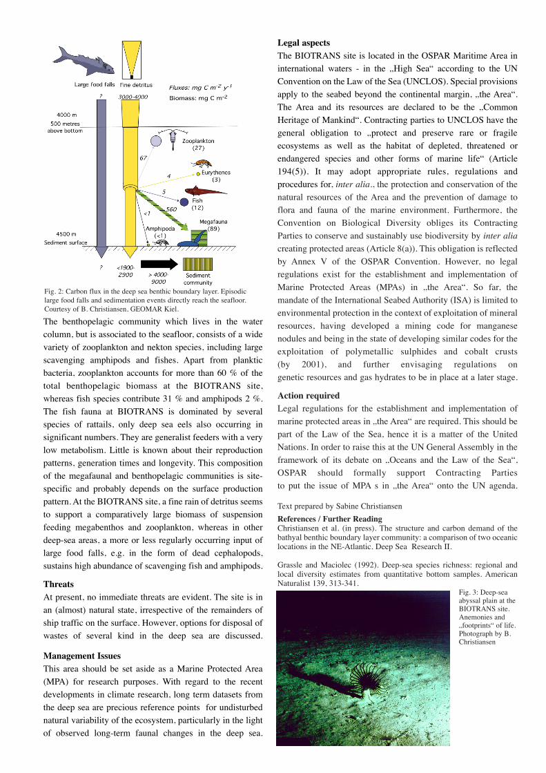
Benthic boundary layerThe near-bottom water layer is enriched with suspended
matter („marine snow“) up to 1000 m above the seafloor
in the plains, caused by the topographically influenced
bottom flow resuspending the very fine material, and
sometimes significantly enhanced by aperiodic, so-called
„benthic storms“. Here, organic material is accumulating
as well which seasonally sediments out from the photic
zone, finally forming layers or aggregations of
phytodetritus on the seafloor. This material is in turn the
major food source for the organisms living above, on and
in the sediment. Short- and medium-term reactions to
pulses of organic material were observed in the benthos
and bacteria. In other words, the seasonal
pulses of organic matter drive the deep-sea ecosystem.
The fauna of the benthic boundary layerThe deep sea floor is known to support a remarkable
faunal biodiversity. At a global scale, deep sea sediments
have been estimated to contain between 500,000 and 10
million species of macrobenthos alone. A single square
meter of sediment may accomodate 250 species of macro-
and meiobenthic invertebrates. Polychaetes, nematodes
and copepods are the most abundant groups within the
meio- and macrofauna at the usually soft-bottomed
BIOTRANS site. Occasional stones and pebbles give
substrate to sea anemonies and sea pens which are the
most commonly found members of the megafauna, the
larger animals living on the sediment. Sponges, sea
cucumbers and crinoids also frequently appear on bottom
photographs, whereas crustaceans, gastropods,
cephalopods, sipunculids and madreporarians only occur
in low numbers. The density of the larger animals living
on the sediment, the megafauna, amounts to 2.5 per m2.
brie
fin
g
For information, contact:
Stephan Lutter
WWF North-East Atlantic Programme
Am Güthpol 11 · D-28757 Bremen · Germany
Tel: +49 421 65846-22 · Fax: +49 421 65846-12
E-mail: [email protected]
BIOTRANS - A Potential MPALocationBIOTRANS is the acronym for the study site of two
successive long term research projects on the carbon
flux in the near-bottom water layers and sediments in
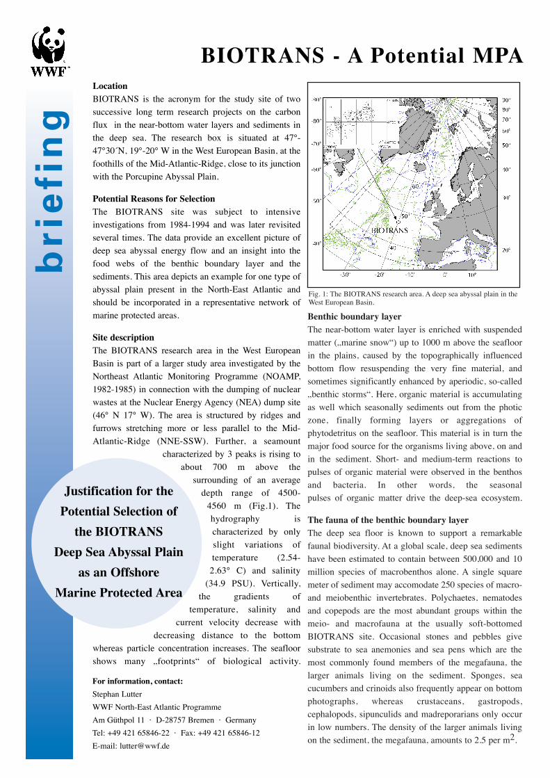
the deep sea. The research box is situated at 47°-
47°30´N, 19°-20° W in the West European Basin, at the
foothills of the Mid-Atlantic-Ridge, close to its junction
with the Porcupine Abyssal Plain.
Potential Reasons for SelectionThe BIOTRANS site was subject to intensive
investigations from 1984-1994 and was later revisited
several times. The data provide an excellent picture of
deep sea abyssal energy flow and an insight into the
food webs of the benthic boundary layer and the
sediments. This area depicts an example for one type of
abyssal plain present in the North-East Atlantic and
should be incorporated in a representative network of
marine protected areas.
Site descriptionThe BIOTRANS research area in the West European
Basin is part of a larger study area investigated by the
Northeast Atlantic Monitoring Programme (NOAMP,
1982-1985) in connection with the dumping of nuclear
wastes at the Nuclear Energy Agency (NEA) dump site
(46° N 17° W). The area is structured by ridges and
furrows stretching more or less parallel to the Mid-
Atlantic-Ridge (NNE-SSW). Further, a seamount
characterized by 3 peaks is rising to
about 700 m above the
surrounding of an average
depth range of 4500-
4560 m (Fig.1). The
hydrography is
characterized by only
slight variations of
temperature (2.54-
2.63° C) and salinity
(34.9 PSU). Vertically,
the gradients of
temperature, salinity and
current velocity decrease with
decreasing distance to the bottom
whereas particle concentration increases. The seafloor
shows many „footprints“ of biological activity.
Justification for the
Potential Selection of
the BIOTRANS
Deep Sea Abyssal Plain
as an Offshore
Marine Protected Area
Fig. 1: The BIOTRANS research area. A deep sea abyssal plain in theWest European Basin.
The benthopelagic community which lives in the water
column, but is associated to the seafloor, consists of a wide
variety of zooplankton and nekton species, including large
scavenging amphipods and fishes. Apart from planktic
bacteria, zooplankton accounts for more than 60 % of the
total benthopelagic biomass at the BIOTRANS site,
whereas fish species contribute 31 % and amphipods 2 %.
The fish fauna at BIOTRANS is dominated by several
species of rattails, only deep sea eels also occurring in
significant numbers. They are generalist feeders with a very
low metabolism. Little is known about their reproduction
patterns, generation times and longevity. This composition
of the megafaunal and benthopelagic communities is site-
specific and probably depends on the surface production
pattern. At the BIOTRANS site, a fine rain of detritus seems
to support a comparatively large biomass of suspension
feeding megabenthos and zooplankton, whereas in other
deep-sea areas, a more or less regularly occurring input of
large food falls, e.g. in the form of dead cephalopods,
sustains high abundance of scavenging fish and amphipods.
ThreatsAt present, no immediate threats are evident. The site is in
an (almost) natural state, irrespective of the remainders of
ship traffic on the surface. However, options for disposal of
wastes of several kind in the deep sea are discussed.
Management IssuesThis area should be set aside as a Marine Protected Area
(MPA) for research purposes. With regard to the recent
developments in climate research, long term datasets from
the deep sea are precious reference points for undisturbed
natural variability of the ecosystem, particularly in the light
of observed long-term faunal changes in the deep sea.
Legal aspectsThe BIOTRANS site is located in the OSPAR Maritime Area in
international waters - in the „High Sea“ according to the UN
Convention on the Law of the Sea (UNCLOS). Special provisions
apply to the seabed beyond the continental margin, „the Area“.
The Area and its resources are declared to be the „Common
Heritage of Mankind“. Contracting parties to UNCLOS have the
general obligation to „protect and preserve rare or fragile
ecosystems as well as the habitat of depleted, threatened or
endangered species and other forms of marine life“ (Article
194(5)). It may adopt appropriate rules, regulations and
procedures for, inter alia., the protection and conservation of the
natural resources of the Area and the prevention of damage to
flora and fauna of the marine environment. Furthermore, the
Convention on Biological Diversity obliges its Contracting
Parties to conserve and sustainably use biodiversity by inter alia
creating protected areas (Article 8(a)). This obligation is reflected
by Annex V of the OSPAR Convention. However, no legal
regulations exist for the establishment and implementation of
Marine Protected Areas (MPAs) in „the Area“. So far, the
mandate of the International Seabed Authority (ISA) is limited to
environmental protection in the context of exploitation of mineral
resources, having developed a mining code for manganese
nodules and being in the state of developing similar codes for the
exploitation of polymetallic sulphides and cobalt crusts
(by 2001), and further envisaging regulations on
genetic resources and gas hydrates to be in place at a later stage.
Action requiredLegal regulations for the establishment and implementation of
marine protected areas in „the Area“ are required. This should be
part of the Law of the Sea, hence it is a matter of the United
Nations. In order to raise this at the UN General Assembly in the
framework of its debate on „Oceans and the Law of the Sea“,
OSPAR should formally support Contracting Parties
to put the issue of MPA s in „the Area“ onto the UN agenda.
Text prepared by Sabine Christiansen
References / Further ReadingChristiansen et al. (in press). The structure and carbon demand of thebathyal benthic boundary layer community: a comparison of two oceaniclocations in the NE-Atlantic. Deep Sea Research II.
Grassle and Maciolec (1992). Deep-sea species richness: regional andlocal diversity estimates from quantitative bottom samples. AmericanNaturalist 139, 313-341.
Fig. 3: Deep-seaabyssal plain at theBIOTRANS site.Anemonies and„footprints“ of life.Photograph by B.Christiansen
Fig. 2: Carbon flux in the deep sea benthic boundary layer. Episodiclarge food falls and sedimentation events directly reach the seafloor.Courtesy of B. Christiansen, GEOMAR Kiel.
brie
fin
g
For information, contact:
Stephan Lutter
WWF North-East Atlantic Programme
Am Gütpohl 11 · D-28757 Bremen · Germany
Tel: +49 421 65846-22 · Fax: +49 421 65846-12
E-mail: [email protected]
Logatchev - A Potential MPA
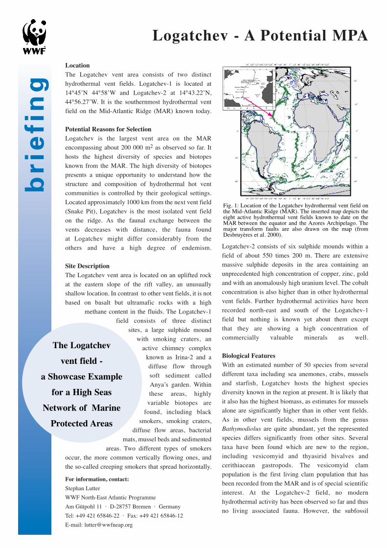
LocationThe Logatchev vent area consists of two distinct
hydrothermal vent fields. Logatchev-1 is located at
14°45’N 44°58’W and Logatchev-2 at 14°43.22’N,
44°56.27’W. It is the southernmost hydrothermal vent
field on the Mid-Atlantic Ridge (MAR) known today.
Potential Reasons for SelectionLogatchev is the largest vent area on the MAR
encompassing about 200 000 m2 as observed so far. It
hosts the highest diversity of species and biotopes
known from the MAR. The high diversity of biotopes
presents a unique opportunity to understand how the
structure and composition of hydrothermal hot vent
communities is controlled by their geological settings.
Located approximately 1000 km from the next vent field
(Snake Pit), Logatchev is the most isolated vent field
on the ridge. As the faunal exchange between the
vents decreases with distance, the fauna found
at Logatchev might differ considerably from the
others and have a high degree of endemism.
Site DescriptionThe Logatchev vent area is located on an uplifted rock
at the eastern slope of the rift valley, an unusually
shallow location. In contrast to other vent fields, it is not
based on basalt but ultramafic rocks with a high
methane content in the fluids. The Logatchev-1
field consists of three distinct
sites, a large sulphide mound
with smoking craters, an
active chimney complex
known as Irina-2 and a
diffuse flow through
soft sediment called
Anya’s garden. Within
these areas, highly
variable biotopes are
found, including black
smokers, smoking craters,
diffuse flow areas, bacterial
mats, mussel beds and sedimented
areas. Two different types of smokers
occur, the more common vertically flowing ones, and
the so-called creeping smokers that spread horizontally.
Logatchev-2 consists of six sulphide mounds within a
field of about 550 times 200 m. There are extensive
massive sulphide deposits in the area containing an
unprecedented high concentration of copper, zinc, gold
and with an anomalously high uranium level. The cobalt
concentration is also higher than in other hydrothermal
vent fields. Further hydrothermal activities have been
recorded north-east and south of the Logatchev-1
field but nothing is known yet about them except
that they are showing a high concentration of
commercially valuable minerals as well.
Biological FeaturesWith an estimated number of 50 species from several
different taxa including sea anemones, crabs, mussels
and starfish, Logatchev hosts the highest species
diversity known in the region at present. It is likely that
it also has the highest biomass, as estimates for mussels
alone are significantly higher than in other vent fields.
As in other vent fields, mussels from the genus
Bathymodiolus are quite abundant, yet the represented
species differs significantly from other sites. Several
taxa have been found which are new to the region,
including vesicomyid and thyasirid bivalves and
cerithiacean gastropods. The vesicomyid clam
population is the first living clam population that has
been recorded from the MAR and is of special scientific
interest. At the Logatchev-2 field, no modern
hydrothermal activity has been observed so far and thus
no living associated fauna. However, the subfossil
Fig. 1: Location of the Logatchev hydrothermal vent field onthe Mid-Atlantic Ridge (MAR). The inserted map depicts theeight active hydrothermal vent fields known to date on theMAR between the equator and the Azores Archipelago. Themajor transform faults are also drawn on the map (fromDesbruyères et al. 2000).
The Logatchev
vent field -
a Showcase Example
for a High Seas
Network of Marine
Protected Areas
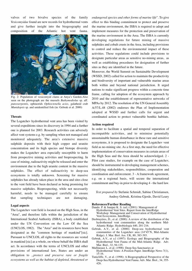
valves of two bivalve species of the family
Vesicomyidae found are new records for hydrothermal vents
and give further insight into the biogeography and
composition of the Atlantic hot vent fauna.
ThreatsThe Logatchev hydrothermal vent area has been visited by
several expeditions since its discovery in 1994 and a further
one is planned for 2003. Research activities can adversely
affect vent systems e.g. by sampling when not managed and
monitored adequately. The area’s extensive massive
sulphide deposits with their high copper and uranite
concentration and its high species and biotope diversity
makes the Logatchev area especially susceptible to harm
from prospective mining activities and bioprospecting. In
case of mining, radioactivity might be released and enter the
environment due to the high uranite content in the massive
sulphides. The effect of radioactivity to deep-sea
ecosystems is totally unknown. Screening for massive
sulphides has already taken place in the area and sites close
to the vent field have been declared as being promising for
massive sulphides. Bioprospecting, while not necessarily
harmful, needs to be managed carefully to ensure
that sampling techniques are not damaging.
Legal aspectsThe Logatchev vent field is located on the High Seas, in the
"Area", and therefore falls within the jurisdiction of the
International Seabed Authority (ISBA), a body established
under the UN Convention on the Law Of the Sea
(UNCLOS, 1982). The "Area” and its resources have been
designated as the "common heritage of mankind”[sic].
Pursuant to UNCLOS, all rights to the resources are vested
in mankind [sic] as a whole, on whose behalf the ISBA shall
act. In accordance with the terms of UNCLOS and other
provisions of international law, States are under an
obligation to „protect and preserve rare or fragile
ecosystems as well as the habitat of depleted, threatened or
endangered species and other forms of marine life”. To give
effect to this binding commitment to protect and preserve
the marine environment, the ISBA is required to adopt and
implement measures for the protection and preservation of
the marine environment in the Area. The ISBA is currently
developing regulations for future mining of massive
sulphides and cobalt crusts in the Area, including provisions
to control and reduce the environmental impact of these
activities. These regulations could include provisions to
designate particular areas as sensitive no-mining areas, as
well as establishing procedures for designation of further
sites as they are identified in the future.
Moreover, the World Summit on Sustainable Development
(WSSD, 2002) called for action to maintain the productivity
and biodiversity of important and vulnerable marine areas
both within and beyond national jurisdiction. It urged
nations to make significant progress within a concrete time
frame, calling for adoption of the ecosystem approach by
2010 and the establishment of representative networks of
MPAs by 2012. The resolution of the UN General Assembly
A/57/L.48 (2002) endorses the Plan of Implementation
adopted at WSSD and further calls for urgent and
coordinated action to protect vulnerable benthic habitats.
Action requiredIn order to facilitate a spatial and temporal separation of
incompatible activities, and to minimise potentially
unsustainable human disturbance in these rare and sensitive
ecosystems, it is proposed to designate the Logatchev vent
field as no-mining site. As a first step, the need for effective
implementation of conservation measures in certain areas of
the High Seas and the Area should be acknowledged. 2 -
Pilot case studies, for example on the case of Logatchev,
should be instrumental to developing management schemes,
identifying stakeholders, responsibilities, cooperation and
coordination and enforcement. 3 - A framework agreement,
e.g. on a regional basis, will secure the international
commitment and buy-in prior to developing 4 - the hard law.
Text prepared by Stefanie Schmidt, Sabine Christiansen,
Andrey Gebruk, Kristina Gjerde, David Leary
References/Further ReadingDando. P. & Juniper K. S. (ed.) (2001): Management of
Hydrothermal Vent Sites. Report from the InterRidgeWorkshop: Management and Conservation of HydrothermalVent Ecosystems. InterRidge.
Desbruyères, D., et al. (2000): A review of the distribution of thehydrothermal vent communities along the northern Mid-Atlantic Ridge. Hydrobiologia 440, 201-216.
Gebruk, A.V., et al. (2000): Deep-sea hydrothermal ventcommunities of the Logatchev area (14°45’N, Mid-AtlanticRidge). J. Mar. Biol. Ass. UK, 80, 383-393.
Gebruk, A.V., et a.l (1997): Ecology and Biogeography of theHydrothermal Vent Fauna of the Mid-Atlantic Ridge. Adv.Mar. Biol., 32, 94-135.
Mullineaux L. et al. (1998): Deep-Sea Sanctuaries atHydrothermal Vents: A Position Paper. InterRidge News 7(1),15-16.
Tunicliffe, V., et al. (1998): A Biogeographical Perspective of theDeep-Sea Hydrothermal Vent Fauna. Adv. Mar. Biol., 34, 355-426.
Fig. 2: Population of vesicomyid clams at Anya’s Garden.Alsoseen on the photograph are the mussels Bathymodiolus sp. aff.puteoserpentis, ophiuorids Ophioctenella acies, galatheid crabMunidopsis sp. and unidentified fish (in: Gebruk et al. 2000)


![Gibbs vs. Non-Gibbs in the Equilibrium Ensemble Approach ... · Gibbs vs. non-Gibbs in the equilibrium ensemble approach 527 was recently made [16,17], namely that joint distributions](https://img.pdfslide.net/doc/110x75/5e91661545a3762eae5be596/gibbs-vs-non-gibbs-in-the-equilibrium-ensemble-approach-gibbs-vs-non-gibbs.jpg)