Embed Size (px)
Citation preview
Chena River Vulnerability Assessment and
Geographic Response Strategies
Fairbanks, Alaska
Technical Direction Documents: 13-03-0001 & 13-09-0008
May 2014
Draft Version 3.0 for the Interior Subarea Contingency Plan, February 2015)
Prepared for:
UNITED STATES ENVIRONMENTAL PROTECTION AGENCY 222 West Seventh Avenue, #19
Anchorage, Alaska 99513
Prepared by:
ECOLOGY AND ENVIRONMENT, INC. 1007 West 3rd Avenue, Suite 201
Anchorage, AK 99501

Page intentionally left blank
i
Table of Contents Introduction .................................................................................................................................................. 5
Chena River Location .................................................................................................................................... 5
1 – Vulnerability Assessment ........................................................................................................................ 7
1.1 Chena River Description ................................................................................................................ 7
1.2 Vulnerability Assessment Area ..................................................................................................... 8
1.3 Hydrology ...................................................................................................................................... 8
1.4 Chena River Lakes Flood Control Project ...................................................................................... 9
1.5 Storm Water Drainage and Discharge .......................................................................................... 9
1.6 History of Spills or Releases .......................................................................................................... 9
1.7 Bulk Fuel and Chemical Storage .................................................................................................. 10
1.8 Transportation of Bulk Fuel and Chemicals ................................................................................ 12
2 – Geographic Response Strategies ........................................................................................................... 13
2.1 Geographic Response Strategies (GRS) ....................................................................................... 13
2.2 GRS Area of Focus ....................................................................................................................... 13
2.3 Response Resources.................................................................................................................... 13
2.4 GRS Locations .............................................................................................................................. 19
2.5 Recovery Tactics .......................................................................................................................... 21
2.6 Deflection Boom ........................................................................................................................ 22
2.7 Diversion Boom ........................................................................................................................... 22
2.7.1 Single Boom ........................................................................................................................ 22
2.7.2 Cascade Boom ..................................................................................................................... 22
2.7.3 Chevron Boom, Staggered or Open .................................................................................... 22
2.8 Shoreside Recovery ..................................................................................................................... 22
2.9 Fast Water Free-Oil Recovery ..................................................................................................... 23
References and Resources .......................................................................................................................... 24
Figures
ii
Tables: Chena River Vulnerability Assessment
Table 1-1 Spills Reported from 1995 to 2011*
Table 1-2 Significant Bulk Fuel Storage Facilities
Table 1-3 Facilities/Total Volume of Bulk Petroleum Product
Tables: Chena River Geographic Response Strategies
Table 2-1 Spill Response Equipment and Services Locations and Contacts in Fairbanks, Alaska
Table 2-2 Chena River Spill Response Resources
Table 2-3 Chena River Access Locations
Table 2-4 Chena River GRSs
iii
Figures: Chena River Vulnerability Assessment
Figure 1-1a Base May with Aerial Photo – Full Area Figure 1-1b Base Map with Aerial Photo: Chena River from Tanana River to Fort Wainwright
Figure 1-1c Base Map with Aerial Photo: Steese Highway to Trans-Alaska Pipeline System
Figure 1-2 Base Map - Road System
Figure 1-3 Stormwater Drainage & Discharge Features
Figure 1-4 Hazardous Materials Storage Facilities
Figure 1-5 Hazmat Storage – Parks Highway to Confluence of Chena R and Tanana R
Figure 1-6 Hazmat Storage – Peger Rd to Parks Hwy
Figure 1-7 Hazmat Storage – Steese Hwy to Peger Rd
Figure 1-8 Hazmat Storage – Noyes Slough
Figure 1-9 Hazmat Storage – TAPS to Steese Hwy
Figures: Chena River GRS
Figure 2-1 River Access Sites
Figure 2-2 CR1 – Chena River Confluence with Tanana River
Figure 2-3 CR2 – Chena Pump House and Cripple Creek
Figure 2-4 CR3- Chena Small Tracts Road/Pike’s Landing Road River Access, and CR4 – Department of Natural Resources, Division of Forestry
Figure 2-5 CR5– Chena River State Recreation Area
Figure 2-6 CR6 – Pioneer Park, CR7 – Kiwanis Park
Figure 2-7 CR8 – Aurora Energy Power Plant and CR9 – Graehl Park and Noyes Slough
Figure 2-8 CR10 – Fort Wainwright Boat Launch and Bentley Island Slough Area
Figure 2-9 CR11 – Fort Wainwright Trainor Gate Road and Railroad Bridge Crossing
iv
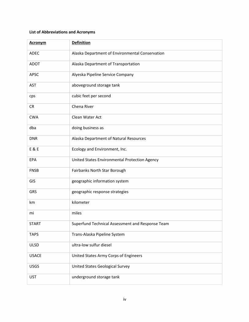
List of Abbreviations and Acronyms
Acronym Definition
ADEC Alaska Department of Environmental Conservation
ADOT Alaska Department of Transportation
APSC Alyeska Pipeline Service Company
AST aboveground storage tank
cps cubic feet per second
CR Chena River
CWA Clean Water Act
dba doing business as
DNR Alaska Department of Natural Resources
E & E Ecology and Environment, Inc.
EPA United States Environmental Protection Agency
FNSB Fairbanks North Star Borough
GIS geographic information system
GRS geographic response strategies
km kilometer
mi miles
START Superfund Technical Assessment and Response Team
TAPS Trans-Alaska Pipeline System
ULSD ultra-low sulfur diesel
USACE United States Army Corps of Engineers
USGS United States Geological Survey
UST underground storage tank
5
Introduction Ecology and Environment, Inc. (E & E), the United States Environmental Protection Agency (EPA) Superfund Technical Assessment and Response Team (START) was tasked to conduct a vulnerability assessment of the Chena River in Fairbanks, Alaska. The assessment included oil and chemical storage facilities, transportation routes, drainage outfalls to the river, and an account of the local spill response resources within the Fairbanks North Star Borough (FNSB). Subsequently, START was tasked with identifying geographic response strategies (GRS) logistic locations, (see Section 2 below). In June 2013, EPA, START, and the Alaska Department of Environmental Conservation (ADEC) conducted a reconnaissance survey of the Chena River to identify access points for GRS locations.
Figures for both the vulnerability assessment and the GRS follow this report under separate tabs.
Chena River Location The Chena River is a tributary of the Tanana River and is located in interior Alaska entirely within the Fairbanks North Star Borough. The city of Fairbanks, Alaska’s second largest city, is located in the lower portion of the Chena River watershed. The headwaters of the Chena River begin in the White Mountains about 145 km (90 miles) east of Fairbanks. The river flows southwest from the confluence of North Fork Chena River and West Fork Chena River near Chena Hot Springs to its confluence with the Tanana River in Fairbanks. The maximum length of the watershed is 161 km (100 miles) and the maximum width is 64.5 km (40 miles). The Chena River drains an area of approximately 5,478 km2 (2,115 mi2).
Noyes Slough, located in the city of Fairbanks, is 8.85 km (5.5 miles) long and is a side branch to the Chena River. Deadman Slough, located west of Noyes Slough, is approximately 4.82 km (3 miles) long and meanders west and south to the Chena River near the Parks Highway (see Figure 1-4). The Noyes Slough branches off to the north from the Chena River and returns to the north bank of the Chena River, upstream of the confluence of the Chena River and the larger Tanana River (see Figure 1-5).
The Little Chena River is the largest tributary to the Chena River and flows into the river below Moose Creek Dam. The Little Chena River originates in the mountains to the northeast and flows south until it enters the Chena River approximately 11 km (7 mi) upstream of the city of Fairbanks. The Little Chena River watershed encompasses 1,062 km2 (410 mi2).
History of the Chena River Area There are indications of early travel and exploration along the Chena River, and mammalian fossils have been found along the river banks. In the early 1900s, two brothers, Robert and Thomas Swan, discovered the Chena Hot Springs after learning that a U.S. Geological Survey crew had spotted steam rising from a valley on the upper Chena River. In July 1905, the brothers left on a boat in search of the hot springs, arriving at the North Fork of the Chena River. They traveled to the mouth of Monument Creek and ascended the creek to find the hot springs on August 5, 1905 (http://www.chenahotsprings.com/history/). The Chena Hot Springs development began in 1915 with construction of the hotel, cabins, and a bathhouse containing wooden hot tubs. People took the 124-mile round trip by sleigh to the hot springs. Construction of three roadhouses along the winter sled trail soon followed with one at the junction of the Little Chena River, one at the junction of Colorado Creek, and another at the Highway Milepost 48 (Gregg’s Roadhouse).
6
The Chena Pumphouse is on the U.S. National Register of Historic Places. The website www.Waymarking.com cites the following description from the NRHP nomination form:
The Pump House was once an unprepossessing, tin-sheathed structure which housed the equipment used to pump water from the Chena River, over Chena Ridge to the Gold Dredging operations of the Fairbanks Exploration Company (F.E.CO.) on Cripple Creek, near Ester. It was around 1930 that the Chief Engineer of the Company, which was already operating on Creeks North of Fairbanks, evolved a scheme for mining Cripple Creek and its tributaries by pumping water from the Chena River up over Chena Ridge. This provided enough pressure to operate the hydraulic giants which were used to strip the overburden. The Pump House was completed and began operations in 1933. It was constructed by the F.E.CO., a subsidiary of United States Smelting, Mining and Refining Co. . . . Inside the building were ten, 14", double suction centrifugal pumps rated at 6000 gpm against a 220 ft, head and direct connected to 400 hp electric motors. These pumps were mounted in series, with two to each unit, making five units which delivered the water to the top of Chena Ridge through three, 26" pipelines against a total head of 440 ft. Water was delivered from there through a three mile ditch to the site of the mining operations where it was used for stripping and thawing and for make-up water for the dredge pond when needed.
Logging has occurred for the past 50 years and continues in some areas. Timber of the Chena River provided wood for many buildings and homes constructed in Fairbanks, and the river provided a way to move the logs downriver.
Recreational uses of the Chena River include sport fishing (Arctic grayling, Chinook salmon, chum salmon and other species), boating and rafting, camping, and hiking, skiing, skijoring, dog mushing, and snowmachining.
Chena River Lakes Flood Control Project In the summer 1967, the Chena and Little Chena rivers flooded more than 6 feet above their flood stage. Damage estimates in Fairbanks totaled more than $80 million. To prevent any more disasters, the Alaska District of the United States Army Corps of Engineers (USACE) proposed the “Chena River Lakes Flood Control Project.” After Congress authorized the Flood Control Act of 1968, the Alaska District and the FNSB began planning and construction of the Moose Creek dam and floodway, the Tanana River levee, and drainage channels, sharing in the acquisition of lands needed for the dam and floodway and for the levee and channels, which are located about 32 km (20 miles) east of Fairbanks. Construction began in 1973 and the $256 million project was completed in 1979. The Moose Creek Dam divides the Chena River into an upper and lower reach, and the reduction of the peak flow of the Chena River and a decline in flow in the Chena Slough and Noyes Sough over the past 40 years is attributed to its construction. In 1987, the FNSB assumed responsibility for the operations and maintenance of the levee and drainage channels.
The Chena River Lakes Flood Control Project is operated only for flood control and does not permanently hold water upstream of the Moose Creek dam. During normal fluctuations of the Chena River, the outlet for the dam is open. Fish, boats, and water move through the open gates. During high water, the flood gates are closed and excess water is redirected to the Tanana River. The last time the gates were closed at the dam was in 2008. Then, water rose to 0.15 km (495.5 feet). A January 2010 article in the Fairbanks Daily News Miner reported that the largest impoundment of water at the dam was in 1992 when the USACE reduced the flow of the Chena River, diverting floodwaters to the Tanana River for 18 days. The
7
dam impounded water to 0.154 km (507.6 feet)—approximately 19% of its capacity. To reduce the risk of a breach underneath the dam the USACE lowered the height of the earthen wall at the flood control complex to allow more water to flow into the Tanana River during a flood.
Biological Resources The Chena River supports one of the largest Chinook salmon (also called king salmon) populations in the Alaska portion of the Yukon River drainage (USFWS 2013). All documented Chinook salmon spawning in the Chena River occurs upriver from the Moose Creek Dam (Brase 2009). In July 2013, the Alaska Department of Fish and Game (ADF&G) issued an emergency order closing the Chena River to king salmon fishing because of low counts of salmon escapement (number of salmon that reach the spawning grounds) and because the run strength was insufficient to sustain the incidental mortality that occurred during catch-and-release fishing. The Chena River escapement goals range from 2,800 to 5,700 king salmon. Escapements that are projected to be below this range may result in fishing restrictions. Similarly, escapements above this range allow higher numbers of fish to be caught per day.
The Chena River is a popular area for sport fishing for residents and for visitors. The mouth of the Chena River in particular is a popular area for sport fishing when the Chinook and chum salmon runs are in. According to the ADF&G Fishery Management Report No. 14-14, restrictions on the king salmon fishery have been imposed in the past couple of years due to low counts. Adult king salmon enter the Yukon River during or shortly after breakup and migrate into the Tanana River and appear in the lower Chena River between late June and the second week of July. King salmon spawn primarily upriver of the fishery and fishing for king salmon is closed above the dam (Brase and Baker 2014).
Other fish species present in the Chena River include chum salmon, Arctic grayling, Burbot, and northern pike. The State changed fishing regulations for Arctic grayling to catch and release only. The Arctic grayling fishery has been popular for nearly 60 years. Anglers fish for Arctic grayling throughout the road- and boat-accessible sections of the river and its tributaries. The Chena (also known as Badger Slough) and Piledriver sloughs provide rearing areas for lower river Arctic grayling and are easily accessible fishing locations (Brase and Baker 2014).
ADF&G designated the Fairbanks area of the Chena River as a “nonsubsistence use” area, defined as areas where “dependence upon subsistence (customary and traditional uses of fish and wildlife) is not a principal characteristic of the economy, culture, and way of life (AS 16.05.258(c)).” http://www.adfg.alaska.gov/index.cfm?adfg=fishingSubsistencebyArea.nonSubsistenceUse
Moose and beaver often are viewed from the Chena Riverwalk, which is approximately 3.5 miles between Pioneer Park and Airport Way. Migratory birds pass through Fairbanks en route to/from nesting areas further north. Among many species of birds, sandhill cranes, snow geese, Canada geese, eagles, Northern Harriers, falcons, owls, mallards, pintails, trumpeter and tundra swans are common in the area.
1 – Vulnerability Assessment
1.1 Chena River Description The Chena River is a meandering river, where the slope is gradual and stream channels develop a snakelike form, weaving across the landscape. The river’s course has changed over time and resulting
8
riverbank erosion causes a large amount of brush, trees, and other debris to fall into the water, creating some hazards for navigation. The Alaska Department of Natural Resources Division of Parks & Outdoor Recreation River Guide for the Chena River State Recreational Park rates the Chena River as a Class II on the international scale of river difficulty due to hazards (http://dnr.alaska.gov/parks/units/chena). The river splits into two or more smaller channels. Upper portions of the river are generally more difficult than the lower portions. The outer portion of each meandering curve is subject to the fastest water velocity, causing the greatest scouring erosive action and often creating undercut banks. By contrast, the inner portion of the curve has the slowest water velocity and receives sediment fill, forming point bar deposits. High water after rains may increase the river’s flow velocity. The soils in the Chena River watershed are dominated by silt.
At the Trans-Alaska Pipeline System (TAPS) crossing, the Chena River flows in a single channel with some highwater channels. The river normally freezes solid at the surface each winter; however, warm water effluent discharged from the municipal utility power plant creates persistent open water areas nearby and downstream of the power plant and two bridges.
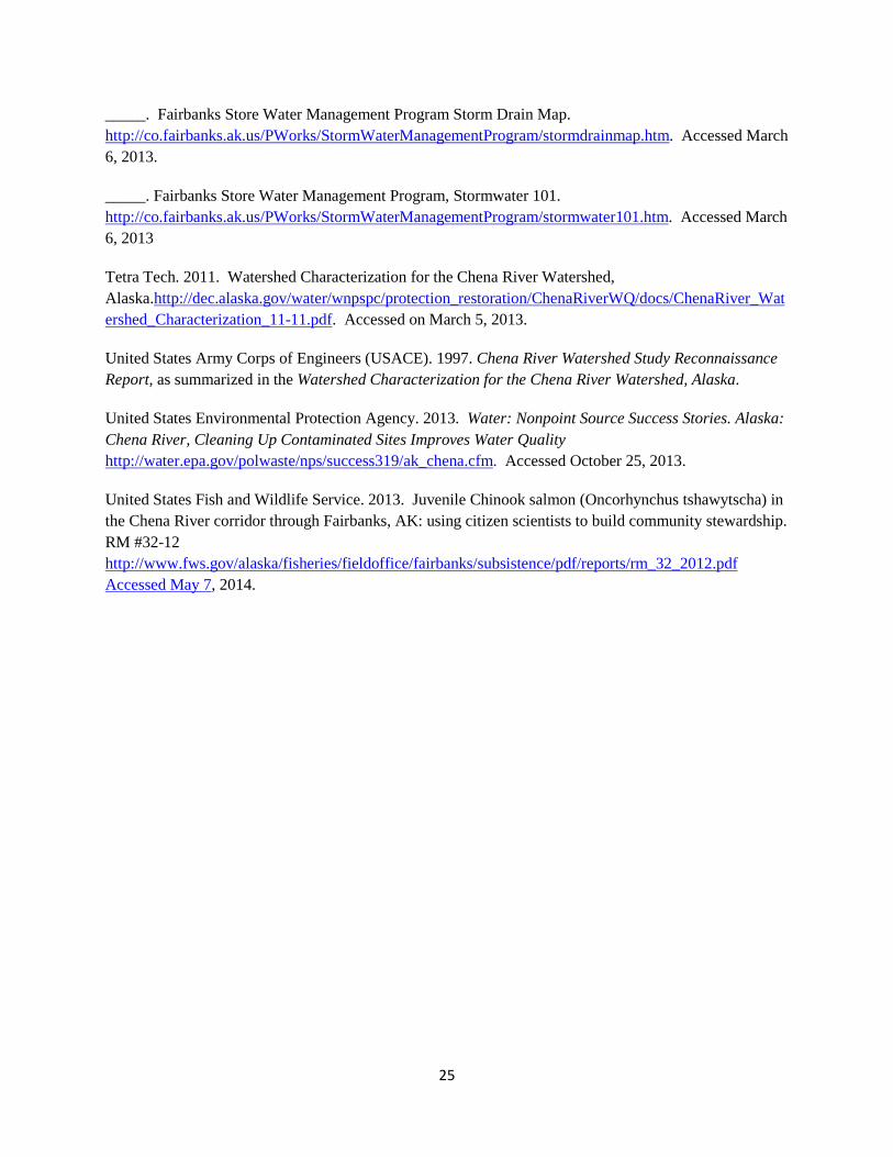
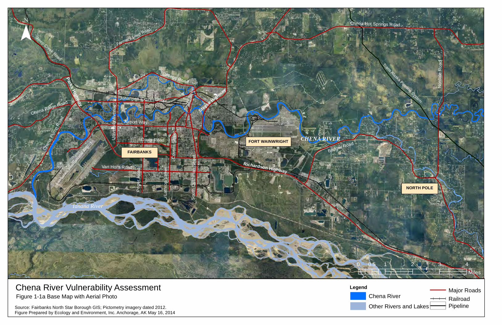
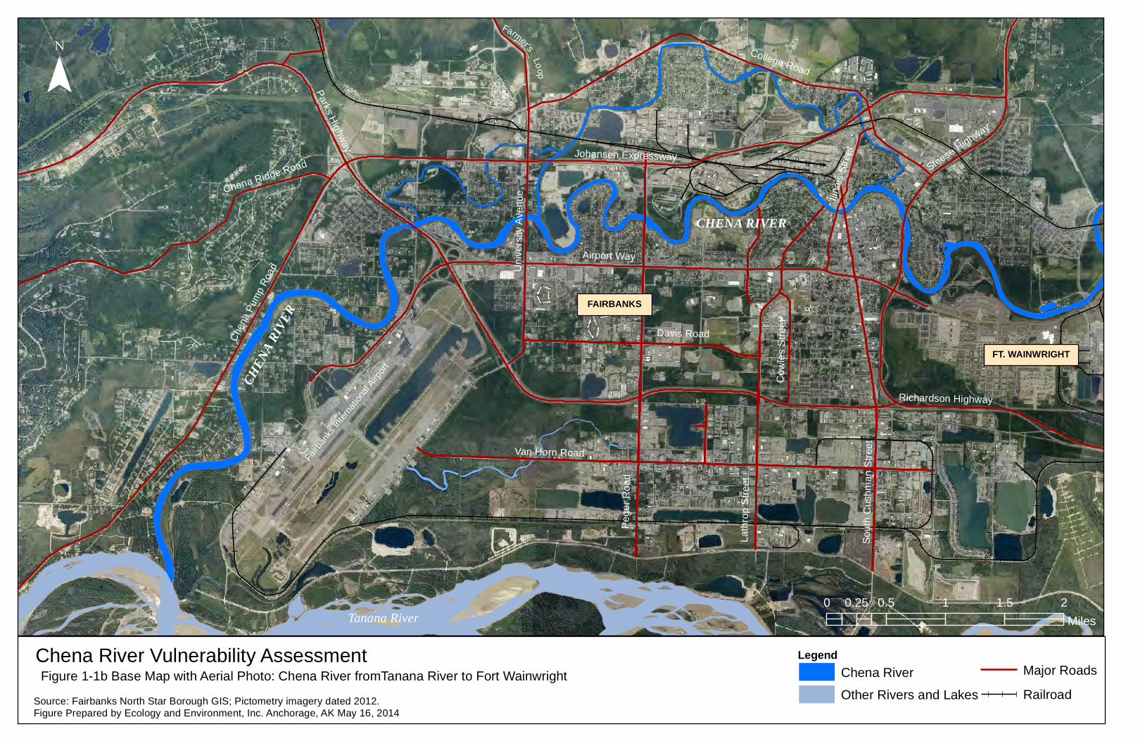
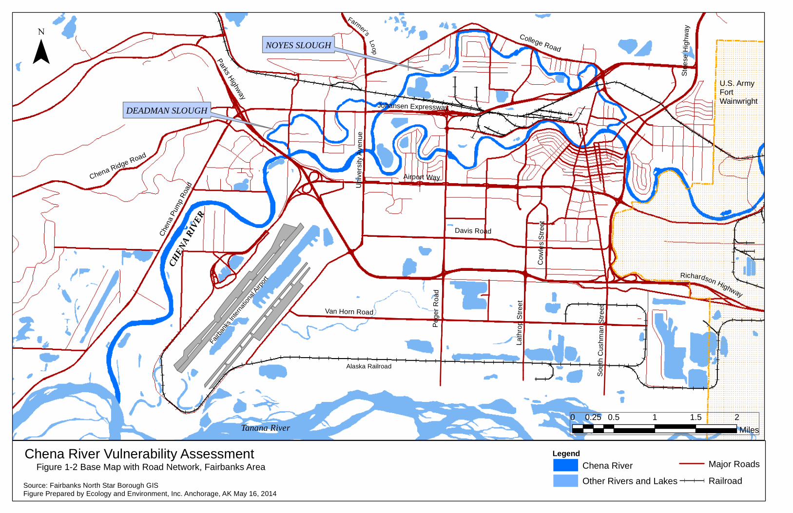
1.2 Vulnerability Assessment Area The vulnerability assessment area includes the Chena River from the western boundary of Fort Wainwright to the Tanana River confluence (13 miles), including Noyes Slough (5.5 miles) and Deadman Slough (2.75 miles). The study area is presented in Figures 1-1a, 1-1b, 1-1c and 1-2.
1.3 Hydrology Sources of water for the Chena River are precipitation, upstream flows, and groundwater from unconfined aquifers. The river flow at Fairbanks ranges from 100 to 74,400 cubic feet per second (cfs), with an average flow of 1,344 cfs,High flows occur in the summer months (May through September) and low flows occur in the winter months (November to April). River velocity also varies by season, with 1-2 mph common during summer months, 2-4 mph during floods are during breakup after the ice moves. When temperatures are below freezing, the velocity drops to 0-1 mph. Ice forms on the river in October and breaks up in April and May, with the highest flow usually occurring in May following spring rains and snow and ice-melt. During flood periods, the width of the Chena River may exceed 1 mile. The river width at normal flow is 150 to 200 feet and at high flow is 200 to 600 feet (Tetra Tech 2011 and APSC 2011)
Based on data for the Chena River at Fairbanks from the U.S. Geological Survey (USGS) Surface Water Monthly Statistics for Alaska, the mean of monthly discharge is as follows:
Jan Feb Mar Apr May Jun Jul Aug Sep Oct Nov Dec Cubic feet per second (CFS)
343 284 261 493 3,480 2,450 2,040 2,430 2,140 1,190 596 443
Knots Notes: Monthly mean is in cfs (for calculation period May 1, 1948 to April 30, 2013).
The Alyeska Pipeline Service Company Trans Alaska Pipeline System Pipeline Oil Discharge Prevention and Contingency Plan, Volume 3 Tactics Manual “Hydrology of Major Drainages” (APSC 2011)
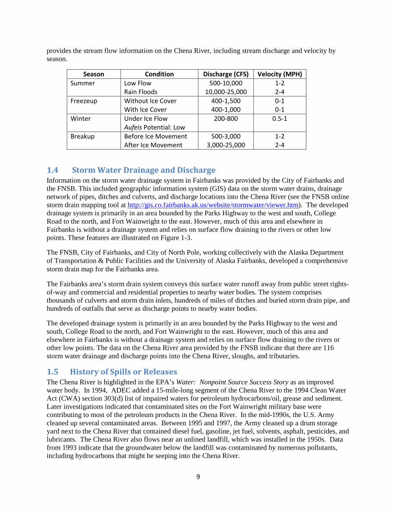
9
provides the stream flow information on the Chena River, including stream discharge and velocity by season.
Season Condition Discharge (CFS) Velocity (MPH) Summer Low Flow
Rain Floods 500-10,000
10,000-25,000 1-2 2-4
Freezeup Without Ice Cover With Ice Cover
400-1,500 400-1,000
0-1 0-1
Winter Under Ice Flow Aufeis Potential: Low
200-800 0.5-1
Breakup Before Ice Movement After Ice Movement
500-3,000 3,000-25,000
1-2 2-4
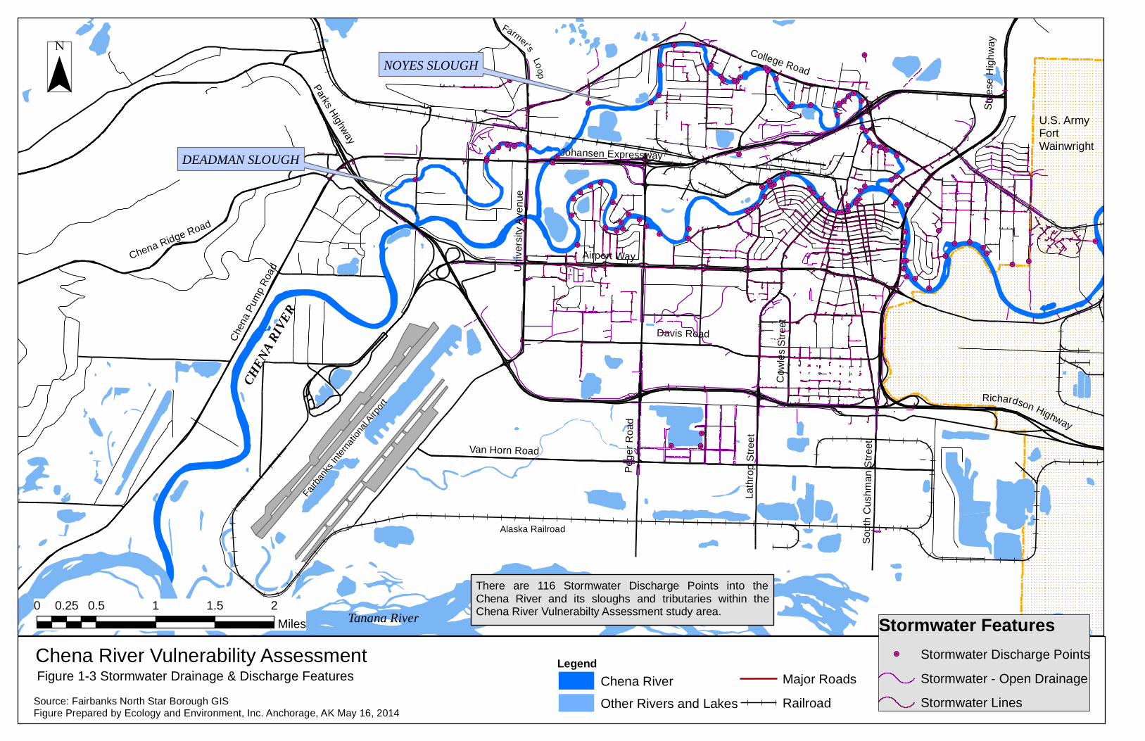
1.4 Storm Water Drainage and Discharge Information on the storm water drainage system in Fairbanks was provided by the City of Fairbanks and the FNSB. This included geographic information system (GIS) data on the storm water drains, drainage network of pipes, ditches and culverts, and discharge locations into the Chena River (see the FNSB online storm drain mapping tool at http://gis.co.fairbanks.ak.us/website/stormwater/viewer.htm). The developed drainage system is primarily in an area bounded by the Parks Highway to the west and south, College Road to the north, and Fort Wainwright to the east. However, much of this area and elsewhere in Fairbanks is without a drainage system and relies on surface flow draining to the rivers or other low points. These features are illustrated on Figure 1-3.
The FNSB, City of Fairbanks, and City of North Pole, working collectively with the Alaska Department of Transportation & Public Facilities and the University of Alaska Fairbanks, developed a comprehensive storm drain map for the Fairbanks area.
The Fairbanks area’s storm drain system conveys this surface water runoff away from public street rights-of-way and commercial and residential properties to nearby water bodies. The system comprises thousands of culverts and storm drain inlets, hundreds of miles of ditches and buried storm drain pipe, and hundreds of outfalls that serve as discharge points to nearby water bodies.
The developed drainage system is primarily in an area bounded by the Parks Highway to the west and south, College Road to the north, and Fort Wainwright to the east. However, much of this area and elsewhere in Fairbanks is without a drainage system and relies on surface flow draining to the rivers or other low points. The data on the Chena River area provided by the FNSB indicate that there are 116 storm water drainage and discharge points into the Chena River, sloughs, and tributaries.
1.5 History of Spills or Releases The Chena River is highlighted in the EPA’s Water: Nonpoint Source Success Story as an improved water body. In 1994, ADEC added a 15-mile-long segment of the Chena River to the 1994 Clean Water Act (CWA) section 303(d) list of impaired waters for petroleum hydrocarbons/oil, grease and sediment. Later investigations indicated that contaminated sites on the Fort Wainwright military base were contributing to most of the petroleum products in the Chena River. In the mid-1990s, the U.S. Army cleaned up several contaminated areas. Between 1995 and 1997, the Army cleaned up a drum storage yard next to the Chena River that contained diesel fuel, gasoline, jet fuel, solvents, asphalt, pesticides, and lubricants. The Chena River also flows near an unlined landfill, which was installed in the 1950s. Data from 1993 indicate that the groundwater below the landfill was contaminated by numerous pollutants, including hydrocarbons that might be seeping into the Chena River.
10
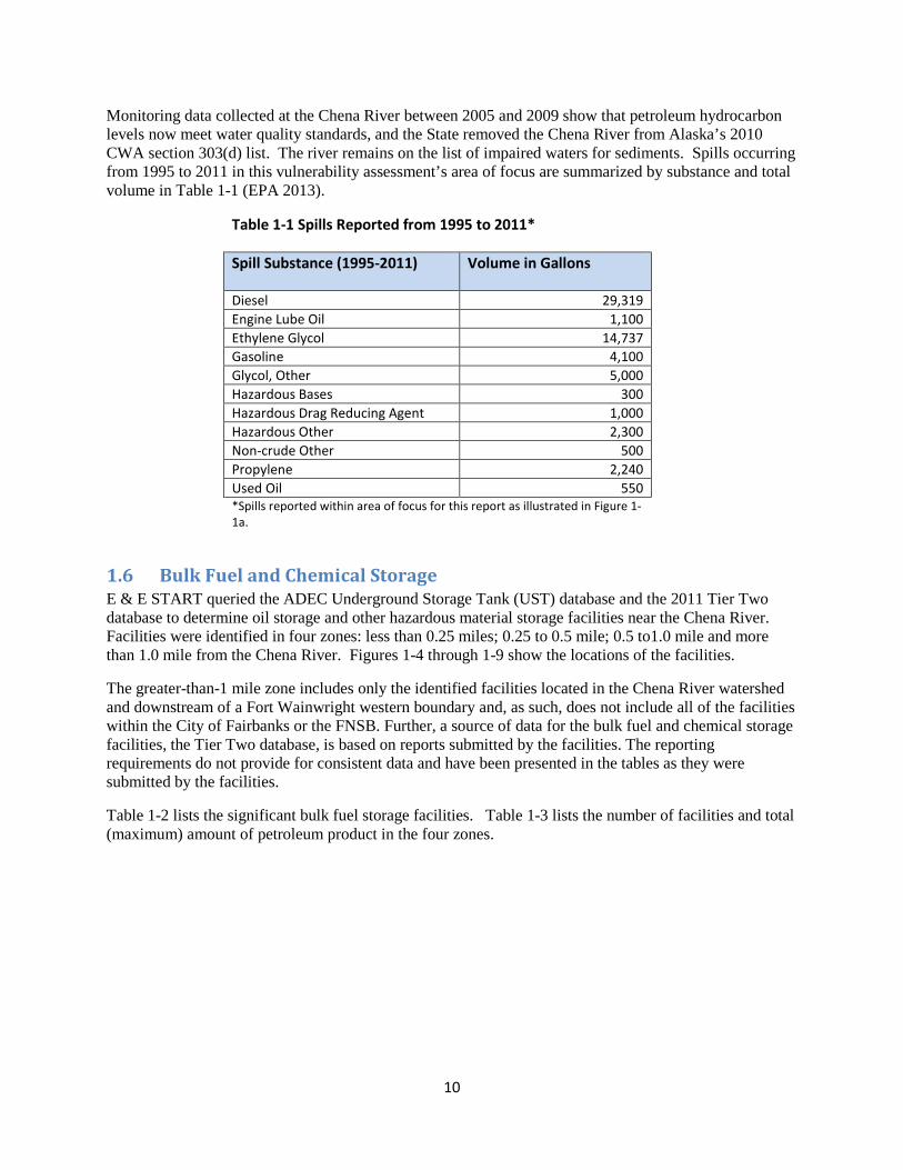
Monitoring data collected at the Chena River between 2005 and 2009 show that petroleum hydrocarbon levels now meet water quality standards, and the State removed the Chena River from Alaska’s 2010 CWA section 303(d) list. The river remains on the list of impaired waters for sediments. Spills occurring from 1995 to 2011 in this vulnerability assessment’s area of focus are summarized by substance and total volume in Table 1-1 (EPA 2013).
Table 1-1 Spills Reported from 1995 to 2011*
Spill Substance (1995-2011) Volume in Gallons
Diesel 29,319 Engine Lube Oil 1,100 Ethylene Glycol 14,737 Gasoline 4,100 Glycol, Other 5,000 Hazardous Bases 300 Hazardous Drag Reducing Agent 1,000 Hazardous Other 2,300 Non-crude Other 500 Propylene 2,240 Used Oil 550 *Spills reported within area of focus for this report as illustrated in Figure 1-1a.
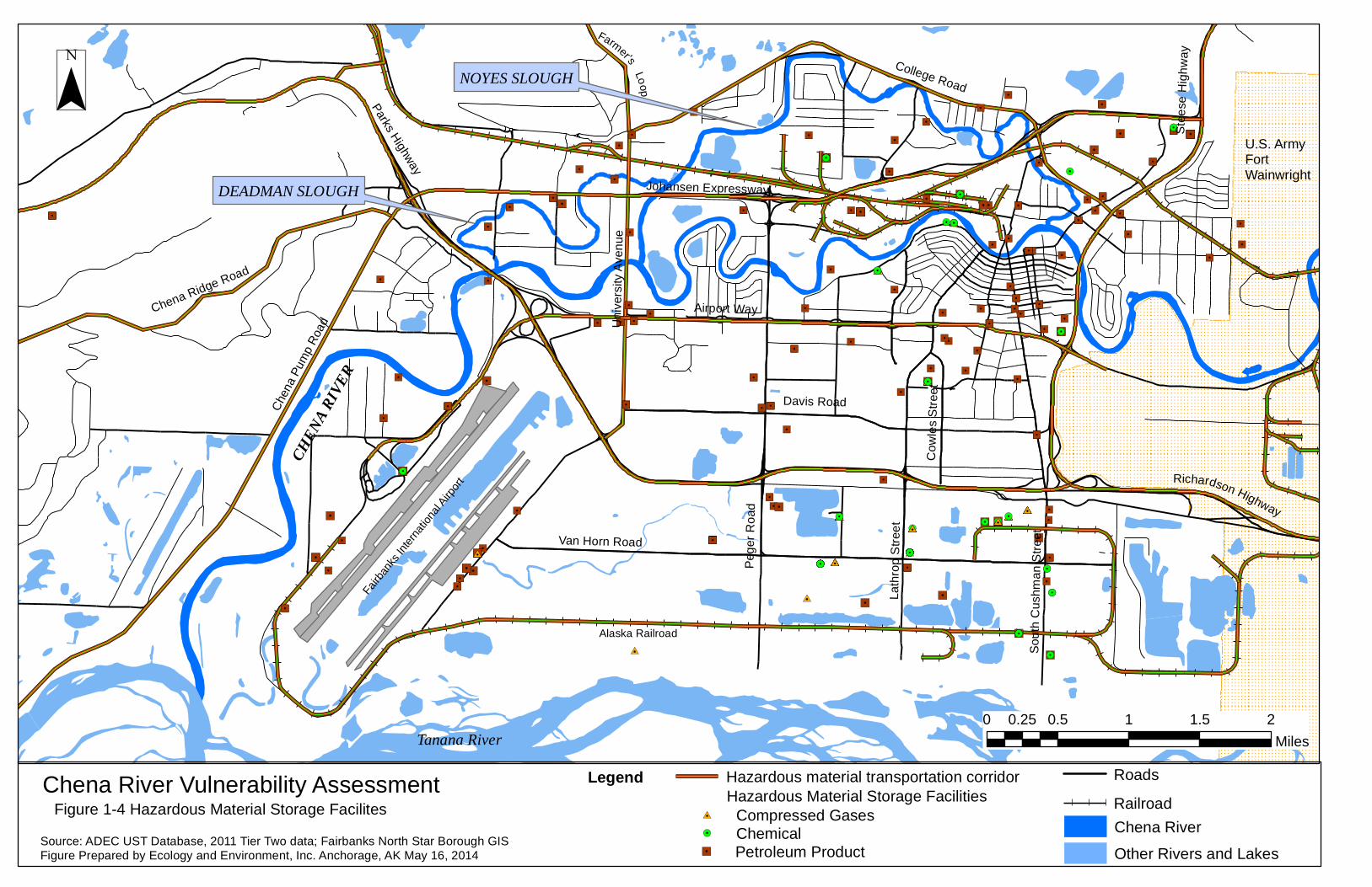
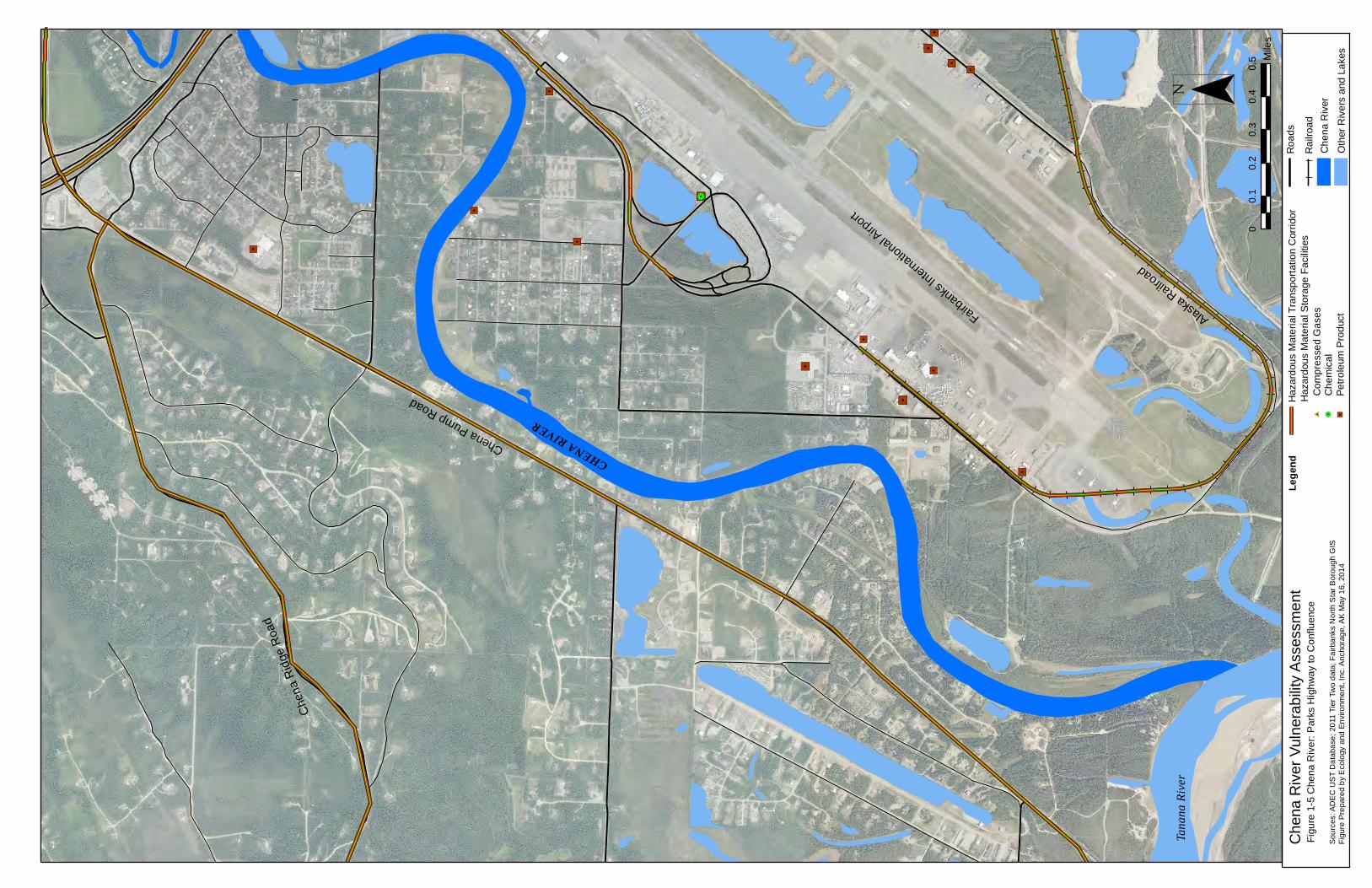
1.6 Bulk Fuel and Chemical Storage E & E START queried the ADEC Underground Storage Tank (UST) database and the 2011 Tier Two database to determine oil storage and other hazardous material storage facilities near the Chena River. Facilities were identified in four zones: less than 0.25 miles; 0.25 to 0.5 mile; 0.5 to1.0 mile and more than 1.0 mile from the Chena River. Figures 1-4 through 1-9 show the locations of the facilities.
The greater-than-1 mile zone includes only the identified facilities located in the Chena River watershed and downstream of a Fort Wainwright western boundary and, as such, does not include all of the facilities within the City of Fairbanks or the FNSB. Further, a source of data for the bulk fuel and chemical storage facilities, the Tier Two database, is based on reports submitted by the facilities. The reporting requirements do not provide for consistent data and have been presented in the tables as they were submitted by the facilities.
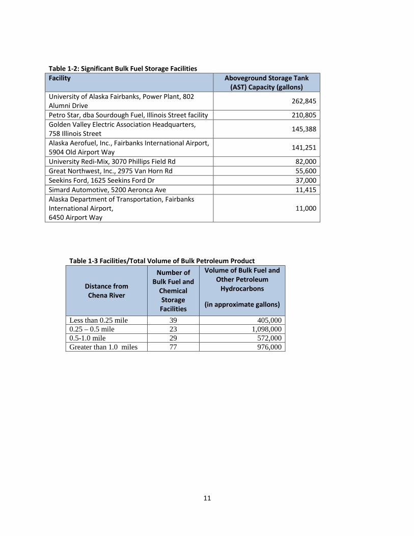
Table 1-2 lists the significant bulk fuel storage facilities. Table 1-3 lists the number of facilities and total (maximum) amount of petroleum product in the four zones.
11
Table 1-2: Significant Bulk Fuel Storage Facilities Facility Aboveground Storage Tank
(AST) Capacity (gallons) University of Alaska Fairbanks, Power Plant, 802 Alumni Drive 262,845
Petro Star, dba Sourdough Fuel, Illinois Street facility 210,805 Golden Valley Electric Association Headquarters, 758 Illinois Street 145,388
Alaska Aerofuel, Inc., Fairbanks International Airport, 5904 Old Airport Way 141,251
University Redi-Mix, 3070 Phillips Field Rd 82,000 Great Northwest, Inc., 2975 Van Horn Rd 55,600 Seekins Ford, 1625 Seekins Ford Dr 37,000 Simard Automotive, 5200 Aeronca Ave 11,415 Alaska Department of Transportation, Fairbanks International Airport, 6450 Airport Way
11,000
Table 1-3 Facilities/Total Volume of Bulk Petroleum Product
Distance from Chena River
Number of Bulk Fuel and
Chemical Storage Facilities
Volume of Bulk Fuel and Other Petroleum
Hydrocarbons
(in approximate gallons)
Less than 0.25 mile 39 405,000 0.25 – 0.5 mile 23 1,098,000 0.5-1.0 mile 29 572,000 Greater than 1.0 miles 77 976,000
12
1.7 Transportation of Bulk Fuel and Chemicals In addition to the chemical storage, this assessment examined the transportation of fuel and other chemicals in the assessment area. The primary overland routes include the major roads and highways and the Alaska Railroad. The petroleum products transported include mostly light and middle distillate range fuels (gasoline, diesel, kerosene, heating fuel, naphtha, and jet fuel). Much of these fuels stored or transported through the area are produced at the Flint Hills Refinery in North Pole, located about 14 miles southeast of Fairbanks. Hot asphalt is also produced at the Flint Hills Refinery and transported throughout the region. There are 17 road and highway bridges crossing the Chena River, Noyes Slough, or Deadman Slough downstream of Fort Wainwright.
The Alaska Railroad route crosses the Chena River 1.7 river miles upstream of the study area boundary, on Fort Wainwright, and crosses Noyes Slough near the intersection of Johansen Parkway and College Road. A railroad spur serves the Fairbanks International Airport, where substantial volumes of bulk fuel are transferred. In 2011, the Alaska Railroad transported more than 1.8 million tons of fuel (ARRC 2012). Most of this fuel came from the Flint Hills Refinery to Fairbanks or Anchorage, although some fuel, mostly ultra-low sulfur diesel fuel (ULSD) was transported north from Anchorage to Fairbanks. Figure 1-3 provides an overview of the major roads in Fairbanks. Figures 1-4 to 1-9 show the major hazardous material transportation corridors as well as the storage facilities.
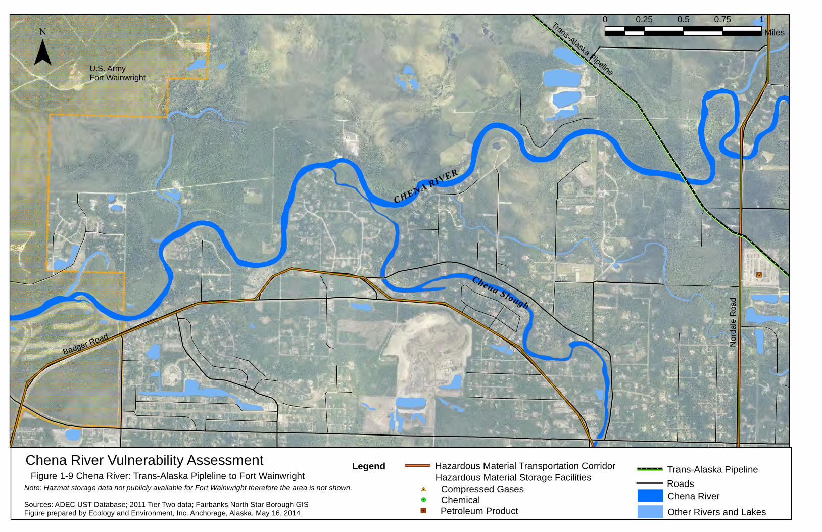
The TAPS is located at the upstream extent of the focus area, crosses the Chena River near Nordale Road in North Pole, Alaska. According to the APSC, in 2012 the pipeline carried 17 million gallons per day of North Slope crude oil (APSC 2013). Figure 1-9 illustrates the location of the pipeline river crossing.
13
2 – Geographic Response Strategies
2.1 Geographic Response Strategies (GRS) Proposed GRS for the Chena River from Fort Wainwright to the confluence with the Tanana River are intended to assist oil and hazardous substances spill response strategies for inland waters of Alaska. These GRS ultimately will supplement the Interior Subarea Contingency Plan. GRS provide unified priorities for the public, responders, and agencies as well as response strategies that protect selected sensitive areas and aid first responders to an oil spill. As the development of Inland GRS continues, the GRS will list additional sensitive resources of an area and the response strategies, equipment, personnel, and logistical information needed to protect the sensitive areas will be included. To test these GRS and ensure that the strategies are the most effective in protecting the resources at risk at a site, sites may be visited and equipment deployed . If changes are indicated by site visits, drills, or actual use during spills, the strategies and this document may be revised.
2.2 GRS Area of Focus For the purpose of the GRS, the area of focus for the Chena River is from the western border of Fort Wainwright to the confluence of the Chena River and the Tanana River. The river access sites selected by the EPA, with concurrence of the ADEC, for development of GRS are meant to identify the logistics of accessing the river. These locations and deployment of strategies are intended to be flexible to allow spill responders to modify them, as necessary, to fit the prevailing conditions at the time of a spill.
2.3 Response Resources Nine facilities, agencies, or or organizations with spill response resources are located in the Fairbanks area:the State of Alaska, the Alaska Railroad Corporation (ARRC), the FNSB Hazardous Materials Response Team, the City of Fairbanks, the University of Alaska Fairbanks Fire Departments, two State-approved response action contractors (Emerald Alaska and Inland PetroService), Alaska West Express, and Arctic Fire & Safety. Some of these organizations have available personnel, equipment, hazmat/emergency response training, and supplies; other sources have only equipment and supplies. The APSC, which operates the TAPS, has significant quantities of spill response equipment and trained personnel located in Fairbanks; however, these assets are dedicated to the pipeline.
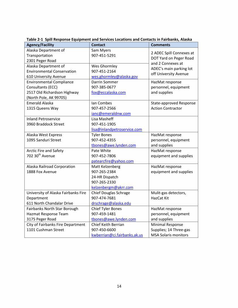
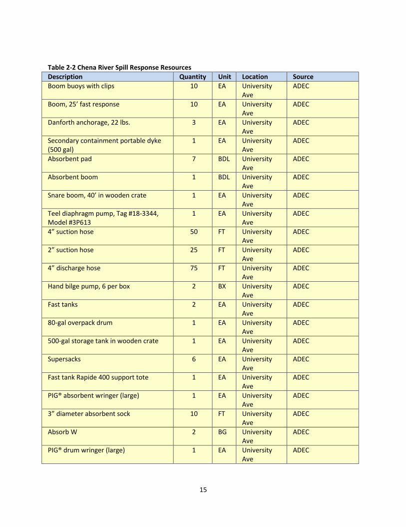
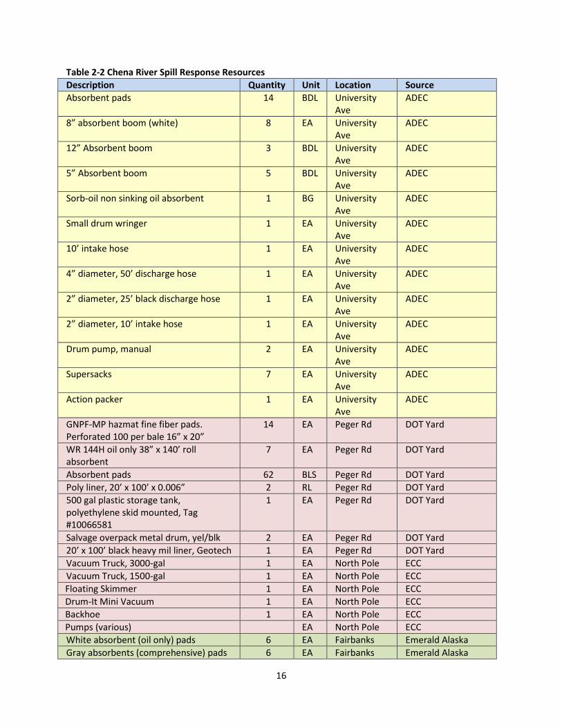
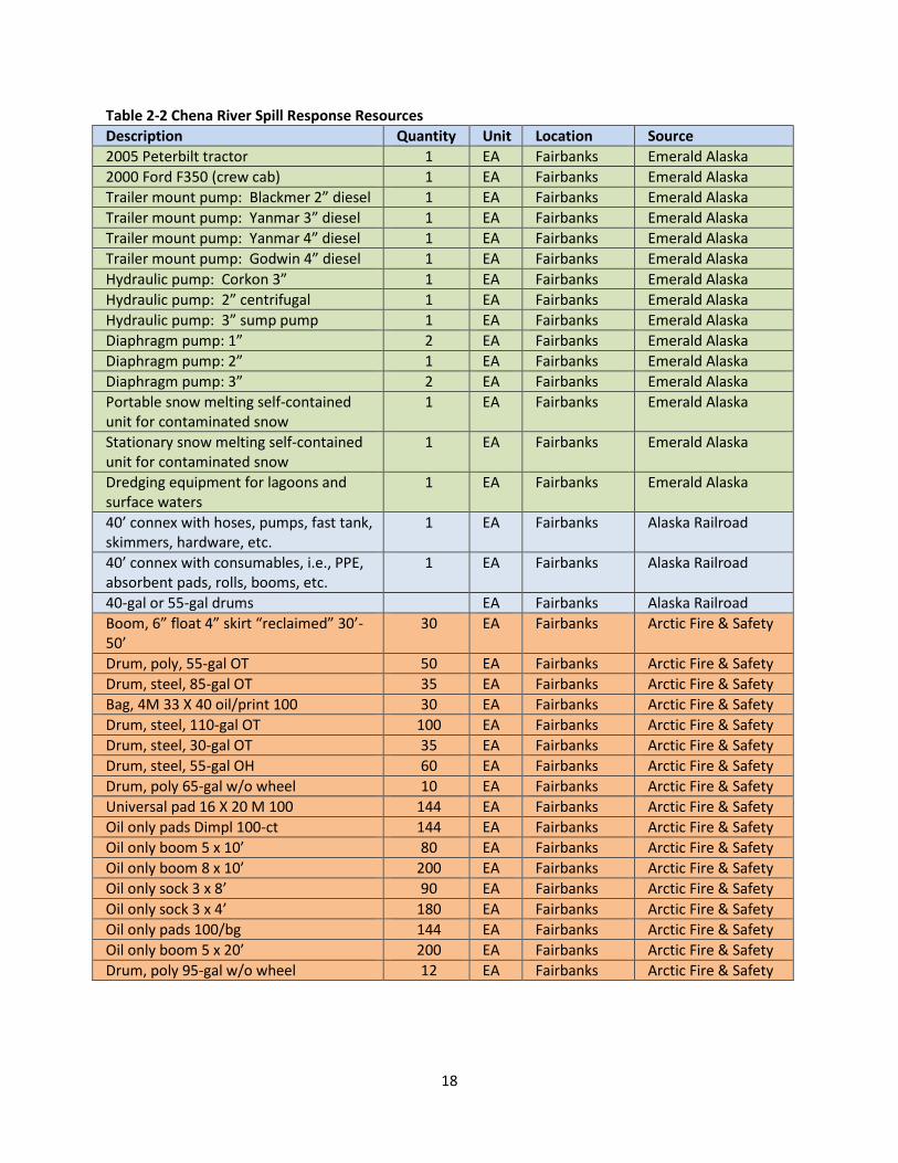
Response equipment available for oil spill response in the Fairbanks area sources and contacts are listed in Table 2-1. Table 2-2 lists the spill-response resources specific to fast water responses on the Chena River and its tributaries in the GRS area. This is not a complete list of response resources.
14
Table 2-1 Spill Response Equipment and Services Locations and Contacts in Fairbanks, Alaska Agency/Facility Contact Comments Alaska Department of Transportation 2301 Peger Road
Sam Myers 907-451-5291 2 ADEC Spill Connexes at
DOT Yard on Peger Road and 2 Connexes at ADEC’s main parking lot off University Avenue
Alaska Department of Environmental Conservation 610 University Avenue
Wes Ghormley 907-451-2164 [email protected]
Environmental Compliance Consultants (ECC) 2517 Old Richardson Highway (North Pole, AK 99705)
Darrin Sommer 907-385-0677 [email protected]
HazMat response personnel, equipment and supplies
Emerald Alaska 1315 Queens Way
Ian Combes 907-457-2566 [email protected]
State-approved Response Action Contractor
Inland Petroservice 3960 Braddock Street
Lisa Masheff 907-451-1905 [email protected]
Alaska West Express 1095 Sanduri Street
Tyler Bones 907-452-4355 [email protected]
HazMat response personnel, equipment and supplies
Arctic Fire and Safety 702 30th Avenue
Pate White 907-452-7806 [email protected]
HazMat response equipment and supplies
Alaska Railroad Corporation 1888 Fox Avenue
Matt Kelzenberg 907-265-2384 24-HR Dispatch 907-265-2330 [email protected]
HazMat response equipment and supplies
University of Alaska Fairbanks Fire Department 611 North Chandalar Drive
Chief Douglas Schrage 907-474-7681 [email protected]
Mulit-gas detectors, HazCat Kit
Fairbanks North Star Borough Hazmat Response Team 3175 Peger Road
Chief Tyler Bones 907-459-1481 [email protected]
HazMat response personnel, equipment and supplies
City of Fairbanks Fire Department 1101 Cushman Street
Chief Keith Berrian 907-450-6600 [email protected]
Minimal Response Supplies; 14 Three-gas MSA Solaris monitors
15
Table 2-2 Chena River Spill Response Resources Description Quantity Unit Location Source Boom buoys with clips 10 EA University
Ave ADEC
Boom, 25’ fast response 10 EA University Ave
ADEC
Danforth anchorage, 22 lbs. 3 EA University Ave
ADEC
Secondary containment portable dyke (500 gal)
1 EA University Ave
ADEC
Absorbent pad 7 BDL University Ave
ADEC
Absorbent boom 1 BDL University Ave
ADEC
Snare boom, 40’ in wooden crate 1 EA University Ave
ADEC
Teel diaphragm pump, Tag #18-3344, Model #3P613
1 EA University Ave
ADEC
4” suction hose 50 FT University Ave
ADEC
2” suction hose 25 FT University Ave
ADEC
4” discharge hose 75 FT University Ave
ADEC
Hand bilge pump, 6 per box 2 BX University Ave
ADEC
Fast tanks 2 EA University Ave
ADEC
80-gal overpack drum 1 EA University Ave
ADEC
500-gal storage tank in wooden crate 1 EA University Ave
ADEC
Supersacks 6 EA University Ave
ADEC
Fast tank Rapide 400 support tote 1 EA University Ave
ADEC
PIG® absorbent wringer (large) 1 EA University Ave
ADEC
3” diameter absorbent sock 10 FT University Ave
ADEC
Absorb W 2 BG University Ave
ADEC
PIG® drum wringer (large) 1 EA University Ave
ADEC
16
Table 2-2 Chena River Spill Response Resources Description Quantity Unit Location Source Absorbent pads 14 BDL University
Ave ADEC
8” absorbent boom (white) 8 EA University Ave
ADEC
12” Absorbent boom 3 BDL University Ave
ADEC
5” Absorbent boom 5 BDL University Ave
ADEC
Sorb-oil non sinking oil absorbent 1 BG University Ave
ADEC
Small drum wringer 1 EA University Ave
ADEC
10’ intake hose 1 EA University Ave
ADEC
4” diameter, 50’ discharge hose 1 EA University Ave
ADEC
2” diameter, 25’ black discharge hose 1 EA University Ave
ADEC
2” diameter, 10’ intake hose 1 EA University Ave
ADEC
Drum pump, manual 2 EA University Ave
ADEC
Supersacks 7 EA University Ave
ADEC
Action packer 1 EA University Ave
ADEC
GNPF-MP hazmat fine fiber pads. Perforated 100 per bale 16” x 20”
14 EA Peger Rd DOT Yard
WR 144H oil only 38” x 140’ roll absorbent
7 EA Peger Rd DOT Yard
Absorbent pads 62 BLS Peger Rd DOT Yard Poly liner, 20’ x 100’ x 0.006” 2 RL Peger Rd DOT Yard 500 gal plastic storage tank, polyethylene skid mounted, Tag #10066581
1 EA Peger Rd DOT Yard
Salvage overpack metal drum, yel/blk 2 EA Peger Rd DOT Yard 20’ x 100’ black heavy mil liner, Geotech 1 EA Peger Rd DOT Yard Vacuum Truck, 3000-gal 1 EA North Pole ECC Vacuum Truck, 1500-gal 1 EA North Pole ECC
Floating Skimmer 1 EA North Pole ECC Drum-It Mini Vacuum 1 EA North Pole ECC Backhoe 1 EA North Pole ECC Pumps (various) EA North Pole ECC White absorbent (oil only) pads 6 EA Fairbanks Emerald Alaska Gray absorbents (comprehensive) pads 6 EA Fairbanks Emerald Alaska
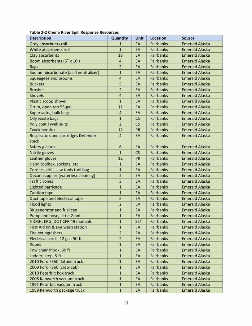
17
Table 2-2 Chena River Spill Response Resources Description Quantity Unit Location Source Gray absorbents roll 1 EA Fairbanks Emerald Alaska White absorbents roll 1 EA Fairbanks Emerald Alaska Clay absorbents 18 EA Fairbanks Emerald Alaska Boom absorbents (5” x 10’) 4 EA Fairbanks Emerald Alaska Rags 2 EA Fairbanks Emerald Alaska Sodium bicarbonate (acid neutralizer) 1 EA Fairbanks Emerald Alaska Squeegees and brooms 4 EA Fairbanks Emerald Alaska Buckets 5 EA Fairbanks Emerald Alaska Brushes 2 EA Fairbanks Emerald Alaska Shovels 4 EA Fairbanks Emerald Alaska Plastic scoop shovel 1 EA Fairbanks Emerald Alaska Drum, open top 55-gal 11 EA Fairbanks Emerald Alaska Supersacks, bulk bags 4 EA Fairbanks Emerald Alaska Oily waste bags 1 CS Fairbanks Emerald Alaska Poly coat Tyvek suits 2 CS Fairbanks Emerald Alaska Tyvek booties 12 PR Fairbanks Emerald Alaska Respirators and cartridges Defender stack
4 EA Fairbanks Emerald Alaska
Safety glasses 6 EA Fairbanks Emerald Alaska Nitrile gloves 1 CS Fairbanks Emerald Alaska Leather gloves 12 PR Fairbanks Emerald Alaska Hand toolbox, sockets, etc. 1 EA Fairbanks Emerald Alaska Cordless drill, saw tools tool bag 1 EA Fairbanks Emerald Alaska Decon supplies (waterless cleaning) 2 EA Fairbanks Emerald Alaska Traffic cones 3 EA Fairbanks Emerald Alaska Lighted barricade 1 EA Fairbanks Emerald Alaska Caution tape 1 EA Fairbanks Emerald Alaska Duct tape and electrical tape 5 EA Fairbanks Emerald Alaska Flood lights 2 EA Fairbanks Emerald Alaska 3K generator and fuel can 1 EA Fairbanks Emerald Alaska Pump and hose, Little Giant 1 EA Fairbanks Emerald Alaska NIOSH, ERG, DOT CFR 49 manuals 1 SET Fairbanks Emerald Alaska First Aid Kit & Eye wash station 1 EA Fairbanks Emerald Alaska Fire extinguishers 2 EA Fairbanks Emerald Alaska Electrical cords, 12 ga., 50-ft 2 EA Fairbanks Emerald Alaska Ropes 1 EA Fairbanks Emerald Alaska Tow chain/hook, 30 ft 1 EA Fairbanks Emerald Alaska Ladder, step, 8-ft 1 EA Fairbanks Emerald Alaska 2010 Ford F550 flatbed truck 1 EA Fairbanks Emerald Alaska 2009 Ford F350 (crew cab) 1 EA Fairbanks Emerald Alaska 2010 Peterbilt box truck 1 EA Fairbanks Emerald Alaska 2008 Kenworth vacuum truck 1 EA Fairbanks Emerald Alaska 1991 Peterbilt vacuum truck 1 EA Fairbanks Emerald Alaska 1989 Kenworth package truck 1 EA Fairbanks Emerald Alaska
18
Table 2-2 Chena River Spill Response Resources Description Quantity Unit Location Source 2005 Peterbilt tractor 1 EA Fairbanks Emerald Alaska 2000 Ford F350 (crew cab) 1 EA Fairbanks Emerald Alaska Trailer mount pump: Blackmer 2” diesel 1 EA Fairbanks Emerald Alaska Trailer mount pump: Yanmar 3” diesel 1 EA Fairbanks Emerald Alaska Trailer mount pump: Yanmar 4” diesel 1 EA Fairbanks Emerald Alaska Trailer mount pump: Godwin 4” diesel 1 EA Fairbanks Emerald Alaska Hydraulic pump: Corkon 3” 1 EA Fairbanks Emerald Alaska Hydraulic pump: 2” centrifugal 1 EA Fairbanks Emerald Alaska Hydraulic pump: 3” sump pump 1 EA Fairbanks Emerald Alaska Diaphragm pump: 1” 2 EA Fairbanks Emerald Alaska Diaphragm pump: 2” 1 EA Fairbanks Emerald Alaska Diaphragm pump: 3” 2 EA Fairbanks Emerald Alaska Portable snow melting self-contained unit for contaminated snow
1 EA Fairbanks Emerald Alaska
Stationary snow melting self-contained unit for contaminated snow
1 EA Fairbanks Emerald Alaska
Dredging equipment for lagoons and surface waters
1 EA Fairbanks Emerald Alaska
40’ connex with hoses, pumps, fast tank, skimmers, hardware, etc.
1 EA Fairbanks Alaska Railroad
40’ connex with consumables, i.e., PPE, absorbent pads, rolls, booms, etc.
1 EA Fairbanks Alaska Railroad
40-gal or 55-gal drums EA Fairbanks Alaska Railroad Boom, 6” float 4” skirt “reclaimed” 30’-50’
30 EA Fairbanks Arctic Fire & Safety
Drum, poly, 55-gal OT 50 EA Fairbanks Arctic Fire & Safety Drum, steel, 85-gal OT 35 EA Fairbanks Arctic Fire & Safety Bag, 4M 33 X 40 oil/print 100 30 EA Fairbanks Arctic Fire & Safety Drum, steel, 110-gal OT 100 EA Fairbanks Arctic Fire & Safety Drum, steel, 30-gal OT 35 EA Fairbanks Arctic Fire & Safety Drum, steel, 55-gal OH 60 EA Fairbanks Arctic Fire & Safety Drum, poly 65-gal w/o wheel 10 EA Fairbanks Arctic Fire & Safety Universal pad 16 X 20 M 100 144 EA Fairbanks Arctic Fire & Safety Oil only pads Dimpl 100-ct 144 EA Fairbanks Arctic Fire & Safety Oil only boom 5 x 10’ 80 EA Fairbanks Arctic Fire & Safety Oil only boom 8 x 10’ 200 EA Fairbanks Arctic Fire & Safety Oil only sock 3 x 8’ 90 EA Fairbanks Arctic Fire & Safety Oil only sock 3 x 4’ 180 EA Fairbanks Arctic Fire & Safety Oil only pads 100/bg 144 EA Fairbanks Arctic Fire & Safety Oil only boom 5 x 20’ 200 EA Fairbanks Arctic Fire & Safety Drum, poly 95-gal w/o wheel 12 EA Fairbanks Arctic Fire & Safety
19
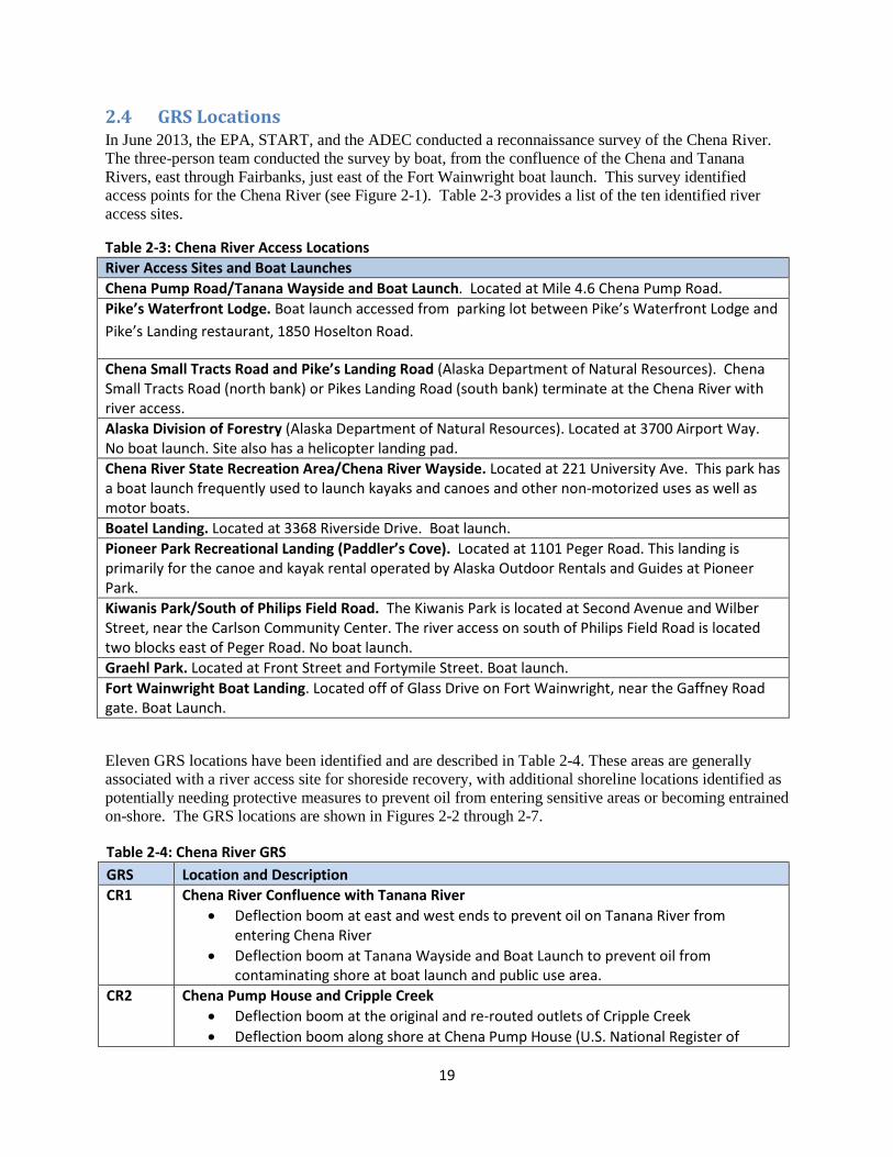
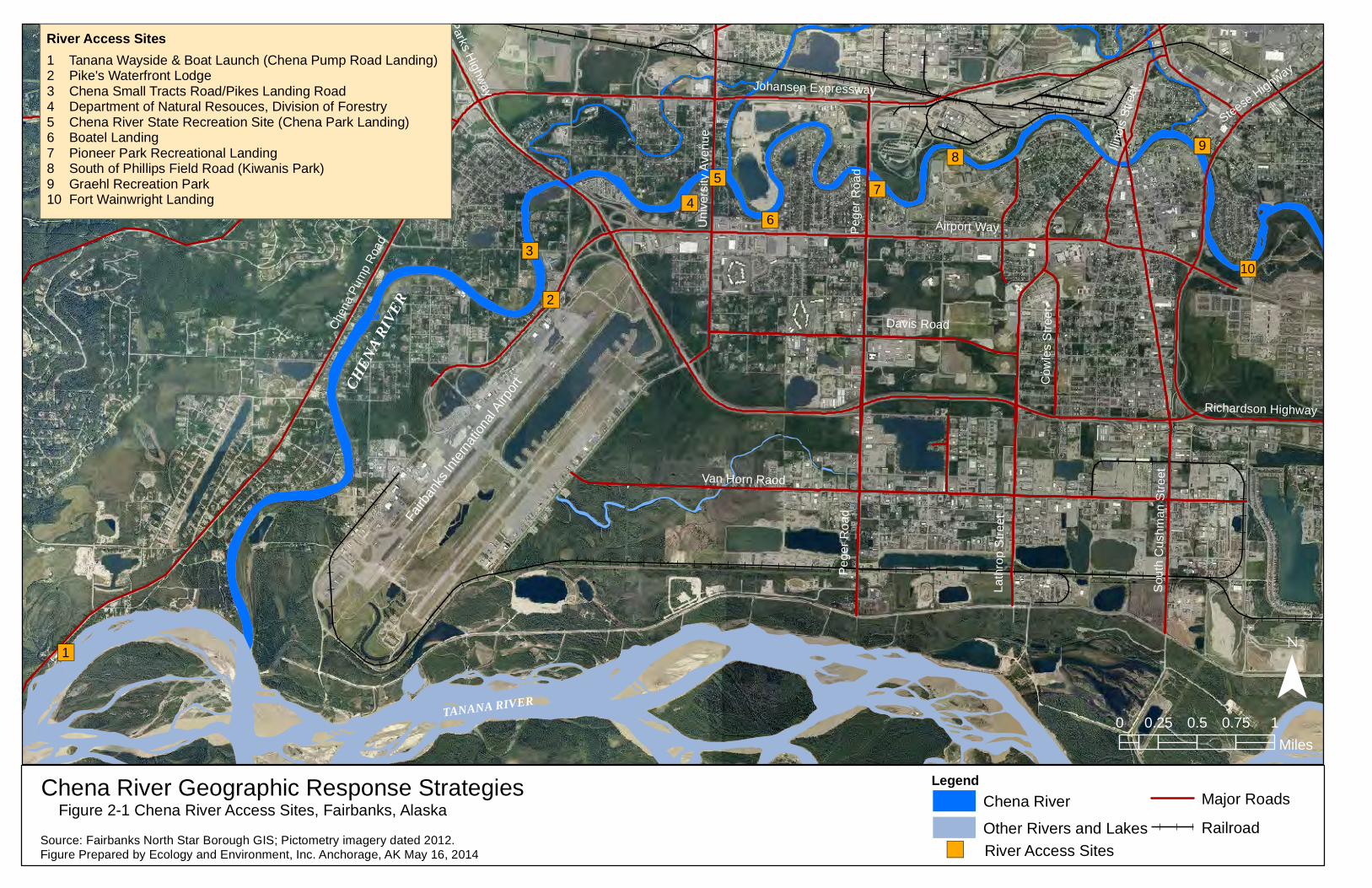
2.4 GRS Locations In June 2013, the EPA, START, and the ADEC conducted a reconnaissance survey of the Chena River. The three-person team conducted the survey by boat, from the confluence of the Chena and Tanana Rivers, east through Fairbanks, just east of the Fort Wainwright boat launch. This survey identified access points for the Chena River (see Figure 2-1). Table 2-3 provides a list of the ten identified river access sites.
Table 2-3: Chena River Access Locations River Access Sites and Boat Launches Chena Pump Road/Tanana Wayside and Boat Launch. Located at Mile 4.6 Chena Pump Road. Pike’s Waterfront Lodge. Boat launch accessed from parking lot between Pike’s Waterfront Lodge and Pike’s Landing restaurant, 1850 Hoselton Road.
Chena Small Tracts Road and Pike’s Landing Road (Alaska Department of Natural Resources). Chena Small Tracts Road (north bank) or Pikes Landing Road (south bank) terminate at the Chena River with river access. Alaska Division of Forestry (Alaska Department of Natural Resources). Located at 3700 Airport Way. No boat launch. Site also has a helicopter landing pad. Chena River State Recreation Area/Chena River Wayside. Located at 221 University Ave. This park has a boat launch frequently used to launch kayaks and canoes and other non-motorized uses as well as motor boats. Boatel Landing. Located at 3368 Riverside Drive. Boat launch. Pioneer Park Recreational Landing (Paddler’s Cove). Located at 1101 Peger Road. This landing is primarily for the canoe and kayak rental operated by Alaska Outdoor Rentals and Guides at Pioneer Park. Kiwanis Park/South of Philips Field Road. The Kiwanis Park is located at Second Avenue and Wilber Street, near the Carlson Community Center. The river access on south of Philips Field Road is located two blocks east of Peger Road. No boat launch. Graehl Park. Located at Front Street and Fortymile Street. Boat launch. Fort Wainwright Boat Landing. Located off of Glass Drive on Fort Wainwright, near the Gaffney Road gate. Boat Launch.
Eleven GRS locations have been identified and are described in Table 2-4. These areas are generally associated with a river access site for shoreside recovery, with additional shoreline locations identified as potentially needing protective measures to prevent oil from entering sensitive areas or becoming entrained on-shore. The GRS locations are shown in Figures 2-2 through 2-7.
Table 2-4: Chena River GRS GRS Location and Description CR1 Chena River Confluence with Tanana River
• Deflection boom at east and west ends to prevent oil on Tanana River from entering Chena River
• Deflection boom at Tanana Wayside and Boat Launch to prevent oil from contaminating shore at boat launch and public use area.
CR2 Chena Pump House and Cripple Creek • Deflection boom at the original and re-routed outlets of Cripple Creek • Deflection boom along shore at Chena Pump House (U.S. National Register of
20
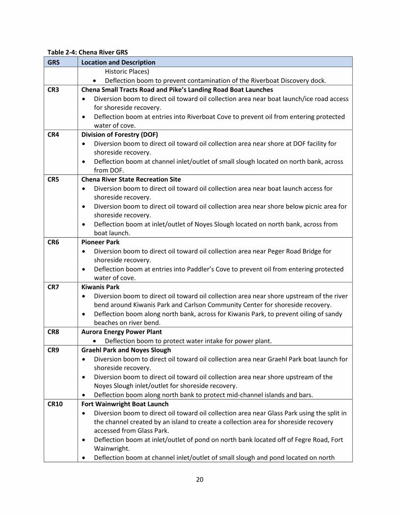
Table 2-4: Chena River GRS GRS Location and Description
Historic Places) • Deflection boom to prevent contamination of the Riverboat Discovery dock.
CR3 Chena Small Tracts Road and Pike’s Landing Road Boat Launches • Diversion boom to direct oil toward oil collection area near boat launch/ice road access
for shoreside recovery. • Deflection boom at entries into Riverboat Cove to prevent oil from entering protected
water of cove. CR4 Division of Forestry (DOF)
• Diversion boom to direct oil toward oil collection area near shore at DOF facility for shoreside recovery.
• Deflection boom at channel inlet/outlet of small slough located on north bank, across from DOF.
CR5 Chena River State Recreation Site • Diversion boom to direct oil toward oil collection area near boat launch access for
shoreside recovery. • Diversion boom to direct oil toward oil collection area near shore below picnic area for
shoreside recovery. • Deflection boom at inlet/outlet of Noyes Slough located on north bank, across from
boat launch. CR6 Pioneer Park
• Diversion boom to direct oil toward oil collection area near Peger Road Bridge for shoreside recovery.
• Deflection boom at entries into Paddler’s Cove to prevent oil from entering protected water of cove.
CR7 Kiwanis Park • Diversion boom to direct oil toward oil collection area near shore upstream of the river
bend around Kiwanis Park and Carlson Community Center for shoreside recovery. • Deflection boom along north bank, across for Kiwanis Park, to prevent oiling of sandy
beaches on river bend. CR8 Aurora Energy Power Plant
• Deflection boom to protect water intake for power plant. CR9 Graehl Park and Noyes Slough
• Diversion boom to direct oil toward oil collection area near Graehl Park boat launch for shoreside recovery.
• Diversion boom to direct oil toward oil collection area near shore upstream of the Noyes Slough inlet/outlet for shoreside recovery.
• Deflection boom along north bank to protect mid-channel islands and bars. CR10 Fort Wainwright Boat Launch
• Diversion boom to direct oil toward oil collection area near Glass Park using the split in the channel created by an island to create a collection area for shoreside recovery accessed from Glass Park.
• Deflection boom at inlet/outlet of pond on north bank located off of Fegre Road, Fort Wainwright.
• Deflection boom at channel inlet/outlet of small slough and pond located on north
21
Table 2-4: Chena River GRS GRS Location and Description
bank, near Hamilton Acres Park. • Deflection boom to protect shoreline of island splitting river into two channels
upstream of boat landing. • Deflection boom to protect Fort Wainwright boat landing and dock.
CR11 Fort Wainwright Trainor Gate Road and railroad bridge crossing • Diversion boom to direct oil toward oil collection areas on south channel using split in
river channel created by an oxbow island. Potential collection areas possible on north and south bank of southern channel.
• Deflection boom on north bank upstream of the oxbow island to direct oil away from northern channel and into southern channel.
• Deflection boom along upstream banks of the oxbow island to prevent oiling of shore. • Deflection boom to protect shoreline of island in southern channel.
During a spill response, some locations shown in the GRS figures may be identified for either protection from contamination by oil or used for recovery of oil. These include the Riverboat Cove (Riverboat Discovery and Tanana Chief docking facilities) and Paddler’s Cove (Pioneer Park Recreational Landing). At either site, oil could be deflected away from entering the protected waters or diverted into the cove area to facilitate recovery, depending on the response needs and property owner and other stakeholder concerns. Additionally, river access sites generally have been identified as potential shoreside recovery areas with diversion boom used to direct oil to the access site. However, it may be appropriate to use a deflection boom to direct free oil away from a boat launch to minimize the spread of contamination as vessels and other equipment enter and exit the river.
2.5 Recovery Tactics The following spill recovery tactics descriptions from the Alaska Spill Tactics for Alaska Responders (STAR) Field Guide (April 2006) are summarized below. Page references from the STAR guide are noted in brackets. Although not specified in the STAR guide, it is assumed that sufficient containment boom will be available when using these tactics.
Both deflection boom and diversion boom are tactics utilizing the same type of boom. The specific type of boom will be determined by the river conditions and available equipment. (Exclusion boom and containment boom are two other commonly used tactics but they are not appropriate for the fast water condition of the Chena River and are not recommended here.)
In the event of a response utilizing all of the tactics identified in Figures 2-2 through 2-9, over 10,000 feet of boom would be required. Depending on river conditions and water levels, additional diversion boom may be required to protect shorelines or mid-channel islands from oil.
22
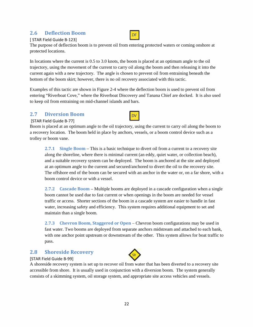
2.6 Deflection Boom [ STAR Field Guide B-123] The purpose of deflection boom is to prevent oil from entering protected waters or coming onshore at protected locations.
In locations where the current is 0.5 to 3.0 knots, the boom is placed at an optimum angle to the oil trajectory, using the movement of the current to carry oil along the boom and then releasing it into the current again with a new trajectory. The angle is chosen to prevent oil from entraining beneath the bottom of the boom skirt; however, there is no oil recovery associated with this tactic.
Examples of this tactic are shown in Figure 2-4 where the deflection boom is used to prevent oil from entering “Riverboat Cove,” where the Riverboat Discovery and Tanana Chief are docked. It is also used to keep oil from entraining on mid-channel islands and bars.
2.7 Diversion Boom [STAR Field Guide B-77] Boom is placed at an optimum angle to the oil trajectory, using the current to carry oil along the boom to a recovery location. The boom held in place by anchors, vessels, or a boom control device such as a trolley or boom vane.
2.7.1 Single Boom – This is a basic technique to divert oil from a current to a recovery site along the shoreline, where there is minimal current (an eddy, quiet water, or collection beach), and a suitable recovery system can be deployed. The boom is anchored at the site and deployed at an optimum angle to the current and secured/anchored to divert the oil to the recovery site. The offshore end of the boom can be secured with an anchor in the water or, on a far shore, with a boom control device or with a vessel.
2.7.2 Cascade Boom – Multiple booms are deployed in a cascade configuration when a single boom cannot be used due to fast current or when openings in the boom are needed for vessel traffic or access. Shorter sections of the boom in a cascade system are easier to handle in fast water, increasing safety and efficiency. This system requires additional equipment to set and maintain than a single boom.
2.7.3 Chevron Boom, Staggered or Open – Chevron boom configurations may be used in fast water. Two booms are deployed from separate anchors midstream and attached to each bank, with one anchor point upstream or downstream of the other. This system allows for boat traffic to pass.
2.8 Shoreside Recovery [STAR Field Guide B-99] A shoreside recovery system is set up to recover oil from water that has been diverted to a recovery site accessible from shore. It is usually used in conjunction with a diversion boom. The system generally consists of a skimming system, oil storage system, and appropriate site access vehicles and vessels.
23
2.9 Fast Water Free-Oil Recovery [STAR Field Guide B-57] Fast water free-oil recovery is an on-water strategy deployed to recover oil without bringing the oil to or near shore. These systems comprise vessels with oil booms for containment and concentration, skimming systems for recovery of oil, and primary storage devices for temporary storage. Vessels, booms, and skimmers should be able to be deployed and operated in waves up to 2 feet and winds up to 15 knots.
This tactic is not shown in any of the GRS figures. It is highly dependent on available vessels and associated equipment (such as Boom Vanes™ and Current Busters™), skilled vessel operators, and conditions on the river. In most cases this tactic is deployed in either open water or very large rivers, unlike the Chena River.
24
References and Resources
Alaska Department of Environmental Conservation, 2013, Underground Storage Tank Database Website. Available at: http://dec.alaska.gov/spar/ipp/ust/search/default.htm. Accessed on April 9, 2013.
Alaska Department of Natural Resources, Division of Parks & Outdoor Recreation. n.d. River Guide for Chena River State Recreation Area. http://dnr.alaska.gov/parks/units/chena/river.htm Accessed October 23, 2013.
Alaska Railroad Corporation. May 2012. Alaska Railroad Freight Services.https://www.alaskarailroad.com/Portals/6/pdf/pr/2012_05_16_Freight_FS_PR.pdf. Accessed on June 13, 2013.
Alaska Spill Tactics for Alaska Responders (STAR) Field Guide (April 2006): http:// dec.alaska.gov/spar/perp/star/docs.htm. Accessed on October 22, 2013.
Alaska Statewide Hazmat Work Group.February 14, 2011. Statewide Hazmat Detection Equipment Assets.
Alyeska Pipeline Service Company (APSC). 2013 Pipeline Operations. http://www.alyeska-pipe.com/TAPS/PipelineOperations/LowFlowOperations. Accessed June 13, 2013.
_____. 2011. Trans Alaska Pipeline System Pipeline Oil Discharge Prevention and Contingency Plan.
Brase, A. L. J. 2009. Sport Fishery Management Plan for Chinook salmon in the Chena and Salcha Rivers. Alaska Department of Fish and Game, Fishery Management Report No. 09-11, Anchorage.
Brase, A. L. J. and B. Baker. 2014. Fishery Management Report for Recreational Fisheries in the Tanana River Management Area, 2012. Alaska Department of Fish and Game, Fishery Management Report No. 14-14, Anchorage.
_____. 2012. Fishery Management Report for Recreational Fisheries in the Tanana River Management Area, 2010. Alaska Department of Fish and Game, Fishery Management Report No. 12-32.
Chena Hot Springs Resort. 2013. History of Chena Hot Springs.: http://www.chenahotsprings.com/history/. Accessed April 22, 2014.
Ecology and Environment, Inc., September 2012. 2011 Tier Two Compilation/CAMEO Database.
_____. 2013. Facility Response Plan Database [computer files].
Fairbanks North Star Borough. April 2013. Fairbanks North Star Borough GIS Data, FNSBGIS.gdb [computer files].
_____. July 2012. Pictometry imagery [computer files].
25
_____. Fairbanks Store Water Management Program Storm Drain Map. http://co.fairbanks.ak.us/PWorks/StormWaterManagementProgram/stormdrainmap.htm. Accessed March 6, 2013.
_____. Fairbanks Store Water Management Program, Stormwater 101. http://co.fairbanks.ak.us/PWorks/StormWaterManagementProgram/stormwater101.htm. Accessed March 6, 2013
Tetra Tech. 2011. Watershed Characterization for the Chena River Watershed, Alaska.http://dec.alaska.gov/water/wnpspc/protection_restoration/ChenaRiverWQ/docs/ChenaRiver_Watershed_Characterization_11-11.pdf. Accessed on March 5, 2013.
United States Army Corps of Engineers (USACE). 1997. Chena River Watershed Study Reconnaissance Report, as summarized in the Watershed Characterization for the Chena River Watershed, Alaska.
United States Environmental Protection Agency. 2013. Water: Nonpoint Source Success Stories. Alaska: Chena River, Cleaning Up Contaminated Sites Improves Water Quality http://water.epa.gov/polwaste/nps/success319/ak_chena.cfm. Accessed October 25, 2013.
United States Fish and Wildlife Service. 2013. Juvenile Chinook salmon (Oncorhynchus tshawytscha) in the Chena River corridor through Fairbanks, AK: using citizen scientists to build community stewardship. RM #32-12 http://www.fws.gov/alaska/fisheries/fieldoffice/fairbanks/subsistence/pdf/reports/rm_32_2012.pdf Accessed May 7, 2014.

26
This page intentionally left blank
Parks Highway
College Road
Uni
vers
ity A
venu
e
Johansen Expressway
Chen
a Pu
mp
Road
Van Horn RoadRichardson Highway
Davis Road
Lath
rop
Stre
et
Peg
er R
oad
Sou
th C
ushm
an S
treet
Steese Highway
Airport Way
Cow
les
Stre
et
Farmer's Loop Road
Chena Ridge Road
Sheep Creek Road
Ilino
is S
treet
Chena Hot Springs Road
Nor
dale
Roa
d
Badger Road
Chena River Vulnerability AssessmentFigure 1-1a Base Map with Aerial Photo
0 1 2 3 40.5Miles
CHENA RIVER
Tanana River
¯
Source: Fairbanks North Star Borough GIS; Pictometry imagery dated 2012.Figure Prepared by Ecology and Environment, Inc. Anchorage, AK May 16, 2014
LegendChena River
Other Rivers and Lakes
Fairb
anks
Inter
natio
nal A
irpor
t
Trans Alaska Pipeline System
RailroadMajor Roads
Pipeline
FAIRBANKS
NORTH POLE
FORT WAINWRIGHT
Parks Highway
College Road
Uni
vers
ity A
venu
e
Johansen Expressway
Chen
a Pu
mp
Road
Van Horn Road
Richardson Highway
Davis Road
Lath
rop
Stre
et
Peg
er R
oad
Sou
th C
ushm
an S
treet
Steese Highway
Airport Way
Cow
les
Stre
et
Chena Ridge Road
Farmer'sLoop
Ilino
is S
treet
Chena River Vulnerability AssessmentFigure 1-1b Base Map with Aerial Photo: Chena River fromTanana River to Fort Wainwright
0 0.5 1 1.5 20.25Miles
CHENA RIVERCH
ENA R
IVER
Tanana River
¯
Source: Fairbanks North Star Borough GIS; Pictometry imagery dated 2012.Figure Prepared by Ecology and Environment, Inc. Anchorage, AK May 16, 2014
Legend
Railroad
Major RoadsChena River
Other Rivers and Lakes
Fairb
anks
Inter
natio
nal A
irpor
t
FAIRBANKS
FT. WAINWRIGHT
Richardson Highway
Sou
th C
ushm
an S
treet
Steese Highway
Ilino
is S
treet
Trans Alaska Pipeline
CHENA RIVERCHENA SLOUGHBadger Road
Nor
dale
Roa
d
Chena River Vulnerability AssessmentFigure 1-1c Base Map with Aerial Photo: Steese Highway to Trans Alaska Pipeline
0 0.5 1 1.5 20.25Miles
Tanana River
¯
Source: Fairbanks North Star Borough GIS; Pictometry imagery dated 2012.Figure Prepared by Ecology and Environment, Inc. Anchorage, AK May 16, 2014
Legend
Railroad
Major RoadsChena River
Other Rivers and Lakes
FT. WAINWRIGHT
NORTH POLE
College Road
Uni
vers
ity A
venu
e
Johansen Expressway
Chen
a Pu
mp
Road
Van Horn Road
Richardson Highway
Davis Road
Lath
rop
Stre
et
Peg
er R
oad
Sou
th C
ushm
an S
treet
Ste
ese
Hig
hway
Airport Way
Cow
les
Stre
et
Farmer'sLoop
Parks Highway
Chena Ridge Road
Chena River Vulnerability AssessmentFigure 1-2 Base Map with Road Network, Fairbanks Area
0 0.5 1 1.5 20.25Miles
Legend
Railroad
Major Roads
Other Rivers and Lakes
Chena River
CHEN
A RIV
ER
Tanana River
¯
Source: Fairbanks North Star Borough GISFigure Prepared by Ecology and Environment, Inc. Anchorage, AK May 16, 2014
U.S. ArmyFort Wainwright
Fairb
anks
Inter
natio
nal A
irpor
t
Alaska Railroad
DEADMAN SLOUGH
NOYES SLOUGH
!H
!H
!H!H
!H
!H
!H
!H
!H
!H
!H
!H
!H
!H
!H
!H !H
!H!H
!H
!H
!H
!H
!H!H
!H
!H!H!H
!H
!H
!H
!H
!H
!H
!H
!H
!H!H
!H!H
!H!H !H!H
!H !H
!H!H !H!H
!H
!H
!H
!H
!H
!H
!H!H!H
!H
!H
!H
!H
!H
!H
!H!H !H
!H
!H
!H
!H!H
!H!H
!H!H
!H
!H
!H
!H
!H
!H
!H
!H
!H
!H!H
!H
!H
!H
!H
!H
!H!H
!H!H!H!H
!H
!H
!H
!H!H
!H
!H
!H!H!H
!H
!H
!H!H
!H
!H!H!H
!H
!H
!H
!H!H
!H
!H!H!H!H!H!H
!H
College Road
Uni
vers
ity A
venu
e
Johansen Expressway
Chen
a Pu
mp
Road
Van Horn Road
Richardson Highway
Davis Road
Lath
rop
Stre
et
Peg
er R
oad
Sou
th C
ushm
an S
treet
Ste
ese
Hig
hway
Airport Way
Cow
les
Stre
et
Farmer'sLoop
Parks Highway
Chena Ridge Road
Chena River Vulnerability AssessmentFigure 1-3 Stormwater Drainage & Discharge Features
0 0.5 1 1.5 20.25Miles
Legend
Railroad
Major Roads
Other Rivers and Lakes
Chena River
CHEN
A RIV
ER
Tanana River
¯
Source: Fairbanks North Star Borough GISFigure Prepared by Ecology and Environment, Inc. Anchorage, AK May 16, 2014
U.S. ArmyFort Wainwright
Fairb
anks
Inter
natio
nal A
irpor
t
Alaska Railroad
DEADMAN SLOUGH
NOYES SLOUGH
Stormwater Features!H Stormwater Discharge Points
Stormwater - Open Drainage
Stormwater Lines
There are 116 Stormwater Discharge Points into theChena River and its sloughs and tributaries within theChena River Vulnerabilty Assessment study area.
"/"/"/"/
"/"/
"/"/
"/
"/"/"/
"/
"/"/"/"/
"/"/"/
"/
"/"/"/"/"/"/"/"/"/"/"/"/"/"/"/
"/"/"/"/
"/"/"/"/
"/"/
"/
"/
"/"/"/"/"/"/
"/
"/"/
"/
"/
"/"/"/
"/
"/"/
"/
"/"/
"/
"/"/"/"/
"/
"/"/
"/"/
"/"/
"/
"/
"/
"/"/
"/
"/
"/
"/
"/
"/
"/
"/
"/"/
"/
"/
"/"/"/
"/"/"/"/"/"/
"/"/"/
"/
"/
"/
"/"/
"/
"/"/"/"/
"/
"/"/
"/"/"/"/
"/
"/"/"/
"/"/"/
"/
"/"/
"/"/
"/"/
"/"/"/"/
"/"/
"/
"/
"/
"/
"/
"/"/
"/
"/
"/
"/
"/"/
"/
"/
"/"/
"/"/
"/
"/"/"/
"/
"/
"/
!.
!.
!.
!.
!.!.
#0
#0
#0
#0
#0#0#0
#0
#0
#0
#0
#0
#0#0
#0
#0
#0
#0
#0
!.
!.
#0
!.!.
!.
#0
!.!.
!.
!.
!.
!.!.!.
#0
#0
#0
#0#0
#0#0
#0
#0
#0
#0
!.!.
"/"/ !.
!.!.!.!.!.!.!.!.!.!.!.
!.
!.
!.
!.
#0
#0
#0
#0
#0
#0
!.
!.
!.
!.
!.
!.!.
#0
#0#0#0
#0#0
#0
#0!.
!.!.
!.
!.!.
!.
!.
#0
#0
!.
!.!.
!.
!.
!.!.
!.
!.!.
!.
!.
"/
"/
"/
"/
"/"/"/
"/
"/
"/
"/
"/"/
"/"/
"/
"/
"/
"/
!.!.!.
!.
!.!.!.!.
!.
!.!.!.
!.
!.
"/
"/
"/
"/
"/
"/
!.
!.
!.!.
!.!.!.
"/
#0#0
#0
#0
!.
#0
!.
#0
#0 #0
!.
!.
!.
!.
!.
#0
#0
#0
#0
#0
"/
"/
"/
!.
!.
!.
!.!.!.!.!.!.!.!.!.!.!.!.!.!.!.!.!.!.!.!.!.!.!.!.
!.
!.
!.
!.!.
!.!.
!.
#0
#0
!.
!.
!.
!.
!.
!.
!.
!.
!.!.
!.!.
!.
!.
#0
#0#0
#0
#0
#0
#0#0
#0
#0
#0
"/
#0#0
#0
#0#0
#0#0
#0
#0#0
#0
#0
#0
#0#0
!.!.
"/
!.
!.
!.
!.!.
!.
!.!.
!.
!.
#0
#0#0#0#0#0#0#0#0#0#0#0
#0#0
#0#0
!.
!.
#0
!.!.
!.
!.!.
!.
!.
!.
!.
!.!.
!.
!.
!.
!.
!.
!.!.!.
!.
!.!.
!.!.
!.
#0
!.
!.
!.
!.
!.
!.
!.
"/
!.
!.
!.
!.
!.
!.
!.
"/!.
!.
"/
"/
!.
#0!.!.
!.
!.
College Road
Uni
vers
ity A
venu
e
Johansen Expressway
Chen
a Pu
mp
Road
Van Horn Road
Richardson Highway
Davis Road
Lath
rop
Stre
et
Peg
er R
oad
Sou
th C
ushm
an S
treet
Ste
ese
Hig
hway
Airport Way
Cow
les
Stre
et
Farmer'sLoop
Parks Highway
Chena Ridge Road
Chena River Vulnerability AssessmentFigure 1-4 Hazardous Material Storage Facilites
0 0.5 1 1.5 20.25Miles
CHEN
A RIV
ER
Tanana River
¯
Source: ADEC UST Database, 2011 Tier Two data; Fairbanks North Star Borough GISFigure Prepared by Ecology and Environment, Inc. Anchorage, AK May 16, 2014
U.S. ArmyFort Wainwright
Fairb
anks
Inter
natio
nal A
irpor
t
Alaska Railroad
DEADMAN SLOUGH
NOYES SLOUGH
Hazardous Material Storage FacilitiesHazardous material transportation corridorLegend
Other Rivers and Lakes
Chena RiverRailroad
Roads
!. Chemical"/ Petroleum Product
#0 Compressed Gases
"/
"/
"/"/"/
"/"/
"/"/
"/
"/"/
"/
"/
"/"/"/"/
"/"/
"/"/
"/
# 0!.!.
"/"/
!.!.
"/
"/"/"/
"/
"/
# 0# 0# 0
"/
"/!.
# 0
!.!.# 0 "/!.
Chena Pump Road
Che
na R
idge
Roa
d
Che
na R
iver
Vul
nera
bilit
y As
sess
men
tFi
gure
1-5
Che
na R
iver
: Par
ks H
ighw
ay to
Con
fluen
ce
00.
10.
20.
30.
40.
5 Mile
s
CHENA RIVER
Tana
na Ri
ver
¯So
urce
s: A
DE
C U
ST
Dat
abas
e; 2
011
Tier
Tw
o da
ta; F
airb
anks
Nor
th S
tar B
orou
gh G
ISFi
gure
Pre
pare
d by
Eco
logy
and
Env
ironm
ent,
Inc.
Anc
hora
ge, A
K M
ay 1
6, 2
014
Fairbanks
InternationalA
irport
Alaska Railro
ad
Haz
ardo
us M
ater
ial S
tora
ge F
acili
ties
Lege
nd
Oth
er R
iver
s an
d La
kes
Che
na R
iver
Rai
lroad
Roa
ds
!.C
hem
ical
"/Pe
trole
um P
rodu
ct
# 0C
ompr
esse
d G
ases
"/
Haz
ardo
us M
ater
ial T
rans
porta
tion
Cor
ridor
"/"/"/"/"/
"/"/"/"/
"/"/"/"/"/"/
"/
"/
"/"/
"/"/
"/
"/
"/
"/
"/
"/"/
"/"/"/
"/"/"/"/"/
"/"/"/"/
"/
"/"/
"/"/
"/"/
"/
"/"/
"/"/
"/
"/"/
"/
!.!.!.
#0
#0#0#0#0!.#0!.!.!.#0!.!.!.#0!.!.!."/
"/
"/
"/
"/!.
"/
"/!.!.!.
"/
!.!.#0!.!.!.!.!.!.!.!.!.!.!.!.!.!.!.!.!.!.!.!.!.!.!.!.!.#0#0
#0
#0#0#0#0#0#0#0#0#0#0#0#0#0#0#0#0#0!.!.
"/
Uni
vers
ity A
venu
e
Johansen Expressway
Davis Road
Airport Way
Parks Highway
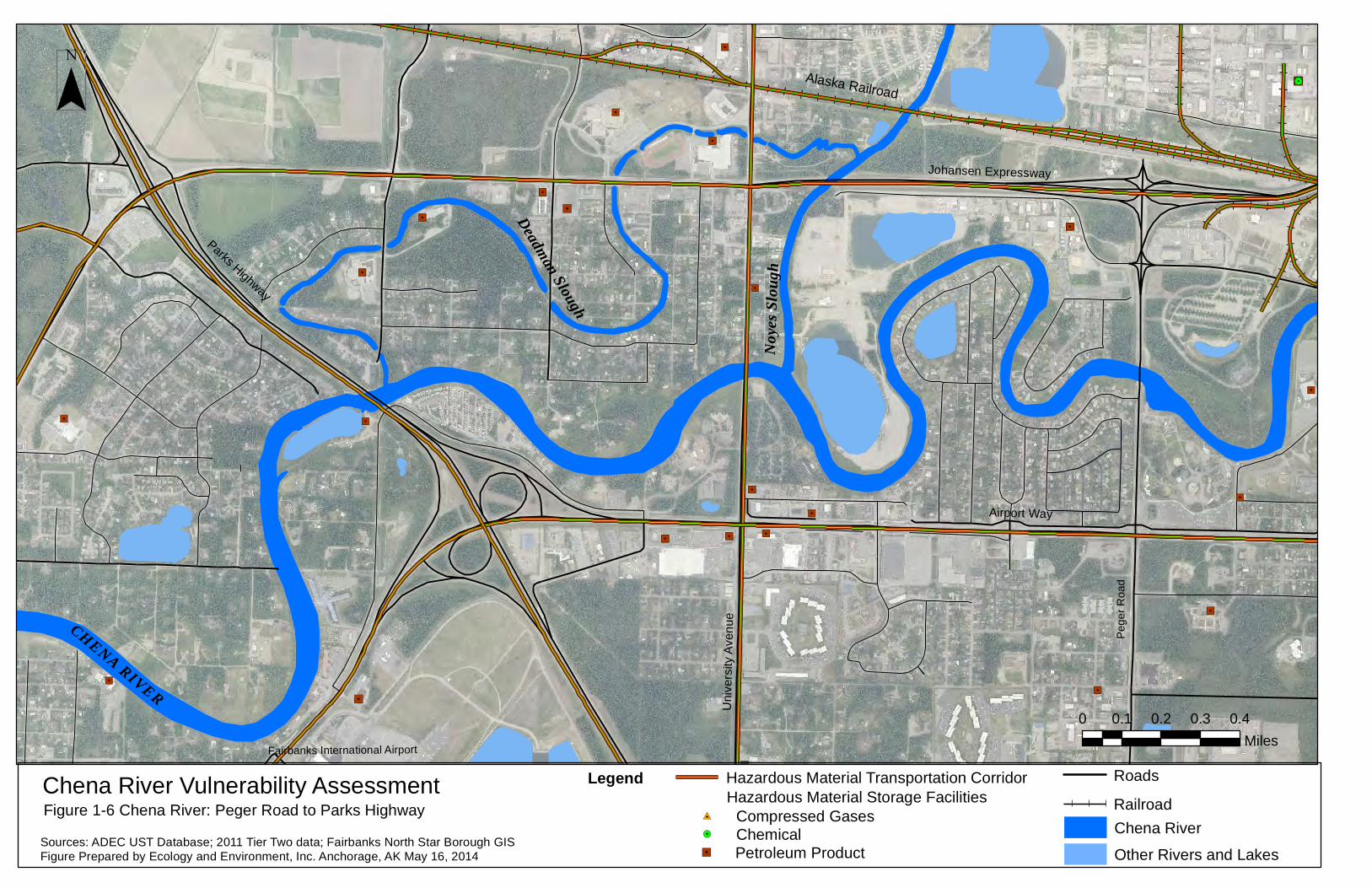
Chena River Vulnerability AssessmentFigure 1-6 Chena River: Peger Road to Parks Highway
0 0.1 0.2 0.3 0.4Miles
CHENA RIVER
¯
Sources: ADEC UST Database; 2011 Tier Two data; Fairbanks North Star Borough GISFigure Prepared by Ecology and Environment, Inc. Anchorage, AK May 16, 2014
Fairbanks International Airport
Hazardous Material Storage FacilitiesLegend
Other Rivers and Lakes
Chena RiverRailroad
Roads
!. Chemical"/ Petroleum Product
#0 Compressed Gases
Noyes
Slou
gh
Deadman Slough
Pege
r Roa
d
Alaska Railroad
"/
"/
Hazardous Material Transportation Corridor
"/"/
"/
"/"/"/"/
"/"/"/
"/
"/
"/"/"/
"/"/"/"/
"/
"/
"/
"/
"/"/"/
"/
"/
"/"/
"/"/
"/
"/
"/
"/
"/
"/
"/
"/
"/
"/"/"/"/
"/"/"/
"/
"/"/
"/
"/"/
"/"/
"/"/
"/"/
"/
"/
"/
"/
"/
"/
"/
"/
"/
"/
"/
!.!.!.
#0
#0
#0#0#0
#0
#0
#0
#0
!.
!.!.
!.
#0
#0
#0
!.!.!.!.!.!.!.!.!.!.!.
!.
!.
!.
!.
!.!.
#0
#0!.
!.!.
!.!.
!.
#0
#0
!.
!.
!.!.!."/
"/
"/
"/
"/
"/
"/
!.
!.
!.
!.
"/
"/
"/
"/
!.!.!.
"/
!.
#0
!.!.
!.
#0
#0
!.
!.!.!.!.!.!.!.!.!.!.!.!.!.!.!.!.!.!.!.!.!.!.!.!.
!.
!.
!.
!.!.!.
!.
!.
!.#0
#0#0
#0
#0
#0
#0
#0
#0
#0#0
#0
#0#0
!.
#0#0#0#0#0#0#0#0#0#0#0#0
!.!.
!.!.
!.
!.
!.
#0
!.
!.
!.
!.
!.
!.
!.
!.
!.
"/
#0!.!.
Johansen Expressway
Davis Road
Airport Way
Cow
les
Stre
et
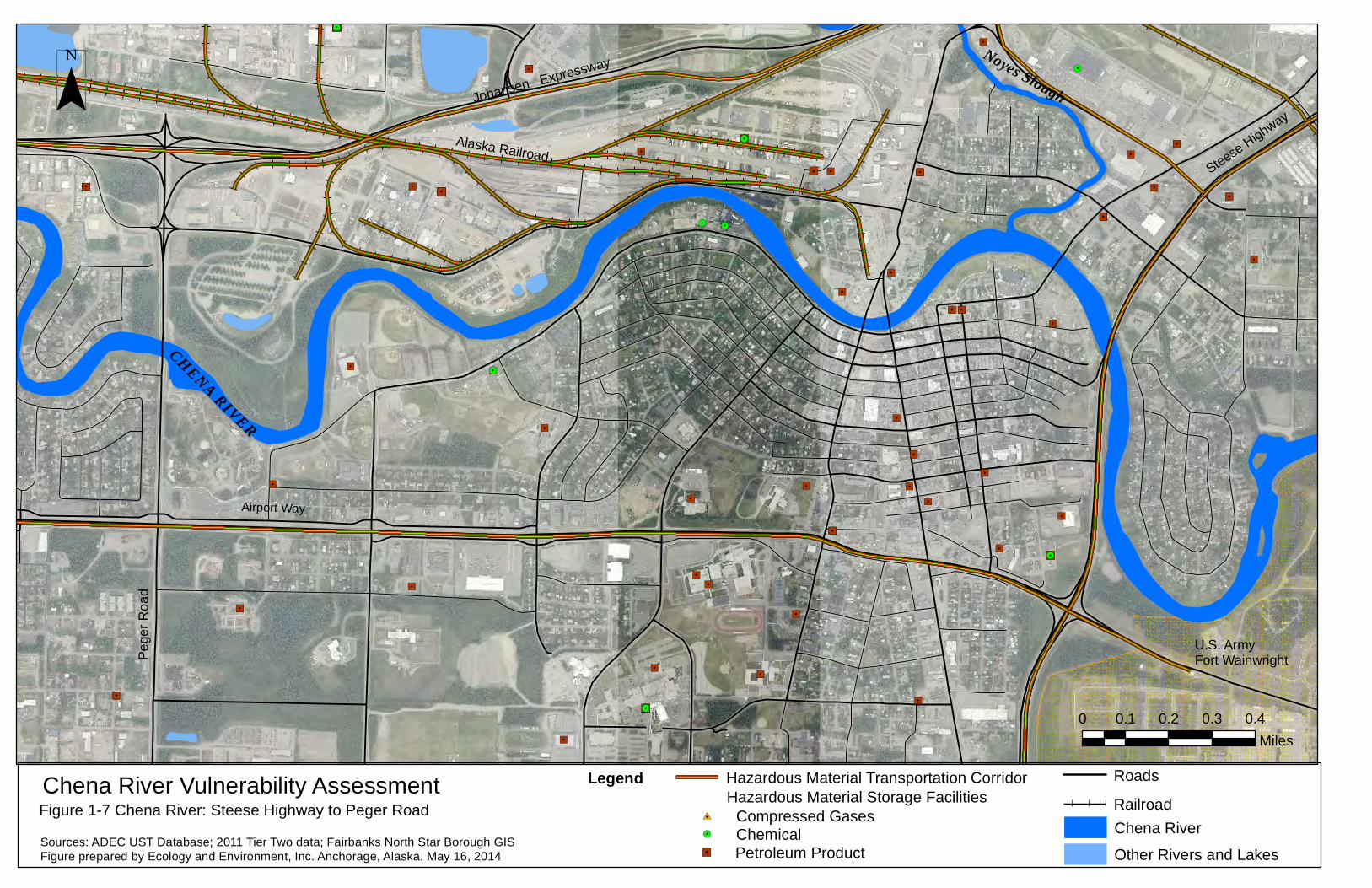
Chena River Vulnerability AssessmentFigure 1-7 Chena River: Steese Highway to Peger Road
0 0.1 0.2 0.3 0.4Miles
CHENA RIVER
¯
Sources: ADEC UST Database; 2011 Tier Two data; Fairbanks North Star Borough GISFigure prepared by Ecology and Environment, Inc. Anchorage, Alaska. May 16, 2014
Hazardous Material Storage FacilitiesLegend
Other Rivers and Lakes
Chena RiverRailroad
Roads
!. Chemical"/ Petroleum Product
#0 Compressed Gases
Noyes Slough
Pege
r Roa
dAlaska Railroad
Steese Highway
U.S. Army Fort Wainwright
Hazardous Material Transportation Corridor
"/
"/"/"/"/
"/
"/
"/"/"/
"/"/"/"/
"/
"/
"/
"/
"/
"/"/"/
"/
"/"/
"/
"/"/
"/"/
"/
"/
"/
"/
"/
"/"/
"/
"/
"/
"/"/
"/"/"/"/
"/
"/"/
"/"/"/
"/"/
"/
"/
"/
"/
"/
"/
"/
"/
"/
"/
"/"/"/
"/
"/
!.!.!.
#0
#0#0#0
#0
#0
#0
!.
!.#0
!.!.!.!.!.!.!.!.!.!.!.
!.
!.
!.!.!.#0!.
!.!.
!.!.
!.
#0
#0
!.
!.!.!.
"/
"/
"/
"/
"/
"/
!.
!.
!.
"/
"/
"/
!.!.!.
"/
!.
!.!.
!.
#0
#0
!.!.!.!.!.!.!.!.!.!.!.!.!.!.!.!.!.!.!.!.!.!.!.!.
!.
!.
!.
!.
#0#0
#0
#0
#0
#0
#0#0#0#0#0#0#0#0#0#0#0#0#0#0#0#0
!.!.!.
#0
!.
!.!.
!.
!.
!.
"/
College Road
Johansen Expressway
Airport WayChena River Vulnerability Assessment
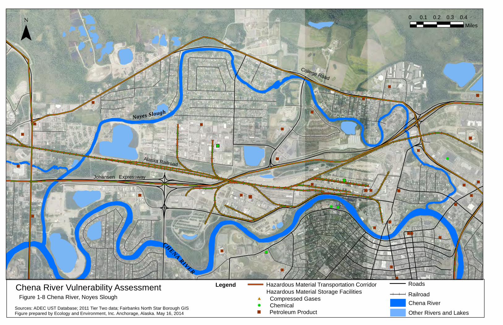
Figure 1-8 Chena River, Noyes Slough
0 0.1 0.2 0.3 0.4Miles
CHENA RIVER
¯
Sources: ADEC UST Database; 2011 Tier Two data; Fairbanks North Star Borough GISFigure prepared by Ecology and Environment, Inc. Anchorage, Alaska. May 16, 2014
Hazardous Material Storage FacilitiesLegend
Other Rivers and Lakes
Chena RiverRailroad
Roads
!. Chemical"/ Petroleum Product
#0 Compressed Gases
Noyes Slough
Alaska Railroad
Hazardous Material Transportation Corridor
##
##
##
##
##
#
#
#
#
#
#
#
#
#
#
#
#
#
#
#
#
#
#
#
#
#
#
#
#
#
#
##
#
#
#
#
#
#
#
##
#
#
#
#
#
#
#
#
#
#
#
#
#
#
#
#
#
#
#
##
#
#
#
#
#
#
#
#
#
#
#
#
#
#
#
#
#
#
#
#
#
#
#
#
#
#
#
#
#
#
#
#
#
#
#
#
#
#
#
#
#
#
#
#
#
#
#
#
#
#
#
#
#
#
#
#
#
#
#
#
#
#
#
#
##
##
#
#
#
#
#
#
#
#
#
#
#
#
#
#
#
#
#
#
#
#
#
#
#
#
#
#
#
#
#
#
#
#
#
#
#
#
#
#
#
#
#
#
#
#
#
#
#
#
#
#
#
#
#
#
#
#
#
#
#
#
#
#
#
#
#
#
#
#
#
#
#
#
#
#
#
#
#
#
#
#
#
#
#
#
#
#
#
#
#
#
#
#
#
#
#
#
#
#
#
#
#
#
#
#
#
#
#
#
##
##
##
##
##
##
##
##
##
##
#
#
#
#
#
#
##
#
Chena River Vulnerability AssessmentFigure 1-9 Chena River: Trans-Alaska Pipleline to Fort Wainwright
0 0.25 0.5 0.75 1Miles
¯
Sources: ADEC UST Database; 2011 Tier Two data; Fairbanks North Star Borough GISFigure prepared by Ecology and Environment, Inc. Anchorage, Alaska. May 16, 2014
Hazardous Material Storage FacilitiesLegend
Other Rivers and Lakes
Chena River!. Chemical"/ Petroleum Product
#0 Compressed Gases
Badger Road
Trans-Alaska PipelineU.S. Army Fort Wainwright
CHENA RIVER
Chena Slough
Nor
dale
Roa
d
"/#0
RoadsTrans-Alaska Pipeline# # # # #
Note: Hazmat storage data not publicly available for Fort Wainwright therefore the area is not shown.
Hazardous Material Transportation Corridor
Parks Highway
Uni
vers
ity A
venu
e
Johansen Expressway
Chen
a Pu
mp
Road
Van Horn Raod
Richardson Highway
Davis Road
Lath
rop
Stre
et
Peg
er R
oad
Sou
th C
ushm
an S
treet
Steese Highway
Airport Way
Cow
les
Stre
et
Chena Ridge Road
Ilino
is S
treet
Peg
er R
oad
Chena River Geographic Response StrategiesFigure 2-1 Chena River Access Sites, Fairbanks, Alaska
0 0.25 0.5 0.75 1Miles
CHEN
A RIV
ER
¯
Source: Fairbanks North Star Borough GIS; Pictometry imagery dated 2012.Figure Prepared by Ecology and Environment, Inc. Anchorage, AK May 16, 2014
Legend
Railroad
Major RoadsChena River
Other Rivers and Lakes
1 Tanana Wayside & Boat Launch (Chena Pump Road Landing)2 Pike's Waterfront Lodge3 Chena Small Tracts Road/Pikes Landing Road4 Department of Natural Resouces, Division of Forestry5 Chena River State Recreation Site (Chena Park Landing)6 Boatel Landing7 Pioneer Park Recreational Landing8 South of Phillips Field Road (Kiwanis Park)9 Graehl Recreation Park 10 Fort Wainwright Landing
River Access Sites
")
")
")
")
")
")
")")
")
1
3
4
5
6
7
89
10
TANANA RIVER
Fairb
anks
Inter
natio
nal A
irpor
t
") River Access Sites
")2
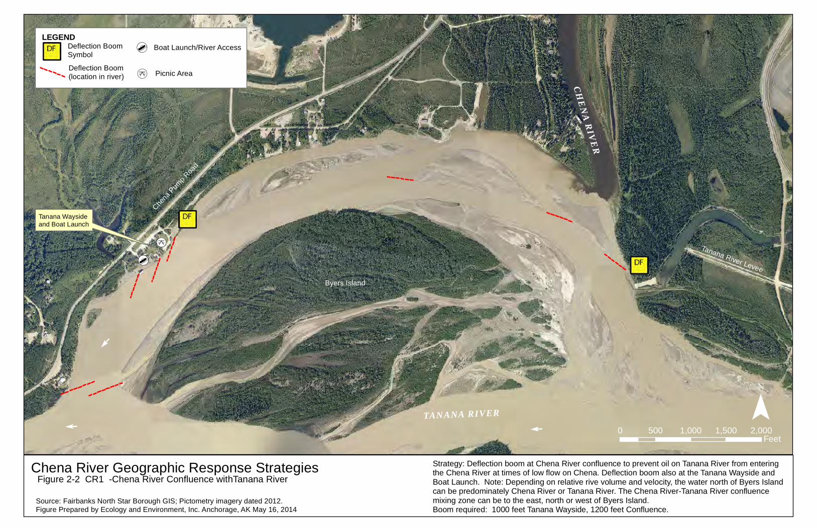
Chena River Geographic Response StrategiesFigure 2-2 CR1 -Chena River Confluence withTanana River
0 500 1,000 1,500 2,000Feet
CHENA RIVER
¯
Source: Fairbanks North Star Borough GIS; Pictometry imagery dated 2012.Figure Prepared by Ecology and Environment, Inc. Anchorage, AK May 16, 2014
Chena
Pum
p Roa
d
E
Strategy: Deflection boom at Chena River confluence to prevent oil on Tanana River from entering the Chena River at times of low flow on Chena. Deflection boom also at the Tanana Wayside and Boat Launch. Note: Depending on relative rive volume and velocity, the water north of Byers Island can be predominately Chena River or Tanana River. The Chena River-Tanana River confluencemixing zone can be to the east, north or west of Byers Island.Boom required: 1000 feet Tanana Wayside, 1200 feet Confluence.
[d
Tanana Wayside and Boat Launch
[k
TANANA RIVER
Byers Island
E
E
Tanana River Levee
LEGEND
[k
[dDeflection Boom Symbol
Deflection Boom(location in river)
Boat Launch/River Access
Picnic Area
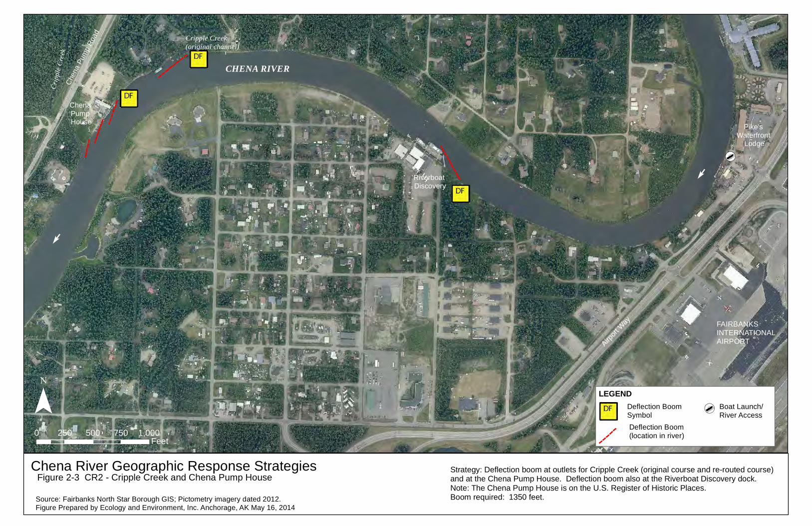
Chen
a Pu
mp
Road
Chena River Geographic Response StrategiesFigure 2-3 CR2 - Cripple Creek and Chena Pump House
0 250 500 750 1,000Feet
CHENA RIVER
¯
Source: Fairbanks North Star Borough GIS; Pictometry imagery dated 2012.Figure Prepared by Ecology and Environment, Inc. Anchorage, AK May 16, 2014
Airport
Way
E
E
Strategy: Deflection boom at outlets for Cripple Creek (original course and re-routed course) and at the Chena Pump House. Deflection boom also at the Riverboat Discovery dock.Note: The Chena Pump House is on the U.S. Register of Historic Places.Boom required: 1350 feet.
[d
Pike's Waterfront
Lodge
Chena Pump House
Riverboat Discovery
Cripple Creek (original channel)
Cripp
le Cr
eek
LEGEND[dDeflection Boom
SymbolDeflection Boom (location in river)
Boat Launch/River Access
FAIRBANKS INTERNATIONALAIRPORT
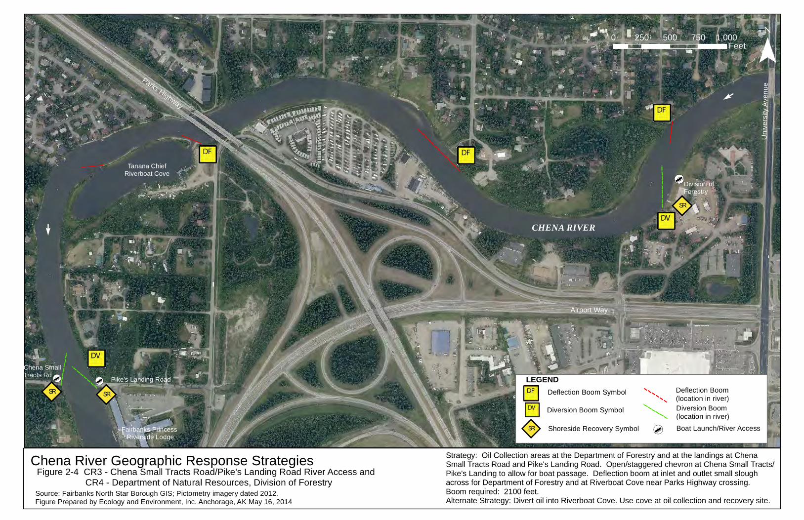
Uni
vers
ity A
venu
e
Chena River Geographic Response StrategiesFigure 2-4 CR3 - Chena Small Tracts Road/Pike's Landing Road River Access and CR4 - Department of Natural Resources, Division of Forestry
0 250 500 750 1,000Feet
CHENA RIVER
¯
Source: Fairbanks North Star Borough GIS; Pictometry imagery dated 2012.Figure Prepared by Ecology and Environment, Inc. Anchorage, AK May 16, 2014
Airport Way
Parks Highway
Tanana ChiefRiverboat Cove
SRSR
SR
E
E
Strategy: Oil Collection areas at the Department of Forestry and at the landings at Chena Small Tracts Road and Pike's Landing Road. Open/staggered chevron at Chena Small Tracts/Pike's Landing to allow for boat passage. Deflection boom at inlet and outlet small slough across for Department of Forestry and at Riverboat Cove near Parks Highway crossing. Boom required: 2100 feet.Alternate Strategy: Divert oil into Riverboat Cove. Use cove at oil collection and recovery site.
Pike's Landing Road[d
Chena Small Tracts Rd
[d
[dDivision of Forestry
Fairbanks Princess Riverside Lodge
LEGEND
SR [d
Deflection Boom Symbol
Diversion Boom Symbol
Shoreside Recovery Symbol
Diversion Boom(location in river)
Deflection Boom(location in river)
Boat Launch/River Access
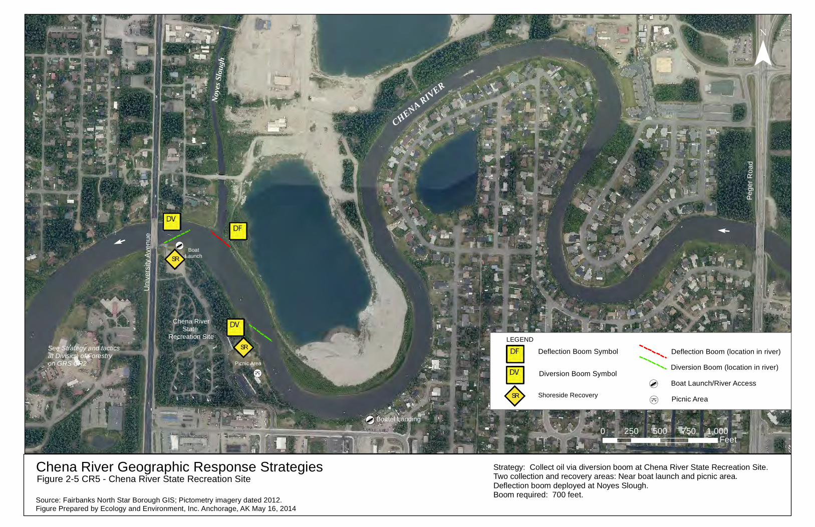
Uni
vers
ity A
venu
e
Peg
er R
oad
Chena River Geographic Response StrategiesFigure 2-5 CR5 - Chena River State Recreation Site
0 250 500 750 1,000Feet
CHENA RIVER
¯
Source: Fairbanks North Star Borough GIS; Pictometry imagery dated 2012.Figure Prepared by Ecology and Environment, Inc. Anchorage, AK May 16, 2014
[d
Noyes
Slou
gh
E
E
Chena RiverState
Recreation SiteSR
SR
See Strategy and tacticsat Division of Forestry on GRS CR2
Strategy: Collect oil via diversion boom at Chena River State Recreation Site.Two collection and recovery areas: Near boat launch and picnic area. Deflection boom deployed at Noyes Slough. Boom required: 700 feet.
[d
[k
BoatLaunch
Picnic Area
Boatel Landing
SR[d
[k
Deflection Boom Symbol
Diversion Boom Symbol
Shoreside Recovery
Deflection Boom (location in river)
Diversion Boom (location in river)
Boat Launch/River Access
Picnic Area
LEGEND
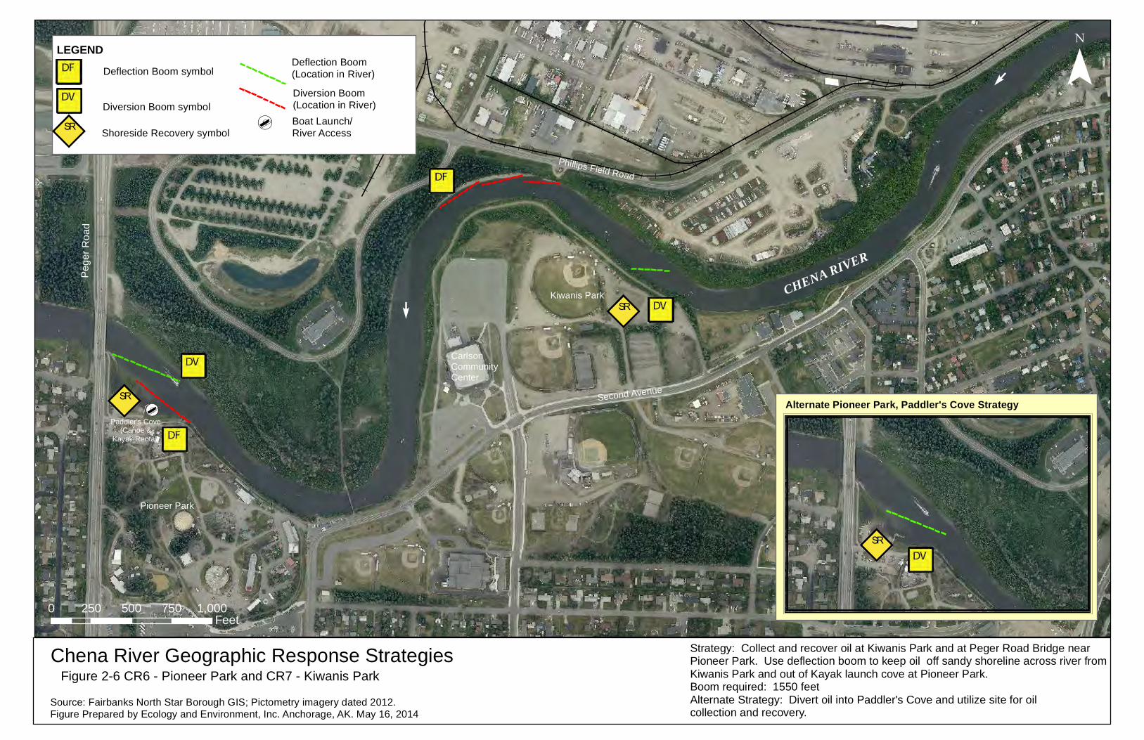
Peg
er R
oad
Chena River Geographic Response StrategiesFigure 2-6 CR6 - Pioneer Park and CR7 - Kiwanis Park
0 250 500 750 1,000Feet
CHENA RIVER
¯
Source: Fairbanks North Star Borough GIS; Pictometry imagery dated 2012.Figure Prepared by Ecology and Environment, Inc. Anchorage, AK. May 16, 2014
Alternate Pioneer Park, Paddler's Cove Strategy
E
Pioneer Park
Kiwanis Park
Carlson Community Center
Phillips Field Road
E
Strategy: Collect and recover oil at Kiwanis Park and at Peger Road Bridge near Pioneer Park. Use deflection boom to keep oil off sandy shoreline across river from Kiwanis Park and out of Kayak launch cove at Pioneer Park. Boom required: 1550 feetAlternate Strategy: Divert oil into Paddler's Cove and utilize site for oil collection and recovery.
Second AvenueSR
SR
SR
[dPaddler's Cove
(Canoe &Kayak Rental)
SR [d
Deflection Boom symbolDeflection Boom (Location in River)
Diversion Boom (Location in River)Diversion Boom symbol
Shoreside Recovery symbol
LEGEND
Boat Launch/River Access
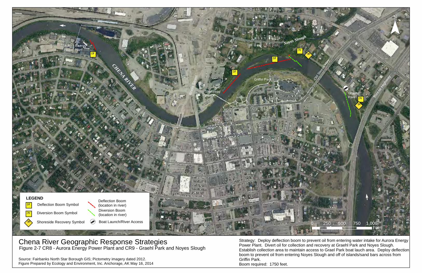
Ilino
is S
treet
Chena River Geographic Response StrategiesFigure 2-7 CR8 - Aurora Energy Power Plant and CR9 - Graehl Park and Noyes Slough
0 250 500 750 1,000Feet
CHENA RIVER
¯
Source: Fairbanks North Star Borough GIS; Pictometry imagery dated 2012.Figure Prepared by Ecology and Environment, Inc. Anchorage, AK May 16, 2014
[d
Noyes Slough
Old St
eese
Hwy
Stee
se H
ighwayGriffin Park
Graehl Park
ShorewayPark
Strategy: Deploy deflection boom to prevent oil from entering water intake for Aurora Energy Power Plant. Divert oil for collection and recovery at Graehl Park and Noyes Slough. Establish collection area to maintain access to Grael Park boat lauch area. Deploy deflection boom to prevent oil from entering Noyes Slough and off of islands/sand bars across from Griffin Park. Boom required: 1750 feet.
SR
SR
E
E
Aurora Energy Power Plant
LEGEND
SR [d
Deflection Boom Symbol
Diversion Boom Symbol
Shoreside Recovery Symbol
Deflection Boom(location in river)Diversion Boom(location in river)
Boat Launch/River Access

Chena River Geographic Response StrategiesFigure 2-8 CR10 - Fort Wainwright Boat Launch and Bentley Island Slough Area
0 250 500 750 1,000Feet
CHENA RIVER
¯Source: Fairbanks North Star Borough GIS; Pictometry imagery dated 2012.Figure Prepared by Ecology and Environment, Inc. Anchorage, AK May 16, 2014
[d
Snedden Memorial
Park (Bentley Park)
Hamilton Acres Park & Fairbanks Community Gardens
Fort WainwrightBoat Landing
Glass Park
U.S. Army Fort Wainwright Boundary
U.S. Army Fort Wainwright Gate
Gaffney Road
SR
E
E
Strategy: Deflect oil from coves and connected water bodies. Deflect oil from islands and boat launch dock. Divert oil to collection and recovery area on east side of island upstream of boat launch.Boom required: 1350 feet
Bentley Island Slough
SR[d
Deflection Boom Symbol
Diversion Boom Symbol
Shoreside Recovery Symbol
Deflection Boom(location in river)
Diversion Boom(location in river)Boat Launch/River Access
LEGEND
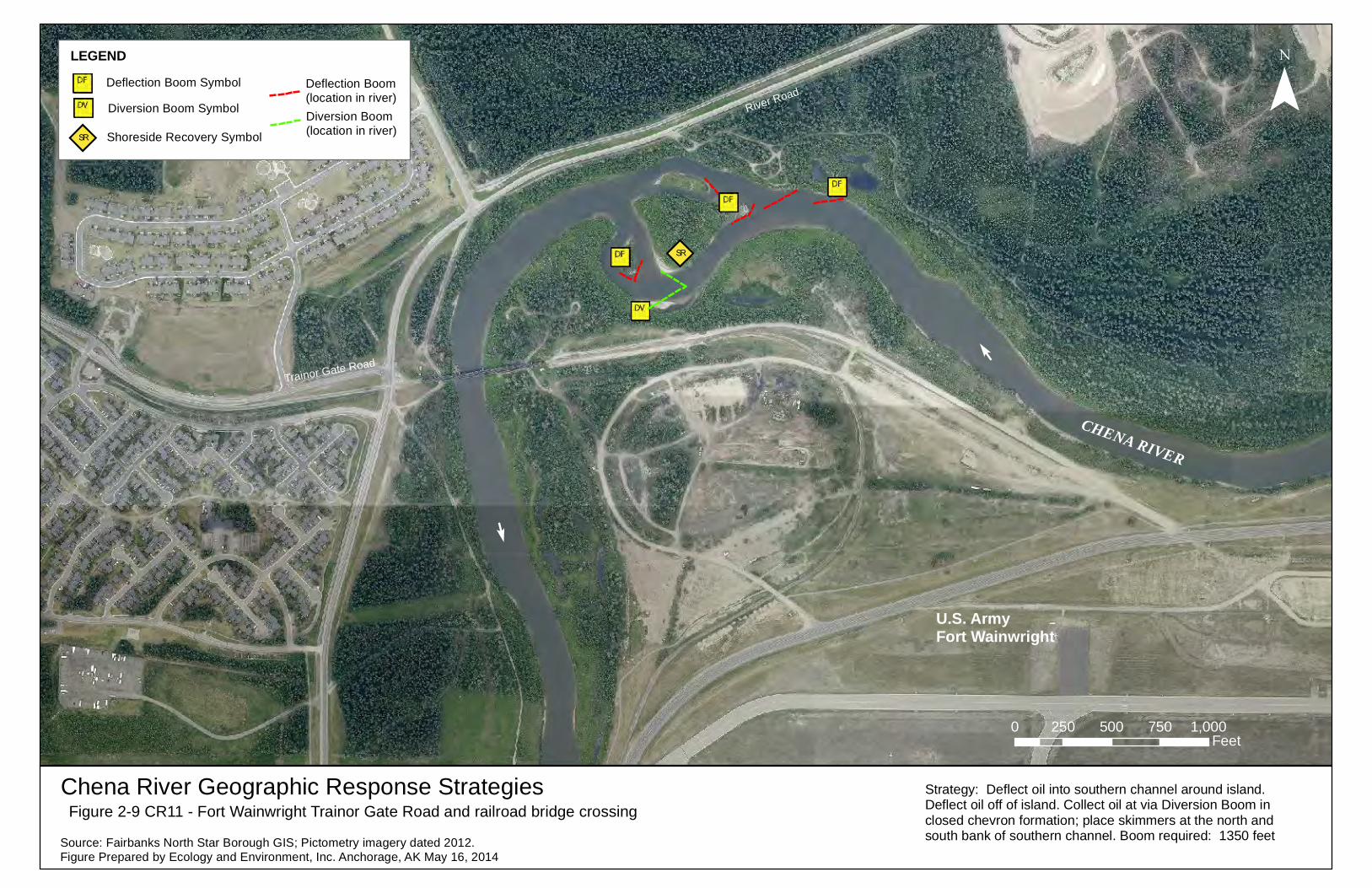
Chena River Geographic Response StrategiesFigure 2-9 CR11 - Fort Wainwright Trainor Gate Road and railroad bridge crossing
0 250 500 750 1,000Feet
CHENA RIVER
¯
Source: Fairbanks North Star Borough GIS; Pictometry imagery dated 2012.Figure Prepared by Ecology and Environment, Inc. Anchorage, AK May 16, 2014
Trainor Gate Road
U.S. Army Fort Wainwright
SR
River Road
EE
Strategy: Deflect oil into southern channel around island. Deflect oil off of island. Collect oil at via Diversion Boom in closed chevron formation; place skimmers at the north andsouth bank of southern channel. Boom required: 1350 feet
LEGEND
SR
Deflection Boom Symbol
Diversion Boom Symbol
Shoreside Recovery Symbol
Deflection Boom(location in river)Diversion Boom(location in river)

![Assessment of Aquifer Vulnerability Based on GIS and ... · Recently, Geographic Information System (GIS) tech-niques have been widely used in aquifer vulnerability mapping [27-31]](https://img.pdfslide.net/doc/110x75/5b16a5eb7f8b9a546d8d1dd8/assessment-of-aquifer-vulnerability-based-on-gis-and-recently-geographic.jpg)