Embed Size (px)
DESCRIPTION
Estudio realizado por el Chicago Department of Transportation. La visión del plan: "La gente de Chicago cultiva, motiva, y disfruta el respeto mutuo en nuestras calles. "La gente escoge ser peatón porque la experiencia es la más segura, más conectada, accesible, y sobre todo, la más disfrutable. "Porque estamos comprometidos a un fuerte ambiente peatonal como una parte esencial de nuestro sistema de transportación completo, somos una ciudad más saludable, una ciudad más vivible".
Citation preview

Chicago Pedestrian PlanDepartment of Transportation
DRAFT


What We Heard 6
Tools for Safer Streets 12
Safety 32
Connectivity 60
Livability 82
Health 92
Making It Happen 104
3
Ta b l e o f C o n T e n T s

4

5
The people of Chicago cultivate, encourage, and enjoy mutual respect on our streets.
People choose to be pedestrians because the experience is the safest, most connected, accessible, and above all, the most enjoyable.
Because we are committed to a strong pedestrian environment as an essential part of our complete transportation system, we are a healthier, more livable city.
v i s i o n s t a te m e n t

w h a t we h e a r dAt some point in the day, everyone is a pedestrian; therefore, every Chicagoan has a voice in this plan. To ensure that the public participation process reflected the incredibly diverse range of pedestrian experiences in Chicago, residents utilized multiple ways to participate and share their ideas. These included seven neighborhood public meetings, opportunities for comment on the project website, an interactive online meeting, mail-in comment cards, and a final downtown walking workshop. This portion of the plan briefly summarizes the thoughts and ideas received throughout the process.
6

7*All words sourced from comments received as part of the Chicago Pedestrian Plan outreach process
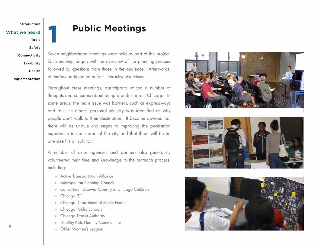
Seven neighborhood meetings were held as part of the project.
Each meeting began with an overview of the planning process
followed by questions from those in the audience. Afterwards,
attendees participated in four interactive exercises:
Throughout these meetings, participants voiced a number of
thoughts and concerns about being a pedestrian in Chicago. In
some areas, the main issue was barriers, such as expressways
and rail; in others, personal security was identified as why
people don’t walk to their destination. It became obvious that
there will be unique challenges to improving the pedestrian
experience in each area of the city and that there will be no
one size fits all solution.
A number of sister agencies and partners also generously
volunteered their time and knowledge to the outreach process,
including:
» Active Transportation Alliance
» Metropolitan Planning Council
» Consortium to Lower Obesity in Chicago Children
» Chicago 311
» Chicago Department of Public Health
» Chicago Public Schools
» Chicago Transit Authority
» Healthy Kids Healthy Communities
» Older Women’s League
Public Meetings1
8
Implementation
Safety
Connectivity
Tools
Livability
Health
Introduction
What we heard

Downtown Event2 The final public meeting was held at Harold Washington Library on
August 24, 2011. All of the attendees went out in groups, analyzed
an intersection, and provided thoughts and ideas to improve its safety,
connectivity, and livability. After about an hour in the field, each
group returned to the library to present the entire audience with their
findings. Over 130 people participated in the event.
9

We asked Chicagoans to give us their BIG idea for improving the
pedestrian experience. We received over 500 BIG Ideas from
the project website (www.chicagopedestrianplan.org), in person,
and in the mail. Some of the ideas that we heard from a number
of people included:
» Improve safety for children around schools and parks
» Improve access to transit
» Make it safer for seniors to cross the street
» Provide safer crossings at intersections
» Increase pedestrian space
» Enforce existing laws
Your BIG Idea3
10
Implementation
Safety
Connectivity
Tools
Livability
Health
Introduction
What we heard

11

12
to o l s f o r s a fe r s t re e t sTools for Safer Streets describes the variety of pedestrian safety tools that will make Chicago’s streets safe for its youngest and oldest pedestrians. Accomplishing this will require creativity and innovation to develop unique solutions throughout Chicago.
Each pedestrian safety tool has been grouped in terms of where it might be best utilized. The first group includes tools appropriate for intersections and corridors and the second group includes tools for neighborhood streets.
Each description includes a brief introduction (WHAT), suggestions for the types of situations where the tool should be implemented (WHERE), and details on the methodology for implementation (HOW). Information on the safety benefits of each tool is provided under
ADDITIONAL RESOURCES.
INTERSECTIONS AND CORRIDORS
1. Marked crosswalks
2. In-road State Law Stop for Pedestrians signs
3. Pedestrian refuge islands
4. Signals and beacons
5. Accessible pedestrian signals
6. Pedestrian countdown timers
7. Leading pedestrian intervals
8. Lagging left turns
9. Road diets
10. Speed feedback signs
11. Roundabouts
NEIGHBORHOOD STREETS
12. Chicanes
13. Vertical traffic calming
14. Skinny streets
15. Bump-outs
16. Neighborhood traffic circles


14
Implementation
Safety
Connectivity
Tools
Livability
Health
Introduction
What we heard
STANDARD CONTINENTAL CROSSWALK
What: Marked crosswalks indicate where pedestrians may cross
the street and where drivers should expect them to cross.
Where: Marked crosswalks should be installed at all legs of
signalized and stop-controlled intersections. At uncontrolled or
midblock locations, consideration should be given to installing
crosswalks with additional pedestrian safety tools, such as
signage, refuge islands and bumpouts.
How: To ensure high visibility among all roadway users, the
default style for marked crosswalks will be the continental style,
as shown in the example to the right. Other crosswalks, such
as brick or other decorative treatments, can be installed at
appropriate locations.
This is a LOW cost pedestrian safety tool.
Marked Crosswalks1
ADDITIONAL RESOURCES
Federal Highway Administration. Crosswalk Marking Field Visibility Study. Washington, D.C., 2010.

15
A p p r o x i m A t e l y 7 8 % o f c r A s h e s i n c h i c A g o i n v o l v i n g p e d e s t r i A n s b e t w e e n 2 0 0 5 A n d 2 0 0 9 t o o k p l A c e i n o r n e A r A c r o s s w A l k .

16
Implementation
Safety
Connectivity
Tools
Livability
Health
Introduction
What we heard
What: State and City law requires that vehicles must stop for
pedestrians who are in a crosswalk. In-road “State Law Stop for
Pedestrians” signs are a supplemental feature to remind drivers of
this law.
Where: In-road “State Law Stop for Pedestrians” signs can
be considered at crosswalks at uncontrolled intersections and
midblock locations where it is difficult for pedestrians to cross.
How: In-road “State Law Stop for Pedestrians” should be
installed at the crosswalk location in the centerline, median,
refuge island, or lane line.
This is a LOW cost pedestrian safety tool.
In-road State Law Stop for Pedestrians signs2
ADDITIONAL RESOURCES
Van Houten, R., S. Huybers, R. Malenfant, and J. E. Louis. “Reducing Conflicts Between Motor Vehicles and
Pedestrians: The Separate and Combined Effects of Pavement Markings and a Sign Prompt.” Journal of Applied
Behavior Analysis, 2004: 37, 445-456.

17
What: A pedestrian refuge island is a protected area that allows
pedestrians to cross one direction of traffic at a time. This makes
finding gaps in traffic easier on two-way streets. Refuge islands differ
from medians in that they are not continuous, but are only provided
at the crossing location.
Where: Pedestrian refuge islands should be considered when
pedestrians are required to cross multiple lanes in each direction or
where insufficient gaps in traffic make pedestrian crossings difficult.
They can be installed at midblock crossings or at intersections if there
is adequate room.
How: Pedestrian refuge islands should be at least 6 feet wide and
40 feet long to provide proper protection for pedestrians. Crosswalks
and accessible ramps or cut-through areas must be provided at the
refuge islands. Truncated dome detectable warning surface areas
must also be installed to allow pedestrians who are blind to detect
the refuge island. Pedestrian refuge islands can be designed with
an angled path through the island so pedestrians are able to see
oncoming traffic prior to crossing.
This is a MEDIUM cost pedestrian safety tool.
ADDITIONAL RESOURCES
Federal Highway Administration. Desktop Reference for Crash Reduction Factors. 2007.
p e d e s t r i A n c r A s h e s h A v e d e c r e A s e d
Pedestrian refuge islands3 p e d e s t r i A n c r A s h e s
h A v e d e c r e A s e d b y 5 6 % i n m u l t i l A n e r o A d w A y s w i t h r e f u g e i s l A n d s 1 .

18
Implementation
Safety
Connectivity
Tools
Livability
Health
Introduction
What we heard
RRFBs can be installed for a pedestrian crossing if there are high pedestrian volumes, a history of pedestrian crashes, not enough gaps in traffic to cross the street, or the roadway width makes it difficult for pedestrians to safely cross.
PHBs can be installed for a pedestrian crossing if there are high pedestrian volumes, a history of pedestrian crashes, or not enough gaps in traffic for pedestrians to safely cross the street.
A traffic signal is a protected crossing that has pedestrian signal heads to inform pedestrians when to cross the street. Traffic signals are warranted by either high traffic volumes or high pedestrian volumes.
Traffic signals can be installed for a pedestrian crossing if there are high pedestrian volumes, such as at a transit station or a school, or a history of pedestrian crashes. Push buttons should only be included where pedestrians do not get a WALK phase during each traffic signal cycle, usually at locations with very low pedestrian volumes.
Traffic signals should be considered where an engineering study (based on criteria from the Manual of Uniform Traffic Control Devices (MUTCD))has determined that pedestrians require a protected crossing at an intersection. All push buttons should be installed with an LED indicator light that demonstrates to the pedestrian that the button was pushed.
This is a HIGH cost pedestrian safety tool.
A pedestrian hybrid beacon (PHB) is a device that stops traffic to allow pedestrians to cross. The beacon flashes yellow, then is steady yellow, then a steady red, then flashes red to make drivers aware to stop. PHBs are a potential solution where traffic signals are not warranted.
PHBs should be considered where an engineering study has determined that pedestrians require a protected crossing at an uncontrolled location and a traffic signal is not warranted, based on criteria in the MUTCD.
This is a HIGH cost pedestrian safety tool.
A rectangular rapid flash beacon (RRFB) can be used as a warning device at uncontrolled or midblock crossings. Pedestrians push a button to activate rapid flashing yellow LED lights to alert drivers to stop. RRFBs are a potential solution if a traffic signal or a PHB is not warranted.
RRFBs can be installed at uncontrolled pedestrian crossings. They are usually solar powered signs and have push buttons. The flashing beacons should be activated for the duration of the pedestrian crossing time.
This is a MEDIUM cost pedestrian safety tool.
WHERE
WHAT
HOW
RECTANGULAR RAPID FLASH BEACONS
TRAFFIC SIGNALS PEDESTRIAN HYBRID BEACONS
Signals and beacons4

19
ADDITIONAL RESOURCES
Pedestrian and Bicycle Information Center. 2012. www.walkinginfo.org (accessed 2012).
Arizona Department of Transportation. Pedestrian Signals - Are They Guarantees of Safety? www.azdot.gov (accessed 2011).
Fitzpatrick, Kay, and Eun Sug Park. Safety Effectiveness of the HAWK Pedestrian crossing Treatment. McLean, Virginia: Federal Highway
Administration, 2010.
Van Houten, Ron, and Michael J. Frederick. “Increasing Motorist Yielding Compliance at Pedestrian Crosswalks from under 2% to as
high as 94% using Rectangular Rapid Flashing Beacons - Earning it “Interim Approval” from Federal Highway Administration.” Journal of
the Institute of Transportation Engineers, July 2008.
Federal Highway Administration. Manual on Uniform Traffic Control Devices (MUTCD). 2009, 4E.01.
Rectangular Rapid Flash Beacons at the Art Institute

20
Implementation
Safety
Connectivity
Tools
Livability
Health
Introduction
What we heard
ADDITIONAL RESOURCES
Harkey, David L., Daniel L. Carter, Janet M. Barlow, and Billie Louise Bentzen. Accessible Pedestrian Signals: A
Guide to Best Practices. National Cooperative Highway Research Program. 2007.
What: An accessible pedestrian signal (APS) is a traffic
signal that provides auditory and/or vibrotactile information to
pedestrians who are blind or have low vision.
Where: An APS should be installed where there is a need
to provide additional crossing information. An APS should be
considered at signalized crossings when requested by one or
more individuals or where the geometry or signal phasing makes
pedestrian crossing locations difficult to identify for pedestrians
who are blind or have low vision.
How: An APS requires push buttons and speakers to provide
auditory feedback. The Manual on Uniform Traffic Control Devices
(MUTCD) provides guidance on the appropriate location of the
devices. These are installed with the traffic signal infrastructure.
This is a MEDIUM cost pedestrian safety tool.
Accessible pedestrian signals5

21
i n 2 0 0 9 A n d 2 0 1 0 , p e d e s t r i A n c o u n t d o w n t i m e r s w e r e i n s t A l l e d A t 3 2 5 i n t e r s e c t i o n s
i n c h i c A g o .
What: Pedestrian countdown timers provide information on the
amount of time remaining to cross the street at signalized intersections.
Where: All new and modernized traffic signals include countdown
timers. Retrofitting existing traffic signals with pedestrian countdown
timers will be prioritized based on safety considerations, including
the presence of children, seniors, and people with disabilities.
How: The pedestrian countdown timer begins in conjunction with
the flashing “DON’T WALK” interval. All countdown timers should
be programmed to allow pedestrians to cross the street at a maximum
walking speed of 3.5 feet per second. Walking speeds slower than
3.5 feet per second should be considered at all locations, particularly
at crossings near children, seniors, and people with disabilities.
This is a LOW cost pedestrian safety tool.
Pedestrian countdown timers6
ADDITIONAL RESOURCES
Transportation Research Board. “Evaluation of Pedestrian Countdown Signals in Montgomery County, Maryland.” Journal
of the Transportation Research Board. Volume 1878/2004.

22
Implementation
Safety
Connectivity
Tools
Livability
Health
Introduction
What we heard
What: A leading pedestrian interval (LPI) gives pedestrians a
head start into an intersection before vehicles. The WALK signal
is turned on approximately three seconds before vehicles are
given a green signal.
Where: Leading pedestrian intervals are most beneficial and
should be prioritized at the following locations:
» Intersections with more than three pedestrian crashes in
three years that involve turning vehicles.
» Intersections within 200 feet of a school or park.
» Intersections with high numbers of conflicts between
pedestrians and vehicles turning right.
» T-intersections.
How: Leading pedestrian intervals are installed by re-timing a
traffic signal. Prohibiting right-turns on red should be strongly
considered wherever leading pedestrian intervals are installed.
Accessible pedestrian signals should be considered at locations
with LPIs to provide information to pedestrians who are blind or
have low vision.
This is a LOW to MEDIUM cost pedestrian safety tool.
1. BOTH VEHICLES AND PEDESTRIANS ARE STOPPED.
HOW A LEADING PEDESTRIAN INTERVAL WORKS
3. BOTH PEDESTRIANS AND VEHICLES CAN ENTER THE INTERSECTION AND TURNING VEHICLES MUST YIELD TO PEDESTRIANS.
2. PEDESTRIANS CAN BEGIN TO CROSS THE INTERSECTION, BUT VEHICLES ARE STILL STOPPED.
ADDITIONAL RESOURCES
Van Houten, R., R.A. Retting, C.M. Farmer, J. Van Houten, and J.E.L. Malenfant. Field Evaluation of a Leading
Pedestrian Interval Signal Phase at Three Urban Intersections. Transportation Research Record No. 1734, 2000.
Leading pedestrian intervals7

23
LAGGING LEFT TURNS CASE STUDY
At Huron Street and Fairbanks Court in Streeterville, vehicles were unable to turn left because pedestrians were crossing during the entire green phase. After a lagging left-turn phase was installed, pedestrians crossed safely with their signal and the issues with vehicles queueing disappeared.
What: A lagging left turn is a signal timing in which the left-turn
arrow is given after vehicles travelling straight have passed through
the intersection. By allowing pedestrians to cross the intersection
at the beginning of a signal cycle, conflicts between pedestrians
and vehicles turning left are reduced and vehicular operations can
improve.
Where: Lagging left turns should be considered at intersections
where any of the following exists:
» Protected left turn phase with high pedestrian volumes.
» Three or more crashes in three years between left turn
vehicles and pedestrians.
» Pedestrians cross during the left turn phase.
» Leading pedestrian intervals.
How: A traffic signal will need to be re-timed so that the protected
left-turn phase occurs after the permitted phase for through traffic. An
analysis must be conducted to ensure that changing a left-turn phase
to lagging will not negatively affect the operations of the intersection.
This is a LOW cost pedestrian safety tool. BEFORE AFTER
ADDITIONAL RESOURCES
Harkey, David L., Daniel L. Carter, Janet M. Barlow, and Billie Louise Bentzen. Accessible Pedestrian Signals: A Guide to
Best Practices. National Cooperative Highway Research Program. 2007.
Lagging left turns8

24
Implementation
Safety
Connectivity
Tools
Livability
Health
Introduction
What we heard
LAWRENCE AVENUE ROAD DIET: AFTER
LAWRENCE AVENUE ROAD DIET: BEFORE
ADDITIONAL RESOURCES
Burden, Dan, and Peter Lagerwey. “Road Diets: Fixing the Big Roads.” Walkable Communities, Inc. March 1999:
1-15.
What: A road diet reduces the amount of space for motor
vehicles, either through eliminating lanes or shrinking the width of
lanes. The reclaimed space from a road diet is then re-allocated
for other uses, such as turn lanes, bus lanes, pedestrian refuge
islands, bike lanes, or more sidewalk space. Road diets typically
involve converting a four- or five-lane roadway into a three-lane
street. There are a number of different situations where a road diet
is appropriate. Road diets also provide consistent and reliable
travel times and speeds on a corridor.
Where: A road diet can be considered on all streets with four or
more lanes and less than 23,000 vehicles traveling on it daily. In
some circumstances, a road diet may be possible on streets with
average daily traffic as high as 30,000 vehicles per day. The
width of travel lanes should be routinely considered as part of all
future roadway projects.
How: Vehicular capacity analyses and simulation will be
necessary to understand the effect of road diets on not only the
focus street, but also the adjacent roadways. The additional
space gained from a road diet can be used for a variety of other
uses, such as sidewalks, refuge islands, bus shelters, bike lanes,
or landscaping.
This is a MEDIUM to HIGH cost pedestrian safety tool.
Road diets9

25
ADDITIONAL RESOURCES
Federal Highway Administration. Roundabouts: An Informational Guide. Washington, D.C. 2010.
Pedestrian Access to Modern Roundabouts: Design and Operational Issues for Pedestrians Who Are Blind. _________
http://www.access-board.gov/research/roundabouts/bulletin.htm (accessed 2011).
What: Roundabouts are circular intersections where vehicles travel
in a counter-clockwise direction and entering vehicles must yield to
circulating vehicles. This treatment forces vehicles to slow down when
going through an intersection. Roundabouts require that pedestrians
take a circuitous path across or around the intersection and can be
particularly difficult crossings for pedestrians who are blind or have
low vision.
Where: Roundabouts should only be considered in Chicago
where the benefit in reducing vehicle speeds through an intersection
outweighs the impacts to pedestrian accessibility and connectivity.
This will typically be in the city’s parks or at intersections with high
vehicle speeds with very low pedestrian volumes.
How: Roundabouts should be designed for low vehicle speeds and
to ensure that is safe for all pedestrians to cross through them. This
may include installing signage, raised crosswalks, pedestrian hybrid
beacons or rapid flash beacons.
This is a HIGH cost pedestrian safety tool.
What: Speed feedback signs display passing vehicle speeds. These
signs have been shown to increase driver compliance with the speed
limit.
Where: Speed feedback signs should be installed at locations where
speeding occurs frequently and in locations with high populations
of vulnerable users, such as around schools, parks, or community
centers.
How: Speed feedback signs can be installed on a temporary or
permanent basis, with or without other pedestrian safety tools.
This is a MEDIUM cost pedestrian safety tool.
ADDITIONAL RESOURCES Cambridge, S., W. Osmers, and T. Francis. Evaluation of the Speed Trailer as a Community Road Resource in Christchurch.
Sydney New South Wales Australia: Road Safety Research Policing and Education Conference, 2003.
Speed feedback signs10 Roundabouts11

26
Implementation
Safety
Connectivity
Tools
Livability
Health
Introduction
What we heard
t h e c i t y o f s e A t t l e f o u n d A n 1 8 -3 5 % r e d u c t i o n i n t r A v e l s p e e d s A n d A 3 2 - 4 5 % d e c r e A s e i n A v e r A g e d A i l y t r A f f i c ( A d t ) v o l u m e s A t l o c A t i o n s w i t h c h i c A n e s 2 .
ADDITIONAL RESOURCES
City of San Diego. “Pedestrian Design Guide.” Design Guide, San Diego.
Streetfilms.org. Chicanes.
Department for Transport. Traffic Advisory Leaflet 12/97. Chicane Schemes. Leaflet, Surrey, UK. Department for
Transport. 1997.
What: Chicanes are created by installing a series of staggered
midblock bump-outs on alternating sides of the street. On two-
way streets, chicanes can either deflect both lanes or narrow the
roadway to one lane used by both directions. Chicanes may
be more desirable to residents than vertical traffic calming tools,
such as speed humps, because there is less noise from vehicles
scraping the street and from speeding up and slowing down.
Where: Chicanes should be considered on residential streets to
reduce speeds and to reduce cut through traffic. They should not
be installed on streets with more than one lane of travel in one
direction (e.g. two-lane, one-way streets).
How: Chicanes are simplest to install on one-way streets.
On two-way streets, there should be sufficient width for both
directions to pass, or one direction should be instructed to yield
to oncoming traffic. Chicanes may require some parking to be
removed. Advance warning signs and reflectors can be used to
increase visibility to motorists. The design should accommodate
emergency vehicles, snow plows, and street sweepers.
This is a HIGH cost pedestrian safety tool.
Chicanes12

27Chicane on Albany Avenue

28
Implementation
Safety
Connectivity
Tools
Livability
Health
Introduction
What we heard
Speed tables or raised intersections can be used to create a raised pedestrian crossing. Signage should be considered at all locations with speed tables and raised intersections.
This is a MEDIUM cost pedestrian safety tool.
Speed humps are only effective at consistently reducing vehicle speeds when used in succession. Signage should be considered at all locations with speed humps.
This is a MEDIUM cost pedestrian safety tool.
Speed bumps are only effective at consistently reducing vehicle speeds when used in succession. Signage should be considered at all locations with speed bumps.
This is a LOW cost pedestrian safety tool.
Speed tables or raised intersections can be used on low volume streets or at crossings with high volumes of pedestrians.
Speed humps can be used to reduce traffic speeds on residential streets.
Speed bumps can be considered at locations outside of residential areas with very low traffic volumes, such as alleys or parking areas.
A speed table and a raised intersection are essentially longer speed humps used to raise the crosswalk or intersection and reduce vehicle speeds.
A speed hump is generally 6 to 12 feet in length and used on residential streets.
A speed bump is less than a foot in length and generally used in spot locations to reduce speeds.
WHERE
WHAT
HOW
SPEED BUMPS SPEED HUMPSSPEED TABLES and
RAISED INTERSECTIONS
Vertical traffic calming devices, such as speed bumps, speed humps, and speed tables, are devices that are placed in the middle of the
road bed and require vehicles to slow down to cross over them.
ADDITIONAL RESOURCES
Portland Bureau of Transportation. Driver Response to Speed Bumps Graphs.
Vertical traffic calming13

29
What: After the severe winters of 1978 and 1979, many of Chicago’s
streets were converted from two-way to one-way to improve mobility
during the winter and to allow plows to go through. However, two-way
streets have many advantages over one-way streets. These “skinny
streets” reduce vehicle speeds and can also increase connectivity for
all users by providing more ways to traverse the city’s grid.
Where: Skinny streets should be considered on all one-way streets
that are wider than 30 feet.
How: Converting a one-way street to a two-way street requires
changes to striping and signage and possibly changes to traffic
signals.
This is a LOW to HIGH cost pedestrian safety tool.
ADDITIONAL RESOURCES
City of Portland. “Neighborhood Street Design Guidelines. An Oregon Guide for Reducing Street Widths.” Design Guide.
Portland. 2000.
Skinny streets14

30
Implementation
Safety
Connectivity
Tools
Livability
Health
Introduction
What we heard
What: Bump-outs (also known as curb extensions or bulb-outs)
extend the sidewalk into a parking or non-moving lane. Bump-
outs can reduce the turning speed for vehicles, reduce the distance
that pedestrians must cross, improve visibility between motorists
and pedestrians, create more space for riders waiting for the bus,
and eliminate illegal parking in the corner clearance zone. They
also reduce turning radii which reduces vehicle turning speeds.
Where: Bump-outs are appropriate on wide streets and areas
with large populations of children and seniors. Bump-outs should
also be considered in areas with large volumes of pedestrians or
in areas with narrow sidewalks. Bump-outs cannot be considered
on corridors with rush-hour parking restrictions.
How: Extending the sidewalk into the roadway for a bump-out
creates a seamless transition, but can be costly due to changes to
the curbs and drainage. “Floating” bump-outs can be constructed
by creating a pedestrian refuge area between the sidewalk and
travel lane. These bump-outs do not affect the existing drainage
and need to be wide enough to provide safe refuge for pedestrians.
Bump-outs can also be created using a combination of striping,
bollards, and planters. These are much less expensive, but do not
provide as much protection for pedestrians.
This is a LOW to HIGH cost pedestrian safety tool.
A 7 ’ b u m p - o u t c A n r e d u c e A p e d e s t r i A n ’ s c r o s s i n g t i m e b y 2 - 3 s e c o n d s .
Bump-outs15
ADDITIONAL RESOURCES
Johnson, Randall S. Pedestrian Safety Impacts of Curb Extensions: A Case Study. Salem. OR. Oregon Department
of Transportation and Federal Highway Administration. 2005.
31
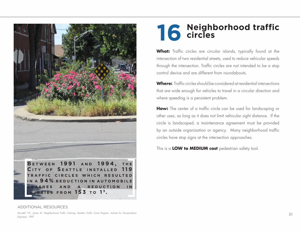
What: Traffic circles are circular islands, typically found at the
intersection of two residential streets, used to reduce vehicular speeds
through the intersection. Traffic circles are not intended to be a stop
control device and are different from roundabouts.
Where: Traffic circles should be considered at residential intersections
that are wide enough for vehicles to travel in a circular direction and
where speeding is a persistent problem.
How: The center of a traffic circle can be used for landscaping or
other uses, as long as it does not limit vehicular sight distance. If the
circle is landscaped, a maintenance agreement must be provided
by an outside organization or agency. Many neighborhood traffic
circles have stop signs at the intersection approaches.
This is a LOW to MEDIUM cost pedestrian safety tool.
b e t w e e n 1 9 9 1 A n d 1 9 9 4 , t h e c i t y o f s e A t t l e i n s t A l l e d 1 1 9 t r A f f i c c i r c l e s w h i c h r e s u l t e d i n A 9 4 % r e d u c t i o n i n A u t o m o b i l e c r A s h e s A n d A r e d u c t i o n i n i n j u r i e s f r o m 1 5 3 t o 1 3 .
Neighborhood traffic circles16
ADDITIONAL RESOURCES
Mundell, P.E., James M. Neighborhood Traffic Calming: Seattle’s Traffic Circle Program. Institute for Transportation
Engineers. 1997.

32
s a f e t yOver the last ten years, Chicago has made tremendous improvements in pedestrian safety; yet even one pedestrian fatality is too many. This chapter identifies the policies and programs to make Chicago the safest city in the country
for pedestrians.
our goals » Eliminate pedestrian fatalities in ten years
» Reduce serious pedestrian injuries by 50% every five years
how we’ll get there » Design and build safer streets for pedestrians
» Encourage and enforce safe driving, walking, and biking behaviors
» Make Chicago’s streets secure from crime and violence

33

34
Implementation
SafetyConnectivity
Tools
Livability
Health
Introduction
What we heard
Reducing pedestrian fatalities to zero over the next ten years is the
primary goal of this plan. The Zero in Ten program will identify
locations that are in the most need of pedestrian improvements
and implement aggressive measures to improve pedestrian safety.
The program will include design improvements, enforcement
initiatives, and education campaigns along two corridors and
four separate intersections in Chicago on an annual basis.
ACTIONS
Shor t Term
» Identify funding sources for the Zero in Ten program.
» Identify locations on an annual basis for the program based on
pedestrian crash data.
» Continue to investigate locations where fatal pedestrian crashes
have occurred.
Mid Term
» Design safety improvements for corridors and intersections.
» Develop and implement aggressive enforcement initiatives along
each corridor and intersection.
» Increase the amount of automated enforcement along each corridor
and at each intersection.
» Work with community groups and neighbors on high visibility
awareness and education campaigns for each location.
» Continually evaluate the results of the program.
Develop a Zero in Ten pedestrian crash reduction program 1
MILESTONES Identify two corridors and four intersections to be improved for the Zero in Ten program by 2013. Annually update the locations for the Zero in Ten program.
Establish and implement the Zero in Ten program by 2014.
Reduce pedestrian fatalities to zero by 2022.
ADDITIONAL RESOURCES
Federal Highway Administration. Pedestrian Safety Countermeasure Deployment Project. Washington, D.C.

35
2Protecting our youngest pedestrians, children, around parks and
schools is imperative. A Safety Zone program will improve safety
around these land uses and encourage more pedestrian activity
among children.
ACTIONS
Shor t Term
» Implement Safety Zones within 1/8-mile of a school or park and ensure
that pedestrian safety efforts, including traffic calming, automated
enforcement with speed cameras, and education efforts, are prioritized
in these areas. Evaluate the effect of the pilot program.
» Coordinate Safety Zones with the Zero in Ten program.
» Collaborate on future school sitings.
» Ensure pedestrian safety improvements are included with the construction
of all new schools and parks.
» Develop a safe park access plan that includes a typology of park access
and associated right of way design strategies.
» Ensure that Safe Routes to School funding is utilized in areas with the
greatest potential to improve safety.
Mid Term
» Investigate the potential of innovative uses of the public way – activity
zones, play streets, etc. to ensure all Chicagoans have safe and
convenient access to recreation space.
» Increase the amount of pedestrian and bicycle safety visits by the
Bicycling and Safe Routes Ambassador programs to schools and parks.
MILESTONES Complete safe park access plan in 2012.
Begin to implement safety zones by 2013.
Evaluate the impact of safety zones on speeds and crashes on an annual basis.
Implement Safety Zones
ADDITIONAL RESOURCES
National Safe Kids Campaign. “Stop Sign Violations Pur Child Pedestrians at Rosk.” 2003.
National Safe Kids Campaign. “Latest Trends in Child Pedestrian Safety - A Five Year Review.” 2007.

36
Implementation
SafetyConnectivity
Tools
Livability
Health
Introduction
What we heard
Mid Term
» Develop a database of all push button locations. Remove all
unnecessary and inoperable push buttons.
» Develop an implementation plan to restrict right turns on red at
intersections within the Central Business District or Pedestrian
Streets. The plan will include guidance on signage, enforcement and
standards for allowing exceptions to this policy.
» Develop a pilot “Don’t Block the Box” program that includes
standard engineering treatments, enforcement recommendations,
and a public awareness component. Identify high priority locations
where vehicles spill over into the intersection on a consistent basis
and implement the pilot program.
» Develop an accessible pedestrian signal request process, a policy
for installation, based on the Manual on Uniform Traffic Control
Devices (MUTCD) guidelines, and identify funding for installation.
ADDITIONAL RESOURCES
“Field Evaluation of Two Methods for Restricting Right Turn on Red to Promote Pedestrian Safety.” Institute of Trans-
portation Engineers Journal. January 2002.
“Thinking Outside the Box: An Analysis of Manhattan Gridlock and Spillback Enforcement.” 2006.
3According to the 2011 Chicago Pedestrian Crash Analysis, about
half of pedestrians struck at intersections with traffic signals
were crossing with the signal. Pedestrian safety at signalized
intersections must be improved through a number of different
means, including changes to traffic and pedestrian signal timing,
turning restrictions, and by providing better information to
pedestrians.
ACTIONS
Shor t Term
» Install leading pedestrian intervals (LPIs) at locations with high
pedestrian volumes or at locations where three or more crashes
involving a turning vehicle and a pedestrian have occurred over the
last three years. Prohibit right turns on red at all approaches that
have LPIs.
» Eliminate push buttons except for locations where they are
necessary to bring up a WALK phases for pedestrians. Include
an LED indicator light with all future push buttons to inform the
pedestrian that the button has been activated. Include LPIs at any
location with a push button.
» Identify locations for changing signal phasing for protected left-turns
from leading to lagging based on pedestrian crash data analysis.
» Develop criteria for pedestrian scrambles (all-way pedestrian
crossings) and implement a pilot location to evaluate its effects on
safety and operations.
» Conduct a study to determine if the default walking speed should be
reduced from 3.5 feet per second.
MILESTONES Develop evaluation criteria and identify locations to change protected left-turn phases from leading to lagging by 2013.
Establish “Don’t Block the Box” program by 2014.
Implement accessible pedestrian signals at ten intersections by 2014.
Include accessible pedestrian signals with all new traffic signals by 2016.
Install pedestrian countdown timers at all signalized intersection by 2022.
Improve pedestrian safety at signalized intersections

37

38
Implementation
SafetyConnectivity
Tools
Livability
Health
Introduction
What we heard Implement a citywide marked crosswalk policy
marked crosswalk should be installed or when an existing
crosswalk should be enhanced. These guidelines are based on
previous national research and on best practices for crosswalk
markings and sitings. If a crosswalk falls under the “Marked
crosswalks alone are insufficient” category, then a crosswalk
should only be installed with additional pedestrian safety tools,
such as signage, refuge islands, bump-outs, or other tools. The
pedestrian safety tools appropriate for each location should be
based on site-specific characteristics and engineering judgment.
A citywide marked crosswalk policy is needed to ensure safe
crossings for pedestrians and to create consistency for both
pedestrians and drivers.
A substantial amount of research has been conducted at the
national level on best practices for crosswalk markings and
sitings. Based on this research, marked crosswalks will be striped
using the continental markings (see Page 15).
For uncontrolled or midblock crossing locations, the guidelines
shown below should be used to determine if and how a new
4

39
ACTIONS
Shor t Term
» Educate the Chicago Department of Transportation (CDOT), Illinois
Department of Transportation (IDOT), Cook County Highway Department
(CCHD), and Chicago Transit Authority (CTA) staff and consultants on
the new guidelines for crosswalks.
» Require all projects that involve crosswalks at uncontrolled locations to
confirm that they meet the new crosswalk guidelines.
» Use the continental design as the default treatment for all future marked
crosswalks. Develop guidelines for decorative crosswalks and other
treatments that may be used in lieu of continental crosswalks.
» Review existing crosswalks at uncontrolled locations on high crash/
high speed/high volume corridors as part of the Zero in Ten program.
Determine what treatments should be implemented to improve safety
based on engineering judgment.
» Require all future roadway projects to include consideration for installing
additional pedestrian safety tools, such as refuge islands or bump-outs,
at crossing locations.
» Develop a comprehensive signage and enforcement program for corner
clearance violations to provide safe sight distance for pedestrians.
Change 9-64-100 of the Municipal Code to match the Illinois Vehicle
Code Section 11-130 to make it illegal to park within 20’ in front of a
crosswalk at an uncontrolled location, whether or not signs are posted.
Mid Term
» Update the guidance on marked crosswalks in the City’s Street and Site
Plan Design Standards.
ADDITIONAL RESOURCES
Federal Highway Administration. Crosswalk Marking Field Visibility Study. Washington, D.C.
Streetfilms.org. Daylighting - Make Your Crosswalks Safer.
National Cooperative Highway Research Program. Improving Pedestrian Safety at Unsignalized Crossings. Washington,
D.C. Transportation Research Board.
Long Term
» Develop a database of crosswalks at uncontrolled and midblock
locations and create an implementation plan to improve crosswalks that
require additional pedestrian safety tools to provide a safe crossing.
MILESTONES Stripe continental crosswalks as part of all future projects.
Begin reviewing crosswalks at uncontrolled locations as part of all current projects.
Address high crash corridors as part of the Zero in Ten program starting in 2013.
Implement changes to corner clearance requirements in the Municipal Code by 2014.

40
Implementation
SafetyConnectivity
Tools
Livability
Health
Introduction
What we heard
It is critical that the space on Chicago’s streets is balanced among
all users. There are streets in Chicago that provide more space
than is necessary for motor vehicles, which allows motorists to
feel comfortable driving at speeds that can increase the risk and
severity of pedestrian crashes.
ACTIONS
Shor t Term
» Identify locations in the city where a road diet would be
appropriate based on the volume of traffic, existing street
configuration, the overall connectivity of the roadway, and land
uses.
Mid Term
» Create a new road diet program that prioritizes locations as part of
resurfacing projects or as stand-alone projects.
» Develop and implement geometric and traffic volume criteria for
peak hour parking restrictions for all future roadway resurfacing
and reconstruction projects. Consider bump-outs on corridors that
do not meet the criteria for peak hour parking restrictions.
» Create a database listing all streets with peak hour parking
restrictions.
Long Term
» Identify funding sources for future road diets.
Balance street space between vehicles, pedestrians, and bicyclists5
MILESTONES Launch peak hour parking restrictions database in 2013.
Begin road diet program by 2014.
Design and implement two road diets per year, starting in 2014.
Develop geometric and traffic volume policies for peak hour parking restrictions by 2015
ADDITIONAL RESOURCES
Burden, Dan, and Peter Lagerwey. “Road Diets: Fixing the Big Roads.” Walkable Communities, Inc. March 1999:
1-15.

41
HUMBOLDT DRIVE ROAD DIET
As part of an overall traffic calming plan
for Humboldt Park, a pilot road diet was
implemented on Humboldt Drive. The pilot
included reducing the number of lanes from
four to three and evaluating the impacts of
the change.
Traffic volumes and speeds were collected
on Humboldt Drive, as well as the adjacent
streets, both before and after the pilot study.
The results of the study showed that traffic
on Humboldt Drive dropped by 26 percent,
the 85th percentile travel speed declined
by 7 percent, and there was a 58 percent
reduction in drivers traveling over 35 mph.
Additionally, 59 percent of people surveyed
found it easier to cross Humboldt Drive when
the pilot was in place.
Based on the results of the pilot study, the
road diet was made permanent and refuge
islands were installed at all crossing locations.

42
Implementation
SafetyConnectivity
Tools
Livability
Health
Introduction
What we heard
Seniors are more likely to be involved in severe crashes and are
often exposed to traffic for longer periods due to slower walking
speeds. Their mobility range as pedestrians, both perceived and
real, can also be limited due to lack of safe pedestrian crossings,
which reduces access to basic services and needs, such as transit,
doctors, and retail. Seniors can benefit from improvements that
reduce crossing distances or increase the amount of time to cross
the street.
ACTIONS
Mid Term
» In coordination with other agencies, analyze the need for
pedestrian safety improvements during the planning and
construction of new senior facilities.
Long Term
» Annually identify five corridors or intersections that have a high
number of senior pedestrian crashes and implement solutions to
reduce the crossing distance. Identify funding sources for these
improvements.
» Coordinate the improvements with the Zero in Ten program.
» Increase the amount of crossing time for pedestrians at signalized
intersections within 1/8-mile of a senior center or hospital.
Implement safety improvements for seniors 6
MILESTONES Identify five corridors or intersections for improvements on an annual basis by 2013.
Implement improvements and evaluate the impacts by 2015.
Reduce crashes involving seniors by 10% annually. ADDITIONAL RESOURCES
Institute of Transportation Engineers. Pedestrian Signal Safety for Older Pedestrians. Washington, D.C. 2007.
43
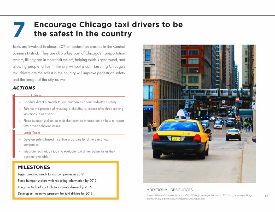
Taxis are involved in almost 30% of pedestrian crashes in the Central
Business District. They are also a key part of Chicago’s transportation
system, filling gaps in the transit system, helping tourists get around, and
allowing people to live in the city without a car. Ensuring Chicago’s
taxi drivers are the safest in the country will improve pedestrian safety
and the image of the city as well.
ACTIONS
Shor t Term
» Conduct direct outreach to taxi companies about pedestrian safety.
» Enforce the practice of revoking a chauffeur’s license after three moving
violations in one year.
» Place bumper stickers on taxis that provide information on how to report
taxi driver behavior issues.
Long Term
» Develop safety based incentive programs for drivers and taxi
companies.
» Integrate technology tools to evaluate taxi driver behavior as they
become available.
7
MILESTONES Begin direct outreach to taxi companies in 2012.
Place bumper stickers with reporting information by 2012.
Integrate technology tools to evaluate drivers by 2016.
Develop an incentive program for taxi drivers by 2016.
Encourage Chicago taxi drivers to be the safest in the country
ADDITIONAL RESOURCES
Business Affairs and Consumer Protection. City of Chicago. Passenger Information. 2012. http://www.cityofchicago.
org/city/en/depts/bacp/supp_info/passenger_information.html.

44
Implementation
SafetyConnectivity
Tools
Livability
Health
Introduction
What we heard
Mid Term
» Develop a pilot program to install 20 mph signs, with aldermanic
and community support, in a few locations and evaluate their effect.
» Develop a monitoring program to evaluate each traffic calming
solution.
» Pilot a Skinny Street program that converts one-way streets to two-
way in order to reduce vehicular speed. Identify all one-way streets
that are wide enough to allow two-way operations. Work with
aldermen and neighborhood groups to develop pilot projects.
» Develop a web-based traffic calming guide to educate aldermen
and residents about available pedestrian safety tools.
» Develop a Home Zone application process that will allow residents
to help design their street.
» Share information with aldermen and community groups about
Home Zones.
The statutory speed limit is 30 miles per hour (mph) on all streets
in Illinois, unless otherwise posted. The same 30 mph speed
limit applies to an arterial roadway like Irving Park Road as
it does to a residential street like Loomis Avenue. To improve
safety, neighborhood streets should be designed for lower vehicle
speeds.
Reducing speeds on neighborhood streets will mean integrating
the broad range of pedestrian safety tools.
ACTIONS
Shor t Term
» Develop and implement typologies for neighborhood streets that will
encourage vehicle speeds of 20 mph.
» Utilize a broader range of pedestrian safety tools for future traffic
calming projects.
» Update the aldermanic menu to include additional tools.
ADDITIONAL RESOURCES
Portland Bureau of Transportation. Traffic Calming Studies and Reports. 2011.
Seattle Department of Transportation. Neighborhood Traffic Operations: Traffic Calming Program. 2011.
City of San Ramon. “Residential Traffic Calming Program.” San Ramon, CA, 2006.
MILESTONES Update the aldermanic menu to include new tools by 2013.
Create a web-based traffic calming guide by 2013.
Begin a traffic calming monitoring/evaluation program by 2014.
Reduce the 85th percentile speed on neighborhood streets to 20 mph by 2022.
Design neighborhood streets for slow, local traffic8

45
ALBANY PARK HOME ZONE
Residents of the 2400 block of N. Albany
Avenue were concerned about the speed
and volume of traffic on their block.
Drivers were using it as a cut through to
avoid the traffic signal at Fullerton Avenue
and Kedzie Avenue. Instead of simply
requesting traffic calming on the street,
the neighbors got together and decided to
develop the first Home Zone in Chicago. A
Home Zone is a residential street designed
to meet the needs of the local community.
The residents of 2400 N. Albany Avenue
collaborated with CDOT staff and the
Alderman’s office to create a unique traffic
calming solution for their block. It included
a chicane, angled parking, bump-outs, and
play spaces for the children on the block.
The entire solution resulted in the loss of
only one parking space.

46
Implementation
SafetyConnectivity
Tools
Livability
Health
Introduction
What we heard
ACTIONS
Shor t Term
» Identify high priority locations, demographics, and behaviors based
on crash data, both local and national, for all users.
» Educate new drivers on pedestrian and driver safety.
» Collect and analyze data on the presence of bicyclists on sidewalks
and crashes between bicyclists and pedestrians.
» Identify locations that should be targeted for enforcement and
annually update the list.
Mid Term
» Develop comprehensive education campaigns for the identified
locations, demographics, and behaviors for all users.
» Continue the existing awareness campaign to encourage bicyclists
to ride on the street and not the sidewalk.
» Coordinate efforts with local community groups to build capacity
and extend the reach of outreach campaigns.
» Develop evaluation criteria to monitor and measure the effectiveness
of the outreach campaigns.
Focus behavior outreach efforts in high crash locations
ADDITIONAL RESOURCES
American Academy of Orthopaedic Surgeons. Decide To Drive. 2011.
City of Chicago. Bike on the Street, Not on the Sidewalk - Safe Cycling in Chicago. 2010.
City of Long Beach. Walk It or Lock It (Video). 2011.
New York City Department of Transportation. New Yorkers Know it All…Except the Speed Limit. 2011.
Van Houten, Ron, and J. E. Louis Malenfant. Effects of A Driver Enforcement Program on Yielding to Pedestrians.
Journal of Applied Behavior Analysis. 2004.
Safe driving, bicycling, and walking behaviors are critical to
improving pedestrian safety. Whether it is distracted driving/
bicycling/walking, speeding, stopping or yielding for pedestrians,
all of these behaviors play a role in the safety of pedestrians.
One way to eliminate unsafe behaviors is to implement strong
public awareness campaigns. The most effective campaigns
target specific behavioral issues that lead to crashes and the
locations where they occur.
MILESTONES Identify high priority locations, demographics, and behaviors by 2013.
Initiate an awareness campaign by 2015.
9

47
Timely access to pedestrian crash data is essential to improving the
pedestrian environment. Aldermen, community groups, planners,
designers, and the public can use this information to build awareness
and make good choices for their communities.
ACTIONS
Shor t Term
» Continue to collaborate among departments and agencies to improve
crash reporting and data collection.
» Identify a funding source for a crash data website.
Mid Term
» Develop a website to host crash data.
» Work with IDOT to provide previous years crash data to website host.
Long Term
» Establish a procedure for IDOT to continually provide current crash data
to the website host.
MILESTONES Identify a funding source for a crash data website by 2014.
Develop a website and import historical data by 2015.
Launch the website by 2016.
Improve crash data collection and sharing
ADDITIONAL RESOURCES
Transportation Alternatives. CrashStat. 2011.
Michigan Department of Transportation. Michigan Traffic Crash Facts. 2011.
Red Eye Chicago. Tracking Homicides in Chicago. 2011.
10

48
Implementation
SafetyConnectivity
Tools
Livability
Health
Introduction
What we heard
ACTIONS
Shor t Term
» Add pedestrian safety enforcement to district operations. Include
crosswalk enforcement in the list of targeted offenses as part of DUI
Strike Force Patrols.
» Compile an annual report that tracks the level of pedestrian safety
enforcements.
» Review the current traffic control aide (TCA) training program and
modify to include a stronger pedestrian safety component.
Mid Term
» Develop a public service announcement to inform the public that
pedestrian safety violations will be enforced on a regular basis.
» Educate officers on what constitutes a pedestrian safety violation
at traffic signals and unsignalized crosswalks and techniques for
enforcement.
» Provide the training program to all officers who are responsible for
traffic enforcement.
» Establish performance measures to gauge the success of integrating
pedestrian safety enforcement into district operations.
» Integrate information about common causes of intersection crashes
in the Central Business District and how they can be prevented into
the TCA training program.
» Create an educational pamphlet or presentation highlighting the
same information to be presented to TCAs who have already
undergone training.
Further integrate pedestrian safety into enforcement efforts
ADDITIONAL RESOURCES
Greater New Orleans Pedestrian and Bicycle Program. “Enforcement for Pedestrian and Bicycle Safety.” New
Orleans, LA. 2010.
Wisconsin Pedestrian and Bicycle Law Enforcement Training Course
Increasing enforcement efforts will require expanding knowledge
about pedestrian safety across law enforcement and traffic
management personnel. Targeted enforcements at specific
locations have begun to change motorists’ behavior. If drivers
come to expect that they will be cited for not stopping at a
crosswalk or for speeding, compliance will be more widespread.
MILESTONES Develop a training program for the Chicago Police Department and begin delivering it in 2013.
Train all traffic control aides about pedestrian crashes in the Central Business District by 2015.
Integrate pedestrian safety enforcement into regular traffic enforcement by 2015.
11

49

50
Implementation
SafetyConnectivity
Tools
Livability
Health
Introduction
What we heard
Automated enforcement has been successful in reducing the
incidence of red light running at signalized intersections. Including
consideration for intersections with high numbers of pedestrian
crashes is another tool to improve pedestrian safety.
ACTIONS
Mid Term
» Update the red light camera priority model to include pedestrian
crashes at intersections where the motorist went straight through an
intersection.
» Evaluate the effectiveness of red light cameras on pedestrian safety,
examining pedestrian crashes at intersections with cameras for five
years prior to and after installation.
» Use cameras to enforce speed limits in close proximity to schools
and parks.
» Ensure public awareness of automated enforcement efforts through
direct community outreach and digital media.
Long Term
» Pilot and evaluate new automated enforcement technologies as they
become available.
Increase automated enforcement
ADDITIONAL RESOURCES
Retting, R.A., Farmer, C.M., McCartt, A.T. Evaluation of automated speed enforcement in Montgomery County,
Maryland. Traffic Injury Prevention 9:440-45. 2008.
Retting, R.A., Farmer, C.M. Evaluation of speed camera enforcement in the District of Columbia. Transportation
Research Record 1830:34-37. Washington, D.C. 2008.
MILESTONES Update the red light camera priority model by 2015.
Develop a report on the effect of red light cameras on pedestrian safety by 2015.
12

51
The court system plays an important role in ensuring pedestrian safety.
A Pedestrian Judicial Safety Committee can address pedestrian safety
issues and create recommendations within the judicial community
that would ensure traffic violations are considered to be serious
public safety concerns. This committee should consist of a variety of
stakeholders from the court system.
ACTIONS
Long Term
» Collaborate with other agencies and organizations to develop a Judicial
Safety Committee comprised of prosecutors, lawyers, judges, and
others to develop recommendations for improved judicial enforcement
of violations and fines. This committee could include four to five judges,
the National Highway Transportation Safety Administration, the Cook
County States Attorney’s Office, the Secretary of State’s office, and
selected legislators.
» Develop a strategic plan in collaboration with the Judicial Safety
Committee and assist in implementing it.
Work with the judicial system to promote safe driving
ADDITIONAL RESOURCES
Dizikes, Cynthia. “Courts Drop Most Cases Against Frequently Ticketed Cabdrivers.” Chicago Tribune, September 23,
2011.
MILESTONES Form a Judicial Safety Committee by 2017.
Develop a strategic plan by 2019.
13

52
Implementation
SafetyConnectivity
Tools
Livability
Health
Introduction
What we heard
Concerns are occasionally raised about traffic calming measures
increasing emergency response times. The needs for safety
afforded by reduced traffic speeds and prompt emergency
response must be balanced.
ACTIONS
Mid Term
» Meet with and interview Chicago emergency responders about their
experience with traffic calming devices.
» Develop an informational packet illustrating traffic calming best
practices for ensuring prompt emergency response times.
» Deliver the informational to emergency responders citywide.
Share information with emergency responders on traffic calming tools
ADDITIONAL RESOURCES
Portland Bureau of Fire, Rescue and Emergency Services. The Influence of Traffic Calming Devices on Fire
Vehicle Travel Times. Portland, OR. Portland Bureau of Transportation, 1996.
Batson, P.E., Scott. Offset Speed Tables for Reduced Emergency Response Delay. Irvine, CA. ITE Technical
Conference, 2004.
MILESTONES Develop and deliver an informational packet by 2013.
14

53
Knowledge of the rules of the road, and in particular issues regarding
pedestrians, could be improved among all users. The best opportunity
to accomplish this is with new drivers. The existing driver education
program can be expanded to include significantly more information
about pedestrian safety, speed and distracted driving.
ACTIONS
Mid Term
» Develop and distribute a mobility education curriculum that teaches
students how to ride a bike, be a pedestrian, and take transit, in addition
to learning to drive.
» Provide information on new traffic safety laws with city sticker
purchases.
» Work with the Secretary of State’s office to increase the amount of
pedestrian topics covered in driver education, licensing exams, and
traffic school curriculum.
Long Term
» Develop a continuing mobility education program for older drivers to
communicate new laws and trends.
Modify driver education programs
ADDITIONAL RESOURCES
Occupational Therapy Association of California. Elder Safety. http://www.eldersafety.org.
Mobility Education. 2012. http://mobilityeducation.org.
MILESTONES Develop a mobility education curriculum by 2015.
Include information on traffic safety laws with city stickers by 2016.
Develop a continuing mobility education program by 2018.
15

54
Implementation
SafetyConnectivity
Tools
Livability
Health
Introduction
What we heard
The quality of buildings facing local streets can have a marked
impact on the experience and perceptions of pedestrians. An
active storefront, for instance, can provide an attractive backdrop
for walking and discourage criminal activity. A vacant building
by contrast is a quality of life hazard that can severely deter
pedestrian activity. Temporary measures are needed to improve
vacant buildings and other inactive surfaces to promote pedestrian
security. Methods must be explored to facilitate approvals for
artists and community organizations seeking to improve these
properties.
ACTIONS
Shor t Term
» Encourage owners of vacant properties to activate their sites with
public art and temporary improvements.
» Explore using nuisance laws to make improvements to vacant
properties.
» Pilot an incentive program for property owners to integrate public
art along visible and blank walls.
Mid Term
» Cite owners of vacant properties on arterial streets who do not
shovel sidewalks adjacent to their property.
Make it easier to install temporary uses in vacant properties
ADDITIONAL RESOURCES
Lin, Xin. Exploring the Relationship Between Environmental Design and Crime: A Case Study of the Gonzaga Univer-
sity District. Washing State University, 2010.
National Crime Prevention Council. “Best Practices for Using Crime Prevention Through Environmental Design in
Weed and Seed Sites.” 2009.
16
MILESTONES Pilot an incentive program for property owners to activate vacant properties by 2015.

55
The Chicago Public Schools (CPS) Safe Passages program provides a
group of focus schools with staff to make students feel safe and secure
on their way to and from school. This staff can also help improve
pedestrian safety around schools.
ACTIONS
Shor t Term
» Develop materials/handouts for Safe Passages staff on pedestrian safety
and laws.
» Include pedestrian safety as a part of Safe Passages staff training.
» Evaluate the effect that the Safe Passages program has on pedestrian
crashes on an annual basis.
Support Chicago’s Safe Passages program 17
MILESTONES Develop Safe Passages materials by 2013.
Integrate pedestrian safety into Safe Passages staff training by 2015.
ADDITIONAL RESOURCES
Chicago Public Schools. Safe Passage. 2011.

56
Implementation
SafetyConnectivity
Tools
Livability
Health
Introduction
What we heard
ACTIONS
Mid Term
» Develop an informational packet on what to do if you’ve been
involved in a pedestrian crash.
» Distribute the informational packet to aldermen and community
groups and through other available means.
» Make the same information available on the CDOT and Chicago
Department of Public Health (CDPH) websites.
Improve information for crash victims
ADDITIONAL RESOURCES
Active Transportation Alliance. Crash Support. 2011.
Stutts, J., and W. Hunter. Police-reporting of Pedestrians and Bicyclists Treated in Hospital Emergency Rooms.
University of North Carolina Highway Safety Research Center.
Many people involved in a pedestrian crash are unaware of the
support that is available to them or the steps to take after the
crash. This information should be made widely available to all
city residents.
18
MILESTONES Develop an informational packet for crash victims by 2014.
Update CDOT and DPH websites with this information by 2015.

57
Crime prevention and transportation safety are both integral to
the health of Chicago’s neighborhoods. As such, the Chicago
Alternative Policing Strategy (CAPS) program plays an important role
in connecting communities with law enforcement. CAPS meetings
provide an excellent opportunity to share information with residents
on pedestrian safety.
ACTIONS
Mid Term
» Create a traffic safety presentation for CAPS meetings.
» Conduct outreach at CAPS meetings.
» Develop educational materials on traffic calming and traffic enforcement
to hand out at these meetings.
» Develop a traffic enforcement request form to provide at CAPS meetings.
Support Chicago Alternative Policing Strategy Program
ADDITIONAL RESOURCES
Chicago Community Policing Evaluation Consortium. “Community Policing in Chicago, Year Ten: An Evaluation of
Chicago’s Alternative Policing Strategy.” 2004.
MILESTONES Develop a presentation and present at CAPS meetings by 2015.
Develop a traffic enforcement request form by 2015.
19

58
Implementation
SafetyConnectivity
Tools
Livability
Health
Introduction
What we heard
The 2011 Chicago Pedestrian Crash Analysis identified a strong
correlation between community areas with high numbers of
pedestrian crashes and community areas with high crime rates.
Correlation does not indicate causation and further study is
necessary to understand this relationship and the potential
broader benefits of pedestrian safety improvements.
ACTIONS
Shor t Term
» Identify and obtain funding for this study.
» Identify a location for safety improvements and obtain data for the
“before” conditions.
Mid Term
» Design and implement pedestrian safety improvements.
» Develop a pedestrian safety enforcement plan for the area for the
duration of the project.
» Analyze the effects on pedestrian safety and crime.
Analyze the relationship between pedestrian safety and crime
ADDITIONAL RESOURCES
National Highway Traffic Safety Administration. Data-Driven Approaches to Crime and Traffic Safety (DDACTS).
2011.
20
MILESTONES Initiate this study by 2013 and complete by 2015.

59

60
c o n n e c t i v i t yMany parts of Chicago have continuous and connected pedestrian facilities. However, there are still a number of barriers in the pedestrian network that need to be addressed. These barriers, such as missing or damaged sidewalks, expressways through neighborhoods, snow on sidewalks, rail viaducts that are long and dark, or pedestrian detours during construction, all affect pedestrian connectivity. This chapter identifies the policies and coordination that are necessary to make it as easy as possible for pedestrians to
access any location in Chicago.
our goals » Identify and eliminate gaps and barriers in the pedestrian network
» Establish policies that prioritize pedestrian access
how we’ll get there » Design, build, and maintain a more connected pedestrian network
» Improve information on the pedestrian environment and the methods through which pedestrian data is collected, analyzed, and shared

DRAFT

62
There are many occasions when sidewalks need to be closed
off or modified during construction projects. Clear, safe, and
accessible pedestrian routes must be provided when sidewalks
are affected by public and private construction.
ACTIONS
Shor t Term
» Require a minimum 6’ travel path be maintained for any full or partial
closure of a sidewalk in the Central Business District, Pedestrian
Streets, and other locations with high pedestrian volumes. Require a
minimum 4’ travel path at all other locations. Allow exceptions when
these widths are not possible.
» Keep travel paths along the building line whenever possible.
» Require a pedestrian access plan for any proposed closure of all or
part of a sidewalk. The access plan should include new walkways,
signage, access to bus stops and train stations, and accessibility
recommendations.
Mid Term
» Develop standards for fences during sidewalk closures.
» Update the Regulations for Openings, Construction, and Repair in
the Public Way manual with these standards for minimum travel paths
and fences and distribute to those that work in the public right of way.
» Develop new urban design standards for sidewalk scaffolding/sheds.
Long Term
» Aggressively enforce violations of these standards.
MILESTONES Require pedestrian access plans by 2013.
Update the Regulations for Openings, Construction, and Repair in the Public Way with new standards by 2015.
Develop urban design standards by 2016.
ADDITIONAL RESOURCES
U.S. Access Board. Proposed Accessibility Guidelines for Pedestrian Facilities in the Public Right-of-Way. July
26, 2011.
Implementation
Safety
Livability
Health
Introduction
What we heard
Tools
Connectivity
Maintain pedestrian access during construction 1

63
MILESTONES Establish a sidewalk snow removal committee by 2013.
Develop draft sidewalk snow removal policies and procedures by 2014.
Develop a method to report locations with mobile device by 2015.
Pilot the neighborhood sidewalk snow removal program by 2015.
ACTIONS
Shor t Term
» Improve coordination between agencies regarding responsibilities for
sidewalk snow removal.
» Prioritize sidewalk snow removal at city facilities.
» Improve awareness citywide of sidewalk snow removal ordinances.
Mid Term
» Cite owners of vacant properties on arterial streets who do not shovel
sidewalks adjacent to their properties.
» Integrate policies and procedures related to pedestrian access and snow
removal operations.
» Provide a method for people to report locations that are not shoveled
using mobile devices and share information on the City’s website of
previous snow removal calls and issues.
» Collect public health information on falls and injuries related to sidewalk
snow and ice.
» Assist in coordinating ward sidewalk snow removal plans.
Improve snow removal practices
ADDITIONAL RESOURCES
City of Madison. Snow Removal Regulations. 2011.
During the winter, ice and snow on sidewalks present significant
challenges for everyone. Without a clear sidewalk, pedestrians are
often forced to walk in the road and into dangerous conflicts with
vehicles. For many pedestrians, particularly people with disabilities
or seniors, snow can prevent access to basic services, such as public
transportation, medical services, or grocery stores. The simple task
of shovelling a sidewalk can tremendously alter another individual’s
quality of life. But no single organization can ensure that Chicago’s
sidewalks are routinely cleared of snow and ice. The City, residents,
community groups, and institutions must work together to share
resources and information.
2

64
MILESTONES Pilot a program for stickers on newspaper boxes and private kiosks by 2015.
Develop new standards and approval process for sidewalk cafes by 2015.
Develop an online method to report sidewalk issues by 2018.
Sidewalks, like streets, must provide the proper balance of space to
allow pedestrians to safely and comfortably use them. Pedestrians
share sidewalks with a number of objects, such as bus shelters,
newspaper boxes, tree pits, sidewalk cafes, and signage. To
ensure a clear pedestrian route, policies need to balance the free
flow of pedestrian movement while accommodating pedestrian
amenities.
ACTIONS
Shor t Term
» Develop quantitative standards for pedestrian volumes and sidewalk
width for the Sidewalk Café program. Require that businesses meet
these standards for future sidewalk cafe applications.
Mid Term
» Require newspaper boxes and private kiosks to display a permit or
license number.
» Partner with Special Service Areas to enforce newspaper box and
private kiosk violations of the Municipal Code.
» Work with Special Service Areas to create neighborhood aesthetic
design standards for sidewalk cafés.
Long Term
» Develop a method to allow people to report issues with sidewalks
on their mobile devices and expand the range of issues that can be
reported.
ADDITIONAL RESOURCES
City of Kirkland, WA. Help Keep Sidewalks and Streets Clear.
Implementation
Safety
Livability
Health
Introduction
What we heard
Tools
Connectivity
Ensure clear pedestrian routes on sidewalks3

65
Every transit rider is also a pedestrian during some point of their
trip. Improvements to pedestrian infrastructure around transit will
encourage more pedestrian activity and transit ridership, improve
the safety and overall experience of transit riders, and advance
pedestrian friendly land uses.
ACTIONS
Shor t Term
» Develop guidelines for access to transit, including bus stop siting,
connecting sidewalks to bus stops, providing the proper amount of
sidewalk space at bus shelters, and coordinating transit improvements
with other complete street projects.
» Implement the recommendations of the Transit Friendly Development
Guide.
Long Term
» Investigate the feasibility of new zoning requirements around transit
stations. These could include a new zoning designation for Transit Streets,
similar to Pedestrian Streets, and the feasibility of parking maximums,
instead of minimums, for new developments located within 1/8 mile of a
transit station. Amend the Zoning Code to include any new ordinances.
» Identify transit stations and stops that need improved pedestrian
infrastructure and implement improvements. MILESTONES Begin to investigate new zoning requirements by 2013.
Develop access to transit guidelines by 2014.
Implement infrastructure solutions at five transit stations or stops in 2014, ten in 2016.
Improve pedestrian connectivity to transit
ADDITIONAL RESOURCES
New York City Department of Transportation. Pedestrians & Sidewalks: Safe Routes to Transit. 2011.
4

66
MILESTONES Develop a database of inaccessible sidewalks and intersections by 2015.
Develop and fund a program to reduce the number of inaccessible sidewalks and intersections on an annual basis.
Any barrier, such as an intersection without an ADA compliant
ramp or the construction of a new building that doesn’t provide
enough width for a wheelchair, can prevent a person with a
disability from getting to their destination easily and safely. As
the pedestrian network is built and improved, upgrades must be
made so that all pedestrians will be able to get around Chicago.
ACTIONS
Shor t Term
» Upgrade sidewalks and crossings for accessibility compliance during
reconstruction.
» Develop, complete, and maintain a database of all ADA compliant
ramps.
Mid Term
» Require a pedestrian accessibility plan for all private and public
projects that affect the sidewalk network. This plan should be
reviewed as part of the CDOT review process.
» Develop a system (online or with a mobile device) to report accessibility
issues with existing infrastructure and temporary construction.
» Develop an application for requesting accessible pedestrian signals.
Long Term
» Identify intersections and crossings without accessible ramps and
locations where the grade of the sidewalk is too steep for wheelchairs.
» Develop an infrastructure improvement program for these ramps,
crossings, and sidewalks and identify funding.
Ensure connectivity for persons with disabilities
ADDITIONAL RESOURCES
U.S. Access Board. Proposed Accessibility Guidelines for Pedestrian Facilities in the Public Right-of-Way. July
26, 2011.
New York City. NYCityMap. 2012.
Implementation
Safety
Livability
Health
Introduction
What we heard
Tools
Connectivity
5

67
MILESTONES Identify the jurisdiction and ownership of all at-grade railroad crossings by 2014.
Begin coordination program with the ICC and the railroads by 2015.
Railroad tracks often serve as a major barrier between neighborhoods.
Given this, it is important to improve at-grade crossings to make it as
easy and safe as possible for people to access both sides of the
tracks.
ACTIONS
Shor t Term
» Identify jurisdictions and ownership of all pedestrian at-grade railroad
crossings.
Mid Term
» Coordinate with the Illinois Commerce Commission (ICC), rail operators
and owners, and Operation Lifesaver to install detectable warning mats
on sidewalks, ensure that all pedestrian paths intersect with the railroad
crossings at as close to 90 degrees as possible, ensure that all at-grade
crossings have proper gates and signage, and provide additional
information for pedestrians at all railroad crossings.
Long Term
» Monitor rail technology for future products that create level surfaces for
pedestrians to cross.
ADDITIONAL RESOURCES
Don’t Become A Wreck. Directed by Sound Transit. 2012.
Improve at-grade railroad crossings 6

68
MILESTONES
Include CDOT as part of the school siting process by 2014.
Students and parents are more encouraged to walk to schools
that are located on residential streets and adjacent to transit.
Conversely, many students and parents may not feel safe walking
to schools located on a busy arterial roadway. Collaborating to
provide input on desirable transportation attributes for potential
sites of future schools is an important element of providing safer
routes to schools.
ACTIONS
Shor t Term
» Require pedestrian improvements for new schools.
Mid Term
» Include CDOT as part of the school siting process for potential public
and charter school sites earlier, including the budgeting and design
stages.
» Evaluate potential sites for future schools based on pedestrian
connectivity and safety.
Collaborate on future school sitings
ADDITIONAL RESOURCES
Oregon Growth Management Program. Walkable Neighborhood Schools. 2011.
Implementation
Safety
Livability
Health
Introduction
What we heard
Tools
Connectivity
7

69
Chicago has a number of atypical intersections, including streets that
are offset from one another, streets that cross each other at acute
angles, and intersections with three or four streets coming together.
It is necessary to identify all of these intersections and develop
standards to make them easier for pedestrians to cross.
ACTIONS
Shor t Term
» Develop typologies and guidelines, utilizing additional pedestrian safety
tools, for diagonal intersections with five or six legs and offset intersections.
Mid Term
» Remove channelized right-turn lanes where streets intersect at acute
angles.
» Pilot a project that studies the effects of prohibiting turning movements at
intersections where three major streets intersect.
MILESTONES Pilot a study prohibiting turns at diagonal intersections by 2014.
Develop intersection typologies by 2014.
Remove all channelized right turn lanes by 2015.
Improve non-standard intersections
ADDITIONAL RESOURCES
An ITE Recommended Practice - Context Sensitive Solutions in Designing Major Urban Thoroughfares for Walkable
Communities. Institute of Transportation Engineers, 2010.
8

70
Implementation
Safety
Livability
Health
Introduction
What we heard
Tools
Connectivity
THE SIX WAY INTERSECTION
Chicago has a number of diagonal streets (Archer Avenue, Blue Island Avenue, Lincoln Avenue, Elston Avenue, Milwaukee Avenue) that intersect at one point with both a north-south street and an east-west street. These six way intersections create a number of challenges for pedestrians and vehicles. They require pedestrians to cross large distances to get from one side of the intersection to the other.
There are a number of improvements that can be made to these types of intersections to reduce the crossing distance and improve the connectivity in the neighborhood. The graphic to the right shows a typical six way intersection where a diagonal street intersects two arterial roadways. On the following page a number of modifications have been made. These include:
• removing the channelized right turn lane• reducing turning radii • prohibiting turns at the intersection• providing crosswalks for all
movements

71

72
Highways and rail lines often act as barriers between
neighborhoods and to employment, parks, schools, and libraries.
The underpasses with sidewalks provide pedestrians access
through this infrastructure also present challenges for pedestrians.
There are a number of ways to improve underpasses through
lighting, art, and general maintenance.
ACTIONS
Mid Term
» Identify all underpasses in Chicago as well as the ownership,
maintenance responsibilities, and jurisdiction.
» Develop criteria and maintenance standards to evaluate existing
underpasses.
» Establish a monitoring and maintenance program for existing
underpasses.
» Develop urban design guidelines for new underpasses and
improvements to existing underpasses.
Long Term
» Create an underpass improvement program that identifies funding for
connectivity, safety, and aesthetic improvements.
INVITING UNDERPASS
UNINVITING UNDERPASS
MILESTONES
Identify all underpasses by 2015.
Develop evaluation criteria by 2015.
Develop urban design guidelines for underpasses by 2015.
Create an underpass improvement program by 2018.
Implementation
Safety
Livability
Health
Introduction
What we heard
Tools
Connectivity
9 Improve underpasses
ADDITIONAL RESOURCES
City of Calgary. Downtown Underpass Urban Design Guidelines. Design Guidelines, Calgary, Canada:
City of Calgary, 2010.

73
Both the CTA Red Line and Blue Line are located along expressways
and an expressway also separates the Loop from the west side of the
city. Thousands of pedestrians must cross the entrances and exits to
the expressways on a daily basis to reach their destinations. Many of
these entrances and exits were designed primarily for vehicles and are
often very difficult for pedestrians to cross. Improving these locations
will make it easier for pedestrians to get to transit, the Loop, and other
destinations and create a more connected pedestrian environment.
ACTIONS
Shor t Term
» Identify all expressway entrances and exits and note which locations have
transit stations.
Mid Term
» Develop typologies for these intersections, including low-cost improvements
such as striping, signage, and refuge islands.
» Prioritize the intersections for improvements.
Long Term
» Consider eliminating ramps, when possible, as part of major improvements
and develop standard intersections at entrances and exits.
» Ensure that all future projects involving expressway entrances and exits
include improvements to allow for easy and safe pedestrian crossings.
MILESTONESDevelop intersection typologies and a prioritization system by 2015.
Begin designing improvements by 2016.
ADDITIONAL RESOURCES
An ITE Recommended Practice - Context Sensitive Solutions in Designing Major Urban Thoroughfares for Walkable
Communities. Institute of Transportation Engineers, 2010.
10 Improve expressway entrances and exits

74
Interstates 55, 57, 90, 94, and 290 all run through neighborhoods of Chicago. While these roadways provide regional connectivity for motorists and freight, they also create significant barriers in the pedestrian network. Because both the CTA Red and Blue lines run within the medians of an interstate, thousands of pedestrians must cross the entrances and exits of the interstates on a daily basis to access train stations. Many of these entrances and exits were designed for optimal vehicular operations that did not take into account pedestrian connectivity. Reducing the radii and/or removing low volume ramps, installing pedestrian refuge islands and providing safer crossings between bus stops and train stations can balance the needs of all users.
Implementation
Safety
Livability
Health
Introduction
What we heard
Tools
Connectivity
INTERSTATE ENTRANCE & EXIT

75

76
The experience of walking in a parking lot should be considered
no different than walking on a sidewalk. It should be safe and
convenient to get from the car to the front door. Minimizing
conflicts between pedestrians and vehicles should be a priority of
parking lot design.
ACTIONS
Mid Term
» Develop parking lot standards for pedestrian and transit access.
» Analyze pedestrian crash data in parking lots.
» Require pedestrian aisles in surface parking lots with more than 200
spaces.
Long Term
» Require crosswalks at all pedestrian crossing locations in parking lots.
MILESTONESUndertake a parking lot pedestrian crash data analysis by 2015.
Develop parking lot standards by 2016.
11 Develop standards for pedestrian facilities within parking lots
Implementation
Safety
Livability
Health
Introduction
What we heard
Tools
Connectivity
ADDITIONAL RESOURCES
Pedestrian Planning and Design Handbook. Florida Department of Transportation.

77
Pedestrian volumes are counted as a part of numerous projects in
Chicago. In order for this information to be valuable on a macro
level, the methods for collecting the data must be standardized.
ACTIONS
Shor t Term
» Develop standards for hourly and daily pedestrian volume counts,
including time and day of week, location, and weather.
» Participate in the National Bicycle and Pedestrian Documentation Project.
» Develop and distribute an informational brochure and/or webpage on
how to collect pedestrian volume data.
Mid Term
» Develop a system for consultants to upload pedestrian data to CDOT.
» Update the Chicago Traffic Information Map to display all pedestrian
counts.
» Distribute walkability tools to aldermen, community groups, and SSAs.
» Encourage aldermen, community groups, and SSAs to conduct and share
the results of walkability audits to obtain qualitative information about the
pedestrian environment.
MILESTONESDevelop pedestrian count standards in 2013.
Develop a system to upload and share data by 2014.
12 Improve pedestrian data collection and sharing methods
ADDITIONAL RESOURCES
Schneider, Robert J, Lindsay S Arnold, and David R Ragland. Methodology for Counting Pedestrians at Intersections:
Use of Automated Counters to Extrapolate Weekly Volumes from Short Manual Counts. Washington, DC: Transportation
Research Board, 2009.
Consortium to Lower Obesity in Chicago Children. Neighborhood Walkability Assessment Tool. 2012.
Navteq Traffic. Chicago Traffic Information Map. 2012.
City of Minneapolis. Pedestrian Counts. 2011.
Institute of Transportation Engineers. National Bicycle and Pedestrian Documentation Project. 2012.

78
Chicago has a number of barriers (interstates, viaducts, rivers,
etc.) and gaps (missing or broken sidewalks, lack of pedestrian
crossing signals, etc.) in its pedestrian network. The first step
towards improving pedestrian access through these barriers and
gaps is to identify them.
ACTIONS
Shor t Term
» Develop a sidewalk checklist that allows residents and neighborhood
groups to survey existing sidewalks and provide the data to CDOT.
Mid Term
» Develop criteria for what should be considered a barrier and what
should be considered a gap.
» Use these criteria to develop and update a database of all identified
barriers and gaps in Chicago.
» Develop a process to allow residents to report gaps in the pedestrian
network with a mobile device.
» Encourage staff that are working in the built environment, such as
Streets and Sanitation or Park District employees, to report sidewalk
conditions.
13 Identify all barriers and gaps in the existing pedestrian network
Implementation
Safety
Livability
Health
Introduction
What we heard
Tools
Connectivity
MILESTONESDevelop criteria and a database of identified barriers and gaps by 2015.
Continually monitor and update this list and ensure that the list is used to inform future transportation projects.
ADDITIONAL RESOURCES
City of Naperville. “Sidewalk Gap Inventory Priority System.” 2012.

79
Whether it’s a tourist visiting Chicago for the first time or a resident
exploring a new neighborhood, people want to easily locate
information on how to reach their destination. This is not only important
in the Central Business District, but to any retail or cultural district in
Chicago. Providing this information in a predictable and reliable
manner can be accomplished by implementing a set of consistent
standards for all future wayfinding projects in Chicago.
ACTIONS
Mid Term
» Integrate digital wayfinding into structures in the public way, such as bus
shelters, trash cans, and other street furniture. Ensure that information is
accessible to people with disabilities.
» Identify all intersections that do not have street signs that face each leg of
the intersection and install street signs.
» Coordinate with the RTA on its wayfinding program for transit stations.
» Work with neighborhood groups to integrate digital wayfinding into future
wayfinding projects.
MILESTONESBegin implementing digital wayfinding by 2014.
Begin adding streets signs at one-way street intersections by 2014 and complete the installations by 2016.
ADDITIONAL RESOURCES
Wayfinder NYC. Mobile Application. New York City, 2012.
14 Improve wayfinding

80
Pedestrian Street is a zoning designation that is intended to
preserve and enhance the character of Chicago’s pedestrian-
oriented shopping districts. The designation regulates building
design, land use, vehicular access, and parking. Pro-actively
identifying future Pedestrian Streets will encourage clusters of
pedestrian retail uses in areas that will support them.
ACTIONS
Shor t Term
» Develop criteria for future Pedestrian Streets.
Mid Term
» Identify a first phase of locations that meet these criteria and designate
them as Pedestrian Streets.
» Evaluate the effectiveness of the proactive zoning.
» Require all future projects along these corridors to meet the Pedestrian
Street requirements stated in the Chicago Zoning Ordinance.
Implementation
Safety
Livability
Health
Introduction
What we heard
Tools
Connectivity
MILESTONESIdentify the first phase of future Pedestrian Streets locations by 2015.
Implement the new zoning by 2016.
15 Identify potential streets for Pedestrian Street designation
ADDITIONAL RESOURCES
Chicago Zoning Ordinance Section 17-4-0500 Pedestrian Streets. Pedestrian Streets. Chicago: City of Chicago.

81
Most new developments and projects are required to conduct a
traffic study as part of the City’s approval process. In addition to
understanding the vehicular impacts of these projects, these studies
also provide a valuable opportunity to evaluate future pedestrian
volumes and movements. There are a number of different tools that
can be used to analyze pedestrian operations depending on the type
of project. Similar to mitigating impacts of vehicular traffic, projects
that affect existing pedestrian safety or operations will require
improvements.
ACTIONS
Shor t Term
» Educate CDOT, CTA, IDOT, and Cook County Highway Department staff
and consultants on pedestrian level of service and multi-modal level of
service analysis.
» Pilot multi-modal level of service analysis for intersection analyses in
City-conducted traffic studies. Evaluate the effectiveness of the pilot. If
successful, require all traffic studies to use multi-modal level of service.
» Encourage new developments on heavily traveled sidewalks to be set back
further from the curb to provide more space for sidewalks or sidewalk
cafes.
Mid Term
» Develop full traffic study guidelines that include pedestrian level of service
analysis, requirements for pedestrian access and using “person trips” for
trip generation.
» Create a trip generation database of existing land uses in Chicago that
includes the size of the land use, proximity to transit, the overall number of
people trips, and the number of trips per mode.
» Require all planned developments to include pedestrian improvement
strategies as part of all review and approval processes.
» Pilot a pedestrian simulation model for a large pedestrian generator.
Evaluate the effectiveness of the pilot and determine if the process should
be utilized for other projects.
MILESTONESPilot multi-modal level of service analysis by 2013.
Develop full traffic study guidelines by 2015.
Launch the trip generation database by 2015.
16 Improve analysis of pedestrian operations
ADDITIONAL RESOURCES 2010 City Environmental Quality Review Manual. New York City: Mayor’s Office of Environmental Coordination, 2010.
National Cooperative Highway Research Program. NCHRP Report 616. Multimodal Level of Service Analysis for Urban
Streets. Washington, D.C.: Transportation Research Board, 2008.

82
23%
s t r e e t sa l l e y s
23% of the land in the City of Chicago, such as
is found in the public right
of way
and
l i v a b i l i t yBeing a pedestrian in Chicago is about more than simply reaching one’s destination; it’s about experiencing all of the places in between. Chicago has some of the best public spaces in the world and these spaces greatly benefit our city. They are places for community engagement in neighborhoods, economic development, and simply having fun. As such, the design and function of these spaces should meet the needs of the community. To accomplish this, we must continue to work with local stakeholders and tap into the wealth of local knowledge and creativity to develop new spaces and improve existing ones. This chapter recommends ways to make Chicago’s streets more livable.
our goals » Increase the amount and quality of pedestrian space
» Increase the activity in pedestrian space
how we’ll get there » Design, build, and maintain more livable streets
» Encourage activity in all pedestrian spaces


Implementation
Safety
Connectivity
Tools
LivabilityHealth
Introduction
What we heard
84
Every neighborhood in Chicago could benefit from more
quality space for its residents and visitors. There are a number
of creative ways in which additional pedestrian space can be
provided. From converting unnecessary roadway space to re-
imagining how to use a parking space, Chicago’s Make Way for
People program will build more livable streets and increase local
economic growth by adding pedestrian space all across the city.
ACTIONS
Shor t Term
» Pilot the Make Way for People Program that creates additional
pedestrian space by closing streets down permanently or temporarily,
creates shared space to give pedestrians the right-of-way, creates
public plazas by reclaiming street space, or creates plazas from
parking spaces.
» Develop quantitative and qualitative criteria and metrics for the
Make Way for People program and evaluate the program on an
annual basis.
» Ensure equitable distribution of geographic sites in the Make Way for
People Program.
Mid Term
» Develop plans for Make Way for People projects throughout the city.
Create at least three new projects annually.
MILESTONESLaunch Make Way for People program in 2012.
Pilot one street closure and two plazas in 2013.
Develop evaluation criteria by 2013.
Create Make Way for People Program 1
ADDITIONAL RESOURCES
City of Chicago. Make Way for People. 2012.
New York City Department of Transportation. Pedestrians and Sidewalks: NYC Plaza Program. 2011.
City of San Francisco. Pavement to Parks San Francisco. 2011.

85
There are many opportunities to increase the number of great public spaces in Chicago by using the public way. This will include taking advantage of streets, alleys, parking, and sidewalks. The example below shows how a segment of a diagonal street could be activated into a world class space for people.

Implementation
Safety
Connectivity
Tools
LivabilityHealth
Introduction
What we heard
86
There are a number of City guidelines and standards that affect the
ways that streets are designed. Incorporating livability and health
principles, from sidewalk width to stormwater management, into
these guidelines will help create better streets for all Chicagoans.
ACTIONS
Shor t Term
» Finalize Complete Street Guidelines.
Mid Term
» Update the Streetscape Guidelines.
» Create Sustainable Infrastructure Design Guidelines.
» Update the Street and Site Plan Design Guidelines.
» Update the Street Marking Standards.
ADDITIONAL RESOURCES
City of Chicago. Streetscape Guidelines. City of Chicago, 2003.
City of Chicago. Street and Site Plan Design Standards. Report, Chicago: City of Chicago, 2007.
City of Chicago. Chicago Street Marking Standards. Chicago: City of Chicago, n.d.
Port Authority of NY & NJ. “Sustainable Infrastructure Guidelines.” 2011.
MILESTONES Begin updating City guidelines by 2012 and ensure integration of all guides with each other.
Finalize Complete Street Guidelines in 2012.
Update City guidelines 2

87

Implementation
Safety
Connectivity
Tools
LivabilityHealth
Introduction
What we heard
88
Designing new spaces for pedestrians is not a one size fits all
process. Great places in Chicago can only be developed through
partnerships with the people that will use them and those that plan
and design them. This process is referred to as placemaking. In
order to ensure that the public way is designed as public space,
future transportation projects will embrace placemaking principles
and facilitate community participation in the design process.
ACTIONS
Shor t Term
» Encourage placemaking for future transportation projects.
» Encourage local stakeholders to voice their ideas on transportation
projects using interactive methods.
Mid Term
» Train city staff and consultants on placemaking principles.
» Incorporate placemaking principles into the city design process.
» Collaborate with not-for-profit organizations and private developers to
create web and mobile applications that can assist with placemaking.
ADDITIONAL RESOURCES
Metropolitan Planning Council. Placemaking Chicago: A Step-by-step Guide. 2011.
MILESTONES Develop placemaking guidelines by 2013.
Integrate placemaking into three major highway or bridge projects by
2015.
Encourage community placemaking3

89
The way that streets and pedestrian areas are used, and by whom,
is a critical component of creating great places. Programming
pedestrian space requires coordination between the City and various
organizations to bring unique and engaging activities to activate the
public realm. Online tools can serve to facilitate an easy and efficient
interface between the City and such groups. These tools can assist
groups in obtaining proper permissions for events, providing “how-
to” basics and guidelines for acceptable uses and directing users
to potential sources of funding or organizational co-sponsors. A
marketing effort targeting potential pedestrian space programmers
would ensure that institutions, performance groups, creative
individuals, and others are directed to the necessary information and
resources.
ACTIONS
Shor t Term
» Partner with SSAs, Chambers of Commerce, and other community
organizations to program new pedestrian spaces.
Mid Term
» Launch a marketing effort for programming pedestrian space.
» Create a new permit process for programming pedestrian spaces.
» Develop an online tool that provides resources for groups wishing to hold
an event.
» Pilot a free Wi-Fi program in pedestrian spaces.
» Create an request process for benches, similar to bike parking.
ADDITIONAL RESOURCES
The Street Plans Collaborative. “Tactical Urbanism: Short Term Action, Long Term Change.” 2012.
Times Square. Times Square Bowtie. 2012.
MILESTONES Develop a new permit process for programming pedestrian spaces by 2015.
Create a bench request program by 2015.
Pilot a Wi-Fi program by 2016.
Launch a marketing effort for pedestrian space programming by 2016.
Program pedestrian space4

Implementation
Safety
Connectivity
Tools
LivabilityHealth
Introduction
What we heard
90ADDITIONAL RESOURCES
Miami-Dade County. Art In Public Places. 2005.
Chicago’s legacy of artistic creativity and cultural production
should be legible on its streets and in its pedestrian spaces. In
a city with so many creative residents looking for opportunities
to show their work, expanding the presence of public art would
serve not only to make Chicago’s creative scene more visible,
but also to help local artists develop their careers. Facilitating
creative innovation to enrich public spaces with interactive art,
temporary outdoor galleries, video projections, sound and
lighting installations, and distinctive green walls to name a few
examples, would engage a diverse range of creative individuals
and further distinguish Chicago’s sidewalks and pedestrian areas.
ACTIONS
Shor t Term
» Ensure that capital projects integrate public art.
Mid Term
» Encourage temporary/rotating art exhibits in public space.
» Streamline the process to include art in transportation projects.
» Pursue grants from the NEA, the NEH, foundations, and other grant
opportunities for public art.
» Encourage placemaking principles to help guide community-led art
installations.
» Establish partnerships with local cultural and educational institutions
for fundraising and implementation support.
MILESTONES Include temporary art in four projects by 2016.
Develop funding partnerships for public art by 2016.
Integrate art into pedestrian spaces 5

91ADDITIONAL RESOURCES
Future Communities. Maintaining High Quality Public Space. 2009.
The City, residents, SSAs, institutions, and business owners all
play a role in maintaining public sidewalks and pedestrian areas.
To facilitate better coordination between the City and community
partners, effective tools are needed to enable community members to
report areas in Chicago where adjacent property owners may need
a reminder that sidewalk maintenance is their responsibility.
ACTIONS
Mid Term
» Institutionalize sustainable design into all roadway projects.
» Facilitate community reporting of trash accumulation hot spots using an
online tool.
» Establish a Clean and Green Day website and explore the feasibility of
holding more events each year.
» Develop maintenance agreements with community organizations for future
Make Way for People projects.
» Continue public education efforts on maintaining the public right of way.
MILESTONES Complete Sustainable Design Standards by 2013.
Establish a pilot program for trash can stewardship by 2015.
Launch Clean and Green Day website by 2016.
Include sustainable design in all transportation projects by 2016.
Maintain public spaces 6

92
SOURCE: Rogers, Shannon, John Halstead, Kevin Gardner, and Cynthia Carlson. Examining Walkability
and Social Capital as Indicators of Quality of Life at the Municipal and Neighborhood Scales. October
2010.
h e a l t hChicago’s prevalence of overweight and obese adults has dramatically risen over the past decade and that is why the city of Chicago has made obesity reduction for both children and adults by 10% a major priority of its Healthy Chicago Public Health Agenda. Pedestrian activity improves the physical and mental health of both the individual pedestrian and the city as a whole and can also lead to improved social and economic health for neighborhoods. The following chapter identifies programs, policies, and strategies that will encourage a healthier Chicago.
our goals » Increase the number of pedestrian trips for enjoyment, school, work, and daily errands
» Increase the mode share of pedestrian trips for enjoyment, school, work, and daily errands
how we’ll get there » Develop and support pedestrian programs and events
» Develop and support pedestrian encouragement policies


Implementation
Safety
Connectivity
Tools
Livability
Health
Introduction
What we heard
94
ACTIONS
Shor t Term
» Coordinate Play Streets efforts between CDOT and the Department of
Public Health.
» Partner with foundations to pilot Play Streets program.
» Identify locations for pilot Play Streets to serve as models for future
community-initiated Play Streets.
» Develop Play Streets pamphlet or other marketing materials for distribution
to community-oriented entities.
Mid Term
» Develop an expedited permit process for Play Streets.
» Create a Play Streets “how-to” guide and distribute via a website.
» Partner with a local cultural/creative institution to hold a city-wide design
competition to create low-cost, playful, mobile, and highly visible street
barriers for use during Play Street play hours.
» Encourage community groups to provide stewardship over Play Streets
and make them more visible and distinctive.
Long Term
» Identify funding sources for equipment for Play Streets.
A zoning designation dating back to the Chicago Municipal
Code of 1922 allows for the establishment of Play Streets.
Play Streets are regular or reoccurring closures of streets with
low traffic volumes to allow children to play in the street. By
facilitating community efforts to implement Play Streets, Chicago
can creatively support more active play areas in neighborhoods
across the city.
MILESTONESImplement a pilot Play Streets program by summer 2012.
Launch design competition in summer/fall 2013.
1 Foster Play Streets
ADDITIONAL RESOURCES Godenzo, Jennifer S., Javier Lopez, Maritza Owens, Maysoun Freij, and Greg Holisko. Play Streets.
Transportation Alternatives.

95

Implementation
Safety
Connectivity
Tools
Livability
Health
Introduction
What we heard
96
Open Streets are large-scale events that temporarily close a street
or streets to vehicular traffic in order to allow pedestrians and
bicyclists to use and enjoy the roadway. Open Streets events have
been held in Chicago in the past, both across neighborhoods
along the Boulevards and in the Loop on State Street. This is
a highly visible opportunity to encourage pedestrian activities
across different communities in a safe and fun environment.
Regular Open Streets events throughout the city are the best way
to maximize the health benefits.
ACTIONS
Shor t Term
» Develop an Open Streets steering committee that includes representatives
from the City, not-for profits, and the private sector.
» Identify streets and lengths that would be suitable for Open Streets events.
Mid Term
» Identify public and private funding sources for Open Streets events.
» Partner with community groups, institutions, and not-for profit groups to
organize, promote, and provide programming for Open Street Events
across Chicago.
Long Term
» Continuously reevaluate Open Streets events programming and locations
based on attendance and feedback from participants.
MILESTONESEstablish an Open Streets steering committee by 2013.
Partner to hold at least three Open Streets events in 2013, six in 2014, and nine in 2015.
2 Hold more Open Streets events
ADDITIONAL RESOURCES
Sarmeinro, et al. “The Ciclovia-Recreativa: A Mass-Recreational Program with Public Health Potential.” Journal
of Physical Activity and Health, July 2010.
Active Transportation Alliance. Open Streets. 2012.

97

Implementation
Safety
Connectivity
Tools
Livability
Health
Introduction
What we heard
98
Every September 22nd, cities around the world participate in
Car Free Day, a celebration of active transportation. Previous
Car Free Days in Chicago have included events and prizes for
participants.
ACTIONS
Shor t Term
» Promote Car Free Day through the City’s and sister agencies’ websites
and social media platforms.
Mid Term
» Partner with community groups to organize a large, Car-Free Day rally.
» Engage local businesses to donate prizes for individual participants and
businesses.
» Study the feasibility of holding an Open Streets event on Car Free Day.
» Partner with local community groups to promote Car Free Day and to hold
organized walks or bike rides.
The first “National Walk Our Children to School Day” took place
in Chicago in 1997 and it has since evolved into a nationwide
event. Walk and Bike to School Day is an excellent opportunity to
bring more attention to pedestrian issues affecting children.
ACTIONS
Shor t Term
» Increase the number of nominations for Crossing Guard Appreciation
Day.
Mid Term
» Increase direct participation from Chicago Public Schools (CPS) in Walk
and Bike to School Day. Institutionalize the event throughout the agency.
» Increase City resources and assistance to schools to participate in Walk
and Bike to School Day.
MILESTONES Help organize and participate in a Car Free Day rally by 2015.
MILESTONES Increase the number of schools that participate in Walk to School Day by 5% every year.
Increase the nominations for Crossing Guard Appreciation Day by 10% every year.
3 Promote Car Free Day 4 Support Walk and
Bike to School Day
ADDITIONAL RESOURCES
Active Transportation Alliance. Chicagoland Car Free Day. 2011.
ADDITIONAL RESOURCES
National Center for Safe Routes to School. International Walk to School in the USA. 2011.

99
Chicago has held Bike to Work Week on an annual basis for the last 19
years to celebrate the experience of commuting by bicycle. A similar
Walk to Work Day currently takes place once a year. Expanding this
to an entire week could bring awareness to all pedestrian issues and
encourage more pedestrian activity.
ACTIONS
Long Term
» Reach out to local community groups, not-for-profit groups, and stakeholders to
organize a Pedestrian Awareness Week.
» Engage the local business community for sponsorship opportunities.
» Secure regular participation from elected officials and leaders for events and
promotional efforts.
» Partner with local schools to develop lessons that can be taught during
Pedestrian Awareness Week.
» Partner with colleges and universities for volunteer opportunities and to host
Pedestrian Awareness Week events.
» Engage local press and social media outlets to promote Pedestrian Awareness
Week.
» Hold rallies and events throughout the city and distribute educational materials
(both physically and electronically) during Pedestrian Awareness Week.
MILESTONES Organize and implement a Pedestrian Awareness Week by 2018.
Hold three events or rallies in neighborhoods by 2018.
5 Implement Pedestrian Awareness Week
ADDITIONAL RESOURCES Bike Walk Virginia. Current Projects: Cyclist and Pedestrian Awareness Week. 2011.

Implementation
Safety
Connectivity
Tools
Livability
Health
Introduction
What we heard
100
A pedestrian challenge event will allow participants to keep track
of how many steps they have taken, compete against their friends,
and compete for prizes. This will encourage more pedestrian
activity and will allow participants to track and improve their
daily physical health.
ACTIONS
Mid Term
» Develop a pilot event program.
» Engage the local and corporate business community for sponsorship
opportunities.
» Investigate developing a smartphone app to track steps in lieu of
distributing pedometers.
» Engage advocacy, employers, and community groups to organize and
promote a Pedestrian Challenge.
» Evaluate the success of the pilot program to determine future events.
MILESTONES Organize and implement a pedestrian challenge program in 2015.
6 Establish pedestrian challenge event
ADDITIONAL RESOURCES Pittsburgh Downtown Partnership. Ready, Set, Walk! 2011.
State of Illinois. Walk Across Illinois. 2011.

101
Health impact assessments (HIA) are a method that many cities use
to measure a project’s effect on health. Incorporating HIAs into
future design and planning projects will help stress the importance of
connecting land use with active transportation.
ACTIONS
Mid Term
» Research best practices on health impact assessments.
» Identify the types of projects that should conduct health impact assessments
and develop the criteria to be included.
» Pilot health impact assessments on two CDOT projects.
» Evaluate the effectiveness of the pilot and determine if the process should be
institutionalized.
MILESTONESResearch best practices by 2014.
Identify the types of projects and criteria to use by 2015.
Pilot health impact assessments by 2016.
7 Incorporate health impact assessments
ADDITIONAL RESOURCES
Centers for Disease Control. Health Impact Assessment. 2011.

Implementation
Safety
Connectivity
Tools
Livability
Health
Introduction
What we heard
102
Building and urban design can play a large role in promoting
physical activity. Incorporating elements such as bike parking,
prominent stairway access, and accessible outdoor spaces
encourages more active transportation. Developing guidelines
that include active design principles for building and infrastructure
construction will assist in furthering healthy lifestyles.
ACTIONS
Long Term
» Develop Healthy by Design guidelines.
» Distribute and promote Healthy by Design guidelines to the development
and real estate community.
Wellness benefits can encourage employees to stay healthy
and active by offering rewards to those who meet certain health
goals. The federal Patient Protection and Affordable Care Act
allows employers to offer a reward of 30% of the cost of coverage
to employees who engage in wellness programs, while private
health insurers are implementing their own wellness programs.
Moreover, the City has taken a proactive role in promoting a
wellness benefit program by proposing such a program for all
City employees.
ACTIONS
Shor t Term
» Continue wellness programs for municipal employees.
Mid Term
» Distribute information to local employers and health insurance companies
regarding wellness programs for employees.
» Ensure that materials distributed with wellness benefit programs include a
pedestrian encouragement component.
MILESTONES Develop Healthy by Design guidelines by 2018.
8 Develop a Healthy by Design guide
ADDITIONAL RESOURCES
New York City Department of Design and Construction. Active Design Guidelines. 2011.
MILESTONESDevelop and distribute information about wellness programs by 2015.
9 Collaborate on Wellness Benefits
ADDITIONAL RESOURCES
“Patient Protection and Affordable Care Act.” Summary of New Health Reform Law. 2011.

103
Nine percent of Chicago’s population is over 65 years old and that
number is expected to grow in the future. As the city’s population
ages, it is important to embrace transportation and land use policies
that will allow seniors to stay in their homes and neighborhoods.
These policies include new design standards and associated training
for City staff and the development community.
ACTIONS
Shor t Term
» Continue to focus signal timing and right of way improvements in areas with
high populations of seniors.
Mid Term
» Develop best practices for design and land use patterns for seniors.
» Encourage future senior housing near transit.
Long Term
» Work with the development community on appropriate design standards for
off-site improvements to facilitate aging in place.
MILESTONESIdentify locations with high populations of seniors in 2012 and update annually.
Develop best practices by 2016.
10 Support aging in place
ADDITIONAL RESOURCES
Transportation for America. “Aging In Place, Stuck Without Options.” 2011.

Safety
SUBJECT STATUS
2022 REPORT CARDCOMMENTS
Connectivity
Livability
Health
Eliminate pedestrian fatalities in ten years
Reduce serious pedestrian injuries by 50% every five years
Identify and eliminate gaps and barriers in the pedestrian network
Establish policies that prioritize pedestrian access
Increase the amount and quality of pedestrian space
Increase the activity in pedestrian space
Increase the number of pedestrian trips for enjoyment, school, work, and daily errands
Increase the mode share of pedestrian trips for enjoyment, school, work, and daily errands
104
Transforming the ideas and strategies of this plan into reality will be a tremendous challenge. It will require additional funding, efforts, and collaborations that do not exist today. This chapter provides details on identifying high priority areas for future programs, and recommendations for
funding.
i m p l e m e n t a t i o n : m a k i n g i t h a p p e n


The datasets were organized into five categories: safety,
connectivity, livability, health, and equity. The categories relate to
the overall goals of the plan.
The datasets were weighted based on a survey that was
distributed to the Mayor’s Pedestrian Advisory Council and other
transportation professionals. The survey asked participants
to rank a list of potential factors by importance and to suggest
factors for the tool that were not listed. Based on the results of the
surveys, each of the factors was weighted accordingly.
This tool identifies high priority pedestrian areas across the city.
The high priority areas, as shown on the following page, were the
locations that fell within the top 25th percentile of the results. This
is only one tool to assist with prioritizing locations for pedestrian
projects; it should not be used as the sole determinant for making
decisions. Availability and stipulations of funding, community
support, and cost sharing opportunities with other planned
projects should all be considered in the decision making process.
A number of new initiatives need to be undertaken in the upcoming
years to improve the pedestrian experience in Chicago. In order
to identify high priority areas for future pedestrian programs, a
tool was developed that analyzed pedestrian deficiencies and
potential for pedestrian demand. It incorporated a number of
city-wide datasets, including land use, pedestrian volumes,
demographics, health, and safety, that paint a picture of
pedestrian conditions across the city.
The tool can be used to compare different locations to help make
data-driven decisions, equitably and fairly. It can be used to
inform the prioritization of future projects, such as streetscapes,
protected bike lanes, resurfacing, education campaigns, or Safe
Routes to School efforts.
High Priority Areas 1
Implementation
Safety
Connectivity
Tools
Livability
Health
Introduction
What we heard
106

107

implement them.
3. Establish a reliable and sustainable funding source for the maintenance of pedestrian facilities.
There currently is no dedicated annual funding source for the maintenance of pedestrian facilities. These activities are typically accomplished either as a part of resurfacing projects or through Aldermanic menu money. A sustainable funding source must be established that is tied to the life cycle of the facilities in order to keep pedestrian infrastructure in a state of good repair.
4. Identify and fund pedestrian infrastructure projects on an annual basis.
A list of potential pedestrian infrastructure projects should be identified on an annual basis.
5. Expand pedestrian safety improvements as part of the Aldermanic Menu program.
Potential pedestrian safety improvements should be included in the Aldermanic Menu program.
6. Allocate a portion of Surface Transportation Program
funds for pedestrian infrastructure projects.
Surface Transportation Program (STP) funds are used for a variety of different transportation projects in the
Implementing new programs and solutions will require funding
and there will never be enough money to do everything. Doing
more with less and exhausting all options for how projects are
funded and maintained will be necessary to accomplish all of the
goals of this plan. Acknowledging that historically a significant
amount of the money for pedestrian efforts has been obtained from
federal funding sources, this section identifies city-led strategies to
increase the amount of funding that pedestrian projects receive.
1. Incorporate pedestrian safety and accessibility improvements into existing transportation projects.
The most efficient method to implement pedestrian safety and accessibility improvements across the city will be to incorporate them into future projects. Any project being designed in the public way, from a street being resurfaced to the rehab of a train station, should be reviewed to ensure that pedestrian safety and accessibility improvements are included.
2. Establish a funding target and a funding tracking tool for pedestrian projects.
An annual funding target should be established for projects that are solely pedestrian related. A tool should also be developed that tracks all pedestrian-related projects and the funding sources being used to
Funding2
Implementation
Safety
Connectivity
Tools
Livability
Health
Introduction
What we heard
108

city. For roadway and bridge projects, the decisions on how funds are allocated are based on level of service, safety, and physical condition. This process should be expanded to include pedestrian safety and operations as well as the condition of pedestrian facilities.
7. Utilize revenue collected as part of automated speed enforcement.
A portion of the revenue collected as part of automated speed enforcement should be allocated for pedestrian safety projects, as directed by the State Statute.
8. Partner with foundations and the private sector for future awareness and education campaigns.
The City has historically partnered with foundations and private sector companies that have a considerable interest in improving pedestrian safety in Chicago. Strengthening these partnerships and forming new ones will provide additional opportunities to increase awareness of pedestrian safety issues.
109

P h o t o C r e d i t s
All photos are courtesy of the City of Chicago and Sam Schwartz Engineering, except for the following:
Public websites
» Page 20, Accessible Pedestrian Signals, accesspress.org » Page 25, Speed Feedback Signs, peds.org » Page 26, Chicanes, streetfilms.org » Page 45, Albany Park Home Zone, albanyparkhomezone.org » Page 46, Focus behavior outreach efforts in high crash locations, www.bikewalklincolnpark.com » Page 54, Temporary uses in vacant properties, makebelieve.wegotitinwpb.com » Page 55, Chicago’s Safe Passages program, abclocal.go.com/wls » Page 55, Chicago’s Safe Passages program, claretianassociates.org » Page 95, Foster Play Streets, cycling-embassy.dk
flickr.com and private collections
» Page 18, Pedestrian Hybrid Beacon, flickr user I_Share_the_Road » Page 23, Lagging Left Turns, Peter Lemmon » Page 56, Improve information for crash victims, Active Transportation Alliance » Page 76, Develop standards for ped facilities within parking lots, flick user Chad KAP » Page 88, Encourage community placemaking, Metropolitan Planning Council » Page 91, Maintain public spaces, Zol87
e n d n o t e s
1. Page 19 - Federal Highway Administration. Desktop Reference for Crash Reduction Factors. 2007.
2. Page 28 - Marek, John, and Shauna Walgren. “Mid-Block Speed Control: Chicanes and Speed Humps”
3. Page 33 - Mundell, P.E., James M. Neighborhood Traffic Calming: Seattle’s Traffic Circle Program. Institute for Transportation Engineers. 1997.
F r o n t A n d r e A r C o V e r
Queen’s Landing intersection at Lake Shore Drive
110


A C k n o w l e d g e m e n t s
Rahm Emanuel, Mayor
Gabe Klein, CDOT Commissioner
CDOT Project Manager
Kiersten Grove
CDOT Contributors
Luann Hamilton
Chris Wuellner
Jerad Weiner
Chelsea Richer
Suzanne Carlson
Consultant Team
Sam Schwartz EnginEEring
Mark de la Vergne
Dan Miodonski
Morgan Whitcomb
Richard Retting
Sam Schwartz
altamanu
John Mac Manus
Sean McKay
Josh Andersson
Josephine Bellalta
mEtro StratEgiES
Laura Wilkison
Karyn Romano
intErfacE Studio
Scott Page
Leah Murphy
Ashley Dicaro
tY lin intErnational
Stacey Meekins
Tim Gustafson
James Considine
outSidE conSultant
Janet Barlow
112

outSidE conSultant
Janet Barlow
Contributors
maYor’S PEdEStrian adviSorY council
Co-Chairs:
Peter Skosey, Metropolitan Planning Council / MPAC Co-Chair
Dr. Kyran Quinlan, MD, MPH, Erie Family Health Center (former MPAC Co-Chair)
mEmbEr organizationS:
Access Living
Active Transportation Alliance
Center for Neighborhood Technology
Chicago Department of Public Health
Chicago Department of Transportation
Chicago Metropolitan Agency For Planning (CMAP)
Chicago Park District
Chicago Police Department (CPD)
Chicago Public Schools (CPS)
Chicago Transit Authority (CTA)
Children’s Memorial Hospital
Department of Family and Support Services
Department of Housing and Economic Development
Federal Highway Administration (FHWA) – Illinois Division
Illinois Department of Transportation
Institute of Traffic Engineers/MUTCD
Local Initiatives Support Corporation (LISC)/Chicago
Mayor’s Office for People with Disabilities (MOPD)
Metropolitan Planning Council
Midwest Latino Health Research, Training and Policy Center
National Highway Traffic Safety Administration (NHTSA) – Great Lakes
Northwestern University
University of Chicago
Special Thanks to the Following Organizations for Volunteering Their Time and Efforts at the Outreach Events
Active Transportation Alliance
Chicago 311
Chicago Public Schools
Chicago Transit Authority
Consortium to Lower Obesity in Chicago Children
Healthy Kids Healthy Communities
Metropolitan Planning Council
Older Women’s League
113


![1] Bike & Pedestrian Master Plan](https://img.pdfslide.net/doc/110x75/616a282011a7b741a34f6af9/1-bike-amp-pedestrian-master-plan.jpg)