Embed Size (px)
Citation preview
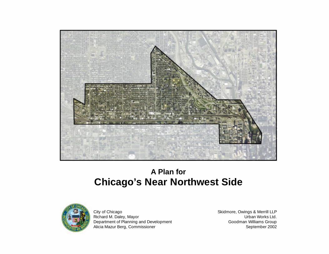
A Plan forChicago’s Near Northwest Side
City of ChicagoRichard M. Daley, MayorDepartment of Planning and DevelopmentAlicia Mazur Berg, Commissioner
Skidmore, Owings & Merrill LLPUrban Works Ltd.
Goodman Williams GroupSeptember 2002
A Plan forChicago’s Near Northwest Side
Prepared by
Skidmore, Owings & Merrill, LLP.Urban Works Ltd.
Goodman Williams Group
for
The City of ChicagoDepartment of Planning and Development
and theThe Near Northwest Side Planning Advisory Committee
September 2002
September 2002
Table of Contents
Introduction
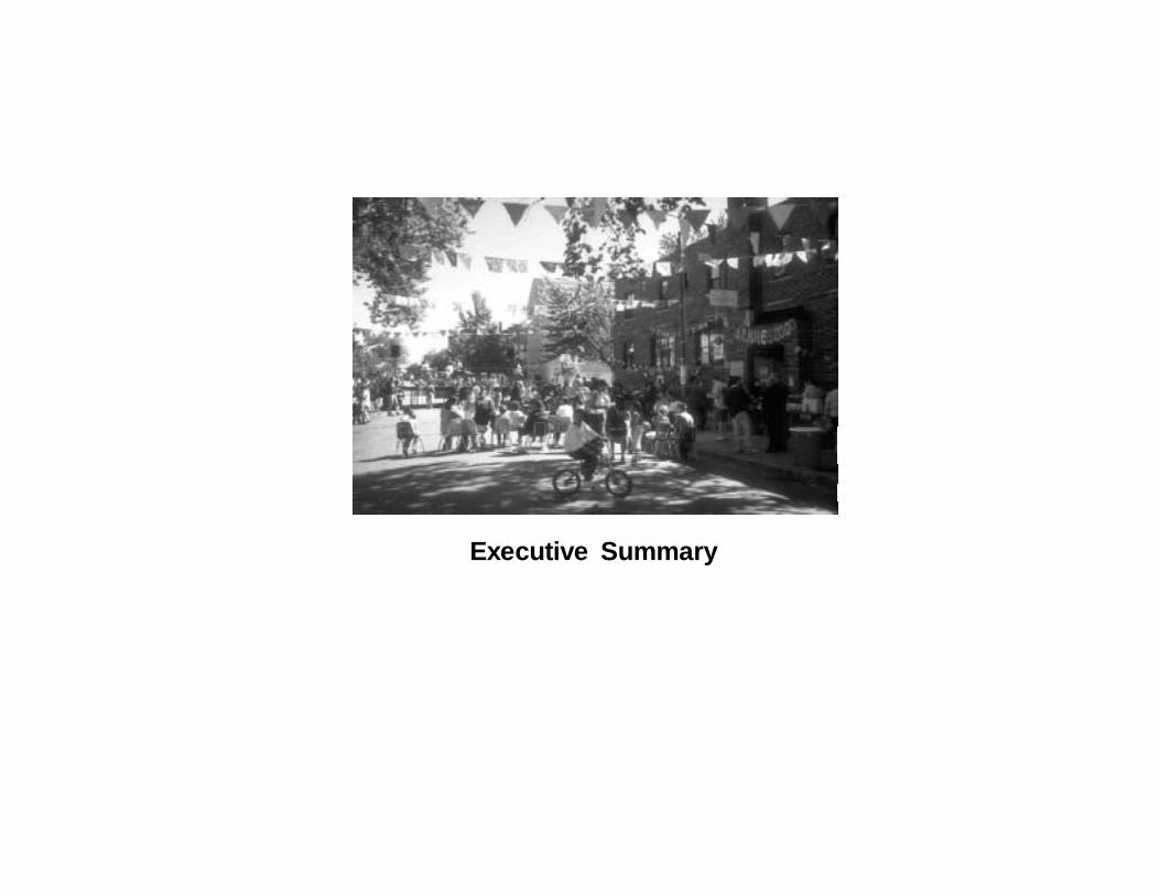
Executive Summary ES-1
1. The Context - Understanding the Community 1-1
Origins of the Near Northwest SideOpen SpaceTransit and InfrastructureDevelopment CorridorsThe Neighborhoods
2. The Plan 2-1
The VisionCompleting the Open Space NetworkPromoting a High-Quality Transit and Infrastructure SystemGuiding Development
Strengthening Neighborhood CorridorsPromoting Livable Residential Neighborhoods
3. Next Steps 3-1
Implementing the PlanFurther Planning
Public Meeting Summary
Acknowledgements
Near Northwest Side
The Near Northwest Study Area
Division
Thomas
Augusta
Iowa
Chicago
Huron
Ohio
Grand
Lake
Fulton
Randolph
Wes
tern
Leav
itt
Dam
en
Woo
d
Ash
land Ogd
enN
oble
Eliz
abet
h
Rac
ine
Abe
rdee
n
Mor
gan
Gre
en
Hal
sted
Kenn
edy
Des
Pla
ines
Jeffe
rson
Clin
ton
Can
al
Chicago-HalstedPMD
MIlwaukee
Chicago Corridor
Grand Corridor
Milwaukee Corridor
Wes
tern
Co
rrid
or
Ash
land
Co
rrid
or
Kinzie Industrial Corridor
N 0 1000’ 2000’
Chi
cago
Riv
er
Ukranian VillageNeighborhood
East VillageNeighborhood
Noble SquareNeighborhood
Eckhart ParkNeighborhood
Fulton RiverDistrict
River WestNeighborhood
Kinzie
Hubbard
Study Boundary
September 2002
September 2002
Introduction
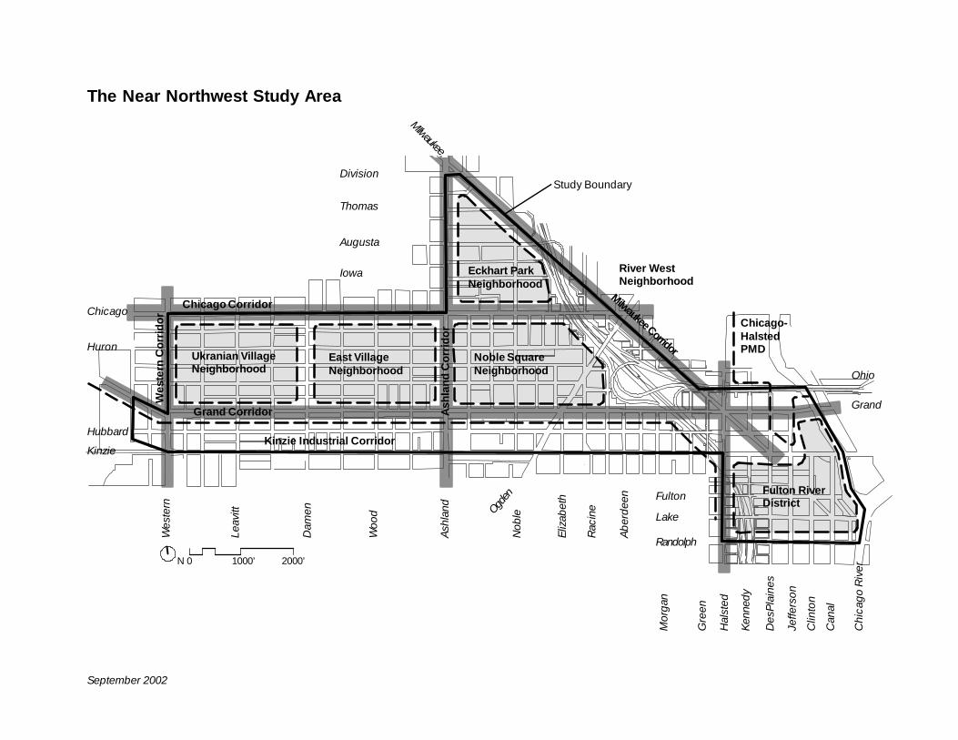
The Near Northwest Side encompasses the northwestLoop (Fulton River District), Eckhart Park, NobleSquare, East Village and Ukranian Village neighbor-hoods. The community touches the largest centralbusiness district in the Midwest to the southeast, andsome of Chicago’s most rapidly changing residentialneighborhoods to the north. The Near NorthwestSide is also home to the Kinzie Industrial Corridor andthe Chicago-Halsted Planned Manufacturing District,which includes both older, established facilities andnew high-tech operations.
The Near Northwest Side continues to evolve. Thearea includes the burgeoning residential and mixed-use Fulton River District, where residential conver-sions and new housing are being developed adjacentto industrial districts. New large retail developmentsare also being proposed. The neighborhoods in thewest are seeing new townhomes, single family homesand loft conversions join the historic housing stock.The restaurant and entertainment boom is spreadingnorth from downtown and south from Wicker Park,bringing new evening and weekend visitors to thearea.
Why the Near Northwest Side Needs a Plan
New development and growth in the Near NorthwestSide highlights a number of issues. Some representlong standing community concerns, while otherissues have been raised as a result of new develop-ment. The issues include:
• Providing more open space and recreation ameni-ties to accommodate long-time residents, newresidents and future residents
• Improving the quality and capacity of transit andtransportation infrastructure
• Guiding new development so it fits within existingneighborhoods and provides clarity to the develop-
ment community• Constructing new buildings which properly address
the street• Creating new retail and commercial uses to meet
the needs brought by new residential development.
To address these issues, the City of Chicago Depart-ment of Planning and Development initiated a processto engage community residents and leaders in thecreation of a plan.
Creating a Plan for the Near Northwest Side
The planning process began with a series of neigh-borhood bus and walking tours with communityresidents and leaders in the Spring of 2000. Issuesand opinions were discussed and local informationshared. An Advisory Committee was formed, andover the following months it worked with the City ofChicago to:
• Confirm neighborhood issues• Establish guiding principles• Develop recommendations for open space, transit
and infrastructure improvements, neighborhoodcorridors and residential districts
• Organize wider community input on the recommen-dations developed.
This document represents the culmination of thatprocess and provides a clear guide for the futuregrowth of the Near Northwest Side for residents, forthe City of Chicago, and for the developmentcommunity. This document is also intended to be aworking document over the 20 year life of the plan.Whereas, some recommendations may not come tofruition, new opportunities may arise and futurerecommendations should be reviewed within theframework of this plan.
Near Northwest Side
Executive Summary
Page ES-2 September 2002
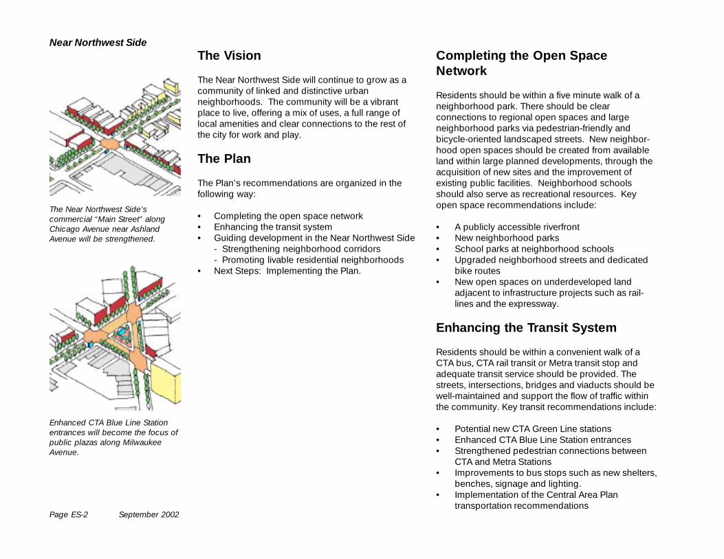
Near Northwest SideThe Vision
The Near Northwest Side will continue to grow as acommunity of linked and distinctive urbanneighborhoods. The community will be a vibrantplace to live, offering a mix of uses, a full range oflocal amenities and clear connections to the rest ofthe city for work and play.
The Plan
The Plan’s recommendations are organized in thefollowing way:
• Completing the open space network• Enhancing the transit system• Guiding development in the Near Northwest Side
- Strengthening neighborhood corridors- Promoting livable residential neighborhoods
• Next Steps: Implementing the Plan.
Completing the Open SpaceNetwork
Residents should be within a five minute walk of aneighborhood park. There should be clearconnections to regional open spaces and largeneighborhood parks via pedestrian-friendly andbicycle-oriented landscaped streets. New neighbor-hood open spaces should be created from availableland within large planned developments, through theacquisition of new sites and the improvement ofexisting public facilities. Neighborhood schoolsshould also serve as recreational resources. Keyopen space recommendations include:
• A publicly accessible riverfront• New neighborhood parks• School parks at neighborhood schools• Upgraded neighborhood streets and dedicated
bike routes• New open spaces on underdeveloped land
adjacent to infrastructure projects such as rail-lines and the expressway.
Enhancing the Transit System
Residents should be within a convenient walk of aCTA bus, CTA rail transit or Metra transit stop andadequate transit service should be provided. Thestreets, intersections, bridges and viaducts should bewell-maintained and support the flow of traffic withinthe community. Key transit recommendations include:
• Potential new CTA Green Line stations• Enhanced CTA Blue Line Station entrances• Strengthened pedestrian connections between
CTA and Metra Stations• Improvements to bus stops such as new shelters,
benches, signage and lighting.• Implementation of the Central Area Plan
transportation recommendations
The Near Northwest Side’scommercial “Main Street” alongChicago Avenue near AshlandAvenue will be strengthened.
Enhanced CTA Blue Line Stationentrances will become the focus ofpublic plazas along MilwaukeeAvenue.
September 2002 Page ES-3
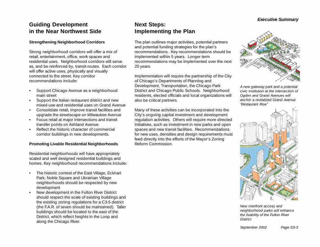
Executive SummaryNext Steps:Implementing the Plan
The plan outlines major activities, potential partnersand potential funding strategies for the plan’srecommendations. Key recommendations should beimplemented within 5 years. Longer termrecommendations may be implemented over the next20 years.
Implementation will require the partnership of the Cityof Chicago’s Departments of Planning andDevelopment, Transportation, the Chicago ParkDistrict and Chicago Public Schools. Neighborhoodresidents, elected officials and local organizations willalso be critical partners.
Many of these activities can be incorporated into theCity’s ongoing capital investment and developmentregulation activities. Others will require more directedinitiatives, such as investment in new parks and openspaces and new transit facilities. Recommendationsfor new uses, densities and design requirements mustfeed directly into the efforts of the Mayor’s ZoningReform Commission.
Guiding Developmentin the Near Northwest Side
Strengthening Neighborhood Corridors
Strong neighborhood corridors will offer a mix ofretail, entertainment, office, work spaces andresidential uses. Neighborhood corridors will serveas, and be reinforced by, transit routes. Each corridorwill offer active uses, physically and visuallyconnected to the street. Key corridorrecommendations include:
• Support Chicago Avenue as a neighborhoodmain street
• Support the Italian restaurant district and newmixed-use and residential uses on Grand Avenue
• Consolidate retail, improve transit facilities andupgrade the streetscape on Milwaukee Avenue
• Focus retail at major intersections and transittransfer points on Ashland Avenue
• Reflect the historic character of commercialcorridor buildings in new developments.
Promoting Livable Residential Neighborhoods
Residential neighborhoods will have appropriatelyscaled and well designed residential buildings andhomes. Key neighborhood recommendations include:
• The historic context of the East Village, EckhartPark, Noble Square and Ukrainian Villageneighborhoods should be respected by newdevelopment
• New development in the Fulton River Districtshould respect the scale of existing buildings andthe existing zoning regulations for a C3-5 district(the F.A.R. of seven should be maintained). Tallerbuildings should be located to the east of theDistrict, which reflect heights in the Loop andalong the Chicago River.
A new gateway park and a potentialcivic institution at the intersection ofOgden and Grand Avenues willanchor a revitalized Grand Avenue‘Restaurant Row”
New riverfront access andneighborhood parks will enhancethe livability of the Fulton RiverDistrict
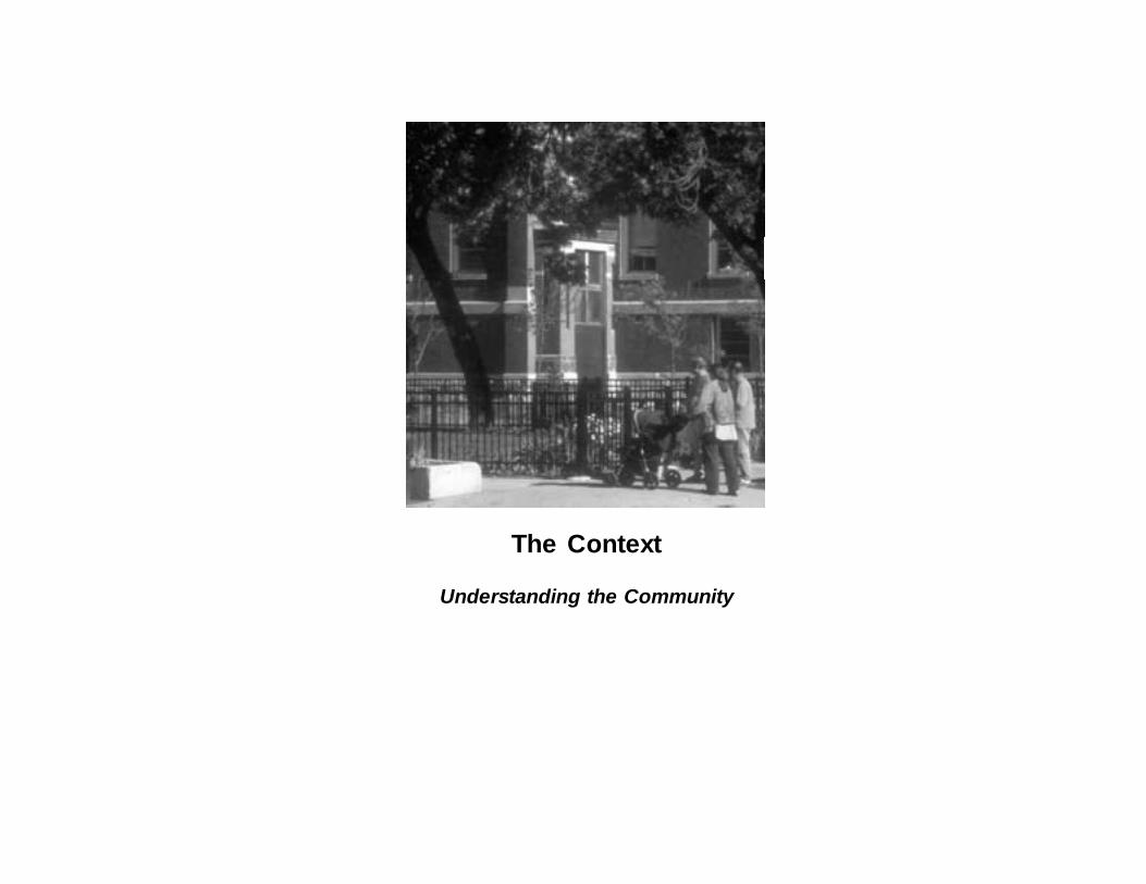
The Context
Understanding the Community
Page 1-2 September 2002
Near Northwest Side
The Fulton River District
The Fulton River District is located on the edge ofChicago’s downtown, northwest of the Loop. Thedistrict is bounded by the North Branch of the Chi-cago River, Halsted Street, Ohio Street to the northand Randolph Street to the south. JamesThompson’s original 1830 plat of Chicago wascentered on Wolf Point at the fork of the ChicagoRiver and included much of the area that is today theFulton River District. The street grid and block layoutimposed on this small area defined the pattern ofChicago’s development as the city grew.
Commerce dominated the district for much of itshistory. Lumber and grain were shipped through thedistrict, and Sears and Roebuck’s first mail orderwarehouse was located at Fulton and DesPlaines.Randolph Street became the center of wholesaleproduce distribution in the late 19th Century and wasthe site of the famous Haymarket Square labor riots of1886 on DesPlaines Street.
Historically, the district has also moved people. TheCity’s first railroad terminal was built at Kinzie andCanal in 1848. Another terminal was built a fewblocks south along the river and became UnionStation. Today, the Ogilvie Transportation Center is amajor commuter rail hub, and nearby connections tothe Kennedy Expressway make this one of the mostaccessible places in the region.
Today, the Fulton River District serves as a transitionfrom the Loop to the east to the lower density, resi-dential neighborhoods of Eckhart Park, Noble Square,East Village and Ukrainian Village, to the west. Origi-nally dominated by industry, warehousing and trans-portation, the Fulton River District is now increasinglyresidential. Low and mid-rise loft buildings are beingconverted to condominiums and apartments as wellas offices. New residential development is bringing
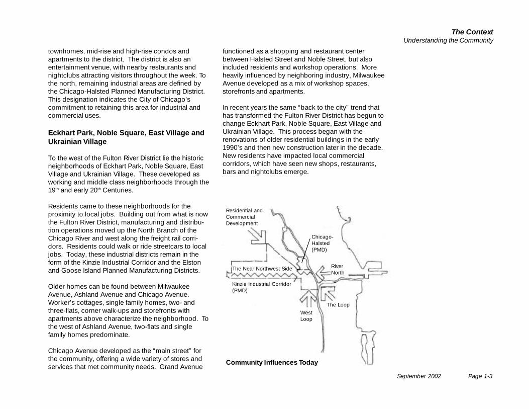
The historic core of the community developed along thestreetcar lines - the intersection of Chicago and Ashlandaround 1920.
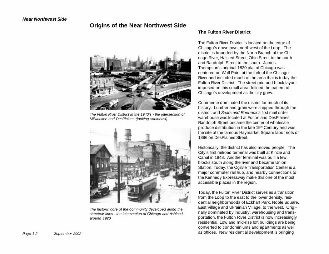
The Fulton River District in the 1940’s - the intersection ofMilwaukee and DesPlaines (looking southeast).
Origins of the Near Northwest Side
September 2002 Page 1-3
The ContextUnderstanding the Community
townhomes, mid-rise and high-rise condos andapartments to the district. The district is also anentertainment venue, with nearby restaurants andnightclubs attracting visitors throughout the week. Tothe north, remaining industrial areas are defined bythe Chicago-Halsted Planned Manufacturing District.This designation indicates the City of Chicago’scommitment to retaining this area for industrial andcommercial uses.
Eckhart Park, Noble Square, East Village andUkrainian Village
To the west of the Fulton River District lie the historicneighborhoods of Eckhart Park, Noble Square, EastVillage and Ukrainian Village. These developed asworking and middle class neighborhoods through the19th and early 20th Centuries.
Residents came to these neighborhoods for theproximity to local jobs. Building out from what is nowthe Fulton River District, manufacturing and distribu-tion operations moved up the North Branch of theChicago River and west along the freight rail corri-dors. Residents could walk or ride streetcars to localjobs. Today, these industrial districts remain in theform of the Kinzie Industrial Corridor and the Elstonand Goose Island Planned Manufacturing Districts.
Older homes can be found between MilwaukeeAvenue, Ashland Avenue and Chicago Avenue.Worker’s cottages, single family homes, two- andthree-flats, corner walk-ups and storefronts withapartments above characterize the neighborhood. Tothe west of Ashland Avenue, two-flats and singlefamily homes predominate.
Chicago Avenue developed as the “main street” forthe community, offering a wide variety of stores andservices that met community needs. Grand Avenue
functioned as a shopping and restaurant centerbetween Halsted Street and Noble Street, but alsoincluded residents and workshop operations. Moreheavily influenced by neighboring industry, MilwaukeeAvenue developed as a mix of workshop spaces,storefronts and apartments.
In recent years the same “back to the city” trend thathas transformed the Fulton River District has begun tochange Eckhart Park, Noble Square, East Village andUkrainian Village. This process began with therenovations of older residential buildings in the early1990’s and then new construction later in the decade.New residents have impacted local commercialcorridors, which have seen new shops, restaurants,bars and nightclubs emerge.
Community Influences Today
Kinzie Industrial Corridor(PMD)
The Near Northwest Side
Residential andCommercialDevelopment
The LoopWestLoop
Chicago-Halsted(PMD)
RiverNorth
Page 1-4 September 2002
Near Northwest Side
Northwestern University Settlement House on Augusta Blvd.
Goldblatt’s department store at 1613-35 W. Chicago Avenue
The Historic Character of the NearNorthwest Side
The Fulton River District and the Eckhart Park, NobleSquare, East Village and Ukrainian Villageneighborhoods have played a significant role inChicago’s social and economic development. Thishistory is reflected in the traditional pattern of itsstreets and blocks and also in its residential,commercial and institutional building stock.
The City of Chicago has designated a number ofneighborhood buildings as historic landmarksbecause of their particular importance to the life of thecity. The Chicago Landmark Commissionrecommended landmark designation for the UkrainianVillage Landmark District at its September 2002meeting.
The Northwestern Settlement House at 1400 WestAugusta was one of the first institutions established inChicago to provide the poor with educational andrecreational programs.
Chicago Commons established social programs inthe 1890’s that the organization continues to provideto this day.
Goldblatt’s department store on Chicago Avenue,built in the early 1920’s, was the first in what becamea regional chain and one of the nation’s oldest largeneighborhood department stores. It helpedrevolutionize American retailing. The building wasrenovated and the historic terra-cotta façadepreserved by the Chicago Public BuildingCommission in 1996. It is now used as departmentaloffices for the City of Chicago.

September 2002 Page 1-5
The ContextUnderstanding the Community
In addition to the neighborhood’s buildings, the NearNorthwest Side has also been the locale for historicevents.
On May 4, 1886 a decade of strife between labor andindustry culminated in a confrontation at the corner ofDesPlaines and Randolph Street that resulted in thedeath of both policemen and workers. This event isremembered across the world at May Day activities. Amemorial to the Haymarket Tragedy and the loss oflife that resulted is now planned close to the site ofthese significant events.
The historic character of these neighborhoods hasplayed a significant role in attracting new residents tothe area in recent years. Many residential buildingsoffer attractive opportunities for renovation, thelandscape character of residential streets is appealingand commercial corridors offer stores, restaurantsand transit service in close proximity to home. Thehistory of the area is a major component of the qualityof life it offers.
The City of Chicago will continue to protect andpreserve the most significant buildings and districtsthrough landmark designation.
There is a rich historic building stock throughout the NearNorthwest Side’s Neighborhoods.
Historic warehouse buildings along Randolph Street.
Page 1-6 September 2002
Near Northwest Side
Open Space
The Near Northwest Side lies between Chicago’s twomain open space resources: the lakefront and thenecklace of regional parks linked by the Boulevardsystem. The Chicago River increasingly offers publicaccess and recreational opportunities. The NearNorthwest Side itself is also home to Eckhart Park andis bounded on the west by Smith Park. Both arelarger Chicago Park District parks offering a variety ofrecreational activities, in both outdoor spaces andfield house facilities.
Regional Open SpaceStrong physical connections to the regional park system, theriver and the lakefront are lacking.
HumboldtPark
LincolnPark
GarfieldPark
DouglasPark
GrantPark
Near Northwest Side
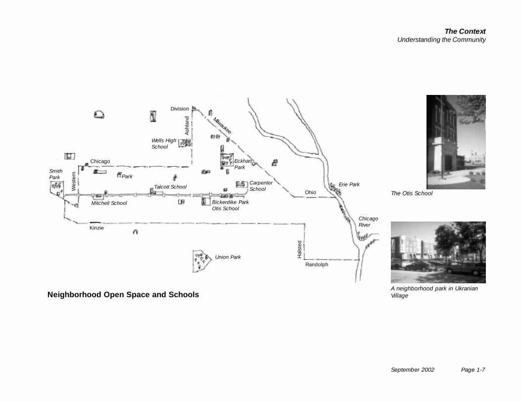
In addition, the neighborhood offers a series ofsmaller parks and school campus recreation facilitiessuch as Bickerdike Park and Talcott, Otis and Carpen-ter Elementary schools.
However, the residents have expressed concerns thatthe community lacks adequate open space and parkamenities.
• In the Fulton River District, public open space andpark amenities have not always been offered inmany of the new residential projects.
• Parks and open spaces have not yet been clearlydefined for all future developments, in anticipationof the influx of residents.
• Much of Noble Square and East Village were alsobuilt without parks or open space.
• Residents feel that the neighborhood must offermore open spaces and recreation opportunities forplay, exercise, dog walking and relaxation.
• Open spaces called for include parks offering activeand passive recreation opportunities, urban plazas,community gardens and improvements to spacesadjacent to highway, railroad or utility infrastructure.
ChicagoRiver
Community facility at Eckhart Park
Recreational facility at Smith Park
September 2002 Page 1-7
The ContextUnderstanding the Community
Bickerdike ParkOtis School
EckhartPark
Mitchell School
SmithPark
Talcott School
Park
Wells HighSchool
CarpenterSchool
Union Park
Neighborhood Open Space and Schools
Kinzie
Chicago
Division
Ohio
Randolph
Hal
sted
Ash
land
Wes
tern
Milwaukee
ChicagoRiver
The Otis School
A neighborhood park in UkranianVillage
Erie Park
Page 1-8 September 2002
Near Northwest Side
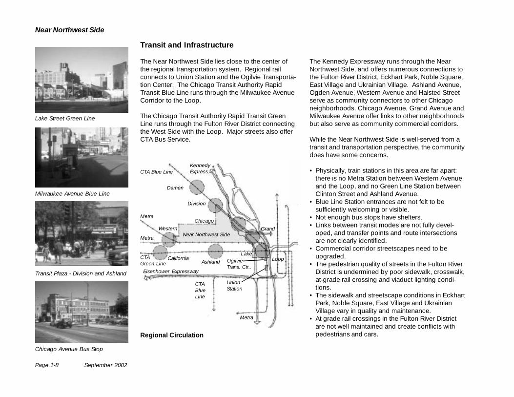
Transit and Infrastructure
The Near Northwest Side lies close to the center ofthe regional transportation system. Regional railconnects to Union Station and the Ogilvie Transporta-tion Center. The Chicago Transit Authority RapidTransit Blue Line runs through the Milwaukee AvenueCorridor to the Loop.
The Chicago Transit Authority Rapid Transit GreenLine runs through the Fulton River District connectingthe West Side with the Loop. Major streets also offerCTA Bus Service.
Regional Circulation
The Kennedy Expressway runs through the NearNorthwest Side, and offers numerous connections tothe Fulton River District, Eckhart Park, Noble Square,East Village and Ukrainian Village. Ashland Avenue,Ogden Avenue, Western Avenue and Halsted Streetserve as community connectors to other Chicagoneighborhoods. Chicago Avenue, Grand Avenue andMilwaukee Avenue offer links to other neighborhoodsbut also serve as community commercial corridors.
While the Near Northwest Side is well-served from atransit and transportation perspective, the communitydoes have some concerns.
• Physically, train stations in this area are far apart:there is no Metra Station between Western Avenueand the Loop, and no Green Line Station betweenClinton Street and Ashland Avenue.
• Blue Line Station entrances are not felt to besufficiently welcoming or visible.
• Not enough bus stops have shelters.• Links between transit modes are not fully devel-
oped, and transfer points and route intersectionsare not clearly identified.
• Commercial corridor streetscapes need to beupgraded.
• The pedestrian quality of streets in the Fulton RiverDistrict is undermined by poor sidewalk, crosswalk,at-grade rail crossing and viaduct lighting condi-tions.
• The sidewalk and streetscape conditions in EckhartPark, Noble Square, East Village and UkrainianVillage vary in quality and maintenance.
• At grade rail crossings in the Fulton River Districtare not well maintained and create conflicts withpedestrians and cars.
AshlandCalifornia
Near Northwest Side
Division
Damen
Metra
CTAGreen Line
Metra
Loop
Eisenhower Expressway
WesternChicago
Lake
Grand
KennedyExpress.
CTABlueLine
CTA Blue Line
Metra
Lake Street Green Line
Milwaukee Avenue Blue Line
Chicago Avenue Bus Stop
Transit Plaza - Division and Ashland
OgilvieTrans. Ctr..
UnionStation
September 2002 Page 1-9
The ContextUnderstanding the Community
Ohio
Division
Chicago
Grand
Wes
tern
Kinzie
Lake
Dam
en
Ash
land H
alst
ed
Clin
ton
Ogd
en
Hubbard
Ken
ned
yE
xpre
ssw
ay
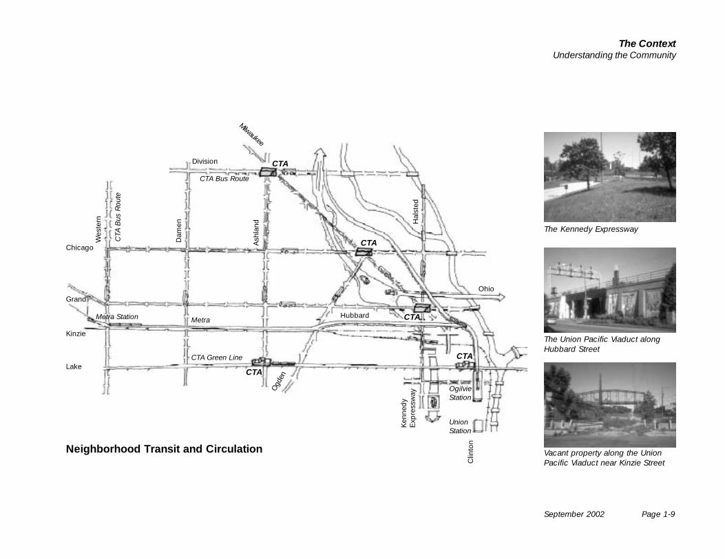
Neighborhood Transit and Circulation
CTA Bus Route
CTA
Bus
Rou
te
CTA Green Line
Metra
OgilvieStation
CTA
CTA
CTA
CTA
CTA
Milwaukee
The Kennedy Expressway
The Union Pacific Viaduct alongHubbard Street
Vacant property along the UnionPacific Viaduct near Kinzie Street
Metra Station
UnionStation
Page 1-10 September 2002
Near Northwest Side
Development Corridors
Eckhart Park, Noble Square, East Village and theUkrainian Village residential areas are organizedwithin a clear framework of development corridors.
• Chicago Avenue is the neighborhood’s main streetwith a mix of local convenience retail and services,municipal offices, Mexican restaurants, new bou-tiques and Ukrainian bakeries and restaurants. It isalso attracting new independent boutique fashionand furniture stores.
• Grand Avenue connects the West Side to down-town. It is a neighborhood retail district at the east,a residential street around Ashland Avenue and alight industrial and workshop corridor to the west.
• Milwaukee Avenue connects the Northwest Side todowntown. It is home to workshop spaces, afford-able housing, new housing development, artsspaces, renovated storefronts and convenienceretail.
• Ashland Avenue is a major arterial street, runningthrough the neighborhood to the north and southsides of the city. Retail, businesses, housing andschools line the street.
• Western Avenue is a major arterial street, runningthrough the neighborhood to the north and southsides of the city. Western Avenue has industrialbusinesses, lofts and local convenience retailers.
• Ogden Avenue is the gateway to the neighborhoodfrom the Kennedy Expressway. The boulevard alsoconnects the neighborhood to the Near West Sideand functions primarily as a community connectorrather than a major development corridor.
• Halsted Street is a major north-south arterial street.Halsted Street has industrial businesses, lofts,restaurants and local convenience retailers.
• The Kinzie Industrial Corridor continues to oper-ate as an active industrial corridor. The ten largestfirms in the corridor account for more than 2,000jobs.
Today, the Near Northwest Side is confronted with anumber of issues relating to its development corri-dors. Although there have been some recent invest-ments in new retail or residential buildings, thedevelopment corridors have yet to see the renova-tions or new development found in the residentialdistricts themselves. There are also concerns thatnew retail development will come in the form of stripmalls or other auto-oriented businesses that willdetract from the historic character of the neighbor-hood.
• Chicago Avenue has storefront and upper floorvacancies, particularly at the periphery east ofAshland Avenue and west of Damen Avenue.
• The Grand Avenue restaurant district does not haveenough city-wide and regional visibility, and thereare gaps in street level activity elsewhere.
• Milwaukee Avenue is fragmented by bridges overthe Kennedy Expressway, which runs beneath it atAugusta and the Ontario-Ohio interchange. It offershomes, work spaces, restaurants, and convenienceretail but still lacks a clear identity, or a way oforganizing development or pedestrian activity onthe street.
• Ashland Avenue has vacant storefronts, poorquality buildings and facades and poor sidewalkconditions, particularly between Grand and ChicagoAvenues.
• Ogden Avenue has vacant buildings andunderutilized land.
• Halsted Street is fragmented by bridges over theKennedy expressway and Union Pacific tracks.
• The influx of an estimated 4,000 residents into theFulton River District into a previously industrial areahas yet to bring daily convenience retail or createidentifiable commercial corridors. The increase inresidential population and the expanding office corecreate an opportunity for new retail in the district.
Milwaukee Avenue
Randolph Street
Chicago Avenue
Chicago Avenue
September 2002 Page 1-11
The ContextUnderstanding the Community
Division
Chicago
Grand
Wes
tern
Kinzie
Randolph
Dam
en
Ash
land
Hal
sted
Ogd
en
Hubbard
Milwaukee
Ohio
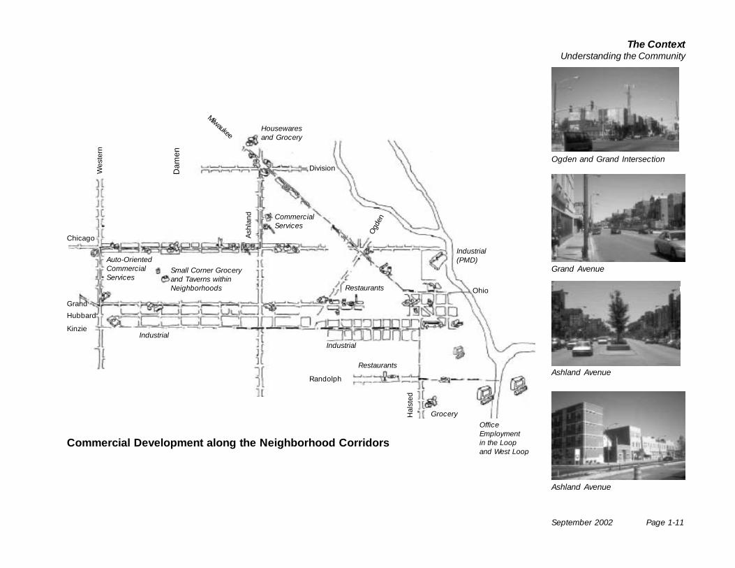
Industrial(PMD)
IndustrialIndustrial
Small Corner Groceryand Taverns withinNeighborhoods
Restaurants
OfficeEmploymentin the Loopand West Loop
Restaurants
Commercial Development along the Neighborhood Corridors
CommercialServices
Grand Avenue
Ashland Avenue
Ogden and Grand Intersection
Ashland Avenue
Auto-OrientedCommercialServices
Grocery
Housewaresand Grocery
Page 1-12 September 2002
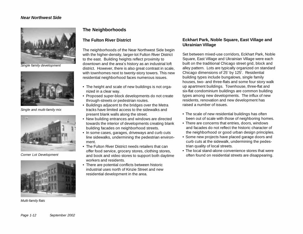
Near Northwest Side
The Neighborhoods
The Fulton River District
The neighborhoods of the Near Northwest Side beginwith the higher-density, larger-lot Fulton River Districtto the east. Building heights reflect proximity todowntown and the area’s history as an industrial loftdistrict. However, there is also great contrast in scale,with townhomes next to twenty-story towers. This newresidential neighborhood faces numerous issues.
• The height and scale of new buildings is not orga-nized in a clear way.
• Proposed super-block developments do not createthrough-streets or pedestrian routes.
• Buildings adjacent to the bridges over the Metratracks have limited access to the sidewalks andpresent blank walls along the street.
• New building entrances and windows are directedtowards the interior of developments creating blankbuilding facades on neighborhood streets.
• In some cases, garages, driveways and curb cutsline sidewalks, undermining the pedestrian environ-ment.
• The Fulton River District needs retailers that canoffer food service, grocery stores, clothing stores,and book and video stores to support both daytimeworkers and residents.
• There are potential conflicts between historicindustrial uses north of Kinzie Street and newresidential development in the area.
Eckhart Park, Noble Square, East Village andUkrainian Village
Set between mixed-use corridors, Eckhart Park, NobleSquare, East Village and Ukrainian Village were eachbuilt on the traditional Chicago street grid, block andalley pattern. Lots are typically organized on standardChicago dimensions of 25’ by 125’. Residentialbuilding types include bungalows, single familyhouses, two- and three-flats and some four story walkup apartment buildings. Townhouse, three-flat andsix-flat condominium buildings are common buildingtypes among new developments. The influx of newresidents, renovation and new development hasraised a number of issues.
• The scale of new residential buildings has oftenbeen out of scale with those of neighboring homes.
• There are concerns that entries, doors, windowsand facades do not reflect the historic character ofthe neighborhood or good urban design principles.
• Some new projects have placed garage doors andcurb cuts at the sidewalk, undermining the pedes-trian quality of local streets.
• The local stand-alone convenience stores that wereoften found on residential streets are disappearing.
Single family development
Single and multi-family mix
Corner Lot Development
Multi-family flats
September 2002 Page 1-13
The ContextUnderstanding the Community
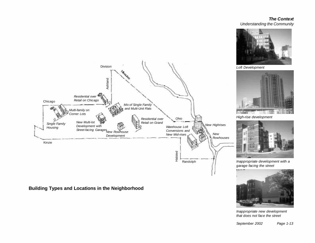
Multi-family onCorner Lots
Single FamilyHousing
New Multi-lotDevelopment withStreet-facing Garages
New RowhouseDevelopment
Residential overRetail on Grand
Mix of Single Family and Multi-Unit Flats
Residential overRetail on Chicago
Warehouse LoftConversions andNew Mid-rises New
Rowhouses
New Highrises
Ohio
Randolph
Chicago
Division
Kinzie
Ash
land
Hal
sted
Milwaukee
Building Types and Locations in the Neighborhood
Loft Development
High-rise development
Inappropriate new developmentthat does not face the street
Inappropriate development with agarage facing the street
Page 1-14 September 2002
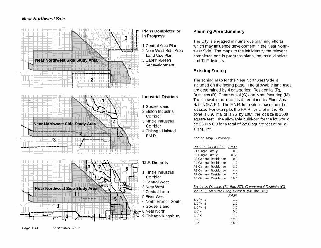
Near Northwest Side
Planning Area Summary
The City is engaged in numerous planning effortswhich may influence development in the Near North-west Side. The maps to the left identify the relevantcompleted and in-progress plans, industrial districtsand T.I.F districts.
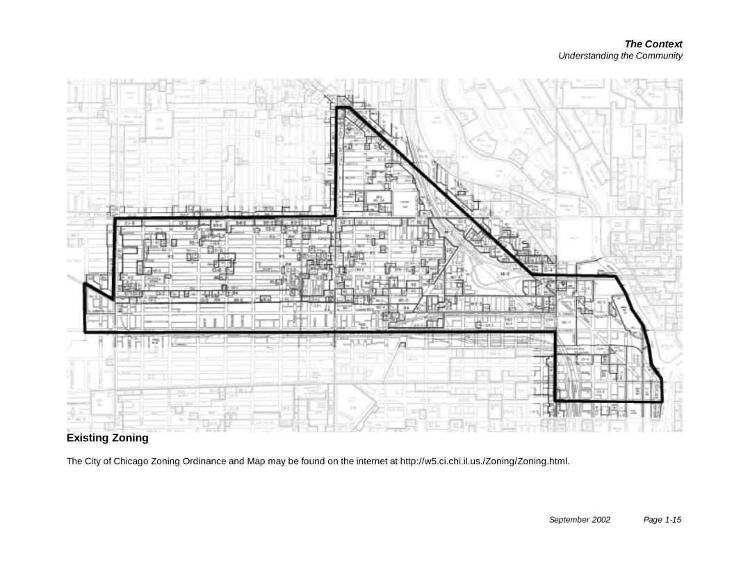
Existing Zoning
The zoning map for the Near Northwest Side isincluded on the facing page. The allowable land usesare determined by 4 categories: Residential (R),Business (B), Commercial (C) and Manufacturing (M).The allowable build-out is determined by Floor AreaRatios (F.A.R.). The F.A.R. for a site is based on thelot size. For example, the F.A.R. for a lot in the R3zone is 0.9. If a lot is 25’ by 100’, the lot size is 2500square feet. The allowable build-out for the lot wouldbe 2500 x 0.9 for a total of 2250 square feet of build-ing space.
Zoning Map Summary
Residential Districts F.A.R.R1 Single Family 0.5R2 Single Family 0.65R3 General Residence 0.9R4 General Residence 1.2R5 General Residence 2.2R6 General Residence 4.4R7 General Residence 7.0R8 General Residence 10.0
Business Districts (B1 thru B7), Commercial Districts (C1thru C5), Manufacturing Districts (M1 thru M3)
F.A.R.B/C/M -1 1.2B/C/M -2 2.2B/C/M -3 3.0B/C -4 5.0B/C -5 7.0B -6 12.0B -7 16.0
Plans Completed orin Progress
1 Central Area Plan2 Near West Side Area
Land Use Plan3 Cabrini-Green
Redevelopment
Industrial Districts
1 Goose Island2 Elston Industrial
Corridor3 Kinzie Industrial
Corridor4 Chicago-Halsted
P.M.D.
T.I.F. Districts
1 Kinzie IndustrialCorridor
2 Central West3 Near West4 Central Loop5 River West6 North Branch South7 Goose Island8 Near North9 Chicago Kingsbury
Near Northwest Side Study Area
1
2
3
1
3
2
4Near Northwest Side Study Area
Near Northwest Side Study Area
1
2 3
6
4
5
7 8
9
September 2002 Page 1-15
The ContextUnderstanding the Community
Existing Zoning
The City of Chicago Zoning Ordinance and Map may be found on the internet at http://w5.ci.chi.il.us./Zoning/Zoning.html.
The Plan
Page 2-2 September 2002
Near Northwest Side
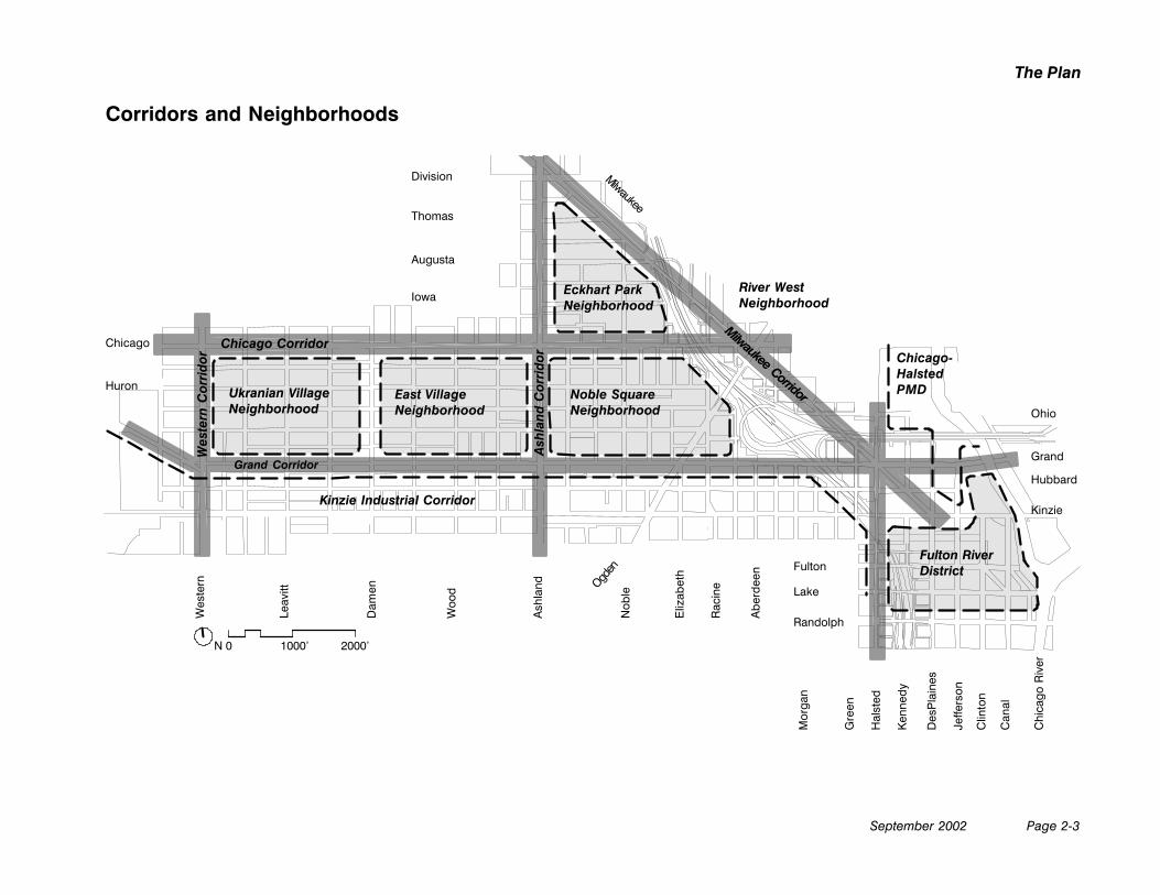
A Visionfor the Near Northwest Side
The Near Northwest Side will continue to grow as acommunity of linked and distinctive urbanneighborhoods. The community will be vibrant placeto live, offering a mix of uses, a full range of localamenities and clear connections to the rest of the cityfor work and play.
There will be clear connections to regional openspaces and large neighborhood parks via pedestrian-friendly and bicycle-oriented landscaped streets.New neighborhood open spaces will be created fromavailable land and as major new developments occur.Neighborhood schools will also serve as recreationalresources. Open lands associated with highway andrail infrastructure will be upgraded to add to thelandscape quality of the neighborhood.
The neighborhoods will be linked to each other withcorridors that offer a mix of retail, entertainment, officeand residential uses. Each corridor will offer activeuses, physically and visually connected to the street.Neighborhood corridors will serve as, and bereinforced by, transit routes. Streets will offer highquality pedestrian environments through theappropriate design of streets and the buildings thatline them. Where corridors connect, they will bemarked by high quality streetscapes, transit facilitiesand a cluster of active street-level uses.
The Fulton River District will grow into a high qualityurban neighborhood. The scale of new residentialbuildings will be greater than elsewhere on the NearNorthwest Side. With appropriate design, a mix ofuses, a high quality pedestrian environment andpublic amenities, a strong residential community willbe created.
Ukrainian Village, East Village, Eckhart Park and theNoble Square Neighborhoods will continue to bestrong residential areas, offering a mix of appropriatehousing types, high-quality housing and streetenvironments. The neighborhoods will haveappropriately scaled and well-designed residentialbuildings and homes. People will be able to see ontostreets from their homes and passers-by will be ableto see into homes, creating a visual connectionbetween them and putting “eyes on the street”. Thepreservation and renovation of historic buildings willbe encouraged. Parking access will be provided fromalleys or the rear of buildings.
Industrial corridors will remain viable places to dobusiness, whether manufacturing or for distribution ofhigh tech operations. Many neighborhood andChicago residents will continue to hold jobs in thesedistricts.
September 2002 Page 2-3
The Plan
Corridors and Neighborhoods
Division
Thomas
Augusta
Iowa
Chicago
Huron
Ohio
Grand
Hubbard
Lake
Kinzie
Fulton
Randolph
Wes
tern
Leav
itt
Dam
en
Woo
d
Ash
land Ogd
enN
oble
Eliz
abet
h
Rac
ine
Abe
rdee
n
Mor
gan
Gre
en
Hal
sted
Ken
nedy
Des
Pla
ines
Jeffe
rson
Clin
ton
Can
al
Chicago-HalstedPMD
Milwaukee
Chicago Corridor
Grand Corridor
Milwaukee Corridor
Wes
tern
Cor
rido
r
Ash
land
Cor
rido
r
Kinzie Industrial Corridor
N 0 1000’ 2000’
Ukranian VillageNeighborhood
East VillageNeighborhood
Noble SquareNeighborhood
Eckhart ParkNeighborhood
Fulton RiverDistrict
Chi
cago
Riv
er
River WestNeighborhood
Page 2-4 September 2002
Near Northwest Side
Guiding Principles
The following principles will guide the development ofopen space and recreation amenities in the NearNorthwest Side.
• Encourage an open space network in the NearNorthwest Side Neighborhood.
• Promote access to the Chicago River and theLakefront.
• Promote access to regional parks such as Smith,Humboldt and Eckhart Park.
• Encourage the use of neighborhood schools foropen space and recreation resources.
• Enhance the landscape quality of key pedestrianstreets linking neighborhood and regional openspaces.
• Encourage public parks and plazas as part of newlarger scale residential developments.
• Encourage the inclusion of landscaped privateopen spaces that are visible from streets in newresidential development projects.
• Incorporate landscaping into infrastructure such asviaducts and expressway edges and interchanges.
• Promote a diversity of open spaces for adults,children and their pets.
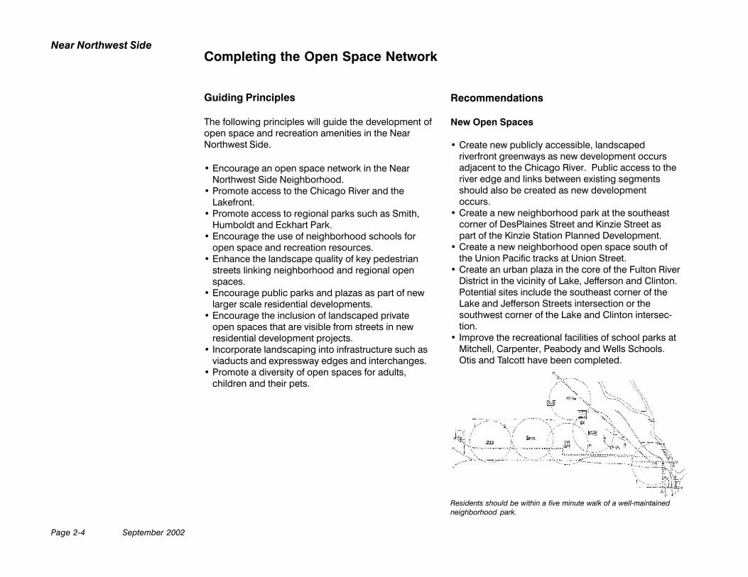
Residents should be within a five minute walk of a well-maintainedneighborhood park.
Recommendations
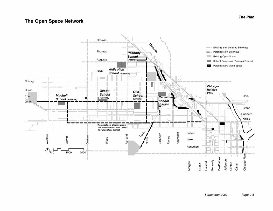
New Open Spaces
• Create new publicly accessible, landscapedriverfront greenways as new development occursadjacent to the Chicago River. Public access to theriver edge and links between existing segmentsshould also be created as new developmentoccurs.
• Create a new neighborhood park at the southeastcorner of DesPlaines Street and Kinzie Street aspart of the Kinzie Station Planned Development.
• Create a new neighborhood open space south ofthe Union Pacific tracks at Union Street.
• Create an urban plaza in the core of the Fulton RiverDistrict in the vicinity of Lake, Jefferson and Clinton.Potential sites include the southeast corner of theLake and Jefferson Streets intersection or thesouthwest corner of the Lake and Clinton intersec-tion.
• Improve the recreational facilities of school parks atMitchell, Carpenter, Peabody and Wells Schools.Otis and Talcott have been completed.
Completing the Open Space Network
September 2002 Page 2-5
The PlanThe Open Space Network
Division
Thomas
Augusta
Iowa
Chicago
Huron
Erie
Ohio
Ohio
Grand
Hubbard
Lake
Kinzie
Fulton
Randolph
Wes
tern
Leav
itt
Dam
en
Woo
d
Ash
land Ogd
enN
oble
Eliz
abet
h
Rac
ine
Abe
rdee
n
Mor
gan
Gre
en
Hal
sted
Ken
nedy
Des
Pla
ines
Jeffe
rson
Clin
ton
Can
al
Milwaukee
N 0 1000’ 2000’
Existing and Identified Bikeways
Potential New Bikeways
Existing Open Space
School Campuses (Existing & Potential)
Potential New Open Space
MitchellSchool (Potential)
TalcottSchool(Existing)
OtisSchool(Existing) Carpenter
School(Potential)
PeabodySchool(Potential)
Wells HighSchool (Potential)
Chi
cago
Riv
er
Chicago-HalstedPMD
Potential new bikeway alongthe Kinzie viaduct from Leavittto Fulton River District
Page 2-6 September 2002
Near Northwest Side
New open spaces (continued)
• Encourage a new gateway park on the vacant landat the northwest corner of Ogden Avenue andGrand Avenue.
• Encourage a new park at the southwest corner ofErie Street and Damen Avenue.
• Promote new open spaces on underdeveloped orremnant land adjacent to the Kennedy Expresswayand the Ohio Feeder between Augusta and Grand.Potential improvements include dog-walking spacesand a sculpture garden adjacent to Grand Avenue.
• While Commercial Park lies just beyond the studyarea, consideration should be given to enlarge thepark at Rice and Wolcott so the park has directfrontage on Chicago Avenue.
• Create a new pedestrian and bicycle open spaceconnection on the rail right-of-way along KinzieStreet, linking Leavitt Street to the Fulton RiverDistrict.
Access to Regional Open Spaces
• Maximize the visibility of designated and proposedbikeways on Grand Avenue, Hubbard Street,Milwaukee Avenue and Kinzie Street with bike lanestriping, signage, lighting and landscaping.
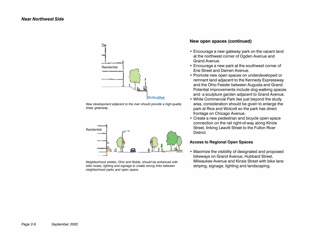
New development adjacent to the river should provide a high-qualitylinear greenway.
Residential
Residential
Neighborhood streets, Ohio and Noble, should be enhanced withbike routes, lighting and signage to create strong links betweenneighborhood parks and open space.
September 2002 Page 2-7
The Plan
• Upgrade the landscape character of Noble Streetand Ohio Street to create strong pedestrian andbicycle links between neighborhood parks andopen spaces.
• Add directional signage to street connections to theChicago River and the lakefront from the NearNorthwest Side.
• Slow traffic at neighborhood schools.
Private Open Space in New Development
• Chicago has a strong tradition of front yards andcourtyard entries to residences that are private, yetstill contribute to the landscape quality of neighbor-hood streets. Ensure that private open spaces thatare created in new developments, such as land-scaped entries and courtyards, are visible from localstreets.
• Private landscaping such as trees, shrubs, andflowers adjacent to and visible from neighborhoodstreets is encouraged. Also, the inclusion of groundcover and shade trees can help minimize the urbanheat-island effect.
• Maximize landscape opportunities in private devel-opments. Encourage the use of green roofs forprivate open space.
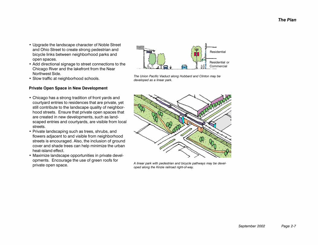
The Union Pacific Viaduct along Hubbard and Clinton may bedeveloped as a linear park.
Residential
Residential orCommercial
A linear park with pedestrian and bicycle pathways may be devel-oped along the Kinzie railroad right-of-way.
Page 2-8 September 2002
Near Northwest Side
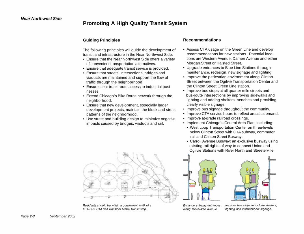
Guiding Principles
The following principles will guide the development oftransit and infrastructure in the Near Northwest Side.• Ensure that the Near Northwest Side offers a variety
of convenient transportation alternatives.• Ensure that adequate transit service is provided.• Ensure that streets, intersections, bridges and
viaducts are maintained and support the flow oftraffic through the neighborhood.
• Ensure clear truck route access to industrial busi-nesses.
• Extend Chicago’s Bike Route network through theneighborhood.
• Ensure that new development, especially largerdevelopment projects, maintain the block and streetpatterns of the neighborhood.
• Use street and building design to minimize negativeimpacts caused by bridges, viaducts and rail.
Residents should be within a convenient walk of aCTA Bus, CTA Rail Transit or Metra Transit stop.
Enhance subway entrancesalong Milwaukee Avenue.
Improve bus stops to include shelters,lighting and informational signage.
Promoting A High Quality Transit System
Recommendations
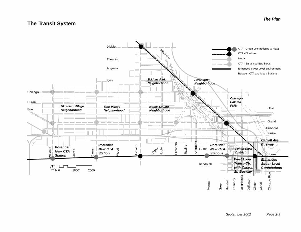
• Assess CTA usage on the Green Line and developrecommendations for new stations. Potential loca-tions are Western Avenue, Damen Avenue and eitherMorgan Street or Halsted Street.
• Upgrade entrances to Blue Line Stations throughmaintenance, redesign, new signage and lighting.
• Improve the pedestrian environment along ClintonStreet between the Ogilvie Transportation Center andthe Clinton Street Green Line station.
• Improve bus stops at all quarter mile streets and bus-route intersections by improving sidewalks and
lighting and adding shelters, benches and providingclearly visible signage.
• Improve bus signage throughout the community.• Improve CTA service hours to reflect areas’s demand.• Improve at-grade railroad crossings.• Implement Chicago’s Central Area Plan, including:
• West Loop Transportation Center on three-levels below Clinton Street with CTA subway, commuter
rail and Clinton Street Busway.• Carroll Avenue Busway: an exclusive busway using
existing rail rights-of-way to connect Union and Ogilvie Stations with River North and Streeterville.
September 2002 Page 2-9
The PlanThe Transit System
Division
Thomas
Augusta
Iowa
Chicago
Huron
Erie Ohio
Grand
Hubbard
Lake
Kinzie
Fulton
Randolph
Wes
tern
Leav
itt
Dam
en
Woo
d
Ash
land
Ogden
Nob
le
Eliz
abet
h
Rac
ine
Ab
erd
een
Mor
gan
Gre
en
Hal
sted
Ken
ned
y
Des
Pla
ines
Jeffe
rson
Clin
ton
Can
al
Milwaukee
N 0 1000’ 2000’
CTA - Green Line (Existing & New)
CTA - Blue Line
Metra
CTA - Enhanced Bus Stops
Enhanced Street Level Environment
Between CTA and Metra Stations
PotentialNew CTAStation
PotentialNew CTAStations
Ukranian VillageNeighborhood
East VillageNeighborhood
Noble SquareNeighborhood
Eckhart ParkNeighborhood
Fulton RiverDistrict
Chi
cago
Riv
er
Chicago-HalstedPMD
PotentialNew CTAStation
EnhancedStreet LevelConnections
River WestNeighborhood
Carroll Ave.Busway
West LoopTransp.Ctr.with ClintonSt. Busway
Page 2-10 September 2002
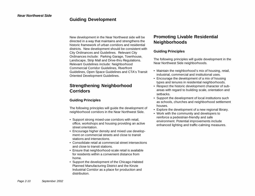
Near Northwest SideGuiding Development
New development in the Near Northwest side will bedirected in a way that maintains and strengthens thehistoric framework of urban corridors and residentialdistricts. New development should be consistent withCity Ordinances and Guidelines. Relevant CityOrdinances include: Parking Garage, Townhouse,Landscape, Strip Mall and Drive-thru Regulations.Relevant Guidelines include: NeighborhoodCommercial Corridor Guidelines, RiverfrontGuidelines, Open Space Guidelines and CTA’s TransitOriented Development Guidelines.
Strengthening NeighborhoodCorridors
Guiding Principles
The following principles will guide the development ofneighborhood corridors in the Near Northwest Side.
• Support strong mixed-use corridors with retail,office, workshops and housing providing an activestreet orientation.
• Encourage higher density and mixed use develop-ment on commercial streets and close to transitstations and intersections.
• Consolidate retail at commercial street intersectionsand close to transit stations.
• Ensure that neighborhood-scale retail is availablefor residents within a convenient distance fromhome.
• Support the development of the Chicago-HalstedPlanned Manufacturing District and the KinzieIndustrial Corridor as a place for production anddistribution.
Promoting Livable ResidentialNeighborhoods
Guiding Principles
The following principles will guide development in theNear Northwest Side neighborhoods.
• Maintain the neighborhood’s mix of housing, retail,industrial, commercial and institutional uses.
• Encourage the development of a mix of housingtypes and tenures in residential neighborhoods.
• Respect the historic development character of sub-areas with regard to building scale, orientation andsetbacks.
• Support the development of local institutions suchas schools, churches and neighborhood settlementhouses.
• Explore the development of a new regional library.• Work with the community and developers to
reinforce a pedestrian-friendly and safeenvironment. Potential improvements includeenhanced lighting and traffic-calming measures.
September 2002 Page 2-11
The Plan
Division
Thomas
Augusta
Iowa
Chicago
Huron
Erie Ohio
Grand
Hubbard
Lake
Kinzie
Fulton
Randolph
Wes
tern
Leav
itt
Dam
en
Woo
d
Ash
land Ogd
enN
oble
Eliz
abet
h
Rac
ine
Ab
erd
een
Mor
gan
Gre
en
Hal
sted
Ken
ned
y
Des
Pla
ines
Jeffe
rson
Clin
ton
Can
al
Milwaukee
N 0 1000’ 2000’
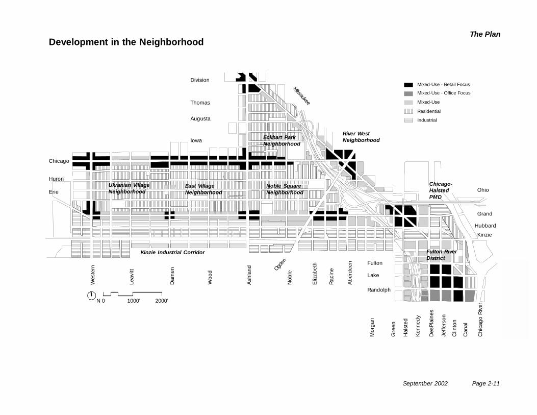
Mixed-Use - Retail Focus
Mixed-Use - Office Focus
Mixed-Use
Residential
Industrial
Development in the Neighborhood
Ukranian VillageNeighborhood
East VillageNeighborhood
Noble SquareNeighborhood
Eckhart ParkNeighborhood
Fulton RiverDistrict
Chicago-HalstedPMD
Kinzie Industrial Corridor
Chi
cago
Riv
er
River WestNeighborhood
Page 2-12 September 2002
Near Northwest Side
Residential
Residential
ResidentialOffice orHome-Office*
ResidentialResidential
Industrial
Community Commercial - Chicago Avenue, Grand Avenue
Community Connector - Ashland Avenue, Ogden Avenue Neighborhood Connectors - Ohio Street, Noble Street
Retail RetailIndustrial
Community Connector - Western Avenue
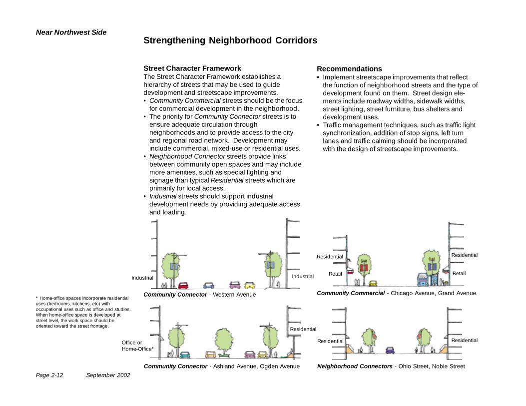
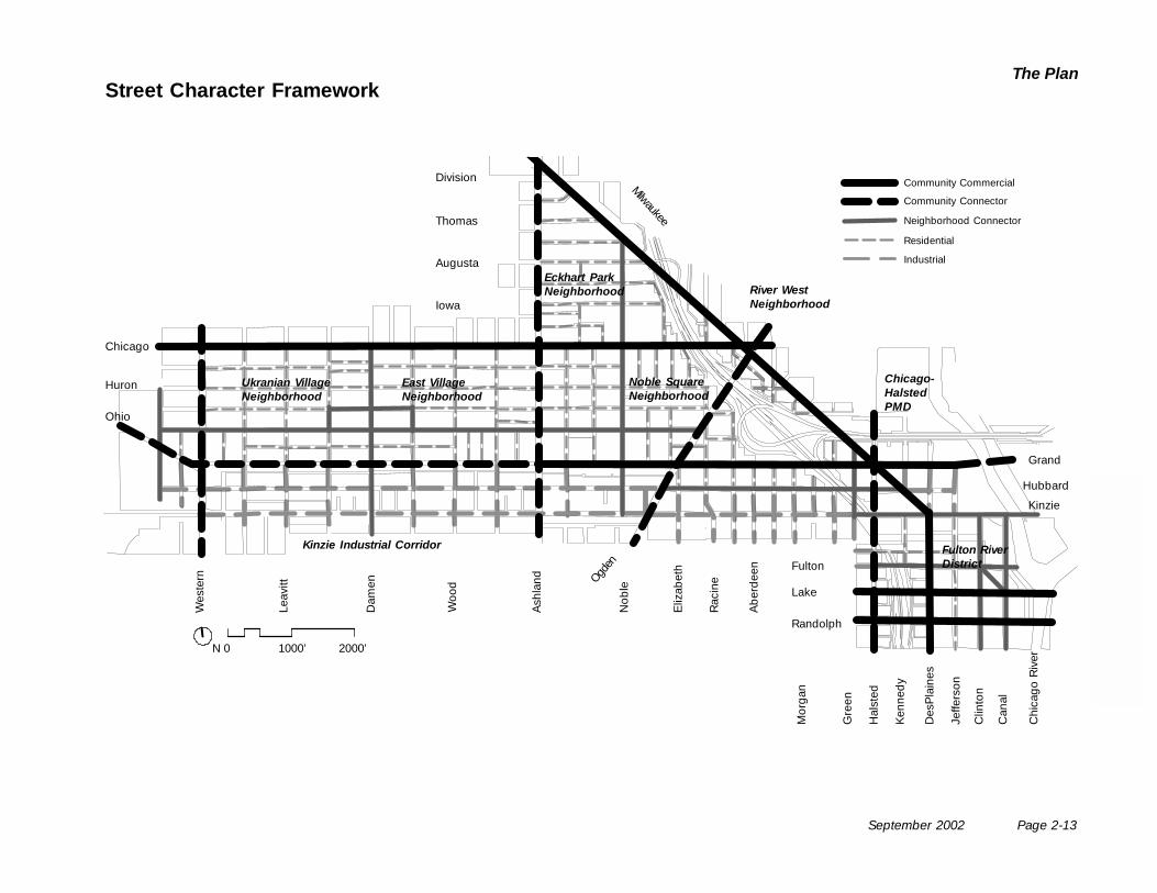
Street Character FrameworkThe Street Character Framework establishes ahierarchy of streets that may be used to guidedevelopment and streetscape improvements.• Community Commercial streets should be the focus
for commercial development in the neighborhood.• The priority for Community Connector streets is to
ensure adequate circulation throughneighborhoods and to provide access to the cityand regional road network. Development mayinclude commercial, mixed-use or residential uses.
• Neighborhood Connector streets provide linksbetween community open spaces and may includemore amenities, such as special lighting andsignage than typical Residential streets which areprimarily for local access.
• Industrial streets should support industrialdevelopment needs by providing adequate accessand loading.
Recommendations• Implement streetscape improvements that reflect
the function of neighborhood streets and the type ofdevelopment found on them. Street design ele-ments include roadway widths, sidewalk widths,street lighting, street furniture, bus shelters anddevelopment uses.
• Traffic management techniques, such as traffic lightsynchronization, addition of stop signs, left turnlanes and traffic calming should be incorporatedwith the design of streetscape improvements.
* Home-office spaces incorporate residentialuses (bedrooms, kitchens, etc) withoccupational uses such as office and studios.When home-office space is developed atstreet level, the work space should beoriented toward the street frontage.
Strengthening Neighborhood Corridors
September 2002 Page 2-13
The Plan
Division
Thomas
Augusta
Iowa
Chicago
Huron
Ohio
Grand
Hubbard
Lake
Kinzie
Fulton
Randolph
Wes
tern
Leav
itt
Dam
en
Woo
d
Ash
land Ogd
enN
oble
Eliz
abet
h
Rac
ine
Ab
erd
een
Mor
gan
Gre
en
Hal
sted
Ken
ned
y
Des
Pla
ines
Jeffe
rson
Clin
ton
Can
al
Milwaukee
N 0 1000’ 2000’
Community Commercial
Community Connector
Neighborhood Connector
Residential
Industrial
Street Character Framework
Ukranian VillageNeighborhood
East VillageNeighborhood
Noble SquareNeighborhood
Eckhart ParkNeighborhood
Fulton RiverDistrict
Kinzie Industrial Corridor
Chi
cago
Riv
er
Chicago-HalstedPMD
River WestNeighborhood
Page 2-14 September 2002
Near Northwest Side
Western
Damen
Ashland
Chicago
Chicago Avenue streetscapeenhancements include improvedsidewalks, lighting and busshelters at intersections of busroutes.
Renovate upper floors forresidential or home-office spacealong Chicago Avenue
Mixed-use infill at Chicagoand Western Avenue
Residential and home-office infilland conversion along AshlandAvenue
Enhance streetscape atstrengthened neighborhoodretail core
Improve sidewalks andlighting on Ashland
Chicago Avenue RevitalizationThe Neighborhood’s Main Street
Recommendations• Support Chicago Avenue as the neighborhood
main street, with a variety of goods and services.• Renovate and convert vacant storefronts and upper
floors of buildings to residential, workshop, office orother uses at the east and west edges of ChicagoAvenue.
• Use streetscaping to identify and promote theintersection of Chicago and Ashland as the centerof the retail strip.
• Enhance bus stops at all quarter mile streets.• Study and implement methods for alleviating traffic
and parking congestion.
Chicago
Potential Streetscape Enhancements at Intersections
Potentiallandscapeimprovementsalong AshlandAvenue
Bus stop improvements may include curbextensions, new bus shelters, benches,improved lighting and signage. Privatedevelopment adjacent to bus stops mayalso provide amenities such as awningsand lighting.
Ash
land
Ave
nue
ChicagoAvenue
September 2002 Page 2-15
The Plan
Division
Ashland
Milw
aukee
Milw
aukeeChicago
Ogden
Milw
aukee
Grand
Halsted
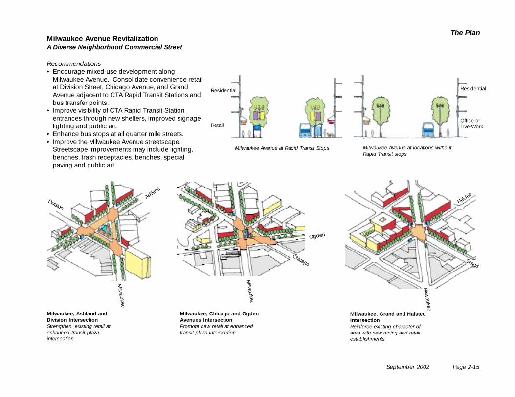
Milwaukee, Ashland andDivision IntersectionStrengthen existing retail atenhanced transit plazaintersection
Milwaukee, Chicago and OgdenAvenues IntersectionPromote new retail at enhancedtransit plaza intersection
Milwaukee, Grand and HalstedIntersectionReinforce existing character ofarea with new dining and retailestablishments.
Milwaukee Avenue RevitalizationA Diverse Neighborhood Commercial Street
Recommendations• Encourage mixed-use development along
Milwaukee Avenue. Consolidate convenience retailat Division Street, Chicago Avenue, and GrandAvenue adjacent to CTA Rapid Transit Stations andbus transfer points.
• Improve visibility of CTA Rapid Transit Stationentrances through new shelters, improved signage,lighting and public art.
• Enhance bus stops at all quarter mile streets.• Improve the Milwaukee Avenue streetscape.
Streetscape improvements may include lighting,benches, trash receptacles, benches, specialpaving and public art.
Milwaukee Avenue at Rapid Transit Stops Milwaukee Avenue at locations withoutRapid Transit stops
Residential
Retail
Residential
Office orLive-Work
Page 2-16 September 2002
Near Northwest Side
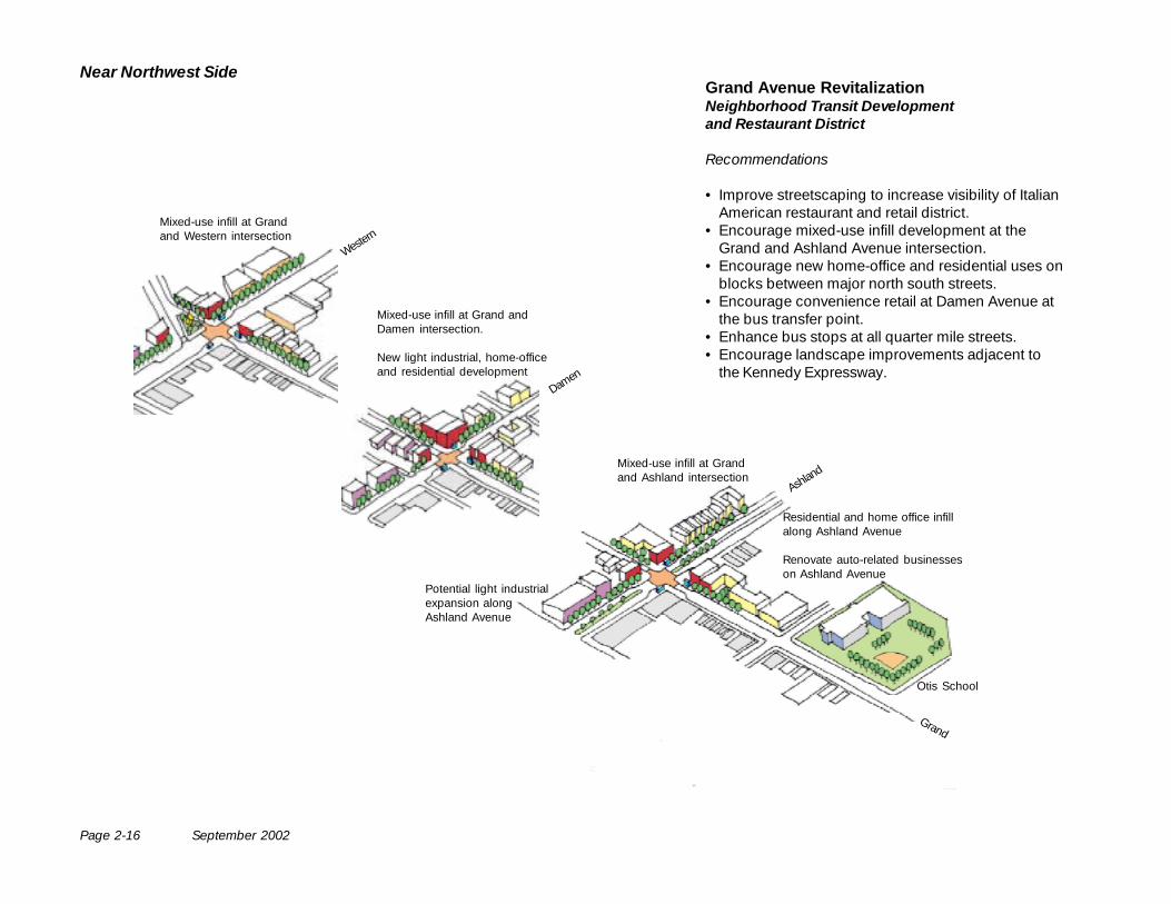
Grand
Western
Damen
Ashland
Mixed-use infill at Grandand Western intersection
Mixed-use infill at Grand andDamen intersection.
New light industrial, home-officeand residential development
Mixed-use infill at Grandand Ashland intersection
Potential light industrialexpansion alongAshland Avenue
Otis School
Residential and home office infillalong Ashland Avenue
Renovate auto-related businesseson Ashland Avenue
Grand Avenue RevitalizationNeighborhood Transit Developmentand Restaurant District
Recommendations
• Improve streetscaping to increase visibility of ItalianAmerican restaurant and retail district.
• Encourage mixed-use infill development at theGrand and Ashland Avenue intersection.
• Encourage new home-office and residential uses onblocks between major north south streets.
• Encourage convenience retail at Damen Avenue atthe bus transfer point.
• Enhance bus stops at all quarter mile streets.• Encourage landscape improvements adjacent to
the Kennedy Expressway.
September 2002 Page 2-17
The Plan
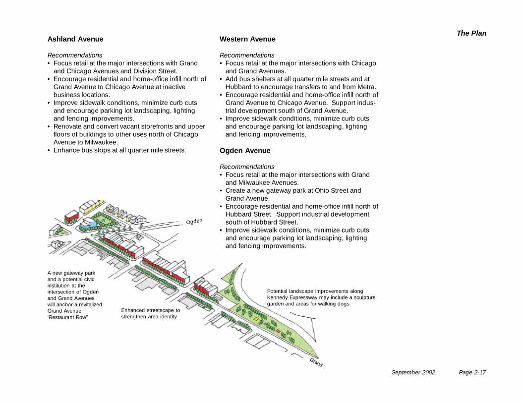
Ogden
Enhanced streetscape tostrengthen area identity
Potential landscape improvements alongKennedy Expressway may include a sculpturegarden and areas for walking dogs
Ashland Avenue
Recommendations• Focus retail at the major intersections with Grand
and Chicago Avenues and Division Street.• Encourage residential and home-office infill north of
Grand Avenue to Chicago Avenue at inactivebusiness locations.
• Improve sidewalk conditions, minimize curb cutsand encourage parking lot landscaping, lightingand fencing improvements.
• Renovate and convert vacant storefronts and upperfloors of buildings to other uses north of ChicagoAvenue to Milwaukee.
• Enhance bus stops at all quarter mile streets.
Grand
Western Avenue
Recommendations• Focus retail at the major intersections with Chicago
and Grand Avenues.• Add bus shelters at all quarter mile streets and at
Hubbard to encourage transfers to and from Metra.• Encourage residential and home-office infill north of
Grand Avenue to Chicago Avenue. Support indus-trial development south of Grand Avenue.
• Improve sidewalk conditions, minimize curb cutsand encourage parking lot landscaping, lightingand fencing improvements.
Ogden Avenue
Recommendations• Focus retail at the major intersections with Grand
and Milwaukee Avenues.• Create a new gateway park at Ohio Street and
Grand Avenue.• Encourage residential and home-office infill north of
Hubbard Street. Support industrial developmentsouth of Hubbard Street.
• Improve sidewalk conditions, minimize curb cutsand encourage parking lot landscaping, lightingand fencing improvements.
A new gateway parkand a potential civicinstitution at theintersection of Ogdenand Grand Avenueswill anchor a revitalizedGrand Avenue‘Restaurant Row”
Page 2-18 September 2002
Near Northwest Side
Design Recommendations
Reflecting the ContextNew infill development and building renovationsshould be of high architectural quality and be sensi-tive to the historic context in which it is occuring. Newbuildings should reflect the scale, orientation andcharacter of existing surrounding buildings on thestreet. By following some simple guidelines, newbuildings can become vibrant, contemporary addi-tions to commercial corridors, while reflecting thepositive qualities so valued by earlier generations.
Uses along Commercial CorridorsCommercial corridor buildings may have retailing,restaurant, office, workshop or residential uses. It islikely that many buildings will have a mix of uses, withresidential on upper floors. Regardless of the overalluse, the ground floor should always have active usesfronting the street.
Building setbacksBuildings should be built to the property line or reflectthe typical setback established for the block as awhole. Most buildings on local corridors are built tothe property line. However, some residential buildingsare set back five or ten feet. Where new residentialbuildings are constructed, they may follow this patternif they neighbor such historic examples. Retail andoffice buildings should be built to the property line.If there is an existing streetwall along the block, itshould be maintained, avoiding upper floor setbacks.
Strengthening Neighborhood Corridors
Ground Floor Flexibility and TransparencyMany corridor buildings have been homes, storefrontsor workshops over the course of their life. To allow forfuture adaptation in case of the change of uses, theground floor of new mixed use buildings should bedesigned to allow the conversion from retail or officeto residential and vice versa. Ground level floor-to-ceiling heights should be a minimum of 14 feet. Theground floor facades should be transparent along thecommercial corridors regardless of use.
Parking and Service AccessParking and service access should be at the rear ofbuildings off the alley and should not front commer-cial corridors. Access from secondary streets may beconsidered, where no alley exists. If interior parking isrequired, it should be recessed to allow active uses atthe ground floor facing the commercial corridor.
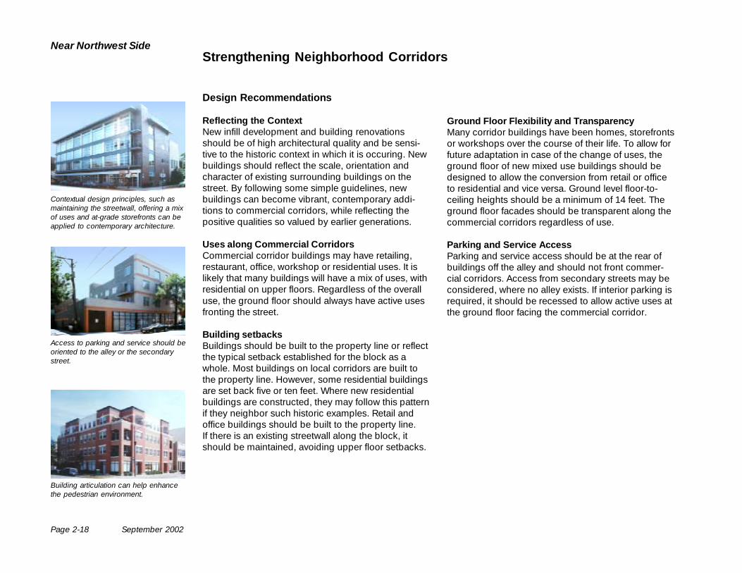
Contextual design principles, such asmaintaining the streetwall, offering a mixof uses and at-grade storefronts can beapplied to contemporary architecture.
Access to parking and service should beoriented to the alley or the secondarystreet.
Building articulation can help enhancethe pedestrian environment.
September 2002 Page 2-19
The Plan
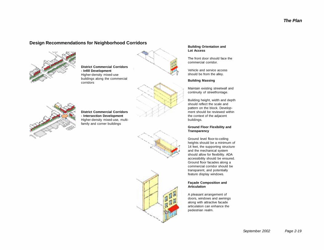
District Commercial Corridors- Infill DevelopmentHigher-density mixed-usebuildings along the commercialcorridors
Façade Composition andArticulation
A pleasant arrangement ofdoors, windows and awningsalong with attractive facadearticulation can enhance thepedestrian realm.
Building Orientation andLot Access
The front door should face thecommercial corridor.
Vehicle and service accessshould be from the alley.
Building Massing
Maintain existing streetwall andcontinuity of streetfrontage.
Building height, width and depthshould reflect the scale andpattern on the block. Develop-ment should be reviewed withinthe context of the adjacentbuildings.
District Commercial Corridors- Intersection DevelopmentHigher-density mixed-use, multi-family and corner buildings
Ground Floor Flexibility andTransparency
Ground level floor-to-ceilingheights should be a minimum of14 feet, the supporting structureand the mechanical systemshould allow for flexibility. ADAaccessibility should be ensured.Ground floor facades along acommercial corridor should betransparent, and potentiallyfeature display windows.
Design Recommendations for Neighborhood Corridors
Page 2-20 September 2002
Near Northwest Side
Recommendations
Building Orientation and Lot Access• The front door or main entry to all residential
buildings should face the street.• Parking should be accessed from the alley.• Surface-parking lots, garages and corresponding
curb cuts along public streets are discouraged.• Parking and trash receptacles should be located at
the rear of properties, preferably along alleyways,and shielded from view with landscaping or fencing.
• Loading facilities should also be designed for rear,alley access.
Scale and Massing of New Development• Development should respect the scale of the
adjacent properties.• Development should maintain the existing streetwall
and building setback along the street.• The Fulton River District generally consists of low
and mid-rise (four to twelve story) masonry ware-house buildings from the late 19th and early 20th
Century. New development in the Fulton Riverneighborhood should be respect the scale of theexisting buildings. The existing zoning regulationsfor a C3-5 district and a F.A.R. of seven should bemaintained. Scale will vary among developments,and taller buildings are appropriate within the FultonRiver District especially along the Chicago River andadjacent to transit where higher density develop-ment is appropriate. Mid-rise buildings in the FultonRiver District should be built to the property line tomaintain the area’s historic street walls.
• Development should respect the historic scale ofthe Eckhart Park, Noble Square, East Village andUkrainian Village by building single family, two andthree flat buildings. Larger buildings are appropri-ate at corners, but they may not exceed the heightlimits recently adopted for R-3, R-4 and R-5 districts.
• Development along the corridors may not exceedthe height limits recently adopted for B-1, B-2, B-3,C-1, C-2 and C-3 zones.
• Front and side setback for bungalows, single familyhomes, townhomes, two-flat and three-flat buildingsshould reflect the typical setback alignments for theblocks on which they are located.
Façade Composition and Articulation• Façade composition and building articulation
should reflect its specific block and site context.• Exterior street level features such as entrances,
windows, awnings and architectural ornamentationshould be included and scaled appropriately to thepedestrian environment. Visible blank walls arediscouraged.
• Porches, bay windows and corner windows are allencouraged.
Promoting Livable Residential Neighborhoods
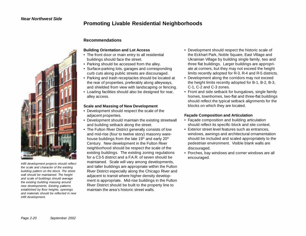
Infill development projects should reflectthe scale and character of the existingbuilding pattern on the block. The streetwall should be maintained. The heightand scale of buildings should averagethe existing building massing aroundnew developments. Existing patternsestablished by floor heights, openingsand materials should be reflected in newinfill development.
September 2002 Page 2-21
The Plan
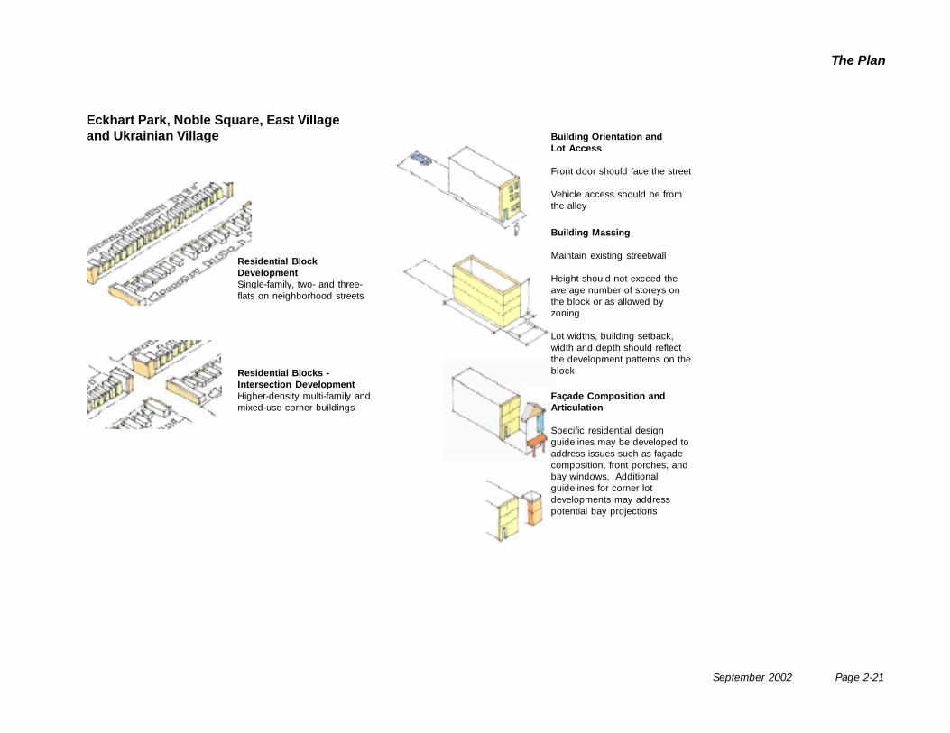
Residential BlockDevelopmentSingle-family, two- and three-flats on neighborhood streets
Residential Blocks -Intersection DevelopmentHigher-density multi-family andmixed-use corner buildings
Façade Composition andArticulation
Specific residential designguidelines may be developed toaddress issues such as façadecomposition, front porches, andbay windows. Additionalguidelines for corner lotdevelopments may addresspotential bay projections
Building Orientation andLot Access
Front door should face the street
Vehicle access should be fromthe alley
Building Massing
Maintain existing streetwall
Height should not exceed theaverage number of storeys onthe block or as allowed byzoning
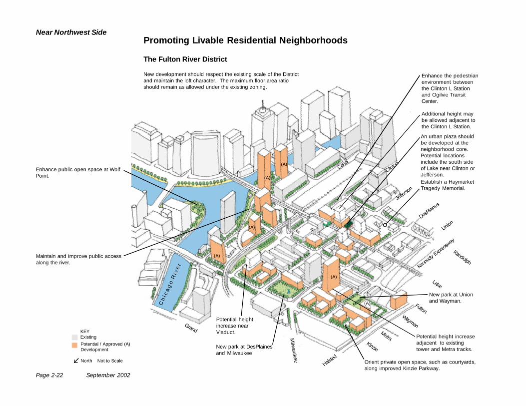
Lot widths, building setback,width and depth should reflectthe development patterns on theblock
Eckhart Park, Noble Square, East Villageand Ukrainian Village
Page 2-22 September 2002
Near Northwest Side
Canal
Clinton
Jeffers
on
DesPlain
es
Kenne
dy Expres
sway
C h
i c
a g
o R
i v
e r
Randolph
Lake
Fulton
MetraKinzie
Wayman
Union
Halsted
Milw
aukee
Grand
Maintain and improve public accessalong the river.
Potential heightincrease nearViaduct.
New park at DesPlainesand Milwaukee
Orient private open space, such as courtyards,along improved Kinzie Parkway.
Potential height increaseadjacent to existingtower and Metra tracks.
An urban plaza shouldbe developed at theneighborhood core.Potential locationsinclude the south sideof Lake near Clinton orJefferson.
New development should respect the existing scale of the Districtand maintain the loft character. The maximum floor area ratioshould remain as allowed under the existing zoning.
Promoting Livable Residential Neighborhoods
The Fulton River District
Additional height maybe allowed adjacent tothe Clinton L Station.
New park at Unionand Wayman.
Enhance the pedestrianenvironment betweenthe Clinton L Stationand Ogilvie TransitCenter.
(A)
(A)
(A)
(A)
(A)
(A)
Enhance public open space at WolfPoint.
KEYExisting
Potential / Approved (A)Development
North Not to Scale
Establish a HaymarketTragedy Memorial.
September 2002 Page 2-23
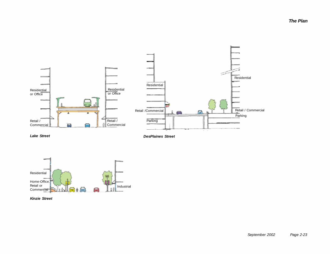
The Plan
Lake Street DesPlaines Street
Kinzie Street
Residentialor Office
Retail /Commercial
Residential
Retail / Commercial
Parking
Residential
Industrial
Retail /Commercial
Parking
Residential
Home-Office,Retail orCommercial
Retail /Commercial
Residentialor Office
Next Steps
Implementing the Plan
Page 3-2 September 2002
Near Northwest Side
Next Steps
Further Planning
This plan has not addressed all issues faced on theNear Northwest Side. Additional efforts arerecommended to respond to calls to reduce theimpact of traffic. A comprehensive traffic and parkingstudy should be developed for the community. Retailparking must also be managed in neighborhoodshopping areas where store employees, delivery truckand customers often jostle for space.
The Chicago Department of Transportation isencouraged to take on traffic and parking issues aspart of the Chicago Central Area Transportation Plan.The Zoning Reform Commission is also encouragedto respond to issues relating to parking forneighborhood retail districts, where localorganizations and elected officials can also helpdevelop parking implementation strategies.
This document is intended to be a working documentover the twenty year life of the plan. Whereas somerecommendations may not come to fruition, newopportunities may arise and future recommendationsshould be reviewed within the framework of this plan.
Implementing the Plan
The time line for implementation of this plan is twentyyears. Implementation will require the partnership ofthe City of Chicago’s Department of Planning andDevelopment, Department of Transportation, theChicago Park District and Chicago Public Schools.Neighborhood residents, elected officials and localorganizations will also be critical partners.
Implementation will require the promotion ofneighborhood corridors as places for newdevelopment, investment by City of Chicagodepartments and agencies, and the guidance of newdevelopment as it occurs.
The tables on pages 3-3 to 3-5 outline major activities,time frames, potential partners and potential fundingsources for implementing the plan’srecommendations. Additional information onpotential implementation and funding tools isprovided on pages 3-6 and 3-7.
Many of these activities can be incorporated into theCity’s ongoing capital investment and developmentregulation activities. Others will require more directedinitiatives, such as investment in new parks and openspaces and new transit facilities. Recommendationson new uses, densities and design requirements mustfeed directly into the efforts of the Mayor’s ZoningReform Commission.
September 2002 Page 3-3
Next StepsImplementing the Plan
Open Space
Key to Abbreviations:Potential Partners:CDOT Chicago Department of TransportationCTA Chicago Transit AuthorityIDOT Illinois Department of TransportationCPD Chicago Park DistrictCPS Chicago Public SchoolsDOZ Department of ZoningDPD Department of Planning and Development
Activities Time Frame Potential Partners Potential Funding In Progress 1 – 5
Years6 – 20Years
School Campus Greening- Talcott School- Otis School- Carpenter School- Mitchell School- Peabody School- Wells School
CompletedCompleted
•
•
•
•••
CPSDPDCPD
City - CitySpace Open Space Impact Fee
Coordinate Development of New PublicOpen Space- Ogden Gateway Park (Ogden & Grand)- Kinzie Park (Kinzie & Des Plaines)- Wayman Park (Union & Wayman)- Urban Plaza (Lake & Clinton or Jefferson)- Riverwalk Greenway
•
•
•
•
••
• DPDCPDProperty OwnersNeighborhood Organization
City - TIFCitySpaceNeighborSpace
Open Space Impact FeePrivate
Develop Bike Routes • • DPDCDOT
FedStateCity - TIF
Develop Linear Open Space alongRail Viaducts- Hubbard Street- Clinton Street- Kinzie Rail Connector
•
•
Union PacificDPD, CPDOpen Space OrganizationsArts OrganizationsMetra
FedStateUnion PacificCityPrivate
Develop Plan for Pocket Parks • DPD (NeighborSpace)Neighborhood Organizations
City - CitySpaceNeighborSpace
Private
Potential Funding:Fed Example: TEA-21 (Transportation Equity Act for the 21st Century)State Example: Illinois First FundingCity Examples: CIP Capital Improvement Program
EZ Enterprise Zone SSA Special Service Area TIF Tax Increment Financing CitySpace Program NeighborSpace Program Open Space Impact Fee Program
Private Impact Fees and P.D. Negotiation Concessions
Page 3-4 September 2002
Near Northwest Side
Transportation and Infrastructure
Key to Abbreviations:Potential Partners:CDOT Chicago Department of TransportationCTA Chicago Transit AuthorityIDOT Illinois Department of TransportationCPD Chicago Park DistrictCPS Chicago Public SchoolsDOZ Department of ZoningDPD Department of Planning and Development
Potential Funding:Fed Example: TEA-21 (Transportation Equity Act for the 21st Century)State Example: Illinois First FundingCity Examples: CIP Capital Improvement Program
EZ Enterprise Zone SSA Special Service Area TIF Tax Increment Financing CitySpace Program NeighborSpace Program Open Space Impact Fee Program
Private Impact Fees and P.D. Negotiation Concessions
Activities Time Frame Potential Partners Potential FundingIn Progress 1 – 5
Years6 – 20Years
Develop a Comprehensive Traffic andParking Plan- Fulton River District- Milwaukee Avenue- Halsted Street- Chicago Avenue- Grand Avenue
••
CDOTDPDElected OfficialsProperty OwnersNeighborhood Organizations
City - TIFPrivate
CTA Rail Improvements- New Green Line Stations- Enhanced Blue Line Entries
•••
•••
CTA FedStateCity
Improve pedestrian environment on ClintonStreet between CTA station and OgilvieTransportation Center
• Union PacificCTACDOT
FedStateCity – CIP, TIFPrivate
CTA Bus Stop Improvements • CTA, CDOTNeighborhood Organizations
FedStateCity
Streetscape Improvements- Milwaukee Avenue- Grand Avenue- Chicago Avenue- Ohio and Noble Street
••
•
•••
CDOTDPDProperty OwnersNeighborhood Organizations
FedStateCity – CIP, TIF, SSA, EZ
CitySpace
Expressway Landscaping • • IDOTChicago Gateway GreenCorporate OrganizationsFoundations
FedStateCityPrivate
Chicago’s Central Area Plan projects- Clinton Street Subway- Clinton Street Busway- Carroll Avenue Busway
•
••
USDOTIDOTCDOT, DPD, CTAMETRA, Amtrak, Union Pacific
FedStateCityPrivate
September 2002 Page 3-5
Next StepsImplementing the Plan
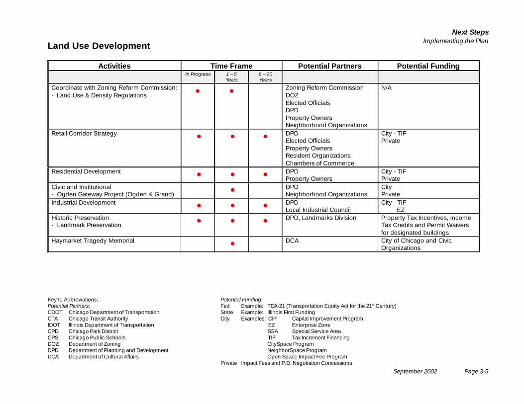
Land Use Development
Key to Abbreviations:Potential Partners:CDOT Chicago Department of TransportationCTA Chicago Transit AuthorityIDOT Illinois Department of TransportationCPD Chicago Park DistrictCPS Chicago Public SchoolsDOZ Department of ZoningDPD Department of Planning and DevelopmentDCA Department of Cultural Affairs
Activities Time Frame Potential Partners Potential FundingIn Progress 1 – 5
Years6 – 20Years
Coordinate with Zoning Reform Commission:- Land Use & Density Regulations • • Zoning Reform Commission
DOZElected OfficialsDPDProperty OwnersNeighborhood Organizations
N/A
Retail Corridor Strategy • • • DPDElected OfficialsProperty OwnersResident OrganizationsChambers of Commerce
City - TIFPrivate
Residential Development • • • DPDProperty Owners
City - TIFPrivate
Civic and Institutional- Ogden Gateway Project (Ogden & Grand) • DPD
Neighborhood OrganizationsCityPrivate
Industrial Development • • • DPDLocal Industrial Council
City - TIF EZ
Historic Preservation- Landmark Preservation • • • DPD, Landmarks Division Property Tax Incentives, Income
Tax Credits and Permit Waiversfor designated buildings
Haymarket Tragedy Memorial • DCA City of Chicago and CivicOrganizations
Potential Funding:Fed Example: TEA-21 (Transportation Equity Act for the 21st Century)State Example: Illinois First FundingCity Examples: CIP Capital Improvement Program
EZ Enterprise Zone SSA Special Service Area TIF Tax Increment Financing CitySpace Program NeighborSpace Program Open Space Impact Fee Program
Private Impact Fees and P.D. Negotiation Concessions
Page 3-6 September 2002
Near Northwest Side
Capital Improvement Program (CIP)
The CIP identifies the physical facilities andimprovements planned for the City to support andenhance its neighborhoods, stimulate the economy,and make City services more efficient. Capital projectsare permanent “bricks and mortar” improvements tothe City’s physical infrastructure and to City-ownedbuildings. Examples of capital improvement projectsare construction of new branch libraries, rehabilitationof bridges, repaving of streets and alleys, and thereplacement of deteriorated sewer and water mains.New construction may be required to accommodateincreased demand, while existing infrastructurerequires periodic rehabilitation or replacement toprotect the City’s earlier capital investment.
Planning for capital improvements is an ongoingprocess; as the City’s infrastructure ages, and asneeds change, capital programs and priorities mustbe adjusted. Each year, City departments submit theirprojected capital needs for the next five years. Publichearings are held in late Fall to inform citizens aboutthe capital selection process and to obtain additionalpublic input. Aldermen are also given the list ofproposed capital projects for review and comment.As with citizens, the aldermen makerecommendations on the proposed projects or submitrequests for new capital projects. The Office ofBudget and Management (OBM) then meets witheach department to examine the merits of their capitalrequests. Recommendations are incorporated into adraft CIP which is reviewed by the CapitalImprovement Advisory Committee. The final CapitalImprovement Program is presented to the Mayor forapproval and then released to the City Council andthe citizens of Chicago.
CTA Adopt-A-Station Program
The Adopt-A-Station Program is an initiative forcommunity groups or businesses to “adopt” stationsand take responsibility for improving the physicalcondition of rail stations/sites.
Chicago Gateway Green Partnership
The Partnership is a nonprofit corporation dedicatedto the beautification of Chicago area expresswaysincluding litter removal, landscape plantings andinstallation of participant recognition signs.
CitySpace Program
The City Space Program is an intergovernmentalinitiative including the City, Chicago Park District, andCook County Forest Preserve District to implementthe CitySpace Plan. Program initiatives addressimprovements to school parks, greenway planning,neighborhood parks and streetscapes.
Enterprise Zone Program
The objectives of the City of Chicago EnterpriseZones are to stimulate economic activity and revitalizedeclining neighborhoods. The Program providesState and City incentives and assistance to encouragethe retention and expansion of businesses in theCity’s six designated Enterprise Zones including:
• Sales Tax Exemption• Property Tax Reduction• Finance Assistance• Real Estate Tax Exemption• Investment Tax Credit• State Jobs Creation Credit• Machinery and Equipment Sales Tax Exemption• Utility Tax Exemption.
Summary ofPotential Implementation Tools
September 2002 Page 3-7
Next StepsImplementing the Plan
Facade Rebate Program
The City’s Facade Rebate Program is administered byDPD and provides rebates for building rehabilitationsuch as facade renovation, exterior lighting, signage/graphics, windows and display, security and energyconservation systems.
Micro Loan Program
The City’s Micro Loan Program provides businessloans to eligible small businesses which create jobsfor low or moderate income City residents. The fundsmay be used for machinery, equipment, renovation orworking capital.
NeighborSpace Program
The NeighborSpace Program is a nonprofitcorporation created by the City, Chicago Park District,and Cook County Forest Preserve District to developand support small neighborhood open spaces suchas community gardens, mini-parks, greenways,plazas and industrial area landscapes.
Open Space Impact Fee Program
The Open Space Impact Fee Program requires newresidential development to contribute to a pool ofmoney for expanding the supply and capacity ofpublic open space within the community area.Permitted uses of the fund include: acquisition/development of new parks and development of landssurrounding public schools to provide landscaping,playground equipment, sidewalks, recreation areasand park furnishings.
Special Service Area Financing (SSA)
The SSA program is a state-authorized financingprogram administered by the City and funded througha separate property tax levy paid by property ownerswithin the designated area to support localimprovements.
Tax Increment Financing (TIF)
TIF is a state authorized program administered by theCity that provides targeted financial resources for aspecific redevelopment area. Projects eligible forfunding include property acquisition, demolition,infrastructure improvements, certain financing costs,relocation, job training and environmentalremediation.
Resources for Historic Landmarks
Financial benefits from federal and local programsinclude: reduced property tax assessments forcommercial rehab (Class L), income tax credits forcommercial rehab and for easement donations,building permit fee waivers, property tax freezes forresidential rehabilitation, building and zoning codeflexibility and technical assistance from City preserva-tion specialists.
AcknowledgementsThe Near Northwest Side Planning Advisory Committee
Alderman Walter Burnett, Jr. 27th WardAlderman Jesse Granato 1St WardAlderman Theodore Matlak 32nd WardAlderman Burton Natarus 42nd WardChuck Abraham MetraJohn Bosca Neighbors of River WestRandall Buescher Neighbors of River WestCarl Byrd Chicago Department of TransportationKathy Dickhut Chicago Department of Planning and DevelopmentDavid Eisenberg Eckhart Park Community CouncilGail Filkowski West Loop GateJonathan Fine East Village AssociationBarbara Frankel Fulton River District AssociationMartha Goldstein West Loop GateDon Grabowski Chicago Department of TransportationJeff Hinkle Chicago Transit AuthorityJim Horan Industrial Council of Nearwest ChicagoJean Jell Ukrainian Village AssociationJohn Joslin Near Northwest Chamber of CommerceTim Later Chicago Department of TransportationAnthony Lucafo Near Northwest Civic CommitteeMary Clare Maxwell Fulton River District AssociationPatrick McAtee MetraBrenda McGruder MetraCyndi Saylor West Central AssociationMartin Stratton Chicago Department of Planning and DevelopmentRobert Wiggs West Central Association
Project StaffNori Bleiman Chicago Department of Planning and DevelopmentMary Bonome Chicago Department of Planning and DevelopmentEdel Perez-Campos Chicago Department of Planning and Development
Project ConsultantsChristopher Hall Skidmore, Owings & Merrill LLPOtto Condon Skidmore, Owings & Merrill LLPLisa Willis-Brown Urban Works LtdScott Swearengen Urban Works LtdChristine Williams Goodman Williams Group
Near Northwest Side
September 2002
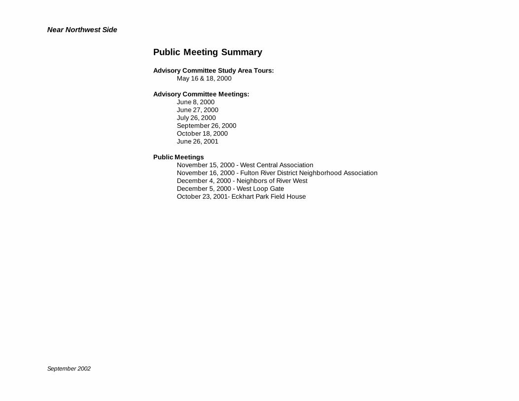
Near Northwest Side
September 2002
Public Meeting Summary
Advisory Committee Study Area Tours:May 16 & 18, 2000
Advisory Committee Meetings:June 8, 2000June 27, 2000July 26, 2000September 26, 2000October 18, 2000June 26, 2001
Public MeetingsNovember 15, 2000 - West Central AssociationNovember 16, 2000 - Fulton River District Neighborhood AssociationDecember 4, 2000 - Neighbors of River WestDecember 5, 2000 - West Loop GateOctober 23, 2001- Eckhart Park Field House