Embed Size (px)
Citation preview

Chowilla Floodplain Icon Site
Summary of 2016 Environmental Water Operations and High Flows
Chowilla Environmental Regulator Operation
Successful high level testing of the Chowilla regulator and ancillary structures was undertaken between August
and November 2016. The operation resulted in the managed inundation of approximately 7,650 hectares of
floodplain and wetlands (Fig 1), providing significant benefit to floodplain vegetation and fauna including many
species of frogs, birds, fish and invertebrates.
The testing of the Chowilla regulator reached a target operating height of 19.75 m AHD (3.45m above normal
level) in late September 2016. At the western end of the floodplain this height is equivalent to the water levels
in Chowilla Creek that would occur during natural flows of around 80,000 - 90,000 ML/day flow in the River
Murray. The inundation filled all of the major high elevation wetlands including Coombool Swamp, Lake Littra,
Werta Wert and Gum Flat and large areas of river red gum and black box woodland and shrubland vegetation.
Fig 1. Landsat 8 image captured 28/09/16 showing 7,650 ha inundated during the testing event
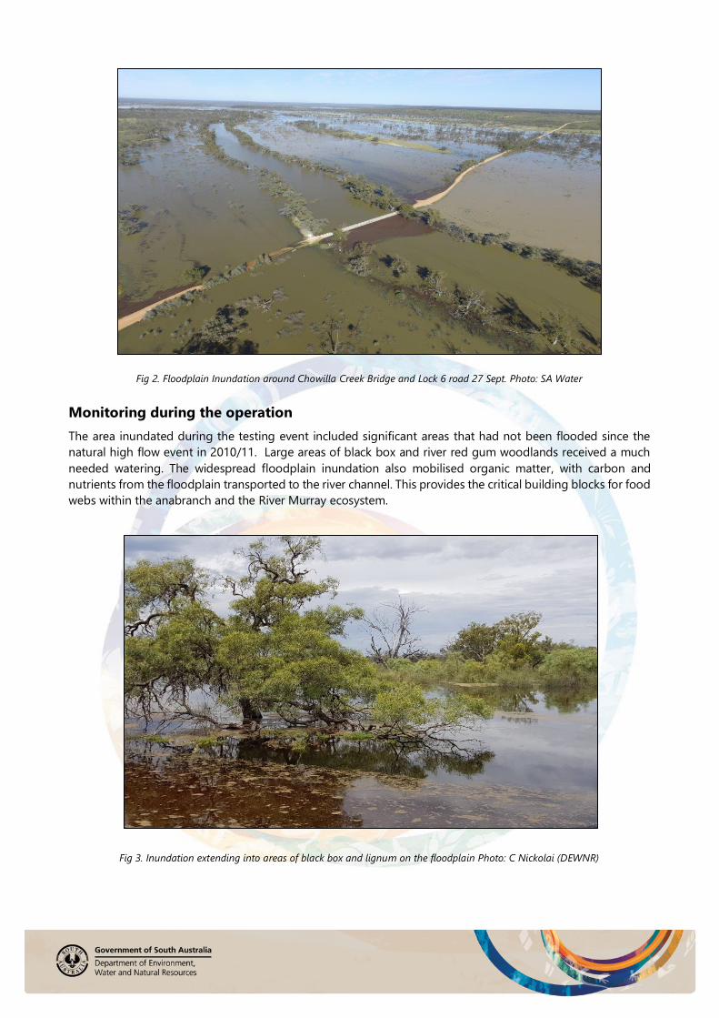
Fig 2. Floodplain Inundation around Chowilla Creek Bridge and Lock 6 road 27 Sept. Photo: SA Water
Fig 2. Floodplain Inundation around Chowilla Creek Bridge and Lock 6 road 27 Sept. Photo: SA Water
Monitoring during the operation
The area inundated during the testing event included significant areas that had not been flooded since the
natural high flow event in 2010/11. Large areas of black box and river red gum woodlands received a much
needed watering. The widespread floodplain inundation also mobilised organic matter, with carbon and
nutrients from the floodplain transported to the river channel. This provides the critical building blocks for food
webs within the anabranch and the River Murray ecosystem.
Fig 3. Inundation extending into areas of black box and lignum on the floodplain Photo: C Nickolai (DEWNR)

Fish surveys on the floodplain and wetlands revealed seven species of native fish and four introduced species.
Encouragingly, there were large numbers of small bodied native fish and several adult golden perch (callop)
detected during monitoring in the floodplain wetlands. Native fish species recorded included: golden perch,
bony bream, carp gudgeon, un-specked hardyhead, rainbow fish, Australian smelt, flat-headed gudgeon. Non-
native species included; common carp, oriental weatherloach, goldfish and gambusia. There was also an
abundance of invertebrates collected during sampling.
Fig 4. Brine shrimp, muscle larvae, and shield shrimp provide important food resources for fish and birds. Photo: S Brown DEWNR
The testing event was coordinated by the Department of Environment Water and Natural Resources working
closely with SA Water who undertake the physical operation and maintenance of the infrastructure. SA Water’s
high level of skill at implementing the complex operations in conjunction with their operation of the River
Murray Locks and Weirs was again apparent. The further testing of the new infrastructure was a success with
the regulator and ancillary structures performing according to plan. The event was undertaken with a
combination of The Living Murray environmental water and unregulated flow and was closely monitored to
manage risks and to document the benefits of operation.
Fig 5. Coppermine Waterhole. Photo: A. Stokes DEWNR
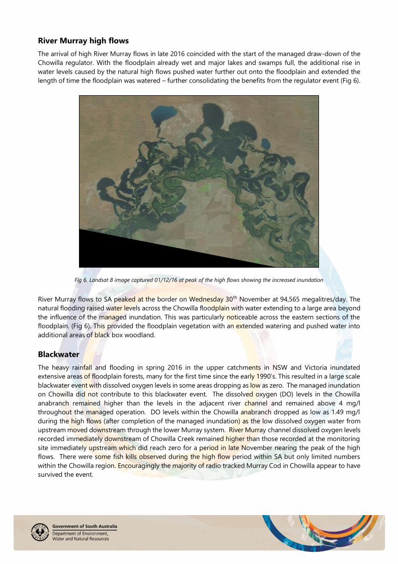
River Murray high flows
The arrival of high River Murray flows in late 2016 coincided with the start of the managed draw-down of the
Chowilla regulator. With the floodplain already wet and major lakes and swamps full, the additional rise in
water levels caused by the natural high flows pushed water further out onto the floodplain and extended the
length of time the floodplain was watered – further consolidating the benefits from the regulator event (Fig 6).
Fig 6. Landsat 8 image captured 01/12/16 at peak of the high flows showing the increased inundation
River Murray flows to SA peaked at the border on Wednesday 30th November at 94,565 megalitres/day. The
natural flooding raised water levels across the Chowilla floodplain with water extending to a large area beyond
the influence of the managed inundation. This was particularly noticeable across the eastern sections of the
floodplain. (Fig 6). This provided the floodplain vegetation with an extended watering and pushed water into
additional areas of black box woodland.
Blackwater
The heavy rainfall and flooding in spring 2016 in the upper catchments in NSW and Victoria inundated
extensive areas of floodplain forests, many for the first time since the early 1990’s. This resulted in a large scale
blackwater event with dissolved oxygen levels in some areas dropping as low as zero. The managed inundation
on Chowilla did not contribute to this blackwater event. The dissolved oxygen (DO) levels in the Chowilla
anabranch remained higher than the levels in the adjacent river channel and remained above 4 mg/l
throughout the managed operation. DO levels within the Chowilla anabranch dropped as low as 1.49 mg/l
during the high flows (after completion of the managed inundation) as the low dissolved oxygen water from
upstream moved downstream through the lower Murray system. River Murray channel dissolved oxygen levels
recorded immediately downstream of Chowilla Creek remained higher than those recorded at the monitoring
site immediately upstream which did reach zero for a period in late November nearing the peak of the high
flows. There were some fish kills observed during the high flow period within SA but only limited numbers
within the Chowilla region. Encouragingly the majority of radio tracked Murray Cod in Chowilla appear to have
survived the event.

Fig 7. Chowilla floodplain during peak of the natural flooding December 2016 Photo: H Smith (DEWNR)
Monitoring during the natural high flows
Monitoring undertaken during the managed inundation was extended to include the peak of the natural
flooding at Chowilla. Monitoring included fish, waterbirds and frog surveys in a number of wetland and floodplain sites.
Fig 8. DEWNR Ecologist Nathan Creeper undertaking fish survey. Photo: C Nickolai (DEWNR).
Field observations indicated a good abundance of native fish species, with native species being more
abundant than non-natives at a number of sites during the November 2016 survey. Native fish species
recorded included: golden perch, bony bream, carp gudgeon, un-specked hardyhead, Australian smelt, flat-headed gudgeon. Non-native species included; common carp, oriental weatherloach, goldfish and gambusia.

During any managed or natural large scale floodplain inundation event a large carp breeding event is
anticipated and subsequent observations indicate that this did indeed occur. However the high River Murray
flows experienced during the regulator testing and subsequently, provided good conditions for native fish.
Aligning Chowilla operations with good River Murray flow conditions is an important way of ensuring benefits for native fish.
Other field observations of interest included;
Juvenile golden perch were observed at a number of sites indicating successful recruitment.
Tadpoles, metamorphs and frogs of several species including, Spotted Grass frog, Eastern Banjo frog
and Peron’s Tree frog and the vulnerable species - Southern Bell frog were recorded, indicating
successful breeding.
Eastern Longneck and Broad Shelled turtles were recorded at four sites.
Fig 9. Golden perch, broad shell turtle; frog metamorph - Limnodynastes species. Photos: C Nickolai (DEWNR).
The floodplain responded well to the extended period of inundation, made possible by the managed operation
of the Chowilla regulator followed by the flooding from the natural high flows. Long lived species such as red
gum, river cooba and black box, as well as a range of understory and aquatic vegetation have responded well.
Fig 10. Vegetation at Gum Flat following the environmental watering and natural flooding Photo: A. Stokes (DEWNR).

Bird activity on the floodplain following the watering was high with some sightings of interest including:
An abundance of wading birds on Gum Flat with about 500 birds recorded in just one area including
100 Red-necked Avocets, 300 ducks (mostly Pink-eared), 37 White-faced Herons, and 1 White-necked
Heron. The shallow water across Gum Flat was just perfect for feeding.
40 Red-necked Stints on the water’s edge at Coombool Swamp. Despite their small size they manage
to make an annual journey north to breed, which is a distance of approximately 12,000 km one way.
They breed in eastern Siberia and western Alaska and visit Australia only in summer.
Over 250 pelicans sited at Coombool Swamp which retains water for many months following flooding.
150 Freckled ducks (listed as vulnerable species in South Australia) at Werta Wert wetland as well as
large numbers of Spiny-cheeked Honeyeaters feeding in the heavily flowering Black Box nearby.
Approximately 1000 Woodswallows, mostly White-browed and some Masked were seen flocking over
Chowilla Island. While this behaviour is common just before they depart for their migration they have
not been recorded in these high numbers at Chowilla in recent surveys.
A flock of 12 Regent Parrots and 2 Major Mitchell’s Cockatoos near Coppermine Waterhole.
Beautiful Rainbow bee-eaters were observed flying around in groups of up to 10 birds, getting ready
to migrate.
The shy Australian Spotted Crakes were feeding in the mud in between the lignum at Lake Littra.
Two freshly made Wedge-tailed Eagle nests were seen, one with 2 birds present in the same tree, one
with the eagle flying nearby.
Owlet-nightjars were heard calling at Werta Wert Wetland and Lake Littra and one was sighted at near
Coppermine Waterhole enjoying a bit of early morning sun. They are nocturnal so not seen very often.
Fig 11. Red-necked Stint (left) and Regent Parrot (right). Photos: H Kieskamp

Fig 12. White-browed and Masked Woodswallows. Photos: H Kieskamp
FOR MORE INFORMATION
Department of Environment, Water and Natural Resources
Email: [email protected] Tel: (08) 8580 1800
Further information is also available at these websites:
Department of Environment Water and Natural Resources (SA)
http://www.environment.sa.gov.au/chowilla-floodplain
Chowilla Game Reserve
http://www.environment.sa.gov.au/parks/
Natural Resources South Australian Murray Darling Basin
http://www.naturalresources.sa.gov.au/samurraydarlingbasin/home
The Living Murray
http://www.mdba.gov.au/
Commonwealth Environmental Water Holder
http://www.environment.gov.au/ewater/
The Living Murray is a joint initiative funded by the New South Wales, Victorian, South Australian, Australian
Capital Territory and Commonwealth governments and coordinated by the Murray-Darling Basin Authority
(MDBA).
DISCLAIMER: The Department of Environment, Water and Natural Resources and its employees do not warrant or make any
representation regarding the use, or results of the use, of the information contained herein as regards to its correctness, accuracy,
reliability, currency or otherwise. The Department of Environment, Water and Natural Resources and its employees expressly
disclaims all liability or responsibility to any person using the information or advice. Information contained in this document is
correct at the time of writing
Licensed under Creative Commons Attribution 3.0 Australia License http://creativecommons.org/licenses/by/3.0/au
Copyright Owner: Crown in right of the State of South Australia 2015