Embed Size (px)
Citation preview
CITY OF BELMONT 215 Wright Street, Cloverdale 6105 (Locked Bag 379, Cloverdale 6985) Ph: 9477 7222 Fax: 9478 1473 [email protected] www.belmont.wa.gov.au
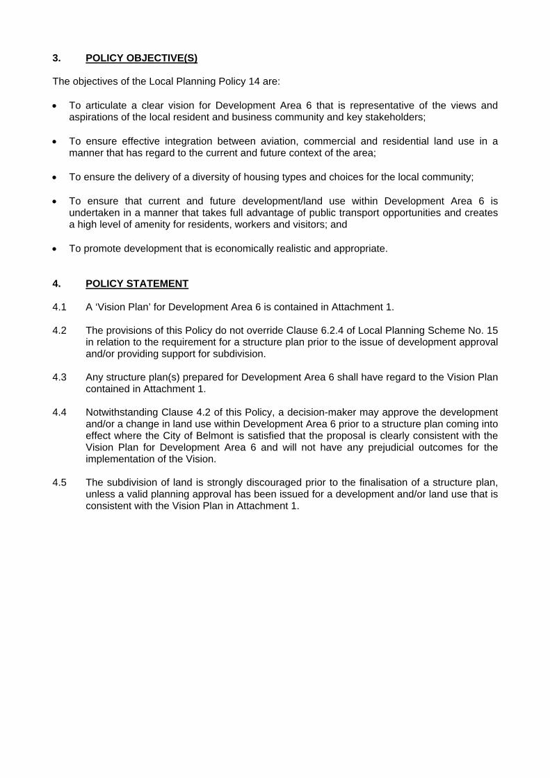
Local Planning Policy No. 14 Pursuant to Clause 2.4 of Local Planning Scheme No. 15 1. POLICY BASIS The City of Belmont and Perth Airport Pty Ltd have worked in partnership to progress a Vision Plan for the area of land identified as ‘Development Area 6’ under Local Planning Scheme No. 15. Development Area 6 has been identified as a significant redevelopment area since 2006. In 2013, the commitment of the State Government to the Perth Airport Rail Project and the identification of indicative alignments gave sufficient certainty for strategic planning for Development Area 6 to proceed. In 2014, this strategic planning was revisited in response to key State Government decisions with respect to the alignment of the Forrestfield Airport Link and the location of the proposed ‘Airport West’ station. Under the provisions of Local Planning Scheme No. 15, the City of Belmont is not permitted to approve development and/or consider recommending subdivision of land within a Development Area unless there is a structure plan for the Development Area or for the relevant part of the Development Area. Given the significance of Development Area 6 as a strategic transit orientated development, this Local Planning Policy has been prepared to articulate the City of Belmont and Perth Airport Pty Ltd’s vision for Development Area 6. The Policy will assist in providing direction for the future planning and progression of detailed structure planning for the precinct. 2. POLICY AREA All land within Development Area 6 as delineated in Local Planning Scheme No. 15, generally bounded by Tonkin Highway, Great Eastern Highway, Coolgardie Avenue, Redcliffe Road, Fauntleroy Avenue, Perth Airport Precincts 1A and 1B.
Adopted by Council: 24/02/2016 (Item 12.1)
CITY OF BELMONT Development Area 6 Vision
3. POLICY OBJECTIVE(S) The objectives of the Local Planning Policy 14 are: To articulate a clear vision for Development Area 6 that is representative of the views and
aspirations of the local resident and business community and key stakeholders;
To ensure effective integration between aviation, commercial and residential land use in a manner that has regard to the current and future context of the area;
To ensure the delivery of a diversity of housing types and choices for the local community;
To ensure that current and future development/land use within Development Area 6 is undertaken in a manner that takes full advantage of public transport opportunities and creates a high level of amenity for residents, workers and visitors; and
To promote development that is economically realistic and appropriate. 4. POLICY STATEMENT 4.1 A ‘Vision Plan’ for Development Area 6 is contained in Attachment 1. 4.2 The provisions of this Policy do not override Clause 6.2.4 of Local Planning Scheme No. 15
in relation to the requirement for a structure plan prior to the issue of development approval and/or providing support for subdivision.
4.3 Any structure plan(s) prepared for Development Area 6 shall have regard to the Vision Plan
contained in Attachment 1. 4.4 Notwithstanding Clause 4.2 of this Policy, a decision-maker may approve the development
and/or a change in land use within Development Area 6 prior to a structure plan coming into effect where the City of Belmont is satisfied that the proposal is clearly consistent with the Vision Plan for Development Area 6 and will not have any prejudicial outcomes for the implementation of the Vision.
4.5 The subdivision of land is strongly discouraged prior to the finalisation of a structure plan,
unless a valid planning approval has been issued for a development and/or land use that is consistent with the Vision Plan in Attachment 1.
REDCLIFFE
ASCOT
DETAILED PLANNINGSUBJECT TO FURTHER
PERTH AIRPORT
AVENUE
REDCLIFFE
ROAD
CO
OLG
ARDIE A
VEN
UE
BULO
NG A
VEN
UE
CENTRAL A
VEN
UE
BO
ULD
ER A
VEN
UE
SECO
ND STREET
FIRST S
TREET
FAU
NTLE
RO
Y
THE C
OU
RT
VIC
TO
RIA S
TREET
KA
NO
WN
A A
VEN
UE
GREA
T E
ASTE
RN
HIG
HW
AY
TO
NKIN H
IGH
WA
Y
DAOR KOONS
LEGEND
* Heights will be subject to site-area and building-performance criteria.
8 storeys*≤Residential
6 storeys*≤Residential
3 storeys≤Residential
DA6 Boundary
1
2
NOTES
3
4
5
6
7
8
9
10
11
12
13
14
15
16
17
18
19
Community/Civic
13 storeys*≤Residential
Perth Airport Boundary
Highway, upgrade.Fauntleroy Avenue intersection with Great Eastern
Highway, upgrade.Coolgardie Avenue intersection with Great Eastern
Airport West Station.
pedestrian crossing-phase in ultimate development.Roundabout on Dunreath Drive modified to signals with
development occurs.Ultimate design of all streets to be determined as
Living stream creating sustainable drainage.
Park and Ride for station (500 bays).
for pedestrians & cycle lane.Central Avenue tree lined boulevard with central median
main access points to Perth Airport.Fauntleroy Avenue, Dunreath Drive and Boud Avenue
New access to Tonkin Highway.
commercial development.Connected public realm through Plaza, local retail,
Airport/residential neighbourhood.Sensitive landscape, built form, land use transition Perth
pedestrian-friendly spaces.Local residential streets designed as slow-speed,
close to Station.Higher intensity mixed use and residential development
neighbourhood.Landscaped buffer area framing residential
3, 6, 8 &13 storey buildings.Redevelopment of residential neighbourhood, with mix of
with optimal tree retention and living stream.parks, recreation paths & cycleways / development sites Brearley Avenue and open space reserves create new
(medium-high intensity) along Great Eastern Highway.Business/Residential mixed use development
decommission.Great Eastern Highway upgrade/Brearley Avenue
DA6 | VISION PLAN
1
14
7
4
2
74
5
6
123
15
5
7
717
15
6
9
13
8
14
16
18
3
10
11
19
REDCLIFFE
PERTH AIRPORT
ASCOT
DETAILED PLANNINGSUBJECT TO FURTHER
AVENUE
REDCLIFFE
ROAD
CO
OLG
ARDIE A
VEN
UE
BULO
NG A
VEN
UE
CENTRAL A
VEN
UE
BO
ULD
ER A
VEN
UE
SECO
ND STREET
FIRST S
TREET
FAU
NTLE
RO
Y
AVEN
UE
THE C
OU
RT
VIC
TO
RIA S
TREET
KA
NO
WN
A A
VEN
UE
GREA
T E
ASTE
RN
HIG
HW
AY
TO
NKIN H
IGH
WA
Y
DAOR KOONS
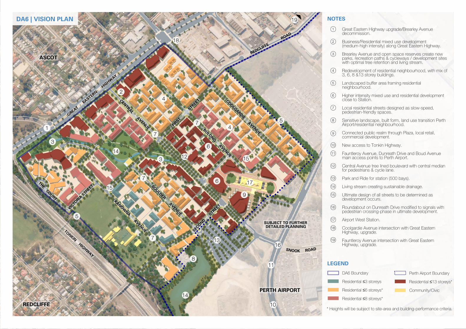
L1
L2
L3
L4
L5
L7
L8
L6
L9
L10
L1
L2
L3
L4
L5
L5
L5
L6
L7
L10
L8
L9
NOTES
LEGEND
with shops.
Local convenience retail close to new Station,
Station.
Higher densities in close proximity to new
encouraged throughout.
Home business 'live-work' opportunities
Primary School as a vital community asset.
Retention and enhancement of Redcliffe
Primary School, along Kanowna Avenue.
Medium-density residential adjacent Redcliffe
linear POS network.
Medium-density residential adjacent to the
Residential adjacent to The Court.
opportunities.
Community building, café alfresco
Avenue.
residential development along Coolgardie
Potential for low-key office development with
Highway.
Mixed Use Commercial along Great Eastern
* Heights will be subject to site-area and building-performance criteria.
Community/Civic
storeys*
13 ≤Residential
Perth Airport Boundary
8 storeys*≤Residential
6 storeys*≤Residential
3 storeys≤Residential
DA6 Boundary
DA6 | VISION PLAN | LAND USE
REDCLIFFE
PERTH AIRPORT
ASCOT
DETAILED PLANNINGSUBJECT TO FURTHER
AVENUE
REDCLIFFE
ROAD
CO
OLG
ARDIE A
VEN
UE
BULO
NG A
VEN
UE
CENTRAL A
VEN
UE
BO
ULD
ER A
VEN
UE
SECO
ND STREET
FIRST S
TREET
FAU
NTLE
RO
Y
THE C
OU
RT
VIC
TO
RIA S
TREET
KA
NO
WN
A A
VEN
UE
GREA
T E
ASTE
RN
HIG
HW
AY
TO
NKIN H
IGH
WA
Y
DAOR KOONS
LEGEND
* Heights will be subject to site-area and building-performance criteria.
NOTES
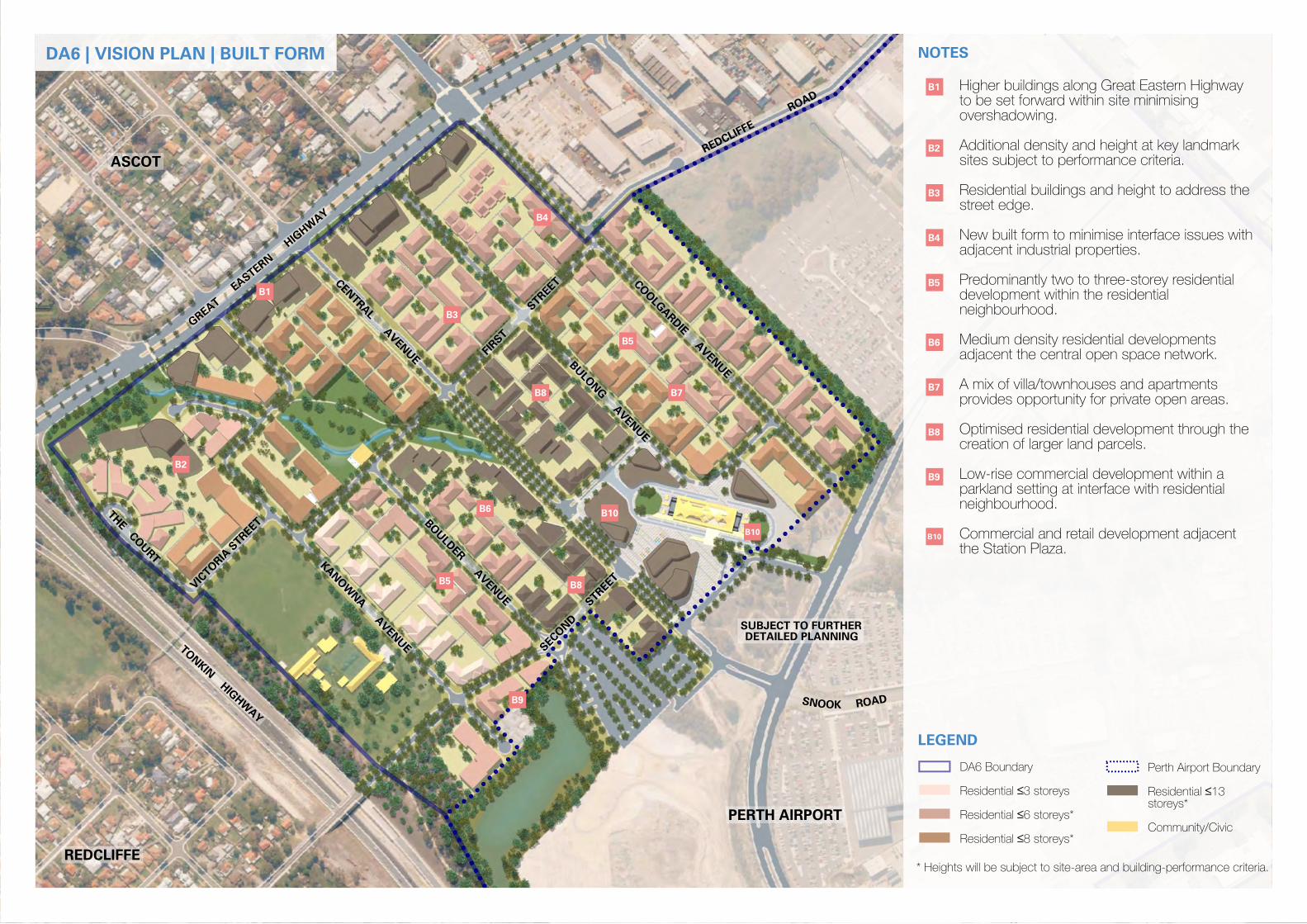
B1
B2
B3
B4
B5
B7
B8
B6
B9
B10
B1
B2
B3
B5
B6
B10
B7
B4
B10
B5
B8
B8
B9
the Station Plaza.
Commercial and retail development adjacent
neighbourhood.
parkland setting at interface with residential
Low-rise commercial development within a
creation of larger land parcels.
Optimised residential development through the
provides opportunity for private open areas.
A mix of villa/townhouses and apartments
adjacent the central open space network.
Medium density residential developments
neighbourhood.
development within the residential
Predominantly two to three-storey residential
adjacent industrial properties.
New built form to minimise interface issues with
street edge.
Residential buildings and height to address the
sites subject to performance criteria.
Additional density and height at key landmark
overshadowing.
to be set forward within site minimising
Higher buildings along Great Eastern Highway
Community/Civic
storeys*
13 ≤Residential
Perth Airport Boundary
8 storeys*≤Residential
6 storeys*≤Residential
3 storeys≤Residential
DA6 Boundary
DA6 | VISION PLAN | BUILT FORM
REDCLIFFE
ASCOT
PERTH AIRPORT
DETAILED PLANNINGSUBJECT TO FURTHER
AVENUE
REDCLIFFE
ROAD
CO
OLG
ARDIE A
VEN
UE
BULO
NG A
VEN
UE
CENTRAL A
VEN
UE
BO
ULD
ER A
VEN
UE
SECO
ND STREET
FIRST S
TREET
FAU
NTLE
RO
Y
THE C
OU
RT
VIC
TO
RIA S
TREET
KA
NO
WN
A A
VEN
UE
GREA
T E
ASTE
RN
HIG
HW
AY
TO
NKIN H
IGH
WA
Y
DAOR KOONS
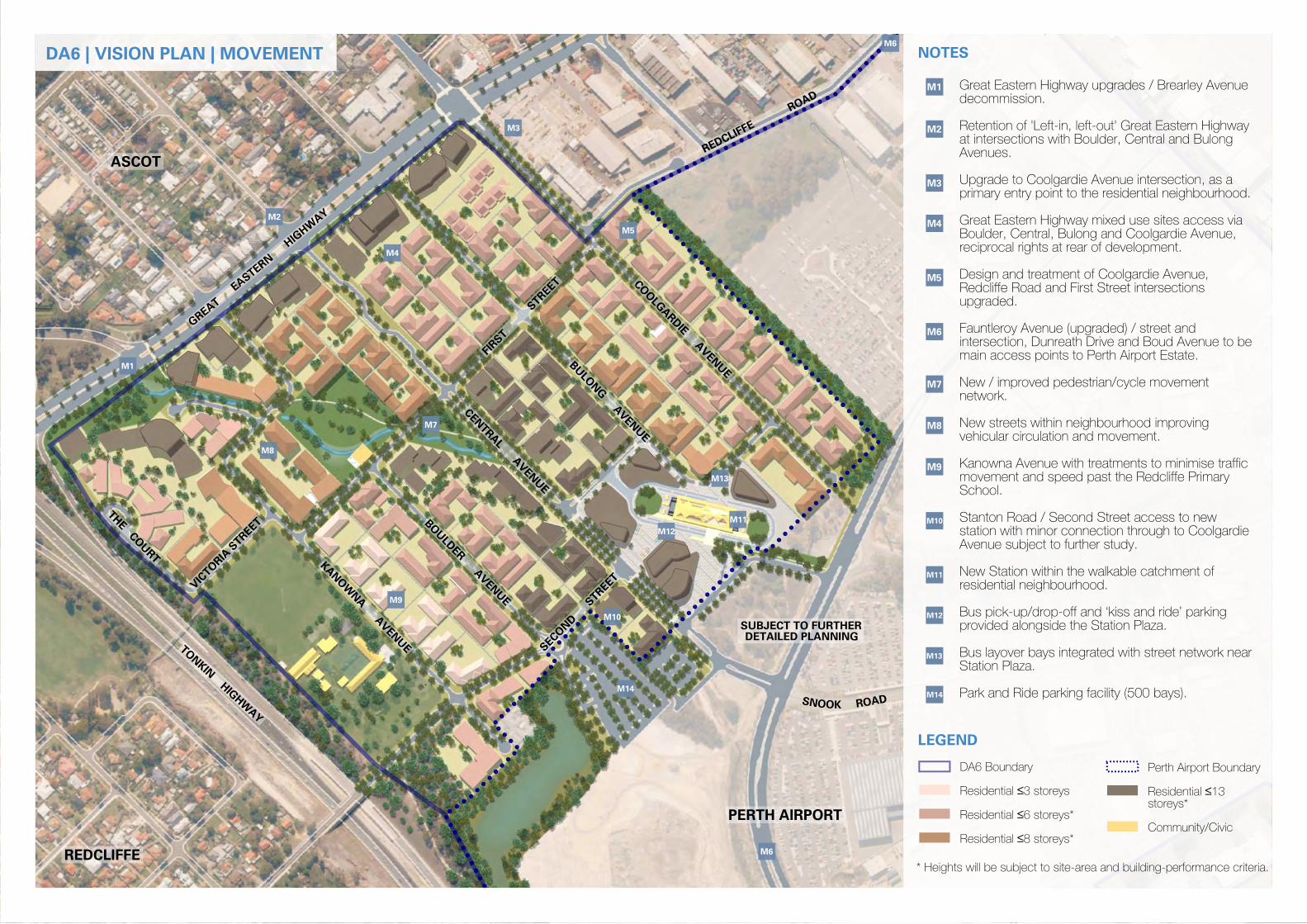
M1
M2
M3
M4
M5
M7
M8
M6
M9
M10
M11
M12
M13
M14
M1
M2
M3
M4
LEGEND
* Heights will be subject to site-area and building-performance criteria.
Community/Civic
storeys*
13 ≤Residential
Perth Airport Boundary
8 storeys*≤Residential
6 storeys*≤Residential
3 storeys≤Residential
DA6 Boundary
NOTES
M5
M7
M8
M9
M14
M10
M12
M11
M13
M6
M6
Park and Ride parking facility (500 bays).
Station Plaza.
Bus layover bays integrated with street network near
provided alongside the Station Plaza.
Bus pick-up/drop-off and ‘kiss and ride’ parking
residential neighbourhood.
New Station within the walkable catchment of
Avenue subject to further study.
station with minor connection through to Coolgardie
Stanton Road / Second Street access to new
School.
movement and speed past the Redcliffe Primary
Kanowna Avenue with treatments to minimise traffic
vehicular circulation and movement.
New streets within neighbourhood improving
network.
New / improved pedestrian/cycle movement
main access points to Perth Airport Estate.
intersection, Dunreath Drive and Boud Avenue to be
Fauntleroy Avenue (upgraded) / street and
upgraded.
Redcliffe Road and First Street intersections
Design and treatment of Coolgardie Avenue,
reciprocal rights at rear of development.
Boulder, Central, Bulong and Coolgardie Avenue,
Great Eastern Highway mixed use sites access via
primary entry point to the residential neighbourhood.
Upgrade to Coolgardie Avenue intersection, as a
Avenues.
at intersections with Boulder, Central and Bulong
Retention of 'Left-in, left-out' Great Eastern Highway
decommission.
Great Eastern Highway upgrades / Brearley Avenue
DA6 | VISION PLAN | MOVEMENT
REDCLIFFE
PERTH AIRPORT
ASCOT
DETAILED PLANNINGSUBJECT TO FURTHER
AVENUE
REDCLIFFE
ROAD
CO
OLG
ARDIE A
VEN
UE
BULO
NG A
VEN
UE
CENTRAL A
VEN
UE
BO
ULD
ER A
VEN
UE
SECO
ND STREET
FIRST S
TREET
FAU
NTLE
RO
Y
THE C
OU
RT
VIC
TO
RIA S
TREET
KA
NO
WN
A A
VEN
UE
GREA
T E
ASTE
RN
HIG
HW
AY
TO
NKIN H
IGH
WA
Y
DAOR KOONS
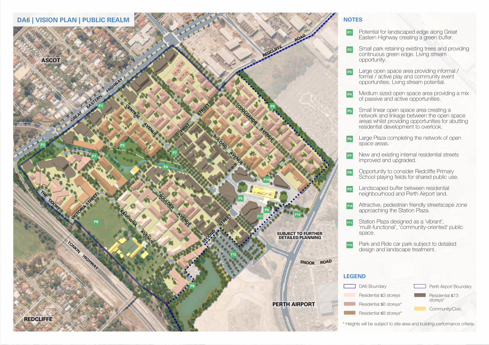
P1
P2
P3
P4
P5
P7
P8
P6
P9
P10
P11
P12
P1
P2
P7
P3
P4
P8
P5
P6
P11P10
P9
P9
P12
P7
P10
LEGEND
* Heights will be subject to site-area and building-performance criteria.
Community/Civic
storeys*
13 ≤Residential
Perth Airport Boundary
8 storeys*≤Residential
6 storeys*≤Residential
3 storeys≤Residential
DA6 Boundary
NOTES
design and landscape treatment.
Park and Ride car park subject to detailed
space.
'mulit-functional', 'community-oriented' public
Station Plaza designed as a 'vibrant',
approaching the Station Plaza.
Attractive, pedestrian friendly streetscape zone
neighbourhood and Perth Airport land.
Landscaped buffer between residential
School playing fields for shared public use.
Opportunity to consider Redcliffe Primary
improved and upgraded.
New and existing internal residential streets
space areas.
Large Plaza completing the network of open
residential development to overlook.
areas whilst providing opportunities for abutting
network and linkage between the open space
Small linear open space area creating a
of passive and active opportunities.
Medium sized open space area providing a mix
opportunities. Living stream potential.
formal / active play and community event
Large open space area providing informal /
opportunity.
continuous green edge. Living stream
Small park retaining existing trees and providing
Eastern Highway creating a green buffer.
Potential for landscaped edge along Great
DA6 | VISION PLAN | PUBLIC REALM