Embed Size (px)
Citation preview

-1-
CITY OF INTERNATIONAL FALLS, MINNESOTA
SOURCE WATER ASSESSMENT
June 2003
Public Water Supply ID 1360002
Facility Contact: Minnesota Department of Health Contact:
Mr. Tom Sakry Ms. Beth KlutheEngineering Department Minnesota Department of HealthP. O. Box 831 1705 Anne Street - Suite 3International Falls, Minnesota 56649 Bemidji, Minnesota 56601Telephone: 218-283-2990 Telephone: 218-755-4173Email: [email protected] Email: [email protected]
PART I
INTRODUCTION
The 1996 Amendments to the federal Safe Drinking Water Act (SDWA) require the MinnesotaDepartment of Health (MDH) to complete source water assessments for public water systems.
The requirements of the SDWA addressed herein are intended to provide International Falls drinkingwater customers with 1) a general description of the area which supplies water to the InternationalFalls water utility, 2) an overview of the relative susceptibility of the water supply to potentialcontaminants, 3) a description of the contaminants of concern which may impact water quality, and 4)to the extent practical, the origins of these contaminants.
The MDH, with the assistance of the International Falls water utility, assembled a source waterassessment team to develop this source water assessment. This team included representatives from theInternational Falls water utility, the city of International Falls, Fort Frances Water Treatment Plant,Koochiching County Soil and Water Conservation District, the Minnesota Pollution Control Agency,North Koochiching Sanitary District, Voyageurs National Park, Boise Paper Solutions, and theKoochiching County Environmental Services Department.
STATUS OF SOURCE WATER PROTECTION PLAN
The City of International Falls does not intend to use this source water assessment as a basis for thedevelopment and implementation of a source water protection plan.
-2-
DESCRIPTION OF THE SOURCE WATER
The city obtains its public water supply from the Rainy River near its outlet from Rainy Lake,upstream of the following: 2nd Creek inlet, the dam located at International Falls, and the downtownarea for the city of International Falls. The water treatment facility is located near the intake. TheInternational Falls water intake pipe extends 1252 feet into the Rainy River, terminates at a depth ofapproximately 26 feet and draws water from 3-6 feet off the bottom using an elbowed pipe. The watertreatment plant has a pumping capacity of 2 million gallons per day. Average water demand isapproximately 900,000 gallons per day.
The Rainy River drainage basin, upstream of the intake, covers approximately 9,519,239 acres; theMinnesota portion of the basin encompasses approximately 2,849,651 acres (30%) and the Ontario,Canada, portion encompasses approximately 6,669,588 acres (70%). Rainy Lake has a total surfacearea of 220,800 acres. The primary focus of the source water assessment is on the Minnesota portionof the basin.
SOURCE WATER SENSITIVITY
In determining the sensitivity of a source water, the intrinsic physical properties of the geologic settingor landscape within the watershed must be considered. The large quantities of water in Rainy Lakeand the rate at which the Rainy River flows help attenuate contaminant concentrations and affects theirmovement to the public water supply intake. The location of the intake near the outlet of the RainyRiver from Rainy Lake means the lake water quality has more influence on the intake than the river’s. Rainy Lake has an estimated residence time of 359 days. Recent water testing conducted by theMinnesota Pollution Control Agency indicates that under high water conditions there is significantflow from the north arm of Rainy Lake. Other factors influencing the sensitivity of a surface waterbody include topography, hydrology, geology, vegetation, and the distribution of various soil typeswithin the sub-watersheds of the Rainy River Basin upstream of the intake. Depending on thecontaminant, the closer a potential source of contamination is to an intake, the greater the potentialimpact on raw water quality because of the lack of opportunity for dilution. Conversely, the further thepotential source of contamination occurs from an intake, the more likely it is that dilution, lake watermovement and river flow will offset any potential risk.
SOURCE WATER ASSESSMENT AREA
The source water assessment area for the city of International Falls includes three distinct nested areas. The inner emergency response area is designed to help the city address contaminant releases whichpresent an immediate (acute) health concern to water users. This geographic area is defined by theamount of notification time the city needs to shut off the surface intake pumping and a "buffer time"to accommodate unanticipated delays in notification and shut down. The outer source watermanagement area is designed to enable protection of water users from long-term (chronic) healtheffects related to low levels of chemical contamination or the periodic presence of contaminants at lowlevels in the surface water used by the city. This area is intended to enable protection of users fromcontaminants that may 1) be usually found at treatable levels in the source water and 2) occasionallypresent an acute health concern under certain conditions, such as periods of high runoff or storm
-3-
events. The establishment of this area also recognizes the potential for future land-use developmentthat may influence source water. The third assessment area is the entire Rainy River Basin, upstreamof the intake. This area is designed to provide the water supplier with a broad perspective in which toprioritize specific types of land uses that may impact the water quality of the source water used. U.S.Environmental Protection Agency guidelines suggest including the entire watershed, upstream of theintake, up to the state boundaries as part of the source water assessment. To meet these guidelines,MDH has included the entire portion of the Rainy River Basin upstream of the intake as the third partof the source water protection area. These three areas are collectively labeled the "source waterassessment area."
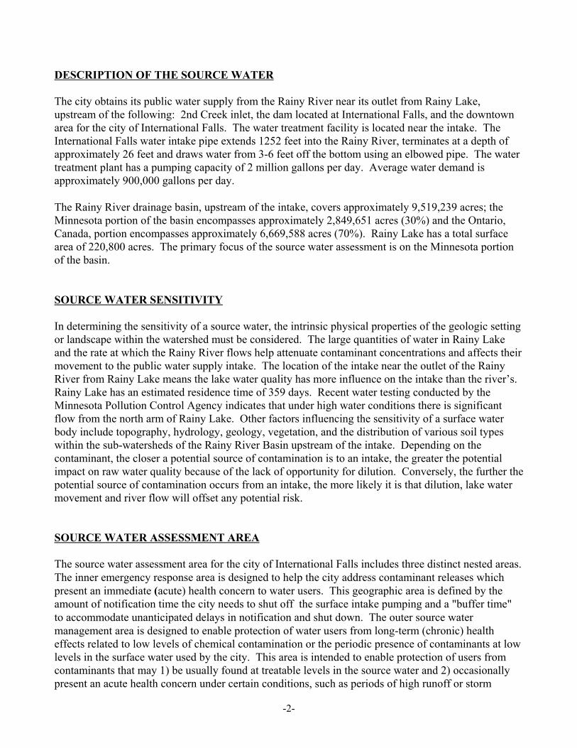
The inner emergency response area for International Falls is shown in Figure 1. The boundary of theinner emergency response area starts at a point upstream of 2nd Creek and the downtown area ofInternational Falls; extends easterly to include development in the town of Ranier; extends north intoCanada to include the highway and railroad causeways crossing Rainy Lake; continues southeasterlyalong Highway 11 towards the city of Fort Frances, including the drainage area north of the city andpotential storm water drainages on the southeast corner of the city; and proceeds to cross the RainyRiver upstream of the 2nd Creek inlet, where it concludes at its starting point. The area excludes the2nd Creek drainage because the intake was specifically designed and located to avoid impacts from the2nd Creek drainage based on testing the water utility did when constructing the current plant andintake.
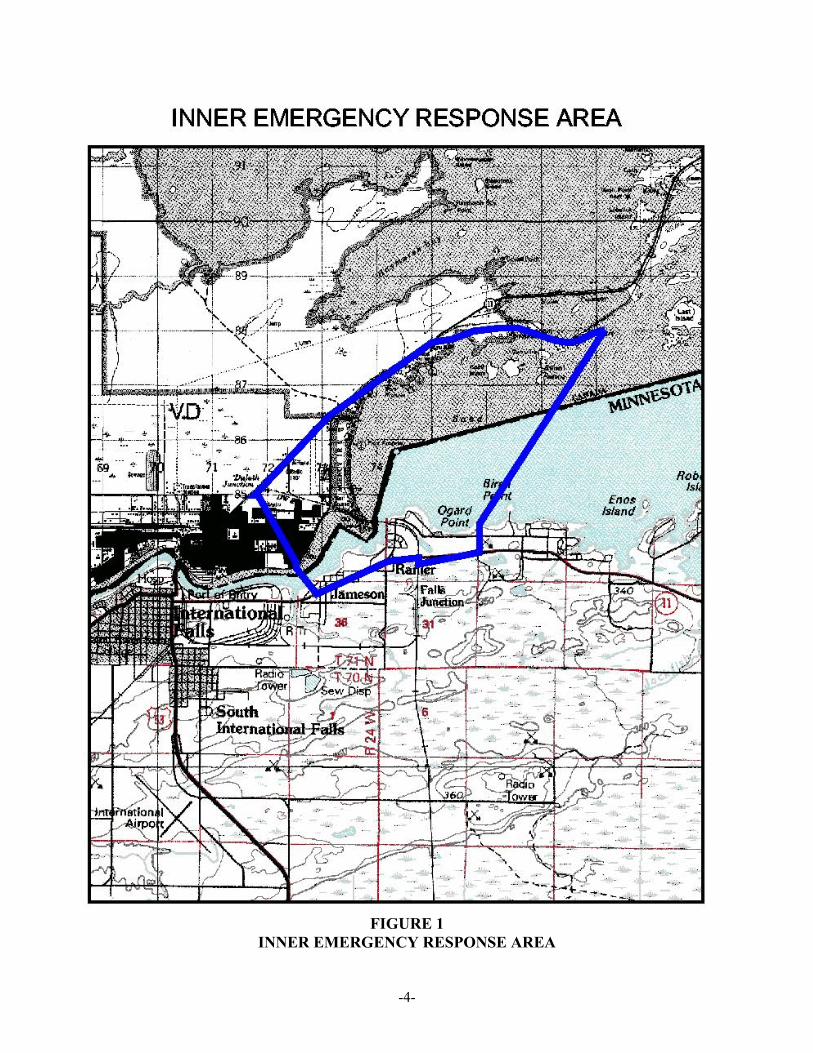
Figure 2 shows the outer source water management area for International Falls. This area surroundsthe inner emergency response area, and includes portions of the Rainy Lake watershed and the BlackBay watershed. The city of International Falls and the majority of Fort Frances are not includedbecause they are located downstream of the intake and, consequently, have limited potential to impactthe intake. The easterly boundary generally follows the boundary line for Voyageurs National Park asopposed to including subwatershed boundaries because the source water assessment team felt the landuse protection afforded by designation as a national park was significant. The team also felt it wasimportant to consider portions of the watershed on the Canadian side of the border. However, becauseof the lack of knowledge, a conservative approach was used which employed public land surveyboundaries and known potential sources of contamination.
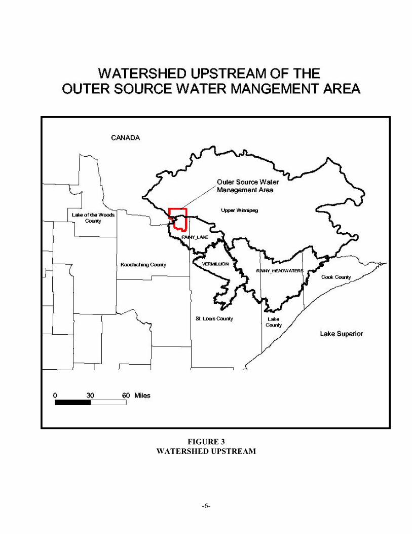
The Rainy River Basin, upstream of the intake, an area of approximately 9,519,239 acres, is shown inthe inset map portion of Figure 3. On the United States side this area includes the following majorwatersheds: Rainy Lake, Rainy Headwaters and Vermillion. On the Canadian side this area includesthe upstream portion of the major watersheds named the Upper Winnipeg (which includes the RainyLake portion on the Canadian side).
-4-
FIGURE 1INNER EMERGENCY RESPONSE AREA

-5-
FIGURE 2OUTER SOURCE WATER MANAGEMENT AREA
-6-
FIGURE 3WATERSHED UPSTREAM

-7-
PART II
POTENTIAL CONTAMINANTS OF CONCERN
The contaminants of concern are those which are regulated under the federal SDWA and listed in thenational primary drinking water standards. They are divided into organic chemicals, inorganicchemicals, radionuclides, disinfection byproducts, and microorganisms. A listing can be found at: http://www.epa.gov/safewater. Of concern to the International Falls water supply are:1) microbiological contaminants, 2) water soluble solvents, and 3) potential spills from railroad trestlesand causeways.
Most monitoring programs in or related to Rainy Lake are conducted for purposes other than drinkingwater protection. For example, the Clean Water Act requires waters to be fishable and swimmable. Agreater emphasis on drinking water standards in the future would be beneficial to public watersuppliers. Results of the various monitoring programs have verified the presence of potentialcontaminants in the source water, all of which have been adequately treated by the water treatmentplant. The public water supplier also conducts a monitoring program for raw and finished water forpurposes of implementing the Safe Drinking Water Act, as required by Environmental ProtectionAgency requirements.
SOURCES OF CONTAMINANTS
Both point sources (such as municipal wastewater treatment plants) and non-point sources (such asrunoff from residential and urban areas) are present in the source water assessment area for the city ofInternational Falls. Specific concerns relative to the International Falls water supply are: 1) leakingseptic systems, 2) the potential for spills from the railroad trestles located on both the American andCanadian sides and the causeway/highway on the Canadian side, 3) the stormwater discharge fromFort Frances, First Nations settlement, and Ranier, 4) mining activities in Canada, and 5) atmosphericdeposition. To a large degree the sources of potential contaminants from the Canadian portion of thesource water assessment area remain unknown.
To the extent practical, Table 1 contains a listing of potential point sources of contamination located inthe inner emergency response area and the outer source water management area in the United Statesportion of the areas. Obtaining similar data for the Canadian portion of the source water assessmentarea was not possible to perform as part of this source water assessment. The potential sources ofcontamination listed in the table represent data collected from a number of state and federal data bases. These data bases are listed and described in the document “Minnesota’s Source Water AssessmentProgram,” which is available from the Minnesota Department of Health. Due to the number of datasets involved in preparing this table, some duplication is possible. Also, many of the data files used toprepare Table 1 do not contain accurate locational or status information for potential contaminantsources. Editing the data sets for possible duplication, status, and locational accuracy was not possibleto perform as part of the preparation of this source water assessment. More detailed informationregarding the data sets is available from the MDH contact listed at the beginning of this assessment.
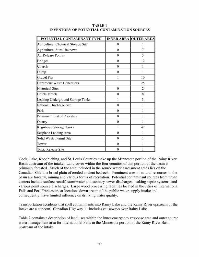
-8-
TABLE 1INVENTORY OF POTENTIAL CONTAMINATION SOURCES
POTENTIAL CONTAMINANT TYPE INNER AREA OUTER AREAAgricultural Chemical Storage Site 0 1Agricultural Sites Unknown 0 7Air Release Points 0 5Bridges 0 12Church 0 1Dump 0 1Gravel Pits 1 10Hazardous Waste Generators 1 25Historical Sites 0 2Hotels/Motels 0 8Leaking Underground Storage Tanks 1 3National Discharge Site 0 1Park 0 1Permanent List of Priorities 0 1Quarry 0 1Registered Storage Tanks 1 42Seaplane Landing Area 0 1Solid Waste Permit Site 0 1Tower 0 1Toxic Release Site 0 1
Cook, Lake, Koochiching, and St. Louis Counties make up the Minnesota portion of the Rainy RiverBasin upstream of the intake. Land cover within the four counties of this portion of the basin isprimarily forested. Much of the area included in the source water assessment areas lies on theCanadian Shield, a broad plain of eroded ancient bedrock. Prominent uses of natural resources in thebasin are forestry, mining and various forms of recreation. Potential contaminant sources from urbancenters include surface runoff, stormwater and sanitary sewer discharges, leaking septic systems, andvarious point source discharges. Large wood processing facilities located in the cities of InternationalFalls and Fort Frances are at locations downstream of the public water supply intake and,consequently, have limited influence on drinking water quality.
Transportation accidents that spill contaminants into Rainy Lake and the Rainy River upstream of theintake are a concern. Canadian Highway 11 includes causeways over Rainy Lake.
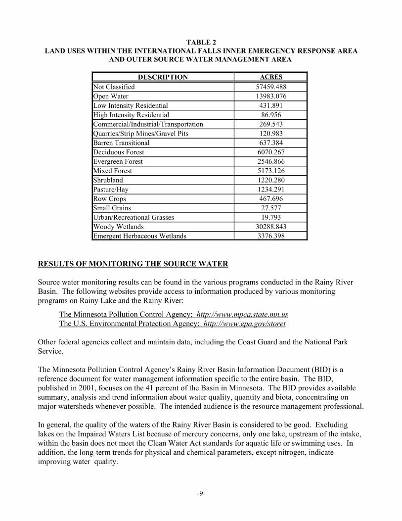
Table 2 contains a description of land uses within the inner emergency response area and outer sourcewater management area for International Falls in the Minnesota portion of the Rainy River Basinupstream of the intake.
-9-
TABLE 2LAND USES WITHIN THE INTERNATIONAL FALLS INNER EMERGENCY RESPONSE AREA
AND OUTER SOURCE WATER MANAGEMENT AREA
DESCRIPTION ACRESNot Classified 57459.488Open Water 13983.076Low Intensity Residential 431.891High Intensity Residential 86.956Commercial/Industrial/Transportation 269.543Quarries/Strip Mines/Gravel Pits 120.983Barren Transitional 637.384Deciduous Forest 6070.267Evergreen Forest 2546.866Mixed Forest 5173.126Shrubland 1220.280Pasture/Hay 1234.291Row Crops 467.696Small Grains 27.577Urban/Recreational Grasses 19.793Woody Wetlands 30288.843Emergent Herbaceous Wetlands 3376.398
RESULTS OF MONITORING THE SOURCE WATER
Source water monitoring results can be found in the various programs conducted in the Rainy RiverBasin. The following websites provide access to information produced by various monitoringprograms on Rainy Lake and the Rainy River:
The Minnesota Pollution Control Agency: http://www.mpca.state.mn.usThe U.S. Environmental Protection Agency: http://www.epa.gov/storet
Other federal agencies collect and maintain data, including the Coast Guard and the National ParkService.
The Minnesota Pollution Control Agency’s Rainy River Basin Information Document (BID) is a reference document for water management information specific to the entire basin. The BID,published in 2001, focuses on the 41 percent of the Basin in Minnesota. The BID provides availablesummary, analysis and trend information about water quality, quantity and biota, concentrating onmajor watersheds whenever possible. The intended audience is the resource management professional.
In general, the quality of the waters of the Rainy River Basin is considered to be good. Excludinglakes on the Impaired Waters List because of mercury concerns, only one lake, upstream of the intake,within the basin does not meet the Clean Water Act standards for aquatic life or swimming uses. Inaddition, the long-term trends for physical and chemical parameters, except nitrogen, indicateimproving water quality.

-10-
The Canada/United States border cuts across Rainy Lake with approximately 60 percent of the lake inCanada and 40 percent in the United States. The U.S. portion of Rainy Lake is entirely withinMinnesota. While there is not comprehensive water quality data for all of Rainy Lake, in generalRainy Lake is oligotrophic. Except for the possibility of spills along transportation corridors, thelargest direct source of potential pollutants into the lake are individual sewage treatment systems alongthe lakeshore. The primary industries upstream of Rainy Lake are forest management, taconitemining, and recreation. The Minnesota legislature designated Rainy Lake as an Outstanding ResourceValue Water on November 5, 1984. This designation provides increased protection for the waterquality of Rainy Lake.
SUSCEPTIBILITY OF THE SOURCE WATER TO CONTAMINATION
Susceptibility is defined as the likelihood that a contaminant will enter a public water supply at a levelwhich may result in an adverse human health impact. For purposes of preparing source waterassessments, determining the susceptibility of a drinking water source is based on rankings of low,medium, and high. The Minnesota Department of Health has determined that the susceptibility of anysurface water source, such as the Rainy River, is determined to be high because there are no practicalmeans of preventing all potential contaminant releases into surface waters. The federal SDWArecognizes the susceptibility of surface waters and requires filtration and disinfection to removepathogens and particulate contaminants. Therefore, the susceptibility of the International Falls surfacewater intake to contamination is designated to be high.
However, it should be noted that there are unique circumstances that apply to the International Fallswater supply. The large volume of water in Rainy Lake and the low number of potential contaminantsources, as we know them to exist, provide a mitigating effect for the International Falls water supply. Therefore, there is a lower potential for contamination than some other public water supply systemsthat rely on surface water sources.
The city's water treatment plant has effectively treated this source water to meet safe drinking waterstandards.
USING THIS ASSESSMENT
Despite the relative susceptibility, protecting the drinking water source is always a wise and relativelyinexpensive investment in the future of International Falls. The overall intent of this assessment is toprovide background information for the community to use in developing and implementing a sourcewater protection plan. The assessment benefits the community by providing the following:
! A basis for focusing limited resources within International Falls to protect the drinking watersourceThe source water assessment provides the community with information regarding activities withinthe source water assessment area that may directly affect its water supply.
-11-
! A basis for informed decision-making regarding land use within the corporate limits ofInternational FallsThe assessment provides the community with information regarding the source of its drinking waterand the contaminant threats to the quality of that source. Knowledge of the character and locationof the resource allows planning authorities to make informed decisions regarding land uses withinthe source water assessment area that are compatible with protecting the source of their drinkingwater supply.
• A basis to develop a coordinated approach to protecting drinking water throughout the RainyRiver BasinThe city of International Falls shares the use of the Rainy River with other communities and publicwater supply systems located along the river and Rainy Lake. This assessment and those preparedfor other public water supply systems can be used to identify common issues and concernsregarding the protection of drinking water supplies. As such, assessment results can be used tobring communities and facilities together to begin the development and implementation of a basin-wide approach to implementing source water protection measures.


![Minnesota Water Resources Conference · Minnesota Stormwater Manual: “… [to] manage stormwater in a way that conserves, enhances, and ... St. Anthony Falls Laboratory . Minnesota](https://img.pdfslide.net/doc/110x75/5f513ddfe5f918157102ae78/minnesota-water-resources-conference-minnesota-stormwater-manual-aoe-to-manage.jpg)