Embed Size (px)
Citation preview

City of Lowell RV Park City of Lowell RV Park Feasibility and Feasibility and
Development StudyDevelopment Study
Kirsten Freiberger, Chris Herrmann, Ann Marie Kerby, Jim McQueen, Will Mouser,
Zach Stogdill and Aaron Walsh
Spring 2009

Outline
I. Project IntroductionII. Community DescriptionIII. Floodplain and Wetland RegulationsIV. Feasibility MatrixV. Case StudiesVI. Design Alternatives and Recommendation

City of Lowell RV Park Feasibility and Development Study
Scope of the Project:Partnered with:
Jim Hall, City of Lowell Parks and Recreation ChairmanDave Pasquale, City of Lowell ManagerCarol Townsend, MSU Extension Educator
Overall Goal of the Study:Assess the viability of the Moose and Rogers Properties and to determine the best possible uses for those properties.

Goals of the Study:
To determine the feasibility of constructing a Recreational Vehicle Park.
To suggest reasonable alternatives if an RV Park is not feasible.
Provide accurate information that can be utilized by Lowell in the future to determine the project’s overall feasibility and viability

Background Information of Lowell, MILocated in Kent County, in close proximity to Grand Rapids
Initially founded in 1829
Population : 4,013 (U.S. Census, 2000)
Relies on industry, small commercialbusiness and agriculture
Robert E. Lee Show Boat, a tourist attraction
Kent County Fair
Farmer’s Market
Home to the North Country Trail Association

Site InformationMoose and Rogers are City-Owned Properties which also includes several islands on the Flat RiverLocated at the confluence of the Flat River and Grand RiverWithin close walking distance to Downtown Lowell (Main Street)33 acres total
Wooded wetlandsRailroad bisects the propertiesLocated in the 100-Year Floodplain and Floodway
Annual 6-10 feet of flooding in the Winter
Grand River
Flat
Riv
er
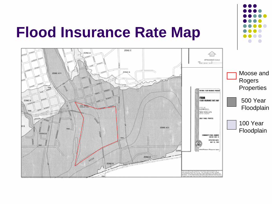
Flood Insurance Rate Map
Moose and Rogers Properties
500 Year Floodplain
100 Year Floodplain

Topographic Map for Moose and Rogers Properties
100 Year Floodplain
618 Ft elevation
620 Ft elevation

Extent of Wetlands on the Moose and Rogers Properties

Business Amenities AnalysisBusiness Amenities applicable to potential RV users analyzed for:
Alpena Grand HavenIoniaLowellManisteeWhitehall
Criteria for the cities chosen was the location of campgrounds within 15 miles of the downtownsSource: MSU Research Team on the Economic Impacts of Recreation Tourism

Amenities AnalysisU.S. Economic Census, 2002
Geographic Area
Food & Beverage Stores
Gasoline Stations
Miscellaneous Store Retailers
Arts, Entertainment & Recreation
Food Services & Drinking Places
Sports Goods, Hobby, Book & Music Stores
Amusement, Gambling & Recreation Industries
Alpena City 9 10 14 5 32 0 0
Grand Haven City
8 6 18 8 58 15 6
Ionia City 5 7 3 4 15 1 0
City Of Lowell
3 3 3 3 16 1 0
Manistee City
3 4 11 7 17 3 0
City of Whitehall
1 5 5 4 14 0 4

Amenities AnalysisThe table shows that Lowell in comparison to the other cities has minimal business amenities available to potential RV usersHowever, Lowell does show an adequate number of Food Services & Drinking PlacesRecommend that Lowell reevaluate their downtown amenities to more readily support potential RV or campground users

Outline
I. Project IntroductionII. Community DescriptionIII. Floodplain and Wetland RegulationsIV. Feasibility MatrixV. Case StudiesVI. Design Alternatives and Recommendation

Community Description
Documents relevant to the Moose and Rogers Properties:
2007 Lowell Master Plan2008 Lowell Recreation Plan

2007 Lowell Master PlanHighlights demographics and analyzes them to determine future needs of the City, including the demand for parks and recreationGoal: Lowell will promote a walkable community with stable neighborhoods, and conveniently located public, commercial and service uses.Assessed Existing Land Uses
Many of the vacant parcels are undeveloped due to land use constraints
New projects will be the redevelopment of existing uses

2007 Lowell Master PlanCommunity Input Survey, 2006
Importance of:Small town qualityMaintain natural featuresHiking, walking, and nature trails
Question if an RV park is a good addition to the City36% of the respondents agree it is a good addition17% disagree47% did not respond to this question
Recommendations in Master Plan Adoption of Zoning Ordinance Amendments
No mention of a Wetland Ordinance

2008 Lowell Recreation Master Plan2008-09 City Budget for 8 Parks: $157,497Recreation programming provided by YMCA
Surrounding townships seek programming from Lowell
Vision: Moose and Rogers Properties have potential to be developed into an RV Park
Connect to Recreation Park and to the Lowell Area Trailway
Responsive to present and future needs of residentsEncourage development of RV ParkSeek potential uses for the property through public input

City of Lowell Existing Recreational Facilities

Outline
I. Project IntroductionII. Community DescriptionIII. Floodplain and Wetland RegulationsIV. Feasibility MatrixV. Case StudiesVI. Design Alternatives and Recommendation

Floodplain RegulationsFederal Regulations
Require that the lowest level of structures be at or above the base flood elevationRV’s are permissible within a floodplain
State RegulationsObtain a permit which analyzes the impact of an alteration on the floodplain
Local RegulationsFloodplain District designated in Lowell Ordinance
Protect public health and help prevent economic lossFlood Hazard Overlay Zone
Uses Permitted:Opens Spaces: parks, golf courses, nature preserves, natural trails, and recreation
Development of a structure must be issued a zoning compliance permit by the Lowell Planning Commission

State Wetland RegulationsWetlands are regulated by the State to ensure protection of their possible benefits:
Flood and erosion controlWildlife habitat preservationRecharging ground water supplies
Activities Permissible in Wetlands:Fishing trapping or huntingSwimming or boatingHikingAgricultural Activities
Permit can be obtained if the development is determined to benefit the public

Outline
I. Project IntroductionII. Community DescriptionIII. Floodplain and Wetland RegulationsIV. Feasibility MatrixV. Case StudiesVI. Design Alternatives and Recommendation

Potential Uses for the Site
Recreational Vehicle CampgroundPrimitive CampingHiking TrailsTemporary CampingCamping CabinsPavilion-Educational AreaWater Treatment Pond

Feasibility Matrix ExampleYes No Conditional Why? Limitations
Modern Campground/ RV Issues
Water
Water under pressure
X
Flush Toilets X R 325.1552.3 Top of sewer must be above Base Flood Elevation (BFE)
1 gpm pumping, housed above ground
X City Water connections is in close proximity to site boundary

LimitationsDetermined by Michigan Campground RegulationsRV Park
Location, elevation, wetlandsPotable water, electricity, road access
Primitive CampingElevation, seasonal camping, privies
Hiking TrailsForested wetlands, bridges to islands, trails
Camping CabinsElevation, wetlands, seasonal use
Pavilion-Educational AreaLocation, elevation wetlands
Outline
I. Project IntroductionII. Community DescriptionIII. Floodplain and Wetland RegulationsIV. Feasibility MatrixV. Case StudiesVI. Design Alternatives and Recommendation

Selection Criteria for Case Studies
Public RV Parks – geographically the closestCampgrounds near Rivers
Potentially in floodplains
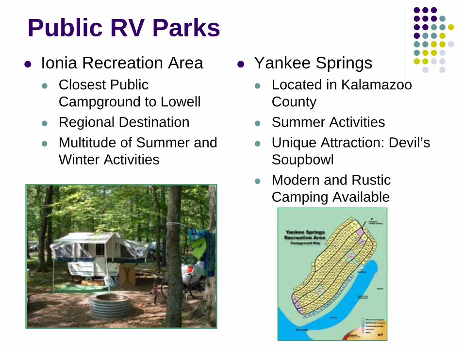
Public RV ParksIonia Recreation Area
Closest Public Campground to LowellRegional DestinationMultitude of Summer and Winter Activities
Yankee SpringsLocated in Kalamazoo CountySummer ActivitiesUnique Attraction: Devil’s SoupbowlModern and Rustic Camping Available

Campgrounds Near RiversCamper’s Cove : Alpena, MI
Private CampgroundLocated on Thunder Bay RiverNot in the floodplain or floodwayVarious indoor and outdoor amenities
Modern and Rustic Camping Available

Campgrounds Near RiversInsta Launch Campground and Marina: Manistee, MI
Private CampgroundLocated on the Big Manistee River25% of the campground is located in the floodplainModern and Rustic Camping, Cabins, MarinaCampground was “grandfathered” in, same owner since the 1950s

Campgrounds Near RiversTrailway Campground – Montague, MINot located directly in a floodplainResembles Moose and Rogers property
Close to downtownDirectly on a riverButtermilk Creek bisects property

Outline
I. Project IntroductionII. Community DescriptionIII. Floodplain and Wetland RegulationsIV. Feasibility MatrixV. Case StudiesVI. Design Alternatives and Recommendation

Criteria for Design Recommendations
FeasibilityFloodplain, Wetlands, potential costs of construction
Business AmenitiesLimited Regional Draw
Short term festivals 4-H FairFarmer’s Market

Design Alternatives
Design possibilities:Trail way and welcome center (most basic)Semi-modern campingTree house campingRV Park (has the most limitations)

Trail Development• Limitations on site allow for the ideal development of a trail
•Design runs in accordance with LARA’s phase three of the recreation plan
• Proposed trail hugs the Flat and Grand Rivers and network with recently approved Lowell Ionia Rail Trail
Moose
Rogers
Grand RiverFlat
Riv
er
Black Line = Proposed Trail

Phase Map of the Lowell Area Trailway

Trail DevelopmentAcquisition of Land
2009 Recreation Plan outlines funding sourcesDevelopment and maintenance of trails
Guidelines according to North Country TrailAccessibility
Log placementRope bridges
BenefitsVersatility, easily rerouted

Description of Welcome CenterCentral gathering placeAttached pavilion to be utilized as an educational center and dining facility
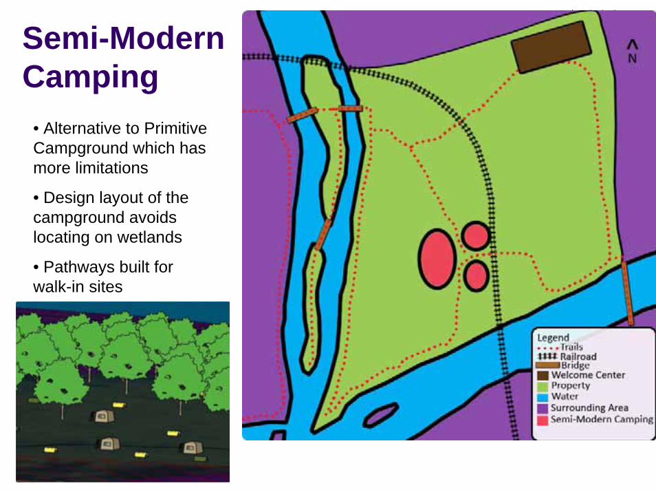
Semi-Modern Camping
Welcome Center
Walk-in tent sites
• Alternative to Primitive Campground which has more limitations
• Design layout of the campground avoids locating on wetlands
• Pathways built for walk-in sites

Tree House Cabins
Small, but growing marketBuilt on steel or wood posts, rest from 8-12 ft above groundAmenities include restroom facilities, electric hookup, gravel/path roads

RV Campground
WelcomeCenter
RV campsites
Most ambitious alternative for this site due to the amount of restrictions and obstacles Potential Operating Costs
RV Park AmenitiesShower/Restroom Facilities Electric Hook-up Gravel Paths/Roads
Phases for DevelopmentPhase 1: Develop a network of trails and roads through the property.
Phase 2: Develop separate, individual campsites for RV’s and tents.
Phase 3: Develop full amenities for an RV park and campground.

Final Recommendation
Create a Wetland Inventory and Wetland OrdinanceConduct Public Information WorkshopsImplement trail development in the first phaseConstruct a Welcome Center, 3-4 tree cabins and 25-30 walk-in sites in the second and third phasesRV Park is plausible, but would be very costly

Thank you for your attention!
QUESTIONS?