Embed Size (px)
Citation preview
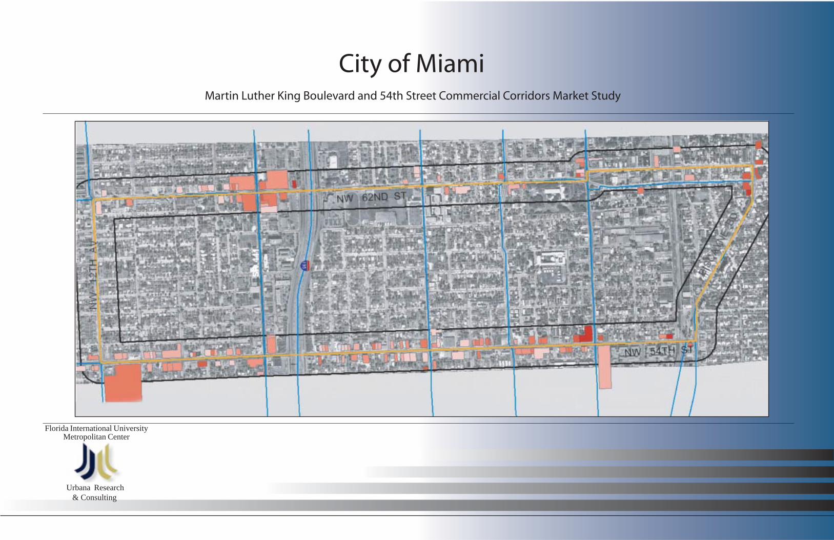
Martin Luther King Boulevard and 54th Street Commercial Corridors Market Study
City of Miami
Florida International UniversityMetropolitan Center
Urbana Research & Consulting

TTTT T abl
e of C
onte
nts
able
of Co
nten
tsab
le of
Cont
ents
able
of Co
nten
tsab
le of
Cont
ents
Executive Summary IAcknowledgements and Study Team II
Introduction 1Chapter I - Overview of Study Area 2
A. Study Area Boundaries 2B. Physical Conditions 4C. Land Use and Zoning 7
Chapter II - Demographics 10A. Methodology 10B. Population and Household Characteristics 10C. Income and Employment Characteristics 12D. Race and Ethnicity Characteristics 14E. Educational Attainment 16
Chapter III - Economic Analysis of the Study Area 17A. Types of Business Establishments 17B. Office Demand 20C. Commercial Property Values 20D. Housing Inventory 22
Chapter IV - The Retail Market 23A. Retail Categories 23B. Demographics of Trade Area 24C. Expenditure Potential 25D. Competition Analysis 26E. Calculating Demand 28F. Business Surveys 30
1. Serving Community/Clientele 302. Business Organizations/Community Assets 303. Image of Crime and Deterioration 314. Other Considerations 31
Chapter V - Economic Development Financing 32A. Background 32B. Factors 32C. An Area-Wide Approach 33D. Redevelopment Financing Tools 34E. Case Studies 36F. Recommendations 44G. General Toolbox 46H. References 47
Appendix I - Financing Tools 49
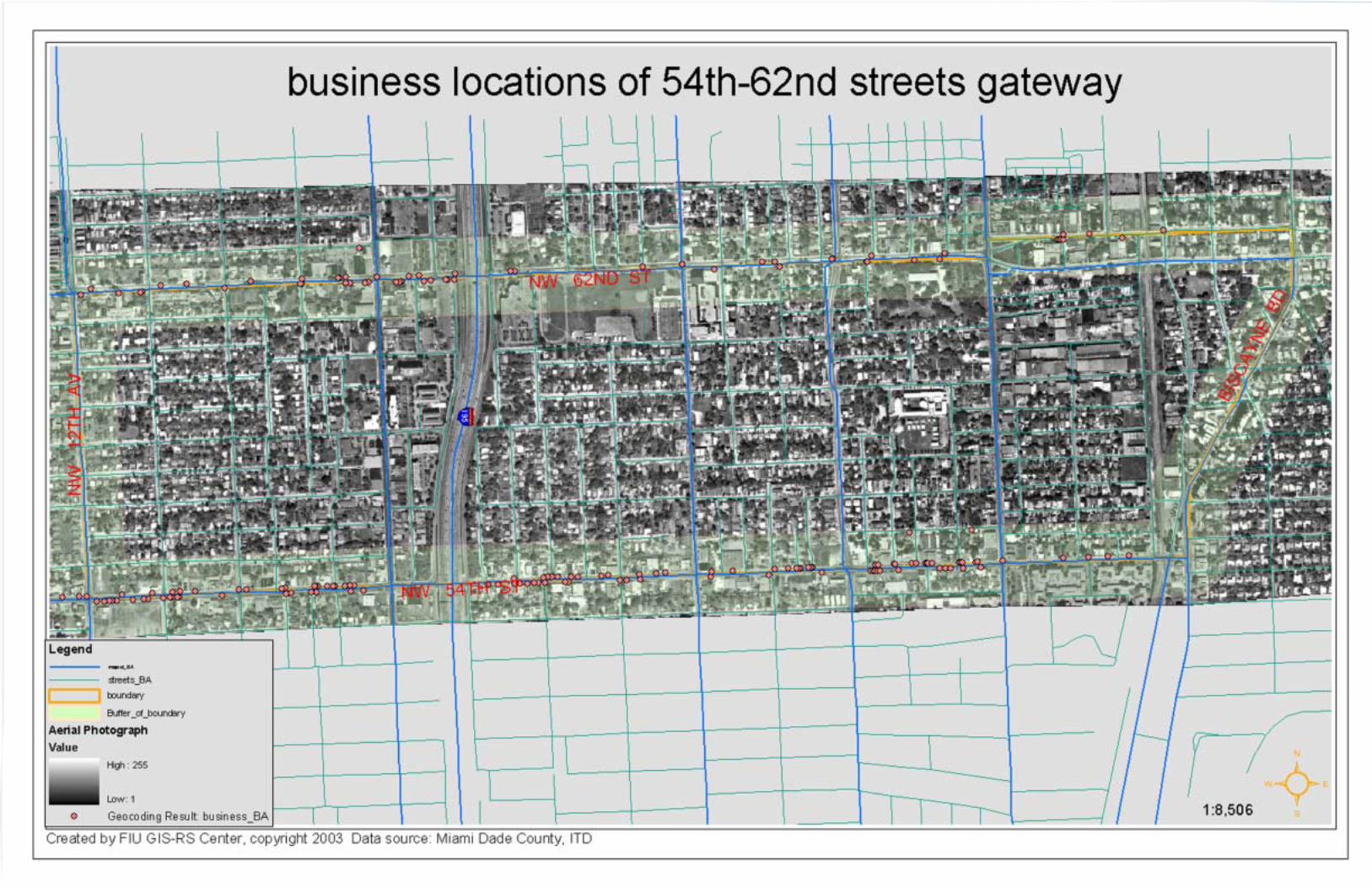
Map 1 - Study Area 3Map 2 - Vacant Lots 6Map 3 - Land Use 8Map 4 - Zoning 9Map 5 - Race and Income 15Map 6 - Location of Businesses 19Map 7 - Property Values 21
Table 1 - Total Population by Age 10Table 2 - Total Households by Income 11Table 3 - Employment Status 12Table 4 - Employment by Industry 13Table 5 - Population by Race and Ethnicity 14Table 6 - Population by Educational Attainment 16Table 7 - Top 4 Industries by Zip Code 17Table 8 - Major Industries by Zip Code 18Table 9 - Businesses by Type 18Table 10 - Commercial Property Values 20Table 11 - Housing Units by Occupancy Status 22Table 12 - Demographic Profile of Trade Area 24Table 13 - Total Expenditure Potential 25Table 14 - Convenience Goods and Personal Services Potential 25Table 15 - Convenience Goods and Personal Services Demand 25Table 16 - Food Stores Within Trade Area 26Table 17 - Drug Stores and Personal Services Within Trade Area 26Table 18 - Total Estimated Retail Competition in Trade Area 27Table 19 - Inflow Sales 27Table 20 - Analysis of Annual Demand 28Table 21 - Spending Potential Indices 29Table 22 - Financing Tools 34Table 23 - Case Studies 36
List of MapsList of MapsList of MapsList of MapsList of Maps
List of TList of TList of TList of TList of Tablesablesablesablesables
TTTTTable of Contentsable of Contentsable of Contentsable of Contentsable of Contents

The Martin Luther King (MLK) Boulevard (62nd Street) and 54th
Street Commercial Corridors Market Study is intended to serveas an economic primer for subsequent corridor and ìgatewayîmaster plans. The data and findings from this study will hopefullyprovide an understanding of the local market that should informsubsequent planning initiatives, while potentially serving as theeconomic underpinnings for future planning considerations anddecisions.
The market study begins with an assessment of the physicalconditions and existing land uses along MLK Boulevard and 54th
Street. Field surveys determined that both commercial corridorslack the physical and aesthetic qualities necessary to attract aheightened level of business investment and customer growth.While a working public infrastructure exists along both corridors,much of the infrastructure is insufficient or poorly designed. Publicinfrastructure conditions are exacerbated by private propertyconditions along the two corridors and a patchwork land use
pattern. Numerous vacant lots at key locations further diminishthe streetscapes and contribute to a general sense of instability.A public infrastructure strategy would help connect dissimilarelements and provide a structure or framework that can besupported and enhanced by incremental development.
A demographic analysis of the MLK Boulevard and 54th Streettrade area indicates that the neighborhoods that serve thecommercial corridors are among the poorest in the city. Both themedian and per capita incomes of the trade area are far belowthe City and Miami-Dade County. The trade area experienceda 6 percent loss in population between 1990-2000, a period inwhich the city showed a modest overall increase in itspopulation. The trade area is predominantly comprised ofBlack/African American populations with neighborhoodconcentrations typically between 80 - 90 percent.
The combination of low household income and lowpopulation density has a significant effect on the tradeareaís ìTotal Expenditure Potential.î The market studyanalyzed the demand for those retail categories -convenience goods and personal services - that providethe majority of businesses in the trade area. The demandand competition analysis determined that a significantnegative gap exists between the trade areaís consumerdemand and the areaís annual sales from conveniencegoods and personal services. While this critical findingsuggests limited potential for new retail development withinthese categories, the study recognizes a potential unmetdemand for ìentertainmentî and ìshoppers goodsî retailopportunities for cultural and ethnic businesses. Thedevelopment of a Community Business District (CoBD) thatlargely depends on the patronage of surroundingneighborhoods can offer a combination of comparison andconvenience shopping that is a mix of everyday goods andservices along with niche entertainment and shoppersgoods that cater to local culture and ethnicity.
Executive SummarExecutive SummarExecutive SummarExecutive SummarExecutive Summaryyyyy
Exec
utive
Sum
mar
Exec
utive
Sum
mar
Exec
utive
Sum
mar
Exec
utive
Sum
mar
Exec
utive
Sum
mar
yyyy y
IIIII

The Martin Luther King Boulevard and 54th Street Commercial Corridors Market Study was prepared by a team of university faculty and research associates and professional communityand economic development sub-consultants. The study team was led by the Florida International University (FIU) Metropolitan Center with the support of the GIS-RS Center. Communityand economic development sub-consulting services were provided by Urbana Research & Consulting and Dr. Lisa Konczal.
The following is an expanded listing of the university and professional study team:
FIU Metropolitan Center
Principal Investigator:Dr. Ned Murray, AICP
Research Associates:Mashinda Kazadi and Nadine Wedderburn
Contracts/Clerical SupportElsy Sardinas and Annette Almanza
GIS-RS Center at FIU Library
Faculty:Jennifer Fu, GIS Manager
Urbana Research & Consulting
Principals:Rosa Davis and Ines Hernandez-Siqueira
Survey Sub-ConsultantDr. Lisa Konczal
Lay-out and ProductionCopy Right Inc.
Acknowledgements
The FIU Metropolitan Centerís study team extends our sincere thanks and appreciation to the City of Miamiís Department of Economic Development for their guidance and supportduring the research and preparation of the Martin Luther King Boulevard and 54th Street Commercial Corridors Market Study. The study team extends our personal gratitude to ClarenceWoods, Project Manager; Carmen Sanchez, Business Development Coordinator; and Keith Carswell, Director of Economic Development.
Acknowledgement and Study TAcknowledgement and Study TAcknowledgement and Study TAcknowledgement and Study TAcknowledgement and Study Teameameameameam
Ackn
owle
dgem
ent a
nd St
udy T
Ackn
owle
dgem
ent a
nd St
udy T
Ackn
owle
dgem
ent a
nd St
udy T
Ackn
owle
dgem
ent a
nd St
udy T
Ackn
owle
dgem
ent a
nd St
udy T
eam
eam
eam
eam
eam
IIIIIIIIII

The Martin Luther King Corridor (NW 62nd Street) has been the subject of numerous planning and community economicdevelopment studies. The purpose of this market analysis is to bridge these former studies and serve as an economic primer forsubsequent corridor and ìgatewayî master plans to be conducted by the City of Miami. The data and findings from this study willhopefully provide an understanding of the local market area that should inform subsequent planning initiatives, while potentiallyserving as the economic underpinnings for future planning considerations and decisions. The market study also includes the54th Street Corridor, which serves the same communities as the Martin Luther King Corridor. The market analysis was con-ducted by a ìstudy teamî led by the Florida International University (FIU) Metropolitan Center.
The market study is organized as follows: Chapter I provides an overview of the study area including a physical description ofthe two commercial corridors including public infrastructure, land use and zoning; Chapter II provides a demographic analysis ofthe corridor areas including population, household, employment and industry characteristics, Chapter III is an economic analy-sis of the study including an inventory of existing businesses, business growth, property values and comparative economic data.Chapter IV provides an analysis of the existing retail market and the corridorsí potential for retail development. The concludingChapter V identifies commercial corridor economic development case studies including program and financing strategies, toolsand techniques.
Introduction
Intro
duct
ion
Intro
duct
ion
Intro
duct
ion
Intro
duct
ion
Intro
duct
ion
11111

62nd Street
The 62nd Street study area, also know as Martin Luther King (MLK) Boulevard, extends 2 miles from Biscayne Bay Boulevard(US 1 Federal Highway) on the east to 12th Avenue on the west (see map page 3). At NW 12th Avenue, MLK Boulevardcontinues west through unincorporated Miami-Dade County and the City of Hialeah. MLK Boulevard is served by north andsouth entrance and exit ramps to Interstate 95. Other north/south arterial and connector roadways include NW 7th Avenue(State Road 7/U.S. 441), one block west of I-95, and NW 2nd, North Miami and NE 2nd Avenues all east of I-95. The FloridaEast Coast (FEC) Railway intersects MLK Boulevard one block west of Biscayne Boulevard.
Heading west from Biscayne Boulevard (Federal Highway) to I-95, MLK Boulevard is a four lane, divided roadway with aplanted median of various widths. The greatest width extends from the entrance on Biscayne Boulevard to NE 2nd Avenue,which is a one-way street heading west. The median narrows from NE 2nd Avenue to I-95 and then continues west to NW 12thAvenue.
54th Street
The 54th Street study area parallels 62nd Street eight blocks to the south. 54th Street extends 1.8 miles from BiscayneBoulevard on the east to NW 12th Avenue on the west. At NW 12th Avenue, 54th Street continues west through unincorporatedMiami-Dade County and the City of Hialeah. There is no 54th Street interchange on I-95, but a ramp road exists that connectsto the 62nd Street interchange to the north. NW 54th Street is served by several north/south arterial and connector roadwaysincluding NW 7th Avenue (State Road 7/U.S. 441) one block west of I-95 and NW 2nd, North Miami and NE 2nd Avenues to theeast of I-95. The Florida East Coast (FEC) Railway intersects 54th Street immediately west of Biscayne Boulevard 54th Streetis a four lane undivided roadway for the full distance from Biscayne Boulevard to NW 12th Avenue.
A. Study Area Boundaries and Description
Chap
ter I
Chap
ter I
Chap
ter I
Chap
ter I
Chap
ter I
Over
view
of th
e 62n
d and
54th
Stre
et Co
rrido
r Are
as
22222
Chapter I OverChapter I OverChapter I OverChapter I OverChapter I Overview of Study Areaview of Study Areaview of Study Areaview of Study Areaview of Study Area


62nd Street
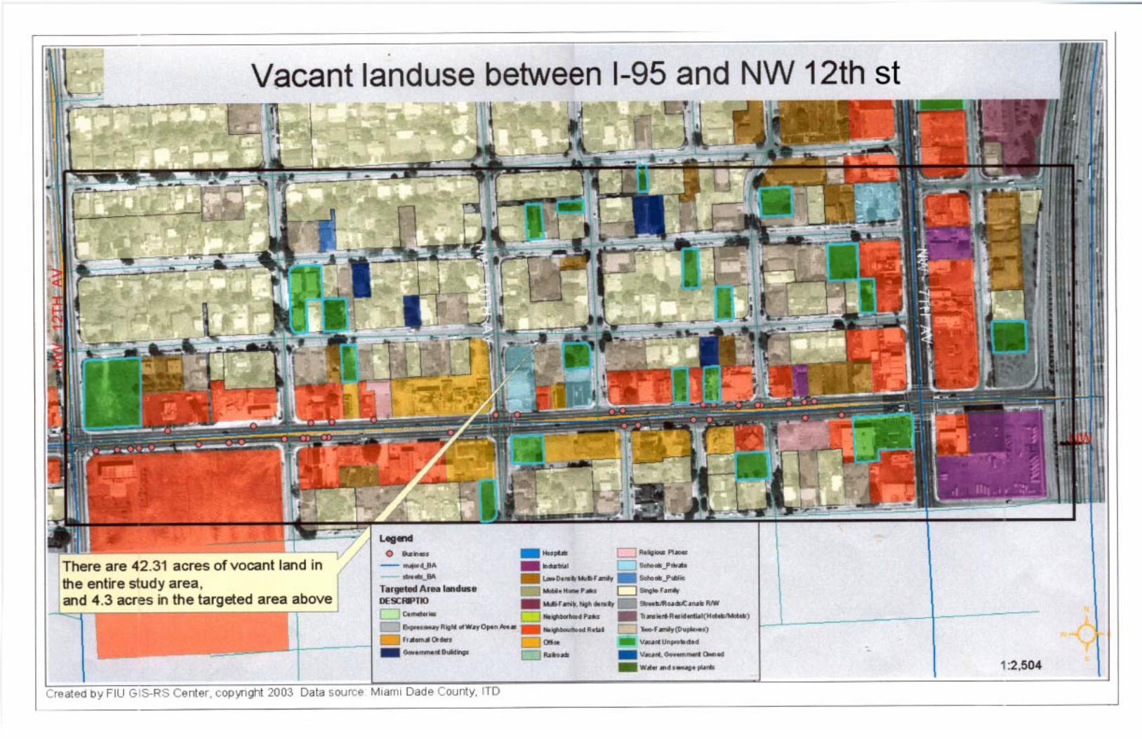
At the one-way entrance heading west from Biscayne Bou-levard, NW 62nd Street is a four-lane road that crosses theFlorida East Coast (FEC) right-of-way one block west. Whilethe street is in fair condition, the lanes are unmarked creat-ing some confusion. The surrounding one-story propertiesare in relatively good condition. The planted median is anasset to the area. Sidewalks exist on both sides of the streetand street trees are abundant. However, crosswalks in thevicinity of Edison Senior High School and M. Athalie RangePark are not clearly marked. Planted median crosswalksand street pavers exist at the intersection of NW 7th Avenue(State Road 7/U.S. 441). However, sidewalk conditions de-teriorate east and west of the intersection and crosswalksare unnoticeable. The west entrance from the I-95 downramp is unsightly with sparse landscaping, worn guardrailsand a general distortion of the public and private realms.Storefronts conditions are a significant detraction in this im-mediate area. Numerous vacant and/or underdevelopedparcels and parking lots create an unsightly appearance onthe north side of 62nd Street between NW 7th Avenue (StateRoad 7/U.S. 441) and NW 12th Avenue. A large vacant andunkempt parcel at the northwest corner of 62nd Street andNW 12th Avenue creates a major void at the City of Miamiíspotential western gateway to MLK Boulevard.
Over
view
of th
e 62n
d and
54th
Stre
et Co
rrido
r Are
as
B. Physical Conditions
44444
62nd Street city gateway
62nd Street vacant parcel
62nd Street I-95 Entrance

54th Street
The 54th Street entrance from Biscayne Boulevard is a con-gested intersection due to the fact that Federal Highway, theFEC Railroad and Biscayne Boulevard essentially merge atthis point. The 54th Street Corridor continues west as a four-lane undivided road for the full 1.8-mile length of the studyarea. The four-lane undivided road has sidewalks on bothsides but faded crosswalks and busy traffic make the entirestretch pedestrian unfriendly. The streetscape is barren oflandscaping and there is a lack of distinction between thepublic and private realms. This lack of distinction creates asense of disorder in the relationship between buildings andthe street, community edges and circulation.
The 54th Street Corridor is largely comprised of 1-storybuildings in a fragmented land use pattern. Fast food res-taurants are intermixed with gas stations, storefront churchesand auto repair shops. Vacant and underdeveloped parcelsand parking lots are visually unappealing and create a senseof disinvestment along the corridor west of I-95. A large va-cant parcel at the northeast corner of NW 12th Avenue cre-ates a major void at the Cityís western gateway to the 54thStreet Corridor.
Over
view
of th
e 62n
d and
54th
Stre
et Co
rrido
r Are
as
55555
54th Street vacant parcel
54th Street streetscape
66666

62nd Street
MLK Boulevard has a generally fragmented land use patternthat is virtually segmented by I-95 (see map page 8). Beginningat its divided one-way entrance and egress extending west andeast between Biscayne Boulevard and NE 2nd Avenue, the landuses are predominantly comprised of Low-Density Multi-FamilyResidential and Industrial uses. The industrial uses are locatedon the west side of the FEC Railroad. From NE 2nd Avenue westto I-95 the land use pattern is a patchwork of Neighborhood Re-tail, Schools, Single and Low-Density Multi-Family Residentialand Neighborhood Park uses. Miami Edison Senior and JuniorHigh Schools are the major land use on the south side entranceto MLK Boulevard from I-95. Directly across from Edison SeniorHigh School on the north side of the street is the City of MiamiísM. Athalie Range Park and Edison Center Branch Library.
West of I-95 a more consistent land use pattern is evident com-prised primarily of Neighborhood Retail uses. NW 7th Avenue(State Road 7/441) intersects MLK Boulevard one block west ofI-95 and serves as the retail hub of the corridor. The majority ofthe MLK Boulevardís retail businesses are clustered within this
Over
view
of th
e 62n
d and
54th
Stre
et Co
rrido
r Are
as
area. Government and institutional uses are located on the southside of the boulevard between NW 7th and 12th Avenues includ-ing the City of Miami Police Department, Belafonte Tacolcy Cen-ter and Park and a United States Post Office. A number of VacantUnprotected parcels exist along this section of the boulevard.
The zoning designations for the MLK Boulevard are generallyconsistent with the existing land use pattern (see map page 9).Restricted Commercial zoning is in place along the major busi-ness intersections - Biscayne Boulevard and NE 2nd, NorthMiami, NW 2nd, NW 7th and NW 12th Avenues. Liberal Com-mercial is found on the entire north side of the boulevard betweenNW 7th and 12th Avenues and for a major portion of the southside east of I-95. The most notable inconsistency between landuse and zoning is found between North Miami and NW 2nd Av-enues where a Restricted Commercial district is comprised of apatchwork of land uses. Government and Institutions zoning pre-dominates on the south side of the boulevard between I-95 andNE 2nd Avenue, while Industrial zoning covers most of the landarea immediately west of the FEC Railroad.
C. Land Use and Zoning
77777
54th Street
The entire 54th Street Corridor is primarily comprised ofNeighborhood Retail uses with the exception of theBiscayne Boulevard end where Low-Density Multi-FamilyResidential (DPlace Condominiums) occupies nearly theentire south side of the street between the FEC Railroadand NE 2nd Avenue. Office uses, including the MiamiTimes business office and the Tri-Arts Medical Building,are located to the west of I-95 and interspersed with retailuses and store front churches. The 54th Street corridorísmajor retail location is the Shoppes of Liberty City (Winn-Dixie Plaza) located just east of NW 12th Avenue. Nu-merous Vacant Unprotected parcels are found along theentire 54th Street corridor.
The zoning designations for the 54th Street corridor aregenerally consistent with the existing land use pattern. Re-stricted Commercial zoning is in place on both sides of thestreet west of I-95. Liberal Commercial zoning is in placeimmediately east of I-95 with Restricted Commercial extend-ing from the intersection of North Miami Avenue to NE 2ndAvenue. Multi-Family zoning covers low-density multi-fam-ily land uses that exist east of NE 2nd Avenue east to theFEC Railroad. Biscayne Boulevard is entirely zoned for Re-stricted Commercial uses.

88888

99999

The market study analyzed the 62nd and 54th Street Corri-dors using both U.S. Census and U.S. Postal Zip Code data.Census Block Groups are the primary data source as theyprovide the best spatial accuracy for defining the demograph-ics of the area. The study area is fully captured by U.S PostalZip Codes 33127 and 33137, which help to provide an eco-nomic characterization of the area. For comparative purposes,adjoining Census Tracts and Zip Codes are utilized as well asCity of Miami and Miami-Dade County U.S. Census (1990-2000) data.
The 62nd and 54th Street Corridor areas have a total popu-lation of approximately 9,717 (see Table 1) according to the2000 U.S. Census. This figure represents a 6 percent declinein total population since 1990, a period in which the City ofMiami and Miami-Dade County grew by 1 and 16 percent,respectively. The largest population decreases occurred inthe ìunder 10î and ì30-39î age groups. This is usually anindication of households/families of the child-rearing age grouprelocating for educational (better schools) and economic (betterjobs) reasons.
Dem
ogra
phic
s D
emog
raph
ics
Dem
ogra
phic
s D
emog
raph
ics
Dem
ogra
phic
sCh
apte
r II
Chap
ter I
ICh
apte
r II
Chap
ter I
ICh
apte
r II
A. Methodology
B. Population and Household Characteristics
Chapter II DemographicsChapter II DemographicsChapter II DemographicsChapter II DemographicsChapter II Demographics
Table 1: Total Population by Age
1010101010SOURCES: U.S CENSUS BUREAU, 1990 - 2000
FIU METROPOLITAN CENTER
Miami-DadeCounty Total
Age 54th & 62nd Streets City of Miami Total
2000 1990
# % # % # % # % # % # %
TotalPopulation
Under 5 years
5 to 9 years
10 to 14 years
15 to 19 years
20 to 24 years
25 to 29 years
30 to 34 years
35 to 39 years
40 to 44 years
45 to 49 years
50 to 54 years
55 to 59 years
60 to 69 years
70 to 74 years
80 to 84 years
85 years +
65 to 69 years
75 to 79 years
1155
1163
812
793
601
733
872
874
749
613
500
420
356
264
199
133
86
53
834
916
939
926
691
730
620
700
743
722
539
467
491
378
260
161
103
69
25,627
23,659
20,015
22,446
24,363
29,566
28,543
25,730
21,685
19,443
19,455
19,004
19,665
17,924
14,536
12,390
8,213
6,284
21,222
21,962
22,182
22,339
23,023
26,482
27,782
29,517
26,165
23,580
20,707
17,983
17,758
16,443
15,790
12,578
8,562
8,395
139,714
131,428
120,490
131,060
139,196
168,342
163,334
147,793
130,250
111,221
90,816
91,769
90,816
81,437
64,694
55,724
38,832
30,119
145,752
157,871
160,754
154,989
144,721
163,859
173,574
191,834
170,132
150,878
131,888
109,141
97,417
84,496
77,761
59,856
39,971
38,468
8.1
8.9
9.1
9.0
6.7
7.1
6.0
6.8
7.2
7.0
5.2
4.5
4.8
2.1
2.5
1.6
1.0
0.7
7.1
6.6
5.6
6.3
6.8
8.2
8.0
7.2
6.0
5.4
5.4
5.3
5.5
5.0
4.0
3.4
1.7
1.7
5.8
6.1
6.1
6.2
6.3
7.3
7.7
8.1
7.2
6.5
5.7
5.0
4.9
4.5
4.4
3.5
2.4
2.3
6.5
7.0
7.1
6.9
6.4
7.3
7.7
8.5
7.5
6.7
5.8
4.8
4.3
3.7
3.4
2.7
1.8
1.7
7.2
6.8
6.2
6.8
7.2
8.7
8.4
7.6
6.7
5.7
4.7
4.7
4.7
4.2
3.3
2.9
2.0
1.5
11.1
11.2
7.8
7.6
5.8
7.1
8.4
8.4
7.2
5.9
4.8
4.0
3.4
2.5
1.9
1.3
0.8
0.5
10,376 100.0 100.0 100.0 100.0 100.0 100.0 9,717 358,548 362,470 1,937,094 2,253,362

Dem
ogra
phic
s D
emog
raph
ics
Dem
ogra
phic
s D
emog
raph
ics
Dem
ogra
phic
s
According to the 2000 U.S. Census, the average age ofthe Corridor areasí population is 31.9 years of age, whichis younger than the City of Miami and Miami-Dade County(35.6 years). The highest cohort is found in the ì10-19îage group, which when combined with the ìunder 10î agegroup, comprises 35 percent of the two Corridor areasípopulation. While the study area is largely young, there isa growing older and elderly population. According to the2000 U.S. Census, every cohort above the ì40-44î agegroup, with the exception of the í65-69" age group, in-creased since 1990. The ì55 and overî age group in-creased by 28 percent during this period.
The average household size within the study area is 2.95persons per household. This is larger than the City of Miamiand Miami-Dade County (2.84). The larger average house-hold size is attributed to the aforementioned concentration ofschool-age and ìunder 5î years of age children.
Consistent with demographics trends at both the nationaland local levels, the 62nd and 54th Street Corridor areas have,despite population loss, experienced a gain from 1990-2000in total households (see Table 2). Total households in thestudy area increased from 3,185 in 1990 to 3,402 in 2000 (7percent). By comparison, the City of Miami and Miami-DadeCounty experienced total household growth of 3 and 12 per-cent, respectively. While a portion of the growth in house-holds can be attributed to the national trend of the dissolutionof the traditional family, household growth in the study area isalso partly attributed to a discernible increase in housingunits.
The corridorsí population loss and accompanying increase inhouseholds and residential units can also be attributed to achange in the make-up or composition of households in the sur-rounding neighborhoods.
Table 2: Total Households by Household Income
1111111111
SOURCES: U.S CENSUS BUREAU, 1990 - 2000FIU METROPOLITAN CENTER
Miami-DadeCounty Total
City of Miami Total
HouseholdIncome
,
,
,
,
,
,
,
,
,
,
,
,
,
,
,
C
Dem
ogra
phic
s D
emog
raph
ics
Dem
ogra
phic
s D
emog
raph
ics
Dem
ogra
phic
s
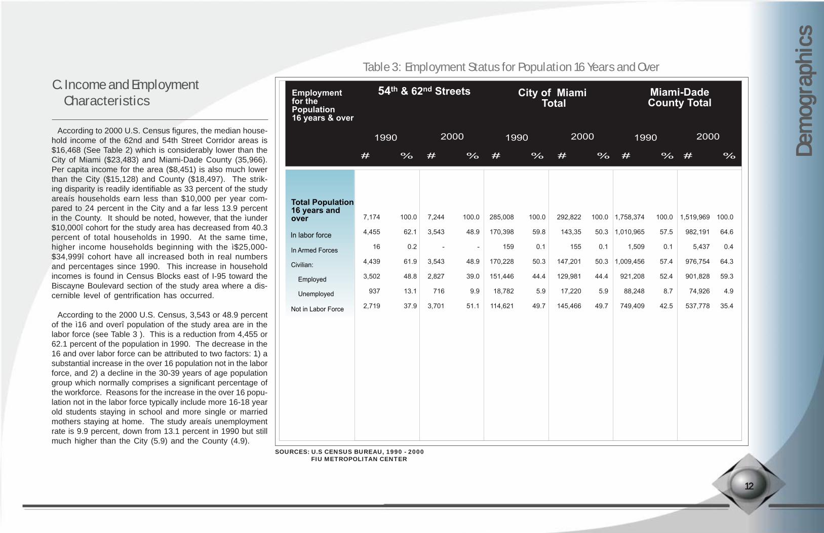
Table 3: Employment Status for Population 16 Years and Over
According to 2000 U.S. Census figures, the median house-hold income of the 62nd and 54th Street Corridor areas is$16,468 (See Table 2) which is considerably lower than theCity of Miami ($23,483) and Miami-Dade County (35,966).Per capita income for the area ($8,451) is also much lowerthan the City ($15,128) and County ($18,497). The strik-ing disparity is readily identifiable as 33 percent of the studyareaís households earn less than $10,000 per year com-pared to 24 percent in the City and a far less 13.9 percentin the County. It should be noted, however, that the ìunder$10,000î cohort for the study area has decreased from 40.3percent of total households in 1990. At the same time,higher income households beginning with the ì$25,000-$34,999î cohort have all increased both in real numbersand percentages since 1990. This increase in householdincomes is found in Census Blocks east of I-95 toward theBiscayne Boulevard section of the study area where a dis-cernible level of gentrification has occurred.
According to the 2000 U.S. Census, 3,543 or 48.9 percentof the ì16 and overî population of the study area are in thelabor force (see Table 3 ). This is a reduction from 4,455 or62.1 percent of the population in 1990. The decrease in the16 and over labor force can be attributed to two factors: 1) asubstantial increase in the over 16 population not in the laborforce, and 2) a decline in the 30-39 years of age populationgroup which normally comprises a significant percentage ofthe workforce. Reasons for the increase in the over 16 popu-lation not in the labor force typically include more 16-18 yearold students staying in school and more single or marriedmothers staying at home. The study areaís unemploymentrate is 9.9 percent, down from 13.1 percent in 1990 but stillmuch higher than the City (5.9) and the County (4.9).
C. Income and Employment Characteristics
1212121212
Miami-DadeCounty Total
Employmentfor thePopulation16 years & over
54th & 62nd Streets City of Miami Total
2000 1990 2000 1990 2000 1990
# % # % # % # % # % # %
Total Population16 years andover
In labor force
In Armed Forces
Civilian:
Employed
Unemployed
Not in Labor Force
1,758,374
1,010,965
1,509
1,009,456
921,208
88,248
749,409
292,822
143,35
155
147,201
129,981
17,220
145,466
100.0
50.3
0.1
50.3
44.4
5.9
49.7
7,174
4,455
16
4,439
3,502
937
2,719
100.0
62.1
0.2
61.9
48.8
13.1
37.9
7,244
3,543
-
3,543
2,827
716
3,701
100.0
48.9
-
48.9
39.0
9.9
51.1
285,008
170,398
159
170,228
151,446
18,782
114,621
100.0
59.8
0.1
50.3
44.4
5.9
49.7
100.0
57.5
0.1
57.4
52.4
8.7
42.5
1,519,969
982,191
5,437
976,754
901,828
74,926
537,778
100.0
64.6
0.4
64.3
59.3
4.9
35.4
SOURCES: U.S CENSUS BUREAU, 1990 - 2000FIU METROPOLITAN CENTER

Dem
ogra
phic
s D
emog
raph
ics
Dem
ogra
phic
s D
emog
raph
ics
Dem
ogra
phic
s
Table 4: Employment by Industry
EMPLOYMENT BY INDUSTRY 54th & 62nd Streets City of Miami Total Miami-Dade County Total
Total Employed Civilian population 16 years and over Agriculture, forestry, fishing, hunting, and mining Construction Manufacturing Wholesale trade Retail trade Transportation and warehousing, and utilities: Information Finance, insurance, real estate, rental and leasing: Professional, scientific, management, administrative, and waste management services: Educational, health and social services Arts, entertainment, recreation, accommodation and food services Other services (except public administration) Public administration
3,502203251605
87558270
3841
644539
87123
56
2,8275
256233
82251247
50108
326604
387172
96
100.00.29.18.22.98.98.71.83.8
11.521.4
146.13.4
151,4462,738
12,05221,765
8,67228,119
8,7762,503
10,155
22,00719,252
2,3338,4754,599
100.01.88.0
14.45.7
18.65.81.76.7
14.512.7
1.55.63.0
129,981671
13,4339,5967,103
14,2698,0073,5518,858
15,30819,450
15,6599,7394,337
100.00.5
10.37.45.5
11.06.22.76.8
11.815.0
12.07.53.3
901,82816,92657,017
102,37257,029
157,77265,89222,83174,499
99478140,979
14,72356,12136,189
100.01.96.3
11.46.3
17.57.32.58.3
95.515.6
1.66.24.0
921,20816,92657,017
102,37257,029
157,77265,89222,83174,499
99,478140,979
14,72356,12136,189
100.00.76.97.16.0
12.37.53.18.0
11.618.0
9.15.64.1
100.05.87.2
17.32.5
15.97.71.11.2
18.415.4
2.53.51.6
# % # % # % # % # % # %
1990 2000 1990 2000 1990 2000
Of the 2,827 employed civilian population of 16 years andover, 2000 U.S. Census data for ìEmployment by Industryî (seeTable 4 above) indicates that 21.4 percent of the study areaíslabor force are employed within Educational, Health and So-cial Services, up from 15.4 percent in 1990. This is followedby Arts, Entertainment, Recreation, Accommodation and FoodServices (14 percent), Professional, Scientific, Management,Administrative, and Waste Management Services (11.5 per-cent) and Construction (9.1 percent). The most significantdecreases in employment occurred in Manufacturing (downfrom 17.3 to 8.2 percent), Retail Trade (down from 15.9 to 8.9percent) and Professional, Scientific, Management, Adminis-trative, and Waste Management Services (down from 18.4 to11.5 percent). An overall decrease in employment in Manu-facturing and Retail Trade was also evident for the City of Mi-ami and Miami-Dade County from 1990-2000.
1313131313
SOURCES: U.S CENSUS BUREAU, 1990 - 2000FIU METROPOLITAN CENTER

Dem
ogra
phic
s D
emog
raph
ics
Dem
ogra
phic
s D
emog
raph
ics
Dem
ogra
phic
sTable 5: Population by Race and Ethnicity
1414141414
Race & Ethnicity 54th & 62nd Streets City of Miami Total Miami-Dade County Total 1990 2000 1990 2000 1990 2000 # % # % # % # % # % # %
TOTAL POPULATION One Race: White Black/African-American American Indian/Alaskan Native Asian Native Hawaiian/Other Pacific Islander Some Other Race Two or more races Hispanic/Latino Not Hispanic/Latino: White alone Black/African-American alone
10,37610,376
7979,394
1018
0157
-1,0429,334
2609029
100.0100.0
7.790.5
0.10.2
-1.5
-10.090.0
2.587.0
9,7178,816
8667,736
1814
3179901
1,1028,615
1617,575
100.090.7
8.979.6
0.20.1
0.031.89.3
11.388.7
1.778.0
358,548358,540235,358
98,207545
2,21457
22,167-
223,964134,584
43,75288,319
100.0100.0
65.627.4
0.20.6
0.026.2
-62.537.512.224.6
100.095.366.622.3
0.20.7
-5.44.7
65.834.211.819.9
100.0100.0
72.920.5
0.21.4
0.025.0
-67.550.830.219.1
100.096.269.720.3
0.21.4
-4.63.8
57.342.720.718.8
362,470345,288241,470
80,858810
2,376130
19,64417,182
238,351124,119
42,89772,190
1,937,0941,937,0941,413,015
397,9933,066
26,307438
96,713-
953,407983,687585,607369,621
2,253,3622,167,9401,570,558
457,2144,365
31,753799
103,25185,422
1,291,737961,625465,772423,656
According to the 2000 U.S. Census, the 62nd and 54th StreetCorridor areas continue to be predominantly ìBlack/African-Americanî (see Table 5). However, the Black population hasdecreased disproportionately to the overall population losswithin the two Corridors. As previously noted, the study areaexperienced a 6 percent overall population loss between 1990-2000. During the same period, the Black population declinedby 1,658 or 17.6 percent. The Black population of the City ofMiami declined at the same rate, while Miami-Dade CountyísBlack population increased by nearly 15 percent.
The racial composition of Whites and Hispanics in the studyarea remained fairly constant between 1990-2000. The areaísWhite population increased by 69 persons, while the Hispanic/Latino population grew by only 60 persons. Whites and Hispan-ics comprise 8.9 and 11.3 percent of the study areaís population,respectively.
D. Race and Ethnicity Characteristics
SOURCES: U.S CENSUS BUREAU, 1990 - 2000FIU METROPOLITAN CENTER

1515151515

Dem
ogra
phic
s D
emog
raph
ics
Dem
ogra
phic
s D
emog
raph
ics
Dem
ogra
phic
s
Table 6: Population 25 Years and Over by Educational Attainment
The U.S. Census provides educational attainment datafor the ì25 and overî population for a given area. The ma-jority (56 percent) of the 62nd and 54th Street Corridor ar-easí population do not have a high school diploma (seeTable 6). In 2000, however, 1,341 or 23 percent of thispopulation had less than a 9th grade education comparedto 2,145 or 36.3 percent in 1990. By contrast, the City ofMiami as a whole experienced a 21.6 percent increase inits 25 and over population with less than a 9th grade edu-cation. Miami-Dade County experienced a 4 percent de-crease in its over 25 population with less than a 9th gradeeducation, but an 18.3 percent increase in this populationwithout a high school diploma.
E. Educational Attainment
1616161616
Educational
Attainment
54th 62nd Streets City of Miami
Total
Miami -Dade
County Total
Total Population 25
Year and over
Less than 9th grade
9th to 12th grade
no diploma
High school graduates
(includes equivalency)
Some College, no
degree
Associate degree
Bachelors degree
Graduate or
Professional degree
5,916
2,145
1,703
1,394
267
141
166
100
100.0
36.3
28.8
23.6
4.5
2.4
2.8
1.7
100.0
23.0
33.3
24.6
16.9
2.9
2.7
1.2
100.0
24.5
22.8
19.8
12.5
4.2
8.6
7.7
100.0
30.9
21.5
19.3
10.7
4.9
7.2
5.6
100.0
17.8
17.2
23.1
16.1
7.0
11.2
7.6
100.0
14.7
17.4
34.5
9.0
9.8
18.7
7.0
5,842
1,341
1,943
1,438
987
167
155
73
252,504
61,818
57,617
49,988
31,514
10,563
21,681
19,323
243.416
75.260
52.290
46.885
26.078
11.857
17.451
13.675
1,281,295
228,426
219,856
296,444
206,600
89,509
143,479
96,981
1,491,789
219,000
260,287
515,268
133,996
146,774
278,584
105,228
1990 2000 1990 2000 1990 2000# % # % # % # % # % # %
SOURCES: U.S CENSUS BUREAU, 1990 - 2000FIU METROPOLITAN CENTER
Chap
ter I
IICh
apte
r III
Chap
ter I
IICh
apte
r III
Chap
ter I
II Ec
onom
ic An
alys
is of
the S
tudy
Area
Econ
omic
Anal
ysis
of th
e Stu
dy Ar
ea Ec
onom
ic An
alys
is of
the S
tudy
Area
Econ
omic
Anal
ysis
of th
e Stu
dy Ar
ea Ec
onom
ic An
alys
is of
the S
tudy
Area
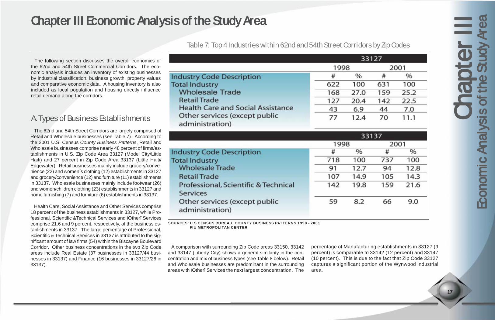
Table 7: Top 4 Industries within 62nd and 54th Street Corridors by Zip Codes
The 62nd and 54th Street Corridors are largely comprised ofRetail and Wholesale businesses (see Table 7). According tothe 2001 U.S. Census County Business Patterns, Retail andWholesale businesses comprise nearly 48 percent of firms/es-tablishments in U.S. Zip Code Area 33127 (Model City/LittleHaiti) and 27 percent in Zip Code Area 33137 (Little Haiti/Edgewater). Retail businesses mainly include grocery/conve-nience (22) and womenís clothing (12) establishments in 33127and grocery/convenience (12) and furniture (11) establishmentsin 33137. Wholesale businesses mainly include footwear (26)and women/children clothing (23) establishments in 33127 andhome furnishing (7) and furniture (6) establishments in 33137.
Health Care, Social Assistance and Other Services comprise18 percent of the business establishments in 33127, while Pro-fessional, Scientific &Technical Services and ìOtherî Servicescomprise 21.6 and 9 percent, respectively, of the business es-tablishments in 33137. The large percentage of Professional,Scientific & Technical Services in 33137 is attributed to the sig-nificant amount of law firms (54) within the Biscayne BoulevardCorridor. Other business concentrations in the two Zip Codeareas include Real Estate (37 businesses in 33127/44 busi-nesses in 33137) and Finance (16 businesses in 33127/26 in33137).
A. Types of Business Establishments
The following section discusses the overall economics ofthe 62nd and 54th Street Commercial Corridors. The eco-nomic analysis includes an inventory of existing businessesby industrial classification, business growth, property valuesand comparative economic data. A housing inventory is alsoincluded as local population and housing directly influenceretail demand along the corridors.
Chapter III Economic Analysis of the Study AreaChapter III Economic Analysis of the Study AreaChapter III Economic Analysis of the Study AreaChapter III Economic Analysis of the Study AreaChapter III Economic Analysis of the Study Area
1717171717
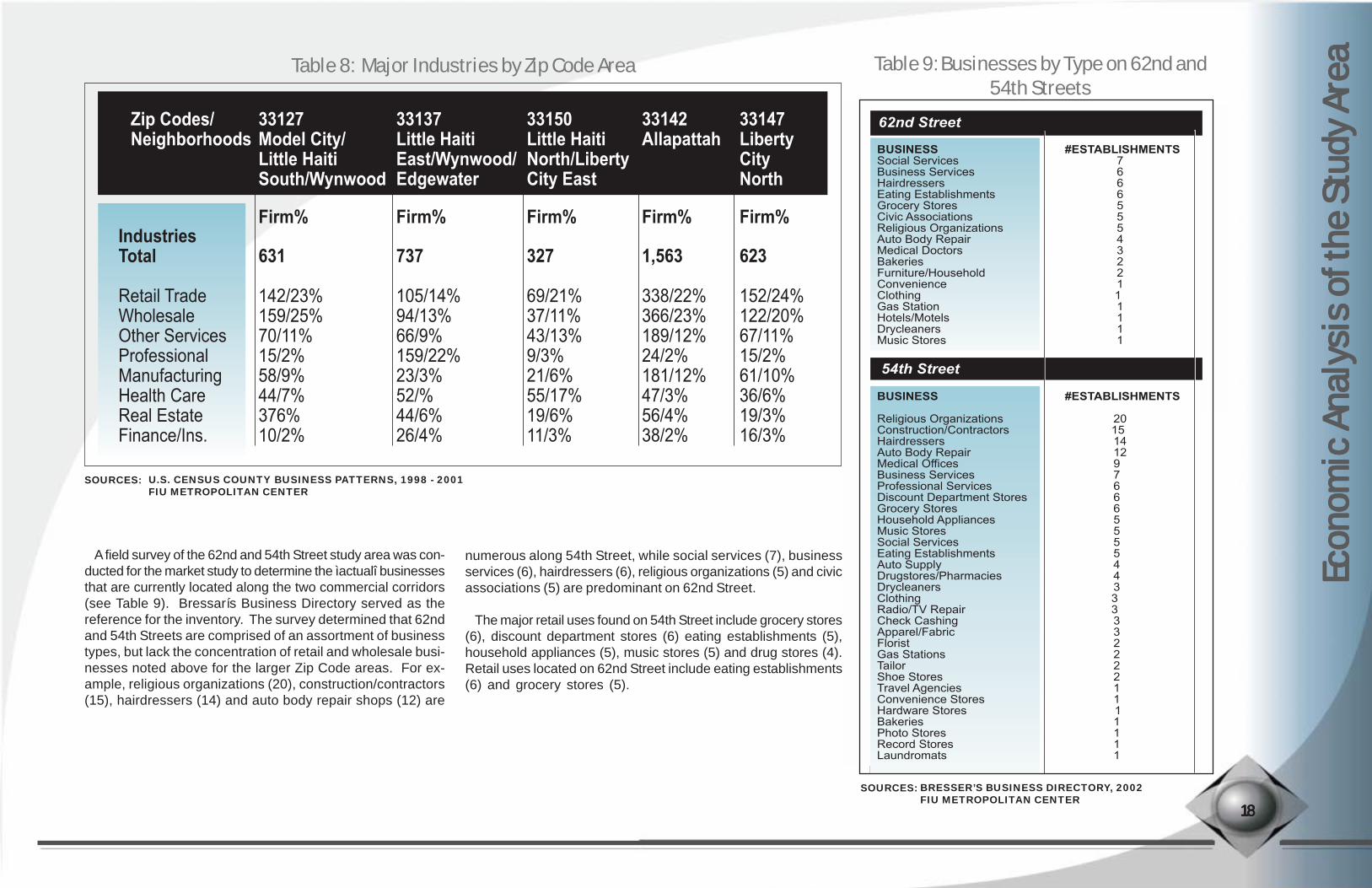
A comparison with surrounding Zip Code areas 33150, 33142and 33147 (Liberty City) shows a general similarity in the con-centration and mix of business types (see Table 8 below). Retailand Wholesale businesses are predominant in the surroundingareas with ìOtherî Services the next largest concentration. The
percentage of Manufacturing establishments in 33127 (9percent) is comparable to 33142 (12 percent) and 33147(10 percent). This is due to the fact that Zip Code 33127captures a significant portion of the Wynwood industrialarea.
SOURCES: U.S CENSUS BUREAU, COUNTY BUSINESS PATTERNS 1998 - 2001FIU METROPOLITAN CENTER
Econ
omic
Anal
ysis
of th
e Stu
dy Ar
ea Ec
onom
ic An
alys
is of
the S
tudy
Area
Econ
omic
Anal
ysis
of th
e Stu
dy Ar
ea Ec
onom
ic An
alys
is of
the S
tudy
Area
Econ
omic
Anal
ysis
of th
e Stu
dy Ar
eaTable 8: Major Industries by Zip Code Area
A field survey of the 62nd and 54th Street study area was con-ducted for the market study to determine the ìactualî businessesthat are currently located along the two commercial corridors(see Table 9). Bressarís Business Directory served as thereference for the inventory. The survey determined that 62ndand 54th Streets are comprised of an assortment of businesstypes, but lack the concentration of retail and wholesale busi-nesses noted above for the larger Zip Code areas. For ex-ample, religious organizations (20), construction/contractors(15), hairdressers (14) and auto body repair shops (12) are
numerous along 54th Street, while social services (7), businessservices (6), hairdressers (6), religious organizations (5) and civicassociations (5) are predominant on 62nd Street.
The major retail uses found on 54th Street include grocery stores(6), discount department stores (6) eating establishments (5),household appliances (5), music stores (5) and drug stores (4).Retail uses located on 62nd Street include eating establishments(6) and grocery stores (5).
Table 9: Businesses by Type on 62nd and54th Streets
1818181818
Zip Codes/Neighborhoods
33127Model City/Little HaitiSouth/Wynwood
Firm%IndustriesTotal
Retail TradeWholesaleOther ServicesProfessionalManufacturingHealth CareReal EstateFinance/Ins.
631
142/23%159/25%70/11%15/2%58/9%44/7%376%10/2%
737
105/14%94/13%66/9%159/22%23/3%52/%44/6%26/4%
327
69/21%37/11%43/13%9/3%21/6%55/17%19/6%11/3%
1,563
338/22%366/23%189/12%24/2%181/12%47/3%56/4%38/2%
623
152/24%122/20%67/11%15/2%61/10%36/6%19/3%16/3%
Firm% Firm% Firm% Firm%
33137Little HaitiEast/Wynwood/Edgewater
33150Little HaitiNorth/LibertyCity East
33142Allapattah
33147LibertyCityNorth
SOURCES: BRESSER’S BUSINESS DIRECTORY, 2002FIU METROPOLITAN CENTER
SOURCES: U.S. CENSUS COUNTY BUSINESS PATTERNS, 1998 - 2001FIU METROPOLITAN CENTER
1919191919
Econ
omic
Anal
ysis
of th
e Stu
dy Ar
ea Ec
onom
ic An
alys
is of
the S
tudy
Area
Econ
omic
Anal
ysis
of th
e Stu
dy Ar
ea Ec
onom
ic An
alys
is of
the S
tudy
Area
Econ
omic
Anal
ysis
of th
e Stu
dy Ar
ea
There currently exists a significant amount of office uses alongthe 62nd and 54th Street Corridors that is comprised mainly ofsocial and business services and medical buildings. The mix ofcommercial office uses complements the local retail base asemployees, clients and patients will typically patronize nearbyrestaurants and convenience stores.
While the existing mix of office uses is important to the 62ndAnd 54th Street Corridors, the overall office market has beenìsoftî for several years. According to statistics from Cushman& Wakefield, vacancy rates in Miami-Dadeís office market havesteadily climbed from 12.8 percent in 2001 to 18.6 percent in2003. As the overall vacancy rate has continued to climb,subleases have also risen and the demand for space as notedby ìnet absorptionî remains negative. Local experts generallyagree that there will be a sustained recovery as the real estatemarket improves but office space will remain soft for the fore-seeable future.
While the office market remains sluggish in the larger localeconomy, there appears to be some strength in the 62nd and54th Street Corridorsí sub-market. This is because local so-cial service and business service offices are oriented to servethe surrounding community. Lower lease rents and good high-way/roadway access also create demand for office space alongthe corridors.
B. Office Demand
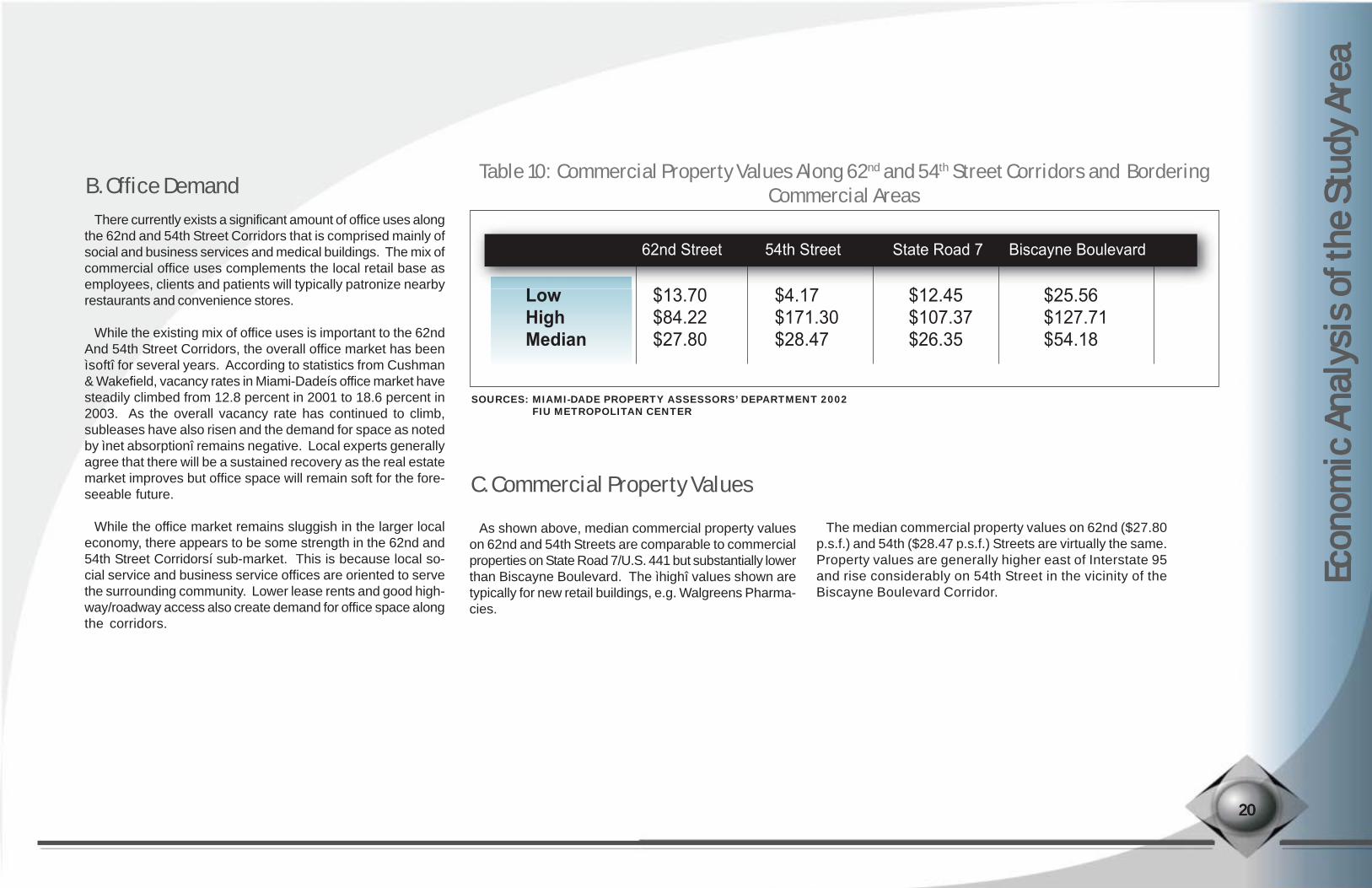
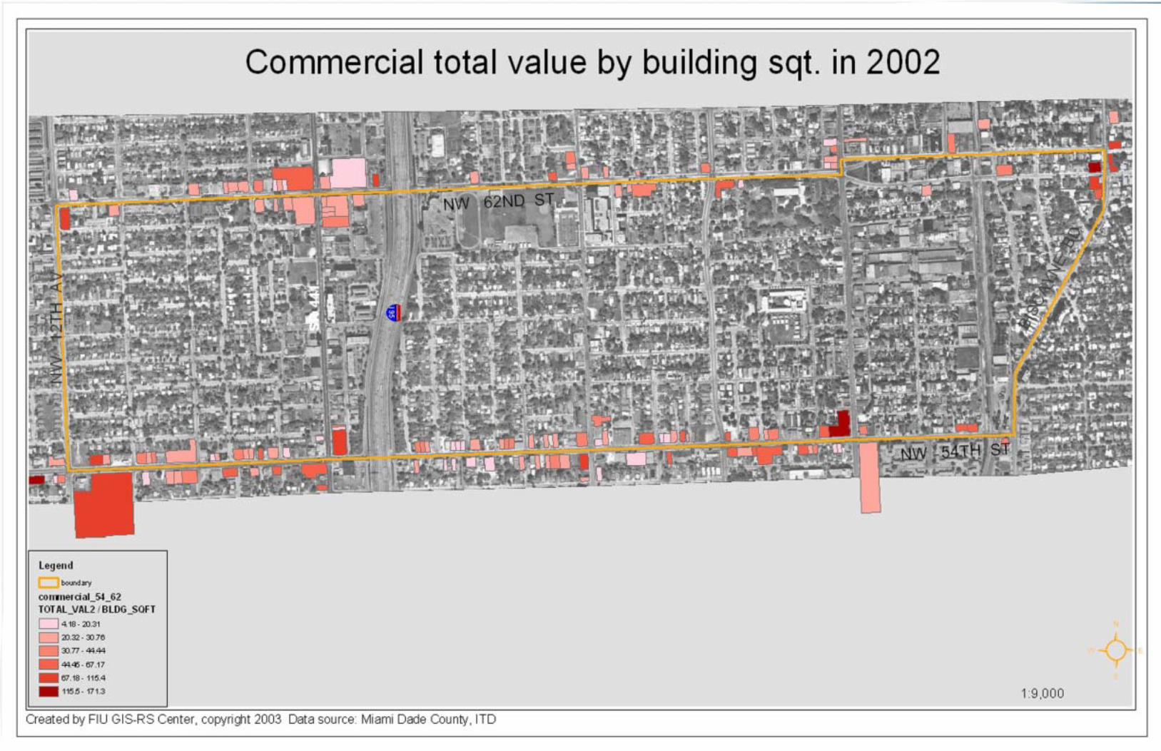
C. Commercial Property Values
Table 10: Commercial Property Values Along 62nd and 54th Street Corridors and BorderingCommercial Areas
2020202020
As shown above, median commercial property valueson 62nd and 54th Streets are comparable to commercialproperties on State Road 7/U.S. 441 but substantially lowerthan Biscayne Boulevard. The ìhighî values shown aretypically for new retail buildings, e.g. Walgreens Pharma-cies.
The median commercial property values on 62nd ($27.80p.s.f.) and 54th ($28.47 p.s.f.) Streets are virtually the same.Property values are generally higher east of Interstate 95and rise considerably on 54th Street in the vicinity of theBiscayne Boulevard Corridor.
SOURCES: MIAMI-DADE PROPERTY ASSESSORS’ DEPARTMENT 2002FIU METROPOLITAN CENTER
2121212121

According the 2000 U.S. Census, there are approximately3,717 housing units in the study area (see Table 11), which indi-cates a slight increase since 1990. The current owner-occu-pancy rate of 21.8 percent is slightly down from 1990, whilerenter occupancy has shown a comparable gain. The vacancyrate showed an increase from 10.4 percent (384 units) in 1990to 10.8 percent (401 units) in 2000. By comparison, both theCity of Miami and Miami-Dade County showed modest in-creases in owner occupancy between 1990-2000 and slightdecreases in renter occupancy. Overall vacancy rates in theCity and county also declined during this period. The relativelylow inventory of housing units coupled with relatively low popu-lation/household density has a significant effect on the TotalExpenditure Potential of the surrounding area, and therefore,the existing capacity of the corridor to accommodate new retaildevelopment.
D. Housing Inventory
Econ
omic
Anal
ysis
of th
e Stu
dy Ar
ea Ec
onom
ic An
alys
is of
the S
tudy
Area
Econ
omic
Anal
ysis
of th
e Stu
dy Ar
ea Ec
onom
ic An
alys
is of
the S
tudy
Area
Econ
omic
Anal
ysis
of th
e Stu
dy Ar
ea
Table 11 - Housing Units by Occupancy Status
2222222222
Occupancy Status 54th 62nd Streets City of Miami
Total
Miami -Dade
County Total
Total Housing Units:
Occupied
Owner-occupied
Renter-occupied
Vacant
3,675
3,291
838
2,453
384
100.0
89.6
22.8
66.7
10.4
100.0
89.2
21.8
67.4
10.8
100.0
90.1
33.1
66.9
9.9
100.0
90.4
34.9
65.1
9.6
100.0
89.8
54.3
45.7
10.2
100.0
91.1
57.8
42.2
8.9
3,716
3,315
810
2,505
401
144,550
130,252
43,102
87,150
14,298
148,388
134,198
46,836
87,362
14,190
771,288
692,355
375,912
316,443
78,933
852,278
776,774
449,325
327,449
75,504
1990 2000 1990 2000 1990 2000# % # % # % # % # % # %
SOURCES: U.S CENSUS BUREAU, 1990 - 2000FIU METROPOLITAN CENTER

This section analyzes the retail market potential of the 62ndand 54th Street Commercial Corridors. The future demand forretail development is based on the supply of existing retail usesalong the two corridors, the supply of existing retail uses withinthe larger trade area and the demographics of the trade area.The retail market is subdivided into the following four catego-ries:
ï Convenience GoodsConvenience goods are daily purchases that include gro-ceries, pharmacy health care and related sundries such ascosmetics and toiletries, food snacks, beer and liquor andbakery items.
Convenience goods are generally purchased at retail loca-tions within two miles of the purchaserís home and often viawalking and/or transit in urban locations. This is particularlythe case in poorer urban neighborhoods where automobileownership is much lower. The two corridors do capture drive-by business, but less so than north/south collector streets dueto existing commuter patterns in Miami.
Chapter IV - The Retail MarketChapter IV - The Retail MarketChapter IV - The Retail MarketChapter IV - The Retail MarketChapter IV - The Retail Market
A. Retail Categories
ï Personal ServicePersonal services are day-to-day and regular types of retailneeds such as beauty salons and barbershops, drycleaners,tailors, shoe cobblers and coin laundries.
Personal services are also generally transacted within two milesof the customerís home. These services also occur within walk-ing distance or via transit in urban locations.
ï Entertainment RetailEntertainment retail includes restaurants, nightclubs, pubs andgame and video establishments.
Due to the fact that retail entertainment is more of a luxury con-sumer product, customers are more willing to travel a further dis-tance to enjoy certain foods, venues and leisure settings. There-fore, the entertainment retail trade area is calculated within aten mile radius.
ï Shopper GoodsShopper goods are large and brand named products typically
sold in department stores, big box retailers and smaller national chains.
Most shopper goods are purchased within five miles of thecustomerís home. For purchases such as home furnish-ings, electronics and apparel there is a significant degree ofcomparison shopping, with price the major determinant inwhere the consumer ultimately purchases those items withinthe trade area.
Entertainment and Shoppers Goods Retail are primarilydestination-oriented and involve comparison shopping. Atpresent, the 62nd and 54th Street Corridors do not showcapacity for these retail opportunities. As such, the followingretail analysis focuses on Convenience Goods and PersonalServices and the opportunities for growth in these retail seg-ments. This does not, however, preclude the potential fornew Entertainment and Shoppers Goods retail developmentalong the corridors. The potential for new development inCommunity Business Districts (CoBDs) within these retailsegments is discussed at the end of this section.
Chap
ter I
VCh
apte
r IV
Chap
ter I
VCh
apte
r IV
Chap
ter I
VTh
e Ret
ail M
arke
tTh
e Ret
ail M
arke
tTh
e Ret
ail M
arke
tTh
e Ret
ail M
arke
tTh
e Ret
ail M
arke
t
2323232323
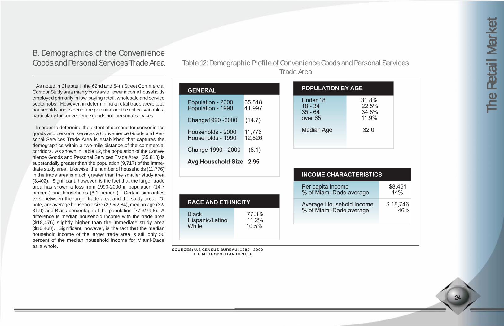
As noted in Chapter I, the 62nd and 54th Street CommercialCorridor Study area mainly consists of lower income householdsemployed primarily in low-paying retail, wholesale and servicesector jobs. However, in determining a retail trade area, totalhouseholds and expenditure potential are the critical variables,particularly for convenience goods and personal services.
In order to determine the extent of demand for conveniencegoods and personal services a Convenience Goods and Per-sonal Services Trade Area is established that captures thedemographics within a two-mile distance of the commercialcorridors. As shown in Table 12, the population of the Conve-nience Goods and Personal Services Trade Area (35,818) issubstantially greater than the population (9,717) of the imme-diate study area. Likewise, the number of households (11,776)in the trade area is much greater than the smaller study area(3,402). Significant, however, is the fact that the larger tradearea has shown a loss from 1990-2000 in population (14.7percent) and households (8.1 percent). Certain similaritiesexist between the larger trade area and the study area. Ofnote, are average household size (2.95/2.84), median age (32/31.9) and Black percentage of the population (77.3/79.6). Adifference is median household income with the trade area($18,476) slightly higher than the immediate study area($16,468). Significant, however, is the fact that the medianhousehold income of the larger trade area is still only 50percent of the median household income for Miami-Dadeas a whole.
The R
etai
l Mar
ket
The R
etai
l Mar
ket
The R
etai
l Mar
ket
The R
etai
l Mar
ket
The R
etai
l Mar
ket
B. Demographics of the ConvenienceGoods and Personal Services Trade Area Table 12: Demographic Profile of Convenience Goods and Personal Services
Trade Area
2222244444
RACE AND ETHNICITY Black 77.3%Hispanic/Latino 11.2%White 10.5%
POPULATION BY AGE Under 18 31.8%18 - 34 22.5%35 - 64 34.8%over 65 11.9%
Median Age 32.0
INCOME CHARACTERISTICS
Per capita Income $8,451% of Miami-Dade average 44%
Average Household Income $ 18,746% of Miami-Dade average 46%
GENERAL Population - 2000 35,818Population - 1990 41,997
Change1990 -2000 (14.7)
Households - 2000 11,776Households - 1990 12,826
Change 1990 - 2000 (8.1)
Avg.Household Size 2.95
SOURCES: U.S CENSUS BUREAU, 1990 - 2000FIU METROPOLITAN CENTER
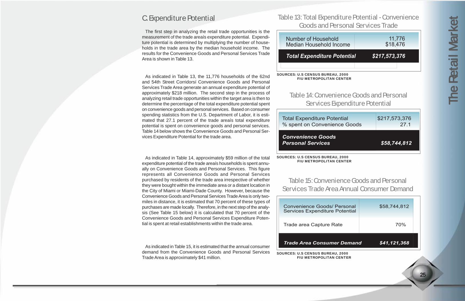
The first step in analyzing the retail trade opportunities is themeasurement of the trade areaís expenditure potential. Expendi-ture potential is determined by multiplying the number of house-holds in the trade area by the median household income. Theresults for the Convenience Goods and Personal Services TradeArea is shown in Table 13.
C. Expenditure Potential
As indicated in Table 13, the 11,776 households of the 62ndand 54th Street Corridorsí Convenience Goods and PersonalServices Trade Area generate an annual expenditure potential ofapproximately $218 million. The second step in the process ofanalyzing retail trade opportunities within the target area is then todetermine the percentage of the total expenditure potential spenton convenience goods and personal services. Based on consumerspending statistics from the U.S. Department of Labor, it is esti-mated that 27.1 percent of the trade areaís total expenditurepotential is spent on convenience goods and personal services.Table 14 below shows the Convenience Goods and Personal Ser-vices Expenditure Potential for the trade area.
As indicated in Table 14, approximately $59 million of the totalexpenditure potential of the trade areaís households is spent annu-ally on Convenience Goods and Personal Services. This figurerepresents all Convenience Goods and Personal Servicespurchased by residents of the trade area irrespective of whetherthey were bought within the immediate area or a distant location inthe City of Miami or Miami-Dade County. However, because theConvenience Goods and Personal Services Trade Area is only two-miles in distance, it is estimated that 70 percent of these types ofpurchases are made locally. Therefore, in the next step of the analy-sis (See Table 15 below) it is calculated that 70 percent of theConvenience Goods and Personal Services Expenditure Poten-tial is spent at retail establishments within the trade area.
As indicated in Table 15, it is estimated that the annual consumerdemand from the Convenience Goods and Personal ServicesTrade Area is approximately $41 million.
The R
etai
l Mar
ket
The R
etai
l Mar
ket
The R
etai
l Mar
ket
The R
etai
l Mar
ket
The R
etai
l Mar
ket
2525252525
Table 13: Total Expenditure Potential - ConvenienceGoods and Personal Services Trade
Number of Household Median Household Income
Total Expenditure Potential $217,573,376
11,776$18,476
SOURCES: U.S CENSUS BUREAU, 2000FIU METROPOLITAN CENTER
SOURCES:
Table 14: Convenience Goods and PersonalServices Expenditure Potential
Total Expenditure Potential $217,573,376% spent on Convenience Goods 27.1
Convenience Goods
Personal Services $58,744,812
U.S CENSUS BUREAU, 2000FIU METROPOLITAN CENTER
Table 15: Convenience Goods and PersonalServices Trade Area Annual Consumer Demand
Convenience Goods/ Personal $58,744,812Services Expenditure Potential
Trade area Capture Rate 70%
Trade Area Consumer Demand $41,121,368
SOURCES: U.S CENSUS BUREAU, 2000FIU METROPOLITAN CENTER

The R
etai
l Mar
ket
The R
etai
l Mar
ket
The R
etai
l Mar
ket
The R
etai
l Mar
ket
The R
etai
l Mar
ket
As previously noted, the 62nd and 54th Street Corridors aretraversed by major north/south arterials including BiscayneBoulevard on the east and State Road 7/U.S. 441 just oneblock west of Interstate 95. Other major north/south roadwaysinclude North Miami Avenue and NE 2nd Avenue. Much ofland use along each of these arterials and roadways is dedi-cated to retail and commercial uses. Additionally, two majoreast/west roadways located within the trade area, 79th and36th Streets, are also predominantly commercial and retailcorridors. In fact, State Road 7/U.S. 441 and 79th Street serveas perhaps the two primary commercial corridors within thetrade area.
Due to the existence of several retail nodes and the abun-dance of various retail stores within the trade area, it is impor-tant that the types and amounts of retail/service establishmentsbe determined as part of a competition analysis. For the pur-poses of this study, the following four types of retail/serviceestablishments are examined:
ï Food Stores: Stores that sell non-prepared foods, grocer-ies, bakeries, and markets specializing in meats, fish,fruits, vegetables, health/nutrition diets and other food prod-ucts.
ï Drug Stores/Pharmacies: Stores that sell prescription and/or non-prescription drugs, as well as cosmetics, toiletries,stationary and assorted personal and household items.
ï Barber/Beauty Shops: Establishments primarily engagedin hair cutting, hairdressing, manicuring and other personalcosmetic treatments.
D. Competition Analysis
ï Laundry/Dry Cleaning Services: Establishments engagedin the cleaning of clothes or linens.
As previously noted, food stores comprise a significant num-ber of Convenience Goods establishments in the 62nd and 54thStreet Corridors. However, food stores, which include super-markets, groceries, produce markets, meat and fish marketsand other specialty food establishments, also represent the larg-est portion of the Convenience Goods category in the largertrade area. As shown in Table 16 below, there are 142 foodstores in the trade area with estimated annual sales of nearly$150 million.
Of the 142 food stores within the trade area about 94 (66percent) are classified as general grocery stores with the re-mainder specialty or miscellaneous food stores. Fifteen of thegrocery stores are listed as having 10 or more employees, ameasure that indicates a larger retail establishment. The Winn-Dixie Plaza at the intersection of 54th Street and NW 12th Av-enue is the largest grocery store in the immediate study area.
Another common establishment within the ConvenienceGoods and Personal Services Trade Area are drug stores orpharmacies. There are 34 drug stores in the trade area withestimated annual sales of over $36 million (See Table 17).
Personal Services common in the trade area include beauty andbarber shops, dry cleaners and laundries. There are 20 beauty/barber shops in the immediate study area and five dry cleanersand laundries. Within the larger trade area there are 34 drug stores,20 beauty/barbershops and 37 dry cleaners and laundries.
2626262626
Table 17: Drug Stores and Personal ServicesEstablishments within Trade Area
SOURCES: CLARITAS INC, BRESSER’S BUSINESS DIRECTORY 2002 FIU METROPOLITAN CENTER
$36,478,000$2,342,857$6,660,000
$45,480,857
EstimatedAnnual Sales
Type of Store # of Store # of por StoresW/10 or MoreEmployees
342037
91
1506
21
Drug StoresBeauty/Barber ShopsDry Cleaners/Laundry
Total
Table 16: Food Stores within ConvenienceGoods Trade Area
SOURCES: CLARITAS INC, BRESSER’S BUSINESS DIRECTORY 2002 FIU METROPOLITAN CENTER
$119,000,000$2,600,000
$680,000$5,800,000
$21,700,000
Estimated
Annual Sales
Type of Store # of Store # of por Stores
W/10 or More
Employees
94339
33
150001
Grocery StoresProduce MarketsRetail BakeriesMeat, Fish, DeliMisc. Food Stores

The R
etai
l Mar
ket
The R
etai
l Mar
ket
The R
etai
l Mar
ket
The R
etai
l Mar
ket
The R
etai
l Mar
ket
Of the 34 drug stores, 15 have 10 or more employees, while six of the trade areaís 37 drycleaners and laundries have 10 or more indicating larger establishments in both cases. Whencombined with food stores, these establishments account for over $195 million in annual sales.
Throughout the two-mile Convenience Goods and Personal Services Trade Area there areapproximately 331 convenience goods and personal services establishments. Of this total,233 include food, drug stores, beauty/barber shops, dry cleaners and laundries. It is esti-mated that 30 percent of these total purchases will come from ìinflow salesî or sales toconsumers who live outside the trade area. Inflow sales for convenience goods and per-sonal services are calculated in Table 19 below.
The table indicates that the trade area sales (those sales attributed to residents of theConvenience Goods and Personal Services Trade Area) accounts for approximately $137million annually.
Table 18: Total Estimated Retail Competition in ConvenienceGoods and Personal Services Trade Area
Table 19: Inflow Sales for Convenience Goods and PersonalServices Trade Area
2727272727
Type of Store # of Stores
14291
233
$149,780,000 $45,480,857
$195,260,857
Foods StoresPersonal Services
Total
EstimatedAnnual Sales
Total Estimated Sales $195,260,857Percentage of Inflow Sales 30% Amount of Inflow Sales $58,578,257
Trade area Sales (Total Less Inflow) $136,682,600
SOURCES: CLARITAS INC., BRESSER’S BUSINESS DIRECTORY 2002FIU METROPOLITAN CENTER
SOURCES: CLARITAS INC., BRESSER’S BUSINESS DIRECTORY 2002FIU METROPOLITAN CENTER

The R
etai
l Mar
ket
The R
etai
l Mar
ket
The R
etai
l Mar
ket
The R
etai
l Mar
ket
The R
etai
l Mar
ket
A positive gap between the demand generated by the trade arearesidents and the sales generated by the trade areaís existing es-tablishments would indicate an ìunmet demandî meaning that moreretail services could be supported by the trade areaís residents.Table shows the calculation for determining unmet demand for con-venience goods and personal services within the trade area.
As shown in Table 20, there is a negative gap of approximately$96 million annually between the trade areaís consumer demandand the areaís annual sales from Convenience Goods and Per-sonal Services. This suggests that there is no growth in demandthat would warrant ìnetî new retail development of establishmentsoffering convenience goods and personal services of the abovebusiness types within the 62nd and 54th Street Corridors at thepresent time.
The most significant ìcompetitive disadvantageî of the 62ndand 54th Streetsí trade area is the comparatively low residentialdensity and itís relative physical and land use isolation. For ex-ample, a similar study of the 79th Street Corridorís ConvenienceGoods and Personal Services Trade Area showed a populationof 89,444 with 26,099 households compared to a population of35,818 with 11,776 households in the 62nd and 54th Street Cor-ridorsí trade area. In addition, the median household incomewithin the 79th Street trade area is $35,778 compared to $18,476in the 62nd and 54th Street area. The low population/householddensity coupled with low household income minimizes the TotalExpenditure Potential of the trade area and, therefore, the de-mand for retail goods and services. The 62nd and 54th StreetCorridorsí trade area is also constrained from a physical andland use standpoint. The trade area is limited to the east byBiscayne Bay and to the west and south by commercial and indus-
E. Calculating Demand Table 20: Convenience Goods and PersonalServices Trade Area Analysis of
Annual Demandtrial districts. In contrast, the 79th Street Corridor trade area in-cludes higher density residential uses and more affluent neighbor-hoods to the east, north and west. This relative isolation of the62nd and 54th Street Corridors creates a negative economic en-clave effect for retail trade.
The relatively low Total Expenditure Potential of the 62nd and54th Street Corridorsí trade area requires that analysis be givento more precise consumer demand considerations in the imme-diate study area. It should be noted, for instance, that many ofthe Convenience Goods and Personal Services establishmentsare located on the fringes of the two-mile distance from the tradearea along State Road 7/U.S. 441, Biscayne Boulevard and 79thStreet. The market analysis does not consider changing con-sumer demand, e.g. consumer tastes, nor the quality or pricingof the trade areaís retail establishments. As such, new Conve-nience Goods and Personal Services establishments that caterto niche consumer markets may have a certain competitive ad-vantage in the trade area.
While this market study determined the 62nd and 54th StreetCorridors are not ideal for destination oriented Entertainment andShopper Goods Retail, there are opportunities for certain typesof establishments within these broader categories. For example,there are currently 11 eating establishments along the two corri-dors and a mix of discount department, clothing and music stores.These establishments are addressing a certain consumer de-mand within the immediate trade area. However, as is the casewith convenience goods and personal services, there is sub-stantial competition within the larger two-mile trade area. Forinstance, there currently exist 125 restaurants in the trade area,50 of which employ 10 or more employees. This competition, once
again, suggests that net new restaurant establishments are not war-ranted at this present time. However, Entertainment and ShopperGoods Retail opportunities may exist for cultural and ethnic retail-ing. Community Business Districts (CoBDs) that largely dependon the patronage of surrounding neighborhoods can offer a combi-nation of comparison and convenience shopping that is a mix ofevery day goods and services along with niche entertainment andshoppers goods that cater to local culture and ethnicity.
2828282828
SOURCES: CLARITAS INC., BRESSER’S BUSINESS DIRECTORY 2002FIU METROPOLITAN CENTER
Unmet Demand ($95,561,231)
$41,121,368$136,682,600
Trade Area Consumer DemandTotal Estimated Trade Area Sales

The R
etai
l Mar
ket
The R
etai
l Mar
ket
The R
etai
l Mar
ket
The R
etai
l Mar
ket
The R
etai
l Mar
ket
ï The Spending Potential Index compares the average localexpenditure for a product to the average amount spentnationally. 100 is the national average index. An SPI of 120shows that the average spent by local consumers is 20percent above the national average. An SPI of 85 showsthat average spent is 15 percent below the nationalaverage.
Table21: Spending Potential Indices
2929292929SOURCE: SOURCE BOOK FOR ZIP CODE DEMOGRAPHICS 2003 FIU METROPOLITAN CENTER
The R
etai
l Mar
ket
The R
etai
l Mar
ket
The R
etai
l Mar
ket
The R
etai
l Mar
ket
The R
etai
l Mar
ket
The FIU study team conducted a survey sampling of ownersand managers of businesses along Martin Luther King Boule-vard. The purpose of the survey was to develop a general un-derstanding of the primary issues concerning businesses in thearea. The surveys were face-to-face interviews at the businesslocation. The interviews were conducted with businesses alongthe NW section of MLK Boulevard between NW 2nd and NW10th Avenues. They represent most of the business types in thearea: small, family owned, retail and service establishments. Thebusinesses are typically older, established ranging from 9-30years at their current location. Each of the businesses leasestheir retail space.
The following is a summary of the key issues or themesraised during the interviews:
F. Business Surveys
Pride in the community and a feeling of wanting to empower thelocal (predominantly African American) community was a centralfocus of the interviewees. The first interview was with the husbandand wife owners of a shoe repair establishment near the corner ofNW 62nd Street and NW 7th Avenue. The decor and products soldat this business are telling of their aim to promote African Ameri-can community and pride. On the outside of the small shop theyadvertise, ìAfrican American History shirts sold here.î Inside, is-sues of the local ìCaribbean Contentî periodical with an article aboutthe NAACP are made available for customers.
The business is over 40 years old and passed down from a gen-eration. It has been located on the same street since the businessopened, but has moved to and from various buildings. One of theowners indicated the rent is ìridiculouslyî high and suspects thatthey get charged more than their neighbors in the area. Sheís con-cerned that they may be moving again - not by choice, but ratherbecause they believe the building ìmay be torn down for new tran-sit projects in the area. Thatís what they do in these neighborhoods.îThese owners feel a bit of mistrust toward the city.
The owner notes that many of their customers are regulars whohave been doing business with them for years. She jokes that they
do not even ask for receipts or documentation. She says thatshe can look at a pair of shoes on the work shelf and knowwhom they belong to just by the style. ìOur customers are fromall over Miami-Dade County including North Miami and OpaLocka. She says they grew up in this neighborhood and theycome back (she adds that about 50% of their clients are fromoutside the neighborhood). The co-owner stated that the bestthing about having a business in the neighborhood is ìserviceto the community.î
The office manager at a nearby electronics (stereos, etc.)repair shop gave the same reply. When asked why they re-main in the area she says, ìto service our people.î Just as theabove shoe repair business, the electronics shop has beenlocated in the area for about 30 years. She stated being aminority business is an advantage because they get a consis-tent flow of customers who are, ìour kind in the neighborhood.îAbout 80 percent of their clientele is local.
The manager of the local sandwich shop asked, ìDid youknow that people in the inner-city spend more per capita thananyone?î He has confidence in the buying power of the localcustomer base.
1. Serving Community/Clientele
2. Business Organizations/Community AssetsThe owner of a local convenience store stated that their revenue
has decreased in recent years, ìwhen Winn Dixie moved 2 yearsago, that hurt business.î Nevertheless they are striving to expandtheir business, which may include adding orthopedic equipment.She hopes to get assistance from area business and economicdevelopment organizations. She and other owners are aware ofthese types of ëcommunity assets.í Theyíre aware of organizationssuch as OCED, MMAP and Tools for Change. She noted that NANAhas helped them with business plans and informed them about
obtaining grants, etc.
The office manager at the electronics shop has also heard ofmany of the business assistance and economic developmentorganizations but has not yet utilized their services. Likewise,the owner of local barber shop (in business for about 10 years)has also heard of a few business organizations and has re-ceived assistance in the past from Tools for Change.
3030303030

The R
etai
l Mar
ket
The R
etai
l Mar
ket
The R
etai
l Mar
ket
The R
etai
l Mar
ket
The R
etai
l Mar
ket
Respondents did not think that crime was a problem in the corri-dor. The question was usually followed by a somewhat disgruntledresponse: ìPeople from outside of the inner city think that there is alot of crime here, when it is just not true. The only problem is whenpeople come to this neighborhood and the fear itself causes someconflict,î according to the manager of the sandwich shop. The Ku-waiti respondent stated that he feels safer here than other areas.He does not live in this area but works at this store with his cousins(the owners).
The manager of the sandwich shop believes that the prob-lem of having a poor, crime-ridden reputation may be solvedby new developments that are taking place a block away fromtheir current location (on NW 62nd St.). His shop is currentlyin a deteriorated strip mall that other businesses have vacated.Since the other businesses left his shop has been relativelyslow. He is very optimistic and believes this will attract outsid-ers and the improved infrastructure will change the ìcrimeîimage.
The owner of the barber shop stated that deteriorated build-ings have been an on-going problem along the corridor. Whenasked why she moved from one building in the neighborhoodto another she exclaimed, ìThe other place was falling in!î
3. Image of Crime and Deterioration
ï Edison High School brings in business. For example, therespondent from the convenience store stated that onschool days, they get waves of about 45 people comingin before and after school and during lunch including stu-dents, faculty, administrators and parents.
ï One respondent from Kuwait noted that there is a smallenclave of businesses on this street owned by peoplefrom the Middle East. They do not live in the neighbor-hood, but own a number of businesses within the corri-dor.
ï Although most businesses have few employees (family-owned businesses generally hire family members), thosewho do stated their employees stay a long time. Themanager of the sandwich shop noted that two employ-ees present during the interview have been working theresince 1993.
ï While the respondents estimate their local clientele is between 50-80 percent, it appears their supplier-base is fromoutside the area including Greater Miami-Dade Countyand the State of Florida.
ï MLK businesses say they do not feel the need for extraassistance with various business skills, except for get-ting grants and loans. A couple respondents said theycould use assistance with marketing/promotion, althoughmost rely on ëword of mouthí from their ëregularsí for mar-keting.
4. Other Observations
3131313131
Development practices have been studied and evaluated fromvarious viewpoints, such as land use, urban design, transportation,environmental and housing practices. The case studies presentedin this report focus on economic development financing. They de-scribe some creative ways in which communities around the UShave used public and private resources to fund revitalization effortsin distressed neighborhoods.
The report is divided into several sections. The first section pro-vides a discussion of the factors that affect public and privatedevelopment financing. Section two describes the various finan-cial tools that are used in redevelopment efforts. Section threeprovides several case study examples of corridor improvementefforts and the innovative use of public and private monies tofinance these projects. The report concludes with recommen-dations for successful and sustained revitalization and a toolboxof recommendations for financing redevelopment projects aswell as other means to increase their feasibility.
Chapter V - Economic Development Financing: Lessons LearnedChapter V - Economic Development Financing: Lessons LearnedChapter V - Economic Development Financing: Lessons LearnedChapter V - Economic Development Financing: Lessons LearnedChapter V - Economic Development Financing: Lessons Learned
Chap
ter V
Chap
ter V
Chap
ter V
Chap
ter V
Chap
ter V
Econ
omic
Deve
lope
men
t Fin
anci
ng: Le
sson
s Lea
rned
Econ
omic
Deve
lope
men
t Fin
anci
ng: Le
sson
s Lea
rned
Econ
omic
Deve
lope
men
t Fin
anci
ng: Le
sson
s Lea
rned
Econ
omic
Deve
lope
men
t Fin
anci
ng: Le
sson
s Lea
rned
Econ
omic
Deve
lope
men
t Fin
anci
ng: Le
sson
s Lea
rned
A. Background
Neighborhood Economy and CharacteristicsRevitalization strategies can be devised through a better under-
standing of neighborhood economies. Neighborhood characteris-tics, including economic strength, often determine where businesseslocate. New businesses locating in a neighborhood strengthen theeconomy by providing residents with job opportunities and accessto goods and services, which in turn improves the overall health ofthe neighborhood. To make neighborhoods viable places to con-duct and sustain businesses, strategic revitalization must addressunderlying factors such as crime and dilapidated housing and store-fronts (Bingham and Zhang 2001). These factors also play a criticalrole in leveraging financial resources from potential investors.
Public Private PartnershipsOne of the most successful revitalization strategies observed in the
case studies included in this report is public-private partnerships.Public-private partnerships attempt to blend the strengths of both thepublic and the private sectors in order to create a seamless con-tinuum and a complementary network of both public and private ser-vices. Most partnerships have as their main purpose to expand thenumber of jobs, level of income, neighborhood improvement, or othermeasures of local community development (Clarke 1998). They arecreated in the belief that concerted efforts will be more successfulthan single ventures.
B. Factors that Affect Economic Redevelopment Financing
In the most common type of partnership, city government andbusinesses make a contribution and expect to receive a speci-fied output. The more rare type is one in which both sides take anequity position in the business (Clarke 1998). Although the scopeof activities in which these partnerships are involved varies widely,the common goals center on the attraction of investors; the cre-ation, expansion and retention of jobs; and the promotion of thecommunityís economic health.
Public-private partnerships garner local, state, and national taxprivileges that would appear illegitimate and excessive if grantedto private firms. Through public-private development partner-ships community-based involvement can be ensured; these part-nerships also enable for-profit developers to tap resourcesthat would not be available to them otherwise (Suchman 1993).
Some innovative and creative partnerships count with in-creasingly varied public and private interests: foundations,neighborhood enterprises, planning agencies, universities,nonprofit organizations, corporations, and local governments.Partnership arrangements may compensate for institutionalweaknesses in the state apparatus. The strength of thesepartnerships lies in the recognition of the fact that each of thecounterparts has distinct qualities and capabilities, as well as var-ied resources from which funding can be leveraged.
3232323232

Successful revitalization efforts will involve many players, publicand private, but the prevailing assumption is that distressed neigh-borhoods are part of the city and metropolitan area in which theyare located, and their vitality and future prospects are tied to theeconomy, organization, and governmental policies of the larger area.To diminish the concentration and isolation of low-income familiesin the regional context, structural changes would be necessary. Forinstance, city departments with different responsibilities-planning,economic development, social services, education, and so forth-would have to plan and participate together in the revitalization ef-
fort. A comprehensive, long-term community plan that articulates thecommunityís and the cityís agreed-upon vision for the neighborhoodmust underlie all revitalization activities. This includes a plan for utiliz-ing funds more effectively and reducing waste and duplication of re-sources.
Citizen InvolvementRenewal efforts involving residents in planning and project develop-
ment result in projects that address resident concerns and help rallysupport for revitalization efforts. Development of partnerships among
residents, the local and federal government, community de-velopment corporations, foundations, and private businesses-especially banks-provide much-needed resources and ideasto support and sustain community efforts. To reassure resi-dents that the redevelopment efforts take their needs into ac-count, the delivery of basic city services such as trash collec-tion, police protection, and code enforcement must be avail-able must be evaluated (Bright 2000). Revitalization plansshould be tailored to fit community needs, and approachesshould identify the funding available to meet those needs.
C. An Area-Wide Approach
Econ
omic
Deve
lope
men
t Fin
anci
ng: Le
sson
s Lea
rned
Econ
omic
Deve
lope
men
t Fin
anci
ng: Le
sson
s Lea
rned
Econ
omic
Deve
lope
men
t Fin
anci
ng: Le
sson
s Lea
rned
Econ
omic
Deve
lope
men
t Fin
anci
ng: Le
sson
s Lea
rned
Econ
omic
Deve
lope
men
t Fin
anci
ng: Le
sson
s Lea
rned
3333333333

Econ
omic
Deve
lope
men
t Fin
anci
ng: Le
sson
s Lea
rned
Econ
omic
Deve
lope
men
t Fin
anci
ng: Le
sson
s Lea
rned
Econ
omic
Deve
lope
men
t Fin
anci
ng: Le
sson
s Lea
rned
Econ
omic
Deve
lope
men
t Fin
anci
ng: Le
sson
s Lea
rned
Econ
omic
Deve
lope
men
t Fin
anci
ng: Le
sson
s Lea
rned
Urban revitalization projects typically involve multifaceted lay-ering of bank and commercial mortgage financing, public grantsor low interest loans, tax abatements, private equity, tax credits,and other forms of subordinated debt. Assembling financing forchallenging urban deals requires patience and creativity(Mattson-Teig 2002). These projects are difficult because ofhigher costs of parcels, adaptive use, and multiple layers of debtand equity. Furthermore, redevelopment tends to be more costlybecause additional capital is required to assemble land, razeor renovate existing structures, and clean up potential environ-mental contamination.
Finance ToolsEconomic development practitioners use a large array of
finance tools both to expand capital availability for economicdevelopment and to fund specific projects or programs. Themost commonly used mechanisms, and those with the high-est impact, are the Community Reinvestment Act, the SmallBusiness Administration (SBA) Loan Guarantees, Revolv-ing Loan Funds (RLFs), Tax Increment Financing (TIF), Busi-ness Improvement Districts (BIDs), Community DevelopmentFinance Institutions (CDFIs), Venture Capital (VC) Funds,Bank Community Development Corporations (Bank CDCs),Capital Access Program (CAP), Asset Securitization, andthe newest federal program, the New Markets Tax CreditProgram. The table below provides a brief explanation ofeach one of these economic development financing tools. Amore detailed description can be found in Appendix 1.
D. Redevelopment Financing Tools
3434343434
Table 22: Financing Tools

Econ
omic
Deve
lope
men
t Fin
anci
ng: Le
sson
s Lea
rned
Econ
omic
Deve
lope
men
t Fin
anci
ng: Le
sson
s Lea
rned
Econ
omic
Deve
lope
men
t Fin
anci
ng: Le
sson
s Lea
rned
Econ
omic
Deve
lope
men
t Fin
anci
ng: Le
sson
s Lea
rned
Econ
omic
Deve
lope
men
t Fin
anci
ng: Le
sson
s Lea
rned
Non-Monetary ResourcesIn addition to the full range of federal, state, and local govern-
ment financial resources described above, cities can use con-siderable non-monetary governmental resources available, in-cluding political leadership, the power to regulate (or expedite)development, excess land and property, expertise and informa-tion, public facilities development and ownership, and support-ive community and social services. Several cities are using anumber of incentives to attract quality developers by providing:attractive land parcels, tax abatements, financial aid forpredevelopment activities, speedy permitting and review pro-cesses, and the provision of experienced public developmentstaff.
3535353535
Table 22: Financing Tools

The case studies presented include various types of part-nerships that enabled redevelopment and revitalization of majorcorridors within distressed neighborhoods in different citiesacross the country.
As is shown in Table 23 the case studies provide a detailedaccount of the public and private funding tools that were uti-lized in each redevelopment area. They also describe the keypartners that were involved in each project. The cases of Cleve-land, Los Angeles and Washington, D.C. exemplify how fi-nancial institutions, such as banks, can partner with local gov-ernment. The cases of Chicago and Cincinnati demonstratehow educational institutions can prove to be important part-ners in neighborhood revitalization.
Table 23: Case Studies
E. Case Studies
Econ
omic
Deve
lope
men
t Fin
anci
ng: Le
sson
s Lea
rned
Econ
omic
Deve
lope
men
t Fin
anci
ng: Le
sson
s Lea
rned
Econ
omic
Deve
lope
men
t Fin
anci
ng: Le
sson
s Lea
rned
Econ
omic
Deve
lope
men
t Fin
anci
ng: Le
sson
s Lea
rned
Econ
omic
Deve
lope
men
t Fin
anci
ng: Le
sson
s Lea
rned
3636363636

In practice, public-private partnerships divide tasks to achievea suitable balance, making each sector shoulder the risks andresponsibilities it is best suited to manage. In the case offinancial institutions, partnerships allow access to capital mar-kets that nontraditional programs cannot offer.
Cleveland
The Lee-Harvard Shopping Center project in Cleveland,Ohio, was selected as a case study because it is a commu-nity-oriented shopping center revitalized through the efforts ofa public-private partnership. Lee Harvard was a middle-classAfrican American community in the early 1960s. Because ofincreased crime in the area, the neighborhood declined throughthe 70s, 80s and 90s and residents took their business else-where. In the late 90s, a non-profit organization, New VillageCorp., saw the potential for recovery in the neighborhood andformed a partnership to undertake the $26.3 million project,the renovation of a 220,000-square-foot strip mall on a 17-acre site (City of Cleveland 2003). The partnership becameknown as LH Development LLC and included New VillageCorp., Amistad, Cleveland-based Forest City Enterprises,Fannie Maeís American Community Fund, Key Corp. Com-munity Development Corp., and National City DevelopmentCorp. Retail stores were included, but also community ser-vices such as a Social Security office, a post office and a li-brary, which makes Lee-Harvard a central place where resi-dents can shop but also conveniently take care of daily busi-ness. The renovation project started in early 2000 and thefirst phase of the project was completed in the spring of 2001.
Partnerships with Financial Institutions
ing (TIF) totaling $1 million, investor equity of $2.875 million,and owner equity of $4.5 million (Mattson-Teig 2002). Theproject secured unconventional financing totaling $5.7 mil-lion - excluding the conventional first mortgage and about $1million in fees waived by Forest City Enterprises.
Another example of public-private partnership in Cleve-land involved the acquisition and rehabilitation of a 1920sshopping center, the nationís second oldest outdoorplanned shopping center. The Shops at Shaker Square$30 million renovation project was a joint venture betweenCleveland-based CenterPoint Properties and Miami-basedRosen Associates. Key Commercial Real Estate provideda $14.3 million first mortgage for the $25.6 million project.Private equity totaled $3 million. The remaining $8.3 mil-lion comprised $3.9 million in TIF, a $1.3 million secondmortgage from the city, a $1.3 million third mortgage fromFirst Energy, a $1 million infrastructure grant, $700,000 invarious Cleveland grants, and a $200,000 Ohio Develop-ment Grant.
Both revitalization projects in Cleveland demonstrate howpartnerships involving the public and private sectors, togetherwith community organizations, creative ideas and drive, canchange the fate of communities in trouble. By using fundsavailable through financing programs and economic devel-opment tools in conjunction with private interests, the feasi-bility of revitalization projects is increased and once the neigh-borhoods in which revitalization sites are located believe inthe benefits that will accrue from them, successful resultscan be expected.
Econ
omic
Deve
lope
men
t Fin
anci
ng: Le
sson
s Lea
rned
Econ
omic
Deve
lope
men
t Fin
anci
ng: Le
sson
s Lea
rned
Econ
omic
Deve
lope
men
t Fin
anci
ng: Le
sson
s Lea
rned
Econ
omic
Deve
lope
men
t Fin
anci
ng: Le
sson
s Lea
rned
Econ
omic
Deve
lope
men
t Fin
anci
ng: Le
sson
s Lea
rned
3333377777
Sponsors of this idea thought that, in addition to fixing a large,deteriorating shopping center that was holding together theneighborhoodís commercial district, redeveloping the plaza wouldrecapture not only the shopping dollars but also the hearts andminds of long-time residents who had been migrating to the sub-urbs to shop. The new plan included demolishing much of theexisting structure, relocating tenants, and rebuilding the plaza toimprove access and reduce congestion. The goal was to reha-bilitate the aging retail center, create additional office space for aneighborhood health clinic, and encourage continued investmentand revitalization in the neighborhood. The new tenants comple-ment a host of older independent stores. Virtually all of the oldtenants have remained in the center.
New Village Corp. was responsible for the unconventional fi-nancing, and for assisting in leasing and tenant relocation.Amistad, besides organizing neighborhood support, raised an-other $500,000 from the districtís U.S. Congress representativefor capital improvements for the shopping center and the adja-cent district. Forest City Enterprises is in charge of management,responsible for tenant coordination, construction and finance.Fannie Maeís American Community Fund, Key Corp. Commu-nity Development Corp., and National City Development Corp.acted as equity investors, while the city of Cleveland provided $3million for capital improvements. KeyBank, acting as the agentbank, structured a $12.1 million facility using construction andmini-permanent loans from a three-bank consortium consistingof KeyBank, National City Bank, and Bank One for the acquisi-tion and renovation of the project. Other funding consisted ofseven layers of sub-debt totaling $4 million, tax increment financ-

Los Angeles
Vermont Avenue in South Central Los Angeles is a major cor-ridor positioned strategically near the Central Business Districtand the University of Southern California (USC). Although thecorridor is primarily commercial, there is a mix of institutionaland residential uses in this predominantly Latino and African-American community. Much of its commercial and residentialstock is old and in need of rehabilitation. During the riots andthe subsequent earthquake in 1992, many of the establishmentsalong Vermont Avenue were damaged or destroyed. Some havenever been restored.
In an effort to revitalize the community, several studies were com-missioned and a redevelopment master plan was developed forthe various neighborhoods that made up South Central LA, in-cluding the Vermont Avenue Corridor. The studies indicated therewas a great misconception regarding the level of poverty in SouthCentral, which was affecting the ability of businesses to attractinvestors and capital. Recommendations to educate financial in-stitutions and other potential investors regarding the investmentopportunities in South Central were crucial. Other redevelopmentstrategies called for Vermont Avenue to be converted into amixed-use, pedestrian-oriented corridor, with a concentration ofretail development at key intersections and low-rise multifamilyhousing lining the Avenue (Suchman 1993). The modernizationof strip malls by enterprising Latinos with funding from compa-nies such as the Los Angeles based Bastion Capital, a $125-
In the wake of SCBDCís success, the City of Los Angelesestablished a private bank, the Los Angeles Community De-velopment Bank. Initially capitalized with $430 million in di-rect and indirect federal grants and loan guarantees, it wasestablished to stimulate private business ventures and cre-ate jobs within a designated market area: a 170-square-milearea that includes downtown Los Angeles, Watts, Compton,Inglewood, parts of East Hollywood and East Los Angeles,and a few acres within the San Fernando Valley.
The Los Angeles Community Development Bank wasmodeled on the South Shore Bank in Chicago and func-tions primarily as a wholesale lending institution. Most ofits assistance is in the form of loan fee subsidies and loanloss reserve funds to conventional banks, enabling themto finance business start-ups and expansions in poor ar-eas of the city. It also offers grants to intermediaries suchas churches and nonprofit economic development organi-zations that provide loans and technical assistance to smallbusinesses in economically disadvantaged communities.
Both the Southern California Business Development Cor-poration and the Los Angeles Community DevelopmentBank have played an important role in financing the rede-velopment plans for South Central LA and the VermontAvenue Corridor.
Econ
omic
Deve
lope
men
t Fin
anci
ng: Le
sson
s Lea
rned
Econ
omic
Deve
lope
men
t Fin
anci
ng: Le
sson
s Lea
rned
Econ
omic
Deve
lope
men
t Fin
anci
ng: Le
sson
s Lea
rned
Econ
omic
Deve
lope
men
t Fin
anci
ng: Le
sson
s Lea
rned
Econ
omic
Deve
lope
men
t Fin
anci
ng: Le
sson
s Lea
rned
3838383838
million fund targeting Latino-owned businesses, was also critical tothe area (Kotkin 1996).
The creation of a Multibank Development Corporation provedto be one of the most important elements of the redevelopmenteffort. The Southern California Business Development Corpora-tion (SCBDC), established in 1992, was created to provide loansand bank services to communities involved in revitalization. Thisorganization is a for-profit, nontraditional ìbankî (Suchman 1995).Twenty-seven participating banks invested in its $12 million loanfund ($4 million in equity, $6 million in lines of credit, and $2million in leverage capital) to provide direct financing forìunbankableî small business expansions. SCBDC is a lender oflast resort. It provides loans ranging from $25,000 to $250,000,generally for two- to five-year terms; however, loan terms areflexible and repayment schedules creative. SCBDC does notoffer grants or below-market-rate financing; neither does it makeloans for land acquisition or real estate development.
The bank serves a 150-square-mile target area. Though eco-nomically distressed, this area is home to 3,500 businesses. Loansare made to manufacturing, retail, service, and wholesale busi-nesses with at least a one-year track record, a positive cash flow,and annual sales of $150,000 or more. In the first three yearsof operation, the bank had made 17 loans totaling $1.54 million,resulting in 159 new jobs.
Washington, D.C.
Revitalization of Washington, D.C. neighborhoods has beenan ongoing process since the 1930s, when Georgetownís ven-erable structures were refurbished. Mount Pleasant, AdamsMorgan, Capitol Hill, Dupont Circle and neighboring LoganCircle all have undergone revitalization in the past few de-cades, a process that continues in many of these areas to-day. At one time the District was full of vibrant mini-town cen-ters that provided citizens centralized places to shop and spendleisure time. In recent decades, retail areas have failed to keepeconomic pace as national marketing trends have changed.
Between 1990 and 1996, the District experienced a steadydecline in populationó11.1 percent over the six-year period.According to a 1999 Urban Institute study, the loss of popula-tion during this period was unusually high and may have oc-curred from the spate of negative publicity about the Districtthat was quite widespread in the early 1990s. During this pe-riod, a number of businesses were also lost to the suburbs,which together with the loss of residents, resulted in decline ofthe tax base and associated reduction in tax revenue. Schoolsfell into decline, existing neighborhood housing deteriorated,new rental housing construction was sparse to nonexistent, andneighborhood retail establishments, such as grocery stores,were being shut. In addition, the residents who remained in theDistrict experienced a marked reduction in the availability andfrequency of many city services (Price 2001). In late 1990s, thesituation started turning and declining crime and unemployment,as well as growing property values, were observed.
One of the neighborhood revitalization actions taken in D.C.was to direct the Department of Housing and Community De-velopment to help assemble sites for housing, major storesand other related amenities. The older, traditional neighbor-hoods lack convenient shopping alternatives for reasonablypriced groceries and other merchandise. Residents are oftenforced to choose between marginal neighborhood stores inthe District and traveling to Maryland or Virginia to purchasename-brand consumer goods. By 2001, local government hadsucceeded in bringing a major grocery store east of the river;however, many hurdles remain to fulfill the promise of bring-ing retail to underserved neighborhoods.
In order to revitalize the cityís commercial centers, the Districthas attempted to reposition neighborhood business districts andretailers based on a successful model designed by the NationalTrust for Historic Preservation known as the Main Streets Program.This is a comprehensive strategy that provides merchants, prop-erty owners and community residents with tools and information sothat neighborhood commercial districts can compete in todayís mar-ket. A hallmark of the Main Street Program is that it encouragescitizens to take the lead in planning and managing a variety ofchanges they want for their neighborhood retail area. The MainStreet approach has proven successful in other cities because itcan readily be adapted to fit the strengths and opportunities in eachcommercial district. Since its founding in 1980, the ìMain Streetîprogram has helped groups revitalize more than 1,500 small-towndowntowns as well as commercial districts in urban neighborhoods(Frankel 2001).
As an overlay to a local ìMain Streetî designation, the Districthas proposed a neighborhood ìspecial district,î where a variety ofeconomic development tools and revitalization incentives, such astax increment financing (TIF), are targeted to specific commercialareas. For example, the three downtown projects under the Districtístax increment financing program, collectively, are expected to fos-ter over 1,600 new jobs for residents and $85 million in contractingopportunities for local, small or disadvantaged business enter-prises. Revamped regulations for the TIF program allow its utiliza-tion for neighborhood development with priorities established bythe District, not just those established by individual developers, sothat local government can assist in prioritizing development activityin neighborhood business districts. The District of Columbia cur-rently has the authority to provide $330 million in TIF (Mattson-Teig2002).
Revitalization has brought new life and opportunities to the cityand some of its neighborhoods, but it has also brought pressureson the housing market, especially on affordable housing. Long-timeresidents see their rents and property taxes increase, and are forcedto move to new communities. Rising land values and constructioncosts make it difficult for affordable housing developers to financenew projects while owners of federally subsidized rental housingprojects look at the booming real estate market and consider con-verting their properties to market-rate housing. Housing develop-
ments are undertaken by small and medium-size builders forthe most part. Larger builders have chosen to stay away fromD.C. because it is a small and heavily regulated market andthere is no room for big, mixed-use projects. Revitalization ef-forts are being made by smaller companies that channel en-ergy and financial resources into 10 to 20 projects a year, whichfocuses on small to medium-size buildings that can be reno-vated into condominiums as part of a neighborhood revitaliza-tion project.
Builders usually seek neighborhoods that are ripe for revi-talization, such as Columbia Heights, which fits the criteriabecause of its proximity to downtownís employment centers,three Metro stops, and neighborhoods that have already beenrevitalized or are known for their long-term affluence. Victo-rian-era buildings provide distinctive streetscapes comparableto Georgetown and Capitol Hill. Some developers are mak-ing agreements with the government and offering some unitsas affordable housing for people with incomes at 50 to 80percent of the median for D.C., others are taking advantageof tax-incentive programs to help finance rental properties.While direct government aid has not been part of the pro-cess, builders cite the $5,000 tax credit for first-time buyersas an effective tool. The District also continues to tap HOPEVI Program dollars. Public housing agencies with severelydistressed housing are eligible to apply for the HOPE VI grantsto revitalize their communities (Mattson-Teig 2002).
Another example of D.C.ís commitment to neighborhoodrevitalization is the decision to locate government centersin undercapitalized areas of the District. The governmentcenters proposal is expected to result in the relocation of1 million square feet of government facilities to up to fiveneighborhood sites. The new government centers willstimulate neighborhood commercial revitalization basedupon strategies developed for each neighborhood. Thelocation of the government centers sends a clear mes-sage to private investors of the cityís long-term commit-ment to revitalizing and maintaining these commercialcorridors. The public investments encourage reinvestmentof owners of existing businesses and property, and bringsjob opportunities to the neighborhood (Price 2001). Geor-gia Avenue and New York Avenue are examples of suchcommercial corridors. Ec
onom
ic De
velo
pem
ent F
inan
cing
: Less
ons L
earn
edEc
onom
ic De
velo
pem
ent F
inan
cing
: Less
ons L
earn
edEc
onom
ic De
velo
pem
ent F
inan
cing
: Less
ons L
earn
edEc
onom
ic De
velo
pem
ent F
inan
cing
: Less
ons L
earn
edEc
onom
ic De
velo
pem
ent F
inan
cing
: Less
ons L
earn
ed
3939393939
Georgia AvenueIn June of 2000, D.C.ís Mayor announced the relocation of the
Department of Motor Vehicles, a $111 million initiative, to Geor-gia Avenue-one of the Districtís most important commercial cor-ridors-with the intent to produce infrastructure improvements,historic preservation, homeownership promotion, small businessdevelopment, and streetscape and commercial facade en-hancements. This commitment paved the way for new invest-ment and leveraged federal and private sector investment tocreate new job opportunities, increased retail sales and ser-vices, image enhancement and community pride.
The project encompasses approximately 65 city blocks ofan area that has historically played a significant role in theimage of the city because it has been the center of resi-dential commercial activity and an integral part of the sur-rounding neighborhoods since development began in thelate 19th and 20th centuries. Numerous historic landmarksand potential tourist attractions in the surrounding neigh-borhoods mark the heritage of the corridor. Its identity hasevolved as a result of the character of the neighborhoodsalong its path; however, civil unrest in the 1960s and a lossof population and retail competition from Maryland and Vir-ginia have contributed to its decline. The revitalizationproject counts with the involvement of various representa-tive agencies, such as the Department of Housing and Com-munity Development, the Department of Consumer andRegulatory Affairs, the Office of Property Management, theOffice of Banking, the Department of Public Works, the De-partment of Parks and Recreation, the Department of Taxand Revenue and the Metropolitan Police Department. The
with the hundreds of blighted properties that are in the govern-ment inventory. It received $25 million in funding from the fed-eral government and $75 million from Fannie Mae investmentsto manage major development projects in the District (Lerner2002). The Center City Partnership, also a public-private part-nership, was created to carry out the Districtís economic de-velopment agenda. It emerged from the downtown actionagenda and will aid in the revitalization of the Center Citythrough development, marketing and facilitation services. Oneof its projects is the $225 million Gallery Place (Mattson-Teig2002). Approximately $76 million in TIF is earmarked for themixed-use redevelopment. The project is a key anchor to therevitalization occurring along the Seventh Street Corridor. Gal-lery Place spans 640,000 square feet, and will house a 14-screen, stadium-style theater; 200,000 square feet of retailspace; 180,000 square feet of office space; 65,000 squarefeet of entertainment space; 193 apartments; and 650 newparking spaces. Western Development Corp. is developingGallery Place in conjunction with the John Akridge Companies.
The Washington D.C. experience suggests that simple im-provements, such as the perception that the area is safe andclean, are enough to spur a wave of revitalization. Anotherlesson learned is that not only residential development, butalso retail development, are necessary to keep the momen-tum of revitalization going. Services also need to be availableand keep pace with the residential growth of a neighborhood.One of the key elements to successful neighborhood revital-ization is preservation and expansion of the housing stock;however, if the housing is not followed by retail and then byschools and other services that provide a sense of commu-nity, revitalization initiatives are doomed to fail.
Econ
omic
Deve
lope
men
t Fin
anci
ng: Le
sson
s Lea
rned
Econ
omic
Deve
lope
men
t Fin
anci
ng: Le
sson
s Lea
rned
Econ
omic
Deve
lope
men
t Fin
anci
ng: Le
sson
s Lea
rned
Econ
omic
Deve
lope
men
t Fin
anci
ng: Le
sson
s Lea
rned
Econ
omic
Deve
lope
men
t Fin
anci
ng: Le
sson
s Lea
rned
4040404040
financial commitment for this initiative includes $27.1 million for anew department of motor vehicles headquarters, $20 million forhousing initiatives, $18 million for commercial revitalization, $30.2million for streetscape and infrastructure improvements, $14.2 mil-lion for public facilities and $1.5 million for transportation, arts andpublic safety.
New York AvenueThe New York Avenue corridor is an expansion of downtown that
will also benefit from government offices relocating to the area; thegroundbreaking was in December 2000. The Bureau of Alcohol,Tobacco and Firearms, with 1,100 employees, is planning to lo-cate its headquarters; the project has a total development cost ofapproximately $120 million. The corridor is a major entryway intothis nationís capital, connecting I-295 to the new convention center,but it is also a significant local street and one of the most heavilyused commuter thoroughfares. It has long been an example of un-planned development, which resulted in a stretch of budget motels,fast food stores, car repair shops and an often-unnoticed main en-trance to the National Arboretum. As far as traffic is concerned, it isdefined by congestion and hazardous intersections.
The construction of the New York Avenue/Petworth Metro Stationwill greatly contribute to the continued economic development of thearea, offering residents easier access to jobs inside and outside thecity. A special assessment district for the area was set up and helpedsecure $25 million in federal funds for the project.
Other initiatives in the District include the creation of the NationalCapitalization Revitalization Corp. (NCRC) and the Center City Part-nership. NCRC, a public-private partnership, was created to deal

Worcester
The City of Worcester, the third largest city in New England,thrived until the 1950s when many local manufacturers aban-doned it for other parts of the country. Between 1990 and 2000,the percentage of residents who commute more than 30 min-utes to work increased from 19 to 25 percent (CCPM 2002).There has been growth in population and in the residentialsector, however, not in the commercial or industrial sectors.There have been attempts to attract businesses as well as torevitalize areas that had fallen into disrepair. An example ofrevitalization is the Worcester Arts District.
The Worcester Arts District, a public-private partnership,is a cultural economic development initiative and neighbor-hood revitalization strategy. The concept first originated at
as the YMCA, Boys & Girls Club, Centro Las Americas, theDistrict City Councilor, neighborhood residents, developers,some business, and artists of course. Several of our task forcemembers who are also developers are taking on individualbuilding redevelopment projects. Approximately seven localfoundations helped to support the creation of the Master Planalong with individual donors, the City, local businesses, andthe cultural community.1
The local Community Development Corporation plans totake a much more active role in redeveloping buildings forartist live / work condos. ARTSWorcester and local artistsare implementing public art projects as recommended inthe Master Plan. As the City does not own much propertyin the Arts District, this public-private coalition has servedas an important facilitator, cheerleader, marketer, broker of re-lationships and of building projects.
1 For details on the Master Plan for Worcester Arts District, see http:www.worcestermass.org/culture/artsdistrict/ Econ
omic
Deve
lope
men
t Fin
anci
ng: Le
sson
s Lea
rned
Econ
omic
Deve
lope
men
t Fin
anci
ng: Le
sson
s Lea
rned
Econ
omic
Deve
lope
men
t Fin
anci
ng: Le
sson
s Lea
rned
Econ
omic
Deve
lope
men
t Fin
anci
ng: Le
sson
s Lea
rned
Econ
omic
Deve
lope
men
t Fin
anci
ng: Le
sson
s Lea
rned
4444411111
a city council candidateís forum on the arts sponsored by a localnonprofit arts advocacy organization, ARTSWorcester, many yearsago. ARTSWorcester worked in partnership with the City in gettingan Arts District Zone Overlay established and soon the successfuldevelopment became a major economic development priority forthe City and as one of the four major goals of the Worcester Cul-tural Coalition, the unified voice of Worcester arts and cultural or-ganizations (Proffitt 2003).
An Arts District Task Force was created three years ago to planfor the Arts District and create a formal document (Arts DistrictMaster Plan) that would serve to guide development in the Dis-trict in a way that was reflective of our community needs, op-portunities, and challenges. Members of the task force includerepresentatives (mostly executive directors) of local culturalorganizations, social service agencies located in the district such

Colleges and universities have valuable assets to offer com-munity partners in their efforts to revitalize neighborhoods, suchas intellectual, technical and technological resources. They alsohave considerable purchasing power and usually play signifi-cant roles in their metropolitan areas. In addition, academicinstitutions receive significant public funding, requiring that theysomehow make a contribution to the social welfare of their com-munities.
Harnessing even a portion of academic institutionsí economicactivity can bring substantial benefits to neighborhood busi-ness and residents (Moser and Elbert 2003).
Chicago
The City of Chicago has a long history of urban problemsrelated to University campuses and the communities that sur-round them (Mayfield et al 1998). In 1989 the MacArthur Foun-dation sponsored a conference that laid the groundwork for anew experience. Collaborative relationships between the uni-versity and the community were suggested and the PolicyResearch Action Group (PRAG) was formed. Since then, 144community-based research projects have been supported bythis partnership that includes four universities in the Chicagoarea and 15 non-profit organizations.
A spin-off of PRAG, the University of Illinois at ChicagoNeighborhoods Initiative (UICNI) is a partnership betweenthe University of Illinois at Chicago (UIC) and two nearbyneighborhoods, Pilsen and Near West Side. Pilsen is thecommunity due south of the university, home to about 50,000
the Community Reinvestment Act.3 As a result, other partner-ships were formed:
ï The University, two Community Development Corpo-rations (CDCs) and the City created an AffordableHousing Fund that will provide $100,000 per yearfor up to four years for small loans for housingimprovements and purchase. Three banks haveagreed to make loans that will leverage these fundsand to participate on the loan approval committee.
ï The First National Bank of Chicago, together with a cor-poration, committed to hiring students from two highschools for summer jobs and to assist them with resumewriting and interviewing.
ï The Bank of America provided a grant of $16,250 to studythe feasibility of commercial development ventures inNear West Side.
ï The Argo Federal Savings Bank opened a satellite facilityin Near West Side and will open a full service branch andprovide housing and commercial assistance loans.
ï Several banks, together with UIC, are providingassistance to help businesses qualify for $50,000 loans tonew and existing businesses in Near West Side froma $1 million community development funds establishedby the United Center Joint Venture.
The host and longevity of public-private partnerships operat-ing in Chicago shows how intent and commitment can bringinterested parties together to effect change. The creative useof financing tools together with community participation can in-crease the feasibility of revitalization initiatives and improve thequality of life for residents in virtually every neighborhood.
2 For a list of lessons learned from both the PRAG and the UICNI initiative see: {http://www.uic/edu/cuppa/gci/publications/working%20papers/pdf/Chicago%20Response.pdf}p.21.3 For details on the Community Reinvestment Act, see Appendix1: Financing Tools Ec
onom
ic De
velo
pem
ent F
inan
cing
: Less
ons L
earn
edEc
onom
ic De
velo
pem
ent F
inan
cing
: Less
ons L
earn
edEc
onom
ic De
velo
pem
ent F
inan
cing
: Less
ons L
earn
edEc
onom
ic De
velo
pem
ent F
inan
cing
: Less
ons L
earn
edEc
onom
ic De
velo
pem
ent F
inan
cing
: Less
ons L
earn
ed
4242424242
people, mostly of Mexican heritage, and the Near West Side areais an African-American area of about 10,000 people, west andnorthwest of the campus (Mayfield and Lucas 2000). The NearWest Side area includes major public housing developments. Ini-tiated by UIC under its new Great Cities program, the Neighbor-hood Initiative is housed at the Great Cities Institute and addressesurban issues through teaching, research and service partnershipsin education, health, economic development, public safety, arts andculture. UICNI brings together resources from the communities andthe university to help strengthen the quality of life for the benefit ofcurrent residents, businesses, the university, and other institutions.The Initiative has completed numerous partnership projects since1994 and currently has more than 30 under way. Some of itsprojects in Pilsen and Near West Side have been in the areas ofaffordable housing (Wiewel 2000), assisted living, health care, busi-ness mentoring, commercial and industrial area design projects,and internship projects.
As part of the Great Cities program, UIC made a long-term fi-nancial commitment to support UICNI with funds for staff, officeexpenses, and resources to develop projects. In addition, majorgrants from HUD funded a series of projects in the neighborhoods.UICNI received a HUD / COPC grant in 1995 and a five-year grantfrom HUD / JCD in 1996. Other partners that have contributed toprojects are: the City of Chicago, the W. K. Kellogg Foundation,the Kauffman Foundation, and various State and City departments.2
UIC also encouraged several local banks and other financialinstitutions to participate in furthering the goals of the Neigh-borhood Initiative while showing their commitment to serve theirlocal communities and working towards fulfilling the requirements of
University / Community Partnerships

Cincinnati
The Calhoun Street Clifton Heights urban renewal programencompasses a 20-block area in the City of Cincinnati, Ohio.This corridor, located in the vicinity of the University of Cincin-nati, constitutes an area that has undergone both physical andfunctional deterioration in the last 20 years. Once an upscaleresidential community, the Calhoun Street corridor and its sur-roundings have been transformed into a ìquasi-retail strip withan inhospitable environment.î The deterioration has been at-tributed to the flight of specialty retail, a proliferation of fast foodestablishments, a reduction in quality of housing stock and theconversion of the street into a one-way traffic system (City ofCincinnati 2003). In an effort to address these problems, a jointpartnership was created between the City of Cincinnati, the Uni-versity of Cincinnati (UC) and various business and communityinterest groups to develop and implement a revitalization planfor the corridor. As a result of these partnerships, the CliftonHeights Community Urban Redevelopment Corporation(CHCURC) was founded in April of 2000 with the mission ofimplementing the renewal program.
The Clifton Heights/UC Joint Urban Renewal Plan, whichwas completed in 2001, establishes guidelines for redevelop-ment and for streetscape improvements. Since a significantportion of the commercial and residential building stock neededrehabilitation or regeneration, the aim of the plan was to cre-ate a pedestrian-friendly district with housing, office space,dining, shopping, entertainment, and green space to servethe needs of the university, local businesses and communityresidents. The project calls for mixed-use development alongCalhoun Street, including 65,000 square feet of retail space,70,000 square feet of institutional space for UC, parkinggarages with approximately 1,100 spaces, 500 beds of stu-dent housing and 150 market rate housing units. The planalso calls for a consolidation of ìfast food rowî into a cen-
trally located fast food marketplace, freeing up space for a central,park-like green space in the heart of the business district. Themarketplace building and park will be the centerpiece of the corri-dor project. Cincinnatiís City Council approved the urban renewalplan for the district in June of 2001, a developer was selected inAugust of the same year and construction began in early 2002(Hoffman 2001).
The financing of this initiative is intricately layered because it en-compasses a large mixed-use institutional / private / public space(Bourgeois 2003). The first two phases of the project to be imple-mented encompass blocks 3, 4 and 5 with completion expected inthe summer of 2004. Blocks 1A and B, the ìGateway Develop-mentî as they are known, are slated to have an RFP issued by theend of this year, with completion targeted for early 2007.
On Block 3, UC is constructing the 1,100 square feet garage andleasing the air rights to CHCURC for one dollar. The lease is for aperiod of 40 years with a 40-year automatic renewal provision.The area above the garage will be used as retail and student hous-ing and CHCURC will begin construction as soon as the parkingdeck is complete. All of the overbuild will be owned and financedby CHCURC. The retail area (37,000 square feet) will be built witha $7.2 million loan to CHCURC by a UC endowment. The studenthousing, totaling 766 beds will cost $55 million and will be financedthrough tax-exempt student housing bonds issued by HamiltonCounty, the county where UC is located.
The gap financing comprises TIFs, retail lease and joint useagreements as follows:
ï TIF (Tax Increment Financing) District: $3.3 million will be issued in revenue bonds through Greater Cincinnati PortAuthority to be repaid by TIF proceeds. These funds will beused for the first phase of public infrastructure improvements (i.e., streetscape, sewers underground utilities, etc.)
ï Retail Lease Agreement: $590 thousand a year providedby UC to ensure that debt service payments can be made,and to lease up any retail space that might be vacant.
ï Joint Use Agreement: $765 thousand a year provided byUC to ensure that debt service payments can be made,and to pay for their use of common space in the building,such as the 0.2-acre public park.
On Blocks 4 A, B and C, CHCURC will be developing a mixed-use marketplace including condominiums, retail and under-ground parking. The 50,000-square foot retail area will be fi-nanced through a loan to CHCURC by a UC endowment ($9.3million). The financing for the condominiums, a total of $56million, will vary depending on use of facilities. One option be-ing considered is to make one of the three towers available tostaff / faculty apartments, but the decision will hinge onCHCURCís success pre-selling the condominiums. Interimconstruction loans will be provided by the UC endowment andrepaid as the units are sold.
The gap financing comprises retail lease and joint useagreements as follows:
ï Retail Lease Agreement: $885 thousand a year providedby UC to ensure that debt service payments can be made,and to lease up any retail space that might be vacant.
ï Joint Use Agreement: $620 thousand a year provided byUC to ensure that debt service payments can be made,and to pay for their use of common space in the building,such as the 0.7-acre public park and marketplace.
There are no plans yet to use TIF (Tax Increment Financ-ing) on Block 4, but it is likely that it will be tapped forfurther public infrastructure needs. On Block 5, land willbe parceled out for town homes and sold to a private localdeveloper (yet to be selected). CHCURC will develop andprogram the 0.7 acre public park, and will hold designcharettes with the community.
Econ
omic
Deve
lope
men
t Fin
anci
ng: Le
sson
s Lea
rned
Econ
omic
Deve
lope
men
t Fin
anci
ng: Le
sson
s Lea
rned
Econ
omic
Deve
lope
men
t Fin
anci
ng: Le
sson
s Lea
rned
Econ
omic
Deve
lope
men
t Fin
anci
ng: Le
sson
s Lea
rned
Econ
omic
Deve
lope
men
t Fin
anci
ng: Le
sson
s Lea
rned
4343434343

Worcester
Worcester, Massachusetts is the home of nine colleges anduniversities, the University of Massachusetts Medical Center,and the Massachusetts Bio-Technology Research Park. ClarkUniversity is located in the University Park section of Worces-ter. The neighborhood covers approximately one square mileand has a population of 12,000. More than 25 percent of theneighborhood residents live at or near the poverty level, andunemployment rates are twice the national average. The hous-ing consists of large, Victorian frame houses that were onceoccupied by the owners and managers of now vacant facto-ries located on the eastern and southern boundaries of theneighborhood, as well as traditional three-story, three-unithomes that housed factory workers.
In 1995, the University Park Neighborhood RestorationPartnership, spearheaded by the Main South CommunityDevelopment Corporation and Clark University, completeda neighborhood revitalization plan for University Park. Theplan to restore a 100-acre area within the Main Southneighborhood included physical rehabilitation, publicsafety, education, economic development and social / recre-ational development. Additional organizations were brought into
six-block, 30-acre area, known as the Gardner-Kilby-Hammond(GKH) Street Neighborhood Revitalization Project, includes 10acres that once were four industrial properties and constituteda brownfield pilot project (EPA 1999). In 1999, Worcester re-ceived $161,500 in EPA Brownfields funding to do assess-ments on the sites. In 2002, a $200,000 grant was awarded tothe Main South CDC to help assess, clean and redevelop theabandoned, contaminated parcels (EPA 2003). This award willallow the Main South CDC to clean up the sites and make roomfor affordable housing, a youth facility, and recreational space.
Some of the lessons learned by the Clark / UniversityPark partnership are that the self-interests of partners needto be recognized and acknowledged from the start so thatcommon goals and objectives can be developed; programsand partnerships to revitalize neighborhoods have to beneighborhood-based to be successful; small projects thatyield quick and tangible results should be dealt with firstto spur confidence in the initiative; and affordable hous-ing alone is not enough to attract people to a neighbor-hood.
Econ
omic
Deve
lope
men
t Fin
anci
ng: Le
sson
s Lea
rned
Econ
omic
Deve
lope
men
t Fin
anci
ng: Le
sson
s Lea
rned
Econ
omic
Deve
lope
men
t Fin
anci
ng: Le
sson
s Lea
rned
Econ
omic
Deve
lope
men
t Fin
anci
ng: Le
sson
s Lea
rned
Econ
omic
Deve
lope
men
t Fin
anci
ng: Le
sson
s Lea
rned
4444444444
the partnership including other local nonprofits and the state, lo-cal, and federal governments. Clark University was involved inall areas of the plan. It provided incentives to faculty and staff topurchase and rehabilitate homes in the neighborhood, offeredfull undergraduate tuition scholarships to the children of eligibleresidents, and decided to establish a school for grades 7 through12 for neighborhood children.
Since the program began in 1995, twelve employees of ClarkUniversity have purchased homes in the neighborhood and fivehomeowners have participated in the exterior improvement pro-gram. Nine properties have been sold under the Main South CDCíspurchase-rehabilitation program, five more are in progress, andthere is a waiting list of buyers. Eleven students have receivedtuition scholarships and the University Park School began opera-tion with a 7th grade class of 35 neighborhood children. The schoolplans to add a grade each year until it is offering grades 7 through12.
A spin-off project, involving the Main South CDC, Clark Univer-sity, the Boys & Girls Club of Central Massachusetts and the Cityof Worcester, restored another area within the neighborhood. The

Below is a list of strategies and recommendations that provedto be successful in the case study communities:
Strategies to Attract Investmentï Stabilize and improve residential property.ï Assemble parcels and bid out to private developers.ï Redevelop smaller parcels on a case-by-case basis with
assistance from private organizations and governmentalagencies.
ï Develop a land acquisition strategy that includes use ofthe cityís condemnation power, directly or through acommunity-based public-private partnership, to assembleland for linchpin development projects, to acquirederelict properties for redevelopment, and to preventspeculator abuse of the revitalization process. (Suchman,1993)
ï Use zoning powers to direct, encourage, or prohibit cer-tain types of development in designated areas. Zones canbe established to attract regional retail stores, reinforcelocal business, promote preservation of architecturallysignificant structures, and encourage pedestrian activityand cultural participation.
ï Concentrate initial efforts on target areas: targetingpublic human and financial resources to high-prioritygeographic areas, though politically difficult, will yieldhighly visible results and demonstrate successes thatcan be expanded and duplicated. Such evidence ofsuccess will stimulate the revitalization process andmaximize the creation of local economic opportunities forresidents.
ï Create a shared parking / circulation program betweenbusinesses and provide additional off-street parking toreduce congestion.
ï Increase amount of open green space. Develop parksand green areas through a collaborative effort between
Econ
omic
Deve
lope
men
t Fin
anci
ng: Le
sson
s Lea
rned
Econ
omic
Deve
lope
men
t Fin
anci
ng: Le
sson
s Lea
rned
Econ
omic
Deve
lope
men
t Fin
anci
ng: Le
sson
s Lea
rned
Econ
omic
Deve
lope
men
t Fin
anci
ng: Le
sson
s Lea
rned
Econ
omic
Deve
lope
men
t Fin
anci
ng: Le
sson
s Lea
rnedF. Recommendations for Successful and Sustained Revitalization
governmental agencies and private non-profit organizationsthat will acquire and maintain properties.
ï Use ULIís recommended retail hierarchy to determine thetype of development that should take place in a community(i.e. community retail center, neighborhood retail center,convenience stores, and specialty stores).
ï Community retail centers consist of approximately 150,000square feet of space on a land area of about 15 acres.Anchored by a national chain store, other tenants in thesecenters might include movie theaters, fashion outlets, restau-rants, and perhaps video or music stores. Communitycenters typically draw from a trade area with a five-mileradius.
ï Neighborhood retail centers include 80,000 to 100,000square feet of space on eight to ten acres. Anchored by asupermarket, these centers typically draw customers from atwo-mile radius. Other stores in the center might include adrugstore, haircut shop, beauty supply store, card shop,photo processing outlet, and small restaurants.
ï Convenience stores can be free standing or located withina community or neighborhood center. They range in sizefrom 2,000 to 10,000 square feet and require an acre ofland or less. Besides the usual convenience stores,service stations, liquor stores, and storefront restaurantsare included in this category.
ï Specialty stores can be used as vehicles for incubating smallbusinesses. Doing so could provide fledgling entrepreneurswith a supportive learning (and earning) environment whileimproving the way this established type of retail outlet servesthe community.
Strategies for Predevelopment FinancingThrough public-private partnerships, community-based involve
ment can be ensured and for-profit developers can tap resourcesthat would otherwise be unavailable to them. Predevelopment fi-nancing is the hardest money for community-based organizationsto find (Suchman 1993). Some suggestions to increase the avail-
ability of predevelopment financing, which in turn increases thefeasibility of initiatives, include:
ï Use up to 10 percent of the cityís HOME funds set asidefor community housing development organizations(CHDOs) for predevelopment.
ï Identify foundations and national intermediaries that mayprovide predevelopment loans to nonprofit organizations.
ï Encourage educational institutions to create a nonprofitentity or a partnership with a community-based nonprofitdeveloper in order to access programs such as FordFoundationís SEEDCO. SEEDCO offers below-marketpredevelopment loans to nonprofit organizations associ-ated with universities. Such a partnership will also provideaccess to HUD University Partnership funding, suchas COPC.
ï Use Community Development Block Grant (CDBG)Section 108 funds for activities such as land assembly andresidential and economic development. Unspent CDBGfunds can also be used by cities as a below-market ìfloatloanî for periods of less than a year.
ï Use federal HOME program funds to provide gapfinancing in tax credit and mixed-income projects or toleverage private capital. The program is designed and shouldbe used to encourage community-based development:at least 15 percent of HOME program funds must betargeted for CHDOs, and HOME technical assistance fundscan be used to assist CHDOs in packaging deals,training staff members, and covering some operating costs.
ï Waive development fees for projects that meet statedcriteria. Cities could reduce the amount of subsidyrequired to make those projects feasible. For instance,developers might be asked to provide on-site amenitiesand facilities in lieu of fees.
4545454545

Econ
omic
Deve
lope
men
t Fin
anci
ng: Le
sson
s Lea
rned
Econ
omic
Deve
lope
men
t Fin
anci
ng: Le
sson
s Lea
rned
Econ
omic
Deve
lope
men
t Fin
anci
ng: Le
sson
s Lea
rned
Econ
omic
Deve
lope
men
t Fin
anci
ng: Le
sson
s Lea
rned
Econ
omic
Deve
lope
men
t Fin
anci
ng: Le
sson
s Lea
rned
Other neighborhood revitalization and economic developmenttools that have been used in communities across the UnitedStates include:
ï Adoption of a multi-year tax abatement program thatis not limited to lower-income rental projects to attract upper-income residences. Example: downtownVancouver, more than 400 upper-income housingunits.
ï Housing trust fund. Fund can be financed with federalcommunity development block grant (CDBG) andHOME monies. Example: In Cleveland, the constructionof 1,656 dwelling units and the rehabilitation ofan additional 1,308 units has been facilitated by ahousing trust fund.
G. General Toolbox
4646464646
ï Speedy and predictable permitting process to attractdevelopers for whom time is money.
ï Significant financial aid for predevelopment activities such asmarket studies.
ï Reliable political support.ï Extensive public education.ï Coordination of marketing efforts.ï Retail recruitment.ï Community reinvestment by banks.ï Focused foundation support.ï Low-income housing tax credits.ï Neighborhood development bond funds.ï Neighborhood development investment funds. These
funds must be invested outside the downtown businessdistrict.
ï Electricity discounts. Lower-cost electricity is an importantmarketing tool for housing and economic development inthe city.
ï Low-cost land. Tax-delinquent properties can be placedin a cityís land bank. The city can sell buildable vacantlots for a nominal price to persons or businessesdemonstrating a commitment to build. It can also sellnonbuildable lots for $1 to adjacent homeowners for yardexpansion, gardens, or garages.
ï Tax abatement. Tax abatement policies can facilitateresidential, commercial, and industrial development.

Berne, Michael J. 2003. Urban Retailing. Urban Land Archives.February, 2003.
Bingham, Richard D. and Zhongcai Zhang. 2001. The Econo-mies of Central-City Neighborhoods. Boulder, Colo.:Westview Press.
Bourgeois, Matthew. 2003. Interview with CHCURC represen-tative conducted by research group on October 14,2003.
Bright, Elise M. 2000. Reviving Americaís Forgotten Neigh-borhoods: An Investigation of Inner City RevitalizationEfforts. New York: Garland Pub.
Carras, James. 2001. The New Markets Tax Credit Program:Moving Mainstream Capital to Developing Communi-ties. Federal Reserve Bank of Boston. Summer 2001.
CCPM-Center for Community Performance Measurement,Worcester Regional Research Bureau. 2002.Benchmarking Economic Development in Worcester:2002. CCPM-02-05. http://www.wrrb.org/Reports/CCPM-02-05.pdf
City of Cincinnati. 2003. Web site consulted on various datesbetween September 13, 2003 and October 24, 2003.http://www.cincinnati-oh.gov
City of Cleveland. 2003. Web site consulted on September19, 2003. http://www.city.cleveland.oh.us/government/departments.html
Clarke, Susan E. 1998. Economic Development Roles inAmerican Cities: A Contextual Analysis of Shifting Part-nership Arrangements. In Public-Private Partnershipsfor Local Economic Development, edited by NormanWalzer and Brian D. Jacobs, 19-45. Westport, Conn.:Praeger.
Clifton Heights / UC Joint Urban Renewal Plan. 2001. Website consulted on September 13, 2003. http://www.cincinnati-oh.gov/cdap/pages/-3610-/
REFERENCESREFERENCESREFERENCESREFERENCESREFERENCES
Refe
renc
esRe
fere
nces
Refe
renc
esRe
fere
nces
Refe
renc
es
EPA-Environmental Protection Agency. 1999. Brownfield Assess-ment Demonstration Pilot. March 1999. EPA-500-F-99-024. http://www.epa.gov/brownfields/
EPA-Environmental Protection Agency. 2003. EPA New En-gland Press Releases. Web site consulted on October27, 2003. http://www.epa.gov/region1/pr/2003/jul/030702.html
Ewing, Reid. 1996. Best Development Practices: doing the rightthing and making money at the same time. Joint Centerfor Environmental and Urban Problems, Florida AtlanticUniversity / Florida International University. Prepared forthe Florida Department of Community Affairs.
FDIC, Federal Deposit Insurance Corporation. 2003. Web siteconsulted on October 20, 2003. http://www.fdic.gov/news/news/financial/1999/fil99109.html
Federal Reserve Board. 2003. Web site consulted on October 3,2003. http://www.federalreserve.gov/dcca/cra/
Frankel, Merrie S. Urban Retail. Urban Land Archives: February,2001.
Freeman, Ernest. 2003. ìFeds Award New Market Tax Credits toNorfolk.î Journal of Housing and Community Development.NAHRO. Sept./Oct. 2003, Vol. 60, number 5.
Hoffman, Carey. 2001. The Changing Look and Feel of Calhoun.General News Oct. 30, 2001. http://www.uc.edu/news/neighcal.htm
Houstoun Jr., Lawrence O. 1997. BIDs: Business ImprovementDistricts. Washington, D.C.: The Urban Land Institute, incooperation with the International Downtown Association.
HUD, United States Department of Housing and Urban Develop-ment. Office of Public/Private Partnerships. 1980. Emerg-ing partnership opportunities for cities: an introduction tothe use of Federal economic development tools and tech-niques for investors and developers. Washington: TheOffice.
HUD, United States Department of Housing and Urban De-velopment. 2003. Web site consulted on October 29,2003. http://www.hud.gov
Huddleston, Jack R. 1982. Local financial dimensions of taxincrement financing: a cost revenue analysis. PublicBudgeting and Finance, 2, 40-49.
Johnson, Craig L. and Joyce Y. Man (eds.). 2001. Tax incrementfinancing and economic development: uses, structures,and impact. Albany: State University of New York Press.
Kotkin, Joel. 1996. Urban Renewers. Inc. Mar96, Vol. 18,Issue 3, 23-24. Academic Search Premier Database.
Kolzow, D. R. 1994. Public / Private Partnership: The Eco-nomic Development Organization of the 90s. Eco-nomic Development Review, Winter, 4-6.
Lerner, Michele. 2002. Revitalization keeps growing in theDistrict. The Washington Times, published on 3/8/2002. Reprinted by Neighborhood Development Com-pany, LLC / NDC Builders, LLC at http://www.ndcbuilders.com/ndcinnews.html
LISC, Local Initiatives Support Corporation. 2003. Web siteconsulted on September 17, 2003. http://www.liscnet.org/resources/new_markets.shtml
Litan, Robert E. et al. 2000. The Community ReinvestmentAct after financial modernization: a baseline report.Washington, D.C.: The U.S. Dept. of the Treasury.
Man, Joyce Y. 1999. Fiscal Pressure, Tax Competition andthe Adoption of Tax Increment Financing. Urban Stud-ies, Vol. 36, No. 7, 1151-1167.
Marcoux, Kent. 2001. Bringing Capital Home to Communi-ties. Journal of Housing & Community Development,Jul/Aug2001, Vol. 58, Issue 4, 16-22.
Mattson-Teig, Beth. 2002. Financing Urban Revitalization.Urban Land Archives: March 2002.
4444477777

Mayfield, Loomis, Maureen Hellwig and Brian Banks. 1999.The Chicago Response to Urban Problems: BuildingUniversity / Community Collaborations. American Be-havioral Scientist. Vol. 42, No. 5, February 1999.
Mayfield, Loomis and Edgar Lucas. 2000. Mutual Awareness,Mutual Respect: The Community and the University In-teract. Cityscape: a Journal of Policy Development andResearch. Vol. 5, No. 1: 173-184.
Moser, Steven B. and Dennis J. Elbert. 2003. Town and GownPartnerships in Economic Development: StimulatingYouth Entrepreneurship. http://www.sbaer.uca.edu/re-search/2003/SBI/papers/31.pdf
Nelton, Sharon. 1999. Loans That Come Full Circle. NationísBusiness, Jun99, Vol. 87, Issue 6, 35-36.
New Markets Tax Credit Coalition. 2003. Web site consultedon September 17, 2003. http://www.newmarketstaxcreditcoalition.org/index.html
Price, Eric. 2001. Testimony of Deputy Mayor for Planningand Economic Development to the Subcommittee onthe District of Columbia, Committee on Appropriations,House of Representatives on April 26, 2001. Web site
consulted on October 25, 2003. http://www.dcwatch.com/govern/econ010426.htm
Proffitt, Christine. 2003. Interview with Arts District representa-tive conducted by research group on October 28, 2003.
Reagan, Ronald. 1982. Message to the Congress TransmittingProposed Enterprise Zones Legislation. March 23, 1982.
Serageldin, Ismail, Richard Barrett, and Joan Martin-Brown, edi-tors. 1995. The business of sustainable cities: public-pri-vate partnerships for creative technical and institutionalsolutions. Washington, D.C.: World Bank.
Shaffer, Ron E. 1994. Bank CDCs. Department of AgriculturalEconomics Newsletter, University of Wisconsin-Madison.Number 209, March 1994.
Smith, David R. 1994. Community Development Gets a Boost.Planning, Nov.94, Vol. 60 Issue 11, 24-25.
State of Maryland. 2003. Web site consulted on October 20, 2003.http://www.dhcd.state.md.us/mcap/fact.asp
State of Ohio. 2003. Web site consulted on October 20, 2003.http://www.odod.state.oh.us/CAP/
Suchman, Diane R. 1993. Turning Around Inner-City Neigh-borhoods. Urban Land Archives: September, 1993.
Suchman, Diane R. 1995. Revisiting South Central L.A. Ur-ban Land Archives. July, 1995.
United States, Small Business Administration. 2003. Website consulted on October 1, 2003. http://www.sba.gov/financing/sbaloan/7a.html
United States, Department of the Treasury. 2003. Web siteconsulted on October 3, 2003. http://www.cdfifund.gov/
United States, General Accounting Office. 1998. Communitydevelopment: CDFI Fund can improve its systems tomeasure, monitor, and evaluate awardeesí perfor-mance. Washington, D.C.: The Office.
Vidal, Avis et al. 2002. Lessons from the Community Out-reach Partnership Center Program. Washington, D.C.:The Urban Institute.
Walzer, Norman and Lori York. 1998. Public-Private Partner-ships in U.S. Cities. In Public-Private Partnerships forLocal Economic Development, edited by Norman Walzerand Brian D. Jacobs, 47-67. Westport, Conn.: Praeger.
REFERENCESREFERENCESREFERENCESREFERENCESREFERENCES
4848484848
Refe
renc
esRe
fere
nces
Refe
renc
esRe
fere
nces
Refe
renc
es
Asset Securitization is the process by which cash generatingassets are pooled and packaged into investment securities.Asset securitization allows a lender to sell existing loans toraise new capital to finance more economic developmentprojects or businesses. It can be undertaken either directlyby a lender, whereby the lender transfers their loans to a sepa-rate entity that then sells securities backed by these loans, orby an intermediary organization that buys loans from lendersand then packages them into securities (FDIC 2003). Assetsecuritization has been widely used in the private sector forhome mortgage loans, car loans, credit card receivables,equipment leases, and commercial real estate mortgages.Interest in asset securitization by economic development andcommunity development entities has grown with the emer-gence of intermediaries, such as the Minneapolis-based Com-munity Reinvestment Fund, and the Economic DevelopmentAdministrationís recent demonstration effort in thesecuritization of economic development loans.
Bank Community Development Corporations (Bank CDCs) areflexible private sector sources of funding which may financemany different types of local projects. They are a mechanismunder which federal bank regulators allow banks to makehigher risk investments than are allowed under ìsafe andsoundî banking standards and/or undertake activities thatbanks are otherwise prohibited from doing. Approved BankCDC activities include high risk loans, equity investments infirms, real estate projects, financing entities or organizations,direct real estate development, consulting and technical as-sistance, and grants (Shaffer 1994). A Bank CDC investmentor activity must serve a public purpose by addressing the needsof low- and moderate-income neighborhoods or governmenttargeted redevelopment areas and directly benefiting low- ormoderate-income persons or small businesses. To be ap-proved by regulators, there must be community involvementin the Bank CDC and the sponsoring bank must devote sig-nificant resources to the CDC. Bank CDCs take many organi-zational forms, including a for-profit or non-profit subsidiary, ajoint venture or partnership with a community-based organi-zation or public agency, a multi-bank organization, and a divi-sion or business unit of the bank.
Business Improvement Districts (BIDs) are special assess-ment districts focused on supporting, improving, and revitaliz-
Appendix 1: Financing ToolsAppendix 1: Financing ToolsAppendix 1: Financing ToolsAppendix 1: Financing ToolsAppendix 1: Financing Toolsing a commercial area, usually a downtown, neighborhood busi-ness district, or other business center (Houstoun 1997). A BIDcollects a special assessment from property owners and/or busi-nesses in the district and uses this revenue to fund activities andinvestments that promote and improve the district. Activities caninclude public safety services, cleaning services, beautificationefforts, promotion and marketing, special events, business re-cruitment and retention, and transportation. BIDs also fund staffto organize, coordinate, plan and advocate for the business dis-trict and important projects. BIDs are authorized under state lawand require a one to two year process to organize, plan for, andsecure required approvals. BIDs have evolved into very effec-tive elements of commercial redevelopment strategies and mostof them appear to have made significant progress toward turningareas that were poor to bad into places that are acceptable togood.
Capital Access Program (CAP) is the most common loan guar-antee program operated by state government. CAP uses a port-folio-based guarantee mechanism rather than individual loanguarantees. For loans originated under the CAP program, theborrower (or participating bank) pays a fee, which is matched bythe CAP program. The fee and matching amount is depositedinto a dedicated loan loss reserve at the participating bank. Thisreserve then covers any losses on CAP loans made by the mem-ber bank, with no additional recourse. Some states increase theCAP match for loan in distressed areas or loans to minority- and/or women-owned firms, providing an incentive to increase suchlending. Best Practices for CAP programs include: active mar-keting to and enrollment of banks, significant funding of reserveswith the capacity to expand them over time, using broad criteriafor eligible loans with incentives to target lending to specific groupsor areas. In the State of Ohio, for instance, a borrower contrib-utes 1.5 to 3 percent of the principal amount of the capital ac-cess loan. The lender must match the borrowerís contributionand the State contributes an amount equal to 10 percent of theprincipal amount of the capital access loan to be enrolled (Stateof Ohio, 2003). In the State of Maryland, conditions differ some-what. Eligibility to CAP is tied to the Smart Growth Act of 1997,therefore, eligible businesses must be located in Marylandís ìPri-ority Funding Areasî (PFAs) approved by the Maryland Depart-ment of Planning for State funding. Lenders that may participateare federally insured financial institutions, institutions regulatedby the Commissioner of Financial Regulation, and others who
have a participation agreement with the Maryland Depart-ment of Housing and Community Development (DHCD)(State of Maryland 2003).
CDBG (Community Development Block Grant) Section 108is one of the most potent and important public investmenttools that HUD offers to local governments. It allows them totransform a small portion of their CDBG funds into federallyguaranteed loans large enough to pursue physical and eco-nomic revitalization projects. Such public investment is of-ten needed to provide the initial resources or simply the con-fidence that private firms and individuals may need to investin distressed areas. Section 108 loans are not risk-free; lo-cal governments borrowing funds guaranteed by Section 108must pledge their current and future CDBG allocations tocover the loan amount as security for the loan. Loan com-mitments are often paired with Economic Development Ini-tiative (EDI) or Brownfield Economic Development Initiative(BEDI) grants, which can be used to pay predevelopmentcosts of a Section 108-funded project. They can also be usedas a loan loss reserve (in lieu of CDBG funds), to write-downinterest rates, or to establish a debt service reserve. Section108 financing is at work in hundreds of communities acrossAmerica. Over 1,200 projects have been funded since theprogramís inception in 1978 (HUD 2003).
Community Business Districts (CoBDs) are common in ar-eas of the Northeast and the mid-Atlantic, where inner-citybusiness districts have had difficulty attaining the critical massor attracting the sort of anchors that distinguish regional shop-ping destinations. CoBDs, a cluster type development, haveemerged in relatively dense, pedestrian-oriented cities, andplay an important role in the shopping patterns of residentsin these communities. Numerous examples exist in NewYork City, but CoBDs take on a far greater significance inmedium-density settings such as Philadelphia, Baltimore, andWashington, D.C., where downtown business districts ori-ented to lower-income populations are disappearing. In ad-dition to stores, these districts offer convenience in the han-dling of financial matters; their tenant mixes almost alwaysinclude banks, tax preparation services, check-cashing agen-cies, etc. Various small-scale community uses, such as postoffices, libraries, medical clinics, and churches, also bringpotential patrons (Berne 2003).
Appe
ndix
1: Fin
anci
ng To
ols
Appe
ndix
1: Fin
anci
ng To
ols
Appe
ndix
1: Fin
anci
ng To
ols
Appe
ndix
1: Fin
anci
ng To
ols
Appe
ndix
1: Fin
anci
ng To
ols
4949494949

Community Development Finance Institutions (CDFIs) are com-munity-based development finance entities that serve a com-munity development mission, often within a targeted geographicarea. CDFIs have grown over past decade, supported by fund-ing from social investors and a new federal program, the CDFIFund, created to expand the availability of credit, investmentcapital, and financial services in distressed urban and rural com-munities. The Fund was authorized by the Riegle CommunityDevelopment and Regulatory Improvement Act of 1994, as abipartisan initiative (United States, Dept. of Treasury 2003).CDFIs include Community Development Loan Funds, Commu-nity Development Credit Unions, Microenterprise Funds, Com-munity Development Venture Capital Funds, and in some case,commercial banks (Smith 1994). Chicagoís South Shore Bankis one of the oldest and best-known CDFIs. CDFIs are usuallylocally organized and controlled non-profit organizations thatcombine development services, e.g., training, technical assis-tance, and real estate development, with financing to further theirmission. CDFIs tap investors concerned about the social im-pact of their investments (e.g., individuals, churches, foundationsand financial institutions making CRA investments) as a majorcapital source. Assistance is conditioned on a one-to-one matchin funds from recipients, and can come in the form of loans, grants,deposits, equity investments or, with no match required, techni-cal aid. The maximum disbursement allowable to a single CDFIis $5 million over a three-year period. The CDFI Fund, withinthe US Treasury Department has certified over 300 CDFIs basedon federal statutory requirements and provides financial assis-tance to CDFIs under 4 separate programs.
The Community Reinvestment Act (CRA) was enacted by Con-gress in 1977. It is intended to encourage depository institu-tions to help meet the credit needs of the communities in whichthey operate, including low and moderate-income neighbor-hoods (Federal Reserve Board 2003). Over the past 20 years,CRA has grown in importance as community groups and politi-cal leaders have become more effective in using it to leveragelending commitments, regulators have expanded enforcement,and federal laws and regulations have increased standards(Litan et al 2000). Under CRA, banks define their service areaand their credit requirements, establish credit products to servethese needs, and make special efforts to serve the needs of lowand moderate-income communities. Regulators encouragebanks to work with community organizations during this process
Appendix 1: Financing ToolsAppendix 1: Financing ToolsAppendix 1: Financing ToolsAppendix 1: Financing ToolsAppendix 1: Financing Toolsto understand and address community credit needs. Federal regu-lators periodically review and rate bank compliance with the CRAand banksí CRA performance is considered by regulators whenapproving applications for establishing a new domestic branch,relocating a main office or branch, making changes in its charter,merging with or acquiring financial facilities, and other matters. Inmany cities, coalitions have successfully negotiated new andexpanded bank lending programs and services for affordable hous-ing, commercial real estate development and small business credit.
Empowerment Zones and Enterprise Communities (EZ/ECs) wereestablished in 1993 by the Clinton Administration, constituting acomprehensive approach for addressing urban and rural commu-nity decline. The program focuses a combination of economic andcommunity development strategies on specifically designated ar-eas of the country in order to develop resources within those ar-eas. Specifically EZ/ECs are meant to create opportunities for zoneresidents and businesses, increasing the number of employableand employed zone residents and the number of zone businesses.A major emphasis has been placed on empowering residents andincluding their ideas and voices in the process of rebuilding theircommunities; this is referred to as the ìbottom-upî approach tocommunity planning. The strategies being implemented under EZ/ECs are economic development strategies that have previouslybeen used throughout the United States. First implemented in the1980s as Enterprise Zones, these strategies are now being com-bined with community development strategies that focus on build-ing human capital.
Enterprise Zones were established through the Enterprise ZoneTax Act of 1982, proposed to Congress by President Reagan. AnEnterprise Zone is a specific geographic area targeted for eco-nomic revitalization. Enterprise Zones encourage economic growthand investment in distressed areas by offering tax advantages andincentives to businesses locating within the zone boundaries. TheEnterprise Zone concept is based on utilizing the market to solveurban problems, relying primarily on private sector institutions. Theidea is to create a productive, free market environment in economi-cally depressed areas by reducing taxes, regulations and othergovernment burdens on economic activity. The removal of theseburdens creates and expands economic opportunity within the zoneareas, allowing private sector firms and entrepreneurs to createjobs and expand economic activity. Enterprise Zones were a freshapproach for promoting economic growth in inner cities, as op-
posed to the old approach, which relied on heavy governmentsubsidies and central planning. In its basic thrust, EnterpriseZones are the direct opposite of the Model Cities Program ofthe 1960s. Enterprise Zones remove government barriers free-ing individuals to create, produce and earn their own wagesand profits. Enterprise Zones do not require appropriations atthe Federal level, except for necessary administrative ex-penses. States and cities have the option of allocating discre-tionary Federal funds for their Enterprise Zones if they desire,or to appropriate additional funds of their own for such zones.State and local governments have broad flexibility to developthe contributions to their zones most suitable to local condi-tions and preferences (Reagan 1982).
HOME is the largest Federal block grant to State and localgovernments designed exclusively to create affordable hous-ing for low-income households. Each year it allocates approxi-mately $2 billion among the States and hundreds of localitiesnationwide. HOME provides formula grants that communitiesuse to fund a wide range of activities that build, buy, and/orrehabilitate affordable housing for rent or homeownership orprovide direct rental assistance to low-income people. Thesefunds are often used in partnership with local nonprofit groups.HOMEís flexibility empowers people and communities to de-sign and implement strategies tailored to their own needs andpriorities. Its emphasis on consolidated planning expands andstrengthens partnerships among all levels of government andthe private sector in the development of affordable housing.HOMEís technical assistance activities and set-aside for quali-fied community-based nonprofit housing groups builds thecapacity of these partners and its requirement that participat-ing jurisdictions match 25 cents of every dollar in program fundsmobilizes community resources in support of affordable hous-ing (HUD 2003).
5050505050
Appe
ndix
1: Fin
anci
ng To
ols
Appe
ndix
1: Fin
anci
ng To
ols
Appe
ndix
1: Fin
anci
ng To
ols
Appe
ndix
1: Fin
anci
ng To
ols
Appe
ndix
1: Fin
anci
ng To
ols

Appendix 1: Financing ToolsAppendix 1: Financing ToolsAppendix 1: Financing ToolsAppendix 1: Financing ToolsAppendix 1: Financing ToolsNeighborhood Business District Improvement Project (NBDIP)was established in the City of Cincinnati to assist communi-ties in implementing projects to stabilize, maintain, revitalize,and improve the economy of a Neighborhood Business Dis-trict (NBD). The goal of the NBDIP is to build on the economicvitality of Cincinnatiís existing NBDs through the retention andexpansion of existing businesses, creation of new businesses,increased business and service mix, improved infrastructure,and increased employment opportunities. It focuses on the cre-ation, retention and expansion of new and existing businesses,increased business and service mix, improved infrastructure,and increased employment opportunitiesfunded through CDBG and CIP programs. To be eligible,projects must have some form of private investment. They maybe proposed by a business, community council, business as-sociation, community development corporation, or propertyowner. The organization or business must fill 51 percent of thenew jobs created (or refill if retained), with persons from low-and moderate-income households and maintain an incomeverification form for each hire in that category. In addition, theorganization or business is required to use its best efforts tofill 75 percent of the new jobs created with City of Cincinnatiresidents and to achieve the following Small Business Enter-prise goals for construction projects: 30 percent for construc-tion, 15 percent for supplies or services, and 10 percent forprofessional services (City of Cincinnati 2003).
The New Markets Tax Credit Program is the newest federalprogram to be introduced. The legislation, signed by Presi-dent Clinton as part of the Community Renewal Tax Relief Actof 2000, authorizes $15 billion in tax credits for private invest-ments over the next seven years. The program provides in-vestment capital that is intended to be venture capital for busi-nesses in emerging markets. It is geographically based, anddollars are earmarked for certain low-income census areas(LISC 2003). The credits are valid only for investment in com-mercial enterprises and businesses such as office buildingsor grocery stores; they may not be used for housing, for whichthe Low-Income Housing Tax Credit is available. NMTCs areavailable only to private investors in eligible Community De-velopment Entities (CDEs), including corporations, banks, in-surance companies, and individuals. Banks are the most likelyusers of these tax credits because they are the predominantinvestors in community development financial institutions.
(Carras 2001). Although the program has yet to be proven, the goalis to stimulate additional opportunities for lending and capital.
Revolving Loan Funds (RLFs) are primarily grant-funded programsthat make loans to small businesses, typically for job creationpurposes, promoting economic self-sufficiency in low-incomecommunities. RLFs are capitalized by public, private, and phil-anthropic sources and provide loans to local businesses that mightnot otherwise attract private financing. Loan repayments are thenrecycled to make additional loans over time (Marcoux 2001). RLFsare one of the oldest, most flexible and an effective developmentfinance tool, since the size and purpose of the fund is easily adapt-able to local needs and resources. They are also one of the mostenduring policy innovations in the field of economic developmentfinance, serving a broad range of users, from microenterprises tohigh-tech companies, from poor, rural communities to distressedinner-city neighborhoods, and from laid-off steelworkers to wel-fare moms. Throughout the United States there are more than7,500 RLFs controlling assets estimated at more than $8 billion(Nelton 1999). RLFs also report repayment rates of 85 to 95 per-cent, evidence that small businesses and low-income borrowersare good credit risks (Marcoux 2001).
The Small Business Administration (SBA), through its Basic 7(a)Loan Program, provides individual loan guarantees of up to$750,000 on private bank or finance company loans for workingcapital and/or fixed assets (United States, SBA 2003). This is themost used type loan of SBAís business loan programs. Its namecomes from section 7(a) of the Small Business Act, which autho-rizes the Agency to provide business loans to American smallbusinesses. All 7(a) loans are provided by lenders who are calledparticipants because they participate with SBA in the 7(a) pro-gram. Not all lenders choose to participate, but most Americanbanks do. There are also some non-bank lenders who partici-pate with SBA in the 7(a) program, which expands the availabilityof lenders making loans under SBA guidelines. Guarantees arefor up to 90% of the loan principal with interest rates up to prime+ 2.75%. Loan terms can extend to 10 years on working capitalloans and 25 years on fixed assets loans. The 7(a) program isthe largest direct tool to help small businesses access capitaland represents approximately 7% of outstanding bank loans bycommercial and savings banks. The (7a) program allows lend-ers to provide longer term loans (13 years for 7(a) loans vs. 3.3years for non-guaranteed loans), lower their equity requirements,
and serve more start-up and minority businesses (22.1% of 7(a)borrowers are start-ups versus 0.4% for non-guaranteed bor-rowers and minority-owned firms account for 13.5% of 7(a)borrowers versus 8.2% of firms receiving non-guaranteedloans).
Tax Increment Financing (TIF) has been widely adopted bymunicipalities to finance infrastructure improvements and eco-nomic development efforts in targeted areas (Man 1999). Itinvolves the garnering of increased tax revenues from new de-velopment to fund specific investments and projects. Since newdevelopment will generate additional taxes, usually propertytaxes, this revenue can be set aside for specific funding pur-poses (Johnson and Man 2001). Local governments using theTIF program identify a specific geographical area, oftentimesa blighted area, as a TIF district and freeze the assessed valu-ation of all parcels in the designated area for a number of years.The tax revenue stream from future development is pledgedand used to repay bonds whose proceeds pay for the requiredupfront sites improvements and infrastructure. TIF encourageslocal governments to initiate development projects that couldnot otherwise be undertaken (Huddleston 1982). The creationof a TIF district assures private investors that their property taxesare used to pay for infrastructure needs and development ex-penditures in the district, which directly benefits from such im-provements. Tax increment financing is authorized under statelaws but typically entails a multi-step process. The TIF concepthas been customized to fit the unique legal and institutional cir-cumstances of each state. This process of fitting the TIF con-cept to local circumstances has produced an interesting varia-tion in program thrusts and limitations across the various states.
5555511111
Appe
ndix
1: Fin
anci
ng To
ols
Appe
ndix
1: Fin
anci
ng To
ols
Appe
ndix
1: Fin
anci
ng To
ols
Appe
ndix
1: Fin
anci
ng To
ols
Appe
ndix
1: Fin
anci
ng To
ols
Appendix 1: Financing ToolsAppendix 1: Financing ToolsAppendix 1: Financing ToolsAppendix 1: Financing ToolsAppendix 1: Financing Tools
Venture Capital (VC) Funds emerged as a new capital afterWorld War II and have grown rapidly since 1980. Venture capi-tal funds historically focused on equity financing for early-stagetechnology businesses, but have expanded to finance other highgrowth businesses. VC funds typically are organized as privateinvestment partnerships that manage investment capital for pen-sion funds, corporations, wealthy individuals, banks and insur-
5555522222
ance companies. They provide equity for high-growth firms thatneed large early investments before becoming profitable. Theycan also generate large regional economic development impactsby financing the commercial development of new technologies andindustries. The federal government has supported private venturecapital formation since the 1950s with the Small Business Invest-ment Company (SBIC) Program while many state governmentssupport venture capital investing through their own public venture
capital funds, pension funds, and tax incentives (United States,SBA 2003). Some regions and cities have also formed VCfunds to advance economic development goals. Public sec-tor VC funds rely on several sources of investment capital,including general obligation bonds, direct appropriations,dedicated revenues, federal grants, public pension funds,local corporate investments, and tax incentives to attractprivate investment. Ap
pend
ix 1:
Finan
cing
Tool
sAp
pend
ix 1:
Finan
cing
Tool
sAp
pend
ix 1:
Finan
cing
Tool
sAp
pend
ix 1:
Finan
cing
Tool
sAp
pend
ix 1:
Finan
cing
Tool
s