Embed Size (px)
Citation preview
- 1 - .
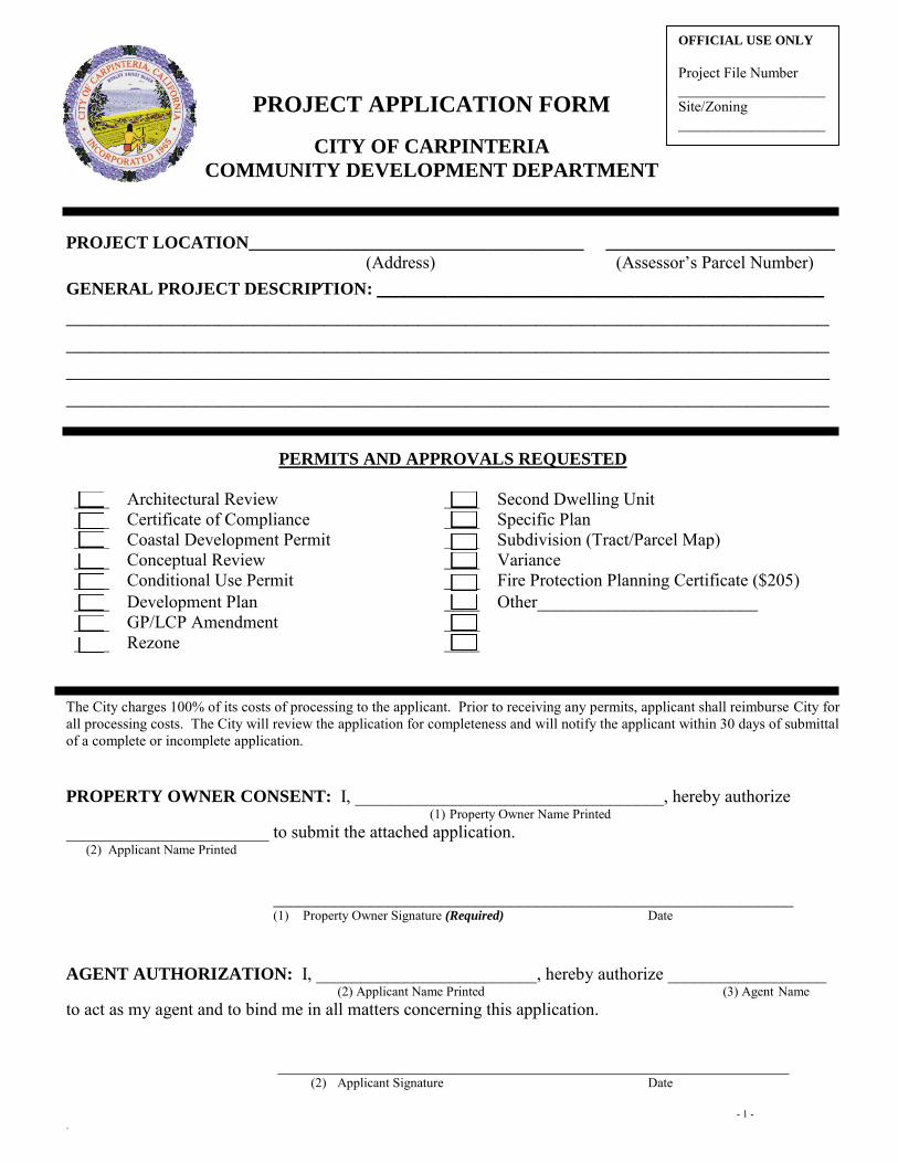
PROJECT APPLICATION FORM
CITY OF CARPINTERIA
COMMUNITY DEVELOPMENT DEPARTMENT
PROJECT LOCATION______________________________________ __________________________
(Address) (Assessor’s Parcel Number) GENERAL PROJECT DESCRIPTION: ______________________________________
_________________________________________________________________ __________________________________________________________________________________________________________________________________ _________________________________________________________________
PERMITS AND APPROVALS REQUESTED
____ Architectural Review ____ Second Dwelling Unit ____ Certificate of Compliance ____ Specific Plan ____ Coastal Development Permit ____ Subdivision (Tract/Parcel Map) ____ Conceptual Review ____ Variance ____ Conditional Use Permit ____ Fire Protection Planning Certificate ($205) ____ Development Plan ____ Other_________________________ ____ GP/LCP Amendment ____ ____ Rezone ____
The City charges 100% of its costs of processing to the applicant. Prior to receiving any permits, applicant shall reimburse City for all processing costs. The City will review the application for completeness and will notify the applicant within 30 days of submittal of a complete or incomplete application.
PROPERTY OWNER CONSENT: I, ___________________________________, hereby authorize (1) Property Owner Name Printed
_______________________ to submit the attached application. (2) Applicant Name Printed ___________________________________________________________
(1) Property Owner Signature (Required) Date AGENT AUTHORIZATION: I, _________________________, hereby authorize __________________ (2) Applicant Name Printed (3) Agent Name to act as my agent and to bind me in all matters concerning this application.
__________________________________________________________
(2) Applicant Signature Date
OFFICIAL USE ONLY
Project File Number ____________________ Site/Zoning ____________________
2
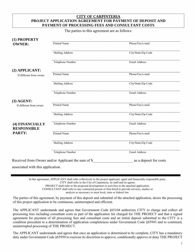
CITY OF CARPINTERIA
PROJECT APPLICATION AGREEMENT FOR PAYMENT OF DEPOSIT AND
PAYMENT OF PROCESSING FEES AND CONSULTANT COSTS
The parties to this agreement are as follows:
(1) ___________________________________________________________________ Printed Name Phone/Fax/e-mail
___________________________________________________________________ Mailing Address City/State/Zip Code ___________________________________________________________________ Telephone Number Email Address
(2) APPLICANT: ___________________________________________________________________
Printed Name Phone/Fax/e-mail
___________________________________________________________________ Mailing Address City/State/Zip Code ___________________________________________________________________ Telephone Number Email Address
(3) AGENT: ___________________________________________________________________
Printed Name Phone/Fax/e-mail
___________________________________________________________________ Mailing Address City/State/Zip Code ___________________________________________________________________ Telephone Number Email Address
___________________________________________________________________ Printed Name Phone/Fax/e-mail
___________________________________________________________________ Mailing Address City/State/Zip Code ___________________________________________________________________ Telephone Number Email Address
Received from Owner and/or Applicant the sum of $_____________________ as a deposit for costs
associated with this application.
In this agreement, APPLICANT shall refer collectively to the project applicant, agent and financially responsible party. CITY shall refer to the City of Carpinteria, its staff and its agents.
PROJECT shall refer to the proposed development or activities in the attached application. CONSULTANT shall refer to any contracted person or firm hired to provide services, studies or
analysis as necessary to meet local, state or federal law.
The parties of this agreement, by payment of this deposit and submittal of the attached application, desire the processing of this project application to be continuous, uninterrupted and efficient. The APPLICANT understands and agrees that Government Code §65104 authorizes CITY to charge and collect all processing fees including consultant costs as part of the application fee charged for THE PROJECT and that a signed agreement for payment of all processing fees and consultant costs and an initial deposit submitted to the CITY is a condition precedent to a determination of application completeness under Government Code §65943 and to continued, uninterrupted processing of THE PROJECT. The APPLICANT understands and agrees that once an application is determined to be complete, CITY has a mandatory duty under Government Code §65950 to exercise its discretion to approve, conditionally approve or deny THE PROJECT
(4) FINANCIALLY
RESPONSIBLE
PARTY:
PROPERTY
OWNER:
If different from owner.
If different from owner.
3
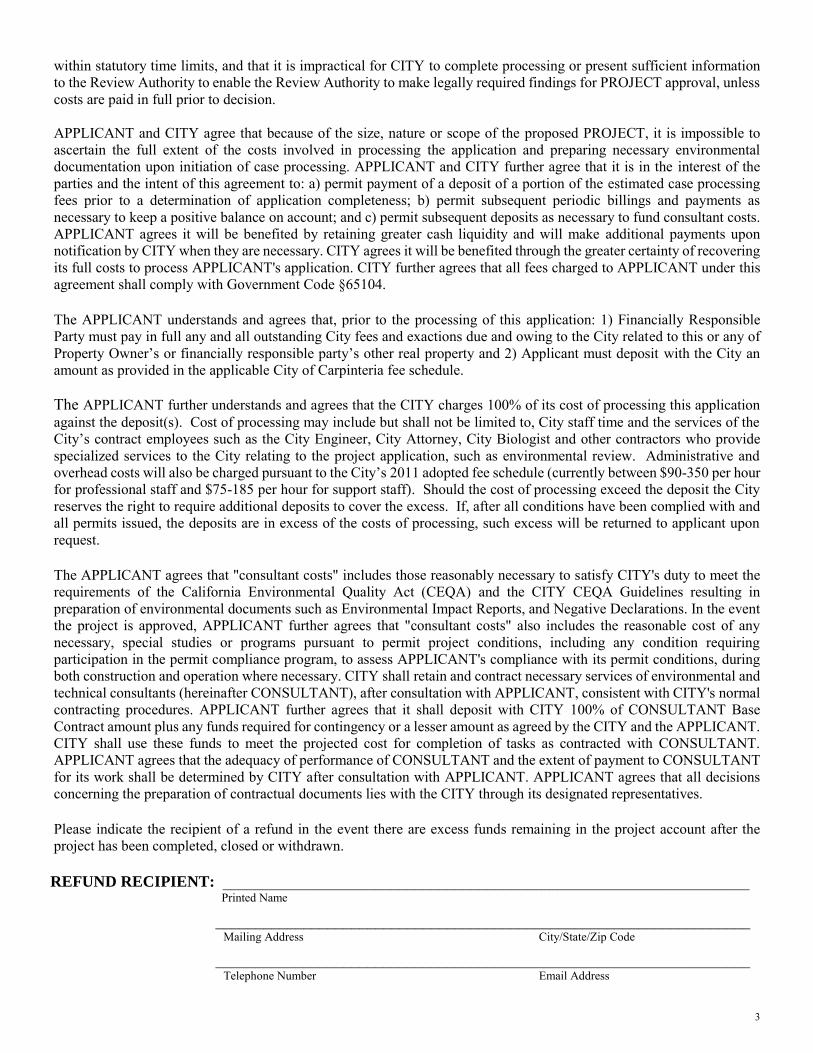
within statutory time limits, and that it is impractical for CITY to complete processing or present sufficient information to the Review Authority to enable the Review Authority to make legally required findings for PROJECT approval, unless costs are paid in full prior to decision. APPLICANT and CITY agree that because of the size, nature or scope of the proposed PROJECT, it is impossible to ascertain the full extent of the costs involved in processing the application and preparing necessary environmental documentation upon initiation of case processing. APPLICANT and CITY further agree that it is in the interest of the parties and the intent of this agreement to: a) permit payment of a deposit of a portion of the estimated case processing fees prior to a determination of application completeness; b) permit subsequent periodic billings and payments as necessary to keep a positive balance on account; and c) permit subsequent deposits as necessary to fund consultant costs. APPLICANT agrees it will be benefited by retaining greater cash liquidity and will make additional payments upon notification by CITY when they are necessary. CITY agrees it will be benefited through the greater certainty of recovering its full costs to process APPLICANT's application. CITY further agrees that all fees charged to APPLICANT under this agreement shall comply with Government Code §65104. The APPLICANT understands and agrees that, prior to the processing of this application: 1) Financially Responsible Party must pay in full any and all outstanding City fees and exactions due and owing to the City related to this or any of Property Owner’s or financially responsible party’s other real property and 2) Applicant must deposit with the City an amount as provided in the applicable City of Carpinteria fee schedule. The APPLICANT further understands and agrees that the CITY charges 100% of its cost of processing this application against the deposit(s). Cost of processing may include but shall not be limited to, City staff time and the services of the City’s contract employees such as the City Engineer, City Attorney, City Biologist and other contractors who provide specialized services to the City relating to the project application, such as environmental review. Administrative and overhead costs will also be charged pursuant to the City’s 2011 adopted fee schedule (currently between $90-350 per hour for professional staff and $75-185 per hour for support staff). Should the cost of processing exceed the deposit the City reserves the right to require additional deposits to cover the excess. If, after all conditions have been complied with and all permits issued, the deposits are in excess of the costs of processing, such excess will be returned to applicant upon request. The APPLICANT agrees that "consultant costs" includes those reasonably necessary to satisfy CITY's duty to meet the requirements of the California Environmental Quality Act (CEQA) and the CITY CEQA Guidelines resulting in preparation of environmental documents such as Environmental Impact Reports, and Negative Declarations. In the event the project is approved, APPLICANT further agrees that "consultant costs" also includes the reasonable cost of any necessary, special studies or programs pursuant to permit project conditions, including any condition requiring participation in the permit compliance program, to assess APPLICANT's compliance with its permit conditions, during both construction and operation where necessary. CITY shall retain and contract necessary services of environmental and technical consultants (hereinafter CONSULTANT), after consultation with APPLICANT, consistent with CITY's normal contracting procedures. APPLICANT further agrees that it shall deposit with CITY 100% of CONSULTANT Base Contract amount plus any funds required for contingency or a lesser amount as agreed by the CITY and the APPLICANT. CITY shall use these funds to meet the projected cost for completion of tasks as contracted with CONSULTANT. APPLICANT agrees that the adequacy of performance of CONSULTANT and the extent of payment to CONSULTANT for its work shall be determined by CITY after consultation with APPLICANT. APPLICANT agrees that all decisions concerning the preparation of contractual documents lies with the CITY through its designated representatives.
Please indicate the recipient of a refund in the event there are excess funds remaining in the project account after the project has been completed, closed or withdrawn.
REFUND RECIPIENT: __________________________________________________________________ Printed Name
___________________________________________________________________ Mailing Address City/State/Zip Code ___________________________________________________________________ Telephone Number Email Address
4
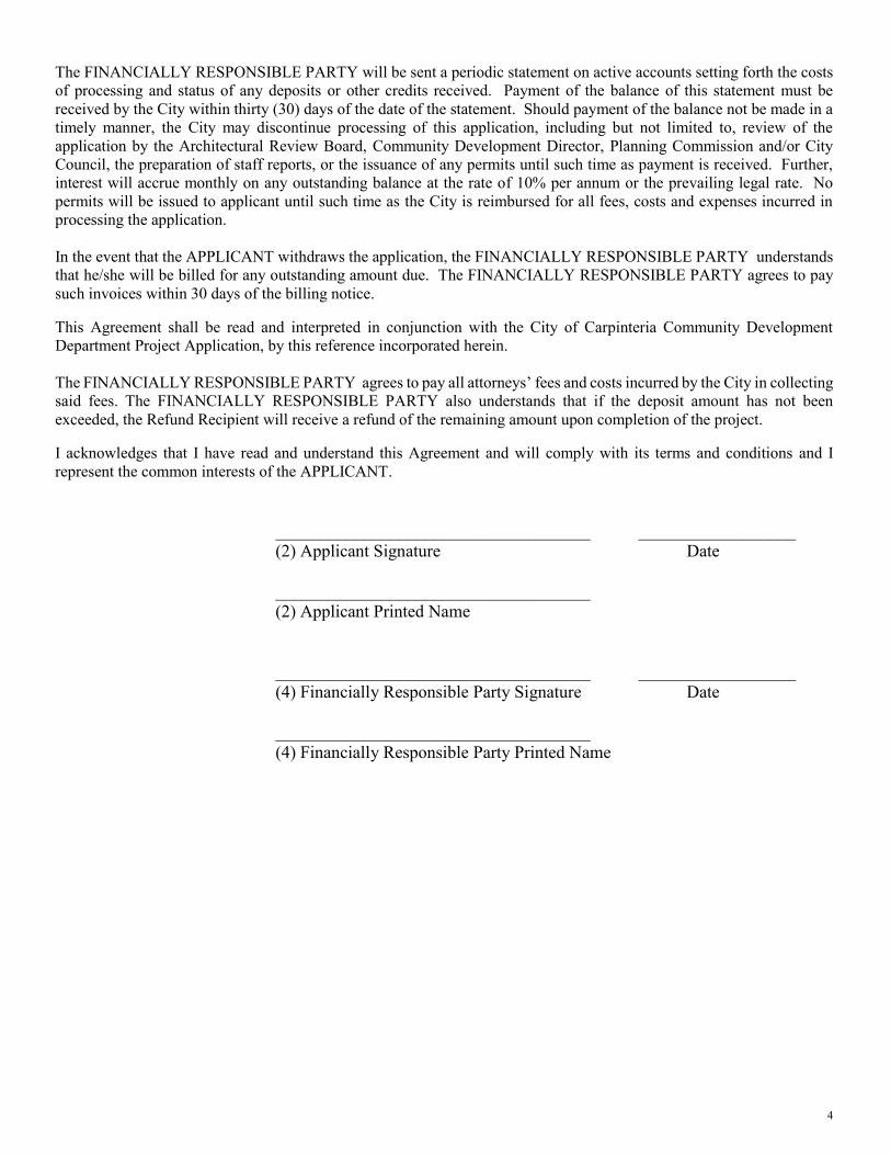
The FINANCIALLY RESPONSIBLE PARTY will be sent a periodic statement on active accounts setting forth the costs of processing and status of any deposits or other credits received. Payment of the balance of this statement must be received by the City within thirty (30) days of the date of the statement. Should payment of the balance not be made in a timely manner, the City may discontinue processing of this application, including but not limited to, review of the application by the Architectural Review Board, Community Development Director, Planning Commission and/or City Council, the preparation of staff reports, or the issuance of any permits until such time as payment is received. Further, interest will accrue monthly on any outstanding balance at the rate of 10% per annum or the prevailing legal rate. No permits will be issued to applicant until such time as the City is reimbursed for all fees, costs and expenses incurred in processing the application. In the event that the APPLICANT withdraws the application, the FINANCIALLY RESPONSIBLE PARTY understands that he/she will be billed for any outstanding amount due. The FINANCIALLY RESPONSIBLE PARTY agrees to pay such invoices within 30 days of the billing notice. This Agreement shall be read and interpreted in conjunction with the City of Carpinteria Community Development Department Project Application, by this reference incorporated herein. The FINANCIALLY RESPONSIBLE PARTY agrees to pay all attorneys’ fees and costs incurred by the City in collecting said fees. The FINANCIALLY RESPONSIBLE PARTY also understands that if the deposit amount has not been exceeded, the Refund Recipient will receive a refund of the remaining amount upon completion of the project. I acknowledges that I have read and understand this Agreement and will comply with its terms and conditions and I represent the common interests of the APPLICANT. ____________________________________ __________________ (2) Applicant Signature Date ____________________________________ (2) Applicant Printed Name ____________________________________ __________________ (4) Financially Responsible Party Signature Date ____________________________________ (4) Financially Responsible Party Printed Name
5
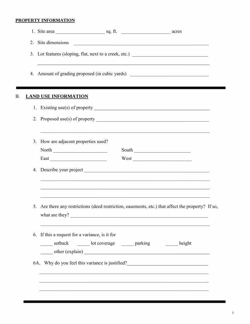
PROPERTY INFORMATION
1. Site area ____________________ sq. ft. ____________________ acres 2. Site dimensions _______________________________________________________ 3. Lot features (sloping, flat, next to a creek, etc.) _______________________________
______________________________________________________________________
4. Amount of grading proposed (in cubic yards) ________________________________
B. LAND USE INFORMATION
1. Existing use(s) of property _______________________________________________ 2. Proposed use(s) of property ______________________________________________
_____________________________________________________________________
3. How are adjacent properties used?
North ______________________ South _______________________
East _______________________ West ________________________
4. Describe your project ___________________________________________________
_____________________________________________________________________
_____________________________________________________________________
_____________________________________________________________________
5. Are there any restrictions (deed restriction, easements, etc.) that affect the property? If so,
what are they? ________________________________________________________
_____________________________________________________________________
6. If this a request for a variance, is it for
_____ setback _____ lot coverage _____ parking _____ height
_____ other (explain) ___________________________________________________
6A. Why do you feel this variance is justified?_________________________________
_____________________________________________________________________
_____________________________________________________________________
_____________________________________________________________________
6
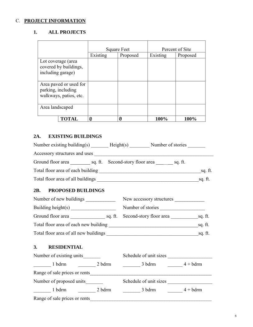
C. PROJECT INFORMATION
1. ALL PROJECTS
Square Feet
Percent of Site Existing Proposed Existing Proposed
Lot coverage (area covered by buildings, including garage)
Area paved or used for parking, including walkways, patios, etc.
Area landscaped
TOTAL 100% 100%
2A. EXISTING BUILDINGS
Number existing building(s) _______ Height(s) ________ Number of stories _______
Accessory structures and uses ________________________________________________
Ground floor area ________ sq. ft. Second-story floor area _______ sq. ft.
Total floor area of each building _________________________________________sq. ft.
Total floor area of all buildings _________________________________________sq. ft.
2B. PROPOSED BUILDINGS
Number of new buildings ____________ New accessory structures ____________
Building height(s) __________________ Number of stories __________________
Ground floor area ______________ sq. ft. Second-story floor area ___________sq. ft.
Total floor area of each new building ____________________________________sq. ft.
Total floor area of all new buildings _____________________________________sq. ft.
3. RESIDENTIAL
Number of existing units_______ Schedule of unit sizes __________________
_______ 1 bdrm _______ 2 bdrm _______ 3 bdrm ______ 4 + bdrm
Range of sale prices or rents_________________________________________________
Number of proposed units_______ Schedule of unit sizes __________________
_______ 1 bdrm _______ 2 bdrm _______ 3 bdrm ______ 4 + bdrm
Range of sale prices or rents_________________________________________________
7
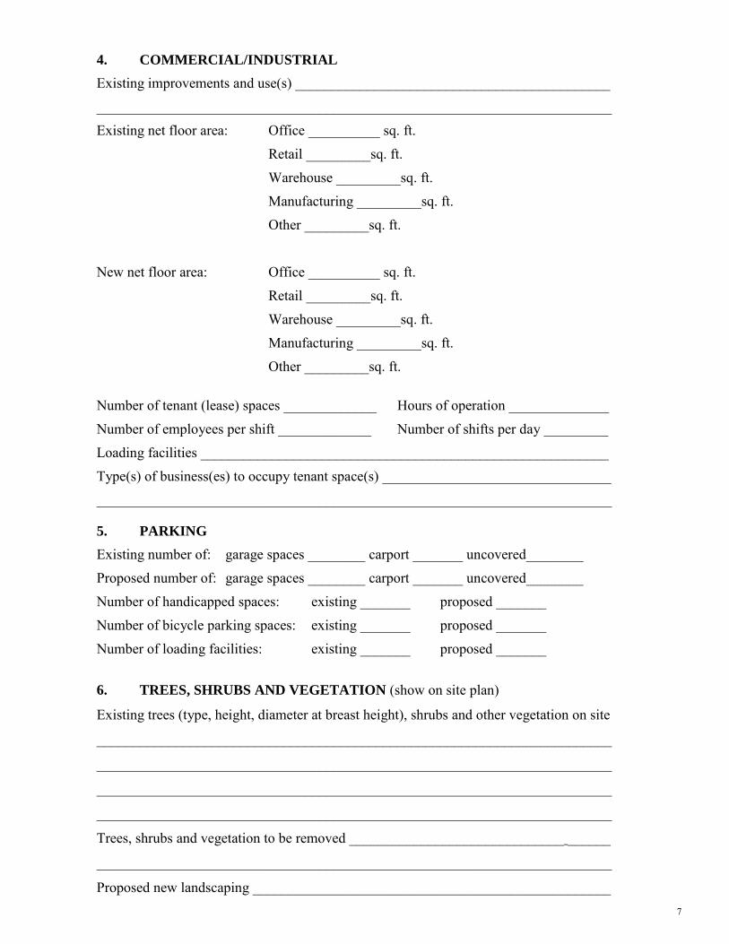
4. COMMERCIAL/INDUSTRIAL
Existing improvements and use(s) ____________________________________________
________________________________________________________________________
Existing net floor area: Office __________ sq. ft.
Retail _________sq. ft.
Warehouse _________sq. ft.
Manufacturing _________sq. ft.
Other _________sq. ft.
New net floor area: Office __________ sq. ft.
Retail _________sq. ft.
Warehouse _________sq. ft.
Manufacturing _________sq. ft.
Other _________sq. ft.
Number of tenant (lease) spaces _____________ Hours of operation ______________
Number of employees per shift _____________ Number of shifts per day _________
Loading facilities _________________________________________________________
Type(s) of business(es) to occupy tenant space(s) ________________________________
________________________________________________________________________
5. PARKING
Existing number of: garage spaces ________ carport _______ uncovered________
Proposed number of: garage spaces ________ carport _______ uncovered________
Number of handicapped spaces: existing _______ proposed _______
Number of bicycle parking spaces: existing _______ proposed _______
Number of loading facilities: existing _______ proposed _______
6. TREES, SHRUBS AND VEGETATION (show on site plan)
Existing trees (type, height, diameter at breast height), shrubs and other vegetation on site
________________________________________________________________________
________________________________________________________________________
________________________________________________________________________
________________________________________________________________________
Trees, shrubs and vegetation to be removed ______________________________ ______
________________________________________________________________________
Proposed new landscaping __________________________________________________
8
________________________________________________________________________
________________________________________________________________________
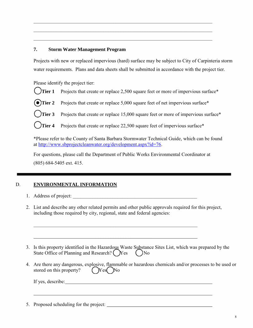
________________________________________________________________________ 7. Storm Water Management Program
Projects with new or replaced impervious (hard) surface may be subject to City of Carpinteria storm
water requirements. Plans and data sheets shall be submitted in accordance with the project tier.
Please identify the project tier:
Tier 1 Projects that create or replace 2,500 square feet or more of impervious surface*
Tier 2 Projects that create or replace 5,000 square feet of net impervious surface*
Tier 3 Projects that create or replace 15,000 square feet or more of impervious surface*
Tier 4 Projects that create or replace 22,500 square feet of impervious surface*
*Please refer to the County of Santa Barbara Stormwater Technical Guide, which can be found at http://www.sbprojectcleanwater.org/development.aspx?id=76.
For questions, please call the Department of Public Works Environmental Coordinator at
(805) 684-5405 ext. 415.
D. ENVIRONMENTAL INFORMATION
1. Address of project: __________________________________________________ 2. List and describe any other related permits and other public approvals required for this project,
including those required by city, regional, state and federal agencies: __________________________________________________________________ __________________________________________________________________
3. Is this property identified in the Hazardous Waste Substance Sites List, which was prepared by the
State Office of Planning and Research? Yes No 4. Are there any dangerous, explosive, flammable or hazardous chemicals and/or processes to be used or
stored on this property? Yes No If yes, describe:
5. Proposed scheduling for the project:
9
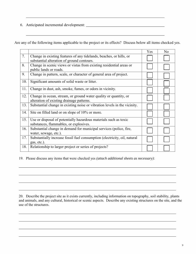
6. Anticipated incremental development:
Are any of the following items applicable to the project or its effects? Discuss below all items checked yes.
Yes No 7. Change in existing features of any tidelands, beaches, or hills, or
substantial alteration of ground contours. 8. Change in scenic views or vistas from existing residential areas or
public lands or roads. 9. Change in pattern, scale, or character of general area of project.
10. Significant amounts of solid waste or litter.
11. Change in dust, ash, smoke, fumes, or odors in vicinity.
12. Change in ocean, stream, or ground water quality or quantity, or
alteration of existing drainage patterns. 13. Substantial change in existing noise or vibration levels in the vicinity.
14. Site on filled land or on slope of 10% or more.
15. Use or disposal of potentially hazardous materials such as toxic
substances, flammables, or explosives. 16. Substantial change in demand for municipal services (police, fire,
water, sewage, etc.). 17. Substantially increase fossil fuel consumption (electricity, oil, natural
gas, etc.). 18. Relationship to larger project or series of projects?
19. Please discuss any items that were checked yes (attach additional sheets as necessary):
20. Describe the project site as it exists currently, including information on topography, soil stability, plants and animals, and any cultural, historical or scenic aspects. Describe any existing structures on the site, and the use of the structures.
10
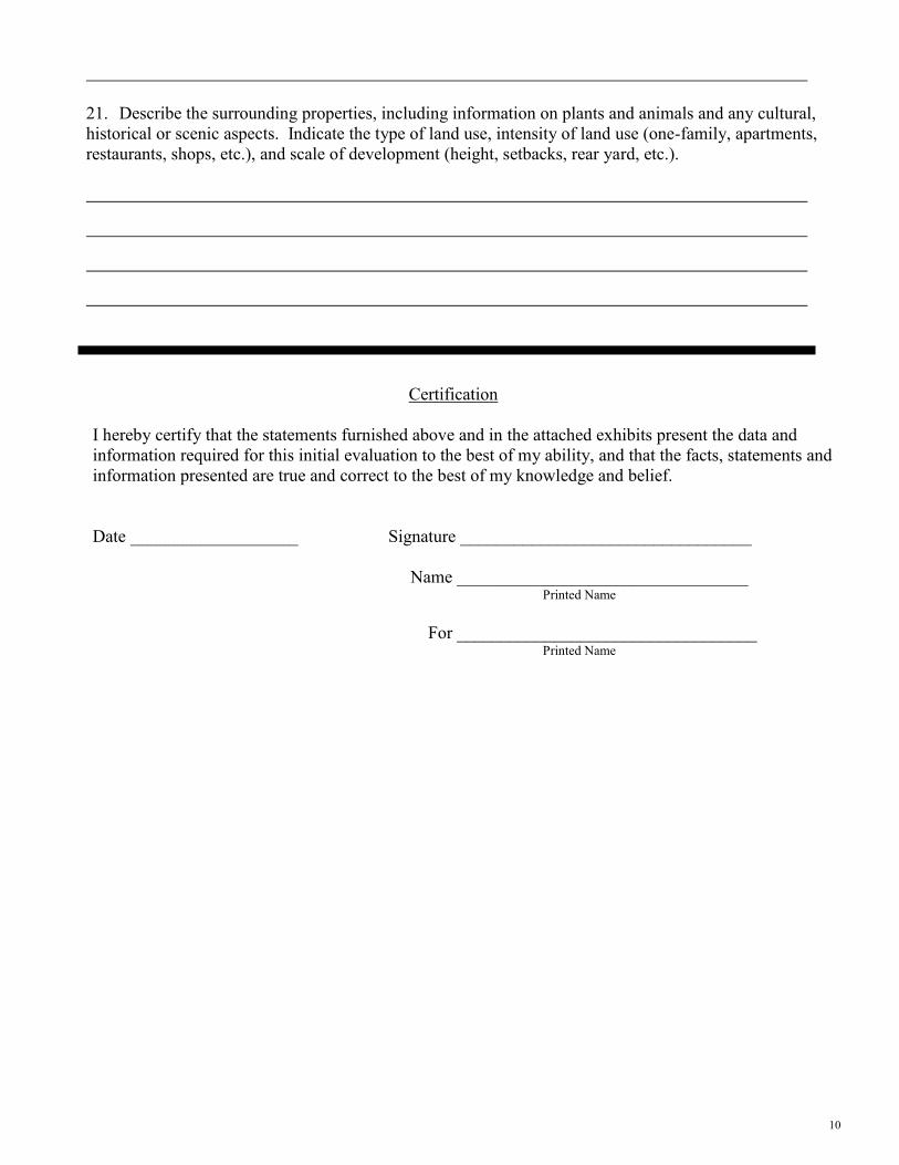
21. Describe the surrounding properties, including information on plants and animals and any cultural, historical or scenic aspects. Indicate the type of land use, intensity of land use (one-family, apartments, restaurants, shops, etc.), and scale of development (height, setbacks, rear yard, etc.).
Certification I hereby certify that the statements furnished above and in the attached exhibits present the data and information required for this initial evaluation to the best of my ability, and that the facts, statements and information presented are true and correct to the best of my knowledge and belief. Date ___________________ Signature _________________________________ Name _________________________________ Printed Name For __________________________________ Printed Name
11
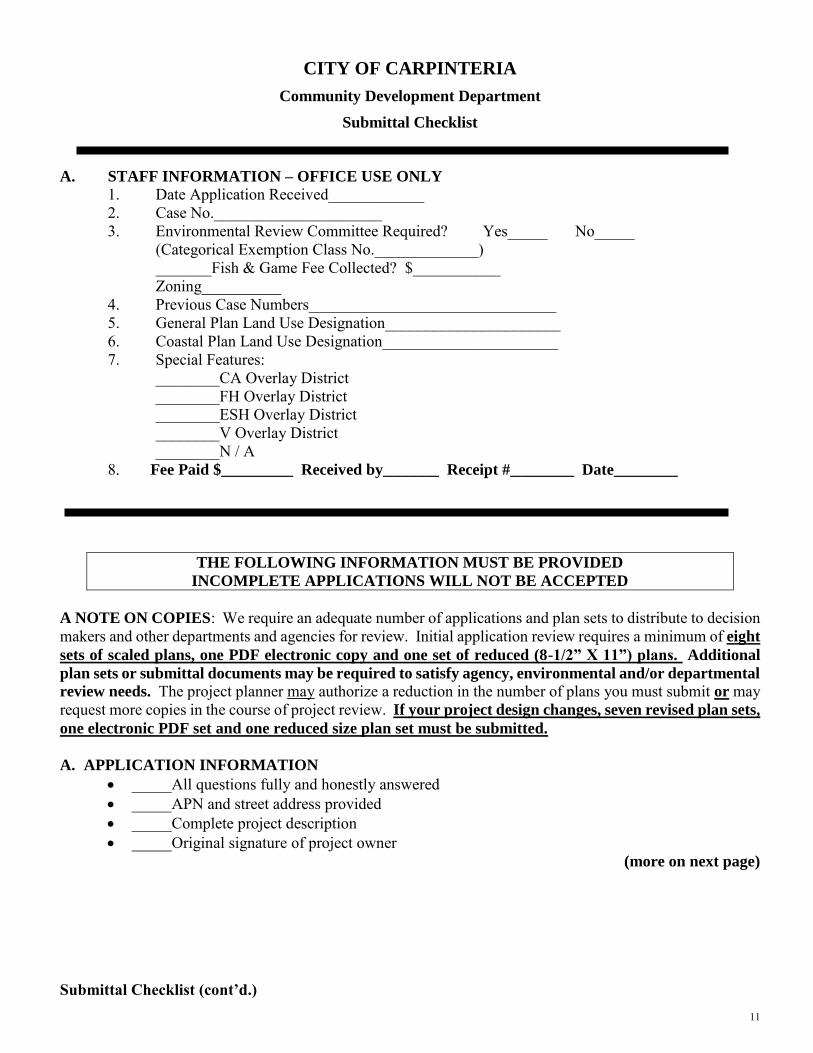
CITY OF CARPINTERIA
Community Development Department
Submittal Checklist
A. STAFF INFORMATION – OFFICE USE ONLY
1. Date Application Received____________ 2. Case No._____________________ 3. Environmental Review Committee Required? Yes_____ No_____
(Categorical Exemption Class No._____________) _______Fish & Game Fee Collected? $___________ Zoning__________
4. Previous Case Numbers_______________________________ 5. General Plan Land Use Designation______________________ 6. Coastal Plan Land Use Designation______________________ 7. Special Features:
________CA Overlay District ________FH Overlay District ________ESH Overlay District ________V Overlay District ________N / A
8. Fee Paid $_________ Received by_______ Receipt #________ Date________
THE FOLLOWING INFORMATION MUST BE PROVIDED
INCOMPLETE APPLICATIONS WILL NOT BE ACCEPTED A NOTE ON COPIES: We require an adequate number of applications and plan sets to distribute to decision makers and other departments and agencies for review. Initial application review requires a minimum of eight
sets of scaled plans, one PDF electronic copy and one set of reduced (8-1/2” X 11”) plans. Additional
plan sets or submittal documents may be required to satisfy agency, environmental and/or departmental
review needs. The project planner may authorize a reduction in the number of plans you must submit or may request more copies in the course of project review. If your project design changes, seven revised plan sets,
one electronic PDF set and one reduced size plan set must be submitted. A. APPLICATION INFORMATION
_____All questions fully and honestly answered _____APN and street address provided _____Complete project description _____Original signature of project owner
(more on next page)
Submittal Checklist (cont’d.)
12
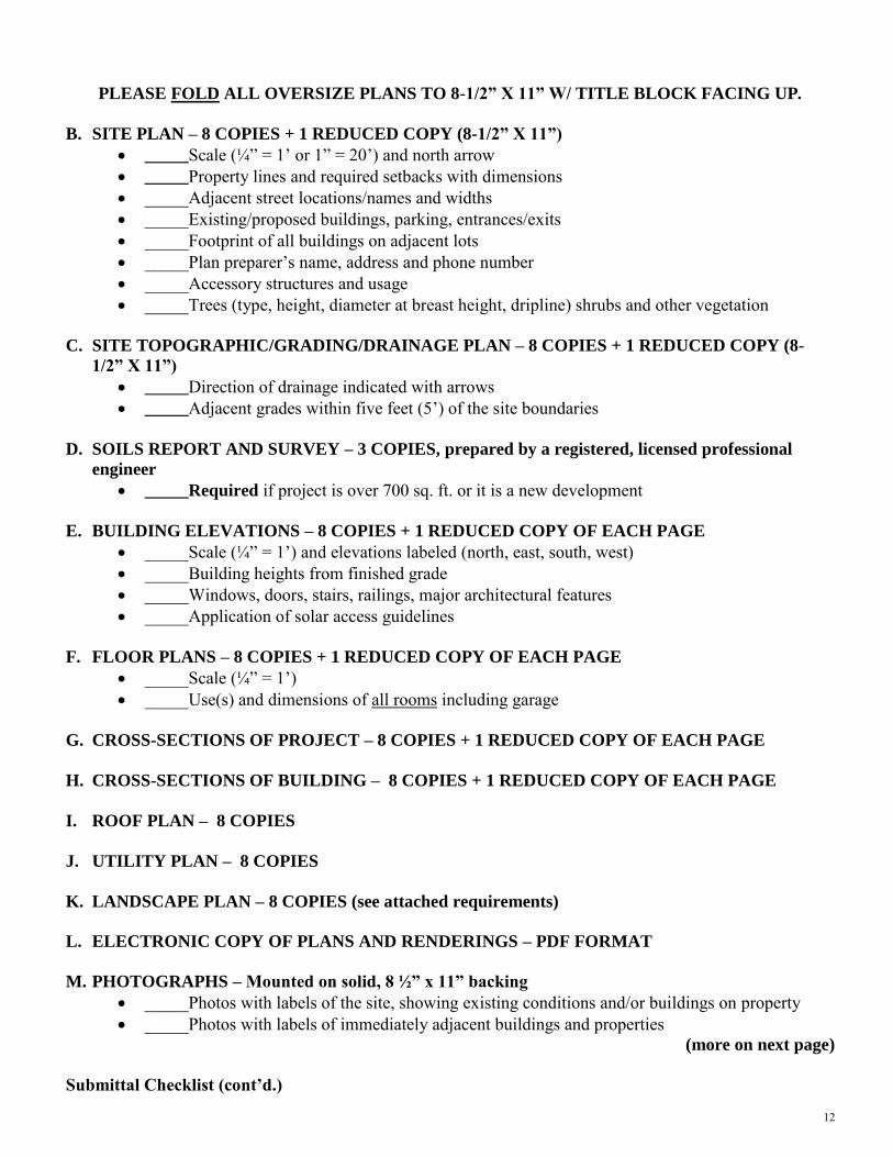
PLEASE FOLD ALL OVERSIZE PLANS TO 8-1/2” X 11” W/ TITLE BLOCK FACING UP.
B. SITE PLAN – 8 COPIES + 1 REDUCED COPY (8-1/2” X 11”)
_____Scale (¼” = 1’ or 1” = 20’) and north arrow _____Property lines and required setbacks with dimensions _____Adjacent street locations/names and widths _____Existing/proposed buildings, parking, entrances/exits _____Footprint of all buildings on adjacent lots _____Plan preparer’s name, address and phone number _____Accessory structures and usage _____Trees (type, height, diameter at breast height, dripline) shrubs and other vegetation
C. SITE TOPOGRAPHIC/GRADING/DRAINAGE PLAN – 8 COPIES + 1 REDUCED COPY (8-
1/2” X 11”)
_____Direction of drainage indicated with arrows _____Adjacent grades within five feet (5’) of the site boundaries
D. SOILS REPORT AND SURVEY – 3 COPIES, prepared by a registered, licensed professional
engineer
_____Required if project is over 700 sq. ft. or it is a new development E. BUILDING ELEVATIONS – 8 COPIES + 1 REDUCED COPY OF EACH PAGE
_____Scale (¼” = 1’) and elevations labeled (north, east, south, west) _____Building heights from finished grade _____Windows, doors, stairs, railings, major architectural features _____Application of solar access guidelines
F. FLOOR PLANS – 8 COPIES + 1 REDUCED COPY OF EACH PAGE
_____Scale (¼” = 1’) _____Use(s) and dimensions of all rooms including garage
G. CROSS-SECTIONS OF PROJECT – 8 COPIES + 1 REDUCED COPY OF EACH PAGE
H. CROSS-SECTIONS OF BUILDING – 8 COPIES + 1 REDUCED COPY OF EACH PAGE
I. ROOF PLAN – 8 COPIES
J. UTILITY PLAN – 8 COPIES
K. LANDSCAPE PLAN – 8 COPIES (see attached requirements)
L. ELECTRONIC COPY OF PLANS AND RENDERINGS – PDF FORMAT
M. PHOTOGRAPHS – Mounted on solid, 8 ½” x 11” backing
_____Photos with labels of the site, showing existing conditions and/or buildings on property _____Photos with labels of immediately adjacent buildings and properties
(more on next page)
Submittal Checklist (cont’d.)
13
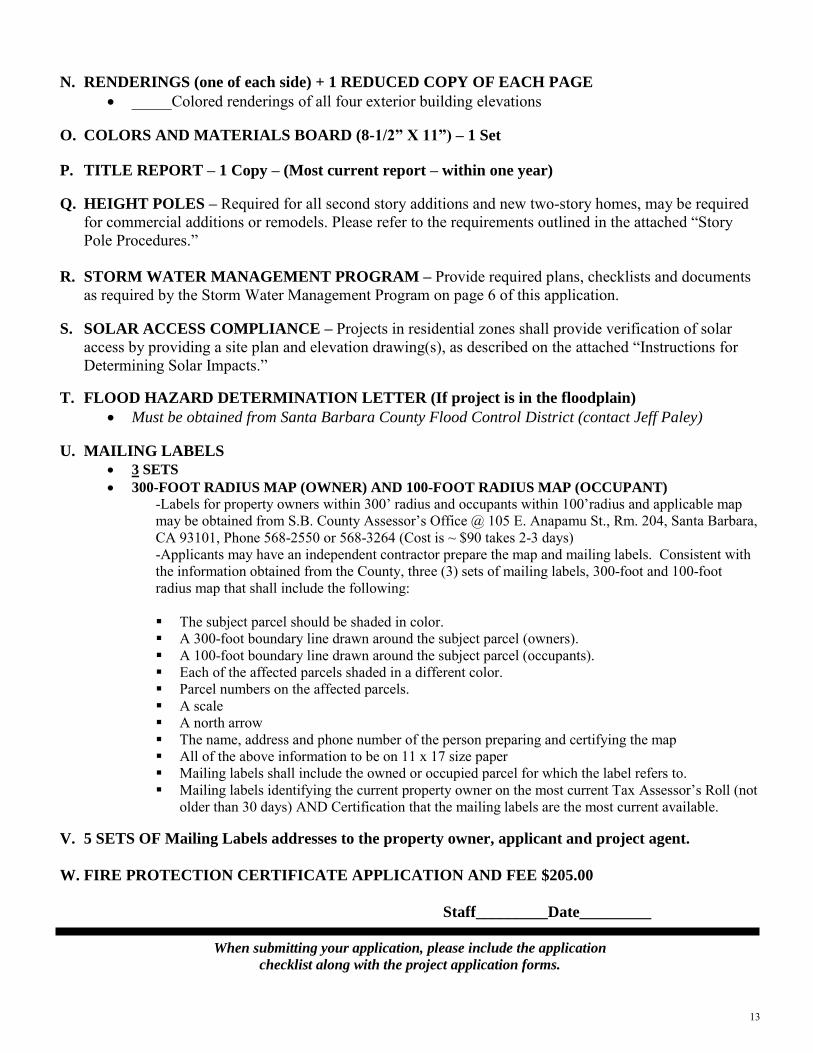
N. RENDERINGS (one of each side) + 1 REDUCED COPY OF EACH PAGE
_____Colored renderings of all four exterior building elevations O. COLORS AND MATERIALS BOARD (8-1/2” X 11”) – 1 Set P. TITLE REPORT – 1 Copy – (Most current report – within one year)
Q. HEIGHT POLES – Required for all second story additions and new two-story homes, may be required for commercial additions or remodels. Please refer to the requirements outlined in the attached “Story Pole Procedures.”
R. STORM WATER MANAGEMENT PROGRAM – Provide required plans, checklists and documents as required by the Storm Water Management Program on page 6 of this application.
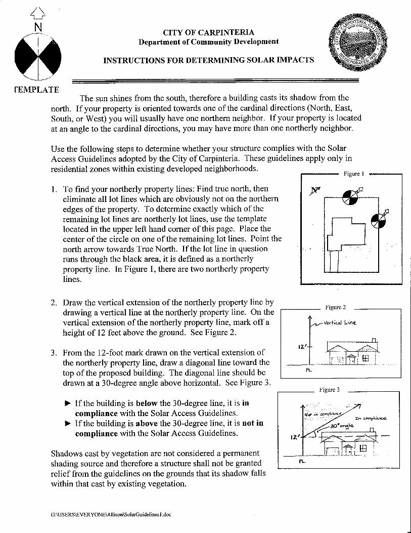
S. SOLAR ACCESS COMPLIANCE – Projects in residential zones shall provide verification of solar access by providing a site plan and elevation drawing(s), as described on the attached “Instructions for Determining Solar Impacts.”
T. FLOOD HAZARD DETERMINATION LETTER (If project is in the floodplain)
Must be obtained from Santa Barbara County Flood Control District (contact Jeff Paley)
U. MAILING LABELS
3 SETS
300-FOOT RADIUS MAP (OWNER) AND 100-FOOT RADIUS MAP (OCCUPANT)
-Labels for property owners within 300’ radius and occupants within 100’radius and applicable map may be obtained from S.B. County Assessor’s Office @ 105 E. Anapamu St., Rm. 204, Santa Barbara, CA 93101, Phone 568-2550 or 568-3264 (Cost is ~ $90 takes 2-3 days) -Applicants may have an independent contractor prepare the map and mailing labels. Consistent with the information obtained from the County, three (3) sets of mailing labels, 300-foot and 100-foot radius map that shall include the following:
The subject parcel should be shaded in color. A 300-foot boundary line drawn around the subject parcel (owners). A 100-foot boundary line drawn around the subject parcel (occupants). Each of the affected parcels shaded in a different color. Parcel numbers on the affected parcels. A scale A north arrow The name, address and phone number of the person preparing and certifying the map All of the above information to be on 11 x 17 size paper Mailing labels shall include the owned or occupied parcel for which the label refers to. Mailing labels identifying the current property owner on the most current Tax Assessor’s Roll (not
older than 30 days) AND Certification that the mailing labels are the most current available.
V. 5 SETS OF Mailing Labels addresses to the property owner, applicant and project agent.
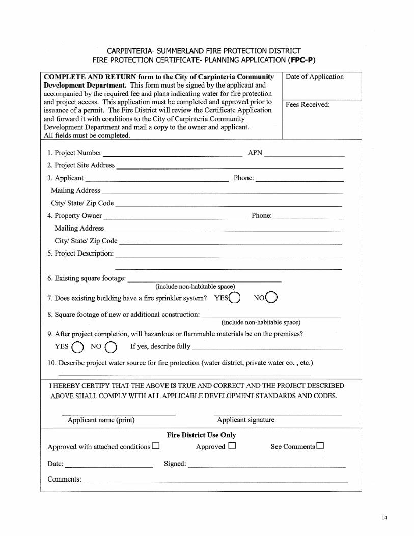
W. FIRE PROTECTION CERTIFICATE APPLICATION AND FEE $205.00
Staff_________Date_________
When submitting your application, please include the application
checklist along with the project application forms.
14
15
Where to File Office Hours and Days
Carpinteria City Hall 8:00 a.m. to 5:00 p.m. Community Development Department Monday through Friday 5775 Carpinteria Avenue Carpinteria, CA 93013
Other Materials You May Find Useful Applicant’s Guide - PC
Applicant’s Guide - ARB New Development Fee Schedule & City Fees List
If you have any questions please contact:
City Hall
Lorena Esparza, Administrative Assistant (805) 755-4410 Shanna Farley-Judkins, Assistant Planner (805) 755-4405Nick Bobroff, Associate Planner (805) 755-4407 Steve Goggia, Senior Planner (805) 755-4414 Jackie Campbell, Community Development Director (805) 755-4451 Public Works (805) 755-4445 Building Inspector (805) 880-3409 Finance / Billing (805) 880-3406 or 755-4448 Other Districts
Carpinteria Sanitary District (805) 684-7214 Carpinteria-Summerland Fire Protection District (805) 566-2451 Carpinteria Unified School District (805) 684-4511 Carpinteria Valley Water District (805) 684-2816 Santa Barbara Air Pollution Control District (805) 961-8800 Santa Barbara County Environmental Health Department (805) 681-4900 United States Post Office (805) 275-8777
16
CITY OF CARPINTERIA
Community Development Department
LANDSCAPE PLAN – REQUIRED INFORMATION
Landscape Plans should include the following information: 1. Name of Applicant 2. Location of Project Site/Address 3. Name of Architect/Agent/Person drawing the plans 4. Landscape Plans must be drawn to scale and the scale shall be noted on the plan.
The scale of the plans shall be the same as the site plan and printed on the same size paper. 5. The location of the area to be landscaped on the property to be specified. 6. The location of all the new plants and trees, with existing trees and plants to remain noted on the plans. 7. All new plantings to be specified on plans, with the botanical and common names given along with the
plant container sizes and plant quantities also specified on plans. 8. Description of the types of irrigation systems to be used, including but not limited to location of
irrigation clocks, backflow preventers and irrigation valves.
All applicants that are not single-family dwellings (residential)
must also include the following:
1. A plant list with botanical and common names, quantities, sizes, recommended spacing of mass
plantings, and any special planting notes. Planting details and tree stake details shall also be included. 2. A separate irrigation drawing with the location, type and size of the main hook-up, irrigation clocks,
backflow preventer, irrigation valves, pressure lines, sleeves, sprinkler heads and nozzles, pipe sizes, and an irrigation legend showing symbols, manufacturer, model numbers, description of items, special installation notes, and installation details of all valves and heads.
17
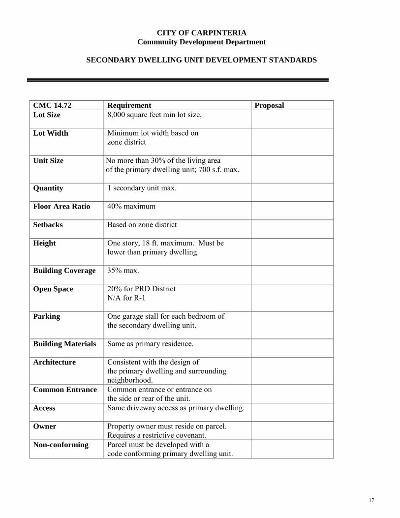
CITY OF CARPINTERIA
Community Development Department
SECONDARY DWELLING UNIT DEVELOPMENT STANDARDS
CMC 14.72 Requirement Proposal
Lot Size
8,000 square feet min lot size,
Lot Width Minimum lot width based on zone district
Unit Size
No more than 30% of the living area of the primary dwelling unit; 700 s.f. max.
Quantity
1 secondary unit max.
Floor Area Ratio
40% maximum
Setbacks
Based on zone district
Height
One story, 18 ft. maximum. Must be lower than primary dwelling.
Building Coverage
35% max.
Open Space
20% for PRD District N/A for R-1
Parking
One garage stall for each bedroom of the secondary dwelling unit.
Building Materials
Same as primary residence.
Architecture Consistent with the design of the primary dwelling and surrounding neighborhood.
Common Entrance Common entrance or entrance on the side or rear of the unit.
Access
Same driveway access as primary dwelling.
Owner Property owner must reside on parcel. Requires a restrictive covenant.
Non-conforming Parcel must be developed with a code conforming primary dwelling unit.
City of Carpinteria
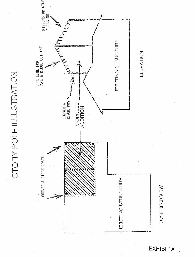
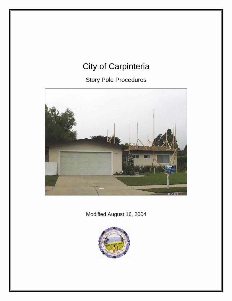
Story Pole Procedures
Modified August 16, 2004
Purpose: Story poles are used to depict the elevations and silhouette of a
proposed structure or an addition to an existing building. Story poles are intended to help decision makers, staff, neighbors and other interested parties visualize the location, mass and/or height of a proposed building(s), as part of the review of the project’s relationship to its surrounding. The use of story poles is not limited to residential development.
When Required: At the discretion of the City, story poles may be
required for development projects and/or additions. As a general rule of thumb, story poles are required for all new homes and second story additions. However, a new one-story addition could also require story poles.
Story Pole Installation/Submittal Requirements: Story
poles shall be constructed pursuant to the following requirements.
1. Installation Timing – A story pole plan must be submitted to staff for approval prior to the installation. The installation shall occur approximately two weeks prior to the scheduled Architectural Review Board meeting.
2. Plan Components – As illustrated in Exhibit A, the story pole plan must include a site plan of the property, a building footprint of all structures on the property, and a complete roof plan detail of the structure under consideration. Story pole locations are plotted on the roof plan and each location should indicate the maximum height of the pole.
3. Construction Method – Story poles shall be made of 2” X 4” lumber, pipes, galvanized conduit or similar material that is sturdy and avoids bending as determined by the City. All story poles need to be erected safely and without putting the public at risk, without bending or leaning, so as to withstand weather and remain standing until meeting dates. This can be accomplished by installing guy wires or other similar temporary support system. The poles must be sturdy (allowing not more than 5” deflection). Story poles must be installed by a licensed contractor.
4. Pole Locations – Story poles shall be erected at the most distant corners of the proposed structure or addition and at the maximum height of the roof ridge. The idea is to achieve a silhouette of the structure or addition, clearly defining the maximum roof heights. Story poles for roof overhangs, eaves, chimneys, balconies, and accessory buildings may also be required at the discretion of the Community Development Director.
5. Flagging Poles – Dark red or blue colored ribbons shall be attached to
taut ropes, between the poles, to detail roof lines. A cable or other appropriate material may be permitted as approved by the Community Development Director. Ribbons shall be a minimum of 12 inches long, 2 inches wide and spaced a minimum of two feet apart.
6. Duration – Story poles shall be erected at least two weeks (14 days) prior to the Architectural Review Board (and Planning Commission if applicable) hearing date and shall remain in place until such time as the Planning Commission or Community Development Director has rendered a decision on the project. Upon notification by City, the story poles shall be removed as soon as possible and no later than 48 hours from the date of the notice. If at any time the story poles become unsafe, they shall be repaired or removed immediately if determined by the City to be a public safety risk. If the poles fall down prior to the hearing date, they shall promptly be replaced.
7. Waiver – The applicant must sign a waiver that absolves the City of any liability associated with construction of, or damage by, the temporary story poles. The applicant shall not install the temporary story poles until the waiver form is submitted to the City.
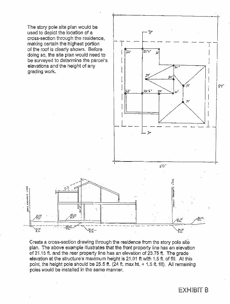
8. Certification – Story pole height and location must be certified in writing by a licensed surveyor, architect (other than the project architect), or a civil engineer. The height of each pole should be clearly marked on the base of each pole. In residential developments involving a single-family dwelling, an alternative certification process is permitted as illustrated in Exhibit B. Although this process still requires a survey of the property elevations, it will save a separate certification of the height poles when installed correctly. The height of each pole should be represented with a tape measure mounted onto each pole.
Story Poles Waiver I, ___________________________, hereby absolve the City of Carpinteria of any and all liability associated with the installation of, or damage by, the temporary story poles that I will erect in compliance with the City’s Story Pole Procedures. _________________________________ ________________ Signature Date