Embed Size (px)
Citation preview
City of San Diego Planning Department 202 C Street, MS 4A San Diego, CA 92101
Printed on recycled paper.
This information, or this document (or portions thereof), will be made available in alternative formats upon request.
- ii -
TORREY PINES COMMUNITY PLAN The following information has been incorporated into this October 2014 posting of this Plan:
Amendment Date Approved by Planning Commission
Resolution Number
Date Adopted by City Council
Resolution Number
Torrey Pines Community Plan Adopted
March 6, 1975
Comprehensive Plan Update
September 8, 1994 2123-PC January 10, 1995 R-285183
Certified by the California Coastal Commission February 8, 1996 by Certificate Number 2-95A
Modifications to the Comprehensive Plan Update as required by the California Coastal Commission
April 16,1996 R-287205
Added MCAS Miramar ALUCP policy language and deleted references and maps to the NAS Miramar CLUP
February 17, 2011 April 26, 2011 R-306737
On August 14, 2014, amended the City of San Diego Local Coastal Program – Coastal Land Use Maps to include the North Coast Corridor Public Works Plan/Transportation and Resource Enhancement Program (NCC PWP/TREP) Project Overlay Map and Project Overlay Improvements Map.
PWP-6-NCC-13-0203-1
- iii -
MAYOR Susan Golding CITY COUNCIL Harry Mathis Scott Harvey Christine Kehoe George Stevens Barbara Warden Valerie Stallings Judy McCarty Juan Vargas CITY ATTORNEY John W. Witt CITY MANAGER Jack McGrory PLANNING COMMISSION K Scott H. Bernet, Chairperson Karen McElliott, Vice Chairperson Lynn Benn Andrea Skorepa Christopher Neils Frisco White Verna Quinn PLANNING DEPARTMENT Ernest Freeman, AICP, Planning Director Jeff Washington, Deputy Director Long Range and Facilities Planning Mike Stang, Principal Planner Mike Westlake, Senior Planner/Project Manager Byron Frohn, Senior Drafting Aide Theresa Newman, Word Processing Operator Sam Riordan, Graphic Designer Ronald St. Germain, Editor/Proofreader Ron Shely, Press Operator
- iv -
ACKNOWLEDGEMENTS Special thanks is hereby extended to all of those members of the Torrey Pines Community Planning Group who have contributed extensive time and thought to the formulation and review of this Plan document. Their efforts as well as the efforts and contributions provided by the many residents and business persons of the Torrey Pines community planning area is greatly appreciated by the Planning Department, Planning Commission and the City Council Planning Group members who have contributed to this Plan include, but are not limited to the following:
TPCPG BOARD MEMBERS (*CHAIRPERSONS)
Louis Adamo Tony Dobrin Bill Phelps Marlene Allen Shelley Gilchrist Roy Riblet Howard Anderson Robert Gilleskie Anne Seifert Chris Borst Brice Griffith Shirley Smith Smart Bresnick Bob Lewis* Christine Springer Marty Carter Paula Lim Therese Tanalski Jim Ciancimino Walter Lim Opal Trueblood* Penny Cox Moira McGrain Mike Wall* James Curl Doug McKenzie Irene Young Nancy Cuthbert Claude Organ* Barbara Zumba Ellen Diehl
- v -
EXECUTIVE SUMMARY
Land Use Plan ...................................................................................................................... 2 Plan Vision ........................................................................................................................... 3 Key Policies .......................................................................................................................... 3
INTRODUCTION
Purpose of the Plan ............................................................................................................... 7 Issues .................................................................................................................................... 7
PLANNING CONTEXT
The Community Planning Area .......................................................................................... 13 Development and Planning History ................................................................................... 13 Environmental Setting ........................................................................................................ 15 Urban Setting ...................................................................................................................... 15 Local Coastal Program ....................................................................................................... 17
PLAN ELEMENTS
Resource Management & Open Space Element ................................................................. 23 Transportation Element ...................................................................................................... 39 Residential Element ............................................................................................................ 59 Commercial Element .......................................................................................................... 69 Industrial Element .............................................................................................................. 77 Community Facilities Element ........................................................................................... 87
A. Legislative Framework ..................................................................................................... 99 B. Relationship to the General Plan..................................................................................... 101 C. Plan Update and Amendment Process ............................................................................ 105 D. MCAS Miramar .............................................................................................................. 107 E. Local Coastal Program Policies ...................................................................................... 113
Hillsides .......................................................................................................................... 113 Grading/Water Quality.................................................................................................... 115 Wetlands/Environmentally Sensitive Resources ............................................................ 116 Visual Resources ............................................................................................................. 118 Los Peñasquitos Watershed Restoration/Enhancement Fee ............................................119
F. Biologically Sensitive Habitats ....................................................................................... 123 G. Environmental Constraints.............................................................................................. 129 H. Open Space Rezonings ................................................................................................... 135 I. Categorical Exclusion Areas ........................................................................................... 141
- vi -
Figure 1. Land Use Plan ......................................................................................................... 2 Figure 2. Vicinity Map ........................................................................................................... 8 Figure 3. Study Area Map .................................................................................................... 14 NCC PWP/TREP Project Overlay ................................................................................. Map 1B NCC PWP/TREP Project Overlay Improvements ........................................................ Map 2A NCC PWP/TREP Project Overlay Improvements ......................................................... Map 2B Figure 4. Designated Open Space ........................................................................................ 24 Figure 5. Resource Zoning Areas ......................................................................................... 26 Figure 6. Wildlife Crossings/Linkages ................................................................................. 28 Figure 7. Street Classifications ............................................................................................. 42 Figure 8. Existing (1990-1992) Average Daily Traffic ........................................................ 44 Figure 9. Horizon Year Average Daily Traffic .................................................................... 46 Figure 10. Bikeway ................................................................................................................ 48 Figure 11. Recommended Mass Transit Facilities ................................................................. 50 Figure 12. Bicycle Facilities Classifications .......................................................................... 52 Figure 13. Residential Land Use Plan .................................................................................... 64 Figure 14. Commercial Land use Plan ................................................................................... 74 Figure 15. Industrial Land Use Plan ....................................................................................... 80 Figure 16. Community Facilities Map ................................................................................... 90 Figure 17. Deleted ................................................................................................................. 108 Figure 18. Deleted ................................................................................................................ 110 Figure 19. Biologically Sensitive Habitats (North) .............................................................. 125 Figure 20. Biologically Sensitive Habitats (Central) ........................................................... 126 Figure 21. Biologically Sensitive Habitats (South) .............................................................. 127 Figure 22. Environmental Constraints (North)..................................................................... 131 Figure 23. Environmental Constraints (Central) .................................................................. 132 Figure 24. Biologically Sensitive Habitats (South) .............................................................. 133 Figure 25. Open Space Rezonings (North) .......................................................................... 137 Figure 26. Open Space Rezonings (Central) ........................................................................ 138 Figure 27. Open Space Rezonings (South) .......................................................................... 139 Figure 28. Categorical Exclusion Areas ............................................................................... 143 Table 1. Torrey Pines Community Plan Land Use Summary ................................................. 16 Table 2. Proposed Residential Development .......................................................................... 65

EXECUTIVE SUMMARY
- 2 -
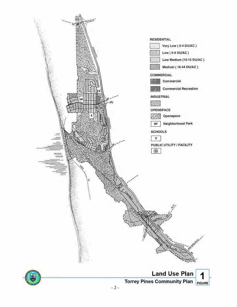
Figure 1. Land Use Plan
- 3 -
EXECUTIVE SUMMARY
PLAN VISION The vision of the Torrey Pines Community Plan (Plan) is to provide, in a democratic manner, the highest possible quality of life for residents and businesses while preserving the community's unique natural environment. The Torrey Pines planning area is a community rich in environmentally sensitive resources. The community contains large areas of Torrey Pine trees, lagoons, wetlands, sandstone bluffs and canyons that in turn provide habitat for several species of unique wildlife. In addition to environmental resources and wildlife, the Torrey Pines community also provides a unique living and working environment for its people. This Plan provides goals, policies and an action plan designed to protect the health, safety and welfare of both its residents and the natural environment.
KEY POLICIES The following key policies reflect the underlying concern for the Torrey Pines community planning area. These policies reflect the Plan vision which is a theme interwoven throughout all the elements of this Plan. 1. All development adjacent to open space areas shall be designed to reduce visual and
development impacts. 2. Provide safe roadways for pedestrians, bicyclists and vehicular traffic, including traffic
control measures and pedestrian crossings where necessary. 3. Residential development shall reflect the diversity of existing homes in the community,
and shall be in compliance with all development regulations. The community does not recommend or support, within single-family zoned areas, the construction of shared housing (also known as mini-dorms or Go-Homes).
4. Commercial development shall be designed to avoid impacts to adjacent residential areas. 5. The construction of public projects shall avoid impacts to residential neighborhoods. 6. Public projects (utilities, roads, railroad, etc.) that cross or encroach into open space
areas shall eliminate or avoid loss to biological resources, shall result in no net loss to wetlands, and shall be required to contribute to the restoration and enhancement of those open space areas.
- 4 -
7. New industrial and commercial development proposed adjacent to identified open space corridors shall contribute to the preservation of these areas.
8. Public mass transit service, including bus, light rail, and commuter rail should be
provided to and through the Torrey Pines community. 9. Emphasize the citywide importance of and encourage the location of scientific research,
biotechnology, and clean manufacturing uses in Sorrento Valley because of its proximity to UCSD and the University and Mira Mesa communities’ industrial areas. Provide adequate mass transit and/or transportation facilities to the Sorrento Valley Area.
10. Useable public parks and active playing fields should be provided within the planning
area for use by all age groups. 11. Affordable housing should be provided within the planning area.

INTRODUCTION

- 7 -
INTRODUCTION
PURPOSE OF THE PLAN The Torrey Pines Community Plan and Local Coastal Program is the City of San Diego's adopted statement of policy for the growth and improvement of the Torrey Pines community planning area. The Plan designates appropriate areas for residential uses, commercial services, and industrial and other employment generating uses, as well as areas that should remain free from development because of sensitive environmental resource characteristics. The Plan also recommends road improvements and designates appropriate locations for public facilities that are necessary to support the projected population of the Torrey Pines planning area.
ISSUES The Plan update process included primarily the cooperation and efforts of the Torrey Pines Community Planning Group, the citizens, and the City of San Diego Planning Department. An update subcommittee of the planning group was established early in the process. This subcommittee held monthly public meetings, where planning group members, Planning Department staff, residents and property owners worked together to formulate various elements of the Plan. The subcommittee identified a number of issues that served as a general framework for the development of the goals, policies and proposals of the Plan. Among these issues were: • The size, bulk, scale, height and compatibility of new residential development • Street improvements, and their impacts on neighborhood character, pedestrians and
environmentally sensitive areas • Development and construction impacts to environmentally sensitive areas, including
sedimentation, erosion, visual impacts and encroachment • Expansion of commercial and multi-unit development in and adjacent to single-unit
residential neighborhoods • The lack of active and passive recreational park facilities • The lack of protection of environmentally sensitive resources • The environmental impacts associated with public utility and facility projects
- 8 -
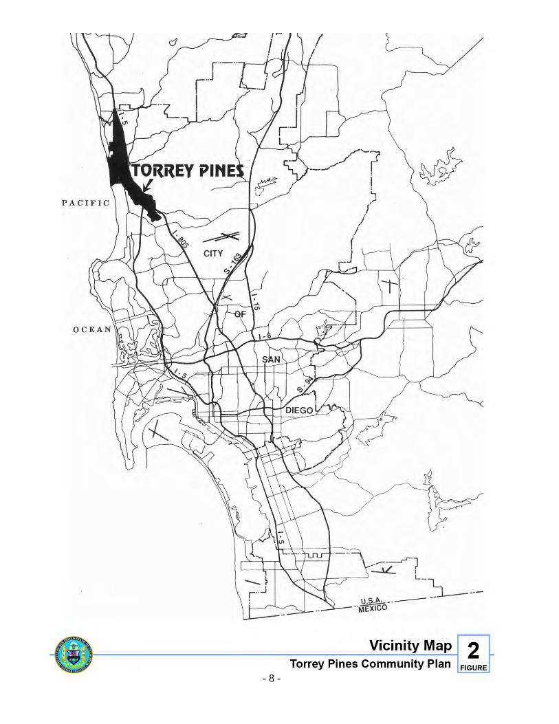
Figure 2. Vicinity Map
- 9 -
The Plan update process also included input and the identification of issues from other City departments and outside agencies. A number of additional issues were identified that were also used as a general framework for the development of this Plan including: • The need to provide affordable housing within the Torrey Pines community planning area.
The City's Housing Element includes a goal of providing assistance to very low- and low-income households, and that those households be distributed among the various community plan areas such that all communities meet their "fair share" goals
• The need to update the City's zoning code in order to provide a more effective and
streamlined planning process • The lack of a mass transportation system to the Torrey Pines community and the need for
the extension of the light rail system, the commuter rail and bus service • The need for a regional transportation system that provides safe and efficient travel
throughout San Diego County • The need to reduce auto trips and improve air quality regionally through the
implementation of transportation demand management strategies, transit-oriented developments and other measures
• The need to provide land and opportunities for scientific research, light manufacturing and
biotech industries for a balanced economy consistent with environmental considerations

THIS PAGE INTENTIONALLY LEFT BLANK.
PLANNING CONTEXT

- 13 -
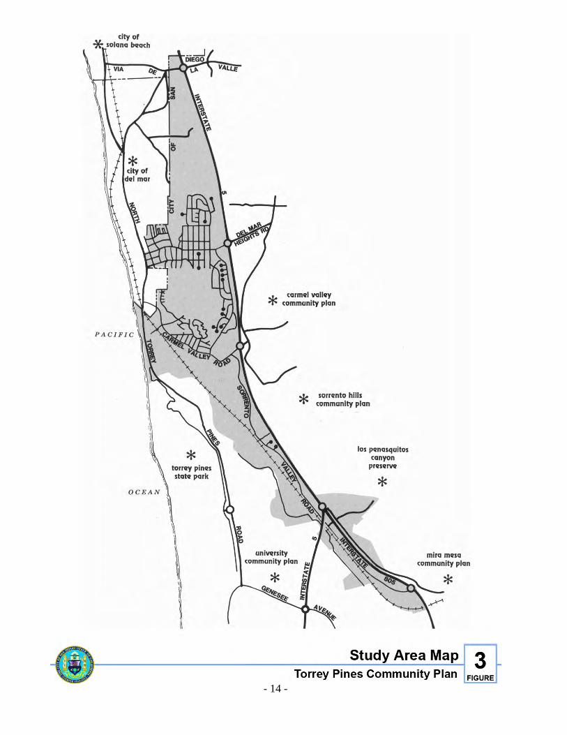
PLANNING CONTEXT
THE COMMUNITY PLANNING AREA The Torrey Pines community planning area comprises approximately 2,600 acres of land located in the northern coastal region of the City of San Diego. Plan boundaries are the northerly San Diego City limits, Interstate 5 (I-5), the southerly portion of the Sorrento Valley Industrial Park, the Pacific Ocean and the city of Del Mar. The city of Solana Beach lies immediately to the north, and the University community extends to the south. East of I-5 are the communities of Carmel Valley and Sorrento Hills.
DEVELOPMENT AND PLANNING HISTORY Planning efforts for the Torrey Pines community have taken place almost continually since the area was annexed in 1958. In 1963, the area contained only two large subdivisions: Del Mar Heights, a 760-lot subdivision, recorded in 1887, and the Del Mar Terrace subdivision, recorded in 1913, containing 547 lots of 30 feet in width. However, in 1963, the area contained only about 100 housing units with a population of 470 persons. In 1963, the City Council adopted the original Del Mar-Torrey Pines Community Plan, which served to guide development in the area for over ten years. During that time period, many changes occurred which necessitated the need for a restructuring of community goals and a plan revision. Those changes included: • The purchase of the Torrey Pines State Park Extension • A crystallization of the opinion that the San Dieguito and Los Peñasquitos Lagoons were a
natural environmental asset and in need of protection • Increased demand and pressure for urbanization of the area because of its very desirable
location • Substantial industrial development and freeway construction These factors led the citizens of the community to form a group to strive toward revision of the 1963 community plan in the early part of 1970. During the two-year period between 1970 and the initiation of the update program, the Torrey Pines Community Planning Group remained active and diligently served to review development activity within the community and conduct research in matters of environmental concern. On March 6, 1975, the San Diego City Council adopted an update to the original 1963 plan, establishing it as the Torrey Pines Community Plan.
- 14 -
Figure 3. Study Area map
- 15 -
Since 1975, the Torrey Pines area has continued to grow and develop under the guidelines of the 1975 plan. This growth and development more recently has become problematic. Numerous negative impacts from development, especially to environmentally sensitive areas, were identified by residents of the Torrey Pines Community Planning Group and Planning Department analysis indicated that the identification, prevention and resolution of these impacts were beyond the scope and control of the existing 1975 plan. As a result of this analysis, the Planning Group requested an update to the existing community plan.
ENVIRONMENTAL SETTING The Torrey Pines community planning area is characterized by an abundance of sensitive environmental resources and contains a number of major local and regional open space systems, most of which are protected by this and other plans, and by various regulations. Most of these systems are associated with the watersheds of the Los Peñasquitos and San Dieguito Lagoons as well as Carmel, Soledad, and Los Peñasquitos Creeks, and include the San Dieguito Lagoon and River Valley, Crest Canyon, the Torrey Pines State Reserve and Extension, Torrey Pines State Beach, the Los Peñasquitos Lagoon and associated uplands, and the Carroll Canyon wetlands/wildlife corridor. These systems, and recommendations regarding them, are described in more detail in the Resource Management and Open Space Element of this Plan.
URBAN SETTING The Torrey Pines community planning area is located in the northern coastal region of the City of San Diego, and is influenced by a number of activities occurring in adjacent jurisdictions, communities and regional parks. The northern end of Torrey Pines is located adjacent to the cities of Del Mar and Solana Beach to the north and west, and to the San Dieguito River Regional Park to the east. Most of this portion of the Torrey Pines community is designated open space in an effort to preserve those sensitive resources within the San Dieguito River Valley. Commercially designated properties in this area are consistent with those commercial areas in Del Mar and Solana Beach that serve visitors whose destinations include the Del Mar Racetrack and/or Fairgrounds, or the City and state beaches located just blocks to the west. The central portion of Torrey Pines is located adjacent to the city of Del Mar and the Pacific Ocean to the west, and the community of Carmel Valley to the east. This area consists primarily of very low and low-density residential development consistent with the same development pattern occurring in the city of Del Mar.
- 16 -
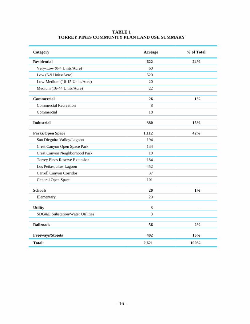
TABLE 1 TORREY PINES COMMUNITY PLAN LAND USE SUMMARY
Category Acreage % of Total
Residential 622 24% Very-Low (0-4 Units/Acre) 60 Low (5-9 Units/Acre) 520 Low-Medium (10-15 Units/Acre) 20 Medium (16-44 Units/Acre) 22
Commercial 26 1% Commercial Recreation 8 Commercial 18
Industrial 380 15% Parks/Open Space 1,112 42%
San Dieguito Valley/Lagoon 194 Crest Canyon Open Space Park 134 Crest Canyon Neighborhood Park 10 Torrey Pines Reserve Extension 184 Los Peñasquitos Lagoon 452 Carroll Canyon Corridor 37 General Open Space 101
Schools 20 1% Elementary 20
Utility 3 -- SDG&E Substation/Water Utilities 3
Railroads 56 2%
Freeways/Streets 402 15%
Total: 2,621 100%
- 17 -
That portion of Torrey Pines located just south of Carmel Valley Road is heavily influenced by Torrey Pines State Reserve and Los Peñasquitos Canyon Preserve and Lagoon. Most of this portion of the community is designated open space to protect the lagoon and resources within Torrey Pines State Park Reserve Extension. The southern portion of Torrey Pines, known as Sorrento Valley, is located adjacent to the scientific research and biotech industrial areas of the University and Mira Mesa communities. The Plan designates all of Sorrento Valley as industrial, which is consistent with the industrial nature of this region of the City of San Diego.
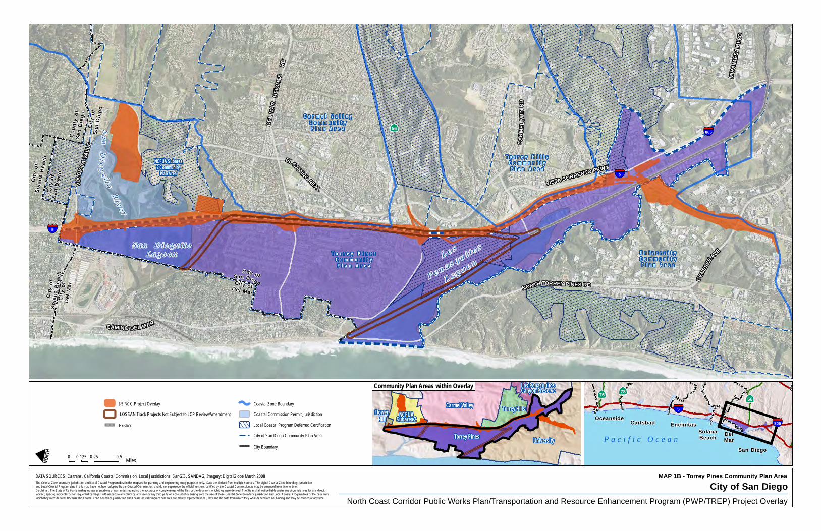
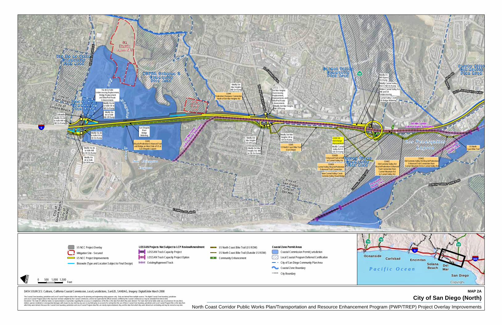
LOCAL COASTAL PROGRAM The California Coastal Act of 1976 established a coastal zone boundary within which certain planning and development requirements must be met. These requirements have been designed to protect and enhance California's coastal resources. The North City Local Coastal Program Land Use Plan (LCP) was adopted by the San Diego City Council in March 1981, revised in May 1985, and revised again in March 1987. The LCP, as amended, remains in full force and effect. However, should any policies contained in this document conflict with the previously adopted LCP Land Use Plan, this document shall take precedence. The LCP encompasses all of the Torrey Pines planning area, except for a small portion at the very southern tip of Sorrento Valley. The LCP also encompasses portions of the community planning areas of Mira Mesa, Carmel Valley, University, Sorrento Hills, and Via De La Valle, as well as open space and urban reserve areas identified in the City's Progress Guide and General Plan (General Plan). These areas were grouped because of considerations of drainage into the San Dieguito and Los Peñasquitos Lagoon, impacts on traffic volume and traffic circulation in the area, and the cumulative impacts of development. The recommendations and development criteria of the LCP have been incorporated into the individual elements of this Plan. Due to the standard of review established in the Coastal Act of 1976, an LCP Land Use Plan must contain a great deal of specificity to direct the formulation of suitable implementing ordinances. Therefore, more specific and detailed supplemental coastal development policies not contained within the main body of this Plan can be found in Appendix E. These policies apply to all development with the coastal zone and take precedence over any policies contained elsewhere in the document that may conflict with the coastal development policies. The approval of the North Coast Corridor Public Works Plan/Transportation and Resource Enhancement Program (NCC PWP/TREP) by the California Coastal Commission in 2014 (Doc. No. PWP-6-NCC-13-0203-1) amended the City’s Local Coastal Program, and requires that subsequent regulatory reviews of projects encompassed by the NCC PWP/TREP be processed under the framework and guidance provided within the NCC PWP/TREP. This amendment of the City of San Diego Local Coastal Program included amendments to the Coastal Land Use Maps contained within the Torrey Pines Community Plan to include the NCC PWP/TREP Project Overlay Map (Map 1B) and Project Overlay Improvements Map (Map 2A-2B). The NCC PWP/TREP Project Overlay provides the applicable standard of
- 18 -
review for the NCC PWP/TREP, which authorizes the development, operation, and maintenance of specific rail, highway, transit, bicycle, pedestrian, community and resource enhancement projects defined therein. The City of San Diego Local Coastal Program NCC Project Overlay Improvements Map identifies those specific rail, highway, transit, bicycle, pedestrian, community and resource enhancement projects envisioned to occur within the jurisdictional boundaries of the Torrey Pines Community Plan pursuant to the NCC PWP/TREP. To the extent any other provisions of the community plan conflict with the NCC PWP/TREP, the provisions of the NCC PWP/TREP shall prevail.
C a r m e l V a l l e yC o m m u n i t yP l a n A r e a
T o r r e y P i n e sC o m m u n i t yP l a n A r e a
U n i v e r s i t yC o m m u n i t yP l a n A r e a
T o r r e y H i l l sC o m m u n i t yP l a n A r e a
NCFUA Subarea2 Community
Plan Area
City ofDel Mar
City ofSan Diego
City
ofD
elM
ar
City
o fS
olan
aB
each
Ci ty
ofSa
nD
iego
Ci ty
ofSo
lana
Bea
ch
Cit
yof
San
Die
go
Cou
nty
ofSa
n D
iego
GEN
ESEE
AVE
VISTA SORRENTO PKWY
CAMINO DEL MAR
VIA
DELA
VALL
E
NORTH TORREY PINES RD
ELCAMINO
REAL
CA
RM
ELM
TNR
D
DEL
MA
RH
EIG
HTS
RD
MIR
A M
ESA
BLV
D
56
5
5
805
North Coast Corridor Public Works Plan/Transportation and Resource Enhancement Program (PWP/TREP) Project Overlay
DATA SOURCES: Caltrans, California Coastal Commission, Local Jursidictions, SanGIS, SANDAG, Imagery: DigitalGlobe March 2008
0 0.25 0.50.125Miles
OceansideCarlsbad
San Diego
EncinitasSolanaBeach Del
Mar
5
805
5676 78
P a c i f i c O c e a n
I-5 NCC Project Overlay
LOSSAN Track Projects Not Subject to LCP Review/Amendment
Existing
Coastal Zone Boundary
Coastal Commission Permit Jurisdiction
Local Coastal Program Deferred Certification
City of San Diego Community Plan Area
City Boundary
The Coastal Zone boundary, jurisdiction and Local Coastal Program data in this map are for planning and engineering study purposes only. Data are derived from multiple sources. The digital Coastal Zone boundary, jurisdictionand Local Coastal Program data in this map have not been adopted by the Coastal Commission, and do not supersede the official versions certified by the Coastal Commission as may be amended from time to time.Disclaimer: The State of California makes no representations or warranties regarding the accuracy or completeness of the files or the data from which they were derived. The State shall not be liable under any circumstances for any direct, indirect, special, incidental or consequential damages with respect to any claim by any user or any third party on account of or arising from the use of these Coastal Zone boundary, jurisdiction and Local Coastal Program files or the data from which they were derived. Because the Coastal Zone boundary, jurisdiction and Local Coastal Program data files are merely representational, they and the data from which they were derived are not binding and may be revised at any time.
UniversityTorrey Pines
Carmel Valley Torrey HillsNCFUA
Subarea 2
Los PenasquitosCanyon Preserve
FlowerHill
Community Plan Areas within Overlay
MAP 1B - Torrey Pines Community Plan Area
City of San Diego
Via de la ValleUndercrossing Replacement,
Bridge Replacementand Bike/Ped Route
Enhancements
Modify Via dela Valle WB
to SB On Ramp
Modify Via dela Valle EB toNB On Ramp
Modify DelMar Heights
NB On Ramp
Modify CarmelValley Rd I-5SB On Ramp
Modify Via dela Valle EB toSB On Ramp
Modify Del MarHeights Rd. WBto SB On Ramp
Modify Del MarHeights EB toSB On Ramp
Modify DelMar HeightsSB Off Ramp
Modify Viade la Valle
SB Off Ramp
Modify Viade la Valle
NB Off Ramp
Modify I-5NB BypassOn Ramp
Modify Via dela Valle WB toNB On Ramp
Modify Del Mar Heights NB Off Ramp
Modify Carmel ValleyRd I-5 NB On Ramp
San DieguitoRiver
BridgeWidening
SD#2ACarmel Valley Bicycle/Pedestrian
Enhanced Trail Connection
SD#4Pedestrian Overpass Connection
North of Del Mar Heights Rd
Sidewalks
SD#2BEnhanced Park & Ride
at Carmel Valley Rd SD#2COld Sorrento Valley Rd
Bicycle/Pedestrian EnhancedTrail Connection fromCarmel Mountain Rdto Carmel Valley Rd
Widen Carmel Valley RdNB and SBUndercrossing
SD#3 Bicycle/Pedestrian Enhanced Trailand Bridge on West Side of I-5 at
San Dieguito Lagoon
Carmel Valley CreekSB Bridge Widening
SD#2COld Sorrento Valley Rd Bicycle/Pedestrian
Enhanced Trail Connection from Carmel Mountain Rd to Carmel Valley Rd
Del Mar Heights OvercrossingReplacement,Improvements andBike/Ped RouteEnhancements
SD#5I-5 North Coast Bike Trail
(San Diego)
New Carmel Valley Creek Sorrento Valley Road Bridge
I-5 North Coast Bike Trail
I-5/SR 56InterchangeImprovements
Del Mar
Tunn
el
- I-5/P
enas
quito
s Alte
rnativ
e
Penasquitos
Double Track
Penasquitos
Double Track
Del Mar Tunnel - I-5/Penasquitos Alternative
City ofSan DiegoCity ofSolana Beach
City ofSan DiegoCity ofDel Mar
City
ofSo
lana
Bea
chC
ityof
Del
Mar
Sa
n
D
i eg
uito
Riv
er
San Dieguito
Lagoon
C a r m e l V a l l e yC o m m u n i t yP l a n A r e a
T o r r e y P i n e sC o m m u n i t yP l a n A r e a
T o r r e y H i l l sC o m m u n i t yP l a n A r e a
V i a D e L a V a l l eC o m m u n i t yP l a n A r e a
N C F U A S u b a r e a 2C o m m u n i t yP l a n A r e a
F l o w e r H i l lC o m m u n i t yP l a n A r e a
L o s P e n a s q u i t o sL a g o o n
Del MarRace Track
56
5
DeanFamilyTrust
SanDieguito
Lagoon MOU
VISTA SORRENTO PKWYVI
AD
ELA
VALL
E
NORTH TORREY PINES RD
CAMINO DEL MAR
ELCAMINO
REAL
CARMELVA
LLEY
RD
CARM
EL
MTN RD
DEL M
AR
HEIG
HTS R
D
MAP 2A
City of San Diego (North)North Coast Corridor Public Works Plan/Transportation and Resource Enhancement Program (PWP/TREP) Project Overlay Improvements
DATA SOURCES: Caltrans, California Coastal Commission, Local Jursidictions, SanGIS, SANDAG, Imagery: DigitalGlobe March 2008
0 1,500500 1,000Feet
I-5 NCC Project Overlay
Mitigation Site - Secured
I-5 NCC Project Improvements
Bioswale (Type and Location Subject to Final Design)
LOSSAN Projects Not Subject to LCP Review/AmendmentLOSSAN Track Capacity Project
LOSSAN Track Capacity Project Option
Existing/Approved Track
I-5 North Coast Bike Trail (I-5 ROW)
I-5 North Coast Bike Trail (Outside I-5 ROW)
Community Enhancement
Coastal Zone Permit AreasCoastal Commission Permit Jurisdiction
Local Coastal Program Deferred Certification
City of San Diego Community Plan Area
Coastal Zone Boundary
City Boundary
OceansideCarlsbad
San Diego
EncinitasSolanaBeach
DelMar
5
805
5676 78
P a c i f i c O c e a n
Copyright:'
The Coastal Zone boundary, jurisdiction and Local Coastal Program data in this map are for planning and engineering study purposes only. Data are derived from multiple sources. The digital Coastal Zone boundary, jurisdictionand Local Coastal Program data in this map have not been adopted by the Coastal Commission, and do not supersede the official versions certified by the Coastal Commission as may be amended from time to time.Disclaimer: The State of California makes no representations or warranties regarding the accuracy or completeness of the files or the data from which they were derived. The State shall not be liable under any circumstances for any direct, indirect, special, incidental or consequential damages with respect to any claim by any user or any third party on account of or arising from the use of these Coastal Zone boundary, jurisdiction and Local Coastal Program files or the data from which they were derived. Because the Coastal Zone boundary, jurisdiction and Local Coastal Program data files are merely representational, they and the data from which they were derived are not binding and may be revised at any time.

I-5 Flyover- Connector
Bridge I
Modify CarmelValley Rd I-5SB On Ramp
Modify I-5NB BypassOn RampModify Carmel ValleyRd I-5 NB On Ramp
Modify Roselle Stto I-5 SBOn Ramp
Modify RoselleSt. Northbound
Off-Ramp
Modify I-5 NB Bypass
Genesee Ave toI-5 NB Bypass
Roselle St. toGenesee AveI-5 SB Bypass
SD#2ACarmel Valley Bicycle/Pedestrian
Enhanced Trail Connection
Voigt Dr.OvercrossingRealignment
Replacement andBike/Ped RouteEnhancements
Modify Genesee SB On-Ramp
Genesee Braided Ramps
SD#2BEnhanced Park & Ride
at Carmel Valley Rd SD#2COld Sorrento Valley Rd
Bicycle/Pedestrian EnhancedTrail Connection fromCarmel Mountain Rdto Carmel Valley Rd
Widen Carmel Valley RdNB and SBUndercrossing Carmel Valley CreekSB Bridge Widening
Modify Genesee SB On-Ramp
Genesse Ave. to Sorrento Valley Rd.
Braided Ramps
Genesse Ave. to Sorrento Valley Rd.
Braided Ramps
I-5 Flyover- Connector
Bridge II
SD#2COld Sorrento Valley Rd Bicycle/Pedestrian
Enhanced Trail Connections from Carmel Mountain Rd to Carmel Valley Rd
New Carmel Valley Creek Sorrento Valley Road Bridge
I-5 North Coast Bike Trail
I-5/SR 56InterchangeImprovements
Penasquitos
Double Track
Del Mar Tunnel - I-5/Penasquitos Alternative
M i r a M e s aC o m m u n i t yP l a n A r e a
C a r m e l V a l l e yC o m m u n i t yP l a n A r e a
T o r r e y P i n e sC o m m u n i t yP l a n A r e a
U n i v e r s i t yC o m m u n i t yP l a n A r e a
T o r r e y H i l l sC o m m u n i t yP l a n A r e a
L o s P e n a s q u i t o sC a n y o n P r e s e r v e
C o m m u n i t y P l a n A r e a
L o s P e n a s q u i t o sL a g o o n
56
805
5
MIRA
MESA
BLVD
NORTH TORREY PINES RD
GENES
EEAV
E
EL CAMINOREAL
VISTA SORRENTO PKWY
CARM
ELVA
LLEY
RD
CA
RM
EL MTN
RD
MAP 2B
City of San Diego (South)North Coast Corridor Public Works Plan/Transportation and Resource Enhancement Program (PWP/TREP) Project Overlay Improvements
DATA SOURCES: Caltrans, California Coastal Commission, Local Jursidictions, SanGIS, SANDAG, Imagery: DigitalGlobe March 2008
0 1,500500 1,000Feet
I-5 NCC Project Overlay
I-5 NCC Project Improvements
LOSSAN Projects Not Subject to LCP Review/Amendment
LOSSAN Track Capacity Project
LOSSAN Track Capacity Project Option
Existing/Approved Track
I-5 North Coast Bike Trail (I-5 ROW)
I-5 North Coast Bike Trail (Outside I-5 ROW)
Community Enhancement
Coastal Zone Permit AreasCoastal Commission Permit Jurisdiction
Local Coastal Program Deferred Certification
City of San Diego Community Plan Area
Coastal Zone Boundary
OceansideCarlsbad
San Diego
EncinitasSolanaBeach
DelMar
5
805
5676 78
P a c i f i c O c e a n
Copyright:'
The Coastal Zone boundary, jurisdiction and Local Coastal Program data in this map are for planning and engineering study purposes only. Data are derived from multiple sources. The digital Coastal Zone boundary, jurisdictionand Local Coastal Program data in this map have not been adopted by the Coastal Commission, and do not supersede the official versions certified by the Coastal Commission as may be amended from time to time.Disclaimer: The State of California makes no representations or warranties regarding the accuracy or completeness of the files or the data from which they were derived. The State shall not be liable under any circumstances for any direct, indirect, special, incidental or consequential damages with respect to any claim by any user or any third party on account of or arising from the use of these Coastal Zone boundary, jurisdiction and Local Coastal Program files or the data from which they were derived. Because the Coastal Zone boundary, jurisdiction and Local Coastal Program data files are merely representational, they and the data from which they were derived are not binding and may be revised at any time.

PLAN ELEMENTS


RESOURCE MANAGEMENT & OPEN SPACE ELEMENT

- 23 -
RESOURCE MANAGEMENT & OPEN SPACE ELEMENT
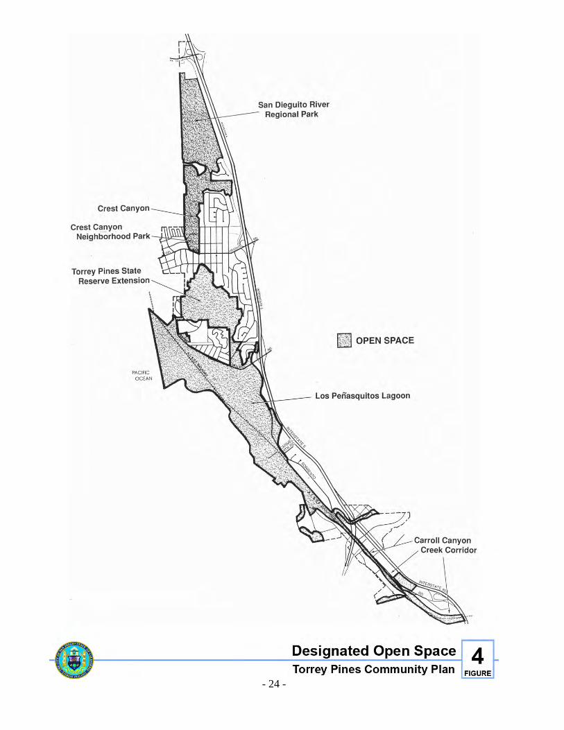
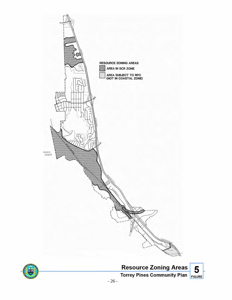
BACKGROUND AND ISSUES The Torrey Pines community consists of over 1,000 acres of open space, located primarily within five separate but related open space systems, each containing numerous sensitive environmental resources. These open space systems include, from the north part of the community to the south, San Dieguito River Valley, Crest Canyon, Torrey Pines Reserve Extension, Los Peñasquitos Lagoon and associated uplands, and the Carroll Canyon Wetlands/Wildlife Corridor (see Figure 4). Except for a small portion at the south end of Sorrento Valley, all of the Torrey Pines community is in the Coastal Zone, and most of the wetlands, wetland buffers, shoreline coastal bluffs, and beaches are within the Sensitive Coastal Resource (SCR) Zone (see Figure 5). The Torrey Pines community is rich in valuable biological resources. The most sensitive of these habitats include Coastal Marsh, Riparian, Coastal Mixed Chaparral, Chamise Chaparral, Coastal Sage Scrub, Grasslands, and Torrey Pine Woodland (please see Biologically Sensitive Habitats maps, Figures 19-21, within the Appendix). The Torrey Pines community is also rich in cultural resources, with over 25 prehistoric and historic archaeological sites recorded as of 1981. The Sorrento Valley/Los Peñasquitos Lagoon area of the Torrey Pines community is the site of the prehistoric Indian village of Ystagua. Ystagua has archaeological remnants unique to the area, and is considered a Multiple Resource Area (MRA) by the National Register of Historic Places Guidelines. The site has extensive middens and artifacts, and has burial sites with cremation remains that are of special concern to local Native Americans. This area is believed to have been the center of a resource network in which prehistoric man visited the lagoon and surrounding area for food and raw materials for tools. The value of this area has been extensively documented in the ethnographic and archaeological record. The California Environmental Quality Act (CEQA) directs agencies to inventory cultural resources under their jurisdiction, and requires projects to consider impacts to archaeological, historic, and Native American resources. The National Environmental Policy Act (NEPA) has made a national policy of preserving historic and cultural aspects of our national heritage. In addition, the General Plan discusses at length the “alarming rate of historical and archaeological site destruction” and the need for increased public efforts to slow the rate of destruction. In addition to the sensitive coastal, biological and cultural resources found within the Torrey Pines community, several other environmental constraints exist including slopes of 25 percent or greater, floodplains, geologic hazards and wetlands (please see detailed Environmental Constraints maps, Figures 22-24, within the Appendix).
- 24 -
Figure 4. Designated Open Space
- 25 -
These biological and cultural resources continue to suffer degradation from a variety of sources. Los Peñasquitos Lagoon and the Carroll Canyon Creek corridor have been degraded by the development of adjacent residential and industrial properties, the construction of public utility and transportation projects, and increased sedimentation and decreased water quality from development in surrounding upstream communities. The Torrey Pines State Reserve Extension is impacted by residential encroachment from adjacent properties. Crest Canyon, because of its excellent access, is a heavily used area that suffers impacts from erosion. That portion of the San Dieguito River Valley Regional Open Space Park within Torrey Pines suffers from a history of sewage discharges, water diversions, sedimentation, human and pet intrusion, and extensive land filling for the Del Mar Racetrack and Fairgrounds.
GOALS 1. Ensure long term sustainability of the unique ecosystems in the Torrey Pines community,
including all soil, water, air, and biological components that interact to form healthy functioning ecosystems.
2. Conserve, restore, and enhance plant communities and wildlife habitat, especially habitat
for rare, threatened, and endangered species. 3. Retain viable, connected systems of wildlife habitat, and maintain these areas in their
natural state. 4. Identify, inventory and preserve the unique paleontological, archaeological, Native
American, and historic resources of Torrey Pines for their educational, cultural, and scientific values.
5. Preserve, enhance and restore all natural open space and sensitive resource areas,
including Los Peñasquitos Lagoon and associated uplands, Torrey Pines State Park and Reserve Extension areas with its distinctive sandstone bluffs and red rock, Crest Canyon, San Dieguito Lagoon and River Valley, the Carroll Canyon Wetland/Wildlife Corridor through Sorrento Valley, and all selected corridors providing linkage between these areas.
6. Establish a pedestrian/bicycle pathway system that links all open space areas, from Carroll
Canyon in the south to the San Dieguito River Valley in the north. This pathway system shall be provided concurrent with adjacent development, and shall be designed consistent with the design guidelines provided within this Plan.
- 26 -
Figure 5. Resource Zoning Areas
- 27 -
POLICIES 1. Land uses adjacent to environmentally sensitive habitats shall not negatively impact
those areas. 2. Development impacts to rare, threatened, endangered, or candidate species shall be
minimized or eliminated. 3. No filling, clearing, grubbing, or other disturbance of biologically sensitive habitats shall
be permitted without approved mitigation plans. 4. Coastal lagoons and estuaries that are designated and zoned open space shall remain
undeveloped. 5. Public access in areas of environmentally sensitive habitats shall be limited to low-
intensity recreational, scientific, or educational use. Access shall be controlled or confined to designated trails or paths, and no access shall be approved which results in disruption of habitat.
6. New development adjacent to and impacting biologically sensitive areas shall be
responsible for the restoration and enhancement of that area. In particular, when mitigation areas are needed for public projects, the disturbed areas in Crest Canyon should be revegetated with Coastal Mixed Chaparral and Torrey Pines.
7. Riparian vegetation in channels through the Sorrento Valley industrial area shall be
preserved in its natural state in order to maintain its vital wildlife habitat value. When vegetation removal is necessary for flood control, the required state and federal permits shall be obtained.
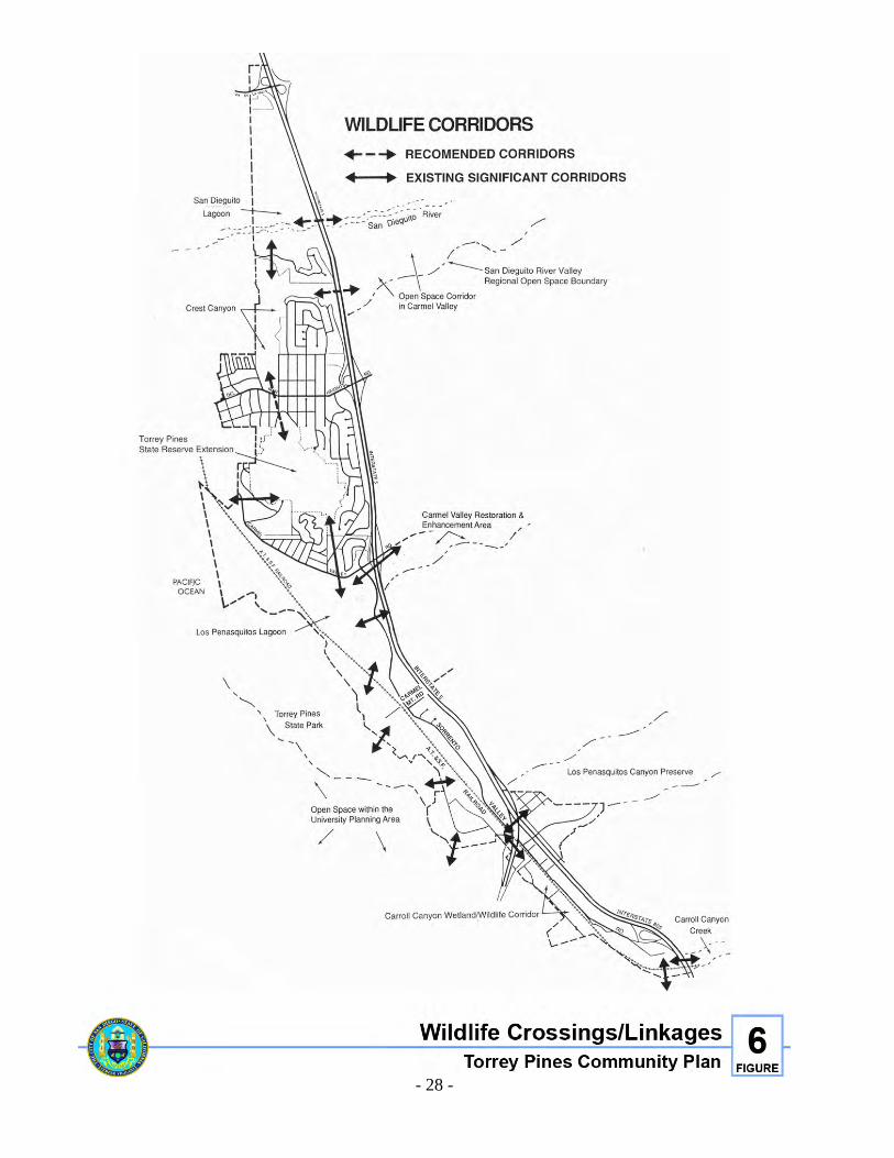
8. Preserve and enhance all open space and wildlife corridors (see Figure 6), especially
those linking Los Peñasquitos Lagoon with Torrey Pines State Reserve Extension and the Carroll Canyon Creek Corridor.
9. Crest Canyon shall be left in its natural state in order to preserve those biologically
sensitive habitats identified within this park. A small portion of the parkland located adjacent to Del Mar Heights Road and Durango Drive should accommodate some limited passive park development.
10. Construction or improvements of roadways adjacent to biologically sensitive areas or
open space shall be designed to avoid impacts, especially in wetlands and wetland buffer areas. Protection of sensitive habitats through buffers, realignments and reduced development areas shall also be considered.
11. New development, both public and private, should incorporate site planning and design
features that avoid or mitigate impacts to cultural resources. When sufficient plan flexibility does not permit avoiding construction on cultural resource sites, mitigation shall be designed in accordance with guidelines of the State Office of Historic Preservation and the State of California Native American Heritage Commission.
- 28 -
Figure 6. Wildlife Crossings/Linkages
- 29 -
12. Maintain regulations that prohibit contaminated runoff from reaching any of the sensitive open space areas designated in this Plan.
13. Conditions of approval for all development that impacts adjacent open space areas
should include restoration and enhancement measures for that particular area. 14. All Torrey Pine trees on public property should be preserved and protected. 15. Provide pedestrian/bicycle linkages so that all open space areas will be connected.
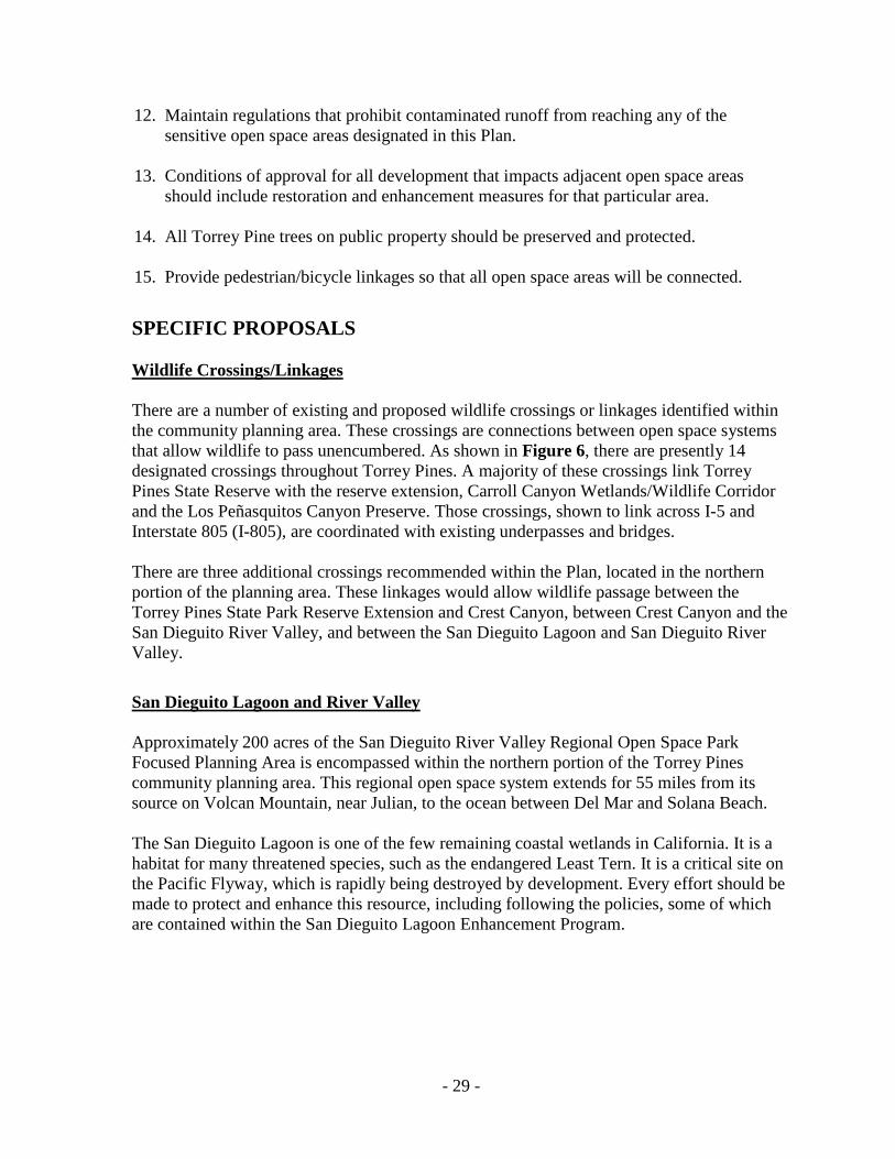
SPECIFIC PROPOSALS Wildlife Crossings/Linkages There are a number of existing and proposed wildlife crossings or linkages identified within the community planning area. These crossings are connections between open space systems that allow wildlife to pass unencumbered. As shown in Figure 6, there are presently 14 designated crossings throughout Torrey Pines. A majority of these crossings link Torrey Pines State Reserve with the reserve extension, Carroll Canyon Wetlands/Wildlife Corridor and the Los Peñasquitos Canyon Preserve. Those crossings, shown to link across I-5 and Interstate 805 (I-805), are coordinated with existing underpasses and bridges. There are three additional crossings recommended within the Plan, located in the northern portion of the planning area. These linkages would allow wildlife passage between the Torrey Pines State Park Reserve Extension and Crest Canyon, between Crest Canyon and the San Dieguito River Valley, and between the San Dieguito Lagoon and San Dieguito River Valley.
San Dieguito Lagoon and River Valley Approximately 200 acres of the San Dieguito River Valley Regional Open Space Park Focused Planning Area is encompassed within the northern portion of the Torrey Pines community planning area. This regional open space system extends for 55 miles from its source on Volcan Mountain, near Julian, to the ocean between Del Mar and Solana Beach. The San Dieguito Lagoon is one of the few remaining coastal wetlands in California. It is a habitat for many threatened species, such as the endangered Least Tern. It is a critical site on the Pacific Flyway, which is rapidly being destroyed by development. Every effort should be made to protect and enhance this resource, including following the policies, some of which are contained within the San Dieguito Lagoon Enhancement Program.
- 30 -
1. New development or expansion of existing uses adjacent to the lagoon shall not encroach into or negatively impact this open space area.
2. The lagoon should be enlarged to enhance plant and animal habitats, and to create a
sufficient tidal prism to ensure adequate water circulation and to keep the mouth of the river open.
3. The existing fairgrounds and parking shall be enhanced with landscaping and the
sensitive habitat areas shall be buffered from fairgrounds activity. Activities of the 22nd Agricultural District shall not encroach into open space areas.
4. Development adjacent to the lagoon should be designed to avoid sedimentation, erosion
or other potential impacts that degrade the quality of the water resources, and should preserve existing public views. The following measures to reduce grading impacts should be utilized where appropriate: minimize grading during the rainy season, install sediment basins and/or energy dissipating structures, and ensure revegetation and stabilization of slopes before the onset of the rainy season. To reduce visual impacts, development should be low-profile and screened from view by landscaped buffers.
5. Within the 100-year floodplain fringe of the San Dieguito River, fill for roads and other
public improvements and/or permanent structures will be allowed only if such development is consistent with uses allowed pursuant to the A-1-10 Zone and other existing zoning, is capable of withstanding periodic flooding, and does not require the construction of offsite flood protective works. The following requirements shall also be met:
• Existing environmentally sensitive habitat areas will not be significantly affected, and, that as a condition of development, significant new riparian corridors will be planted and maintained to function as enhanced wildlife corridors.
• The design of the development incorporates the findings and recommendations of both a site-specific and coastal watershed hydrologic study in order that the development either assures that there will be no increase in the peak runoff rate from the fully developed site, and neither significantly increase nor contributes to downstream bank erosion and sedimentation, including wetlands, lagoons, and other environmentally sensitive habitat areas.
• There will be no significant adverse water quality impacts to downstream wetland, lagoon and other environmentally sensitive habitat areas.
6. Protect, preserve and enhance the variety of natural features within the San Dieguito
River Valley including the floodplain, the open waters of the lagoon and river, wetlands, marshlands and uplands.
7. Maintain and enhance the experience of nature within the lagoon by screening present
conflicting uses, prohibiting future conflicting uses, retaining natural areas and promoting an expanded water body within the lagoon.
- 31 -
Crest Canyon Crest Canyon is composed of 134 acres of open space and ten acres of land dedicated by ordinance as a neighborhood park. It extends north from Del Mar Heights Road to San Dieguito Valley and includes native Coastal Sage Scrub, Torrey Pines Woodland, sandstone cliffs, and steep slopes. 1. The neighborhood park portion of Crest Canyon shall have limited development on the
1.5+ acres of semi-level land adjacent to view points, benches, trail heads, information signs and decomposed granite trails except where disabled access is viable.
The open space portion of the canyon shall be preserved. Limited public access shall be provided by defined trails under standards established for the preservation of biologically sensitive plants and wildlife.
2. Design of dwelling units adjacent to State Reserve Extension and Crest Canyon shall stress a blending of architecture with the natural terrain. Architectural shapes, bulk, materials, and landscaping should be carefully chosen to respect the physical constraints of the land.
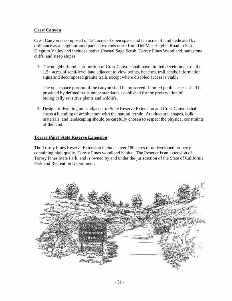
Torrey Pines State Reserve Extension The Torrey Pines Reserve Extension includes over 180 acres of undeveloped property containing high quality Torrey Pines woodland habitat. The Reserve is an extension of Torrey Pines State Park, and is owned by and under the jurisdiction of the State of California Park and Recreation Department.
- 32 -
Residential development along the rim of the Reserve Extension represents the most significant encroachment problem, creating both visual and erosion impacts. 1. New development, both public and private, shall not encroach into or negatively impact
the Reserve Extension. Adequate buffer areas and appropriate landscaped screening shall be provided and maintained between development and the Reserve Extension to avoid significant visual and erosion impacts from construction.
2. Both wildlife corridors (Portofino and Via Mar Valle) shall be preserved and enhanced
to provide appropriate wildlife linkage to Los Peñasquitos Lagoon. 3. Future development adjacent to the Torrey Pines Reserve Extension area shall provide
for adequate buffer areas. Development proposals shall provide adequate setbacks to avoid significant erosion, visual, or sediment impacts from construction. Setbacks also shall be provided to prevent the necessity of firebreaks being constructed on reserve property.
4. Landscaping of properties adjacent to the Extension shall not use invasive plant species.
Landscaping adjacent to this area should use plant species naturally occurring in that area.
Los Peñasquitos Lagoon Los Peñasquitos Lagoon is one of the few remaining tidal estuaries in Southern California and is particularly important among San Diego County's estuaries because of its proximity to the Torrey Pines State Reserve and Beach. The lagoon and associated upland serves as a major stopping point for migratory birds and also has a large residential bird population. Los Peñasquitos Lagoon is a good example of the unique biological community of plants associated with the transition zone between marine and fresh water environment. The reserve extension is isolated from Torrey Pines State Park, is surrounded on all sides by residential development, and is linked inadequately to Los Peñasquitos Lagoon through two corridors. One corridor links the southeast portion of the reserve to the lagoon by traversing Portofino Drive and Carmel Valley Road, and the other is in the southwest portion of the reserve just south of Via Mar Valle. In the past sixty years, Los Peñasquitos Lagoon has evolved from a tidal estuary to a lagoon that is closed to tidal action for long periods of time. The major factors degrading the lagoon have been: 1) The construction of a railroad embankment that cut off lagoon channels; 2) The construction of North Torrey Pines Road and bridge along the barrier beach that restricted the location of the lagoon mouth; 3) Construction of the north beach parking lot in historic tidal areas; 4) Increased sediment from changing land uses upstream, and; 5) Decreased water quality from urban runoff and sewage effluent.
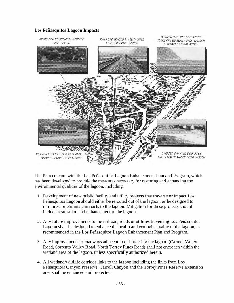
- 33 -
Los Peñasquitos Lagoon Impacts
The Plan concurs with the Los Peñasquitos Lagoon Enhancement Plan and Program, which has been developed to provide the measures necessary for restoring and enhancing the environmental qualities of the lagoon, including: 1. Development of new public facility and utility projects that traverse or impact Los
Peñasquitos Lagoon should either be rerouted out of the lagoon, or be designed to minimize or eliminate impacts to the lagoon. Mitigation for these projects should include restoration and enhancement to the lagoon.
2. Any future improvements to the railroad, roads or utilities traversing Los Peñasquitos
Lagoon shall be designed to enhance the health and ecological value of the lagoon, as recommended in the Los Peñasquitos Lagoon Enhancement Plan and Program.
3. Any improvements to roadways adjacent to or bordering the lagoon (Carmel Valley
Road, Sorrento Valley Road, North Torrey Pines Road) shall not encroach within the wetland area of the lagoon, unless specifically authorized herein.
4. All wetland/wildlife corridor links to the lagoon including the links from Los
Peñasquitos Canyon Preserve, Carroll Canyon and the Torrey Pines Reserve Extension area shall be enhanced and protected.
- 34 -
5. Plans for future removal or rerouting of the electrical utility lines that transect Los Peñasquitos Lagoon shall be given high priority.
6. Public access and educational opportunities shall be provided consistent with resource
protection. 7. The lagoon mouth shall be opened regularly (or as recommended in the Los Peñasquitos
Lagoon Restoration and Enhancement Plan) to enhance the health and ecological value of the lagoon.
8. Erosion and siltation control measures shall be required for all developments proposed
within the total watershed of Los Peñasquitos Lagoon. 9. Any future changes in the design of the North Torrey Pines Road and bridge shall be
designed such that the ecosystem of the lagoon is maintained and, if possible, enhanced. 10. Applicants for coastal development permits for projects located in the watershed of Los
Peñasquitos Lagoon shall, in addition to meeting all other requirements, enter into an agreement with the City of San Diego and the State Coastal Conservancy as a condition of development approval to pay a Los Peñasquitos watershed restoration and enhancement fee to the Los Peñasquitos Lagoon Fund for restoration of the Los Peñasquitos Lagoon and watershed.
Carroll Canyon Wetland/Wildlife Corridor This open space corridor runs the length of Sorrento Valley and provides an important linkage between Carroll Canyon and Los Peñasquitos Lagoon. The majority of this corridor is privately owned and consists primarily of wetlands containing riparian vegetation. Some portions of this corridor have been channelized and most of it has experienced urban encroachment. However, this area continues to support riparian habitat and provides a significant linkage for many plant and animal species between two significant open space resource areas.
1. All new development proposed adjacent to this open space corridor shall incorporate the
urban design guidelines located within the Industrial Element as appropriate. 2. New development proposed adjacent to this open space corridor shall not contribute to
increased sediment loading of the wetland, disturbance of its habitat values, or otherwise impair the functional capacity of the wetland.
3. New development proposed adjacent to and impacting this open space corridor shall
enhance and improve the habitat value of this system. 4. All mature trees and other significant existing vegetation in this system shall be
protected, including the riparian habitat located in the existing concrete-lined channels.
- 35 -
5. All new development proposed adjacent to this corridor shall submit a pedestrian/bicycle pathway plan, indicating the construction of their portion of the pathway consistent with the community-wide pathway system and the industrial development design guidelines contained in the Industrial Element.
6. Within the l00-year floodplain fringe of Sorrento Valley, fill for roads, public
improvements, or other permanent structures will only be allowed if it can be shown that all of the following will be met:
a. Existing environmentally sensitive habitat areas will not be significantly
adversely affected.
b. Increased erodible flood flow velocities will not occur.
c. Areas to be filled do not create unplanned detention/siltation.
d. Any loss or degrading of existing wildlife habitat areas will be appropriately mitigated.
e. Increases in post-construction runoff and sediment above the ten-year storm frequency preconstruction condition, will be mitigated.
f. Appropriate upstream national pollution discharge elimination system criteria will be implemented to maintain the water quality of the downstream wetlands.
g. If existing sensitive environmental areas are affected, then suitable mitigation will be provided.
Brush Management Because of the abundance of natural open space areas including canyons rich with native vegetation, special brush management consideration and enforcement should be provided within the Torrey Pines planning area. Currently all development within Torrey Pines must comply with the Uniform Fire Code and Section 6 (Brush Management) of the City of San Diego's Landscape Technical Manual. In summary, these codes state that brush or native vegetative growth on steep slopes must be controlled to protect existing and proposed structures from fire hazards. The Torrey Pines community includes numerous publicly-owned open space areas containing biologically sensitive wildlife and vegetation. In most cases, the vegetation provides the very basis for the biological community that exists within these public areas. Removal or disturbance of vegetation to reduce wildfire potential can be ecologically disruptive. In order to protect these sensitive areas, resource management policies of the City of San Diego and the State of California discourage the removal of vegetation for wildfire reduction within public parkland when it becomes ecologically disruptive.
- 36 -
Ecologically beneficial methods to reduce wildfire potential in public parklands do exist. Prescribed fire, which mimics a natural process, is an example of an ecological, efficient and effective means of reducing wildfire danger. Alternatives that balance the needs for resource management with public safety should continue to be explored through the cooperative efforts of the citizens and responsible public agencies.
IMPLEMENTATION The specific proposals and design guidelines for development adjacent to environmentally sensitive areas currently can only be implemented through the discretionary review process. The update to the City's zoning code should establish new zones that provide adequate development regulations to protect the City's sensitive environmental resources. Appendix E of this Plan contains additional land use policies developed by the City of San Diego and approved by the Coastal Commission that are incorporated into this Plan and which apply to all development located in the coastal zone. In order to implement the open space recommendations of this plan, all properties designated open space and recommended to be preserved as open space shall be rezoned to the appropriate Open Space (OS) Zone (see Figure 25 in the Appendix).
Several properties within the planning area are designated but not zoned open space. Most of these areas are privately owned, and contain some limited sensitive cultural or biologically sensitive resources. These areas and all areas covered by this Plan should be allowed to develop in compliance with the underlying zone as well as all applicable resource protection regulations such as the Sensitive Coastal Resource Zone, Hillside Review, Coastal Regulations, Archaeology/Paleontology Regulations, Flood Plain and Floodway Ordinances, etc.
- 37 -
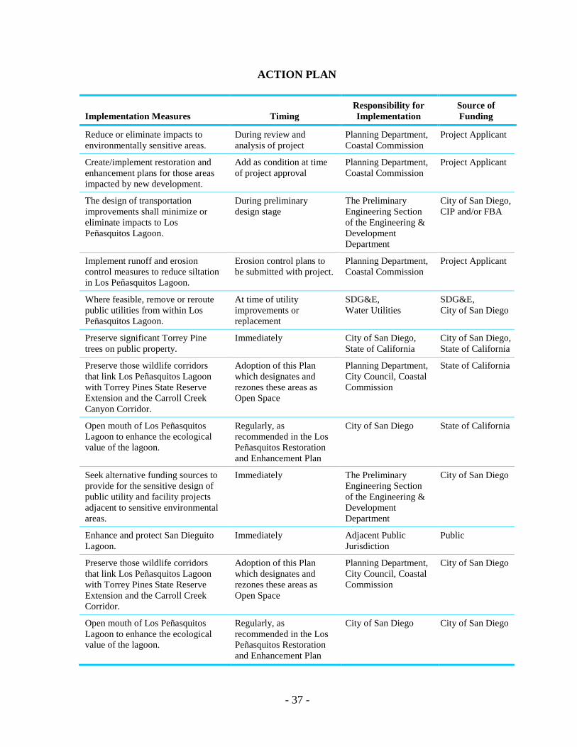
ACTION PLAN
Implementation Measures Timing Responsibility for Implementation
Source of Funding
Reduce or eliminate impacts to environmentally sensitive areas.
During review and analysis of project
Planning Department, Coastal Commission
Project Applicant
Create/implement restoration and enhancement plans for those areas impacted by new development.
Add as condition at time of project approval
Planning Department, Coastal Commission
Project Applicant
The design of transportation improvements shall minimize or eliminate impacts to Los Peñasquitos Lagoon.
During preliminary design stage
The Preliminary Engineering Section of the Engineering & Development Department
City of San Diego, CIP and/or FBA
Implement runoff and erosion control measures to reduce siltation in Los Peñasquitos Lagoon.
Erosion control plans to be submitted with project.
Planning Department, Coastal Commission
Project Applicant
Where feasible, remove or reroute public utilities from within Los Peñasquitos Lagoon.
At time of utility improvements or replacement
SDG&E, Water Utilities
SDG&E, City of San Diego
Preserve significant Torrey Pine trees on public property.
Immediately City of San Diego, State of California
City of San Diego, State of California
Preserve those wildlife corridors that link Los Peñasquitos Lagoon with Torrey Pines State Reserve Extension and the Carroll Creek Canyon Corridor.
Adoption of this Plan which designates and rezones these areas as Open Space
Planning Department, City Council, Coastal Commission
State of California
Open mouth of Los Peñasquitos Lagoon to enhance the ecological value of the lagoon.
Regularly, as recommended in the Los Peñasquitos Restoration and Enhancement Plan
City of San Diego State of California
Seek alternative funding sources to provide for the sensitive design of public utility and facility projects adjacent to sensitive environmental areas.
Immediately The Preliminary Engineering Section of the Engineering & Development Department
City of San Diego
Enhance and protect San Dieguito Lagoon.
Immediately Adjacent Public Jurisdiction
Public
Preserve those wildlife corridors that link Los Peñasquitos Lagoon with Torrey Pines State Reserve Extension and the Carroll Creek Corridor.
Adoption of this Plan which designates and rezones these areas as Open Space
Planning Department, City Council, Coastal Commission
City of San Diego
Open mouth of Los Peñasquitos Lagoon to enhance the ecological value of the lagoon.
Regularly, as recommended in the Los Peñasquitos Restoration and Enhancement Plan
City of San Diego City of San Diego
- 38 -
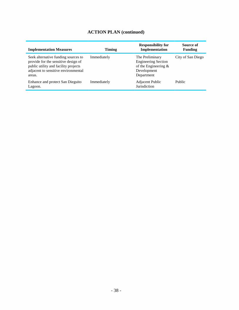
ACTION PLAN (continued)
Implementation Measures Timing Responsibility for Implementation
Source of Funding
Seek alternative funding sources to provide for the sensitive design of public utility and facility projects adjacent to sensitive environmental areas.
Immediately The Preliminary Engineering Section of the Engineering & Development Department
City of San Diego
Enhance and protect San Dieguito Lagoon.
Immediately Adjacent Public Jurisdiction
Public
TRANSPORTATION ELEMENT

- 41 -
TRANSPORTATION ELEMENT
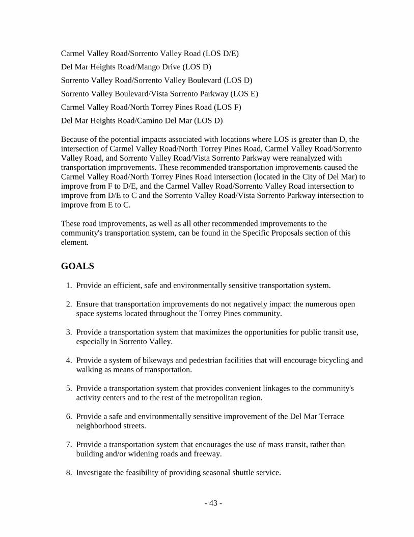
BACKGROUND AND ISSUES A majority of the most significant traffic issues identified by the community were related to safety. Del Mar Heights Road, because of its width, traffic volumes and speed, is perceived by many residents as a major barrier dividing the community in two. Many children are bused only a few blocks to school to avoid having to cross Del Mar Heights Road on foot. Residents have identified a variety of additional traffic concerns including the lack of efficient pedestrian circulation, illegal excessive speeds on Del Mar Heights Road and Carmel Valley Road, increasing traffic volumes and congestion overall, overflow beach parking during summer weekends, the substandard street conditions in the Del Mar Terrace neighborhood and traffic impacts from regional growth including the construction of State Route 56 (SR-56). The Torrey Pines community faces the challenge of planning and developing a transportation system that accommodates future traffic volumes, emphasizing mass transit, without disrupting the community's unique environment and the lifestyle of its residents. The traditional services provided by a community's traffic circulation system are internal circulation from one part of the community to another and a means of connecting the entire community to other communities. Because of its location at the northern extent of the City of San Diego and its long, thin shape, the Torrey Pines circulation system must also carry through traffic (i.e., traffic without an origin or destination within the community). The Torrey Pines community forms a long, narrow area along I-5 and I-805 through which all east-west traffic must pass. Among the areas to be served are the city of Del Mar, the beaches, the fairgrounds-race track area and other residential areas. The uses of some of these facilities (beaches and race track) vary considerably from winter to summer and thus cause a seasonal variation in traffic between these time periods. In February 1992, a Transportation Study was completed in association with the Torrey Pines Community Plan Update. This study contained an analysis of existing transportation conditions, as well as documentation of the travel forecast used in the analysis of future transportation conditions. The Transportation Study indicated that existing daily traffic volumes on North Torrey Pines Road, Sorrento Valley Road, Via De La Valle and Carmel Valley Road exceeded their approximate maximum desirable average daily traffic. The study also found that three intersections operated with a level of service (LOS) below C including: Carmel Valley Road/Sorrento Valley Road (LOS D)
Carmel Valley Road/North Torrey Pines Road (LOS F)
Sorrento Valley Road/Sorrento Valley Boulevard (LOS D)
Some of the potential problems associated with levels of service D or greater include congestion, delay and air quality impacts. Intersection Level of Service analyses were then performed using projected traffic at buildout of the Plan and surrounding communities and jurisdictions. Analyses assumed existing road geometrics. Six intersections had LOS greater than C:
- 42 -
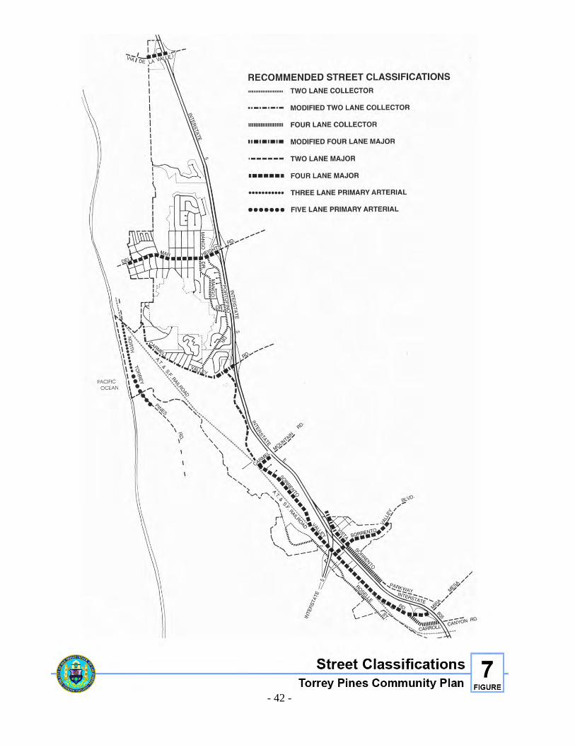
Figure 7. Street Classifications
- 43 -
Carmel Valley Road/Sorrento Valley Road (LOS D/E)
Del Mar Heights Road/Mango Drive (LOS D)
Sorrento Valley Road/Sorrento Valley Boulevard (LOS D)
Sorrento Valley Boulevard/Vista Sorrento Parkway (LOS E)
Carmel Valley Road/North Torrey Pines Road (LOS F)
Del Mar Heights Road/Camino Del Mar (LOS D) Because of the potential impacts associated with locations where LOS is greater than D, the intersection of Carmel Valley Road/North Torrey Pines Road, Carmel Valley Road/Sorrento Valley Road, and Sorrento Valley Road/Vista Sorrento Parkway were reanalyzed with transportation improvements. These recommended transportation improvements caused the Carmel Valley Road/North Torrey Pines Road intersection (located in the City of Del Mar) to improve from F to D/E, and the Carmel Valley Road/Sorrento Valley Road intersection to improve from D/E to C and the Sorrento Valley Road/Vista Sorrento Parkway intersection to improve from E to C. These road improvements, as well as all other recommended improvements to the community's transportation system, can be found in the Specific Proposals section of this element.
GOALS 1. Provide an efficient, safe and environmentally sensitive transportation system. 2. Ensure that transportation improvements do not negatively impact the numerous open
space systems located throughout the Torrey Pines community. 3. Provide a transportation system that maximizes the opportunities for public transit use,
especially in Sorrento Valley. 4. Provide a system of bikeways and pedestrian facilities that will encourage bicycling and
walking as means of transportation. 5. Provide a transportation system that provides convenient linkages to the community's
activity centers and to the rest of the metropolitan region. 6. Provide a safe and environmentally sensitive improvement of the Del Mar Terrace
neighborhood streets. 7. Provide a transportation system that encourages the use of mass transit, rather than
building and/or widening roads and freeway. 8. Investigate the feasibility of providing seasonal shuttle service.
- 44 -
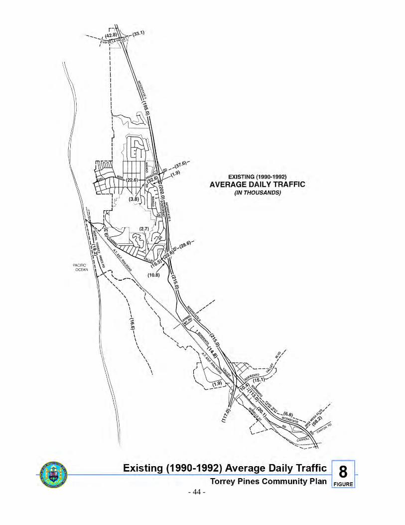
Figure 8. Existing (1990-1992) Average Daily Traffic
- 45 -
POLICIES 1. The construction of new roads or improvements to existing roads adjacent to open space
areas shall mitigate impacts through the restoration and enhancement of that open space system to the maximum extent feasible.
2. When road improvements are proposed, those portions that traverse sensitive areas
(water courses, wildlife corridors, sensitive biological areas, etc.) shall be designed to reduce or eliminate impacts to those areas.
3. Improved public transit service should be provided to the Torrey Pines community,
especially to the employment area of Sorrento Valley and the North Torrey Pines mesa area. Regular bus service, light rail transit and commuter rail should link the Torrey Pines community with the regional transportation network.
4. Provide bikeway and pedestrian paths that link all areas within the community, as well
as linking Torrey Pines with surrounding communities and jurisdictions. 5. Provide improvements to the road network that will facilitate traffic circulation without
negatively impacting adjacent open space areas and residential neighborhoods. 6. Require that Transportation Demand Management strategies are implemented within the
Sorrento Valley industrial area. Provide bicycle racks/lockers, showers, and locker room facilities for employees who bike or walk to work.
7. All available traffic measures that improve pedestrian safety on Del Mar Heights Road
should be investigated, and where feasible, implemented.
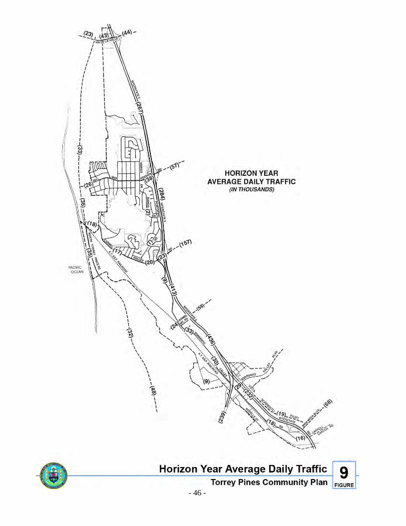
SPECIFIC PROPOSALS Traffic Volume Trends Torrey Pines existing traffic counts for 1990 are shown in Figure 8, and projected (Horizon Year) traffic volumes are shown in Figure 9. It should be noted that the projected traffic volumes were generated using an adjusted version of SANDAG's calibrated mid-county model which assumed buildout of the Torrey Pines Community Plan, buildout of surrounding communities and jurisdictions, buildout of all surrounding planned circulation improvements, and a 40 percent drive alone rate (a regional goal).
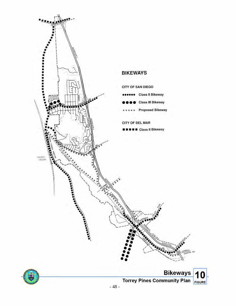
Bikeways The City of San Diego has actively pursued the establishment of a commuter-oriented bikeway system in the City. The purpose of the bikeway system is to encourage the use of bicycles as a transportation mode especially in place of single occupant motor vehicles. It is expected that the increased use of bicycles as a transportation mode will help reduce air pollution and traffic congestion. There are three classifications of bikeway facilities. Class I (bike paths), Class II (bike lanes) and Class III (bike routes). See Figures 10 and 12 for details.
- 46 -
Figure 9. Horizon Year Average Daily Traffic
- 47 -
The majority of the existing bikeways in the Torrey Pines community are Class II bike lanes. Bicyclists are allowed to use I-5 shoulders between the Genesee Avenue and the Sorrento Valley Road interchanges. The following Class I bicycle path projects have been proposed within the Torrey Pines community. The Carmel Valley Road bicycle path is proposed to be constructed along the south side of Carmel Valley Road between McGonigle Road and Sorrento Valley Road. The San Dieguito River Valley bicycle path, a planned 55-mile regional bicycle path, will parallel the San Dieguito River. The Coastal bicycle path is proposed to be built within the A.T.&S.F. Railroad right-of-way between downtown San Diego and Oceanside. Class II bicycle lanes are planned along the northern portion of Sorrento Valley Road between Carmel Valley Road and the Sorrento Valley Industrial Park.
Pedestrian Paths Primary pedestrian routes should be well lit and located along or visible from the street. Wherever possible, trees planted in parkways or tree wells should line the street to create shade and a buffer between pedestrians and the street.
Mass Transit Currently, only one bus line provides service between downtown and the Torrey Pines community planning area. The San Diego County Transit System provides express service (Route 800) between Oceanside and downtown with one stop at the park-and-ride facility located on the southwest corner of I-5 and Carmel Valley Road. The North County Transit District, Route 301, operates along North Torrey Pines Road and provides shuttle service to the annual Fair and thoroughbred racing during the summer months. In addition, future mass transit plans by the Metropolitan Transit Development Board (MTDB) include a variety of mass transit service improvements.
- 48 -
Figure 10. Bikeway
- 49 -
Light Rail Transit (LRT) MTDB’s long-range plans include extending the LRT line north along I-5 to Oceanside. The LRT alignment would extend north along the I-5 corridor with future potential LRT stations within Sorrento Valley near the I-5/I-805 intersection, and on the east side of I-5 both at Carmel Mountain Road and Carmel Valley Road (see Figure 11). Commuter Rail The North County transit district is in the process of implementing a plan for a commuter rail line that would provide mass transit service to those communities along I-5 between Oceanside and San Diego. The commuter rail line would use the existing Santa Fe Railroad right-of-way through Sorrento Valley (see Figure 11) with a station within Sorrento Valley near the I-5/I-805 interchange. Bus Service MTDB's short-range transit plan identifies a need for one new bus service line to serve the Torrey Pines area. Route 961, while currently unfunded, would operate from Carmel Valley to University Towne Centre, with service to Sorrento Valley and Sorrento Mesa (Figure 11). Transit Stations Transit stations should provide shelter for pedestrians, convenient passenger loading zones, telephones, adequate lighting and secure bike storage. Retail shops and services should also be integrated with transit stations. Pedestrians and feeder/shuttle bus users should not have to walk across parking lots in order to board the rail lines. The intent is to provide comfortable, safe, convenient stations. The commercial uses can help alleviate the need for before or after work auto trips to do errands.
Scenic Routes Since 1964, the City has maintained a 52-mile scenic route extending from Mount Soledad on the north to Cabrillo National Monument on the south and traversing such in-between areas of attraction as Balboa Park and Mission Bay Park. This route was designed to provide scenic views of the San Diego community as well as to link points of visitor interest.
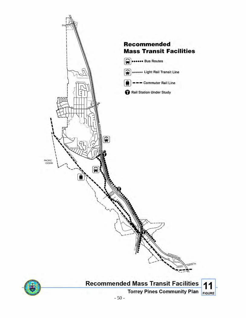
- 50 -
Figure 11. Recommended Mass Transit Facilities
- 51 -
In addition to the 52-mile scenic route, the Torrey Pines community has a number of road segments that have scenic qualities worthy of formal recognition and protection. Three road segments within the community are currently recommended for a scenic route designation including North Torrey Pines Road, Carmel Valley Road and Sorrento Valley Road.
Specific Road Improvements The following specific road improvements are recommended primarily to: 1) protect the health and safety of pedestrians, bicyclists and motorists; 2) accommodate existing and future traffic with minimum disruption to residents and businesses; and 3) protect the sensitive environmental resources contained within the community planning area. North Torrey Pines Road North Torrey Pines Road is a five-lane primary arterial which narrows to two lanes as it passes about half-way through the Torrey Pines community planning area. In order to improve the level of service at the intersection of North Torrey Pines Road and Carmel Valley Road, an additional northbound lane will be provided from Torrey Pines Park Road to the boundary of the City's jurisdiction. Improvements north of the City of San Diego's boundary can only occur subsequent to approval by the city of Del Mar. In addition, the bridge over the railroad tracks just south of this intersection should be improved to allow a second northbound lane as well as bike lanes and a sidewalk on the west side to the City's jurisdiction. Bridge improvements north of the City's boundary can only occur subsequent to approval by the city of Del Mar. An alternative to extending the additional lane through the intersection includes extending the lane as a right turn only lane onto Carmel Valley Road. North Torrey Pines Road Bridge over Peñasquitos Creek The North Torrey Pines Road Bridge over Peñasquitos Creek will need to be reconstructed due to seismic and structural deficiencies. The reconstruction of this bridge includes the addition of a northbound lane, bike lanes on both sides, a sidewalk on the west side, and transition widening on both road approaches. Although the bridge should be widened in order to provide ultimately for three lanes, it should be striped for two lanes until the recommended northern road improvements are constructed. This project includes a special bridge design that will contribute to the restoration and enhancement of Los Peñasquitos Lagoon. The ultimate design of this bridge creates a wider lagoon mouth by approximately 40 feet, in order to increase the tidal prism, restore tidal action and improve circulation of lagoon waters. Design consideration should include completely spanning the lagoon mouth by cutting back the road embankment and lengthening the bridge span, etc. The design of this bridge shall include input from a qualified biologist or other lagoon expert familiar with the complex ecosystem found within Los Peñasquitos Lagoon. No impacts to salt marsh habitat shall occur.
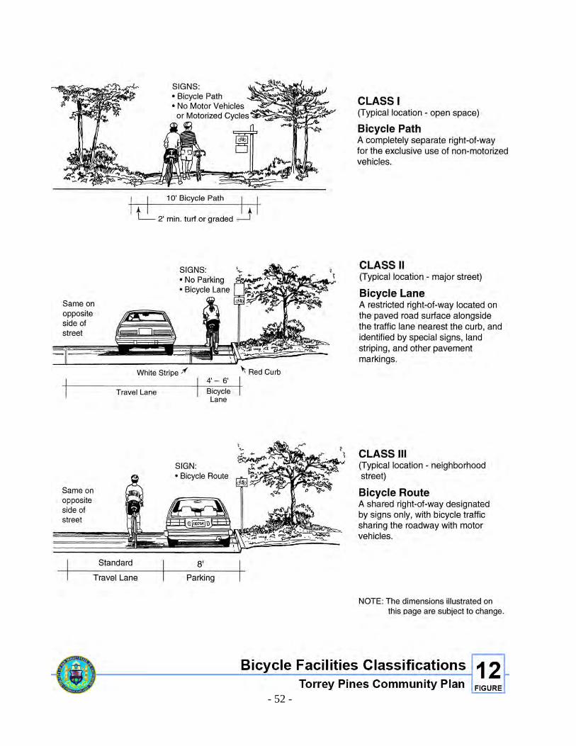
- 52 -
Figure 12. Bicycle facilities Classifications
- 53 -
One of the most scenic visual resources of the community includes those views of North Torrey Pines Road as it passes between the Pacific Ocean and Los Peñasquitos Lagoon. In order to protect the scenic and visual qualities of this coastal area, the reconstruction and/or replacement of the North Torrey Pines Road bridges should include a design that is visually and aesthetically compatible with the character of the area. The design of both bridges should restore and enhance the visual quality and public views of this area. It is suggested that a variety of aesthetic designs and architectural alternatives be explored. The Torrey Pines Community Planning Group and the community shall review and provide input during the design of the bridges. Carmel Valley Road A variety of improvements to Carmel Valley Road are anticipated in the future, and may include widening, intersection improvements, a parking lane, and a bicycle/pedestrian pathway. At the time specific design proposals are determined and environmental impacts assessed, coastal development permits will be required to implement the project. A preliminary plan for the improvements is described below; however, in no case shall any improvement result in wetland fill. Improvements to Carmel Valley Road include retaining this road as a modified two-lane collector street with a center turn lane. Carmel Valley Road should remain a modified four-lane major between I-5 and just west of Sorrento Valley Road. A traffic signal will be provided at Portofino Drive and Carmel Valley Road, with intersection improvements as needed there and at Sorrento Valley Road. Bicycle and pedestrian circulation should be provided along the south side of Carmel Valley Road within the Bicycle/Pedestrian Pathway (see Bicycle/Pedestrian Pathway discussion below). Parking for residents and businesses should be provided along the north side of Carmel Valley Road, and a sidewalk should also be provided along the north side with appropriate street lighting. The ultimate design of Carmel Valley Road should also include the following improvements provided that adequate right-of-way exists: 1. A parking lane should be provided along the south side of Carmel Valley Road between
Via Donada and Via Aprilia. 2. The existing curb line, sidewalk, landscaping and patios along the north side of Carmel
Valley Road between Via Donada and Del Mar Scenic Parkway should be preserved. Future improvements to Carmel Valley Road should include all measures necessary to eliminate silt and/or pollutants from entering/draining into Los Peñasquitos Lagoon. The speed limit on Carmel Valley Road should be aggressively enforced. Various types and levels of traffic control methods and devices (i.e., traffic signals, stop signs, etc.) shall be utilized in order to provide the greatest degree of safety and efficiency for pedestrians, bicyclists and motorists on Carmel Valley Road.
- 54 -
Bicycle/Pedestrian Pathway A bicycle/pedestrian pathway should be provided in the existing disturbed, upland area along the south side of Carmel Valley Road. A variety of design options should be considered, however, in no case shall the bicycle/pedestrian pathway involve wetland fill. An appropriate buffer between the bicycle/pedestrian pathway and the lagoon shall be established after full consultation with the U.S. Fish and Wildlife Service, the State Department of Fish and Game and the State Department of Parks and Recreation. The pathway should be wide enough to be shared by bicyclists and pedestrians, and should be physically separated from Carmel Valley Road (see Bicycle/Pedestrian Path Concept Sketch). The pathway should be constructed with a combination of concrete and wood. The concrete portion would be used for those previously disturbed areas where the path is located immediately adjacent to the road; the wooden or boardwalk portions would be constructed where the path meandered closer to sensitive resource areas. The path should meander along the lagoon, and in several places provide sitting areas and viewpoints into the lagoon. Interpretive displays describing the marsh and lagoon ecosystem should be included at these viewpoint areas. Safe access to the pathway from the north should be provided at regular intervals. Del Mar Heights Road Del Mar Heights Road shall remain a four-lane major street but shall include improvements to facilitate pedestrian safety and traffic flow. Improvements should include a raised center median, a traffic signal with pedestrian crossing indications at Crest Way, a protected left turn signal for north-southbound traffic on Mango, adequate storage for left turns at Mango Drive and sidewalks along the entire length of Del Mar Heights Road. The raised center median should be landscaped when funding becomes available. Funding sources include, but are not limited to, a landscape maintenance district. Sorrento Valley Road Sorrento Valley Road, from Industrial Court to Carmel Valley Road, is a two-lane major road that is scheduled for realignment improvements. The existing road lies immediately adjacent to wetlands and other sensitive habitat areas at several points. Any improvements to Sorrento Valley Road shall require the issuance of coastal development permits, and shall be permitted only if consistent with the specific development standards in the Wetlands/Environmentally Sensitive Resources policies contained in Appendix E. Riparian impacts shall be mitigated at a ratio of 3:1 and salt marsh impacts shall be mitigated at a ratio of 4:1. Mitigation for impacts to the lagoon must include restoration and enhancement of all areas previously disturbed by activities associated with the construction and operation of Sorrento Valley Road. The Torrey Pines Community Planning Group shall be provided the opportunity to review and provide input regarding the mitigation, restoration and enhancement efforts associated with this road improvement.
- 55 -
Carmel Mountain Road/I-5 Interchange This project will construct a diamond interchange at I-5 and Carmel Mountain Road. Design and construction is to be completed by Caltrans. Although the cost of this improvement is being paid by the Carmel Valley Facilities Benefit Assessment District and Sorrento Hills Development Agreement, it is immediately adjacent to the Torrey Pines Community. A strong benefit of this improvement is the reduction of traffic using Sorrento Valley Road between Carmel Mountain and Carmel Valley Roads. Vista Sorrento Parkway The restriping of the northbound lanes of Vista Sorrento Parkway at Sorrento Valley Road is proposed to improve the poor Level of Service (LOS) projected at buildout. The restriping of the three northbound lanes from the existing left, through and right to two lefts and a through/right will improve the projected LOS from E to C. This minor modification should only be implemented when actual future traffic volumes warrant it. In conjunction with buildout of the Sorrento Hills community planning area, Vista Sorrento Parkway shall be extended from its existing terminus (Sorrento Valley Court) northerly through Sorrento Hills until it intersects with Carmel Mountain Road. Construction of this extension, known as Street “A”, will require some fill in existing wetlands at the western end of Los Peñasquitos Canyon Preserve. Various project alternatives have been examined to determine that the proposed project is the least environmentally damaging one. There are currently two options that may be implemented to mitigate the environmental impact of the proposed project.
OPTION A
Any unavoidable permanent wetland fill associated with Street “A” shall be mitigated at a ratio of 4:1 for alkali marsh/meadow impacts and 1:1 for freshwater marsh (i.e., cattails) impacts. Shading impacts to cattails shall be mitigated at a ratio of 1:1. Mitigation for freshwater marsh impacts shall be in kind and shall occur within the Los Peñasquitos Lagoon watershed. Mitigation for alkali marsh/meadow impacts shall be in kind and in the immediate area of the alkali marsh/meadow or, if no appropriate site can be found for creation of alkali marsh/meadow, mitigation shall consist of newly created willow scrub habitat within the Los Peñasquitos Lagoon watershed.
or OPTION B
Any unavoidable permanent wetland fill associated with Street “A” shall be mitigated at a ratio of 1:1. Mitigation for direct and shading impacts to freshwater marsh (i.e., cattails) shall be in kind and shall occur within the Los Peñasquitos Lagoon watershed. Mitigation for alkali marsh/meadow impacts shall be in kind and in the immediate area of the alkali marsh/meadow or, if no appropriate site can be found, mitigation shall consist of newly created willow scrub habitat within the Los Peñasquitos Lagoon watershed.
and
The balance of the alkali marsh/meadow shall be designated open space and permanently protected from development through dedication of an open space easement, recordation of a deed restriction, or some other appropriate mechanism.
- 56 -
Carroll Canyon Road This project, financed through the Mira Mesa Public Facilities Financing Plan, will construct Carroll Canyon Road as a four-lane collector street from its westerly terminus at Scranton Road, beneath I-805, to Sorrento Valley Road. Design of this roadway extension should minimize impacts to the adjacent Carroll Canyon Creek Corridor. Mitigation for construction of this roadway should include implementation of the Guidelines for the preservation and enhancement of the Carroll Canyon Creek Corridor, which are located in the Industrial Element of this Plan. Mitigation for impacts to the wetland area must include restoration and enhancement of all areas previously disturbed by activities associated with the construction and operation of Carroll Canyon Road. The Torrey Pines Community Planning Group shall be provided the opportunity to review and provide input regarding the mitigation, restoration and enhancement efforts associated with this road improvement. Del Mar Terrace Neighborhood Streets The streets of the Del Mar Terrace neighborhood, located immediately north of Carmel Valley Road, have never been improved and accepted for maintenance by the City of San Diego. As a consequence these streets are in a state of disrepair. Property owners in the Del Mar Terrace neighborhood have petitioned the City Council to form an assessment district to improve the streets. The City Council directed City staff to take the necessary steps to form a maintenance district and directed that the street design maintain the rural nature of the area. State Route 56/I-5/I-805 Widening Projects These CALTRANS projects are located immediately east of the Torrey Pines planning area, and will be constructed in order to alleviate the extremely congested regional traffic conditions projected to occur on I-5, I-805 and I-15. Environmental reports have been completed for each of these projects. Potential exists for significant environmental impacts to the Torrey Pines area, including, but not limited to, air quality impacts, visual impacts, impacts to wetlands, noise impacts and erosion impacts. Visual impacts include permanent landform change as a result of new cut slopes, fill slopes, bridge structures, traffic movement and retaining walls. Visual grading impacts will be reduced to levels below significance by erosion control measures including immediate plant cover on cut/fill slopes. Newly planted slopes will be compatible with surrounding landforms. Interchanges will be given a full planting scheme with Torrey Pines. The visual impact from retaining walls will be mitigated by incorporating crib walls where feasible, special wall treatment utilizing texture, color and design elements, and, new bridges with slender, aesthetically pleasing design. Impacts to wetlands are attributable to bridge piers, temporary work areas and shading from bridge structures. It is considered biologically important to treat the creeks and lagoon as an ecosystem therefore, mitigation for impacts to wetlands are included in the Carmel Valley Restoration and Enhancement Project (CVREP).
- 57 -
Existing noise levels at some points within the Torrey Pines area along I-5 exceed federal guidelines. The proposed projects will increase noise from one to four additional decibels over today’s level. It should be noted that a three-decibel change is hardly discernible to the human ear. Sound walls at several locations are proposed as mitigation measures. There will be increased erosion caused by grading. A detailed erosion control plan has been prepared. This plan includes immediately seeding new slopes and other abatement measures. Due to the sensitivity of Los Peñasquitos Lagoon, every reasonable precaution will be taken to protect watershed flow into the lagoon to avoid or minimize muddying and silting, before, during, and after construction.
ACTION PLAN
Implementation Measures Timing Responsibility for Implementation
Source of Funding
Restore and enhance those biologically sensitive areas impacted by circulation improvements.
Add as condition at time of project approval. Include in preliminary design.
Planning Department, Engineering & Development Department
City of San Diego,
Provide mass transit service, especially in the Sorrento Valley area.
Immediately MTDB MTDB through various funding sources including private sector
Provide bikeways and pedestrian paths that link all areas within the community.
Include in design of private development and transportation projects.
Planning Department, Engineering & Development Department
City of San Diego and Private
Adopt the Facilities Financing Plan to identify costs and potential funding sources.
Adopt with this Community Plan.
City Council, Planning Department
City of San Diego
Require projects to design for transit, bicycle and pedestrian use (i.e., submit TDM Programs, provide bike lockers, showers, etc.)
Add as condition at time of project approval.
Planning Department
Private
Reconstruction of North Torrey Pines Road bridge shall contribute to restoration and enhancement of Los Peñasquitos Lagoon.
At preliminary design stage
Engineering & Development Department
City of San Diego, and state bridge grant
Provide street improvements for the Del Mar Terrace neighborhood.
Immediately Engineering & Development Department
Assessment District

THIS PAGE INTENTIONALLY LEFT BLANK.

RESIDENTIAL ELEMENT

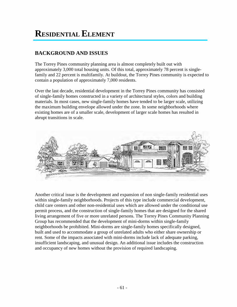
- 61 -
RESIDENTIAL ELEMENT
BACKGROUND AND ISSUES The Torrey Pines community planning area is almost completely built out with approximately 3,000 total housing units. Of this total, approximately 78 percent is single-family and 22 percent is multifamily. At buildout, the Torrey Pines community is expected to contain a population of approximately 7,000 residents. Over the last decade, residential development in the Torrey Pines community has consisted of single-family homes constructed in a variety of architectural styles, colors and building materials. In most cases, new single-family homes have tended to be larger scale, utilizing the maximum building envelope allowed under the zone. In some neighborhoods where existing homes are of a smaller scale, development of larger scale homes has resulted in abrupt transitions in scale.
Another critical issue is the development and expansion of non single-family residential uses within single-family neighborhoods. Projects of this type include commercial development, child care centers and other non-residential uses which are allowed under the conditional use permit process, and the construction of single-family homes that are designed for the shared living arrangement of five or more unrelated persons. The Torrey Pines Community Planning Group has recommended that the development of mini-dorms within single-family neighborhoods be prohibited. Mini-dorms are single-family homes specifically designed, built and used to accommodate a group of unrelated adults who either share ownership or rent. Some of the impacts associated with mini-dorms include lack of adequate parking, insufficient landscaping, and unusual design. An additional issue includes the construction and occupancy of new homes without the provision of required landscaping.
- 62 -
GOALS 1. Single-family development incorporating a variety of architectural styles, colors and
building materials. 2. Residential development designed to preserve the integrity of the community's unique
system of canyons, parks, sandstone bluffs and lagoons. 3. New single-family homes that are similar in bulk and scale to existing homes within the
immediate neighborhood. 4. Residential neighborhoods that are designed to protect the safety and security of its
residents.
POLICIES 1. New residential development shall be consistent with the design guidelines of this
element. 2. The construction of shared housing (also known as mini-dorms) within the Torrey Pines
community planning area shall be discouraged. 3. Commercial development shall not be permitted within areas designated for residential
development. 4. Residential neighborhoods should be preserved and protected from encroachment by
adjacent uses including commercial development and the construction of public roads and utilities.
SPECIFIC PROPOSALS Although the Torrey Pines community planning area maintains a predominantly low-density residential character, a wide range of residential densities and product types are recommended by this Plan. Descriptions, locations and recommendations regarding these density categories are as follows. Density Categories Very Low-Density (0-4 DUs/acre) In the Torrey Pines area this density is characterized by both single-family detached and attached development with large portions of land area devoted to open space areas. This density is implemented in Torrey Pines by the existing R1-10000, R1-15000, R1-20000 and R1-40000 Zones.
- 63 -
Very low-density developments in Torrey Pines are located on the edges of environmentally sensitive areas. This provides for minimal disturbance by buffering these areas from higher density land uses. Very low-density areas in the Torrey Pines area include: • The 27-lot residential subdivision of Del Mar Estates is located in the northern portion of
the community along Racetrack View Drive. This development includes large single-family detached homes of 25 feet in height on large (average one acre) lots, and over 17 acres set aside in an open space easement. This development is located in an environmentally sensitive location, within the Focused Planning Area of the San Dieguito Regional Open Space Park Plan, situated south of the San Dieguito River and Lagoon and north of Crest Canyon. Because of the area's sensitivity, additional development (tennis courts, pools, decks, gardens, walls, lighting, etc.) shall minimize or eliminate impacts to these resource areas.
• Two low-density residential subdivisions exist near the northern portion of Torrey Pines
Reserve Extension. One is located adjacent to the northwest comer of the reserve extension at the terminus of Mar Scenic Drive and Nogales Drive, and the other is located adjacent to the northeast comer of the reserve extension on Mira Montana. The Mira Montana project (approximately 19 residential lots and five acres of open space easements) is built out. All open space easement areas that are part of this project shall be preserved.
• Another very low-density project is located adjacent to the western boundary of the
reserve extension, along Caminito Mar Villa and Via Mar Valle. This project is completely built out and consists of approximately 50 units, both attached and detached, and over six acres of open space easements. The open space easement located south of the homes along Via Mar Valle provides a crucial open space corridor linking the reserve extension to Los Peñasquitos Lagoon. This linkage shall be preserved and protected through the Open Space designation on the area.
• The Point Del Mar development is also a very low-density project, and is located on the
bluffs northwest of Carmel Valley Road and I-5. This project includes approximately 99 single-family detached homes on large (half-acre) lots, and over 26 acres of open space easements. The open space easements located along the western portion of this project provide a critical wildlife corridor linking the reserve extension to the Los Peñasquitos Lagoon. This linkage has been preserved and protected by dedication and acceptance by the State Coastal Conservancy, and is managed by the Los Peñasquitos Lagoon Foundation. This area shall be preserved and protected through the Open Space designation on the area.
Low-Density (5-9 DUs/acre) This density category is characterized by the conventional suburban subdivision, including single-family detached homes on 5,000- to 6,000-square-foot lots. Approximately 70 percent of the residential community is developed under this density category, which is implemented through the existing R1-5000 and R1-6000 Zones.
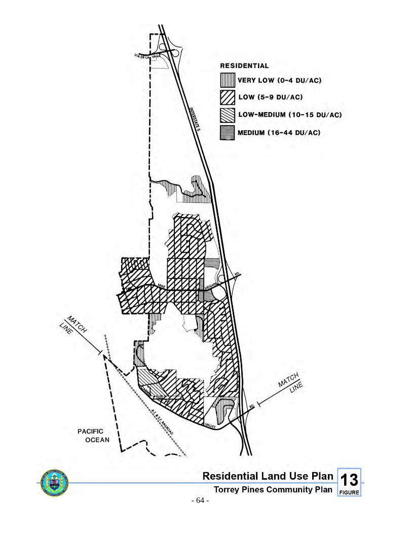
- 64 -
Figure 13. Residential Land Use Plan
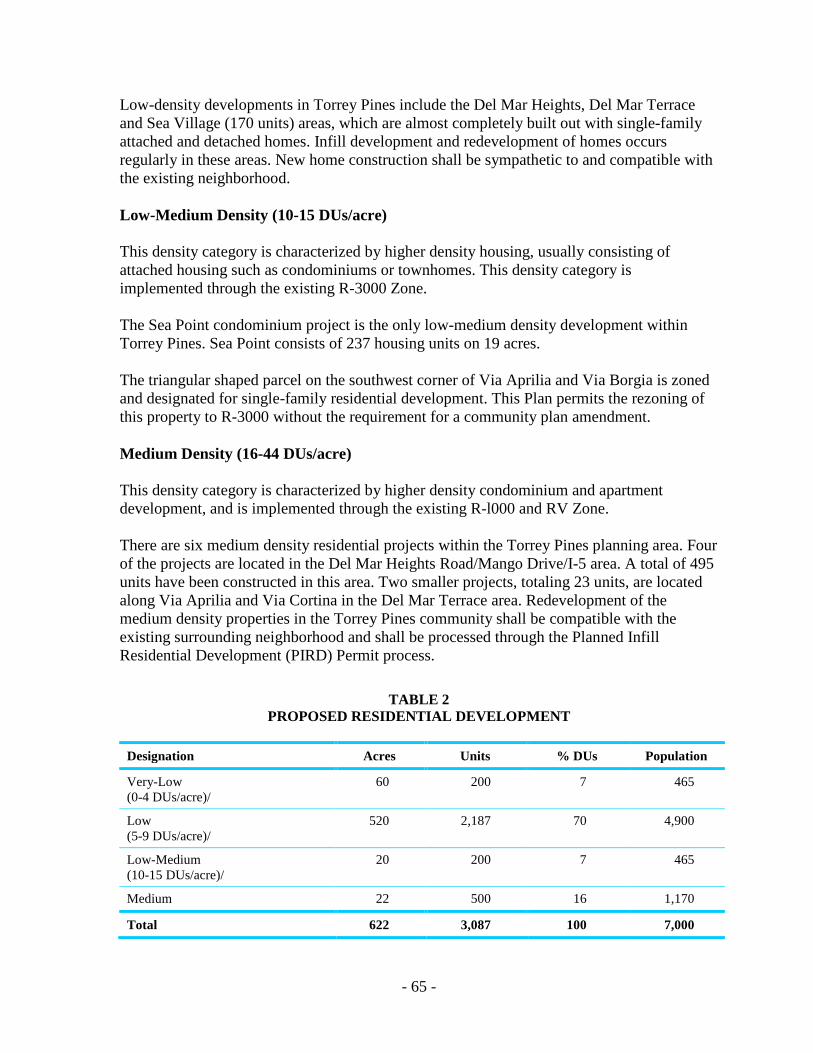
- 65 -
Low-density developments in Torrey Pines include the Del Mar Heights, Del Mar Terrace and Sea Village (170 units) areas, which are almost completely built out with single-family attached and detached homes. Infill development and redevelopment of homes occurs regularly in these areas. New home construction shall be sympathetic to and compatible with the existing neighborhood. Low-Medium Density (10-15 DUs/acre) This density category is characterized by higher density housing, usually consisting of attached housing such as condominiums or townhomes. This density category is implemented through the existing R-3000 Zone. The Sea Point condominium project is the only low-medium density development within Torrey Pines. Sea Point consists of 237 housing units on 19 acres. The triangular shaped parcel on the southwest corner of Via Aprilia and Via Borgia is zoned and designated for single-family residential development. This Plan permits the rezoning of this property to R-3000 without the requirement for a community plan amendment. Medium Density (16-44 DUs/acre) This density category is characterized by higher density condominium and apartment development, and is implemented through the existing R-l000 and RV Zone. There are six medium density residential projects within the Torrey Pines planning area. Four of the projects are located in the Del Mar Heights Road/Mango Drive/I-5 area. A total of 495 units have been constructed in this area. Two smaller projects, totaling 23 units, are located along Via Aprilia and Via Cortina in the Del Mar Terrace area. Redevelopment of the medium density properties in the Torrey Pines community shall be compatible with the existing surrounding neighborhood and shall be processed through the Planned Infill Residential Development (PIRD) Permit process.
TABLE 2 PROPOSED RESIDENTIAL DEVELOPMENT
Designation Acres Units % DUs Population
Very-Low (0-4 DUs/acre)/
60 200 7 465
Low (5-9 DUs/acre)/
520 2,187 70 4,900
Low-Medium (10-15 DUs/acre)/
20 200 7 465
Medium 22 500 16 1,170
Total 622 3,087 100 7,000
- 66 -
Residential Development Design Guidelines New residential development within the Torrey Pines community should continue to incorporate a wide variety of architectural styles, colors and building materials. New residential development should also be designed to encourage compatibility in bulk and scale between existing and new residential development. All new residential development shall conform to citywide underlying zoning and Coastal Zone requirements. The Torrey Pines Community Planning Group should review all development requiring discretionary approval by the City. The following additional guidelines should also be incorporated into single-family residential development. 1. All required landscaping shall be installed prior to the issuance of an occupancy permit. 2. Natural runoff control measures should be implemented to direct runoff toward the street
and not toward open space areas and to eliminate erosion and siltation of biologically sensitive areas (see Coastal Development Regulations in Appendix).
All new multifamily residential projects shall be developed through the Planned Infill Residential Development (PIRD) Permit Process. All new multifamily projects shall be considered compatible, and in conformance with the Plan if it meets the criteria of the PIRD, the Multifamily Design Regulations and all other citywide regulations including the underlying zone.
Balanced Community It is the policy of the City of San Diego to promote economically and racially balanced communities: The Housing Element of the General Plan identifies four components of balanced communities: economic, ethnic, housing type (concentration of detached housing) and housing tenure (concentration of owner-occupied housing). As of the 1990 Census, the Torrey Pines community was not considered a balanced community. In order to alleviate this situation and provide opportunities for affordable housing, the Housing Element of the General Plan recommends Plan revisions to higher densities and assistance programs, examples of which are provided below: Multifamily Bond Program Through the sale of bonds, this program provides low-interest loans to developers of multifamily housing. In exchange for the loans, developers must rent 20 percent of the units to low-income households for ten years. Public Housing Public housing units are managed by the San Diego Housing Commission and rented to very low-income households. Residents pay 30 percent of their gross monthly income for rent.
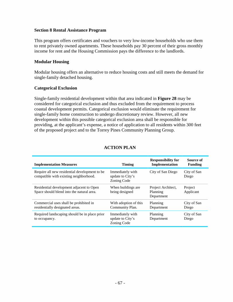
- 67 -
Section 8 Rental Assistance Program This program offers certificates and vouchers to very low-income households who use them to rent privately owned apartments. These households pay 30 percent of their gross monthly income for rent and the Housing Commission pays the difference to the landlords. Modular Housing Modular housing offers an alternative to reduce housing costs and still meets the demand for single-family detached housing. Categorical Exclusion Single-family residential development within that area indicated in Figure 28 may be considered for categorical exclusion and thus excluded from the requirement to process coastal development permits. Categorical exclusion would eliminate the requirement for single-family home construction to undergo discretionary review. However, all new development within this possible categorical exclusion area shall be responsible for providing, at the applicant’s expense, a notice of application to all residents within 300 feet of the proposed project and to the Torrey Pines Community Planning Group.
ACTION PLAN
Implementation Measures Timing Responsibility for Implementation
Source of Funding
Require all new residential development to be compatible with existing neighborhood.
Immediately with update to City’s Zoning Code
City of San Diego City of San Diego
Residential development adjacent to Open Space should blend into the natural area.
When buildings are being designed
Project Architect, Planning Department
Project Applicant
Commercial uses shall be prohibited in residentially designated areas.
With adoption of this Community Plan.
Planning Department
City of San Diego
Required landscaping should be in place prior to occupancy.
Immediately with update to City’s Zoning Code
Planning Department
City of San Diego

THIS PAGE INTENTIONALLY LEFT BLANK.

COMMERCIAL ELEMENT

- 71 -
COMMERCIAL ELEMENT
BACKGROUND AND ISSUES The Torrey Pines community planning area contains approximately 26 acres of land designated for commercial development. Although these figures appear to be very low, unmet needs within the community are provided by commercial centers in adjacent areas including Del Mar and Carmel Valley. There are four areas within Torrey Pines that are designated for commercial development (see Figure 14) including: I) a 12-acre shopping center at the north-west comer of I-5 and Del Mar Heights Road; 2) an approximately ten-acre area at the northern end of the community just south of Via De La Valle; 3) a 2.96-acre shopping center located at the northwest corner of I-5 and Carmel Valley Road, and; 4) a small commercial area located on lots fronting Carmel Valley Road, between Via Donada and just north of Via Aprilia. Some of the issues associated with commercial development within the Torrey Pines community planning area, particularly within the Del Mar Terrace Neighborhood, include traffic, noise and visual impacts to adjacent residential development, encroachment into adjacent environmentally sensitive areas, lack of parking, and ingress and egress problems.
GOALS 1. Provide conveniently located and well-designed commercial development that
adequately serves the needs of the community. Commercial development should be easily accessed by, and attractive to pedestrians.
2. Encourage commercial uses that operate without adversely impacting surrounding
residential neighborhoods. 3. Prohibit the encroachment of commercial development into areas other than those
designated commercial, especially into residential, open space and environmentally sensitive areas.
4. Mixed-use developments should be encouraged in commercial zones. Apartments over
retail or office uses could help Torrey Pines meet its fair share of affordable housing goals.
POLICIES 1. Runoff and pollution control measures required by federal, state, county or City
regulations should be installed and maintained by the property owner in all commercial developments.
- 72 -
2. Commercial development within predominantly residential neighborhoods shall be designed to minimize or eliminate traffic, noise, parking and visual impacts to residents.
3. All commercial development shall be processed through the Planned Commercial
Development (PCD) Permit procedure and shall be consistent with the design guidelines contained in this element.
4. All required parking for commercial development shall be accommodated on site, no on-
street parking shall be used to satisfy parking requirements.
SPECIFIC PROPOSALS Commercial Areas Shopping Center at I-5 and Del Mar Heights Road Infill commercial development within this center shall not result in a reduction of parking below those levels adequate to provide ample parking for tenant businesses and shall not be allowed to impact vehicle access or on-street parking. Ingress/egress to Del Mar Heights Road from this center, and from Mango Road, should be improved during improvement either to the center or Del Mar Heights Road. Current ingress/egress conditions include difficult and confusing pedestrian crossing, congestion, and elevation differences between the shopping center entrance, Mango Road and Del Mar Heights Road. These elevations differences have caused difficulties for larger delivery trucks, in some cases “bottoming out” or becoming “high centered.” Commercial Area Southwest of Del Mar Heights Road/l-5 Intersection This four-acre area should be maintained for visitor-serving commercial recreation facilities (long and short-term rental facilities, accessory uses) consistent with the site's proximity to single-family development, visibility from I-5 and location at the entrance of the community. Commercial Area South of Via De La Valle This ten-acre area, which includes a hotel, gas station and restaurant, should be maintained for commercial recreational development. Because most of this area is within the 100-year floodplain, and adjacent to the San Dieguito River Valley and Lagoon, new development in this area shall not be allowed unless it can be shown that: 1. Disturbance to environmentally sensitive areas will be minimized or eliminated. 2. Increase flood flow velocities will not occur. 3. Areas not in the floodplain to be filled will not function as significant silt deposition areas.
- 73 -
4. Any loss or degradation of existing wildlife habitat areas will be completely mitigated. 5. Increases in runoff and sediment will be mitigated. 6. There will be no adverse water quality impacts to adjacent or downstream wetland areas. 7. The development meets the specific development standards included in Appendix E. In addition, there is a 14-acre parcel abutting this developed area to the south, which includes a small visitor-serving RV park and a recreational complex including tennis courts, miniature golf, a driving range pro-shop and clubhouse facilities and parking lots. This area should be maintained for these types of less intensive commercial recreation uses and designated Commercial Recreation up to the paved sidewalk north of the driving range. Because this entire area is within the 100-year floodplain and immediately adjacent to the San Dieguito River Valley and Lagoon, new development in this area shall be allowed only if such development is consistent with uses allowed pursuant to the A-1-10 Zone and other existing zoning, is capable of withstanding periodic flooding, and does not require the construction of off-site flood protective works. Any development of this parcel shall be consistent with the requirements for the San Dieguito Lagoon and River Valley stated in the Resource Management and Open Space Element of this document. Carmel Valley Commercial Center This 2.96-acre area shall be developed with a mix of commercial uses under an existing approved Planned Commercial Development Permit. Development of this area, as required by the PCD, shall include mitigating measures including: 1. The landscaping program shall be of sufficient quality and quantity to completely screen
the large crib wall from view in all directions. 2. Erosion control measures shall be implemented in order to mitigate potential urban
runoff impacts. 3. Pollution control measures to prevent contaminated runoff from reaching the Los
Peñasquitos Lagoon wetlands and Carmel Valley Creek shall be implemented.
Design Guidelines Carmel Valley Road Neighborhood Commercial Design Guidelines The development of commercial uses within this area, because of its location within the residential neighborhood of Del Mar Terrace, shall be designed to mitigate all potential impacts including traffic, parking, noise, pollution, runoff, etc. Only those lots that front directly on Carmel Valley Road, between Via Donada and just north of Via Aprilia are designated for neighborhood commercial development. Expansion of commercial use on properties other than those designated shall be prohibited.
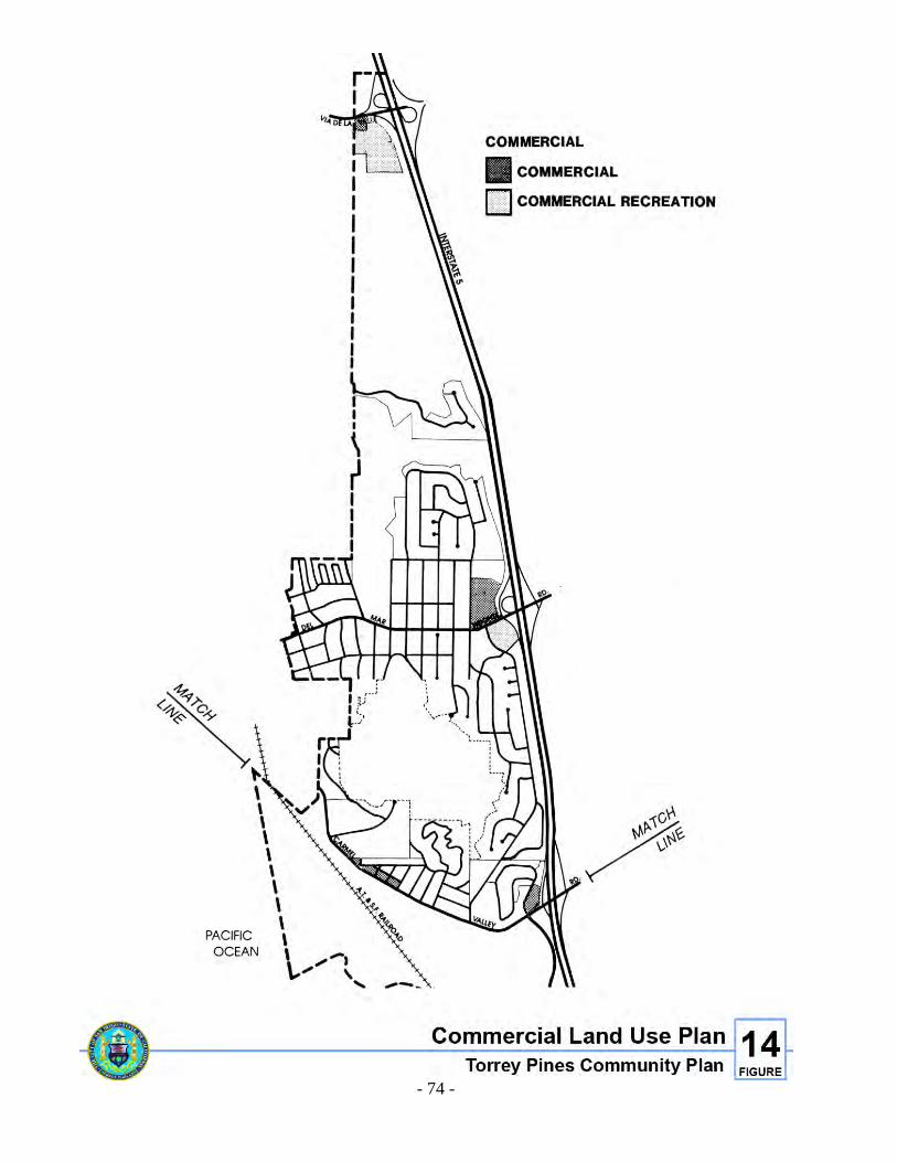
- 74 -
Figure 14. Commercial Land use Plan
- 75 -
Those areas designated commercial along Carmel Valley Road may be redeveloped to neighborhood commercial uses through the Planned Commercial Development (PCD) permit process. The PCD process should address and implement the following commercial development design guidelines. Commercial Development Design Guidelines Although the design guidelines listed below apply particularly to the neighborhood commercial area located along Carmel Valley Road, most can also be applied to the other designated commercial areas within the Torrey Pines planning area. Specific design guidelines for the other commercial areas within Torrey Pines can be found under the individual commercial policy discussions. 1. Bulk and scale of new commercial development along Carmel Valley Road shall be
low-scale and of similar height to buildings and homes in the existing area. 2. Activity areas (e.g., areas that generate noise, foot traffic, parking lots, etc.) of
commercial projects shall be oriented away from residents, towards Carmel Valley Road.
3. Noise, light, odors or any other potential effects of or emissions from commercial
development shall not emanate beyond the commercial property into residential areas. 4. New commercial development shall be designed to accommodate the worst case parking
scenario unless well served by public transit. The use of on-street parking shall not be considered to calculate parking requirements.
5. Erosion/sedimentation control measures shall be implemented to prevent runoff into the
Los Peñasquitos and San Dieguito Lagoon. 6. The rear portions of commercial development that face residential areas should be
designed (use of heavy landscaping, design elements, etc.) to mimic the continuation of a residential neighborhood.
7. A neighborhood association composed of residents and business owners should be
formed to resolve existing problems in the neighborhood including: a. Coordination, timing, access and location of delivery trucks. b. Provision of adequate off-street parking. c. Litter, noise and traffic control.
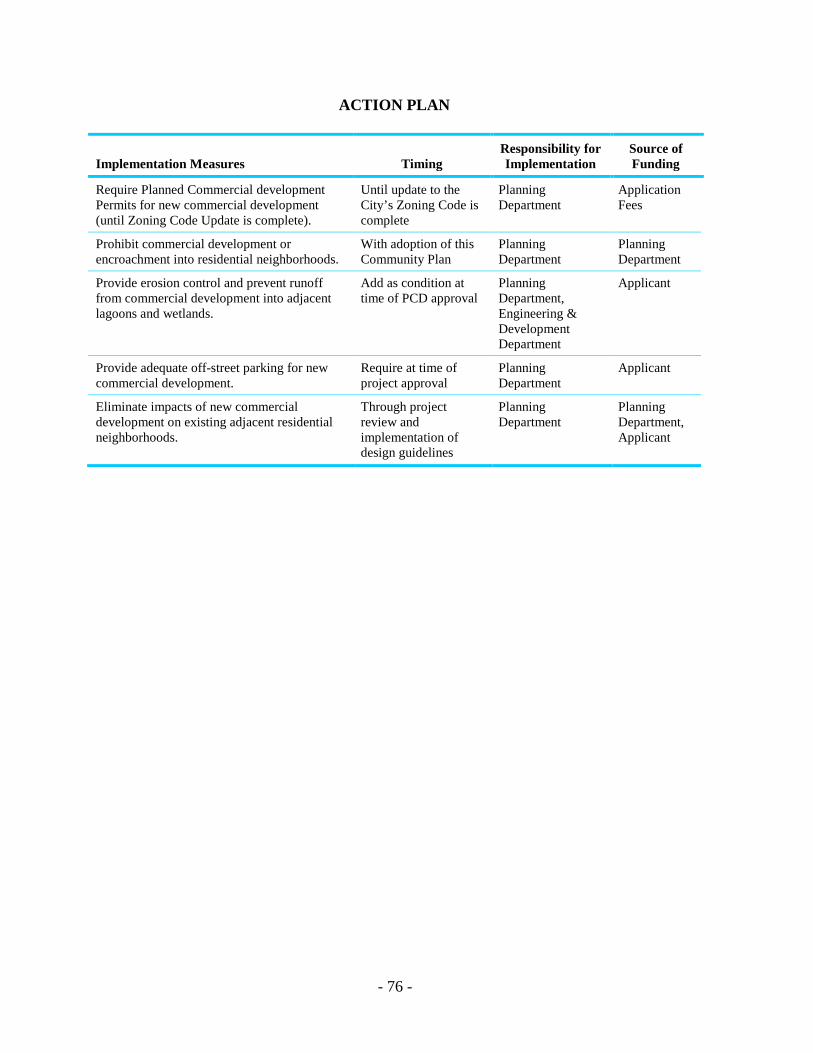
- 76 -
ACTION PLAN
Implementation Measures Timing Responsibility for Implementation
Source of Funding
Require Planned Commercial development Permits for new commercial development (until Zoning Code Update is complete).
Until update to the City’s Zoning Code is complete
Planning Department
Application Fees
Prohibit commercial development or encroachment into residential neighborhoods.
With adoption of this Community Plan
Planning Department
Planning Department
Provide erosion control and prevent runoff from commercial development into adjacent lagoons and wetlands.
Add as condition at time of PCD approval
Planning Department, Engineering & Development Department
Applicant
Provide adequate off-street parking for new commercial development.
Require at time of project approval
Planning Department
Applicant
Eliminate impacts of new commercial development on existing adjacent residential neighborhoods.
Through project review and implementation of design guidelines
Planning Department
Planning Department, Applicant

INDUSTRIAL ELEMENT

- 79 -
INDUSTRIAL ELEMENT
BACKGROUND AND ISSUES Industrial development in the Torrey Pines planning area is located in Sorrento Valley, which contains approximately 380 acres of industrially-designated property. Industrial development in Sorrento Valley includes manufacturing firms, research and development, laboratories, offices, industrial services, incubator industry and business uses, and support commercial and retail uses. Most of the industrially designated property in Sorrento Valley is zoned M-1A with the FPF (Floodplain Fringe) Overlay Zone. The primary effect of the FPF Zone in this area is to ensure that new development will not adversely impact existing riparian habitat areas. The Sorrento Valley area contains an abundance of environmentally sensitive areas, including both cultural and biological resources (see Resource Management Element). The most significant resource areas are located within the floodplain, wetland and riparian habitat areas of the Los Peñasquitos Lagoon and Carroll Canyon Creek, which bisect the entire Sorrento Valley area. Issues associated with industrial development in Sorrento Valley include the impacts from industrial development on adjacent environmentally sensitive resources, lack of mass transit service, and lack of a usable, continuous open space system.
GOALS 1. Emphasize the citywide importance of and encourage the location of scientific research,
biotechnology, and light manufacturing uses in Sorrento Valley because of its proximity to UCSD and the University and Mira Mesa communities’ industrial areas. Ensure adequate transit/transportation facilities are provided.
2. Ensure that industrial land needs as required for a balanced economy and balanced land
use are met consistent with environmental considerations. 3. Contain industrial development within areas specifically designated for industrial usage. 4. Restore and enhance the Carroll Canyon Creek Wildlife Corridor and the Los
Peñasquitos Lagoon. 5. Encourage new industrial development to be well designed and aesthetically pleasing. 6. Provide easy access to the Sorrento Valley employment area through bicycling, mass
transit, and transit-oriented development such as providing safe and direct pedestrian connections and a convenient mix of uses.
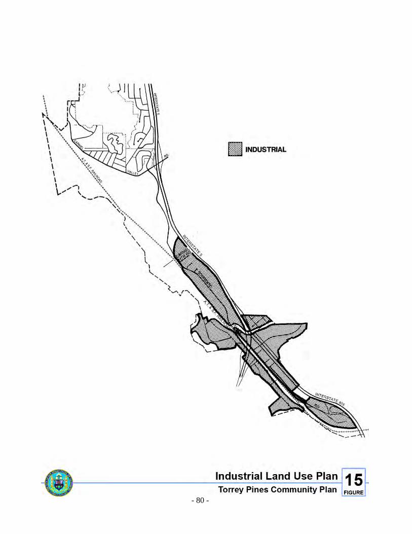
- 80 -
Figure 15. Industrial Land Use Plan
- 81 -
7. Minimize traffic impacts from new industrial development through the implementation of Transportation Demand Management Programs. New industrial development should provide opportunities for staggered shifts, four-day work weeks, and other similar alternatives, and should incorporate services such as locker rooms, child care centers, restaurants, post offices, dry cleaners and gift shops to minimize the need for auto trips and to make car pooling a more attractive option.
8. Restrict industrial development on steep slopes, wetlands, riparian habitats, and on
archaeological sites, and further encroachment into Los Peñasquitos Lagoon and the Carroll Canyon Creek Corridor, and design industrial projects to blend into adjacent open space areas.
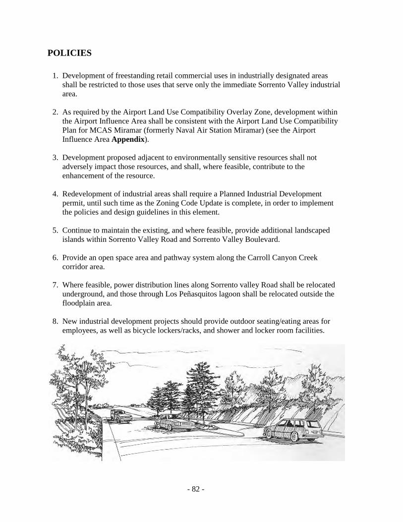
- 82 -
POLICIES 1. Development of freestanding retail commercial uses in industrially designated areas
shall be restricted to those uses that serve only the immediate Sorrento Valley industrial area.
2. As required by the Airport Land Use Compatibility Overlay Zone, development within
the Airport Influence Area shall be consistent with the Airport Land Use Compatibility Plan for MCAS Miramar (formerly Naval Air Station Miramar) (see the Airport Influence Area Appendix).
3. Development proposed adjacent to environmentally sensitive resources shall not
adversely impact those resources, and shall, where feasible, contribute to the enhancement of the resource.
4. Redevelopment of industrial areas shall require a Planned Industrial Development
permit, until such time as the Zoning Code Update is complete, in order to implement the policies and design guidelines in this element.
5. Continue to maintain the existing, and where feasible, provide additional landscaped
islands within Sorrento Valley Road and Sorrento Valley Boulevard. 6. Provide an open space area and pathway system along the Carroll Canyon Creek
corridor area. 7. Where feasible, power distribution lines along Sorrento valley Road shall be relocated
underground, and those through Los Peñasquitos lagoon shall be relocated outside the floodplain area.
8. New industrial development projects should provide outdoor seating/eating areas for
employees, as well as bicycle lockers/racks, and shower and locker room facilities.
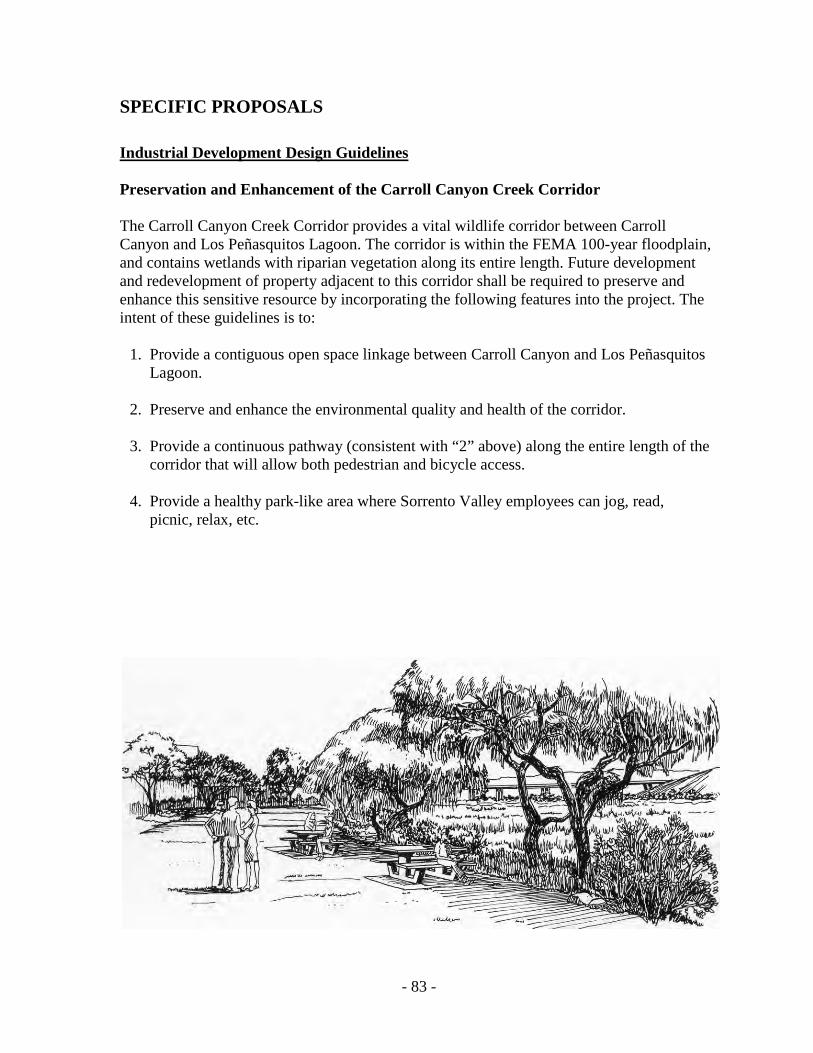
- 83 -
SPECIFIC PROPOSALS Industrial Development Design Guidelines Preservation and Enhancement of the Carroll Canyon Creek Corridor The Carroll Canyon Creek Corridor provides a vital wildlife corridor between Carroll Canyon and Los Peñasquitos Lagoon. The corridor is within the FEMA 100-year floodplain, and contains wetlands with riparian vegetation along its entire length. Future development and redevelopment of property adjacent to this corridor shall be required to preserve and enhance this sensitive resource by incorporating the following features into the project. The intent of these guidelines is to: 1. Provide a contiguous open space linkage between Carroll Canyon and Los Peñasquitos
Lagoon. 2. Preserve and enhance the environmental quality and health of the corridor. 3. Provide a continuous pathway (consistent with “2” above) along the entire length of the
corridor that will allow both pedestrian and bicycle access. 4. Provide a healthy park-like area where Sorrento Valley employees can jog, read, picnic, relax, etc.
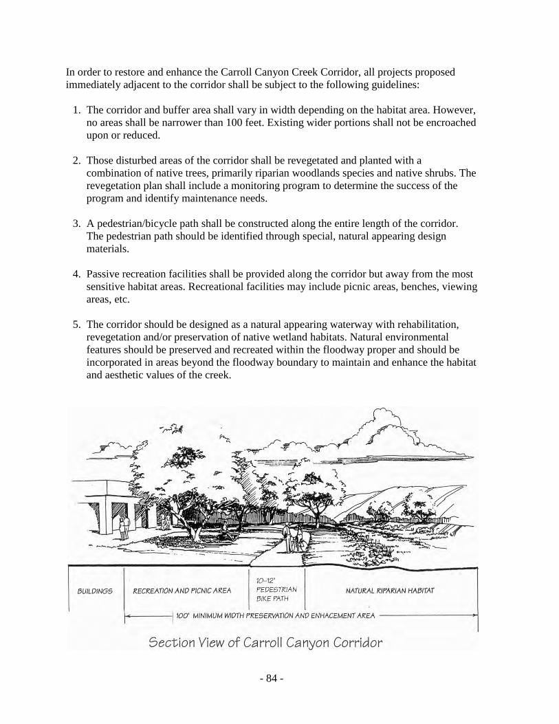
- 84 -
In order to restore and enhance the Carroll Canyon Creek Corridor, all projects proposed immediately adjacent to the corridor shall be subject to the following guidelines: 1. The corridor and buffer area shall vary in width depending on the habitat area. However,
no areas shall be narrower than 100 feet. Existing wider portions shall not be encroached upon or reduced.
2. Those disturbed areas of the corridor shall be revegetated and planted with a
combination of native trees, primarily riparian woodlands species and native shrubs. The revegetation plan shall include a monitoring program to determine the success of the program and identify maintenance needs.
3. A pedestrian/bicycle path shall be constructed along the entire length of the corridor.
The pedestrian path should be identified through special, natural appearing design materials.
4. Passive recreation facilities shall be provided along the corridor but away from the most
sensitive habitat areas. Recreational facilities may include picnic areas, benches, viewing areas, etc.
5. The corridor should be designed as a natural appearing waterway with rehabilitation,
revegetation and/or preservation of native wetland habitats. Natural environmental features should be preserved and recreated within the floodway proper and should be incorporated in areas beyond the floodway boundary to maintain and enhance the habitat and aesthetic values of the creek.
- 85 -
ACTION PLAN
Implementation Measures Timing Responsibility for Implementation
Source of Funding
Establish a restoration and enhancement plan for the Carroll Canyon Creek Corridor.
Immediately City of San Diego, Coastal Commission, State Coastal Conservancy
City of San Diego, State of California, Private
Provide a continuous usable open space linkage between Carroll Canyon and Los Peñasquitos lagoon, including a pedestrian/bicycle pathway.
Require as mitigation at time of project review and approval
Planning Department, Engineering & Development Department
City of San Diego, Applicant
Allow a mixed-use and intensification of industrial land uses adjacent to LRT stations.
Subsequent to determination of station sites
City Council, Planning Department, MTDB
City of San Diego, MTDB
Where feasible, underground power distribution lines along Sorrento valley Road, and remove or relocate those lines within Los Peñasquitos lagoon.
As soon as possible SDG&E SDG&E
Provide outdoor eating/seating areas for employees, as well as bike lockers/racks, shower and locker room facilities.
Require as condition of project review approval
Planning Department
Applicant
Require Planned Industrial Development permits for all new industrial projects proposed adjacent to any designated open space areas.
Until update to Zoning Code is complete
Planning Department
Reimbursable

THIS PAGE INTENTIONALLY LEFT BLANK.
COMMUNITY FACILITIES ELEMENT

- 89 -
COMMUNITY FACILITIES ELEMENT
BACKGROUND AND ISSUES Community facilities within the Torrey Pines community planning area include park and recreation facilities, libraries, schools, water and sewer facilities, and police and fire protection. Issues associated with community facilities include lack of usable active park area, public utility and facility projects that traverse and impact Los Peñasquitos Lagoon and other sensitive environmental areas, and visual impacts associated with above ground power transmission lines.
Park and Recreation The General Plan, Recreational Element, establishes population-based park, open space, resource/regional park, and other park requirements within the City. Population-based park requirements are based on 2.40 usable acres per 1,000 population. The Torrey Pines Community Plan identifies a potential buildout population of 7,000. This buildout population will require 16.80 usable acres. The existing Crest Canyon Neighborhood Park is ten acres in size total but only 1.5 more or less is usable. The Torrey Pines community planning area is short 15.30 acres of usable park property. The possible joint use of the Del Mar Hills and Del Mar Heights Elementary Schools should be investigated. The acquisition of either school, should they be declared surplus, shall be initiated under existing state codes.
Library Residents of the Torrey Pines community planning area are currently provided with library service both through the Carmel Valley and the City of Del Mar Library. The new 13,000-square-foot library facility in Carmel Valley includes a community meeting room and a myriad of informational and multimedia resources. The Carmel Valley Branch Library is located east of I-5, southwest of the intersection of Carmel Country Road and Townsgate Drive within the Carmel Valley community planning area (see Figure 16).
Schools Elementary Schools Elementary school students attend Del Mar Heights School and Del Mar Hills School (see Figure 10), both located in the City of San Diego, west of I-5. Both schools serve K-6 grade students from throughout the Del Mar Union School District. Students are bused to these schools based on the criteria of avoiding heavily traveled streets and roads and excessive walking distance. Bus routes are designed so that students who live south of Del Mar Heights
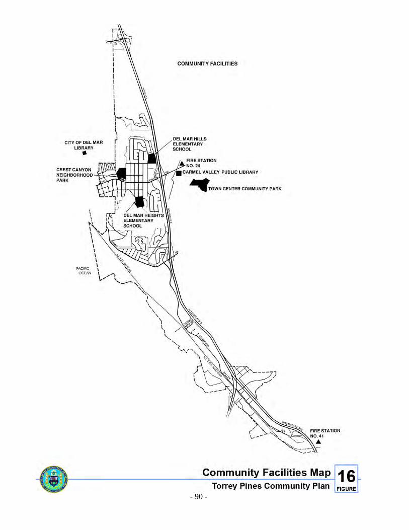
- 90 -
Figure 16. Community Facilities Map
- 91 -
Road and attend Del Mar Hills School (located north of Del Mar Heights Road) and students who live north of Del Mar Heights Road and attend Del Mar Heights School (located south of Del Mar Heights Road) are bused across this busy street. The new Carmel Del Mar School in the Carmel Valley portion of the school district opened in 1992. In May 1994, the Board of Trustees of the Del Mar Union School District established school attendance boundaries. Del Mar Heights and Del Mar Hills share a contiguous boundary and children may attend either school depending upon the class size at the time the students enroll. Carmel Del Mar School, east of the planning area, has a separate attendance boundary for its students. The Del Mar Shores School, located in the City of Del Mar, is still owned by the Del Mar Union School District, however, this facility was closed following passage of Proposition 13 and declining enrollment. The district operates a before and after school child care program on a portion of this campus, and other portions are leased to a private preschool and a school for children with special needs. In addition, the school district's administrative offices, warehousing facility, and staff infant care program are located at this campus. High Schools The community of Torrey Pines is served by the Torrey Pines High School for grades nine to 12 and Earl Warren Junior High School in Solana Beach for grades seven and eight. In addition, the San Dieguito Union High School District is currently negotiating with several owners of property in the Carmel Valley area to acquire land for purposes of constructing a junior high school. The San Dieguito Union High School District has employed a variety of funding mechanisms to finance the construction of school facilities. In the Carmel Valley area, the San Dieguito Union High School District has joined with a number of other agencies in cooperation with the City of San Diego in a North City West Joint Powers Agency (JPA) for School Facilities Financing. This JPA utilizes a fee and a Mello Roos to support the construction of school facilities. The district anticipates continued cooperation from developers and other agencies to ensure that adequate facilities are planned and constructed in anticipation of student population.
Fire Protection/Paramedic Service The Torrey Pines community planning area is served by two fire stations. Fire Station No. 41, located at Carroll Canyon and Scranton Road, has one engine and one truck company with a crew of eight personnel. Fire Station No. 24 is located at Del Mar Heights Road and Hartfield Avenue. Paramedic services are provided to the Torrey Pines community planning area through County Service Area 17. This paramedic service is funded by property taxes collected from the Torrey Pines community.
- 92 -
Police Police service is provided to the Torrey Pines community planning area by the Northern Substation located on Eastgate Mall in the University community. Police service will also be provided by the proposed Northwestern Substation to be constructed in the Carmel Valley community.
Water A majority of the Torrey Pines community is served with potable water via the 30-inch Del Mar Heights Pipeline, the 24-inch Soledad Valley Pipeline and through the 16-inch/24-inch pipelines in Carmel Valley Road which is supplied by the 54-inch Miramar Pipeline reduced 712 Pressure Zone. A small portion on the north side of the community is served by the 20-inch pipeline that runs from the east and west directions along Via de la Valle in the 284 feet Hydraulic Grade Line (HGL) Rancho Santa Fe Pressure Zone. Pressure Zones within the community north of Carmel Valley Road are the 610 feet HGL North City West, 330 feet HGL Carmel Valley, 328 feet HGL Del Mar Terrace, 378 feet HGL Mar Villa, 420 feet HGL Arroyo Sorrento, 196 feet HGL Lower Del Mar Terrace and 435 feet HGL Del Mar Hills. Pressure zones within the community south of Carmel Valley Road are also the 610 feet HGL North City West, 330 feet HGL Torrey Pines, 420 feet HGL Arroyo Sorrento and 196 feet HGL Lower Del Mar Terrace. South of Carmel Valley Road is a portion of the 30-inch Green Valley Pipeline which is in various stages of development. This pipeline is the main source of water for the 610, 470, and 330 feet HGL pressure zones serving the Sorrento Valley Road industrial area. The Green Valley Pipeline is a main hub for the water supply to this community and the adjacent communities. This pipeline runs in the north and south directions, which ties into the existing 30-inch Del Mar Heights Pipeline and the existing 54-inch Miramar Pipeline respectively.
Sewer Sewer facilities serving the Torrey Pines community are considered adequate. Improvements in the sewer transmission network are planned or under construction along Carmel Valley Road, Sorrento Valley Boulevard and Sorrento Valley Road. Existing major sewer facilities that run within the community include 12-inch/18-inch Del Mar Heights Trunk Sewer, 12-inch Del Mar force main and 33-inch Carmel Valley Trunk Sewer which all terminates at Pump Station 65 which is located in Los Peñasquitos Lagoon. From Pump Station 65, a 24-inch force main, the Sorrento Valley Trunk Sewer and the Campus Point Trunk Sewer carries the total flow of sewage from Torrey Pines and surrounding communities to Pump Station 64, which sends the effluent southward through the 42-inch force main towards the Point Loma Wastewater Treatment Plant. There is also an existing 84-inch sewer main along Sorrento Valley Boulevard and Sorrento Valley Road for the Sewer Pump Station 64 Emergency Storage.
- 93 -
Sewer improvements are planned or under construction in the portion of the Torrey Pines community south of Carmel Valley Road to accommodate growth in several adjacent communities and to solve technical problems. These improvement projects could affect road planning, environmental protection and land use. The most critical project planned is the relocation of Pump Station 65 out of Los Peñasquitos Lagoon along with associated relocation and upgrading of major trunk sewers. This series of facilities must be coordinated with the realignment of Sorrento Valley Road, upgrading of protection for Los Peñasquitos Lagoon, and land use planning for northern Sorrento Valley. Sewer projects related directly to development of Carmel Valley and Sorrento Hills are planned or under construction along Carmel Valley Road and Sorrento Valley Boulevard.
Reclaimed Water City Ordinance No. 0-17327, adopted in July 1989, mandates that no person or public agency shall use potable water for irrigation of greenbelt areas, or other uses where use of reclaimed water is suitable, when reclaimed water is available. Reclaimed water uses can include, but are not limited to, the irrigation of greenbelt and agricultural areas, filling of artificial uses, and appropriate industrial and commercial uses. The ordinance further requires that tentative maps, subdivision maps, land use permits, or other development projects, if falling within an existing or proposed reclaimed water service area based on the Water Reclamation Master Plan, be served with reclaimed water or include facilities designed to accommodate the reclaimed water in the future. The Torrey Pines community planning area is located within the service area of the proposed North City Water Reclamation Plant. Therefore, facilities to accommodate future reclaimed water use will be a condition of approval of all developments in the area. The use of reclaimed water will include irrigation of greenbelt areas in commercial and industrial areas, schools, parks, multifamily residential and street medians and slopes.
Utilities Major SDG&E land uses within the community plan area include the Del Mar substation and five overhead 69KV transmission lines. The Del Mar substation is an electric distribution substation that provides service to area customers within and outside the Torrey Pines community planning area. Future expansion of the Del Mar substation will occur as customer growth occurs. Reconductoring of a portion of TL 666 and TL 662, enlarging the existing wire size, is planned in 1994. The underground reconductor of portions of TL 662 and TL 666 has been scheduled for 1994. No improvements are presently contemplated for the other identified transmission lines. A route selection is underway for the installation of a new 69KV transmission line that will likely traverse the southern portion of Sorrento Valley. The line will originate within an existing 150-foot wide transmission line corridor in the Mira Mesa community planning area and terminate at the Genesee substation, which is located in the University community planning area.
- 94 -
GOALS 1. Provide adequate park and recreation facilities, libraries, schools, water and sewer
service, and police and fire protection to the residents of Torrey Pines. 2. Maximize accessibility to community facilities for all members of the community. 3. Ensure that students have safe, direct access to their schools. 4. Ensure that new facilities are designed to minimize or preclude adverse impacts to
environmentally sensitive resource areas. 5. Underground, where feasible, all above ground power lines, and relocate all power lines
out of Los Peñasquitos Lagoon.
POLICIES 1. Permit only those recreational activities that do not negatively impact environmentally
sensitive areas. 2. Crest Canyon Open Space Park, due to its topography and abundance of sensitive
environmental resources, shall remain in its natural state, and shall not be developed for active recreational uses.
3. Passive recreational uses within the State Park and natural open space areas should
continue to be provided to serve all age groups and interests. 4. Where feasible, remove or relocate public utility or facility projects from Los
Peñasquitos Lagoon when improvements to these utilities are proposed. 5. When feasible, underground all above ground utility lines when major street
improvements are proposed. 6. In order to provide a portion of needed active and passive recreational space, and to
contribute towards meeting General Plan standards for active park area, the following actions should be pursued.
a. The neighborhood park portion of Crest Canyon should have limited park
development on the 1.5+ acres of semi-level land adjacent to Del Mar Heights Road and Durango Drive. The development should be for passive recreational use and limited to view points, benches, trail heads, information signs and decomposed granite trails except where disabled access is viable. The open space portion of the canyon shall be preserved. Limited public access shall be provided by defined trails under standards established for the preservation of biologically sensitive plants and wildlife.
- 95 -
b. Whenever possible, small vacant properties within residential neighborhoods should be purchased (by the City or through an assessment district) and developed as pocket parks. Development of pocket parks in residential areas should not generate noise or traffic impacts to adjacent residents.
c. Large, vacant, non-sensitive state-owned lands should be purchased (by the City or
through an assessment district) and developed as neighborhood or community parks. d. Joint use agreements with the elementary schools should be secured. If these schools
should ever be declared surplus by the school district, they should be purchased by the City and developed as neighborhood or community parks.
7. Both the Del Mar Union and San Dieguito High School Districts should utilize every
mechanism available to ensure that adequate school facilities are maintained. Future residential development east of I-5 should not negatively impact schools within the Torrey Pines planning area.
8. Adequate police protection should be maintained within the Torrey Pines planning area.
All available police protection and law enforcement mechanisms should be provided to the Torrey Pines planning area.
ACTION PLAN
Implementation Measures Timing Responsibility for Implementation
Source of Funding
Where feasible, underground all power distribution lines and relocate existing utilities out of Los Peñasquitos Lagoon.
When funding becomes available, or concurrent with major street or utility improvement projects
City of San Diego, SDG&E
City of San Diego, SDG&E
Provide joint use of elementary schools’ recreational facilities.
Continuous Del Mar Union School District, City of San Diego
School District, City of San Diego
Maintain Crest Canyon open space park as an undeveloped, passive recreational park.
Continuous Park and Recreation Department
City of San Diego
Adopt the Torrey Pines Public facilities Financing Plan.
Adopt with Plan Planning Department
City of San Diego
Purchase and develop existing vacant property as pocket, neighborhood and/or community parks.
When funding becomes available
Park and Recreation Department
Assessment District, City of San Diego

THIS PAGE INTENTIONALLY LEFT BLANK.

APPENDICES

- 99 -
A. LEGISLATIVE FRAMEWORK
The Torrey Pines Community Plan was developed within the context of a legislative framework existing on federal, state, and local levels. Among the more important levels of influence are: • Section 65450 of the Government Code of the State of California (State Planning and
Zoning Act) which gives authority for the preparation of the community plan and specifies the elements which must appear in each plan. It also provides means for adopting and administering these plans.
• Government Code Chapter 4.3 requires that local governments and agencies provide
incentives to developers to include affordable units in housing projects. The City has adopted an ordinance which establishes an Affordable Housing Density Bonus that provides for an increase in density in a given zone to be granted for projects in which a portion of the total housing units are for low or moderate-income persons.
• The California Environmental Quality Act of 1970 (CEQA), as amended, requires that
environmental documents be prepared for all community plans. Separate, detailed environmental impact reports are also required for all projects which may adversely affect the environment, including actions related to implementing this Plan.
• The Regional Air Quality Strategy (RAQS) was developed in 1977 to achieve a level of
air quality in the San Diego Air Basin that would meet federal air quality standards set forth in the National Clean Air Act. A major recommendation pertinent to this planning effort is to include air quality considerations in all land use and transportation plans.
• The California Coastal Act of 1976 mandates that all designated coastal areas develop a
Local Coastal Plan that is consistent with state-wide goals and objectives. The North City Local Coastal Program Land Use Plan, with revisions, was adopted by the City Council in March, 1987. The plan provides specific guidelines for the development of that area of the community that lies within the coastal zone boundary.
• The Progress Guide and General Plan of the City of San Diego establishes citywide goals,
guidelines, standards and recommendations which serve as the basis for the goals, objectives and recommendations of the community plan.
• The citywide zoning and subdivision ordinances that regulate the development and
subdivision of land in the City. • In addition to legislation and ordinances, the City Council has adopted a number of
policies to serve as guidelines in the decision-making process. Many of the policies relate directly to planning issues and are used in implementing plan recommendations.

THIS PAGE INTENTIONALLY LEFT BLANK.
- 101 -
B. RELATIONSHIP TO THE GENERAL PLAN
This Plan provides specific recommendations for actions that will implement the goals and objectives of the General Plan. Recommendations, which implement the General Plan's goals and objectives, are outlined below:
RESIDENTIAL This Plan recommends the retention of all existing residentially designated areas of the community, provides compatibility guidelines for new residential development, and encourages a balanced community character, and restricts commercial encroachment into residentially designated areas. These recommendations are consistent with the General Plan objectives of conserving, preserving and rehabilitating residential areas, promoting balanced communities and providing opportunities for new residential construction.
COMMERCIAL This Plan recommends the elimination of a small amount of commercially-designated property within a residential neighborhood, requires that new commercial development occur only within designated areas, and provides specific design guidelines that require new commercial projects to be compatible with the existing neighborhood, including requirements for off-street parking, landscaping and design. These recommendations are consistent with the General Plan objectives of prohibiting the expansion of existing strip commercial development, encouraging consolidated off-street parking, and suggesting drought-resistant landscaping in all new commercial developments.
INDUSTRIAL This Plan designates approximately 380 acres for industrial development within Sorrento Valley. The Industrial Element of this Plan contains recommendations and guidelines which limit commercial development within industrial property, encourage light manufacturing type uses, and promote Transportation Demand Management strategies for new industrial developments. In addition, a significant portion of industrial land that is environmentally sensitive, and has been purchased and included within Torrey Pines State Park, has been designated Open Space in this Plan. These recommendations are consistent with the General Plan recommendations to limit commercial uses in manufacturing zones, remove inappropriately designated industrial land from the citywide industrial inventory and conditionally reduce parking requirements for industrial establishments which provide transportation for their employees.
- 102 -
TRANSPORTATION
The Plan provides for vehicular circulation improvements and some street widening along with the inclusion of bikeways and improved pedestrian amenities. The Plan also provides recommendations for mass transit, provides recommendations for bicycle racks and locker facilities in industrial areas, and recommends that logical and convenient pedestrian paths and bikeways be linked to LRT stations. The community plan recommendations are consistent with the General Plan recommendations to place equal emphasis on the aesthetic, functional and noise design considerations of streets, the maintenance and increased efficiency of the existing street system, the development of an improved mass transit system, the maintenance of bicycle facilities at connection points with other transportation modes, and the provision of adequately sized pedestrian paths and bikeways.
PUBLIC FACILITIES, SERVICES AND SAFETY This Plan meets the General Plan standards for fire, school, police, library, water and sewer service. This plan also recommends the joint use, for recreational purposes, of Del Mar Hill and Del Mar Heights Elementary Schools. This recommendation is consistent with the General Plan, which encourages joint use of school sites.
OPEN SPACE This Plan designates over 1,000 acres for open space purposes. Most of this open space land contains sensitive environmental resources that are found within already established open space systems such as Los Peñasquitos Lagoon, Torrey Pines State Park Reserve Extension, Crest Canyon, and San Dieguito Lagoon and River Valley. This plan is consistent with the General Plan's goals, guidelines and standards for open space including: establish an open space system which provides for the preservation of natural resources.
RECREATION Although over 1,000 acres within the community have been designated for open space, no public park space for active recreational type activities exist within the community. Based on the General Plan guidelines for park and recreational facility service areas, this community's needs are met by facilities located in surrounding areas, and through the use of schools within the community planning area. This Plan also recommends implementation of bikeways and pedestrian pathways that provide connections between open space and other areas within the community. CONSERVATION OF RESOURCES AND CULTURAL RESOURCE MANAGEMENT This Plan contains a Resource Management Element that identifies all biologically and culturally sensitive resources within the planning area, and provides guidelines on how these
- 103 -
resources should be protected and preserved. The Plan meets the General Plan recommendations to establish an open space and sensitive land element for each community plan with specific criteria on which to identify open space and sensitive land areas; identify and map all hillsides, canyons, water resources, bluffs, beaches, farm land, parks, open space areas, natural resources and special urban areas; minimize grading, control soil runoff, sedimentation, and erosion; and ensure that excavation of archaeological resources be done by qualified professionals who fully analyze and document all materials.

THIS PAGE INTENTIONALLY LEFT BLANK.
- 105 -
C. PLAN UPDATE AND AMENDMENT PROCESS While the Plan sets forth many proposals for implementation, it does not establish new regulations or legislation, nor does it rezone property. Some rezonings are recommended to carry out the proposals of the Plan and public hearings for these will be held in conjunction with hearings for this Plan. Should the land use recommendations in the Plan necessitate future rezonings, subsequent public hearings would be held as necessary so that future development is consistent with Plan proposals. This Plan is not a static document. While it is intended to provide long-range guidance for the orderly growth of the community, in order to respond to unanticipated changes in environmental, social, or economic conditions, the Plan must be continually monitored and updated as necessary to remain relevant to community and City needs. Once the Plan is adopted, two additional steps will follow: implementation and review. Implementation refers to the process of putting Plan policies and recommendations into effect. Review is the process of monitoring the community and recommending changes to the Plan as conditions in the community change. Guidelines for implementation are provided in the Plan, but the process must be based on a cooperative effort of private citizens, city officials and other agencies. The Torrey Pines Planning Group, as well as other private citizen organizations, will provide the continuity needed for an effective implementation program.

THIS PAGE INTENTIONALLY LEFT BLANK.
- 107 -
D. MCAS MIRAMAR
Marine Corps Air Station (MCAS) Miramar, although located a couple of miles southeast of the Torrey Pines community planning area, represents some influence on land use within the southern portion of Sorrento Valley. MCAS Miramar air operations include departures to the west via the Seawolf corridor, departures to the north via the Julian departure corridor, arrivals from the east, Fleet Carrier Landing Practice conducted over a southern loop, and touch-and-go exercises conducted over a northern loop. The Airport Influence Area for MCAS Miramar affects the Torrey Pines Community. The Airport Influence Area serves as the planning boundaries for the Airport Land Use Compatibility Plan for MCAS Miramar and is divided into two review areas. Review Area 1 is comprised of the noise contours, safety zones, airspace protection surfaces, and overflight areas. Review Area 2 is comprised of the airspace protection surfaces and overflight areas. The Airport Land Use Commission for San Diego County adopted the Airport Land Use Compatibility Plan for MCAS Miramar to establish land use compatibility policies and development criteria for new development within the Airport Influence Area to protect the airport from incompatible land uses and provide the City with development criteria that will allow for the orderly growth of the area surrounding the airport. The policies and criteria contained in the Airport Land Use Compatibility Plan are addressed in the General Plan (Land Use and Community Planning Element and Noise Element) and implemented by the supplemental development regulations in the Airport Land Use Compatibility Overlay Zone within Chapter 13 of the San Diego Municipal Code. Planning efforts need to address airport land use compatibility issues consistent with airport land use compatibility policies and regulations mentioned above.

- 108 -
Figure 17. Deleted

- 109 -
THIS PAGE INTENTIONALLY LEFT BLANK

- 110 -
Figure 18. Deleted

- 111 -
THIS PAGE INTENTIONALLY LEFT BLANK .

THIS PAGE INTENTIONALLY LEFT BLANK.
- 113 -
E. LOCAL COASTAL PROGRAM POLICIES
The policies of this section shall apply to all development in the Torrey Pines community planning area within the Coastal Zone. In the event these policies conflict with goals, policies, or proposals contained elsewhere in the Plan, the Local Coastal Program Policies shall take precedence.
HILLSIDES Within the Coastal Zone, landforms that consist of slopes of 25 percent grade and over that have not been identified as possessing environmentally sensitive habitats, significant scenic amenities or hazards to developments, may be developed provided the applicant can demonstrate all of the following: 1. To protect the scenic and visual qualities of the site as seen from public vantage points,
recreational areas, and roads or highways, the proposed development shall minimize the alteration of natural landforms and create only new slopes that are topographically compatible with natural landforms of the surrounding area.
2. The proposed development restores and enhances any previously manufactured slopes
on the site to make them compatible with surrounding natural landforms and native vegetation.
3. The proposed development, including any fill or grading, does not create any significant
new soil erosion, silting of lower slopes, slide damage or other geologic instability, flooding, or permanent scarring.
4. The proposed development contains a native vegetation restoration and enhancement
program for those portions of the site in 25 percent or greater slopes that will provide as follows:
a. For every area or quantity of native vegetation located on slopes of 25 percent grade
and over, in excess of the encroachment allowance provided in the table below that is disturbed by the development, an area equal to 120 percent of the disturbed area shall be restored in native vegetation. The restoration and enhancement program shall be performed prior to or concurrently with the development and may be incorporated into the design and implementation of the overall landscaping program for the site.
b. The native vegetation restoration and enhancement program required by Subsection
(a) shall be located on the site of the permitted development. However, if the size, topography or biological characteristics of the site are determined by the Planning Director to be unsuitable for said restoration or enhancement program, then the native vegetation shall be provided at one or more off-site locations within the Coastal Zone, which may include publicly owned rights-of-way. If such locations within the Coastal
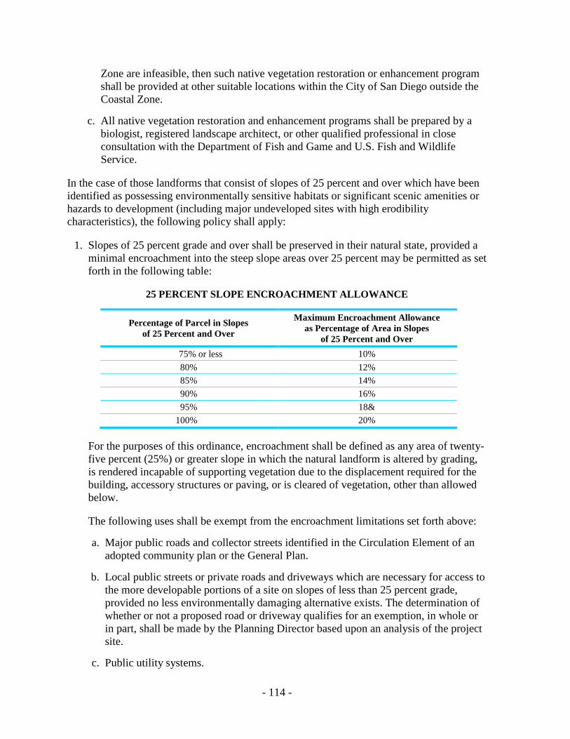
- 114 -
Zone are infeasible, then such native vegetation restoration or enhancement program shall be provided at other suitable locations within the City of San Diego outside the Coastal Zone.
c. All native vegetation restoration and enhancement programs shall be prepared by a
biologist, registered landscape architect, or other qualified professional in close consultation with the Department of Fish and Game and U.S. Fish and Wildlife Service.
In the case of those landforms that consist of slopes of 25 percent and over which have been identified as possessing environmentally sensitive habitats or significant scenic amenities or hazards to development (including major undeveloped sites with high erodibility characteristics), the following policy shall apply: 1. Slopes of 25 percent grade and over shall be preserved in their natural state, provided a
minimal encroachment into the steep slope areas over 25 percent may be permitted as set forth in the following table:
25 PERCENT SLOPE ENCROACHMENT ALLOWANCE
Percentage of Parcel in Slopes of 25 Percent and Over
Maximum Encroachment Allowance as Percentage of Area in Slopes
of 25 Percent and Over 75% or less 10% 80% 12% 85% 14% 90% 16% 95% 18& 100% 20%
For the purposes of this ordinance, encroachment shall be defined as any area of twenty-five percent (25%) or greater slope in which the natural landform is altered by grading, is rendered incapable of supporting vegetation due to the displacement required for the building, accessory structures or paving, or is cleared of vegetation, other than allowed below.
The following uses shall be exempt from the encroachment limitations set forth above:
a. Major public roads and collector streets identified in the Circulation Element of an
adopted community plan or the General Plan. b. Local public streets or private roads and driveways which are necessary for access to
the more developable portions of a site on slopes of less than 25 percent grade, provided no less environmentally damaging alternative exists. The determination of whether or not a proposed road or driveway qualifies for an exemption, in whole or in part, shall be made by the Planning Director based upon an analysis of the project site.
c. Public utility systems.
- 115 -
2. On existing legal parcels, a deviation in the encroachment allowance percentage may be granted by the Planning Director, if necessary to maintain a minimum development right (total disturbed area) equal to 20 percent of the entire parcel.
3. All encroachment allowances, including permissible deviations, shall be subject to a
determination by the Planning Director that such encroachment supports the findings of fact set forth in the City's Hillside Review Zone.
GRADING/WATER QUALITY A grading plan that incorporates runoff and erosion control procedures to be utilized during all phases of project development shall be prepared and submitted concurrently with subdivision improvement plans or planned development applications where such development is proposed to occur on lands that will be graded, filled, or have a slope of 25 percent or greater. Such a plan shall be prepared by a registered civil engineer and shall be designed to assure that there will be no increase in the peak runoff rate from the fully developed site over the rate of discharge that would occur from the existing undeveloped site as a result of the intensity of rainfall expected during a six-hour period once every ten years (the “six-hour, ten year” design storm). Runoff control shall be accomplished by establishing on-site or at suitable nearby locations catchment basins, detention basins, and siltation traps along with energy dissipating measures at the terminus of storm drains, or other similar means of equal or greater effectiveness. Sediment basins (debris basins, desilting basins, or silt traps) shall be installed in conjunction with the initial grading operation and maintained through the development process as necessary to remove sediment from runoff waters draining from the land undergoing development. Areas disturbed but not completed prior to November 15, including graded pads and stockpiles, shall be suitably prepared to prevent soil loss during the late fall and winter seasons. All graded slopes shall be stabilized prior to November 15 by means of native vegetation, if feasible, or by other suitable means. The use of vegetation as a means to control site erosion shall be accomplished pursuant to plans and specifications prepared by a licensed landscape architect or other qualified professional. Erosion control utilizing mulching, fertilization and irrigation within sufficient time prior to November 15 to provide landscape coverage that is adequate to achieve the provisions of this policy. Temporary erosion control measures shall include the use of berms, interceptor ditches, sandbagging, hay bales, filtered inlets, debris basins, silt traps, or other similar means of equal or greater effectiveness. From November 15 to March 31, grading may be permitted provided the applicant conforms to the requirements listed below and submits monthly documentation within two weeks following the end of the preceding month to the City Engineer on the condition of the erosion control procedures for graded pads, slopes and stockpiles whenever precipitation during the month exceeds two (2) inches. From November 15 to March 31, grading may only occur: 1. In increments as determined by the City Engineer based on site-specific soil erodibility
and slopes in order to minimize soil exposure.
- 116 -
2. The applicant has installed temporary erosion control measures that the City Engineer finds are designed to assure that there will be no increase in the peak runoff rate.
3. The applicant posts a bond which shall remain in force and effect for one year after
acceptance by the City of the subdivision sufficient to cover the costs of any remedial grading and replanting of vegetation, including any grading and replanting of vegetation, including any restoration of lagoon, wetland, or other environmentally sensitive habitat areas adversely affected by the failure of the erosion control measures.
4. The applicant agrees to provide daily documentation to the City Engineer of the
condition of the erosion control procedures for any 24-hour period in which precipitation exceeds 0.25 inches. Failure to provide such documentation or occurrence of any significant discharge of sediments or silts in violation of this policy shall constitute automatic grounds for suspension of the applicant's grading permit(s) during the period of November 15 to March 31.
Grading for properties within the Coastal Zone which drain into Los Peñasquitos Lagoon or San Dieguito Lagoon require compliance with erosion control measures specified in the document “Erosion Control Measures for North City Areas Draining to Los Peñasquitos or San Dieguito Lagoons,” on file in the Office of the City Clerk as Document No. 00-17068.
WETLANDS/ENVIRONMENTALLY SENSITIVE RESOURCES The diking, filling, or dredging of open coastal waters, wetlands, estuaries, and lakes shall be permitted where there is no feasible, less environmentally damaging alternative, where feasible mitigation measures have been provided to minimize adverse environmental effects, and shall be limited to the following newly permitted uses and activities: 1. Incidental public service purposes, including, but not limited to, burying cables and
pipes or inspection of piers and maintenance of existing intake and outfall lines. 2. Mineral extraction, including sand for restoring beaches, except in environmentally
sensitive areas. 3. Restoration purposes. 4. Nature study, aquaculture or similar resource-dependent activities. Dredging and spoils disposal shall be planned and carried out to avoid significant disruption to marine and wildlife habitats and water circulation. Dredge spoils suitable for beach replenishment should be transported for such purposes to appropriate beaches or into suitable long shore current systems. Buffer zones sufficient to protect wetlands shall generally be 100 feet in width, unless the applicant demonstrates that a smaller buffer will protect the resources of the wetland based on site-specific information including but not limited to the type and size of the development
- 117 -
and/or proposed mitigation which will also achieve the purposes of the buffer. The California Department of Fish and Game and the U.S. Fish and Wildlife Service shall be consulted in such buffer determinations and their comments shall be accorded great weight by the City of San Diego and by the California Coastal Commission. Developments permitted in wetland buffer areas shall be limited to access paths, passive recreational areas, fences and similar improvements necessary to protect the wetland, and such improvements shall be restricted to the upper/inland half of the buffer zone. Developments shall be located so as not to contribute to increased sediment loading of the wetland, cause disturbance to its fish and wildlife values, or otherwise impair the functional capacity of the wetland.
Development in Floodplain Areas Within the l00-year floodplain fringe of the San Dieguito River, fill for roads and other public improvements and/or permanent structures will be allowed only if such development is consistent with uses allowed pursuant to the A-1-10 Zone and other existing zoning, is capable of withstanding periodic flooding, and does not require the construction of off-site flood protective works. The following requirements shall also be met:
Existing environmentally sensitive habitat areas will not be significantly affected and, that as a condition of development, significant new riparian corridors will be planted and maintained to function as enhanced wildlife corridors. Such revegetation program shall, to the maximum extent feasible, utilize native vegetation and shall be designed and implemented by a professional landscape architect, biologist, or other qualified professional in close consultation with the Department of Fish and Game and the U.S. Fish and Wildlife Service.
The design of the development incorporates the findings and recommendations of both a site-specific and coastal watershed hydrologic study in order that the development either assures that there will be no increase in the peak runoff rate from the fully developed site over the greatest discharge that would occur from the existing undeveloped site as a result of the intensity of rainfall expected during a six-hour period once every ten years, and neither significantly increases nor contributes to downstream bank erosion and sedimentation, including wetlands, lagoons, and other environmentally sensitive habitat areas.
Development in Areas of Sensitive Vegetation In addition, to the extent applicable, all new development within the coastal zone shall be designed to be consistent with multi-species and multi-habitat preservation goals and requirements as established in the statewide Natural Communities Conservation Planning (NCCP) Program, and shall comply with the City of San Diego MSCP Interim Habitat Loss Permit Process, or shall obtain an incidental take permit under Section 4d, Section 7 or Section l0a of the Endangered Species Act related to the California Gnatcatcher. Compliance with these goals and requirements shall be implemented in consultation with the United States Fish and Wildlife Service and California Department of Fish and Game.
- 118 -
VISUAL RESOURCES The State Coastal Act states that the scenic and visual qualities of the coastal areas shall be considered and protected as a resource of public importance. The Torrey Pines community planning area possesses many highly scenic open space areas and dramatic vistas. Torrey Pines also has a number of road segments that have scenic qualities worthy of formal recognition and protection. This Plan contains numerous recommendations, policies and implementing actions focusing on the preservation of these visual resources including: 1. Significant scenic resource areas including San Dieguito River Regional Park, Crest
Canyon, Torrey Pines State Reserve Extension, Los Peñasquitos Lagoon, and the Carroll Canyon Creek Corridor have been designated and rezoned to open space.
2. Three road segments possessing dramatic vistas are recommended for a Scenic Route
designation including North Torrey Pines Road, Carmel Valley Road, and Sorrento Valley Road.
3. Power distribution lines and utilities along Sorrento Valley Road and within Los
Peñasquitos Lagoon are recommended to be relocated underground. 4. Future development adjacent to the Torrey Pines Reserve Extension, San Dieguito
Lagoon, and Crest Canyon areas shall provide for adequate buffer areas. Development proposals shall provide adequate setbacks to avoid significant erosion, visual or sediment impacts from construction. Setbacks also shall be required to prevent fire breaks from being constructed on reserve property or into off-site sensitive areas. No clear-cutting or removal of vegetation shall be allowed within the San Dieguito Lagoon Preserve, Crest Canyon or the Torrey Pines State Reserve Extension.
5. Landscaping of properties adjacent to open space areas shall not use invasive plant
species. Landscaping adjacent to these areas should use plant species naturally occurring in that area.
6. New residential development shall be compatible with the existing neighborhood, and
designed to blend into adjacent natural open space areas. Only low-profile dwellings designed to fit with the natural terrain and not be visually prominent from the canyon floor shall be allowed. For development located in visually prominent areas adjacent to space areas, building colors and materials shall be limited to earth tones and colors subordinate to the surrounding natural environment, which minimize the development's contrast with the surrounding hillsides and open space areas.
7. New commercial development within predominantly residential neighborhoods shall be
designed to minimize or eliminate traffic, noise, parking and visual impacts to residents. Bulk and scale of new commercial development shall be low-scale and of similar height to buildings and homes in the existing area.
8. Continue to maintain the existing, and where feasible, provide additional landscaped
islands within Sorrento Valley Road and Sorrento Valley Boulevard. A landscaped center median should be provided along Del Mar Heights Road.
- 119 -
9. Those disturbed areas of the Carroll Canyon Creek Corridor shall be revegetated and planted with a combination of native trees, primarily riparian woodlands species and native shrubs. The revegetation plan shall include a monitoring program to determine the success of the program and identify maintenance needs.
10. Mechanical equipment, outdoor storage and appurtenances shall be screened from view
and designed as integral parts of the overall building design. Fences, walls, grillwork, etc. should be of similar material and color as the main building.
11. The Plan recommends the preservation of Torrey Pines trees in private as well as public
areas, and encourages the planting of Torrey Pines trees in roadways and other landscaped areas. Should Torrey Pines trees require removal, relocation or replacement of the trees shall occur whenever feasible.
12. New residential, commercial, and industrial development shall provide landscape
buffers to screen views of the buildings from designated scenic roadways.
Parking All commercial, industrial and residential uses shall be designed and constructed with sufficient off-street parking and loading facilities to assure adequate parking is provided with new development such that no adverse impacts on coastal access are documented. Parking ratios shall be utilized as specified and detailed in the City's Zoning Code to provide sufficient parking spaces so as not to require patrons/employees/residents to utilize parking which is necessary/required for other approved uses, or street and other public parking that would otherwise be available for public use. In addition, existing public parking facilities used for public beach access shall be maintained and no reduction in existing public parking shall be permitted.
LOS PEÑASQUITOS WATERSHED RESTORATION/ENHANCEMENT FEE Applicants for coastal development permits for projects located in the watershed of Los Peñasquitos Lagoon shall enter into an agreement with the City of San Diego and the State Coastal Conservancy as a condition of development approval to pay a Los Peñasquitos watershed restoration and enhancement fee to the Los Peñasquitos Lagoon Fund for restoration of the Los Peñasquitos Lagoon and watershed. The Los Peñasquitos watershed restoration and enhancement fee shall be computed on the basis of the site surface affected by grading for urban development, agricultural, transportation, and other public service facility service facility improvements, but not including for habitat restoration or enhancement, at a rate of $0.005/square foot and at an additional rate for impervious surface(s) created by the development at a rate of $0.03/square foot. The applicant shall provide evidence satisfactory to the City that such payment has been made prior to issuance of the Coastal Development Permit. Mitigation measures for development or fill within the lagoon shall include, at a minimum, either acquisition of equivalent areas of equal or greater biological productivity, or opening equivalent areas to tidal action.

THIS PAGE INTENTIONALLY LEFT BLANK.
RESOURCE MANAGEMENT MAPS
F. Biologically Sensitive Habitats G. Environmental Constraints H. Open Space Rezonings


F. BIOLOGICALLY SENSITIVE HABITATS

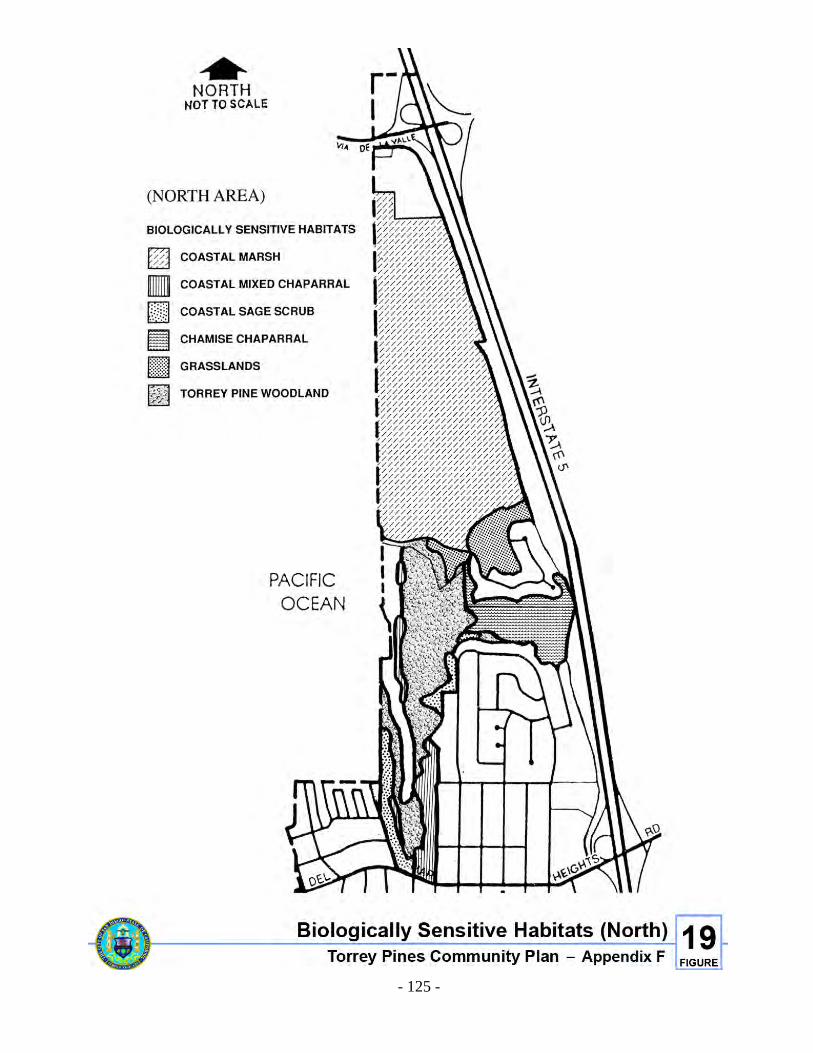
- 125 -
Figure 19. Biologically Sensitive Habitats (North)
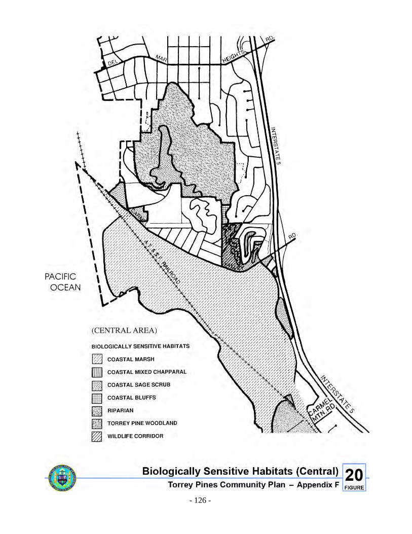
- 126 -
Figure 20. Biologically Sensitive habitats (Central)
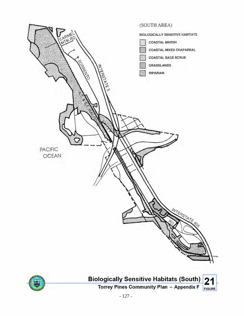
- 127 -
Figure 21. Biologically Sensitive habitats (South)


G. ENVIRONMENTAL CONSTRAINTS

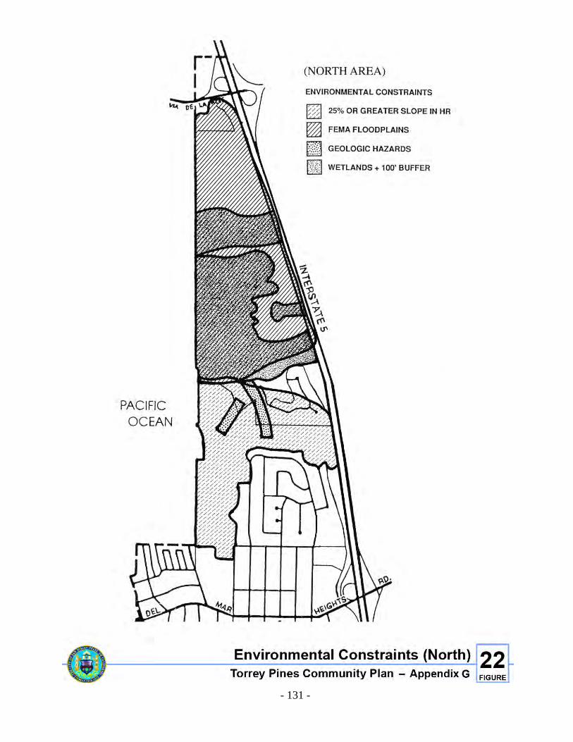
- 131 -
Figure 22. Environmental Constraints (North)
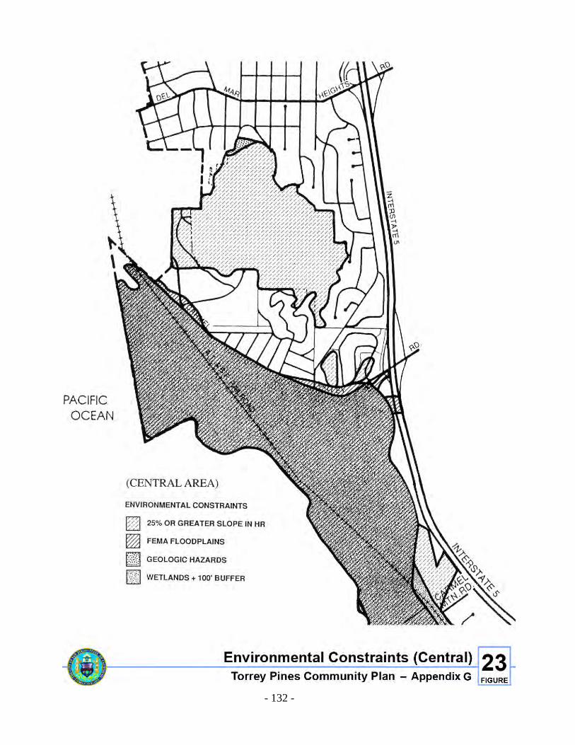
- 132 -
Figure 23. Environmental Constraints (Central)
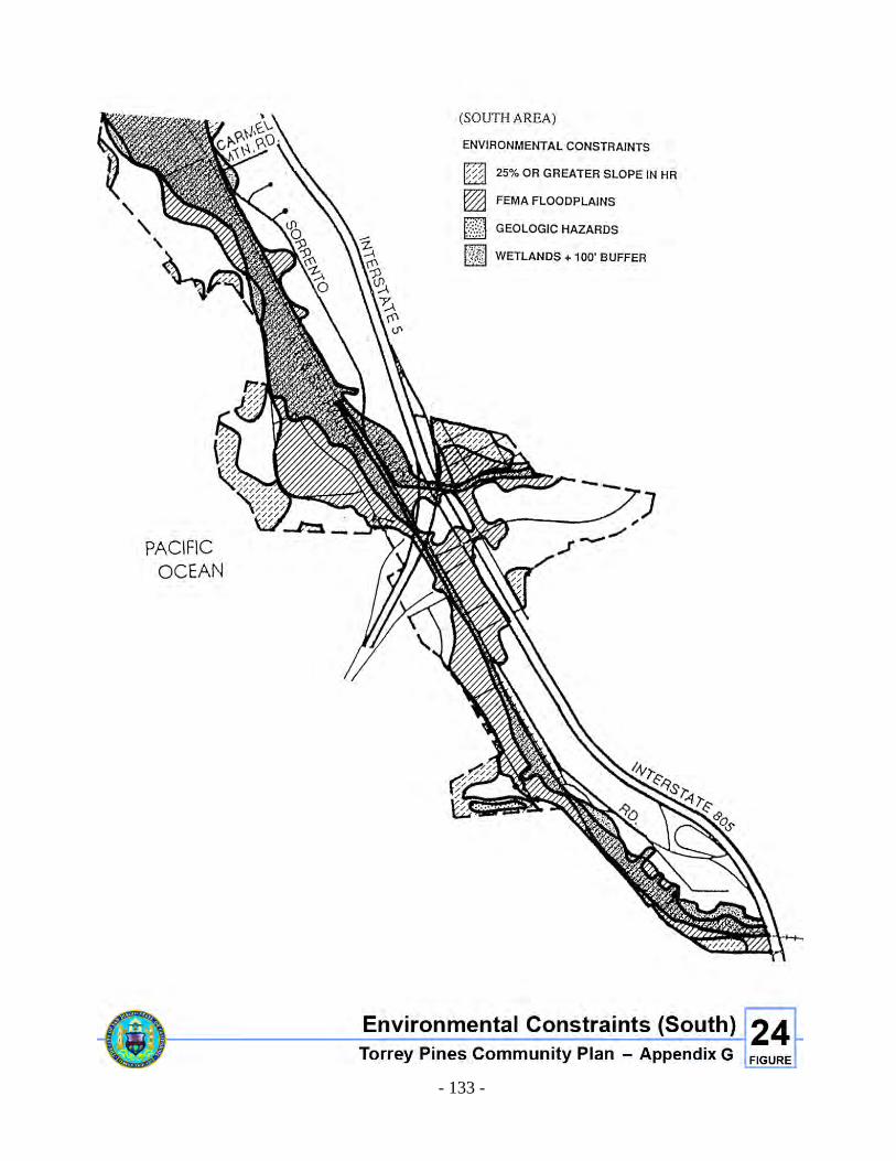
- 133 -
Figure 24. Biologically Sensitive Habitats (South)


H. OPEN SPACE REZONINGS

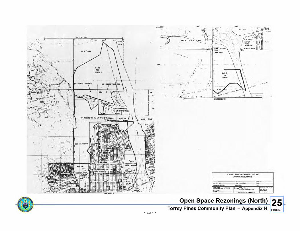
- 137 -
Figure 25. Open Space Rezonings (North)
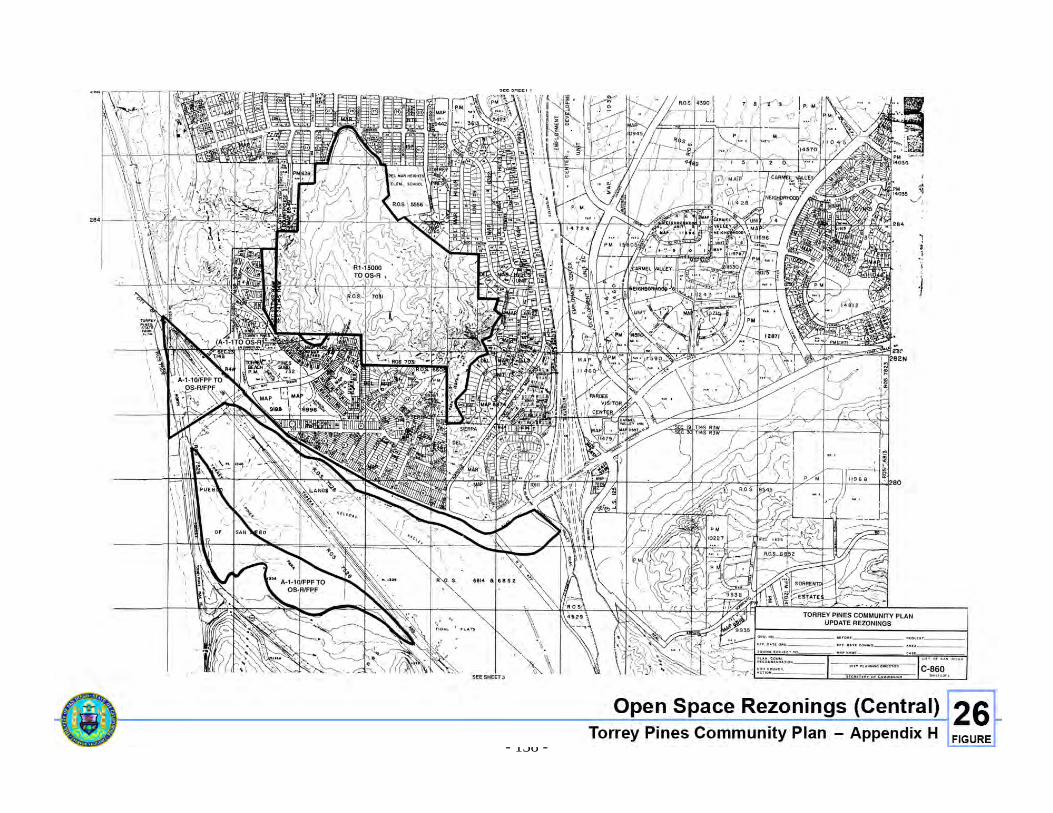
- 138 -
Figure 26. Open Space Rezonings (Central)
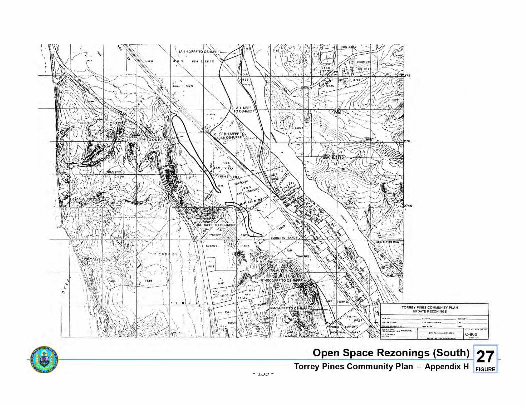
- 139 -
Figure 27. Open Space Rezonings (South)


I. CATEGORICAL EXCLUSION AREAS

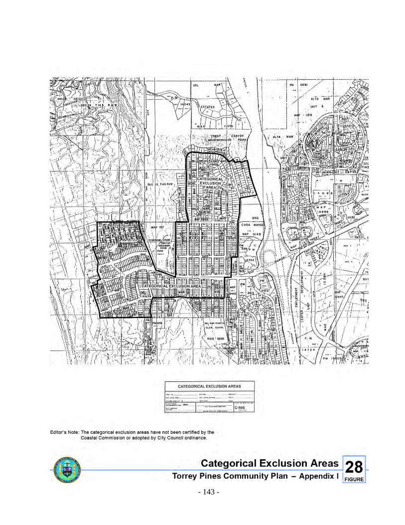
- 143 -
Figure 28. Categorical Exclusion Areas