Embed Size (px)
Citation preview
Way�nding Study Phase I
City of Syracuse
Final Report
100 Clinton Square126 North Salina St, Suite 100Syracuse, NY 13202(315) 422-5716Fax: (315) 422-7753www.smtcmpo.org
Syracuse Metropolitan Transportation CouncilJune 2013
690
City of Syracuse Wayfinding Study (Phase I) Syracuse Metropolitan Transportation Council
Final Report June 12, 2013
This document was prepared with financial assistance from the Federal Highway Administration and the Federal Transit Administration of the U.S. Department of Transportation through the New York State Department of Transportation. The Syracuse Metropolitan Transportation Council is solely responsible for its contents.
____________________________________________________________________________
For further information contact: Michael D. Alexander, AICP, Project Manager James D’Agostino, Director Syracuse Metropolitan Transportation Council 126 N. Salina St., 100 Clinton Square, Suite 100, Syracuse, NY 13202 PHONE: (315) 422-5716 FAX: (315) 422-7753 www.smtcmpo.org

City of Syracuse Wayfinding Study (Phase I)
6-12-13 i
Executive Summary
Introduction: Wayfinding refers to the use of directional signage to guide visiting motorists to their destination along the most simple and direct route possible. Communities that implement successful wayfinding programs improve a visitor’s experience by enhancing one’s ability to easily navigate an unfamiliar area.
This study focuses on vehicular wayfinding needs only and is the first of two separate studies. This study, which is considered Phase I, identifies major traffic generating destinations within the city that warrant guide signs on interstates and wayfinding signs on city roads. This study also identifies interstate shield signs to direct motorists back to the interstates from the major destinations.
A second study, Phase II, will build upon this study by directing motorists from the major destinations to other destinations once they are within the city by listing them on any remaining sign space. The second study will commence following completion of this study and will take approximately one year to complete.
As a technical analysis, this study will not address sign branding. Road owners may choose to brand, fabricate, and install signs following the completion of the second study. Fabricating and installing signs following completion of Phase II will ensure the efficient expenditure of resources and promote cost savings.
To accomplish Phase I study objectives, the SMTC established a Study Advisory Committee (SAC) and a Working Group comprised of SAC
members to provide technical and procedural guidance for the project.
Wayfinding Systems and Studies: The Syracuse Metropolitan Transportation Council (SMTC) reviewed existing and planned sign systems and studies to determine the presence of wayfinding systems, identify common destinations and routes, and incorporate existing efforts into a comprehensive sign network. The review yielded these primary findings:
• A comprehensive wayfinding program for motorists, pedestrians, and cyclists has never been studied or put into place.
• Existing studies are limited in scope because they typically cover a small geographic area, only direct motorists to the destination (no directional signage from the destination back to the interstates), and do not assess guide signs found on the interstates.
• Common destinations included: the Onondaga Historical Association, the Everson Museum of Art, the Museum of Science and Technology, the John H. Mulroy Civic Center, Destiny USA, and Regional Transportation Center/Alliance Bank Stadium.
• Large traffic generators that produce special event traffic such as the Carrier Dome may require separate study and assessment.
• Syracuse University and the University Hill Corporation are designing and installing localized vehicular and pedestrian wayfinding programs.

City of Syracuse Wayfinding Study (Phase I)
6-12-13 ii
Case Study: City of Rochester Wayfinding Program: For three decades, the City of Rochester has maintained a vehicular wayfinding system, which has evolved into a color-coded network. Additionally, at the time of the writing of this report, Rochester planning officials were reviewing the recommendations from a recently completed pedestrian wayfinding study. The pedestrian wayfinding study builds upon the same color-coded theme as the vehicular wayfinding program.
Several changes have occurred since Rochester’s vehicular sign system was first installed in 1983. In 2008, Rochester replaced its old system with an entirely new Center City Signage Wayfinding System.
Example of a Vehicular Wayfinding Sign in Rochester, NY.
Rochester installed more than 200 color-coded vehicular wayfinding and gateway signs that direct motorists to approximately two dozen destinations. Total project cost was $817,000.
Although still under review by Rochester’s planning officials, preliminary cost estimates for installing the complementary pedestrian wayfinding system are between $350,000 and $400,000.
Example of color-coded pedestrian wayfinding signs proposed in 2012 for the City of Rochester, NY.
Thus, Rochester’s vehicular wayfinding system has evolved over three decades and the City is considering the installation of a complementary pedestrian wayfinding sign system.
Regulatory Research: There are different rules for wayfinding signs, guide signs, and gateway signs. The 2009 Manual on Uniform Traffic Control Devices or MUTCD defines minimum standards to install, maintain, and ensure uniformity of signs on all public streets, highways, and private roads open to public traffic. The New York State Department of Transportation, Thruway Authority, and the Highway Design Manual also provide additional rules and guidelines.
Directional signs to destinations from a freeway are limited to the use of the following three sign types:
1. An Advance Guide Sign

City of Syracuse Wayfinding Study (Phase I)
6-12-13 iii
2. A Supplemental Guide Sign
3. A Destination Guide Sign
Wayfinding signs are only permitted on local roadways and may list up to three destinations. Wayfinding sign systems may be single-color or color-coded systems and both systems may include a graphic enhancement marker.
1. A Single-color Wayfinding Sign
A color-coded wayfinding sign system usually consists of the following three types of signs:
1. A General Information Sign
2. A Destination Guide Sign
3. A Color-Coded Wayfinding Sign
Applicable Service Signs, Information Signs, and Street Name Signs considered in this study include:
1. A General Service “H” Hospital Sign
2. A General Information Airport Sign
3. A General Information College Symbol
Sign
Origins, Destinations, Routes, and Existing Signs: The SMTC staff, the Study Advisory Committee (SAC), and the Working Group identified origins, destinations, and direct travel routes.
Origins include the New York State Thruway (NYS Thruway) and the interstates within the Metropolitan Planning Area.
The SAC, including the Syracuse Convention and Visitors Bureau, identified the following civic, cultural, educational facilities, transportation facilities, and hospitals as potential destinations appropriate for the expenditure of public funds:
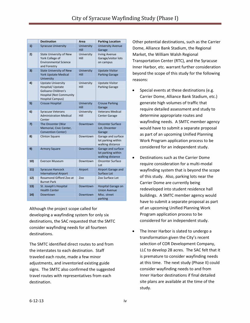
City of Syracuse Wayfinding Study (Phase I)
6-12-13 iv
Destination Area Parking Location 1) Syracuse University University
Hill University Avenue Garage
2) State University of New York College of Environmental Science and Forestry
University Hill
Irving Avenue Garage/visitor lots on campus
3) State University of New York Upstate Medical University
University Hill
Upstate Visitor Parking Garage
4) Upstate University Hospital/ Upstate Golisano Children's Hospital (Not Community Hospital Campus)
University Hill
Upstate Visitor Parking Garage
5) Crouse Hospital University Hill
Crouse Parking Garage
6) Syracuse Veterans Administration Medical Center
University Hill
Veterans Medical Center Garage
7) The Oncenter (War Memorial, Civic Center, Convention Center)
Downtown Oncenter Surface Lot, Oncenter Garage
8) Clinton Square Downtown Garage and surface lot parking within walking distance
9) Armory Square Downtown Garage and surface lot parking within walking distance
10) Everson Museum Downtown Oncenter Surface Lot
11) Syracuse Hancock International Airport
Airport Airport Garage and Surface Lot
12) Rosamond Gifford Zoo at Burnet Park
Zoo Zoo Surface Lot
13) St. Joseph's Hospital Health Center
Downtown Hospital Garage on Union Avenue
14) Downtown Downtown Misc. street parking
Although the project scope called for developing a wayfinding system for only six destinations, the SAC requested that the SMTC consider wayfinding needs for all fourteen destinations.
The SMTC identified direct routes to and from the interstates to each destination. Staff traveled each route, made a few minor adjustments, and inventoried existing guide signs. The SMTC also confirmed the suggested travel routes with representatives from each destination.
Other potential destinations, such as the Carrier Dome, Alliance Bank Stadium, the Regional Market, the William Walsh Regional Transportation Center (RTC), and the Syracuse Inner Harbor, etc. warrant further consideration beyond the scope of this study for the following reasons:
• Special events at these destinations (e.g. Carrier Dome, Alliance Bank Stadium, etc.) generate high volumes of traffic that require detailed assessment and study to determine appropriate routes and wayfinding needs. A SMTC member agency would have to submit a separate proposal as part of an upcoming Unified Planning Work Program application process to be considered for an independent study.
• Destinations such as the Carrier Dome require consideration for a multi-modal wayfinding system that is beyond the scope of this study. Also, parking lots near the Carrier Dome are currently being redeveloped into student residence hall buildings. A SMTC member agency would have to submit a separate proposal as part of an upcoming Unified Planning Work Program application process to be considered for an independent study.
• The Inner Harbor is slated to undergo a transformation given the City’s recent selection of COR Development Company, LLC to develop 28 acres. The SAC felt that it is premature to consider wayfinding needs at this time. The next study (Phase II) could consider wayfinding needs to and from Inner Harbor destinations if final detailed site plans are available at the time of the study.
City of Syracuse Wayfinding Study (Phase I)
6-12-13 v
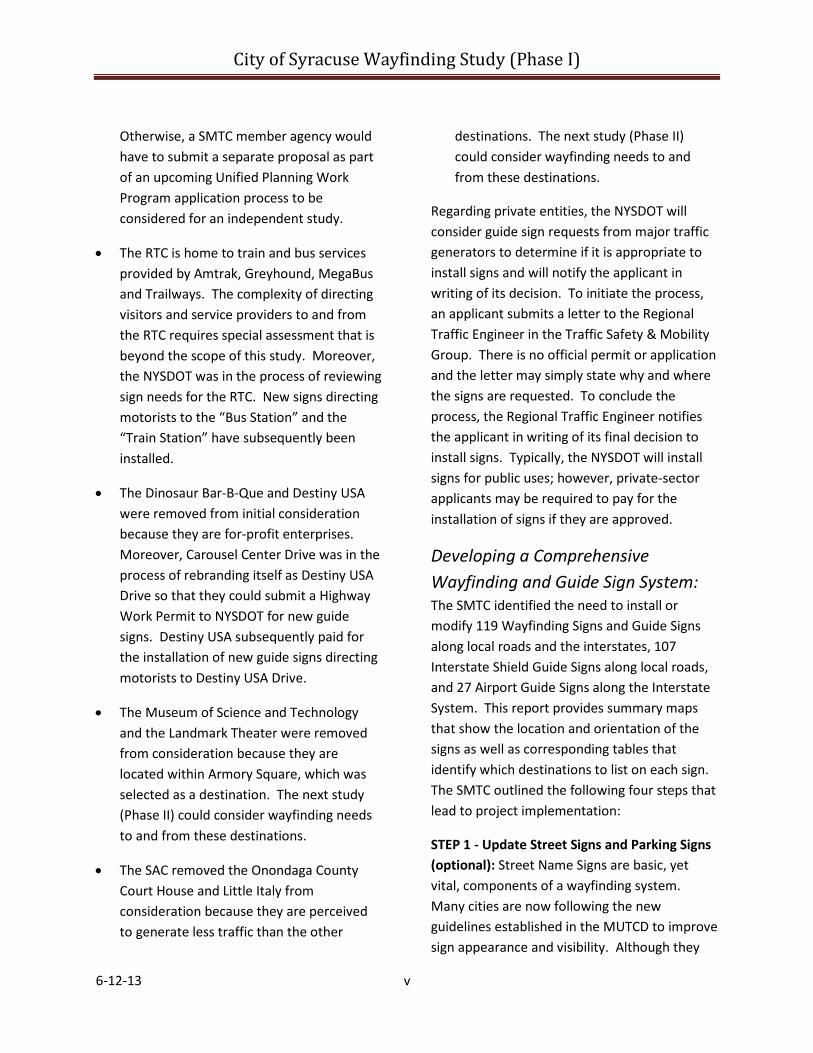
Otherwise, a SMTC member agency would have to submit a separate proposal as part of an upcoming Unified Planning Work Program application process to be considered for an independent study.
• The RTC is home to train and bus services provided by Amtrak, Greyhound, MegaBus and Trailways. The complexity of directing visitors and service providers to and from the RTC requires special assessment that is beyond the scope of this study. Moreover, the NYSDOT was in the process of reviewing sign needs for the RTC. New signs directing motorists to the “Bus Station” and the “Train Station” have subsequently been installed.
• The Dinosaur Bar-B-Que and Destiny USA were removed from initial consideration because they are for-profit enterprises. Moreover, Carousel Center Drive was in the process of rebranding itself as Destiny USA Drive so that they could submit a Highway Work Permit to NYSDOT for new guide signs. Destiny USA subsequently paid for the installation of new guide signs directing motorists to Destiny USA Drive.
• The Museum of Science and Technology and the Landmark Theater were removed from consideration because they are located within Armory Square, which was selected as a destination. The next study (Phase II) could consider wayfinding needs to and from these destinations.
• The SAC removed the Onondaga County Court House and Little Italy from consideration because they are perceived to generate less traffic than the other
destinations. The next study (Phase II) could consider wayfinding needs to and from these destinations.
Regarding private entities, the NYSDOT will consider guide sign requests from major traffic generators to determine if it is appropriate to install signs and will notify the applicant in writing of its decision. To initiate the process, an applicant submits a letter to the Regional Traffic Engineer in the Traffic Safety & Mobility Group. There is no official permit or application and the letter may simply state why and where the signs are requested. To conclude the process, the Regional Traffic Engineer notifies the applicant in writing of its final decision to install signs. Typically, the NYSDOT will install signs for public uses; however, private-sector applicants may be required to pay for the installation of signs if they are approved.
Developing a Comprehensive Wayfinding and Guide Sign System: The SMTC identified the need to install or modify 119 Wayfinding Signs and Guide Signs along local roads and the interstates, 107 Interstate Shield Guide Signs along local roads, and 27 Airport Guide Signs along the Interstate System. This report provides summary maps that show the location and orientation of the signs as well as corresponding tables that identify which destinations to list on each sign. The SMTC outlined the following four steps that lead to project implementation:
STEP 1 - Update Street Signs and Parking Signs (optional): Street Name Signs are basic, yet vital, components of a wayfinding system. Many cities are now following the new guidelines established in the MUTCD to improve sign appearance and visibility. Although they

City of Syracuse Wayfinding Study (Phase I)
6-12-13 vi
Overhead street name sign. Street name sign above a STOP sign.
Route Shield Street Name Sign
are considered separately from a wayfinding program, improving street name signs based on new MUTCD guidelines may occur prior to installing a comprehensive wayfinding system.
STEP 2 - Conduct Phase II Study: Phase II will direct motorists to and from other destinations once they are within the city. In addition, Phase II may identify gateways and where to locate future gateway signs. The completion of Phase II is envisioned before road owners fabricate and install signs. The study will commence during the summer of 2013 and will take approximately one year to complete.
STEP 3 – Design Signs and Develop Spec Sheets for Multijurisdictional Sign System: Following completion of Phase II, the NYSTA, the NYSDOT, and the City must design their respective signs and develop mounting and installation spec sheets. The City of Syracuse should serve as the lead applicant to the NYSTA and the NYSDOT and ensure that all signs coincide with Phase II recommendations prior to fabrication and installation.
STEP 4 - Sign Removal, Installation and Maintenance: Road sign crews may install new signs and remove unnecessary signs following confirmation of the sign spec sheets. Removing unnecessary signs should occur during the
installation of the new signs. Work crews should document and inventory new signs to assist with future maintenance and inspection activities.
Conclusion: This study identifies guide sign and wayfinding sign needs to major destinations in the City of Syracuse from the interstates. It also identifies shield sign needs that direct motorists back to the interstates. The second study will identify additional destinations to list on remaining wayfinding sign space. Implementation is envisioned following completion of the second study.

City of Syracuse Wayfinding Study (Phase I)
6-12-13 Page 1
Table of Contents
Executive Summary
1 - Introduction ............................................................................................................................................. 4
1.1 What Is Wayfinding? ........................................................................................................................... 4
1.2 Study Overview ................................................................................................................................... 4
1.3 Purpose and Objectives ...................................................................................................................... 5
1.4 Study Area ........................................................................................................................................... 5
1.5 Study Process ...................................................................................................................................... 5
1.6 Stakeholder Engagement .................................................................................................................... 6
2 - Local Wayfinding Programs and Studies .................................................................................................. 7
2.1 Existing/Planned Systems ................................................................................................................... 7
2.2 Completed Studies .............................................................................................................................. 9
2.3 Conclusions ....................................................................................................................................... 11
3 - Case Study: City of Rochester Wayfinding Program .............................................................................. 13
3.1 Rochester’s Vehicular Wayfinding Program ..................................................................................... 13
3.2 Rochester’s Pedestrian Wayfinding Program ................................................................................... 15
3.3 Lessons Learned ................................................................................................................................ 18
4 - Regulatory Research .............................................................................................................................. 19
4.1 Federal Guidance .............................................................................................................................. 19
4.1.1 Guide Signs – Freeways .............................................................................................................. 19
4.1.2 Wayfinding Signs – Conventional Roads .................................................................................... 20
4.1.3 Applicable Service Signs, Information Signs, and Street Name Signs ........................................ 22
4.2 State Guidance .................................................................................................................................. 24
4.2.1 New York State Department of Transportation Supplement to the MUTCD (Signs Program) .. 24
4.2.2 New York State Thruway Authority ........................................................................................... 24
4.2.3 New York State Highway Design Manual ................................................................................... 24
4.3 Current NYSDOT Guide Sign Request Procedures ............................................................................ 25
City of Syracuse Wayfinding Study (Phase I)
6-12-13 Page 2
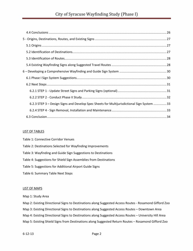
4.4 Conclusions ....................................................................................................................................... 26
5 - Origins, Destinations, Routes, and Existing Signs .................................................................................. 27
5.1 Origins ............................................................................................................................................... 27
5.2 Identification of Destinations............................................................................................................ 27
5.3 Identification of Routes..................................................................................................................... 28
5.4 Existing Wayfinding Signs along Suggested Travel Routes ............................................................... 28
6 – Developing a Comprehensive Wayfinding and Guide Sign System ...................................................... 30
6.1 Phase I Sign System Suggestions ....................................................................................................... 30
6.2 Next Steps ......................................................................................................................................... 31
6.2.1 STEP 1 - Update Street Signs and Parking Signs (optional) ........................................................ 31
6.2.2 STEP 2 - Conduct Phase II Study ................................................................................................. 32
6.2.3 STEP 3 – Design Signs and Develop Spec Sheets for Multijurisdictional Sign System ............... 33
6.2.4 STEP 4 - Sign Removal, Installation and Maintenance ............................................................... 33
6.3 Conclusion ......................................................................................................................................... 34
LIST OF TABLES
Table 1: Connective Corridor Venues
Table 2: Destinations Selected for Wayfinding Improvements
Table 3: Wayfinding and Guide Sign Suggestions to Destinations
Table 4: Suggestions for Shield Sign Assemblies from Destinations
Table 5: Suggestions for Additional Airport Guide Signs
Table 6: Summary Table Next Steps
LIST OF MAPS
Map 1: Study Area
Map 2: Existing Directional Signs to Destinations along Suggested Access Routes - Rosamond Gifford Zoo
Map 3: Existing Directional Signs to Destinations along Suggested Access Routes – Downtown Area
Map 4: Existing Directional Signs to Destinations along Suggested Access Routes – University Hill Area
Map 5: Existing Shield Signs from Destinations along Suggested Return Routes – Rosamond Gifford Zoo

City of Syracuse Wayfinding Study (Phase I)
6-12-13 Page 3
Map 6: Existing Shield Signs from Destinations along Suggested Return Routes – Downtown Area
Map 7: Existing Shield Signs from Destinations along Suggested Return Routes – University Hill Area
Map 8: Existing Directional Signs to Syracuse Hancock International Airport
Map 9: Wayfinding and Guide Sign Suggestions to Destinations– Rosamond Gifford Zoo Area
Map 10: Wayfinding and Guide Sign Suggestions to Destinations – Downtown Area
Map 11: Wayfinding and Guide Sign Suggestions to Destinations – University Hill Area
Map 12: Suggestions for Shield Sign Assemblies from Destinations – Rosamond Gifford Zoo Area
Map 13: Suggestions for Shield Sign Assemblies from Destinations – Downtown Area
Map 14: Suggestions for Shield Sign Assemblies from Destinations – University Hill Area
Map 15: Suggestions for Additional Airport Guide Signs
LIST OF APPENDICES
Appendix A – Meeting Summaries
Appendix B – Summary of Applicable Rules
City of Syracuse Wayfinding Study (Phase I)
6-12-13 Page 4
1 - Introduction The Syracuse Metropolitan Transportation Council (SMTC) agreed to complete the Vehicular Wayfinding Study for Major Traffic Generators on behalf of the City of Syracuse (City) as part of the 2012-2013 Unified Planning Work Program (UPWP).
1.1 What Is Wayfinding? As used in this study, wayfinding refers to the use of directional signage to guide visiting motorists to and from their destination. Communities that implement successful wayfinding programs improve a visitor’s experience by enhancing one’s ability to easily navigate an unfamiliar area.
Wayfinding programs can be developed for areas such as downtowns and districts (e.g., a Theater District), on sites such as college campuses, or within buildings such as large sports arenas. The process varies in design and implementation depending on target audience (i.e., motorists, cyclists, or pedestrians).
This study focuses on vehicular wayfinding needs only. Systems for cyclists and pedestrians may incorporate a similar design as the motorists’ signs, but are mutually exclusive from a vehicular system as they do not guide vehicular traffic. As such, pedestrian wayfinding signs have more design leeway than vehicular or bicycle wayfinding systems because they are not considered traffic control devices.
Although there are limitations, vehicular wayfinding signs may use color coding and themed enhancement markers to promote an area’s unique character. Communities may also use additional elements such as gateway signs, banners, flags, public art, and lighting to
celebrate an area’s history, character, or unique social environment.
1.2 Study Overview The City of Syracuse does not contain a coordinated wayfinding sign system. To address this, the City sought technical assistance from the SMTC to identify vehicular wayfinding needs.
Developing a vehicular wayfinding system is a complex, multi-step process. Given the complexities associated with vehicular wayfinding, the SMTC developed this study as an initial phase. This study, Phase I, identifies opportunities to direct motorists into and out of the city, via the interstates and along local roads, to a limited number of major traffic generators. It does not direct motorists to and from other destinations once within the city.
A second study, Phase II, will commence immediately following the completion of this study. The purpose of the second study is to direct motorists to and from other destinations from their original destination. As a technical analysis, Phase I and II do not address sign branding. Road owners may choose to brand, fabricate, and install signs following the completion of the second study, which the SMTC anticipates will be complete in March 2014.
Fabricating signs following completion of Phase II will ensure the efficient expenditure of resources, promote cost savings, and minimize the number of signs installed throughout the system. In addition to reducing sign clutter, installing signs after Phase II is complete will ensure the establishment of a unified system that is easily recognizable by visiting motorists.

City of Syracuse Wayfinding Study (Phase I)
6-12-13 Page 5
1.3 Purpose and Objectives Purpose: The purpose of this study is to identify vehicle wayfinding needs to guide visiting motorists from the New York State Thruway (NYS Thruway), I-81, I-690, and I-481 to major traffic-generating destinations located along city roadways and back to the interstate/NYS Thruway.
Objectives: This study will achieve the following objectives:
• provide a summary of the City of Rochester’s wayfinding program as a case study;
• document sign inventory procedures;
• identify origins outside of the City;
• identify destinations that serve as large traffic generators within the City;
• determine direct travel routes to and from the identified destinations;
• inventory existing wayfinding signs along the direct travel routes;
• identify sign needs and approximate locations appropriate for new sign placement; and
• outline an approach to transition into the next study (Phase II) that considers vehicular wayfinding needs to other destinations once a motorist is in the city.
1.4 Study Area Destinations are located within the City of Syracuse. Origins include the New York State Thruway and the interstates located within the SMTC’s Metropolitan Planning Area (MPA), which includes all of Onondaga County and portions of Oswego and Madison counties. Please see Map 1.
Map 1 – Study Area
1.5 Study Process The SMTC used the following process to achieve the purpose and objectives.
Project Initiation: The SMTC established a Study Advisory Committee (SAC) to provide technical and procedural guidance for the project. The SAC and staff from the SMTC met throughout the process to guide the study. In addition to the SAC, the SMTC also established a Working Group to refine the destinations and routes identified by the SAC.
City of Syracuse Wayfinding Study (Phase I)
6-12-13 Page 6
Review and Summarize Local Wayfinding Studies: Chapter two identifies and summarizes local wayfinding studies and programs.
Case Study Research: Chapter three provides a summary of the City of Rochester’s wayfinding program.
Regulatory Research: A summary of applicable rules and regulations from the Manual on Uniform Traffic Control Devices (MUTCD) for wayfinding signs, guide signs, and gateway signs is provided in chapter four.
Origins, Destinations, Routes, and Existing Signs: Chapter five identifies the origins, destinations, and routes based on input from Rochester’s wayfinding program, the review of local studies, applicable regulations, and feedback from the SAC and Working Group participants.
The SMTC determined that a sign inventory does not exist. As a result, the SMTC inventoried existing wayfinding signs along the identified routes. This information is summarized in chapter five.
Developing a Coordinated Vehicular Wayfinding System: The SMTC with the SAC developed general recommendations for wayfinding signs. Chapter six outlines Phase I suggestions that will be modified and evolve into recommendations at the completion of Phase II.
1.6 Stakeholder Engagement During the scoping process, the City and the SMTC determined that the formation and engagement of the Study Advisory Committee (SAC) would serve the public involvement needs for this study and that a Public Involvement
Plan (PIP) would not be prepared. No other public outreach was conducted.
Study Advisory Committee: Formed to provide technical and procedural guidance, the SAC consisted of representatives from the following member agencies:
• CenterState Corporation for Economic Opportunity
o Syracuse Convention and Visitors Bureau (SCVB)
o Downtown Committee of Syracuse
• New York State Department of Transportation (NYSDOT)
• Syracuse-Onondaga County Planning Agency (SOCPA)
• Central New York Regional Planning and Development Board (CNYRPDB)
• City of Syracuse
o Department of Public Works (DPW) o Department of Neighborhood and
Business Development (NBD)
In addition to providing technical guidance, the SAC confirmed origins, destinations, and potential routes; provided input on sign regulations and reference materials; considered Working Group membership; and provided review and oversight of the Draft Final Report. The SMTC met with the SAC three times during the planning process. Meeting summaries are provided in Appendix A.
Working Group: The SMTC assembled a Working Group comprised of a subset of SAC members. The purpose of the Working Group was to refine the list of destinations and routes. One meeting was held, and a summary of the meeting is provided in Appendix A.
City of Syracuse Wayfinding Study (Phase I)
6-12-13 Page 7
2 - Local Wayfinding Programs and Studies The Syracuse Metropolitan Transportation Council (SMTC) reviewed existing/planned systems and completed studies to determine the presence of wayfinding systems and identify common destinations and routes. The SMTC and the Study Advisory Committee (SAC) considered destinations and sign issues and opportunities referenced in the following studies.
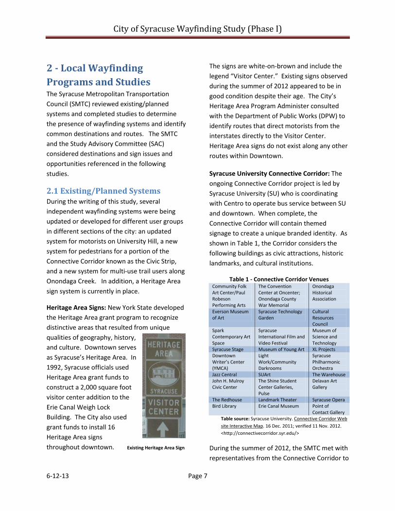
2.1 Existing/Planned Systems During the writing of this study, several independent wayfinding systems were being updated or developed for different user groups in different sections of the city: an updated system for motorists on University Hill, a new system for pedestrians for a portion of the Connective Corridor known as the Civic Strip, and a new system for multi-use trail users along Onondaga Creek. In addition, a Heritage Area sign system is currently in place.
Heritage Area Signs: New York State developed the Heritage Area grant program to recognize distinctive areas that resulted from unique qualities of geography, history, and culture. Downtown serves as Syracuse’s Heritage Area. In 1992, Syracuse officials used Heritage Area grant funds to construct a 2,000 square foot visitor center addition to the Erie Canal Weigh Lock Building. The City also used grant funds to install 16 Heritage Area signs throughout downtown. Existing Heritage Area Sign
The signs are white-on-brown and include the legend “Visitor Center.” Existing signs observed during the summer of 2012 appeared to be in good condition despite their age. The City’s Heritage Area Program Administer consulted with the Department of Public Works (DPW) to identify routes that direct motorists from the interstates directly to the Visitor Center. Heritage Area signs do not exist along any other routes within Downtown.
Syracuse University Connective Corridor: The ongoing Connective Corridor project is led by Syracuse University (SU) who is coordinating with Centro to operate bus service between SU and downtown. When complete, the Connective Corridor will contain themed signage to create a unique branded identity. As shown in Table 1, the Corridor considers the following buildings as civic attractions, historic landmarks, and cultural institutions.
Table 1 - Connective Corridor Venues Community Folk Art Center/Paul Robeson Performing Arts
The Convention Center at Oncenter; Onondaga County War Memorial
Onondaga Historical Association
Everson Museum of Art
Syracuse Technology Garden
Cultural Resources Council
Spark Contemporary Art Space
Syracuse International Film and Video Festival
Museum of Science and Technology
Syracuse Stage Museum of Young Art XL Projects Downtown Writer’s Center (YMCA)
Light Work/Community Darkrooms
Syracuse Philharmonic Orchestra
Jazz Central SUArt The Warehouse John H. Mulroy Civic Center
The Shine Student Center Galleries, Pulse
Delavan Art Gallery
The Redhouse Landmark Theater Syracuse Opera Bird Library Erie Canal Museum Point of
Contact Gallery Table source: Syracuse University. Connective Corridor Web site Interactive Map. 16 Dec. 2011; verified 11 Nov. 2012. <http://connectivecorridor.syr.edu/>
During the summer of 2012, the SMTC met with representatives from the Connective Corridor to
City of Syracuse Wayfinding Study (Phase I)
6-12-13 Page 8
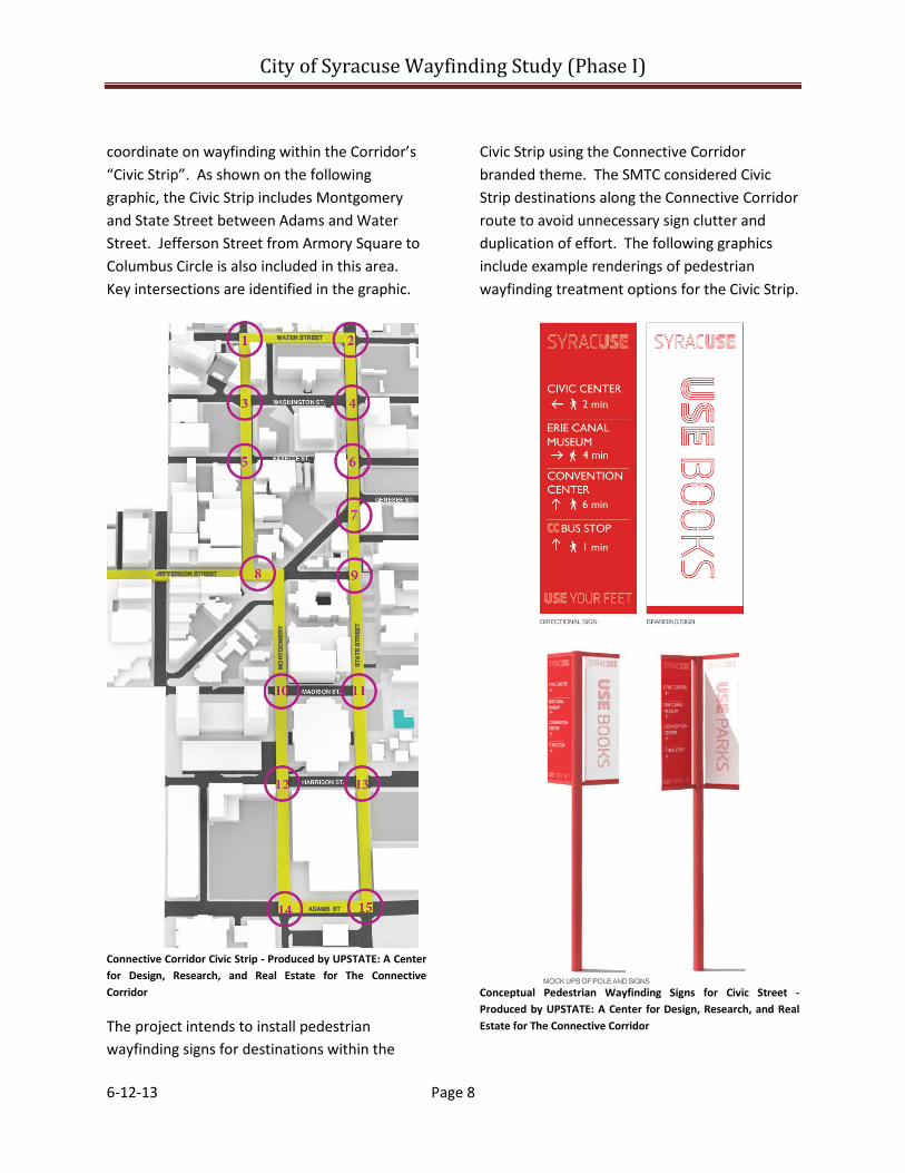
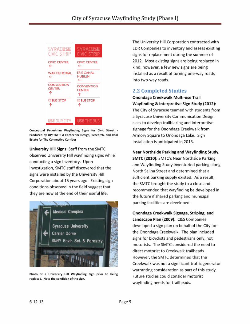
coordinate on wayfinding within the Corridor’s “Civic Strip”. As shown on the following graphic, the Civic Strip includes Montgomery and State Street between Adams and Water Street. Jefferson Street from Armory Square to Columbus Circle is also included in this area. Key intersections are identified in the graphic.
Connective Corridor Civic Strip - Produced by UPSTATE: A Center for Design, Research, and Real Estate for The Connective Corridor
The project intends to install pedestrian wayfinding signs for destinations within the
Civic Strip using the Connective Corridor branded theme. The SMTC considered Civic Strip destinations along the Connective Corridor route to avoid unnecessary sign clutter and duplication of effort. The following graphics include example renderings of pedestrian wayfinding treatment options for the Civic Strip.
Conceptual Pedestrian Wayfinding Signs for Civic Street - Produced by UPSTATE: A Center for Design, Research, and Real Estate for The Connective Corridor
City of Syracuse Wayfinding Study (Phase I)
6-12-13 Page 9
Conceptual Pedestrian Wayfinding Signs for Civic Street - Produced by UPSTATE: A Center for Design, Research, and Real Estate for The Connective Corridor
University Hill Signs: Staff from the SMTC observed University Hill wayfinding signs while conducting a sign inventory. Upon investigation, SMTC staff discovered that the signs were installed by the University Hill Corporation about 15 years ago. Existing sign conditions observed in the field suggest that they are now at the end of their useful life.
Photo of a University Hill Wayfinding Sign prior to being replaced. Note the condition of the sign.
The University Hill Corporation contracted with EDR Companies to inventory and assess existing signs for replacement during the summer of 2012. Most existing signs are being replaced in kind; however, a few new signs are being installed as a result of turning one-way roads into two-way roads.
2.2 Completed Studies Onondaga Creekwalk Multi-use Trail Wayfinding & Interpretive Sign Study (2012): The City of Syracuse teamed with students from a Syracuse University Communication Design class to develop trailblazing and interpretive signage for the Onondaga Creekwalk from Armory Square to Onondaga Lake. Sign installation is anticipated in 2013.
Near Northside Parking and Wayfinding Study, SMTC (2010): SMTC’s Near Northside Parking and Wayfinding Study inventoried parking along North Salina Street and determined that a sufficient parking supply existed. As a result, the SMTC brought the study to a close and recommended that wayfinding be developed in the future if shared parking and municipal parking facilities are developed.
Onondaga Creekwalk Signage, Striping, and Landscape Plan (2009): C&S Companies developed a sign plan on behalf of the City for the Onondaga Creekwalk. The plan included signs for bicyclists and pedestrians only, not motorists. The SMTC considered the need to direct motorist to Creekwalk trailheads. However, the SMTC determined that the Creekwalk was not a significant traffic generator warranting consideration as part of this study. Future studies could consider motorist wayfinding needs for trailheads.
City of Syracuse Wayfinding Study (Phase I)
6-12-13 Page 10
Transportation Project Report – Initial Project Proposal/Final Design Report – Scoping and Design Study for the Lakefront/Harbor Area of Syracuse (April 2010): CHA Inc. developed sign recommendations for the City that direct motorists to the following destinations from interstate exit ramps: William F. Walsh Regional Transportation Center, Destiny USA, Alliance Bank Stadium, Central New York Regional Market, Franklin Square, and the Inner Harbor. Signs directing motorists from a destination to the interstates were not identified. In-field observations by SMTC staff indicated that the recommendations from this study were not implemented.
Downtown Wayfinding Study, C&S Companies (2008): The City and C&S identified potential locations for wayfinding signs in downtown Syracuse for: Clinton Square, Hanover Square, Oncenter, Everson Museum, Onondaga Historic Association Museum, Armory Square, and the Museum of Science and Technology. Field observations by the SMTC suggest that this study was never implemented. The proposed signs direct travelers from interstate exits toward the destination. However, signs were not proposed for some of the interstate exits and signs directing travelers back to the interstates were not identified.
Downtown Parking Study, Syracuse Industrial Development Agency (February 2008): The SMTC reviewed the downtown Parking Study to determine potential parking locations for destinations visited by motorists. C&S Companies, Inc. completed the Downtown Parking Study in 2008 for the Syracuse Industrial Development Agency. The study found that at the time, downtown Syracuse included 18,229 parking spaces, broken down
as follows: 9% on-street spaces, 77% off-street spaces; and 14% private parking spaces. The study shows that there are a variety of parking options close to destinations that do not have a designated parking facility, such as Armory Square and Clinton Square.
University Hill Transportation Study, SMTC (2007): The SMTC completed the University Hill Transportation Study to encourage multi-modal transportation between downtown and University Hill. The study identified several transportation alternatives to improve mobility and enhance connections to destinations such as Armory Square, Oncenter, Landmark Theater, and other downtown attractions (Jacobs 2007)1.
The study’s Needs Assessment report suggests that new signs should direct motorists to parking, clearly state which lot belongs to which institution, state if the lots are available for public use, and state if there are any associated fees (Wallace 2006).2
University Hill Special Events Transportation Study – Final Report (February 2000): The University Hill Special Events Transportation Study identified the following issues with special event traffic: limited vehicular, pedestrian, and shuttle service wayfinding; a lack of posted parking rules and regulations; existing vehicular signs direct motorists to the 1 Jacobs Edwards and Kelcey; Wallace Roberts and Todd; and, Alta Planning and Design. University Hill Transportation Study – Final Recommendations. Sept. 2007: 2.
2 Wallace Roberts and Todd., Alta Planning and Design. University Hill Transportation Study - Needs Assessment. Nov. 2006: 43.
City of Syracuse Wayfinding Study (Phase I)
6-12-13 Page 11
Dome’s main entrance and not to parking; and neighborhood streets are often traveled by motorists looking for parking or trying to navigate to the Dome (Parsons 2000).3
The report suggested inventorying existing guide signs, removing conflicting signs, installing interstate guide signs, and developing a local wayfinding program that directs motorists from the interstate to the parking areas with posted parking regulations and shuttle instructions (Parsons 2000).4
The SMTC and SAC decided that the Carrier Dome warrants its own separate wayfinding study due to the complexities associated with developing a multi-modal wayfinding system for associated special events.
Syracuse Convention and Visitors Bureau – Visitor Intercept Survey Findings and Responses: In 2007, the Syracuse Convention and Visitors Bureau surveyed overnight visitors in Syracuse, NY. The survey identified where overnight visitors originate, their destination, and purpose for visiting Syracuse.
According to the survey, about 34% of visitors come from New York State, 22% from Canada, and 44% from other states (RTM 2007).5
3 Parsons Brinckerhoff Quade & Douglas, Inc. University Hill Special Events Transportation Study Final Report. Feb 2000: 33-25.
4 Parsons Brinckerhoff Quade & Douglas, Inc. University Hill Special Events Transportation Study Final Report. Feb 2000: 47, 48.
5 Randall Travel Marketing, Inc. Visitor Intercept Survey Findings and Responses. Syracuse Convention and Visitors Bureau, 2007: 1.
Approximately 37% of respondents conducted business, 49% visited entertainment destinations, and 14% visited convention establishments (RTM 2007).6 When asked about their experience visiting Syracuse, visitors indicated they were most displeased with the lack of wayfinding signs (RTM 2007).7
2.3 Conclusions The SMTC’s review of past studies and programs has yielded these primary findings:
• A comprehensive wayfinding program for motorists, pedestrians, and cyclists has never been studied or put into place.
• Limited vehicular wayfinding studies have been conducted, but not implemented.
• These studies are limited in scope because they typically cover a small geographic area, only direct motorists to the destination (no directional signage from the destination back to the interstates), and do not assess guide signs found on the interstates.
• There were several common destinations that were included in multiple studies, including: the Onondaga Historical Association, the Everson Museum of Art, the Museum of Science and Technology, the John H. Mulroy Civic Center, Destiny USA, and Regional Transportation Center/Alliance Bank Stadium.
6 Randall Travel Marketing, Inc. Visitor Intercept Survey Findings and Responses. Syracuse Convention and Visitors Bureau, 2007: 1.
7 Randall Travel Marketing, Inc. Visitor Intercept Survey Findings and Responses. Syracuse Convention and Visitors Bureau, 2007: 23.
City of Syracuse Wayfinding Study (Phase I)
6-12-13 Page 12
• Large traffic generators that produce special event traffic such as the Carrier Dome may require separate study and assessment.
• Syracuse University and the University Hill Corporation are designing and installing localized vehicular and pedestrian wayfinding programs.
City of Syracuse Wayfinding Study (Phase I)
6-12-13 Page 13
3 - Case Study: City of Rochester Wayfinding Program For three decades, the City of Rochester has maintained and modified a vehicular wayfinding system. Over time, Rochester’s sign program evolved into a color-coded system by city quadrant. As a complimentary initiative, Rochester recently developed a pedestrian wayfinding study. At the time of the writing of this report, Rochester planning officials were reviewing the study’s final recommendations.
3.1 Rochester’s Vehicular Wayfinding Program The City of Rochester first installed a vehicle wayfinding program in 1983. Several changes have occurred since the beginning of this program, which include the establishment of the Center City boundary, an increase in the number of downtown tourist destinations, the inclusion of new signs for new destinations, and periodic updates to the Manual Uniform Traffic Control Devices (MUTCD). As a result of these gradual changes, Rochester officials felt that the sign program began to lack uniformity, added visual clutter, and did not adequately serve a comprehensive and coordinated purpose.
To address these issues, the City of Rochester teamed with Clark Patterson Lee and Corbin Design to develop a Center City Signage Wayfinding Program. This program branded a new sign type for the Center City to welcome visitors, and safely and efficiently guide them to their desired destination. The recently installed system coordinates and unifies wayfinding signs for more than two dozen destinations located throughout the Center City.
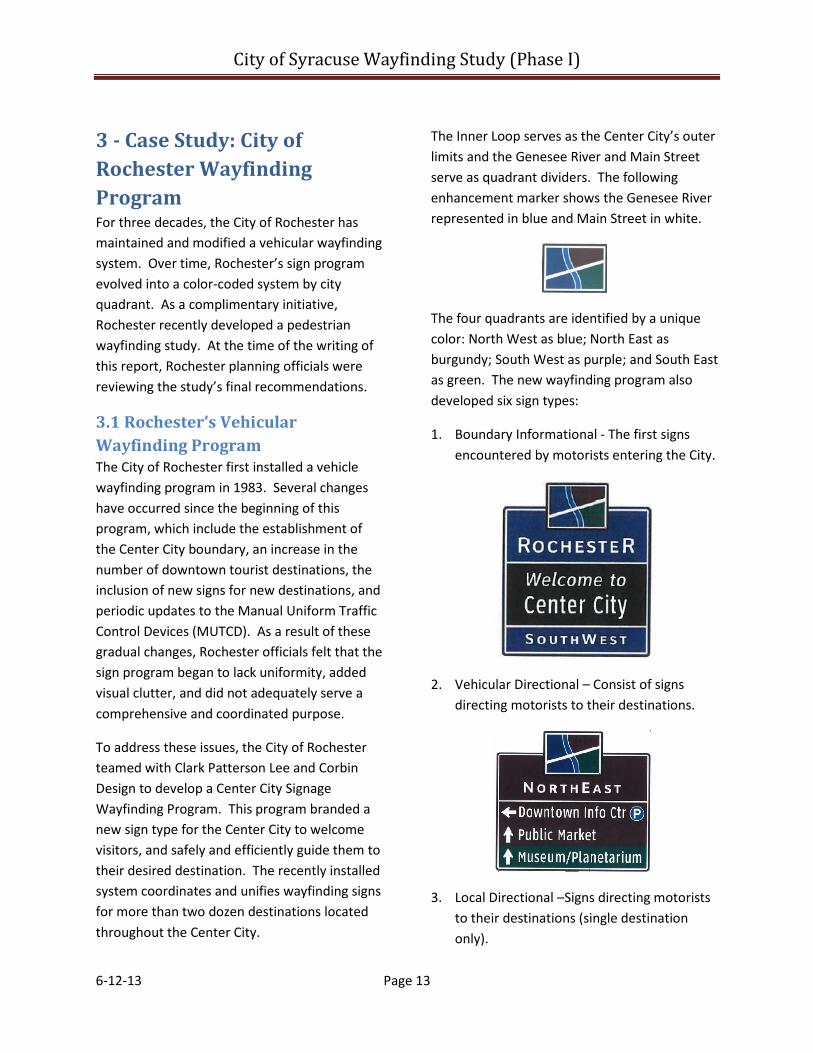
The Inner Loop serves as the Center City’s outer limits and the Genesee River and Main Street serve as quadrant dividers. The following enhancement marker shows the Genesee River represented in blue and Main Street in white.
The four quadrants are identified by a unique color: North West as blue; North East as burgundy; South West as purple; and South East as green. The new wayfinding program also developed six sign types:
1. Boundary Informational - The first signs encountered by motorists entering the City.
2. Vehicular Directional – Consist of signs directing motorists to their destinations.
3. Local Directional –Signs directing motorists to their destinations (single destination only).

City of Syracuse Wayfinding Study (Phase I)
6-12-13 Page 14
4. Destination Identifier – These signs identify when the motorist has located their destination.
5. Parking Identifier – The signs locate available municipal parking facilities.
6. Gateway Identifier – Signs that welcome motorists into a new area within the city. Typically these signs are located on bridges or overhead sign bridges. The following photographs serve as examples of gateway signs found in the City of Rochester.
Example Gateway Sign: “Welcome to Rochester Center City”.
Example Gateway Sign: “Welcome - Corn Hill - Center City”.
In 2008, the City of Rochester installed more than 200 new color-coded vehicular wayfinding and gateway signs that welcome motorists to the city and direct travelers to their destination. C.P. Ward, Inc. manufactured and installed the signs and the project was financed by the Federal Highway Administration, the New York State Department of Transportation, and the City of Rochester. Total project cost was $817,000.
Clark Patterson Lee developed record mapping for installed signs to serve as a sign inventory. The record mapping indicates sign locations using an AutoCAD base map. A dot on the map indicates the location of a sign, and the color indicates sign type. As illustrated in the example, each dot is assigned an ID number, and information about the sign is provided in an accompanying table.

City of Syracuse Wayfinding Study (Phase I)
6-12-13 Page 15
Example of Rochester’s Record Mapping and Sign Database Inventory. Top graphic represents Record Mapping. Center left graphic shows Center City color-coded by quadrant. Center right graphic shows sign legend for record mapping. Bottom graphic shows corresponding record mapping inventory database table.
The following information provided in the table and the AutoCAD file could also be transferred into a Geographical Information System (GIS):
• Sign ID Number
• Quadrant Location
• Sign Type (please see above)
• Mount Position (i.e., Right, Center, Left)
• Pole Type
• Pole ID Number/Off Street
• Parking
• Text Line One
• Text Line Two
• Text Line Three
Clark Paterson Lee developed four record maps, one for each quadrant to inventory the location of installed signs. A data attribute table accompanied each record map.
3.2 Rochester’s Pedestrian Wayfinding Program Coordinating a complementary pedestrian sign program was first explored as a recommendation within Rochester’s March 2003 Center City Master Plan. The 2003 Master Plan identified destinations and conceptualized a Walk Center City Trail program. As envisioned, the trail program links attractions together into a cohesive pedestrian circulation system. Since the development of the 2003 Plan, Rochester has advanced the development of the 1.25-mile-long Heritage Trail and the 18-mile-long Genesee River Trail.
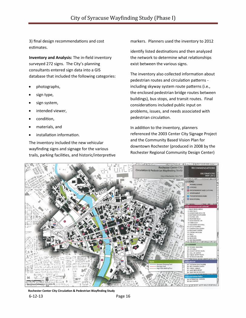
In 2011 and 2012, Rochester and its consultants, Bergman Associates and Cloud/Geshan (from Philadelphia), conducted a pedestrian wayfinding study focused on linking the existing trail and vehicular wayfinding programs by city quadrant. The City of Rochester released a report entitled Center City – Pedestrian Circulation and Wayfinding Study in June 2012.
The 2012 Pedestrian Circulation Study contained a conceptual plan focused on creating “a safe, seamless, and integrated tourist/visitor pedestrian circulation experience.” The concept plan directs visitors to attractions and existing urban trail systems through a consistently branded and coordinated pedestrian wayfinding sign system. The study consists of three components: 1) an inventory and analysis, 2) conceptual design options, and
City of Syracuse Way�inding Study (Phase I)
6-12-13 Page 16
3) final design recommendations and cost estimates.
Inventory and Analysis: The in-field inventory surveyed 272 signs. The City’s planning consultants entered sign data into a GIS database that included the following categories:
• photographs,
• sign type,
• sign system,
• intended viewer,
• condition,
• materials, and
• installation information.
The inventory included the new vehicular wayfinding signs and signage for the various trails, parking facilities, and historic/interpretive
markers. Planners used the inventory to 2012
identify listed destinations and then analyzed the network to determine what relationships exist between the various signs.
The inventory also collected information about pedestrian routes and circulation patterns - including skyway system route patterns (i.e., the enclosed pedestrian bridge routes between buildings), bus stops, and transit routes. Final considerations included public input on problems, issues, and needs associated with pedestrian circulation.
In addition to the inventory, planners referenced the 2003 Center City Signage Project and the Community Based Vision Plan for downtown Rochester (produced in 2008 by the Rochester Regional Community Design Center)
Rochester Center City Circulation & Pedestrian Wayfinding Study

City of Syracuse Wayfinding Study (Phase I)
6-12-13 Page 17
to identify possible destinations. Community input also helped supplement the in-field inventory and refine destinations.
Destinations considered included: event centers, cultural districts, accommodations, public parks and plazas, transportation facilities, government offices, office buildings, corporate headquarters, educational institutions, and landmarks. Services such as restaurants, retail, etc. were not considered because they were not viewed as permanent establishments and thus would require frequent sign maintenance.
Community officials determined that there were too many destinations to sign after reviewing the list of potential candidates. So, the project consultant developed the following criteria to help select appropriate destinations:
• permanent establishments - i.e., no services such as retail and restaurants;
• open year round;
• publicly accessible; and
• consistent with the existing vehicular wayfinding system.
After applying the criteria, Rochester identified 30 destinations.
National Best Practices: Rochester also considered national best practices for developing a branded pedestrian wayfinding program. Pedestrian wayfinding systems were investigated across the country. Best practice categories included: organization of wayfinding systems, route selection, sign and map design and layout, and universal accessibility to all users.
Conceptual Design: Sign designers considered the information collected in the inventory and analysis phase to create three alternative designs for presentation to the public: traditional, modern, and wildcard. Planners also conducted a public meeting to solicit comments on the three sign designs.
Public input for the project included two informational meetings; a Project Advisory Committee that included city staff, county DOT staff, Rochester Downtown Development Corporation (RDDC), the transit authority, and Visit Rochester; public displays at several RDDC events at the convention center; and a final meeting with volunteers who put up the temporary downtown directional signage/placards during the summer.
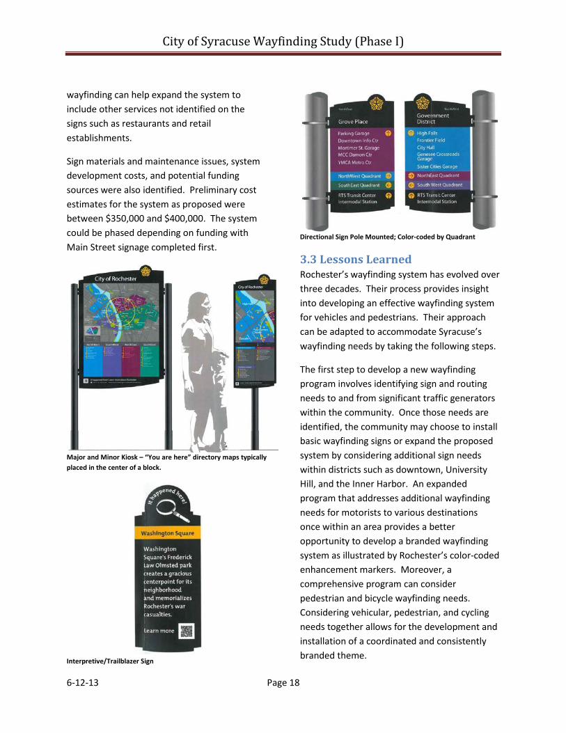
Designers estimated itemized costs and identified funding strategies for fabrication and installation. Rochester officials used input from the public to select the final design, Traditional, which is presented in the following graphics. Rochester identified five sign categories: major kiosk, minor kiosk, directional signage, midblock map, and interpretive/trailblazer. District logos were considered, but the design icons were too difficult to develop and agree upon.
Rochester established sign locations based on an evaluation and classification of pedestrian routes/corridors and destination locations. A sample journey and video were developed to aid in the analysis of sign locations the effectiveness of signage system and messages.
If desired, the signs could also incorporate digital wayfinding, such as interaction maps or QR codes, for use on mobile devices that expands upon the built sign system. Digital
City of Syracuse Wayfinding Study (Phase I)
6-12-13 Page 18
wayfinding can help expand the system to include other services not identified on the signs such as restaurants and retail establishments.
Sign materials and maintenance issues, system development costs, and potential funding sources were also identified. Preliminary cost estimates for the system as proposed were between $350,000 and $400,000. The system could be phased depending on funding with Main Street signage completed first.
Major and Minor Kiosk – “You are here” directory maps typically placed in the center of a block.
Interpretive/Trailblazer Sign
Directional Sign Pole Mounted; Color-coded by Quadrant
3.3 Lessons Learned Rochester’s wayfinding system has evolved over three decades. Their process provides insight into developing an effective wayfinding system for vehicles and pedestrians. Their approach can be adapted to accommodate Syracuse’s wayfinding needs by taking the following steps.
The first step to develop a new wayfinding program involves identifying sign and routing needs to and from significant traffic generators within the community. Once those needs are identified, the community may choose to install basic wayfinding signs or expand the proposed system by considering additional sign needs within districts such as downtown, University Hill, and the Inner Harbor. An expanded program that addresses additional wayfinding needs for motorists to various destinations once within an area provides a better opportunity to develop a branded wayfinding system as illustrated by Rochester’s color-coded enhancement markers. Moreover, a comprehensive program can consider pedestrian and bicycle wayfinding needs. Considering vehicular, pedestrian, and cycling needs together allows for the development and installation of a coordinated and consistently branded theme.
City of Syracuse Wayfinding Study (Phase I)
6-12-13 Page 19
4 - Regulatory Research There are different rules for wayfinding signs, guide signs, and gateway signs. Different rules also apply for different categories of roads. The SMTC summarized applicable rules and regulations for freeways (divided highways with full control of access) and conventional roads to help the Study Advisory Committee (SAC) identify appropriate destinations, routes, and sign needs. (See Appendix B for full definitions of road categories.)
4.1 Federal Guidance The 2009 Manual on Uniform Traffic Control Devices or MUTCD is published by the Federal Highway Administration (FHWA) under 23 Code of Federal Regulations (CFR), Part 655, Subpart F. The MUTCD defines minimum standards used by road managers nationwide to install, maintain, and ensure uniformity of signs on all public streets, highways, and private roads open to public traffic (FHWA 2009).8 All traffic control devices, including signs on roads open to public traffic, must comply with the MUTCD.
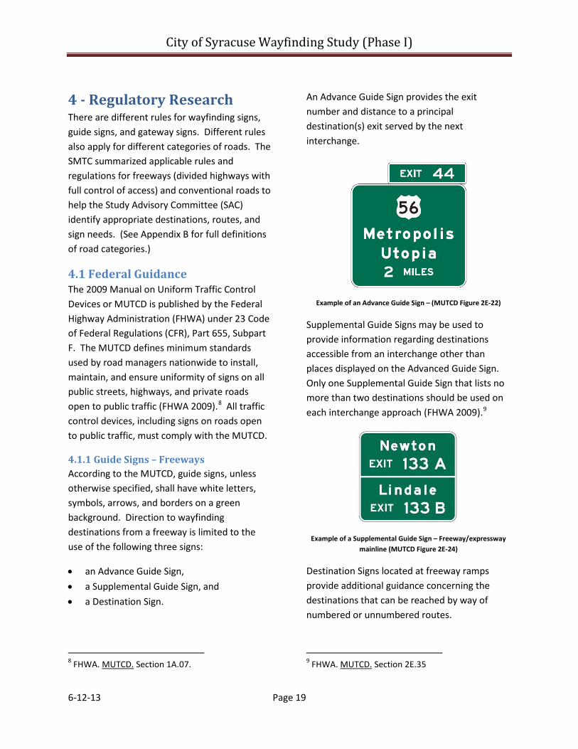
4.1.1 Guide Signs – Freeways According to the MUTCD, guide signs, unless otherwise specified, shall have white letters, symbols, arrows, and borders on a green background. Direction to wayfinding destinations from a freeway is limited to the use of the following three signs:
• an Advance Guide Sign, • a Supplemental Guide Sign, and • a Destination Sign.
8 FHWA. MUTCD. Section 1A.07.
An Advance Guide Sign provides the exit number and distance to a principal destination(s) exit served by the next interchange.
Example of an Advance Guide Sign – (MUTCD Figure 2E-22)
Supplemental Guide Signs may be used to provide information regarding destinations accessible from an interchange other than places displayed on the Advanced Guide Sign. Only one Supplemental Guide Sign that lists no more than two destinations should be used on each interchange approach (FHWA 2009).9
Example of a Supplemental Guide Sign – Freeway/expressway mainline (MUTCD Figure 2E-24)
Destination Signs located at freeway ramps provide additional guidance concerning the destinations that can be reached by way of numbered or unnumbered routes.
9 FHWA. MUTCD. Section 2E.35
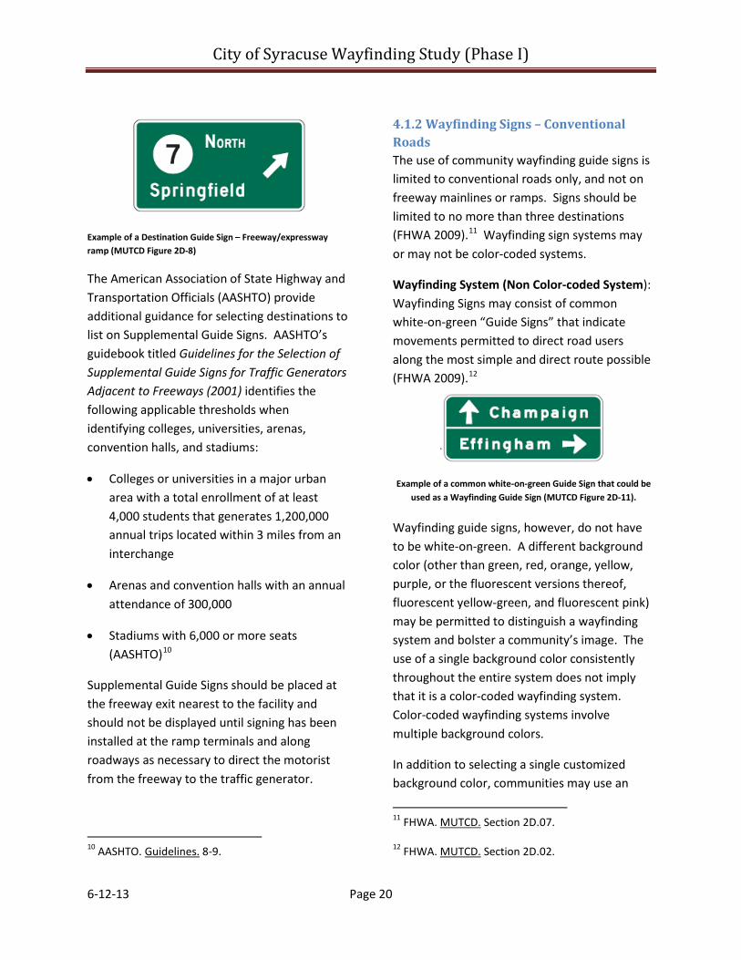
City of Syracuse Wayfinding Study (Phase I)
6-12-13 Page 20
Example of a Destination Guide Sign – Freeway/expressway ramp (MUTCD Figure 2D-8)
The American Association of State Highway and Transportation Officials (AASHTO) provide additional guidance for selecting destinations to list on Supplemental Guide Signs. AASHTO’s guidebook titled Guidelines for the Selection of Supplemental Guide Signs for Traffic Generators Adjacent to Freeways (2001) identifies the following applicable thresholds when identifying colleges, universities, arenas, convention halls, and stadiums:
• Colleges or universities in a major urban area with a total enrollment of at least 4,000 students that generates 1,200,000 annual trips located within 3 miles from an interchange
• Arenas and convention halls with an annual attendance of 300,000
• Stadiums with 6,000 or more seats (AASHTO)10
Supplemental Guide Signs should be placed at the freeway exit nearest to the facility and should not be displayed until signing has been installed at the ramp terminals and along roadways as necessary to direct the motorist from the freeway to the traffic generator.
10 AASHTO. Guidelines. 8-9.
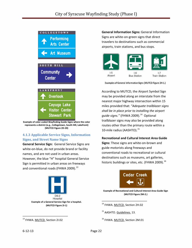
4.1.2 Wayfinding Signs – Conventional Roads The use of community wayfinding guide signs is limited to conventional roads only, and not on freeway mainlines or ramps. Signs should be limited to no more than three destinations (FHWA 2009).11 Wayfinding sign systems may or may not be color-coded systems.
Wayfinding System (Non Color-coded System): Wayfinding Signs may consist of common white-on-green “Guide Signs” that indicate movements permitted to direct road users along the most simple and direct route possible (FHWA 2009).12
Example of a common white-on-green Guide Sign that could be
used as a Wayfinding Guide Sign (MUTCD Figure 2D-11).
Wayfinding guide signs, however, do not have to be white-on-green. A different background color (other than green, red, orange, yellow, purple, or the fluorescent versions thereof, fluorescent yellow-green, and fluorescent pink) may be permitted to distinguish a wayfinding system and bolster a community’s image. The use of a single background color consistently throughout the entire system does not imply that it is a color-coded wayfinding system. Color-coded wayfinding systems involve multiple background colors.
In addition to selecting a single customized background color, communities may use an
11 FHWA. MUTCD. Section 2D.07.
12 FHWA. MUTCD. Section 2D.02.

City of Syracuse Wayfinding Study (Phase I)
6-12-13 Page 21
“enhancement marker” to help distinguish a wayfinding sign system. Enhancement markers are unique symbols used on a sign assembly that identify a neighborhood or geographical subarea. They should not be used to distinguish between different types of destinations.
Example of a Wayfinding Guide Sign using a different color
background and an Enhancement Marker (MUTCD Figure 2E-24)
Enhancement markers may use a graphic representation of an area, university or college, or a government-approved institution referred to as a pictograph. Pictographs shall be simple, dignified, and devoid of any advertising. When used to represent a political jurisdiction or a university, the pictograph shall be the official seal. Otherwise, when a symbol exists in the National MUTCD, it should be used. Business logos, commercial graphics, or other forms of advertising are not allowed on community wayfinding guide signs or sign assemblies.
Wayfinding System (Color-Coded): Similar to Rochester’s wayfinding system, communities have the option to use multiple background colors on wayfinding guide signs. A color-coded wayfinding sign system usually consists of the following types of signs:
• a General Information Sign, • a Destination Guide Sign, and
• a color-coded wayfinding sign. General Information Signs inform travelers of items such as city limits, landmarks, airports, train stations, and bus stops. General Information Signs shall have white legends and borders on green rectangular-shaped backgrounds. Gateway Signs at community entrances are considered an alternative to the MUTCD municipal boundary signs. (See Section 4.7.)
Example of a General Information Sign (MUTCD Figure 2D-20).
Destination Guide Signs are posted at the boundaries where color-coded community wayfinding signs are used. These signs must be white-on-green and should inform road users about the presence of wayfinding signing and identify the meanings of the various colors or pictographs.
Example of a Destination Guide Sign that explains the meaning of Colors (MUTCD Figure 2D-20).
The color represents a specific, identifiable neighborhood or geographical subarea, not different types of destinations.
City of Syracuse Wayfinding Study (Phase I)
6-12-13 Page 22
Example of color-coded Wayfinding Guide Signs where the color
represents a district (e.g., Collegetown, South Hill, Lakefront) (MUTCD Figure 2D-20)
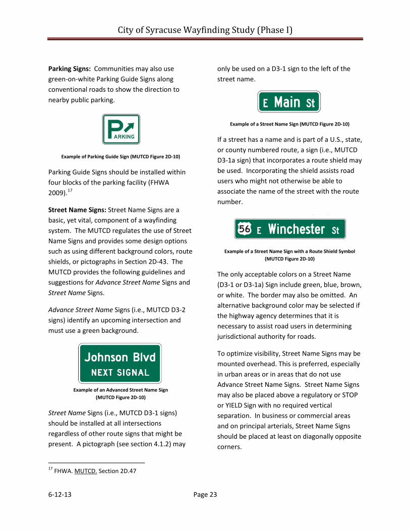
4.1.3 Applicable Service Signs, Information Signs, and Street Name Signs General Service Sign: General Service Signs are white-on-blue, do not provide brand or facility names, and are not used in urban areas. However, the blue “H” hospital General Service Sign is permitted in urban areas on freeways and conventional roads (FHWA 2009).13
Example of a General Service Sign for a hospital.
(MUTCD Figure 2I-1)
13 FHWA. MUTCD. Section 2I.02
General Information Signs: General Information Signs are white-on-green signs that direct travelers to destinations such as commercial airports, train stations, and bus stops.
According to MUTCD, the Airport Symbol Sign may be provided along an interstate from the nearest major highway intersection within 15 miles provided that: “Adequate trailblazer signs shall be in place prior to installing the airport guide signs.” (FHWA 2009).14 Optional trailblazer signs may also be provided along routes other than the primary route within a 10-mile radius (AASHTO).15
Recreational and Cultural Interest Area Guide Signs: These signs are white-on-brown and guide motorists along freeways and conventional roads to recreational or cultural destinations such as museums, art galleries, historic buildings or sites, etc. (FHWA 2009).16
Example of Recreational and Cultural Interest Area Guide Sign
(MUTCD Figure 2M-2.)
14 FHWA. MUTCD. Section 2H.02
15 AASHTO. Guidelines. 13.
16 FHWA. MUTCD. Section 2M.01
City of Syracuse Wayfinding Study (Phase I)
6-12-13 Page 23
Parking Signs: Communities may also use green-on-white Parking Guide Signs along conventional roads to show the direction to nearby public parking.
Example of Parking Guide Sign (MUTCD Figure 2D-10)
Parking Guide Signs should be installed within four blocks of the parking facility (FHWA 2009).17
Street Name Signs: Street Name Signs are a basic, yet vital, component of a wayfinding system. The MUTCD regulates the use of Street Name Signs and provides some design options such as using different background colors, route shields, or pictographs in Section 2D-43. The MUTCD provides the following guidelines and suggestions for Advance Street Name Signs and Street Name Signs.
Advance Street Name Signs (i.e., MUTCD D3-2 signs) identify an upcoming intersection and must use a green background.
Example of an Advanced Street Name Sign
(MUTCD Figure 2D-10)
Street Name Signs (i.e., MUTCD D3-1 signs) should be installed at all intersections regardless of other route signs that might be present. A pictograph (see section 4.1.2) may
17 FHWA. MUTCD. Section 2D.47
only be used on a D3-1 sign to the left of the street name.
Example of a Street Name Sign (MUTCD Figure 2D-10)
If a street has a name and is part of a U.S., state, or county numbered route, a sign (i.e., MUTCD D3-1a sign) that incorporates a route shield may be used. Incorporating the shield assists road users who might not otherwise be able to associate the name of the street with the route number.
Example of a Street Name Sign with a Route Shield Symbol (MUTCD Figure 2D-10)
The only acceptable colors on a Street Name (D3-1 or D3-1a) Sign include green, blue, brown, or white. The border may also be omitted. An alternative background color may be selected if the highway agency determines that it is necessary to assist road users in determining jurisdictional authority for roads.
To optimize visibility, Street Name Signs may be mounted overhead. This is preferred, especially in urban areas or in areas that do not use Advance Street Name Signs. Street Name Signs may also be placed above a regulatory or STOP or YIELD Sign with no required vertical separation. In business or commercial areas and on principal arterials, Street Name Signs should be placed at least on diagonally opposite corners.
City of Syracuse Wayfinding Study (Phase I)
6-12-13 Page 24
4.2 State Guidance The New York State Department of Transportation, the New York State Thruway Authority, and the New York State Highway Design Manual also provide additional rules and guidelines for wayfinding signs.
4.2.1 New York State Department of Transportation Supplement to the MUTCD (Signs Program) The State Administrative Procedures Act (SAPA) permits New York State to adopt a supplement to the MUTCD, referred to in short as the NYS Supplement. The NYS Supplement provides additional regulations that complement the MUTCD. Please see Appendix B for more information. The following bullets outline applicable rules and regulations pertaining to this study (NYSDOT Supplement 2009).18
• When possible, signs should be at least 200 feet apart. (Section 2A.16, O6A)
• Place Destination Signs 200 feet in advance of an intersection, and following a junction assembly. Where a second Destination Sign is used along an intersection approach to enable proper lane selection, it should be placed between 800 and 1400 feet in advance of the intersection (NYS Supplement 2B.40 Guidance 03B).
• Name auxiliary signs (e.g., “Crouse Hospital”) may supplement symbol signs (e.g., blue “H” hospital sign) and shall match colors. (NYS Supplement Section 2D.10)
18 NYSDOT. Supplement to the Manual on Uniform Traffic Control Devices for Streets and Highways – 2009 Edition. Dec. 2010, Effective March 16, 2011.
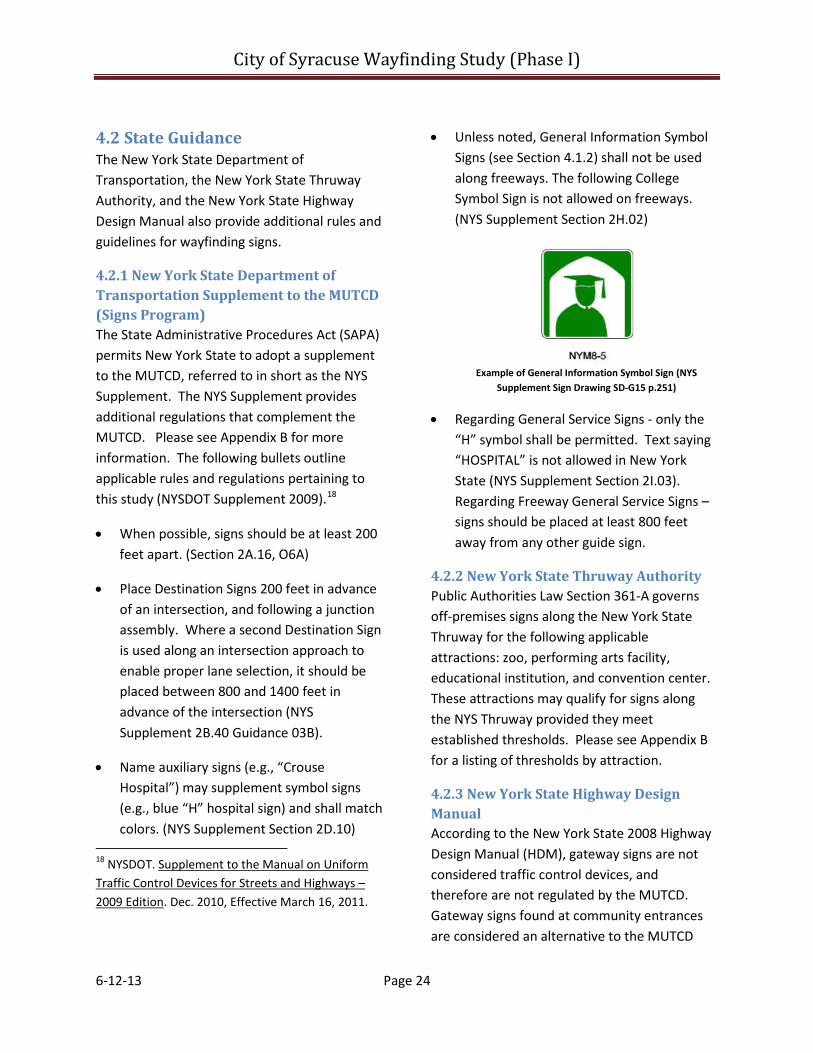
• Unless noted, General Information Symbol Signs (see Section 4.1.2) shall not be used along freeways. The following College Symbol Sign is not allowed on freeways. (NYS Supplement Section 2H.02)
Example of General Information Symbol Sign (NYS
Supplement Sign Drawing SD-G15 p.251)
• Regarding General Service Signs - only the “H” symbol shall be permitted. Text saying “HOSPITAL” is not allowed in New York State (NYS Supplement Section 2I.03). Regarding Freeway General Service Signs – signs should be placed at least 800 feet away from any other guide sign.
4.2.2 New York State Thruway Authority Public Authorities Law Section 361-A governs off-premises signs along the New York State Thruway for the following applicable attractions: zoo, performing arts facility, educational institution, and convention center. These attractions may qualify for signs along the NYS Thruway provided they meet established thresholds. Please see Appendix B for a listing of thresholds by attraction.
4.2.3 New York State Highway Design Manual According to the New York State 2008 Highway Design Manual (HDM), gateway signs are not considered traffic control devices, and therefore are not regulated by the MUTCD. Gateway signs found at community entrances are considered an alternative to the MUTCD
City of Syracuse Wayfinding Study (Phase I)
6-12-13 Page 25
municipal boundary signs. The HDM defines community gateway signs as:
“A non-commercial, civic-oriented sign that may contain a salutation (e.g., “WELCOME TO …”), the name of a community (e.g., “UTOPIA”) and/or a short slogan (e.g., A GREAT PLACE TO LIVE, WORK, AND PLAY)” (NYSDOT).19
The HDM also identifies two types of landscaping permitted at gateways: the first involves installing flowers, shrubs, etc. around a welcome sign; and the second involves spelling out the salutation with the landscaping.
Gateway signs and Landscaping may be allowed on most conventional roads and on certain controlled access highways, but not on interstates or freeways. Signs should not contain directional information, shall not exceed 32 square feet, and the maximum landscape size shall not exceed 144 square feet, 500 square feet if it imparts a welcome message (NYSDOT).20
4.3 Current NYSDOT Guide Sign Request Procedures The New York State Department of Transportation (NYSDOT) has sign review procedures for approving and installing signs along their roadways. The following summary outlines the NYSDOT sign review and approval process.
New York State Department of Transportation The NYSDOT will consider guide sign requests from major traffic generators such as hospitals or universities. The NYSDOT will review the 19 NYSDOT. HDM. 11B-3.
20 NYSDOT. HDM. 11B-3.
request to determine if it is appropriate to install signs and will notify the applicant in writing of its decision.
To initiate the process, an applicant submits a letter to the Regional Traffic Engineer in the Traffic Safety & Mobility Group. There is no official permit or application and the letter may simply state why and where the signs are requested. The Traffic Safety and Mobility Group will investigate to determine if signs are warranted. Upon a favorable determination, sign locations are chosen and text determined. The Design Group will develop sign face layouts for nonstandard signs. The Traffic Safety & Mobility Group will prepare a sign work order and sketch for the local Maintenance Residency showing sign locations and number required. The Maintenance Residency will submit sign face layouts to CorCraft for fabrication, and will coordinate with Dig Safely New York (DSNY) to check sign locations for utility interference. Large signs may be beyond the scope of maintenance forces to install and must be included in a future sign installation contract.
When the signs are received, the local maintenance residency will install the signs and document their final location in the sketch plan. The sketch plan will be available for future reference in the record file, but will not become part of an official inventory.
To conclude the process, the Regional Traffic Engineer notifies the applicant in writing of its final decision to install signs. Typically, the NYSDOT will install signs for public uses; however, private-sector applicants may be required to pay for the installation of signs if they are approved.
City of Syracuse Wayfinding Study (Phase I)
6-12-13 Page 26
4.4 Conclusions The MUTCD regulates signs and other traffic control devices to maintain standard practices, ensure consistency, and increase predictability from community to community across the United States.
Although many standard practices are put into place, there are very specific standards, rules, regulations, and guidelines that must be followed when considering wayfinding and guide sign needs. Such factors include, but are not necessarily limited to, the type of roadway (e.g., local road, interstate, ramps, etc.), surrounding land uses (e.g., urban vs. rural), and the type of destination (e.g., civic establishment, traffic generator, historic/cultural, etc.). Sign needs and placement needs vary from community to community.
The MUTCD permits using a single background color wayfinding system or a color-coded wayfinding system. A single background color system directs motorists to a destination from a freeway. A color-coded system directs motorists to a destination from the freeway and then provides information to other destinations located in the same district or in an adjacent district. A special color is assigned to denote each district.
In addition to national standards and guidelines established in the MUTCD, New York State and other authorities such as the New York State Thruway Authority establish supplemental rules and regulations that pertain to their facilities. These rules add another layer of regulations that must be followed when developing a wayfinding program that involves multiple facility owners (i.e., City of Syracuse, New York
State Thruway Authority, and the New York State Department of Transportation).

City of Syracuse Wayfinding Study (Phase I)
6-12-13 Page 27
5 - Origins, Destinations, Routes, and Existing Signs The SMTC worked with the Study Advisory Committee (SAC) and the Working Group to identify origins, destinations, and direct travel routes. To assist with identifying routes, the SMTC, the SAC, and the Working Group considered the sign needs identified in the local wayfinding studies reviewed by the SMTC.
5.1 Origins Origins include the New York State Thruway (NYS Thruway) and the interstates within the Metropolitan Planning Area.
5.2 Identification of Destinations The SMTC worked with the Study Advisory Committee (SAC) to select approximately six destinations based on the following subjective criteria. The SAC considered civic, cultural, and educational facilities, as well as transportation facilities and hospitals as potential destinations. Preference was given to public-oriented uses. Destinations that did not meet these initial criteria were removed from consideration.
The SAC determined that several of the possible destinations warrant further consideration beyond the scope of this study. These destinations include: the Carrier Dome, Alliance Bank Stadium, the Regional Market, the William Walsh Regional Transportation Center (RTC), and the Syracuse Inner Harbor. The SAC decided that these destinations warrant further assessment beyond the scope of this study for the following reasons:
• Special events at these destinations generate high volumes of traffic that require detailed assessment and study to
determine appropriate routes and wayfinding needs. Destinations such as the Carrier Dome also require consideration for a multi-modal wayfinding system that is beyond the scope of this study.
• Parking lots near the Carrier Dome are currently being redeveloped into student residence hall buildings.
• The Inner Harbor is slated to undergo a transformation given the City’s recent selection of COR Development Company, LLC to develop 28 acres.
• The RTC is home to train and bus services provided by Amtrak, Greyhound, MegaBus and Trailways. The complexity of directing visitors and service providers to and from the RTC requires special assessment that is beyond the scope of this study.
The Dinosaur Bar-B-Que and Destiny USA were removed from initial consideration because they are for-profit enterprises. The Museum of Science and Technology and the Landmark Theater were removed from consideration because they are located within Armory Square, which was selected as a destination. The SAC removed the Onondaga County Court House and Little Italy from consideration because they are perceived to generate less traffic than the other destinations. The next study (Phase II) could consider wayfinding needs to and from these destinations.
In consultation with the SAC, the SMTC identified fourteen destinations for final consideration. Although six were to be selected, the SAC requested that the SMTC consider wayfinding needs for all fourteen destinations identified in the Table 2.

City of Syracuse Wayfinding Study (Phase I)
6-12-13 Page 28
Table 2 – Destinations Selected for Wayfinding Improvements Destination Area Parking Location 1) Syracuse University University
Hill University Avenue Garage
2) State University of New York College of Environmental Science and Forestry
University Hill
Irving Avenue Garage/visitor lots on campus
3) State University of New York Upstate Medical University
University Hill
Upstate Visitor Parking Garage
4) Upstate University Hospital/ Upstate Golisano Children's Hospital (Not Community Hospital Campus)
University Hill
Upstate Visitor Parking Garage
5) Crouse Hospital University Hill
Crouse Parking Garage
6) Syracuse Veterans Administration Medical Center
University Hill
Veterans Medical Center Garage
7) The Oncenter (War Memorial, Civic Center, Convention Center)
Downtown Oncenter Surface Lot, Oncenter Garage
8) Clinton Square Downtown Garage and surface lot parking within walking distance
9) Armory Square Downtown Garage and surface lot parking within walking distance
10) Everson Museum Downtown Oncenter Surface Lot
11) Syracuse Hancock International Airport
Airport Airport Garage and Surface Lot
12) Rosamond Gifford Zoo at Burnet Park
Zoo Zoo Surface Lot
13) St. Joseph's Hospital Health Center
Downtown Hospital Garage on Union Avenue
14) Downtown Downtown Misc. street parking
The SMTC complied with the SAC’s request and considered opportunities for wayfinding improvement to these destinations. The destinations selected for this study are shown on Maps 2 to 8.
5.3 Identification of Routes Using the following route identification criteria in consultation with the SAC, the SMTC identified direct travel routes linking origins and destinations:
• directness of travel;
• ability to overlap travel paths as much as possible to and from a destination;
• prioritize using state routes over local roads;
• directions suggested on the destination’s web site, if available;
• the location of entrances into and exits out of visitor parking lots and garages;
• interstate on and off ramps within close proximity to each other;
• connections between I-81 and I-690 (A motorist traveling eastbound on I-690 cannot connect to I-81 north without traveling on local roads; nor can a motorist traveling southbound on I-81 connect directly to I-690 west. In addition, the ramp from I-690 west to I-81 south bypasses Exit 18 on I-81.);
• the location of one way streets; and
• vertical and horizontal sight lines.
After identifying possible routes, staff from the SMTC traveled all of the routes and made a few minor adjustments to account for traffic patterns, parking facility entrances and exits, and sight lines. The SMTC then confirmed suggested travel routes with destination representatives and the SAC.
5.4 Existing Wayfinding Signs along Suggested Travel Routes A full city-wide inventory of wayfinding signs was not conducted as part of this study. The SMTC inventoried existing guide and wayfinding signs on the New York State Thruway and the interstates within 15 miles of a destination. Staff also inventoried existing signs along the roadways identified as travel routes.
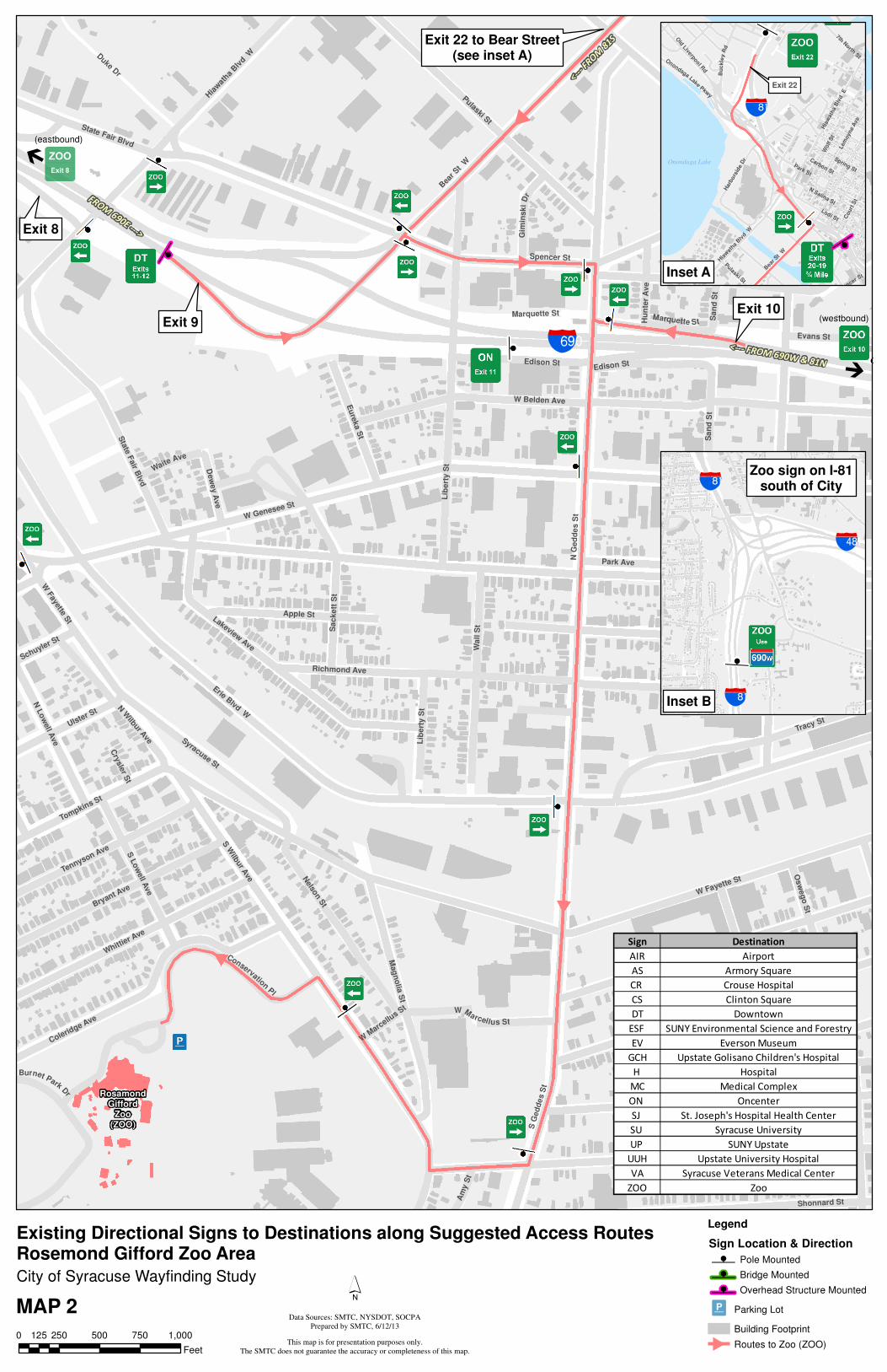
z
z
z
RosamondGifford
Zoo(ZOO)
badExit 9
Exit 10
Exit 22 to Bear Street(see inset A)
Å
Exit 8
#
(eastbound)
Å
(westbound)
<--- FROM 690W & 81N
<---FROM81S
FROM690E
--->
Park Ave
Erie Blvd W
W Genesee St
N G
ed
de
s S
t
W Fayette St
Van Rensselaer St
Spencer St
Lib
er t
y S
t
S W
ilbur A
ve
Seymour St
W Belden Ave
Otisco St
Richmond Ave
S G
ed
des S
t
Gifford St
Tracy St
Wa
l l S
t
Pulaski St
Bea
r St
W
Wilkinson St
Osw
eg
o S
t
Marcellus St
Hia
wat
ha Blv
d W
Whittier A
ve
Bryant Ave
Coleridge Ave
Lakeview Ave
Tully St
Nelso
n S
t
Mag
no
lia S
t
Apple St
Duke D
r
Sta
te F
air B
lvd
Sen
eca S
t
Syracuse St
W Kirkpatric
k St
Sa
cke
tt S
t
Ulster St
Tennyson Ave
Sa
nd
St
Edison St
Tompkins St
N L
ow
ell A
ve
On
tario
St
Eu
reka S
t
Shonnard St
N W
ilbur Ave
S L
ow
ell A
ve
Marquette St
ConservationPl
W Marcellus St
Burnet Park
Dr
Evans St
Gim
insk
iD
r
Matt
y A
ve
Schuyler St
Hu
nte
r A
ve
WaiteAve
Dew
ey A
ve
Am
y S
t
Parki n g Lot
Cry
sle
r St
Central Ave
Marquette St
State Fair Blvd
Un
nam
ed
Str
eet
Edison St
Lib
ert
y S
t
Sa
nd
St
Park Ave
W F
ayette St
W M
arcellu
s St
Barge Canal
Legend
Sign Location & Direction
z Pole Mounted
z Bridge Mounted
z Overhead Structure Mounted
Parking Lot
Building Footprint
Routes to Zoo (ZOO)z
z
encer St
Exit 22
bac
Wolf S
t
Park St
Lodi St
Bea
r St
W
N Salina St
Hia
wath
a B
lvd
E
Court
St
Carbon St
Spring St
Hia
wat
ha B
lvd W
Lem
oyne A
ve
Bu
ck
l ey
Rd
Harb
ors
ide D
r
OnondagaLake
Pkwy
Pulaski St
Old
Liverpoo
l Rd
7th North St
Onondaga Lake
0 250 500 750 1,000125
Feet
Inset A
City of Syracuse Wayfinding Study
Existing Directional Signs to Destinations along Suggested Access RoutesRosemond Gifford Zoo Area
z
z
bac
bac
baf
Inset B
Zoo sign on I-81south of City
MAP 2
Sign Destination
AIR Airport
AS Armory Square
CR Crouse Hospital
CS Clinton Square
DT Downtown
ESF SUNY Environmental Science and Forestry
EV Everson Museum
GCH Upstate Golisano Children's Hospital
H Hospital
MC Medical Complex
ON Oncenter
SJ St. Joseph's Hospital Health Center
SU Syracuse University
UP SUNY Upstate
UUH Upstate University Hospital
VA Syracuse Veterans Medical Center
ZOO Zoo
´
This map is for presentation purposes only.
The SMTC does not guarantee the accuracy or completeness of this map.
Data Sources: SMTC, NYSDOT, SOCPA
Prepared by SMTC, 6/12/13
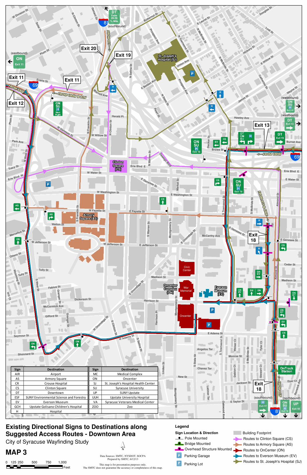
z
z
z
z
z zz
z
St. Joseph'sHospital (SJ)
ClintonSquare
(CS)
ArmorySquare (AS)
OncenterComplex
(ON)
EversonMuseum
(EV)
Exit 20
Exit 11Exit 11
Exit 13
Exit18
Gen
an
t Dr
Exit 19
Exit 12
CivicCenter
WarMemorial
Oncenter
bad
bac
bad
bacÀ À
À
À
Exit18
(southbound) (northbound)
À
(eastbound)
À
(westbound)
À
(westbound)
<--- FROM 690W & 81N
FROM690E
--->
FROM
81S--->
FROM
81S&690E--->
<--- FROM 690W
<-- -
FROM
81N
(southbound)
I 81
S S
tat e
St
S S
alin
a S
t
James S
t
S C
linto
n S
t
E Willo
w St
E Water St
S W
arr
en
St
N S
tate S
t
N S
alin
a S
t
E Fayette St
E Adams St
Cath
erin
e S
t
Harrison St
E Taylor St
Hickory S
t
N M
cB
ride S
t
N To
wnsend S
t
Lodi St
Alm
on
d S
t
Gifford St
E Washington St
E Laurel St
N F
ran
kli
n S
t
Burnet Ave
W Fayette St
W Genesee St
W Water St
Evans St
Pearl S
t
Erie Blvd E
Erie Blvd W
On
eid
a S
t
Plum St
Seymour St
Mo
ntg
om
ery
St
STo
wn
se
nd
St
Fabius St
Shonnard St
Walton St
W Taylor St
S M
cB
rid
e S
t
Hawley Ave
New St
Wyo
min
g S
t
Herald Pl
N C
linto
n S
t
Sola
r St
W Washington St
S F
r an
kl in
St
E Jefferson St
N W
est
St
Temple St
Union Ave
Madison St
Jackson St
King St
E Genesee St
Pro
spect A
ve
W Adams St
Li n
de
n S
t
Dickerson St
Midland A
ve
Wayne S
t
Dyer Ct
W Willow St
Tully St
Cedar St
Tyle
r C
t
Harr
iso
n P
l
WDivision St
N W
ar r
en
St
Gr a
ng
er S
t
Tracy St
Dab
lon
Ct
We
ise
r C
t
Douglas St
W Jefferson St
Park Ave
Otisco St
Browa St
Ste
wa
rt C
t
Mark
et
St
Ren
wic
k A
ve
Marcellus St
Onondaga P
l
Larned St
McCarthy Ave
Chavez Ter
Slocum A
ve
Marnell Ave
Latim
er T
er
McCormick Ave
Angelou Ter
So
uth
Av
e
Osw
ego B
lvd
O Oa ak kw w
o oo o
d dA A
v ve e
E Belden A
ve
Will C
t
Deck
er
St
Tully St
S T
ow
nse
nd
St
E Onondag
a St
Temple St
Erie Blvd E
W O
nondaga
St
Mo
ntg
om
ery
St
Plu
m S
t
Pro
spect A
ve
Monroe St
Al m
on
d S
t
E Genesee St
Mo
ntg
om
ery
St
N M
cB
ride S
t
N C
lin
t on
St
Madison St
W Jefferson St
S W
est S
t
EGenesee St
S M
cB
rid
e S
t
Buttern
ut St
Gra
ng
er S
t
E Onond
aga
St
City of Syracuse Wayfinding Study
MAP 3
Sign Destination Sign Destination
AIR Airport MC Medical Complex
AS Armory Square ON Oncenter
CR Crouse Hospital SJ St. Joseph's Hospital Health Center
CS Clinton Square SU Syracuse University
DT Downtown UP SUNY Upstate
ESF SUNY Environmental Science and Forestry UUH Upstate University Hospital
EV Everson Museum VA Syracuse Veterans Medical Center
GCH Upstate Golisano Children's Hospital ZOO Zoo
H Hospital
0 250 500 750 1,000125
Feet
Existing Directional Signs to Destinations alongSuggested Access Routes - Downtown Area
Legend
Sign Location & Direction
z Pole Mounted
z Bridge Mounted
z Overhead Structure Mounted
Parking Garage
Parking Lot
Building Footprint
Routes to Clinton Square (CS)
Routes to Armory Square (AS)
Routes to OnCenter (ON)
Routes to Everson Museum (EV)
Routes to St. Joseph's Hospital (SJ)
´
This map is for presentation purposes only.
The SMTC does not guarantee the accuracy or completeness of this map.
Data Sources: SMTC, NYSDOT, SOCPA
Prepared by SMTC, 6/12/13
z
z
z
z
z
zz
zz
zCrouseHospital
(CR)
GolisanoChildren'sHospital(GCH)
VA MedicalCenter
(VA)
SUNY-ESF(ESF)
SyracuseUniversity
(SU)
UniversityHospital
Exit 13
Exit18
Exit18
Exit 14 - Teall Ave to Erie Blvd(see inset)
bad
bac
Upstate Medical UniversityUpstate University Hospital
(UP/UUH)
WeiskottenHall
(various locations)
ÀÀ
<--- FROM 690W
FROM
690E&81S--->
<--- FROM 690W
<---
FROM
81N
(southbound) (northbound)
E Water St
Burnet Ave
Irv
ing
Ave
E Fayette St
E Adams St
Canal St
Ostro
m A
ve
Madison St
Co
msto
ck A
ve
Wa
lnu
t A
ve
S C
rou
se A
ve
Un
i vers
i ty A
ve
Harrison St
Hawley Ave
E Genesee St
Lodi St
Sims Dr
University Pl
S M
cB
ride S
t
Alm
on
d S
t
Burt St
Waverly Ave
Marshall St
Pin
e S
t
Oak
wo
od
Ave
S B
eec
h S
t
Re
nw
ick
Av
e
Wa
lnu
t P
l
E Taylor St
Cedar St
E Washington St
STow
nsen
dS
t
Sta
diu
m P
l Euclid Ave
Fo
rman
Ave
Hen
ry S
t
Co
lle
ge
Pl
N B
eec
h S
t
Fin
evie
w P
l
E Castle St
Ashworth Pl
Elm
St
Oak
St
C-D
Rd
Jackson St
Fo
r estr
y D
r
Van Buren St
N C
rou
se A
veN M
cB
rid
e S
t
Coms tock Pl
E Raynor Ave
Stratford StOakland St
N T
ow
ns
en
d S
t
Standart St
ThorndenPark
Dr
Dyer Ct
Ostra
m A
ve
Mount O
lympus
Dr
Rose Ave
Forestry Dr W
Manilla St
Math
er S
t
Wellington Pl
Dab
lon
Ct
We
ise
r C
t
Ho
wa
rd S
t
Ste
wa
rt C
t
Sm
ith
Dr
Browa St
Clarendon St
Orange Aly
Cro
ton
Ter
El i
zab
eth
Bla
ckw
ell S
t
Towers Ln
Dan
fort
h T
er
Sizer St
Grape Ter
E Raynor Ave
E Genesee St
E Washington St
Alm
on
d S
t
Erie Blvd E
E Genesee St
Monroe St
S M
cB
rid
e S
t
I rv
ing
Ave
S T
ow
nse
nd
St
Alm
on
d S
t
Ren
wic
k A
ve
Harrison St
Van Buren St
Legend
Sign Location & Direction
z Pole Mounted
z Bridge Mounted
z Overhead Structure Mounted
Parking Garage
Parking Lot
Building Footprints
Routes to University Hospital (UH/UUH/GCH)
Routes to Crouse Hospital (CR)
Routes to Syracuse University (SU)
Routes to VA Medical Center (VA)
Routes to SUNY-ESF (ESF)
Exit 14
badBurnet Ave
E Fayette St
Canal St
Te
all A
ve
Elm
St
Hawley Ave
E Genesee St
Erie Blvd E
Pin
e S
t
Waln
ut
Av
e
Ma
the
r St
Lexington Ave
E Water St
S B
ee
ch
St
Lombard Ave
Ma
ple
St
Win
ton
St
Al le
n S
t
Lynch St
Comstock Pl
Fa
irv
iew
Av
e
Erie Blvd E
Inset
City of Syracuse Wayfinding Study
MAP 4
0 250 500 750 1,000125
Feet
Existing Directional Signs to Destinations alongSuggested Access Routes - University Hill Area
Sign Destination
AIR Airport
AS Armory Square
CR Crouse Hospital
CS Clinton Square
DT Downtown
ESF SUNY Environmental Science and Forestry
EV Everson Museum
GCH Upstate Golisano Children's Hospital
H Hospital
MC Medical Complex
ON Oncenter
SJ St. Joseph's Hospital Health Center
SU Syracuse University
UP SUNY Upstate
UUH Upstate University Hospital
VA Syracuse Veterans Medical Center
ZOO Zoo
´
This map is for presentation purposes only.
The SMTC does not guarantee the accuracy or completeness of this map.
Data Sources: SMTC, NYSDOT, SOCPA
Prepared by SMTC, 6/12/13
RosamondGifford
Zoo(ZOO)
badExit 9
Exit 10
Kirkpatrick St to Court Stto Sunset Ave Ramp to I-81 N
(see inset)
Exit 8
bad
TO81N--->
<--- TO 690W
TO 690E & 81S --->
#
Park Ave
Erie Blvd W
W Genesee St
N G
ed
de
s S
t
W Fayette St
Van Rensselaer St
Spencer St
Lib
er t
y S
t
S W
ilbur A
ve
Seymour St
W Belden Ave
Otisco St
Richmond Ave
S G
ed
des S
t
Gifford St
Tracy St
Wa
l l S
t
Pulaski St
Bea
r St
W
Wilkinson St
Osw
eg
o S
t
Marcellus St
Hia
wat
ha Blv
d W
Whittier A
ve
Bryant Ave
Coleridge Ave
Lakeview Ave
Tully St
Nelso
n S
t
Mag
no
lia S
t
Apple St
Duke D
r
Sta
te F
air B
lvd
Sen
eca S
t
Syracuse St
W Kirkpatric
k St
Sa
cke
tt S
t
Ulster St
Tennyson Ave
Sa
nd
St
Edison St
Tompkins St
N L
ow
ell A
ve
On
tario
St
Eu
reka S
t
N W
ilbur Ave
S L
ow
ell A
ve
Marquette St
ConservationPl
W Marcellus St
Burnet Park
Dr
Evans St
Gim
insk
iD
r
Matt
y A
ve
Schuyler St
Hu
nte
r A
ve
WaiteAve
Dew
ey A
ve
Am
y S
t
Cry
sle
r St
Central Ave
State Fair Blvd
Edison St
Lib
ert
y S
t
Sa
nd
St
Park Ave
W F
ayette St
W M
arcellu
s St
Legend
Sign Location & Direction
z Pole Mounted
z Bridge Mounted
z Overhead Structure Mounted
Parking Lot
Building Footprint
Routes from Zoo (ZOO)
bacLodi St
Solar St
Genant Dr
N C
linton St
N S
tate
St
N S
alina S
t
Sunset Ave
Court
St
W C
ou
rt S
t
Danfo
rth S
t
Spencer St
Bea
r St
W
N Alvord St
Bear
St
Kir
kpatr
ick
St
WKirk
patrick
St
Union Pl
Barge Canal
Inset
City of Syracuse Wayfinding Study
MAP 5
0 250 500 750 1,000125
Feet
Existing Shield Signs from Destinations along Suggested Return RoutesRosemond Gifford Zoo Area
Sign Destination
AIR Airport
AS Armory Square
CR Crouse Hospital
CS Clinton Square
DT Downtown
ESF SUNY Environmental Science and Forestry
EV Everson Museum
GCH Upstate Golisano Children's Hospital
H Hospital
MC Medical Complex
ON Oncenter
SJ St. Joseph's Hospital Health Center
SU Syracuse University
UP SUNY Upstate
UUH Upstate University Hospital
VA Syracuse Veterans Medical Center
ZOO Zoo
´
This map is for presentation purposes only.
The SMTC does not guarantee the accuracy or completeness of this map.
Data Sources: SMTC, NYSDOT, SOCPA
Prepared by SMTC, 6/12/13
St. Joseph'sHospital (SJ)
ClintonSquare
(CS)
ArmorySquare (AS)
OncenterComplex
(ON)
EversonMuseum
(EV)
Exit 20
Exit 11
Exit 11
Exit 13
Exit18
Exit18
Gen
an
t Dr
Exit 19
Exit 12
CivicCenter
WarMemorial
Oncenter
bad
bac
bad
bac
TO81N--->
<--- TO 690 & 81S
TO81N--->
<--- TO 690 & 81S
<---TO
81N T
O81&690--->
TO 690E --->
<---TO81&690
TO81&690--->
TO81S-- ->
TO81N&690--->
TO 690E & 81S --->
<--- TO69
0W
<---TO
690
TO81--->
TO81--->
S S
tat e
St
S S
alin
a S
t
James S
t
S C
linto
n S
t
E Willo
w St
E Water St
S W
arr
en
St
N S
tate
St
N S
alin
a S
t
E Fayette St
E Adams St
Cath
erin
e S
t
Harrison St
E Taylor St
Hickory S
t
N M
cB
ride S
t
N To
wnsend S
t
Lodi St
Alm
on
d S
t
Gifford St
E Washington St
E Laurel St
N F
ran
kli
n S
t
Burnet Ave
W Fayette St
W Genesee St
W Water St
Evans St
Pearl S
t
Erie Blvd E
Erie Blvd W
On
eid
a S
t
Plum St
Seymour St
Mo
ntg
om
ery
St
STo
wn
se
nd
St
Fabius St
Shonnard St
Walton St
W Taylor St
S M
cB
rid
e S
t
Hawley Ave
New St
Wyo
min
g S
t
Herald Pl
N C
linto
n S
t
Sola
r St
W O
nondaga
St
W Washington St
S F
r an
kl in
St
E Jefferson St
N W
est
St
Temple St
Union Ave
Madison St
Jackson St
King St
E Genesee St
Pro
spect A
ve
W Adams St
Lin
de
n S
t
Dickerson St
Midland A
ve
Wayne S
t
Dyer Ct
Willow St
Tully St
Cedar St
Green S
t
Harr
iso
n P
l
WDivision St
N W
ar r
en
St
Gr a
ng
er S
t
Tracy St
Dab
lon
Ct
Douglas St
W Jefferson St
Park Ave
Otisco St
Browa St
Ste
wa
rt C
t
Mark
et
St
Ren
wic
k A
ve
Marcellus St
Onondaga P
l
Larned St
McCarthy Ave
Chavez Ter
Slocum A
ve
Latim
er T
er
McCormick Ave
So
uth
Av
e
Osw
ego B
lvd
L igh
tC
t
Oakw
oo
dA
ve
Fri
sb
ie C
t
Will C
t
Deck
er
St
Tully St
S T
ow
nse
nd
St
E Onondag
a St
Temple St
Erie Blvd E
W O
nondaga
St
Mo
ntg
om
ery
St
Plu
m S
t
Pro
spect A
ve
Monroe St
Al m
on
d S
t
E Genesee St
Mo
ntg
om
ery
St
N M
cB
ride S
t
N C
lin
t on
St
Madison St
W Jefferson St
S W
est S
t
EGenesee St
S M
cB
rid
e S
t
Buttern
ut St
Gra
ng
er S
t
E Onond
aga
St
City of Syracuse Wayfinding Study
Legend
Sign Location & Direction
z Pole Mounted
z Bridge Mounted
z Overhead Structure Mounted
Parking Garage
Parking Lot
Building Footprint
Routes from Clinton Square (CS)
Routes from Armory Square (AS)
Routes from OnCenter (ON)
Routes from Everson Museum (EV)
Routes from St. Joseph's Hospital (SJ)
MAP 6
Sign Destination
AIR Airport
AS Armory Square
CR Crouse Hospital
CS Clinton Square
DT Downtown
ESF SUNY Environmental Science and Forestry
EV Everson Museum
GCH Upstate Golisano Children's Hospital
H Hospital
MC Medical Complex
ON Oncenter
SJ St. Joseph's Hospital Health Center
SU Syracuse University
UP SUNY Upstate
UUH Upstate University Hospital
VA Syracuse Veterans Medical Center
ZOO Zoo
0 250 500 750 1,000125
Feet
Existing Shield Signs from Destinations alongSuggested Return Routes - Downtown Area
´
This map is for presentation purposes only.
The SMTC does not guarantee the accuracy or completeness of this map.
Data Sources: SMTC, NYSDOT, SOCPA
Prepared by SMTC, 6/12/13
CrouseHospital
(CR)
GolisanoChildren'sHospital(GCH)
VA MedicalCenter
(VA)
SUNY-ESF(ESF)
SyracuseUniversity
(SU)
UniversityHospital
Exit 13
Exit18
Exit18
Erie Blvd toTeall Aveto I-690
(see inset)
bad
bac
Upstate Medical UniversityUpstate University Hospital
(UP/UUH)
WeiskottenHall
(various locations)
Irv
ing
Ave
<---
TO690&81N
TO81S--->
<--- TO 690 & 81
TO690--->
E Water St
Burnet Ave
Irv
ing
Ave
E Fayette St
E Adams St
Canal St
Ostro
m A
ve
Madison St
Co
msto
ck A
ve
Wa
lnu
t A
ve
S C
rou
se A
ve
Un
i vers
i ty A
ve
Harrison St
Hawley Ave
E Genesee St
Lodi St
Sims Dr
University PlS M
cB
ride S
t
Burt St
Waverly Ave
Marshall St
Pin
e S
t
Oak
wo
od
Ave
S B
eec
h S
t
Re
nw
ick
Av
e
Wa
lnu
t P
l
E Taylor St
Cedar St
E Washington St
STo
wn
sen
dS
t
Sta
diu
m P
l Euclid Ave
Fo
rman
Ave
Hen
ry S
t
Co
lle
ge
Pl
N B
eec
h S
t
Fin
evie
w P
l
E Castle St
Ashworth Pl
Elm
St
Oak
St
C-D
Rd
Jackson St
Fo
r estr
y D
r
Van Buren St
N C
rou
se A
veN M
cB
rid
e S
t
Coms tock Pl
E Raynor Ave
Stratford StOakland St
N T
ow
ns
en
d S
t
Standart St
ThorndenPark
Dr
Dyer Ct
Ostra
m A
ve
Mount O
lympus
Dr
Rose Ave
Forestry Dr W
Manilla St
Math
er S
t
Wellington Pl
Dab
lon
Ct
We
ise
r C
t
Ho
wa
rd S
t
Ste
wa
rt C
t
Sm
ith
Dr
Browa St
Clarendon St
Orange Aly
Cro
ton
Ter
El i
zab
eth
Bla
ckw
ell S
t
Towers Ln
Dan
fort
h T
er
Sizer St
Grape Ter
E Raynor Ave
E Genesee St
E Washington St
Alm
on
d S
t
Erie Blvd E
E Genesee St
Monroe St
S M
cB
rid
e S
t
I rv
ing
Ave
S T
ow
nsen
d S
t
Al m
on
d S
t
Ren
wic
k A
ve
Harrison St
Van Buren St
Legend
Sign Location & Direction
z Pole Mounted
z Bridge Mounted
z Overhead Structure Mounted
Parking Garage
Parking Lot
Building Footprints
Routes from University Hospital (UP/UUH/GCH)
Routes from Crouse Hospital (CR)
Routes from Syracuse University (SU)
Routes from VA Medical Center (VA)
Routes from SUNY-ESF (ESF)
´
Exit 14
badBurnet Ave
E Fayette St
Canal St
Te
all A
ve
Elm
St
Hawley Ave
E Genesee St
Pin
e S
t
Waln
ut
Av
e
Ma
the
r St
Lexington Ave
E Water St
S B
ee
ch
St
Ma
ple
St
Win
ton
St
Erie Blvd E
Inset
City of Syracuse Wayfinding Study
MAP 7
Sign Destination
AIR Airport
AS Armory Square
CR Crouse Hospital
CS Clinton Square
DT Downtown
ESF SUNY Environmental Science and Forestry
EV Everson Museum
GCH Upstate Golisano Children's Hospital
H Hospital
MC Medical Complex
ON Oncenter
SJ St. Joseph's Hospital Health Center
SU Syracuse University
UP SUNY Upstate
UUH Upstate University Hospital
VA Syracuse Veterans Medical Center
ZOO Zoo
0 250 500 750 1,000125
Feet
Existing Shield Signs from Destinations alongSuggested Return Routes - University Hill Area
This map is for presentation purposes only.
The SMTC does not guarantee the accuracy or completeness of this map.
Data Sources: SMTC, NYSDOT, SOCPA
Prepared by SMTC, 6/12/13
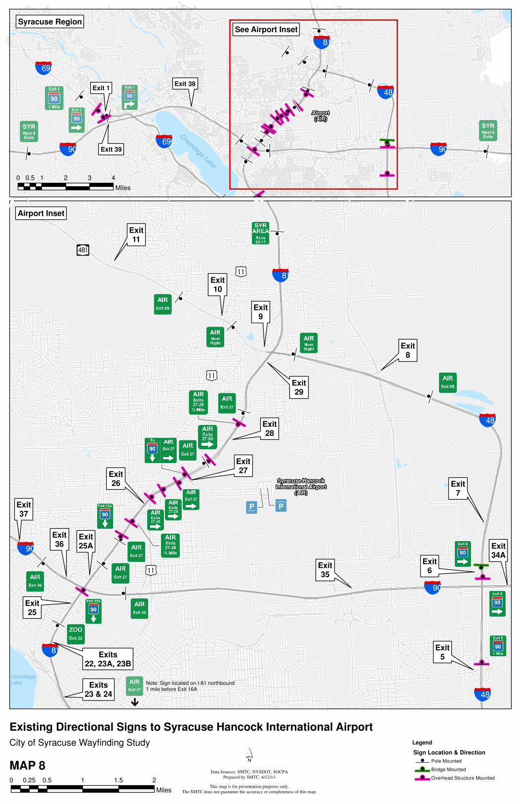
z
z
z
z
z
z
z
z
z
z
z
z
z
z
z
z
z
z
z
z
z
z
z
z
Syracuse HancockInternational Airport
(AIR)
bae
bac
bac
bae
baf
[Õ
baf
OnondagaLake
¡§
¡§
¡§
Exit9
Exit29
Exit10
Exit11
Exit8
Exit7
Exit6
Exit5
Exit28
Exit27Exit
26
Exit25A
Exit25
Exit36
Exits22, 23A, 23B
Exits23 & 24
Exit35
Exit34A
Exit37
À
Note: Sign located on I-81 northbound1 mile before Exit 16A
Legend
Sign Location & Direction
z Pole Mounted
z Bridge Mounted
z Overhead Structure Mounted0 0.5 1 1.5 20.25
Miles
Airport Inset
z
z
z
z
z
z
zzz
z
zz
z
zz
z
zz
z
z
z
z
z
z
z
z
z
z
zz
zz
z
bac
baf
baebae bad
bad
Onondaga Lake
Airport(AIR)
Exit 1
Exit 39
Exit 38
See Airport InsetSyracuse Region
0 1 2 3 40.5
Miles
City of Syracuse Wayfinding Study
MAP 8
Existing Directional Signs to Syracuse Hancock International Airport
´
This map is for presentation purposes only.
The SMTC does not guarantee the accuracy or completeness of this map.
Data Sources: SMTC, NYSDOT, SOCPA
Prepared by SMTC, 6/12/13

City of Syracuse Wayfinding Study (Phase I)
6-12-13 Page 29
Destinations, travel routes, and existing signs are shown on the signs on Maps 2 to 8. In some cases, the signs may include more information, such as other destinations, than what is indicated in the abbreviations shown on these maps. Photographs of signs are included in the electronic inventory developed by the SMTC.
In some cases, when traveling along the identified routes, staff observed destination signs that indicated an alternative travel route. When this occurred, staff traveled these routes and included any observed signs in the inventory.
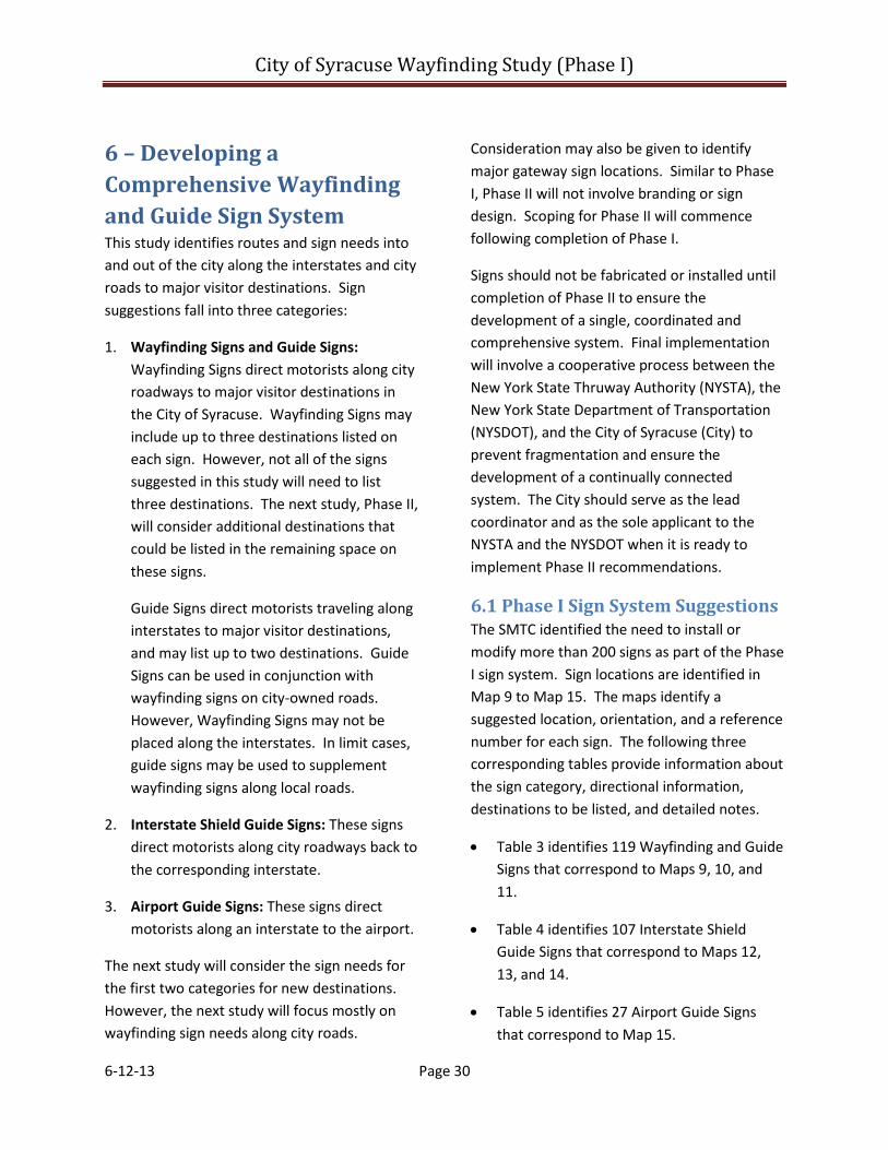
City of Syracuse Wayfinding Study (Phase I)
6-12-13 Page 30
6 – Developing a Comprehensive Wayfinding and Guide Sign System This study identifies routes and sign needs into and out of the city along the interstates and city roads to major visitor destinations. Sign suggestions fall into three categories:
1. Wayfinding Signs and Guide Signs: Wayfinding Signs direct motorists along city roadways to major visitor destinations in the City of Syracuse. Wayfinding Signs may include up to three destinations listed on each sign. However, not all of the signs suggested in this study will need to list three destinations. The next study, Phase II, will consider additional destinations that could be listed in the remaining space on these signs.
Guide Signs direct motorists traveling along interstates to major visitor destinations, and may list up to two destinations. Guide Signs can be used in conjunction with wayfinding signs on city-owned roads. However, Wayfinding Signs may not be placed along the interstates. In limit cases, guide signs may be used to supplement wayfinding signs along local roads.
2. Interstate Shield Guide Signs: These signs direct motorists along city roadways back to the corresponding interstate.
3. Airport Guide Signs: These signs direct motorists along an interstate to the airport.
The next study will consider the sign needs for the first two categories for new destinations. However, the next study will focus mostly on wayfinding sign needs along city roads.
Consideration may also be given to identify major gateway sign locations. Similar to Phase I, Phase II will not involve branding or sign design. Scoping for Phase II will commence following completion of Phase I.
Signs should not be fabricated or installed until completion of Phase II to ensure the development of a single, coordinated and comprehensive system. Final implementation will involve a cooperative process between the New York State Thruway Authority (NYSTA), the New York State Department of Transportation (NYSDOT), and the City of Syracuse (City) to prevent fragmentation and ensure the development of a continually connected system. The City should serve as the lead coordinator and as the sole applicant to the NYSTA and the NYSDOT when it is ready to implement Phase II recommendations.
6.1 Phase I Sign System Suggestions The SMTC identified the need to install or modify more than 200 signs as part of the Phase I sign system. Sign locations are identified in Map 9 to Map 15. The maps identify a suggested location, orientation, and a reference number for each sign. The following three corresponding tables provide information about the sign category, directional information, destinations to be listed, and detailed notes.
• Table 3 identifies 119 Wayfinding and Guide Signs that correspond to Maps 9, 10, and 11.
• Table 4 identifies 107 Interstate Shield Guide Signs that correspond to Maps 12, 13, and 14.
• Table 5 identifies 27 Airport Guide Signs that correspond to Map 15.
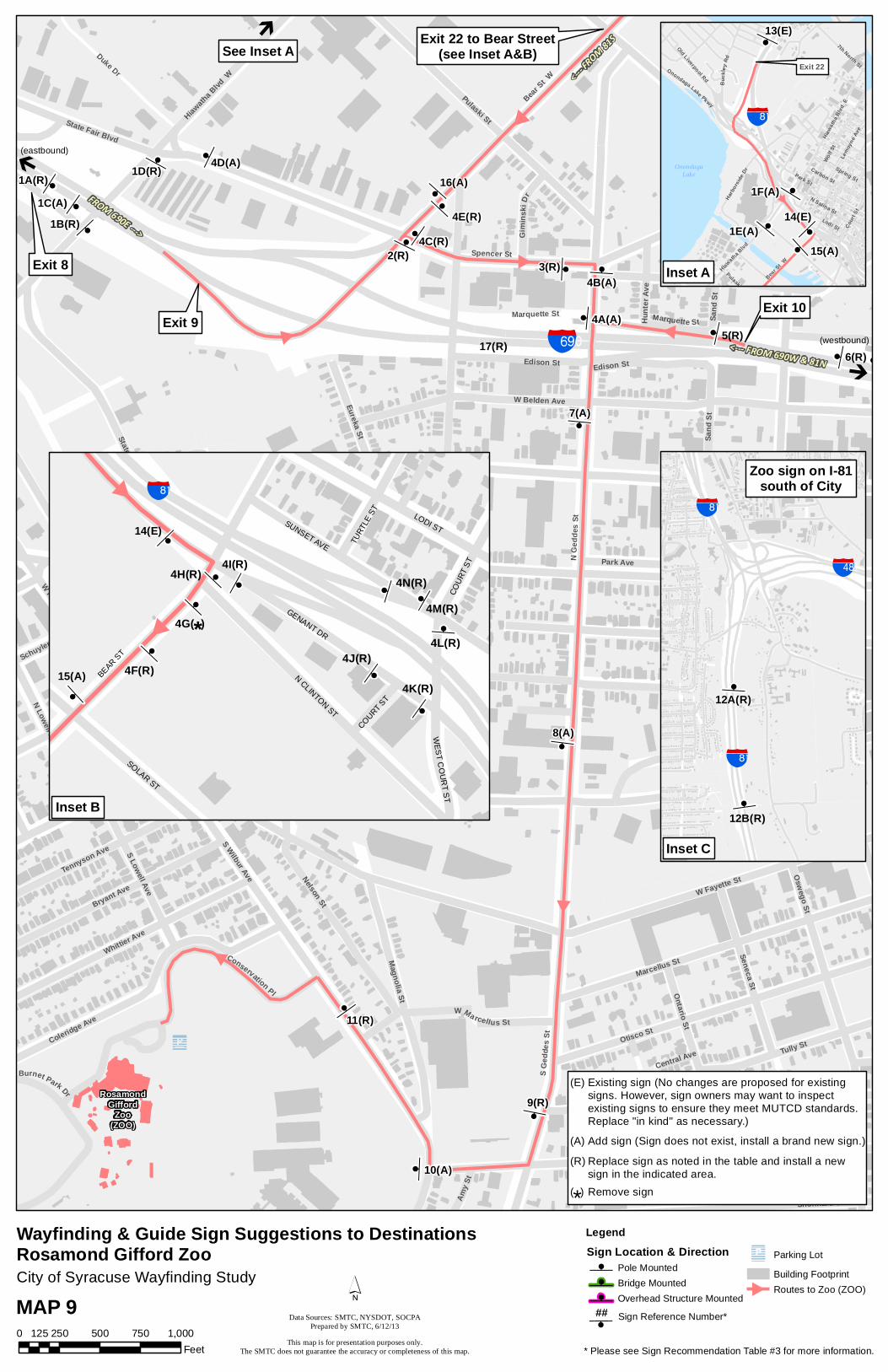
z
z
z
z
z
z
z
z
z
z
z
z
z
z
z
z
z
zzz
RosamondGifford
Zoo(ZOO)
badExit 9
Exit 10
Exit 22 to Bear Street(see Inset A&B)
zÅ
Exit 8
#
(eastbound)
Å
(westbound)<--- FROM 690W & 81N
<--- FROM 81S
FROM 690E --->
1A(R)
z6(R)
See Inset A
Å
4E(R)
Park Ave
Erie Blvd W
W Genesee St
N Ge
ddes
St
W Fayette St
Van Rensselaer St
Spencer St
Libert
y St
S Wilbur Ave
Seymour St
W Belden Ave
Otisco St
Richmond Ave
S Ged
des S
t
Gifford St
Tracy St
Wall S
t
Pulaski St
Bear St W
Wilkinson St
Oswego St
Marcellus St
Hiawath
a Blvd
W
Whittier Ave
Bryant Ave
Coleridge Ave
Lakeview Ave
Tully St
Nelson St
Magnolia St
Apple St
Duke Dr
State Fair Blvd
Seneca St
Syracuse St
W Kirkpatrick St
Sack
ett St
Ulster St
Tennyson Ave
Sand
St
Edison St
Tompkins St
N Lowell Ave
Ontario St
Eureka St
Shonnard St
N Wilbur Ave
S Lowell Ave
Marquette St
Conservation PlW Marcellus St
Burnet Park Dr
Gim i
n sk i
Dr
Matty
Ave
Schuyler StHu
nter
Ave
Waite Ave
Dewey Ave
Amy S
t
Parki n g Lot
Crysler St
Central Ave
Marquette St
State Fair Blvd
Unna
med S
treet
Edison St
Libert
y St
Sand
St
Park Ave
W Fayette St
17(R)5(R)
11(R)
1B(R)
1D(R)
2(R)
16(A)
3(R)
4A(A)
7(A)
8(A)
9(R)
10(A)
1C(A)
4B(A)
4C(R)
4D(A)
BargeCanal
LegendSign Location & Directionz Pole Mounted
z Bridge Mounted
z Overhead Structure Mounted
Parking Lot
Building FootprintRoutes to Zoo (ZOO)
zz
z
z zz
z
z
z
Spencer St
Exit 22
bac
z
Wolf St
Park St
Lodi St
Bear St W
N Salina St
Hiawa
tha Bl
vd E
Court
St
Carbon St
Spring St
Hiawatha Blvd
Lemoy
ne Av
e
B uc k
l eyRd
Harbo
rside
Dr
Onondaga Lake Pkwy
Pulaski St
Old Liverpool Rd
7th North St
13(E)
14(E)
15(A)1E(A)
1F(A)
OnondagaLake
Inset A
City of Syracuse Wayfinding Study
z
z
bac
bac
baf
12A(R)
12B(R)
Inset C
Zoo sign on I-81south of City
z## Sign Reference Number*MAP 90 250 500 750 1,000125
Feet
Wayfinding & Guide Sign Suggestions to DestinationsRosamond Gifford Zoo
z
z
z
zz z
z
z
z
zz
bac
4G( )*
14(E)
15(A)
##
N CLINTON ST
SUNSET AVE
GENANT DR
LODI ST
SOLAR ST
BEAR ST
COU
RT S
T
WES
T CO
UR
T ST
COURT ST
TURT
LE S
T
4F(R)
4H(R) 4I(R)
4J(R)
4K(R)
4L(R)
4M(R)4N(R)
Inset B
* Please see Sign Recommendation Table #3 for more information.
Existing sign (No changes are proposed for existingsigns. However, sign owners may want to inspectexisting signs to ensure they meet MUTCD standards.Replace "in kind" as necessary.)
(E)
Add sign (Sign does not exist, install a brand new sign.)(A)
Replace sign as noted in the table and install a newsign in the indicated area.
(R)
Remove sign( )*
´This map is for presentation purposes only.
The SMTC does not guarantee the accuracy or completeness of this map.
Data Sources: SMTC, NYSDOT, SOCPAPrepared by SMTC, 6/12/13
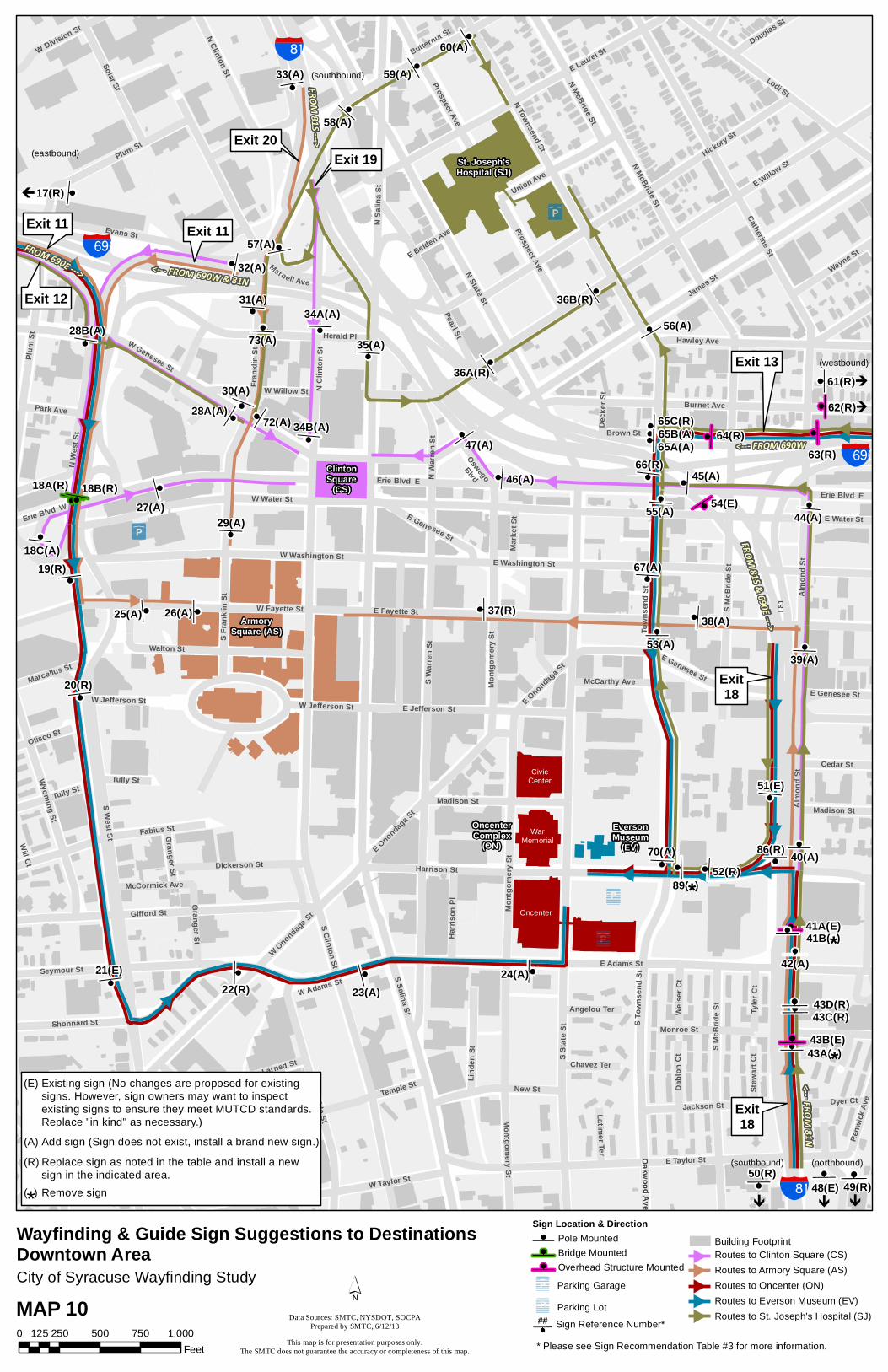
z
z
z zz
z
zzz
z
z
z
z
z z
z
z
z
z
z
z
zz
z
z z
z
z
z
z
z
zz
z
z
z
z
z
z
z
z
z
z
z
z
z z
z
z
z
z
zzz
z
z
z
St. Joseph'sHospital (SJ)
VA
CR
GCH
ClintonSquare
(CS)
ArmorySquare (AS)
OncenterComplex
(ON)EversonMuseum
(EV)
Exit 20
Exit 11 Exit 11
Exit 13
Exit18
Exit 19
Exit 12
CivicCenter
WarMemorial
Oncenter
bad
bac
bad
bacÀ À
z
À
Exit18
(southbound) (northbound)
À
(eastbound)
À
(westbound)
<--- FROM 690W & 81N
FROM 690E --->
FROM81S -- - >
FROM81S & 690E --->
<--- FROM 690W
<-- -F ROM8 1N
(southbound)
50(R) z48(E)z49(R)
45(A)
z62(R)
Àz61(R)
z
17(R)
zzz
43B(E)43C(R)43D(R)
65B(A)65C(R)
zz
86(R)
18B(R)
18C(A)
89( )*41B( )*
43A( )*
I 81
S Stat
e St
S Salina St
James St
S Clinton St
E Willow St
E Water St
S War
ren St
N State St
N Sa
lina S
t
E Fayette St
E Adams St
Catherine St
Harrison St
E Taylor St
Hickory St
N McBride St
N Townsend St
Lodi St
Almo
nd St
Gifford St
E Washington St
E Laurel St
Fran
klin S
t
Burnet Ave
W Fayette St
W Genesee St
W Water St
Evans St
Pearl St
Erie Blvd E
Erie Blvd W
Oneida St
Plum St
Seymour St
Montg
omery
St
S To w
n sen
dSt
Fabius St
Shonnard St
Walton St
W Taylor St
S McB
ride S
t
Hawley Ave
New St
Wyoming St
Herald Pl
N Clinton St
Solar St
W Washington St
S Fran
klin S
t
E Jefferson St
N We
st St
Temple St
Union Ave
Madison St
Jackson St
King St
E Genesee St
Prospect Ave
W Adams St
Linde
n St
Dickerson St
Midland Ave
Wayne St
Dyer Ct
W Willow St
Tully St
Cedar StTy
ler C
t
Harri
son P
l
W Division St
N Wa
rren S
t
Granger StDa
blon C
tWe
iser C
t
Douglas St
W Jefferson St
Park Ave
Otisco St
Brown St
Stew
art C
t
Mark
et St
Renw
ick Av
e
Marcellus St
Onondaga Pl
Larned St
McCarthy Ave
Chavez Ter
Slocum Ave
Marnell AveLatimer Ter
McCormick Ave
Angelou Ter
South Ave
Oswego
Blvd
O Oa ak kw wo oo od dA Av ve eE Belden Ave
Will Ct
Deck
er St
Tully St
Town
send
St
E Onondaga S
t
Temple St
Erie Blvd E
W Onondaga St
Montg
omery
St
Plum
St
Prospect Ave
Monroe St
Almo
nd St
E Genesee St
Montgomery St
N McBride St
N Cl
inton
St
Madison St
W Jefferson St
S West St
E Genesee St
S McB
ride S
t
Butternut St
Granger St
E Onondaga S
t
25(A)
20(R)
21(E)22(R)
41A(E)
42(A)
37(R)
51(E)
18A(R)
19(R)
23(A)24(A)
26(A)
27(A)
28A(A)
28B(A)
29(A)
30(A)
31(A)34A(A)
34B(A)
35(A)
36A(R)
36B(R)
38(A)
39(A)
40(A)
44(A)
46(A)
47(A)
52(R)
53(A)
55(A)
57(A)
58(A)
59(A)
60(A)
66(R)
67(A)
70(A)
72(A)
73(A)56(A)
65A(A)
54(E)
63(R)64(R)
32(A)
33(A)
City of Syracuse Wayfinding Study
MAP 100 250 500 750 1,000125
Feet
Wayfinding & Guide Sign Suggestions to DestinationsDowntown Area
Existing sign (No changes are proposed for existingsigns. However, sign owners may want to inspectexisting signs to ensure they meet MUTCD standards.Replace "in kind" as necessary.)
(E)
Add sign (Sign does not exist, install a brand new sign.)(A)
Replace sign as noted in the table and install a newsign in the indicated area.
(R)
Remove sign( )*
* Please see Sign Recommendation Table #3 for more information.
Routes to Clinton Square (CS)Routes to Armory Square (AS)Routes to Oncenter (ON)Routes to Everson Museum (EV)Routes to St. Joseph's Hospital (SJ)
Sign Location & Directionz Pole Mounted
z Bridge Mounted
z Overhead Structure Mounted
Parking Garage
Parking Lot
Building Footprint
Sign Reference Number*z##
´This map is for presentation purposes only.
The SMTC does not guarantee the accuracy or completeness of this map.
Data Sources: SMTC, NYSDOT, SOCPAPrepared by SMTC, 6/12/13

z
zz
z
z
zz
z
z
z
z
z
z
z
zz z z
z
zz
zzzz
z
OnCenterComplex
(ON)
CrouseHospital
(CR)
GolisanoChildren'sHospital(GCH)
VA MedicalCenter
(VA)
SUNY-ESF(ESF)
SyracuseUniversity
(SU)
UniversityHospital
Exit 13
Exit18
Exit18
Exit 14 - Teall Ave to Erie Blvd(see inset)
bad
bac
Upstate Medical UniversityUpstate University Hospital
(UP/UUH)
WeiskottenHall
(various locations)
ÀÀ
<--- FROM 690W
FROM690E & 81S--->
<--- FROM 690W
<---FR OM81N
(southbound) (northbound)
Brown St
z50(R)z49(R)
43C(R)
71(R)
65A(A)
zz
65B(A)65C(R)
70(A)
z
z
66(R)
67(A)
43A( )*
87( )*
E Water St
Burnet Ave
Irving
Ave
E Fayette St
E Adams St
Canal St
Ostrom Ave
Madison St
Comstock Ave
Walnu
t Ave
S Cro
use A
ve
Unive
rsity
Ave
Harrison St
Hawley Ave
E Genesee St
Lodi St
Sims Dr
University Pl
S McBride St
Almo
nd St
Burt St
Waverly Ave
Marshall St
Pine S
t
Oakwood AveS B
eech
St
Ren w
i ckA v
e
Walnu
t Pl
E Taylor St
Cedar St
E Washington St
S Town
send
S t
Stadium Pl Euclid Ave
Form
an Av
e
Henry St
Colle
ge Pl
N Be
ech S
t
Finev
iew P
l
E Castle St
Ashworth Pl
Livingston Ave
Elm St
Oak S
t
C-D
Rd
Jackson St
Fore
stry D
r
Van Buren St
N Cr
ouse
Ave
N Mc
Bride
St
Comstock Pl
E Raynor Ave
Stratford StOakland St
N To
wnse
nd S
t
Standart St
Thornden Park Dr
Dyer Ct
Ostram Ave
Mount Olympus Dr
Rose Ave
Forestry Dr W
Manilla St
Mather St
Wellington Pl
Dablo
n Ct
Weise
r Ct
Howa
rd St
Stew
art C
t
Smith
Dr
Clarendon St
Orange Aly
Croto
n Ter
Eliza
beth
Blac
kwell
St
Towers Ln
Danf
orth
Ter
Sizer StGrape Ter
E Raynor Ave
E Genesee St
E Washington St
Almo
nd St
Erie Blvd E
E Genesee St
Monroe St
S McB
ride S
t
Irving
Ave
S Tow
nsen
d St
Almo
nd St
Renw
ick Av
e
Harrison St
Van Buren St
80(R)
84(R)
43B(E)
88(R)
90(R)
85A(R)
43D(R)
79(A)
81(R)82(R)
83(A)
85B(R)
54(E)
48(E)
61(R)62(R)
63(R)64(R)
Sign Location & Directionz Pole Mounted
z Bridge Mounted
z Overhead Structure Mounted
Parking Garage
Parking Lot
Building FootprintsRoutes to University Hospital (UH/UUH/GCH)
Routes to Crouse Hospital (CR)Routes to Syracuse University (SU)Routes to VA Medical Center (VA)
Routes to SUNY-ESF (ESF)
0 250 500 750 1,000125Feet
z
z
zz
z
zz
Exit 14
bad79(A)
Burnet Ave
E Fayette St
Canal St Teall
Ave
Elm St
Hawley Ave
E Genesee St
Erie Blvd E
Pine S
t
Walnu
t Ave
Mather St
Lexington Ave
E Water St
S Bee
ch S
t
Lombard Ave
Maple
St
Winto
n St
Allen St
Lynch St
Comstock Pl
Fairv
iew Av
e
Erie Blvd E
76(A)
77(A)78(A)
74(A)
75(A)
Inset
City of Syracuse Wayfinding Study
Wayfinding & Guide Sign Suggestions to DestinationsUniversity Hill Area
* Please see Sign Recommendation Table #3 for more information.
Sign Reference Number*z##MAP 11
Existing sign (No changes are proposed for existingsigns. However, sign owners may want to inspectexisting signs to ensure they meet MUTCD standards.Replace "in kind" as necessary.)
(E)
Add sign (Sign does not exist, install a brand new sign.)(A)
Replace sign as noted in the table and install a newsign in the indicated area.
(R)
Remove sign( )*
´This map is for presentation purposes only.
The SMTC does not guarantee the accuracy or completeness of this map.
Data Sources: SMTC, NYSDOT, SOCPAPrepared by SMTC, 6/12/13

Sign No.
Type Destination 1D1 Arrow Direction/
TextDestination 2
D2 Arrow Direction/
TextDestination 3
D3 Arrow Direction/
Text
Collocate Guide Sign
Arrow Direction/
Text
Replace, Add,
Remove
Responsible Agency
NOTES* (*When "replacing" local guide signs with wayfinding signs ‐ please note the suggested placement of new wayfinding sign on the corresponding map. The new sign is not always suggested to be replaced in the same location.
1ASupplemental Guide Sign
Destiny USA Exit 8 Rosamond Gifford Zoo Exit 8
Bus & Train Station,
Watertown/ Syracuse Airport
Exit 9 * * Replace NYSDOTOverlay "Watertown" with "Watertown, Syracuse Airport" Exit 9. Recommendations for this sign are also mentioned in the Airport Sign Recommendations Table ‐ please cross reference Sign B3 in that table.
1B Wayfinding Zoo Left * * * * Airport (I‐5) Left Replace City Remove existing Zoo guide sign and install new Wayfinding Sign. Co‐locate Airport I‐5 Sign. If space exists during Phase II, add Zoo with left arrow.
1C Supplemental Guide Sign
* * * * * * * * N/A NYSDOT Sign does not exist. Sign (previously recommended) is not required at this time. No further action is required.
1D Wayfinding Zoo Right * * * * Airport (I‐5) Up Replace City Remove existing Zoo guide sign and install new Wayfinding Sign. Co‐locate Airport I‐5 Sign with arrow pointing up. If space exists during Phase II, add Zoo with right arrow.
1E Wayfinding * * * * * * Airport (I‐5) Use I‐81 North
Add City Add Airport I‐5 sign to future Wayfinding Sign. Possibly include text saying "Next Left"
1F Wayfinding * * * * * * Airport (I‐5) Left Add City Add Airport I‐5 sign to future wayfinding sign in the median.
2 Wayfinding Zoo Right * * * * Airport (I‐5) Up Replace City Remove existing Zoo guide sign and install new Wayfinding Sign.
3 Wayfinding Zoo Right * * * * * * Replace City Remove existing Zoo guide sign at southwest corner of Geddes Street and Spencer Street. Place new wayfinding sign in advance of intersection peMUTCD guidelines.
4A Wayfinding Zoo Left * * * * Airport (I‐5) Right Add City No existing sign. Install a wayfinding sign. Add Airport I‐5 sign to future Wayfinding Sign with directional arrow to the right.
4B Wayfinding * * * * * * Airport (I‐5) Left Add City No existing sign. Install a wayfinding sign. Add Airport I‐5 sign to future Wayfinding Sign with directional arrow to the left.
4CExisting Interstate
Shield Sign Assembly
* * * * * * Airport (I‐5) Right Replace NYSDOTCollocate Airport I‐5 sign with a right arrow to existing Interstate Shield Sign Assembly. (Reference Table 4 Sign 13A for additional recommendations.)
4D Wayfinding * * * * * * * * Add City Sign does not exist. Sign (previously recommended) is not required at this time. No further action is required.
4EExisting Interstate
Shield Sign Assembly
* * * * * * Airport (I‐5) Up Replace NYSDOTCollocate Airport I‐5 sign with a up arrow to existing Interstate Shield Sign Assembly. (Reference Table 4 Sign 13B for additional recommendations.)
4FExisting Interstate
Shield Sign Assembly
* * * * * * Airport (I‐5) Up Replace NYSDOTCollocate Airport I‐5 sign with a up arrow to existing Interstate Shield Sign Assembly. (Reference Table 4 Sign 13C for additional recommendations.)
4GExisting Interstate
Shield Sign Assembly
* * * * * * * * Remove NYSDOT See Table 4 sign 13D. Recommendation is to remove this sign assembly.
4HExisting Interstate
Shield Sign Assembly
* * * * * * Airport (I‐5) Right Replace NYSDOT Add Airport I‐5 sign to existing interstate shield sign assembly with a right arrow. See Table 5 sign 13E for additional recommendations.
4IExisting Interstate
Shield Sign Assembly
* * * * * * Airport (I‐5) Up Replace NYSDOT Add Airport I‐5 sign to existing interstate shield sign assembly with a up arrow. See Table 4 sign 13F for additional recommendations.
4JExisting Interstate
Shield Sign Assembly
* * * * * * Airport (I‐5) Up Replace NYSDOT Add Airport I‐5 sign to existing interstate shield sign assembly with a up arrow. See Table 4 sign 13G for additional recommendations.
4KExisting Interstate
Shield Sign Assembly
* * * * * * Airport (I‐5) Left Replace NYSDOT Add Airport I‐5 sign to existing interstate shield sign assembly with a left arrow. See Table 4 sign 13H for additional recommendations.
4LExisting Interstate
Shield Sign Assembly
* * * * * * Airport (I‐5) Left Replace NYSDOT Add Airport I‐5 sign to existing interstate shield sign assembly with a left arrow. See Table 4 sign 10 for additional recommendations.
4MExisting Interstate
Shield Sign Assembly
* * * * * * Airport (I‐5) Left Replace NYSDOT Add Airport I‐5 sign to existing interstate shield sign assembly with a left arrow. See Table 4 sign 11 for additional recommendations.
4NExisting Interstate
Shield Sign Assembly
* * * * * * Airport (I‐5) Left Replace NYSDOT Add Airport I‐5 sign to existing interstate shield sign assembly with a left arrow. See Table 4 sign 12 for additional recommendations.
5General
Information Guide Sign
Zoo Left Airport Right N/A N/A N/A N/A Replace NYSDOT Replace existing guide sign to now read "Zoo" with a left arrow, and "Airport" with a right arrow.
6 Supplemental Guide Sign
Zoo Exit 10 Airport Exit 10 N/A N/A N/A N/A Replace NYSDOT Replace existing pole‐mounted guide sign so that it now reads "Zoo" and "Syracuse Airport". Direct motorists to Exit 10. Please note: Recommendations for this sign are also mentioned in the Airport Sign Recommendations Table 5 ‐ please cross reference Sign B4
7 Wayfinding Zoo Up * * * * * * Add City No existing sign. Install a wayfinding sign.
8 Wayfinding Zoo Up * * * * * * Add City No existing sign. Install a wayfinding sign.
Table 3. Wayfinding and Guide Sign Suggestions to Destinations (Refer to Maps 9, 10, and 11)
* Sign space reserved for Phase II destinations as needed. Page 1 of 4 (Table 3)
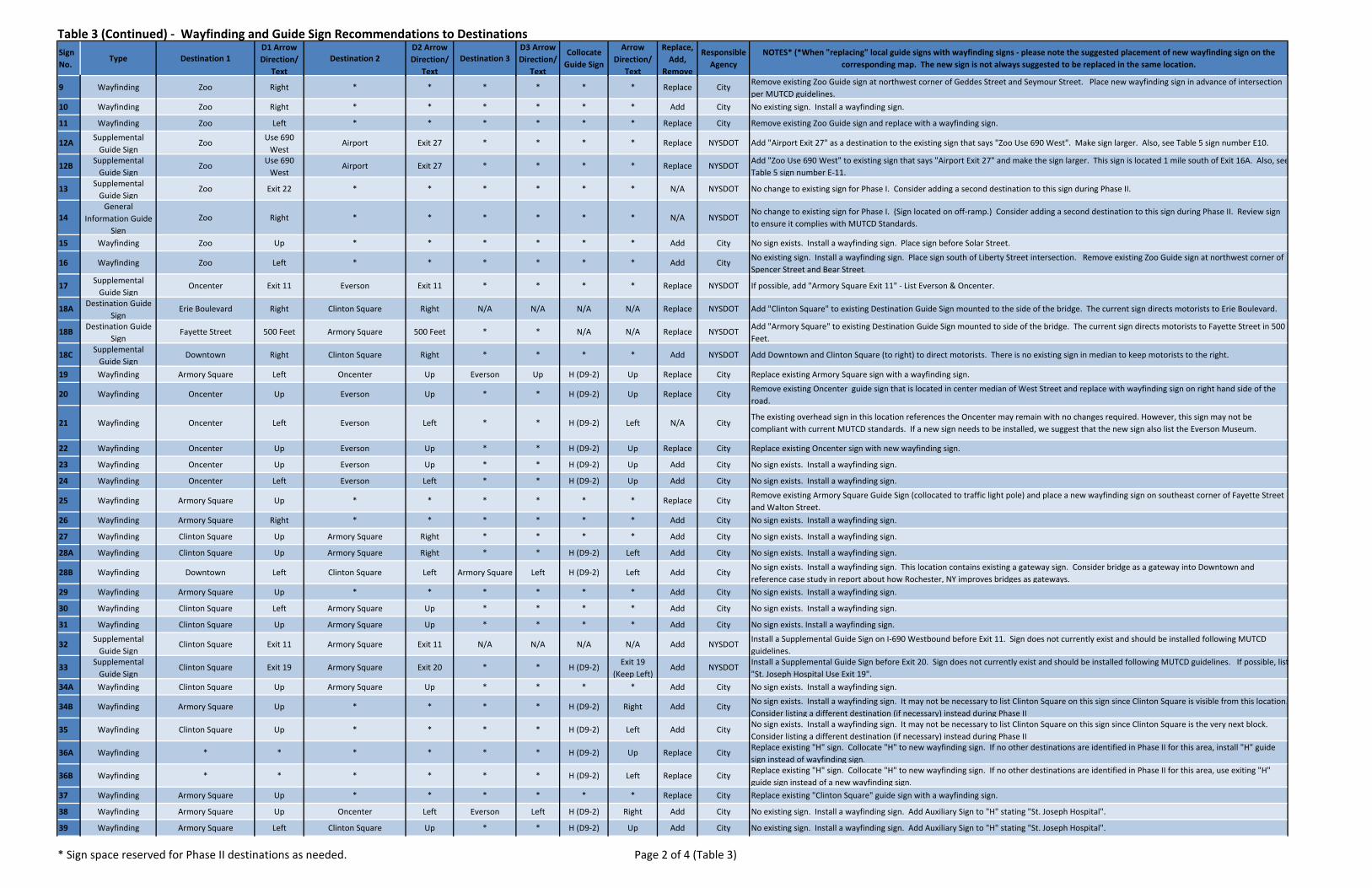
Table 3 (Continued) ‐ Wayfinding and Guide Sign Recommendations to Destinations Sign No.
Type Destination 1D1 Arrow Direction/
TextDestination 2
D2 Arrow Direction/
TextDestination 3
D3 Arrow Direction/
Text
Collocate Guide Sign
Arrow Direction/
Text
Replace, Add,
Remove
Responsible Agency
NOTES* (*When "replacing" local guide signs with wayfinding signs ‐ please note the suggested placement of new wayfinding sign on the corresponding map. The new sign is not always suggested to be replaced in the same location.
9 Wayfinding Zoo Right * * * * * * Replace City Remove existing Zoo Guide sign at northwest corner of Geddes Street and Seymour Street. Place new wayfinding sign in advance of intersection per MUTCD guidelines.
10 Wayfinding Zoo Right * * * * * * Add City No existing sign. Install a wayfinding sign.
11 Wayfinding Zoo Left * * * * * * Replace City Remove existing Zoo Guide sign and replace with a wayfinding sign.
12A Supplemental Guide Sign
Zoo Use 690 West
Airport Exit 27 * * * * Replace NYSDOT Add "Airport Exit 27" as a destination to the existing sign that says "Zoo Use 690 West". Make sign larger. Also, see Table 5 sign number E10.
12B Supplemental Guide Sign
Zoo Use 690 West
Airport Exit 27 * * * * Replace NYSDOT Add "Zoo Use 690 West" to existing sign that says "Airport Exit 27" and make the sign larger. This sign is located 1 mile south of Exit 16A. Also, seeTable 5 sign number E‐11.
13 Supplemental Guide Sign
Zoo Exit 22 * * * * * * N/A NYSDOT No change to existing sign for Phase I. Consider adding a second destination to this sign during Phase II.
14General
Information Guide Sign
Zoo Right * * * * * * N/A NYSDOTNo change to existing sign for Phase I. (Sign located on off‐ramp.) Consider adding a second destination to this sign during Phase II. Review sign to ensure it complies with MUTCD Standards.
15 Wayfinding Zoo Up * * * * * * Add City No sign exists. Install a wayfinding sign. Place sign before Solar Street.
16 Wayfinding Zoo Left * * * * * * Add City No existing sign. Install a wayfinding sign. Place sign south of Liberty Street intersection. Remove existing Zoo Guide sign at northwest corner of Spencer Street and Bear Street.
17 Supplemental Guide Sign
Oncenter Exit 11 Everson Exit 11 * * * * Replace NYSDOT If possible, add "Armory Square Exit 11" ‐ List Everson & Oncenter.
18A Destination Guide Sign
Erie Boulevard Right Clinton Square Right N/A N/A N/A N/A Replace NYSDOT Add "Clinton Square" to existing Destination Guide Sign mounted to the side of the bridge. The current sign directs motorists to Erie Boulevard.
18B Destination Guide Sign
Fayette Street 500 Feet Armory Square 500 Feet * * N/A N/A Replace NYSDOT Add "Armory Square" to existing Destination Guide Sign mounted to side of the bridge. The current sign directs motorists to Fayette Street in 500 Feet.
18C Supplemental Guide Sign
Downtown Right Clinton Square Right * * * * Add NYSDOT Add Downtown and Clinton Square (to right) to direct motorists. There is no existing sign in median to keep motorists to the right.
19 Wayfinding Armory Square Left Oncenter Up Everson Up H (D9‐2) Up Replace City Replace existing Armory Square sign with a wayfinding sign.
20 Wayfinding Oncenter Up Everson Up * * H (D9‐2) Up Replace City Remove existing Oncenter guide sign that is located in center median of West Street and replace with wayfinding sign on right hand side of the road.
21 Wayfinding Oncenter Left Everson Left * * H (D9‐2) Left N/A CityThe existing overhead sign in this location references the Oncenter may remain with no changes required. However, this sign may not be compliant with current MUTCD standards. If a new sign needs to be installed, we suggest that the new sign also list the Everson Museum.
22 Wayfinding Oncenter Up Everson Up * * H (D9‐2) Up Replace City Replace existing Oncenter sign with new wayfinding sign.
23 Wayfinding Oncenter Up Everson Up * * H (D9‐2) Up Add City No sign exists. Install a wayfinding sign.
24 Wayfinding Oncenter Left Everson Left * * H (D9‐2) Up Add City No sign exists. Install a wayfinding sign.
25 Wayfinding Armory Square Up * * * * * * Replace City Remove existing Armory Square Guide Sign (collocated to traffic light pole) and place a new wayfinding sign on southeast corner of Fayette Street and Walton Street.
26 Wayfinding Armory Square Right * * * * * * Add City No sign exists. Install a wayfinding sign.
27 Wayfinding Clinton Square Up Armory Square Right * * * * Add City No sign exists. Install a wayfinding sign.
28A Wayfinding Clinton Square Up Armory Square Right * * H (D9‐2) Left Add City No sign exists. Install a wayfinding sign.
28B Wayfinding Downtown Left Clinton Square Left Armory Square Left H (D9‐2) Left Add City No sign exists. Install a wayfinding sign. This location contains existing a gateway sign. Consider bridge as a gateway into Downtown and reference case study in report about how Rochester, NY improves bridges as gateways.
29 Wayfinding Armory Square Up * * * * * * Add City No sign exists. Install a wayfinding sign.
30 Wayfinding Clinton Square Left Armory Square Up * * * * Add City No sign exists. Install a wayfinding sign.
31 Wayfinding Clinton Square Up Armory Square Up * * * * Add City No sign exists. Install a wayfinding sign.
32 Supplemental Guide Sign
Clinton Square Exit 11 Armory Square Exit 11 N/A N/A N/A N/A Add NYSDOT Install a Supplemental Guide Sign on I‐690 Westbound before Exit 11. Sign does not currently exist and should be installed following MUTCD guidelines.
33 Supplemental Guide Sign
Clinton Square Exit 19 Armory Square Exit 20 * * H (D9‐2) Exit 19 (Keep Left)
Add NYSDOT Install a Supplemental Guide Sign before Exit 20. Sign does not currently exist and should be installed following MUTCD guidelines. If possible, list "St. Joseph Hospital Use Exit 19".
34A Wayfinding Clinton Square Up Armory Square Up * * * * Add City No sign exists. Install a wayfinding sign.
34B Wayfinding Armory Square Up * * * * H (D9‐2) Right Add City No sign exists. Install a wayfinding sign. It may not be necessary to list Clinton Square on this sign since Clinton Square is visible from this location.Consider listing a different destination (if necessary) instead during Phase II
35 Wayfinding Clinton Square Up * * * * H (D9‐2) Left Add City No sign exists. Install a wayfinding sign. It may not be necessary to list Clinton Square on this sign since Clinton Square is the very next block. Consider listing a different destination (if necessary) instead during Phase II
36A Wayfinding * * * * * * H (D9‐2) Up Replace City Replace existing "H" sign. Collocate "H" to new wayfinding sign. If no other destinations are identified in Phase II for this area, install "H" guide sign instead of wayfinding sign.
36B Wayfinding * * * * * * H (D9‐2) Left Replace City Replace existing "H" sign. Collocate "H" to new wayfinding sign. If no other destinations are identified in Phase II for this area, use exiting "H" guide sign instead of a new wayfinding sign.
37 Wayfinding Armory Square Up * * * * * * Replace City Replace existing "Clinton Square" guide sign with a wayfinding sign.
38 Wayfinding Armory Square Up Oncenter Left Everson Left H (D9‐2) Right Add City No existing sign. Install a wayfinding sign. Add Auxiliary Sign to "H" stating "St. Joseph Hospital".
39 Wayfinding Armory Square Left Clinton Square Up * * H (D9‐2) Up Add City No existing sign. Install a wayfinding sign. Add Auxiliary Sign to "H" stating "St. Joseph Hospital".
* Sign space reserved for Phase II destinations as needed. Page 2 of 4 (Table 3)

Table 3 (Continued) ‐ Wayfinding and Guide Sign Recommendations to Destinations Sign No.
Type Destination 1D1 Arrow Direction/
TextDestination 2
D2 Arrow Direction/
TextDestination 3
D3 Arrow Direction/
Text
Collocate Guide Sign
Arrow Direction/
Text
Replace, Add,
Remove
Responsible Agency
NOTES* (*When "replacing" local guide signs with wayfinding signs ‐ please note the suggested placement of new wayfinding sign on the corresponding map. The new sign is not always suggested to be replaced in the same location.
40 Wayfinding Armory Square Up Clinton Square Up * * H (D9‐2) Up Add City No existing sign. Install a wayfinding sign. Add Auxiliary Sign to "H" stating "St. Joseph Hospital".
41A Destination Guide Sign
Oncenter (Downtown Exit:) Left
Everson (Downtown Exit:) Left
N/A N/A N/A N/A N/A City No change to existing overhead sign. However, current sign may not be compliant with current MUTCD standards and may need to be replaced.
41BGeneral
Information Guide Sign
Everson Museum of Art Left N/A N/A N/A N/A N/A N/A Remove City Remove "Everson Museum of Art" sign.
42 Wayfinding Armory Square Up Clinton Square Up * * H (D9‐2) Up Add City No existing sign. Install a wayfinding sign. Add Auxiliary Sign to "H" stating "St. Joseph Hospital"
43AGeneral
Information Guide Sign
Remove Sign (Ontrack) N/A N/A N/A N/A N/A N/A Remove NYSDOT Remove OnTrack Sign.
43B Supplemental Guide Sign
Harrison Street Up Adams Street Right H (D9‐2) Right N/A N/A N/A NYSDOT No change to the existing overhead sign is proposed for Phase I. However, the overhead sign on off‐ramp may need to be replaced to comply with MUTCD Standards. If so, also consider adding "Downtown, Oncenter, and Everson" with a go straight arrow
43CGeneral Symbol Information Sign
NYM8‐5
SUNY Upstate Medical University
Right Syracuse University Right SUNY E.S.F. Right N/A N/A Replace NYSDOT Add Syracuse University Name Auxiliary Sign to existing assembly.
43D General Service Sign D9‐2
Upstate Right Crouse Right VA Right N/A N/A N/A NYSDOT NYSDOT recently updated sign by listing three hospital names. No additional action is required.
44 Wayfinding Clinton Square Left * * * * H (D9‐2) Left Add City No existing sign. Install a wayfinding sign. Add Auxiliary Sign to "H" stating "St. Joseph Hospital"
45 Wayfinding Clinton Square Up * * * * H (D9‐2) Right Add City No existing sign. Install a wayfinding sign. Add Auxiliary Sign to "H" stating "St. Joseph Hospital"
46 Wayfinding Clinton Square Right * * * * * * Add City No existing sign. Install a wayfinding sign.
47 Wayfinding Clinton Square Left * * * * * * Add City No existing sign. Install a wayfinding sign. Consider adding "H" sign and direct motorists to St. Joseph's Hospital with right arrow up James Street in Phase II. Also, on existing I‐690 shield sign remove word (West). It should read TO I‐690
48 Supplemental Guide Sign
Oncenter Exit 18 Syracuse University Exit 18 N/A N/A H (D9‐2) Exit 18 N/A NYSDOT No change to existing sign. Review it to ensure it meets MUTCD standards ‐ replace if necessary.
49Supplemental Guide Sign
Syracuse University Exit 18 SUNY E.S.F. Exit 18 SUNY Upstate Exit 18 H (D9‐2) Exit 18 Replace NYSDOTUpdate sign to indicate that Exit 18 provides access to Syracuse University, SUNY Upstate Medical University, and SUNY ESF. Sign currently directs motorists to SUNY Upstate Medical University only. Also, remove existing NYM8‐5 Sign that is collocated to a cobra light pole just before Exit 17. It directs motorists to Exit 17 (for O.C.C.).
50Supplemental Guide Sign
Upstate Community Campus (Onondaga Hill)
Exit 17 (Left) * * N/A N/A N/A N/A Replace NYSDOTMake distinction between hospital campuses on existing sign now that Community Hospital is owned by Upstate. Upstate Community Campus is located on Onondaga Hill.
51 Supplemental Guide Sign
Oncenter Right Everson Right N/A N/A N/A N/A N/A NYSDOT No change to existing Supplemental Guide sign. However, current sign may not be compliant with current MUTCD standards and may need
52 Wayfinding Oncenter Up Everson Up * * H (D9‐2) See note. Replace City Replace sign 89 (lists Oncenter and Everson) with a wayfinding sign 52. Add Auxiliary Sign to "H" stating "St. Joseph Hospital" with a right arrow. Add Auxiliary signs for "Upstate", "Crouse", "VA" with a left arrow.
53 Wayfinding Armory Square Left Clinton Square Up * * H (D9‐2) Up Add City No sign exists. Install a wayfinding sign. Add Auxiliary Sign to "H" stating "St. Joseph Hospital".
54 Destination Guide Sign
Oncenter Exit 18 Syracuse University Exit 18 H Exit 18 N/A N/A N/A NYSDOT No change to existing overhead sign. However, current sign may not be compliant with current MUTCD standards and may need to be replaced.
55 Wayfinding Clinton Square Left * * * * H (D9‐2) Up Add City No sign exists. Install a wayfinding sign. Add Auxiliary Sign to "H" stating "St. Joseph Hospital".
56 Wayfinding * * * * * * H (D9‐2) Up Add City No sign exists. Install a wayfinding sign. Collocate "H" to new wayfinding sign. If no other destinations are identified in Phase II for this area, install "H" guide sign instead of wayfinding sign.
57 General Service "H" Sign (D9‐2)
H Right N/A N/A N/A N/A N/A N/A Add NYSDOT Install "H" guide sign with right arrow on exit looping north toward Butternut Street.
58 Wayfinding * * * * * * H (D9‐2) Up Add City No sign exists. Install a wayfinding sign. Add Phase II destinations as needed. If there are no destinations to list on the Wayfinding sign install a General Service "H" Sign (D9‐2) instead.
59 Wayfinding * * * * * * H (D9‐2) Up Add City No sign exists. Install a wayfinding sign. Add Phase II destinations as needed. If there are no destinations to list on the Wayfinding sign install a General Service "H" Sign (D9‐2) instead.
60 Wayfinding * * * * * * H (D9‐2) Right Add City No sign exists. Install a wayfinding sign. Add Phase II destinations as needed. If there are no destinations to list on the Wayfinding sign install a General Service "H" Sign (D9‐2) instead.
61 Supplemental Guide Sign
Oncenter Exit 13 Everson Exit 13 N/A N/A H (D9‐2) N/A Replace NYSDOT Remove SU from existing pole sign. (Instead, direct motorists to Teall Ave Exit to get to S.U.) Replace existing sign with a new one titled: "Downtown Exit" and list "Oncenter" and "Everson".
62Destination Guide
SignDowntown Exit 13 Airport
Use I‐81 North towards
Watertown
N/A N/A H (D9‐2) Exit 13 Replace NYSDOTAdd Hospital Sign to overhead sign; Sign #62 is the same as sign #B5 in the Airport Table (Table 5). Add "Syracuse Airport" to existing overhead sign that directs motorists to use I‐81 North.
63 Destination Guide Sign
Downtown Exit 13 N/A N/A N/A N/A H (D9‐2) N/A Replace NYSDOT Add Hospital Sign to existing overhead sign directing motorists to Exit 13.
64 Destination Guide Sign
Oncenter Left Everson Left N/A N/A H (D9‐2) N/A Replace NYSDOT Replace existing overhead signs with new sign. Title new sign "Downtown Exit" and list "Oncenter" , "Everson", and add a D9‐2 "H" sign.
65AGeneral Symbol Information Sign
NYM8‐5Syracuse University Left
SUNY Upstate Medical University
Left SUNY ESF Left N/A N/A Add City No sign exists. Install a General Symbol Information Sign NYM8‐5 with three Name Auxiliary Signs for each listed college.
65B General Service "H" Sign (D9‐2)
Upstate Left Crouse Left VA Left N/A N/A Add City No sign exists. Install a General Service "H" Sign (D9‐2) and hospital name auxiliary signs.
* Sign space reserved for Phase II destinations as needed. Page 3 of 4 (Table 3)
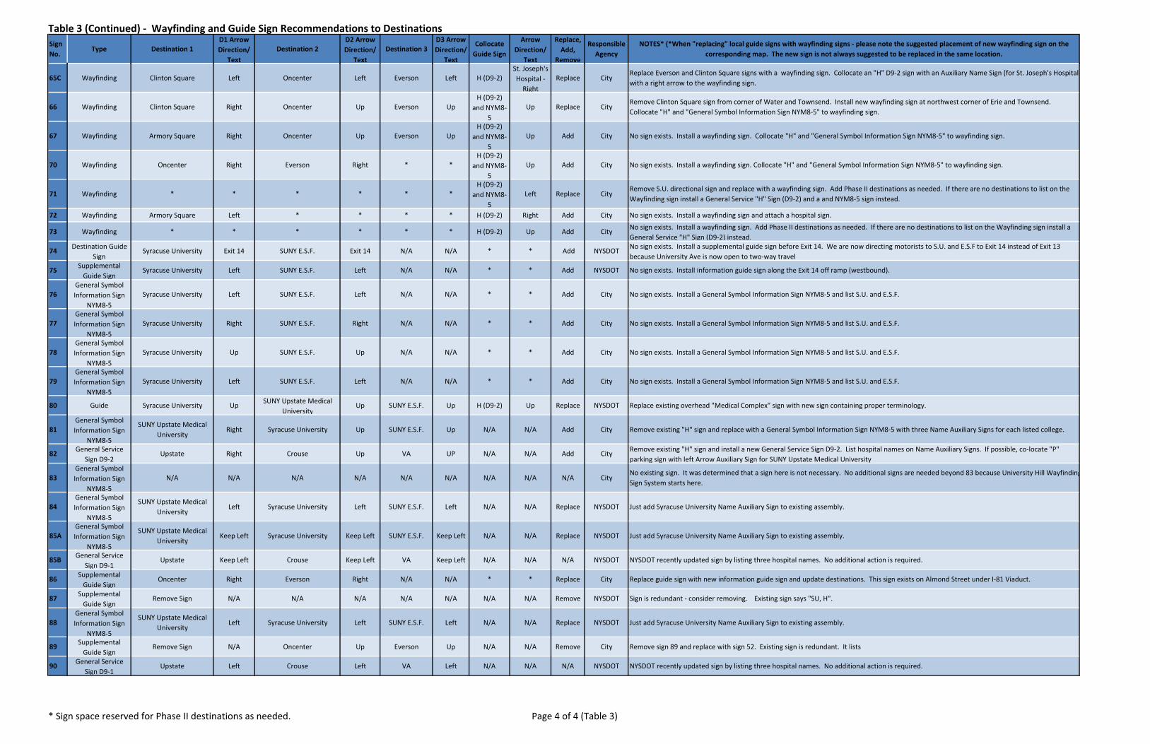
Table 3 (Continued) ‐ Wayfinding and Guide Sign Recommendations to Destinations Sign No.
Type Destination 1D1 Arrow Direction/
TextDestination 2
D2 Arrow Direction/
TextDestination 3
D3 Arrow Direction/
Text
Collocate Guide Sign
Arrow Direction/
Text
Replace, Add,
Remove
Responsible Agency
NOTES* (*When "replacing" local guide signs with wayfinding signs ‐ please note the suggested placement of new wayfinding sign on the corresponding map. The new sign is not always suggested to be replaced in the same location.
65C Wayfinding Clinton Square Left Oncenter Left Everson Left H (D9‐2)St. Joseph's Hospital ‐ Right
Replace CityReplace Everson and Clinton Square signs with a wayfinding sign. Collocate an "H" D9‐2 sign with an Auxiliary Name Sign (for St. Joseph's Hospitalwith a right arrow to the wayfinding sign.
66 Wayfinding Clinton Square Right Oncenter Up Everson UpH (D9‐2)
and NYM8‐5
Up Replace CityRemove Clinton Square sign from corner of Water and Townsend. Install new wayfinding sign at northwest corner of Erie and Townsend. Collocate "H" and "General Symbol Information Sign NYM8‐5" to wayfinding sign.
67 Wayfinding Armory Square Right Oncenter Up Everson UpH (D9‐2)
and NYM8‐5
Up Add City No sign exists. Install a wayfinding sign. Collocate "H" and "General Symbol Information Sign NYM8‐5" to wayfinding sign.
70 Wayfinding Oncenter Right Everson Right * *H (D9‐2)
and NYM8‐5
Up Add City No sign exists. Install a wayfinding sign. Collocate "H" and "General Symbol Information Sign NYM8‐5" to wayfinding sign.
71 Wayfinding * * * * * *H (D9‐2)
and NYM8‐5
Left Replace CityRemove S.U. directional sign and replace with a wayfinding sign. Add Phase II destinations as needed. If there are no destinations to list on the Wayfinding sign install a General Service "H" Sign (D9‐2) and a and NYM8‐5 sign instead.
72 Wayfinding Armory Square Left * * * * H (D9‐2) Right Add City No sign exists. Install a wayfinding sign and attach a hospital sign.
73 Wayfinding * * * * * * H (D9‐2) Up Add City No sign exists. Install a wayfinding sign. Add Phase II destinations as needed. If there are no destinations to list on the Wayfinding sign install a General Service "H" Sign (D9‐2) instead.
74 Destination Guide Sign
Syracuse University Exit 14 SUNY E.S.F. Exit 14 N/A N/A * * Add NYSDOT No sign exists. Install a supplemental guide sign before Exit 14. We are now directing motorists to S.U. and E.S.F to Exit 14 instead of Exit 13 because University Ave is now open to two‐way travel.
75 Supplemental Guide Sign
Syracuse University Left SUNY E.S.F. Left N/A N/A * * Add NYSDOT No sign exists. Install information guide sign along the Exit 14 off ramp (westbound).
76General Symbol Information Sign
NYM8‐5Syracuse University Left SUNY E.S.F. Left N/A N/A * * Add City No sign exists. Install a General Symbol Information Sign NYM8‐5 and list S.U. and E.S.F.
77General Symbol Information Sign
NYM8‐5Syracuse University Right SUNY E.S.F. Right N/A N/A * * Add City No sign exists. Install a General Symbol Information Sign NYM8‐5 and list S.U. and E.S.F.
78General Symbol Information Sign
NYM8‐5Syracuse University Up SUNY E.S.F. Up N/A N/A * * Add City No sign exists. Install a General Symbol Information Sign NYM8‐5 and list S.U. and E.S.F.
79General Symbol Information Sign
NYM8‐5Syracuse University Left SUNY E.S.F. Left N/A N/A * * Add City No sign exists. Install a General Symbol Information Sign NYM8‐5 and list S.U. and E.S.F.
80 Guide Syracuse University Up SUNY Upstate Medical University
Up SUNY E.S.F. Up H (D9‐2) Up Replace NYSDOT Replace existing overhead "Medical Complex" sign with new sign containing proper terminology.
81General Symbol Information Sign
NYM8‐5
SUNY Upstate Medical University
Right Syracuse University Up SUNY E.S.F. Up N/A N/A Add City Remove existing "H" sign and replace with a General Symbol Information Sign NYM8‐5 with three Name Auxiliary Signs for each listed college.
82 General Service Sign D9‐2
Upstate Right Crouse Up VA UP N/A N/A Add City Remove existing "H" sign and install a new General Service Sign D9‐2. List hospital names on Name Auxiliary Signs. If possible, co‐locate "P" parking sign with left Arrow Auxiliary Sign for SUNY Upstate Medical University
83General Symbol Information Sign
NYM8‐5N/A N/A N/A N/A N/A N/A N/A N/A N/A City
No existing sign. It was determined that a sign here is not necessary. No additional signs are needed beyond 83 because University Hill WayfindingSign System starts here.
84General Symbol Information Sign
NYM8‐5
SUNY Upstate Medical University
Left Syracuse University Left SUNY E.S.F. Left N/A N/A Replace NYSDOT Just add Syracuse University Name Auxiliary Sign to existing assembly.
85AGeneral Symbol Information Sign
NYM8‐5
SUNY Upstate Medical University
Keep Left Syracuse University Keep Left SUNY E.S.F. Keep Left N/A N/A Replace NYSDOT Just add Syracuse University Name Auxiliary Sign to existing assembly.
85B General Service Sign D9‐1
Upstate Keep Left Crouse Keep Left VA Keep Left N/A N/A N/A NYSDOT NYSDOT recently updated sign by listing three hospital names. No additional action is required.
86 Supplemental Guide Sign
Oncenter Right Everson Right N/A N/A * * Replace City Replace guide sign with new information guide sign and update destinations. This sign exists on Almond Street under I‐81 Viaduct.
87 Supplemental Guide Sign
Remove Sign N/A N/A N/A N/A N/A N/A N/A Remove NYSDOT Sign is redundant ‐ consider removing. Existing sign says "SU, H".
88General Symbol Information Sign
NYM8‐5
SUNY Upstate Medical University
Left Syracuse University Left SUNY E.S.F. Left N/A N/A Replace NYSDOT Just add Syracuse University Name Auxiliary Sign to existing assembly.
89 Supplemental Guide Sign
Remove Sign N/A Oncenter Up Everson Up N/A N/A Remove City Remove sign 89 and replace with sign 52. Existing sign is redundant. It lists
90 General Service Sign D9‐1
Upstate Left Crouse Left VA Left N/A N/A N/A NYSDOT NYSDOT recently updated sign by listing three hospital names. No additional action is required.
* Sign space reserved for Phase II destinations as needed. Page 4 of 4 (Table 3)

z
zz
z
z
z
z
z
z
z
RosamondGifford
Zoo(ZOO)
badExit 9
Exit 10
See Inset
Exit 8
bad
TO 81N & 90 --->
<--- TO 690W
TO 690E & 81S --->
#
See Inset#
13B(R)
Park Ave
Erie Blvd W
W Genesee St
N Ge
ddes
St
W Fayette St
Van Rensselaer St
Spencer St
Libert
y St
S Wilbur Ave
Seymour St
W Belden Ave
Otisco St
Richmond Ave
S Ged
des S
t
Gifford St
Tracy St
Wall S
t
Pulaski St
Bear St W
Wilkinson St
Oswego St
Marcellus St
Hiawath
a Blvd
W
Whittier Ave
Bryant Ave
Coleridge Ave
Lakeview Ave
Tully St
Nelson St
Magnolia St
Apple St
Duke Dr
State Fair Blvd
Seneca St
Syracuse St
W Kirkpatrick St
Sack
ett St
Ulster St
Tennyson Ave
Sand
St
Edison St
Tompkins St
N Lowell Ave
Ontario St
Eureka St
Shonnard St
N Wilbur Ave
S Lowell Ave
Marquette St
Conservation PlW Marcellus St
Burnet Park Dr
Evans St
Gim i
n sk i
Dr
Matty
Ave
Hunt
er Av
e
Waite Ave
Dewey Ave
Amy S
t
Crysler St
Central Ave
State Fair Blvd
Libert
y St
Sand
St
Park Ave
W Fayette St
W Marcellus St
2(R)
6(R)
3(R)
7(R)
13A(R)
1(A)
4(A)
5(A)
8(R)
BargeCanal
LegendSign Location & Directionz Pole Mounted
z Bridge Mounted
z Overhead Structure Mounted
Routes from Zoo (ZOO)
Parking Lot
Building Footprint
z
z
zz
z
zzz z
zz
bac
11(R)
9A(A)
#
#
#
#
9B(R)
13H(R)
13G(R)
12(R)
10(R)
13F(R)
13D( )
13C(R)
13E(R)
*
bac
Lodi St
Solar St
Genant DrN Clinton St
N State St
N Salina St
Sunset Ave
Court
St
W Co
urt St
Danfo
rth St
Spencer St
Bear St W
N Alvord St
Bear
St
Kirkp
atrick
St
W Kirkpatrick St
Union Pl
BargeCanal
Inset
City of Syracuse Wayfinding Study
z## Sign Reference Number*
* Please see Sign Recommendation Table #4 for more information.
MAP 120 250 500 750 1,000125
Feet
Suggestions for Shield Sign Assemblies from DestinationsRosamond Gifford Zoo Area
Existing sign (No changes are proposed for existingsigns. However, sign owners may want to inspectexisting signs to ensure they meet MUTCD standards.Replace "in kind" as necessary.)
(E)
Add sign (Sign does not exist, install a brand new sign.)(A)
Replace sign as noted in the table and install a newsign in the indicated area.
(R)
Remove sign( )*
´This map is for presentation purposes only.
The SMTC does not guarantee the accuracy or completeness of this map.
Data Sources: SMTC, NYSDOT, SOCPAPrepared by SMTC, 6/12/13

z z z
z z
z
z
z
z
z
z
z
z
zz
z
z
z
zz
z
z
z
z
z
z
z
z
z
z
z
z z
z
z z
z
z
z
z
z
z
z
zz
z
z
z
z
z
z
zz
z
z
z
z
z
St. Joseph'sHospital (SJ)
GCH
ClintonSquare
(CS)
ArmorySquare (AS)
OncenterComplex
(ON)EversonMuseum
(EV)
Exit 20
Exit 11
Exit 11
Exit 13
Exit18
Exit18
Genant Dr
Exit 19
Exit 12
CivicCenter
WarMemorial
Oncenter
bad
bac
bad
bac
TO8 1N
--->
<--- TO 690 & 81S
TO81 N
--->
<--- TO 690 & 81S
<--- TO 81NTO 81 &690 --->
TO 690E --->
<---T O
8 1& 6
9 0
TO81&6 90--->
TO 81S--->
T O81
N &69 0
- -->
TO 690E & 81S --->
<--- TO 690W
<--- TO 690
TO81--->TO81--->
23(R)
20C(A)56B(E)
16B(A)16C(A)
16D(A)
48A(A)
48B(A)
20B(A)
46B(A)
32(A)
S Stat
e St
S Salina St
James St
S Clinton St
E Willow St
E Water St
S War
ren St
N State StN
Salin
a St
E Fayette St
E Adams St
Catherine St
Harrison St
E Taylor St
Hickory St
N McBride St
N Townsend St
Lodi St
Almo
nd St
Gifford St
E Washington St
E Laurel St
N Fr
ankli
n St
Burnet Ave
W Fayette St
W Genesee St
W Water St
Evans St
Pearl St
Erie Blvd E
Erie Blvd W
Oneida St
Plum St
Seymour St
Montg
omery
St
S To w
n sen
dSt
Fabius St
Shonnard St
Walton St
W Taylor St
S McB
ride S
t
Hawley Ave
New St
Wyoming St
Herald Pl
N Clinton St
Solar St
W Onondaga St
W Washington St
S Fran
klin S
t
E Jefferson St
N We
st St
Temple St
Union Ave
Madison St
Jackson St
King St
E Genesee St
Prospect Ave
W Adams St
Linde
n St
Dickerson St
Midland Ave
Wayne St
Dyer Ct
Willow St
Tully St
Cedar St
Green St
Harri
son P
l
W Division St
N Warren St
Granger St
Tracy St
Dablo
n Ct
Douglas St
W Jefferson St
Park Ave
Otisco St
Brown St
Stew
art C
t
Mark
et St
Renw
ick Av
e
Marcellus St
Onondaga Pl
Larned St
McCarthy Ave
Chavez Ter
Slocum Ave
Latimer Ter
McCormick Ave
South Ave
Oswego Blvd
L ightC
t
Oa kwoo dAve
Frisb
ie Ct
Will Ct
Deck
er St
Tully St
S Tow
nsen
d St
E Onondaga S
t
Temple St
Erie Blvd E
W Onondaga St
Montg
omery
St
Plum
St
Prospect Ave
Monroe St
Almo
nd St
E Genesee St
Montgomery St
N McBride St
N Cl
inton
St
Madison St
W Jefferson St
S West St
E Genesee St
S McB
ride S
t
Butternut St
Granger St
E Onondaga S
t
50(R) 52(R) 25(R)26(R)
30(R)
38(R)
39(R)
40(R)
36(R)
42(E)
43(E)
57(R)
15B(E)15C(E)
58(R)
41(E)
27(E)29(E)
31(R)
28(E)
44(R)
55(R)
56A(R)
49(R)
14(A)
15A(A)
16A(A)
17(A)
18(R)
19(R)20A(A)
21A(A)
21B(E)
21C(E)
22(A)33(A)
34(A)
35(R)
37(A)
45(A)
46A(A)
47A(A)
47B(A)
51(A)
53(A)
54(A)
59(A)
City of Syracuse Wayfinding Study
MAP 130 250 500 750 1,000125
Feet
Suggestions for Shield Sign Assemblies from DestinationsDowntown Area
* Please see Sign Recommendation Table #4 for more information.
Sign Reference Number*z##
Routes from Clinton Square (CS)Routes from Armory Square (AS)Routes from Oncenter (ON)Routes from Everson Museum (EV)Routes from St. Joseph's Hospital (SJ)
LegendSign Location & Directionz Pole Mounted
z Bridge Mounted
z Overhead Structure Mounted
Parking Garage
Parking Lot
Building Footprint
Existing sign (No changes are proposed for existingsigns. However, sign owners may want to inspectexisting signs to ensure they meet MUTCD standards.Replace "in kind" as necessary.)
(E)
Add sign (Sign does not exist, install a brand new sign.)(A)
Replace sign as noted in the table and install a newsign in the indicated area.
(R)
Remove sign( )*
´This map is for presentation purposes only.
The SMTC does not guarantee the accuracy or completeness of this map.
Data Sources: SMTC, NYSDOT, SOCPAPrepared by SMTC, 6/12/13
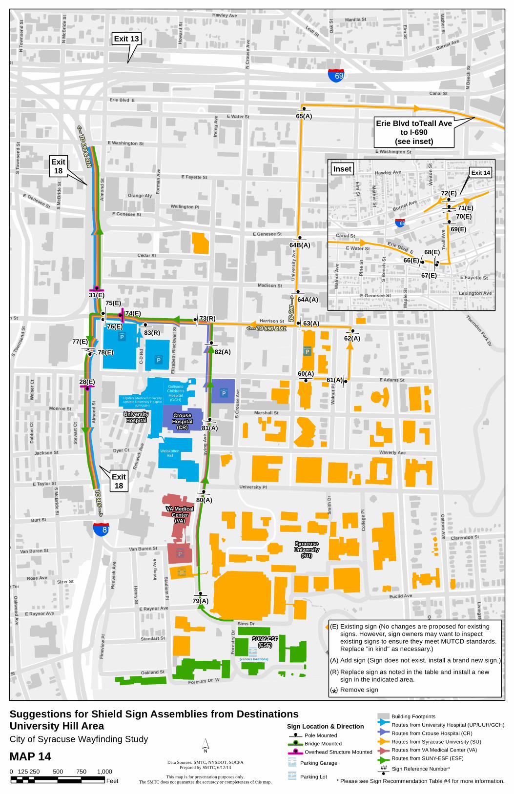
z
zzz
z
z
z
zz z
zz
z
z
z
z
z
z
z
zOnCenterComplex
(ON)
CrouseHospital
(CR)
GolisanoChildren'sHospital(GCH)
VA MedicalCenter
(VA)
SUNY-ESF(ESF)
SyracuseUniversity
(SU)
UniversityHospital
Exit 13
Exit18
Exit18
Erie Blvd toTeall Aveto I-690
(see inset)
bad
bac
Upstate Medical UniversityUpstate University Hospital
(UP/UUH)
WeiskottenHall
(various locations)
Irving
Ave
<--- TO690 & 81NTO 81S-- ->
<--- TO 690 & 81
TO6 90
--- >
77(E)
64A(A)
E Water St
Burnet Ave
Irving
Ave
E Fayette St
E Adams St
Canal St
Ostrom Ave
Madison St
Comstock Ave
Walnu
t Ave
S Cro
use A
ve
Unive
rsity
Ave
Harrison St
Hawley Ave
E Genesee St
Lodi St
Sims Dr
University PlS McBride St
Burt St
Waverly Ave
Marshall StPin
e St
Oakwood Ave
S Bee
ch St
Ren w
i ckAv
e
Walnu
t Pl
E Taylor St
Cedar St
E Washington St
S Town
send
S t
Stadium Pl Euclid Ave
Form
an Av
e
Henry St
Colle
ge Pl
N Be
ech S
t
Finev
iew P
l
E Castle St
Ashworth Pl
Livingston Ave
Elm StOak S
t
C-D
Rd
Jackson St
Fore
stry D
r
Van Buren St
N Cr
ouse
AveN
McBr
ide St
Comstock Pl
E Raynor Ave
Stratford StOakland St
N To
wnse
nd S
t
Standart St
Thornden Park Dr
Dyer Ct
Ostram Ave
Mount Olympus Dr
Rose Ave
Forestry Dr W
Manilla St
Mather St
Wellington Pl
Dablo
n Ct
Weise
r Ct
Howa
rd St
Stew
art C
t
Smith
Dr
Browa St
Clarendon St
Orange Aly
Croto
n Ter
Eliza
beth
Blac
kwell
St
Towers Ln
Danf
orth
Ter
Sizer StGrape Ter
E Raynor Ave
E Genesee St
E Washington St
Almo
nd St
Erie Blvd E
E Genesee St
Monroe St
S McB
ride S
t
Irving
Ave
S Tow
nsen
d St
Almo
nd St
Renw
ick Av
e
Harrison St
Van Buren St
83(R)
74(E)76(E)
75(E)31(E)
78(E)
28(E)60(A)
61(A)
62(A)63(A)
64B(A)
65(A)
73(R)
79(A)
80(A)
81(A)
82(A)
z zz
zzzz
z
z
z
Exit 14
bad
68(E)
70(E)69(E)
Burnet Ave
E Fayette St
Canal St
Teall
Ave
Elm St
Hawley Ave
E Genesee St
Pine S
t
Walnu
t Ave
Mather St
Lexington Ave
E Water St
S Bee
ch S
t
Maple
St
Winto
n St
Erie Blvd E66(E)
67(E)
71(E)72(E)
Inset
City of Syracuse Wayfinding Study
MAP 140 250 500 750 1,000125
Feet
Suggestions for Shield Sign Assemblies from DestinationsUniversity Hill Area
* Please see Sign Recommendation Table #4 for more information.
Sign Location & Directionz Pole Mounted
z Bridge Mounted
z Overhead Structure Mounted
Parking Garage
Parking Lot
Building FootprintsRoutes from University Hospital (UP/UUH/GCH)Routes from Crouse Hospital (CR)Routes from Syracuse University (SU)Routes from VA Medical Center (VA)Routes from SUNY-ESF (ESF)
Sign Reference Number*z##
Existing sign (No changes are proposed for existingsigns. However, sign owners may want to inspectexisting signs to ensure they meet MUTCD standards.Replace "in kind" as necessary.)
(E)
Add sign (Sign does not exist, install a brand new sign.)(A)
Replace sign as noted in the table and install a newsign in the indicated area.
(R)
Remove sign( )*
´This map is for presentation purposes only.
The SMTC does not guarantee the accuracy or completeness of this map.
Data Sources: SMTC, NYSDOT, SOCPAPrepared by SMTC, 6/12/13

Sign Interstate Shield(s) Sign Sign Interstate Shield(s) Sign Sign Replace, Responsible Notes1 To 690/81/90 Right * * Add NYSDOT No sign exists. Install a sign.2 To 690/81/90 Left * * Replace NYSDOT Replace existing sign assembly.3 To 690/81/90 Left * * Replace NYSDOT Replace existing sign assembly.4 To 690/81/90 Up * * Add NYSDOT No sign exists. Install a sign.5 To 690/81/90 Up * * Add NYSDOT No sign exists. Install a sign.6 690 East/81 South Right * * Replace NYSDOT Replace existing sign assembly.7 690West/90/81 Up * * Replace NYSDOT Replace existing sign assembly (add NYS Thruway sign).8 690 West/90/81 Left * * Replace NYSDOT Update existing sign to direct motorists to SR298 per NYSDOT preference. 9A To 81/90 Up 81 South Right Replace NYSDOT Update existing sign. 9B 81 North/90/Airport I‐5 Up 81 South Right Replace NYSDOT Add NYS Thruway and Airport I‐5 Sign with an up arrow.10 81 North/90/Airport I‐5 Left * * Replace NYSDOT Replace existing sign assembly (add NYS Thruway sign, and Airport I‐5 Sign).11 81 North/90/Airport I‐5 Left * * Replace NYSDOT Replace existing sign assembly (add NYS Thruway sign, and Airport I‐5 Sign).12 81 North/90/Airport I‐5 Left * * Replace NYSDOT Replace existing sign assembly (add NYS Thruway sign, and Airport I‐5 Sign).13A 690 West/90 Left 81 Right Replace NYSDOT Update existing sign and add Airport I‐5 sign.13B To 81/Airport I‐5 Up * * Replace NYSDOT Update existing sign and add Airport I‐5 sign.
13C To 81/90/690 East/ Airport I‐5
Up * * Replace NYSDOT Update existing sign and add Airport I‐5 sign and NYS Thruway sign.
13D * * * * Remove NYSDOTExisting sign assembly is located on Bear Street just before Clinton Street. It contains up
and over arrows and may not be necessary as the next sign assembly is located just beyond this sign assembly
13E To 81/90/Airport I‐5/ 690 East
Right * * Replace NYSDOT Simplify and correct existing sign assembly. Add Airport I‐5 sign and NYS Thruway sign.
13F 81 South/690 East Left 81 North/90/Airport I‐5 Up Replace NYSDOT Simplify and correct existing sign assembly. Add Airport I‐5 sign and NYS Thruway sign13G 81 North/90/Airport I‐5 Up * * Replace NYSDOT Simplify and correct existing sign assembly. Add Airport I‐5 sign and NYS Thruway sign13H 81 North/90/Airport I‐5 Left * * Replace NYSDOT Simplify and correct existing sign assembly. Add Airport I‐5 sign and NYS Thruway sign14 81 North/90 Up * * Add NYSDOT No sign exists. Install a sign.15A 81 North/90 Right * * Add NYSDOT No sign exists. Install a sign.15B 81 North ‐ Jct * * * N/A NYSDOT No change to existing sign, but review for MUTCD compliance.15C 81 North/90 Right * * N/A NYSDOT No change to existing sign, but review for MUTCD compliance.16A To 81/690/90 Right * * Add NYSDOT Place next to stop sign at SW corner.16B To 81/690/90 Up * * Add NYSDOT No sign exists. Install a sign.16C 81 North/90 Right To 690/81 South Left Add NYSDOT No sign exists. Install a sign.16D To 690/81 Right * * Add NYSDOT No sign exists. Install a sign.17 81 North/90 Right To 690/81 South Up Add NYSDOT No sign exists. Install a sign.18 81 North/90 Right * * Replace NYSDOT Simplify existing sign assembly.19 81 North/90 Left * * Replace NYSDOT Simplify existing sign assembly.20A 690 West/81 North/90 Right 690 East/81 South Up Add NYSDOT No sign exists. Install a sign.20B 81 North/90 Right * * Add NYSDOT No sign exists. Install a sign.20C To 690 Up * * Add NYSDOT No sign exists. Install a sign.21A 690 East Left To 81/90 Up Add NYSDOT No sign exists. Install a sign.21B 690 East Left * * N/A NYSDOT No change to existing sign, but review for MUTCD compliance.21C 690 East Right * * N/A NYSDOT No change to existing sign, but review for MUTCD compliance.22 To 81/690/90 Up * * Add NYSDOT No sign exists. Install a sign.
23 To 690/81 North/90 Left (Left Lane)
81 South Left (Right Lane)
Replace NYSDOT Replace two existing signs with a single sign assembly. Use Auxiliary Sign indicating lane.
25 To 81/690/90 Up * * Replace NYSDOT Please note there is no sign #24.26 690/81 North/90 Left 81 South Keep Right Replace NYSDOT Replace overhead signs as necessary.27 81 South Right * * N/A NYSDOT No change to existing sign, but review for MUTCD compliance.28 81 South Down * * N/A NYSDOT No change to existing sign, but review for MUTCD compliance.29 690/81 North/90 Left * * N/A NYSDOT No change to existing sign, but review for MUTCD compliance.30 690 West/81 North/90 Down 690 East Down Replace NYSDOT Replace overhead signs as necessary. (Add NYS Thruway.)31 690 West/81 North/90 Down 690 East Down Replace NYSDOT Replace overhead signs as necessary. (Add NYS Thruway.)32 To 690/81/90 Up * * Add NYSDOT No existing sign. Install a sign.33 690/81 South Left 81 North/90 Up Add NYSDOT No existing sign. Install a sign.34 690/81 South Up 81 North/90 Right Add NYSDOT No existing sign. Install a sign.35 81 North/90 Up * * Add NYSDOT No existing sign. Install a sign.36 81 North/90 Up * * Replace NYSDOT Replace existing sign assembly.37A 690/81 South Right * * Add NYSDOT No sign exists. Install a sign.37B 81 North/90 Left * * Add NYSDOT No sign exists. Install a sign.38 690 West Down 690 East/81 South Down Replace NYSDOT Replace existing overhead sign.39 690 West Down 690 East/81 South Down Replace NYSDOT Replace existing overhead sign.40 690 West Left 690 East/81 South Right Replace NYSDOT Replace existing overhead sign.41 81 North/90 Up * * N/A NYSDOT No change to existing sign, but review for MUTCD compliance.42 81 North ‐ Jct * * N/A NYSDOT No change to existing sign, but review for MUTCD compliance.43 81 North/90 Left * * N/A NYSDOT No change to existing sign, but review for MUTCD compliance.44 81 North/90 Left * * Replace NYSDOT Replace existing sign assembly45 To 690/81 South Right 81 North/90 Up Add NYSDOT No sign exists. Install a sign.46A To 690/81 South Right 81 North/90 Up Add NYSDOT No sign exists. Install a sign.46B To 81/690/90 Right * * Add NYSDOT No sign exists. Install a sign.47A To 81/690/90 Up * * Add NYSDOT No sign exists. Install a sign.47B To 81/690/90 Right * * Add NYSDOT No sign exists. Install a sign.48A To 690/81 South Left To 81 North Right Add NYSDOT No sign exists. Install a sign.48B To 81/690/90 Up * * Add NYSDOT No sign exists. Install a sign.49 To 81/690/90 Left * * Replace NYSDOT Replace existing sign assembly.50A To 81/690/90 Up * * Replace NYSDOT Replace existing sign assembly.50B To 81/690/90 Left * * Add NYSDOT No sign exists. Install a sign.50C To 81/690/90 Right * * Replace NYSDOT Replace existing sign assembly.51 To 81/690/90 Left * * Add NYSDOT No sign exists. Install a sign.52 To 81/690/90 Up * * Replace NYSDOT Replace existing sign assembly.53 To 81/690/90 Left * * Add NYSDOT No sign exists. Install a sign.54 To 81/690/90 Left * * Add NYSDOT No sign exists. Install a sign.55 To 690/81/90 Up * * Replace NYSDOT Replace existing sign assembly.56A To 690/81 South Left 81North/90 Right Replace NYSDOT Replace existing sign assembly.56B * * * * Remove NYSDOT Remove existing sign collocated to pole.57 To 690/81 South Right * * Replace NYSDOT Replace existing sign assembly.58 690/90/81 South Right * * Replace NYSDOT Replace existing sign assembly.59 690/81 South Up 81 North/90 Right Add NYSDOT No sign exists. Install a sign.60 To 81/90/690 Left * * Add NYSDOT No sign exists. Install a sign.61 To 81/90/690 Left * * Add NYSDOT No sign exists. Install a sign.62 To 81/90/690 Left * * Add NYSDOT No sign exists. Install a sign.63 To 81/90/690 Up * * Add NYSDOT No sign exists. Install a sign.64A To 690 Up * * Add NYSDOT No sign exists. Install a sign.64B To 690 Up * * Add NYSDOT No sign exists. Install a sign.65 To 690 Right * * Add NYSDOT No sign exists. Install a sign.66 To 690 Left * * N/A NYSDOT No change to existing sign, but review for MUTCD compliance.67 To 690 Left * * N/A NYSDOT No change to existing sign, but review for MUTCD compliance.68 To 690 Left * * N/A NYSDOT No change to existing sign, but review for MUTCD compliance.69 690 West Up 690 East Right N/A NYSDOT No change to existing sign, but review for MUTCD compliance.70 690 West Up 690 East Right N/A NYSDOT No change to existing sign, but review for MUTCD compliance.71 690 West Left * * N/A NYSDOT No change to existing sign, but review for MUTCD compliance.72 690 West Left * * N/A NYSDOT No change to existing sign, but review for MUTCD compliance.73 To 81/90/690 Up * * Replace NYSDOT Replace existing sign assembly.74 81 South Left 690/81 North/90 Right N/A NYSDOT No change to existing sign, but review for MUTCD compliance.75 81 South Left 690/81 North/90 Right N/A NYSDOT No change to existing sign, but review for MUTCD compliance.76 81 South Left * * N/A NYSDOT No change to existing sign, but review for MUTCD compliance.77 81 South Right * * N/A NYSDOT No change to existing sign, but review for MUTCD compliance.78 81 South Right * * N/A NYSDOT No change to existing sign, but review for MUTCD compliance.79 81/690/90 Up * * Add NYSDOT No sign exists. Install a sign.80 81/690/90 Up * * Add NYSDOT No sign exists. Install a sign.81 81/690/90 Up * * Add NYSDOT No sign exists. Install a sign.82 81/690/90 Left * * Add NYSDOT No sign exists. Install a sign.83 81/690/90 Left * * Replace NYSDOT Simplify existing sign assembly.
Table 4. Suggestions for Shield Sign Assemblies from Destinations (Refer to Maps 12, 13, and 14)
* Future Sign Assembly reserved for Phase II routes as needed. Page 1 of 1 (Table 4)

z
z
z
zzzzz
z
zz
zzzz
z
z
z
z
z
zz
z
z
zz
zzz
z
z
zzz
z z z
zz
zzzz
z
z
z
z
z
z
zz
zz
z
z
z
zz
z
Syracuse HancockInternational Airport
(AIR)bae
bac
bac
bae
baf
[Õ
baf
Onondaga Lake
¡§
¡§
¡§
bac
bad
bad
E6(R)
D2(E)
C8(R)
E10(R)
E11(R)
Exit 36Exit 25A
Exit 26Exit 27
Exit 28Exit 29
Exit 9Exit 10
Exit 11
Exit 8
Exit 7
Exit 6 Exit 34A
Exit 5
Exit 37
Exit 25Exits
22, 23A, 23BExits 23 & 24
Exit 20Exit 21 & 22
Exit 19
Exit 18
Exit 17
Exit 16A
Exit 16
Exit 1
Exit 2
Exit 3
Exit 4
Exit 12
Exit 38
Exit 39
Exit 1
Exit 2 Exit 3 Exit 4
Exit 5
Exit 6
Exit 7
Exit 8
Exit 9
Exit 10Exit 11 & 12
Exit 13
Exit 14 Exit 15 Exit 16
Exit 17
Exit 30
Exit 31
Exit 35
D8(A)
(E)
(E)(E)
(E)(E)(E)
(E)(E)
(E)(E)(E)
(E)(E)
(E)
(E)
(E)(E)
C9(A) C10(A)
A1(R)
A2(R)
A3(A)A4(A)
A5(A)A6(A) B2(A)
B1(A)
B3(R)B4(R)
B5(R)C2(E)
C1(E)C3(E)C4(E)
C5(E)
C7(E)C6(E)
D1(E)
D3(E)D4(E)
D5(E)
D6(E)
D7(R)
E1(A)
E2(A)
E3(R)
E4(R)
E5(R)
E7(R)
E8(R)
E9(R)
Sign Location & Directionz Pole Mounted
z Bridge Mounted
z Overhead Structure Mounted
0 1 2 30.5Miles
City of Syracuse Wayfinding Study
MAP 15 z## Sign Reference Number
Please see Sign Recommendation Table 5 for more information.
Parking Garage
Parking Lot
Suggestions for Additional Airport Guide Signs
**Note: Please see Table 3 and Map 9 for additional airport sign suggestions.
Existing sign (No changes are proposed for existingsigns. However, sign owners may want to inspectexisting signs to ensure they meet MUTCD standards.Replace "in kind" as necessary.)
(E)
Add sign (Sign does not exist, install a brand new sign.)(A)
Replace sign as noted in the table and install a newsign in the indicated area.
(R)
Remove sign( )*
´This map is for presentation purposes only.
The SMTC does not guarantee the accuracy or completeness of this map.
Data Sources: SMTC, NYSDOT, SOCPAPrepared by SMTC, 6/12/13

Sign ID Highway2 Type Suggested Text Arrow Direction/ TextReplace, Add,
Remove
Responsible Agency
Notes
A1 NYS Thruway
Advance Guide Sign (Overhead) Syracuse Airport N/A Replace NYSDOT Add "Syracuse Airport" to existing overhead sign that directs motorists to I‐690 East (i.e., update and replace sign as necessary).
A2 NYS Thruway
Advance Guide Sign (Overhead) Syracuse Airport N/A Replace NYSDOT Add "Syracuse Airport" to existing overhead sign that directs motorists to I‐481 North (i.e., update and replace sign as necessary).
A3 NYS Thruway
Supplemental Guide Sign (Pole) Syracuse Airport 10 Use Exit 36 (I‐81 North) Add NYSTA Install a new supplemental guide sign 10 miles from airport on NYS Thruway heading west. Place sign along Thruway east of Fremont Road. May include a second destination on the sign; perhaps list Syracuse.
A4 NYS Thruway
Supplemental Guide Sign (Pole) Syracuse Airport NYS Thruway West Add NYSDOT Install a new supplemental guide sign directing motorists who have exited the Toll Booth. A second destination could be listed on this sign. May want to consider placing guide signs directing motorists from hotels to airport via Carrier Circle and the NYS Thruway
A5 NYS Thruway
Supplemental Guide Sign (Pole) Syracuse Airport 5 Use Exit 36 (I‐81 North) Add NYSTA Install a new supplemental guide sign 5 miles from airport on NYS Thruway heading east. Place sign along Thruway south of Lockheed Martin. May include a second destination on the sign; perhaps list Syracuse.
A6 NYS Thruway
Supplemental Guide Sign (Pole) Syracuse Airport 10 Use Exit 36 (I‐81 North) Add NYSTA Install a new supplemental guide sign 10 miles from airport on NYS Thruway heading east. Sign should be placed along Thruway east of the ramp once motorists have merged into eastbound traffic. May include a second destination on the sign; perhaps list Syracuse.
B1 I‐690 Supplemental Guide Sign (Pole) Syracuse Airport 15 N/A Add NYSDOT Install a new supplemental guide sign 15 miles from airport (to be viewed by motorists coming from Village Green exit). Place sign 800' beyond existing sign that references the NYS Thruway. May include a second destination on the sign; perhaps list Syracuse.
B2 I‐690 Supplemental Guide Sign (Pole) Syracuse Airport 10 N/A Add NYSDOT Install a new supplemental guide sign 10 miles from airport (800' of existing supplemental guide sign in this area). May include a second destination on the sign; perhaps list Syracuse.
B3 I‐690 Supplemental Guide Sign (Pole) Syracuse Airport Use Exit 9 Replace NYSDOTOverlay "Watertown" with "Watertown, Syracuse Airport" Exit 9. Please note: Recommendations for this sign are also mentioned in Table #3, Sign 1A. Reference Table 3 for the following: from Exit 9 along Bear Street (298) and following signs to I‐81 North.
B4 I‐690 Supplemental Guide Sign (Pole) Syracuse Airport Right Replace NYSDOT Replace existing guide sign so that it now reads "Zoo" and "Syracuse Airport". Direct motorists to Exit 10. Reference Table 3 for the following: from Exit 10, direct motorists north along Geddes Street, left on to Spencer Street, right on to Bear Road (298) and following signs to I‐81 North.
B5 I‐690 Advance Guide Sign (Overhead) Syracuse Airport Use I‐81 North Replace NYSDOT Add "Syracuse Airport" to existing overhead sign that directs motorists to use I‐81 North. Sign B5 is the same sign as 62 in Map 10.
C1‐C7 SR 5/695 Advance Guide Sign (Overhead) Syracuse Airport Use I‐690 East to Exit 9 N/A NYSDOT Existing Structures ‐ No change proposed. However, NYSDOT may consider if it wants to add Airport signs to each structure directing motorists to use I‐690 East.
C‐8 695 Supplemental Guide Sign (Pole)Baldwinsville Keep Right; Syracuse/ Airport Keep Left
N/A Replace NYSDOT Replace existing Baldwinsville Keep Right sign to also indicate Syracuse/Airport Keep Left.
C9 695 Supplemental Guide Sign (Pole) Airport Use I‐690 East to Exit 9 Add NYSDOT Add new supplemental guide sign that says AIRPORT Use I‐690 East to Exit 9.
C10 695 Supplemental Guide Sign (Pole) Airport Use I‐690 East to Exit 9 Add NYSDOT Add new supplemental guide sign that says AIRPORT Use I‐690 East to Exit 9.
D1‐D6 I‐481 Advance Guide Sign (Overhead) Syracuse Airport Use Exit 9S to 81 S N/A NYSDOT Existing Structures ‐ No change is proposed. However, NYSDOT may consider adding a new sign to each existing structure that directs motorists to the Airport via Exit 9S to I‐81S. D7 I‐481 Supplemental Guide Sign (Pole) Syracuse Airport Use Exit 9S to 81 S Replace NYSDOT Replace existing supplemental guide sign that says "DEWITT 3" with a new one that also contains AIRPORT. Add in number of miles and if necessary add "Use Exit 9S to 81S".D8 I‐481 Supplemental Guide Sign (Pole) Syracuse Airport Use Exit 9S to 81 S Add NYSDOT Install a new supplemental guide sign that says AIRPORT. Add in number of miles and if necessary add "Use Exit 9S to 81S".
E1 I‐81 Supplemental Guide Sign (Pole) Syracuse Airport 10 N/A Add NYSDOT Install a new supplemental guide sign 10 miles from airport (to be viewed by motorists coming from the hamlet of Brewerton). May include a second destination on the sign; perhaps list Syracuse.
E2 I‐81 Supplemental Guide Sign (Pole) Syracuse Airport 5 N/A Add NYSDOT Install a new supplemental guide sign 5 miles from airport (the sign could be located 800 feet north of the exiting sign that states SYR Area Exits 28‐17). May include a second destination on the sign; perhaps list Syracuse.
E3 I‐81 Advance Guide Sign (Overhead) Syracuse Airport I‐81 North Next Left Replace NYSDOT This overhead sign is located on the 7th North Street Bridge over I‐81. A sign could be placed to direct motorists traveling east to Syracuse Airport I‐81 North (Left lane). Co‐locate sign to existing structure.
E4 I‐81 Supplemental Guide Sign (Pole) Syracuse Airport I‐81 North Next Right Replace NYSDOT Add Syracuse Airport Next Right to existing guide sign on 7th North Street (eastbound) at I‐81 North onramp.E5 I‐81 Advance Guide Sign (Overhead) Syracuse Airport Exits 27‐28 Replace NYSDOT This overhead sign is located just north of the I‐81 bridges over the Onondaga Lake Parkway. Install an Airport sign directing motorists to Exits 27‐28 (North Syracuse).E6 I‐81 Advance Guide Sign (Overhead) Syracuse Airport Down Replace NYSDOT Existing Structures ‐ Consider replacing I‐81 to Watertown sign with new sign that directs motorists to Watertown and the Syracuse Airport. E7 I‐81 Advance Guide Sign (Overhead) Syracuse Airport Down Replace NYSDOT Existing Structures ‐ Consider replacing I‐81 to Watertown sign with new sign that directs motorists to Watertown and the Syracuse Airport.
E8 I‐81 Advance Guide Sign (Overhead) Syracuse Airport 10 N/A Replace NYSDOT This overhead sign is located approximately 10 miles from the airport (just north of the I‐481 interchange south of the city). There is room to attach another sign to the structure. Sign could indicate Syracuse Airport 10 miles.
E9 I‐81 Advance Guide Sign (Overhead) Syracuse Airport Use I‐81 North Replace NYSDOT This overhead sign is located just south of the I‐481 interchange south of the city. There is room to attach another sign to the structure directing motorists to stay on I‐81 North for the Airport.
E10 I‐81 Supplemental Guide Sign (Pole) Syracuse Airport Exit 27 Replace NYSDOTExisting sign that says "Zoo Use I‐690 West" should be replaced with a larger sign that also says "Airport Exit 27". Please note: Recommendations for this sign are also mentioned in the Wayfinding (To Destination) Recommendations Table #3 ‐ please cross reference Sign 12A in that table.
E11 I‐81 Supplemental Guide Sign (Pole) Syracuse Airport Exit 27 Replace NYSDOT Existing sign that says "Airport Exit 27" should be replaced with a larger sign that also says "Zoo Use I‐690 West). Also, see Table 3, sign number 12B.
Table 5. Suggestions for Additional Airport Guide Signs (Refer to Map 15)
Page 1 of 1 (Table 5)
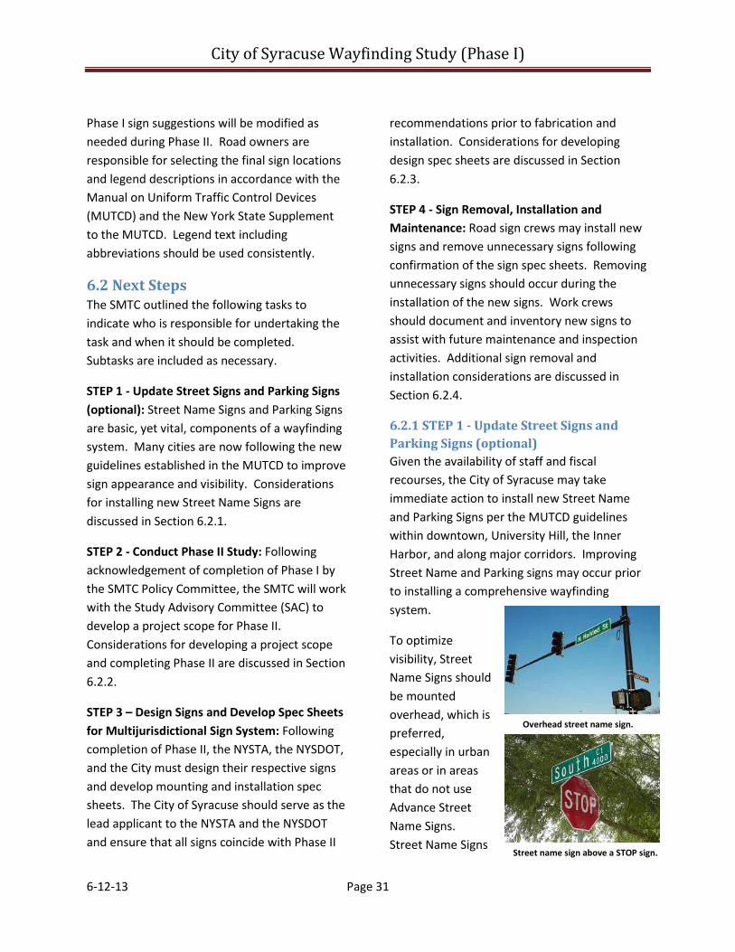
City of Syracuse Wayfinding Study (Phase I)
6-12-13 Page 31
Phase I sign suggestions will be modified as needed during Phase II. Road owners are responsible for selecting the final sign locations and legend descriptions in accordance with the Manual on Uniform Traffic Control Devices (MUTCD) and the New York State Supplement to the MUTCD. Legend text including abbreviations should be used consistently.
6.2 Next Steps The SMTC outlined the following tasks to indicate who is responsible for undertaking the task and when it should be completed. Subtasks are included as necessary.
STEP 1 - Update Street Signs and Parking Signs (optional): Street Name Signs and Parking Signs are basic, yet vital, components of a wayfinding system. Many cities are now following the new guidelines established in the MUTCD to improve sign appearance and visibility. Considerations for installing new Street Name Signs are discussed in Section 6.2.1.
STEP 2 - Conduct Phase II Study: Following acknowledgement of completion of Phase I by the SMTC Policy Committee, the SMTC will work with the Study Advisory Committee (SAC) to develop a project scope for Phase II. Considerations for developing a project scope and completing Phase II are discussed in Section 6.2.2.
STEP 3 – Design Signs and Develop Spec Sheets for Multijurisdictional Sign System: Following completion of Phase II, the NYSTA, the NYSDOT, and the City must design their respective signs and develop mounting and installation spec sheets. The City of Syracuse should serve as the lead applicant to the NYSTA and the NYSDOT and ensure that all signs coincide with Phase II
recommendations prior to fabrication and installation. Considerations for developing design spec sheets are discussed in Section 6.2.3.
STEP 4 - Sign Removal, Installation and Maintenance: Road sign crews may install new signs and remove unnecessary signs following confirmation of the sign spec sheets. Removing unnecessary signs should occur during the installation of the new signs. Work crews should document and inventory new signs to assist with future maintenance and inspection activities. Additional sign removal and installation considerations are discussed in Section 6.2.4.
6.2.1 STEP 1 - Update Street Signs and Parking Signs (optional) Given the availability of staff and fiscal recourses, the City of Syracuse may take immediate action to install new Street Name and Parking Signs per the MUTCD guidelines within downtown, University Hill, the Inner Harbor, and along major corridors. Improving Street Name and Parking signs may occur prior to installing a comprehensive wayfinding system.
To optimize visibility, Street Name Signs should be mounted overhead, which is preferred, especially in urban areas or in areas that do not use Advance Street Name Signs. Street Name Signs
Overhead street name sign.
Street name sign above a STOP sign.
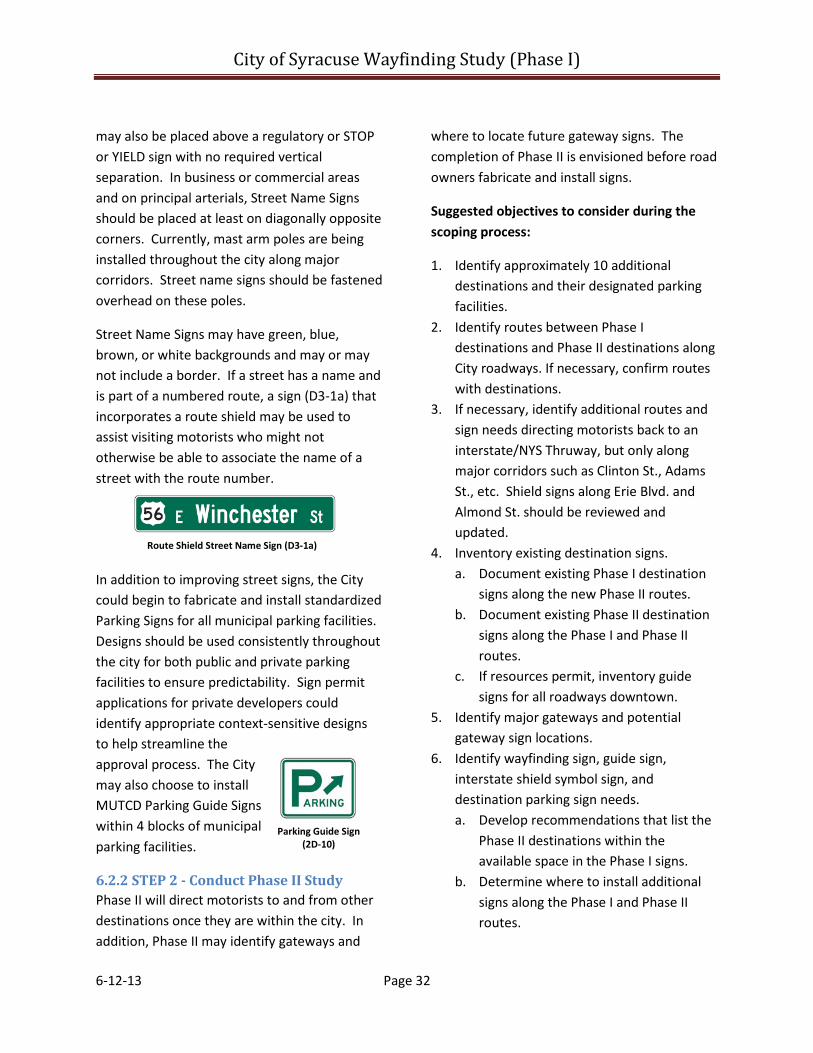
City of Syracuse Wayfinding Study (Phase I)
6-12-13 Page 32
may also be placed above a regulatory or STOP or YIELD sign with no required vertical separation. In business or commercial areas and on principal arterials, Street Name Signs should be placed at least on diagonally opposite corners. Currently, mast arm poles are being installed throughout the city along major corridors. Street name signs should be fastened overhead on these poles.
Street Name Signs may have green, blue, brown, or white backgrounds and may or may not include a border. If a street has a name and is part of a numbered route, a sign (D3-1a) that incorporates a route shield may be used to assist visiting motorists who might not otherwise be able to associate the name of a street with the route number.
In addition to improving street signs, the City could begin to fabricate and install standardized Parking Signs for all municipal parking facilities. Designs should be used consistently throughout the city for both public and private parking facilities to ensure predictability. Sign permit applications for private developers could identify appropriate context-sensitive designs to help streamline the approval process. The City may also choose to install MUTCD Parking Guide Signs within 4 blocks of municipal parking facilities.
6.2.2 STEP 2 - Conduct Phase II Study Phase II will direct motorists to and from other destinations once they are within the city. In addition, Phase II may identify gateways and
where to locate future gateway signs. The completion of Phase II is envisioned before road owners fabricate and install signs.
Suggested objectives to consider during the scoping process:
1. Identify approximately 10 additional destinations and their designated parking facilities.
2. Identify routes between Phase I destinations and Phase II destinations along City roadways. If necessary, confirm routes with destinations.
3. If necessary, identify additional routes and sign needs directing motorists back to an interstate/NYS Thruway, but only along major corridors such as Clinton St., Adams St., etc. Shield signs along Erie Blvd. and Almond St. should be reviewed and updated.
4. Inventory existing destination signs. a. Document existing Phase I destination
signs along the new Phase II routes. b. Document existing Phase II destination
signs along the Phase I and Phase II routes.
c. If resources permit, inventory guide signs for all roadways downtown.
5. Identify major gateways and potential gateway sign locations.
6. Identify wayfinding sign, guide sign, interstate shield symbol sign, and destination parking sign needs. a. Develop recommendations that list the
Phase II destinations within the available space in the Phase I signs.
b. Determine where to install additional signs along the Phase I and Phase II routes.
Route Shield Street Name Sign (D3-1a)
Parking Guide Sign (2D-10)
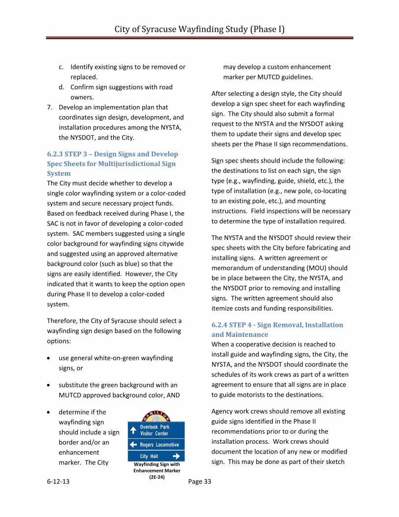
City of Syracuse Wayfinding Study (Phase I)
6-12-13 Page 33
c. Identify existing signs to be removed or replaced.
d. Confirm sign suggestions with road owners.
7. Develop an implementation plan that coordinates sign design, development, and installation procedures among the NYSTA, the NYSDOT, and the City.
6.2.3 STEP 3 – Design Signs and Develop Spec Sheets for Multijurisdictional Sign System The City must decide whether to develop a single color wayfinding system or a color-coded system and secure necessary project funds. Based on feedback received during Phase I, the SAC is not in favor of developing a color-coded system. SAC members suggested using a single color background for wayfinding signs citywide and suggested using an approved alternative background color (such as blue) so that the signs are easily identified. However, the City indicated that it wants to keep the option open during Phase II to develop a color-coded system.
Therefore, the City of Syracuse should select a wayfinding sign design based on the following options:
• use general white-on-green wayfinding signs, or
• substitute the green background with an MUTCD approved background color, AND
• determine if the wayfinding sign should include a sign border and/or an enhancement marker. The City
may develop a custom enhancement marker per MUTCD guidelines.
After selecting a design style, the City should develop a sign spec sheet for each wayfinding sign. The City should also submit a formal request to the NYSTA and the NYSDOT asking them to update their signs and develop spec sheets per the Phase II sign recommendations.
Sign spec sheets should include the following: the destinations to list on each sign, the sign type (e.g., wayfinding, guide, shield, etc.), the type of installation (e.g., new pole, co-locating to an existing pole, etc.), and mounting instructions. Field inspections will be necessary to determine the type of installation required.
The NYSTA and the NYSDOT should review their spec sheets with the City before fabricating and installing signs. A written agreement or memorandum of understanding (MOU) should be in place between the City, the NYSTA, and the NYSDOT prior to removing and installing signs. The written agreement should also itemize costs and funding responsibilities.
6.2.4 STEP 4 - Sign Removal, Installation and Maintenance When a cooperative decision is reached to install guide and wayfinding signs, the City, the NYSTA, and the NYSDOT should coordinate the schedules of its work crews as part of a written agreement to ensure that all signs are in place to guide motorists to the destinations.
Agency work crews should remove all existing guide signs identified in the Phase II recommendations prior to or during the installation process. Work crews should document the location of any new or modified sign. This may be done as part of their sketch Wayfinding Sign with
Enhancement Marker (2E-24)

City of Syracuse Wayfinding Study (Phase I)
6-12-13 Page 34
plan notes, or more preferably, as part of an electronic database file. Consideration should be given to using a GPS system to log signs into a Geographical Information System (GIS).
Inspections should be conducted every 5 years and a procedure should be in place to repair and replace signs as necessary. The City should notify destinations about the new signs so that they may update the directions on their websites, etc.
Table 6 - Next Steps Summary Table
6.3 Conclusion This study identifies guide sign and wayfinding sign needs to major destinations in the City of Syracuse from the interstates. It also identifies shield sign needs that direct motorists back to the interstates. The second study will identify additional destinations to list on remaining wayfinding sign space. Implementation is envisioned following completion of the second study. Table 6 summarizes steps 1 to 4 and outlines applicable tasks and responsibilities through project implementation.
Step Tasks Start/ Finish
Responsibility
1
Update Street Signs and Parking Signs (optional) 1. Install enhanced Street Name Signs for major corridors citywide in accordance with
MUTCD guidelines and suggestions in Section 6.2.1. 2. Standardize and install Parking “P” Signs for all public parking lots and garages citywide. 3. As necessary, install Parking Guide Signs (MUTCD 2D-10) within 4 blocks of major parking
facilities such as the Washington Street Parking Garage. 4. Require private owners who provide parking to the public to install standardized Parking
“P” Signs as part of the site plan review process.
Immediately/ Ongoing
City of Syracuse Department of Public Works (DPW)
2 Conduct Phase II Study 1. Scope Phase II Wayfinding Study with project applicant and Study Advisory Committee. 2. Conduct Phase II Wayfinding Study in accordance with scope and the suggested
objectives found outlined in Section 6.2.2.
Summer 2013/ Summer 2014
Syracuse Metropolitan Transportation Council (SMTC)
3
Design Signs and Develop Spec Sheets for Multijurisdictional Sign System 1. City of Syracuse decides the type of wayfinding sign system it wishes to install. 2. City of Syracuse determines how it wants to pay for sign improvements and secures
funding sources or seeks funding accordingly. 3. City of Syracuse works with a graphic design firm to design signs/enhancement marker in
accordance with MUTCD regulations and suggestions in Section 6.2.3. 4. City of Syracuse oversees the development of sign spec sheets per Phase II sign
suggestions and suggestions in Section 6.2.3. (Each road owner is responsible for determining the exact location of final sign placement and the type of mounting needs necessary for installation.)
5. City of Syracuse submits a formal request to NYSDOT and NYS Thruway Authority to update signs along their roadways per Phase II sign suggestions.
6. NYSDOT and NYS Thruway Authority develop their own sign spec sheets and review them with the City of Syracuse prior to taking any action.
7. The City of Syracuse reviews the NYSDOT and NYS Thruway sign spec sheets for consistency and obtains a memorandum of understanding (MOU) from both agencies before signs are fabricated. The MOU should itemize costs and funding responsibilities.
8. The City of Syracuse, the NYSDOT, and the NYS Thruway Authority send their spec sheets to their respective fabricators.
Summer 2014/ Summer 2015
City of Syracuse in coordination with NYSDOT and NYS Thruway Authority.
4
Sign Removal, Installation and Maintenance 1. The City of Syracuse should coordinate work crew schedules with NYSDOT and NYS
Thruway Authority as part of a written agreement to ensure that old signs are removed and new signs are installed per Phase II sign suggestions. Respective agency work crews should document and inventory all new signs per suggestions in Section 6.2.4, and provide copies of the inventory to the City of Syracuse.
2. The City of Syracuse should contact all destinations to notify them of the updated sign system so that they may update their website directions, etc.
3. Respective agencies should inspect signs every 5 years and replace signs as necessary.
Summer 2015/ Ongoing
City of Syracuse in coordination with NYSDOT and NYS Thruway Authority
City of Syracuse Wayfinding Study (Phase I)
6-12-13 Page 35
Additional References
The following documents were referenced throughout the course of this study for informational purposes only:
• Berger, Craig M. Wayfinding – Designing and Implementing Graphic Navigational Systems. RotoVision SA. 2009.
• Clough Harbor & Associates LLP. City of Syracuse Comprehensive Plan 2025. 2005
• Cornell Local Roads Program. Traffic Sign Handbook for Local Roads CLRP Report 11-07. 2011
• James A. Coon Local Government Technical Series. Municipal Control of Signs. New York State Department of State Division of Local Government. 2006 (Reprinted 2008).
• Mandelker, Daniel; Andrew Bertucci; and William Ewald. Street Graphics and the Law – Revised Edition. American Planning Association. Aug. 2004.
• Onondaga Citizens League. Leveraging a Better Downtown Study Report No. 27. 2006
• Onondaga County Parks. Discovery Trail Guide Sign System Inventory. 1987
• Syracuse Metropolitan Transportation Council. Long Range Transportation Plan 2011 Update. 2011
• University Hill Development Corporation. University Hill Wayfinding Sign Inventory. 2012
City of Syracuse Wayfinding Study (Phase I)
Appendix A
Meeting Summaries

Syracuse Metropolitan Transportation Council 100 Clinton Square
126 North Salina Street, Suite 100 Syracuse, New York 13202
Phone (315) 422-5716 Fax (315) 422-7753 www.smtcmpo.org
Wayfinding Study for Major Visitor Destinations SAC Kick-off Meeting
SMTC 1st Floor Conference Room Friday, January 6, 2012 10:00 a.m. – 11:30 a.m.
Attendees: Mike Alexander, SMTC Paul S. Mercurio, City of Syracuse Jeanie Gleisner, SMTC Meghan Vitale, SMTC David Holder, Visitors Bureau Mike Godfrey, SMTC Kevin Kosakowski, SMTC Julie Bednar, NYSDOT Heather Carrington, Downtown Committee Megan Costa, SOCPA Purpose:
• Build consensus on the project purpose, goals, and objectives • Identify relevant background studies to be reviewed • Identify approximately six destinations • Identify working group members
Introductions: Meeting participants introduced themselves. Project Purpose, Goal, Objectives & Schedule: The City of Syracuse sponsored this study. The SAC supported the project purpose, goal, and objectives statements and posed the following general comments/questions:
• What are the selection criteria for choosing the destinations? o The identification of selection criteria is not a task within the project scope. However,
destinations should be located within the City of Syracuse and have a significant draw of motorists from across the region.
• Will there be an inventory of existing signage? o A citywide inventory will not be conducted. The SMTC will only inventory signs along the
identified destination routes. Background Studies: The SAC identified the following additional reference materials:
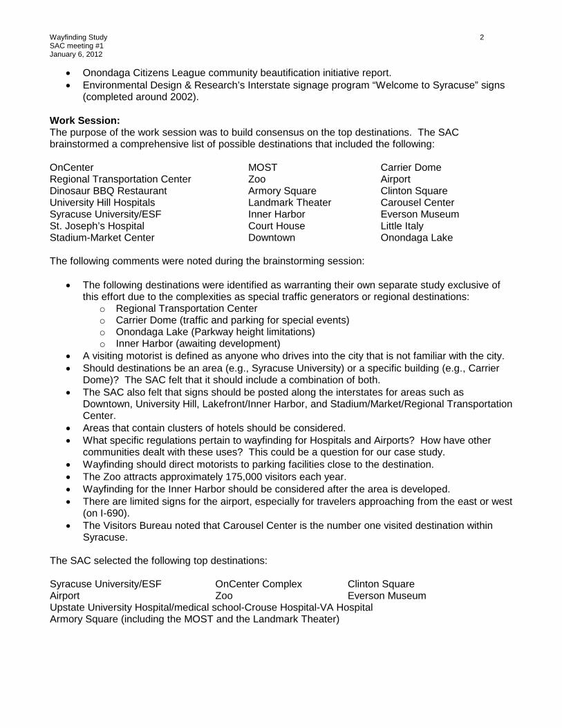
Wayfinding Study 2 SAC meeting #1 January 6, 2012
• Onondaga Citizens League community beautification initiative report. • Environmental Design & Research’s Interstate signage program “Welcome to Syracuse” signs
(completed around 2002). Work Session: The purpose of the work session was to build consensus on the top destinations. The SAC brainstormed a comprehensive list of possible destinations that included the following: OnCenter MOST Carrier Dome Regional Transportation Center Zoo Airport Dinosaur BBQ Restaurant Armory Square Clinton Square University Hill Hospitals Landmark Theater Carousel Center Syracuse University/ESF Inner Harbor Everson Museum St. Joseph’s Hospital Court House Little Italy Stadium-Market Center Downtown Onondaga Lake The following comments were noted during the brainstorming session:
• The following destinations were identified as warranting their own separate study exclusive of this effort due to the complexities as special traffic generators or regional destinations:
o Regional Transportation Center o Carrier Dome (traffic and parking for special events) o Onondaga Lake (Parkway height limitations) o Inner Harbor (awaiting development)
• A visiting motorist is defined as anyone who drives into the city that is not familiar with the city. • Should destinations be an area (e.g., Syracuse University) or a specific building (e.g., Carrier
Dome)? The SAC felt that it should include a combination of both. • The SAC also felt that signs should be posted along the interstates for areas such as
Downtown, University Hill, Lakefront/Inner Harbor, and Stadium/Market/Regional Transportation Center.
• Areas that contain clusters of hotels should be considered. • What specific regulations pertain to wayfinding for Hospitals and Airports? How have other
communities dealt with these uses? This could be a question for our case study. • Wayfinding should direct motorists to parking facilities close to the destination. • The Zoo attracts approximately 175,000 visitors each year. • Wayfinding for the Inner Harbor should be considered after the area is developed. • There are limited signs for the airport, especially for travelers approaching from the east or west
(on I-690). • The Visitors Bureau noted that Carousel Center is the number one visited destination within
Syracuse. The SAC selected the following top destinations: Syracuse University/ESF OnCenter Complex Clinton Square Airport Zoo Everson Museum Upstate University Hospital/medical school-Crouse Hospital-VA Hospital Armory Square (including the MOST and the Landmark Theater)
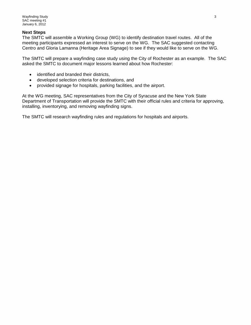
Wayfinding Study 3 SAC meeting #1 January 6, 2012
Next Steps The SMTC will assemble a Working Group (WG) to identify destination travel routes. All of the meeting participants expressed an interest to serve on the WG. The SAC suggested contacting Centro and Gloria Lamanna (Heritage Area Signage) to see if they would like to serve on the WG. The SMTC will prepare a wayfinding case study using the City of Rochester as an example. The SAC asked the SMTC to document major lessons learned about how Rochester:
• identified and branded their districts, • developed selection criteria for destinations, and • provided signage for hospitals, parking facilities, and the airport.
At the WG meeting, SAC representatives from the City of Syracuse and the New York State Department of Transportation will provide the SMTC with their official rules and criteria for approving, installing, inventorying, and removing wayfinding signs. The SMTC will research wayfinding rules and regulations for hospitals and airports.

Syracuse Metropolitan Transportation Council 100 Clinton Square
126 North Salina Street, Suite 100 Syracuse, New York 13202
Phone (315) 422-5716 Fax (315) 422-7753
www.smtcmpo.org
Wayfinding Study for Major Visitor Destinations
Study Advisory Committee (SAC) Meeting #2 SMTC Lower Level Conference Room
Tuesday, October 16, 2012 2:00 p.m. to 4:30 p.m.
Attendees: Mike Alexander, SMTC Dan Arseneau, SMTC Meghan Vitale, SMTC Kevin Kosakowski, SMTC Paul S. Mercurio, City of Syracuse Carl Thomas, City of Syracuse
Julie Bednar, NYSDOT David Holder, Visitors Bureau Megan Costa, SOCPA Jeanie Gleisner, CNYRPDB
Purpose and Update
Meeting Purpose:
The purpose of today’s meeting is to: 1) build consensus on the selected origins, destinations, and routes, and 2) determine if a second study phase should be sponsored for the 2013-2014 UPWP program year that would expand upon this study prior to implementation.
Study Purpose:
The purpose of the study is to identify sign needs from the interstate to major destinations and back to the interstate. It does not direct motorists to and from destinations once within the city. The SMTC intentionally phased this study with the option of conducting an additional phase that could direct motorists to and from other destinations. A new study phase would require member agency sponsorship for a subsequent UPWP program year.
Study Background:
The City of Syracuse does not have an existing wayfinding system, nor does it maintain an inventory of existing signs. The SMTC agreed to inventory signs along the identified destination routes, and determined that a citywide inventory of wayfinding signs was beyond the scope of this study.
The SMTC and the project sponsor (i.e., the City of Syracuse) agreed to conduct this study as an initial phase with the option to conduct future phases. As an initial phase, this study identifies major traffic
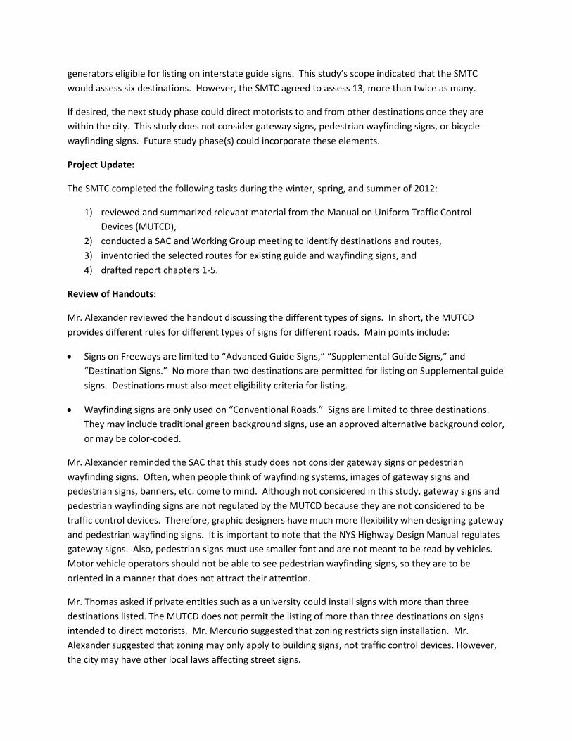
generators eligible for listing on interstate guide signs. This study’s scope indicated that the SMTC would assess six destinations. However, the SMTC agreed to assess 13, more than twice as many.
If desired, the next study phase could direct motorists to and from other destinations once they are within the city. This study does not consider gateway signs, pedestrian wayfinding signs, or bicycle wayfinding signs. Future study phase(s) could incorporate these elements.
Project Update:
The SMTC completed the following tasks during the winter, spring, and summer of 2012:
1) reviewed and summarized relevant material from the Manual on Uniform Traffic Control Devices (MUTCD),
2) conducted a SAC and Working Group meeting to identify destinations and routes, 3) inventoried the selected routes for existing guide and wayfinding signs, and 4) drafted report chapters 1-5.
Review of Handouts:
Mr. Alexander reviewed the handout discussing the different types of signs. In short, the MUTCD provides different rules for different types of signs for different roads. Main points include:
• Signs on Freeways are limited to “Advanced Guide Signs,” “Supplemental Guide Signs,” and “Destination Signs.” No more than two destinations are permitted for listing on Supplemental guide signs. Destinations must also meet eligibility criteria for listing.
• Wayfinding signs are only used on “Conventional Roads.” Signs are limited to three destinations. They may include traditional green background signs, use an approved alternative background color, or may be color-coded.
Mr. Alexander reminded the SAC that this study does not consider gateway signs or pedestrian wayfinding signs. Often, when people think of wayfinding systems, images of gateway signs and pedestrian signs, banners, etc. come to mind. Although not considered in this study, gateway signs and pedestrian wayfinding signs are not regulated by the MUTCD because they are not considered to be traffic control devices. Therefore, graphic designers have much more flexibility when designing gateway and pedestrian wayfinding signs. It is important to note that the NYS Highway Design Manual regulates gateway signs. Also, pedestrian signs must use smaller font and are not meant to be read by vehicles. Motor vehicle operators should not be able to see pedestrian wayfinding signs, so they are to be oriented in a manner that does not attract their attention.
Mr. Thomas asked if private entities such as a university could install signs with more than three destinations listed. The MUTCD does not permit the listing of more than three destinations on signs intended to direct motorists. Mr. Mercurio suggested that zoning restricts sign installation. Mr. Alexander suggested that zoning may only apply to building signs, not traffic control devices. However, the city may have other local laws affecting street signs.

Rochester Case Study:
Rochester’s program has evolved over 30 years into a color-coded vehicular wayfinding system. The Center City is divided into 4 quadrants, with each assigned a color. Destinations are listed in the legend with the background colored to correspond with the color of the quadrant. The signs use an enhancement marker to indicate color code meanings. The City installed the signs in 2008 for a cost of more than $800,000 for 200 signs listing approximately two dozen destinations. The City also recently finished a pedestrian wayfinding study that promotes using the same color codes as the existing vehicular system.
• Mr. Thomas asked why Rochester was chosen for the case study. Mr. Alexander explained that the project sponsor requested that the study include Rochester for the following reasons: 1) it is another upstate city, 2) Rochester’s vehicular wayfinding system is currently installed, 3) Rochester is currently considering installing a pedestrian wayfinding system as an extension of their vehicular system, 4) Rochester’s vehicular system has evolved over three decades, 5) several SAC members have navigated Rochester’s Central City using the wayfinding system and found it very useful, and 6) Rochester’s system is color-coded and citywide.
• Mr. Mercurio asked how to handle a destination that is not in a district, such as our zoo. Mr. Alexander said that you could assign a consistent color for areas outside of the districts and use that color consistently citywide.
• Mr. Thomas asked if there was a big cost difference in the design of color-coded vs. noncolor-coded signs. Mr. Holder noted that $800k for Rochester’s 200 signs is very reasonable. Mr. Alexander said that the signs are fabricated using the same materials and dimensions whether color-coded or not color-coded. Thus, there should not be much of a difference in cost between the two systems.
• Mr. Holder noted that people more easily understand neighborhood names, not colored quadrant symbols. Therefore, he suggests that Syracuse’s wayfinding system consider using district/neighborhood names instead of by colored quadrants. Several additional comments were made favoring a noncolor-coded program for Syracuse.
• Ms. Vitale suggested that color coding may just add to the confusion of our future wayfinding sign system since multiple themed signs are currently being installed (e.g., University Hill Signs, Connective Corridor Signs, and Civic Strip Signs). However, Ms. Vitale suggested that it might be beneficial to color code the pedestrian signs and not the vehicle signs. Mr. Mercurio said we need to consider this before we design and install any program in the future.
• Ms. Gleisner said it is crucial to work with designers on wayfinding, and that in her opinion, Rochester’s color coded system is a bit overwhelming for drivers to comprehend all the text and the different colors.

• Ms. Bednar noted that a color-coded system allows a driver to understand where they are located within a city. Mr. Holder suggested that this could be accomplished by using neighborhood/district names instead of colors.
• A SAC member asked if the Rochester system has been in place long enough to determine whether it was successful. Feedback heard to date suggests that it has been successful at directing motorists.
• Mr. Mercurio asked if there are recommendations for appropriate sign spacing. Mr. Alexander said that the MUTCD provides guidance on how far apart to space signs for trailblazing purposes.
Work Session:
Mr. Alexander asked if there are any destinations that should have been considered.
• Mr. Mercurio asked if there is a reason why the Inner Harbor was not chosen as a destination at this time. Mr. Alexander said it is because development in the area has just begun and that the SAC decided that it was too early to determine what uses would exist and where they would be located.
• Ms. Gleisner suggested that the Regional Transportation Center be considered as part of a second phase study.
• SAC members noted that “special event” destinations (such as the Carrier Dome, the SRC Arena, the Regional Transportation Center, etc.) may warrant their own study.
• Ms. Costa suggested that this phase one study should set the overall comprehensive general plan for all wayfinding elements.
• Mr. Thomas asked if we plan to do all 13 destinations all at once. Mr. Alexander said that this study will identify the sign needs for all 13 destinations and will outline additional steps for adding other destinations for consideration to expand upon the program if desired by the SAC. SAC members noted that signs should not be fabricated or installed until additional destinations are considered in a subsequent phase.
• Mr. Mercurio would like the study to include the steps required to implement a citywide wayfinding program. He would like the SMTC to develop a chart that indicates the point at which the SMTC would recommend that the City initiate a capital investment in the fabrication and installation of signs. Ms. Costa also expressed support for this approach.
• Mr. Holder suggested that the court system could be added to the destinations.
• SAC members suggested that Destiny be considered as an origin in the next study phase to direct people from Destiny to the Inner Harbor, Downtown destinations, and University Hill, etc.
• Mr. Holder suggested that medical tourism be considered for wayfinding during the next study.
• Ms. Vitale suggested that the next study consider the destinations identified by the SAC that were not advanced during this study. She asked if there were other destinations that the SAC should consider. A few SAC members felt that other destinations may exist and should be brainstormed at the beginning of the next study.
• The SAC had reservations about the need to develop a wayfinding program around districts. However, Ms. Costa suggested that if districts were considered in the future, that the Lakefront, Downtown, and University Hill be considered as districts. Mr. Holder agreed that these areas could serve as districts if necessary. Others could include Little Italy and the Regional Market/Stadium.
• Mr. Alexander indicated that there is a discrepancy between the exits currently identified for the
Zoo on the existing guide signs located along I-690 and those selected by the SAC and Working Group for this study. Mr. Mercurio would like to know if NYSDOT is willing to replace guide signs consistent with our study recommendations. Ms. Bednar said she would consult with others at NYSDOT to see how willing they are to modifying existing signs. The SAC decided to advocate for the routes identified in this study, even if they conflict with the routes currently signed.
• Mr. Holder suggested that the SAC be open to signing private entities because they may be able to
help finance the cost of sign fabrication and installation. Citing his work in Fredericksburg, Maryland, Mr. Holder worked with a private retail company to fund a portion of the installation because it brought people from Downtown to their establishment.
• Mr. Alexander pointed out that current signs and current routes identified in the study use West
Street to access the Oncenter and the Everson Museum. Mr. Holder and others expressed concern that directing motorists to West Street deprives them of experiencing more vibrant parts of downtown such as Armory Square. Mr. Thomas suggested directing motorists through Armory Square via Fayette Street. Mr. Mercurio expressed concerns over the capacity of Fayette Street and suggested that West Street was better suited to handle large event traffic at these destinations. Mr. Holder would like to direct motorists and pedestrians to other downtown destinations once they leave destinations such as the Oncenter. Mr. Alexander said that the second phase study could direct motorist to other locations once they arrive at their primary destination. The SAC decided to use West Street due to the large event traffic that could occur.
• Mr. Alexander noted that existing University Hill signs direct motorists towards the Hall of
Languages, while our routes direct motorists to the University Avenue Parking Garage. Mr. Holder said he would reach out to the University Hill Corporation to notify them of this discrepancy. The S.U. website also directs motorists to the garage. Ms. Costa asked the SMTC to verify that this is the only garage designated by the University for public parking. Also, it was noted that the University Avenue garage closes early and will lock cars in if they remain past the close time. The SMTC will determine if there are other parking options for Syracuse University. In the meantime, the SAC decided to continue directing motorists to the University Avenue parking garage.
• Mr. Alexander will contact Mr. Mercurio to determine the latest development of the Creekwalk signage being prepared by Syracuse University students.
• Mr. Alexander asked the SAC if they felt it was important for the SMTC to contact the destinations
identified in this study and get their buy-in on the suggested routes. Everyone agreed that this was important. Mr. Alexander asked the members to assist in providing contact information for destinations, so that the SMTC may continue to progress this study in a timely manner and wrap-up the study by the end of March 2013.
• Mr. Alexander noted an opportunity to direct traffic visiting E.S.F. and S.U. via Exit 14 off of I-690
towards University Avenue. Several destinations are currently being directed to Exit 13 which creates sign clutter and limits some destinations from being listed on wayfinding signs. Using exit 14 would help disperse the traffic and allow for a balance of signs throughout the network, thereby reducing sign clutter. The SAC was willing to consider this as an alternative if necessary.
Study Phase-Two Sponsorship Discussion:
Mr. Alexander reminded the SAC that this study was intentionally designed as an initial phase, and that the SAC and the project sponsor should consider conducting the second phase before implementing or installing wayfinding signs. He noted that the SMTC is mailing UPWP call letters soon, in case the City and/or Centerstate CEO is interested in sponsoring the phase two study. A follow-up study could direct motorists to other destinations once within the city and thus identify additional destinations that could be listed on a sign before it is fabricated. The project sponsor, Ms. Costa, Mr. Holder, and the other SAC members agreed that conducting the second study phase should occur before facility owners fabricate and install signs.
• Mr. Mercurio restated his interest that the final chapter includes an outline of what needs to be done and when to develop a citywide program. Mr. Mercurio said he does not want to install a sign system until everyone is comfortable that all destinations and users have been considered. He agreed that the intent of this current study is limited to major traffic generators and that the second phase should occur before signs are fabricated and installed. Wayfinding signs may list up to three destinations. Once a sign is fabricated, you cannot add another destination, so it is better to install a system once you have assessed all desired destinations and areas. The SAC members indicated that they wish to conduct the second study phase before fabricating or installing signs suggested as part of this study.
• Ms. Costa agreed and felt the next phase should be done before installing the signs. Mr. Holder agreed that the second phase should occur before signs are fabricated and installed.
• In the future, Mr. Mercurio suggested that a pedestrian level study should occur at the MPO level and not at the city level.
• Meeting adjourned at approximately 4:30 p.m.

Syracuse Metropolitan Transportation Council 100 Clinton Square
126 North Salina Street, Suite 100 Syracuse, New York 13202
Phone (315) 422-5716 Fax (315) 422-7753 www.smtcmpo.org
Wayfinding Study for Major Visitor Destinations Working Group Meeting Summary SMTC 1st Floor Conference Room
Friday, February 10, 2012 10:00 a.m. – 11:30 a.m.
Attendees: Mike Alexander, SMTC Kevin Kosakowski, SMTC Paul S. Mercurio, City of Syracuse Jeanie Gleisner, SMTC Meghan Vitale, SMTC Julie Bednar, NYSDOT David Holder, Visitors Bureau Heather Carrington, Downtown Committee Rebecca Klossner, City of Syracuse Megan Costa, SOCPA
• Mr. Mercurio asked why the lakefront was eliminated as a destination. Mr. Alexander answered that the SAC felt that wayfinding for the lakefront area should wait until the area is developed. Currently, there is a proposal to develop 34 acres around the Inner Harbor.
• Mr. Alexander reiterated project goals, which include identifying destinations, routes to and from
those destinations, and approximate sign locations. This study does not involve branding or sign design.
• Ms. Vitale asked if there was anything that speaks to how large an area needs to be for it to be
considered a “district”. If not a specific area, are there a minimum number of destinations that qualify an area to be a district? Mr. Alexander and Ms. Gleisner both said that the MUTCD guidelines did not speak to those specificities.
• There was much discussion about whether Armory Square should be considered a district or a
destination. On one hand, people recognize it as a district, while on the other hand, the area is a destination. Should wayfinding signs identify districts or destinations? Ms. Costa feels that the city has essentially three districts, the lakefront, the downtown and the university district. It was agreed upon for at least right now to consider Armory Square a destination; if it is later decided that “Armory Square” is a district, then it should be listed on the wayfinding signage as “Armory/MOST/Landmark District”. The boundaries should include the historic district boundaries.
• Check what GPS devices give as directions to the destinations. It was also suggested to check
Google maps and the web sites for each destination.
• The remainder of the meeting involved the group drawing on the maps showing the routes to the destinations.
Syracuse Metropolitan Transportation Council 100 Clinton Square
126 North Salina Street, Suite 100 Syracuse, New York 13202
Phone (315) 422-5716 Fax (315) 422-7753
www.smtcmpo.org
Wayfinding Study for Major Visitor Destinations Study Advisory Committee (SAC) Meeting #3
SMTC Lobby Conference Room Thursday, April 25, 2013 10:00 p.m. to 11:30 p.m.
Attendees: Mike Alexander, SMTC Meghan Vitale, SMTC Kevin Kosakowski, SMTC Paul S. Mercurio, City of Syracuse Carl Thomas, City of Syracuse Julie Bednar, NYSDOT
Jim Lawler, NYSDOT David Holder, Visitors Bureau Megan Costa, SOCPA Jeanie Gleisner, CNY RPDB Adria Finch, Downtown Committee
Purpose and Update
Mr. Alexander welcomed everyone and thanked them for coming. He reviewed the study purpose, which is to identify sign needs from the interstate to major destinations and back to the interstate. It does not direct motorists to and from destinations once within the city. The SMTC intentionally phased this study with the option of conducting an additional phase that could direct motorists to and from other destinations once they are within the city.
Meeting Purpose:
The purpose of today’s meeting was to go over the draft report and receive initial feedback from committee members. All comments must be submitted to Mr. Alexander no later than Thursday, May 9. The anticipated completion date of Phase I is June of this year.
2013-2014 UPWP Program Year (Phase II Study):
Phase II was selected for the next UPWP year and will start in the summer. Phase II will identify additional destinations to list on the wayfinding signs recommended in Phase I. Phase II should take about one year to complete.
Coordinated with destination to confirm routes:
Mr. Alexander spoke with representatives from the destinations and incorporated their comments regarding the travel routes to and from their destination. For example, the Armory Square Association President suggested adding Clinton Street as an exit from Armory Square.
Coordinated with Rochester to confirm Case Study Summary:
Mr. Alexander did research and consulted with planners from Rochester to learn how they developed and implemented their wayfinding program. Their wayfinding system has evolved over 30 years. In 2008, Rochester installed more than 200 wayfinding signs for approximately $817,000 total project cost. Several SAC members do not want to install a color-coded wayfinding system. Rochester’s system is color-coded.
Draft Phase I sign recommendations:
Mr. Alexander suggested a method for how to review the maps and tables. Committee members were provided, as part of the draft report, “existing conditions” maps, showing where all the signs currently exist and “recommendation” maps, showing where signs are being recommended. Along with these maps are corresponding tables that speak to whether a sign should be added, removed, or replaced.
Sign Categories:
• Wayfinding Signs (city road) & Guide Signs (interstates) • Interstate Shield Signs (city roads) • Airport Guide Signs (interstates)
Mr. Alexander talked briefly about each of the different categories of signs. He noted that pictures of many of the signs, if not all of the signs, are linked to a GIS map and could be provided if desired.
Work Session:
Review Recommendations Maps:
One of the main purposes for meeting was to hear feedback from committee members on the Draft report, more specifically, the maps, tables, and ultimately the recommendations. Below are some of the participants’ questions, suggestions, and/or comments.
Mr. Alexander’s general comments
• Wayfinding signs are of low priority compared to other signs, such as speed limit signs, and are placed where there is space. Typically, they lie 200 feet in advance of an intersection.
• Mr. Alexander noted that the University Hill has its own wayfinding sign program. Sign suggestions in our study end where the University Hill system begins.
SAC Member Questions/ Suggestions/Comments
Questions
• Mr. Mercurio asked if it would be possible to indicate ownership or agency responsibility next to each of the signs identified in the tables/maps. Having ownership information would be very helpful come time of implementation. Mr. Alexander said that would be possible to do.
• Ms. Finch asked where signs should be placed on an interstate to inform motorists that a destination is upcoming. Mr. Alexander said it is 800 feet in advance of an exit (signs should also be 800 feet apart).
• Mr. Holder asked if we could indicate which “recommended signs” exist and which ones do not. Mr. Alexander said there would be too much clutter on the maps if existing and proposed signs were identified together. Thus, the current intent is to reference the existing conditions maps to see the existing signs and the recommendation maps to see the proposed signs.
• Following completion of the Wayfinding Study, the City, NYSDOT, and NYS Thruway Authority will have to go out with an engineer/DPW crews, etc. to identify the exact location of each sign and the type of installation needs. This information will be used by each agency to develop sign spec engineering sheets. The Wayfinding Study will suggest general sign locations and destination information.
• Mr. Holder asked what the funding needs may be to make this all happen. Mr. Alexander, as noted earlier in the meeting, said that the City of Rochester spent ~$850k in 2008 to develop their existing program, which included more than 200 signs.
• Ms. Gleisner said some existing signs are confusing and wondered if they would be replaced. Mr. Alexander said that new sign regulations came out in 2009 and that many existing signs do not meet these requirements. A general recommendation is that old signs be updated with new ones as funds permit.
• Mr. Holder asked Mr. Alexander what is the best way to review the maps and tables short of driving the routes. Mr. Alexander said to block aside 2-3 hours and review the maps and tables together. He said to pick an origination point outside of the city along the thruway from the North, East, South, or West and follow the signs one by one to a destination. He said to repeat this for each direction and each destination. The reverse is true for the interstate shield maps. He said start at the destination and follow subsequent signs back to the interstate for each approach (north, south, east, and west.)
• Mr. Holder asked where and/or when do we address the integration of the pedestrian wayfinding in the corridor. How do we take all that is going on with the Connective Corridor and the Civic Strip and bring it all together? Mr. Alexander said that he has been in contact with people from the Connective Corridor, and that coordination is ongoing.
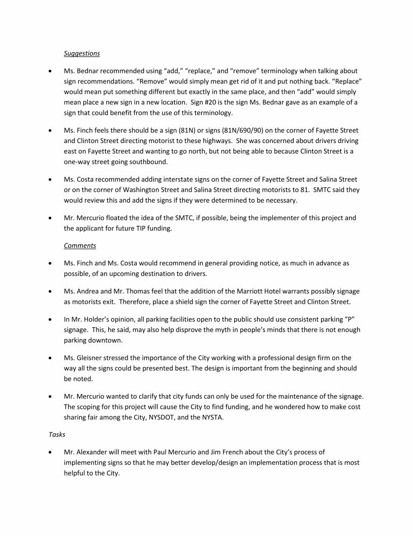
Suggestions
• Ms. Bednar recommended using “add,” “replace,” and “remove” terminology when talking about sign recommendations. “Remove” would simply mean get rid of it and put nothing back. “Replace” would mean put something different but exactly in the same place, and then “add” would simply mean place a new sign in a new location. Sign #20 is the sign Ms. Bednar gave as an example of a sign that could benefit from the use of this terminology.
• Ms. Finch feels there should be a sign (81N) or signs (81N/690/90) on the corner of Fayette Street and Clinton Street directing motorist to these highways. She was concerned about drivers driving east on Fayette Street and wanting to go north, but not being able to because Clinton Street is a one-way street going southbound.
• Ms. Costa recommended adding interstate signs on the corner of Fayette Street and Salina Street or on the corner of Washington Street and Salina Street directing motorists to 81. SMTC said they would review this and add the signs if they were determined to be necessary.
• Mr. Mercurio floated the idea of the SMTC, if possible, being the implementer of this project and the applicant for future TIP funding.
Comments
• Ms. Finch and Ms. Costa would recommend in general providing notice, as much in advance as possible, of an upcoming destination to drivers.
• Ms. Andrea and Mr. Thomas feel that the addition of the Marriott Hotel warrants possibly signage as motorists exit. Therefore, place a shield sign the corner of Fayette Street and Clinton Street.
• In Mr. Holder’s opinion, all parking facilities open to the public should use consistent parking “P” signage. This, he said, may also help disprove the myth in people’s minds that there is not enough parking downtown.
• Ms. Gleisner stressed the importance of the City working with a professional design firm on the way all the signs could be presented best. The design is important from the beginning and should be noted.
• Mr. Mercurio wanted to clarify that city funds can only be used for the maintenance of the signage. The scoping for this project will cause the City to find funding, and he wondered how to make cost sharing fair among the City, NYSDOT, and the NYSTA.
Tasks
• Mr. Alexander will meet with Paul Mercurio and Jim French about the City’s process of implementing signs so that he may better develop/design an implementation process that is most helpful to the City.

• Mr. Alexander asked if Ms. Finch could check with David Mankiewicz to see if we can share the University Hill sign inventory as an appendix to our report.
• Can the City make a hotel or other entity put signs directing motorists to the interstates as part of its site plan approval?
• Mr. Holder mentioned that the Syracuse Convention & Visitors Bureau is currently revising their directional maps and would eventually like to hear feedback from the SAC and the SMTC.
Next Steps
Comments due by Thursday, May 9, 2013:
Mr. Alexander would be willing to meet with anyone one-on-one to go over in more detail the maps and tables if it would be helpful.
Planning & Policy Committee Meetings:
With these meetings on the horizon, there is a tight schedule that Mr. Alexander is working under, making the due date for comments firm.
Phase II Scoping Meeting:
Mr. Alexander stated that scoping for Phase II will commence later this summer.
Phase II SAC kick off:
No specific date has been set, but it will be sometime this summer.
City of Syracuse Wayfinding Study (Phase I)
Appendix B
Summary of Applicable Rules
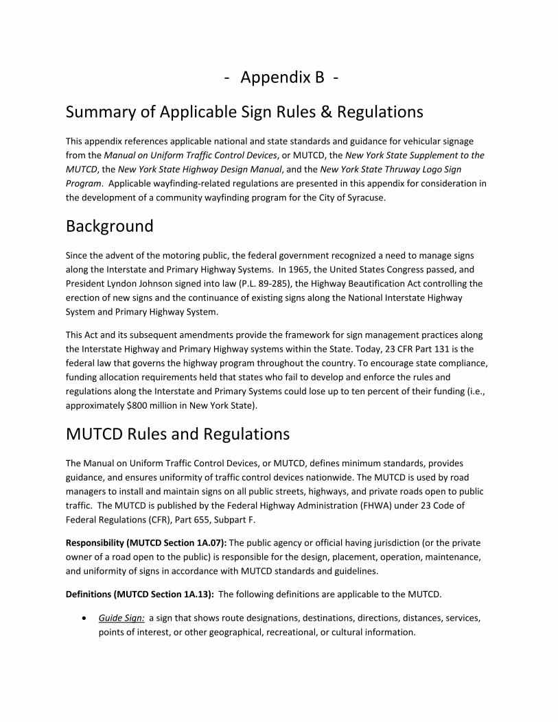
- Appendix B -
Summary of Applicable Sign Rules & Regulations This appendix references applicable national and state standards and guidance for vehicular signage from the Manual on Uniform Traffic Control Devices, or MUTCD, the New York State Supplement to the MUTCD, the New York State Highway Design Manual, and the New York State Thruway Logo Sign Program. Applicable wayfinding-related regulations are presented in this appendix for consideration in the development of a community wayfinding program for the City of Syracuse.
Background
Since the advent of the motoring public, the federal government recognized a need to manage signs along the Interstate and Primary Highway Systems. In 1965, the United States Congress passed, and President Lyndon Johnson signed into law (P.L. 89-285), the Highway Beautification Act controlling the erection of new signs and the continuance of existing signs along the National Interstate Highway System and Primary Highway System.
This Act and its subsequent amendments provide the framework for sign management practices along the Interstate Highway and Primary Highway systems within the State. Today, 23 CFR Part 131 is the federal law that governs the highway program throughout the country. To encourage state compliance, funding allocation requirements held that states who fail to develop and enforce the rules and regulations along the Interstate and Primary Systems could lose up to ten percent of their funding (i.e., approximately $800 million in New York State).
MUTCD Rules and Regulations The Manual on Uniform Traffic Control Devices, or MUTCD, defines minimum standards, provides guidance, and ensures uniformity of traffic control devices nationwide. The MUTCD is used by road managers to install and maintain signs on all public streets, highways, and private roads open to public traffic. The MUTCD is published by the Federal Highway Administration (FHWA) under 23 Code of Federal Regulations (CFR), Part 655, Subpart F.
Responsibility (MUTCD Section 1A.07): The public agency or official having jurisdiction (or the private owner of a road open to the public) is responsible for the design, placement, operation, maintenance, and uniformity of signs in accordance with MUTCD standards and guidelines.
Definitions (MUTCD Section 1A.13): The following definitions are applicable to the MUTCD.
• Guide Sign: a sign that shows route designations, destinations, directions, distances, services, points of interest, or other geographical, recreational, or cultural information.
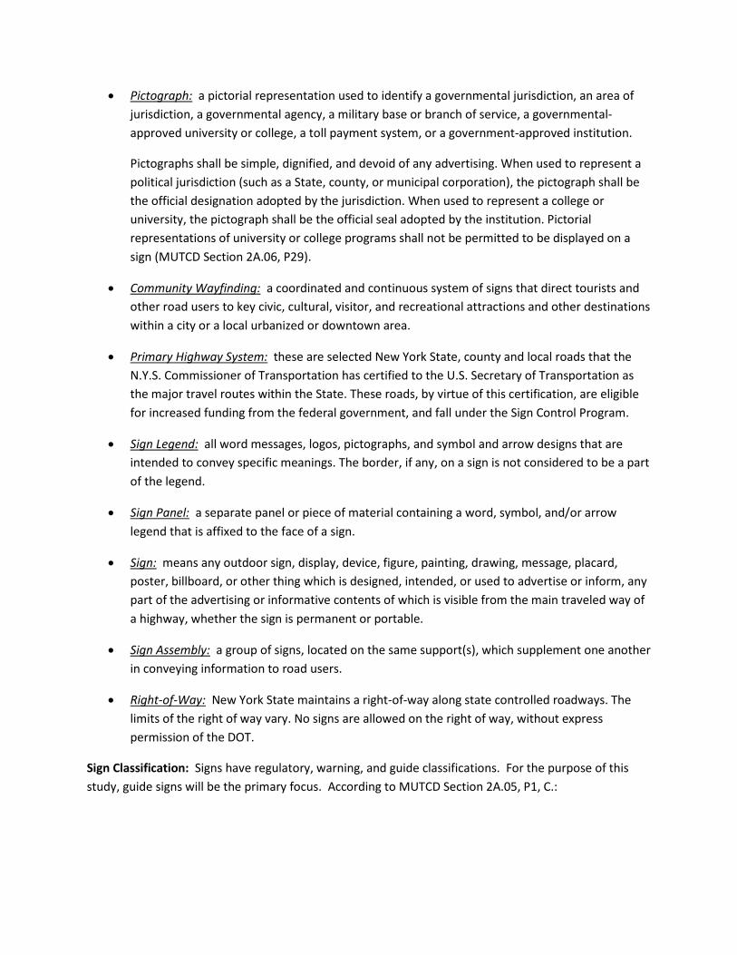
• Pictograph: a pictorial representation used to identify a governmental jurisdiction, an area of jurisdiction, a governmental agency, a military base or branch of service, a governmental-approved university or college, a toll payment system, or a government-approved institution.
Pictographs shall be simple, dignified, and devoid of any advertising. When used to represent a political jurisdiction (such as a State, county, or municipal corporation), the pictograph shall be the official designation adopted by the jurisdiction. When used to represent a college or university, the pictograph shall be the official seal adopted by the institution. Pictorial representations of university or college programs shall not be permitted to be displayed on a sign (MUTCD Section 2A.06, P29).
• Community Wayfinding: a coordinated and continuous system of signs that direct tourists and other road users to key civic, cultural, visitor, and recreational attractions and other destinations within a city or a local urbanized or downtown area.
• Primary Highway System: these are selected New York State, county and local roads that the N.Y.S. Commissioner of Transportation has certified to the U.S. Secretary of Transportation as the major travel routes within the State. These roads, by virtue of this certification, are eligible for increased funding from the federal government, and fall under the Sign Control Program.
• Sign Legend: all word messages, logos, pictographs, and symbol and arrow designs that are intended to convey specific meanings. The border, if any, on a sign is not considered to be a part of the legend.
• Sign Panel: a separate panel or piece of material containing a word, symbol, and/or arrow legend that is affixed to the face of a sign.
• Sign: means any outdoor sign, display, device, figure, painting, drawing, message, placard, poster, billboard, or other thing which is designed, intended, or used to advertise or inform, any part of the advertising or informative contents of which is visible from the main traveled way of a highway, whether the sign is permanent or portable.
• Sign Assembly: a group of signs, located on the same support(s), which supplement one another in conveying information to road users.
• Right-of-Way: New York State maintains a right-of-way along state controlled roadways. The limits of the right of way vary. No signs are allowed on the right of way, without express permission of the DOT.
Sign Classification: Signs have regulatory, warning, and guide classifications. For the purpose of this study, guide signs will be the primary focus. According to MUTCD Section 2A.05, P1, C.:

Guide signs show route designations, destinations, directions, distances, services, points of interest, and other geographical, recreational, or cultural information. (FHWA 2009).1
Color Code Meanings: Section 1A.12. P3 of the MUTCD establishes general meanings of colors appropriate for use in conveying traffic control information. For this study, relevant color code general meanings include:
• Black—regulation
• Blue—road user services guidance, tourist information, and evacuation route
• Brown—recreational and cultural interest area guidance
• Coral—unassigned
• Fluorescent Pink—incident management
• Fluorescent Yellow-Green—pedestrian warning, bicycle warning, playground warning, school bus and school warning
• Green—indicated movements permitted, direction guidance
• Light Blue—unassigned
• Orange—temporary traffic control
• Purple—lanes restricted to use only by vehicles with registered electronic toll collection (ETC) accounts
• Red—stop or prohibition
• White—regulation
• Yellow—warning
Highway Road Classifications: Sign rules and regulations vary based on highway category as roadways vary in purpose, function, and design. The following applicable terms are defined in MUTCD Section 1A.13, P1.
• Conventional Road: a street or highway other than a low-volume road, not a freeway or an expressway.
• Expressway: a divided highway with partial control of access.
1 Federal Highway Administration (FHWA). Manual on Uniform Traffic Control Devices. Dec 2009: 28.
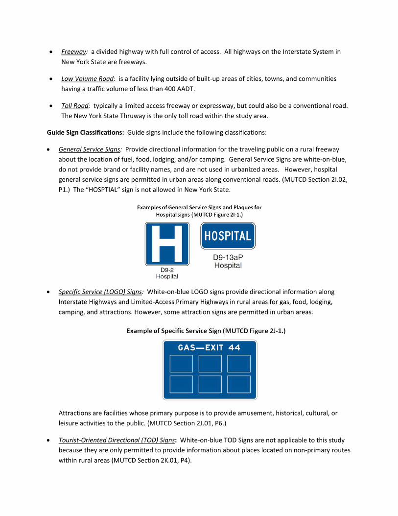
• Freeway: a divided highway with full control of access. All highways on the Interstate System in New York State are freeways.
• Low Volume Road: is a facility lying outside of built-up areas of cities, towns, and communities having a traffic volume of less than 400 AADT.
• Toll Road: typically a limited access freeway or expressway, but could also be a conventional road. The New York State Thruway is the only toll road within the study area.
Guide Sign Classifications: Guide signs include the following classifications:
• General Service Signs: Provide directional information for the traveling public on a rural freeway about the location of fuel, food, lodging, and/or camping. General Service Signs are white-on-blue, do not provide brand or facility names, and are not used in urbanized areas. However, hospital general service signs are permitted in urban areas along conventional roads. (MUTCD Section 2I.02, P1.) The “HOSPTIAL” sign is not allowed in New York State.
• Specific Service (LOGO) Signs: White-on-blue LOGO signs provide directional information along Interstate Highways and Limited-Access Primary Highways in rural areas for gas, food, lodging, camping, and attractions. However, some attraction signs are permitted in urban areas.
Attractions are facilities whose primary purpose is to provide amusement, historical, cultural, or leisure activities to the public. (MUTCD Section 2J.01, P6.)
• Tourist-Oriented Directional (TOD) Signs: White-on-blue TOD Signs are not applicable to this study because they are only permitted to provide information about places located on non-primary routes within rural areas (MUTCD Section 2K.01, P4).
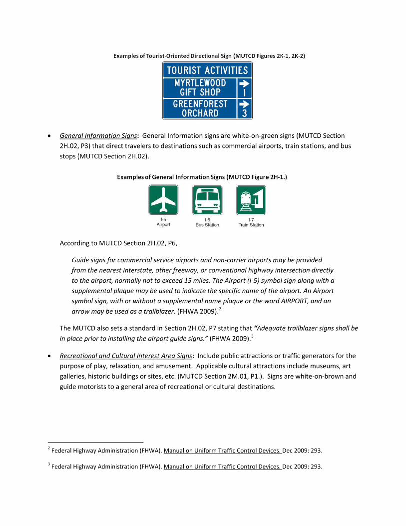
• General Information Signs: General Information signs are white-on-green signs (MUTCD Section 2H.02, P3) that direct travelers to destinations such as commercial airports, train stations, and bus stops (MUTCD Section 2H.02).
According to MUTCD Section 2H.02, P6,
Guide signs for commercial service airports and non-carrier airports may be provided from the nearest Interstate, other freeway, or conventional highway intersection directly to the airport, normally not to exceed 15 miles. The Airport (I-5) symbol sign along with a supplemental plaque may be used to indicate the specific name of the airport. An Airport symbol sign, with or without a supplemental name plaque or the word AIRPORT, and an arrow may be used as a trailblazer. (FHWA 2009).2
The MUTCD also sets a standard in Section 2H.02, P7 stating that “Adequate trailblazer signs shall be in place prior to installing the airport guide signs.” (FHWA 2009).3
• Recreational and Cultural Interest Area Signs: Include public attractions or traffic generators for the purpose of play, relaxation, and amusement. Applicable cultural attractions include museums, art galleries, historic buildings or sites, etc. (MUTCD Section 2M.01, P1.). Signs are white-on-brown and guide motorists to a general area of recreational or cultural destinations.
2 Federal Highway Administration (FHWA). Manual on Uniform Traffic Control Devices. Dec 2009: 293.
3 Federal Highway Administration (FHWA). Manual on Uniform Traffic Control Devices. Dec 2009: 293.

Signs may be used on conventional roads where there is direct access to the destination. (MUTCD Section 2M.01, P3.).
Additional MUTCD Rules Based on Highway Road Classification
The MUTCD regulates guide signs based on the type of roadway they serve. The requirements and specifications for freeway signing exceed those for expressway signing; likewise, expressway signing specifications exceed those for conventional roads.
• Guide Signs for Freeways and Expressways: The following bullets summarize applicable MUTCD rules and regulations for guide signs along Freeways and Expressways. A citation is provided with each bullet for easy reference to the MUTCD.
o Signs are to be developed as a planned system of installations supported by an engineering study as necessary. (Section 2E.02)
o Signs, unless otherwise specified, shall have white letters, symbols, arrows, and borders on a green background (MUTCD Section 2E.05)
o No more than two destination names or street names should be displayed on advance guide signs or exit direction signs. Avoid placing city names and street names on the same sign. Only one destination should be listed on a sign where two or three signs are placed on the same supports. Limit sign legends to three lines. (MUTCD Section 2E.10)
o No more than three guide signs should be displayed at any one location either on the overhead structure or its support. (MUTCD Section 2E.11)
o The standard Trailblazer Assembly (see MUTCD Section 2D.35) may be used on roads indicating the nearest or most convenient point of access leading to the freeway or expressway. (MUTCD Section 2E.27)
o Control cities (city names on interstate sign) are selected and predetermined by each state to insure consistency with available map information and consistency in signs along the route. (MUTCD Section 2E.13)
o Advance guide signs notify travelers of the destination exit and the distance to that exit. (MUTCD Section 2E.33)
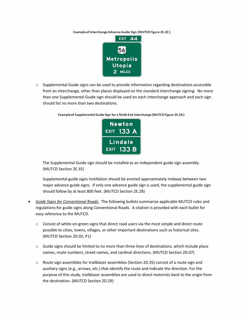
o Supplemental Guide signs can be used to provide information regarding destinations accessible from an interchange, other than places displayed on the standard interchange signing. No more than one Supplemental Guide sign should be used on each interchange approach and each sign should list no more than two destinations.
The Supplemental Guide sign should be installed as an independent guide sign assembly. (MUTCD Section 2E.35)
Supplemental guide signs instillation should be erected approximately midway between two major advance guide signs. If only one advance guide sign is used, the supplemental guide sign should follow by at least 800 feet. (MUTCD Section 2E.28)
• Guide Signs for Conventional Roads: The following bullets summarize applicable MUTCD rules and regulations for guide signs along Conventional Roads. A citation is provided with each bullet for easy reference to the MUTCD.
o Consist of white-on-green signs that direct road users via the most simple and direct route possible to cities, towns, villages, or other important destinations such as historical sites. (MUTCD Section 2D.02, P1)
o Guide signs should be limited to no more than three lines of destinations, which include place names, route numbers, street names, and cardinal directions. (MUTCD Section 2D.07)
o Route sign assemblies for trailblazer assemblies (Section 2D.35) consist of a route sign and auxiliary signs (e.g., arrows, etc.) that identify the route and indicate the direction. For the purpose of this study, trailblazer assemblies are used to direct motorists back to the origin from the destination. (MUTCD Section 2D.29)
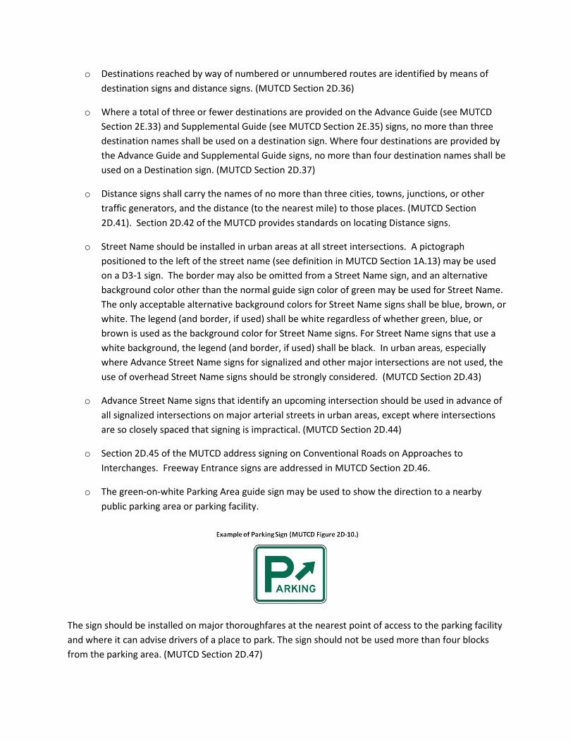
o Destinations reached by way of numbered or unnumbered routes are identified by means of destination signs and distance signs. (MUTCD Section 2D.36)
o Where a total of three or fewer destinations are provided on the Advance Guide (see MUTCD Section 2E.33) and Supplemental Guide (see MUTCD Section 2E.35) signs, no more than three destination names shall be used on a destination sign. Where four destinations are provided by the Advance Guide and Supplemental Guide signs, no more than four destination names shall be used on a Destination sign. (MUTCD Section 2D.37)
o Distance signs shall carry the names of no more than three cities, towns, junctions, or other traffic generators, and the distance (to the nearest mile) to those places. (MUTCD Section 2D.41). Section 2D.42 of the MUTCD provides standards on locating Distance signs.
o Street Name should be installed in urban areas at all street intersections. A pictograph positioned to the left of the street name (see definition in MUTCD Section 1A.13) may be used on a D3-1 sign. The border may also be omitted from a Street Name sign, and an alternative background color other than the normal guide sign color of green may be used for Street Name. The only acceptable alternative background colors for Street Name signs shall be blue, brown, or white. The legend (and border, if used) shall be white regardless of whether green, blue, or brown is used as the background color for Street Name signs. For Street Name signs that use a white background, the legend (and border, if used) shall be black. In urban areas, especially where Advance Street Name signs for signalized and other major intersections are not used, the use of overhead Street Name signs should be strongly considered. (MUTCD Section 2D.43)
o Advance Street Name signs that identify an upcoming intersection should be used in advance of all signalized intersections on major arterial streets in urban areas, except where intersections are so closely spaced that signing is impractical. (MUTCD Section 2D.44)
o Section 2D.45 of the MUTCD address signing on Conventional Roads on Approaches to Interchanges. Freeway Entrance signs are addressed in MUTCD Section 2D.46.
o The green-on-white Parking Area guide sign may be used to show the direction to a nearby public parking area or parking facility.
The sign should be installed on major thoroughfares at the nearest point of access to the parking facility and where it can advise drivers of a place to park. The sign should not be used more than four blocks from the parking area. (MUTCD Section 2D.47)
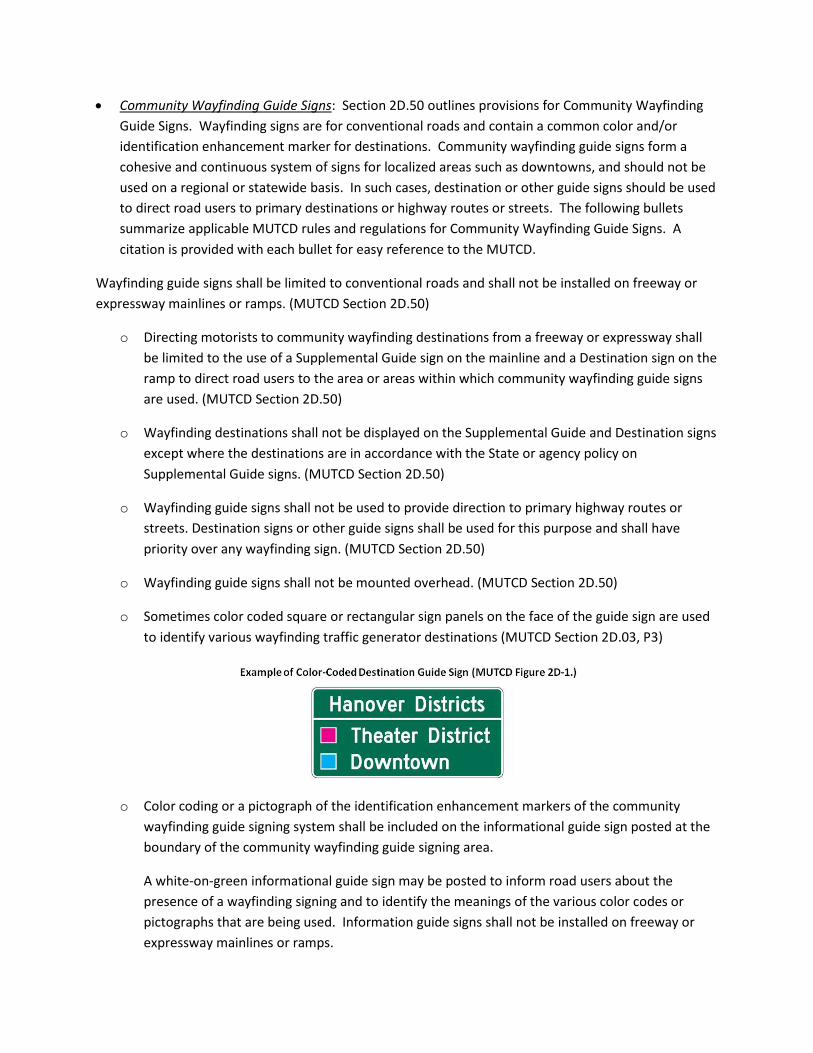
• Community Wayfinding Guide Signs: Section 2D.50 outlines provisions for Community Wayfinding Guide Signs. Wayfinding signs are for conventional roads and contain a common color and/or identification enhancement marker for destinations. Community wayfinding guide signs form a cohesive and continuous system of signs for localized areas such as downtowns, and should not be used on a regional or statewide basis. In such cases, destination or other guide signs should be used to direct road users to primary destinations or highway routes or streets. The following bullets summarize applicable MUTCD rules and regulations for Community Wayfinding Guide Signs. A citation is provided with each bullet for easy reference to the MUTCD.
Wayfinding guide signs shall be limited to conventional roads and shall not be installed on freeway or expressway mainlines or ramps. (MUTCD Section 2D.50)
o Directing motorists to community wayfinding destinations from a freeway or expressway shall be limited to the use of a Supplemental Guide sign on the mainline and a Destination sign on the ramp to direct road users to the area or areas within which community wayfinding guide signs are used. (MUTCD Section 2D.50)
o Wayfinding destinations shall not be displayed on the Supplemental Guide and Destination signs except where the destinations are in accordance with the State or agency policy on Supplemental Guide signs. (MUTCD Section 2D.50)
o Wayfinding guide signs shall not be used to provide direction to primary highway routes or streets. Destination signs or other guide signs shall be used for this purpose and shall have priority over any wayfinding sign. (MUTCD Section 2D.50)
o Wayfinding guide signs shall not be mounted overhead. (MUTCD Section 2D.50)
o Sometimes color coded square or rectangular sign panels on the face of the guide sign are used to identify various wayfinding traffic generator destinations (MUTCD Section 2D.03, P3)
o Color coding or a pictograph of the identification enhancement markers of the community wayfinding guide signing system shall be included on the informational guide sign posted at the boundary of the community wayfinding guide signing area.
A white-on-green informational guide sign may be posted to inform road users about the presence of a wayfinding signing and to identify the meanings of the various color codes or pictographs that are being used. Information guide signs shall not be installed on freeway or expressway mainlines or ramps.
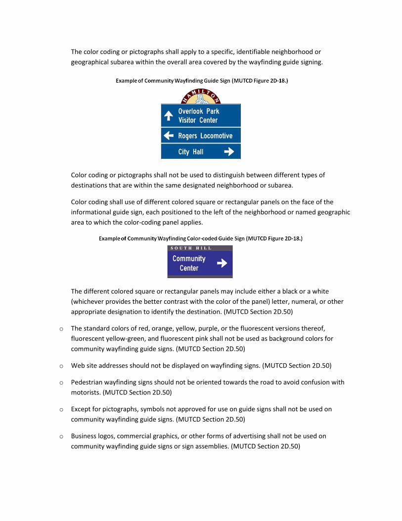
The color coding or pictographs shall apply to a specific, identifiable neighborhood or geographical subarea within the overall area covered by the wayfinding guide signing.
Color coding or pictographs shall not be used to distinguish between different types of destinations that are within the same designated neighborhood or subarea.
Color coding shall use of different colored square or rectangular panels on the face of the informational guide sign, each positioned to the left of the neighborhood or named geographic area to which the color-coding panel applies.
The different colored square or rectangular panels may include either a black or a white (whichever provides the better contrast with the color of the panel) letter, numeral, or other appropriate designation to identify the destination. (MUTCD Section 2D.50)
o The standard colors of red, orange, yellow, purple, or the fluorescent versions thereof, fluorescent yellow-green, and fluorescent pink shall not be used as background colors for community wayfinding guide signs. (MUTCD Section 2D.50)
o Web site addresses should not be displayed on wayfinding signs. (MUTCD Section 2D.50)
o Pedestrian wayfinding signs should not be oriented towards the road to avoid confusion with motorists. (MUTCD Section 2D.50)
o Except for pictographs, symbols not approved for use on guide signs shall not be used on community wayfinding guide signs. (MUTCD Section 2D.50)
o Business logos, commercial graphics, or other forms of advertising shall not be used on community wayfinding guide signs or sign assemblies. (MUTCD Section 2D.50)

o An enhancement marker, smaller than the community wayfinding guide signs themselves, consists of a shape, color, and/or pictograph that is used as a visual identifier for the community wayfinding guide signing system for an area. (MUTCD Section 2D.50)
o Enhancement markers shall not be designed to have an appearance that could be mistaken by road users as being a traffic control device. (MUTCD Section 2D.50)
o An identification enhancement marker may be used in a community wayfinding guide sign assembly, or may be incorporated into the overall design of a community wayfinding guide sign, as a means of visually identifying the sign as part of an overall system of community wayfinding signs and destinations. (MUTCD Section 2D.50)
o Street Name signs are a basic, yet vital component of a wayfinding system. The MUTCD regulates the use of Street Name Signs and provides some design options such as using different background colors, route shields, or pictographs. The MUTCD provides the following guidelines and suggestions for Advance Street Name signs and Street Name Signs.
Advanced Street Name Signs: Advance Street Name signs (D3-2) identify an upcoming intersection and must use a green background.
Example of Advanced Street Name Sign (MUTCD Figure 2D-10)
Street Name Signs: Street Name (D3-1) signs should be installed at all intersections regardless of other route signs that might be present. A pictograph may only be used on a D3-1 sign to the left of the street name.
Example of Street Name Sign (MUTCD Figure 2D-10)
If a street has a name and is part of a U.S., State, or county numbered route, a sign (D3-1a) that incorporates a route shield may be used. Incorporating the shield assists road users who might not otherwise be able to associate the name of the street with the route number.
Example of Street Name Sign with a Route Shield Symbol (MUTCD Figure 2D-10)

The only acceptable colors on a Street Name (D3-1 or D3-1a) sign include green, blue, brown, or white. The border may also be omitted. An alternative background color may be selected if the highway agency determines that it is necessary to assist road users in determining jurisdictional authority for roads.
To optimize visibility, Street Name signs may be mounted overhead. This is preferred, especially in urban areas or in areas that do not use Advance Street Name Signs. Street Name signs may also be placed above a regulatory or STOP or YIELD sign with no required vertical separation. In business or commercial areas and on principal arterials, Street Name signs should be placed at least on diagonally opposite corners (MUTCD Section 2D.43).
NYS Supplement to the MUTCD In New York State (NYS), signs and other traffic control devices must conform to national MUTCD standards. States are also allowed to adopt supplemental standards to the MUTCD. The State Administrative Procedures Act (SAPA) includes provisions allowing New York State to adopt a Supplement to the MUTCD (NYS Supplement) that contains more stringent rules and regulations. Where a conflict with material presented in the MUTCD and the NYS Supplement occur, the NYS Supplement supersedes the information found in the corresponding sections of the MUTCD. The following discussion outlines applicable NYS Supplement rules and regulations pertaining to wayfinding signs.
Responsibility (NYS Supplement Section 1A.07): According to the NYS Supplement: “The National MUTCD and its specifications are adopted as the state standard for traffic control devices on any street, highway, or bicycle path ‘open to public travel’. No person shall install or maintain in any area of private property used by the public any sign, signal, marking or other device intended to regulate, warn or guide traffic unless it conforms with the state manual and specifications maintained under this section.” (NYSDOT Supplement).4
General Rules and Regulations
The following bullets summarize applicable NYS Supplement rules and regulations.
o Sign installations should be at least 200 feet apart where possible. (NYS Supplement Section 2A.16, O6A)
o The location of Destination Signs is discussed in Section 2D.40. Typically signs are placed between 800 and 1400 feet in advance of an intersection (200-400 feet in advance of a junction assembly).
4 NYS Department of Transportation. New York State Supplement to the Manual on Uniform Traffic Control Devices for Streets and Highways – 2009 Edition. Dec. 2010, Effective March 16, 2011: 11.

o Name Auxiliary signs may be used to supplement General Information symbol signs and Recreational and Cultural Interest Symbol guide signs, and may be used in other instances where motorist guidance would be enhanced by the inclusion of a specific name in a route assembly.
Where more than one hospital is in the vicinity of a Hospital symbol sign, a Name auxiliary sign with the name of the hospital the symbol is referring to may also be used to supplement this symbol.
Name auxiliary signs shall have background and legend colors that match the colors of the sign they supplement. (NYS Supplement Section 2D.107)
o Post-Interchange Distance Signs should not be shown more frequently than at 10-mile intervals. (NYS Supplement Section 2E.39)
o Unless otherwise noted in the NYS Supplement, symbol signs shall not be used along freeways for general information signs. The following symbols applicable to this wayfinding study may be used: College, State/Local Parks, Commuter Rail Stations, and Theater. Except for state/local parks and theater symbols, political boundary and scenic byway logos and signs, General Information signs shall have white-on-green. The others shall have white-on-brown. (NYS Supplement Section 2H.02)
o Historic Site signs may be used along conventional highways and expressways to guide traffic to places of recognized historic value operated and maintained in the public interest.
There is a distinction between historic site signs and state historic site signs. Historic site signs shall only be used for sites listed in the National or State Register of Historic Places.
Historic Districts can be signed using the state historic site sign by modifying the text to say “HISTORIC DISTRICT”.
Signs should be placed in the immediate vicinity of the site/district and should contain a sufficient number of signs to direct the motorists to reach the site/district. (NYS Supplement Section 2H.101).
o Section 2H.102 outlines provisions and regulations pertaining to NYS Heritage Signs.
o General Service hospital sign shall only contain white-on-blue symbol on a Freeway General Service Sign and on conventional roads. Hospital and Emergency Service signs should not be used in the same location. (NYS Supplement Section 2I.02)
o Only the “H” symbol shall be permitted on the Freeway General Service Sign. Text saying “HOSPITAL” is not allowed in New York State.
The sign should be placed at least 800 feet away from any other guide sign. (NYS Supplement Section 2I.03)
o Specific Service (ATTRACTION) signs shall be used only on freeways in New York. ATTRACTION Signs may be used in urbanized areas if it meets the various requirements (NYS Supplement Section 2J.01)
o Specific Service Trailblazer Signs (for ATTRACTIONS) are not allowed in New York State. Wayfinding signs should supplement specific service trailblazer signs. (NYS Supplement Section 2J.09)
o Specific Service Ramp signs (for ATTRACTIONS) are permitted for use on freeway exit ramps. (NYS Supplement Section 2J.101)
o Recreational and Cultural Interest Area Sign symbols shall not be used along freeways. (NYS Supplement Section 2M.01)
New York State Highway Design Manual Appendix 11B – Decorative Community Gateway Signing and/or Landscaping on the State Highway Right-of-Way: The New York State Department of Transportation developed a policy to regulating gateway signing and landscaping to define how, when, and where it is appropriate. According to the Highway Design Manual (HDM) Appendix 11B (HDM Appendix 11B), Decorative Community Gateway Signs are defined as:
A non-commercial, civic oriented sign that may contain a salutation (e.g., “WELCOME TO …”), the name of a community (e.g., “UTOPIA”) and/or a short slogan (e.g., A GREAT PLACE TO LIVE, WORK, AND PLAY”).
This type of sign is usually found at the entrance or gateway to a community and is considered an alternative to the MUTCD approved municipal boundary signs (Section 2D.110 of the New York State Supplement). In instances where signs deviate from the

MUTCD and take on a more decorative appearance in shape, color, font, text, etc., the signs are not considered to be traffic control devices, and therefore not regulated by the MUTCD. (NYSDOT HDM 11B-3)5
The HDM identifies two types of landscaping under what is termed “Decorative Community Gateway Landscaping,” both civic natured and are non-commercial. The first type involves installing flowers, shrubs, etc. around a welcome sign. The second type involves spelling out the Salutation with the landscaping material. Although, not considered a MUTCD issue, such landscaping is subject to other State and Federal laws. The FHWA under (23 CFR 1.23(c)) will permit an exception to landscaping in the public right-of-way if it is shown to be “in the public interest and will not impair the highway or interfere with the free and safe flow of traffic thereon.” (HDM Appendix 11B. 1. 2)
Decorative Gateway Signing and Landscaping may be allowed on most Conventional Roads and on certain controlled access highways such as community bypasses and expressways. It is not allowed on Interstates, Freeways and Parkways. (HDM Appendix 11B. 1. 3) NYSDOT prefers that municipal gateway signs and landscaping be installed in a location outside of the NYS highway right-of-way. (HDM Appendix 11B. 3)
The following applicable conditions are required (additional conditions may apply) to install gateway signs/landscaping:
• Do not display advertizing or sponsorship information. (HDM Appendix 11B. 2. A)
• A use and occupancy permit for a single sign or a group of signs shall be required in the State right-of-way. (HDM Appendix 11B. 2. B)
• A highway work permit for a single sign or a group of signs shall be required in the State right-of-way, unless NYSDOT is installing the sign as part of a capital project. Otherwise, municipalities must apply for a permit and shall not install signs/landscaping under the municipality’s annual maintenance permit. (HDM Appendix 11B. 2. C)
• Signs and landscaping shall meet all lateral offset clearances as identified in (HDM Appendix 11B. 2. D)
• Notification of the Resident Engineer shall be required three days before installation. (HDM Appendix 11B. 2. E)
• Work zone traffic control shall be required as approved by the Regional Traffic Engineer/ Design Engineer (HDM Appendix 11B. 2. F).
5 NYS Department of Transportation. Highway Design Manual (HDM) - Appendix 11B - Decorative Community Gateway Signing and/or Landscaping on the State Highway Right of Way. Feb. 2008: 11B-3.
• Post-construction maintenance is the responsibility of the municipality under its annual maintenance highway work permit. (HDM Appendix 11B. 2. G)
• Signs should not contain directional information, and should be reflective and or illuminated if it serves as the primary means of denoting the municipal boundary (HDM Appendix 11B. 3. A)
• The maximum sign size shall not exceed 32 square feet. (HDM Appendix 11B. 3. B)
• The maximum landscape size shall not exceed 144 square feet; 500 square feet if it imparts a welcome message. (HDM Appendix 11B. 4. C)
New York State Thruway Logo Sign Program Public Authorities Law Section 361-a governs off-premises signs along the New York State Thruway. Additionally, the New York State Thruway Logo Sign Program identifies provisions for logo signs in rural and rural appearing areas along the Thruway.
Similar to the MUTCD, the Thruway Authority establishes provisions under its Logo Sign Program for ATTRACTION signs along the Thruway. According to Section 5.C.3, to qualify for a specific service attractions panel the permittee shall:
• have adequate parking accommodations
• provide rest rooms and drinking water where appropriate
• provide or be reasonably close to a phone for public use
• be located within 15 miles of exit ramp
• if seasonal, provide covering/removal of the sign when not in use
• be in operation at least four days per week during annual or seasonal operation (seasonal operation must be not less than 30 days)
• satisfy the criteria developed by the Thruway Authority’s Department of Economic Development by falling under one of the following categories:
o Zoo – (Must demonstrate that at least 25% of average daily annual visitors originate from 50 or more miles from the attraction)
o Cultural/historic site, museum – (Must demonstrate that at least 25% of average daily annual visitors originate from 50 or more miles from the attraction)
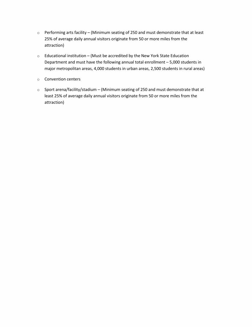
o Performing arts facility – (Minimum seating of 250 and must demonstrate that at least 25% of average daily annual visitors originate from 50 or more miles from the attraction)
o Educational institution – (Must be accredited by the New York State Education Department and must have the following annual total enrollment – 5,000 students in major metropolitan areas, 4,000 students in urban areas, 2,500 students in rural areas)
o Convention centers
o Sport arena/facility/stadium – (Minimum seating of 250 and must demonstrate that at least 25% of average daily annual visitors originate from 50 or more miles from the attraction)