Embed Size (px)
DESCRIPTION
A paper on building high for sustainable urban development in Västra City, Stockholm city centre.
Citation preview

Department of Architecture and built Environment
Master thesis in urban planning and design
Spring semester 2009
Cityscapes of the future:
Design for sustainable urban development in Stockholm’s city centre
By: Assienah Mooki Morosini
Supervisor: Daniel Koch

1 | P a g e
1
Abstract
This thesis deals with the ever changing landscapes of the Stockholm
city and how to develop it's cityscape in a way that is sustainable in
terms of economic, social and environmental sustainability. The
proposal is set upon the fact that Stockholm is expected to reach a
population of 1 million by the year 2030 and wants to become a more
global city while maintaining it's stance on sustainability.
The aim of this thesis is to create an urban design proposal for the city
centre of Stockholm, which pays attention to the existing urban
landscape and its daily use while maintaining the goal of Stockholm
becoming a more sustainable global city and region. The delimitation is
set upon the Stockholm-Mälaren region and Stockholm city for
descriptive reasons. A proposal will then be done for the area of Västra
city . The method of analysis is a visual/ image analysis based on Kevin
Lynchs book Image of this city. The method involves visual mapping of
areas in terms of objects, visibility, strength, weaknesses, connections,
disconnections and interrelations. The thesis' theoretical framework:
includes literature on the utopianism of city planning that features
readings on works by Ebenezer Howard, Le Corbusier and others. In
terms of sustainability litterature on the concept of sustainability is
used along with litterature on vertical urban theory which is adopted in
the projects proposal. In conclusion this thesis and proposal will
hopefully make it aware that despite current debate on the future
planning of Stockholm, there is enough room for the city to maintain
and achieve it's role and labels as a Global city, Green city, Venice of
the North and a Sustainable city while getting an exciting cityscape.
While the area of Västra city is today not that of which one would
expect of a “Global city” it's future proposed development through
high-density sustainable development, will make for a more inviting
and exciting first glance of the city.

2 | P a g e
2
Table of content
Part I Introduction
1.Introduction....................................4
1.1 BACKGROUND ........................................................................................................... 4 1.2 AIM AND PURPOSE ..................................................................................................... 4 1.3 DELIMITATION........................................................................................................... 4 1.4 METHODOLOGY AND STRUCTURE .................................................................................. 4
3 Stockholm city and it’s region.........6
3.1 HISTORY OF STOCKHOLM’S CITY CENTRE ......................................................................... 6
3.2 Vision 2030 ..................................7
3.3 VÄSTRA CITY ............................................................................................................. 7
Part III The city examined
4 The planning of cities....................10
4.1INTRODUCTION ........................................................................................................ 10
4.2 URBAN UTOPIAS.......................................................................................................10 4.3 SPRAWL AND THE AUTOMOBILE CITY ............................................................................11
5 Case studies ................................. 14
5.1. LA DEFÉNSE ............................................................................................................14 5.2 MORE LONDON .......................................................................................................14
Part IV Elements in the
sustainability of cities
6. Sustainable development ........... 17
6.1THE CONCEPT OF SUSTAINABILITY .................................................................................17 6.2 THE ECONOMY AND VALUE OF SUSTAINABILITY ...............................................................17 6.3. VERTICAL URBAN THEORY..........................................................................................18 6.4 CONCLUSIONS .........................................................................................................19
Part VI Planning for Västra city
7 Current situation analysis ............ 21
7.1 METHOD OF ANALYSIS ...............................................................................................21 7.1.1 Edges ..................................................................................................... 21 7.1.2 Landmarks............................................................................................. 21 7.1.3 Nodes .................................................................................................... 21 7.1.4 Paths ..................................................................................................... 21 7.1.5 Districts ................................................................................................. 21
7.2 BICYCLE AND PEDESTRIAN NETWORK.............................................................................22 7.3 CAR STREETS AND MOTORWAY NETWORK ......................................................................22 7.4 BUILT LANDSCAPE AND GREEN STRUCTURE .....................................................................22 7.5 BUILDING TYPOLOGY .................................................................................................22 7.6 STRUCTURAL CHARACTER ANALYSIS ..............................................................................23 7.7 CONCLUSION AND DEVELOPMENT PLAN.........................................................................23
Proposal
8. Västra City ................................... 25
8.1 DEVELOPMENT PLAN .................................................................................................26 8.2 ELEVATIONS.............................................................................................................27 8.3 SUSTAINABILITY STRATEGY ..........................................................................................29 8.4 TRAFFIC STRATEGY ....................................................................................................30 8.4 TRAFFIC STRATEGY ....................................................................................................31 8.4 3D ILLUSTRATIONS....................................................................................................33 8.4 MASTERPLAN...........................................................................................................36
Litterature references..................................................................................... 37 Internet references......................................................................................... 37

3 | P a g e
3
Part I Introduction

4 | P a g e
4
1.Introduction
1.1 Background The united nations estimated in 2001, that half of the world’s
population would be living in cities by the year 2010(Cadessasso,
M.L., 2008 p.8). This will mean a need for further urban
development in order to provide housing, workplaces and places
of leisure for the expanding urban population. In Stockholm like in
most countries sustainable development has become an important
part of urban planning and design with goals such as minimizing
environmental degradation put in place. Cities like Stockholm are
struggling to provide exciting environments while striving for a
more sustainable development. Stockholm is however also dealing
with the debate on whether or not to change it’s cityscape. The
city is slowly but surely recovering from the urban demolition of
the sixties and plans by the municipality are to have the city grow
higher through a densification program. Many city officials,
planners and architects speak of Manhattan when referring to the
planned urban development of the city. The idea is to build high,
but many are in opposition with this, with planners, architects, city
officials and citizens on opposite sides of the debate. Some say
that the city should not let the market and globalization forces
dictate it’s the urban development. While other see the building
of high-rises as the image of a city. The debate which started with
the building of the city’s first high building (city hall) is thought to
likely arise every time there are plans for a new high-rise
(http://www.dn.se/sthlm/stockholms-city-vaxer-upp-1.794181).
In December 2009, members of the liberal Swedish political party
(Folkpartiet) penned a debate article in the Swedish newspaper
Svenska Dagbladet with the title “The beauty of Stockholm is
threatened”. The introduction to the piece which was most
passionate went as following “A CITY IN TRANSITION soulless giants
of steel, glass and concrete do not belong in Stockholm. Stockholm
is one of the world's most beautiful cities. Today it is threatened of
becoming dramatically unattractive. The process is already in
motion.”
The underlying argument in the debate article, was the fear that
members of the party felt of Stockholm becoming a “mini-
Manhattan” even criticizing members of their own coalition
government the conservative (Moderaterna), for wanting to give
funding to development companies that were willing to build high-
rises (http://www.svd.se/opinion/brannpunkt/stockholms-skonhet-
ar-hotad_3988187.svd).
Despite concerns the general idea in Stockholm has long been an
adaptation of the Paris model with building and development
regulation codes, that opted for a preservation of the cityscape by
ensuring that the height levels of new development did not surpass
that of the existing. However there has in the city centre been an
exception to this rule, allowing a height difference of two to three
floors more than average. Västra city is one controversy in this
matter as it is proposed to reach new heights.
There are however some that feel that this is in clear contradiction
with some of the city’s plans for the future of Stockholm (which
features skyscrapers in its central parts). In a debate article in the
Swedish architectural magazine Arkitekten, Fillip Henley a city
architect for one of Sweden’s municipalities said “If Stockholm
wishes to develop as a Green Capital one has to question the plans
for high-rises in the city centre”. Henley further states that
Stockholm is often referred to as the Venice of the North, another
quality of the city is that it is built in human scale with a tranquillity
not often experienced in many other cities (Henley, F. Arkitekten 02
2010). While much of the arguments presented by Henley are of
relevance the competitiveness of cities around the world is
apparent in an ever globalizing world. The planning and
administrative bodies in Stockholm are intent on raising land value,
which they view as building high-rises. This while others such as
Heneey speak of the cultural value that will be lost as the urban
cityscape and urban value is altered by the new high –rises (Henley,
F. 2010 Arkitekten p.58).
1.2 Aim and purpose
The aim of this thesis will be to create an urban design proposal for
the city centre of Stockholm, which pays attention to the existing
urban landscape and its daily use while maintaining the goal of
Stockholm becoming a more sustainable global city and region.
1.3 Delimitation
The delimitation of this thesis covers the aspects of environmental ,
social and economic sustainability in terms of sustainable
development. The geographical study area is Västra City an area
located in the center of Stockholm city. Some attention is also paid
to the ongoing development projects of Stockholm and the
Stockholm-Mälaren region.
1.4 Methodology and structure The project is set in five parts a descriptive which will include a
historic overview of the development of the Stockholm city centre.
This methodology and structure is included in the first part which is
the introduction. The second part of the thesis is a historical
overview of planning and the development of Stockholm. The third
part of the thesis will cover theoretical literature on sustainability
and sustainable development. The fourth part of the thesis will
analyze The Stockholm city centre (Norrmalm) in terms spatial,
social and economical aspects that are of importance for the
everyday life of the city. The fifth and final part of this thesis will
present a proposal for the future development of Stockholm its
region and its cityscape.

5 | P a g e
5
Part II Stockholm

6 | P a g e
6
3 Stockholm city and it’s region
3.1 History of Stockholm’s city centre Urban development in Stockholm has since the demolitions of the
inner parts of the city been turbulent, and often meets resistance from
the citizens. While their resistance is valid the changes that were
implemented in the mid 20th century fell short of the urban utopia that
was envisioned, and in their place resides a more than lacklustre urban
centre. The city of Stockholm was unlike other European cities
untouched by the Second World War which left many European cities
in ruins and in need of reconstruction. But a reconstruction
nonetheless took place in Stockholm as the city was seen as
inadequate to hold the title of city centre. Stadsholmen, today’s old
town was in the beginning seen as Stockholm’s city centre. The area
was however soon seen as not fit to be representative of the industrial
era which demanded locals for banking and firms. The new buildings
were therefore situated in Norrmalm which meant a restructuring on
the position of the city’s centre. Norrmalm soon became an attractive
commercial district. This soon brought about the end of Stadsholmen
and the birth of Gamla stan, as Stadsholmen could no longer be called
the centre of Stockholm. Norrmalm in turn gained two streets
Kungsgatan and Sveavägen. The area around Kungsgatan which was
mostly residential was changed to office places and places for
commerce (Hall, T. 2009 p.112-113).
By the mid 1920s the motorization of the city had begun with the
numbers of automobiles in the city rising from 2 000 to 17 500. The
roads of the city were shared by various vehicles such as trams, horse
drawn carts, cyclists and of course the pedestrians, which soon created
chaos. A solution was seen as necessary but the city’s chief urban
planner had no interest in such changes. By 1927 the chief urban
planner Per Olof Hallmans working contract ended with the position
being offered to Albert Lilienberg, who at the time was one of the
country’s most prominent urban planners. Lilienberg was unlike
Hallman more technical in his way of planning, as he was an engineer
by education. In 1928 he revealed a general plan for the city’s most
urban parts . The plan included future metro lines, overpasses and well
structured streets, much of the plan was implemented. Another part of
Lilienbergs plan was the construction of a city centre which meant the
transformation of the southern part of Norrmalm. Lilienberg advocated
for a centralisation of finance and retail even referring to Lindhagens
plan for Norrmalm from the 1866, which featured Sveavägen leading to
the waterfront. The plan would mean a demolishing of existing
structures, to clear way for the extension of Sveavägen. The plan for
Sveavägen which was first met with praise soon received heavy
critique, and was later scrutinized leading to an international
architectural competition, for the site including all of southern
Norrmalm. The competition which garnered 350 entries within and
outside of Sweden was viewed as highly successful. The judging of the
projects was based on how the structures would promote
commercialization and accessibility. None of the entries won due to the
fact that the planning committee could not reach a unanimous decision
(Hall, T. 2009 p.115-119).
Lindhagen plan source: www.wikipedia.org
Lilienberg later came up with a more detailed plan for southern
Norrmalm featuring the widening of Sveavägen which would intersect
with Hamngatan together with the creation of a new piazza
“Sveaplatsen”. This plan like the one before garnered heavy critique,
mainly due to the fact that the proposal did not respect the existing
topography. Which would mean a digging out of the Brunkebergs ridge.
The proposal was further seen as detrimental for Gamla stan as it
would mean a possible traffic increase for the area. While the plan was
criticized by many planning practitioners it was supported by the city
politicians. The plan was eventually not implemented as the city
council voted 56 against and 35 for (Hall, T. 2009 p.121-126).
By 1944 Albert Lilienberg was no longer the citys chief urban planner.
The fate of Sveavägen had however not been concluded. The torch for
the citys urban planning was handed over to Sven Markelius , who
began an alteration of the plan for southern Norrmalm. A new proposal
for the area was put forward in 1946. The new plan marked a vast
redevelopment of Stockholms city centre. The plan featured the
construction of new development and car free shopping streets. The
proposal also paid attention to the function of buildings and suggested
a higher amount of spaces for firms and companies within the area.
The current scatter of businesses was seen as un-preferable for the
future of the city, both financially and functionally. The proposed plan
was meet favourably but the traffic solutions were found to be
unfavourable by the building committee and the aesthetic council, who
felt the handling of the existing through demolition, was dire. The
urban planning office however saw no value in maintaining the existing
buildings (Hall, T. 2009 p.128-130).
Much of the land to be developed was owned by the city, which was
intent on raising land value through development. Another defining
factor for this inner-city development is though to be the entrance of
the metro system, which facilitated in the destruction of buildings
around Sergelgatan and further giving strength to the inner city
project. The city was growing fast and its economy strengthening. By
early 1951 the reconstruction of southern Norrmalm was underway.
There was however no general plan for Norrmalm but “partial
development plans” facilitating in a non negotiation in the planning
direction for Norrmalm which would hinder any debate or critique. The
first “partial development plan” covered the expansion of
7 | P a g e
7
Klarabergsgatan . The second “partial development plan” covered the
area around Hötorget, featuring the removal of the theatre which was
to be replaced by a cinema and various retail. Also featured in the plan
were modernist high-rises. Many were against the destruction of the
existing environment which had before garnered no special interest,
such as the Sergel house and Bethlehem church. The third “partial
development plan” conceived in 1953 featured the location on the
west side of Drottninggatan. The plan meant a digging out of the area
in order to provide traffic development and a building site for the
planned highrises. The forth “partial development plan” concerned the
formation of Sergelstorg the area previously planned as Sveaplan. The
name of the place would pay homage to Johan Tobias Sergel whos
studio, the Sergel house had been demolished in the transformation
process (Hall, T. 2009 p.130-134).
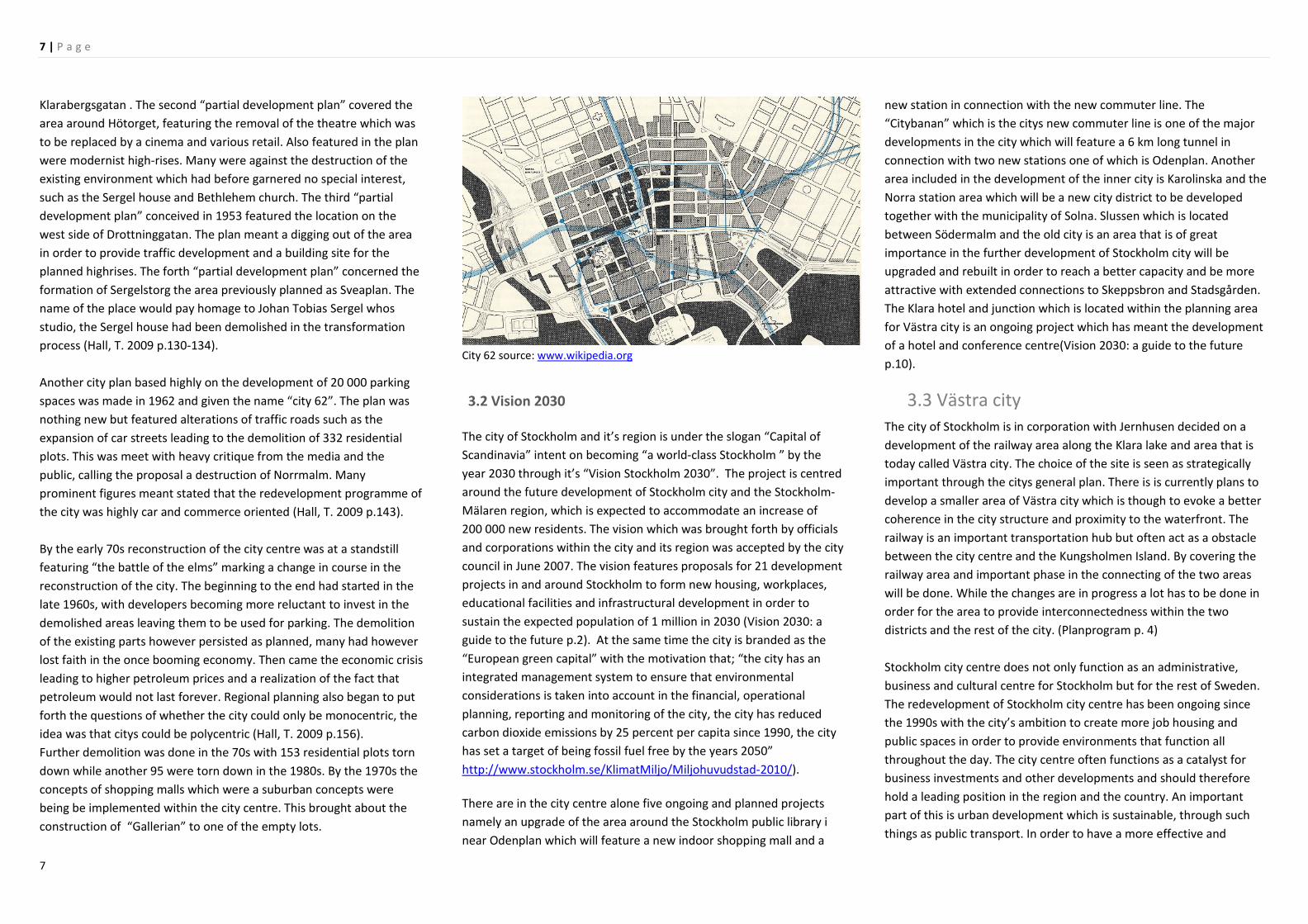
Another city plan based highly on the development of 20 000 parking
spaces was made in 1962 and given the name “city 62”. The plan was
nothing new but featured alterations of traffic roads such as the
expansion of car streets leading to the demolition of 332 residential
plots. This was meet with heavy critique from the media and the
public, calling the proposal a destruction of Norrmalm. Many
prominent figures meant stated that the redevelopment programme of
the city was highly car and commerce oriented (Hall, T. 2009 p.143).
By the early 70s reconstruction of the city centre was at a standstill
featuring “the battle of the elms” marking a change in course in the
reconstruction of the city. The beginning to the end had started in the
late 1960s, with developers becoming more reluctant to invest in the
demolished areas leaving them to be used for parking. The demolition
of the existing parts however persisted as planned, many had however
lost faith in the once booming economy. Then came the economic crisis
leading to higher petroleum prices and a realization of the fact that
petroleum would not last forever. Regional planning also began to put
forth the questions of whether the city could only be monocentric, the
idea was that citys could be polycentric (Hall, T. 2009 p.156).
Further demolition was done in the 70s with 153 residential plots torn
down while another 95 were torn down in the 1980s. By the 1970s the
concepts of shopping malls which were a suburban concepts were
being be implemented within the city centre. This brought about the
construction of “Gallerian” to one of the empty lots.
City 62 source: www.wikipedia.org
3.2 Vision 2030
The city of Stockholm and it’s region is under the slogan “Capital of
Scandinavia” intent on becoming “a world-class Stockholm ” by the
year 2030 through it’s “Vision Stockholm 2030”. The project is centred
around the future development of Stockholm city and the Stockholm-
Mälaren region, which is expected to accommodate an increase of
200 000 new residents. The vision which was brought forth by officials
and corporations within the city and its region was accepted by the city
council in June 2007. The vision features proposals for 21 development
projects in and around Stockholm to form new housing, workplaces,
educational facilities and infrastructural development in order to
sustain the expected population of 1 million in 2030 (Vision 2030: a
guide to the future p.2). At the same time the city is branded as the
“European green capital” with the motivation that; “the city has an
integrated management system to ensure that environmental
considerations is taken into account in the financial, operational
planning, reporting and monitoring of the city, the city has reduced
carbon dioxide emissions by 25 percent per capita since 1990, the city
has set a target of being fossil fuel free by the years 2050”
http://www.stockholm.se/KlimatMiljo/Miljohuvudstad-2010/).
There are in the city centre alone five ongoing and planned projects
namely an upgrade of the area around the Stockholm public library i
near Odenplan which will feature a new indoor shopping mall and a
new station in connection with the new commuter line. The
“Citybanan” which is the citys new commuter line is one of the major
developments in the city which will feature a 6 km long tunnel in
connection with two new stations one of which is Odenplan. Another
area included in the development of the inner city is Karolinska and the
Norra station area which will be a new city district to be developed
together with the municipality of Solna. Slussen which is located
between Södermalm and the old city is an area that is of great
importance in the further development of Stockholm city will be
upgraded and rebuilt in order to reach a better capacity and be more
attractive with extended connections to Skeppsbron and Stadsgården.
The Klara hotel and junction which is located within the planning area
for Västra city is an ongoing project which has meant the development
of a hotel and conference centre(Vision 2030: a guide to the future
p.10).
3.3 Västra city The city of Stockholm is in corporation with Jernhusen decided on a
development of the railway area along the Klara lake and area that is
today called Västra city. The choice of the site is seen as strategically
important through the citys general plan. There is is currently plans to
develop a smaller area of Västra city which is though to evoke a better
coherence in the city structure and proximity to the waterfront. The
railway is an important transportation hub but often act as a obstacle
between the city centre and the Kungsholmen Island. By covering the
railway area and important phase in the connecting of the two areas
will be done. While the changes are in progress a lot has to be done in
order for the area to provide interconnectedness within the two
districts and the rest of the city. (Planprogram p. 4)
Stockholm city centre does not only function as an administrative,
business and cultural centre for Stockholm but for the rest of Sweden.
The redevelopment of Stockholm city centre has been ongoing since
the 1990s with the city’s ambition to create more job housing and
public spaces in order to provide environments that function all
throughout the day. The city centre often functions as a catalyst for
business investments and other developments and should therefore
hold a leading position in the region and the country. An important
part of this is urban development which is sustainable, through such
things as public transport. In order to have a more effective and

8 | P a g e
8
sustainable city Stockholm has to be centred and more compact as a
city. There are many ongoing development project in Stockholm with a
focus on creating “green and blue” environment with a proximity to
nature and water. Stockholm is a city built on those principles. In order
to get a more versatile environment a mix in architecture and function
is needed. The existing buildings are also taken into consideration
when creating a more versatile and alive city. This means possibly
adding more floorage above buildings and opening up places for
activity on the bottom floors. Vasagatan and Klarabergsgatan can in the
future become the more important streets in the city as they provide
links to some of the cities prominent public spaces such as Norra
Bangatan and Tegelbruket in the case of Vasagatan and Sergelstorg and
Klarabergsplan in the case of Klarabergsgatan. Klarabergsgatan also
serves as an important axis between Kungsholmen and the inner city.
The development of the citybanan and bridging of the railway area are
the largest development projects within the area and are highly
influential for the future development of the area. Overdecking the
railway area would mean the creation of two new areas Västra city
south of Kungsbron and Barnhusviken north of Kungsbron exteding
from Tegelbacken to Karlberg. Today the area acts as a barrier in the
city and Kungholmen but an overdecking of it could mean new
connections and a better city life. Sustainable development is
becoming more and more important as more people move into cities.
This socially, economically and environmentally, it is up to cities to in
their planning create more sustainable environments. One way of this
is building more compact cities that allow for a better flow of people
and a wider use of public transportation. This will possibly lead to less
energy consumption and lower uses of fossil fuels. Statistics show that
in the EU alone the built environment stand for 40 % of the energy
consumption, something that can be prevented in using more
sustainable building methods. The idea for Västra city is to create more
sustainable buildings and good living environments (planprogram p8-
9).

9 | P a g e
9
Part III The city examined

10 | P a g e
10
4 The planning of cities 4.1Introduction As planners, architects and urban designers we often leap to a utopian
way of addressing the problems of the city. We envision what could be
of the city rather that what the city is. The bad is often thought as so
detrimental to the good of the city that there is no other solution than
to start over from a clean slate. In the mid 90s Stockholm underwent a
major transformation of its inner city areas, leading to demolition of
what would now be considered as architecturally, social and
economically valuable. While the city has learned from its mistakes the
fear that came resulted in contempt for urban change. While
Stockholm is growing much of the inner city problems are being
addressed elsewhere, through clean slate processes, with the city
spreading further and further away from its boundaries. This
subsequently leads to problems such as sprawl and other social and
environmental issues. In order to find a way for Stockholm to grow in a
healthy manner the city has to in my mind look at the underlying
fundaments of urban planning and design coupled with the human use
of the city. Much of contemporary urban design is a result of past
utopianism. The rigidness of the views presented often lead to greater
gaps than intended, creating more problems in urban form and
function. Their implementations often leave out the fluidity of urban
life. Urbanity however structured and controlled seems to happen in its
own way, when the prescribed result is not the reality one finds. It is
evident in the history of urban planning practice, that urbanity is highly
dependent on far too many conditions to ever be prescribed a certain
societal outcome.
Stockholm is a city in transition a transition that cannot be hindered.
But how far can we go, how much should the effects of globalization
impact Stockholm? These are some of the questions that need to be
addressed when designing Stockholm.
4.2 Urban utopias In understanding the contemporary urban environment of today one
has to look at forerunners of this kind of utopianisms such as Ebenezer
Howard and Le Corbusier. But to understand the mechanism that has
resulted in our current urbanities one must travel further back in time,
and examine the visions of thinkers such as William Morris who
through his published work of 1890 titled Views from nowhere,
illustrates a future city envisioned through the story of a man waking
up in a green urban Utopia, where the evils of the city such as
consumerism, poverty and governance are replaced by a consumer
free altruistic society. Through this Howard found some of his
motivational detest for the city, viewing it as consisting of cramped
spaces and unhealthy living conditions. Howard furthermore saw the
outward growth of cities as detrimental to the health of people and
perseverance of country living going as far as describing the city as a
tumour. As much as most of Howards views of the city were negative,
he none the less found value in the social aspects of the city. Howard
was in some ways also greatly inspired by Edward Bellamy’s book
Looking back published in 1888 as complete opposite to Morris´ Views
from nowhere. Through this Howard saw the possibility to create a
socialistic ideal society. A great attribute to the success of Howard’s
ideas was his ability to access polarities and find unifying qualities.
Much of Howards work focused on merging the qualities of town with
that of the country in order to create a new form of society. A large
part of these ideas were based on bringing back nature into the daily
lives of people without eliminating the qualities of the city. These ideas
were realized in his creation of the garden city (Pinder, D. 2005, p.30-
36). Utopianism was in Howard’s mind an essential component in
achieving reform in urbanity and society. Utopianism was seen as a
guiding light in urban planning futures. Changing the form of the city
would in his mind lead to a societal change and thus a change in values
(Pinder, D. 2005, p.40). The realization of Howard’s Garden city often
fell short to his main guiding principles and became a type of urban
planning rather than societal reform, where the creation of good
society gave way to the formation of good suburbs. This often led to
the urban problems of suburbs that we today find in Great Britain
(Pinder, D. 2005, p.46). However Utopian Howard’s ideas were they
clearly had importance in improving the lives and health of city
inhabitants. One critic to Howard’s ideals was Jane Jacobs who viewed
the clinical organization of spaces advocated by this utopianism, as
neglecting of the realism of space and its apparent organization. She
viewed Howard’s Garden city as a city for mindless individuals, who
followed
suit rather than created their own adventures (Pinder, D. 2005, p.52).
Howards main contribution to the field of planning is undoubtedly the
strategic organization of space, in a presumptive manner based on
rules and regulations (Pinder, D. 2005, p.55). Le Corbusier is another
utopian whose thoughts have had a great impact on the urban
organization (Pinder, D. 2005, p.52). The end of the First World War
brought about the yearning for innovation combined with cities in
shambles. Existing values were ridiculed and rejected. Theorists that
had inspired creations such as the garden city were dismissed and seen
as not adaptable to the concept of the urban. Buildings were to be
seen as machines serving a function rather than elaborate aesthetical
constructions. This was seen by Walter Gropius one of the founder of
the Bauhaus modernist school as a rejection of utopianism leading to a
change in position that called for a merging of mechanics and
aesthetics (Pinder, D. 2005, p.60-61). This thinking is in some ways a
foundation to Le Corbusier ideas, which in some ways differ and relate
to Howards ideas. Creating tremendous possibilities in the discussion of
the urban planning discourse. Both ideas are furthermore fundamental
for the policies and ideas of today’s urban planning. Le Corbusier was
like Howard dissatisfied with the city functioned but spatially rather
than societal. The solution was according to him in organization with
CIAM a physical transformation of the city, this transformation was
referred to Paris which was the subject of Le Corbusier thoughts
(Pinder, D. 2005, p.60). In Le Corbusier mind a tweaking of the existing
situation was inapplicable but rather a creation of completely new
cities, the past was to be forgotten. The new world order of urbanism
was to be in line with industrialist architecture through form would
eventually lead to the creation of better societies (Pinder, D. 2005,
p.62). Cities were to be contained in the sense that they had to
structurally be perfected through various zoning regulations inhabiting
a population of 3 million. Le Corbusiers vision came up in his depiction
of a future Paris through his “Voisin plan” which would mean a

11 | P a g e
11
demolition of the central parts of Paris featuring in its place 18 high-
rises.
Le Corbusier saw the city as a functional apparatus. In his work on the
“The contemporary city for three million people”, prepared for a city
exposition, he placed transportation as the most important element of
urban design featuring a variety of transportation routes and methods
(Fishman, R. 1982 p. 190).
The city was in Le Corbusiers mind a place for the exchange of
thoughts, therefore he placed the central station as it’s most important
element as it was always a place for the movement of people. Around
this centre would be an agglomeration of high-rises. Which would
house the cities intellectuals. His strategic placement of skyscrapers
would become an important element in urban planning and
design(Fishman, R. 1982 p. 192).
4.3 Sprawl and the automobile city
In his book Sprawl a compact history Robert Bruegmann described
sprawl as “a low density scattered, urban development without
systematic large-scale or regional public land use planning”.
(Bruegmann, 2005, p10).
Pieser however defined Sprawl as “the gluttonous use of land,
uninterrupted monotonous development, leapfrog discontinuous
development and inefficient use of land” (Peiser, 2001, p278). The term
of sprawl is thus often reserved for developments that predominantly
include single family housing. Other characteristic are a lacking
infrastructure in terms of accessibility and a insufficient use or land
(Bergström, 2003, p10).
Cities have however historically tended to be compact in the centre
when it comes to population density while the peripheral areas had a
lower population density. This trend has however changed in recent
times with cities like London shifting densities with the cores losing
population densities to the peripheral areas. (Bruegmann, 2005, p10-
11 ).
Early protest to Sprawl was due to the infiltration of the city to the
nature and countryside. European cities unlike American cities, had
begun to grow into natural lands and farmlands. The environments
that came from these expansions were often not the best of
environments as they were often unplanned, contained industries and
were created entirely for financial profit. The sprawl that occurred in
the early twentieth century was however mainly due to well-off
families moving outside of the chaotic and filthy city. These new class
formations were in Britain often meet with resentment from the
existing aristocratic society who felt that they alone held the right to
have large estates outside the city. A large number of the population in
the west world inhabit urban areas that are often located in the edges
of cities. The urbanization trend of the past century has reshaped cities
to more of a regional spectrum. Cities have thus become
agglomerated. Cities like Los Angeles now feature a confederation
including up to twelve municipalities. Tokyo with its 31 million
inhabitants is the largest of the worlds developed areas. Cities are in a
sense no longer concentrated but sprawled to include a number of
fringe municipalities (Ingersoll, R. 2006, p.3)
In the beginning sprawl was something that only occurred in developed
countries but is now a phenomenon that is seen in developing
countries. Cairo is one example of a country with a fast growing sprawl
pattern. One of the many consequences of sprawl lies in the fact that
people do not work or shop in proximity to where they live anymore.
The trend in commercial development has been that of the shopping
mall. The values of the inner city are therefore not prescribed to the
outer parts of the city. The incentive for sprawl lies in the ability to
build on inexpensive land, the vehicle friendly environment and the
perceived value of being close to the countryside. Although often
planned(such as in the case of American suburbs) the inconsistency of
sprawl makes it seem unplanned. There seems to be in perception a
lack in connectivity, as highways do not lead directly to development
and tend to create a barrier between developments. The sprawled
development often tends to not be pedestrian friendly. The values of
the inner city such as visual interconnectedness have been lost in
sprawl and been replaced by a virtual interconnectedness through
infrastructure such as the internet and telephones. The city is now
more or less seen as a sightseer destination (Ingersoll, R. 2006, p.4-5).
In sprawl everything is tagged as centre, a shopping mall becomes a
shopping centre a business park becomes a business centre even
though the cited may not be constructed central within a development.
One reason for this is thought to be a lack in spatial constraints
(Ingersoll, R. 2006, p.8).
The analysis of sprawl has to be in its accessibility and not in its
location. Analysing it through built environment is something hard to
do as it is built or inbuilt, hard surface of soft surface. Good space is
seen as something that is constant while bad space (sprawling space) is
seen as something negative as it is always fleeting. The historic form of
the city in its compact and architectural divergence was something that
gave cities a sense of character. The street pattern may have been
similar in most cities, but their compositions always varied. Sprawl
however always contains the same characteristics, motorways, signs,
huge rectangular buildings with parking spaces framing them and so
on. Suburbs are however not uniform as sprawl in Europe is often
different from the one in North America. European sprawl is often
legislated and in the intermediate peripheries of the city. The result in
construction is however the same whether it is in a European or
American city, while the city centres tend to vary dramatically
(Ingersoll, R. 2006, p.3).
Krier sought in his writing for a breakdown of sprawl and a
beautification of cities to match that of a pre-industrial era where the
city was seen as a body. The sprawled was to in some way be
redesigned into small cities with traditional centres. Koolhaus meant
that the city was affected by the process of globalisation, which could
not be contained within the city. The urbanization process was
therefore directed by the market and the architect should rather than
to try and hinder these processes adapt to them. Krier however
proposed a more compact city one that would hinder unnecessary
growth through the production of his Krierstadt through various
legislation. Koolhaas in turn opposed this kind of legislation as it would
according to him only hinder development in one place only to have it
appear in another, ultimately giving no power to the legislation. The
market was perceived as a force too strong to withstand (Ingersoll, R.
2006, p.17-18).

12 | P a g e
12
One important argument against sprawl is environmental degradation.
This has in recent times been evident in climate change which is said to
be a result of elevated greenhouse gas emissions. Sprawl tends to lead
to a heightened amount of cars and a squandering of the planets
natural resources. Sprawl embraces the vehicle and the inner city
concept of compactness. The urban becomes in many ways limitless.
The pedestrian is not included in sprawl but rather denied space and
connectivity. Streets were before a centre stage for the activities of the
city’s inhabitants. Vehicles are in some sense inadaptable to the public
spaces in the city, such as parks and squares; they also form barriers in
the urban environment, through the construction of roads and
motorways. The visual scenery of an urban environment is fragmentally
perceived when driving in a vehicle. The entrance of the vehicle into
society meant a change in the organisation of the city is both spatially
and socially. The city is no longer adapted to pedestrians but to the
automobile consisting of filling stations parking lots and motorways
(Ingersoll, R. 2006, p.73-76).
Much of the urban design process was due to population growth of
cities. Leading to results such as Haussmann’s Paris, where
restructuring lead to a network of boulevards that allowed the
possibility for new commerce infrastructure and public spaces.
Automobiles were introduced to the equation with incentives such as
roundabouts like the one found around the Arc de Triomphe. The
streets were then seen as existing on different levels with the
separation of cars from people. The impact of automobiles on urban
design was highly evident with the entrance of the modernist
movement leading to the recognition of modernists such as Le
Corbusier, who wrote many influential pieces on the modernistic, but
none as influential as the La Ville Radiuse(1953). La Ville Radiuse
presented fundamental change to the urban makeup of boulevards,
parks with tall buildings containing work and residential areas. The plan
was to give a form of personal freedom that would be
further strengthened by information and communication technologies.
The result would however lead to a sort of urban isolation (Ingersoll, R.
2006, p.80-83).
Urban living can be radically improved, made more real and less
placeless, it is argued by a return to concepts of locality, commune and
solidity in urban life (Harvey. D. 2005 Sprawl and suburbia, p.21-22)
The motorway was however by far the leading force in the creation of
“the motorized society”. In the USA the highway became an important
part of planning legislation. The Futurama Pavilion sponsored by
General Motors and presented during the World Fair of 1939 brought
with it the lobbying of vehicle friendly development by the automobile
industries. This lead to legislation that would ensure the production of
the major interstate highway. Demolition was introduced as a necessity
for the creation of the interstate highway leading to the demolition of
massive urban development (Ingersoll, R. 2006, p.86-87)
La Ville Radiuse source: www.thecarandtheelephant.com
The interstate source: www.fogcityjournal.com
The fragmentation caused by sprawl can often be thought of as limited
to a lack in urban planning or disorder (Ingersoll, R. 2006, p.89). The
motorization process soon lead to the production of highrises in the
city centred and multileveled motorways, then came the shopping
centre which would facilitate in better accessibility for the car and it’s
user. The products were areas the Barbican centre in London and La
Defense in Paris (Ingersoll, R. 2006, p.91-93).
The Barcadian centre source: www.ianvisits.co.uk

13 | P a g e
13
La Defence source: www.arnaudfrichphoto.com
The fact that half the world’s population lives in the city, with the
numbers ever increasing is leading to a continued territorialisation of
undeveloped land by the urban. Ecology is slowly being devoured by
the built environment, and with sprawl this is happening in a rapid
pace. At the same time cars and their petrol is being used to reach
these sprawling distances leading to a heightened emission of
greenhouse gases. The solutions to this problem are many such as
legislation to protect the ecological environment and incentives in
construction using technologies. While they are all in good faith they
have not had any strength. There have in recent decades been various
conferences and political gatherings in the intent to solve the
ecological problems created by heightened gas emissions such as the
Rio de Janeiro conference which gave birth to a general outlook on the
solution to the ecological problems. Other gatherings followed in which
various nations debated on methods for achieving sustainability. This
while urban thinkers argued that the solutions could be found by
looking at the past urban patterns and the life of past cities (Ingersoll,
R. 2006, p.129-131).
Consumerism is often blamed for our inability to live simpler lives. The
consumption of American society which is twice the size of that of the
European, leads to a land use of 5, 2 hectare used for production of
consumer goods, leading to a consumption rate of 30 % of the worlds
production of goods (Ingersoll, R. 2006, p.133)..

14 | P a g e
14
5 Case studies
5.1. La defénse
La defense is part of the so called “presidential” projects which lie in the legacy of French governmental traditions. La defénse was part of a program launched by President Mitterand in the early 80s which was seen as a way of introducing modern architecture to the city of Paris, a development project that not only produced the Arc of La defense but also the notable Louvre. The Arc of La defénse was however designed by Otto von Spercklesen through an architectural completion held by the city.
La defense Arc Source: www.rfi.fr
Today the area of La defense is one of Europe’s principal Central
business districts consisting of an area well over 314,000 m2.The area
features various types of skyscrapers that accommodate for shopping,
has a working population of about 140 000 inhabitant and a residential
population of roughly 30 000 people. The area is located within five
kilometer west of central Paris. La defense is home to some of the
world leading firms and companies such as IBM and Total. The area is
mainly for pedestrian traffic as most car traffic is directed
underground. The Arch metro station is the main form of public
transportation leading to Paris city center within 10 minutes.
La defense Source: www.froggynews.net
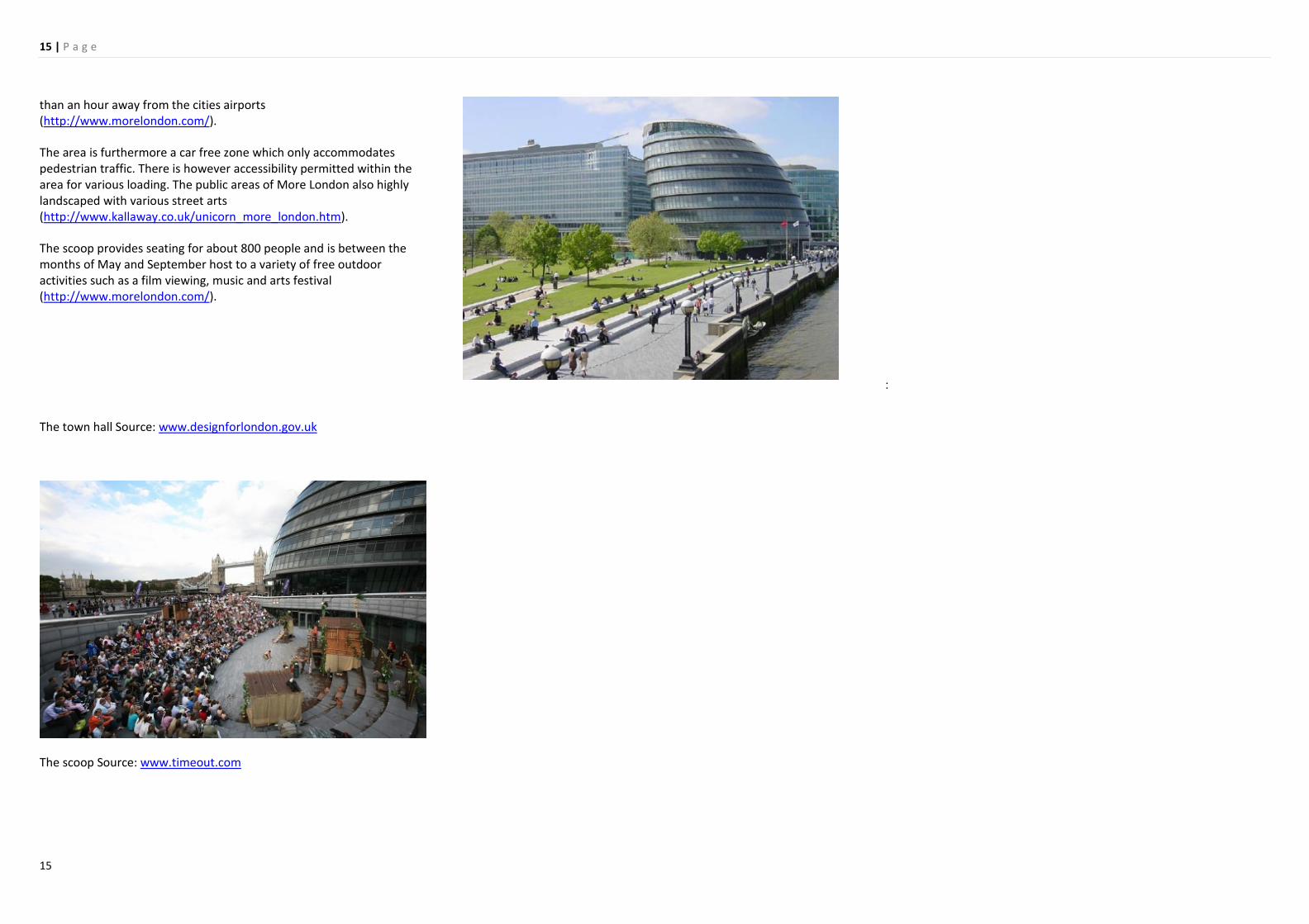
5.2 More London
More London is an area located on the Southbank of the Thames River in the Borough of Southwark in between the famous London Bridge and Tower Bridge. The area features mixed-use development that stretch over an area over 53,000 m
2The area provides recreational and professional facilities for over 20 000 inhabitants. The area also features the London city Hall an important administrative building. The area also features a large amphitheatre called the scoop and a pedestrian plaza. More London is home to world firm such as Ernst and Young but also accommodates Britain’s first certified theatre for children (http://www.kallaway.co.uk/unicorn_more_london.htm).
Ernst and Young More London Place
Source: www.kallaway.co.uk
More London Source: www.morelondon.com
More London is in terms of public transportation very well placed as it is not far to areas such as Mayfair, Canary Wharf, Bank and no more
15 | P a g e
15
than an hour away from the cities airports (http://www.morelondon.com/).
The area is furthermore a car free zone which only accommodates pedestrian traffic. There is however accessibility permitted within the area for various loading. The public areas of More London also highly landscaped with various street arts (http://www.kallaway.co.uk/unicorn_more_london.htm).
The scoop provides seating for about 800 people and is between the months of May and September host to a variety of free outdoor activities such as a film viewing, music and arts festival (http://www.morelondon.com/).
:
The town hall Source: www.designforlondon.gov.uk
The scoop Source: www.timeout.com

16 | P a g e
16
Part IV Elements in the
sustainability of cities

17 | P a g e
17
6. Sustainable development
6.1The concept of sustainability The general definition of sustainability is the Brundtland definition of
1987 which states that sustainable development is “development
which meets the needs of the present without compromising the
ability of future generation to meet their own needs”. Land that we
have available to our disposal today has to be disposable in the same
effort for coming generations as it is for us. This is however a difficult
concept to implement in the case of fossil fuels which cannot be
renewed or revitalize. (Price, C. 2000 p.33-34).
Most of the writing on sustainable development is based upon the
“environmental paradox” which means that there is a discrepancy in
the give and take of natural resources, leading to the process of trying
to reach a more sustainable development. A now know important
component in reaching sustainable development is a lowering of the
pressure put on attaining natural resources. This is however easier said
and done. One solution is through “weak sustainability of shallow
environmentalism” which often means relying more on renewable
resources, while increasing the output of resources. Another way of
reaching sustainability is through a “strong sustainability or deep
ecology” which means lowering the output of natural resources thus
changing the way we live in order to suit the capacity of the natural
resources. Lastly there is “moderate sustainability” which means
combining the “strong sustainability” with “weak sustainability” by
relying more on natural resources and trying to lessen the output of
resources (Williams, C. & Millington, A.C. 2004 p.100).
Humans rather than nature are at the center of the “weak
sustainability” . The view is centered around the thought that we are
not part of nature but rather that nature exist for our use rather than
having a give and take situation. We should in this case learn how to
control nature in order to maximize resources (Williams, C. &
Millington, A.C. 2004 p.100).
There is great faith that the “weak sustainability” will allow for a way of
solving the problems of environmental degradation, as there will be a rise in
resources with the help of technology. The technological development is
thought to become a very important part of avoiding environmental
degradation in the future. “Weak sustainability” therefore allows us to
continue living the way that we are currently living, as we will be able to solve
the problems of depleting resources. Supporter of the “weak sustainability”
urge for an incorporation of environmental issue s in the capitalistic view. This
means applying environmental guidelines through various agencies in how to
better manage resources, the assessment of the environmental impacts of
various projects and applying cost efficiency in environmental projects. There
are two popular views in the writings of “weak sustainability”, the first is that
we can heighten economic development in a way that has a lesser impact on
nature in terms of output. The second view is that we can carry on our
economic development if we reallocate the expenditure and advantage in a
way that makes it more equal know as “environmental justice” or “ just
sustainability” (Williams, C. & Millington, A.C. 2004 p.100-101).
6.2 The economy and value of sustainability Sustainability as a concept is by economist varying. The most
implemented is the neo-capitalistic economic view on landscape and
sustainability. Here the consumer is at the forefront in terms of
consuming goods and services that are generated for profit. The goods
or services that generate a high revenue for companies and firms are
those that are favored for production the landscape is in neo-
capitalism vies seen as a product like most this in neo-capitalism, as it
main concept lies in the creation of markets in all aspects of life that
are not restricted to monopoly or parastatal management (Price, C.
p.2000 33-34)
The prevention in use of a resource or resources in order to preserve
them seems unlikely as it may hinder our society’s development and
way of life, which diminishes the concept of resources. Landscapes are
however unique in that their value as a resource lies in their temporal
use. Our use of the land is what gives it value as it will be for future
generations. In order to comply with the concept of landscape
sustainability there has to be certain limitations or goals that have to
be reached in its development. In economy however it is the turnover
for a product that dictates its value. The limitation and goals may
however create “intolerable costs” in development. The cost and
benefit in developing a landscape may if deemed intolerable as it
provides more loss than it does value to the landscape (Price, C. p.36-
37). Another part of sustainability is the idea of replacement an area
lost to say a railway may be replaced with the creation of an area
somewhere else, thus minimizing the loss. This is an idea that is highly
accepted in neo-capitalism as it is only cost that is viewed as a hinder
(everything can be bought). The technological evolution in
development has also made it possible to compensate the loss of an
attractive are with the production of a new (Price, C. p.41.) An outcome
of the neo-capitalistic view on landscapes is that the aesthetics and use
of certain landscape may only be limited to those who can afford to
purchase it (Price, C.2000 p.43-44).
In defining the sustainability of cities one could simply compare the
input and output of two cities the one that need less input and
generates less outputs is the more sustainable, as it is if the cities are of
the same capacity than the other is able to sustain itself with less.
Sustainability is this relative. In order to make a landscape more
sustainable one has to look at its functioning mechanisms such as
“earth, water, vegetation, building types, transportation systems and
spatial organization”, these mechanisms affect the legibility and
management of a landscape and may be likened to the concept of an
“ecological footprint” a term coined by Rees in 1997, in a study done
by him. The conclusion was that if the area of Lower Fraser valley in
Vancouver were to maintain its status quo in terms of land used for
disposing of waste material the city would need an area 200 large than
the current. Cities should therefore try to minimize their “footprint” (or
the area necessary for daily life) (Armstrong, H., Brown, H. & Arnold, T.
2000 p. 157-158).
The existing systems of a city may often hinder its sustainability as they
may be so deeply rooted in its structure, that trying to make one more
sustainable say the biological system may implode a physical system. A
solution is seen as creating more compact cities with higher densities
which is thought to lead to more sustainable cities. The urbanization of
landscape is an occurrence that alters a landscape in an unnatural way.
When developing a landscape its sustainability can only be measured
over time in order to see what has been lost. There has to be more
work done in keeping good landscapes and creating these such as
18 | P a g e
18
adapting the green into the existing urban landscape. Cities have often
been culprits as they damage the natural or biological landscape. The
disposal of certain material that can be recycled in new development is
one such matter (Armstrong, H., Brown, H. & Arnold, T. 2000 p. 160-
161).
There has to in planning and architecture be a diversity of landscape
both in the physical and biological systems of the city. One such
solution could be eco-buildings or areas that also feature greenery. This
has more benefits than aesthetics as it allows for more sustainable
storm water management, greenhouse gas absorption, noise pollution
reduction and thermal isolation for buildings. The roof is here the most
favorable area for vegetation development (Armstrong, H., Brown, H. &
Arnold, T. 2000 p. 168).
6.3. Vertical urban theory
“How can we make working, living and all aspects of life in high-rises
more palatable” this is Ken Yeangs leading question in his book
Reinventing the skyscraper: a vertical theory on urban design. He goes
on to state that this question is of importance for all who are involved
in all aspects of creating and maintaining a city. There is however
strong opposition to the construction of high-rises in cities even though
they play a large role in contemporary cities both in terms of forms and
finances (Yeang, K. 2002 p5.)
Many cities around the world are opting for high-rise development
such as in London. The important issue here is if these kinds of
environments fulfill the needs of the cities inhabitants. The skyscrapers
can be described as compartments put on top of one another,
something that has been the very base of the design and development
of skyscraper, while their capabilities in terms of technological aids has
improved. The skyscrapers however cost efficient do not always
enhance the daily life of their inhabitants as they often creates a
claustrophobic feeling. There is here a need for diversity in the
activities and living environments of skyscraper areas (Yeang, K. 2002
p10-11.).
The future of our race will be one dominated by the influx of
inhabitants to cities as more and more people move into these cities.
With this there will be a greater need for more urban expansion,
requiring the need for new ways of dealing with high-rises. There are
already a great number of cities reaching population levels well over
ten million inhabitants with the numbers growing for cities with
inhabitants under a million. Often cities choose to halt their sprawling,
but when this is done a need for a new solution to growth arises. This
could be through the creation of satellite cities (which was the case
which Stockholm during the million housing program era). This may
however not be the best solution as if can intrude on valuable natural
land and lead to an increase in transportation which has negative
economical but overall environmental effects. It is therefore logically
important to preserve existing natural areas. The next solution to the
urban expansion problem is therefore to limit the city’s growth and
develop on existing built areas such as old industrial lots. This is
something that is practiced by most cities. While there is much debate
on building high the method is being employed in many cities in order
to provide urban environments for existing, new and anticipated city
inhabitants. This expansion is in most cities such as London and Paris
being carried out in the “central business districts” with development
being done by for example the over decking of railway areas. Increasing
the urban density of cities has proven to be a good way of lowering the
consumed energy for each inhabitant by reducing automobile use
(Yeang, K. 2002 p.33-46)
The spaces that were in cities before use as public places and spaces
have in many cases been taken over by the automobile, one way of
understanding the impact of this would be that “for every car that
leaves to work the area needed for parking equal the footprint of an
average house. In making cities more compact activities connected to
our daily routine can be located closer to the home and workplace
(Yeang, K. p. 2002 47-48).
Old city centers (such as Stockholm’s) will probably continue to
function as the core of the city, a place where firms and companies
want to locate themselves and people want to go for various activities
or even inhabit. This is the reason for the high land value in these areas
and ultimately their increase in land value as development spaces in
the cities decline. As cities continue to build higher more emphasis will
need to be put on the need for public transportation, rather than on
automobile transport. This will mean that skyscrapers will need to be
located close to transportation hubs and nodes.
While offices still carry the leading role in the city centers there will be
a need for housing in order to minimize travel distance between work
and home. This need is most prominent for working singles and
couples without children as they often want to live in the lively city
centers. This also entails a need for creating lively streetscapes (Yeang,
K. 2002 p 49-53.).
Cities have in some ways suffered at the hands of planners when it
comes to zoning regulations that have resulted in a separation of urban
activities that once coexisted in one and the same space. This often
calls for diversity in one and the same urban space. One solution could
be creating high-rises that host a variety of urban spaces. Another
problem for this solution is the travel between home and work which is
time and energy consuming and furthermore leaves at least one space
empty for a long period of time during a 24 hour day. In order to avoid
this one has to see over the zoning of building functions. A high-rise
could provide both a home and working environment, keeping the
building in use 24/7. There has to be more flexibility in the functional
zoning of buildings (Yeang, K. 2002 p91-93).
Urban areas should contain a variety of functions that enhance
business and leisure in order to maintain”life” within the area at all
times of the day. This diversity should not as is common be limited to
certain floors such as the ground floor, which is often the norm (Yeang,
K. 2002 p.95).
Landscape architecture and diversity in the form of park and other
public spaces are very important for it’s inhabitants. The green can also
facilitate in giving the skyscraper a more accommodating look, one way
of doing this is through vertical landscaping(Yeang, K. 2002 p.129).
In addition to the high-rise one increases the biodiversity within the
built form. Another benefit could be in the production of food within
the skyscraper through e.g. rooftop gardens. In adding greenery the
skyscraper or the urban is incorporated into the ecosystem (Yeang, K.
2002 p.131).
.The buildings of today often contribute negatively to the environment
as the function as separate from the ecosystem where there is a higher
19 | P a g e
19
output then input. Meaning that we take more than we give back to
nature(Yeang, K. 2002p.182-183).
The high-rise should therefore function in a way that is like the natural
ecosystem. There has to be a reduction in the energy used and a
heightened efficiency in the use of the buildings. This means having a
better and more diversity in function and use of the environment .
There has to be a diversity in the structure and in the types of people
that use them. There has to furthermore be better communications
and resources should be managed better. This could be done through
having roof gardens that collect water or having solar panels on
buildings. (Yeang, K. 2002 p.190-192)).
6.4 Conclusions
The idea of sustainability is one that is often difficult to comprehend
this mostly due to the complexity of its defenition. How do we preserve
our way of life without destroying the chances for future generations
to have a prosperous way of life? We live in a consumer based society
where almost anything can be treated as good or services in order to
be traded and profited from. This is very apparent in landscape
developers seek to invest on it in order to trade it off for a high
turnover. The value of land in city centers is fast increasing as land to
develop in becomes more scares due to our noble need to minimize
environmental degradation and natural land loss. While it has been the
norm to in many cities build low it is apparent that this simply
minimizes the amount of land available while need for new
development increases with more and more people living in cities. We
have to therefore realize that building high may be the best way of
doing this is through vertical landscaping which can serve in creating a
more sustainable urban environment, socially and environmentally.
20 | P a g e
20
Part VI Planning for Västra City
21 | P a g e
21
7 Current situation analysis
7.1 Method of analysis
The analysis of the city center is important in analyzing Västra city and
what is needed in order to create a more sustainable and well
functioning district. This part of the thesis will therefore help in
clarifying the character and structure of the city center and in detail
Västra city. The analysis will moreover provide a platform in dealing
with weaknesses and threats in the area while maintaining strengths
and developing opportunities. Visual or image analysis was used by
Kevin Lynch in his book Image of this city. Here he states that the
imagery of the city can be something very pleasurable, an intricacy of
vastness. Those certain parts of the city are so familiar to us that they
are deeply embedded in our recollection and perception of the spaces.
The city can furthermore be seen as something fluid and ever changing
almost impossible to control due to the fact that it never comes to a
conclusion, but is always transforming. The city is unlike other
constructions such as art, architecture or music constrained to certain
processes and outcomes. Lynch states that a good city is a clearly
defined city. (Lynch, K. 1-2)
One important part in the analysis of the city is therefore imageability,
which refers to a city’s how strong an image it gives to the one viewing
it. The analysis of an exterior object is done using three features
identity, structure and meaning. These features are often viewed in
unison and need to be separated when analyzing. Identifying an object
is the first step; this does not mean likening an object to another but
finding purpose in it. Finding the structure of an object means deducing
its spatial relation to its surroundings. The object must lastly evoke
emotion or meaning to the observer. The image of a city can evoke a
strong meaning such as the skyline of New York’s Manhattan which is
said to stand for “vitality, power decadence, mystery, congestion
greatness” and much more. The meanings are so many and
differentiated that they eventually come together. 8-9
In his analysis of Boston, Jersey and Los Angeles Lynch used two
methods. The first involved the visual mapping of areas in terms of
objects, visibility, strength, weaknesses, connections, disconnections
and interrelations. The second type of analysis was interviews of
residences on how they viewed and interpret their environment. In this
thesis the focus will be on the first mention type of analysis. For this
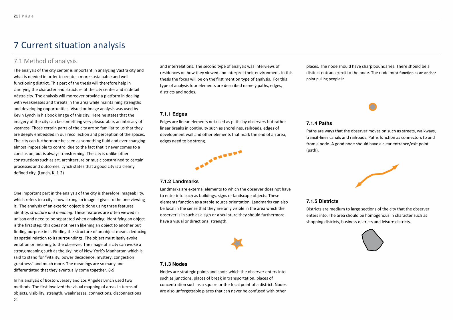
type of analysis four elements are described namely paths, edges,
districts and nodes.
7.1.1 Edges
Edges are linear elements not used as paths by observers but rather
linear breaks in continuity such as shorelines, railroads, edges of
development wall and other elements that mark the end of an area,
edges need to be strong.
7.1.2 Landmarks
Landmarks are external elements to which the observer does not have
to enter into such as buildings, signs or landscape objects. These
elements function as a stable source orientation. Landmarks can also
be local in the sense that they are only visible in the area which the
observer is in such as a sign or a sculpture they should furthermore
have a visual or directional strength.
7.1.3 Nodes
Nodes are strategic points and spots which the observer enters into
such as junctions, places of break in transportation, places of
concentration such as a square or the focal point of a district. Nodes
are also unforgettable places that can never be confused with other
places. The node should have sharp boundaries. There should be a
distinct entrance/exit to the node. The node must function as an anchor
point pulling people in.
7.1.4 Paths
Paths are ways that the observer moves on such as streets, walkways,
transit-lines canals and railroads. Paths function as connectors to and
from a node. A good node should have a clear entrance/exit point
(path).
7.1.5 Districts
Districts are medium to large sections of the city that the observer
enters into. The area should be homogenous in character such as
shopping districts, business districts and leisure districts.

22 | P a g e
22
7.2 Bicycle and pedestrian network
The city centre of Stockholm has a highly developed bicycle network
system feature main routes and regional routes. Streets that are mainly
pedestrian are located mostly in the southern parts of the city centre.
While the bicycle connections to the island of the Old city (Gamla stan)
are adequate there are very few connection leading to the island of
Kungsholmen with only three possibilities to travel between the island
and the city centre on a stretch of over 2000 meters. The longest
distance between bridges being that between the Barnhusbridge and
Sankt Erik’s bridge in the north with a distance of over 600 meters.
7.3 Car streets and motorway network The city centre has a total of three motorways including an underpass
coming from the south and leading to the Klara tunnel. In the centre of
the city there is a large network of streets most of them narrow except
for Sveavägen which functions as a sort of boulevard coming from
Sergelstorg which is considered as the core of the city all the way to the
north reaching the area of Norra station. The street network of the
Stockholm centre is very elaborate and well-connected with car traffic
possible at almost every corner of the city centre.
7.4 Built landscape and green structure The city centre of Stockholm has as the rest of the city a green
structure that is well integrated into the built. There are a series of
parks and other green spaces networks and one doesn’t have to walk
too far to find a green area. The area of Västra city is however due to
its current use and structure not a contributing part to the urban green
of the city centre. The built landscape feature a grid structure with
small sized building blocks which also allows for more diverse
neighbourhoods and walk able streetscapes.
7.5 Building typology Stockholm’s city centre has due to redevelopment in the 60s and
current urban renewal, very diverse building typologies. The oldest
buildings in the city centre and Stockholm are found in the Old town
(Gamla stan) dating as far back as the 13th century. The Stone city is
what provides for some of the most beautiful building in the city and is
dated all the way back to the 17th century. These building once covered
much of the city centre before the 1960s demolitions. The stone city
edges are what comprise of the areas built from the early 1900s to the
21st century which are often modernist inspired buildings. Most of the
development that is being carried out now is more or less inspired by
the postmodernism featuring high-rises with shiny glass facades. These
types of building are currently being carried out through urban renewal
of sites such as Västra city

23 | P a g e
23
Source: (www.eniro.se)
7.6 Structural character analysis
The area of Västra city is clearly separated from Kungsholmen both
visually and physically due to infrastructural edges and a riverbank that
does not allow accessibility mainly due to the heavy infrastructure.
While there is an edge towards the Old town (Gamla stan) this edge is
vaguer as the island is made more accessible to pedestrians and
vehicles via multiple bridges and banks near sea level.
The city centre can furthermore be characterized as having eight
districts much of the area of Västra city is however vague in character
as it is often in development of occupied by heavy traffic. It is an area
that is almost completely inaccessible and is therefore not a district in
the pedestrian sense. There are a multitude of Landmarks in the
Stockholm city centre. The most prominent of this is to some extent
located out of its boundaries the Town hall which is one of the most
defining structure in the future development of Stockholm. The
building offers a unique view from Södermalm and certain parts of the
city centre. The most modern landmark in the city is the five modernist
high-rises created during the 60s redevelopment period. These five
building serve as a constant orientation point for those coming to the
city centre from the central station via Klarabergsgatan. Other notable
Landmarks are the Royal palace, the house of parliament (Located in
the old town) and the Concert house (located near the five
Hötorgsskraparna.
Some of Stockholm’s most important nodes are located within the city
centre these are Odenplan and important transit stop which will also
through the citybana project accommodate a commute line stop.
Östermalmstorg which is located in the boundary between the city
centre and Östermalm and serves as an important area for the city’s
nightlife, Norrmalmstorg another transit stop, Sergelstog the main
transportation hub for the city together with central station. These
three stop will in the coming years serve as tram stations for the
planned Spårvägcity. The city centres most prominent paths are those
that connect the city with its Island and the neighbouring municipality
of Solna. These are some of the most heavily trafficked streets in
Stockholm.
7.7 Conclusion and development plan The city centre of Stockholm is one of great diversity and one heavily
adapted to car traffic. While this is something hard to remove from the
current existing built structure it is something that can be minimized in
future planning. While there has to be streets large enough to
accommodate cars they should not be given primary access to these.
Public transportation is something that is well covered in the Vision
2030 plans, while the pedestrian streets need to be paid more
attention to. Stockholm city centre has a consistent variation between
the built and the green urban landscape something that should not be
forgotten or disregarded in future development. With all this in mind
for the future development of Västra city an adaptation of green public
spaces and pedestrian friendly (mixed use to car free) streets is to be
advocated. The green and public spaces are to be integrated into the
built in the form of public plazas and parks. In order to provide access
not only for cars but also for pedestrian traffic bridges are to be
advocated where it is deemed as necessary. The development of Västra
city in the style of newley developed buildings within the area, will give
it a more unified character and provide for a great deal of urban
diversity throughout the city. This kind of development also allows for
a greater deal of new sustainable technology, higher economic land
value and in garnering Stockholm a role in that of the global world
cities.
24 | P a g e
24
The proposal

25 | P a g e
25
8. Västra City

26 | P a g e
26
8.1 Development plan

27 | P a g e
27
8.2 Elevations

28 | P a g e
28

29 | P a g e
29
8.3 Sustainability strategy
The idea of the project is to have an area that is socially sustainable,
containing a variety of urban environments such as parks, squares and
alternative places together with buildings. Environmental sustainability
is an important part of the proposal an entails adopting the green into
the urban environment together with methods of sustainability such as
stormwater collection, green roofs and solar panelling. The economic
sustainability of the project will be through it’s formation as a CBD
featuring places for firms and companies to establish themselves.

30 | P a g e
30

31 | P a g e
31
8.4 Traffic strategy

32 | P a g e
32
The area of Västra city will due to its positioning have a variety of
transportation choices. All the metro lines are connected to this area
with three stop in close proximity. A tramline also goes through the
area and features a stop right in front of the central station. Bus lines
go through all of the area and an additional bus line will be added near
the waterfront in zone 2 with two accompanying stops. Car traffic will
be permitted throughout the area but with limited speeds within the
new built. There will be one major parking house within zone two and
two groundfloor parking house with limited parking near the central
station. The rest of the parking spaces will be small outdoor parking
spaces. The parking spaces are limited in order to minimize car use. The
new area will be highly pedestrian oriented especially in the area of the
new Galleria and on the waterfront. The waterfront will also feature
three small bridges that will be mainly pedestrian but can also
accommodate some bicycle traffic..

33 | P a g e
33
8.4 3D Illustrations

34 | P a g e
34
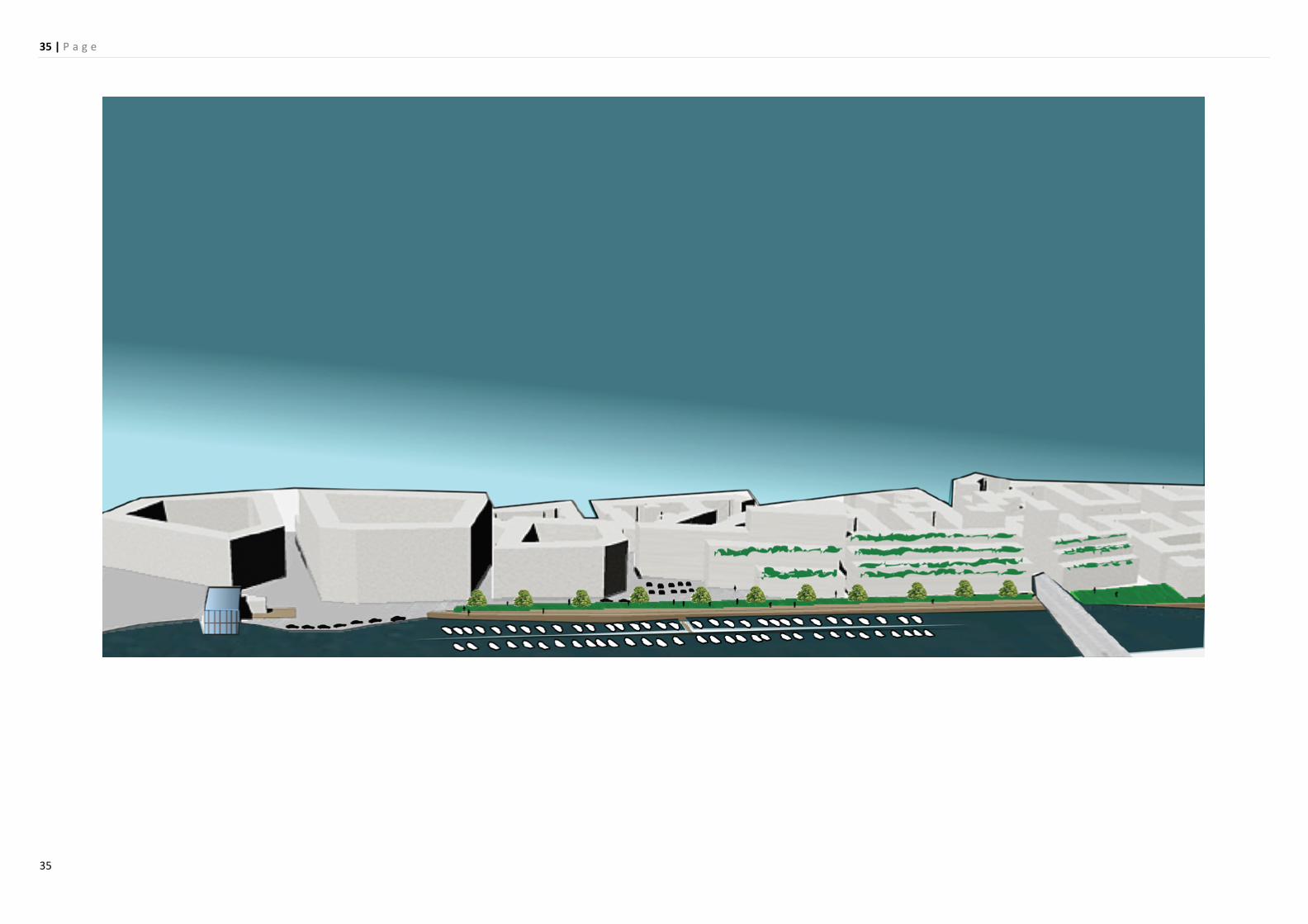
35 | P a g e
35
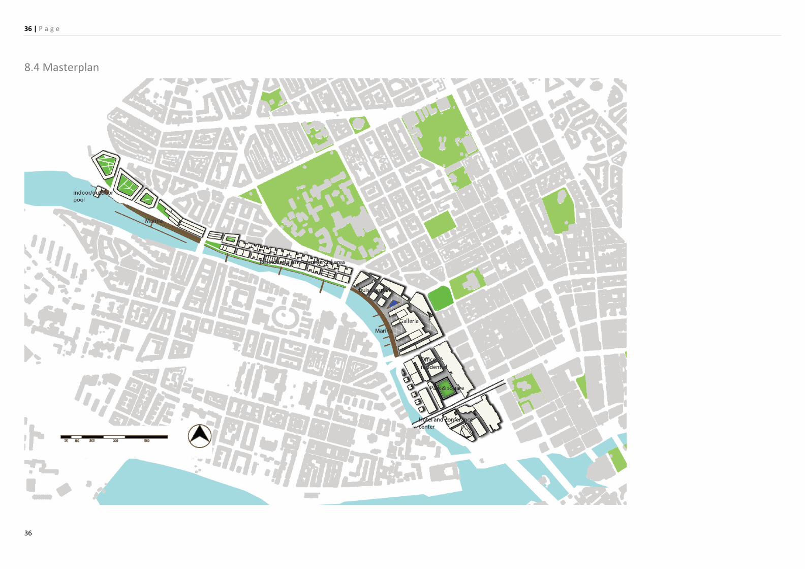
36 | P a g e
36
8.4 Masterplan

37 | P a g e
37
9.Conclusion
Cities are places of transformation and change and while we often get
caught up in the nostalgia of what once was, that too was at some
certain point new. It is important to value existing cityscapes but
changes such as the building of Västra city into a high-density
sustainable area, are of benefit for a city like Stockholm. Not only in
terms of investment and population growth, but also in giving the city a
stronger identity. It is apparent in Stockholm, as in many other cities
that globalisation turns to put labels on city. In the case Stockholm
according to the debates presented in the introduction, many see
these labels as clashing with one other. I however feel that there is
enough room for Stockholm to be a Global city, Green city, Venice of
the North and a city with an exciting cityscape. The area of Västra city
is today not that of which one would expect of a “Global city”. It is
however the first thing ones sees when coming to Stockholm.
Development of Västra city will allow for a more inviting and exciting
first glance of the city and if done properly, it could become an
important district for the city’s inhabitants.
It is also important to understand that urban planning and design as all
other process of creation is a learning process. There are no profound
errors but rather chances for learning. Many might have been
fascinated with Le Corbusier “Radius city” or Howards “Garden city”
and the implementations that followed only allowed for feature
generations to understand the components of the city and learn how
to do it better the next time. The art of making cities is one that has
great utopianism and what works in logic may not always function in
reality. The city however goes on and keeps changing for better rather
than worse.
Bibliography
Litterature references
Armstrong, H., Brown, H. & Arnold, T. 2000 Landscape planning and
city form pp.157-178 Landscape and planning London Spon press
Bruegmann, R. (2005) Sprawl: a compact history Chicago: University of
Chicago Press.
Bergström, I.r (2003) Urban sprawl in Europe The Swedish Urban
Environmental council/Boverket
Hall, T. 2009 Stockholm: the making of a metropolis
Ingersoll, R. 2006 Sprawl town: looking for cities on its edges
Princeton Architectural Press; 1 edition
Saunders, W.S.ed., 2005 Sprawl and Suburbia Harvard design magazine
reader Minneapolis : University of Minnesota Press London Routledge
Cadessasso, M.L., 2008 Linking ecological and built components of
urban mosaics: an open cycle of ecological design Journal of Ecology
FUTURE DIRECTIONS No. 1
Henley, F. Arkitekten 02 2010
Stockholms Stad och Jernhusen i samarbete med Banverket
Planprogram för utvecklingen av Västra city 2009 Stockholm
Pinder, D. 2004 Visions of the city : utopianism, power and politics in
twentieth-century urbanism Edinburgh : Edinburgh University Press
Fishman, R. 1982 Urban utopias in the twentieth century: Ebenezer
Howard, Frank Lloyd Wright .MIT press
Price, C. 2000 Landscape planning and city form pp.33-51 Landscape
and planning London Spon press
Williams, C. & Millington, A.C. 2004 The diverse and contested
meanings of sustainable development pp. 99-104The Geographical
Journal, Vol. 170,
Yeang, K. 2002 Reinventing the Skyscraper: a vertical urban theory
Chichester : Wiley-Academy
Internet references
http://thecarandtheelephant.com/chapters/context/figs/Fig12.jpg
http://www.fogcityjournal.com/news_in_brief/bcn_maze_collapse_07
0429.shtml
http://www.ianvisits.co.uk/blog/wp-
content/uploads/2009/02/default.jpg
http://www.arnaudfrichphoto.com/english-version/paris-la-defense-
7.htm
http://sv.wikipedia.org/wiki/Fil:Lindhagens_plan_1866c.jpg
http://www.stockholm.se/KlimatMiljo/Miljohuvudstad-2010/
http://sv.wikipedia.org/wiki/Fil:City_plan_62.jpg
http://www.svd.se/opinion/brannpunkt/stockholms-skonhet-ar-
hotad_3988187.svd
http://www.dn.se/sthlm/stockholms-city-vaxer-upp-1.794181
http://www.dn.se/sthlm/stockholms-city-vaxer-upp-1.794181
http://www.stockholm.se/KlimatMiljo/Miljohuvudstad-2010/
http://www.kallaway.co.uk/unicorn_more_london.htm
www.froggynews.net
www.designforlondon.gov.uk
http://www.morelondon.com/
http://www.kallaway.co.uk/unicorn_more_london.htm
http://www.morelondon.com/