Embed Size (px)
Citation preview

CLC2012 Addendum to CLC2006 Technical Guidelines ndash Final draft V2 (August 2014) 1
CLC2012 Addendum to
CLC2006 Technical Guidelines
Final Draft
Prepared by G Buumlttner (EEA) T Soukup and B Kosztra (ETC-SIA)
Date
14082014
V2
Project Manager
G Maucha
CLC2012 Addendum to CLC2006 Technical Guidelines ndash Final draft V2 (August 2014) 2
TABLE OF CONTENTS
1 Introduction 3 11 About the document 3 12 How to use this document 3 13 Participating countries 5
2 GIO Land Service Continental Component 6
3 IMAGE2012 basics 8 31 High-Resolution satellite images (IMAGE2012) 8
4 Production of CLC-Change2006-2012 13 41 Change mapping 13 42 CLC2012 Support Package 21 43 Alternative solutions 24
5 In-situ Ancillary data 25
6 Production of CLC2012 data 26
7 Meta data 27 71 Working unit-level metadata 27 72 Country-level metadata 27
8 Training and verification 28 81 Training 28 82 Verification 28
9 Deliverables 30 91 Delivery Procedure 30
Acronyms 32
Acknowledgement 35
CLC2012 Addendum to CLC2006 Technical Guidelines ndash Final draft V2 (August 2014) 3
1 INTRODUCTION
11 ABOUT THE DOCUMENT
The purpose of this document is to assist national teams in implementing CORINE Land
Cover 2012 (CLC2012) under GIO (GMES Initial Operations)
CLC2012 is the fourth CORINE Land Cover inventory in Europe (Table 1)
Table 1 CORINE Land Cover inventories in Europe
Name Start year End year
CLC1990 1986 1999
CLC2000 2001 2006
CLC2006 2007 2010
CLC2012 2013 2014
The content of this Addendum is based on
Experiences gained during CLC2006 verification missions
EIONET meetings (November 2010 and May 2011)
GIO land monitoring 2011-2013 Project Implementation Plan (abbreviated as
PIP) Continental and Local Component EEA May 2011
Technical Annex to Specific Contract No 3541B2012R0-GIOEEA54870 GMES
Initial Operations 2011-2013 Land Monitoring Services
ESA GMES Space Component documents
12 HOW TO USE THIS DOCUMENT
From technical point of view CLC2012 is the same as CLC2006 Therefore it is not the
purpose of this document to provide a complete guide to CLC2012 The document is
complementary to CLC2006 Technical Guidelines (abbreviated as TG) Especially changes
relative to the TG are emphasised For easy reference the same numbering is used in this
document as in TG
In addition to the Addendum there are other important documents to be used (Table 2)
All documents can be downloaded from Eionet Forum
httpforumeioneteuropaeunrc_land_coverslibrarygio-landcorine-land-cover-
clctechnical-guidelines
Password can be requested from AnaSousaeeaeuropaeu
CLC2012 Addendum to CLC2006 Technical Guidelines ndash Final draft V2 (August 2014) 4
Table 2 List of documents supporting the implementation of CLC2012 tasks
Title Description Recommendation
CORINE Land Cover
nomenclature ndash Illustrated
guide
Basic reading regarding
definitions and understanding
of CORINE Land Cover
classes
Obligatory for experts new
to CLC tasks
CLC2006 Technical
Guidelines EEA Technical
report no 172007
Document about technical
implementation of CLC2006
(valid also for CLC2012
tasks)
Obligatory for experts new
to CLC tasks
CLC2012 Addendum to
CLC2006 Technical
Guidelines (ETC SIA1
report 2012) ndash this
documents
Includes news in CLC2012
(not found in CLC2006
Technical Guidelines)
Obligatory for all CLC2012
participants
Manual of CORINE Land
Cover changes (ETC-SIA
report 2011)
Basic reading regarding
interpretation and
understanding of CLC Change
Strongly recommended for
all CLC2012 participants
A macro program for
generating CLC2006 from
CLC2000 and CLC-
Changes (ETC-LUSI2
report 2007)
Documentation about the
ArcInfo macro that supports
the integration of previous
CLC layer (2000) and the new
CLC-Change2000-2006 layer to
produce the new CLC layer
(2006) (valid also for
CLC2012 tasks)
Strongly recommended for
GIS experts new to CLC
tasks and dealing with data
integration
Development of
methodology to eliminate
contradictions between
CLC-Change1990-2000 and
CLC-Change2000-2006 (ETC-
SIA report 2011)
Document about the
development of methodology
to eliminate contradictions
between CLC-Change1990-2000
and CLC-Change2000-2006
Recommended reading
CLC QC Quick Guide -
online offline manual
Kopecky M Loukotka T
Soukup T Vobora V (2014)
CLC QC Tool Quick Guide
(online version as part of the
tool)
Recommended reading
1 European Topic Centre Spatial Information and Analysis
2 European Topic Centre Land Use and Spatial Information (predecessor of ETC SIA)
CLC2012 Addendum to CLC2006 Technical Guidelines ndash Final draft V2 (August 2014) 5
13 PARTICIPATING COUNTRIES
39 countries with total area of 58 Mkm2 participate in GIO Land Monitoring 32 EEA
member states and 7 cooperating countries (Table 3)
Table 3 Participants of CLC2012 under GIO land
Albania
Austria
Belgium
Bosnia and Herzegovina
Bulgaria
Croatia
Cyprus
Czech Republic
Denmark
Estonia
Finland
Former Yugoslavian Republic of Macedonia
France
Germany
Greece
Hungary
Iceland
Ireland
Italy
Kosovo under UNSCR 124499
Latvia
Liechtenstein
Lithuania
Luxemburg
Malta
Montenegro
The Netherlands
Norway
Poland
Portugal
Romania
Serbia
Slovakia
Slovenia
Spain
Sweden
Switzerland
Turkey
United Kingdom
CLC2012 Addendum to CLC2006 Technical Guidelines ndash Final draft V2 (August 2014) 6
2 GIO LAND SERVICE CONTINENTAL COMPONENT
CLC2012 inventory is carried out within the frames of GIO land Continental Component
For sake of completeness a brief overview of the GIO land Continental Component is
given below
Figure 1 Production scheme for pan-European continental component of GIO land services
(extracted from PIP)
The Pan-European continental component of the GIO land service includes the following
steps (Fig 1)
1 Post-processing of space data and the automatic extraction of
intermediate products including the production of Pan-European mosaic of
ortho-rectified high-resolution (HR) images and intermediate products such as
bio-geophysical variables based on HR space data
2 Production of five high-resolution layers with land cover characteristics (ie
attributes of comparable quantitative measures across Europe) related to the
mapping and change mapping of artificial surfaces forest areas agricultural
areas wetlands and water bodies at pixel level and validated at 1 ha grid cell The
production of the five high resolution layers (HRLs) shall include for full
geographical coverage
a Artificial surfaces Mapping of degree of imperviousness
b Forest areas Mapping of tree cover density and forest type
c Agricultural areas Mapping of permanent grassland The analysis will use
the three reference years 2006 2009 2012 to detect the permanent presence
CLC2012 Addendum to CLC2006 Technical Guidelines ndash Final draft V2 (August 2014) 7
of grassland The discrimination of permanent grassland from other
agricultural land areas such as arable land bare soil etc should take into
account seasonal variations based on AWiFS data (reference year 2012)
d Wetlands Mapping of presence of surface water during the reference year
(2012) Seasonal changes using AWiFS data will be used to map areas covered
temporarily by water
e Water bodies Mapping of permanent water bodies The analysis will use the
three reference years 2006 2009 2012 to detect the permanent presence of
surface water Seasonal AWiFS data will be used to separate temporary water
from permanent water bodies
3 New CORINE Land Cover inventory including
a CORINE Land Cover Change (2006-2012) mapping of all land cover changes
between 2006 and 2012 with a spatial resolution of 5 ha for the standard 44
CORINE Land Cover classes
b Production of CORINE land cover map 2012 generalized to 25 ha
minimum mapping unit Including derived gridded data in 100m and 250m
resolution
4 Validation and quality control of products
5 Collection of in-situ data required for the pan-European continental activities
ie non-space data including ancillary and reference data at European and
national level Collecting national level in-situ data is the responsibility of the
countries
Institutional actors involved in the coordination
EC General Directorate for Enterprise and Industry (DG-ENTR) as leading
governance body
European Environment Agency (EEA) as overall technical coordinator of the
continental and local service and potential contributor to access to reference data
activity
EC Joint Research Centre (JRC) as coordinator of global component and provider
of information and scientific expertise
EC Directorate General Eurostat as coordinator of reference data and provider of
the LUCAS in-situ data
EC General Directorate Regio (DG-REGIO) as associated coordinator of Urban
Atlas
EC General Directorate Environment as coordinator of the GMES User Forum
EC General Directorate Environment Climate Agriculture and Regio as users of
GIO land services
Actors involved in the data and service supply
European Space Agency (ESA) as provider of the Earth Observation component
Data and Service providers (Industry) as contractors for specific tasks of the
project
Eionet National Reference Centres (NRCs) as national contributors to the project
providing local expertise as well as in-situ data NRCs are the national or regional
authorities nominated by the Eionet National Focal Points (NFPs)
Following this overview in the rest of the document only questions related to CORINE
Land Cover are discussed
CLC2012 Addendum to CLC2006 Technical Guidelines ndash Final draft V2 (August 2014) 8
3 IMAGE2012 BASICS
Access to remote sensing data under GIO is handled by ESA For the period 2011-2013 a
new concept of Data Warehouse has been developed The new approach is based on the
procurement of a set of common and pre-defined core datasets made broadly available
to public organisations at European and national level A data access portfolio3 (V25 at
the time of writing) describes the datasets available
A new agreement for data access (Data Warehouse) to provide access satellite data for
GIO land 2011 ndash 2013 has been concluded The agreement intends to provide multiple
right of use of the ortho-corrected satellite images as long as traceability of use is
ensured National Teams will be granted access to these data for internal use as soon as
the Data Warehouse Licence will have been signed There will be no IMAGE2012 delivery
on DVD like eg in CLC2006 but images will have to be downloaded from the Data
Warehouse
31 HIGH-RESOLUTION SATELLITE IMAGES (IMAGE2012)
Two coverages of pan-European multi-temporal ortho-rectified satellite imagery covering
all 39 participating countries and 12 nautical miles sea buffer will be delivered by ESA
(based on the Data Access Agreement) for the period of 2011-20124 with all spectral
bands and cloud masking This set of imagery is called IMAGE2012 (compare with
IMAGE2000 IMAGE2006 IMAGE2009) The raw images will be projected into national
projection systems These images will be the main satellite data input for producing the
core land cover data (CLC2012 databases and high-resolution layers) Two dates of
acquisition (acquisition windows specified by countries) with cloud-free data (maximum 5
cloud coverage) are envisaged to be collected for each area Images will be made
available to contractors and participating countries on a NUTS2 level equivalent reference
layer
In year 2011 high-resolution satellite images covering 13 of Europe have been acquired
In year 2012 images will be acquired for 23 of Europe The ortho-corrected imagery
should be available for the national teams in January following the image acquisition year
the latest (ie January 2013 and January 2014) In 2014 only gap-filling acquisition is
planned with very low percentage of the total coverage
According to the GSC DAP DWH document the following type of imagery is available
(Table 4)
Coverage one (1st priority by countries) is planned to be completed normally by
the Indian IRS Resourcesat-1 and Resourcesat-2 satellites Data are delivered in
20 m pixels in national projection and in 25m pixels in European projection This
dataset is included in CORE_01 of DWH
Coverage two (2nd priority by countries) is planned to be completed normally by
the German RapidEye satellite constellation RapidEye includes spectral bands in
visible and near infrared bands but not in SWIR band Data are delivered in 20 m
pixels in national projection and in 25 m pixels in European projection A 5 m pixel
size version in UTM projection also exist This dataset is included also in CORE_01
of DWH
Access to former pan-European coverage (eg IMAGE2006 IMAGE2009) This
dataset is included in CORE_02 of DWH
3 httpgmesdataesaintcdocument_libraryget_fileuuid=9f57e0f4-af57-43ca-aa26-
b9418fbf40eaampgroupId=10725
4 Data acquisition period was longer (3 years) in FTS Land Monitoring (2006)
CLC2012 Addendum to CLC2006 Technical Guidelines ndash Final draft V2 (August 2014) 9
Additionally a medium-resolution monthly (March ndash August) time-composite IRS
AWiFS data are available especially to support the derivation of some of the high-
resolution layers This dataset is included in CORE_08 of DWH
Table 4 Overview of the main HR satellite data products
IRS LISS III
(coverage-1)
RapidEye
(coverage-2)
IRS AWiFS
(suited mostly for
HRLs)
No of bands 4 5 4
Channels Green red NIR
SWIR
Blue green red
red-edge NIR
Green red NIR
SWIR
Ground sampling
distance (m)
235 65 56-70
Bit depth 7 Up to 12 10
Delivered
resolution
25 m (European)
20 m (National)
25 m (European)
20 m (National)
5 m (UTM)
60 m
311 Quick guide to access satellite imagery
Participating countries gain access to satellite imagery though a multiple-step registration
system and a number of interfaces maintained by ESA Procedure is rather complicated
with interrelated steps information on use scattered over different websites therefore a
road map guiding through the process is given below (Description includes a large
number of abbreviations needed for identification of elements of the system Collection of
their explanation is found in Chapter 83)
3111 Registering at ESA as GMES user and signing the licence agreement
In order to get access to satellite imagery first a user account for GSCDA has to be
requested from ESA As first step GIO implementing organization has to register as
GMES user at ESA and sign licence agreement between you and ESA Steps of this
process are as follows
1 For registration at ESA in order to become an eligible GMES user e-mail has to be
sent to gmesdataesaint
In reply ESA will send two attachments
SP_Member_List_Templatexls excel file with two sheets both of which
should be filled in
Point of contact Data Access sheet
Legal Representative sheet
This information will be needed by when assigning user accounts for data
viewing and download
ldquoMultiple-User and Usage sub-licence for EO Data from GSCDArdquo It can also
be downloaded from
httpgsc-prodnetceterachcdocument_libraryget_fileuuid=26fd8509-
a612-4e3e-973d-5953c45e1702ampgroupId=10725
2 Relevant boxes fields of the sub-licence agreement should be filled in
CLC2012 Addendum to CLC2006 Technical Guidelines ndash Final draft V2 (August 2014) 10
1st page in order to specify which Datasets5 you request to have access
to select row ldquoFP7 Service Project participantrdquo as user category and in the
ldquoDOWNLOAD Servicerdquo column write CORE_01 and CORE_02 as shown in
Table 5 (CORE_01 and CORE_02 refer to IMAGE2012 and to image
coverage of former CLC inventories respectively)
User name on the 2nd page
On the last page of the sublicense agreement the date the signature and
the legal representativersquos full name
Table 5 Guide to filling in 1st page table of sub-licence agreement
Usage Types
VIEW Service DOWNLOAD Service
Art 120 Art 121
User
Categories
FP7 Service
Project Participant
Art 171 DWH_MG2_CORE_01
DWH_MG2_CORE_02
EU Institution or
Body
Art 172
Public Authority Art 173
International
Organisation or
NGO
Art 174
Public (in general) Art 175
Art 171 etc refer to relevant Articles of the licence agreement defining user categories service types
3 The completed signed stamped licence agreement should be scanned and sent
back to ESA by e-mail (gmesdataesaint)
4 Based on these the user will be registered at the EO Interface and Helpdesk at
ESA (called CDS-SCI)
3112 Selecting image data using EOLi-sa and downloading through ftp
There are two separate interfaces for selecting required satellite data and for
downloading it The process has three steps using the two interfaces
1 Browsing and selecting requested EO (satellite data) in EOLi-sa catalogue program in
GMES User mode After selecting required data a kmz file containing information on the
images selected should be created (For detailed description of the process see Box 1
below)
In order to be able to log in to EOLI-sa a GSCDA Service Project Personal Account with
the UM-SSO ID (User Management Single Sign On) should be created This account name
and password is given to operators (not the organization) named in Point of contact
Data Access sheet referred to at 3111 at bullet point 1 Process of acquiring an UM-
SSO ID is explained in the link below
5 The GSCDA data and services are accessible in the form of Datasets (there are two types of Datasets CORE
and ADD out of which the first one is relevant to GIO) Access to the Datasets will be granted to the GMES Service Projects (in practice GIO implementing national organization) CORE Datasets are the fixed part of the DWH offer they are pre-defined large datasets covering among others the needs of the operational services to be initiated under GIO
CLC2012 Addendum to CLC2006 Technical Guidelines ndash Final draft V2 (August 2014) 11
httpgmesdataesaintcdocument_libraryget_fileuuid=85c6c567-f0e3-4121-9095-
550db351c992ampgroupId=10725
From the link above one can also download a short explanation of the functionalities of
the Open Ticket Request System (OTRS) tool which is a useful interface for
communication between users and the Services Coordinated Interface (CDS-SCI) This is
also the system users should contact in case of technical or access difficulties
Box 1 Guide to the use of EOLi-sa (version 915)
EOLi-sa (Earth Observation Link) is a web tool operated by ESA for browsing in ESArsquos
EO Data Catalogue for the purposes of (among others) the GIO project EOLi-sa tool can
be downloaded from httpearthesaintEOLiEOLihtml
1 Start the EOLI program (A popup window tells you that downloading is
confined to GSCDA users Please close this popup) Log in using the username
and password received during the process described in 3112 point 1
2 Maximise window Zoom into your required country using zoom tool or the
mouse wheel Hold left mouse button and drag to re-centre the map
3 On Line Collection select the mission of interest
4 In the bottom left frame you can select the date and the area range of
interest
5 Set area Click on the lsquoSet arearsquo button above the map Gazetteer function
can be used to zoom to given country Left click to set the top left of the area
then left click to set the bottom right of it The selected area is going to be
highlighted on the map
6 Search catalogue
7 Search result should be shown in a new small window if not they are visible
at the bottom of the EOLi interface By default only the first 100 results are
displayed Click on all the search result check boxes to see all footprints and
record table and click on lsquoReplacersquo The scene footprints will appear on the
map and the record table below
8 Checking ARCHIVED scenes click on lsquoStatusrsquo field name to sort the records
Highlight the archived ones by holding down the lsquoshiftrsquo button On the map
they will be shown with another colour
9 Export archived scene footprints as KML polygons On the interface down
below click on lsquoexportrsquo button select lsquoKMZrsquo and click on lsquoexportrsquo Exported
KML polygons can be viewed in Google Earth or GIS software
10 Matching EOLi search result with ESA data warehouse FTP site for
downloading
a) Result setClear results
b) Select area with lsquoArea selectionGazetterrsquo Select a country Click on
lsquoselectrsquo
c) Search for scenes within the selected country with lsquoSearch Cataloguersquo
d) Sort results on lsquoStatusrsquo field and select ARCHIVED ones They are
going to be highlighted
e) Double click on record selected lsquoProduct detailsrsquo box with metadata
will open with which we can download the image
f) Open ESArsquos data warehouse FTP site and navigate to the folder
indicated in the lsquoACQUISITIONDESCRIPTORrsquo field of the lsquoProduct
Detailsrsquo
g) The scene to download from the FTP folder is the one with matching
Orbit Start and Stop parameters
Presentations explaining the above more in detail are available at Eionet Forum (ask for
password from Ana Sousa (anasousaeeaeuropaeu)
CLC2012 Addendum to CLC2006 Technical Guidelines ndash Final draft V2 (August 2014) 12
Access to ESA Data Warehouse
httpforumeioneteuropaeunrc_land_coverslibrarygio-landhigh-resolution-layers-
hrlharmonization-workshops-june-july-2012access-esa-data-warehouse
EEA unofficial guide for EOLi-sa
httpforumeioneteuropaeunrc_land_coverslibrarygio-landhigh-resolution-layers-
hrlharmonization-workshops-june-july-2012eea-unofficial-guide-eoli-sa
2 The kmz file should be sent to ESA by e-mail (gmesdataesaint) Based on this kmz
ESA will upload data to an ftp site (see next step)
3 Data should be downloaded from dedicated ftp site called CDS Core Infrastructure
(CDS-ODA ftp)
Username and password providing access to CDS-ODA ftp are sent in two separate e-
mails after registration at ESA (these e-mails will be automatically sent no need to
request them or do any other registration process) This account and password belongs
to the organization not to the operators
Connection to CDS-ODA ftp is done by inserting typing the following path in a web-
browser
ftpusernamepasswordcds-oda-eseoesaint
Substitute the username and the password with the ones received from ESA Afterwards
data can be downloaded
Other links with useful information and downloads
Terms amp Conditions for Use of EO Data from the GSC-DA (sub-licence agreement)
httpgmesdataesaintwebgscterms_and_conditions
GMES Space Component Data Access Portfolio Data Warehouse 2011-2014
(document describing GSCDA and data specifications)
httpgsc-prodnetceterachcdocument_libraryget_fileuuid=9f57e0f4-af57-43ca-
aa26-b9418fbf40eaampgroupId=10725
This document contains all datasets planned to be made available via the GMES Space
Component from GMES Contributing Missions in the time frame 1st June 2011 to 31st May
2014
Dataset status can be checked in ESArsquos monthly updated ldquoData availability reportrdquo
which is advertised on the GSCDA Portal under ldquoGSCDA data provision statusrdquo reports
named ldquoCORE datasets_month_yearrdquo httpgmesdataesaintwebgschome
CLC2012 Addendum to CLC2006 Technical Guidelines ndash Final draft V2 (August 2014) 13
4 PRODUCTION OF CLC-CHANGE2006-2012
41 CHANGE MAPPING
This chapter is partly a repetition of the TGrsquos relevant chapter with some elements more
emphasized and some new elements added
Similarly to the last CLC inventory CLC-Change2006-2012 is the primary and most important
product of the CLC2012 project CLC-Change2006-2012 is an individual product (ie not
derived by intersecting CLC2006 and CLC2012) having a smaller MMU (5 ha) than CLC2006 (25 ha)
The aim is to produce European coverage of real land cover changes that
ndash are larger than 5 ha
ndash wider than 100 m
ndash occurred between 2006 and 2012
ndash are detectable on satellite images
regardless of their position (ie connected to existing CLC2000 polygon or being ldquoislandrdquo-
like)
The production will be carried out by national teams (the Eionet National Reference
Centres for spatial analysis and land cover - NRCs) which combine best expertise with
local knowledge and where ancillary data are available for mapping land cover changes
The overall thematic accuracy of the change database shall be gt85 (similarly to CLC2006)
Mapping of CLC changes should be carried out by applying the lsquochange mapping firstrsquo
approach meaning that changes are interpreted directly based on comparison of
reference images Visual comparison of IMAGE2006 with IMAGE2012 satellite imagery
(with CLC2006 vector data overlaid for spatial reference) is followed by direct delineation
of change polygons Practically if change occurred to a CLC2006 polygon it should be
transferred to the database of CLC changes where the changed part will be delineated
and kept as polygon (Fig 2) At the end of process CLC-Change2006-2012 polygons will be
combined with CLC2006 polygons to obtain CLC2012 database Necessary thematic
geometric correction of CLC2006 data must precede the delineation of change polygons
in order to avoid error propagation from CLC2006 to CLC2012
Therefore change mapping consists of two steps namely CLC2006 correction and
interpretation of changes that occurred between 2006 and 2012 The two processes can
be carried out consecutively or in parallel but on level of individual polygons correction must always precede change delineation (see Ch 412)
The basis of identification of changes is the interpretation of visually detectable land
cover differences on images from 2006 and 2012 Ancillary data such as topographic
maps orthophotos HR layers (derived from satellite imagery) Google Earth imagery are highly recommended to use
Delineation of changes must be based on CLC2006 polygons in order to avoid creation of
sliver polygons and false changes when producing CLC2012 database This means that
during interpretation of changes CLC2006 polygons must be visualised for and used by
the interpreter so that outlines of CLC-Change2006-2012 polygons exactly fit CLC2006 boundaries See Fig 2
CLC2012 Addendum to CLC2006 Technical Guidelines ndash Final draft V2 (August 2014) 14
Interpreter must give two CLC codes to each change polygon code2006 and code2012 both
included as separate attributes These codes must represent the land cover status of the
given polygon in the two dates respectively Change code pair thus shows the process
that occurred in reality and may be different from the codes occurring in the final CLC databases (due to generalisation applied in producing CLC2006 and CLC2012)
The CLC2006 polygon
including the change is
taken over into the
CLC-Change2006-2012 database
The change area is outlined
by the photointerpreter
The non-changed area is
deleted and the change is coded (211-121)
Figure 2 A method of using
CLC2006 polygons as basis for change delineation is taking over the changed CLC2006 polygons
into the CLC-Change2006-2012 database then outlining the
changed part then deleting the unchanged part
CLC2012 Addendum to CLC2006 Technical Guidelines ndash Final draft V2 (August 2014) 15
411 Input vector data
There are two input vector layers to be used in implementation of change mapping
The first and most important of these is the CLC2006 database Similarly to CLC2000 a
border-matched version of CLC2006 has been produced by EEA in order to eliminate
inconsistencies along state boundaries As most of the borders were already matched
during the CLC2000 project only a limited level of border matching took place this time
mostly affecting borders of countries newly entering the project in CLC2006
For consistency reasons all countries are expected to use that national version of
CLC2006 which has been clipped from the recent integrated European version These
(vector format national projection) can be downloaded from Eionet Forum (see link below)
Use of CLC-Change2000-2006 in deriving CLC-Change2006-2012
In former CLC inventories geometric and thematic consistency of change databases
following each other was not examined and not considered After completion of the
CLC2006 inventory a study revealed that inconsistencies between the two available CLC-
Change layers exist (see Box 2) Inconsistencies proved to be numerous but not
significant regarding area covered (less than 1 of changed area)
Box 2
Contradictions between CLC-Change1990-2000 and CLC-Change2000-2006
[G Maucha Gy Buumlttner and R Pataki Development of methodology to eliminate
contradictions between CLC-Change1990-2000 and CLC-Change2000-2006 ETC-SIA Report
06302011] were analysed by examining cases where code_2000 of the old (CLC-
Change1990-2000) and the new (CLC-Change2000-2006) change databases did not match on
the same location It was found that
Disagreements between old and new CLC-Change layers are result of combined
effect of obvious positional inaccuracies in delineation slight uncertainties in
application of CLC nomenclature and mistakes in interpretation
Largest number of mismatches was found between forestry changes
Two typical occasions when disagreements were often found
(1) CLC change continued in time on the same area eg 211-133 between
1990 and 2000 while 133-112 between 2000 and 2006 (if mapped
properly)
(2) CLC change continued in the neighbourhood of an existing change polygon
eg 324-311 between 1990 and 2000 and the same type of change in the
neighbour area between 2000 and 2006
Small average polygon size in a disagreement type most likely meant slight
differences in delineation of neighbouring changes (most of disagreement types)
Large average polygon size in disagreement type most likely meant
interpretation mistake either in CLC2000 or in CLC2006 Two such common
interpretation problems are distinguishing between 324 and 321 and between
324 and 323
CLC2012 Addendum to CLC2006 Technical Guidelines ndash Final draft V2 (August 2014) 16
Aiming to avoid introducing more such inconsistencies national teams are asked to use
the CLC-Change2000-2006 database of the previous CLC inventory as an ancillary support
layer to keep consistency of the ldquooldrdquo and ldquonewrdquo change layers In practical terms
harmonization requirement means that in locations where CLC changes exist in both
layers the same code_2006 is expected to be given in both change databases
However there is no intention to revise CLC-Change2000-2006 data consequently mistakes
found in it are not requested to be corrected On the other hand the CLC-Change2006-2012
should reflect reality visible on images as much as possible Therefore there is priority of
producing a correct CLC-Change2006-2012 over harmonizing code_2006 with CLC-
Change2000-2006 (Ie if a wrong code_2006 is discovered in CLC-Change2000-2006 it should
not be taken over to CLC-Change2006-2012)
In deriving CLC-Change2006-2012 CLC-Change2000-2006 data are recommended to be used in
the following ways
(1) If CLC change continues in time on the same area the change code sequence
should indicate it Eg construction process on arable land 211-133 between
2000 and 2006 133-112 between 2006 and 2012 Try to use the same
outline in the new change polygon as much as possible
(2) If CLC change continues in the neighbourhood of the existing change polygon
Eg 324-311 between 2000 and 2006 and the same type of change in the
neighbour area between 2006 and 2012 In such cases attention should be
paid to drawing the boundary between the ldquooldrdquo and ldquonewrdquo change so that
overlap is minimized
Border-matched CLC2006 and CLC-Change2000-2006 data (vector format national
projection) for participating countries are available for download at
httpforumeioneteuropaeunrc_land_coverslibrarygio-landcorine-land-cover-
clcsupport-files-clc-production
Delivery contents
CLC2012_support_XXmdb - database in ESRI ArcGIS 93 personal geodatabase format
clc06_XX_nat CLC2006 status dataset
cha06_XX_nat CLC2000-CLC2006 change dataset
shapes - directory with data in ESRI shape format
clc06_XX_natshp CLC2006 status dataset
cha06_XX_natshp CLC2000-CLC2006 change dataset
CLC2012_support_XXxml - INSPIRE compliant metadata file in XML format
CLC2012_support_XXpdf - Summary report for delivery (including CRS transformation
parameters)
XX_natprj - Coordinate Reference System definition on ESRI PRJ file
412 Particular requirements concerning CLC2012 mapping
There are particular requirements of change mapping that were indeed mentioned but
(as shown by experience gathered during the CLC2006 verification process) probably not
emphasised strongly enough in CLC2006 Technical Guidelines
4121 CLC2006 correction
Occurrence of interpretation mistakes is an inherent characteristic of visual interpretation
of remote sensing data coming not necessarily from negligence but insufficient
information During updating by examining newly available satellite images or ancillary
data usually a number of thematic mistakes are discovered in the database to be
CLC2012 Addendum to CLC2006 Technical Guidelines ndash Final draft V2 (August 2014) 17
updated In order to avoid error propagation into CLC2012 mistakes discovered in
CLC2006 are much recommended - in locations of changes absolutely necessary - to be
corrected
These are
1 Systematic mistakes known from the previous inventory but not corrected yet and
ones discovered during change mapping These are relatively easy to find by searching
for the codes that show systematic mistakes Systematic improvement of geometry can
also be included here
2 Random mistakes These are usually ad hoc discovered during change mapping or can
be systematically searched for by visually browsing CLC2006 map in scale 130000-
40000
In case national team decides not to modify previously submitted CLC2006 data the tool
of technical change (polygons of any size in the change database having similar codes for
2006 and 2012) can be used for correction (and transfer of correction to CLC2012) If
used for correction technical changes can be larger than 25 ha Eg if a 50 ha polygon is
coded as technical change (121-121) it means that 50 ha industrial area was not
mapped in CLC2006 As a result of using technical change CLC2012 will include this 50 ha industry as correction
The process of CLC2006 correction can be done either before starting change mapping or
in parallel with change mapping (depending on the software used) However interpreter
must make sure that correction of an individual CLC2006 polygon is always done BEFORE a change is mapped in the same location
4122 CLC change interpretation
1 Geometry
a) The mapping of CLC changes must be done using the geometrical basis of CLC2006
polygon layer The outline of change polygons must therefore match CLC2006 polygon
border otherwise false changes and geometric mistakes occur This means that firstly
there should not be any narrow channels (Fig 3) between or slivers around change
polygon outlines and CLC2006 polygon outlines secondly change polygon outlines
should nor criss-cross over CLC2006 outlines (Fig 4) These mistakes can be most easily
avoided by applying the recommended method of change mapping taking over polygons
from CLC2006 to change database then drawing changes then discarding not changed
parts
b) Topological consistency must be kept Change polygons should not overlap each other
CLC2012 Addendum to CLC2006 Technical Guidelines ndash Final draft V2 (August 2014) 18
IMAGE2000 + CLC2000 (yellow) IMAGE2006 + CLC-Change2000-2006 (magenta)
Figure 3 Mistake Narrow channel between change outlines (magenta) and CLC2000 outlines (yellow)
IMAGE2000 + CLC2000 (yellow) IMAGE2006 + CLC-Change2000-2006 (magenta)
Figure 4 Mistake Change outlines (magenta) not matching CLC2000 outlines (yellow)
2 Coding
Interpreter should give two codes to each change polygon according to what is visible on
the relevant imagery one representing land cover in 2006 and the other in 2012 Change
codes should always represent the change process that happened in reality Therefore
codes can be different from respective codes in CLC2006 and CLC2012 databases Eg if
a 15 ha urban green area is being built up change polygon should be coded 141-133
while due to generalization the area is coded as 112 both in CLC2006 and in CLC2012 databases (Fig 5)
CLC2012 Addendum to CLC2006 Technical Guidelines ndash Final draft V2 (August 2014) 19
Figure 5 Interpreting a real change the loss of urban green (141) lt 25 ha by becoming a construction site (133) must be coded 141-133 in the CLC-Change database although the patch is generalised into discontinuous urban fabric (112) in both CLC2006 and CLC2012
The two codes of change polygons should be described by two different attribute fields in
the data table (called eg code06 and code12)
When giving the codes interpreter always must be able to answer the question what is
the process described by the code I gave Is this process the same what I see on the
image pair Is this really a CLC change This way interpreter can avoid mapping seasonal
differences as change or giving attributes that are meaningless on the field
3 Image dates
In order to avoid mapping seasonal differences as change interpreter should always be
aware of image dates (year and month at least) The best way to achieve this is to
include image date in the image name so that it is visualised all the time It is the same
reason that makes image mosaics of limited use for CLC change mapping in a mosaic
image dates are hard or impossible to check and radiometry (colours) are often strongly
distorted Knowing image dates is especially important in the following cases
Mapping vegetation of mountainous areas vegetation reaches its full
development foliage cover late in the year only around June so earlier images
might mislead interpreter
Mapping hot and dry (Mediterranean and strongly continental) areas vegetation
is usually dried out by early summer which is the ldquonormalrdquo date of images for
land cover mapping Thus vegetation (arable crops grassland) is not detectable
on images or it is almost impossible to distinguish arable fields from patches of
natural grassland or even sparsely vegetated areas Therefore ancillary images
from AprilMay are highly recommended to use in such areas (eg Iberian
Peninsula Anatolia) The same is true for distinguishing natural grassland areas
from sparsely vegetated areas or bare rocks
Mapping changes of lakes especially water reservoirs being unaware of image
dates might lead to mapping seasonal water level fluctuations (lakes shrinking
due to summer heat and water take-up for irrigation) as permanent changes
which is a mistake Same is true for Alpine rivers where highest water level
occurs in springearly summer due to snow melt
Mapping glaciers and permanent snow images of not exactly the same date
(which should be the date of smallest snow extent late August or early
September) are not comparable thus using them leads to mapping false
changes
141-133
112
211 211
IMAGE 2012 IMAGE CLC2006 CLC2012 CLC-CHANGE
112
CLC2012 Addendum to CLC2006 Technical Guidelines ndash Final draft V2 (August 2014) 20
4 Nomenclature
There are a few conclusions coming from lessons learnt during verification process that
are not or inadequately described in the latest version of the CORINE land Cover
nomenclature so are reasonable to be described here Issues are listed in the order of the relevant CLC code
Industrial and commercial sites (121)
Geothermal fields together with pipelines and the surface between them should
be coded as industry (121) even though real land cover between the pipes is
usually natural
Construction sites (133)
The deposited material along road constructions should be part of the road
construction polygon (133) Interpreter should be aware that these areas are
normally turned back to arable land grassland or are forested after construction
is finished which is a change (133-22x or 133-324) not be missed when
interpreting changes
Construction of ldquoartificial naturerdquo ie natural habitat reconstruction works for
conservation purposes are also part of class 133 As this kind of construction is
not to be considered ldquoharmfulrdquo for environment in the analyses there might be a
need to differentiate from ldquotraditionalrdquo constructions A way of doing this is giving
an additional attribute or assigning it to a level-4 class (for national use only)
indicating that given construction polygon is not going to turn to built-up in the
future Construction of golf courses might also fall into this category
Generally constructions do not last longer than 6 years so these polygons are
likely to have change Checking all 133 polygons in CLC2006 systematically helps
interpreter to avoid omitting these changes
Sport and recreation area (142)
Artificial snow According to the nomenclature ski pistes are not mapped as part
of ski resorts (142) as they can be considered natural grassland most of the
year However in recent years many ski resorts have been equipped with
facilities producing artificial snow (snow canons) Essential part of this
infrastructure is a pond providing water Sometimes the slopes where artificial
snow is applied are fully changed the uneven ground is levelled rocks are
removed etc Chemicals are also mixed into the artificial snow to assure higher
melting point Due to use of artificial snow the length of the season is about
twice as long as before lasting from November to April therefore human impact
on the environment is increased Based on the above it is considered acceptable
to map the creation of such areas as 3xx-142 change (together with pistes) if the
infrastructure (water ponds) is visible
Holiday cottages In Scandinavian countries holiday cottages often far from any
settlement are being built The spatial structure is very loosely built-up houses
are several hundred metres away from each other in most of the cases lacking
any infrastructure (such as roads) These ldquoholiday settlementrdquo do however have
an impact on the environment especially in otherwise untouched areas so it is
important to map them Therefore it is acceptable to interpret these cottages
together with natural vegetation among them as 142
Burnt areas (334)
Burnt forests and shrubland mapped as 334 usually should change in six years
Ie it is expected that 334 polygons in CLC2006 will change in CLC2012 In case
of forests the usual process is the regeneration (334-324 or 334-31x) depending
CLC2012 Addendum to CLC2006 Technical Guidelines ndash Final draft V2 (August 2014) 21
on the level of damage and the speed of regeneration (more details in Manual of
CLC Changes)
Inland salt lakes and wetlands (411)
Salt marshes along the shores of high salt content lakes far from sea (typical in
Turkey) should not be coded as salt marshes (421) in CLC but as wetland (411)
Salines (422)
Areas of salt production by evaporation should be coded as 422 regardless of
their location (seaside or inland typical in Turkey) Abandoned salines on the
coast should be coded as 421
42 CLC2012 SUPPORT PACKAGE
As part of contribution to the implementation of GIO land ETC-SIA has been
commissioned by EEA to develop a software tool for CLC change mapping by
photointerpretation Development of the lsquoCLC2012 Support Packagersquo is based on the
experience gained during development of former CLC change mapping support packages
user feedback requirements and recent technical considerations
The CLC Support Package will be available for all participating national teams free of
charge from 1st December 2012 Detailed help and printable users guide (in English) as well as user support are inherent parts of the package
CLC2012 Support Package is a significantly modified and improved version of the
CLC2000 and CLC2006 Support Packages (see description in Box 3) successfully used
by a number of national teams and the CLC Technical Teams during the previous two CLC
inventories Its main novelties compared to former packages are 1 on-the-fly
coordinate reference system transformation capability (no need to have all data in the
same projection) 2 ability of using data from web map services (WMS) 3 CLC2012
Support Package is a set of standalone applications developed with Embarcadero Delphi
XE2 and TatukGIS Developer Kernel Thus user does not need to purchase install and
tune any other software to carry out CLC2012 change mapping
CLC2012 Support Package is a specialized task oriented software tool which significantly
facilitates updating change detection and mapping quality control and correction of CORINE land cover databases by means of computer-assisted visual photointerpretation
CLC2012 Support Package consists of three modules
1 InterChange for interpreting land cover changes Program provides a tool for the
revision of CLC2006 land cover database and supports the interpretation of land cover
changes in order to create the CLC-Change2006ndash2012 database The program provides a
convenient and easy-to-use interface for editing polygons in CLC2006 and CLC-Change
databases for viewing and modification of polygon data for finding and correction of
errors generated during interpretation and editing
Major functionalities include
- Polygon editing functions tools for error correction in CLC2006 creation
deleting of polygon in CLC-Change polygon cut split unification
- Interpretation support tools synchronized double-window environment for
displaying CLC2006 (on top of IMAGE2006) and change (on top of IMAGE2012)
data display of data for selected polygon simple polygon data editing CLC code
can be selected from a list comment display options easily adjustable several
CLC2012 Addendum to CLC2006 Technical Guidelines ndash Final draft V2 (August 2014) 22
polygon search options according to eg CLC code change type comment error supervisors remark progress status area change probability
- Error prevention functions invalid CLC codes not allowed to use warning if
basic interpretation rules (eg MMU) violated non-adjacent polygons cannot be
unified error-checking tool helps to find and correct topological (eg multipart
polygon overlaps) or other (eg zero code MMU error) mistakes
- Information support functions LUCAS data display code code change
colouring error colouring flexible code label display options detailed definition of
CLC classes available with a single click ndash description in national language can be
easily added sophisticated area measurement tools detailed help and printable users guide (all in English)
Figure 6 InterChangersquos double-window environment for display and correction of CLC2006 data
(left IMAGE2006 in background) and change mapping on IMAGE2012 (right IMAGE2012 in background)
2 InterCheck for checking databases Program serves the checking of revised CLC2006
and CLC-Change data InterCheck program has been prepared primarily for supporting
the CLC2012 Technical Team although national central teams might apply it as a tool for
checking of the completed CLC2012 and CLC-Change databases InterCheck can be used
for checking CLC2006CLC2012 and CLC-Change databases in many file formats not only those that has been prepared with InterChange
Major functionalities supporting control procedure polygon editing not
allowed verification units can be assigned sophisticated search tool according to
several characteristics such as CLC code change type remark area change
probability or technical change remarks can be added to polygons and any point in both databases
3 LUCAS Photo Viewer Program displays the main data and field photos (if any) of
the LUCAS (2006 2012) point selected in InterChange or InterCheck program
Further information and news regarding the CLC2012 Support Package are available at
the dedicated website httpclc2012taracsakhu
CLC2012 Addendum to CLC2006 Technical Guidelines ndash Final draft V2 (August 2014) 23
Box 3
CLC2000 Support Package was developed in order to help the implementation of the
European CLC2000 project CLC2000 software was a macro package written in Avenue
ArcViews own macro language The software was a supplement to ArcView 3233 GIS
As the CLC2000 macro package was made available for free for countries participating
CLC2000 project (on the condition that it is used solely in the implementation of the
CLC2000 project) users had to possess purchase only ArcView ldquomother softwarerdquo Use
of the Support Package significantly facilitated updating change detection quality
control and correction of land cover databases by means of computer-assisted visual
photo-interpretation The CLC2000 software was used by 15 European national
teams out of 30 participating countries for interpreting changes in CLC2000 project
CLC2006 Support Package was a significantly modified and improved version of
CLC2000 Support Package The package consisted of four main parts InterPrepare for
the preparation of source files and work directories for change detection InterChange
program provided a tool for the revision of CLC2000 land cover database and supported
the interpretation of land cover changes InterCheck program served the checking of
revised CLC2000 and CLC-Change map sheets LUCAS photo viewer displayed the
main land cover and land use data of selected LUCAS point together with field
photographs CLC2006 software was a commercial product customers therefore could
use software licenses without any time or project limitations In the European CLC2006
project 17 European national teams used this software (see figure 7)
Figure 7 copy 2012 Taracsaacutek Gaacutebor
CLC2006 verification by Technical Team was done in all 38 participating countries with
help of the InterCheck Some national teams also used it as a tool for final checking of the completed CLC2006 and CLC-Change databases
CLC2012 Addendum to CLC2006 Technical Guidelines ndash Final draft V2 (August 2014) 24
ALTERNATIVE SOLUTIONS
During the implementation of the CLC2006 project some countries (especially in
Scandinavia) applied procedures different from visual photo-interpretation for deriving
CORINE Land Cover data These solutions aimed to reduce human work-load and
combined national GIS datasets satellite image processing technology on-screen
digitization (visual photo-interpretation) and GIS-based generalisation Most of these
methods aimed to produce CLC ldquostatus layersldquo (ie CLC2006) but they were also
successful in facilitating partly solving the change mapping job
These GISIP based alternative change mapping solutions are encouraged if results are
compatible (in terms of technical features and accuracy) with the traditional method In
case of change mapping major issues of non-compliance are as follows (as experienced
during CLC2006 verification missions)
- Changes mapped are not ldquorealrdquo changes ie they do not represent a change that occurred in reality
- Changes are topologically (eg overlap) or geometrically incorrect (eg narrow or
sliver polygons)
- Change outlines do not match CLC2006 boundaries
These can be avoided by
- First of all not taking uncritically the changes derived from ancillary databases
but considering them as potential change areas which are to be visually checked
and approved by interpreters or used as background information for interpreters
in manual delineation of changes This is especially true for changes of built-up
areas heterogeneous agricultural classes and non-forested natural classes
Forestry changes are easier to be automatically detected they however also require at least partial visual control (especially forest growth)
- Making sure that source databases are timely ie not outdated but especially not
fore dated (databases of buildings or spatial planning do often contain features that are planned to be raised but in reality are still not existing)
Taking CLC2006 database as a geometrical basis of change mapping is a necessary
requirement In the exceptional case when CLC2012 is produced first and CLC-Changes
are derived by backdating geometrical and thematic compliance with new status layer
(CLC2012) is necessary
CLC2012 Addendum to CLC2006 Technical Guidelines ndash Final draft V2 (August 2014) 25
5 IN-SITU ANCILLARY DATA In-situ data in GMES definition comprise all non-space-born data with a geographic
dimension Access to existing in-situ is object of the GMES Data and Information Policy
Major use of in situ data in CLC project is to complement the satellite data in process of
production and to validate results provided from space-born data
Interpreter should be aware that primary source of information is IMAGE2006 and
IMAGE2012 which are considered reference data concerning both date and thematic
content
In-situ data requirements include
Topographic maps and basic geographic reference data which will be used during
interpretation mapping and validation process
Aerial photography thematic maps (built-up vegetation forestry hydrology
snow and ice etc) and other ancillary data (eg LPIS) for
identificationinterpretation and verification of land-cover mapping
LUCAS 2012 field survey data coordinated by Eurostat including landscape
photographs from visited points covering EU27 Primary data will be available in
1st half of 2013 In addition to LUCAS2006 data LUCAS2009 data are also
available from Eurostat6
Results of HRLs produced by using the same IMAGE2012 data under GIO land
project (especially degree of imperviousness and tree cover density forest type)
can be used and encouraged to be used as supporting information
Ancillary data complementing the above and being useful in CLC change mapping are as
follows
1 Additional satellite imagery provides more multi-temporal information This is of
utmost importance in mapping agriculture in MediterraneanAnatolian region mapping
vegetation in mountains mapping glaciers avoiding transitional phenomena (eg floods)
falsely mapped as change Straightforward additional satellite imagery is IMAGE2009
which can be downloaded from DWH Core_02 dataset7
2 Google Earth imagery (or equivalent) provides (often multi-temporal) VHR data
where no ortho-photos are available Major uses are identification of fast-changing
processes (eg constructions) identification of plantations (both fruit and forest) dehesa
montado and scattered holiday cottages and their changes use of field photos
Interpreter however should always a) be aware of GE image dates b) treat GE data with
a due precaution as non-valid image dates might occur Ie if GE data contradicts
IMAGE20062012 the latter should be used as reference
6
httpeppeurostateceuropaeuportalpageportallucasintroduction
7 httpgsc-prodnetceterachcdocument_libraryget_filep_l_id=13702ampfolderId=46272ampname=DLFE-
653pdf
CLC2012 Addendum to CLC2006 Technical Guidelines ndash Final draft V2 (August 2014) 26
6 PRODUCTION OF CLC2012 DATA In the CLC2012 project the CORINE Land Cover database is updated by the bdquochange
mapping firstrdquo approach This means that national teams interpret all changes that are
larger than 5 ha The given change codes should approximate as much as possible the
real evolution process During change mapping discovered errors (thematic as well as
geometric) of CLC2006 have to be corrected providing a CLC2006rev dataset (or a layer
of technical changes)
CLC2012 database will be produced by adding CLC2006rev and CLC-Change2006-2012 in a
GIS similarly to CLC2006 project
The two major prerequisites of producing CLC2012 out of CLC2006 and change data by
GIS is that
1 CLC-Change2006-2012 outlines are geometrically based on CLC2006 outlines
2 Both CLC2006 and CLC-Change2006-2012 are topologically correct databases (no holes
no overlaps no multi-part polygons no dissolve errors)
If any of these conditions are not fulfilled GIS operation will produce false result and
slivers therefore will give an incorrect CLC2012
Integrating CLC2006rev and CLC-Change2006-2012 in order to produce CLC2012 should rely
on the equation
CLC2012 = CLC2006rev (+) CLC-Change2006-2012
Where (+) means the following operation CLC2006rev (revised CLC2006) and CLC-
Change2006-2012 databases are intersected then CLC-Change polygonsrsquo code2006 is
replaced by code2012 and finally neighbours with similar code are unified Small (lt25
ha) polygons are generalized according to a priority table As an option polygons slightly
below the 25 ha limit (eg 24 ha) can be manually enlarged by a photo-interpreter The
ETC-SIA Technical Team provides an ArcInfo script written for the ldquointelligentrdquo data
integration like in CLC2006 project8
8 Pataki R (2008) A macro program for generating CLC2006 from CLC2000 and CLC-Changes (download from
Eionet Forum)
CLC2012 Addendum to CLC2006 Technical Guidelines ndash Final draft V2 (August 2014) 27
7 META DATA
Similarly to CLC2006 project two levels of metadata are produced in CLC2012 project
71 WORKING UNIT-LEVEL DOCUMENTATION
The purpose of the working-unit level documentation is to document all steps of
production of the CLC-change database National teams are responsible for preparing
working unit-level documentation for their CLC-change database for internal use within
CLC projects The templates for 2006 and 2012 and an example of a filled-in form can be
found in Eionet Forum httpforumeioneteuropaeunrc_land_coverslibrarygio-
landcorine-land-cover-clctechnical-guidelinesmetadataworking-unit-level-metadata
72 COUNTRY-LEVEL METADATA
Country-level metadata mostly serve the users by informing them about the main
parameters of the product
Country-level metadata are to be produced by the national teams for CLC-Change2006-
2012 CLC2012 and if applicable for the revised CLC2006 databases
Since country level metadata for CLC products include information common to all
countries a template XML file specific for CLC has been prepared9 and can be found in
EIONET Forum at
httpforumeioneteuropaeunrc_land_coverslibrarygio-landcorine-land-cover-
clctechnical-guidelinesmetadatacountry-level-metadata
Country-level metadata can be edited with the INSPIRE metadata editor and saved in a
new XML file XML files should be delivered together with CLC2012 map products
Since the direct editing of an XML file is rather complicated for metadata editing we
recommend to use the INSPIRE metadata editor10 available at httpinspire-
geoportaleceuropaeueditor With the help of this tool one can open previously saved
XML files containing metadata edit them and save in a new file
Be aware that currently only INSPIRE core metadata elements can be entered and
edited with this tool (not possible to add theme specific metadata) For this reason other
XML editors can also be used
An example of a pdf file with metadata for CLC can be found in
httpforumeioneteuropaeunrc_land_coverslibrarygio-landcorine-land-cover-
clctechnical-guidelinesmetadatacountry-level-metadataexample It is meant to give
an example of what can be written in the country specific XML file Titles like abstract or
resource constraints should be maintained As for lineage we give an example used for
CLC Luxembourg
9 For information country-level metadata for CLC2012 products is INSPIRE compatible and applies EEArsquos requirements which follow the ldquoGuidelines for creators of metadata related to spatial
datasetsrdquo found in httptaskmaneioneteuropaeuprojectssdiwikiCataloguemetadata_guidelines
10 General user guide for this tool can be found at
httpwwweurogeosseuDocumentsEuroGEOSS_D_2_2_3pdf
CLC2012 Addendum to CLC2006 Technical Guidelines ndash Final draft V2 (August 2014) 28
8 TRAINING AND VERIFICATION
Training and verification for CLC2012 are implemented by the CLC Technical Team under
the guidance of the EEA similarly to previous CLCs
81 TRAINING
In CLC2006 project training of a National Team was organised only on the request of the
team
As the methodology of CLC2012 is the same as that of CLC2006 training will be held
only in exceptional cases on the request of the country in their national proposal for GIO
82 VERIFICATION
In CLC2006 usually two verification missions were organised to each participating
country This was the best way to understand country-specific problems and discuss with
national experts In-situ data (especially ortho-photos and topographic maps) available
only in the countries were valuable source of data to understand problems and find
solutions
Due to the large number of participants (39) and the short implementation time of
CLC2012 (15 years = 68 weeks) it would be difficult to apply the ldquotwo visits in each
countryrdquo strategy for all participants (there would be 78 missions) Therefore a flexible
mix of ldquoremote verificationrdquo (data sent to Technical Team for remote checking) and on-
site missions will be implemented On site missions are mostly planned for countries
which are new in CLC (Albania Kosovo) or which have a reorganised CLC team
Similarly to CLC2006 in CLC2012 two verification actions per country are planned
1st verification (usually remote verification) is due when the first few working units are
interpreted (eg 10-30 of the country) The main purpose of this mission is to reveal
problems in the early phase of implementation Countries new in CLC or having less-
experienced CLC team will be visited A new element is that in countries working with
regional teams (eg Croatia Italy Spain) all regions need to send separately a sample
for first verification
2nd verification (in majority of cases remote verification) is due when around 75 of the
country area is interpreted The main purpose of the mission is to check the database
close to completion and suggest improvements if needed
To support remote verification the following materials will be requested from National
Teams to be made available via ftp
Coverage of completed databases (revised CLC2006 and CLC-Change2006-2012)
Topographic maps covering working units selected for verification
Optionally other in-situ data supporting interpretation are also much welcome by
Technical Team executing the verification The InterCheck software (known from
CLC2006) will be used in the verification Remarks will be written into the CLCCLC-
Change database (associated to a polygon or a specific location) if mistakes were found
in order to orient the correction The results of the verification will be expressed in
qualitative terms (applied already in CLC2006)
A (accepted) means only minor problems were found
CA (conditionally accepted) means there are more problems but relatively easy to
correct following corrections the working unit is accepted
CLC2012 Addendum to CLC2006 Technical Guidelines ndash Final draft V2 (August 2014) 29
R (rejected) means there are many mistakes in the database (incorrect application of
the nomenclature omitted changes false changes etc) which takes considerable work
to correct
CLC2012 Addendum to CLC2006 Technical Guidelines ndash Final draft V2 (August 2014) 30
9 DELIVERABLES11
Delivery of national CLC2012 products from National Technical Team (NT) to the EEA is
part of the CLC2012 planning in countries and follows the agreed CLC2012 projects
schedule Any foreseen alteration of the delivery schedule shall be indicated to the CLC
Technical Team in advance so these can be accommodated appropriately in the project
plan
National data can be considered as lsquoready for deliveryrsquo after the following steps are
fulfilled
1 Last verification mission of CLC Technical Team took place and Verification Mission Report has been issued
2 Recommendations specified in the Verification Reports have been integrated into the data by the NT
3 Technical quality of deliverables has been checked internally by NT and screened using
online tool (see Ch 911) to conform to all specifications as defined in the CLC2006
Technical Guidelines and summarized in the lsquoDelivery Guidelinesrsquo (see Ch10 in CLC2006
Technical Guidelines)
Compared to CLC2006 there is an additional delivery revised CLC200612 The following
deliveries [delivery file name] are expected from the countries (xx means the two
character-long ISO name of the country)
CLC-Changes (2006-2012) [CHA12_xx]
CLC2012 [CLC12_xx]
Revised CLC2006 [CLC06_xx]
Metadata as specified in Chapter 7
In addition ESRI geodatabase format introduced during CLC2006 mapping is now
considered as primary delivery one Geodatabase an object-oriented geographic
database that provides framework for managing geographic data and their topological
relations is considered as robust standard For other file formats please consult with
central technical team (contact tomassoukupgisatcz)
91 DELIVERY PROCEDURE
911 Online quality screening
When deliveries are ready to be uploaded into CDR folders dedicated for national
CLC2012 deliveries the NT performs final quality check using the CLC QC Tool - online
technical quality screening service Conformity to the CLC specifications as defined in the
technical guidelines can be checked there and results are provided visually as well as
11 Written by T Soukup (GISAT)
12 Revised CLC2000 in CLC2006 project was not an obligatory deliverable and was strongly
missing in indicator development Revised CLC2000 was collected following the completion of
CLC2006 and needed significant extra efforts This should be avoided in CLC2012
CLC2012 Addendum to CLC2006 Technical Guidelines ndash Final draft V2 (August 2014) 31
reported via dedicated reports and errors correction supporting GIS files in automatic
manner The tool supports national teams in their DIY compliance checking in order to
assure conformity of the final deliveries prior to upload to EEA CDR in a standard
transparent and more effective way This shall streamline final data acceptance and
provision of the DBTA Report - the Database Technical Acceptance Report
CLC technical quality screening service is available as web service via web address
httpclcqcgisatcz The service launch will be announced via EIONET forum in the
2Q2014 and eligible national team users will be notified with access information For
detailed information about the CLC QC Tool functionalities please consult documentation
(The CLCQC Tool Quick Guide April 2014) For any additional questions related to
CLC2012 technical quality screening service please contact tomassoukupgisatcz
Figure 8 CLC QC Tool home page - httpclcqcgisatcz
912 DBTA report
When online checked deliveries are uploaded into the CDR the central technical team
proceeds with final acceptance As mentioned the DBTA report contains summary of
data and metadata conformity checks as specified in the lsquoDelivery Guidelinesrsquo (see Ch10
in CLC2006 Technical Guidelines) and is therefore used either as
A - final data acceptance confirmation - to confirm that all delivery parts have been
accepted by ETCSIA without problems listing all exceptions if present
or
B ndash a part of lsquothe request for improvementrsquo from the ETCSIA documenting inconsistencies
found and guiding the NT in data improvement In this case the DBTA report draft is
accompanied with supporting information and GIS files for such guidance and sent to
National Team Nevertheless number of these iterations shall be minimized if not
avoided at all by introducing the online technical quality screening service Nevertheless
in case of some non-conformity still found in data the NT will be notified with request to
CLC2012 Addendum to CLC2006 Technical Guidelines ndash Final draft V2 (August 2014) 32
proceed with improvement of datasets new online checking and new submission into
the EEA Central Data Repository (CDR)
913 Final delivery
The final data delivery process is very simple All deliveries shall be uploaded into the
EEA Central Data Repository (CDR) In order to deliver data you have to log in with your
EIONET account and password in the relevant folder for your country in the Reportnet
Central Data Repository (see list below) You should then carry out the following steps
bull Create the delivery envelope
bull Activate the task
bull Upload your files from your system to CDR
bull Verify that the delivery is complete
bull Release the envelope (Files which should not be available to the public can be locked)
bull Finish
All final accepted deliveries (the DBTA report is issued) shall be uploaded into the EEA
Central Data Repository (CDR) subfolder named final together with the DBTA report
National CLC2012 coordinators should liaise with National Focal Points on the delivery
process to the EEA If you need any assistance during the delivery process do not
hesitate to contact EIONET helpdesk at helpdeskeioneteuropaeu or by telephone on
+372 508 4992 from Monday through Friday 900 to 1700 CET
The CDR folders for national CLC2012 deliveries
AT httpcdreioneteuropaeuateeaclc
BA httpcdreioneteuropaeubaeeaclc
BE httpcdreioneteuropaeubeeeaclc
BG httpcdreioneteuropaeubgeeaclc
CH httpcdreioneteuropaeucheeaclc
CY httpcdreioneteuropaeucyeeaclc
CZ httpcdreioneteuropaeuczeeaclc
DE httpcdreioneteuropaeudeeeaclc
DK httpcdreioneteuropaeudkeeaclc
EE httpcdreioneteuropaeueeeeaclc
ES httpcdreioneteuropaeueseeaclc
FI httpcdreioneteuropaeufieeaclc
FR httpcdreioneteuropaeufreeaclc
GR httpcdreioneteuropaeugreeaclc
HR httpcdreioneteuropaeuhreeaclc
HU httpcdreioneteuropaeuhueeaclc
IE httpcdreioneteuropaeuieeeaclc
IS httpcdreioneteuropaeuiseeaclc
IT httpcdreioneteuropaeuiteeaclc
LI httpcdreioneteuropaeulieeaclc
LT httpcdreioneteuropaeulteeaclc
LU httpcdreioneteuropaeulueeaclc
LV httpcdreioneteuropaeulveeaclc
ME httpcdreioneteuropaeumeeeaclc
CLC2012 Addendum to CLC2006 Technical Guidelines ndash Final draft V2 (August 2014) 33
MK httpcdreioneteuropaeumkeeaclc
MT httpcdreioneteuropaeumteeaclc
NL httpcdreioneteuropaeunleeaclc
PL httpcdreioneteuropaeupleeaclc
PThttpcdreioneteuropaeupteeaclc
NO httpcdreioneteuropaeunoeeaclc
RO httpcdreioneteuropaeuroeeaclc
RS httpcdreioneteuropaeurseeaclc
SE httpcdreioneteuropaeuseeeaclc
SI httpcdreioneteuropaeusieeaclc
SK httpcdreioneteuropaeuskeeaclc
TR httpcdreioneteuropaeutreeaclc
UK httpcdreioneteuropaeugbeeaclc
XK httpcdreioneteuropaeuxkeeaclc
92 COMPARISON TO 2006 DELIVERY PROCEDURE
As seen above the delivery workflow for CLC2012 update mapping remains mostly the
same as in the case of CLC2006 one In addition the CLC2012 technical quality
screening service is introduced
to guide and support NT in consistency checking providing online screening tool
to reduce number of iteration and data exchange in delivery process
and thus to streamline the overall delivery and acceptance process
This will help to assure technical consistency of each individual national CLC database
from countries in shorter time and enable subsequent smooth and fast integration of data
into the seamless European CLC2012 products
CLC2012 Addendum to CLC2006 Technical Guidelines ndash Final draft V2 (August 2014) 34
ACRONYMS
AWiFS - Advanced Wide Field Sensor (on IRS P6 RESOURCESAT)
CDS - Coordinated Data Access System
CDS-CI - Coordinated Data Access System ndash Core Infrastructure
CDS-ODA - Coordinated Data Access System ndash Online Data Access
CDS-SCI - Coordinated Data Access System ndash Service Coordinated Interface
CLC - CORINE Land Cover
DBTA - Database Technical Acceptance
DG-ENTR - EC General Directorate for Enterprise and Industry
DG-REGIO - EC General Directorate Regio
DWH - Data Warehouse (of ESA)
EEA - European Environment Agency
Eionet - European Environment Information and Observation Network
ESA - European Space agency
ETC - European Topic Centre
ETC-SIA - European Topic Centre on Spatial Information Analysis
GCL - GMES Client
GCM - GMES Contributing Mission
GCME - GMES Contributing Mission Entity
GE - Google Earth
GIO - GMES Initial Operations
GMES - Global Monitoring for Environment and Security
GSCDA - GMES Space Component Data Access
GSC DAP - GMES Space Component Data Access Portfolio
GSP - GMES Service Project
HR - High-resolution
HRL - High Resolution Layer (GIO land Service product)
IMAGE2012 - Satellite data for purposes of GIO land (CLC2012 and HRLs)
IRS - Indian Remote Sensing Satellites
JRC - Joint Research Centre
LC - Land Cover
LPIS - Land Parcel Identification system
LU - Land Use
LUCAS - Land Use Cover Area frame Survey
MR - Medium-resolution
NFP - Eionet National Focal Point
NRC - Eionet National Reference Centre
NT - National Team (responsible for CLC implementation)
OTRS - Open Ticket Request System
PIP - Project Implementation Plan
QAQC - Quality Assurance Quality Control
SPDM - Service Project Dataset Management
SWIR - Short-wave Infrared
TG - Technical Guidelines (CLC2006)
UM-SSO - User Management Single Sign On
CLC2012 Addendum to CLC2006 Technical Guidelines ndash Final draft V2 (August 2014) 35
ACKNOWLEDGEMENT
Ana Sousa has provided many useful advices in writing this document
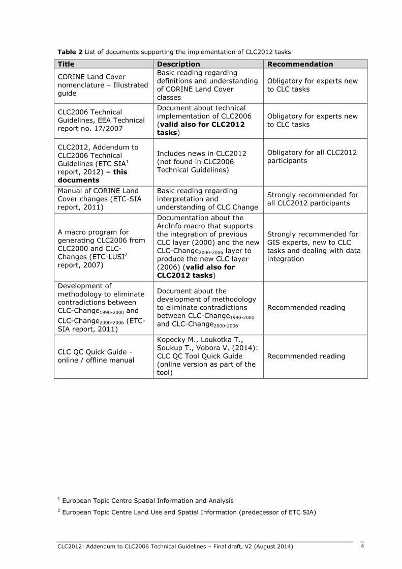
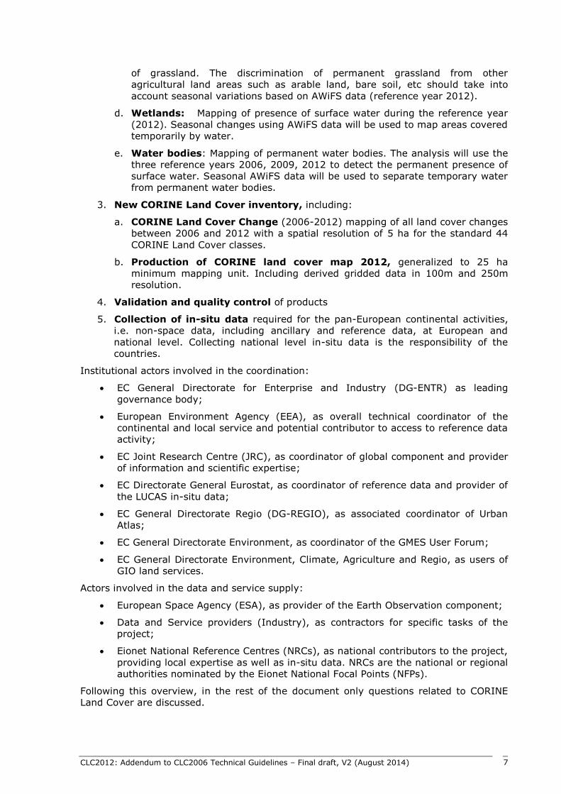
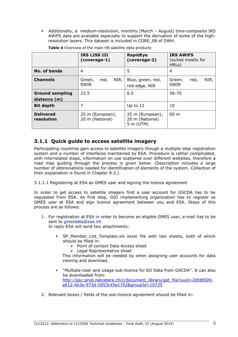
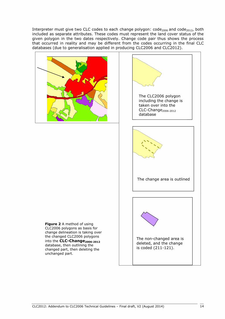
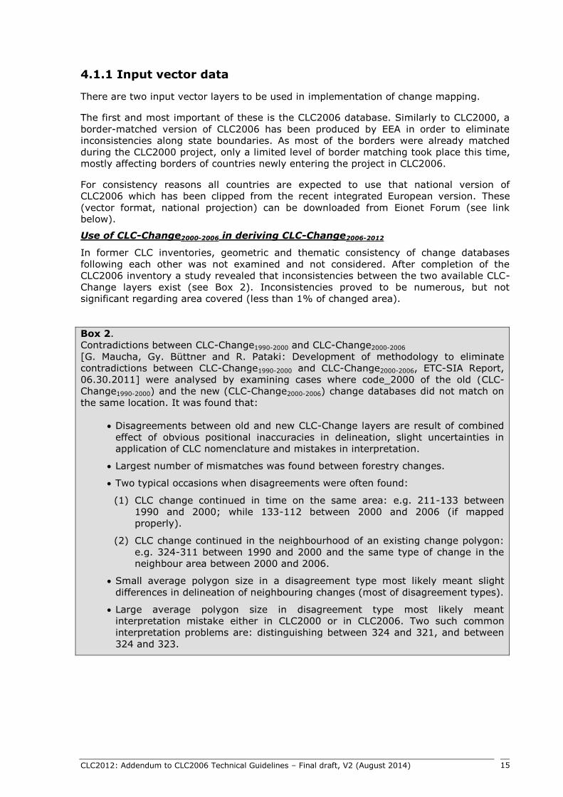
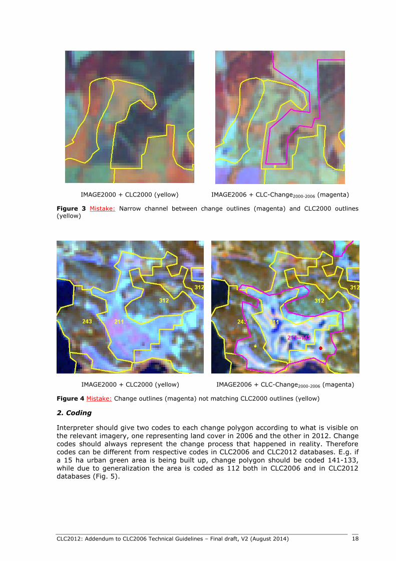
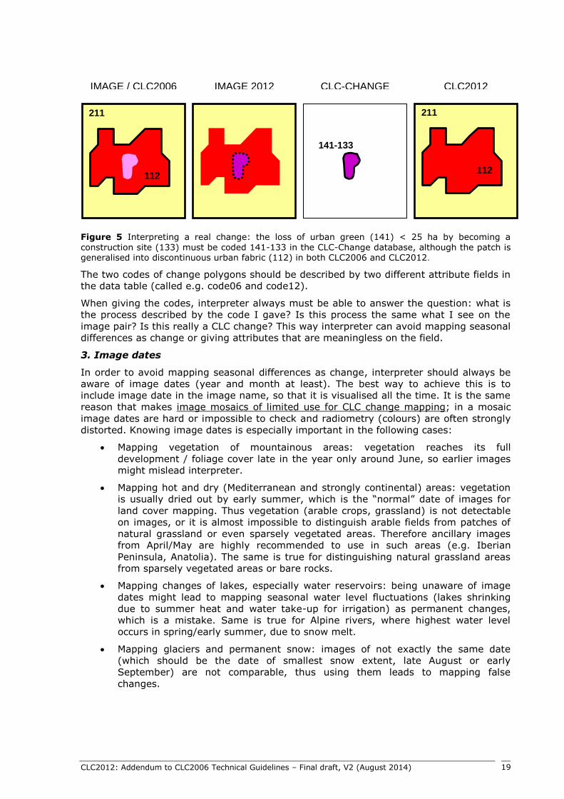
CLC2012 Addendum to CLC2006 Technical Guidelines ndash Final draft V2 (August 2014) 35
ACKNOWLEDGEMENT
Ana Sousa has provided many useful advices in writing this document