Embed Size (px)
Citation preview
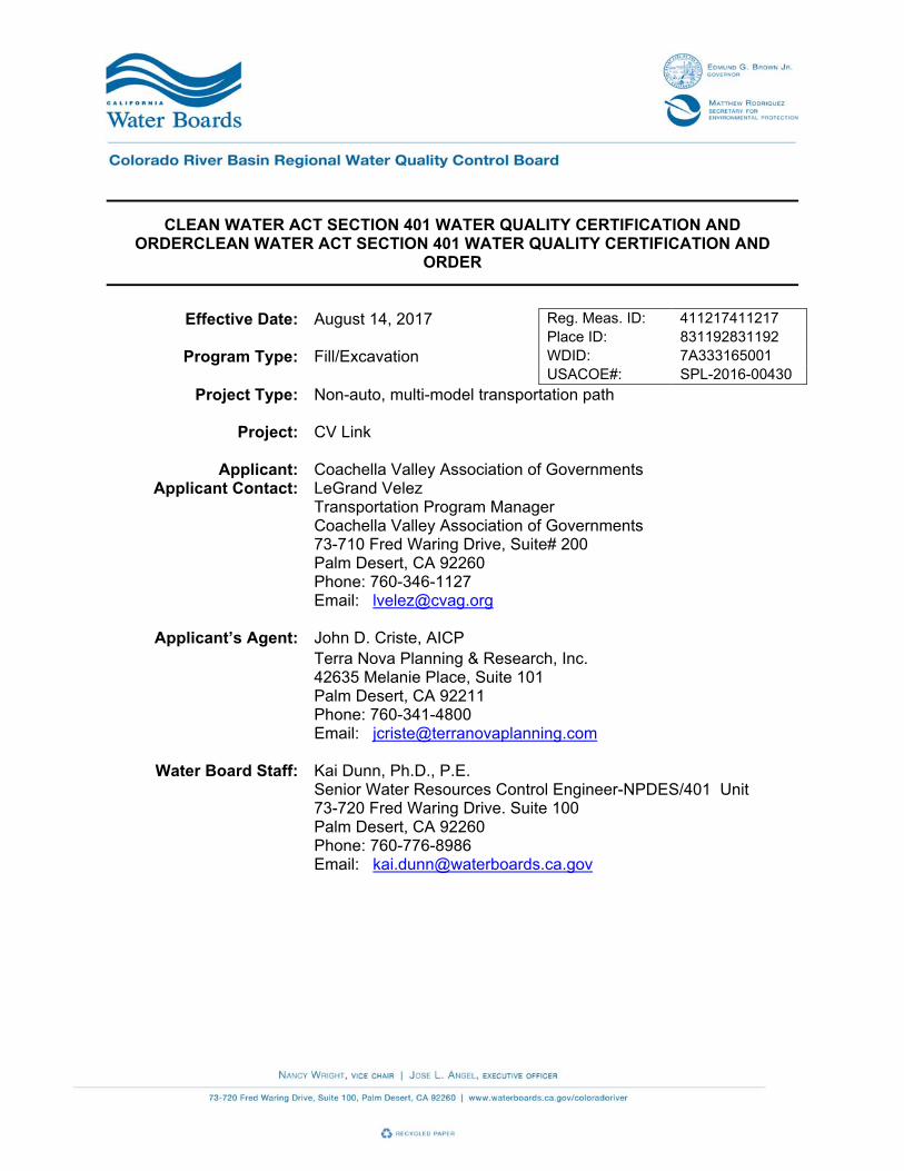
CLEAN WATER ACT SECTION 401 WATER QUALITY CERTIFICATION AND ORDERCLEAN WATER ACT SECTION 401 WATER QUALITY CERTIFICATION AND
ORDER
Effective Date: August 14, 2017 Reg. Meas. ID: 411217411217
Place ID: 831192831192 Program Type: Fill/Excavation WDID: 7A333165001
USACOE#: SPL-2016-00430
Project Type: Non-auto, multi-model transportation path
Project: CV Link
Applicant: Coachella Valley Association of Governments Applicant Contact: LeGrand Velez
Transportation Program Manager Coachella Valley Association of Governments 73-710 Fred Waring Drive, Suite# 200 Palm Desert, CA 92260 Phone: 760-346-1127 Email: [email protected]
Applicant’s Agent: John D. Criste, AICP Terra Nova Planning & Research, Inc. 42635 Melanie Place, Suite 101 Palm Desert, CA 92211 Phone: 760-341-4800 Email: [email protected]
Water Board Staff: Kai Dunn, Ph.D., P.E. Senior Water Resources Control Engineer-NPDES/401 Unit 73-720 Fred Waring Drive. Suite 100 Palm Desert, CA 92260 Phone: 760-776-8986 Email: [email protected]

CV Link WDID: 7A333165001 Reg. Meas. ID: 411217 Place ID: 831192
Page 2 of 20
Water Board Contact Person: If you have any questions, please call Colorado River Basin Regional Water Quality Control Board (Colorado River Basin Water Board) Staff listed above or (760) 346-7491 and ask to speak with the Water Quality Certification and Wetlands Unit Program Manager. Attachment A Project Location and Impact Sites Exhibits Attachment B Receiving Waters, Impact, and Mitigation Information Attachment C CEQA Findings and Facts Attachment D Signatory Requirements Attachment E Reporting Requirements

CV Link WDID: 7A333165001 Reg. Meas. ID: 411217 Place ID: 831192
Page 3 of 20
#
, Click here to enter a date
I. Order
This Clean Water Act (CWA) section 401 Water Quality Certification action and Order (Order) is issued at the request of the Coachella Valley Association of Governments (CVAG) (herein after Permittee) for the Project. This Order is for the purpose described in application and supplemental information submitted by the Permittee. The application was received on January 11, 2017. The application was deemed complete May 17, 2017.
II. Public Notice
Public notice (1-11-2017) was done on January 11, 2017 and completed on February 2, 2017.
III. Project Purpose
The main purpose of CV Link Project is to enhance connectivity between major employment, residential, recreational, and institutional centers throughout the Coachella Valley, while facilitating and promoting the use of alternative modes of transportation, including walking, bicycles, low speed electric vehicles (LSEVs), and mobility assistance devices. The Project is also expected to contribute to reductions in motor vehicle congestion along local roadways, including State Highway 111 - the valley’s principal motorized connector route. The associated reductions in vehicle miles travelled will also reduce pollutant emissions and result in air quality improvements. The Project will enhance the valley’s active transportation network and also provide new health and recreational opportunities for pathway users. In order to address the above needs, the following objectives (goals) are proposed and considered for the design of the Project alternatives: A. Create a regional multi-modal transportation facility that interconnects the highest intensity
land use corridor in the Coachella Valley with neighborhoods, schools, parks, tourist destinations, retail centers, high density residential development, and employment centers, to enhance community livability and cohesiveness.
B. Help the Coachella Valley comply with the Global Warming Solutions Act (AB 32) and the
Sustainable Communities and Climate Protection Act (SB 375) by encouraging zero-emission transportation technologies, transit, and active transportation.
C. Promote healthy lifestyles through the provision of infrastructure where people can safely
travel and recreate by means of active transportation, which in turn can help to address public health problems such as childhood obesity and diabetes.
D. Limit conflicts between motor vehicle traffic, pedestrians and bicyclists, reduce injuries and
fatalities, and create a pleasant user experience by providing grade-separated crossings (bridges and undercrossings) of major roadways to the greatest extent possible.
E. Support “safe routes to schools” efforts by providing connections to K-12 schools in three
school districts and to higher education opportunities.

CV Link WDID: 7A333165001 Reg. Meas. ID: 411217 Place ID: 831192
Page 4 of 20
F. Optimize the use of underutilized flood control rights-of-way, enhance stormwater maintenance infrastructure, and improve emergency response access.
IV. Project Description
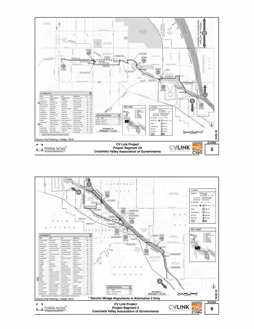
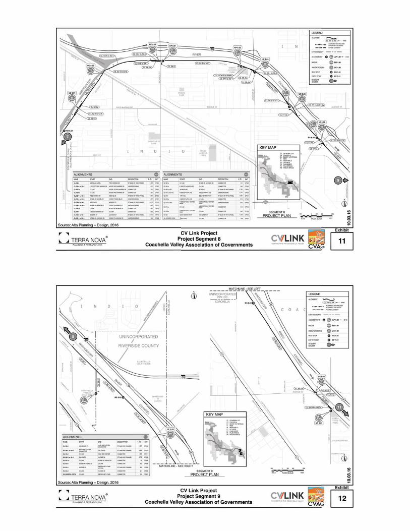
CV Link is a ±49-mile multi-modal transportation network that passes through 12 jurisdictions, including eight incorporated cities (Palm Springs, Cathedral City, Rancho Mirage, Palm Desert, Indian Wells, La Quinta, Indio, Coachella), unincorporated county lands and three Native American tribes (Agua Caliente Band of Cahuilla Indians, Cabazon Band of Mission Indians, Twenty-Nine Palms Band of Mission Indians, and County of Riverside). The length of the Proposed Project route is approximately 44 miles, with the potential maximum length of approximately 49 miles, which is fully analyzed as Alternative 2 in the Project EIR. For permitting purposes, the maximum route length of approximately 49 miles was considered. The pathway will pass through some of the most developed and populated portions of the Coachella Valley, providing access and connectivity between residential, commercial, recreational, institutional, and other land uses throughout the region, and providing recreational opportunities for pathway users. It is also anticipated that the Project will contribute to local reductions in traffic volumes and associated air pollutants. The pathway largely follows, and is to be built upon, the levees of the region’s principal watercourses, including Chino Wash, Tahquitz Creek, and the Whitewater River Stormwater Channel/Coachella Valley Stormwater Channel. In some locations, the pathway shares right-of-way with roads and provides direct access to key commercial districts and recreational and institutional venues. CV Link will also incorporate and expand the Tahquitz Creek Trail in Palm Springs between South Palm Canyon Drive and the Whitewater Channel. The western termini are at Highway 111 (North Palm Canyon Drive) in northern Palm Springs (the Palm Springs Visitor Center at Tramway Road – access point for the Aerial Tram) and at South Palm Canyon Drive in central Palm Springs, providing access to adjacent commercial services and to Downtown Palm Springs, as well as the Tahquitz Canyon Visitor Center. The eastern terminus of CV Link is at Airport Boulevard (Avenue 56) and the Coachella Valley Stormwater Channel (CVSC) in the City of Coachella and the unincorporated community of Thermal. This terminus provides multi-modal access to the administrative offices of the Coachella Valley Unified School District, John Kelley Elementary School, the La Familia Continuing Education High School, a new Riverside County Sheriff’s Station, US Post Office, the Jacqueline Cochran Airport, the Horses in the Sun (HITS) facility, and the Thermal Club Race Track (under construction).
V. Project Location
The Project site is located in the Coachella Valley region of central Riverside County. It is a multi-modal (non-automobile) transportation path that passes through multiple jurisdictions including the cities of Palm Springs, Cathedral City, Rancho Mirage, Palm Desert, Indian Wells, La Quinta, Indio, and Coachella. For the Proposed Project, CV Link will not pass through Rancho Mirage; however, Rancho Mirage is analyzed as part of Alternative 2 and is therefore considered for this application to be conservative. Maps showing the Project location and impacts sites are found in Attachment A of this Order.

CV Link WDID: 7A333165001 Reg. Meas. ID: 411217 Place ID: 831192
Page 5 of 20
VI. Project Impact and Receiving Waters Information
The Project is located within the jurisdiction of Colorado River Basin Regional Water Quality Control Board. Receiving waters and groundwater potentially impacted by this Project are protected in accordance with the applicable water quality control plan (Basin Plan) for the region and other plans and policies which may be accessed online at: http://www.waterboards.ca.gov/plans_policies/. The Basin Plan includes water quality standards, which consist of existing and potential beneficial uses of waters of the state, water quality objectives to protect those uses, and the state and federal anti-degradation policies. It is the policy of the State of California that every human being has the right to safe, clean, affordable, and accessible water adequate for human consumption, cooking, and sanitary purposes. This Order promotes that policy by requiring discharges to meet maximum contaminant levels designed to protect human health and ensure that water is safe for domestic use. Project impact and receiving waters information can be found in Attachment B. Individual impact location and quantity is shown in Table 1, and Attachment B.
VII. Description of Direct Impacts to Waters of the U.S.
Large portions of CV Link are located along the Whitewater River Storm Channel/Coachella Storm Water Channel, Tahquitz Creek Channel, East and West Cathedral Canyon Channels, Magnesia Falls Channel, and the Deep Canyon Channel. There are several locations where the route encroaches into “waters of the U.S.” and will have direct impact, including the placement of bridge piers and path improvements in jurisdictional waters. These are delineated and quantified on each of the impact site exhibits. The fill activities associated with the construction of the CV Link path would also result in direct permanent impacts to 14.68 acres of a delineated California Department of Fish and Wildlife (CDFW) Jurisdictions. All delineated storm channels within the Project area are under the jurisdiction of CDFW, United State Army Corps of Engineers (USACE), and Regional Water Quality Control Board (RWQCB). Only small fraction of lands permanently impacted (0.03 acres) would be USACE/CDFW Wetlands, which would be under RWQCB the Clean Water Act (CWA) section 401 Water Quality Certification Jurisdiction. Approximately 2.34 acres of USACE non-wetlands will be permanently impacted. Total Project dredge and fill/excavation quantities for all impacts are summarized in Table 1. Permanent impacts are categorized as those resulting in a physical loss in area and also those degrading ecological condition only. There would also be temporary impacts to waters of the U.S./State associated with the Project which are also summarized in the Table 1. Total Project permanent and temporary impacts quantities for all impacts sites are summarized in Table 1. Permanent impacts are categorized as those resulting in a physical loss in area and also those degrading ecological condition only. Permanent impacts are categorized as those resulting in a physical loss in area and also those degrading ecological condition only.

CV Link WDID: 7A333165001 Reg. Meas. ID: 411217 Place ID: 831192
Page 6 of 20
Table 1 Total Project Fill/Excavation Quantity
Aquatic Resource Type
Temporary Impact1
Permanent Impact
Physical Loss of Area
Degradation of Ecological Condition
Only
Acres CY LF Acres CY LF Acre
s CY
LF
Lake Ocean/bay/ estuary
Riparian Zone Stream Channel
Wetland 0.06 63.28 105 0.03 125.56 45
VIII. Description of Indirect Impacts to Waters of the U.S.
The Colorado River Basin Water Board recognizes the potential for indirect impacts to waters of the U.S. associated with the Project. A set of mitigation and minimization measures are designed for CV Link to reduce indirect impacts during and after construction and to protect fish, wildlife, and plant resources. These mitigation and minimization measures are discussed below: 1. Mitigation Related to the Coachella Valley Multiple Species Habitat Conservation
Plan (CVMSHCP)
CVAG will be required to pay the local development mitigation fee to mitigate for impacts to covered species and natural communities within the plan area, inside or outside of Conservation Areas. Project activities inside Conservation Areas are subject to the Joint Project Review process to determine consistency with plan goals and objectives.
CVAG shall comply with all terms and conditions of the CVMSHCP and Implementing Agreement including, but not limited to: 1) participation in the Joint Project Review Process with the Coachella Valley Conservation Commission for projects within conservation areas as described in Section 6.6.1.1 of the CVMSHCP, and 2) Implementation of the “Land Use Adjacency Guidelines” as described in Section 4.5 of the CVMSHCP for any portion of the Proposed Project that impact or are adjacent to the Whitewater Floodplain and Santa Rosa and San Jacinto Mountains Conservation Areas.
2. Measures for the “Land Use Adjacency Guidelines”
a. Drainage: Development of the Proposed Project adjacent to or within a conservation area shall incorporate plans to ensure that the quantity and quality of runoff discharged to the adjacent conservation area is not altered in an adverse way when compared with
1 Includes only temporary direct impacts to waters of the state and does not include upland areas of temporary disturbance which could result in a discharge to waters of the state. Temporary impacts, by definition, are restored to pre-project conditions and therefore do not include a physical loss of area or degradation of ecological condition.

CV Link WDID: 7A333165001 Reg. Meas. ID: 411217 Place ID: 831192
Page 7 of 20
existing conditions. Storm water systems shall be designed to prevent the release of pollutants (e.g., toxins, chemicals, petroleum products, exotic plant materials) or other elements that might degrade or harm biological resources or ecosystem processes within the adjacent conservation area.
b. Toxics: Development of the Proposed Project adjacent to or within a conservation area shall be required to incorporate measures to ensure that application of fertilizers, pesticides, herbicides or similar chemicals does not result in any discharge to the adjacent conservation area.
c. Lighting: Lighting in areas adjacent to or located within conservation areas shall be shielded and directed away from the conservation area, toward developed areas. Landscape shielding or other appropriate methods shall be incorporated in project designs to minimize the effects of lighting adjacent to or within the adjacent conservation area in accordance with the guidelines included in the Implementation Manual.
d. Noise: Noise generated by construction adjacent to or within a conservation area in excess of 75 dBA shall incorporate setbacks, berms, or walls, as appropriate, to minimize the effects of noise on the adjacent conservation area according to Implementation Manual guidelines.
e. Invasives: Landscape plans shall be prepared for the Proposed Project. Landscape plans for areas that are located adjacent to or within a conservation area are prohibited from using invasive, non-native plant species in their design.
3. Mitigation Related to Migratory Bird Treaty Act
If ground disturbance, tree or plant removal is proposed between February 1st and August 31st, a qualified biologist shall conduct a nesting bird survey within 14 days of initiation of grading onsite focusing on Migratory Bird Treaty Act (MBTA) covered species. If active nests are reported, then species-specific measures shall be prepared. At a minimum, grading in the vicinity of a nest shall be postponed till the young birds have fledged. For construction between September 1st and January 31th, no pre-removal nesting bird survey is required.
In the event active nests are found, exclusionary fencing shall be placed 200 feet around the nest until such time as nestlings have fledged. Nests of raptors and burrowing owls shall be provided a 500-foot buffer. Ground disturbance between September 1 and January 31 shall be exempt from this requirement.
4. Mitigation Related to Burrowing Owl
A “take avoidance survey” for the burrowing owl no less than 14 days (in accordance with the Staff Report on Burrowing Owl Mitigation [CDFW 2012]) and no more than 30 days (in accordance with CVWD’s Operations and Maintenance Manual) prior to ground breaking activities is required within and outside of conservation areas that contain suitable habitat for this species. Additionally, a final survey must be conducted within 24 hours of the initiation of ground disturbance activities in accordance with the CDFW 2012 protocol.
a. If no burrowing owls are detected during those surveys, implementation of ground
disturbance activities could proceed without further consideration of this species assuming there is no lapse between the surveys and construction as the protocol states “time lapses between Project activities trigger subsequent take avoidance surveys including but not limited to a final survey conducted within 24 hours prior to ground disturbance."

CV Link WDID: 7A333165001 Reg. Meas. ID: 411217 Place ID: 831192
Page 8 of 20
b. If burrowing owls are detected during the take avoidance surveys, avoidance and minimization measures would then be required and the need for mitigation for otherwise unavoidable impacts triggered.
5. Mitigation Related to Casey’s June Beetle
Prior to any construction in that portion of the Proposed Project occurring within the Survey Area for Casey’s June Beetle, the Project proponent shall complete, and the USFWS approve a Habitat Conservation Plan for the species, and issue an incidental take permit. The HCP shall include the acquisition, restoration or creation of habitat for the species.
6. Additional Mitigation Measures
The following mitigation measures are applicable to those sections of the Route adjacent to native habitat.
a. Fencing/Signage – As a means to protect the adjacent lands of the Whitewater
Floodplain Conservation Area present on Segment 1 of the CV Link Route (see Appendix B for location of this Segment), fencing and/or regularly placed signage shall be employed near the “top-of-slope” of the levee to prevent people and their pets (particularly dogs being walked by their owners) from straying off the designated CV Link path and into the adjacent natural habitat. Signage shall be placed intermittently along the entire CV Link Segment.
b. Pet Control – Additional signage shall be placed intermittently along the entire CV Link Route indicating that all dogs shall be required to be on a leash while traversing CV Link. Aside from preventing individual animals from entering native habitat, the benefits of such a mandate are numerous including facilitating personal safety for other users of the Link, preventing altercations with other dogs present on the path, and increased safety for the individual pet in question (i.e. preventing collisions with bicyclists and LSEV users). In addition, disposal bins for pet waste shall also be provided throughout CV Link.
c. Interpretive Signage – Interpretive signs adjacent to areas of native habitat (such as the Whitewater Floodplain Preserve) shall illustrate and educate the public on some of the native wildlife, plant, or vegetation communities present adjacent to CV Link.
IX. Avoidance and Minimization
To avoid and minimize direct and indirect impacts to Waters of the U.S./state the applicant will implement Project-specific stormwater management controls during construction as well as operation and maintenance activities. Table 2 includes the BMPs developed to address anticipated and potential water quality issues that could arise as a result of the development of the Project. Additionally, all development projects in Riverside County are required to implement Low Impact Development (LID) BMPs. The goal of the County’s LID program is to protect water quality by preserving and mimicking nature through the use of stormwater planning and management. The development projects with the potential to add pollutants to stormwater or to affect the flow rate and velocity of stormwater runoff after construction is completed are required to employ post-construction (permanent) BMPs, as feasible, to ensure that pollutants and runoff from the development are reduced to the maximum extent possible.

CV Link WDID: 7A333165001 Reg. Meas. ID: 411217 Place ID: 831192
Page 9 of 20
Table 2 BMPs Type of
BMP
BMP Application
Construction BMPs
Erosion control Implement erosion control BMPs to mitigate soil erosion, minimize soil loss from wind erosion, and to reduce air pollution during construction activities for all disturbed areas. Examples: mulch, straw, wood chips, soil application, lot perimeter protection per county standards, bonded fiber matrix or stabilized fiber matrix, physical stabilization erosion control blanket.
Velocity reduction Implement velocity reduction BMPs to reduce water/runoff velocity. Examples: energy dissipater outlet protection.
Sediment control Implement sediment control BMPs to remove sediment loads from runoff generated within the construction site for all disturbed areas. Examples: silt fence, fiber rolls, gravel bags, dewatering filtration.
Off-site sediment tracking control
Implement off-site sediment tracking control BMPs for reducing the transport of sediment on tires off, and within, construction site. Examples: stabilized construction entrance, construction road stabilization, entrance/exit tire wash, entrance/exit inspection and cleaning facility.
General site and materials management
Implement general site and materials management BMPs for materials and waste management. Examples: material delivery and storage management, spill prevention and control, concrete waste management, solid waste management, sanitary waste management, hazardous waste management.
Low Impact Development
Conservation of natural drainages
Implement LID BMPs to conserve natural drainages. Examples: minimize disturbances of natural areas, construct in least environmentally sensitive areas.
Minimize disturbances to natural drainages
Implement LID BMPs to minimize disturbances to natural drainages. Examples: avoid disturbing natural swales and topographic depressions, construction setback from creeks.
Minimize impervious surfaces
Implement LID BMPs to reduce impervious surfaces through efficient site design. Examples: preserve existing vegetation, permeable roads with minimum widths.
Minimize soil compaction
Implement LID BMPs to minimize soil compaction. Examples: protect native soil and vegetation from construction equipment.
Drain runoff from impervious surfaces to pervious areas
Implement LID BMPs to drain runoff from impervious surfaces to pervious areas.
Hydrologic design Implement LID BMPs for optimizing hydrologic design. Examples: infiltration tranches or basins, depression areas for infiltration, bio-filters such as vegetated or rock swales.
Permeable pavement design
Implement LID BMPs using permeable pavement design. Examples: pervious concrete, permeable asphalt concrete/pavers, granular material.
LID road design Implement LID BMPs for road design. Examples: permeable roads, reduction of overall road coverage, direct runoff to vegetated swales.

CV Link WDID: 7A333165001 Reg. Meas. ID: 411217 Place ID: 831192
Page 10 of 20
Table 2 BMPs Type of
BMP
BMP Application
Post-Construction BMPs
Protection of channel banks/manufactured slopes
Implement channel protection BMPs to protect banks of the channels as well as the slopes.
Outlet protection Implement outlet protection BMPs to reduce discharge/water velocity. Examples: energy dissipater outlet protection, velocity dissipation devices.
BMPs will be regularly monitored following installation in accordance with the County Standard Urban Stormwater Mitigation Plan (SUSMP) guidelines, and if any BMP is determined to be underperforming, an assessment will be made for correcting performance deficiencies. The property owner or the responsible party is responsible for scheduling and conducting maintenance of BMPs.
X. Compensatory Mitigation
Compensatory mitigation for temporary impacts to waters of the U.S. is not required as the temporary impact area will be restored to pre-construction conditions upon project completion and will not result in the temporal loss and/or degradation of ecological condition.
The Permittee has agreed to provide compensatory mitigation, described in Section VI for permanent impacts, at 1:1 impact-to-mitigation ratio, for a total of 0.03 acre of streambed and 45 linear feet, through the purchase of mitigation credits from the Coachella Valley Conservation Commission (CVCC) approved In-Lieu Fee Program (ILFP).
XI. California Environmental Quality Act (CEQA)
On May 15, 2017, the Coachella Valley Association of Government (CVAG), as lead agency, certified an environmental impact report (EIR) (State Clearinghouse (SCH) No. 2013111050) for the Project and files a Notice of Determination (NOD) at SCH on May 16, 2017. Pursuant to CEQA, the Colorado River Basin Water Board has made Findings of Facts (Findings) which support the issuance of this Order and are included in Attachment C.
XII. Petitions for Reconsideration
Any person aggrieved by this action may petition the State Water Board to reconsider this Order in accordance with California Code of Regulations, title 23, section 3867. A petition for reconsideration must be submitted in writing and received within 30 calendar days of the issuance of this Order.
XIII. Fees Received
An application fee of $1,097.00 was received on January 11, 2017. The fee amount ($1,215) was determined as required by California Code of Regulations, title 23, sections 3833(b)(3) and 2200(a)(3), and was calculated as category A - Fill & Excavation Discharges (fee code 84)A - Fill & Excavation Discharges (fee code 84) with the dredge and fill fee calculator.

CV Link WDID: 7A333165001 Reg. Meas. ID: 411217 Place ID: 831192
Page 11 of 20
An additional fee of $ 136 based on total Project impacts was received on July 3, 2017.
XIV. Conditions
The Colorado River Basin Water Board has independently reviewed the record of the Project to analyze impacts to water quality and designated beneficial uses within the watershed of the Project. In accordance with this Order, the Permittee may proceed with the Project under the following terms and conditions:
A. Authorization
1. Impacts to waters of the U.S. shall not exceed quantities shown in Table 1.
2. Permittee shall develop and implement a Storm Water Pollution Prevention Plan (SWPPP) per the County’ Stormwater Ordinance.
3. Permittee shall implement the BMPs and LIDs described under Section IX, Avoidance and Minimization.
4. Discharges of pollutants associated with construction-related storm water runoff are subject to National Pollutant Discharge Elimination System permitting under CWA Section 402. The discharger must file a Notice of Intent with the State Water Resources Control Board to obtain coverage under the Construction General Permit.
B. Reporting and Notification Requirements The following section details the reporting and notification types and timing of submittals. Requirements for the content of these reporting and notification types are detailed in Attachment E, including specifications for photo and map documentation during the Project Written reports and notifications must be submitted using the Reporting and Notification Cover Sheet located in Attachment E, which must be signed by the Permittee or an authorized representative.
1. Project Reporting
a. Monthly Reporting: The Permittee must submit a Monthly Report to the Colorado River Basin Water Board on the 15th of each month for duration of the construction phase of the Project. Monthly reporting shall continue until the Colorado River Basin Water Board issues a Notice of Project Complete Letter to the Permittee.
b. Annual Reporting: The Permittee shall submit an Annual Report each year on February 17. Annual reporting shall continue until a Notice of Project Complete Letter is issued to the Permittee.
c. Other Reporting: If pollutants are observed in surface water, the Applicant shall
submit a report to the Colorado River Basin Water Board within 30-days after encountering the pollutants and describe actions taken to correct the problem and provide photographic documentation that supports the information in the report.

CV Link WDID: 7A333165001 Reg. Meas. ID: 411217 Place ID: 831192
Page 12 of 20
2. Project Status Notifications
a. Commencement of Construction: The Permittee shall submit a Commencement of Construction Report at least seven (7) days prior to start of initial ground disturbance activities.
b. Request for Notice of Completion of Discharges Letter: The Permittee shall submit a Request for Notice of Completion of Discharges Letter following completion of active Project construction activities, including any required restoration and permittee-responsible mitigation. This request shall be submitted to the Colorado River Basin Water Board staff within thirty (30) days following completion of all Project construction activities. Upon acceptance of the request, Colorado River Basin Water Board staff shall issue a Notice of Completion of Discharges Letter to the Permittee which will end the active discharge period and associated annual fees.
c. Request for Notice of Project Complete Letter: The Permittee shall submit a
Request for Notice of Project Complete Letter when construction and/or any post-construction monitoring is complete,2 and no further Project activities will occur. This request shall be submitted to Colorado River Basin Water Board staff within thirty (30) days following completion of all Project activities. Upon approval of the request, the Colorado River Basin Water Board staff shall issue a Notice of Project Complete Letter to the Permittee which will end the post discharge monitoring period and associated annual fees.
3. Conditional Notifications and Reports: The following notifications and reports are required as appropriate.
a. Accidental Discharges of Hazardous Materials3
Following an accidental discharge of a reportable quantity of a hazardous material, sewage, or an unknown material, the following applies (Wat. Code, § 13271):
i. As soon as (A) Permittee has knowledge of the discharge or noncompliance, (B) notification is possible, and (C) notification can be provided without substantially impeding cleanup or other emergency measures then: first call – 911 (to notify local response agency) then call – Office of Emergency Services (OES) State Warning Center at:
(800) 852-7550 or (916) 845-8911 Lastly follow the required OES procedures as set forth in:
http://www.caloes.ca.gov/FireRescueSite/Documents/CalOES-Spill_Booklet_Feb2014_FINAL_BW_Acc.pdf
2 Completion of post-construction monitoring shall be determined by Colorado River Water Board staff and shall be contingent on successful attainment of restoration and mitigation performance criteria.
3 "Hazardous material" means any material that, because of its quantity, concentration, or physical or chemical characteristics, poses a significant present or potential hazard to human health and safety or to the environment if released into the workplace or the environment. "Hazardous materials" include, but are not limited to, hazardous substances, hazardous waste, and any material that a handler or the administering agency has a reasonable basis for believing that it would be injurious to the health and safety of persons or harmful to the environment if released into the workplace or the environment. (Health & Saf. Code, § 25501.)

CV Link WDID: 7A333165001 Reg. Meas. ID: 411217 Place ID: 831192
Page 13 of 20
ii. Following notification to OES, the Permittee shall notify Colorado River Basin Water Board, as soon as practicable (ideally within 24 hours). Notification may be via telephone, e-mail, delivered written notice, or other verifiable means.
iii. Within five (5) working days of notification to the Colorado River Basin Water Board, the Permittee must submit an Accidental Discharge of Hazardous Material Report.
b. Violation of Compliance with Water Quality Standards: The Permittee shall notify the Colorado River Basin Water Board of any event causing a violation of compliance with water quality standards. Notification may be via telephone, e-mail, delivered written notice, or other verifiable means.
i. Examples of noncompliance events include: lack of storm water treatment following a rain event, discharges causing a visible plume in a water of the state, and water contact with uncured concrete.
ii. This notification must be followed within three (3) working days by submission
of a Violation of Compliance with Water Quality Standards Report.
c. In-Water Work
i. The Permittee shall notify the Colorado River Basin Water Board at least forty-eight (48) hours prior to initiating work in water or stream diversions. Notification may be via telephone, e-mail, delivered written notice, or other verifiable means.
ii. Within three (3) working days following completion of work in water or stream diversions, an In-Water Work/Diversions Water Quality Monitoring Report must be submitted to Colorado River Basin Water Board staff.
d. Modifications to Project Project modifications may require an amendment of this Order. The Permittee shall give advance notice to Colorado River Basin Water Board staff if Project implementation as described in the application materials is altered in any way or by the imposition of subsequent permit conditions by any local, state or federal regulatory authority by submitting a Modifications to Project Report. The Permittee shall inform Colorado River Basin Water Board staff of any Project modifications that will interfere with the Permittee’s compliance with this Order.
e. Transfer of Property Ownership: This Order is not transferable in its entirety or in part to any person or organization except after notice to the Colorado River Basin Water Board in accordance with the following terms:
i. The Permittee must notify the Colorado River Basin Water Board of any change in ownership or interest in ownership of the Project area by submitting a Transfer of Property Ownership Report. The Permittee and purchaser must sign and date the notification and provide such notification to the Colorado River Basin Water Board at least 10 days prior to the transfer of ownership. .

CV Link WDID: 7A333165001 Reg. Meas. ID: 411217 Place ID: 831192
Page 14 of 20
ii. Until such time as this Order has been modified to name the purchaser as the permittee, the Permittee shall continue to be responsible for all requirements set forth in this Order.
f. Transfer of Long-Term BMP Maintenance: If maintenance responsibility for post-
construction BMPs is legally transferred, the Permittee must submit to the Colorado River Basin Water Board a copy of such documentation and must provide the transferee with a copy of a long-term BMP maintenance plan that complies with manufacturer or designer specifications. The Permittee must provide such notification to the Colorado River Basin Water Board with a Transfer of Long-Term BMP Maintenance Report at least 10 days prior to the transfer of BMP maintenance responsibility.
C. Water Quality Monitoring
1. General: If surface water is present, continuous visual surface water monitoring shall be conducted to detect accidental discharge of construction related pollutants (e.g. oil and grease, turbidity plume, or uncured concrete).
2. Accidental Discharges/Noncompliance: Upon occurrence of an accidental discharge of hazardous materials or a violation of compliance with a water quality standard, Colorado River Basin Water Board staff may require water quality monitoring based on the discharge constituents and/or related water quality objectives and beneficial uses.
3. In-Water Work or Diversions:
For projects involving planned work in water or stream diversions, a water quality monitoring plan shall be submitted to Colorado River Basin Water Board staff for acceptance at least 30 days in advance of any discharge to the affected water body. Water quality monitoring shall be conducted in accordance with the approved plan.
Sampling shall be conducted in accordance with Table 3 sampling parameters.4
4 Pollutants shall be analyzed using the analytical methods described in 40 Code of Federal Regulations Part 136; where no methods are specified for a given pollutant, the method shall be approved by Colorado River Water Board staff. Grab samples shall be taken between the surface and mid-depth and not be collected at the same time each day to get a complete representation of variations in the receiving water. A hand-held field meter may be used, provided the meter utilizes a U.S. EPA-approved algorithm/method and is calibrated and maintained in accordance with the manufacturer’s instructions. A calibration and maintenance log for each meter used for monitoring shall be maintained onsite.

CV Link WDID: 7A333165001 Reg. Meas. ID: 411217 Place ID: 831192
Page 15 of 20
Table 3: Sample Type and Frequency Requirements Parameter Unit of
Measurement Type of Sample
Minimum Frequency
Oil and Grease N/A Visual Continuous
Dissolved Oxygen mg/L & % saturation Grab Every 4 hours
pH Standard Units Grab Every 4 hours Turbidity NTU Grab Every 4 hours
Temperature °F (or as °C) Grab Every 4 hours
4. Post-Construction: Visually inspect the Project site during the rainy season for five (5) years to ensure excessive erosion, stream instability, or other water quality pollution is not occurring in or downstream of the Project site. If water quality pollution is occurring, contact the Colorado River Basin Water Board staff member overseeing the Project within three (3) working days. The Colorado River Basin Water Board may require the submission of a Violation of Compliance with Water Quality Standards Report. Additional permits may be required to carry out any necessary site remediation.
D. Standard
1. This Order is subject to modification or revocation upon administrative or judicial review, including review and amendment pursuant to Water Code section 13330, and California Code of Regulations, title 23, chapter 28, Article 6 commencing with sections 3867-3869, inclusive.sections 3867-3869, inclusive. Additionally, the Colorado River Basin Water Board reserves the right to suspend, cancel, or modify and reissue this Order, after providing notice to the Permittee, if the Colorado River Basin Water Board determines that: the Project fails to comply with any of the conditions of this Order; or, when necessary to implement any new or revised water quality standards and implementation plans adopted or approved pursuant to the Porter-Cologne Water Quality Control Act (Wat. Code, § 13000 et seq.) or federal Clean Water Act section 303 (33 U.S.C. § 1313).
2. This Order is not intended and shall not be construed to apply to any activity involving a hydroelectric facility requiring a Federal Energy Regulatory Commission (FERC) license or an amendment to a FERC license, unless the pertinent certification application was filed pursuant to subsection 3855(b) of chapter 28, title 23 of the California Code of Regulations, and that application specifically identified that a FERC license or amendment to a FERC license for a hydroelectric facility was being sought.
3. This Order is conditioned upon total payment of any fee required under title 23 of the California Code of Regulations and owed by the Permittee.
4. In the event of any violation or threatened violation of the conditions of this Order, the violation or threatened violation shall be subject to any remedies, penalties, process, or sanctions as provided for under state and federal law. For purposes of Clean Water Act, section 401(d), the applicability of any state law authorizing remedies, penalties, processes, or sanctions for the violation or threatened violation constitutes a limitation necessary to assure compliance with the water quality standards and other pertinent requirements incorporated into this Order.

CV Link WDID: 7A333165001 Reg. Meas. ID: 411217 Place ID: 831192
Page 16 of 20
E. General Compliance
1. Failure to comply with any condition of this Order shall constitute a violation of the Porter-Cologne Water Quality Control Act and the Clean Water Act. The Permittee and/or discharger may then be subject to administrative and/or civil liability pursuant to Water Code section 13385.
2. Permitted actions must not cause a violation of any applicable water quality standards, including impairment of designated beneficial uses for receiving waters as adopted in the Basin Plans by any applicable Colorado River Basin Water Board or any applicable State Water Board (collectively Water Boards) water quality control plan or policy. The source of any such discharge must be eliminated as soon as practicable.
3. In response to a suspected violation of any condition of this Order, the Colorado River Basin Water Board may require the holder of this Order to furnish, under penalty of perjury, any technical or monitoring reports the Water Boards deem appropriate, provide that the burden, including costs, of the reports shall bear a reasonable relationship to the need for the reports and the benefits to be obtained from the reports. The additional monitoring requirements ensure that permitted discharges and activities comport with any applicable effluent limitations, water quality standards, and/or other appropriate requirement of state law.
4. The Permittee must, at all times, fully comply with engineering plans, specifications, and technical reports submitted to support this Order; and all subsequent submittals required as part of this Order. The conditions within this Order and Attachments supersede conflicting provisions within Permittee submittals.
5. This Order and all of its conditions contained herein continue to have full force and effect regardless of the expiration or revocation of any federal license or permit issued for the Project. For purposes of Clean Water Act, section 401(d), this condition constitutes a limitation necessary to assure compliance with the water quality standards and other pertinent requirements of state law.
6. Construction General Permit Requirement: The Permittee shall maintain compliance with conditions described in, and required by, NPDES General Permit for Storm Water Discharges Associated with Construction and Land Disturbance Activities (Order No. 2009-0009-DWQ; NPDES No. CAS000002).
F. Administrative
1. Signatory requirements for all document submittals required by this Order are presented in Attachment D of this Order.
2. This Order does not authorize any act which results in the taking of a threatened, endangered or candidate species or any act, which is now prohibited, or becomes prohibited in the future, under either the California Endangered Species Act (Fish & G. Code, §§ 2050-2097) or the federal Endangered Species Act (16 U.S.C. §§ 1531-1544). If a “take” will result from any act authorized under this Order held by the Permittee, the Permittee must obtain authorization for the take prior to any construction or operation of the portion of the Project that may result in a take. The Permittee is responsible for meeting all requirements of the applicable endangered species act for the Project authorized under this Order.

CV Link WDID: 7A333165001 Reg. Meas. ID: 411217 Place ID: 831192
Page 17 of 20
3. The Permittee shall grant Colorado River Basin Water Board staff, or an authorized representative (including an authorized contractor acting as a Water Board representative), upon presentation of credentials and other documents as may be required by law, permission to:
a. Enter upon the Project or compensatory mitigation site(s) premises where a regulated facility or activity is located or conducted, or where records are kept.
b. Have access to and copy any records that are kept and are relevant to the Project or the requirements of this Order.
c. Inspect any facilities, equipment (including monitoring and control equipment), practices, or operations regulated or required under this Order.
d. Sample or monitor for the purposes of assuring Order compliance.
4. A copy of this Order shall be provided to any consultants, contractors, and subcontractors working on the Project. Copies of this Order shall remain at the Project site for the duration of this Order. The Permittee shall be responsible for work conducted by its consultants, contractors, and any subcontractors.
5. A copy of this Order must be available at the Project site(s) during construction for review by site personnel and agencies. All personnel performing work on the Project shall be familiar with the content of this Order and its posted location at the Project site.
6. Lake and Streambed Alteration Agreement – The Permittee shall submit a signed copy of the Department of Fish and Wildlife’s lake and streambed alteration agreement to the Colorado River Basin Water Board immediately upon execution and prior to any discharge to waters of the state.
G. Construction 1. Work shall only be performed under “no flow” conditions in the washes to preclude
potential impacts to water quality.
Good Site Management “Housekeeping” 2. Good site management “housekeeping”, erosion control, sediment control, and other
construction-related activities are described in Section IX. 3. A monitor shall be on site during grading, clearing, grubbing, trenching, construction, and
decommissioning activities to prevent impacts to special-status species and other biological resources, as well as document and report any construction-related incidences.
4. After completing the activities, the disturbed area shall be restored to pre-existing contours and conditions to the extent feasible.
Hazardous Materials 5. No toxic and/or hazardous materials shall be stored near or within wash/drainage areas.
To the extent practicable, these materials shall be stored offsite and placed in appropriate secondary containment.
6. Spoil sites shall not be located where spoil could be washed back into the stream channel or where spoil covers aquatic or riparian vegetation. Any materials placed in
CV Link WDID: 7A333165001 Reg. Meas. ID: 411217 Place ID: 831192
Page 18 of 20
seasonally dry portions of the drainage areas that could be washed downstream or could be harmful to aquatic life shall be removed from the streambed prior to inundation by high flows.
7. No fueling or maintenance of equipment or vehicles shall occur adjacent or within the wash/drainage areas.
Post-Construction Storm Water Management 8. Work shall not be conducted during rain events. 9. Post-construction storm water management shall be protected through channel
protection BMPs to protect the banks of the channels and slopes.
Roads 10. Work and staging areas and temporary access routes shall be sized, located and
flagged to limit potential impacts to natural areas. Previous disturbed areas shall be used to the extent feasible.
H. Mitigation for Temporary Impacts
The Permittee shall restore all areas of temporary impacts towaters of the state and all Project site upland areas of temporary disturbance which could result in a discharge of waters of the state
I. Compensatory Mitigation for Permanent Impacts5
1. Purchase of Mitigation Credits by Permittee for Compensatory Mitigation
a. A copy of the fully executed agreement for the purchase of mitigation credits shall be provided to the Colorado River Basin Water Board on within 90 days of authorized impacts.
b. The Permittee shall retain responsibility for providing the compensatory mitigation and long-term management until Colorado River Basin Water Board staff has received documentation of the credit purchase and the transfer agreement between the Permittee and the seller of credits.
2. Total Required Compensatory Mitigation
a. The Permittee is required to provide compensatory mitigation for the authorized impact to non-wetland waters of the U.S. by purchasing 0.03 acre of streambed enhancement credits from the CVCC approved ILFP.
b. Total required Project compensatory mitigation information for permanent physical loss of area is summarized in Table 4
5 Compensatory Mitigation is for permanent physical loss and permanent ecological degradation of a water of the state.

CV Link WDID: 7A333165001 Reg. Meas. ID: 411217 Place ID: 831192
Page 19 of 20
Table 4: Required Project Compensatory Mitigation Quantity for Permanent Physical Loss of Area in Acres
Aquatic Resource
Type
Comp Mit.
Type6 Units
Method7
Est. Re-est. Reh. Enh. Pres. Unknown
Wetland ILF Acres 0.03
Click here to enter text.
6 Compensatory mitigation type may be: In-Lieu-Fee (ILF); Mitigation Bank (MB); Permittee-Responsible (PR)
7 Methods: establishment (Est.), reestablishment (Re-est.), rehabilitation (Reh.), enhancement (Enh.), preservation (Pres.). Unknown applies to advance credits with an unknown method and or location.


Attachment A Project Maps

(This page intentionally left blank)


Attachment B Receiving Waters, Impact, and Mitigation Information

(This page intentionally left blank)

CV Link Reg. Meas. ID: 411217 Attachment B Place ID: 831192
Page 3 of 27
Receiving Waters The following table shows the receiving waters associated with each impact and Permittee responsible mitigation site.
Table 1: Receiving Water(s) Information Non-
Federal Waters
Impact Site ID
Waterbody Name Impacted Aquatic
Resource Type
Water Board
Hydrologic Unit
Receiving Waters
Receiving Waters Beneficial Uses
303d Listing Pollutant
eCRAM ID1
☐ RWCB Site 1 (Exhibit 14)
Whitewater Non-wetland Salton Sea Watershed*
Salton Sea Municipal & Domestic Supply; Agricultural Supply; Groundwater Recharge; Water Contact and Non-contact Water Recreation; Cold Freshwater and Wildlife Habitat
NA. However, urban runoff with certain levels of pathogens (bacteria, protozoa, viruses), Sediment, trash, fertilizers (nutrients, compounds of nitrogen and phosphorus), pesticides (DDT, chlordane, diazinon, chlorpyrifos), heavy metals (cadmium, chromium, copper, lead, zinc), and petroleum products (oil, grease, petroleum hydrocarbons, polycyclic aromatic hydrocarbons) may enter into the Whitewater River.**
1 California Rapid Assessment Method (CRAM) score of impacted sites provided by the Permittee. * The project site lies in the Whitewater Hydrologic Unit, specifically Indio Hydrologic Subarea. In terms of Colorado River Basin Regional Water Quality Control Board, the site is located within “Salton Sea Watershed” which is also referred as USGS Hydrologic Unit 18100200. Source: RWCB; http://www.waterboards.ca.gov/coloradoriver/water_issues/programs/salton_sea/ and project specific Water Quality Assessment Report; https://www.cvag.org/library/pdf_files/trans/CV%20Link%20DEIR/Appendix%20N.pdf ** R7-2013-0011 - State Water Resources Control Board – California; http://www.swrcb.ca.gov/coloradoriver/board_decisions/adopted_orders/orders/2013/0011cv_ms4.pdf *** Final 2010 Integrated Report (CWA Section 303(d) List / 305(b) Report); http://www.waterboards.ca.gov/water_issues/programs/tmdl/2010state_ir_reports/category5_report.shtml

CV Link Reg. Meas. ID: 411217 Attachment B Place ID: 831192
Page 4 of 27
Table 1: Receiving Water(s) Information Non-
Federal Waters
Impact Site ID
Waterbody Name Impacted Aquatic
Resource Type
Water Board
Hydrologic Unit
Receiving Waters
Receiving Waters Beneficial Uses
303d Listing Pollutant
eCRAM ID1
☐ RWCB Site 2 (Exhibit 15)
Whitewater Non-wetland Salton Sea Watershed
Salton Sea Municipal & Domestic Supply; Agricultural Supply; Groundwater Recharge; Water Contact and Non-contact Water Recreation; Cold Freshwater and Wildlife Habitat
NA. However, urban runoff with certain levels of pathogens (bacteria, protozoa, viruses), Sediment, trash, fertilizers (nutrients, compounds of nitrogen and phosphorus), pesticides (DDT, chlordane, diazinon, chlorpyrifos), heavy metals (cadmium, chromium, copper, lead, zinc), and petroleum products (oil, grease, petroleum hydrocarbons, polycyclic aromatic hydrocarbons) may enter into the Whitewater River.**
☐ RWCB Site 3 (Exhibit 16)
Whitewater Non-wetland Salton Sea Watershed
Salton Sea Municipal & Domestic Supply; Agricultural Supply; Groundwater Recharge; Water Contact and Non-contact Water Recreation; Cold Freshwater and Wildlife Habitat
NA. However, urban runoff with certain levels of pathogens (bacteria, protozoa, viruses), Sediment, trash, fertilizers (nutrients, compounds of nitrogen and phosphorus), pesticides (DDT, chlordane, diazinon, chlorpyrifos), heavy metals (cadmium, chromium, copper, lead, zinc), and petroleum products (oil, grease, petroleum hydrocarbons, polycyclic aromatic hydrocarbons) may enter into the Whitewater River.**

CV Link Reg. Meas. ID: 411217 Attachment B Place ID: 831192
Page 5 of 27
Table 1: Receiving Water(s) Information Non-
Federal Waters
Impact Site ID
Waterbody Name Impacted Aquatic
Resource Type
Water Board
Hydrologic Unit
Receiving Waters
Receiving Waters Beneficial Uses
303d Listing Pollutant
eCRAM ID1
☐ RWCB Site 4 (Exhibit 17)
Whitewater Non-wetland Salton Sea Watershed
Salton Sea Municipal & Domestic Supply; Agricultural Supply; Groundwater Recharge; Water Contact and Non-contact Water Recreation; Cold Freshwater and Wildlife Habitat
NA. However, urban runoff with certain levels of pathogens (bacteria, protozoa, viruses), Sediment, trash, fertilizers (nutrients, compounds of nitrogen and phosphorus), pesticides (DDT, chlordane, diazinon, chlorpyrifos), heavy metals (cadmium, chromium, copper, lead, zinc), and petroleum products (oil, grease, petroleum hydrocarbons, polycyclic aromatic hydrocarbons) may enter into the Whitewater River.**
☐ RWCB Site 5 (Exhibit 18)
Whitewater Non-wetland Salton Sea Watershed
Salton Sea Municipal & Domestic Supply; Agricultural Supply; Groundwater Recharge; Water Contact and Non-contact Water Recreation; Cold Freshwater and Wildlife Habitat
NA. However, urban runoff with certain levels of pathogens (bacteria, protozoa, viruses), Sediment, trash, fertilizers (nutrients, compounds of nitrogen and phosphorus), pesticides (DDT, chlordane, diazinon, chlorpyrifos), heavy metals (cadmium, chromium, copper, lead, zinc), and petroleum products (oil, grease, petroleum hydrocarbons, polycyclic aromatic hydrocarbons) may enter into the Whitewater River.**

CV Link Reg. Meas. ID: 411217 Attachment B Place ID: 831192
Page 6 of 27
Table 1: Receiving Water(s) Information Non-
Federal Waters
Impact Site ID
Waterbody Name Impacted Aquatic
Resource Type
Water Board
Hydrologic Unit
Receiving Waters
Receiving Waters Beneficial Uses
303d Listing Pollutant
eCRAM ID1
☐ RWCB Site 6 (Exhibit 19)
Whitewater Non-wetland Salton Sea Watershed
Salton Sea Municipal & Domestic Supply; Agricultural Supply; Groundwater Recharge; Water Contact and Non-contact Water Recreation; Cold Freshwater and Wildlife Habitat
NA. However, urban runoff with certain levels of pathogens (bacteria, protozoa, viruses), Sediment, trash, fertilizers (nutrients, compounds of nitrogen and phosphorus), pesticides (DDT, chlordane, diazinon, chlorpyrifos), heavy metals (cadmium, chromium, copper, lead, zinc), and petroleum products (oil, grease, petroleum hydrocarbons, polycyclic aromatic hydrocarbons) may enter into the Whitewater River.**
☐ RWCB Site 7 (Exhibit 20)
Whitewater Non-wetland Salton Sea Watershed
Salton Sea Municipal & Domestic Supply; Agricultural Supply; Groundwater Recharge; Water Contact and Non-contact Water Recreation; Cold Freshwater and Wildlife Habitat
NA. However, urban runoff with certain levels of pathogens (bacteria, protozoa, viruses), Sediment, trash, fertilizers (nutrients, compounds of nitrogen and phosphorus), pesticides (DDT, chlordane, diazinon, chlorpyrifos), heavy metals (cadmium, chromium, copper, lead, zinc), and petroleum products (oil, grease, petroleum hydrocarbons, polycyclic aromatic hydrocarbons) may enter into the Whitewater River.**

CV Link Reg. Meas. ID: 411217 Attachment B Place ID: 831192
Page 7 of 27
Table 1: Receiving Water(s) Information Non-
Federal Waters
Impact Site ID
Waterbody Name Impacted Aquatic
Resource Type
Water Board
Hydrologic Unit
Receiving Waters
Receiving Waters Beneficial Uses
303d Listing Pollutant
eCRAM ID1
☐ RWCB Site 8 (Exhibit 21)
Whitewater Non-wetland Salton Sea Watershed
Salton Sea Municipal & Domestic Supply; Agricultural Supply; Groundwater Recharge; Water Contact and Non-contact Water Recreation; Cold Freshwater and Wildlife Habitat
NA. However, urban runoff with certain levels of pathogens (bacteria, protozoa, viruses), Sediment, trash, fertilizers (nutrients, compounds of nitrogen and phosphorus), pesticides (DDT, chlordane, diazinon, chlorpyrifos), heavy metals (cadmium, chromium, copper, lead, zinc), and petroleum products (oil, grease, petroleum hydrocarbons, polycyclic aromatic hydrocarbons) may enter into the Whitewater River.**
☐ RWCB Site 9 (Exhibit 22)
Whitewater Non-wetland Salton Sea Watershed
Salton Sea Municipal & Domestic Supply; Agricultural Supply; Groundwater Recharge; Water Contact and Non-contact Water Recreation; Cold Freshwater and Wildlife Habitat
NA. However, urban runoff with certain levels of pathogens (bacteria, protozoa, viruses), Sediment, trash, fertilizers (nutrients, compounds of nitrogen and phosphorus), pesticides (DDT, chlordane, diazinon, chlorpyrifos), heavy metals (cadmium, chromium, copper, lead, zinc), and petroleum products (oil, grease, petroleum hydrocarbons, polycyclic aromatic hydrocarbons) may enter into the Whitewater River.**

CV Link Reg. Meas. ID: 411217 Attachment B Place ID: 831192
Page 8 of 27
Table 1: Receiving Water(s) Information Non-
Federal Waters
Impact Site ID
Waterbody Name Impacted Aquatic
Resource Type
Water Board
Hydrologic Unit
Receiving Waters
Receiving Waters Beneficial Uses
303d Listing Pollutant
eCRAM ID1
☐ RWCB Site 10 (Exhibit 23)
Whitewater Non-wetland Salton Sea Watershed
Salton Sea Municipal & Domestic Supply; Agricultural Supply; Groundwater Recharge; Water Contact and Non-contact Water Recreation; Cold Freshwater and Wildlife Habitat
NA. However, urban runoff with certain levels of pathogens (bacteria, protozoa, viruses), Sediment, trash, fertilizers (nutrients, compounds of nitrogen and phosphorus), pesticides (DDT, chlordane, diazinon, chlorpyrifos), heavy metals (cadmium, chromium, copper, lead, zinc), and petroleum products (oil, grease, petroleum hydrocarbons, polycyclic aromatic hydrocarbons) may enter into the Whitewater River.**
☐ RWCB Site 11 (Exhibit 24)
Whitewater Non-wetland Salton Sea Watershed
Salton Sea Municipal & Domestic Supply; Agricultural Supply; Groundwater Recharge; Water Contact and Non-contact Water Recreation; Cold Freshwater and Wildlife Habitat
NA. However, urban runoff with certain levels of pathogens (bacteria, protozoa, viruses), Sediment, trash, fertilizers (nutrients, compounds of nitrogen and phosphorus), pesticides (DDT, chlordane, diazinon, chlorpyrifos), heavy metals (cadmium, chromium, copper, lead, zinc), and petroleum products (oil, grease, petroleum hydrocarbons, polycyclic aromatic hydrocarbons) may enter into the Whitewater River.**

CV Link Reg. Meas. ID: 411217 Attachment B Place ID: 831192
Page 9 of 27
Table 1: Receiving Water(s) Information Non-
Federal Waters
Impact Site ID
Waterbody Name Impacted Aquatic
Resource Type
Water Board
Hydrologic Unit
Receiving Waters
Receiving Waters Beneficial Uses
303d Listing Pollutant
eCRAM ID1
☐ RWCB Site 12 (Exhibit 25)
Whitewater Non-wetland Salton Sea Watershed
Salton Sea Municipal & Domestic Supply; Agricultural Supply; Groundwater Recharge; Water Contact and Non-contact Water Recreation; Cold Freshwater and Wildlife Habitat
NA. However, urban runoff with certain levels of pathogens (bacteria, protozoa, viruses), Sediment, trash, fertilizers (nutrients, compounds of nitrogen and phosphorus), pesticides (DDT, chlordane, diazinon, chlorpyrifos), heavy metals (cadmium, chromium, copper, lead, zinc), and petroleum products (oil, grease, petroleum hydrocarbons, polycyclic aromatic hydrocarbons) may enter into the Whitewater River.**
☐ RWCB Site 13 (Exhibit 26)
Whitewater Non-wetland Salton Sea Watershed
Salton Sea Municipal & Domestic Supply; Agricultural Supply; Groundwater Recharge; Water Contact and Non-contact Water Recreation; Cold Freshwater and Wildlife Habitat
NA. However, urban runoff with certain levels of pathogens (bacteria, protozoa, viruses), Sediment, trash, fertilizers (nutrients, compounds of nitrogen and phosphorus), pesticides (DDT, chlordane, diazinon, chlorpyrifos), heavy metals (cadmium, chromium, copper, lead, zinc), and petroleum products (oil, grease, petroleum hydrocarbons, polycyclic aromatic hydrocarbons) may enter into the Whitewater River.**

CV Link Reg. Meas. ID: 411217 Attachment B Place ID: 831192
Page 10 of 27
Table 1: Receiving Water(s) Information Non-
Federal Waters
Impact Site ID
Waterbody Name Impacted Aquatic
Resource Type
Water Board
Hydrologic Unit
Receiving Waters
Receiving Waters Beneficial Uses
303d Listing Pollutant
eCRAM ID1
☐ RWCB Site 14 (Exhibit 27)
Whitewater Non-wetland Salton Sea Watershed
Salton Sea Municipal & Domestic Supply; Agricultural Supply; Groundwater Recharge; Water Contact and Non-contact Water Recreation; Cold Freshwater and Wildlife Habitat
NA. However, urban runoff with certain levels of pathogens (bacteria, protozoa, viruses), Sediment, trash, fertilizers (nutrients, compounds of nitrogen and phosphorus), pesticides (DDT, chlordane, diazinon, chlorpyrifos), heavy metals (cadmium, chromium, copper, lead, zinc), and petroleum products (oil, grease, petroleum hydrocarbons, polycyclic aromatic hydrocarbons) may enter into the Whitewater River.**
☐ RWCB Site 15 (Exhibit 28)
Whitewater Non-wetland Salton Sea Watershed
Salton Sea Municipal & Domestic Supply; Agricultural Supply; Groundwater Recharge; Water Contact and Non-contact Water Recreation; Cold Freshwater and Wildlife Habitat
NA. However, urban runoff with certain levels of pathogens (bacteria, protozoa, viruses), Sediment, trash, fertilizers (nutrients, compounds of nitrogen and phosphorus), pesticides (DDT, chlordane, diazinon, chlorpyrifos), heavy metals (cadmium, chromium, copper, lead, zinc), and petroleum products (oil, grease, petroleum hydrocarbons, polycyclic aromatic hydrocarbons) may enter into the Whitewater River.**

CV Link Reg. Meas. ID: 411217 Attachment B Place ID: 831192
Page 11 of 27
Table 1: Receiving Water(s) Information Non-
Federal Waters
Impact Site ID
Waterbody Name Impacted Aquatic
Resource Type
Water Board
Hydrologic Unit
Receiving Waters
Receiving Waters Beneficial Uses
303d Listing Pollutant
eCRAM ID1
☐ RWCB Site 16 (Exhibit 29)
Whitewater Non-wetland Salton Sea Watershed
Salton Sea Municipal & Domestic Supply; Agricultural Supply; Groundwater Recharge; Water Contact and Non-contact Water Recreation; Cold Freshwater and Wildlife Habitat
NA. However, urban runoff with certain levels of pathogens (bacteria, protozoa, viruses), Sediment, trash, fertilizers (nutrients, compounds of nitrogen and phosphorus), pesticides (DDT, chlordane, diazinon, chlorpyrifos), heavy metals (cadmium, chromium, copper, lead, zinc), and petroleum products (oil, grease, petroleum hydrocarbons, polycyclic aromatic hydrocarbons) may enter into the Whitewater River.**
☐ RWCB Site 17 (Exhibit 30)
Whitewater Non-wetland Salton Sea Watershed
Salton Sea Municipal & Domestic Supply; Agricultural Supply; Groundwater Recharge; Water Contact and Non-contact Water Recreation; Cold Freshwater and Wildlife Habitat
NA. However, urban runoff with certain levels of pathogens (bacteria, protozoa, viruses), Sediment, trash, fertilizers (nutrients, compounds of nitrogen and phosphorus), pesticides (DDT, chlordane, diazinon, chlorpyrifos), heavy metals (cadmium, chromium, copper, lead, zinc), and petroleum products (oil, grease, petroleum hydrocarbons, polycyclic aromatic hydrocarbons) may enter into the Whitewater River.**

CV Link Reg. Meas. ID: 411217 Attachment B Place ID: 831192
Page 12 of 27
Table 1: Receiving Water(s) Information Non-
Federal Waters
Impact Site ID
Waterbody Name Impacted Aquatic
Resource Type
Water Board
Hydrologic Unit
Receiving Waters
Receiving Waters Beneficial Uses
303d Listing Pollutant
eCRAM ID1
☐ RWCB Site 18 (Exhibit 31)
Whitewater Non-wetland Salton Sea Watershed
Salton Sea Municipal & Domestic Supply; Agricultural Supply; Groundwater Recharge; Water Contact and Non-contact Water Recreation; Cold Freshwater and Wildlife Habitat
NA. However, urban runoff with certain levels of pathogens (bacteria, protozoa, viruses), Sediment, trash, fertilizers (nutrients, compounds of nitrogen and phosphorus), pesticides (DDT, chlordane, diazinon, chlorpyrifos), heavy metals (cadmium, chromium, copper, lead, zinc), and petroleum products (oil, grease, petroleum hydrocarbons, polycyclic aromatic hydrocarbons) may enter into the Whitewater River.**
☐ RWCB Site 19 (Exhibit 32)
Whitewater Non-wetland Salton Sea Watershed
Salton Sea Municipal & Domestic Supply; Agricultural Supply; Groundwater Recharge; Water Contact and Non-contact Water Recreation; Cold Freshwater and Wildlife Habitat
NA. However, urban runoff with certain levels of pathogens (bacteria, protozoa, viruses), Sediment, trash, fertilizers (nutrients, compounds of nitrogen and phosphorus), pesticides (DDT, chlordane, diazinon, chlorpyrifos), heavy metals (cadmium, chromium, copper, lead, zinc), and petroleum products (oil, grease, petroleum hydrocarbons, polycyclic aromatic hydrocarbons) may enter into the Whitewater River.**
CV Link Reg. Meas. ID: 411217 Attachment B Place ID: 831192
Page 13 of 27
Table 1: Receiving Water(s) Information Non-
Federal Waters
Impact Site ID
Waterbody Name Impacted Aquatic
Resource Type
Water Board
Hydrologic Unit
Receiving Waters
Receiving Waters Beneficial Uses
303d Listing Pollutant
eCRAM ID1
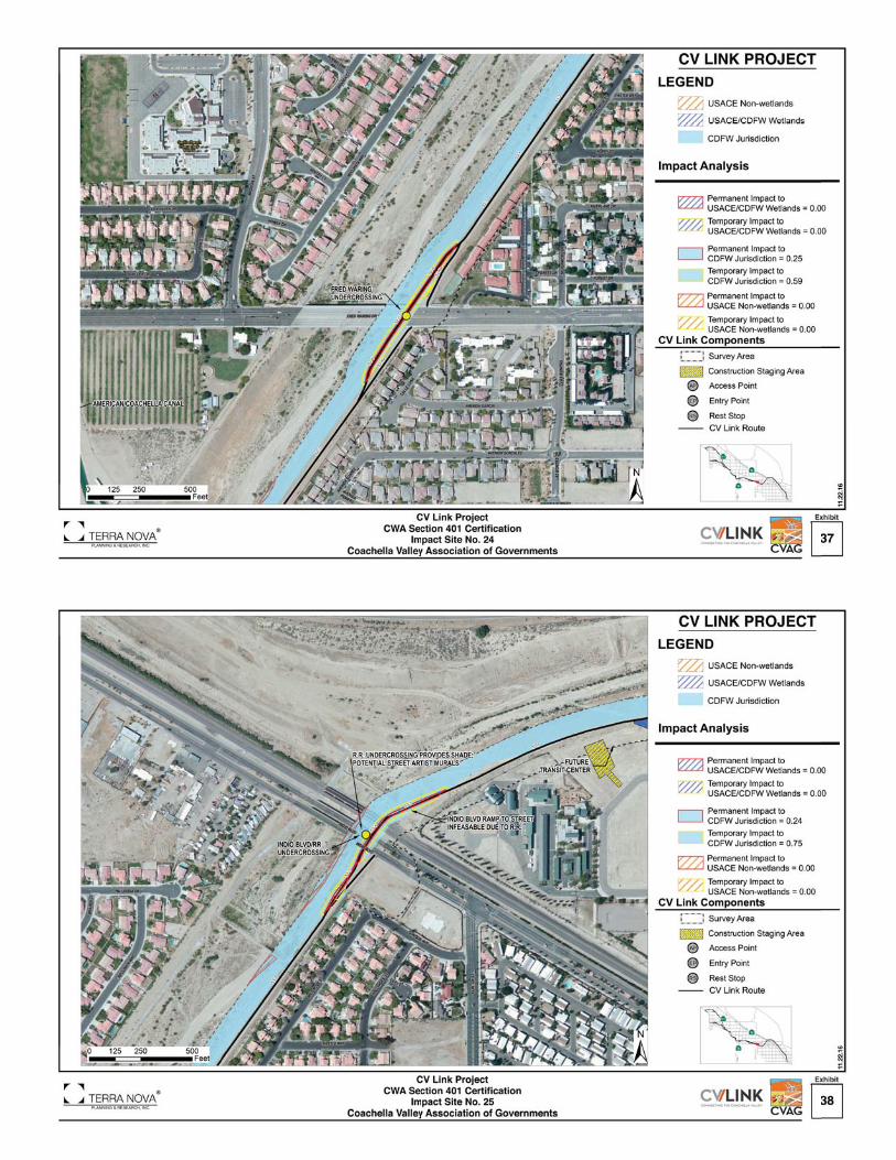
☐ RWCB Site 20 (Exhibit 33)
Whitewater Non-wetland Salton Sea Watershed
Salton Sea Municipal & Domestic Supply; Agricultural Supply; Groundwater Recharge; Water Contact and Non-contact Water Recreation; Cold Freshwater and Wildlife Habitat
NA. However, urban runoff with certain levels of pathogens (bacteria, protozoa, viruses), Sediment, trash, fertilizers (nutrients, compounds of nitrogen and phosphorus), pesticides (DDT, chlordane, diazinon, chlorpyrifos), heavy metals (cadmium, chromium, copper, lead, zinc), and petroleum products (oil, grease, petroleum hydrocarbons, polycyclic aromatic hydrocarbons) may enter into the Whitewater River.**
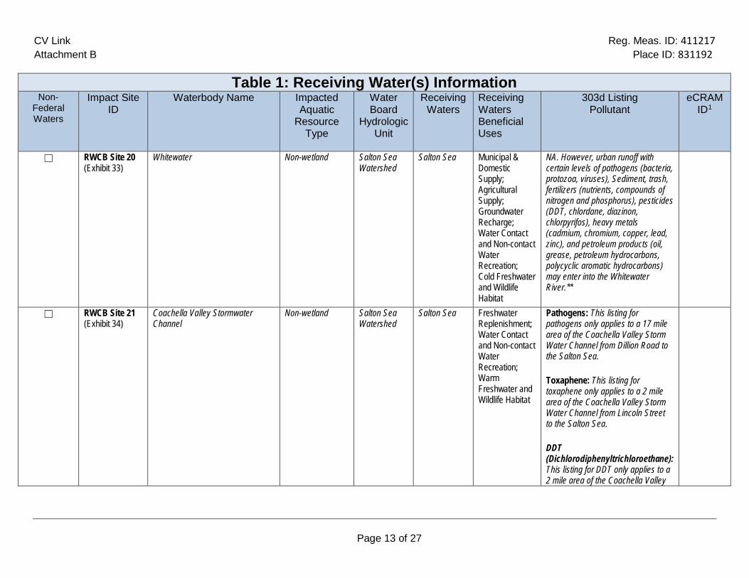
☐ RWCB Site 21 (Exhibit 34)
Coachella Valley Stormwater Channel
Non-wetland Salton Sea Watershed
Salton Sea Freshwater Replenishment; Water Contact and Non-contact Water Recreation; Warm Freshwater and Wildlife Habitat
Pathogens: This listing for pathogens only applies to a 17 mile area of the Coachella Valley Storm Water Channel from Dillion Road to the Salton Sea.
Toxaphene: This listing for toxaphene only applies to a 2 mile area of the Coachella Valley Storm Water Channel from Lincoln Street to the Salton Sea.
DDT (Dichlorodiphenyltrichloroethane): This listing for DDT only applies to a 2 mile area of the Coachella Valley

CV Link Reg. Meas. ID: 411217 Attachment B Place ID: 831192
Page 14 of 27
Table 1: Receiving Water(s) Information Non-
Federal Waters
Impact Site ID
Waterbody Name Impacted Aquatic
Resource Type
Water Board
Hydrologic Unit
Receiving Waters
Receiving Waters Beneficial Uses
303d Listing Pollutant
eCRAM ID1
Storm Water Channel from Lincoln Street to the Salton Sea.
Dieldrin: This listing for Dieldrin only applies to a 2 mile area of the Coachella Valley Storm Water Channel from Lincoln Street to the Salton Sea.
PCBs (Polychlorinated biphenyls): This listing for PCBs only applies to a 2 mile area of the Coachella Valley Storm Water Channel from Lincoln Street to the Salton Sea.***
☐ RWCB Site 22 (Exhibit 35)
Coachella Valley Stormwater Channel
Wetland/ Non-wetland
Salton Sea Watershed
Salton Sea Freshwater Replenishment; Water Contact and Non-contact Water Recreation; Warm Freshwater and Wildlife Habitat
Pathogens: This listing for pathogens only applies to a 17 mile area of the Coachella Valley Storm Water Channel from Dillion Road to the Salton Sea.
Toxaphene: This listing for toxaphene only applies to a 2 mile area of the Coachella Valley Storm Water Channel from Lincoln Street to the Salton Sea.
DDT (Dichlorodiphenyltrichloroethane): This listing for DDT only applies to a 2 mile area of the Coachella Valley

CV Link Reg. Meas. ID: 411217 Attachment B Place ID: 831192
Page 15 of 27
Table 1: Receiving Water(s) Information Non-
Federal Waters
Impact Site ID
Waterbody Name Impacted Aquatic
Resource Type
Water Board
Hydrologic Unit
Receiving Waters
Receiving Waters Beneficial Uses
303d Listing Pollutant
eCRAM ID1
Storm Water Channel from Lincoln Street to the Salton Sea.
Dieldrin: This listing for Dieldrin only applies to a 2 mile area of the Coachella Valley Storm Water Channel from Lincoln Street to the Salton Sea.
PCBs (Polychlorinated biphenyls): This listing for PCBs only applies to a 2 mile area of the Coachella Valley Storm Water Channel from Lincoln Street to the Salton Sea.***
☐ RWCB Site 23 (Exhibit 36)
Coachella Valley Stormwater Channel
Wetland/ Non-wetland
Salton Sea Watershed
Salton Sea Freshwater Replenishment; Water Contact and Non-contact Water Recreation; Warm Freshwater and Wildlife Habitat
Pathogens: This listing for pathogens only applies to a 17 mile area of the Coachella Valley Storm Water Channel from Dillion Road to the Salton Sea.
Toxaphene: This listing for toxaphene only applies to a 2 mile area of the Coachella Valley Storm Water Channel from Lincoln Street to the Salton Sea.
DDT (Dichlorodiphenyltrichloroethane): This listing for DDT only applies to a 2 mile area of the Coachella Valley

CV Link Reg. Meas. ID: 411217 Attachment B Place ID: 831192
Page 16 of 27
Table 1: Receiving Water(s) Information Non-
Federal Waters
Impact Site ID
Waterbody Name Impacted Aquatic
Resource Type
Water Board
Hydrologic Unit
Receiving Waters
Receiving Waters Beneficial Uses
303d Listing Pollutant
eCRAM ID1
Storm Water Channel from Lincoln Street to the Salton Sea.
Dieldrin: This listing for Dieldrin only applies to a 2 mile area of the Coachella Valley Storm Water Channel from Lincoln Street to the Salton Sea.
PCBs (Polychlorinated biphenyls): This listing for PCBs only applies to a 2 mile area of the Coachella Valley Storm Water Channel from Lincoln Street to the Salton Sea.***
☐ RWCB Site 24 (Exhibit 37)
Coachella Valley Stormwater Channel
Non-wetland Salton Sea Watershed
Salton Sea Freshwater Replenishment; Water Contact and Non-contact Water Recreation; Warm Freshwater and Wildlife Habitat
Pathogens: This listing for pathogens only applies to a 17 mile area of the Coachella Valley Storm Water Channel from Dillion Road to the Salton Sea.
Toxaphene: This listing for toxaphene only applies to a 2 mile area of the Coachella Valley Storm Water Channel from Lincoln Street to the Salton Sea.
DDT (Dichlorodiphenyltrichloroethane): This listing for DDT only applies to a 2 mile area of the Coachella Valley

CV Link Reg. Meas. ID: 411217 Attachment B Place ID: 831192
Page 17 of 27
Table 1: Receiving Water(s) Information Non-
Federal Waters
Impact Site ID
Waterbody Name Impacted Aquatic
Resource Type
Water Board
Hydrologic Unit
Receiving Waters
Receiving Waters Beneficial Uses
303d Listing Pollutant
eCRAM ID1
Storm Water Channel from Lincoln Street to the Salton Sea.
Dieldrin: This listing for Dieldrin only applies to a 2 mile area of the Coachella Valley Storm Water Channel from Lincoln Street to the Salton Sea.
PCBs (Polychlorinated biphenyls): This listing for PCBs only applies to a 2 mile area of the Coachella Valley Storm Water Channel from Lincoln Street to the Salton Sea.***
☐ RWCB Site 25 (Exhibit 38)
Coachella Valley Stormwater Channel
Non-wetland Salton Sea Watershed
Salton Sea Freshwater Replenishment; Water Contact and Non-contact Water Recreation; Warm Freshwater and Wildlife Habitat
Pathogens: This listing for pathogens only applies to a 17 mile area of the Coachella Valley Storm Water Channel from Dillion Road to the Salton Sea.
Toxaphene: This listing for toxaphene only applies to a 2 mile area of the Coachella Valley Storm Water Channel from Lincoln Street to the Salton Sea.
DDT (Dichlorodiphenyltrichloroethane): This listing for DDT only applies to a 2 mile area of the Coachella Valley

CV Link Reg. Meas. ID: 411217 Attachment B Place ID: 831192
Page 18 of 27
Table 1: Receiving Water(s) Information Non-
Federal Waters
Impact Site ID
Waterbody Name Impacted Aquatic
Resource Type
Water Board
Hydrologic Unit
Receiving Waters
Receiving Waters Beneficial Uses
303d Listing Pollutant
eCRAM ID1
Storm Water Channel from Lincoln Street to the Salton Sea.
Dieldrin: This listing for Dieldrin only applies to a 2 mile area of the Coachella Valley Storm Water Channel from Lincoln Street to the Salton Sea.
PCBs (Polychlorinated biphenyls): This listing for PCBs only applies to a 2 mile area of the Coachella Valley Storm Water Channel from Lincoln Street to the Salton Sea.***
☐ RWCB Site 26 (Exhibit 39)
Coachella Valley Stormwater Channel
Non-wetland Salton Sea Watershed
Salton Sea Freshwater Replenishment; Water Contact and Non-contact Water Recreation; Warm Freshwater and Wildlife Habitat
Pathogens: This listing for pathogens only applies to a 17 mile area of the Coachella Valley Storm Water Channel from Dillion Road to the Salton Sea.
Toxaphene: This listing for toxaphene only applies to a 2 mile area of the Coachella Valley Storm Water Channel from Lincoln Street to the Salton Sea.
DDT (Dichlorodiphenyltrichloroethane): This listing for DDT only applies to a 2 mile area of the Coachella Valley

CV Link Reg. Meas. ID: 411217 Attachment B Place ID: 831192
Page 19 of 27
Table 1: Receiving Water(s) Information Non-
Federal Waters
Impact Site ID
Waterbody Name Impacted Aquatic
Resource Type
Water Board
Hydrologic Unit
Receiving Waters
Receiving Waters Beneficial Uses
303d Listing Pollutant
eCRAM ID1
Storm Water Channel from Lincoln Street to the Salton Sea.
Dieldrin: This listing for Dieldrin only applies to a 2 mile area of the Coachella Valley Storm Water Channel from Lincoln Street to the Salton Sea.
PCBs (Polychlorinated biphenyls): This listing for PCBs only applies to a 2 mile area of the Coachella Valley Storm Water Channel from Lincoln Street to the Salton Sea.***
☐ RWCB Site 27 (Exhibit 40)
Coachella Valley Stormwater Channel
Non-wetland Salton Sea Watershed
Salton Sea Freshwater Replenishment; Water Contact and Non-contact Water Recreation; Warm Freshwater and Wildlife Habitat
Pathogens: This listing for pathogens only applies to a 17 mile area of the Coachella Valley Storm Water Channel from Dillion Road to the Salton Sea.
Toxaphene: This listing for toxaphene only applies to a 2 mile area of the Coachella Valley Storm Water Channel from Lincoln Street to the Salton Sea.
DDT (Dichlorodiphenyltrichloroethane): This listing for DDT only applies to a 2 mile area of the Coachella Valley

CV Link Reg. Meas. ID: 411217 Attachment B Place ID: 831192
Page 20 of 27
Table 1: Receiving Water(s) Information Non-
Federal Waters
Impact Site ID
Waterbody Name Impacted Aquatic
Resource Type
Water Board
Hydrologic Unit
Receiving Waters
Receiving Waters Beneficial Uses
303d Listing Pollutant
eCRAM ID1
Storm Water Channel from Lincoln Street to the Salton Sea.
Dieldrin: This listing for Dieldrin only applies to a 2 mile area of the Coachella Valley Storm Water Channel from Lincoln Street to the Salton Sea.
PCBs (Polychlorinated biphenyls): This listing for PCBs only applies to a 2 mile area of the Coachella Valley Storm Water Channel from Lincoln Street to the Salton Sea.***
☐ RWCB Site 28 (Exhibit 41)
Coachella Valley Stormwater Channel
Non-wetland Salton Sea Watershed
Salton Sea Freshwater Replenishment; Water Contact and Non-contact Water Recreation; Warm Freshwater and Wildlife Habitat
Pathogens: This listing for pathogens only applies to a 17 mile area of the Coachella Valley Storm Water Channel from Dillion Road to the Salton Sea.
Toxaphene: This listing for toxaphene only applies to a 2 mile area of the Coachella Valley Storm Water Channel from Lincoln Street to the Salton Sea.
DDT (Dichlorodiphenyltrichloroethane): This listing for DDT only applies to a 2 mile area of the Coachella Valley

CV Link Reg. Meas. ID: 411217 Attachment B Place ID: 831192
Page 21 of 27
Table 1: Receiving Water(s) Information Non-
Federal Waters
Impact Site ID
Waterbody Name Impacted Aquatic
Resource Type
Water Board
Hydrologic Unit
Receiving Waters
Receiving Waters Beneficial Uses
303d Listing Pollutant
eCRAM ID1
Storm Water Channel from Lincoln Street to the Salton Sea.
Dieldrin: This listing for Dieldrin only applies to a 2 mile area of the Coachella Valley Storm Water Channel from Lincoln Street to the Salton Sea.
PCBs (Polychlorinated biphenyls): This listing for PCBs only applies to a 2 mile area of the Coachella Valley Storm Water Channel from Lincoln Street to the Salton Sea.***
☐ RWCB Site 29 (Exhibit 42)
Coachella Valley Stormwater Channel
Non-wetland Salton Sea Watershed
Salton Sea Freshwater Replenishment; Water Contact and Non-contact Water Recreation; Warm Freshwater and Wildlife Habitat
Pathogens: This listing for pathogens only applies to a 17 mile area of the Coachella Valley Storm Water Channel from Dillion Road to the Salton Sea.
Toxaphene: This listing for toxaphene only applies to a 2 mile area of the Coachella Valley Storm Water Channel from Lincoln Street to the Salton Sea.
DDT (Dichlorodiphenyltrichloroethane): This listing for DDT only applies to a 2 mile area of the Coachella Valley

CV Link Reg. Meas. ID: 411217 Attachment B Place ID: 831192
Page 22 of 27
Table 1: Receiving Water(s) Information Non-
Federal Waters
Impact Site ID
Waterbody Name Impacted Aquatic
Resource Type
Water Board
Hydrologic Unit
Receiving Waters
Receiving Waters Beneficial Uses
303d Listing Pollutant
eCRAM ID1
Storm Water Channel from Lincoln Street to the Salton Sea.
Dieldrin: This listing for Dieldrin only applies to a 2 mile area of the Coachella Valley Storm Water Channel from Lincoln Street to the Salton Sea.
PCBs (Polychlorinated biphenyls): This listing for PCBs only applies to a 2 mile area of the Coachella Valley Storm Water Channel from Lincoln Street to the Salton Sea.***
☐ RWCB Site 30 (Exhibit 43)
Coachella Valley Stormwater Channel
Non-wetland Salton Sea Watershed
Salton Sea Freshwater Replenishment; Water Contact and Non-contact Water Recreation; Warm Freshwater and Wildlife Habitat
Pathogens: This listing for pathogens only applies to a 17 mile area of the Coachella Valley Storm Water Channel from Dillion Road to the Salton Sea.
Toxaphene: This listing for toxaphene only applies to a 2 mile area of the Coachella Valley Storm Water Channel from Lincoln Street to the Salton Sea.
DDT (Dichlorodiphenyltrichloroethane): This listing for DDT only applies to a 2 mile area of the Coachella Valley

CV Link Reg. Meas. ID: 411217 Attachment B Place ID: 831192
Page 23 of 27
Table 1: Receiving Water(s) Information Non-
Federal Waters
Impact Site ID
Waterbody Name Impacted Aquatic
Resource Type
Water Board
Hydrologic Unit
Receiving Waters
Receiving Waters Beneficial Uses
303d Listing Pollutant
eCRAM ID1
Storm Water Channel from Lincoln Street to the Salton Sea.
Dieldrin: This listing for Dieldrin only applies to a 2 mile area of the Coachella Valley Storm Water Channel from Lincoln Street to the Salton Sea.
PCBs (Polychlorinated biphenyls): This listing for PCBs only applies to a 2 mile area of the Coachella Valley Storm Water Channel from Lincoln Street to the Salton Sea.***
☐ RWCB Site 31 (Exhibit 44)
Coachella Valley Stormwater Channel
Non-wetland Salton Sea Watershed
Salton Sea Freshwater Replenishment; Water Contact and Non-contact Water Recreation; Warm Freshwater and Wildlife Habitat
Pathogens: This listing for pathogens only applies to a 17 mile area of the Coachella Valley Storm Water Channel from Dillion Road to the Salton Sea.
Toxaphene: This listing for toxaphene only applies to a 2 mile area of the Coachella Valley Storm Water Channel from Lincoln Street to the Salton Sea.
DDT (Dichlorodiphenyltrichloroethane): This listing for DDT only applies to a 2 mile area of the Coachella Valley

CV Link Reg. Meas. ID: 411217 Attachment B Place ID: 831192
Page 24 of 27
Table 1: Receiving Water(s) Information Non-
Federal Waters
Impact Site ID
Waterbody Name Impacted Aquatic
Resource Type
Water Board
Hydrologic Unit
Receiving Waters
Receiving Waters Beneficial Uses
303d Listing Pollutant
eCRAM ID1
Storm Water Channel from Lincoln Street to the Salton Sea.
Dieldrin: This listing for Dieldrin only applies to a 2 mile area of the Coachella Valley Storm Water Channel from Lincoln Street to the Salton Sea.
PCBs (Polychlorinated biphenyls): This listing for PCBs only applies to a 2 mile area of the Coachella Valley Storm Water Channel from Lincoln Street to the Salton Sea.***

CV Link Reg. Meas. ID: 411217 Attachment B Place ID: 831192
Page 25 of 27
Individual Direct Impact Locations Affecting Waters of the US2 The following table shows individual impact locations. Table 2: Individual Direct Impact Information
Impact Site ID
Latitude
Longitude Indirect Impact
Requiring Compensatory
Mitigation
Direct Impact
Duration
Dredge* Fill/Excavation*
Yes No Acres Cubic Yards
Linear Feet
Acres Cubic Yards
Linear Feet
1 RWCB Site 1 (Exhibit 14) (Non-Wetland)
33.860118° -116.515907° ☐ ☒
Temporary 1.40 721.5 1,480 1.40 721.5 1,480
Permanent 0.39 1,443 1,395 0.39 1,443 1,395
2 RWCB Site 2 (Exhibit 15) (Non-Wetland)
33.850138° -116.506012° ☐ ☐
Temporary 0 0 0 0 0 0 Permanent 0 0 0 0 0 0
3 RWCB Site 3 (Exhibit 16) (Non-Wetland)
33.843905° -116.499915° ☐ ☐ Temporary 0.04 18.5 800 0.04 18.5 800
Permanent 0.01 37 45 0.01 37 45 4 RWCB Site 4 (Exhibit 17) (Non-
Wetland) 33.815921° -116.479861°
☐ ☐ Temporary 0.003 3.7 20 0.003 3.7 20 Permanent 0.002 7.4 14 0.002 7.4 14
5 RWCB Site 5 (Exhibit 18) (Non-Wetland)
33.801193° -116.475177° ☐ ☐ Temporary 0.15 111 550 0.15 111 550
Permanent 0.06 222 40 0.06 222 40 6 RWCB Site 6 (Exhibit 19) (Non-
Wetland) 33.809585° -116.510784°
☐ ☐ Temporary 0 0 0 0 0 0 Permanent 0 0 0 0 0 0
7 RWCB Site 7 (Exhibit 20) (Non-Wetland)
33.810480° -116.528442° ☐ ☐ Temporary 0.20 315 560 0.20 315 560
Permanent 0.17 629 550 0.17 629 550 8 RWCB Site 8 (Exhibit 21) (Non-
Wetland) 33.794423° -116.473558°
☐ ☐ Temporary 0.69 666 1,540 0.69 666 1,540 Permanent 0.36 1332 1170 0.36 1332 1170
9 RWCB Site 9 (Exhibit 22) (Non-Wetland)
33.791201° -116.468500° ☐ ☐ Temporary 0.17 148 360 0.17 148 360
Permanent 0.08 296 200 0.08 296 200 10 RWCB Site 10 (Exhibit 23) (Non-
Wetland) 33.780076° -116.455888°
☐ ☐ Temporary 0.19 111 100 0.19 111 100 Permanent 0.06 222 24 0.06 222 24
11 RWCB Site 11 (Exhibit 24) (Non-Wetland)
33.772788° -116.443186° ☐ ☐ Temporary 0.83 740 1,420 0.83 740 1,420
Permanent 0.40 1,480 1400 0.40 1,480 1400 33.768257° -116.435801° ☐ ☐ Temporary 0.16 166 240 0.16 166 240
2 Table includes sites with impacts only to Waters of the State (wetland and non-wetlands) and is shown as having zero (0) impacts. For impacts to State Waters see impact site exhibits.
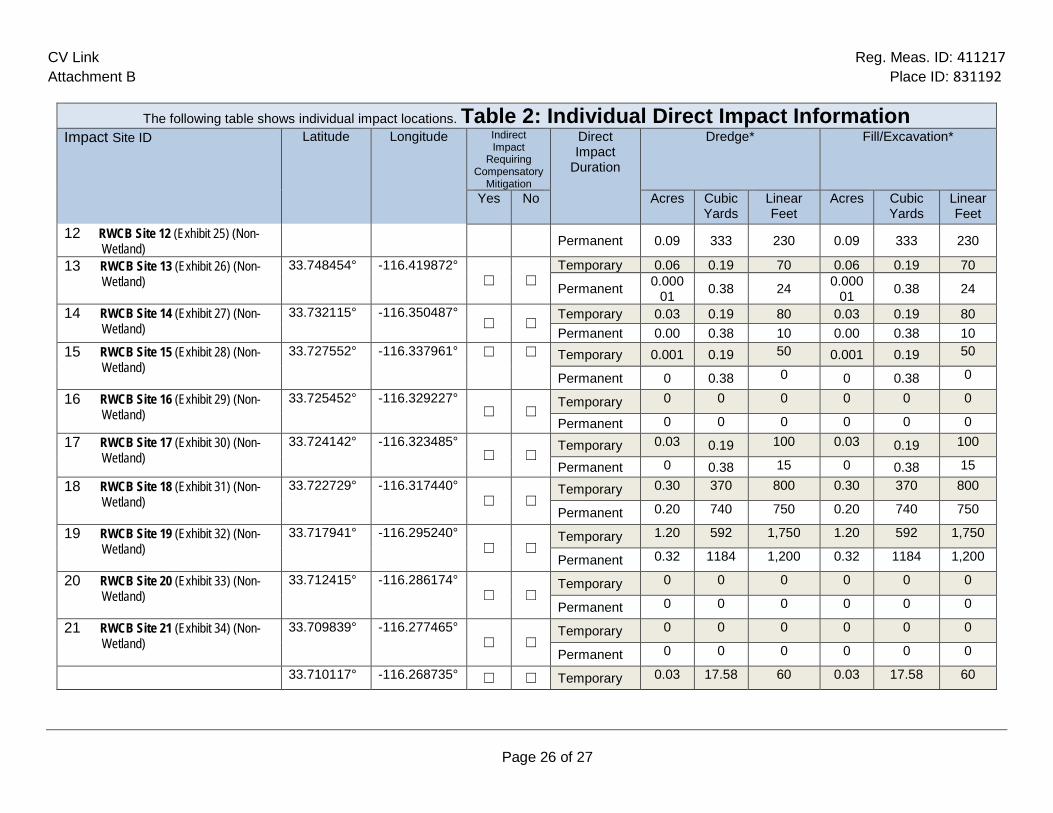
CV Link Reg. Meas. ID: 411217 Attachment B Place ID: 831192
Page 26 of 27
The following table shows individual impact locations. Table 2: Individual Direct Impact Information Impact Site ID
Latitude
Longitude Indirect
Impact Requiring
Compensatory Mitigation
Direct Impact
Duration
Dredge* Fill/Excavation*
Yes No Acres Cubic Yards
Linear Feet
Acres Cubic Yards
Linear Feet
12 RWCB Site 12 (Exhibit 25) (Non-Wetland) Permanent 0.09 333 230 0.09 333 230
13 RWCB Site 13 (Exhibit 26) (Non-Wetland)
33.748454° -116.419872° ☐ ☐
Temporary 0.06 0.19 70 0.06 0.19 70
Permanent 0.00001 0.38 24 0.000
01 0.38 24
14 RWCB Site 14 (Exhibit 27) (Non-Wetland)
33.732115° -116.350487° ☐ ☐
Temporary 0.03 0.19 80 0.03 0.19 80 Permanent 0.00 0.38 10 0.00 0.38 10
15 RWCB Site 15 (Exhibit 28) (Non-Wetland)
33.727552° -116.337961° ☐ ☐ Temporary 0.001 0.19 50 0.001 0.19 50
Permanent 0 0.38 0 0 0.38 0
16 RWCB Site 16 (Exhibit 29) (Non-Wetland)
33.725452° -116.329227° ☐ ☐
Temporary 0 0 0 0 0 0
Permanent 0 0 0 0 0 0 17 RWCB Site 17 (Exhibit 30) (Non-
Wetland) 33.724142° -116.323485°
☐ ☐ Temporary 0.03 0.19 100 0.03 0.19 100
Permanent 0 0.38 15 0 0.38 15 18 RWCB Site 18 (Exhibit 31) (Non-
Wetland) 33.722729° -116.317440°
☐ ☐ Temporary 0.30 370 800 0.30 370 800
Permanent 0.20 740 750 0.20 740 750
19 RWCB Site 19 (Exhibit 32) (Non-Wetland)
33.717941° -116.295240° ☐ ☐
Temporary 1.20 592 1,750 1.20 592 1,750
Permanent 0.32 1184 1,200 0.32 1184 1,200
20 RWCB Site 20 (Exhibit 33) (Non-Wetland)
33.712415° -116.286174° ☐ ☐
Temporary 0 0 0 0 0 0
Permanent 0 0 0 0 0 0
21 RWCB Site 21 (Exhibit 34) (Non-Wetland)
33.709839° -116.277465° ☐ ☐
Temporary 0 0 0 0 0 0
Permanent 0 0 0 0 0 0
33.710117° -116.268735° ☐ ☐ Temporary 0.03 17.58 60 0.03 17.58 60

CV Link Reg. Meas. ID: 411217 Attachment B Place ID: 831192
Page 27 of 27
The following table shows individual impact locations. Table 2: Individual Direct Impact Information Impact Site ID
Latitude
Longitude Indirect
Impact Requiring
Compensatory Mitigation
Direct Impact
Duration
Dredge* Fill/Excavation*
Yes No Acres Cubic Yards
Linear Feet
Acres Cubic Yards
Linear Feet
22 RWCB Site 22 A3 (Exhibit 35) (Non-Wetland) Permanent 0.000 35.16 20 0.000 35.16 20
22 RWCB Site 22 B4 (Exhibit 35) (Wetland)
33.710117° -116.268735° ☐ ☐ Temporary 0.015 25.9 50 0.015 25.9 50
☐ ☐ Permanent 0.008 51.8 20 0.008 51.8 20
23 RWCB Site 23 A (Exhibit 36) (Non-Wetland)
33.722079° -116.255515° ☐ ☐
Temporary 0.004 45.7 45 0.004 45.7 45
Permanent 0.003 91.4 25 0.003 91.4 25
23 RWCB Site 23 B (Exhibit 36) (Wetland)
33.722079° -116.255515° ☐ ☐ Temporary 0.04 38.85 75 0.04 38.85 75
Permanent 0.021 77.7 25 0.021 77.7 25
24 RWCB Site 24 (Exhibit 37) (Non-Wetland)
33.729305° -116.249177° ☐ ☐
Temporary 0 0 0 0 0 0
Permanent 0 0 0 0 0 0
25 RWCB Site 25 (Exhibit 38) (Non-Wetland)
33.735220° -116.244391° ☐ ☐
Temporary 0 0 0 0 0 0
Permanent 0 0 0 0 0 0
26 RWCB Site 26 (Exhibit 39) (Non-Wetland)
33.735363° -116.216449° ☐ ☐
Temporary 0 18.5 0 0 18.5 0
Permanent 0 37 0 0 37 0
27 RWCB Site 27 (Exhibit 40) (Non-Wetland)
33.729456° -116.209195° ☐ ☐
Temporary 0.35 351.5 700 0.35 351.5 700
Permanent 0.19 703 630 0.19 703 630
28 RWCB Site 28 (Exhibit 41) (Non-Wetland)
33.724441° -116.203787° ☐ ☐
Temporary 0 0 0 0 0 0
Permanent 0 0 0 0 0 0
33.685850° -116.166479° ☐ ☐ Temporary 0 0 0 0 0 0
3 Sites 22A and 23A show the impacts to the non-wetlands. 4 Sites 22B and 23B show the impacts to the wetlands.

CV Link Reg. Meas. ID: 411217 Attachment B Place ID: 831192
Page 28 of 27
The following table shows individual impact locations. Table 2: Individual Direct Impact Information Impact Site ID
Latitude
Longitude Indirect
Impact Requiring
Compensatory Mitigation
Direct Impact
Duration
Dredge* Fill/Excavation*
Yes No Acres Cubic Yards
Linear Feet
Acres Cubic Yards
Linear Feet
29 RWCB Site 29 (Exhibit 42) (Non-Wetland) Permanent 0 0 0 0 0 0
30 RWCB Site 30 (Exhibit 43) (Non-Wetland)
33.672281° -116.149794° ☐ ☐
Temporary 0 0 0 0 0 0
Permanent 0 0 0 0 0 0
31 RWCB Site 31 (Exhibit 44) (Non-Wetland)
33.642144° -116.137778° ☐ ☐
Temporary 0 0 0 0 0 0
Permanent 0 0 0 0 0 0
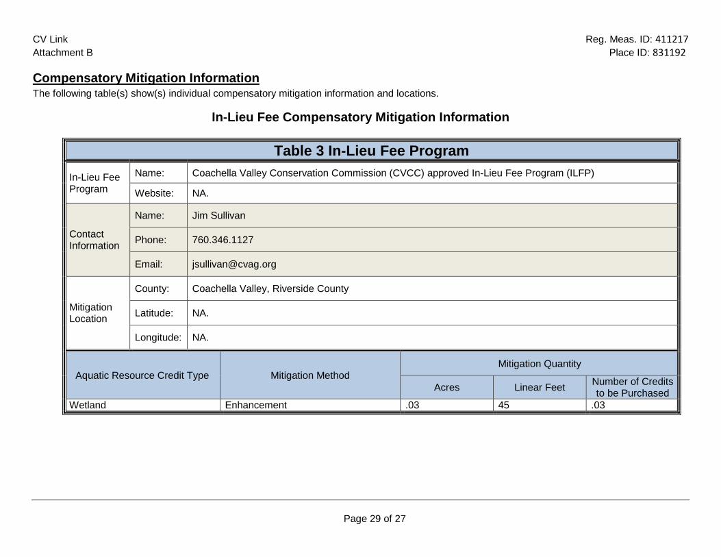
CV Link Reg. Meas. ID: 411217 Attachment B Place ID: 831192
Page 29 of 27
Compensatory Mitigation Information The following table(s) show(s) individual compensatory mitigation information and locations.
In-Lieu Fee Compensatory Mitigation Information
Table 3 In-Lieu Fee Program
In-Lieu Fee Program
Name: Coachella Valley Conservation Commission (CVCC) approved In-Lieu Fee Program (ILFP)
Website: NA.
Contact Information
Name: Jim Sullivan
Phone: 760.346.1127
Email: [email protected]
Mitigation Location
County: Coachella Valley, Riverside County
Latitude: NA.
Longitude: NA.
Aquatic Resource Credit Type Mitigation Method Mitigation Quantity
Acres Linear Feet Number of Credits to be Purchased
Wetland Enhancement .03 45 .03

Attachment C CEQA Findings of Facts

(This page intentionally left blank.)

CV Link Reg. Meas. ID: 411217 Attachment C Place ID: 831192
Page 1 of 3
Click here to enter text.
A. Environmental Review
On May 15, 2017, the Coachella Valley Association of Government (CVAG), as lead agency, certified an environmental impact report (EIR) (State Clearinghouse (SCH) No. 2013111050) for the Project and files a Notice of Determination (NOD) at SCH on May 16, 2017. The Colorado River Basin Water Board is a responsible agency under CEQA (Pub. Resources Code, § 21069) and in making its determinations and findings, must presume that CVAGCVAG’s certified environmental document comports with the requirements of CEQA and is valid. (Pub. Resources Code, § 21167.3.) The Colorado River Basin Water Board has reviewed and considered the environmental document and finds that the environmental document prepared by CVAGCVAG addresses the Project’s water resource impacts. (Cal. Code Regs., tit. 14, § 15096, subd. (f).) The environmental document includes the mitigation monitoring and reporting program (MMRP) developed by CVAGCVAG for all mitigation measures that have been adopted for the Project to reduce potential significant impacts. (Pub. Resources Code, § 21081.6, subd. (a)(1); Cal. Code Regs., tit. 14, § 15091, subd. (d).)
B. Determination The Colorado River Basin Water Board has determined that the Project, when implemented in accordance with the MMRP and the conditions in this Order, will not result in any significant adverse water quality or supply impacts. (Cal. Code Regs., tit. 14, § 15096, subd. (h).)

CV Link Reg. Meas. ID: 411217 Attachment C Place ID: 831192
Page 2 of 3

CV Link Reg. Meas. ID: 411217 Attachment C Place ID: 831192
Page 3 of 3

Attachment D Signatory Requirements

(This page intentionally left blank)

CV Link Reg. Meas. ID: 411217 Attachment D Place ID: 831192
Page 1 of 1
SIGNATORY REQUIREMENTS
All Documents Submitted In Compliance With This Order Shall Meet The Following Signatory Requirements:
1. All applications, reports, or information submitted to the Choose an item. must be signed
and certified as follows: a) For a corporation, by a responsible corporate officer of at least the level of
vice-president. b) For a partnership or sole proprietorship, by a general partner or proprietor,
respectively. c) For a municipality, or a state, federal, or other public agency, by either a
principal executive officer or ranking elected official.
2. A duly authorized representative of a person designated in items 1.a through 1.c above may sign documents if: a) The authorization is made in writing by a person described in items 1.a
through 1.c above. b) The authorization specifies either an individual or position having
responsibility for the overall operation of the regulated activity. c) The written authorization is submitted to the State Water Board Staff Contact prior to
submitting any documents listed in item 1 above.
3. Any person signing a document under this section shall make the following certification: “I certify under penalty of law that I have personally examined and am familiar with the information submitted in this document and all attachments and that, based on my inquiry of those individuals immediately responsible for obtaining the information, I believe that the information is true, accurate, and complete. I am aware that there are significant penalties for submitting false information, including the possibility of fine and imprisonment.”

Attachment E Report and Notification Requirements

(This page intentionally left blank)

CV Link WDID 7A333165001 Reg. Meas. ID: 411217 Attachment E Place ID: 831192
Page 1 of 11
Copies of this Form In order to identify your project, it is necessary to include a copy of the Project specific Cover Sheet below with your report: please retain for your recordsIf you need to obtain a copy of the Cover Sheet you may download a copy of this Order as follows: 1. Go to: http://www.waterboards.ca.gov/water_issues/programs/cwa401/certifications.shtml
2. Find your Order in the table based on Applicant, Date, and Subject headers.
Report Submittal Instructions 1. Check the box on the Report and Notification Cover Sheet next to the report or notification you are
submitting. • Part A (Annual Report): This report will be submitted annually from the anniversary of Project
effective date until a Notice of Project Complete Letter is issued.
• Part B (Project Status Notifications): Used to notify the Colorado River Basin Water Board of the status of the Project schedule that may affect Project billing.
• Part C (Conditional Notifications and Reports): Required on a case by case basis for accidental discharges of hazardous materials, violation of compliance with water quality standards, notification of in-water work, or other reports.
2. Sign the Report and Notification Cover Sheet and attach all information requested for the Report Type.
3. Electronic Report Submittal Instructions: • Submit signed Report and Notification Cover Sheet and required information via email to: RB7-
[email protected] and cc: [email protected] • Include in the subject line of the email:
Subject: ATTN: Kai Dunn; Reg. Measure ID: 411217_Report
Definition of Reporting Terms
1. Active Discharge Period: The active discharge period begins with the effective date of this Order and ends on the date that the Permittee receives a Notice of Completion of Discharges Letter or, if no post-construction monitoring is required, a Notice of Project Complete Letter. The Active Discharge Period includes all elements of the Project including site construction and restoration, and any Permittee responsible compensatory mitigation construction.
2. Request for Notice of Completion of Discharges Letter: This request by the Permittee to the
Colorado River Basin Water Board staff pertains to projects that have post construction monitoring requirements, e.g. if site restoration was required to be monitored for 5 years following construction. Colorado River Basin Water Board staff will review the request and send a Completion of Discharges Letter to the Permittee upon approval. This letter will initiate the post-discharge monitoring period and a change in fees from the annual active discharge fee to the annual post-discharge monitoring fee.

CV Link WDID 7A333165001 Reg. Meas. ID: 411217 Attachment E Place ID: 831192
Page 2 of 11
3. Request for Notice of Project Complete Letter: This request by the Permittee to the Colorado River
Basin Water Board staff pertains to projects that either have completed post-construction monitoring and achieved performance standards or have no post-construction monitoring requirements, and no further Project activities are planned. Colorado River Basin Water Board staff will review the request and send a Project Complete Letter to the Permittee upon approval. Termination of annual invoicing of fees will correspond with the date of this letter.
4. Post-Discharge Monitoring Period: The post-discharge monitoring period begins on the date of the Notice of Completion of Discharges Letter and ends on the date of the Notice of Project Complete Letter issued by the Colorado River Basin Water Board staff. The Post-Discharge Monitoring Period includes continued water quality monitoring or compensatory mitigation monitoring.
5. Effective Date: Date of Order issuance.
Map/Photo Documentation Information
When submitting maps or photos, please use the following formats. 1. Map Format Information:
Preferred map formats of at least 1:24000 (1” = 2000’) detail (listed in order of preference): • GIS shapefiles: The shapefiles must depict the boundaries of all project areas and extent of
aquatic resources impacted. Each shape should be attributed with the extent/type of aquatic resources impacted. Features and boundaries should be accurate to within 33 feet (10 meters). Identify datum/projection used and if possible, provide map with a North American Datum of 1983 (NAD38) in the California Teale Albers projection in feet.
• Google KML files saved from Google Maps: My Maps or Google Earth Pro. Maps must show the boundaries of all project areas and extent/type of aquatic resources impacted. Include URL(s) of maps. If this format is used include a spreadsheet with the object ID and attributed with the extent/type of aquatic resources impacted.
• Other electronic format (CAD or illustration format) that provides a context for location (inclusion of landmarks, known structures, geographic coordinates, or USGS DRG or DOQQ). Maps must show the boundaries of all project areas and extent/type of aquatic resources impacted. If this format is used include a spreadsheet with the object ID and attributed with the extent/type of aquatic resources impacted.
• Aquatic resource maps marked on paper USGS 7.5 minute topographic maps or Digital Orthophoto Quarter Quads (DOQQ) printouts. Maps must show the boundaries of all project areas and extent/type of aquatic resources impacted. If this format is used include a spreadsheet with the object ID and attributed with the extent/type of aquatic resources impacted.
2. Photo-Documentation: Include a unique identifier, date stamp, written description of photo details, and latitude/longitude (in decimal degrees) or map indicating location of photo. Successive photos should be taken from the same vantage point to compare pre/post construction conditions.

CV Link WDID 7A333165001 Reg. Meas. ID 411217 Attachment E Place ID: 831192
Page 3 of 11
REPORT AND NOTIFICATION COVER SHEET
Project: CV Link Permittee: CVAG Reg. Meas. ID: Click here to enter text Place ID: Click here to enter text Order Effective Date: Click here to enter a date
Report Type Submitted Part A – Project Reporting
Report Type 1 ☐ Monthly Report Report Type 2 ☐ Annual Report
Part B - Project Status Notifications
Report Type 3 ☐ Commencement of Construction Report Type 4 ☐ Request for Notice of Completion of Discharges Letter Report Type 5 ☐ Request for Notice of Project Complete Letter
Part C - Conditional Notifications and Reports
Report Type 6 ☐ Accidental Discharge of Hazardous Material Report Report Type 7 ☐ Violation of Compliance with Water Quality Standards Report Report Type 8 ☐ In-Water Work/Diversions Water Quality Monitoring Report Report Type 9 ☐ Modifications to Project Report Report Type 10 ☐ Transfer of Property Ownership Report Report Type 11 ☐ Transfer of Long-Term BMP Maintenance Report

CV Link WDID 7A333165001 Reg. Meas. ID 411217 Attachment E Place ID: 831192
Page 4 of 11
“I certify under penalty of law that I have personally examined and am familiar with the information submitted in this document and all attachments and that, based on my inquiry of those individuals immediately responsible for obtaining the information, I believe that the information is true, accurate, and complete. I am aware that there are significant penalties for submitting false information, including the possibility of fine and imprisonment.”
Print Name 1 Affiliation and Job Title
Signature Date
1STATEMENT OF AUTHORIZATION (include if authorization has changed since application was submitted)
I hereby authorize to act in my behalf as my representative in the submittal of this report, and to furnish upon request, supplemental information in support of this submittal. Permittee’s Signature Date *This Report and Notification Cover Sheet must be signed by the Permittee or a duly authorized representative and included with all written submittals.

CV Link WDID 7A333165001 Reg. Meas. ID: 411217 Attachment E Place ID: 831192
Page 5 of 11
Part A – Project Reporting
Report Type 1 Monthly Report
Report Purpose Notifies Colorado River Basin Water Board staff of the Project status and environmental compliance activities on a monthly basis.
When to Submit On [Date] until a Notice of Project Complete Letter is issued to the Permittee.
Report Contents 1. Construction Summary Describe Project progress and schedule including initial ground disturbance, site clearing and grubbing, road construction, site construction, and the implementation status of construction storm water Best Management Practices (BMPs1). If construction has not started, provide estimated start date.
2. Event Summary Describe distinct Project activities and occurrences, including environmental monitoring, surveys, and inspections.
3. Photo Summary Provide photos of Project activities. For each photo, include a unique site identifier, date stamp, written description of photo details, and latitude/longitude (in decimal degrees) or map indicating location of photo. Successive photos should be taken from the same vantage point to compare pre/post construction conditions.
4. Compliance Summary a) List name and organization of environmental surveyors, monitors, and
inspectors involved with monitoring environmental compliance for the reporting period.
b) List associated monitoring reports for the reporting period.
c) Summarize observed incidences of non-compliance, compliance issues, minor problems, or occurrences.
d) Describe each observed incidence in detail. List monitor name and organization, date, location, type of incident, corrective action taken (if any), status, and resolution.
1 Best Management Practices (BMPs) is a term used to describe a type of water pollution or environmental control.

CV Link WDID 7A333165001 Reg. Meas. ID: 411217 Attachment E Place ID: 831192
Page 6 of 11
Report Type 2 Annual Report
Report Purpose Notify the Colorado River Basin Water Board staff of Project status during both the active discharge and post-discharge monitoring periods.
When to Submit Annual reports shall be submitted each year on [Date]. Annual reports shall continue until a Notice of Project Complete Letter is issued to the Permittee.
Report Contents The contents of the annual report shall include the topics indicated below for each project period. Report contents are outlined in Annual Report Topics below. During the Active Discharge Period • Topic 1: Construction Summary • Topic 2: Mitigation for Temporary Impacts Status • Topic 3: Compensatory Mitigation for Permanent Impacts Status During the Post-Discharge Monitoring Period • Topic 2: Mitigation for Temporary Impacts Status • Topic 3: Compensatory Mitigation for Permanent Impacts Status
Annual Report Topics (1-3)
Annual Report Topic 1 Construction Summary
When to Submit With the annual report during the Active Discharge Period.
Report Contents 1. Project progress and schedule including initial ground disturbance, site clearing and grubbing, road construction, site construction, and the implementation status of construction storm water best management practices (BMPs). If construction has not started, provide estimated start date and reasons for delay.
2. Map showing general Project progress. 3. If applicable:
a. Summary of Conditional Notification and Report Types 6 and 7 (Part C below).
b. Summary of Certification Deviations. See Certification Deviation Attachment for further information.
Annual Report Topic 2 Mitigation for Temporary Impacts Status
When to Submit With the annual report during both the Active Discharge Period and Post-Discharge Monitoring Period.
Report Contents 1. Planned date of initiation and map showing locations of mitigation for temporary impacts to waters of the state and all upland areas of temporary disturbance which could result in a discharge to waters of the state.
2. If mitigation for temporary impacts has already commenced, provide a map and information concerning attainment of performance standards contained in the restoration plan.
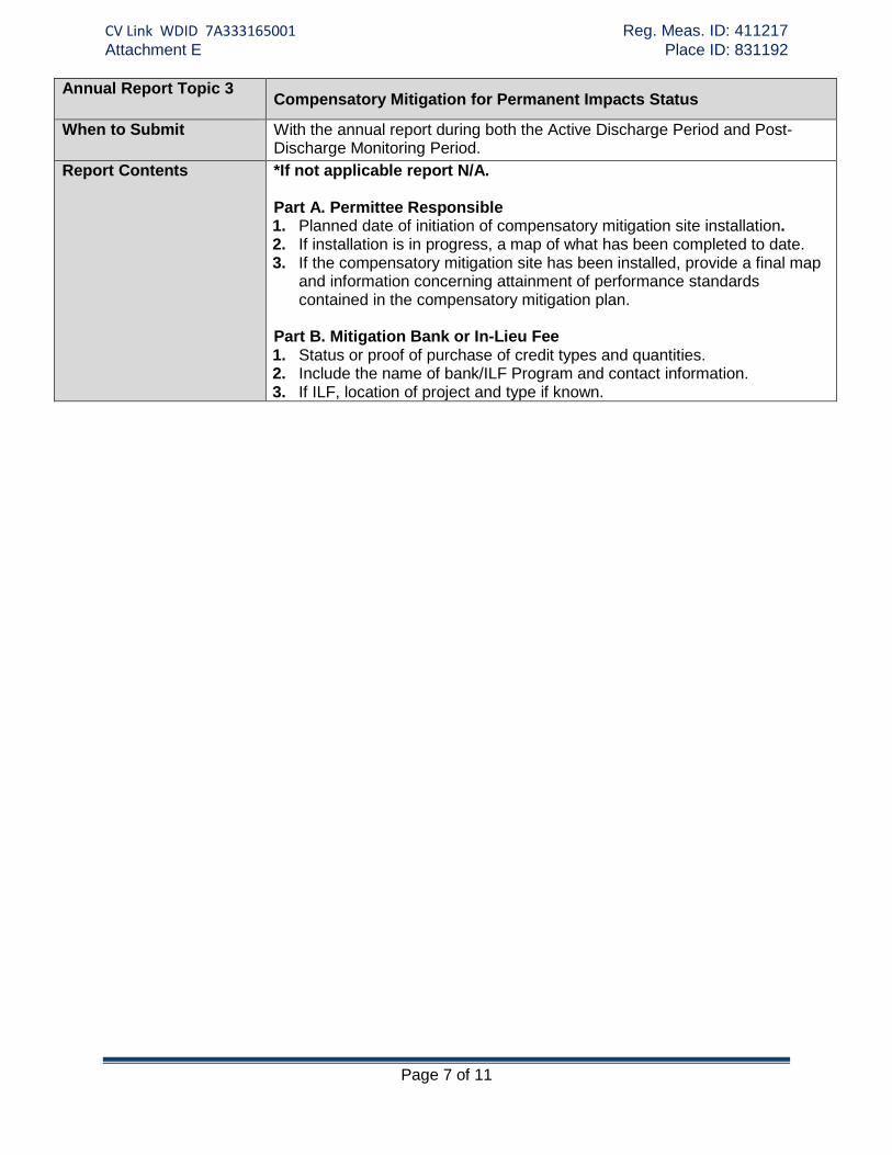
CV Link WDID 7A333165001 Reg. Meas. ID: 411217 Attachment E Place ID: 831192
Page 7 of 11
Annual Report Topic 3 Compensatory Mitigation for Permanent Impacts Status
When to Submit With the annual report during both the Active Discharge Period and Post-Discharge Monitoring Period.
Report Contents *If not applicable report N/A. Part A. Permittee Responsible 1. Planned date of initiation of compensatory mitigation site installation. 2. If installation is in progress, a map of what has been completed to date. 3. If the compensatory mitigation site has been installed, provide a final map
and information concerning attainment of performance standards contained in the compensatory mitigation plan.
Part B. Mitigation Bank or In-Lieu Fee 1. Status or proof of purchase of credit types and quantities. 2. Include the name of bank/ILF Program and contact information. 3. If ILF, location of project and type if known.

CV Link WDID 7A333165001 Reg. Meas. ID: 411217 Attachment E Place ID: 831192
Page 8 of 11
Part B – Project Status Notifications
Report Type 3 Commencement of Construction
Report Purpose Notify Colorado River Basin Water Board staff prior to the start of construction.
When to Submit Must be received at least seven (7) days prior to start of initial ground disturbance activities.
Report Contents 1. Date of commencement of construction. 2. Anticipated date when discharges to waters of the state will occur. 3. Project schedule milestones including a schedule for onsite compensatory
mitigation, if applicable.
Report Type 4 Request for Notice of Completion of Discharges Letter
Report Purpose Notify Colorado River Basin Water Board staff that post-construction monitoring is required and that active Project construction, including any mitigation and permittee responsible compensatory mitigation, is complete.
When to Submit Must be received by Colorado River Basin Water Board staff within thirty (30) days following completion of all Project construction activities.
Report Contents 1. Status of storm water Notice of Termination(s), if applicable. 2. Status of post-construction storm water BMP installation. 3. Pre- and post-photo documentation of all Project activity sites where the
discharge of dredge and/or fill/excavation was authorized. 4. Summary of Certification Deviation discharge quantities compared to
initial authorized impacts to waters of the state, if applicable. 5. An updated monitoring schedule for mitigation for temporary impacts to
waters of the state and permittee responsible compensatory mitigation during the post-discharge monitoring period, if applicable.
Report Type 5 Request for Notice of Project Complete Letter
Report Purpose Notify Colorado River Basin Water Board staff that construction and/or any post-construction monitoring is complete, or is not required, and no further Project activity is planned.
When to Submit Must be received by Colorado River Basin Water Board staff within thirty (30) days following completion of all Project activities.
Report Contents Part A: Mitigation for Temporary Impacts 1. A report establishing that the performance standards outlined in the
restoration plan have been met for Project site upland areas of temporary disturbance which could result in a discharge to waters of the state.
2. A report establishing that the performance standards outlined in the
restoration plan have been met for restored areas of temporary impacts to waters of the state. Pre- and post-photo documentation of all restoration sites.
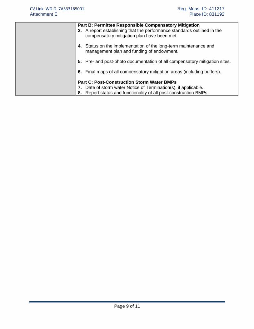
CV Link WDID 7A333165001 Reg. Meas. ID: 411217 Attachment E Place ID: 831192
Page 9 of 11
Part B: Permittee Responsible Compensatory Mitigation 3. A report establishing that the performance standards outlined in the
compensatory mitigation plan have been met.
4. Status on the implementation of the long-term maintenance and management plan and funding of endowment.
5. Pre- and post-photo documentation of all compensatory mitigation sites.
6. Final maps of all compensatory mitigation areas (including buffers).
Part C: Post-Construction Storm Water BMPs 7. Date of storm water Notice of Termination(s), if applicable. 8. Report status and functionality of all post-construction BMPs.

CV Link WDID 7A333165001 Reg. Meas. ID: 411217 Attachment E Place ID: 831192
Page 10 of 11
Part C – Conditional Notifications and Reports
Report Type 6 Accidental Discharge of Hazardous Material Report
Report Purpose Notifies Colorado River Basin Water Board staff that an accidental discharge of hazardous material has occurred.
When to Submit Within five (5) working days following the date of an accidental discharge. Continue reporting as required by Colorado River Basin Water Board staff.
Report Contents 1. The report shall include the OES Incident/Assessment Form, a full description and map of the accidental discharge incident (i.e. location, time and date, source, discharge constituent and quantity, aerial extent, and photo documentation). If applicable, the OES Written Follow-Up Report may be substituted.
2. If applicable, any required sampling data, a full description of the sampling methods including frequency/dates and times of sampling, equipment, locations of sampling sites.
3. Locations and construction specifications of any barriers, including silt curtains or diverting structures, and any associated trenching or anchoring.
Report Type 7 Violation of Compliance with Water Quality Standards Report
Report Purpose Notifies Colorado River Basin Water Board staff that a violation of compliance with water quality standards has occurred.
When to Submit The Permittee shall report any event that causes a violation of water quality standards within three (3) working days of the noncompliance event notification to Colorado River Basin Water Board staff.
Report Contents The report shall include: the cause; the location shown on a map; and the period of the noncompliance including exact dates and times. If the noncompliance has not been corrected, include: the anticipated time it is expected to continue; the steps taken or planned to reduce, eliminate, and prevent reoccurrence of the noncompliance; and any monitoring results if required by Colorado River Basin Water Board staff.
Report Type 8 Modifications to Project Report
Report Purpose Notifies Colorado River Basin Water Board staff if the Project, as described in the application materials, is altered in any way or by the imposition of subsequent permit conditions by any local, state or federal regulatory authority.
When to Submit If Project implementation as described in the application materials is altered in any way or by the imposition of subsequent permit conditions by any local, state or federal regulatory authority.
Report Contents A description and location of any alterations to Project implementation. Identification of any Project modifications that will interfere with the Permittee’s compliance with the Order.

CV Link WDID 7A333165001 Reg. Meas. ID: 411217 Attachment E Place ID: 831192
Page 11 of 11
Report Type 9 Transfer of Property Ownership Report
Report Purpose Notifies Colorado River Basin Water Board staff of change in ownership of the Project or Permittee-responsible mitigation area.
When to Submit At least 10 working days prior to the transfer of ownership.
Report Contents 1. A statement that the Permittee has provided the purchaser with a copy of this Order and that the purchaser understands and accepts:
a. the Order’s requirements and the obligation to implement them or be subject to administrative and/or civil liability for failure to do so; and
b. responsibility for compliance with any long-term BMP2 maintenance plan requirements in this Order.
2. A statement that the Permittee has informed the purchaser to submit a written request to the Colorado River Basin Water Board to be named as the permittee in a revised order.
Report Type 10 Transfer of Long-Term BMP Maintenance Report
Report Purpose
Notifies Colorado River Basin Water Board staff of transfer of long-term BMP maintenance responsibility.
When to Submit At least 10 working days prior to the transfer of BMP maintenance responsibility.
Report Contents A copy of the legal document transferring maintenance responsibility of post-construction BMPs.
2 Best Management Practices (BMPs) is a term used to describe a type of water pollution or environmental control.