Embed Size (px)
Citation preview

ABANDONED MINE LANDS SITE
DISCOVERY PROCESSPrepared for: U.S. Environmental Protection Agency, Region 9
Prepared by: California Environmental Protection Agency,
Department of Toxic Substances Control ,
Site Mitigation and Brownfields Reuse Program,
Northern California-Central Cleanup Operations Branch
James L. Tjosvold, P.E., Chief, Northern Californ ia-Centra lCleanup Operations Branch
June 30, 2006
6/30106
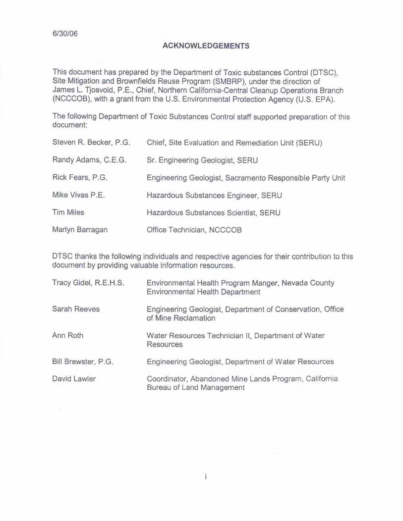
ACKNOWLEDGEMENTS
This document has prepared by the Department of Toxic substances Control (DTSC),Site Mitigation and Brownfields Reuse Program (SMBRP), under the direction ofJames L. Tjosvold, P.E., Chief , Northern Californ ia-Central Cleanup Operations Branch(NCCCOB), with a grant from the U.S. Environmental Protection Agency (U.S. EPA).
The following Department of Toxic Substances Control staff supported preparation of thisdocument:
Steven R. Becker, P.G.
Randy Adams, C.E.G.
Rick Fears, P.G.
Mike Vivas P.E.
Tim Miles
Marlyn Barragan
Chief, Site Evaluation and Remediation Unit (SERU )
Sr. Engineering Geologist, SERU
Engineering Geologist, Sacramento Respons ible Party Unit
Hazardous Substances Engineer, SERU
Hazardous Substances Scientist , SERU
Office Technician , NCCCOB
DTSC thanks the following indiv iduals and respective agencies for their contr ibution to thisdocument by providing valuable information resources.
Tracy Gidel, R.E.H .S.
Sarah Reeves
Ann Roth
Bill Brewster, P.G.
David Lawler
Environmental Health Program Manger, Nevada CountyEnvironmental Health Department
Engineering Geologist, Department of Conservation, Officeof Mine Reclamation
Water Resources Technician II, Department of WaterResources
Engineering Geologist, Department of Water Resources
Coordinator, Abandoned Mine Lands Program, CaliforniaBureau of Land Management

6/30/06
TABLE OF CONTENTS
INTRODUCTION 1
Purpose 1
Background 2
SUMMARY OF TYPICAL MINING OPERATIONS AND ORE PROCESSING
METHODS 2
Types of Mining 2
Types of Processing/Milling Operations 4
Gravity Concentration 4
Magnetic Separation 4
Electrostatic Separation 4
Flotation 4
Leaching 5
SOURCES OF RELEASES 5
Waste Rock 5
Mine Tailings 5
Ore Milling and Operation Facilities ..7Mine Drainage Water (Groundwater) 7
Dump/Heap Pile Wastes 7
Surface Impoundments 7
Slag 7
CONTAMINANTS OF CONCERN (COG) ASSOCIATED WITH MINE WASTES .7
Mineral Association with COC 8
EXPOSURE PATHWAYS AND MEDIA OF EXPOSURE 8
ii

6/30106
TABLE OF CONTENTS(cont'd)
AML DISCOVERY SITE PROCESS APPROACH 12
AML SITE DISCOVERY REPORT 14
EXAMPLE OF AML SITE DISCOVERY PROCESS 14
REFERENCES 15
FIGURES
Figure 1: Geologic Provinces of California 3
Figure 2: Summary of Contamination from Hardrock Mining Activ ities 6
Figure 3: Mine Waste Conceptual Site Model Diagram 11
TABLES
Table 1: Minerals Associated with Ore Deposits 9
APPENDICES
Appendix A: Information Resources
Appendix B: Pre-CERCLIS Screening Assessment ChecklisUDecision
Appendix C: U. S. EPA Discovery Report Format
Appendix D: Example of AML Site Discovery Process
iii

6/30/06
INTRODUCTION
The Department of Toxic Substances Control (DTSC) Northern California-Central CleanupOperations Branch (NCCCOB) initiated an Abandoned Mine Lands (AML) Focused SiteDiscovery Project under the Fiscal Year (FY) 2005-2006 Preliminary AssessmenVSiteInspection (PAlSI) Cooperative Agreement between DTSC and the United StatesEnvironmental Protection Agency (U.S. EPA). This discovery project was proposedbecause contaminants found in mine wastes on Abandoned Mine Lands (AML) inCalifornia may pose a risk to human health, the environment, and water quality. To thisend, DTSC has evaluated various sources of information, including existing databasesrelated to mining activities, population density maps, well location databases, and parcelidentification in California, for use in developing this "AML Site Discovery Process".Additionally, the "Abandoned Mine Lands Preliminary Assessment Handbook", DTSC1999, provides guidance for conducting site assessments for AML.
DTSC selected Nevada County, California to develop and apply the AML Site DiscoveryProcess due to the County's numerous AML sites, available mining information, and thecurrent and planned population growth communities (e.g., Grass Valley and Nevada City)are experiencing; and the cooperation DTSC has with the Nevada County EnvironmentalHealth Department.
Purpose
This AML Site Discovery Process document was developed to provide a process forconducting initial evaluations to discover potential AML sites that could be potentialsources of contamination which may affect human health, the environment, and waterquality in and around communities that are experiencing significant population grow1h, andareas that have current or planned development. It is intended to be used to discover AMLsites that are not yet being addressed by state, federal or local agencies; and primarily foruse by DTSC and other environmental regulators concerned with the release of AML sitecontaminants to the environment.
AML sites are found on both private and public lands, While not all AML sites havehazardous substances present, proper assessment of AML sites should be conductedprior to any development on or adjacent to these properties to determine whether threatsto human health, the environment, or water quality may exist.
This AML Site Discovery Process emphasizes gathering information on the location, typeof mining operation, scale of mining, ore processing, and other operation/disposalpractices by means of existing mining databases in conjunction with current and futureland uses. The AML Site Discovery Process also includes conducting site reconnaissancewhere possible (e.g. public lands) to identify AML locations to verify their current land useand location.
1

6/30/06
Background
Mining (excavating) minerals from the earth is the primary source of raw materials used inmanufacturing and construction industries. Mineral commodities can be grouped into threecategories 1) metallic minerals, also referred to as ore minerals, consisting of preciousmetals (gold and silver); base metal sulfides of (copper, lead, and zinc); and oxides ofmetals (aluminum, iron, titanium); 2) nonmetallic minerals (asbestos, calcite, dolomite,gypsum, quartz); and 3) solid fuel minerals (coal and tar sands).
California has been a major mineral producer since the days of the "Gold Rush" beginningin approximately 1849. Mining activities have occurred in all eleven of California's geologicprovinces (Figure 1) with the highest density of mining activity occurring in the SierraNevada: (gold, base metal sulfides, tungsten and some chromite) and Klamath Mountains:(gold, base metal sulfides, chromite, and some mercury). The lowest density of miningactivity has occurred in the Cascade Range and Modoc Plateau: (mostly cinders, pumice,and building stone). Significant mining has also occurred in the Coast Ranges andTransverse Ranges: (mercury, gold-silver, gypsum, phosphate, and coal); Mojave Desert:(gold/silver, lead-silver-zinc, limestone, aggregate, and gypsum); Great Valley: (sandgravel, and placer gold); Peninsular Ranges and Colorado Desert: (gold, tungsten, lithium,mica, and gemstones); and Great Basin: (gold-silver, tungsten, iron, lead-silver-zinc,borate, sodium carbonate, and clay).
Extensive mining activities in California have resulted in thousands of inactive orabandoned mines. Historical mining practices, ore processing techniques, disposalpractices, closure procedures, and/or surface exposure of ore deposits at AML sites haveresulted in the generation and disposition of large quantities of mine wastes, includingwaste rock, mine tailings, mine drainage water, processing chemicals, and other wastes tothe land and waters of the state. The interaction of natural processes such as climate,hydrology, geochemistry, and weathering with these wastes have resulted in the release ofcontaminants which may affect human health, the environment, and water quality.
SUMMARY OF TYPICAL MINING OPERATIONS AND ORE PROCESSING METHODS
Types of Mining
Mining operations for metals (e.g. gold) and other minerals, in general, consists of surfacemining, and underground mining methods to find and excavate ore (rock containing thevaluable mineral). Surface mining methods include open pit and placer mining. Open pitmining involves the removal of "overburden" material form the land consisting of non-gradeore to the ore grade material being mined. Placer mining is a type of surface mining formineral deposits (e.g. gold) where minerals have accumulated as a result of fluvialaction such as in deposits associated with streams , rivers, and alluvial fans.
2

6/30106
FIGURE 1GEOLOGIC PROVINCES OF CALIFORNIA
SC ALEU IOO MiIU 100 Km
E X PLA N ATlO :-;I SIERRA NEVADAII KLAM ATH MOUNTAIN S(II CASCADE RANta·:IV MODOC PLATJo:.·\ UV GREAT BASINVI COAST IlANGESVII TRAr\SYERSF. RANGESVIII Gi l EAT VALLEYIX PEN INSULAR Il"NIlESX COLO IlADO DESEIlTXI MOJAVE DESERT
From Abandoned Mine Lands 3Preliminary Endangerment AssessmentHandbooks, DTSC 1999

6/30/06
Large scale placer mining includes dredging and hydraulic methods. Underground mining(e.g., hard rock mining) includes lode mining in which the mineral bearing ore is minedunderground in enriched mineralized zones such as veins.
Waste rock consists of non-mineralized and/or low grade mineralized rock removed from,around, and within an ore body as a result of mining activities. Following the excavation ofore from the earth, ore is crushed and or ground to fine sand size particles and thismilled/crushed material is processed by various methods to extract the desired mineral.Tailings are a waste product of this process.
Types of Processing/Milling Operations
Ore contains the valuable minerals (typically metals) which are being sough!. Gangueminerals are the non-valuable minerals associated with the valuable minerals in the ore.Beneficiation are activities that separate and concentrate valuable minerals from gangueminerals using mechanical and chemical processes following the initial crushing and/orgrinding of the ore in mills.
Gravity Concentration
Gravity concentration process involves differences in the density of minerals to separatethe valuable mineral form the gangue minerals: 1) Coarse Fine Concentration - sluices aretypically used to settle heavy materials from lighter materials where the slurry (crushed oreand water) is further processed or discharged to tailing impoundments; 2) Amalgamation historically used to recover gold, uses mercury to form an amalgam. Gold is recovered byfiltering off the mercury; 3) Sink! Float Separation - also known as heavy media separation,uses buoyancy to separate minerals on the basis of a mineral's buoyancy/density in aliquid media.
Magnetic Separation
Magnetic separation is generally applied to ores of iron, columbium/tan talum, and tungstenwhere a magnetic field separates particle based on their affinity to magnetism.
Electrostatic Separation
Electrostatic separation is used to separate minerals based on their conductivity to anelectric charge.
Flotation
Flotation is a process which involves adding chemicals to slurry which causes minerals toadhere to air bubbles forced through the slurry. The air bubbles containing the mineral areseparated from the matrix.
4

6/30/06
Leaching
Leaching typically involves a pre-leaching process where ore is heated in furnaces,sometimes under pressure (autoclaving), and sometimes with chemicals such as sodium.The ore is subsequently placed in piles (dump and heap leaching) or in tanks (tankleaching) where liquids are applied such as cyanide, acids, or water. The applied liquidleaches the mineral from the ore for further processing.
SOURCES OF RELEASES
As noted above, the interaction of natural processes and mine wastes can result in therelease of contaminants. Waste rock, mine tailings, mine drainage water (groundwater),surface impoundments, processing chemicals, and other wastes are common sources ofreleases. The mobility of a waste constituent is dependent on 1) chemical and physicalproperties of the constituent, 2) chemical and physical properties of the media, and 3)environmental factors, including, topography, climate, hydrology, geochemistry,mineralogy, and extent of weathering.
Following initial milling/beneficiation, smaller mines typically transport the mineralconcentrates to off-site facilities for further mineral processing. Larger mines may conductthese additional operations on-site. These additional mineral processing operationsinclude, pyro-metallurgical (smelting/refining); hydro-metallurgical (acid/precipitate); andelectro-metallurgical (electrolytic/plating) operations. A conceptual site model depictingtypes of contaminant releases from mining, milling, and mineral processing activities isshown in Figure 2, titled "Summary of Contamination from Hardrock Mining Activities"
Waste Rock
Waste rock will contain some concentration of the mineral being sought in addition to otherminerals. Waste rock geochemistry may vary from site to site depending on the sitelithology and geochemical processes. Waste rock includes broken rock of varying size tofine sand size material. Waste rock is typically disposed of in piles adjacent to or downslope of mine openings. Water migrating through waste rock piles, via rain or surface watermay impact surface water and groundwater. Waste rock may also be a source of soilcontamination and sediment contamination in streams and lakes.
Mine Tailings
Mine tailings contain the residual matrix material from the processed ore as well aschemical additives. They are commonly transported in slurry to tailings impoundments fordisposal or other processing. These impoundments were commonly constructed bydamning off natural drainages, often using waste rock as a construction material. Tailingsare also commonly disposed of in a dried state and are located on hillsides, and in valleys.Mine tailings tend to pose more environmental problems than waste rock due their fineparticle size. Like waste rock, water migrating trough tailings may impact surface waterand groundwater, and be a source of soil and sediment contamination in streams andlakes. Tailings piles may also be a source air-bam contamination.
5
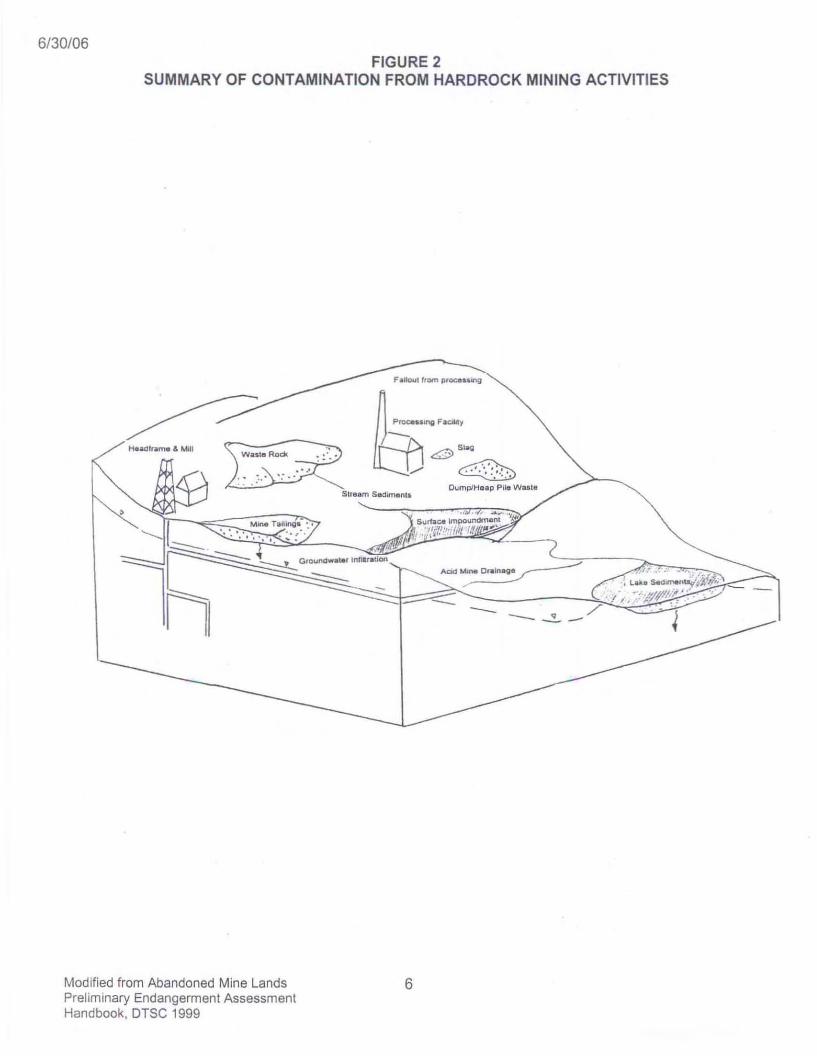
6/30106FIGURE 2
SUMMARY OF CONTAMINATION FROM HARDROCK MINING ACTIVITIES
Proces.ong F.lC*ty-~H......~.M.U ~'WUle Rodl. ~ : '.'
" ,: ~ .:.. ' .: ..
Stream SedlmClnll
<:OJ ' '''~
Dump/Heap Pile Waite
Modified from Abandoned Mine LandsPreliminary Endangermen t AssessmentHandbook, DTSC 1999
6

6/30/06
Ore Milling and Operation Facilities
Ore milling and other operations, often located on site, can be sources of contaminationassociated with milling and other machinery (e.g. lubricants, solvents, fuels). Locationswhere processing chemicals (e.g. mercury, cyanide, acids) are stored and used in themineral concentration process and mineral assay facilities where ore samples areevaluated for mineral content can be sources of chemical contamination to surface water,groundwater, and soil.
Mine Drainage Water (Groundwater)
During mining operations, mines are often dewatered to provide access to ore bodies.Inactive mines provide both an inlet and outlet for surface and rain water. Water exiting amine can contain leached metals and other minerals and have a lowered pH valueproducing "acid mine drainage". This mine drainage water may impact surface water, andgroundwater.
Dump/Heap Pile Wastes
Dump and heap plies may remain on-site following the recovery of leachate containing thevaluable mineral from these piles. Water migrating through these piles, via rain or surfacewater, may impact surface water, groundwater, surface soil, and air quality. They may alsobe a source of sedimentation in streams and lakes.
Surface Impoundments
Surface impoundments are used to 1) collect leachate from dump/heap leaching activitiesand are commonly located down gradient of dump/heap piles: 2) dispose of spentleachants; 3) dispose of spent electrolytic solutions; 4) recover valuable minerals byprecipitation; and 5) store and provide a source of water for mine operations.
Waste associated with smelting/refining includes slag. Slag is partly fused impuritiesseparated from metallic ore concentrates after being heated to a molten state in a furnaceduring the smelting process. Rain and surface water may leach out contaminants in theslag waste piles and may impact surface water and groundwater.
CONTAMINANTS OF CONCERN (COG) ASSOCIATED WITH MINE WASTES
Mine wastes is a general term applied to wastes that are associated with the mining andprocessing of ore. Mine wastes includes waste rock, mine tailings, mine drainage water(groundwater) surface impoundments, processing chemicals, slag, heap piles and otheroperational wastes.
7

6/30/06
COCs associated with mine wastes are related to 1) the chemical composition of theminerals which make up the ore and surrounding rock being mined; 2) mining methods; 3)ore processing methods, including chemicals used to process the ore (e.g., mercury andcyanide used in gold recovery); 4) mine waste disposal methods; and 5) the interaction ofnatural processes with mine wastes. Other COCs include residual explosives, fuels,solvents and lubricants used in mining operations.
Mineral Association with COC
Most minerals exist in soil and rock as a combination of two or more elements. Examplesof minerals associated with ore include 1) native elements: gold, silver, copper, platinum,and iron; 2) metal oxides: chromite (FeCr204), cuprite (CU20), magnetite (Fe304). Ilmenite(FeTi0 3); 3) metal sulfides: arsenopyrite (FeAsS), galena (PbS); cinnabar (HgS), pyrite(FeS2); and 4) sulfates: barite (BaS04), anglesite (PbS04), anhydrite (CaS04).Additionally, minerals have association to other minerals or groups of minerals based onthe rock type (e.g., igneous, including volcanic and plutonic; metamorphic; andsedimentary) and/or geologic processes in which mineral enrichment and alteration occursthrough secondary processes such as hydrothermal enrichment, metamorphic alteration,and sedimentation. For example, ultramafic rock (rocks having mostly iron and magnesiumminerals) are associated with chromite, Ilmenite, and asbestos minerals such as tremolite,actionlite, and chrysotile. Ultramafic rocks can be igneous and metamorphic in origin.Tablet, titled "Minerals Associated with Ore Deposits" list common minerals associatedwith ore deposits and weathering related minerals and can be used to identify COCs thatmay be associated with specific types of ore minerals that are mined.
Exposure Pathways and Media of Exposure
Exposure pathways at mine sites are similar to other sites having hazardous substancesreleases. The following exposure routes and media of exposure are applicable:
• Inhalation: airborne dust and volatile organic compounds in indoor air from solventsand fuels.
• Ingestion: surface water, groundwater, and incidental ingestion of soil.• Dermal Absorption: direct contact with soil, surface water, and groundwater .
Figure 3, titled "Mine Waste Conceptual Site Model Diagram" is an AML conceptual sitemodel describing potential mining COC sources, release mechanisms, migrationpathways, exposure routes, and receptors. Collectively, mine wastes are the primarysources in which surface water runoff, infiltration/percolation, and erosion are primaryrelease mechanisms. Secondary sources are surface water/sediments , groundwater, soil,and dust.
Not all sources, migrations pathways, and receptors may apply to a given AML site and theextent of exposure to human receptors varies depending on the existing and proposediand use.
8

6/30106
TABLE 1MINERALS ASSOCIATED WITH ORE DEPOSITS
1. ORE MINERALS
a) SULFIDESPyriteMarcasitePyrrhotiteChalcopyriteBorniteChalcociteCovelliteGersdorffiteArsenopyriteArsenian pyriteLoeilingite
OrpimentRealgarCinnabarMetacinnabarSphaleriteGreenock iteStibniteGalenaMiilerite
2. GANGUEMINERALS
a) CARBONATESCalciteAragoniteDolomiteAnkeriteSideriteRhodochrosite
FORMULAFeS2FeS2Fe(1 " ISCuFeS2CusFeS,CU2SCuSNiAsSFeAsSFe(S,AshFeAs2
As2S,AsSHgSHgS(Zn,Fe ,Cd,Hg )SCdSSb2S,PbSNiS
FORMULACaCO,CaCO,CaMa(CO , hCa(Fe ,Mg}(CO, hFeCO,MnCO,
b) SULFOSAL TSTennantlte-tetrahedriteEnargiteLuzonite-famatiniteProustite-pyrargyrite
c) NATIVE ELEMENTSElectrumGoldSilverCopperQuicksilver (nativemercury)
d) OTHERNiccoliteMagnetiteCalaver iteHessitePetzlte
FORMULA(Cu,Ag,Fe,Zn )'2(As, se), S\3Cu,AsS,Cu,(As, Sb)S,Ag, (As,Sb)S,
FORMULA(Au,Ag)AuAgCuHg
FORMULANiAsFe,04AuTe2Ag2Te
Ag,AuTe2
From Abandoned Mine Lands 9Preliminary Endangerm ent AssessmentHandbooks , DTSC 1999

6/30106
TABLE 1 (continued)MINERALS ASSOCIATED WITH ORE DEPOSITS
bl SILICATESQuartzAlbiteOrthoclaseAnorthite (plagioclase)KaoliniteMuscoviteMariposite (Cr-phengite)
cl SULFATESBariteGypsumAnhydrite
2. WEATHERINGMINERALS
FORMULASi02
NaAISi30.KAISi30.Ca2A12Si20 .AI2Si20 5(OH),KAI2AISi30,o(OH),K(AI,Cr), ,(Mg, Fe)osAlo,Si3.,O, o(OHh
FORMULABaSO,CaS042H20CaSO,
illOXIDES/HYDROXIDESHematiteGoethiteFerrihydrite
CupriteTenoriteGibbsiteBoehmite ,diasporeBunseniteTheophraslite
bl SULFATES
AntleriteBrochantiteGypsumMelanteriteRozeniteSzomolnokiteHalotrichileCoquimbiteCopiapiteFerricopiapileSchwertmanniteRhomboclaseJarositeAluniteJurbaniteAnglesiteGoslarite
FORMULA
Fe203FeO(OH)Fe20i 2FeOOH 2 6H,O
CU20CuOAI(OH),AIO(OH)NiONi(OH),
FORMULA
CU3(SO,)(OH),Cu,(SO,)(OH).CaSO, 2H20Fe"SO,7H20Fe"SO,'4H 20Fe"SO, H20Fe"Al2(SO, ), 2 2H20Fe'"2(SO,h 9H20Fe"Fe"', (SO')6(OH), 20H20Fe"'5(SO' )60 (OH) 20H20Fe'Il. O. (OH). SO,Fe"I\H30)(SO,h 3H20KFe "3(SO,J,(OH)6KAl3(SO,),(OH).AI(SO,)(OH) 5H20PbSO,ZnSO,7H20
cl ARSENATES &ANTIMONATESScoroditeMansfielditePharmacosiderite
Beudanli teStibiconiteBindheimite
dl HALIDESCalomelChloragyr iteAtacamite,paratacamite
e) CARBONATESAzuriteMalachiteCerussiteSmithsonite
FORMULA
Fe'"AsO,2H20AIAsO,2H20KFe'",(AsO,hlOH)67H20PbFe'"3(AsO, )(SO, )(OH).Sb30.(OH)Pb2Sb20 . (0 ,OH)
FORMULAHgCIAgCICu,CI2(OH).
CU3(C03J,(OH),CU2(C03)(OH),PbC03ZnC0 3
From Abandoned Mine Lands 10Preliminary Endangerment AssessmentHandbooks, DTSC 1999

6/30106FIGURE 3
MINE WASTE CONCEPTUAL SITE MODEL DIAGRAM
PrimarySource(s)
PrimaryReleaseMechanism(s)
- stace WaterRunoff
SecondarySource(s)
SecondaryReleaseMechanlsm(s)
MigrationPathway(s)
ExposureRoute(s)
t:}ineWase
1--. InfiltrationPercolation
Erosion DirectContact
[Wind
Erosion-..- [ Deposition I
1
L-.Plants ,
Animals ,FI~h
__ m ~ Ingestion I I I 0
L.---+i Dusts
Modified from Guidance for Conducting Remed ialInvestigations and Feasibility Study under CERCLA,U.S. EPA 1998 and other sources
~---- - -~ Inhalalion I I I D
11
6/30106
However, since development is occurring on and near AML sites, various pathways maybecome relevant (e.g., use of groundwater or surface water as part of new development)and receptor scenarios may apply depending on the land use (e.g., residential versusrecreational and trespasser receptors).
AML DISCOVERY PROCESS APPROACH
The AML Site Discovery Process approach has been developed to make use of readilyavailable information sources (e.g., regulator agency files) and state-of-the-art informationtechnology including databases and Geographic Information System (GIS) mappingsystems to conduct an initial assessment that identifies AML sites that may be associatedwith releases of contaminants to the environment that are not yet being addressed bystate, federal or local agencies. Once identified, these AML sites can be examined for theneed to conduct a more detailed evaluation or investigation of the site.
The Discovery Process begins with identifying known AML sites through the evaluation ofexisting databases. DTSC acquired the following Geographical Information Systems (GIS)AML databases from various local, state, and federal agencies: 1) Topograph ic OccurringMine Symbols (TOMS), California Department of Conservation; 2) Principle Areas of MinePollution (PAMP), California Department of Conservation; 3) Environmental Health Mines(EH mines), Nevada County Environmental Health Department; 4) Digital Mining Claims,U.S. Geological Surver: 5) Mineral Resources, U.S. Geological Survey; and 6) AbandonedMine Module (AMM) (1, U.S. Bureau of Land Management. DTSC also obtained 1) Countyassessor parcel maps, Nevada County Environmental Health Department ; 2) Populationdensity maps for California, U.S. EPA; and 3) High resolution aerial photographs. Withinformation on AML sites and their locations, regulatory agency files and historical miningrecords can be reviewed for information on the size, type, and processing activitiesassociated with a given mining operation. Some of this information may also be included inthe above AML databases . The numbers identified in "brackets" following the ProcessDiscovery steps refer to respective information sources provided in Appendix A, titled"Information Resources".
The steps of this Discovery Process are:
1. Apply available AML databases on a statewide or regional basis and map locations ofAML site. [1-6]
2. Conduct a statewide or regional query of, local, state, and federal databases thattrack agency oversight including, cleanup, complaint, and enforcement activities toidentify AML sites that are currently being addressed by respective agencies. Agencyoversight databases include DTSC, Regional Water Quality Control Boards(RWQCBs), Bureau of Land Management (BLM), Department of Conservation(DOC), the U.S. Forest Service (USFS), U.S. Geological Survey (USGS) and U.S.EPA. [9-19,27,29]
(1) BLM's AMM database is currently being 12updated and was not available for DTSC'suse for this AML Site Discovery Process.
6/30/06
3. Select a geographic area on which to focus the assessment based on an evaluationof statewide or regional growth trends; current and future land use, includingcommercial, residential, and recreational development. Consult with local agencyplanning departments and refer to "General Plans' and zoning maps developed bylocal agencies. Apply respective general plan and zoning GIS databases if available.[32,34]
4. Consult with local agencies (e.g. counties, cities) for information regarding propertyownership based on parcel identification. Apply respective parcel identification GISdatabases if available. Note that multiple AML sites may exist on a given parcel andmultiple parcels may be associated with a given mining operation and have multipleproperty owners. [28, 33]
5. Within the selected geographic area, identify the locations of AML sites that are notcurrently being addressed by local, state, and federal agencies that are potentialsources of releases to the environment. Note that AML sites which are currently beingaddressed by agencies can be associated with multiple parcels or multiple AML sitesmay exist on a given parcel.
6. Apply Population density maps to selected geographic area to visualize the proximityof AML sites to population. [7, 32]
7. Apply aerial photographs to selected geographic area of interest to visualize proximityof AML to infrastructure and development; and to identify features associated withmining activities (e.g. tailings and waste rock piles, impoundments, head-framestructures, building foundations/structures, and other mining features). [21 , 22, 23]
8. Apply topographic base map to identify topographic relief, streams, lakes, reservoirs,canals, etc. [21 , 22, 23, 41 1
9. Collect information on the location of municipal water wells and private water wells.For private and municipal well completion information in California contact DWR. Formunicipal well water information in California, contact DHS. Private well informationmay also be available from local agencies (e.g., county environmental healthagencies). [25, 26, 37, 38]
10. Examine potential threats to the public health, environment, and water quality basedon the proximity of AML features (e.g. tailings and waste rock piles, processingfacilities, etc) to existing and/or planned development, surface water features anddrinking water wells. [25, 26, 35, 40]
11 . Collect information regarding operational history from identified AML sites fromlocal and state libraries, libraries of state and federal agencies (e.g. BLM, USGS, U.S.EPA, DOC, RWQCBs etc.) [28, 36]
13
6/30/06
12. Conduct a site visit to confirm location of AML and presence of mining activities.Note that conducting site visits on public lands may be readily accomplished.However, conducting site visits on private lands requires coordination with the landowner(s) and local agencies.
13. Identify needs for additional assessment or investigation, including sampling andanalysis.
AML SITE DISCOVERY REPORT
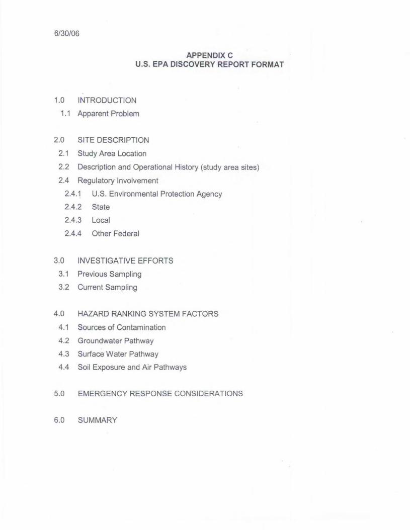
The techniques and informational sources used in this AML Discovery Process areapplicable to any format used for initial assessment of potential contamination related toAML sites (e.g. DTSC's Preliminary Endangerment Assessment, RWQCB's SiteAssessment, and U.S. EPA's PAlSI). The information gathered and conclusions reached inimplementing the Discovery Process for a particular area can also be documented usingU.S. EPA's "Pre-Comprehensive Environmental Response, Compensation and LiabilityInformation System (Pre-CERCUS) Screening Assessment ChecklisVDecision Form"(Appendix B); and presented in the U.S. EPA's Site Discovery Report Format (AppendixC). This AML Site Discovery Process was prepared in a manner consistent with theprocess for conducting a U.S. EPA PAISI Site Discovery.
EXAMPLE OF AML SITE DISCOVERY PROCESS
As discussed, the AML Site Discovery Process was developed to help users conductdiscovery level assessments for AML sites using existing information sources and state-ofthe-art information technology including databases and Geographic Information System(GIS) mapping systems to conduct an initial assessment.
Typically, the AML Site Discovery Process would be used.to discover AML sites that arenot yet being addressed by state, federal or local agencies. However, DTSC selected theformer Idaho Maryland Mine in Grass Valley, Nevada County, California an example forapplying the subject AML Site Discovery Process. This site was selected because of itsproximity to ongoing growth in the City of Grass Valley and to compare information (e.g.location of mining features, topography, well locations, property boundaries, etc.) acquiredfrom this discovery process to similar information acquired for this site based onPreliminary Assessment work DTSC completed for the U.S. EPA in June 2002.
Please refer to Appendix D, titled "Example of AML Discovery Process (Idaho MarylandMine, Grass Valley, California)" for a discussion of this application.
14
6/30106
REFERENCES
Abandoned Mine Lands Preliminarv Endangermen t Assessment Handbook, Departme nt ofToxic Substances Control , February 1999.
Foothill Counties Mining Handbook, Special Publication 86, Department of Conservation,Mines and Geology, October 1985.
Solid Minerals Reclamation Handbook. BLM Manual Handbook H-3042-1,U,S. Department of the Interior, Bureau of Land Management , February 7, 1972.
Abandoned Mine Site Characterizat ion and Cleanup Handbook, EPA 910-B-00-001,U.S. Environmental Protection Agency, August 2000.
Reclaiming Inactive and Abandoned Mines Lands, National Mining Association, July 1998.
Abandoned Mine Land and Hazard Evaluation Handbook, U.S. Department of Interior,Bureau of Mines, May 1994.
"National Overview of Abandoned Mine Land Sites Utilizing the Minerals AvailabilitySystem and Geographic Information System (GIS) Technology ' , David A. Ferderer ,U.S. Geological Survey Open-File Report 96-549 ,1996,
Northern California-Central Cleanup Operations Branch, Visalia Dry Cleaner SiteDiscovery Report, Department of Toxic Substances Control, September 30, 2005,
Dry Cleaner Site Discovery Process, Department of Toxic Substances Control,September 30, 2005.
15

6/30/06
APPENDIX AINFORMATION RESOURCES
1. Topographic Occurring Mine Symbols (TOMS), Department of Conservation, Californiahttp://www.consrv.ca.gov/OMR/abandonedmine lands/toms/index.htm
2. Principal Areas of Mine Pollution (PAMP), Department of Conservation, Californiahttp://www.consrv.ca.gov/OMR/abandoned mine lands/pamp/index.htm
3. Environmental Health Mines (EH mines), Nevada County Environmental Health,California http://new.mynevadaeounty.eom/gis/index.cfm?ces- 630 (fee required)
4. Digital Mining Claims , United States Geologic Surveyhttp://geopubs.wr.usgs.gov/open-file/of99-4091
5. Mineral Resources (MR), United States Geologic Survey http://tin.er.usgs.gov/mrds
6. Abandoned Mine Module, formerly the Abandoned Mine Lands Inventory System(AMLlS) , United States Bureau of Land Managementhttp://www.blm.gov/amllam lls.htm ( AMLIS database is being revised and is notcurrently available as of 6/1/06)
7. DTSC Intranet - Population Density Maps and other databases for Californiahttp://dtsenet.dtsc.ca .gov/GlSI
8. GIS resources for Nevada County including, General Plan, and Zoninghttp://new.mynevadaeounty.com/gis/index.cfm?ccs- 629
9. DTSC Internet - Site Mitigation and Brownfields Reuse Program Database (Envirostor)http://www.envirostor .dtse.ea.gov/public/
10. California Certified Unified Program Agencies (CUPA) - http://www.calcupa.net/
11. U.S. EPA Enforcement and Compliance History Online (ECHO) ; search for Informationby city or zip code - http://www.epa.gov/echol
12. U.S. EPA Watershed Assessment Tracking and Environmental Results (WATERS)GIS web site - http://www.epa.gov/waters/
13. U.S. EPA Archived Sites - http://cfpub.epa.gov/supercpad/arcsites/srchsites.cfm
14. U.S. EPA CERCLIS Database http://efpub.epa.govisupercpad/cursites/srchsltes.cfm
15. DTSC Internet- Hazardous Waste and Substances Site List (Cortese List)http://www.dtsc.ca.gov/SlteCieanup/Cortese List.cfm

6/30/06
16. U.S. EPA Envirofacts Data Warehouse (A resource to find generators, transporters,treaters, storers, and disposers of hazardous waste in the area of interest)http://oaspub.epa,gov/enviro/ef home2,waste
17. U.S. EPA - AML sites with EPA removals/emergency responseshttp://www.epa.gov/aml/amlsite/removal.htm
18. U.S. EPA - A list of mining sites and mineral processing sites on the NPL or deletedfrom the NPL http://www.epa.gov/amllamlsite/npl.htm
19. AML CERCUS Inventory - a list of AML sites from CERCUS (EPA database ofhazardous waste site, potential hazardous waste sites, and remedial activities)http://www.epa.gov/aml /amlsite/nonnpl.htm
20. DTSC Intranet - Estimate location longitude and latitude from street addresshttp://intranetiGIS/geocode/geocode1.cfm
21 . Mapping and aerial photos - MapQuest - http://www.mapguest.com
22. Mapping and aerial photos - http://terraserver-usa.com
23. Mapping and aerial photos - http://terrafly.fiu.edu
24. State Library - California History Room, Room 200, 900 N Street, Sacramento. (916)645-0176. Email: [email protected] Research hours 09:30 - 15:45 M-F.
25. Water Departments , Agencies and Companies: American Water ResourcesAssociation http://www.awra.org/state/socal/membersagenciesindivsicawateragencies.htm
26. California Water Service Group, a large water purveyor that owns a number of waterservice systems in California - http://www.calwa ter.com/
27. Geotracker Web Site - Information on RWQCB UGT/LUST and SUC sites; SomeDHS water quality information - http://geotracker .swrcb.ca.gov/
28. Secretary of State - Corporation and LLC locator ; can use as a resource to find currentand past businesses - http://kepler,ss.ca,gov/lisl.html
29. DTSC intranet accessible GIS mapping of generators of hazardous waste http://intranetiG IS/maapslind ex,cfm
30. SWRCB Water Quality Plans and Policies web address http://www.waterboards.ca.qov/plnspols/index.htmI
31 . DWR - Basin maps and descriptionshttp://www.groundwater .water.ca,gov/bulletin118/index.cfm

6/30/06
32. Nevada County Community Planning Agencyhllp s://docs.co.nevada.ca.uS/dsweblView/Coliection-1581
33. Nevada County Assessor's Parcel Number (APN) Mapshllp :l/new.mynevadacounty .com/gis/index.cfm?ccs-630 (fee required)
34. Nevada County Zoning Mapshllps:/ldocs .co.nevada.ca.us/dscgi/ds.pylView/Collection-9087
35. California Department of Water Resources, Water Use and Planninghttp://www.water.ca.gov/nav.cfm?topic-Water Use and Planning
36. California Geolog ical Survey Libraryhttp://www.consrv.ca.gov/CGS/information/publications/library/index.htm
37. California Geologic Survey, Geologic Mapshttp://www.consrv.ca.goc/CGS/information/geologicmapping/index.htm
38. U.S. Department of Agriculture, Soil Survey Documentshttp://websollsurvey.nrcs.usda.gov/app/
39. California Soil Surveys, University of California , Davishttp://casoilresource.lawr.ucdavis.edu/drupal/node/27
40. California Department of Health Services , Drinking Water Programhttp://www.dhs.ca.gov/ps/ddwem/technical/dwp/dwpindex.h tm
41. U.S. Geological Survey, Topographic Mapshttp://ngmdb .usgs.gov/OtherResources/rdbtopo.html

6/30/06
APPEND IX BPRE·SCREENING CERCLIS ASSESSMENT
CHECKLIST/DECISION FORM

PRE·CERCUS SCREENING ASSESSMENT FORM
Preparer Name: I Date:
Agency:
Address:
Ph one: ( ) - Ext. I E-Mail:
SECTION A .
Site Name:
Prev ious Names :
S ite Locati on:
City : 1 St: I Z ipcode: -CA DTSC Rac lon: I CA DTSC Reg ion #: ICA RWQCB Reo lon : I CA RWaCB ReCllon #: I
Complete the followin g checkli st. If ·yes· Is marked, pl ea se exp la in be low. YES NO
1. Does the site already appear in CERCLlS? 0 0
2. Is the release from products that are part of the structure of, and result in exposure 0 0within, residential buildings or businesses or community structures?
3. Does the site consist of a release of a naturally occurring substance in its unaltered 0 0form, or altered soleiy through naturally occurring processes or phenomena, from alocation where it is naturally found?
4. Is the release into a public or private drinking water supply due to deterioration of the 0 0system through ordinary use?
5. Is some other program actively involved with the site (i.e., another Federal, State, or 0 0Tribal program)?
6. Are the hazardous substances potentially released at the site regulated under a 0 0statutory exclusion (i.e., petroleum, natural gas, natural gas liquids, synthetic gasusable for fuel, normal application of fertilizer, release located in a workplace , naturallyoccurr ing. or regulated by the NRC, UMTRCA, or OSHA)?
7. Are the hazardous substances potentially released al the site excluded by policy 0 0considerations (e.g., deferral to RCRA Corrective Action)?
8. Is there suffic ient documentation that clearly demonstrates that there is no potential fora release that could cause adverse environmental or human health impacts (e.g., 0 0comprehens ive remedial investigation equivalent data showing no release aboveARARs, completed removal action, documentation showing that no hazardoussubstance releases have occurred , EPA approved risk assessment completed)?
Briefl y exp lain all " yes" answers In sect ion B,
Revision 0 - 9/29/04 - 1 -
PRE·CERCUS SCREENING ASSESSMENT FORM
SECTION B.Site Determination:
Site is eligible for CERCLA: 0(Further assessment is recommended. I NonNPLStatus =PA Needed I NPL Status = N)
The site is not eligible for CERCLA: DNPL Status=0 for all options below(Pick one below:)Non·NPL Status=Not a Valid Site : DNon-NPL Status = Not a Valid Sile - RCRA Lead: DNon-NPL Slatus = Not a Valid Site - NRCLead: DNon-NPL Status = Not a Valid Site - State Lead: D
Site is part of a NPL site: 0(NPL Slatus =A)
DECISIONIDISCUSSION/RATIONALEISITE ACTION COMMENTS:
Regional EPA Reviewer: _
State AgencyfTribe : _
Date Submitted to IMC: _
Date: _
Date: _
Revision 0 - 9/29 /04 - 2-
FED FAC IND
PRE·CERCUS SCREENING ASSESSMENT FORMDATA ENTRY FORM FOR DISCOVERY OF SITE
O Federa l Facility ONol a Federal Facility O Status Undetermined
SITE TYPES (Check all secondary subcateaaries that applv. Desianate one subcategory as primary)Manufacturina/Processina/Ma lntenance Other(Subcategory) . ;-::;(Si::u:..:;b'"'ca""t""eg-o-ry""')----------- ----1Primary Secendarv Primary Secendarv
I I Chemicals and allied products f-;.LJ;r'irL......r.A=.orric;>u"'n"u"ra71- - - - - - - - - - - - ---JU U Coal oasification D D Contaminated sediment site with no identifiable
sourceL ) n Coke production U U DustcentrolD U Elecbic powergeneration and disbibution f-i-l-U+Ui-f-BG2'ro"'u':'n"'d"'w~a~tee,r:-:p:;:lu:-:m=-e:-:cs i7:te:-:W1..,·""th:-:n:-:o:-;ld=en=ti"'fi""ab::i""e---1
sourceUUD
Electronic/electrical ecuiomentFabrics/textilesLumber and wood oroductsloulp and oaoer
Militarv/other ordinanceProduct storaaefdistributionResearch develooment and testina 'aciliN
o RetailfcommerclalD
U U
D D
D D
Lumber and wood products/woodoreservina/lreatmentMetal fabrication/finishing/coating and alliedindustriesOil andgas
Ordnance production
Plastics and rubber oroducts
U U
U U
U U
Spillor other one time event
Transportation (e.g. railroad yards, airports. bargedockino siteTreatmentworkslseptic tanks/other sewagelreatment
U UU U
Primary metals/mineralsprocessingRadioactive products
TanneriesTruckslshipsltrains/aircraftand relatedcomponents
Minlna(SUbcategory)Primarv l'Secendarvo 0 CoalD D Metals
U U Non-metals mineralsWaste Manaaement(Subcategory)Prima Secendarv
LJ I 0 Oil and gas
RecvclinaRadioactive waste treatment. storage, disposal
DD
U U
Municipal solidwaste landfillMine tailinas disoosalIndustrial waste landfill
Industrial waste facility (non generator)
(Subcategory)Primary1·Seccndarvn I n Automobiles/tiresD D Batteries/scrap metals/secendary
smeltinoforecious metal recovervU U Chemicals/chemicalswaste (e.g. solvent
recoverv)I I lIleaal disoosaVooen duma
n I I Co-dlsocsat landlill (rnunlcinal and industriall
PREPARED BY:
I I I I Drums/tanksI I I I WasteJused oil
DATE:
IMC:
QA/QC:
I DATE: ISS:
DATE:
IDATE:
BOLD AND ITALIC FIELDS ARE REQUIRED
Revision 0 - 9129104 - 3 -
6/30106
APPENDIX CU.S. EPA DISCOVERY REPORT FORMAT
1.0 INTRODUCTION
1.1 Apparent Problem
2.0 SITE DESCRIPTION
2.1 Study Area Location
2.2 Description and Operational History (study area sites)
2.4 Regulatory Involvement
2.4.1 U.S. Environmental Protection Agency
2.4.2 State
2.4.3 Local
2.4.4 Other Federal
3.0 INVESTIGATIVE EFFORTS
3.1 Previous Sampling
3.2 Current Sampling
4.0 HAZARD RANKING SYSTEM FACTORS
4.1 Sources of Contamination
4.2 Groundwater Pathway
4.3 Surface Water Pathway
4.4 Soil Exposure and Air Pathways
5.0 EMERGENCY RESPONSE CONSIDERATIONS
6.0 SUMMARY

6/30106
APPENDIX DEXAMP LE OF AML SITE DISCOVERY PROCESS(Idaho Marylan d Mine, Grass Valley, California)

6/30/06
EXAMPLE OF AML SITE DISCOVERY PROCESS
DTSC selected the former Idaho Maryland Mine in Grass Valley, Nevada County, Californiaan example for applying the subject AML Site Discovery Process. This site (study area)was selected because of its proximity to ongoing growth in the City of Grass Valley and tocompare information (e.g. location of mining features, topography, well locations, propertyboundaries, etc.) acquired from this AML Site Discovery Process to similar informationacquired for this site based on a Preliminary Assessment (PA) DTSC completed for U.S.EPA in June 2002.
Idaho Maryland Mine Preliminary Assessment
The former Idaho Maryland Mine, owned and operated by the Idaho Maryland MineCompany, produced gold from approximately 1867 to 1956 (non- operational during WorldWar II). As of June 2006, the site of the former Idaho Maryland Mine is occupied bycommercial and light industrial buildings along Idaho Maryland Road. A majority of theformer mine has been developed and is either occupied by buildings or paved roads.Based on the review of available literature, the Idaho Maryland Mine Company may haveowned approximately 1000 acres in the vicinity of the mine site. Subsequently, propertysurrounding the mine site has been subdivided into smaller parcels ranging in size fromapproximately one-half to forty acres.
Using county parcel maps as a base map, a site visit in 2002 documented the followingmining features. The main shaft to the mine is located on Assessor Parcel Number (APN)09-690-21 . A mill is located approximately 450 south of the main shaft on APN 09-68006.Tailings from this mining and milling operation are deposited in several locations beginningapproximately 400 feet west of the mill on APN 09-550-38. The tailings piles range fromapproximately 800 x 350 feet, 200 x 400 feet, and 200 x 200 feet respectively in aerialextent. Please refer to Figure A, titled "Preliminary Assessment, Idaho Maryland Mine" formapping details.
AML Site Discovery Process
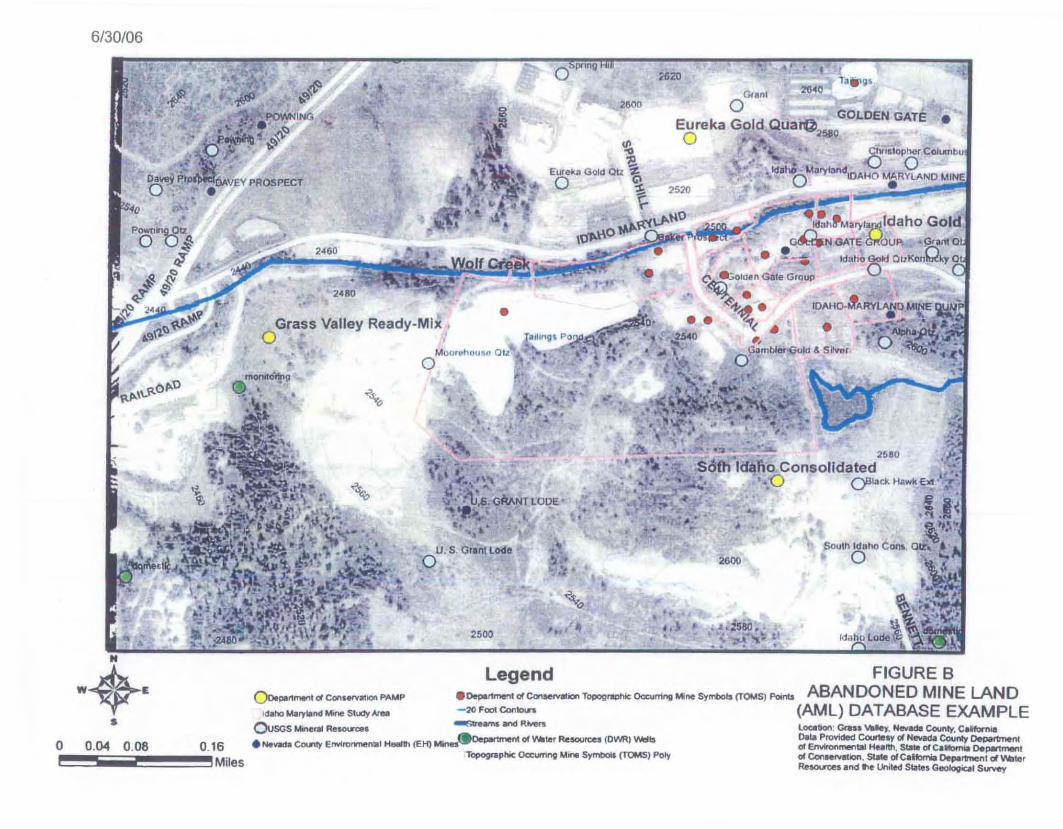
For this same location, DTSC applied the following GIS AML databases: 1) TopographicOccurring Mine Symbols (TOMS), California Department of Conservation; 2) PrincipleAreas of Mine Pollution (PAMP), California Department of Conservation; 3) EnvironmentalHealth Mines (EH Mines), Nevada County Environmental Health Department ; and 4)Mineral Resources, U.S. Geological Survey. DTSC also applied 1) County assessor parcelmaps, Nevada County Environmental Health Department; 2) Population density maps forCalifornia, U.S. EPA; and 3) High resolution aerial photographs. This information isdisplayed on the following figures.
Figure B, titled "AML Database Example", includes information displaying the approximatelocation of mining features in the study area from the TOMS, PAMP, EH Mines, and MineralResources databases; and the approximate location of selected Department of WaterResources domestic water and monitoring wells overlain on a high resolution aerialphotograph base map with topographic features. Figure C, titled "Aerial PhotographyExample" displays aerial photography of the study area. Figure D, titled "Zoning Map

6/30/06
Example" displays zoning information for the study area. Figure E, titled "Population DensityExample" includes population density information for the study area. The analysis of thesefigures reveals the following findings.
Figure B - AML Site Discovery Example
The plot of AML databases reveals approximately a dozen AML features including minenames (EH Mines, PAMP, and Mineral Resources), and related mining structures (TOMS)in the proximity of the study area. The Idaho Maryland Mine is plotted in the northeastportion of the study area. Notably, the Idaho Maryland Mine site is plotted in severallocations depending on the source of the database. This is due in part to the "projection"that different databases use and that the representative features identified in the AMLdatabases are not necessarily initially located with great accuracy. Additional mines,including the Idaho Gold, Gambler Gold and Silver, Moorehouse Quartz, Eureka GoldQuartz, and the Golden Gate Group are also plotted in the study area as shown. AMLfeatures plotted from the TOMS database are concentrated in the vicinity of the IdahoMaryland Mine site and the northeast portion of the study area.
Notably, a tailings pond feature is shown in the western portion of the study area. (Thetailings pond is also a mapped feature on the U.S. Geological Survey 7.5 minute seriestopographic map, Grass Valley Quadrangle, California - Nevada). Wolf Creek traverses thestudy area approximately parallel to Idaho Maryland Road. Several domestic water wellsand monitoring wells are plotted in the study area as shown.
Figure C - Aerial Photography Example
The aerial photography reveals several areas having no to sparse vegetation in anotherwise vegetated area. The areas of interest appear "white" in the black and white aerialphotograph and are highlighted with a white border for identification. When considered inconjunction with other AML information, these non-vegetated features are suggestive ofpotential grading and/or other unnatural activities. Due to the proximity of mining featuresfrom the above AML databases, the highlighted areas of interest could likely be related tomining activities (e.g., mine waste rock, or mine tailings, as verified by the Idaho MarylandMine PAl.
Figure 0 - Zoning Map Example
The zoning map for this area reveals that the area of interest is zoned as BP - BusinessPark.
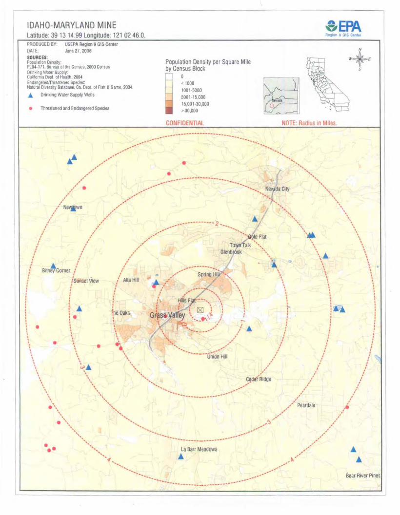
Figure D -Population Density Example
Figure 0 is from the Idaho Maryland Mine PA June 2002 and displays the populationdensity, location of municipal water wells, and threatened and endangered species in thevicinity of the Idaho Maryland Mine. This figure reveals that areas north and west of the siteare more densely popuiated. The municipal water wells are located approximately two tofour miles northeast and southwest of the study area.

6/30/06
The population of the City of Grass Valley and sphere of influence for planning purposeswas approximately 15,220 in 1993 and is projected to be 22,695 by 2020.
Interpretation of Information
When interpreting the above information, the user should be aware that the location offeatures plotted from the AML databases are not necessarily representative of the exactlocation for a given AML feature. Additionally, the use of multipie AML databases may resultin the plotting of multiple AML features (e.g. mine name) in slightly different locations. Thisis due in part to the "projection" that different databases use and that the representativefeatures identified in the AML databases are not necessarily initially located with greataccuracy. This is evident, especially when using parcel maps as a GIS layer and when theparcels are small In area (e.g., an AML feature may plot outside the boundary of a givenparcel for which the feature is actually located). However, when used in conjunction highresolution aerial photography, the plotting of AML features in the general vicinity of interestcan be of great value in identifying potential AML sites requiring further evaluation.
Other GIS databases providing information on zoning, population density, location of waterwells and surface waters can provide valuable information in terms assessing pathways forpotential AML contaminants associated with mine tailings, tailings ponds, and mine wasterock. As with any investigation, once an AML site is identified in an area of interest, a sitevisit should be conducted to verify AML features in the field. A hand held Global PositioningSystem (GPS) instrument is an ideal tool for this purpose.
For this study area it is apparent that due to the high density of mining features; presence ofsurface water (e.g., Wolf Creek); domestic water wells within 0.3 miles and municipal waterwells within two miles of the study area; close proximity to populated areas; close proximityof ongoing development; and interpretation of aerial photography (e.g., apparent minewaste features), further assessment would be recommended. Specifically, these minewastes features and associated contaminants (e.g., arsenic, lead, and mercury which aretypically associated gold lode mining) may be sources of contamination that can migrate tohuman receptors via air, groundwater, and surface water and sediment pathways andmigrate to biological receptors via air, surface water, and sediment pathways. Both humanand biological receptors may be exposed via inhalation of dust, ingestion water andsoil/sediments, and via direct contact with water, soil/sediments.
Conclusion and Future Work
Based on the application of the AML Site Discovery Process, the Idaho Maryland Mine is anAML site that requires further assessment (e.g., the Idaho Maryland Mine PA recommendsa SI). In general, AML sites having the characteristics discussed in this example are goodcandidates for preparing a Pre-CERCLIS Screening Assessment ChecklisUDecision Formand follow-up documentation in a Site Discovery Report.
Following U.S. EPA's approval of the draft AML Site Discovery Process, DTSC proposes toapply the final AML site Discovery Process to the communities of Grass Valley and NevadaCity, California under a future U.S. EPA Preliminary Assessment/Site InspectionCooperative Agreement and prepare a Site Discovery Report which focuses on AML sites.

!2:weo(J)
r,:1~
"
lH~')
P6,j II - Je t
liS 10
iii:
•,. 6Jl.".. J" t.,10 CJI:)
I':;;,
,.""
~aAO
- "
..a~ IJ '
@
crcJo,o,·(22)- +.!y',1mk.~"l
'"I~.
"
~
2W~.=
Af .... :_ t t! St".. J~
,":z 2Q:) '
O ' -=:;,......
WI9"f;.c .
IDAHO - \,lARYV-HO
." 1/4 CO,S." IS
AI~'·""4. 'e u:«... Q ~Id. l. J l.n -
~~
" 66\~. ~~ 4'Jt"",,=. p~~.. ," ,0.\ (( ~_:II "-. \ \:\:~ /~·i,..~ II
'll:"ooa
@1 -1
& M.
ItS 11-"
67\471lc
"\AfP'",.,,;_iz. l ;...~J.--;"of f. - :.;'1 r..,I,.,J
'.'-J''' 1' - 11
~
@
........'.
'1~ 12- 01
c;::..
p""If 01 -5.50-3?
liS ' 0 -26_
-fN
•
@!§ OBAc
PTN. N. 1/ 2 SEC. 26, T. 16 N., R. 8
"U"T1.., _.1I)l.Q:: 1:3 iil5 'l>.,-<l>IIIIIIII)IIIIII3II):;,-c:.,::To:!:.,-<.,:;,a.:!:5'II)
•
•1a ilfgs.
26<0
lOCItton: era.. ~Iey, Nev~County, CeKQrn..o.taProvided Coul1tly d Hevaet. County OeoartmentfA EnvIronmental Health, Sblle fA Calfomll Depwtn'*11d ConHN8Ion. State d Caitl::ltriaDePlF1'nenl d WlllterReSOU"OeS and I'I~ UnitedStates~icll SUl"¥'l!'y
5!.W15'OP"'-'f Cewumbu''U 0
• tefilho'~ MorybndtOAHo MARYLAND MINE.' ., 0 • .I
•
.r:Eureka Gold Quar@ GOLDEN GATEo . 2~O
25:10
2600
..• •
• , !•
;00
•••·'d3"fM. ry 'apl,ldaho GoldvAN GATEG.(OU" - G<0llI Q
o. • 'Q, • - _- . tdaho Gold OIlKcn " "-y 0'
C': ~ld.n G ate Group 0~ . . .
"'''I-~ • IDAHQ.M'ARY~D M~E ~;,.. ~( . . . ._~ . ' .....un • • . , ,", _-D1i. •~ " , ' • O .-~..,,:( \A ..
.. j " Gantl~-Gold & Sltvar .~ ;0, O· . ,
;620
.. : .•
•
2600
..
.-
'..
err:
'\ ." I" v',, .
•
Legend
2500
,.', ..~.,
-, i'. ,(_ \, f\~ ' :.10 ' •.. .' : U,6;GMNT LODE!"L ; .-r ' ., ,
•"
• •
-,.
u . s . Grlnt Lodeo
Mou rtoflow'w a tio
..~o
2,60
•
oGrass Valley Ready-Mix .,
, "!."FIGURE B
()oe..nmenldColO P....P . 0000""*" d eon_ ionT...._O=om"" ..... S'_Is (TOMS)""''''' ABANDONED MINE LAND,..... ..." s •..".""'" - :IO f "" eon.... (AML) DATABASE EXAMPLE
OJsos~Re~ ~ams~ RMen
• ......,.,a CDIIItY Erwtrormenlal H_1l (E li) Mina.Oe~ of ....ler Rt!SOUFCeI (D'hf{) 'II\lelts
Tcpogtaphlc 0C:cumn9 Mn SyM:lol& (TOMS) Pot)'
moooo'Tg
# "'~.,' . \Iit" .
... ~) .r::ovtN-ING
.p.~ '! ~...<>~ bo"?
./'-
ll...>Pr,0'"
lU'\\..\l.Ol'O
'0
Pown~"'!l.o U~~....,
.'1 .f $''t' ...~
.....,.· 2'~~~~'IO •
..~(l.~ •
•
6/30106
"".) '....- ",.t. -... I.k.. or 1 t ' . e~ - .... ,. -""/'" .. . . -6- ·· ..·'
a 0.04 0.08 0.16i 'Miles

6/30106
I''' g~ I 0 1 I
h-" . t T ~ , ...~" \.1,,1(,/' · 1.1 I,,,,.l,,. . (J ..... t .' tr1 l r' _ (I ,,~,\Q' tr t"nr'<"'rlr-o::USCS Grass Valley. CalUorn ,a , United State. Ib Aug 19'1l!
l'~'-~--~-~' 1u(.,M
Irnil<;J(, lowte<;y of n it' Ll ~ . ( 1" O IOQ JLrl l Surve~
t ) tln J ~-1 11 H ' ...II 't (Cl' I'O","' I{,1l Terms o( Use Privacy Statement
Figure CAerial Photography Example

~NORTH
M1
RA-'3--.--1
T~ ProdudlOfIZ- {TPZj
LC)M~ Rl~A'DR
I I M·l
'---""'"
Nevada County Zoning
~
.--
RA-3-PD
..
.r~ G'UI v..... (GRASS VALLEY).rod Ne".e. C«y (N£VA[)A CITY)
. ...
I I I r AQneuIl'" bdu_IAEJ ~ FOfftllfRI Q Sonele-f..-.l1 R• ...,\Ial (All
~ GII,...ral Agncullur.' lAG) L:? lnlllnm o.""~l'IlR'MNe (IDR) rrfi! M.....m o.n'"tR",cMnllAllR21
C ""_u P.'" (BPI ~ UghllnckllU_ il,U) ~ HIgh o.n""Y R.soa.nNl rR3)
I Neogl\bclrtloOd~ (e1, Q OffQ & ProlenCll\tlIOPI Q R.t/deflUJ AgnculMal (RAJ
~ Co_ntly Co!Trne~1aliC2) ~ Open Sp.ee (OS) ~ R.tr..bOfl (REe)
~Hoghwwy Co........eral ICH) Q~(P)
.t
. -.
".Ii.. _
GR~SS VALLEY
~" GT':"~~~ ~ '~,
Ml
Appro ximate scale in miles
o 1/2 1, ! t
\
,,
N"Tl "\o - , \::::ICC_.c:::::I ..
CC Cll
3:0Dl
't:lm)(Dl3't:lCD
]~Uil""" f';, I
~~l . \!~k ' , ,
,>. , I; GR~~ VI\l!bE;t'1
R'l~'VP,: ", ., ,'.. ~, .
, .
IDAHO-MARYLAND MINELatitude: 391314.99 Longitude: 121 0246.0,
& EPARegion {I GIS Cerrtllf
PROOUCEO BY: USEPA RtgiOO 9 GIS CenterDATE ..IJnt 21. 2006SOURCES:Populati on DenSity:Pl~-17 1 , Bureau 01 the census. 2000 C8I1susOrinklnq Water Supply.Dalrtomia Dept. 01 Health, 2004EndangeredlTnreatendd Species.:Natural o.verSlty Database . Ca. Dept. 01f Ish & Game. 2004
... Onnking Water Supply Wells
• Threatened and Endangered Species
Population Densityper SquareMileby CensusBlock
o< 1000100 1-5000SlI01 ·15,ooO15,001-30,000> 30.000
N
E
s
••
CONFIDENTIAL NOTE: Radius In Miles.
••
•••
,,,,,,,,,,,,,~&
,,
\'"''-,
-.-,,., .<,
....... ........"-.... .......... .._-_ ...... --
La Barr MeaOows&
Bear River Pmes