Embed Size (px)
Citation preview
Appendix KFlooding and Drainage
Kellyville Station Precinct

KELLYVILLE STATION PRECINCT FLOODING AND DRAINAGE PRECINCT PLANNING

Kellyville Station Precinct—Flooding and Drainage Revision 1
Hyder Consulting Pty Ltd-ABN 76 104 485 289
f:\aa007617\f-reports\kellyville\rev1\aa007617-001 kv flooding rev1.docx
Hyder Consulting Pty Ltd
ABN 76 104 485 289
Level 5, 141 Walker Street Locked Bag 6503 North Sydney NSW 2060 Australia
Tel: +61 2 8907 9000
Fax: +61 2 8907 9001
www.hyderconsulting.com
DEPARTMENT OF PLANNING & ENVIRONMENT
KELLYVILLE STATION PRECINCT
Flooding and Drainage
Precinct Planning
Author David Stone
Checker Bruce Caldwell
Approver Greg Ives
Report No AA007617-001
Date 14 August 2015
Revision 1
This report has been prepared for Department of Planning &
Environment in accordance with the terms and conditions of
appointment for Kellyville Station Precinct dated 14 July
2014. Hyder Consulting Pty Ltd (ABN 76 104 485 289)
cannot accept any responsibility for any use of or reliance
on the contents of this report by any third party.

Kellyville Station Precinct—Flooding and Drainage Revision 1
Hyder Consulting Pty Ltd-ABN 76 104 485 289 Page i
f:\aa007617\f-reports\kellyville\rev1\aa007617-001 kv flooding rev1.docx
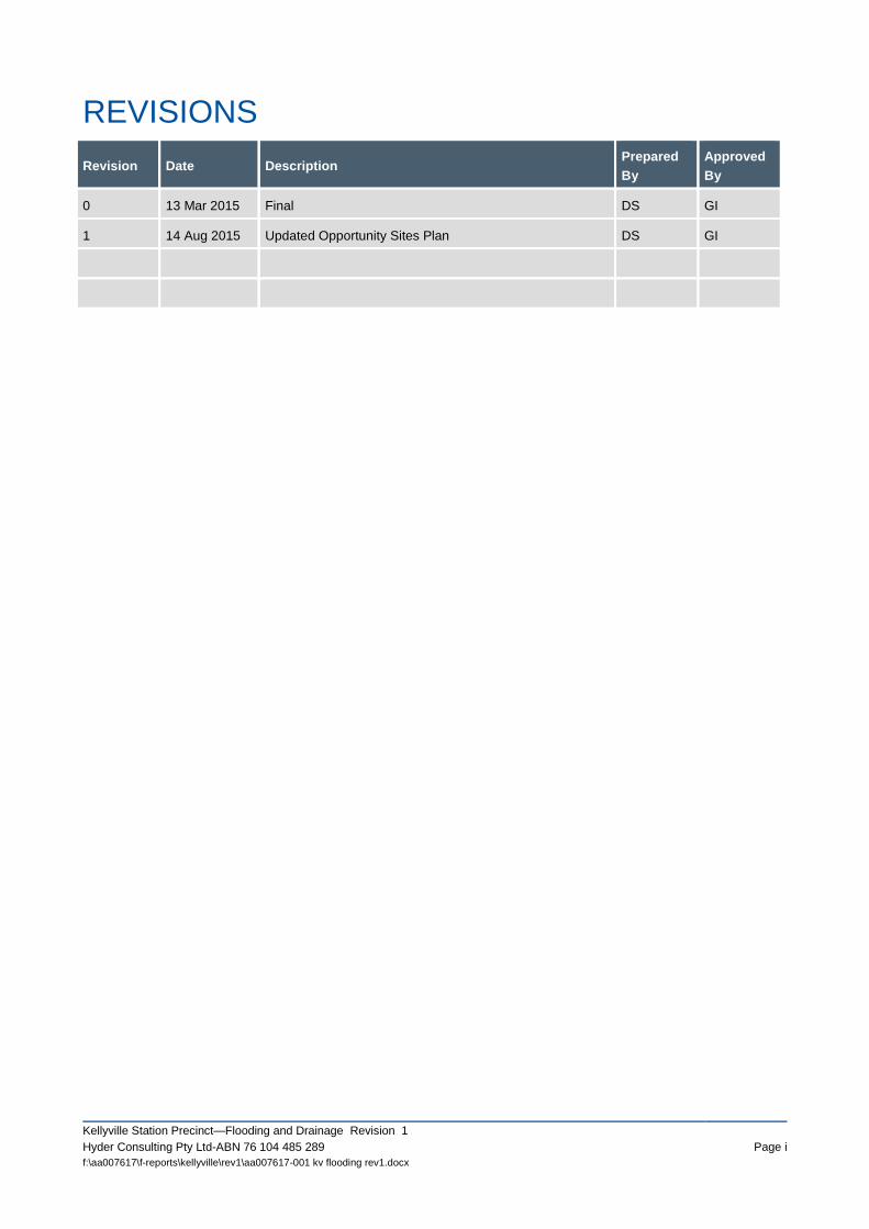
REVISIONS
Revision Date Description Prepared
By
Approved
By
0 13 Mar 2015 Final DS GI
1 14 Aug 2015 Updated Opportunity Sites Plan DS GI

Kellyville Station Precinct—Flooding and Drainage Revision 1
Hyder Consulting Pty Ltd-ABN 76 104 485 289 Page i
f:\aa007617\f-reports\kellyville\rev1\aa007617-001 kv flooding rev1.docx
CONTENTS
EXECUTIVE SUMMARY ......................................................................................................................... 1
1 Introduction .................................................................................................................................... 2
1.1 Opportunity Sites ............................................................................................................................... 2
2 Data Collection .............................................................................................................................. 3
2.1 Rouse Hill Flood Study ...................................................................................................................... 3
2.2 NWRL EIS 2 ...................................................................................................................................... 4
3 Flooding ......................................................................................................................................... 5
3.1 Adequacy of Information .................................................................................................................... 5
3.2 Flood Planning Levels ....................................................................................................................... 6
4 Development Controls ................................................................................................................... 7
4.1 The Hills DCP 2012 ........................................................................................................................... 7
4.2 Recommended Controls .................................................................................................................... 7
5 Conclusion ..................................................................................................................................... 8
APPENDICES
Appendix 1
Appendix 2
Opportunity Sites
Rouse Hill Flood Study Extracts

Kellyville Station Precinct—Flooding and Drainage Revision 1
Hyder Consulting Pty Ltd-ABN 76 104 485 289 Page 1
f:\aa007617\f-reports\kellyville\rev1\aa007617-001 kv flooding rev1.docx
EXECUTIVE SUMMARY
This report has been prepared by Hyder Consulting (Hyder) and provides an assessment of flooding and
drainage relating to the proposed rezoning of the Kellyville Station Precinct. Opportunity sites for the
Kellyville Station Precinct (refer Appendix 1) have been identified based on an overall opportunity and
constraints analysis by the urban designers in collaboration with the precinct planning team. It is primarily
with respect to flooding and stormwater related to rezoning for these opportunity sites that this report
provides assessment.
Data Collection and Review
The Rouse Hill Flood Study (RHFS)(WMAwater, 2014) provides the most recent and comprehensive
information on flood behaviour in the Kellyville Station Precinct. The study included design flood estimates
for storm events ranging from the 2 year to 100 year ARI and also included sensitivity analysis in relation to
blockage criteria and rainfall intensities. It is noted that the Rouse Hill Flood study does not include modelling
of the Probable Maximum Flood (PMF) event.
While the RHFS flood study provides flood information it is within the context of regional assessments. Hyder
recommends that the RHFS modelling and results be reviewed in detail for the purpose of determining the
extent of re-modelling necessary.
Recommendations
It is recommended that:
Flood Planning Levels (FPLs) for the Kellyville Station Precinct be derived from flood levels included in
the Rouse Hill Flood Study, subject to a detailed review of the flood study models and necessary
refinements.
Development controls for stormwater management and flooding be generally consistent with The Hills
DCP 2012. In addition, floodplain management should comply with ‘Floodplain Development Manual
the management of flood liable land’ (NSW Government, April 2005) and stormwater drainage design
should be in accordance with Council guidelines and Australian Rainfall and Runoff (Institution of
Engineers Australia, 1987, noting current updates).
Water sensitive urban design pollution reduction targets be consistent with those applied to the North
West Growth Centres.
Conclusion
Hyder has identified:
available flooding information and recommended analysis and review processes necessary before
application of such flood information to the opportunity sites (report Section 3.1).
development controls applicable to the rezoning and development of the Kellyville Station Precinct
(report Section 4.2) .
the next steps in assessing of flooding and drainage related to the proposed rezoning of the Kellyville Station Precinct opportunity sites A, B, C and D as:
- conducting the flood model review and associated assessment refinements discussed in report Section 3.1;
- producing a development layout plan and documentation that demonstrates how compliance with
the floodplain management policies and guidelines, and the meeting of pollution reduction targets,
(identified in report Section 4.1), would be facilitated.
Kellyville Station Precinct—Flooding and Drainage Revision 1
Page 2 Hyder Consulting Pty Ltd- ABN 76 104 485 289
f:\aa007617\f-reports\kellyville\rev1\aa007617-001 kv flooding rev1.docx
1 INTRODUCTION
This report has been prepared by Hyder Consulting (Hyder) and provides an assessment of
flooding and drainage relating to the proposed rezoning of the Kellyville Station Precinct.
The Kellyville Station Precinct was announced by the NSW Government in August 2014. The
precinct is one of number of ‘Priority Precincts’ which aim to provide for more homes, jobs and
improved public spaces close to transport and services. One of the key goals for Priority
Precincts is to increase housing choice and affordability by delivering increased housing supply
in an environmentally, socially and economically sustainable manner.
The Kellyville Station Precinct covers approximately 437 hectares, and includes the area within
an 800 metre radius, or roughly a 10 minute walk, of the new Kellyville Station. The boundary
has also taken into account the surrounding road network, natural features, and the
development pattern of the area.
The precinct covers two local government areas. Land on the eastern side of Old Windsor Road
is located within the Hills Local Government Area, and land on the western side of Old Windsor
Road is within the Blacktown Local Government Area.
The vision for the Kellyville Station Precinct is for a vibrant, predominantly residential area
offering a mix of housing types within walking distance of the new station, along with local
shops, community facilities, and improved open space network.
The Kellyville Station Precinct is a long term project that will be delivered over the next 25 years.
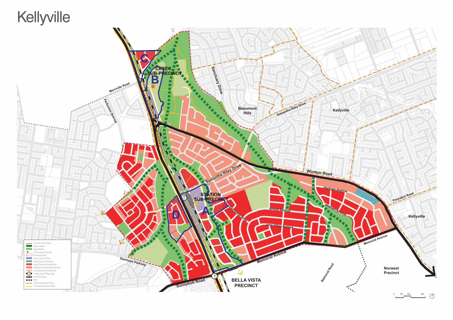
1.1 OPPORTUNITY SITES
Opportunity sites for the Kellyville Station Precinct (refer Appendix 1) have been identified
based on an overall opportunity and constraints analysis by the urban designers in collaboration
with the precinct planning team. It is primarily with respect to flooding and stormwater related to
rezoning for these opportunity sites that this report provides assessment.
Kellyville Station Precinct—Flooding and Drainage Revision 1
Hyder Consulting Pty Ltd-ABN 76 104 485 289 Page 3
f:\aa007617\f-reports\kellyville\rev1\aa007617-001 kv flooding rev1.docx
2 DATA COLLECTION
The Kellyville Station Precinct is located within the Rouse Hill Development Area (RHDA). The
RHDA is defined by Sydney Regional Environmental Plan No. 19 – Rouse Hill Development
Area. Sydney Water is the designated Trunk Drainage Authority (TDA) and is responsible for
the management of Trunk Drainage Land (TDL) within the RHDA. The TDL is generally defined
as land within the 100 year Average Recurrence Interval (ARI) flood extents.
Flood extents within the RHDA were originally based on a study by GHD in 1998 and
subsequently refined as part of the study Rouse Hill Integrated Stormwater Strategy Review
(SKM, 2007). Sydney Water commissioned the Rouse Hill Flood Study (WMAwater, 2014) to
assist in further updating the TDL extents within the RHDA. The Rouse Hill Flood Study
(WMAwater, 2014) provides the most recent and comprehensive information on flood behaviour
in the Kellyville Station Precinct.
Further to the Rouse Hill Flood Study, in discussions with Sydney Water it was noted that they
are currently undertaking a project to assess whether the TDL can be minimised along Elizabeth
Macarthur Creek in order to facilitate development in these areas.
Other flood studies have also been undertaken in the area, with the largest studies being to
inform the preparation of an Environmental Impact Assessment for the Sydney Metro Northwest
project (previously referred to as the North West Rail Link (NWRL)). While these studies provide
relevant information on flood behaviour within the Kellyville Station Precinct, the studies were
prepared for different purposes and do not provide comprehensive information on flood
behaviour across the entire Kellyville Station Precinct
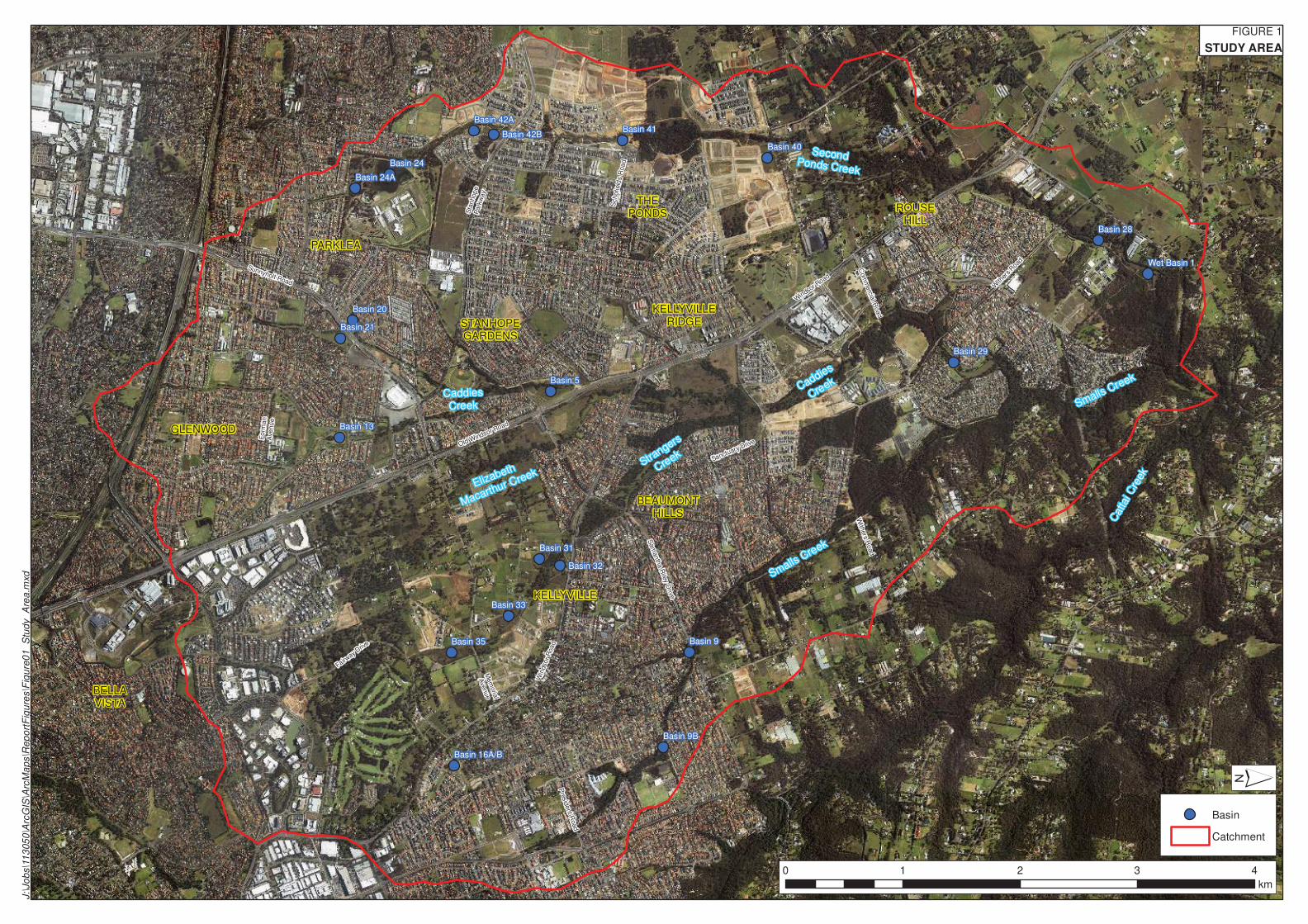
2.1 ROUSE HILL FLOOD STUDY
Sydney Water, as the designated Trunk Drainage Land Acquisition Authority, commissioned the
Rouse Hill Flood Study (WMAwater, April 2014) to assist in defining the TDL within the Rouse
Hill Development Area (RHDA). The catchment/study area is outlined in Appendix 2 and
includes the entire Kellyville Station Precinct.
The Rouse Hill Flood Study involved the development of hydrologic and hydraulic models. The
XP-RAFTS hydrologic model used for the study was based on a model originally developed by
GHD in 1998 and subsequently updated by SKM in 2007. The SKM model was refined by
WMAwater to reflect current information on ultimate catchment development conditions.
A new hydraulic model was developed for the Rouse Hill Flood Study. TUFLOW was used to
develop a 1D/2D hydrodynamic model with a terrain surface based predominantly on LiDAR
and supplemented with information from Work As Executed drawings and detailed creek survey.
The study included design flood estimates for storm events ranging from the 2 year to 100 year
ARI and also included sensitivity analysis in relation to blockage criteria and rainfall intensities. It
is recommended in the report that blockage of individual structures should be considered further
when considering development controls and design of future structures.
It is noted that the Rouse Hill Flood study does not include modelling of the Probable Maximum
Flood (PMF) event. While the PMF is not typically used to derive Flood Planning Levels (FPLs),
it is often a key input into floodplain planning and, among other things, is used to determine
evacuation requirements for extreme flood events.
Kellyville Station Precinct—Flooding and Drainage Revision 1
Page 4 Hyder Consulting Pty Ltd- ABN 76 104 485 289
f:\aa007617\f-reports\kellyville\rev1\aa007617-001 kv flooding rev1.docx
2.2 NWRL EIS 2
The NWRL EIS 2, Technical Paper 7 (AECOM, 2012), was prepared to inform the NWRL EIS 2
(Stations, Rail Infrastructure & Systems). The flood modelling carried out for the NWRL project
was specifically for the purpose of defining flood behaviour in the vicinity of the NWRL corridor
and to address a number of particular requirements of the NWRL project, including the
assessment of:
existing and future development scenarios;
potential impacts due to climate change;
alternative design options/configurations;
quantification of flood behaviour in the PMF event to manage flood risk to critical
infrastructure.
Hydrologic models were developed using WBNM software. Hydraulic models were developed
using either HEC-RAS or TUFLOW software depending on the creek/floodplain characteristics.
Within the Kellyville Station Precinct the waterways were all modelled using TUFLOW.
Kellyville Station Precinct—Flooding and Drainage Revision 1
Hyder Consulting Pty Ltd-ABN 76 104 485 289 Page 5
f:\aa007617\f-reports\kellyville\rev1\aa007617-001 kv flooding rev1.docx
3 FLOODING
The Kellyville Station Precinct has three main creeks running through the Precinct, generally
from south to north. These are:
Caddies Creek;
Strangers Creek;
Elizabeth Macarthur Creek.
These creeks are tributaries of Cattai Creek, which in turn is a tributary of the Hawkesbury
River.
As part of the Rouse Hill Development Area (RHDA) flooding and stormwater management
strategy, a number of detention basins have been constructed along these creeks within the
Kellyville Station Precinct. As referenced in the Rouse Hill Flood Study (RHFS), these include
Basins 5, 31, 32 and 33 (refer Appendix 2). Basin 5 is online (Caddies Creek passes through
the basin) and is a prescribed dam under the Dams Safety Act 1978 (prescribed dams have
significant monitoring requirements to maintain safety). Basins 31, 32 and 33 are all offline from
Strangers Creek and are not prescribed. No basins were noted along Elizabeth Macarthur
Creek.
Flood behaviour in the creeks has been modelled as part of both the Rouse Hill Flood Study
and the NWRL EIS 2 study, both of which adopted similar modelling approaches. The Rouse
Hill Flood Study is considered the more appropriate information source to use for current
planning purposes due largely to the fact that the specific aims of the study were to define flood
levels and extents for planning purposes which is largely the same objective as the current
study. The NWRL EIS 2 study was developed specifically for the purpose of assessing flood risk
and potential impacts for the NWRL project which covers only part of the Precinct. The NWRL
EIS 2 study did not aim to assess flood behaviour across the Precinct as a whole and hence is
considered less suitable to use for precinct planning purposes.
3.1 ADEQUACY OF INFORMATION
The opportunity sites identified have been superimposed onto Figure 16 (Peak Flood Depths
and Level Contours, 1% AEP Event) of the RHFS (refer Appendix 2). As seen, Areas A, B, C
and D are all located adjacent to, or within, the creek corridors of Elizabeth Macarthur Creek
and Caddies Creek.
While the RHFS flood study (and the NWRL EIS 2 study) provides flood information, both are
within the context of regional assessments. To more adequately define flow regimes including
floodways, flood extents and depths for the opportunity sites, Hyder recommends that the RHFS
modelling and results be reviewed in detail and refined where necessary. In particular Hyder
notes (from the RHFS report) that necessary refinements may include:
discretising of sub-catchment areas;
improved/additional ground survey of overbank areas, the creek waterways, and waterway
structures;
refinement of the 5m grid size (to say 2m);
detention basin representation;
blockage assessments of waterway structures;
modelling of the underground drainage systems to facilitate assessment of local waterway
flooding (beyond the mainstream flooding);
Kellyville Station Precinct—Flooding and Drainage Revision 1
Page 6 Hyder Consulting Pty Ltd- ABN 76 104 485 289
f:\aa007617\f-reports\kellyville\rev1\aa007617-001 kv flooding rev1.docx
climate change impacts;
the PMF event.
Such refinements would be expected to involve floodplain model adjustments and running.
Depending on the scope of refinements (determined as necessary), it may be more expedient to
extract hydraulic parameters from the regional RHFS model, and generate a site focused
flooding and drainage model covering areas A, B, C and D.
Also, further consultation should be undertaken with Sydney Water to determine the current
status of any projects which may modify flood levels behaviour in TDL.
3.2 FLOOD PLANNING LEVELS
It is recommended that Flood Planning Levels (FPLs) for the Kellyville Station Precinct be
derived from flood levels included in the Rouse Hill Flood Study, subject to the review and
refinements discussed above. FPLs and development controls are discussed in the following
report Section 4.
Kellyville Station Precinct—Flooding and Drainage Revision 1
Hyder Consulting Pty Ltd-ABN 76 104 485 289 Page 7
f:\aa007617\f-reports\kellyville\rev1\aa007617-001 kv flooding rev1.docx
4 DEVELOPMENT CONTROLS
4.1 THE HILLS DCP 2012
The Hills Development Control Plan 2012 (The Hills DCP 2012), adopted by Council in March
2013, provides development controls that apply to the majority of land within The Hills Shire
LGA.
Part B includes controls that apply across the LGA to different development types. In general,
these require drainage systems to be designed in accordance with Council guidelines and
Australian Rainfall and Runoff (Institution of Engineers Australia, 1987). While there are some
requirements for Water Sensitive Urban Design (WSUD) to be implemented, the controls do not
include pollution reduction targets.
Part C, Section 6 (Flood Controlled Land) defines flood planning levels (FPLs) relative to
20 year ARI, 100 year ARI and PMF flood levels for different land uses. Habitable floor levels for
most land uses are required to be no lower than the 100 year ARI flood level plus 0.5 m
freeboard.
Part D includes site specific controls for a number of areas including the Balmoral Road
Release Area and the Kellyville Rouse Hill Release Area which fall partly within the boundaries
of the Kellyville Station Precinct. The site specific controls for stormwater management differ
between the Balmoral Road and Kellyville Rouse Hill Release Areas, however the key controls
are generally consistent, including:
Minor drainage systems are required to capture and convey the 10 year ARI design storm.
Owners of properties adjoining TDL are required to contact Council/Sydney Water to
confirm the 100 year ARI flood levels and extents.
Discharge to or construction within TDL will require approval of Sydney Water
All residential, employment and commercial developments will be required to provide
rainwater tanks
No on-site detention (OSD) is required as part of any development within the RHDA as this has
been provided by Sydney Water at a regional level. However, consideration still needs to be
given to the potential impact of development on any existing or proposed local drainage
systems and OSD may be appropriate in some instances.
4.2 RECOMMENDED CONTROLS
It is recommended that controls for stormwater management and flooding be generally
consistent with The Hills DCP 2012. However, also complying with the NSW ‘Floodplain
Development Manual the management of flood liable land’ (April 2005), and following Council
guidelines and Australian Rainfall and Runoff (Institution of Engineers Australia, 1987, noting
current updates) with respect to drainage design.
In addition to these ‘water quantity’ controls, current best practice for water sensitive urban
design (WSUD) in Sydney goes beyond such requirements. Current best practice requirements
for WSUD include demonstrating compliance with pollution reduction targets. Consistent with
targets applied to the North West Growth Centres, it is recommended that pollution reduction
targets, relative to post-development loads without treatment, be applied and include:
85% Total Suspended Solids;
65% Total Phosphorus;
45% Total Nitrogen;
90% Gross Pollutants.
Kellyville Station Precinct—Flooding and Drainage Revision 1
Page 8 Hyder Consulting Pty Ltd- ABN 76 104 485 289
f:\aa007617\f-reports\kellyville\rev1\aa007617-001 kv flooding rev1.docx
5 CONCLUSION
Hyder has:
identified available flooding information and recommended analysis and review processes
necessary (in report Section 3) before application of such regional flood information to the
opportunity sites; and
listed flooding and stormwater management and development controls applicable to the
rezoning and development of the Kellyville Station Precinct.
The next steps in assessing of flooding and drainage related to the proposed rezoning of the
Kellyville Station Precinct opportunity sites A, B, C and D, should involve:
conducting the flood review and associated assessment refinements, discussed in report
Section 3.1);
producing a development layout plan and documentation that demonstrates how
compliance with the floodplain management policies and guidelines, and the meeting of
pollution reduction targets, identified in report Section 4.1, would be facilitated.

Kellyville Station Precinct—Flooding and Drainage Revision 1
Hyder Consulting Pty Ltd-ABN 76 104 485 289 Page 9
f:\aa007617\f-reports\kellyville\rev1\aa007617-001 kv flooding rev1.docx
APPENDIX 1
OPPORTUNITY SITES
Newbury
Old W
indsor Road
Windsor Road
Samantha Riley Drive
Memorial Avenue
Sunnyholt Road BELLA VISTAPRECINCT
NorwestPrecinct
BeaumontHills
Kellyville
Sanctuary Drive
Kellyville
John Hillas Avenue
Arnold Avenue
Gorman Avenue
Hartigan Avenue
Gainsford Drive
Merriville Road
Perfection Avenue
Stanhope Parkway
President Road
Balm
oral
Roa
d
Samantha Riley Drive
Memorial Avenue
CREEKSUB-PRECINCT
STATIONSUB-PRECINCT
T
T
T
Kellyville
C
B
D A
Precinct Boundary Open Space
Community Facility Heritage Item New Local Centre Existing Local Centre High Density Residential Medium Density Residential Low Density Residential
T T-Way and T-Way Stop Primary Road Rail Existing Bicycle Paths Proposed Bicycle Paths
0 200100 400
Kellyville Station Precinct—Flooding and Drainage Revision 1
Hyder Consulting Pty Ltd-ABN 76 104 485 289 Page 11
f:\aa007617\f-reports\kellyville\rev1\aa007617-001 kv flooding rev1.docx
APPENDIX 2
ROUSE HILL FLOOD STUDY EXTRACTS
Mem
oria
l
Ave
nue
Sta
nhop
eP
ark
wa
y
Schofield
s R
oa
d
Fo
rma
nA
ve
nu
e
Com
merc
ial R
oad
Pre
sid
ent R
oad
Sam
anth
a R
iley D
rive
Sunnyholt Road
With
ers R
oad
Sanctuary DriveOld Windsor R
oad
Fairway
Drive
With
ers Roa
d
Win
dsor R
oad
Win
dsor
Road
Caddies
Creek
Elizabeth
Macarthur Creek
Strangers
Creek
Caddies
Creek Smalls Creek
Smalls C
reek
Catta
i Cre
ek
SecondPonds Creek
GLENWOOD
PARKLEA
KELLYVILLE
BEAUMONTHILLS
BELLAVISTA
STANHOPEGARDENS
THEPONDS
KELLYVILLERIDGE
ROUSEHILL
Basin 13
Basin 21
Basin 20
Basin 24
Basin 24A
Basin 42A
Basin 42BBasin 41
Basin 40
Basin 29
Basin 28
Wet Basin 1
Basin 5
Basin 9B
Basin 9
Basin 16A/B
Basin 35
Basin 33
Basin 31
Basin 32
FIGURE 1
STUDY AREA
0 1 2 3 4
km
´
Basin
Catchment
J:\
Jo
bs\1
13
05
0\A
rcG
IS\A
rcM
ap
s\R
ep
ort
Fig
ure
s\F
igu
re0
1_
Stu
dy_
Are
a.m
xd

Mem
oria
l
Ave
nue
Sta
nhope
Park
way
Schofield
s R
oad
Form
an
Avenue
Com
merc
ial R
oad
Pre
sid
ent R
oad
Sam
anth
a R
iley D
rive
Sunnyholt Road
With
ers R
oad
Sanctuary DriveOld Windsor R
oad
Fairway Drive
With
ers
Roa
d
Windsor R
oad
Win
dsor R
oad
Caddies
Creek
Elizabeth
Macarthur Creek
Strangers
Creek
Caddies
Creek
Smalls Creek
Smalls C
reek
Cattai C
reek
Second Ponds Creek
GLENWOOD
PARKLEA
KELLYVILLE
BEAUMONTHILLS
BELLAVISTA
STANHOPEGARDENS
THEPONDS
KELLYVILLERIDGE
ROUSEHILL
Basin 13
Basin 21
Basin 20
Basin 24
Basin 24A
Basin 42A Basin 42BBasin 41
Basin 40
Basin 29
Basin 28
Wet Basin 1
Basin 5
Basin 9B
Basin 9
Basin 16A/B
Basin 35
Basin 33
Basin 31
Basin 32
70
55
60
60
70
60
55
40
60
60
40
55 45
40
45
55
60
55
55
5065
65
55
60
65
65
75
45
75
65
60
60
65
55
65
70
70
65
80
55
80
45
70
70
50
50
70
35
65
35
45
60
70
85
35
55
50
60
40
60
40
40
50
30
60
55
45
50
35
45 4
0
65
30
50
40
65
60
45
65
60
50
50
55
40
70
45
50
65
70
45
35
50
55
45
55
70
75
45
35
45
60
FIGURE 16
PEAK FLOOD DEPTHS AND LEVEL CONTOURS
1% AEP EVENT
0 1 2 3 4
km
´
Peak Water Level (m AHD)
Major Contours (5m interval)
Minor Contours (1m interval)
Basin
Catchment
Depth (m)
< 0.10
0.10 to 0.25
0.25 to 0.50
0.50 to 1.00
1.00 to 5.00
> 5.00
J:\Jobs\113050\ArcGIS\ArcMaps\ReportFigures\Figure16_Peak_Flood_Depths_and_Level_Contours_1%AEP_Event.mxd