Embed Size (px)
Citation preview
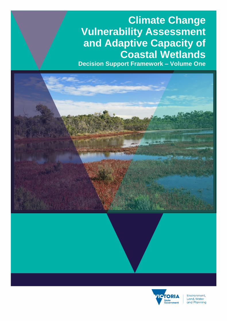
Climate Change Vulnerability Assessment and Adaptive Capacity of
Coastal Wetlands Decision Support Framework ndash Volume One
Acknowledgements
The authors would like to thank the Steering Committee who oversaw the work of
this project and provided valuable input Mark Rodrique Parks Victoria Rex
Candy East Gippsland Catchment Management Authority Eleisha Keogh and
Matt Khoury West Gippsland Catchment Management Authority Andrew
Morrison Port Phillip and Westernport Catchment Management Authority Donna
Smithyman Corangamite Catchment Management Authority Jacinta Hendricks
Glenelg Hopkins Catchment Management Authority Andrea White and Janet
Holmes DELWP Andrea White provided comments on the draft and final reports
Authors
Heard S Treadwell S and Boon P
Citation
Department of Environment Land Water and Planning (2016) Climate change
vulnerability and adaptive capacity of coastal wetlands Decision Support
Framework ndash Volume 1 Department of Environment Land Water and Planning
East Melbourne Victoria
Photo credit
Tim Allen
copy The State of Victoria Department of Environment Land Water and Planning 2016
This work is licensed under a Creative Commons Attribution 40 International licence You are free to re-use the work under that licence on the condition that you credit the State of Victoria as author The licence does not apply to any images photographs or branding including the Victorian Coat of Arms the Victorian Government logo and the Department of Environment Land Water and Planning (DELWP) logo To view a copy of this licence visit httpcreativecommonsorglicensesby40
ISBN 978-1-76047-426-3 (pdfonline)
Disclaimer
This publication may be of assistance to you but the State of Victoria and its employees do not guarantee that the publication is without flaw of any kind or is wholly appropriate for your particular purposes and therefore disclaims all liability for any error loss or other consequence which may arise from you relying on any information in this publication
Report produced by
Jacobs Group Australia
Level 11 452 Flinders Street Melbourne VIC 3000
Web wwwjacobscom
Jacobs Limitation This report has been prepared on behalf of and for the exclusive use of Jacobsrsquo Client and is subject to and issued in connection with the provisions of the agreement between Jacobs and its Client Jacobs accepts no liability or responsibility whatsoever for or in respect of any use of or reliance upon this report by any third party
Accessibility
If you would like to receive this publication in an alternative format please telephone the
DELWP Customer Service Centre on 136186 email customerservicedelwpvicgovau
or via the National Relay Service on 133 677 wwwrelayservicecomau This document is
also available on the internet at wwwdelwpvicgovau
Climate Change Vulnerability Assessment and Adaptive Capacity of Coastal Wetlands
Decision Support Framework ndash Volume One
1
Executive Summary 2
1 Introduction 4
11 Background 4
12 Project objectives 5
13 Volume One Report 5
2 Vulnerability Assessment Framework and Decision Support Framework 7
21 Overview of vulnerability assessment framework 7
22 Decision Support Framework 8
221 What is the Decision Support Framework Meant to do 8
222 Approach to developing the Decision Support Framework 9
3 Decision Support Framework user guide 10
31 Step 1 ndash How to identify your wetland type 10
32 Step 2 ndash How to determine the potential impacts from climate change on your wetland 11
33 Step 3 ndash What are your management objective and actions for the site 14
4 Case study application 18
5 References 19
Appendix A Sensitivity tables 20
Appendix B Adaptive capacity of wetland types 21
Appendix C Decision Support Framework template 22
Appendix D Decision Support Framework case study applicationhelliphelliphelliphelliphelliphelliphelliphelliphelliphellip30
Contents
2 Climate Change Vulnerability Assessment and Adaptive Capacity of Coastal Wetlands
Decision Support Framework ndash Volume One
This report presents a Decision Support Framework (DSF) to assess the vulnerability and adaptive capacity of coastal wetlands in Victoria to the impacts of climate change
The report also provides guidance on management objectives and actions for those coastal wetland systems
likely to be affected by climate change The project was commissioned by the Victorian Governmentrsquos
Department of Environment Land Water and Planning (DELWP) and was undertaken by Jacobs Group
(Australia) Pty Ltd (Jacobs) and Dodo Environmental (Professor Paul Boon)
The Victorian Government has invested in climate change vulnerability projects in order to facilitate an
adaptive management approach for ecosystems under climate change and inform Victorian water resource
policy Understanding the vulnerability and adaptive capacity of wetlands based on future conditions helps
guide investment and predict longer term viability of management Projects that have been undertaken in
Victoria include the Governmentrsquos Future Coasts Program which aimed to better understand and plan for the
risks associated with sea level rise and storm surge for coastal wetlands in Victoria The Victorian Coastal
Inundation dataset and Victorian Coastal Hazard Guide were developed as part of this work and provide
mapping and guidance about the potential risks from sea level rise along the Victoria coastline An indicative
assessment of climate change vulnerability for wetlands in Victoria (SKM 2013) was also undertaken with a
particular emphasis on understanding likely changes in hydrological regimes and the regional distribution of
these changes across Victoria This project will build on these previous projects with a focus on coastal
wetlands systems in Victoria and their vulnerability and adaptive capacity to the impacts of climate change
The high level objectives of this project are to
1 identify the different types of coastal wetlands in Victoria
2 assess the level of exposure and sensitivity of these wetlands to the impacts of climate change and
thereby estimate the level of potential impact
3 identify how wetland processes components and values are likely to be affected
4 provide guidance on potential management responses through the development of a DSF
It is intended that project outputs will be used by DELWP and Victorian wetland managers to better
understand the vulnerability and adaptive capacity of a coastal wetland systems in the State and to help
guide investment and predict longer term viability of management actions A high priority for the project was
therefore to develop a framework and methods that do not require users to have detailed climate change
vulnerability and adaptive capacity expertise
The report is presented in two volumes this volume (Volume One) presents the framework and methods for
assessing the vulnerability and adaptive capacity of coastal wetland in Victoria and guidance on potential
management objectives and actions that could be adopted for those coastal wetland systems likely to be
affected by climate change This volume also provides a case study application of the framework for a
selected Victorian coastal wetland The second volume presents supporting technical information required to
apply the framework and describes the logic and assumptions behind each of the considerations
underpinning the DSF
Executive Summary
Climate Change Vulnerability Assessment and Adaptive Capacity of Coastal Wetlands
Decision Support Framework ndash Volume One
3
The broad approach applied is shown below The DSF is a three step approach that is closely aligned with
the project objectives
Step 1 Wetland type ndash identification of wetland type (eg mangrove saltmarsh) using a
combination of the coastal wetland dataset developed as part of this project and existing knowledge
of the site This step guides the sensitivity assessment undertaken in Step 2
Step 2 Assess potential impacts from climate change ndash based on the position of the wetland in
the landscape identification of which component of climate change the wetland is sensitive to This
step involves undertaking the exposure and sensitivity components of the vulnerability assessment
outline above using a combination of the exposure mapping conceptual models and sensitivity
tables provided in the Volume 2 report
Step 3 Identify management objectives and actions ndash identification of the adaptation
mechanisms possible for the wetland and development of management objectives and actions This
step will inform the development of a management plan which is undertaken outside of the DSF
Figure 1 Decision Support Framework outlining the key steps to assess the vulnerability and adaptive capacity of an
individual wetland type
A DSF template has also been developed as part of this project to provide wetland planners and managers
with a user-friendly guide to the DSF in a step by step process The template provides a consistent and
concise approach to identifying wetland types their vulnerability and adaptive capacity to climate change
and developing agreed set of management objectives and actions that can be adopted for the wetland This
template could also be used to support an existing management plan for the wetland or as the basis for the
development of one
The DSF developed in this project has been applied to one wetland in Victoria the Powlett River Estuary in
West Gippsland The wetland was selected by DELWP through a consultation process with Victoria wetland
managers
Step 1 Wetland type
(refer to Section 3 Volume 2)
What is the wetland type
Step 2 Assess potential impacts from climate change
(refer to Section 4 and Section 5 Volume 2)
Given the location of the wetland in the landscape which components
of climate change is the wetland sensitive to and what is the likely
response to climate change
Step 3 Identify management objectives and actions
(refer to Section 6 Volume 2)
a) Identify constraints
and potential
management
objectives and actions
b) Confirm
management
objectives
c) Confirm
management actions
and develop
implementation plan
4 Climate Change Vulnerability Assessment and Adaptive Capacity of Coastal Wetlands
Decision Support Framework ndash Volume One
11 Background
The climate of southern Australia is changing and will continue to change (CSIRO-BOM 2015a b) Mean air
temperatures have risen by 08minus10oC over the past century and are projected with very high confidence to
increase further Rainfall already variable at the regional scale is projected to decrease overall and winter
and spring in particular to become drier Extreme events such as heat waves and extremes of rainfall and
drought are expected to become more common Solar radiation will increase and relative humidity decrease
leading to changes in evaporative losses and a harsher fire climate and increased fire risk All these factors
will have significant impacts on Victorias coastal wetlands not only via direct effects on hydrology and
related impacts on wetting and drying regimes but also indirectly through changes to myriad related
processes such as sedimentation and erosion nutrient cycling salinisation and ecological connectivity
Some assessments have been made on likely impacts on Australian inland wetlands (Nielsen and Brock
2009 SKM 2013 Finlayson et al 2013 Lovelock et al no date) but there are few if any comparable studies
for climate-change impacts on Victorian coastal wetlands A study was made of possible sea-level rise
impacts and mitigation strategies for Victorian seagrass systems (Morris 2013) but there is little on other
Victorian coastal wetland systems such as mangroves coastal saltmarsh the wide range of estuarine
wetlands or for swamp scrubs and other wetland types vegetated with woody plants (Boon 2012)
Comparable studies have been undertaken for some of these systems elsewhere in Australia (eg Gilman
et al 2008 Pralahad et al 2011) but not for Victoria and it is not evident that they can be transferred to
Victorian systems
Coastal wetlands are especially susceptible to climate change because of their position near to the ocean
and thus their exposure to rising sea levels Mean sea levels are projected with very high confidence to
continue to rise at rates of ~ 3 mm per year The height and frequency of extreme sea-level events will also
increase CSIRO-BOM (2015 a b) projected that by 2090 eustatic sea levels are predicted to rise by
027minus066 m under an intermediate emissions case (RCP45) and by 038minus089 m under a high-emissions
scenario (RCP85) These changes alone will markedly alter the ecological structure function and value of
coastal wetlands and will exacerbate impacts caused by higher temperatures and altered river discharge
Higher mean sea levels for instance will modify the inundation regimes experienced by coastal wetlands
changing their wetting and drying cycles and their salinity regimes and in some cases also contribute to the
widespread loss of coastal wetlands due to shoreline erosion Rises in eustatic sea levels however are not
the only mechanism by which climate change will affect coastal wetlands (Osland et al 2016) other impacts
include those arising storm surges altered freshwater runoff (with implications for the supply of sediments
and nutrients to coastal systems) and changed fire frequency Moreover it cannot be assumed that the
different types of wetlands that occur along the Victorian coast will respond in the same way to these various
impacts nor that the same suite of mitigation strategies will work equally well for each type (Friess et al
2012)
We should be concerned about possible impacts of climate change on coastal wetlands for a number of
reasons First the conservation and biodiversity value of coastal wetlands is well known they provide habitat
for a diverse range of plants and animals they protect shorelines against erosion and they offer recreational
opportunities to local and distant human populations
Second the coast of Victoria supports a wide range of important and different wetland types including
seagrass beds mangroves coastal saltmarshes estuarine reedbeds and various types of swamp scrubs
(Department of Sustainability and Environment 2012 Boon 2012 Boon et al 2015a)
Third these wetlands provide essential ecosystem services including the provision of raw materials and
food coastal protection erosion control water purification maintenance of fisheries carbon sequestration
and tourism recreation education and research (Barbier et al 2011) As far as we are aware they are no
economic valuations available for Australian coastal wetland systems other than an old study of northern-
Australian mangroves which were estimated to generate $14000 AUD per hectare each year to commercial
fisheries (Morton 1990) More recently Creighton et al (2015) have shown that returns to commercial and
recreational fishing alone of rehabilitating estuaries and their associated fringing wetlands is one of the most
effective investments that can be made by natural resource managers in Australia far outweighing the
returns that accrue from investment into inland wetlands
1 Introduction
Climate Change Vulnerability Assessment and Adaptive Capacity of Coastal Wetlands
Decision Support Framework ndash Volume One
5
Given the paucity of quantitative data for Australian coastal systems it is necessary to turn to overseas
studies that demonstrate the economic value of wetlands and coastal wetlands in particular The ecosystem
services provided by tidal marshesmangroves globally was estimated in 2011 to be in the order of US
$194000 ha-1 y-1 (Costanza et al 2014) The economic value of ecosystem services quantified in the UKrsquos
2011 National Ecosystem Assessment which showed that coastal wetlands in the UK provided ecosystem
services worth pound1534 million each year in terms of flood control and the protection of shorelines against
erosion pound1275 million annually in biodiversity value pound1245 million in water-quality improvement pound514
million in the provision of clean water and pound1081 million in amenity value On a per-area basis coastal
wetlands were estimated to be worth pound3700 per hectare annually merely for the protection they offered to
coasts against flooding and erosion
Finally human populations and economic activity are increasingly skewed towards coastal settings
(Johnston et al 2015) In Australia for example more than 85 of the population lives within 50 km of the
coast one-quarter of the population lives within 3 km of the coast (Zann and Dutton 2000) It is the wetlands
that this population lives near to and draws upon for various ecosystem services that will be most strongly
affected by climate change
The Victorian Governmentrsquos Department of Environment Land Water and Planning (DELWP) has invested
in climate change vulnerability projects in order to facilitate an adaptive management approach for
ecosystems under climate change and inform Victorian water resource policy Understanding the
vulnerability and adaptive capacity of wetlands based on future conditions helps guide investment and
predict longer term viability of management Projects that have been undertaken in Victoria include the
Governmentrsquos Future Coasts Program which aimed to better understand and plan for the risks associated
with sea level rise and storm surge for coastal wetlands in Victoria The Victorian Coastal Inundation dataset
and Victorian Coastal Hazard Guide were developed as part of this work and provide mapping and guidance
about the potential risks from sea level rise along the Victoria coastline An indicative assessment of climate
change vulnerability for wetlands in Victoria (SKM 2013) was also undertaken with a particular emphasis on
understanding likely changes in hydrological regimes and the regional distribution of these changes across
Victoria This current study will build on these previous projects with a focus on coastal wetlands systems in
Victoria and their vulnerability and adaptive capacity to the impacts of climate change
12 Project objectives
The purpose of this project is to outlineassess the vulnerability and adaptive capacity of the range of coastal
wetland systems in Victoria to the impacts of climate change including sea-level rise decreased freshwater
inflows and increased frequency and severity of extreme events
The project outputs will provide guidance for wetland managers in setting management objectives and in
developing adaptation plans for coastal wetland systems likely to be affected by climate change both at an
individual wetland scale and a landscape scale
In summary the project objectives are to
1 identify the different types of coastal wetland ecosystems in Victoria
2 assess the level of exposure and sensitivity of these wetlands to the impacts of climate change and
thereby estimate the level of potential impact
3 identify how wetland processes components and values are likely to be affected
4 provide guidance on potential management responses through the development of a Decision
Support Framework (DSF)
13 Volume One Report
An important outcome of the study is the development of a (DSF) which DELWP and Victorian wetland
managers can follow to better understand the vulnerability and adaptive capacity of a coastal wetland
systems in the State This framework can be used to help guide investment and predict longer term viability
of management actions
6 Climate Change Vulnerability Assessment and Adaptive Capacity of Coastal Wetlands
Decision Support Framework ndash Volume One
This report (Volume One) presents the framework and methods for assessing the vulnerability and adaptive
capacity of coastal wetland in Victoria and guidance on potential management objectives and actions that
could be adopted for those coastal wetland systems likely to be affected by climate change This volume also
provides a case study application of the framework for a selected Victorian coastal wetland Volume Two
provides the supporting technical information required to apply the framework and describes the logic and
assumptions behind each of the considerations underpinning the DSF
The structure of this report is
Section 2 outlines the approach used to address the project objectives outline in Section 12 It
includes an overview of the vulnerability assessment framework and the DSF
Section 3 provides step by step guidance on how to apply the DSF to undertake a vulnerability and
adaptive capacity assessment for an individual coastal wetland or wetland mosaic and identify
management objectives and actions to guide the development of a management implementation
plan This Section provides links to the Volume Two report to aid in the application of the DSF
Section 4 presents a case study application of the DSF including the populated A4 booklet template
developed to guide the DSF
Climate Change Vulnerability Assessment and Adaptive Capacity of Coastal Wetlands
Decision Support Framework ndash Volume One
7
21 Overview of vulnerability assessment framework
The vulnerability assessment aims to determine the vulnerability and adaptive capacity of wetlands in
Victoria to the impacts of climate change The evaluation is made using a risk based approach (Figure 2)
which centres on a joint assessment of exposure of a given suite of wetlands to the impacts associated with
specific components of climate change and the sensitivity of wetland values to these threats These two
elements are equivalent to likelihood and consequence in a traditional risk assessment approach
consistent with the Australian Standard for risk assessments (ASNZS ISO 310002009 Risk management -
Principles and guidelines) In combination they define the potential impact (or level of vulnerability) When
potential impact is linked with adaptive capacity (either autonomous or by intervention) it is possible to
make an assessment of the vulnerability (residual risk) of wetlands to the potential impacts of climate
change
Figure 2 Assessment approach to determine the vulnerability and adaptive capacity of wetland in Victoria to the impacts of
climate change
The following provides a definition of the vulnerability assessment components in the context of this project
Each component is explored in further detail in later sections of this report
Exposure assesses the likelihood of a given group or type of wetlands being subject to the given climate
change component (eg eustatic sea-level rise increased concentration of atmospheric carbon dioxide)This
is determined largely through the position of the wetland in the landscape in particular elevation and
distance from the sea combined with current projections for the magnitude of each climate change
component For example a coastal wetland located in the swales of a sand-dune system is unlikely to be
affected by sea-level rise over the short term because it is isolated from the ocean by at least one sand dune
crest whereas a mangrove or saltmarsh system will be strongly affected because they are subject to
recurrent tidal inundation In contrast all types of coastal wetland are likely to be affected to some degree or
other by increases in air temperature and in concentrations of atmospheric carbon dioxide Section 3 in
Volume Two provides more detail
Sensitivity is how a given wetland will respond to exposure to a specific climate change component
Wetland types that can tolerate significant changes prompted by a given climate change component (eg
increased salinity reduced rainfall increased temperature) are assessed as having a low sensitivity
whereas wetlands that can tolerate only small changes in the external environment without being altered
(eg via changes in productivity species composition or in the worst case complete loss and possible
replacement by another wetland type) are assessed as having a high sensitivity In many cases the
sensitivity of a given wetland type is influenced strongly by the physiological tolerances of the biota For
example saltmarsh plants are highly sensitive to subtle changes in inundation and salinity regimes and can
be expected to be highly sensitive to changes in sea level and storm-surge impacts Mangroves by contrast
occur over a wide tidal range and although their elevational or lateral position in the landscape will change as
a result of sea-level rise their continued existence along a given stretch of coastline might not All that would
happen is they migrate to slightly higher land (if such space is available as discussed later in the report)
Sensitivity therefore is derived from the evaluation of the likely response of different wetland types to each
2 Vulnerability Assessment Framework and Decision Support Framework
Potential impact
Sensitivity Exposure
Adaptive capacity
Vulnerability
8 Climate Change Vulnerability Assessment and Adaptive Capacity of Coastal Wetlands
Decision Support Framework ndash Volume One
climate change component based on expert knowledge Conceptual models have been developed to
highlight the mechanisms by which a given wetland type may be sensitive to a given climate change
component and these are shown in Section 4 of Volume Two
Potential impact is the product of exposure minus largely determined by the position of the wetland in the
landscape minus and sensitivity minus the capacity of the wetland to cope with the change
Adaptive capacity describes the ability of the wetland to adapt to change as a result of the climate change
component to which it is exposed It is closely allied to both the exposure and the sensitivity assessments
undertaken in the earlier stage of the vulnerability assessment Adaptive capacity is therefore a combination
of the sensitivity of a particular wetland type to climate change components and site-specific characteristics
especially degree of exposure that may enhance or limit the wetlands ability to response to local climate-
change components It is also influenced by site-specific physical constraints (eg location of seawalls that
hinder landward migration of mangrove or saltmarsh communities) and management actions (eg capacity
to control saline intrusions by creating levees or to provide fresh water from further upstream via the
construction of regulators and other water-control structures) that can help achieve management objectives
This matter is discussed in detail in Section 5 of Volume Two
The overall vulnerability of a wetland is the product of the potential impact of climate change and its ability
to adapt to cope with the impact its adaptive capacity Overall vulnerability therefore provides a measure
of the potential change to an ecosystem (eg loss of habitat or species diversity disruption to food webs
loss of ecosystem resilience or an increase in habitat fragmentation) as a result of climate change
22 Decision Support Framework
221 What is the Decision Support Framework Meant to do
Through the course of this project it became clear that the variability of wetland types their different locations
and responses to climate change components and the availability of useful data presented a significant
challenge to the development of a single uniform vulnerability assessment approach that could be used to
provide consistent outcomes across the State Because of this complexity a generic DSF was developed to
enable DELWP and wetland managers to assess the vulnerability and adaptive capacity of an individual
wetland type at the site or local landscape scale The DSF uses knowledge of the likely physiological and
ecological responses of the biota of a particular wetland type to climate change components (based on
conceptual models developed for the current project see Section 41 of Volume Two) and knowledge of site-
specific constraints and available management actions that can assist in adaptation The DSF can be used
to help guide investment and predict longer term viability of various management actions associated with the
management of coastal wetlands in response to the myriad changes likely to occur as a result of a globally
changing climate
The DSF is intended to provide guidance on
the range of different wetland types that occur along the Victorian coastline
determining the level of exposure and sensitivity (and thus potential impact) of an individual
wetland type to the impacts of climate change in terms of wetland structure processes and values
determining the likely outcome of the climate change component on the individual coastal wetland
type or wetland mosaic at the site local landscape scale (based on sensitivity and site constraints
ie adaptive capacity)
setting management objectives and actions for the individual coastal wetland type or wetland
mosaic This is an iterative process that considers constraints and available management actions It
provides the basis for the preparation of a management plan
Given it is intended that the project outputs will be used by wetland planners and managers the approach
developed for the DSF does not require users to have detailed knowledge of coastal wetland processes
component and values likely to be affected by climate change The conceptual models outlined in Section
41 of Volume Two are intended to provide guidance on these matters Moreover it is desirable to make the
DSF as consistent with existing approaches and databases as possible For this reason the general
Climate Change Vulnerability Assessment and Adaptive Capacity of Coastal Wetlands
Decision Support Framework ndash Volume One
9
approaches outlined in subsequent parts of the report aim to draw upon existing information and existing
approaches to classifying wetlands their biota and physical landforms
222 Approach to developing the Decision Support Framework
The broad approach applied in the DSF is illustrated in Figure 3 The DSF is a three step approach that is
closely aligned with the project objectives and the subsequent chapters in the report are arranged to help the
user work through the DSF The three steps include
Step 1 Wetland type ndash in this step you identify your wetland type (eg mangrove saltmarsh) using
a combination of the coastal wetland dataset developed as part of this project and existing
knowledge of the site This step guides the sensitivity assessment undertaken in Step 2
Step 2 Assess potential impacts from climate change ndash in this step you consider the position of
your wetland in the landscape to determine which component of climate change your wetland is
sensitive to This step involves undertaking the exposure and sensitivity components of the
vulnerability assessment outline above using a combination of the exposure mapping conceptual
models and sensitivity tables provided in the Volume 2 report
Step 3 Identify management objectives and actions ndash in this step you consider the adaptation
mechanisms possible for your wetland and development of management objectives and actions
This step will inform the development of a management plan which is undertaken outside of the
DSF
Figure 3 Decision Support Framework outlining the key steps to assess the vulnerability and adaptive capacity of an
individual wetland type
Step 1 Wetland type
(refer to Section 3 Volume 2)
What is the wetland type
Step 2 Assess potential impacts from climate change
(refer to Section 4 and Section 5 Volume 2)
Given the location of the wetland in the landscape which components
of climate change is the wetland sensitive to and what is the likely
response to climate change
Step 3 Identify management objectives and actions
(refer to Section 6 Volume 2)
a) Identify constraints
and potential
management
objectives and actions
b) Confirm
management
objectives
c) Confirm
management actions
and develop
implementation plan
10 Climate Change Vulnerability Assessment and Adaptive Capacity of Coastal Wetlands
Decision Support Framework ndash Volume One
The following sections provide guidance on undertaking the three steps (Figure 3) to assess the vulnerability
and adaptive capacity of coastal wetlands to the impacts of climate change and the development of
management objectives and actions to manage the impacts of climate change both at an individual wetland
type scale and a landscape scale
A DSF template was also developed as part of this project to allow wetland planners and managers to work
through the DSF in a step by step process The template provides a consistent and concise approach to
identifying wetland types their vulnerability and adaptive capacity to climate change and developing agreed
set of management objectives and actions that can be adopted for the wetland This template could also be
used to support existing management plans or as the basis for the development of one The DSF is provided
in a booklet in Appendix C A case study of the application of the DSF was undertaken for the Powlett
Estuary and is provided in Appendix D and discussed in Section 4 This case study has also been applied in
Section 31 to Section 33 to provide examples of how each step of the DSF is completed
31 Step 1 ndash How to identify your wetland type
In this step you identify your wetland type This will guide the sensitivity component of the risk assessment
because different types of coastal wetlands will respond in different ways to different climate change
components and to the different drivers these components generate
1 Using the coastal wetland dataset (geospatial database) for Victoria generated as part of this project
(refer to Section 25 of Volume Two) determine at your selected site
a) The wetland category the wetland belongs to (eg marine embayment estuarine coastal floodplain
etc) (refer to Section 24 of Volume Two for detailed description of categories)
b) The wetland typeEVC group the wetland belongs to (eg mangroves saltmarsh freshwater
wetland estuary)
2 Confirm the wetland typeEVC group during either a site visit or with existing literature or local site
knowledge Descriptions of individual wetland categories and types are provided in Section 23 and
Section 24 of Volume Two and can be used an additional source of information to confirm the wetland
typeEVC
3 If your wetland type is an estuary search your location on the interactive map on the Oz Coasts website
(httpwwwozcoastsgovausearch_datamap_searchjsp) to determine its classification (eg wave
dominated or tide dominated) and sub-classification (eg wave tide dominated delta or estuary coastal
lagoon strandplain tidal flat creek) Using local knowledge determine the estuaries geomorphology
(eg permanently opened permanently closed or intermittently opened) This information is important to
capture in the DSF because the function of an estuary varies between the different classifications and
geomorphology and this is important when considering the impacts of climate change For example in
the case of the Powlett River if the estuary was permanently closed then that may help mitigate some of
impact of sea level However if the estuary was to shift to a permanently open estuary then the ecology
of the estuary and associated wetlands would change due to the impacts of sea level rise
It is important to note that at some sites there might be multiple wetland typesEVC groups that make up a
wetland In this case the risk assessment should be undertaken at a landscape scale and all wetland
typesEVC groups identified at the site should be considered when assessing the impacts of potential climate
change components (Step 2) and identifying management objectives and actions for the site (Step 3)
3 Decision Support Framework user guide
Climate Change Vulnerability Assessment and Adaptive Capacity of Coastal Wetlands
Decision Support Framework ndash Volume One
11
32 Step 2 ndash How to determine the potential impacts from climate change on your wetland
In this step you consider the position of your wetland in the landscape to determine which components of
climate change your wetland is sensitive to The outcomes of this step will determine the requirement of a
management or adaptation plan for the wetland and if so help guide the identification of management
objectives and actions (Step 3)
1 Identify the climate change scenario RCP (45 and 85) and timeframe (2050 2070 2090) (see Section
333 in Volume Two) which will be used to inform management of your wetland Multiple RCPs and
timeframes can be used in this process for example consider medium case (ie RCP 45) and worst
case (ie Business as usual RCP 85) scenarios There are also short term and long term management
timeframes that need to be considered for example to inform when to bring forward or delay certain
actions based on which climate change outcomes become most obvious or likely
2 Using the maps of exposure of climate change components to coastal wetlands in Victoria generated as
part of this project (refer to Section 334 in Volume Two) for the RCPs and timeframes selected identify
those components of climate change that your wetland is exposed
a) Sea level rise ndash any wetland within the area of coastal inundation boundary (Appendix F of Volume
Two)
b) Increased carbon dioxide concentration - all wetlands will be exposed to the carbon dioxide
concentration component of climate change and therefore no map is provided as part of this project
c) Altered rainfall ndash consider the likely effects of predicted change in rainfall (Appendix F of Volume
Two)
d) Increased temperature - consider the likely effects of predicted change in temperature Appendix F of
Volume Two)
3 For each climate change component note the magnitude of change predicted under the climate change
scenario(s) selected at a site specific scale for example
a) Sea level rise ndash examine the coastal inundation mapping at your wetland site or alternatively use
DELWPrsquos Coastal Inundation dataset (available at wwwdatavicgovau) to produce your own
mapping (see case study application in Appendix D)Separate maps can be produced for sea level
rise and storm surges
b) Increased carbon dioxide concentration ndash no information is available to make predictions of the
magnitude of change at a site specific scale
c) Altered rainfall ndash examine details of the magnitude of change (mean surface temperature change)
predicted for the site Section 332 of Volume Two Also document any seasonal changes predicted
(also see Section 332 of Volume Two)
d) Increased temperature - examine details of the magnitude of change in rainfall predicted for the site
Section 332 of Volume Two Also document any seasonal changes predicted (also see Section
332 of Volume Two)
4 Under each climate change copmonent listed in the DSF populate the sensitivity ranking (positive
negative and neutral) for those climate change components to which you wetland is exposed to The
sensitivity of the wetland type to the climate change component will be based on the rankings provided in
Appendix A of this report and Section 42 of Volume Two If multiple wetland typesEVC groups are
identified at the site (see DSF step in Section 31) then separate sensitivity rankings should be populated
for each wetland typeEVC group For example see Powlett River Estuary sensitivity analysis in Table 1
12 Climate Change Vulnerability Assessment and Adaptive Capacity of Coastal Wetlands
Decision Support Framework ndash Volume One
Table 1 Sensitivity analysis for Powlett River Estuary
5 Based on the conceptual models for each climate change component provided in Section 41 of Volume
Two and the adaptive capacity summary provided in Section 43 of Volume Two populate the likely
outcome of climate change for the wetland type A summary of the likely outcomes of climate change for
coastal wetlands is provided below (Table 2)
Table 2 Summary of the likely outcome of climate change for coastal wetlands
Climate change component Estuary Saltmarsh Estuarine
Wetland
Swamp
scrub
Swampy
riparian
woodland
Sea level rise and storm surge
Chronic salinisation Neutral Positive Neutral Negative Negative
Episodic salinisation Negative Negative Negative Negative Negative
Erosion shoreline recession Negative Negative Negative Negative Negative
Increased carbon dioxide concentration
Altered C3 and C4 relationship Neutral Negative Neutral Neutral Neutral
Carbonate dissolution Neutral Neutral Neutral Neutral Neutral
Decreased rainfall
Chronic salinisation Neutral Positive Neutral Negative Negative
Increased air temperature
Phonological impacts altered primary productivity Positive Positive Positive Positive Positive
Increased water temperature
Phonological impacts altered primary productivity Neutral Neutral Neutral Neutral Neutral
Climate change
component Likely outcomes for coastal wetland
Increased sea
level and storm
surge
More permanent inundation or increased frequency and duration of inundation of wetlands
Change in salinity and water regime in wetlands due to saline intrusion
Changes in vegetation distribution along the elevational gradient from the sea with possible
landward migration
Conversion of currently intertidal seagrass beds to subtidal systems and an increase in
depth of subtidal systems
Replacement of areas currently vegetated with saltmarshes by more inundation-tolerant
mangroves
Replacement of areas currently vegetated with glycophytic (eg Phragmites australis) or
brackish-water plants (eg Melaleuca ericifolia) by saltmarshes
Changes in the floristic distribution of saltmarsh taxa along the elevational gradient from
the sea
Excessive sedimentation and erosion along shoreline impacts mangroves and coastal saltmarsh
effects can occur at both the establishment phase of young plants and adult plants
Changes in distribution of plant propagules via altered currents and tidal patterns
Breakage of young plants by wind or waves during their establishment
Modification of patterns and rates of coastal sedimentation and erosion affecting the area
suitable for mangrove or saltmarsh colonisation
Geomorphic changes to estuary mouth and coastal barriers dunes due to sea level rise and
storm surges (eg increased rates of erosion)
Saline intrusion into the upper estuary and lower freshwater reaches of the rivers due to
increased sea levels and storm surge activity Causes rise in saline conditions along riparian
zone
Saline intrusion into groundwater results in a changed wetland environment
Climate Change Vulnerability Assessment and Adaptive Capacity of Coastal Wetlands
Decision Support Framework ndash Volume One
13
For example the estuary and saltmarsh wetlands of the Powlett River Estuary have the following likely
outcome
Estuary
Potential in change from intermittently open estuary mouth to permanently opened or permanently
closed estuaryndash may become more similar to Andersons Inlet
Saline intrusion into the upper estuary and lower freshwater reaches of the river due to increased
sea levels and storm surge activity and reduced rainfall
Saline intrusion into groundwater results in a changed species composition year round
Saltmarsh
Permanent inundation or increased frequency and duration of inundation
Change in salinity and water regime
Changes in its distribution along the elevational gradient from the sea (migrates landwards)
Possible invasion by mangroves if geomorphic changes result in a more permanent estuary opening
Increased pressure from weed invasion
Increased
carbon dioxide
concentration
Competitive interactions between plants will be affected C3 plants will be advantaged (eg
mangroves and most but not all saltmash plants and mangroves)
Acidification of coastal waters causing major impacts on phytoplankton and possibly on
submerged angiosperms such as seagrasses Aquatic organisms that build calcareous or
carbonate shells from aragonite (eg crustaceans) and some macroalgae that have calcified
tissues may also be affected
Increased pressure from weed invasion
Decreased
rainfall
Change in water and salinity regime due to reduced freshwater inflows decreased rainfall and
increased flooding causing longer periods between freshwater inundation and development of
hypersaline conditions
Replacement of areas of coastal wetlands currently vegetated with glycophytic (eg Phragmites
australis) or brackish-water plants (eg Melaleuca ericifoia) by saltmarshes as a result of
increased salinity
Changes in primary productivity and distributions of mangrove communities probably towards
increased vigour and a wider distribution
Modification of patterns and rates of coastal sedimentation and erosion with effects on the area
suitable for mangrove or saltmarsh colonisation
Saline intrusion into groundwater due to reduced groundwater recharge results in a changed
wetland environment
Saline intrusion into the upper estuary and lower freshwater reaches of the river due to reduced
rainfallcatchment runoff
Increased pressure from weed invasion
Increased
temperature
Impacts on flowering and germination of plants and the breeding success of invertebrates fish
and birds
Disruption of life histories of stenothermal invertebrates and fish with consequences for growth
mortality and secondary productivity
Increased rates of primary production by saltmarshes and mangroves unless other factors (eg
hypersalinity lowered nutrient availability etc) intervene
Changes in primary productivity and distributions of mangrove communities probably towards
increased vigour and a wider distribution
Change in water and salinity regime due to increased evaporation losses causing reduction in
permanence and an increase in ephemerality in coast wetlands
Increased pressure from weed invasion
14 Climate Change Vulnerability Assessment and Adaptive Capacity of Coastal Wetlands
Decision Support Framework ndash Volume One
Saltmarsh are C3 plants so potentially advantaged by increases in atmospheric CO2 concentrations
Increased pressure from weed invasion
Saline intrusion into groundwater results in a changed species composition year round
6 Based on the main adaptive mechanisms and the main factors limiting adaptive capacity of your wetland
(summary table provided in Appendix B and further detail contained in Section 43 of Volume Two)
populate the table to reflect the likely adaptive capacity of your wetland type to climate change For
example see analysis on the Powlett River Estuary adaptive capacity in Table 3
Table 3 Adaptive capacity of Powlett River Estuary
Based on your knowledge of the wetland and its site specific characteristics (eg presence of barriers for
migration) specific assessments of opportunities and constraints to adaptive capacity can also be
undertaken to further inform this part of the DSF
33 Step 3 ndash What are your management objective and actions for the site
In this step you consider the adaptation mechanisms possible for your wetland and develop management
objectives and actions The outcomes of this step will inform the development of management and
implementation plans which would be undertaken outside of the DSF
1 Identify the constraints to management for the site which may include barriers to migration land
ownership available funding and knowledge and data availability (see Section 51 of Volume Two) For
example the Powlett River Estuary has the following likely management constraints
Barriers to migration
Powlett Road may restrict inland migration
Rail trail towards Dayleston may restrict inland migration
Small cluster of housing north east of the Estuary mouth may restrict inland migration
Land ownership
The land in which wetlands could migrate in to is predominately private land used for agriculture
(grazing and cropping)
Funding
Limited funding available ndash not currently a priority site for intervention
Wetland
type
Adaptive
capacity Main adaptive mechanism Main limiting factors
Saltmarsh Low Sediment accretion movement
to higher elevations positive
response to increase
temperature (variable responses
to increased CO2)
Rate of sea level rise storm
surge intensity and shoreline
erosion seawalls and other
physical impediments impact of
increased atmospheric CO2
impacts on floristic composition
Estuarine
wetland
Moderate Positive response to
temperature neutral to most
other impacts until sea levels
make the sites intertidal
Salinisation and waterlogging
due to storm surges
Swamp
scrub
Low Positive response to
temperature
Salinisation and waterlogging
(ie changes to wetting and
drying regimes)
Swampy
Riparian
woodland
Low Positive response to
temperature
Salinisation and waterlogging
(ie changes to wetting and
drying regimes)
Climate Change Vulnerability Assessment and Adaptive Capacity of Coastal Wetlands
Decision Support Framework ndash Volume One
15
Whilst there is good collaboration between agencies and landholders there are different priorities for
the funding available and therefore so some actions are difficult to agree to
Limitations to knowledge and data
What geomorphic changes to the estuary mouth are likely to occur as a result of climate change (ie
changes in estuary dynamics)
Understanding the economic value of the estuary and coastal wetlands (eg value of wetlands
versus the value of agricultural land)
What happens to Acid Sulfate Soils as a result of climate change
Other potential constraints
Current State policies and procedures for statutory planning changes and land purchase to enable
long term change in land use
Community understanding and expectation around estuary opening and closing
2 Taking into consideration the main constraints to management of the site develop and document in
consultation with relevant agencies and community stakeholders a management objective for the site in
regards to climate change adaptation using the broad management objectives provided in Table 4
(further discussed in Section 52 of Volume Two)
Table 4 Decision Support Framework ndash broad management objectives
Broad Management Objectives
1 Savemaintain existing wetland in current position
2 Facilitate landward migration of existing wetland type
3 Facilitate transition to new wetland type in current location
4 No intervention
It is also important to consider wetland values current threats to the wetland local and regional
objectives and adjacent habitat typeszones wetland buffer zones and transition zone between wetland
and terrestrial habitats (further detail on these considerations provided in Section 52 of Volume Two)
For example based on the pre-existing management objectives for the Powlett River Estuary the site
could have the following management objective
To enhance and significantly increase Swamp scrub Swampy riparian woodland and estuarine wetland
vegetation communities through the facilitation of landward migration
Combinations of the management objectives listed above may also be identified across a range of time
scales in response to the degree of exposure of the wetland to the components of climate change (ie
scenario planning) this is further discussed in Section 52 of Volume Two
3 Based on the management objective identified any pre-existing management actions and the
management actions provided in Section 53 of Volume Two (summary provided in Table 5 below) select
the most appropriatefeasible management actions to enable objectives to be achieved
The development of objectives and actions is iterative and requires consideration of constraints and
assessment of the feasibility of management options Hence this step may require an evaluation of a
range of actions to identify those that are most feasible and likely to enable objectives to be met If it
turns out actions are not feasible then objectives may need to be reviewed
Monitoring is a critical part of all actions because it is used to inform timing of implementation and
adaptive management For example the landward migration of the wetland will take many years and so
some actions may not be required until landward movement has commenced or reached a certain
extent or may not be needed at all if monitoring reveals that the climate change component does not
manifest at that location Other actions may require immediate implementation even though the benefits
of that actions may not be realised until some time in the future (eg land use planning rules or land
16 Climate Change Vulnerability Assessment and Adaptive Capacity of Coastal Wetlands
Decision Support Framework ndash Volume One
acquisition may be required now so that space is available in future years when climate change
components manifest themselves)
Table 5 Decision Support Framework ndash how management actions relate to various management objectives
The suite of actions and timing of implementation are very much siteregion specific For example the
following management actions (new and adaption of existing management actions in place for the site)
could be set for the Powlett River Estuary
Table 6 Decision Support Framework ndash example management actions for the Powlett River Estuary
Management Actions
Save maintain
existing wetland in
current position
Facilitate landward
migration of existing
wetland type
Facilitate
transition to new
wetland type in
current location
No
intervention
Influence private land
management -
Land acquisition planning - - -
Active revegetation -
Invasive species control -
New infrastructure on
seaward side of wetland - - -
Infrastructure removal
modification on landward
side of wetland - - -
Education and community
engagement -
Fire Management - - -
Management Action Timeframe Responsibility
Complete a study to assess the likely geomorphic changes to the estuary as
a result of climate change
2 years WGCMA
Undertake scenario planning - refine management actions and objectives for
Estuary based on finding of geomorphic study This could identify nearby
systems that could form a template for what Powlett River might look like in
the future (eg Andersons Inlet)
2-5 years WGCMA
Review Bass Coast Planning Scheme to understand any implications to
future management actions works at the Powlett Estuary Provide feedback
to the State Government on any issues associated with State policies and
procedures for statutory planning that may constrain long term management
of the Estuary
2-5 years WGCMA
Resolve issues and complexities around the impacts of climate change (sea
level rise) on crown land boundaries
2-5 years State
Government
Resolve issues associated with State policies and procedures for statutory
planning that may constrain long term management of the Estuary
2-5 years State
Government
Estuary Management Plan Action E31 (see above) ndash to become 2 actions
a Investigate opportunities for land purchase within the current inundation
areas of the estuary
8 years WGCMA
Climate Change Vulnerability Assessment and Adaptive Capacity of Coastal Wetlands
Decision Support Framework ndash Volume One
17
4 Following the identification of objectives and actions the last step is to develop a management plan (or
update existing plan) that provides the specific details around actions responsibilities monitoring and
timeframes for implementation
b Investigate opportunities for land purchase within the future inundation
areas of the estuary
Estuary Management Plan Action E32 (see above) ndash include
consideration of future inundation eg ldquoDesign and implement a program of
stewardship payment for the seasonal inundation of estuary floodplain from
estuary mouth closures under both current and future inundation conditionsrdquo
8 years WGCMA
Estuary Management Plan Action E 39 (see above) ndash to become 2 actions
a Investigate opportunities to encourage the conversion of current Crown
land water frontage grazing licences to riparian management licences
b Investigate issues and opportunities related to sea level rise impacts on
Crown Land Water frontage grazing licences and riparian management
licences (including how to define boundaries if existing boundaries are
inundated by sea level rise)
8 years WGCMA
Estuary Management Plan Action E44 (see above) ndash Undertake detailed
risk assessment of potential and active acid sulfate soils
8 years WGCMA
Estuary Management Plan Action E49 (see above) ndash Continue to build
understanding of and plan for risks associated with climate change
8 years WGCMA
18 Climate Change Vulnerability Assessment and Adaptive Capacity of Coastal Wetlands
Decision Support Framework ndash Volume One
In order to provide validation that the DSF can provide an assessment of the vulnerability and adaptive
capacity of a coastal wetland in Victoria to the impacts of climate change and guidance to wetland managers
on potential management objectives and actions for those coastal wetland systems likely to be affected by
climate change the DSF was applied to a case study wetland in Victoria
The case study wetland was selected by DELWP from a list of potential wetlands provided by the wetland
managers from the working group established as part of the project Wetland managers included
representatives from the DELWP Parks Victoria West Gippsland Catchment Management Authority (CMA)
East Gippsland CMA Port Phillip and Westernport CMA Glenelg Hopkins CMA and Corangamite CMA
The wetland selected was the Powlett River Estuary in the West Gippsland CMA region This decision was
based on existing information available for the site (an existing estuary management plan was available) its
value (listed as a Nationally Important Wetland and a habitat for the critically endangered Orange-bellied
Parrot) and that the site provided a good balance between covering a number of different coastal wetland
types (estuary saltmarsh riparian scrub estuarine wetland heathlands and woodlands) but without being
too complex and large
Consultation with West Gippsland CMA was undertaken throughout the case study application to ensure that
local knowledge was incorporated and so that the wetland manager could provide input to setting the
wetland management objectives and actions The completed application of the DSF for the Powlett River
Estuary is provided in Appendix D
Through the case study application it became apparent that Step 1 (wetland type) could be largely
completed by applying local knowledge of the wetland ecosystems found within the site Step 2 (assess the
potential impacts from climate change) however requires more technical knowledge of the wetlands
sensitivity and adaptive capacity to climate change and therefore requires close consultation with the
supporting technical information contained in Volume 2 Volume 2 provides enough information for a wetland
manager with limited climate change knowledge to complete this component of the DSF Step 3 is then a
combination of applying local knowledge to set management objectives and then using a combination of
local knowledge and the supporting technical information contained in Volume 2 to develop management
actions
The maps included in the case study application use only publically available data (the coastal wetland
dataset developed as part of this project and DELWPs coastal inundation dataset) and their manipulation
and interrogation is well within the GIS capability within the relevant wetland managerrsquos organisations
The case study application of the DSF demonstrated its effectiveness at providing a framework for assessing
potential impacts from climate change on Victorian coastal wetlands and will be a useful tool for assisting
wetland managers to 1) understand and 2) develop objectives and actions for managing coastal wetlands in
response to a changing climate
4 Case study application
Climate Change Vulnerability Assessment and Adaptive Capacity of Coastal Wetlands
Decision Support Framework ndash Volume One
19
Barbier EB Hacker SD Kennedy C Koch EW Stier AC amp Silliman BR (2011) The value of estuarine and
coastal ecosystem services Ecological Monographs 81169-93
Boon PI (2012) Coastal wetlands of temperate eastern Australia will Cinderella ever go to the ball Marine
and Freshwater Research 63 845-855
Boon PI Allen T Carr G Frood D Harty C McMahon A Mathews S Rosengren N Sinclair S White M amp
Yugovic J (2015a) Coastal wetlands of Victoria south-eastern Australia providing the inventory and
condition information needed for their effective management and conservation Aquatic Conservation Marine
and Freshwater Ecosystems 25 454-479
Costanza R de Groot R Sutton P van der Ploeg S Anderson SJ Kubiszewski I et al (2014) Changes in
the global value of ecosystem services Global Environmental Change 26152-8
Creighton C Boon PI Sheaves M amp Brookes J (2015) Revitalising Australiarsquos estuaries ndash what benefits at
what cost Marine and Freshwater Research 66 493-507
CSIRO and BOM (2015a) Southern slopes cluster report Climate change in Australia projections for
Australiarsquos natural resource management regions Full Report CSIRO and Bureau of Meteorology
Canberra Available on-line at httpwwwclimatechangeinaustraliagovauenimpacts-and-adaptationnrm-
regions
CSIRO and BOM (2015b) Climate change in Australia Projections for Australias NRM regions Southern
slopes Summary report CSIRO and Bureau of Meteorology Canberra Available on-line at
httpwwwclimatechangeinaustraliagovauenimpacts-and-adaptationnrm-regions
Finlayson CM Davis JA Gell PA Kingsford RT and Parton KA (2013) The status of wetlands and the
predicted effects of climate global climate change the situation in Australia Aquatic Sciences 75 73-93
Friess DA Krauss KW Horstman EM Balke T Bouma TJ Galli D amp Webb EL (2012) Are all intertidal
wetlands naturally created equal Bottlenecks thresholds and knowledge gaps to mangrove and saltmarsh
ecosystems Biological Reviews 87 346-366
Gilman EL Ellison J Duke NC amp Field C (2008) Threats to mangroves from climate change and adaptation
options a review Aquatic Botany 89 237-250
Johnston EM Hedge LH and Mayer-Pinto M (2015) The urgent need to understand port and harbour
ecosystems Marine and Freshwater Research 66 i-ii
Morton RM (1990) Community structure density and standing crop of fishes in a subtropical Australian
mangrove area Marine Biology 105 385-94
Morris L (2013) Chapter 2 Implications of future climate change for seagrass and soft sediments In
Implications of future climate change for Victorians marine environments Eds Klemke J amp Arundel H Report
to Glenelg Hopkins CMA
Nielsen D and M Brock 2009 Modified water regime and salinity as a consequence of climate change
prospects for wetlands of Southern Australia Climatic Change 95523-533
Osland MJ Enwright NM Day RH Gabler CA Stagg CL and Grace JB (2016) Beyond just sea-level rises
considering macroclimatic drivers within coastal wetland vulnerability assessments to climate change Global
Change Biology 22 1-11
Prahalad VN Kirkpatrick JB amp Mount RE (2011) Tasmanian coastal saltmarsh community transitions
associated with climate change and relative sea level rise 1975minus2009 Australian Journal of Botany 59 741-
748
SKM (2013) Indicative Assessment of Climate Change Vulnerability for Wetlands in Victoria Report
prepared for Department of Sustainability and Environment (now DELWP)
Zann LP amp Dutton I (2000) The social values and perceptions of Australians concerning the marine
environment In State of the Environment Report for Australia Technical summary Edited by LP Zann
Pages 127-134 Ocean Rescue 2000 amp Department of the Environment Sport and Territories Canberra
5 References
20 Climate Change Vulnerability Assessment and Adaptive Capacity of Coastal Wetlands
Decision Support Framework ndash Volume One
Wetland Type and corresponding EVC
group
Climate change components and ecological consequences
Increased Sea level and storm surges Increased carbon dioxide
concentration
Decreased rainfall Higher air
temperature
Higher water
temperature
Chronic
salinisation
Episodic
salinisation
Erosion
shoreline
recession
Altered C3
and C4
relationship
Carbonate
dissolution
Chronic
salinisation
Altered
sediment
load
Phenological
impacts
altered primary
productivity
Phenological
impacts altered
primary
productivity
Marine
Embayment
Mangrove Positive Neutral to
Negative
Negative Positive Neutral Positive Positive Positive Neutral
Seagrass (not mapped) Positive Negative Neutral Neutral Positive Positive Negative Positive Positive
Saltmarsh Positive Negative Negative Negative Neutral Positive Positive Positive Neutral
Estuarine -
Intertidal
Mangrove Positive Neutral to
Negative
Negative Positive Neutral Positive Positive Positive Neutral
Saltmarsh Positive Negative Negative Negative Neutral Positive Positive Positive Neutral
Estuarine -
supratidal
Heathlands Neutral Neutral Negative Neutral Neutral Neutral Neutral Positive Neutral
Herb-rich woodlands Neutral Neutral Negative Neutral Neutral Neutral Neutral Positive Neutral
Coastal scrubs and
woodlands
Neutral Neutral Negative Neutral Neutral Neutral Neutral Positive Neutral
Wetland - estuarine semi-
permanent saline
Neutral Negative Negative Neutral Neutral Neutral Positive Positive Neutral
Coastal
floodplain
Riparian scrubs or
swampy scrubs and
woodlands
Negative Negative Negative Neutral Neutral Negative Positive Positive Neutral
Coastal brackish wetlands Negative Negative Negative Neutral Neutral Negative Positive Positive Neutral
Freshwater wetlands Negative Negative Negative Neutral Neutral Negative Positive Positive Neutral
Dune
systems
Freshwater wetlands Neutral Neutral Negative Neutral Neutral Neutral Neutral Positive Neutral
Appendix A Sensitivity tables
Climate Change Vulnerability Assessment and Adaptive Capacity of Coastal Wetlands
Decision Support Framework ndash Volume One
21
1 where adaptive capacity is unknown data gaps limit the ability to make clear assessment of adaptive capacity
Appendix B Adaptive capacity of wetland types
Wetland Type Adaptive
capacity1 Main adaptive mechanism Main limiting factor to
adaptation
Marine
Embayment
estuarine -
intertidal
Mangrove Adaptable Sediment accretion movement to higher
elevations positive response to increased temperature and increased atmospheric CO2
Rate of sea-level rise storm surge intensity and shoreline erosion seawalls and other
physical impediments
Seagrass (not mapped)
Adaptable Positive response to increased salinity
Storm surge intensity smothering by catchment-
derived sediments reductions in underwater light fields
consequent to catchment-associated processes
Saltmarsh Adaptable Sediment accretion movement to higher
elevations positive response to increased temperature
(Variable responses to increased CO2)
Rate of sea-level rise storm surge intensity and shoreline erosion seawalls and other
physical impediments impacts of increased atmospheric CO2
impacts on floristic composition
Estuarine ndash
supratidal
Heathlands Unknown Positive response to temperature neutral to most other impacts until sea levels
make the sites intertidal
Salinisation and waterlogging due to storm surge
Herb-rich woodlands
Unknown Positive response to temperature neutral to most other impacts until sea levels
make the sites intertidal
Salinisation and waterlogging due to storm surge
Coastal scrubs and woodlands
Unknown Positive response to temperature neutral to most other impacts until sea levels
make the sites intertidal
Salinisation and waterlogging due to storm surge
Wetland - estuarine semi-permanent saline
Unknown Positive response to temperature neutral to most other impacts until sea levels
make the sites intertidal
Salinisation and waterlogging due to storm surge
Coastal
floodplain
Riparian scrubs or swampy scrubs and woodlands
Non-adaptable
Positive response to temperature
Salinisation and waterlogging (ie changes to wetting and
drying regimes)
Coastal brackish wetlands
Non-adaptable
Positive response to temperature
Salinisation and waterlogging (ie changes to wetting and
drying regimes)
Freshwater wetlands
Non-adaptable
Positive response to temperature
Salinisation and changes to wetting and drying regimes
Dune systems
Freshwater wetlands
Unknown Positive response to temperature neutral to most
other impacts
Physical loss of habitat salinisation possible changes to
wetting and drying regimes
22 Climate Change Vulnerability Assessment and Adaptive Capacity of Coastal Wetlands
Decision Support Framework ndash Volume One
Appendix C Decision Support Framework template
Climate Change Vulnerability Assessment and Adaptive Capacity of Coastal Wetlands
Decision Support Framework ndash Volume One
23
Coastal Wetlands and Climate Change
Decision Support Framework
Site Name Insert wetland name
Purpose
This document provides a Decision Support Framework to enable wetland managers to assess the
vulnerability and adaptive capacity of wetlands to climate change at an individual wetland or local landscape
scale The DELWP Climate Change Vulnerability Assessment and Adaptive Capacity of Coastal Wetlands
report provides the background and supporting material for this assessment and should be used in
conjunction with each stage of the assessment process outlined below
The broad approach applied in the Decision Support Framework is illustrated below It is a three step
approach that includes
Step 1 Wetland type ndash in this step you identify your wetland type (eg mangrove saltmarsh) using
a combination of the coastal wetland dataset developed as part of this project and your existing
knowledge of the site This step guides the sensitivity assessment undertaken in step 2
Step 2 Assess potential impacts from climate change ndash in this step you consider the position of
your wetland in the landscape so you can determine which component of climate change the
wetland is most sensitive to This step involves undertaking the exposure and sensitivity
components of the vulnerability assessment outlined above using the exposure mapping the
conceptual models and the sensitivity tables provided in the supporting documents
Step 3 Identify management objectives and actions ndash in this step you consider the adaptation
mechanisms possible for your wetland and develop management objectives and actions This step
will inform the development of a management plan which is undertaken outside of the DSF
Step 2 Assess potential impacts from climate change
(refer to Section 4 and Section 5 Volume 2)
Given the location of the wetland in the landscape which components of climate change is the
wetland sensitive to and what is the likely response to climate change
Step 3 Identify management objectives and actions
(refer to Section 6 Volume 2)
a) Identify constraints and
potential management
objectives and actions
b) Confirm
management
objectives
c) Confirm management
actions and develop
implementation plan
Step 1 Wetland type
(refer to Section 3 Volume 2)
What is the wetland type
24 Climate Change Vulnerability Assessment and Adaptive Capacity of Coastal Wetlands
Decision Support Framework ndash Volume One
Decision Support Framework
1 Wetland identification (Section 2 Volume Two)
Name Insert wetland name
Location address Insert generic location description
Easting Northing
Bioregion Refer to httpwwwdepivicgovauenvironment-and-wildlifebiodiversityevc-benchmarks
Wetland category
(Section 24 Volume
Two)
Tidal wetlands
Marine embayment
Estuarine (intertidal)
Estuarine (supratidal)
Non-tidal wetland
Coastal floodplain
Dune system
Wetland type EVC
group(s)
(Section 23 Volume
Two and supporting
geospatial dataset)
Seagrass
Saltmarsh
Mangroves
Brackish wetland
Freshwater wetland (floodplain)
Freshwater wetland (dune)
Riparian swampy scrub
Estuarine wetland
Estuarine scrubs heathlands and
woodlands
Estuary classification
(if relevant)
httpwwwozcoastsgov
ausearch_datamap_se
archjsp
Classification
Wave dominated
Sub-classification
Wave dominated delta
Tide dominated delta
Wave dominated estuary
Tide dominated estuary
Tide dominated
Coastal lagoon
Strandplain
Tidal flat creek
Other
Estuary
geomorphology (if
relevant)
Permanently open
Permanently closed
Intermittently opened and closed
Wetland values See Section 44 of Volume Two for more detail
Climate Change Vulnerability Assessment and Adaptive Capacity of Coastal Wetlands
Decision Support Framework ndash Volume One
25
Decision Support Framework
Decision Support Framework
Insert location map including location of individual wetland EVC types
26 Climate Change Vulnerability Assessment and Adaptive Capacity of Coastal Wetlands
Decision Support Framework ndash Volume One
Decision Support Framework
2 Potential impacts from climate change to the wetland (Section 4 Volume Two)
What is the
climate change
scenario
timeframe
Select climate change scenario timeframe detailed in Section 333 of Volume 2
Given the
position of the
wetland in the
landscape how
exposed is the
wetland to sea
level rise and
storm surge
climate change
components
Insert exposure map for sea level rise and storm surges (See Appendix F of Volume Two Coastal Inundation
dataset is publically available at wwwdatavicgovau)
Sea level rise
Storm surges
Climate Change Vulnerability Assessment and Adaptive Capacity of Coastal Wetlands
Decision Support Framework ndash Volume One
27
Decision Support Framework
Decision Support Framework
Site specific
infrastructure
dynamics that
would influence
the impact from
sea level rise
and storm
surges
Identify any specific infrastructure dynamics that may increase or decrease the impact from sea level rise
and storm surges (eg presence of artificial barriers to restrict seawater intrusion)
Given the
position of the
wetland in the
landscape how
exposed is the
wetland to
temperature and
rainfall climate
change
components
Insert climate change projections for temperature and rainfall based on current CSIRO-BOM (2015)
modelling provided in Section 332 of Volume Two
Temperature
Based on CSIRO-BOM (2015) modelling the following predictions are made in regards to change in
temperature
Magnitude of change
(mean surface temp
change)
Seasonality
Rainfall
Based on CSIRO-BOM (2015) modelling the following predictions are made in regards to change in rainfall
Magnitude of change
(change in rainfall) Seasonality
Wetland
sensitivity
Insert wetland type and sensitivity to climate change components (positive [highlight green] negative
[highlight red] neutral [highlight yellow] NA) provided in Appendix A of Volume One
Climate change component and
impacts on coastal wetlands
Insert
wetland
type
Insert
wetland
type
Insert
wetland
type
Insert
wetland
type
Sea level
Chronic salinisation
Episodic salinisation
Erosion shoreline recession
Carbon dioxide
Altered C3 and C4 relationship
Carbonate dissolution
Rainfall
Chronic salinisation
Temperature (air)
Phenological impacts altered primary
productivity
Temperature (water)
Phenological impacts altered primary
productivity
Positive = positive response to climate change negative = negative response to climate change neutral =
unlikely to have any response to climate change NA = not exposed
28 Climate Change Vulnerability Assessment and Adaptive Capacity of Coastal Wetlands
Decision Support Framework ndash Volume One
Decision Support Framework
Likely outcome Based on the Table 2 in Section 32 of Volume One and the conceptual models presented in Section 41 of
Volume Two
Adaptive
capacity
General adaptive capacity of wetland types present
Describe based on the conceptual models presented in Section 41 of Volume Two and populated table
based on table provided in Section 43 of Volume Two
Wetland
type
Adaptive
capacity Main adaptive mechanism Main limiting factor
Site specific adaptive capacity
Need to consider site specific opportunities and constraints to adaptive capacity based on site specific
characteristics
3 Management objectives and actions (Section 5 of Volume Two)
Constraints to
management
See Section 51 of Volume Two report for more detail
Barriers to migration
Land ownership
Funding
Limitations to knowledge and data
Other potential constraints
Pre-existing threats Identify pre-existing threats that may impact the wetlands capacity to cope with change
Pre-existing
management
objectives
Document local and regional management objectives in pre-existing management plans and
strategies
Proposed management
objective in relation to
climate change
Based on wetland values and existing objectives define the management objective for the wetland in
relation to climate change See Section 52 of Volume Two for more detail
Climate Change Vulnerability Assessment and Adaptive Capacity of Coastal Wetlands
Decision Support Framework ndash Volume One
29
Decision Support Framework
Decision Support Framework
Management actions to
address climate
change impacts and
management
objectives
Identify a suite of management actions for the site See Section 53 of Volume Two for more details
May include existing and new management actions
Existing actions
Management Action Timeframe
New actions
Management Action Timeframe Responsibility
4 Recommendations
Identify any recommendations for management of the wetland eg addressing data gaps further investigation required
development of management or implementation plan
5 Key management resource documents
Insert useful resource documents and web links associated with management at the site including but not limited to
1 Peters G Morris K Frood D Papas P and Roberts J (2015) A Guide to managing livestock grazing in Victorias
wetlands Decision framework and guidelines - Version 10 Arthur Rylah Institute for Environmental Research Technical
Report Series Report number 265
2 Morris K and Papas P (2012) Wetland conceptual models associations between wetland values threats and management
interventions Version one Arthur Rylah Institute for Environmental Research Technical Report Series Report number 237
3 DELWP wetland buffers guidelines (in prep)
4 DELWP wetland revegetation guidelines (in prep)
5 DELWP wetland invasive species management guidelines (in prep)
6 SKM (2005) Guidelines for the design and operation of environmentally friendly wetland regulators (MDBC project report
R2002) Report by Sinclair Knight Merz for the MDBC
6 Key references
Insert key reference supporting documents used to populate decision support framework template
Appendix D Decision Support Framework case study application
30 Climate Change Vulnerability Assessment and Adaptive Capacity of Coastal Wetlands
Decision Support Framework ndash Volume One
Climate Change Vulnerability Assessment and Adaptive Capacity of Coastal Wetlands
Decision Support Framework ndash Volume One
31
Coastal Wetlands and Climate Change
Decision Support Framework
Site Name Powlett River Estuary
Purpose
This document provides a Decision Support Framework to enable wetland managers to assess the
vulnerability and adaptive capacity of wetlands to climate change at an individual wetland or local landscape
scale The DELWP Climate Change Vulnerability Assessment and Adaptive Capacity of Coastal Wetlands
report provides the background and supporting material for this assessment and should be used in
conjunction with each stage of the assessment process outlined below
The broad approach applied in the Decision Support Framework is illustrated below It is a three step
approach that includes
Step 1 Wetland type ndash in this step you identify your wetland type (eg mangrove saltmarsh) using
a combination of the coastal wetland dataset developed as part of this project and your existing
knowledge of the site This step guides the sensitivity assessment undertaken in step 2
Step 2 Assess potential impacts from climate change ndash in this step you consider the position of
your wetland in the landscape so you can determine which component of climate change the
wetland is most sensitive to This step involves undertaking the exposure and sensitivity
components of the vulnerability assessment outlined above using the exposure mapping the
conceptual models and the sensitivity tables provided in the supporting documents
Step 3 Identify management objectives and actions ndash in this step you consider the adaptation
mechanisms possible for your wetland and develop management objectives and actions This step
will inform the development of a management plan which is undertaken outside of the DSF
Step 2 Assess potential impacts from climate change
(refer to Section 4 and Section 5 Volume 2)
Given the location of the wetland in the landscape which components of climate change is the
wetland sensitive to and what is the likely response to climate change
Step 3 Identify management objectives and actions
(refer to Section 6 Volume 2)
a) Identify constraints and
potential management
objectives and actions
b) Confirm
management
objectives
c) Confirm management
actions and develop
implementation plan
Step 1 Wetland type
(refer to Section 3 Volume 2)
What is the wetland type
32 Climate Change Vulnerability Assessment and Adaptive Capacity of Coastal Wetlands
Decision Support Framework ndash Volume One
Decision Support Framework
1 Wetland identification (Section 2 Volume Two)
Name Powlett River Estuary
Location address Located in the West Gippsland Catchment Management Authority (CMA) region near the coast
between Kilcunda and Wonthaggi
Easting 370380205 Northing 5728345662
Bioregion Gippsland Plain
Wetland category
(Section 24 Volume
Two)
Tidal wetlands
Marine embayment
Estuarine (intertidal)
Estuarine (supratidal)
Non-tidal wetland
Coastal floodplain
Dune system
Wetland type EVC
group(s)
(Section 23 Volume
Two and supporting
geospatial dataset)
Seagrass
Saltmarsh
Mangroves
Brackish wetland
Freshwater wetland (floodplain)
Freshwater wetland (dune)
Riparian swampy scrub
Estuarine wetland
Estuarine scrubs heathlands and
woodlands
Estuary classification
(if relevant)
httpwwwozcoastsgov
ausearch_datamap_se
archjsp
Classification
Wave dominated
Sub-classification
Wave dominated delta
Tide dominated delta
Wave dominated estuary
Tide dominated estuary
Tide dominated
Coastal lagoon
Strandplain
Tidal flat creek
Other
Estuary
geomorphology (if
relevant)
Permanently open
Permanently closed
Intermittently opened and closed
Climate Change Vulnerability Assessment and Adaptive Capacity of Coastal Wetlands
Decision Support Framework ndash Volume One
33
Decision Support Framework
Decision Support Framework
Wetland values
The Powlett River Estuary has a diverse range of bird plant and fish communities
5 different EVCs including coastal saltmarsh (Coastal Tussock Saltmarsh and Wet Saltmarsh
Herbland) protected under the Environmental Protection and Biodiversity Conservation Act
1999 (EPBC Act)
22 fish species including the Australian Grayling which is listed threatened under the Flora
and Fauna Guarantee Act 1988 (FFG Act) and vulnerable under the EPBC Act
31 State Australian and Internationally listed bird species including the critically endangered
Orange-bellied Parrot (WGCMA 2015)
The Powlett River Estuary also has significant social and economic value
Recreational activities ndash fishing sightseeing swimming walking bird watching picnics etc
Coastal dunes near the mouth of the Estuary have Aboriginal cultural heritage significance
(number of coastal midden sites recorded)
Landholders commonly graze along the river upstream of the Mouth of Powlett Road
Water source for irrigation and stock and domestic water use (WGCMA 2015)
34 Climate Change Vulnerability Assessment and Adaptive Capacity of Coastal Wetlands
Decision Support Framework ndash Volume One
Decision Support Framework
2 Potential impacts from climate change to the wetland (Section 4 Volume Two)
What is the
climate change
scenario
timeframe
Based on CSIRO-BOM (20015) modelling RCP 45 (moderate response to climate change) and RCP 85
(worst case scenario business as usual response to climate change)
Timeframes 2050 2070 and 2090 were all considered
Given the
position of the
wetland in the
landscape how
exposed is the
wetland to sea
level rise and
storm surge
climate change
components
Sea level rise
Climate Change Vulnerability Assessment and Adaptive Capacity of Coastal Wetlands
Decision Support Framework ndash Volume One
35
Decision Support Framework
Decision Support Framework
Storm surges
Site specific
infrastructure
dynamics that
would influence
the impact from
sea level rise
and storm
surges
There is currently no infrastructure at the Powlett River Estuary that would influence the extent of inundation
from the projected sea level rise and storm surges
When the mouth of the estuary is closed this may help mitigate some of impact of sea level
Given the
position of the
wetland in the
landscape how
exposed is the
wetland to
temperature and
rainfall climate
change
components
Temperature
Based on CSIRO-BOM (2015) modelling the following predictions are made in regards to change in
temperature
Magnitude of change
(mean surface temp
change)
Seasonality
RCP 45
2050 = 05 to 1degC
2070 = gt1 to 15degC
2090 = gt1 to 15degC
RCP 85
2050 = gt15 to 2degC
2070 = gt2 to 25degC
2090 = gt3 to 35deg
Temperature increases are similar in all seasons with some models
simulating to some extent larger increases in summer and autumn
than in other seasons
Projected changes for both daily maximum and minimum
temperature generally follow those of the mean temperature
although there is somewhat lower warming in daily minimum
temperatures than daily maximum temperatures in autumn winter
and spring
Increase in the temperature reached on the hottest days an increase
in the frequency of very hot days and duration of warm spells
36 Climate Change Vulnerability Assessment and Adaptive Capacity of Coastal Wetlands
Decision Support Framework ndash Volume One
Decision Support Framework
Given the
position of the
wetland in the
landscape how
exposed is the
wetland to
temperature and
rainfall climate
change
components
Rainfall
Based on CSIRO-BOM (2015) modelling the following predictions are made in regards to change in rainfall
Magnitude of change
(change in rainfall) Seasonality
RCP 45
2050 = 25 to 75
2070 = gt -25 to 25
2090 = gt -25 to 25
RCP 85
2050 = gt - 75 to -25
2070 = gt - 75 to -25
2090 = gt -125 to - 75
Rainfall declines are strongest in winter and spring Projected
reductions in winter rainfall in the Victoria NSW East region are up
to 30 in 2090 under high emissions
There is little change projected in autumn and either increases or
decreases in summer rainfall are possible
Tendency for heavier rainfall interspersed by longer dry periods
with some extremely dry and wet years with natural variability
continuing to be a major driver of rainfall for the near future (2030)
Intensity of heavy rainfall events is predicted to increase with
timing and magnitude also driven by natural variability
A decline in the number but an increase in the intensity of east
coast lows impacting on average rainfall and heavy rain events
Time spent in drought is predicted to increase over the course of
this century in line with changes to average rainfall and the
frequency and duration of extreme droughts will increase
Wetland
sensitivity
Climate change component and
impacts on coastal wetlands Saltmarsh
Estuarine
Wetland
Swamp
scrub
Swampy
riparian
woodland
Sea level
Chronic salinisation Positive Neutral Negative Negative
Episodic salinization Negative Negative Negative Negative
Erosion shoreline recession Negative Negative Negative Negative
Carbon dioxide
Altered C3 and C4 relationship Negative Neutral Neutral Neutral
Carbonate dissolution Neutral Neutral Neutral Neutral
Rainfall
Chronic salinisation Positive Neutral Negative Negative
Temperature (air)
Phenological impacts altered primary
productivity
Positive Positive Positive Positive
Temperature (water)
Phenological impacts altered primary
productivity
Neutral Neutral Neutral Neutral
Positive = positive response to climate change negative = negative response to climate change neutral =
unlikely to have any response to climate change NA = not exposed
Likely outcome Estuary
Potential change from intermittently open estuary mouth to permanently opened or more permanently
closed estuary depending on regional changes to rainfallcatchment runoff river discharge eustatic
sea levels and storm surges May become more similar to Andersons Inlet (marine embayment) to
the east
Saline intrusion into the upper estuary and lower freshwater reaches of the river due to increased sea
levels and storm surge activity and reduced rainfallcatchment runoff
Climate Change Vulnerability Assessment and Adaptive Capacity of Coastal Wetlands
Decision Support Framework ndash Volume One
37
Decision Support Framework
Decision Support Framework
Saline intrusion into groundwater results in a changed in species composition year round
Saltmarsh
More permanent inundation or increased frequency and duration of inundation
Change in salinity and water regime
Changes in distribution along the elevational gradient from the sea with possible landward migration
Possible invasion by mangroves if geomorphic changes result in a more permanent estuary opening
(eg similar to Andersons Inlet)
Many of the saltmarsh taxa at the site are C3 plants so potentially advantaged by increases in
atmospheric CO2 concentrations
Increased pressure from weed invasion from surrounding agricultural land
Saline intrusion into groundwater results in a changed wetland environment
Estuarine Wetland
Change in salinity and water regime (eg reduced freshwater inflows and saline intrusion increased
evaporation losses)
Increased pressure from weed invasion
Saline intrusion into groundwater results in a changed wetland environment
Riparian scrub and swampy riparian woodland
Change in salinity and water regime (eg reduced freshwater inflows and saline intrusion decreased
rainfall increased extreme flood events)
Rise in saline conditions along riparian zone
Replacement with saltmarsh as a result of increased salinity
Increased pressure from weed invasion
Saline intrusion into groundwater results in a changed species composition year round
Adaptive
capacity
General adaptive capacity of wetland types present
Wetland
type
Adaptive
capacity Main adaptive mechanism Main limiting factor
Saltmarsh Low Sediment accretion movement
to higher elevations positive
response to increase
temperature (variable
responses to increased CO2)
Rate of sea level rise storm surge
intensity and shoreline erosion
seawalls and other physical
impediments impact of increased
atmospheric CO2 impacts on floristic
composition
Estuarine
wetland
Moderate Positive response to
temperature neutral to most
other impacts until sea levels
make the sites intertidal
Salinisation and waterlogging due to
storm surges
Swamp
scrub
Low Positive response to
temperature
Salinisation and waterlogging (ie
changes to wetting and drying regimes)
Swampy
Riparian
woodland
Low Positive response to
temperature
Salinisation and waterlogging (ie
changes to wetting and drying regimes)
38 Climate Change Vulnerability Assessment and Adaptive Capacity of Coastal Wetlands
Decision Support Framework ndash Volume One
Decision Support Framework
Site specific adaptive capacity
Not completed as part of case study ndash requires specific assessments of opportunities and constraints to
adaptive capacity based on site specific characteristics
3 Management objectives and actions (Section 5 of Volume Two)
Constraints to
management
Barriers to migration
Mouth of Powlett Road is a barrier to wetland migration
Rail trail towards Dayleston provides a barrier to landward migration
Small cluster of housing north east of the estuary mouth similarly constrains landward
migration
Land ownership
The land in which wetlands could migrate in to is predominately private land used for
agriculture (grazing and cropping)
Funding
Limited funding available ndash not a priority site State wide nor Ramsar listed
Whilst there is good collaboration between agencies and landholders there are different
priorities for the funding available and therefore so some actions are difficult to implement An
example includes raising roads and carparks that experience inundation during closure
events or buying back regularly inundated marginal farmland
Limitations to knowledge and data
Uncertainty around the likely geomorphic changes to the estuary mouth (ie change in estuary
dynamic)
Understanding the economic value of the estuary coastal wetlands (eg value of wetlands
versus the value of agricultural land)
Uncertainty around acid sulfate soils as a result of climate change
Other potential constraints
Current State policies and procedures for statutory planning changes and land buyback to
enable long term management
Community understanding and expectation around estuary opening and closing
Pre-existing threats The key pre-existing threats identified in the Powlett River Estuary Management Plan that may
influence the resilience of the estuary to climate change impacts include
Degraded water quality
Degraded riparian vegetation (large trees in particular)
Trampling and bank erosion associated with pedestrian access
Rural drainage and drain clearing
Channelisation of the river channel
Vehicle access
Livestock access
Pest plants and animals
Inappropriate recreation causing dune erosion
Disturbance of acid sulfate soils
Climate Change Vulnerability Assessment and Adaptive Capacity of Coastal Wetlands
Decision Support Framework ndash Volume One
39
Decision Support Framework
Decision Support Framework
Pre-existing
management
objectives
Regional catchment strategy
No coastal wetland specific actions objectives for the Powlett River
West Gippsland Waterways Strategy (2014-2022)
Regional objectives relating to the Powlett River Estuary as a coastal wetland
Maintain and improve the habitat and condition of waterways to support waterway dependent
animals and plants
Maintain the ecological character of significant wetlands and estuaries
Catchment objectives for Powlett River Estuary relating to coastal wetlands include
Riparian vegetation provides improved visual amenity and contributes to community use of
waterways
The extent of freshwater wetlands is maintained and their condition is improved
Powlett Estuary Management Plan
Swamp scrub swampy riparian woodland and estuarine wetland vegetation communities are
enhanced and significantly increased in the area
West Gippsland Regional NRM Climate Change Strategy (2016)
The strategy outlines approaches and options to support climate change adaptation and mitigation
The objectives of the adaptation and management strategies are linked to the 20 year objectives in
the Regional Catchment Strategy The Powlett River Estuary is located within the Bunurong Coastal
planning area The estuary is listed as one of the most vulnerable estuary assets to climate change
across the region
Reports are available at lthttpwwwwgcmavicgovauour-regionwaterwayspowlett-river-estuarygt
[Verified 17052016 ]
Proposed management
objective in relation to
climate change
The following management objective is based the existing geomorphic characteristics of the estuary
(ie intermittently closed estuary)
To enhance and significantly increase Swamp scrub Swampy riparian woodland and estuarine
wetland vegetation extent through the facilitation of landward migration of these communities over the
next 50 years
Climate change also poses a threat to non-wetland EVCs (eg Coast Banksia Woodland) and
therefore even though they are not considered in this coastal wetland risk assessment they are still a
management consideration for the CMA in the coastal zone
Management actions to
address climate
change impacts and
management
objectives
Existing actions
Existing management actions provided in Section 81 of the Estuary Management Plan (WGCMA
2015) that are related to climate change are listed below
Management Action Timeframe
E31 Investigate opportunities for land purchase within the inundation
areas of the estuary
8 years
E32 Design and implement a program of stewardship payment for the
seasonal inundation of estuary floodplain from estuary mouth closures
Priority should be given to enhancing coastal saltmarsh and estuarine
wetland communities Payments should be calculated and prioritised
based on potential value to estuary health and ability to minimise artificial
estuary mouth openings
8 years
E 39 Investigate opportunities to encourage the conversion of Crown land
water frontage grazing licences to riparian management licences
8 years
E 43 Undertake hydraulic modelling and bathymetry survey of the Powlett 8 years
40 Climate Change Vulnerability Assessment and Adaptive Capacity of Coastal Wetlands
Decision Support Framework ndash Volume One
Decision Support Framework
estuary floodplain to understand the impacts and benefits of the structures
(including levees and drains) and landforms that affect the movement of
water before during and after artificial estuary mouth opening before
considering any updates changes or removal of these floodplain features
E 44 Undertake a detailed risk assessment including on-ground mapping
to identify potential and active acid sulphate soils with the Powlett estuarine
floodplain
8 years
E 46 Investigate the use of the saltmarsh wetlands and estuary channel
by recreational fish species and other native fish species particularly Black
Bream and prioritise areas for further protection
8 years
E 49 Continue to build understanding of and plan for the risks associated
with climate change including sea level rise This includes future flood
risk
8 years
New actions
The following additional management actions should be considered
Management Action Timeframe Responsibility
Complete a study to assess the likely geomorphic changes
to the estuary as a result of climate change
2 years WGCMA
Undertake scenario planning in consultation with Bass Coast
Shire Council VicRoads and Parks Victoria- refine
management actions and objectives for Estuary based on
finding of geomorphic study This could identify nearby
systems that could form a template for what Powlett River
might look like in the future (eg Andersons Inlet)
2-5 years WGCMA
Review Bass Coast Planning Scheme to understand any
implications to future management actions works at the
Powlett Estuary Provide feedback to the State Government
on any issues associated with State policies and procedures
for statutory planning that may constrain long term
management of the Estuary
2-5 years WGCMA
Consultation with other relevant managers in the area
(including Council VicRoads and Parks Victoria) to discuss
potential issues associated road repairs culverts and other
flood mitigation measures in the area that may arise as a
result of climate change
2-5 years WGCMA
Resolve issues and complexities around the impacts of
climate change (sea level rise) on crown land boundaries
2-5 years State
Government
Resolve issues associated with State policies and
procedures for statutory planning that may constrain long
term management of the Estuary
2-5 years State
Government
Community engagement and education program to provide
the community with an understanding of the predicted
impacts of climate change and enable them to play an active
role in management
2-5 years WGCMA
Estuary Management Plan Action E31 (see above) ndash to
become 2 actions
a Investigate opportunities for land purchase within the
8 years WGCMA
Climate Change Vulnerability Assessment and Adaptive Capacity of Coastal Wetlands
Decision Support Framework ndash Volume One
41
Decision Support Framework
Decision Support Framework
current inundation areas of the estuary
b Investigate opportunities for land purchase within the
future inundation areas of the estuary
Estuary Management Plan Action E32 (see above) ndash
include consideration of future inundation eg ldquoDesign and
implement a program of stewardship payment for the
seasonal inundation of estuary floodplain from estuary
mouth closures under both current and future inundation
conditionsrdquo
8 years WGCMA
Estuary Management Plan Action E 39 (see above) ndash to
become 2 actions
a Investigate opportunities to encourage the conversion of
current Crown land water frontage grazing licences to
riparian management licences
b Investigate issues and opportunities related to sea level
rise impacts on Crown Land Water frontage grazing licences
and riparian management licences (including how to define
boundaries if existing boundaries are inundated by sea level
rise)
8 years WGCMA
Estuary Management Plan Action E44 (see above) ndash
Undertake detailed risk assessment of potential and active
acid sulfate soils
8 years WGCMA
Estuary Management Plan Action E49 (see above) ndash
Continue to build understanding of and plan for risks
associated with climate change
8 years WGCMA
4 Recommendations
1 Climate change threats are currently implied within the management actions in the Powlett River Estuary Management Plan It
is recommended that additional material on climate change impacts be included and climate change threats addressed more
explicitly in the management actions This would meet Action E49 in particular
2 Management objectives also need to consider management for a 30-50 year timeframe ie take in to consideration longer
term climate change impacts including on estuary mouth dynamics A distinction between responses to current and future
threats should be made
5 Key management resource documents
1 Peters G Morris K Frood D Papas P and Roberts J (2015) A Guide to managing livestock grazing in Victorias
wetlands Decision framework and guidelines - Version 10 Arthur Rylah Institute for Environmental Research Technical
Report Series Report number 265
2 Morris K and Papas P (2012) Wetland conceptual models associations between wetland values threats and management
interventions Version one Arthur Rylah Institute for Environmental Research Technical Report Series Report number 237
3 DELWP wetland buffers guidelines (in prep)
4 DELWP wetland revegetation guidelines (in prep)
5 DELWP wetland invasive species management guidelines (in prep)
6 SKM (2005) Guidelines for the design and operation of environmentally friendly wetland regulators (MDBC project report
R2002) Report by Sinclair Knight Merz for the MDBC
42 Climate Change Vulnerability Assessment and Adaptive Capacity of Coastal Wetlands
Decision Support Framework ndash Volume One
Decision Support Framework
6 Key references
1 WGCMA (2012) West Gippsland Regional Catchment Strategy 2013-2019 West Gippsland Catchment Management
Authority
2 WGCMA (2014) West Gippsland Waterway Strategy 2014-2022 West Gippsland Catchment Management Authority
3 WGCMA (2015) Powlett River Estuary Management Plan West Gippsland Catchment Management Authority
4 WGCMA (2016) West Gippsland Regional NRM Climate Change Strategy ndash Final Draft West Gippsland Catchment
Management Authority
5 CSIRO and BOM (2015) Southern Slopes Cluster Report Climate Change in Australia Projections for Australiarsquos Natural
Resource Management Regions Cluster Reports eds Ekstroumlm M et al CSIRO and Bureau of Meteorology Australia
Climate Change Vulnerability Assessment and Adaptive Capacity of Coastal Wetlands
Decision Support Framework ndash Volume One
43
Decision Support Framework
Decision Support Framework
delwpvicgovau delwpvicgovau
Climate Change Vulnerability Assessment and Adaptive Capacity of Coastal Wetlands
Decision Support Framework ndash Volume One
1
Executive Summary 2
1 Introduction 4
11 Background 4
12 Project objectives 5
13 Volume One Report 5
2 Vulnerability Assessment Framework and Decision Support Framework 7
21 Overview of vulnerability assessment framework 7
22 Decision Support Framework 8
221 What is the Decision Support Framework Meant to do 8
222 Approach to developing the Decision Support Framework 9
3 Decision Support Framework user guide 10
31 Step 1 ndash How to identify your wetland type 10
32 Step 2 ndash How to determine the potential impacts from climate change on your wetland 11
33 Step 3 ndash What are your management objective and actions for the site 14
4 Case study application 18
5 References 19
Appendix A Sensitivity tables 20
Appendix B Adaptive capacity of wetland types 21
Appendix C Decision Support Framework template 22
Appendix D Decision Support Framework case study applicationhelliphelliphelliphelliphelliphelliphelliphelliphelliphellip30
Contents
2 Climate Change Vulnerability Assessment and Adaptive Capacity of Coastal Wetlands
Decision Support Framework ndash Volume One
This report presents a Decision Support Framework (DSF) to assess the vulnerability and adaptive capacity of coastal wetlands in Victoria to the impacts of climate change
The report also provides guidance on management objectives and actions for those coastal wetland systems
likely to be affected by climate change The project was commissioned by the Victorian Governmentrsquos
Department of Environment Land Water and Planning (DELWP) and was undertaken by Jacobs Group
(Australia) Pty Ltd (Jacobs) and Dodo Environmental (Professor Paul Boon)
The Victorian Government has invested in climate change vulnerability projects in order to facilitate an
adaptive management approach for ecosystems under climate change and inform Victorian water resource
policy Understanding the vulnerability and adaptive capacity of wetlands based on future conditions helps
guide investment and predict longer term viability of management Projects that have been undertaken in
Victoria include the Governmentrsquos Future Coasts Program which aimed to better understand and plan for the
risks associated with sea level rise and storm surge for coastal wetlands in Victoria The Victorian Coastal
Inundation dataset and Victorian Coastal Hazard Guide were developed as part of this work and provide
mapping and guidance about the potential risks from sea level rise along the Victoria coastline An indicative
assessment of climate change vulnerability for wetlands in Victoria (SKM 2013) was also undertaken with a
particular emphasis on understanding likely changes in hydrological regimes and the regional distribution of
these changes across Victoria This project will build on these previous projects with a focus on coastal
wetlands systems in Victoria and their vulnerability and adaptive capacity to the impacts of climate change
The high level objectives of this project are to
1 identify the different types of coastal wetlands in Victoria
2 assess the level of exposure and sensitivity of these wetlands to the impacts of climate change and
thereby estimate the level of potential impact
3 identify how wetland processes components and values are likely to be affected
4 provide guidance on potential management responses through the development of a DSF
It is intended that project outputs will be used by DELWP and Victorian wetland managers to better
understand the vulnerability and adaptive capacity of a coastal wetland systems in the State and to help
guide investment and predict longer term viability of management actions A high priority for the project was
therefore to develop a framework and methods that do not require users to have detailed climate change
vulnerability and adaptive capacity expertise
The report is presented in two volumes this volume (Volume One) presents the framework and methods for
assessing the vulnerability and adaptive capacity of coastal wetland in Victoria and guidance on potential
management objectives and actions that could be adopted for those coastal wetland systems likely to be
affected by climate change This volume also provides a case study application of the framework for a
selected Victorian coastal wetland The second volume presents supporting technical information required to
apply the framework and describes the logic and assumptions behind each of the considerations
underpinning the DSF
Executive Summary
Climate Change Vulnerability Assessment and Adaptive Capacity of Coastal Wetlands
Decision Support Framework ndash Volume One
3
The broad approach applied is shown below The DSF is a three step approach that is closely aligned with
the project objectives
Step 1 Wetland type ndash identification of wetland type (eg mangrove saltmarsh) using a
combination of the coastal wetland dataset developed as part of this project and existing knowledge
of the site This step guides the sensitivity assessment undertaken in Step 2
Step 2 Assess potential impacts from climate change ndash based on the position of the wetland in
the landscape identification of which component of climate change the wetland is sensitive to This
step involves undertaking the exposure and sensitivity components of the vulnerability assessment
outline above using a combination of the exposure mapping conceptual models and sensitivity
tables provided in the Volume 2 report
Step 3 Identify management objectives and actions ndash identification of the adaptation
mechanisms possible for the wetland and development of management objectives and actions This
step will inform the development of a management plan which is undertaken outside of the DSF
Figure 1 Decision Support Framework outlining the key steps to assess the vulnerability and adaptive capacity of an
individual wetland type
A DSF template has also been developed as part of this project to provide wetland planners and managers
with a user-friendly guide to the DSF in a step by step process The template provides a consistent and
concise approach to identifying wetland types their vulnerability and adaptive capacity to climate change
and developing agreed set of management objectives and actions that can be adopted for the wetland This
template could also be used to support an existing management plan for the wetland or as the basis for the
development of one
The DSF developed in this project has been applied to one wetland in Victoria the Powlett River Estuary in
West Gippsland The wetland was selected by DELWP through a consultation process with Victoria wetland
managers
Step 1 Wetland type
(refer to Section 3 Volume 2)
What is the wetland type
Step 2 Assess potential impacts from climate change
(refer to Section 4 and Section 5 Volume 2)
Given the location of the wetland in the landscape which components
of climate change is the wetland sensitive to and what is the likely
response to climate change
Step 3 Identify management objectives and actions
(refer to Section 6 Volume 2)
a) Identify constraints
and potential
management
objectives and actions
b) Confirm
management
objectives
c) Confirm
management actions
and develop
implementation plan
4 Climate Change Vulnerability Assessment and Adaptive Capacity of Coastal Wetlands
Decision Support Framework ndash Volume One
11 Background
The climate of southern Australia is changing and will continue to change (CSIRO-BOM 2015a b) Mean air
temperatures have risen by 08minus10oC over the past century and are projected with very high confidence to
increase further Rainfall already variable at the regional scale is projected to decrease overall and winter
and spring in particular to become drier Extreme events such as heat waves and extremes of rainfall and
drought are expected to become more common Solar radiation will increase and relative humidity decrease
leading to changes in evaporative losses and a harsher fire climate and increased fire risk All these factors
will have significant impacts on Victorias coastal wetlands not only via direct effects on hydrology and
related impacts on wetting and drying regimes but also indirectly through changes to myriad related
processes such as sedimentation and erosion nutrient cycling salinisation and ecological connectivity
Some assessments have been made on likely impacts on Australian inland wetlands (Nielsen and Brock
2009 SKM 2013 Finlayson et al 2013 Lovelock et al no date) but there are few if any comparable studies
for climate-change impacts on Victorian coastal wetlands A study was made of possible sea-level rise
impacts and mitigation strategies for Victorian seagrass systems (Morris 2013) but there is little on other
Victorian coastal wetland systems such as mangroves coastal saltmarsh the wide range of estuarine
wetlands or for swamp scrubs and other wetland types vegetated with woody plants (Boon 2012)
Comparable studies have been undertaken for some of these systems elsewhere in Australia (eg Gilman
et al 2008 Pralahad et al 2011) but not for Victoria and it is not evident that they can be transferred to
Victorian systems
Coastal wetlands are especially susceptible to climate change because of their position near to the ocean
and thus their exposure to rising sea levels Mean sea levels are projected with very high confidence to
continue to rise at rates of ~ 3 mm per year The height and frequency of extreme sea-level events will also
increase CSIRO-BOM (2015 a b) projected that by 2090 eustatic sea levels are predicted to rise by
027minus066 m under an intermediate emissions case (RCP45) and by 038minus089 m under a high-emissions
scenario (RCP85) These changes alone will markedly alter the ecological structure function and value of
coastal wetlands and will exacerbate impacts caused by higher temperatures and altered river discharge
Higher mean sea levels for instance will modify the inundation regimes experienced by coastal wetlands
changing their wetting and drying cycles and their salinity regimes and in some cases also contribute to the
widespread loss of coastal wetlands due to shoreline erosion Rises in eustatic sea levels however are not
the only mechanism by which climate change will affect coastal wetlands (Osland et al 2016) other impacts
include those arising storm surges altered freshwater runoff (with implications for the supply of sediments
and nutrients to coastal systems) and changed fire frequency Moreover it cannot be assumed that the
different types of wetlands that occur along the Victorian coast will respond in the same way to these various
impacts nor that the same suite of mitigation strategies will work equally well for each type (Friess et al
2012)
We should be concerned about possible impacts of climate change on coastal wetlands for a number of
reasons First the conservation and biodiversity value of coastal wetlands is well known they provide habitat
for a diverse range of plants and animals they protect shorelines against erosion and they offer recreational
opportunities to local and distant human populations
Second the coast of Victoria supports a wide range of important and different wetland types including
seagrass beds mangroves coastal saltmarshes estuarine reedbeds and various types of swamp scrubs
(Department of Sustainability and Environment 2012 Boon 2012 Boon et al 2015a)
Third these wetlands provide essential ecosystem services including the provision of raw materials and
food coastal protection erosion control water purification maintenance of fisheries carbon sequestration
and tourism recreation education and research (Barbier et al 2011) As far as we are aware they are no
economic valuations available for Australian coastal wetland systems other than an old study of northern-
Australian mangroves which were estimated to generate $14000 AUD per hectare each year to commercial
fisheries (Morton 1990) More recently Creighton et al (2015) have shown that returns to commercial and
recreational fishing alone of rehabilitating estuaries and their associated fringing wetlands is one of the most
effective investments that can be made by natural resource managers in Australia far outweighing the
returns that accrue from investment into inland wetlands
1 Introduction
Climate Change Vulnerability Assessment and Adaptive Capacity of Coastal Wetlands
Decision Support Framework ndash Volume One
5
Given the paucity of quantitative data for Australian coastal systems it is necessary to turn to overseas
studies that demonstrate the economic value of wetlands and coastal wetlands in particular The ecosystem
services provided by tidal marshesmangroves globally was estimated in 2011 to be in the order of US
$194000 ha-1 y-1 (Costanza et al 2014) The economic value of ecosystem services quantified in the UKrsquos
2011 National Ecosystem Assessment which showed that coastal wetlands in the UK provided ecosystem
services worth pound1534 million each year in terms of flood control and the protection of shorelines against
erosion pound1275 million annually in biodiversity value pound1245 million in water-quality improvement pound514
million in the provision of clean water and pound1081 million in amenity value On a per-area basis coastal
wetlands were estimated to be worth pound3700 per hectare annually merely for the protection they offered to
coasts against flooding and erosion
Finally human populations and economic activity are increasingly skewed towards coastal settings
(Johnston et al 2015) In Australia for example more than 85 of the population lives within 50 km of the
coast one-quarter of the population lives within 3 km of the coast (Zann and Dutton 2000) It is the wetlands
that this population lives near to and draws upon for various ecosystem services that will be most strongly
affected by climate change
The Victorian Governmentrsquos Department of Environment Land Water and Planning (DELWP) has invested
in climate change vulnerability projects in order to facilitate an adaptive management approach for
ecosystems under climate change and inform Victorian water resource policy Understanding the
vulnerability and adaptive capacity of wetlands based on future conditions helps guide investment and
predict longer term viability of management Projects that have been undertaken in Victoria include the
Governmentrsquos Future Coasts Program which aimed to better understand and plan for the risks associated
with sea level rise and storm surge for coastal wetlands in Victoria The Victorian Coastal Inundation dataset
and Victorian Coastal Hazard Guide were developed as part of this work and provide mapping and guidance
about the potential risks from sea level rise along the Victoria coastline An indicative assessment of climate
change vulnerability for wetlands in Victoria (SKM 2013) was also undertaken with a particular emphasis on
understanding likely changes in hydrological regimes and the regional distribution of these changes across
Victoria This current study will build on these previous projects with a focus on coastal wetlands systems in
Victoria and their vulnerability and adaptive capacity to the impacts of climate change
12 Project objectives
The purpose of this project is to outlineassess the vulnerability and adaptive capacity of the range of coastal
wetland systems in Victoria to the impacts of climate change including sea-level rise decreased freshwater
inflows and increased frequency and severity of extreme events
The project outputs will provide guidance for wetland managers in setting management objectives and in
developing adaptation plans for coastal wetland systems likely to be affected by climate change both at an
individual wetland scale and a landscape scale
In summary the project objectives are to
1 identify the different types of coastal wetland ecosystems in Victoria
2 assess the level of exposure and sensitivity of these wetlands to the impacts of climate change and
thereby estimate the level of potential impact
3 identify how wetland processes components and values are likely to be affected
4 provide guidance on potential management responses through the development of a Decision
Support Framework (DSF)
13 Volume One Report
An important outcome of the study is the development of a (DSF) which DELWP and Victorian wetland
managers can follow to better understand the vulnerability and adaptive capacity of a coastal wetland
systems in the State This framework can be used to help guide investment and predict longer term viability
of management actions
6 Climate Change Vulnerability Assessment and Adaptive Capacity of Coastal Wetlands
Decision Support Framework ndash Volume One
This report (Volume One) presents the framework and methods for assessing the vulnerability and adaptive
capacity of coastal wetland in Victoria and guidance on potential management objectives and actions that
could be adopted for those coastal wetland systems likely to be affected by climate change This volume also
provides a case study application of the framework for a selected Victorian coastal wetland Volume Two
provides the supporting technical information required to apply the framework and describes the logic and
assumptions behind each of the considerations underpinning the DSF
The structure of this report is
Section 2 outlines the approach used to address the project objectives outline in Section 12 It
includes an overview of the vulnerability assessment framework and the DSF
Section 3 provides step by step guidance on how to apply the DSF to undertake a vulnerability and
adaptive capacity assessment for an individual coastal wetland or wetland mosaic and identify
management objectives and actions to guide the development of a management implementation
plan This Section provides links to the Volume Two report to aid in the application of the DSF
Section 4 presents a case study application of the DSF including the populated A4 booklet template
developed to guide the DSF
Climate Change Vulnerability Assessment and Adaptive Capacity of Coastal Wetlands
Decision Support Framework ndash Volume One
7
21 Overview of vulnerability assessment framework
The vulnerability assessment aims to determine the vulnerability and adaptive capacity of wetlands in
Victoria to the impacts of climate change The evaluation is made using a risk based approach (Figure 2)
which centres on a joint assessment of exposure of a given suite of wetlands to the impacts associated with
specific components of climate change and the sensitivity of wetland values to these threats These two
elements are equivalent to likelihood and consequence in a traditional risk assessment approach
consistent with the Australian Standard for risk assessments (ASNZS ISO 310002009 Risk management -
Principles and guidelines) In combination they define the potential impact (or level of vulnerability) When
potential impact is linked with adaptive capacity (either autonomous or by intervention) it is possible to
make an assessment of the vulnerability (residual risk) of wetlands to the potential impacts of climate
change
Figure 2 Assessment approach to determine the vulnerability and adaptive capacity of wetland in Victoria to the impacts of
climate change
The following provides a definition of the vulnerability assessment components in the context of this project
Each component is explored in further detail in later sections of this report
Exposure assesses the likelihood of a given group or type of wetlands being subject to the given climate
change component (eg eustatic sea-level rise increased concentration of atmospheric carbon dioxide)This
is determined largely through the position of the wetland in the landscape in particular elevation and
distance from the sea combined with current projections for the magnitude of each climate change
component For example a coastal wetland located in the swales of a sand-dune system is unlikely to be
affected by sea-level rise over the short term because it is isolated from the ocean by at least one sand dune
crest whereas a mangrove or saltmarsh system will be strongly affected because they are subject to
recurrent tidal inundation In contrast all types of coastal wetland are likely to be affected to some degree or
other by increases in air temperature and in concentrations of atmospheric carbon dioxide Section 3 in
Volume Two provides more detail
Sensitivity is how a given wetland will respond to exposure to a specific climate change component
Wetland types that can tolerate significant changes prompted by a given climate change component (eg
increased salinity reduced rainfall increased temperature) are assessed as having a low sensitivity
whereas wetlands that can tolerate only small changes in the external environment without being altered
(eg via changes in productivity species composition or in the worst case complete loss and possible
replacement by another wetland type) are assessed as having a high sensitivity In many cases the
sensitivity of a given wetland type is influenced strongly by the physiological tolerances of the biota For
example saltmarsh plants are highly sensitive to subtle changes in inundation and salinity regimes and can
be expected to be highly sensitive to changes in sea level and storm-surge impacts Mangroves by contrast
occur over a wide tidal range and although their elevational or lateral position in the landscape will change as
a result of sea-level rise their continued existence along a given stretch of coastline might not All that would
happen is they migrate to slightly higher land (if such space is available as discussed later in the report)
Sensitivity therefore is derived from the evaluation of the likely response of different wetland types to each
2 Vulnerability Assessment Framework and Decision Support Framework
Potential impact
Sensitivity Exposure
Adaptive capacity
Vulnerability
8 Climate Change Vulnerability Assessment and Adaptive Capacity of Coastal Wetlands
Decision Support Framework ndash Volume One
climate change component based on expert knowledge Conceptual models have been developed to
highlight the mechanisms by which a given wetland type may be sensitive to a given climate change
component and these are shown in Section 4 of Volume Two
Potential impact is the product of exposure minus largely determined by the position of the wetland in the
landscape minus and sensitivity minus the capacity of the wetland to cope with the change
Adaptive capacity describes the ability of the wetland to adapt to change as a result of the climate change
component to which it is exposed It is closely allied to both the exposure and the sensitivity assessments
undertaken in the earlier stage of the vulnerability assessment Adaptive capacity is therefore a combination
of the sensitivity of a particular wetland type to climate change components and site-specific characteristics
especially degree of exposure that may enhance or limit the wetlands ability to response to local climate-
change components It is also influenced by site-specific physical constraints (eg location of seawalls that
hinder landward migration of mangrove or saltmarsh communities) and management actions (eg capacity
to control saline intrusions by creating levees or to provide fresh water from further upstream via the
construction of regulators and other water-control structures) that can help achieve management objectives
This matter is discussed in detail in Section 5 of Volume Two
The overall vulnerability of a wetland is the product of the potential impact of climate change and its ability
to adapt to cope with the impact its adaptive capacity Overall vulnerability therefore provides a measure
of the potential change to an ecosystem (eg loss of habitat or species diversity disruption to food webs
loss of ecosystem resilience or an increase in habitat fragmentation) as a result of climate change
22 Decision Support Framework
221 What is the Decision Support Framework Meant to do
Through the course of this project it became clear that the variability of wetland types their different locations
and responses to climate change components and the availability of useful data presented a significant
challenge to the development of a single uniform vulnerability assessment approach that could be used to
provide consistent outcomes across the State Because of this complexity a generic DSF was developed to
enable DELWP and wetland managers to assess the vulnerability and adaptive capacity of an individual
wetland type at the site or local landscape scale The DSF uses knowledge of the likely physiological and
ecological responses of the biota of a particular wetland type to climate change components (based on
conceptual models developed for the current project see Section 41 of Volume Two) and knowledge of site-
specific constraints and available management actions that can assist in adaptation The DSF can be used
to help guide investment and predict longer term viability of various management actions associated with the
management of coastal wetlands in response to the myriad changes likely to occur as a result of a globally
changing climate
The DSF is intended to provide guidance on
the range of different wetland types that occur along the Victorian coastline
determining the level of exposure and sensitivity (and thus potential impact) of an individual
wetland type to the impacts of climate change in terms of wetland structure processes and values
determining the likely outcome of the climate change component on the individual coastal wetland
type or wetland mosaic at the site local landscape scale (based on sensitivity and site constraints
ie adaptive capacity)
setting management objectives and actions for the individual coastal wetland type or wetland
mosaic This is an iterative process that considers constraints and available management actions It
provides the basis for the preparation of a management plan
Given it is intended that the project outputs will be used by wetland planners and managers the approach
developed for the DSF does not require users to have detailed knowledge of coastal wetland processes
component and values likely to be affected by climate change The conceptual models outlined in Section
41 of Volume Two are intended to provide guidance on these matters Moreover it is desirable to make the
DSF as consistent with existing approaches and databases as possible For this reason the general
Climate Change Vulnerability Assessment and Adaptive Capacity of Coastal Wetlands
Decision Support Framework ndash Volume One
9
approaches outlined in subsequent parts of the report aim to draw upon existing information and existing
approaches to classifying wetlands their biota and physical landforms
222 Approach to developing the Decision Support Framework
The broad approach applied in the DSF is illustrated in Figure 3 The DSF is a three step approach that is
closely aligned with the project objectives and the subsequent chapters in the report are arranged to help the
user work through the DSF The three steps include
Step 1 Wetland type ndash in this step you identify your wetland type (eg mangrove saltmarsh) using
a combination of the coastal wetland dataset developed as part of this project and existing
knowledge of the site This step guides the sensitivity assessment undertaken in Step 2
Step 2 Assess potential impacts from climate change ndash in this step you consider the position of
your wetland in the landscape to determine which component of climate change your wetland is
sensitive to This step involves undertaking the exposure and sensitivity components of the
vulnerability assessment outline above using a combination of the exposure mapping conceptual
models and sensitivity tables provided in the Volume 2 report
Step 3 Identify management objectives and actions ndash in this step you consider the adaptation
mechanisms possible for your wetland and development of management objectives and actions
This step will inform the development of a management plan which is undertaken outside of the
DSF
Figure 3 Decision Support Framework outlining the key steps to assess the vulnerability and adaptive capacity of an
individual wetland type
Step 1 Wetland type
(refer to Section 3 Volume 2)
What is the wetland type
Step 2 Assess potential impacts from climate change
(refer to Section 4 and Section 5 Volume 2)
Given the location of the wetland in the landscape which components
of climate change is the wetland sensitive to and what is the likely
response to climate change
Step 3 Identify management objectives and actions
(refer to Section 6 Volume 2)
a) Identify constraints
and potential
management
objectives and actions
b) Confirm
management
objectives
c) Confirm
management actions
and develop
implementation plan
10 Climate Change Vulnerability Assessment and Adaptive Capacity of Coastal Wetlands
Decision Support Framework ndash Volume One
The following sections provide guidance on undertaking the three steps (Figure 3) to assess the vulnerability
and adaptive capacity of coastal wetlands to the impacts of climate change and the development of
management objectives and actions to manage the impacts of climate change both at an individual wetland
type scale and a landscape scale
A DSF template was also developed as part of this project to allow wetland planners and managers to work
through the DSF in a step by step process The template provides a consistent and concise approach to
identifying wetland types their vulnerability and adaptive capacity to climate change and developing agreed
set of management objectives and actions that can be adopted for the wetland This template could also be
used to support existing management plans or as the basis for the development of one The DSF is provided
in a booklet in Appendix C A case study of the application of the DSF was undertaken for the Powlett
Estuary and is provided in Appendix D and discussed in Section 4 This case study has also been applied in
Section 31 to Section 33 to provide examples of how each step of the DSF is completed
31 Step 1 ndash How to identify your wetland type
In this step you identify your wetland type This will guide the sensitivity component of the risk assessment
because different types of coastal wetlands will respond in different ways to different climate change
components and to the different drivers these components generate
1 Using the coastal wetland dataset (geospatial database) for Victoria generated as part of this project
(refer to Section 25 of Volume Two) determine at your selected site
a) The wetland category the wetland belongs to (eg marine embayment estuarine coastal floodplain
etc) (refer to Section 24 of Volume Two for detailed description of categories)
b) The wetland typeEVC group the wetland belongs to (eg mangroves saltmarsh freshwater
wetland estuary)
2 Confirm the wetland typeEVC group during either a site visit or with existing literature or local site
knowledge Descriptions of individual wetland categories and types are provided in Section 23 and
Section 24 of Volume Two and can be used an additional source of information to confirm the wetland
typeEVC
3 If your wetland type is an estuary search your location on the interactive map on the Oz Coasts website
(httpwwwozcoastsgovausearch_datamap_searchjsp) to determine its classification (eg wave
dominated or tide dominated) and sub-classification (eg wave tide dominated delta or estuary coastal
lagoon strandplain tidal flat creek) Using local knowledge determine the estuaries geomorphology
(eg permanently opened permanently closed or intermittently opened) This information is important to
capture in the DSF because the function of an estuary varies between the different classifications and
geomorphology and this is important when considering the impacts of climate change For example in
the case of the Powlett River if the estuary was permanently closed then that may help mitigate some of
impact of sea level However if the estuary was to shift to a permanently open estuary then the ecology
of the estuary and associated wetlands would change due to the impacts of sea level rise
It is important to note that at some sites there might be multiple wetland typesEVC groups that make up a
wetland In this case the risk assessment should be undertaken at a landscape scale and all wetland
typesEVC groups identified at the site should be considered when assessing the impacts of potential climate
change components (Step 2) and identifying management objectives and actions for the site (Step 3)
3 Decision Support Framework user guide
Climate Change Vulnerability Assessment and Adaptive Capacity of Coastal Wetlands
Decision Support Framework ndash Volume One
11
32 Step 2 ndash How to determine the potential impacts from climate change on your wetland
In this step you consider the position of your wetland in the landscape to determine which components of
climate change your wetland is sensitive to The outcomes of this step will determine the requirement of a
management or adaptation plan for the wetland and if so help guide the identification of management
objectives and actions (Step 3)
1 Identify the climate change scenario RCP (45 and 85) and timeframe (2050 2070 2090) (see Section
333 in Volume Two) which will be used to inform management of your wetland Multiple RCPs and
timeframes can be used in this process for example consider medium case (ie RCP 45) and worst
case (ie Business as usual RCP 85) scenarios There are also short term and long term management
timeframes that need to be considered for example to inform when to bring forward or delay certain
actions based on which climate change outcomes become most obvious or likely
2 Using the maps of exposure of climate change components to coastal wetlands in Victoria generated as
part of this project (refer to Section 334 in Volume Two) for the RCPs and timeframes selected identify
those components of climate change that your wetland is exposed
a) Sea level rise ndash any wetland within the area of coastal inundation boundary (Appendix F of Volume
Two)
b) Increased carbon dioxide concentration - all wetlands will be exposed to the carbon dioxide
concentration component of climate change and therefore no map is provided as part of this project
c) Altered rainfall ndash consider the likely effects of predicted change in rainfall (Appendix F of Volume
Two)
d) Increased temperature - consider the likely effects of predicted change in temperature Appendix F of
Volume Two)
3 For each climate change component note the magnitude of change predicted under the climate change
scenario(s) selected at a site specific scale for example
a) Sea level rise ndash examine the coastal inundation mapping at your wetland site or alternatively use
DELWPrsquos Coastal Inundation dataset (available at wwwdatavicgovau) to produce your own
mapping (see case study application in Appendix D)Separate maps can be produced for sea level
rise and storm surges
b) Increased carbon dioxide concentration ndash no information is available to make predictions of the
magnitude of change at a site specific scale
c) Altered rainfall ndash examine details of the magnitude of change (mean surface temperature change)
predicted for the site Section 332 of Volume Two Also document any seasonal changes predicted
(also see Section 332 of Volume Two)
d) Increased temperature - examine details of the magnitude of change in rainfall predicted for the site
Section 332 of Volume Two Also document any seasonal changes predicted (also see Section
332 of Volume Two)
4 Under each climate change copmonent listed in the DSF populate the sensitivity ranking (positive
negative and neutral) for those climate change components to which you wetland is exposed to The
sensitivity of the wetland type to the climate change component will be based on the rankings provided in
Appendix A of this report and Section 42 of Volume Two If multiple wetland typesEVC groups are
identified at the site (see DSF step in Section 31) then separate sensitivity rankings should be populated
for each wetland typeEVC group For example see Powlett River Estuary sensitivity analysis in Table 1
12 Climate Change Vulnerability Assessment and Adaptive Capacity of Coastal Wetlands
Decision Support Framework ndash Volume One
Table 1 Sensitivity analysis for Powlett River Estuary
5 Based on the conceptual models for each climate change component provided in Section 41 of Volume
Two and the adaptive capacity summary provided in Section 43 of Volume Two populate the likely
outcome of climate change for the wetland type A summary of the likely outcomes of climate change for
coastal wetlands is provided below (Table 2)
Table 2 Summary of the likely outcome of climate change for coastal wetlands
Climate change component Estuary Saltmarsh Estuarine
Wetland
Swamp
scrub
Swampy
riparian
woodland
Sea level rise and storm surge
Chronic salinisation Neutral Positive Neutral Negative Negative
Episodic salinisation Negative Negative Negative Negative Negative
Erosion shoreline recession Negative Negative Negative Negative Negative
Increased carbon dioxide concentration
Altered C3 and C4 relationship Neutral Negative Neutral Neutral Neutral
Carbonate dissolution Neutral Neutral Neutral Neutral Neutral
Decreased rainfall
Chronic salinisation Neutral Positive Neutral Negative Negative
Increased air temperature
Phonological impacts altered primary productivity Positive Positive Positive Positive Positive
Increased water temperature
Phonological impacts altered primary productivity Neutral Neutral Neutral Neutral Neutral
Climate change
component Likely outcomes for coastal wetland
Increased sea
level and storm
surge
More permanent inundation or increased frequency and duration of inundation of wetlands
Change in salinity and water regime in wetlands due to saline intrusion
Changes in vegetation distribution along the elevational gradient from the sea with possible
landward migration
Conversion of currently intertidal seagrass beds to subtidal systems and an increase in
depth of subtidal systems
Replacement of areas currently vegetated with saltmarshes by more inundation-tolerant
mangroves
Replacement of areas currently vegetated with glycophytic (eg Phragmites australis) or
brackish-water plants (eg Melaleuca ericifolia) by saltmarshes
Changes in the floristic distribution of saltmarsh taxa along the elevational gradient from
the sea
Excessive sedimentation and erosion along shoreline impacts mangroves and coastal saltmarsh
effects can occur at both the establishment phase of young plants and adult plants
Changes in distribution of plant propagules via altered currents and tidal patterns
Breakage of young plants by wind or waves during their establishment
Modification of patterns and rates of coastal sedimentation and erosion affecting the area
suitable for mangrove or saltmarsh colonisation
Geomorphic changes to estuary mouth and coastal barriers dunes due to sea level rise and
storm surges (eg increased rates of erosion)
Saline intrusion into the upper estuary and lower freshwater reaches of the rivers due to
increased sea levels and storm surge activity Causes rise in saline conditions along riparian
zone
Saline intrusion into groundwater results in a changed wetland environment
Climate Change Vulnerability Assessment and Adaptive Capacity of Coastal Wetlands
Decision Support Framework ndash Volume One
13
For example the estuary and saltmarsh wetlands of the Powlett River Estuary have the following likely
outcome
Estuary
Potential in change from intermittently open estuary mouth to permanently opened or permanently
closed estuaryndash may become more similar to Andersons Inlet
Saline intrusion into the upper estuary and lower freshwater reaches of the river due to increased
sea levels and storm surge activity and reduced rainfall
Saline intrusion into groundwater results in a changed species composition year round
Saltmarsh
Permanent inundation or increased frequency and duration of inundation
Change in salinity and water regime
Changes in its distribution along the elevational gradient from the sea (migrates landwards)
Possible invasion by mangroves if geomorphic changes result in a more permanent estuary opening
Increased pressure from weed invasion
Increased
carbon dioxide
concentration
Competitive interactions between plants will be affected C3 plants will be advantaged (eg
mangroves and most but not all saltmash plants and mangroves)
Acidification of coastal waters causing major impacts on phytoplankton and possibly on
submerged angiosperms such as seagrasses Aquatic organisms that build calcareous or
carbonate shells from aragonite (eg crustaceans) and some macroalgae that have calcified
tissues may also be affected
Increased pressure from weed invasion
Decreased
rainfall
Change in water and salinity regime due to reduced freshwater inflows decreased rainfall and
increased flooding causing longer periods between freshwater inundation and development of
hypersaline conditions
Replacement of areas of coastal wetlands currently vegetated with glycophytic (eg Phragmites
australis) or brackish-water plants (eg Melaleuca ericifoia) by saltmarshes as a result of
increased salinity
Changes in primary productivity and distributions of mangrove communities probably towards
increased vigour and a wider distribution
Modification of patterns and rates of coastal sedimentation and erosion with effects on the area
suitable for mangrove or saltmarsh colonisation
Saline intrusion into groundwater due to reduced groundwater recharge results in a changed
wetland environment
Saline intrusion into the upper estuary and lower freshwater reaches of the river due to reduced
rainfallcatchment runoff
Increased pressure from weed invasion
Increased
temperature
Impacts on flowering and germination of plants and the breeding success of invertebrates fish
and birds
Disruption of life histories of stenothermal invertebrates and fish with consequences for growth
mortality and secondary productivity
Increased rates of primary production by saltmarshes and mangroves unless other factors (eg
hypersalinity lowered nutrient availability etc) intervene
Changes in primary productivity and distributions of mangrove communities probably towards
increased vigour and a wider distribution
Change in water and salinity regime due to increased evaporation losses causing reduction in
permanence and an increase in ephemerality in coast wetlands
Increased pressure from weed invasion
14 Climate Change Vulnerability Assessment and Adaptive Capacity of Coastal Wetlands
Decision Support Framework ndash Volume One
Saltmarsh are C3 plants so potentially advantaged by increases in atmospheric CO2 concentrations
Increased pressure from weed invasion
Saline intrusion into groundwater results in a changed species composition year round
6 Based on the main adaptive mechanisms and the main factors limiting adaptive capacity of your wetland
(summary table provided in Appendix B and further detail contained in Section 43 of Volume Two)
populate the table to reflect the likely adaptive capacity of your wetland type to climate change For
example see analysis on the Powlett River Estuary adaptive capacity in Table 3
Table 3 Adaptive capacity of Powlett River Estuary
Based on your knowledge of the wetland and its site specific characteristics (eg presence of barriers for
migration) specific assessments of opportunities and constraints to adaptive capacity can also be
undertaken to further inform this part of the DSF
33 Step 3 ndash What are your management objective and actions for the site
In this step you consider the adaptation mechanisms possible for your wetland and develop management
objectives and actions The outcomes of this step will inform the development of management and
implementation plans which would be undertaken outside of the DSF
1 Identify the constraints to management for the site which may include barriers to migration land
ownership available funding and knowledge and data availability (see Section 51 of Volume Two) For
example the Powlett River Estuary has the following likely management constraints
Barriers to migration
Powlett Road may restrict inland migration
Rail trail towards Dayleston may restrict inland migration
Small cluster of housing north east of the Estuary mouth may restrict inland migration
Land ownership
The land in which wetlands could migrate in to is predominately private land used for agriculture
(grazing and cropping)
Funding
Limited funding available ndash not currently a priority site for intervention
Wetland
type
Adaptive
capacity Main adaptive mechanism Main limiting factors
Saltmarsh Low Sediment accretion movement
to higher elevations positive
response to increase
temperature (variable responses
to increased CO2)
Rate of sea level rise storm
surge intensity and shoreline
erosion seawalls and other
physical impediments impact of
increased atmospheric CO2
impacts on floristic composition
Estuarine
wetland
Moderate Positive response to
temperature neutral to most
other impacts until sea levels
make the sites intertidal
Salinisation and waterlogging
due to storm surges
Swamp
scrub
Low Positive response to
temperature
Salinisation and waterlogging
(ie changes to wetting and
drying regimes)
Swampy
Riparian
woodland
Low Positive response to
temperature
Salinisation and waterlogging
(ie changes to wetting and
drying regimes)
Climate Change Vulnerability Assessment and Adaptive Capacity of Coastal Wetlands
Decision Support Framework ndash Volume One
15
Whilst there is good collaboration between agencies and landholders there are different priorities for
the funding available and therefore so some actions are difficult to agree to
Limitations to knowledge and data
What geomorphic changes to the estuary mouth are likely to occur as a result of climate change (ie
changes in estuary dynamics)
Understanding the economic value of the estuary and coastal wetlands (eg value of wetlands
versus the value of agricultural land)
What happens to Acid Sulfate Soils as a result of climate change
Other potential constraints
Current State policies and procedures for statutory planning changes and land purchase to enable
long term change in land use
Community understanding and expectation around estuary opening and closing
2 Taking into consideration the main constraints to management of the site develop and document in
consultation with relevant agencies and community stakeholders a management objective for the site in
regards to climate change adaptation using the broad management objectives provided in Table 4
(further discussed in Section 52 of Volume Two)
Table 4 Decision Support Framework ndash broad management objectives
Broad Management Objectives
1 Savemaintain existing wetland in current position
2 Facilitate landward migration of existing wetland type
3 Facilitate transition to new wetland type in current location
4 No intervention
It is also important to consider wetland values current threats to the wetland local and regional
objectives and adjacent habitat typeszones wetland buffer zones and transition zone between wetland
and terrestrial habitats (further detail on these considerations provided in Section 52 of Volume Two)
For example based on the pre-existing management objectives for the Powlett River Estuary the site
could have the following management objective
To enhance and significantly increase Swamp scrub Swampy riparian woodland and estuarine wetland
vegetation communities through the facilitation of landward migration
Combinations of the management objectives listed above may also be identified across a range of time
scales in response to the degree of exposure of the wetland to the components of climate change (ie
scenario planning) this is further discussed in Section 52 of Volume Two
3 Based on the management objective identified any pre-existing management actions and the
management actions provided in Section 53 of Volume Two (summary provided in Table 5 below) select
the most appropriatefeasible management actions to enable objectives to be achieved
The development of objectives and actions is iterative and requires consideration of constraints and
assessment of the feasibility of management options Hence this step may require an evaluation of a
range of actions to identify those that are most feasible and likely to enable objectives to be met If it
turns out actions are not feasible then objectives may need to be reviewed
Monitoring is a critical part of all actions because it is used to inform timing of implementation and
adaptive management For example the landward migration of the wetland will take many years and so
some actions may not be required until landward movement has commenced or reached a certain
extent or may not be needed at all if monitoring reveals that the climate change component does not
manifest at that location Other actions may require immediate implementation even though the benefits
of that actions may not be realised until some time in the future (eg land use planning rules or land
16 Climate Change Vulnerability Assessment and Adaptive Capacity of Coastal Wetlands
Decision Support Framework ndash Volume One
acquisition may be required now so that space is available in future years when climate change
components manifest themselves)
Table 5 Decision Support Framework ndash how management actions relate to various management objectives
The suite of actions and timing of implementation are very much siteregion specific For example the
following management actions (new and adaption of existing management actions in place for the site)
could be set for the Powlett River Estuary
Table 6 Decision Support Framework ndash example management actions for the Powlett River Estuary
Management Actions
Save maintain
existing wetland in
current position
Facilitate landward
migration of existing
wetland type
Facilitate
transition to new
wetland type in
current location
No
intervention
Influence private land
management -
Land acquisition planning - - -
Active revegetation -
Invasive species control -
New infrastructure on
seaward side of wetland - - -
Infrastructure removal
modification on landward
side of wetland - - -
Education and community
engagement -
Fire Management - - -
Management Action Timeframe Responsibility
Complete a study to assess the likely geomorphic changes to the estuary as
a result of climate change
2 years WGCMA
Undertake scenario planning - refine management actions and objectives for
Estuary based on finding of geomorphic study This could identify nearby
systems that could form a template for what Powlett River might look like in
the future (eg Andersons Inlet)
2-5 years WGCMA
Review Bass Coast Planning Scheme to understand any implications to
future management actions works at the Powlett Estuary Provide feedback
to the State Government on any issues associated with State policies and
procedures for statutory planning that may constrain long term management
of the Estuary
2-5 years WGCMA
Resolve issues and complexities around the impacts of climate change (sea
level rise) on crown land boundaries
2-5 years State
Government
Resolve issues associated with State policies and procedures for statutory
planning that may constrain long term management of the Estuary
2-5 years State
Government
Estuary Management Plan Action E31 (see above) ndash to become 2 actions
a Investigate opportunities for land purchase within the current inundation
areas of the estuary
8 years WGCMA
Climate Change Vulnerability Assessment and Adaptive Capacity of Coastal Wetlands
Decision Support Framework ndash Volume One
17
4 Following the identification of objectives and actions the last step is to develop a management plan (or
update existing plan) that provides the specific details around actions responsibilities monitoring and
timeframes for implementation
b Investigate opportunities for land purchase within the future inundation
areas of the estuary
Estuary Management Plan Action E32 (see above) ndash include
consideration of future inundation eg ldquoDesign and implement a program of
stewardship payment for the seasonal inundation of estuary floodplain from
estuary mouth closures under both current and future inundation conditionsrdquo
8 years WGCMA
Estuary Management Plan Action E 39 (see above) ndash to become 2 actions
a Investigate opportunities to encourage the conversion of current Crown
land water frontage grazing licences to riparian management licences
b Investigate issues and opportunities related to sea level rise impacts on
Crown Land Water frontage grazing licences and riparian management
licences (including how to define boundaries if existing boundaries are
inundated by sea level rise)
8 years WGCMA
Estuary Management Plan Action E44 (see above) ndash Undertake detailed
risk assessment of potential and active acid sulfate soils
8 years WGCMA
Estuary Management Plan Action E49 (see above) ndash Continue to build
understanding of and plan for risks associated with climate change
8 years WGCMA
18 Climate Change Vulnerability Assessment and Adaptive Capacity of Coastal Wetlands
Decision Support Framework ndash Volume One
In order to provide validation that the DSF can provide an assessment of the vulnerability and adaptive
capacity of a coastal wetland in Victoria to the impacts of climate change and guidance to wetland managers
on potential management objectives and actions for those coastal wetland systems likely to be affected by
climate change the DSF was applied to a case study wetland in Victoria
The case study wetland was selected by DELWP from a list of potential wetlands provided by the wetland
managers from the working group established as part of the project Wetland managers included
representatives from the DELWP Parks Victoria West Gippsland Catchment Management Authority (CMA)
East Gippsland CMA Port Phillip and Westernport CMA Glenelg Hopkins CMA and Corangamite CMA
The wetland selected was the Powlett River Estuary in the West Gippsland CMA region This decision was
based on existing information available for the site (an existing estuary management plan was available) its
value (listed as a Nationally Important Wetland and a habitat for the critically endangered Orange-bellied
Parrot) and that the site provided a good balance between covering a number of different coastal wetland
types (estuary saltmarsh riparian scrub estuarine wetland heathlands and woodlands) but without being
too complex and large
Consultation with West Gippsland CMA was undertaken throughout the case study application to ensure that
local knowledge was incorporated and so that the wetland manager could provide input to setting the
wetland management objectives and actions The completed application of the DSF for the Powlett River
Estuary is provided in Appendix D
Through the case study application it became apparent that Step 1 (wetland type) could be largely
completed by applying local knowledge of the wetland ecosystems found within the site Step 2 (assess the
potential impacts from climate change) however requires more technical knowledge of the wetlands
sensitivity and adaptive capacity to climate change and therefore requires close consultation with the
supporting technical information contained in Volume 2 Volume 2 provides enough information for a wetland
manager with limited climate change knowledge to complete this component of the DSF Step 3 is then a
combination of applying local knowledge to set management objectives and then using a combination of
local knowledge and the supporting technical information contained in Volume 2 to develop management
actions
The maps included in the case study application use only publically available data (the coastal wetland
dataset developed as part of this project and DELWPs coastal inundation dataset) and their manipulation
and interrogation is well within the GIS capability within the relevant wetland managerrsquos organisations
The case study application of the DSF demonstrated its effectiveness at providing a framework for assessing
potential impacts from climate change on Victorian coastal wetlands and will be a useful tool for assisting
wetland managers to 1) understand and 2) develop objectives and actions for managing coastal wetlands in
response to a changing climate
4 Case study application
Climate Change Vulnerability Assessment and Adaptive Capacity of Coastal Wetlands
Decision Support Framework ndash Volume One
19
Barbier EB Hacker SD Kennedy C Koch EW Stier AC amp Silliman BR (2011) The value of estuarine and
coastal ecosystem services Ecological Monographs 81169-93
Boon PI (2012) Coastal wetlands of temperate eastern Australia will Cinderella ever go to the ball Marine
and Freshwater Research 63 845-855
Boon PI Allen T Carr G Frood D Harty C McMahon A Mathews S Rosengren N Sinclair S White M amp
Yugovic J (2015a) Coastal wetlands of Victoria south-eastern Australia providing the inventory and
condition information needed for their effective management and conservation Aquatic Conservation Marine
and Freshwater Ecosystems 25 454-479
Costanza R de Groot R Sutton P van der Ploeg S Anderson SJ Kubiszewski I et al (2014) Changes in
the global value of ecosystem services Global Environmental Change 26152-8
Creighton C Boon PI Sheaves M amp Brookes J (2015) Revitalising Australiarsquos estuaries ndash what benefits at
what cost Marine and Freshwater Research 66 493-507
CSIRO and BOM (2015a) Southern slopes cluster report Climate change in Australia projections for
Australiarsquos natural resource management regions Full Report CSIRO and Bureau of Meteorology
Canberra Available on-line at httpwwwclimatechangeinaustraliagovauenimpacts-and-adaptationnrm-
regions
CSIRO and BOM (2015b) Climate change in Australia Projections for Australias NRM regions Southern
slopes Summary report CSIRO and Bureau of Meteorology Canberra Available on-line at
httpwwwclimatechangeinaustraliagovauenimpacts-and-adaptationnrm-regions
Finlayson CM Davis JA Gell PA Kingsford RT and Parton KA (2013) The status of wetlands and the
predicted effects of climate global climate change the situation in Australia Aquatic Sciences 75 73-93
Friess DA Krauss KW Horstman EM Balke T Bouma TJ Galli D amp Webb EL (2012) Are all intertidal
wetlands naturally created equal Bottlenecks thresholds and knowledge gaps to mangrove and saltmarsh
ecosystems Biological Reviews 87 346-366
Gilman EL Ellison J Duke NC amp Field C (2008) Threats to mangroves from climate change and adaptation
options a review Aquatic Botany 89 237-250
Johnston EM Hedge LH and Mayer-Pinto M (2015) The urgent need to understand port and harbour
ecosystems Marine and Freshwater Research 66 i-ii
Morton RM (1990) Community structure density and standing crop of fishes in a subtropical Australian
mangrove area Marine Biology 105 385-94
Morris L (2013) Chapter 2 Implications of future climate change for seagrass and soft sediments In
Implications of future climate change for Victorians marine environments Eds Klemke J amp Arundel H Report
to Glenelg Hopkins CMA
Nielsen D and M Brock 2009 Modified water regime and salinity as a consequence of climate change
prospects for wetlands of Southern Australia Climatic Change 95523-533
Osland MJ Enwright NM Day RH Gabler CA Stagg CL and Grace JB (2016) Beyond just sea-level rises
considering macroclimatic drivers within coastal wetland vulnerability assessments to climate change Global
Change Biology 22 1-11
Prahalad VN Kirkpatrick JB amp Mount RE (2011) Tasmanian coastal saltmarsh community transitions
associated with climate change and relative sea level rise 1975minus2009 Australian Journal of Botany 59 741-
748
SKM (2013) Indicative Assessment of Climate Change Vulnerability for Wetlands in Victoria Report
prepared for Department of Sustainability and Environment (now DELWP)
Zann LP amp Dutton I (2000) The social values and perceptions of Australians concerning the marine
environment In State of the Environment Report for Australia Technical summary Edited by LP Zann
Pages 127-134 Ocean Rescue 2000 amp Department of the Environment Sport and Territories Canberra
5 References
20 Climate Change Vulnerability Assessment and Adaptive Capacity of Coastal Wetlands
Decision Support Framework ndash Volume One
Wetland Type and corresponding EVC
group
Climate change components and ecological consequences
Increased Sea level and storm surges Increased carbon dioxide
concentration
Decreased rainfall Higher air
temperature
Higher water
temperature
Chronic
salinisation
Episodic
salinisation
Erosion
shoreline
recession
Altered C3
and C4
relationship
Carbonate
dissolution
Chronic
salinisation
Altered
sediment
load
Phenological
impacts
altered primary
productivity
Phenological
impacts altered
primary
productivity
Marine
Embayment
Mangrove Positive Neutral to
Negative
Negative Positive Neutral Positive Positive Positive Neutral
Seagrass (not mapped) Positive Negative Neutral Neutral Positive Positive Negative Positive Positive
Saltmarsh Positive Negative Negative Negative Neutral Positive Positive Positive Neutral
Estuarine -
Intertidal
Mangrove Positive Neutral to
Negative
Negative Positive Neutral Positive Positive Positive Neutral
Saltmarsh Positive Negative Negative Negative Neutral Positive Positive Positive Neutral
Estuarine -
supratidal
Heathlands Neutral Neutral Negative Neutral Neutral Neutral Neutral Positive Neutral
Herb-rich woodlands Neutral Neutral Negative Neutral Neutral Neutral Neutral Positive Neutral
Coastal scrubs and
woodlands
Neutral Neutral Negative Neutral Neutral Neutral Neutral Positive Neutral
Wetland - estuarine semi-
permanent saline
Neutral Negative Negative Neutral Neutral Neutral Positive Positive Neutral
Coastal
floodplain
Riparian scrubs or
swampy scrubs and
woodlands
Negative Negative Negative Neutral Neutral Negative Positive Positive Neutral
Coastal brackish wetlands Negative Negative Negative Neutral Neutral Negative Positive Positive Neutral
Freshwater wetlands Negative Negative Negative Neutral Neutral Negative Positive Positive Neutral
Dune
systems
Freshwater wetlands Neutral Neutral Negative Neutral Neutral Neutral Neutral Positive Neutral
Appendix A Sensitivity tables
Climate Change Vulnerability Assessment and Adaptive Capacity of Coastal Wetlands
Decision Support Framework ndash Volume One
21
1 where adaptive capacity is unknown data gaps limit the ability to make clear assessment of adaptive capacity
Appendix B Adaptive capacity of wetland types
Wetland Type Adaptive
capacity1 Main adaptive mechanism Main limiting factor to
adaptation
Marine
Embayment
estuarine -
intertidal
Mangrove Adaptable Sediment accretion movement to higher
elevations positive response to increased temperature and increased atmospheric CO2
Rate of sea-level rise storm surge intensity and shoreline erosion seawalls and other
physical impediments
Seagrass (not mapped)
Adaptable Positive response to increased salinity
Storm surge intensity smothering by catchment-
derived sediments reductions in underwater light fields
consequent to catchment-associated processes
Saltmarsh Adaptable Sediment accretion movement to higher
elevations positive response to increased temperature
(Variable responses to increased CO2)
Rate of sea-level rise storm surge intensity and shoreline erosion seawalls and other
physical impediments impacts of increased atmospheric CO2
impacts on floristic composition
Estuarine ndash
supratidal
Heathlands Unknown Positive response to temperature neutral to most other impacts until sea levels
make the sites intertidal
Salinisation and waterlogging due to storm surge
Herb-rich woodlands
Unknown Positive response to temperature neutral to most other impacts until sea levels
make the sites intertidal
Salinisation and waterlogging due to storm surge
Coastal scrubs and woodlands
Unknown Positive response to temperature neutral to most other impacts until sea levels
make the sites intertidal
Salinisation and waterlogging due to storm surge
Wetland - estuarine semi-permanent saline
Unknown Positive response to temperature neutral to most other impacts until sea levels
make the sites intertidal
Salinisation and waterlogging due to storm surge
Coastal
floodplain
Riparian scrubs or swampy scrubs and woodlands
Non-adaptable
Positive response to temperature
Salinisation and waterlogging (ie changes to wetting and
drying regimes)
Coastal brackish wetlands
Non-adaptable
Positive response to temperature
Salinisation and waterlogging (ie changes to wetting and
drying regimes)
Freshwater wetlands
Non-adaptable
Positive response to temperature
Salinisation and changes to wetting and drying regimes
Dune systems
Freshwater wetlands
Unknown Positive response to temperature neutral to most
other impacts
Physical loss of habitat salinisation possible changes to
wetting and drying regimes
22 Climate Change Vulnerability Assessment and Adaptive Capacity of Coastal Wetlands
Decision Support Framework ndash Volume One
Appendix C Decision Support Framework template
Climate Change Vulnerability Assessment and Adaptive Capacity of Coastal Wetlands
Decision Support Framework ndash Volume One
23
Coastal Wetlands and Climate Change
Decision Support Framework
Site Name Insert wetland name
Purpose
This document provides a Decision Support Framework to enable wetland managers to assess the
vulnerability and adaptive capacity of wetlands to climate change at an individual wetland or local landscape
scale The DELWP Climate Change Vulnerability Assessment and Adaptive Capacity of Coastal Wetlands
report provides the background and supporting material for this assessment and should be used in
conjunction with each stage of the assessment process outlined below
The broad approach applied in the Decision Support Framework is illustrated below It is a three step
approach that includes
Step 1 Wetland type ndash in this step you identify your wetland type (eg mangrove saltmarsh) using
a combination of the coastal wetland dataset developed as part of this project and your existing
knowledge of the site This step guides the sensitivity assessment undertaken in step 2
Step 2 Assess potential impacts from climate change ndash in this step you consider the position of
your wetland in the landscape so you can determine which component of climate change the
wetland is most sensitive to This step involves undertaking the exposure and sensitivity
components of the vulnerability assessment outlined above using the exposure mapping the
conceptual models and the sensitivity tables provided in the supporting documents
Step 3 Identify management objectives and actions ndash in this step you consider the adaptation
mechanisms possible for your wetland and develop management objectives and actions This step
will inform the development of a management plan which is undertaken outside of the DSF
Step 2 Assess potential impacts from climate change
(refer to Section 4 and Section 5 Volume 2)
Given the location of the wetland in the landscape which components of climate change is the
wetland sensitive to and what is the likely response to climate change
Step 3 Identify management objectives and actions
(refer to Section 6 Volume 2)
a) Identify constraints and
potential management
objectives and actions
b) Confirm
management
objectives
c) Confirm management
actions and develop
implementation plan
Step 1 Wetland type
(refer to Section 3 Volume 2)
What is the wetland type
24 Climate Change Vulnerability Assessment and Adaptive Capacity of Coastal Wetlands
Decision Support Framework ndash Volume One
Decision Support Framework
1 Wetland identification (Section 2 Volume Two)
Name Insert wetland name
Location address Insert generic location description
Easting Northing
Bioregion Refer to httpwwwdepivicgovauenvironment-and-wildlifebiodiversityevc-benchmarks
Wetland category
(Section 24 Volume
Two)
Tidal wetlands
Marine embayment
Estuarine (intertidal)
Estuarine (supratidal)
Non-tidal wetland
Coastal floodplain
Dune system
Wetland type EVC
group(s)
(Section 23 Volume
Two and supporting
geospatial dataset)
Seagrass
Saltmarsh
Mangroves
Brackish wetland
Freshwater wetland (floodplain)
Freshwater wetland (dune)
Riparian swampy scrub
Estuarine wetland
Estuarine scrubs heathlands and
woodlands
Estuary classification
(if relevant)
httpwwwozcoastsgov
ausearch_datamap_se
archjsp
Classification
Wave dominated
Sub-classification
Wave dominated delta
Tide dominated delta
Wave dominated estuary
Tide dominated estuary
Tide dominated
Coastal lagoon
Strandplain
Tidal flat creek
Other
Estuary
geomorphology (if
relevant)
Permanently open
Permanently closed
Intermittently opened and closed
Wetland values See Section 44 of Volume Two for more detail
Climate Change Vulnerability Assessment and Adaptive Capacity of Coastal Wetlands
Decision Support Framework ndash Volume One
25
Decision Support Framework
Decision Support Framework
Insert location map including location of individual wetland EVC types
26 Climate Change Vulnerability Assessment and Adaptive Capacity of Coastal Wetlands
Decision Support Framework ndash Volume One
Decision Support Framework
2 Potential impacts from climate change to the wetland (Section 4 Volume Two)
What is the
climate change
scenario
timeframe
Select climate change scenario timeframe detailed in Section 333 of Volume 2
Given the
position of the
wetland in the
landscape how
exposed is the
wetland to sea
level rise and
storm surge
climate change
components
Insert exposure map for sea level rise and storm surges (See Appendix F of Volume Two Coastal Inundation
dataset is publically available at wwwdatavicgovau)
Sea level rise
Storm surges
Climate Change Vulnerability Assessment and Adaptive Capacity of Coastal Wetlands
Decision Support Framework ndash Volume One
27
Decision Support Framework
Decision Support Framework
Site specific
infrastructure
dynamics that
would influence
the impact from
sea level rise
and storm
surges
Identify any specific infrastructure dynamics that may increase or decrease the impact from sea level rise
and storm surges (eg presence of artificial barriers to restrict seawater intrusion)
Given the
position of the
wetland in the
landscape how
exposed is the
wetland to
temperature and
rainfall climate
change
components
Insert climate change projections for temperature and rainfall based on current CSIRO-BOM (2015)
modelling provided in Section 332 of Volume Two
Temperature
Based on CSIRO-BOM (2015) modelling the following predictions are made in regards to change in
temperature
Magnitude of change
(mean surface temp
change)
Seasonality
Rainfall
Based on CSIRO-BOM (2015) modelling the following predictions are made in regards to change in rainfall
Magnitude of change
(change in rainfall) Seasonality
Wetland
sensitivity
Insert wetland type and sensitivity to climate change components (positive [highlight green] negative
[highlight red] neutral [highlight yellow] NA) provided in Appendix A of Volume One
Climate change component and
impacts on coastal wetlands
Insert
wetland
type
Insert
wetland
type
Insert
wetland
type
Insert
wetland
type
Sea level
Chronic salinisation
Episodic salinisation
Erosion shoreline recession
Carbon dioxide
Altered C3 and C4 relationship
Carbonate dissolution
Rainfall
Chronic salinisation
Temperature (air)
Phenological impacts altered primary
productivity
Temperature (water)
Phenological impacts altered primary
productivity
Positive = positive response to climate change negative = negative response to climate change neutral =
unlikely to have any response to climate change NA = not exposed
28 Climate Change Vulnerability Assessment and Adaptive Capacity of Coastal Wetlands
Decision Support Framework ndash Volume One
Decision Support Framework
Likely outcome Based on the Table 2 in Section 32 of Volume One and the conceptual models presented in Section 41 of
Volume Two
Adaptive
capacity
General adaptive capacity of wetland types present
Describe based on the conceptual models presented in Section 41 of Volume Two and populated table
based on table provided in Section 43 of Volume Two
Wetland
type
Adaptive
capacity Main adaptive mechanism Main limiting factor
Site specific adaptive capacity
Need to consider site specific opportunities and constraints to adaptive capacity based on site specific
characteristics
3 Management objectives and actions (Section 5 of Volume Two)
Constraints to
management
See Section 51 of Volume Two report for more detail
Barriers to migration
Land ownership
Funding
Limitations to knowledge and data
Other potential constraints
Pre-existing threats Identify pre-existing threats that may impact the wetlands capacity to cope with change
Pre-existing
management
objectives
Document local and regional management objectives in pre-existing management plans and
strategies
Proposed management
objective in relation to
climate change
Based on wetland values and existing objectives define the management objective for the wetland in
relation to climate change See Section 52 of Volume Two for more detail
Climate Change Vulnerability Assessment and Adaptive Capacity of Coastal Wetlands
Decision Support Framework ndash Volume One
29
Decision Support Framework
Decision Support Framework
Management actions to
address climate
change impacts and
management
objectives
Identify a suite of management actions for the site See Section 53 of Volume Two for more details
May include existing and new management actions
Existing actions
Management Action Timeframe
New actions
Management Action Timeframe Responsibility
4 Recommendations
Identify any recommendations for management of the wetland eg addressing data gaps further investigation required
development of management or implementation plan
5 Key management resource documents
Insert useful resource documents and web links associated with management at the site including but not limited to
1 Peters G Morris K Frood D Papas P and Roberts J (2015) A Guide to managing livestock grazing in Victorias
wetlands Decision framework and guidelines - Version 10 Arthur Rylah Institute for Environmental Research Technical
Report Series Report number 265
2 Morris K and Papas P (2012) Wetland conceptual models associations between wetland values threats and management
interventions Version one Arthur Rylah Institute for Environmental Research Technical Report Series Report number 237
3 DELWP wetland buffers guidelines (in prep)
4 DELWP wetland revegetation guidelines (in prep)
5 DELWP wetland invasive species management guidelines (in prep)
6 SKM (2005) Guidelines for the design and operation of environmentally friendly wetland regulators (MDBC project report
R2002) Report by Sinclair Knight Merz for the MDBC
6 Key references
Insert key reference supporting documents used to populate decision support framework template
Appendix D Decision Support Framework case study application
30 Climate Change Vulnerability Assessment and Adaptive Capacity of Coastal Wetlands
Decision Support Framework ndash Volume One
Climate Change Vulnerability Assessment and Adaptive Capacity of Coastal Wetlands
Decision Support Framework ndash Volume One
31
Coastal Wetlands and Climate Change
Decision Support Framework
Site Name Powlett River Estuary
Purpose
This document provides a Decision Support Framework to enable wetland managers to assess the
vulnerability and adaptive capacity of wetlands to climate change at an individual wetland or local landscape
scale The DELWP Climate Change Vulnerability Assessment and Adaptive Capacity of Coastal Wetlands
report provides the background and supporting material for this assessment and should be used in
conjunction with each stage of the assessment process outlined below
The broad approach applied in the Decision Support Framework is illustrated below It is a three step
approach that includes
Step 1 Wetland type ndash in this step you identify your wetland type (eg mangrove saltmarsh) using
a combination of the coastal wetland dataset developed as part of this project and your existing
knowledge of the site This step guides the sensitivity assessment undertaken in step 2
Step 2 Assess potential impacts from climate change ndash in this step you consider the position of
your wetland in the landscape so you can determine which component of climate change the
wetland is most sensitive to This step involves undertaking the exposure and sensitivity
components of the vulnerability assessment outlined above using the exposure mapping the
conceptual models and the sensitivity tables provided in the supporting documents
Step 3 Identify management objectives and actions ndash in this step you consider the adaptation
mechanisms possible for your wetland and develop management objectives and actions This step
will inform the development of a management plan which is undertaken outside of the DSF
Step 2 Assess potential impacts from climate change
(refer to Section 4 and Section 5 Volume 2)
Given the location of the wetland in the landscape which components of climate change is the
wetland sensitive to and what is the likely response to climate change
Step 3 Identify management objectives and actions
(refer to Section 6 Volume 2)
a) Identify constraints and
potential management
objectives and actions
b) Confirm
management
objectives
c) Confirm management
actions and develop
implementation plan
Step 1 Wetland type
(refer to Section 3 Volume 2)
What is the wetland type
32 Climate Change Vulnerability Assessment and Adaptive Capacity of Coastal Wetlands
Decision Support Framework ndash Volume One
Decision Support Framework
1 Wetland identification (Section 2 Volume Two)
Name Powlett River Estuary
Location address Located in the West Gippsland Catchment Management Authority (CMA) region near the coast
between Kilcunda and Wonthaggi
Easting 370380205 Northing 5728345662
Bioregion Gippsland Plain
Wetland category
(Section 24 Volume
Two)
Tidal wetlands
Marine embayment
Estuarine (intertidal)
Estuarine (supratidal)
Non-tidal wetland
Coastal floodplain
Dune system
Wetland type EVC
group(s)
(Section 23 Volume
Two and supporting
geospatial dataset)
Seagrass
Saltmarsh
Mangroves
Brackish wetland
Freshwater wetland (floodplain)
Freshwater wetland (dune)
Riparian swampy scrub
Estuarine wetland
Estuarine scrubs heathlands and
woodlands
Estuary classification
(if relevant)
httpwwwozcoastsgov
ausearch_datamap_se
archjsp
Classification
Wave dominated
Sub-classification
Wave dominated delta
Tide dominated delta
Wave dominated estuary
Tide dominated estuary
Tide dominated
Coastal lagoon
Strandplain
Tidal flat creek
Other
Estuary
geomorphology (if
relevant)
Permanently open
Permanently closed
Intermittently opened and closed
Climate Change Vulnerability Assessment and Adaptive Capacity of Coastal Wetlands
Decision Support Framework ndash Volume One
33
Decision Support Framework
Decision Support Framework
Wetland values
The Powlett River Estuary has a diverse range of bird plant and fish communities
5 different EVCs including coastal saltmarsh (Coastal Tussock Saltmarsh and Wet Saltmarsh
Herbland) protected under the Environmental Protection and Biodiversity Conservation Act
1999 (EPBC Act)
22 fish species including the Australian Grayling which is listed threatened under the Flora
and Fauna Guarantee Act 1988 (FFG Act) and vulnerable under the EPBC Act
31 State Australian and Internationally listed bird species including the critically endangered
Orange-bellied Parrot (WGCMA 2015)
The Powlett River Estuary also has significant social and economic value
Recreational activities ndash fishing sightseeing swimming walking bird watching picnics etc
Coastal dunes near the mouth of the Estuary have Aboriginal cultural heritage significance
(number of coastal midden sites recorded)
Landholders commonly graze along the river upstream of the Mouth of Powlett Road
Water source for irrigation and stock and domestic water use (WGCMA 2015)
34 Climate Change Vulnerability Assessment and Adaptive Capacity of Coastal Wetlands
Decision Support Framework ndash Volume One
Decision Support Framework
2 Potential impacts from climate change to the wetland (Section 4 Volume Two)
What is the
climate change
scenario
timeframe
Based on CSIRO-BOM (20015) modelling RCP 45 (moderate response to climate change) and RCP 85
(worst case scenario business as usual response to climate change)
Timeframes 2050 2070 and 2090 were all considered
Given the
position of the
wetland in the
landscape how
exposed is the
wetland to sea
level rise and
storm surge
climate change
components
Sea level rise
Climate Change Vulnerability Assessment and Adaptive Capacity of Coastal Wetlands
Decision Support Framework ndash Volume One
35
Decision Support Framework
Decision Support Framework
Storm surges
Site specific
infrastructure
dynamics that
would influence
the impact from
sea level rise
and storm
surges
There is currently no infrastructure at the Powlett River Estuary that would influence the extent of inundation
from the projected sea level rise and storm surges
When the mouth of the estuary is closed this may help mitigate some of impact of sea level
Given the
position of the
wetland in the
landscape how
exposed is the
wetland to
temperature and
rainfall climate
change
components
Temperature
Based on CSIRO-BOM (2015) modelling the following predictions are made in regards to change in
temperature
Magnitude of change
(mean surface temp
change)
Seasonality
RCP 45
2050 = 05 to 1degC
2070 = gt1 to 15degC
2090 = gt1 to 15degC
RCP 85
2050 = gt15 to 2degC
2070 = gt2 to 25degC
2090 = gt3 to 35deg
Temperature increases are similar in all seasons with some models
simulating to some extent larger increases in summer and autumn
than in other seasons
Projected changes for both daily maximum and minimum
temperature generally follow those of the mean temperature
although there is somewhat lower warming in daily minimum
temperatures than daily maximum temperatures in autumn winter
and spring
Increase in the temperature reached on the hottest days an increase
in the frequency of very hot days and duration of warm spells
36 Climate Change Vulnerability Assessment and Adaptive Capacity of Coastal Wetlands
Decision Support Framework ndash Volume One
Decision Support Framework
Given the
position of the
wetland in the
landscape how
exposed is the
wetland to
temperature and
rainfall climate
change
components
Rainfall
Based on CSIRO-BOM (2015) modelling the following predictions are made in regards to change in rainfall
Magnitude of change
(change in rainfall) Seasonality
RCP 45
2050 = 25 to 75
2070 = gt -25 to 25
2090 = gt -25 to 25
RCP 85
2050 = gt - 75 to -25
2070 = gt - 75 to -25
2090 = gt -125 to - 75
Rainfall declines are strongest in winter and spring Projected
reductions in winter rainfall in the Victoria NSW East region are up
to 30 in 2090 under high emissions
There is little change projected in autumn and either increases or
decreases in summer rainfall are possible
Tendency for heavier rainfall interspersed by longer dry periods
with some extremely dry and wet years with natural variability
continuing to be a major driver of rainfall for the near future (2030)
Intensity of heavy rainfall events is predicted to increase with
timing and magnitude also driven by natural variability
A decline in the number but an increase in the intensity of east
coast lows impacting on average rainfall and heavy rain events
Time spent in drought is predicted to increase over the course of
this century in line with changes to average rainfall and the
frequency and duration of extreme droughts will increase
Wetland
sensitivity
Climate change component and
impacts on coastal wetlands Saltmarsh
Estuarine
Wetland
Swamp
scrub
Swampy
riparian
woodland
Sea level
Chronic salinisation Positive Neutral Negative Negative
Episodic salinization Negative Negative Negative Negative
Erosion shoreline recession Negative Negative Negative Negative
Carbon dioxide
Altered C3 and C4 relationship Negative Neutral Neutral Neutral
Carbonate dissolution Neutral Neutral Neutral Neutral
Rainfall
Chronic salinisation Positive Neutral Negative Negative
Temperature (air)
Phenological impacts altered primary
productivity
Positive Positive Positive Positive
Temperature (water)
Phenological impacts altered primary
productivity
Neutral Neutral Neutral Neutral
Positive = positive response to climate change negative = negative response to climate change neutral =
unlikely to have any response to climate change NA = not exposed
Likely outcome Estuary
Potential change from intermittently open estuary mouth to permanently opened or more permanently
closed estuary depending on regional changes to rainfallcatchment runoff river discharge eustatic
sea levels and storm surges May become more similar to Andersons Inlet (marine embayment) to
the east
Saline intrusion into the upper estuary and lower freshwater reaches of the river due to increased sea
levels and storm surge activity and reduced rainfallcatchment runoff
Climate Change Vulnerability Assessment and Adaptive Capacity of Coastal Wetlands
Decision Support Framework ndash Volume One
37
Decision Support Framework
Decision Support Framework
Saline intrusion into groundwater results in a changed in species composition year round
Saltmarsh
More permanent inundation or increased frequency and duration of inundation
Change in salinity and water regime
Changes in distribution along the elevational gradient from the sea with possible landward migration
Possible invasion by mangroves if geomorphic changes result in a more permanent estuary opening
(eg similar to Andersons Inlet)
Many of the saltmarsh taxa at the site are C3 plants so potentially advantaged by increases in
atmospheric CO2 concentrations
Increased pressure from weed invasion from surrounding agricultural land
Saline intrusion into groundwater results in a changed wetland environment
Estuarine Wetland
Change in salinity and water regime (eg reduced freshwater inflows and saline intrusion increased
evaporation losses)
Increased pressure from weed invasion
Saline intrusion into groundwater results in a changed wetland environment
Riparian scrub and swampy riparian woodland
Change in salinity and water regime (eg reduced freshwater inflows and saline intrusion decreased
rainfall increased extreme flood events)
Rise in saline conditions along riparian zone
Replacement with saltmarsh as a result of increased salinity
Increased pressure from weed invasion
Saline intrusion into groundwater results in a changed species composition year round
Adaptive
capacity
General adaptive capacity of wetland types present
Wetland
type
Adaptive
capacity Main adaptive mechanism Main limiting factor
Saltmarsh Low Sediment accretion movement
to higher elevations positive
response to increase
temperature (variable
responses to increased CO2)
Rate of sea level rise storm surge
intensity and shoreline erosion
seawalls and other physical
impediments impact of increased
atmospheric CO2 impacts on floristic
composition
Estuarine
wetland
Moderate Positive response to
temperature neutral to most
other impacts until sea levels
make the sites intertidal
Salinisation and waterlogging due to
storm surges
Swamp
scrub
Low Positive response to
temperature
Salinisation and waterlogging (ie
changes to wetting and drying regimes)
Swampy
Riparian
woodland
Low Positive response to
temperature
Salinisation and waterlogging (ie
changes to wetting and drying regimes)
38 Climate Change Vulnerability Assessment and Adaptive Capacity of Coastal Wetlands
Decision Support Framework ndash Volume One
Decision Support Framework
Site specific adaptive capacity
Not completed as part of case study ndash requires specific assessments of opportunities and constraints to
adaptive capacity based on site specific characteristics
3 Management objectives and actions (Section 5 of Volume Two)
Constraints to
management
Barriers to migration
Mouth of Powlett Road is a barrier to wetland migration
Rail trail towards Dayleston provides a barrier to landward migration
Small cluster of housing north east of the estuary mouth similarly constrains landward
migration
Land ownership
The land in which wetlands could migrate in to is predominately private land used for
agriculture (grazing and cropping)
Funding
Limited funding available ndash not a priority site State wide nor Ramsar listed
Whilst there is good collaboration between agencies and landholders there are different
priorities for the funding available and therefore so some actions are difficult to implement An
example includes raising roads and carparks that experience inundation during closure
events or buying back regularly inundated marginal farmland
Limitations to knowledge and data
Uncertainty around the likely geomorphic changes to the estuary mouth (ie change in estuary
dynamic)
Understanding the economic value of the estuary coastal wetlands (eg value of wetlands
versus the value of agricultural land)
Uncertainty around acid sulfate soils as a result of climate change
Other potential constraints
Current State policies and procedures for statutory planning changes and land buyback to
enable long term management
Community understanding and expectation around estuary opening and closing
Pre-existing threats The key pre-existing threats identified in the Powlett River Estuary Management Plan that may
influence the resilience of the estuary to climate change impacts include
Degraded water quality
Degraded riparian vegetation (large trees in particular)
Trampling and bank erosion associated with pedestrian access
Rural drainage and drain clearing
Channelisation of the river channel
Vehicle access
Livestock access
Pest plants and animals
Inappropriate recreation causing dune erosion
Disturbance of acid sulfate soils
Climate Change Vulnerability Assessment and Adaptive Capacity of Coastal Wetlands
Decision Support Framework ndash Volume One
39
Decision Support Framework
Decision Support Framework
Pre-existing
management
objectives
Regional catchment strategy
No coastal wetland specific actions objectives for the Powlett River
West Gippsland Waterways Strategy (2014-2022)
Regional objectives relating to the Powlett River Estuary as a coastal wetland
Maintain and improve the habitat and condition of waterways to support waterway dependent
animals and plants
Maintain the ecological character of significant wetlands and estuaries
Catchment objectives for Powlett River Estuary relating to coastal wetlands include
Riparian vegetation provides improved visual amenity and contributes to community use of
waterways
The extent of freshwater wetlands is maintained and their condition is improved
Powlett Estuary Management Plan
Swamp scrub swampy riparian woodland and estuarine wetland vegetation communities are
enhanced and significantly increased in the area
West Gippsland Regional NRM Climate Change Strategy (2016)
The strategy outlines approaches and options to support climate change adaptation and mitigation
The objectives of the adaptation and management strategies are linked to the 20 year objectives in
the Regional Catchment Strategy The Powlett River Estuary is located within the Bunurong Coastal
planning area The estuary is listed as one of the most vulnerable estuary assets to climate change
across the region
Reports are available at lthttpwwwwgcmavicgovauour-regionwaterwayspowlett-river-estuarygt
[Verified 17052016 ]
Proposed management
objective in relation to
climate change
The following management objective is based the existing geomorphic characteristics of the estuary
(ie intermittently closed estuary)
To enhance and significantly increase Swamp scrub Swampy riparian woodland and estuarine
wetland vegetation extent through the facilitation of landward migration of these communities over the
next 50 years
Climate change also poses a threat to non-wetland EVCs (eg Coast Banksia Woodland) and
therefore even though they are not considered in this coastal wetland risk assessment they are still a
management consideration for the CMA in the coastal zone
Management actions to
address climate
change impacts and
management
objectives
Existing actions
Existing management actions provided in Section 81 of the Estuary Management Plan (WGCMA
2015) that are related to climate change are listed below
Management Action Timeframe
E31 Investigate opportunities for land purchase within the inundation
areas of the estuary
8 years
E32 Design and implement a program of stewardship payment for the
seasonal inundation of estuary floodplain from estuary mouth closures
Priority should be given to enhancing coastal saltmarsh and estuarine
wetland communities Payments should be calculated and prioritised
based on potential value to estuary health and ability to minimise artificial
estuary mouth openings
8 years
E 39 Investigate opportunities to encourage the conversion of Crown land
water frontage grazing licences to riparian management licences
8 years
E 43 Undertake hydraulic modelling and bathymetry survey of the Powlett 8 years
40 Climate Change Vulnerability Assessment and Adaptive Capacity of Coastal Wetlands
Decision Support Framework ndash Volume One
Decision Support Framework
estuary floodplain to understand the impacts and benefits of the structures
(including levees and drains) and landforms that affect the movement of
water before during and after artificial estuary mouth opening before
considering any updates changes or removal of these floodplain features
E 44 Undertake a detailed risk assessment including on-ground mapping
to identify potential and active acid sulphate soils with the Powlett estuarine
floodplain
8 years
E 46 Investigate the use of the saltmarsh wetlands and estuary channel
by recreational fish species and other native fish species particularly Black
Bream and prioritise areas for further protection
8 years
E 49 Continue to build understanding of and plan for the risks associated
with climate change including sea level rise This includes future flood
risk
8 years
New actions
The following additional management actions should be considered
Management Action Timeframe Responsibility
Complete a study to assess the likely geomorphic changes
to the estuary as a result of climate change
2 years WGCMA
Undertake scenario planning in consultation with Bass Coast
Shire Council VicRoads and Parks Victoria- refine
management actions and objectives for Estuary based on
finding of geomorphic study This could identify nearby
systems that could form a template for what Powlett River
might look like in the future (eg Andersons Inlet)
2-5 years WGCMA
Review Bass Coast Planning Scheme to understand any
implications to future management actions works at the
Powlett Estuary Provide feedback to the State Government
on any issues associated with State policies and procedures
for statutory planning that may constrain long term
management of the Estuary
2-5 years WGCMA
Consultation with other relevant managers in the area
(including Council VicRoads and Parks Victoria) to discuss
potential issues associated road repairs culverts and other
flood mitigation measures in the area that may arise as a
result of climate change
2-5 years WGCMA
Resolve issues and complexities around the impacts of
climate change (sea level rise) on crown land boundaries
2-5 years State
Government
Resolve issues associated with State policies and
procedures for statutory planning that may constrain long
term management of the Estuary
2-5 years State
Government
Community engagement and education program to provide
the community with an understanding of the predicted
impacts of climate change and enable them to play an active
role in management
2-5 years WGCMA
Estuary Management Plan Action E31 (see above) ndash to
become 2 actions
a Investigate opportunities for land purchase within the
8 years WGCMA
Climate Change Vulnerability Assessment and Adaptive Capacity of Coastal Wetlands
Decision Support Framework ndash Volume One
41
Decision Support Framework
Decision Support Framework
current inundation areas of the estuary
b Investigate opportunities for land purchase within the
future inundation areas of the estuary
Estuary Management Plan Action E32 (see above) ndash
include consideration of future inundation eg ldquoDesign and
implement a program of stewardship payment for the
seasonal inundation of estuary floodplain from estuary
mouth closures under both current and future inundation
conditionsrdquo
8 years WGCMA
Estuary Management Plan Action E 39 (see above) ndash to
become 2 actions
a Investigate opportunities to encourage the conversion of
current Crown land water frontage grazing licences to
riparian management licences
b Investigate issues and opportunities related to sea level
rise impacts on Crown Land Water frontage grazing licences
and riparian management licences (including how to define
boundaries if existing boundaries are inundated by sea level
rise)
8 years WGCMA
Estuary Management Plan Action E44 (see above) ndash
Undertake detailed risk assessment of potential and active
acid sulfate soils
8 years WGCMA
Estuary Management Plan Action E49 (see above) ndash
Continue to build understanding of and plan for risks
associated with climate change
8 years WGCMA
4 Recommendations
1 Climate change threats are currently implied within the management actions in the Powlett River Estuary Management Plan It
is recommended that additional material on climate change impacts be included and climate change threats addressed more
explicitly in the management actions This would meet Action E49 in particular
2 Management objectives also need to consider management for a 30-50 year timeframe ie take in to consideration longer
term climate change impacts including on estuary mouth dynamics A distinction between responses to current and future
threats should be made
5 Key management resource documents
1 Peters G Morris K Frood D Papas P and Roberts J (2015) A Guide to managing livestock grazing in Victorias
wetlands Decision framework and guidelines - Version 10 Arthur Rylah Institute for Environmental Research Technical
Report Series Report number 265
2 Morris K and Papas P (2012) Wetland conceptual models associations between wetland values threats and management
interventions Version one Arthur Rylah Institute for Environmental Research Technical Report Series Report number 237
3 DELWP wetland buffers guidelines (in prep)
4 DELWP wetland revegetation guidelines (in prep)
5 DELWP wetland invasive species management guidelines (in prep)
6 SKM (2005) Guidelines for the design and operation of environmentally friendly wetland regulators (MDBC project report
R2002) Report by Sinclair Knight Merz for the MDBC
42 Climate Change Vulnerability Assessment and Adaptive Capacity of Coastal Wetlands
Decision Support Framework ndash Volume One
Decision Support Framework
6 Key references
1 WGCMA (2012) West Gippsland Regional Catchment Strategy 2013-2019 West Gippsland Catchment Management
Authority
2 WGCMA (2014) West Gippsland Waterway Strategy 2014-2022 West Gippsland Catchment Management Authority
3 WGCMA (2015) Powlett River Estuary Management Plan West Gippsland Catchment Management Authority
4 WGCMA (2016) West Gippsland Regional NRM Climate Change Strategy ndash Final Draft West Gippsland Catchment
Management Authority
5 CSIRO and BOM (2015) Southern Slopes Cluster Report Climate Change in Australia Projections for Australiarsquos Natural
Resource Management Regions Cluster Reports eds Ekstroumlm M et al CSIRO and Bureau of Meteorology Australia
Climate Change Vulnerability Assessment and Adaptive Capacity of Coastal Wetlands
Decision Support Framework ndash Volume One
43
Decision Support Framework
Decision Support Framework
delwpvicgovau delwpvicgovau
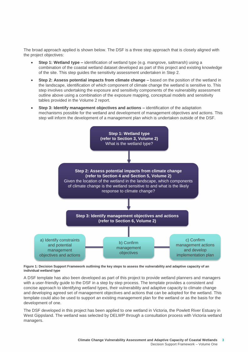
Climate Change Vulnerability Assessment and Adaptive Capacity of Coastal Wetlands
Decision Support Framework ndash Volume One
3
The broad approach applied is shown below The DSF is a three step approach that is closely aligned with
the project objectives
Step 1 Wetland type ndash identification of wetland type (eg mangrove saltmarsh) using a
combination of the coastal wetland dataset developed as part of this project and existing knowledge
of the site This step guides the sensitivity assessment undertaken in Step 2
Step 2 Assess potential impacts from climate change ndash based on the position of the wetland in
the landscape identification of which component of climate change the wetland is sensitive to This
step involves undertaking the exposure and sensitivity components of the vulnerability assessment
outline above using a combination of the exposure mapping conceptual models and sensitivity
tables provided in the Volume 2 report
Step 3 Identify management objectives and actions ndash identification of the adaptation
mechanisms possible for the wetland and development of management objectives and actions This
step will inform the development of a management plan which is undertaken outside of the DSF
Figure 1 Decision Support Framework outlining the key steps to assess the vulnerability and adaptive capacity of an
individual wetland type
A DSF template has also been developed as part of this project to provide wetland planners and managers
with a user-friendly guide to the DSF in a step by step process The template provides a consistent and
concise approach to identifying wetland types their vulnerability and adaptive capacity to climate change
and developing agreed set of management objectives and actions that can be adopted for the wetland This
template could also be used to support an existing management plan for the wetland or as the basis for the
development of one
The DSF developed in this project has been applied to one wetland in Victoria the Powlett River Estuary in
West Gippsland The wetland was selected by DELWP through a consultation process with Victoria wetland
managers
Step 1 Wetland type
(refer to Section 3 Volume 2)
What is the wetland type
Step 2 Assess potential impacts from climate change
(refer to Section 4 and Section 5 Volume 2)
Given the location of the wetland in the landscape which components
of climate change is the wetland sensitive to and what is the likely
response to climate change
Step 3 Identify management objectives and actions
(refer to Section 6 Volume 2)
a) Identify constraints
and potential
management
objectives and actions
b) Confirm
management
objectives
c) Confirm
management actions
and develop
implementation plan
4 Climate Change Vulnerability Assessment and Adaptive Capacity of Coastal Wetlands
Decision Support Framework ndash Volume One
11 Background
The climate of southern Australia is changing and will continue to change (CSIRO-BOM 2015a b) Mean air
temperatures have risen by 08minus10oC over the past century and are projected with very high confidence to
increase further Rainfall already variable at the regional scale is projected to decrease overall and winter
and spring in particular to become drier Extreme events such as heat waves and extremes of rainfall and
drought are expected to become more common Solar radiation will increase and relative humidity decrease
leading to changes in evaporative losses and a harsher fire climate and increased fire risk All these factors
will have significant impacts on Victorias coastal wetlands not only via direct effects on hydrology and
related impacts on wetting and drying regimes but also indirectly through changes to myriad related
processes such as sedimentation and erosion nutrient cycling salinisation and ecological connectivity
Some assessments have been made on likely impacts on Australian inland wetlands (Nielsen and Brock
2009 SKM 2013 Finlayson et al 2013 Lovelock et al no date) but there are few if any comparable studies
for climate-change impacts on Victorian coastal wetlands A study was made of possible sea-level rise
impacts and mitigation strategies for Victorian seagrass systems (Morris 2013) but there is little on other
Victorian coastal wetland systems such as mangroves coastal saltmarsh the wide range of estuarine
wetlands or for swamp scrubs and other wetland types vegetated with woody plants (Boon 2012)
Comparable studies have been undertaken for some of these systems elsewhere in Australia (eg Gilman
et al 2008 Pralahad et al 2011) but not for Victoria and it is not evident that they can be transferred to
Victorian systems
Coastal wetlands are especially susceptible to climate change because of their position near to the ocean
and thus their exposure to rising sea levels Mean sea levels are projected with very high confidence to
continue to rise at rates of ~ 3 mm per year The height and frequency of extreme sea-level events will also
increase CSIRO-BOM (2015 a b) projected that by 2090 eustatic sea levels are predicted to rise by
027minus066 m under an intermediate emissions case (RCP45) and by 038minus089 m under a high-emissions
scenario (RCP85) These changes alone will markedly alter the ecological structure function and value of
coastal wetlands and will exacerbate impacts caused by higher temperatures and altered river discharge
Higher mean sea levels for instance will modify the inundation regimes experienced by coastal wetlands
changing their wetting and drying cycles and their salinity regimes and in some cases also contribute to the
widespread loss of coastal wetlands due to shoreline erosion Rises in eustatic sea levels however are not
the only mechanism by which climate change will affect coastal wetlands (Osland et al 2016) other impacts
include those arising storm surges altered freshwater runoff (with implications for the supply of sediments
and nutrients to coastal systems) and changed fire frequency Moreover it cannot be assumed that the
different types of wetlands that occur along the Victorian coast will respond in the same way to these various
impacts nor that the same suite of mitigation strategies will work equally well for each type (Friess et al
2012)
We should be concerned about possible impacts of climate change on coastal wetlands for a number of
reasons First the conservation and biodiversity value of coastal wetlands is well known they provide habitat
for a diverse range of plants and animals they protect shorelines against erosion and they offer recreational
opportunities to local and distant human populations
Second the coast of Victoria supports a wide range of important and different wetland types including
seagrass beds mangroves coastal saltmarshes estuarine reedbeds and various types of swamp scrubs
(Department of Sustainability and Environment 2012 Boon 2012 Boon et al 2015a)
Third these wetlands provide essential ecosystem services including the provision of raw materials and
food coastal protection erosion control water purification maintenance of fisheries carbon sequestration
and tourism recreation education and research (Barbier et al 2011) As far as we are aware they are no
economic valuations available for Australian coastal wetland systems other than an old study of northern-
Australian mangroves which were estimated to generate $14000 AUD per hectare each year to commercial
fisheries (Morton 1990) More recently Creighton et al (2015) have shown that returns to commercial and
recreational fishing alone of rehabilitating estuaries and their associated fringing wetlands is one of the most
effective investments that can be made by natural resource managers in Australia far outweighing the
returns that accrue from investment into inland wetlands
1 Introduction
Climate Change Vulnerability Assessment and Adaptive Capacity of Coastal Wetlands
Decision Support Framework ndash Volume One
5
Given the paucity of quantitative data for Australian coastal systems it is necessary to turn to overseas
studies that demonstrate the economic value of wetlands and coastal wetlands in particular The ecosystem
services provided by tidal marshesmangroves globally was estimated in 2011 to be in the order of US
$194000 ha-1 y-1 (Costanza et al 2014) The economic value of ecosystem services quantified in the UKrsquos
2011 National Ecosystem Assessment which showed that coastal wetlands in the UK provided ecosystem
services worth pound1534 million each year in terms of flood control and the protection of shorelines against
erosion pound1275 million annually in biodiversity value pound1245 million in water-quality improvement pound514
million in the provision of clean water and pound1081 million in amenity value On a per-area basis coastal
wetlands were estimated to be worth pound3700 per hectare annually merely for the protection they offered to
coasts against flooding and erosion
Finally human populations and economic activity are increasingly skewed towards coastal settings
(Johnston et al 2015) In Australia for example more than 85 of the population lives within 50 km of the
coast one-quarter of the population lives within 3 km of the coast (Zann and Dutton 2000) It is the wetlands
that this population lives near to and draws upon for various ecosystem services that will be most strongly
affected by climate change
The Victorian Governmentrsquos Department of Environment Land Water and Planning (DELWP) has invested
in climate change vulnerability projects in order to facilitate an adaptive management approach for
ecosystems under climate change and inform Victorian water resource policy Understanding the
vulnerability and adaptive capacity of wetlands based on future conditions helps guide investment and
predict longer term viability of management Projects that have been undertaken in Victoria include the
Governmentrsquos Future Coasts Program which aimed to better understand and plan for the risks associated
with sea level rise and storm surge for coastal wetlands in Victoria The Victorian Coastal Inundation dataset
and Victorian Coastal Hazard Guide were developed as part of this work and provide mapping and guidance
about the potential risks from sea level rise along the Victoria coastline An indicative assessment of climate
change vulnerability for wetlands in Victoria (SKM 2013) was also undertaken with a particular emphasis on
understanding likely changes in hydrological regimes and the regional distribution of these changes across
Victoria This current study will build on these previous projects with a focus on coastal wetlands systems in
Victoria and their vulnerability and adaptive capacity to the impacts of climate change
12 Project objectives
The purpose of this project is to outlineassess the vulnerability and adaptive capacity of the range of coastal
wetland systems in Victoria to the impacts of climate change including sea-level rise decreased freshwater
inflows and increased frequency and severity of extreme events
The project outputs will provide guidance for wetland managers in setting management objectives and in
developing adaptation plans for coastal wetland systems likely to be affected by climate change both at an
individual wetland scale and a landscape scale
In summary the project objectives are to
1 identify the different types of coastal wetland ecosystems in Victoria
2 assess the level of exposure and sensitivity of these wetlands to the impacts of climate change and
thereby estimate the level of potential impact
3 identify how wetland processes components and values are likely to be affected
4 provide guidance on potential management responses through the development of a Decision
Support Framework (DSF)
13 Volume One Report
An important outcome of the study is the development of a (DSF) which DELWP and Victorian wetland
managers can follow to better understand the vulnerability and adaptive capacity of a coastal wetland
systems in the State This framework can be used to help guide investment and predict longer term viability
of management actions
6 Climate Change Vulnerability Assessment and Adaptive Capacity of Coastal Wetlands
Decision Support Framework ndash Volume One
This report (Volume One) presents the framework and methods for assessing the vulnerability and adaptive
capacity of coastal wetland in Victoria and guidance on potential management objectives and actions that
could be adopted for those coastal wetland systems likely to be affected by climate change This volume also
provides a case study application of the framework for a selected Victorian coastal wetland Volume Two
provides the supporting technical information required to apply the framework and describes the logic and
assumptions behind each of the considerations underpinning the DSF
The structure of this report is
Section 2 outlines the approach used to address the project objectives outline in Section 12 It
includes an overview of the vulnerability assessment framework and the DSF
Section 3 provides step by step guidance on how to apply the DSF to undertake a vulnerability and
adaptive capacity assessment for an individual coastal wetland or wetland mosaic and identify
management objectives and actions to guide the development of a management implementation
plan This Section provides links to the Volume Two report to aid in the application of the DSF
Section 4 presents a case study application of the DSF including the populated A4 booklet template
developed to guide the DSF
Climate Change Vulnerability Assessment and Adaptive Capacity of Coastal Wetlands
Decision Support Framework ndash Volume One
7
21 Overview of vulnerability assessment framework
The vulnerability assessment aims to determine the vulnerability and adaptive capacity of wetlands in
Victoria to the impacts of climate change The evaluation is made using a risk based approach (Figure 2)
which centres on a joint assessment of exposure of a given suite of wetlands to the impacts associated with
specific components of climate change and the sensitivity of wetland values to these threats These two
elements are equivalent to likelihood and consequence in a traditional risk assessment approach
consistent with the Australian Standard for risk assessments (ASNZS ISO 310002009 Risk management -
Principles and guidelines) In combination they define the potential impact (or level of vulnerability) When
potential impact is linked with adaptive capacity (either autonomous or by intervention) it is possible to
make an assessment of the vulnerability (residual risk) of wetlands to the potential impacts of climate
change
Figure 2 Assessment approach to determine the vulnerability and adaptive capacity of wetland in Victoria to the impacts of
climate change
The following provides a definition of the vulnerability assessment components in the context of this project
Each component is explored in further detail in later sections of this report
Exposure assesses the likelihood of a given group or type of wetlands being subject to the given climate
change component (eg eustatic sea-level rise increased concentration of atmospheric carbon dioxide)This
is determined largely through the position of the wetland in the landscape in particular elevation and
distance from the sea combined with current projections for the magnitude of each climate change
component For example a coastal wetland located in the swales of a sand-dune system is unlikely to be
affected by sea-level rise over the short term because it is isolated from the ocean by at least one sand dune
crest whereas a mangrove or saltmarsh system will be strongly affected because they are subject to
recurrent tidal inundation In contrast all types of coastal wetland are likely to be affected to some degree or
other by increases in air temperature and in concentrations of atmospheric carbon dioxide Section 3 in
Volume Two provides more detail
Sensitivity is how a given wetland will respond to exposure to a specific climate change component
Wetland types that can tolerate significant changes prompted by a given climate change component (eg
increased salinity reduced rainfall increased temperature) are assessed as having a low sensitivity
whereas wetlands that can tolerate only small changes in the external environment without being altered
(eg via changes in productivity species composition or in the worst case complete loss and possible
replacement by another wetland type) are assessed as having a high sensitivity In many cases the
sensitivity of a given wetland type is influenced strongly by the physiological tolerances of the biota For
example saltmarsh plants are highly sensitive to subtle changes in inundation and salinity regimes and can
be expected to be highly sensitive to changes in sea level and storm-surge impacts Mangroves by contrast
occur over a wide tidal range and although their elevational or lateral position in the landscape will change as
a result of sea-level rise their continued existence along a given stretch of coastline might not All that would
happen is they migrate to slightly higher land (if such space is available as discussed later in the report)
Sensitivity therefore is derived from the evaluation of the likely response of different wetland types to each
2 Vulnerability Assessment Framework and Decision Support Framework
Potential impact
Sensitivity Exposure
Adaptive capacity
Vulnerability
8 Climate Change Vulnerability Assessment and Adaptive Capacity of Coastal Wetlands
Decision Support Framework ndash Volume One
climate change component based on expert knowledge Conceptual models have been developed to
highlight the mechanisms by which a given wetland type may be sensitive to a given climate change
component and these are shown in Section 4 of Volume Two
Potential impact is the product of exposure minus largely determined by the position of the wetland in the
landscape minus and sensitivity minus the capacity of the wetland to cope with the change
Adaptive capacity describes the ability of the wetland to adapt to change as a result of the climate change
component to which it is exposed It is closely allied to both the exposure and the sensitivity assessments
undertaken in the earlier stage of the vulnerability assessment Adaptive capacity is therefore a combination
of the sensitivity of a particular wetland type to climate change components and site-specific characteristics
especially degree of exposure that may enhance or limit the wetlands ability to response to local climate-
change components It is also influenced by site-specific physical constraints (eg location of seawalls that
hinder landward migration of mangrove or saltmarsh communities) and management actions (eg capacity
to control saline intrusions by creating levees or to provide fresh water from further upstream via the
construction of regulators and other water-control structures) that can help achieve management objectives
This matter is discussed in detail in Section 5 of Volume Two
The overall vulnerability of a wetland is the product of the potential impact of climate change and its ability
to adapt to cope with the impact its adaptive capacity Overall vulnerability therefore provides a measure
of the potential change to an ecosystem (eg loss of habitat or species diversity disruption to food webs
loss of ecosystem resilience or an increase in habitat fragmentation) as a result of climate change
22 Decision Support Framework
221 What is the Decision Support Framework Meant to do
Through the course of this project it became clear that the variability of wetland types their different locations
and responses to climate change components and the availability of useful data presented a significant
challenge to the development of a single uniform vulnerability assessment approach that could be used to
provide consistent outcomes across the State Because of this complexity a generic DSF was developed to
enable DELWP and wetland managers to assess the vulnerability and adaptive capacity of an individual
wetland type at the site or local landscape scale The DSF uses knowledge of the likely physiological and
ecological responses of the biota of a particular wetland type to climate change components (based on
conceptual models developed for the current project see Section 41 of Volume Two) and knowledge of site-
specific constraints and available management actions that can assist in adaptation The DSF can be used
to help guide investment and predict longer term viability of various management actions associated with the
management of coastal wetlands in response to the myriad changes likely to occur as a result of a globally
changing climate
The DSF is intended to provide guidance on
the range of different wetland types that occur along the Victorian coastline
determining the level of exposure and sensitivity (and thus potential impact) of an individual
wetland type to the impacts of climate change in terms of wetland structure processes and values
determining the likely outcome of the climate change component on the individual coastal wetland
type or wetland mosaic at the site local landscape scale (based on sensitivity and site constraints
ie adaptive capacity)
setting management objectives and actions for the individual coastal wetland type or wetland
mosaic This is an iterative process that considers constraints and available management actions It
provides the basis for the preparation of a management plan
Given it is intended that the project outputs will be used by wetland planners and managers the approach
developed for the DSF does not require users to have detailed knowledge of coastal wetland processes
component and values likely to be affected by climate change The conceptual models outlined in Section
41 of Volume Two are intended to provide guidance on these matters Moreover it is desirable to make the
DSF as consistent with existing approaches and databases as possible For this reason the general
Climate Change Vulnerability Assessment and Adaptive Capacity of Coastal Wetlands
Decision Support Framework ndash Volume One
9
approaches outlined in subsequent parts of the report aim to draw upon existing information and existing
approaches to classifying wetlands their biota and physical landforms
222 Approach to developing the Decision Support Framework
The broad approach applied in the DSF is illustrated in Figure 3 The DSF is a three step approach that is
closely aligned with the project objectives and the subsequent chapters in the report are arranged to help the
user work through the DSF The three steps include
Step 1 Wetland type ndash in this step you identify your wetland type (eg mangrove saltmarsh) using
a combination of the coastal wetland dataset developed as part of this project and existing
knowledge of the site This step guides the sensitivity assessment undertaken in Step 2
Step 2 Assess potential impacts from climate change ndash in this step you consider the position of
your wetland in the landscape to determine which component of climate change your wetland is
sensitive to This step involves undertaking the exposure and sensitivity components of the
vulnerability assessment outline above using a combination of the exposure mapping conceptual
models and sensitivity tables provided in the Volume 2 report
Step 3 Identify management objectives and actions ndash in this step you consider the adaptation
mechanisms possible for your wetland and development of management objectives and actions
This step will inform the development of a management plan which is undertaken outside of the
DSF
Figure 3 Decision Support Framework outlining the key steps to assess the vulnerability and adaptive capacity of an
individual wetland type
Step 1 Wetland type
(refer to Section 3 Volume 2)
What is the wetland type
Step 2 Assess potential impacts from climate change
(refer to Section 4 and Section 5 Volume 2)
Given the location of the wetland in the landscape which components
of climate change is the wetland sensitive to and what is the likely
response to climate change
Step 3 Identify management objectives and actions
(refer to Section 6 Volume 2)
a) Identify constraints
and potential
management
objectives and actions
b) Confirm
management
objectives
c) Confirm
management actions
and develop
implementation plan
10 Climate Change Vulnerability Assessment and Adaptive Capacity of Coastal Wetlands
Decision Support Framework ndash Volume One
The following sections provide guidance on undertaking the three steps (Figure 3) to assess the vulnerability
and adaptive capacity of coastal wetlands to the impacts of climate change and the development of
management objectives and actions to manage the impacts of climate change both at an individual wetland
type scale and a landscape scale
A DSF template was also developed as part of this project to allow wetland planners and managers to work
through the DSF in a step by step process The template provides a consistent and concise approach to
identifying wetland types their vulnerability and adaptive capacity to climate change and developing agreed
set of management objectives and actions that can be adopted for the wetland This template could also be
used to support existing management plans or as the basis for the development of one The DSF is provided
in a booklet in Appendix C A case study of the application of the DSF was undertaken for the Powlett
Estuary and is provided in Appendix D and discussed in Section 4 This case study has also been applied in
Section 31 to Section 33 to provide examples of how each step of the DSF is completed
31 Step 1 ndash How to identify your wetland type
In this step you identify your wetland type This will guide the sensitivity component of the risk assessment
because different types of coastal wetlands will respond in different ways to different climate change
components and to the different drivers these components generate
1 Using the coastal wetland dataset (geospatial database) for Victoria generated as part of this project
(refer to Section 25 of Volume Two) determine at your selected site
a) The wetland category the wetland belongs to (eg marine embayment estuarine coastal floodplain
etc) (refer to Section 24 of Volume Two for detailed description of categories)
b) The wetland typeEVC group the wetland belongs to (eg mangroves saltmarsh freshwater
wetland estuary)
2 Confirm the wetland typeEVC group during either a site visit or with existing literature or local site
knowledge Descriptions of individual wetland categories and types are provided in Section 23 and
Section 24 of Volume Two and can be used an additional source of information to confirm the wetland
typeEVC
3 If your wetland type is an estuary search your location on the interactive map on the Oz Coasts website
(httpwwwozcoastsgovausearch_datamap_searchjsp) to determine its classification (eg wave
dominated or tide dominated) and sub-classification (eg wave tide dominated delta or estuary coastal
lagoon strandplain tidal flat creek) Using local knowledge determine the estuaries geomorphology
(eg permanently opened permanently closed or intermittently opened) This information is important to
capture in the DSF because the function of an estuary varies between the different classifications and
geomorphology and this is important when considering the impacts of climate change For example in
the case of the Powlett River if the estuary was permanently closed then that may help mitigate some of
impact of sea level However if the estuary was to shift to a permanently open estuary then the ecology
of the estuary and associated wetlands would change due to the impacts of sea level rise
It is important to note that at some sites there might be multiple wetland typesEVC groups that make up a
wetland In this case the risk assessment should be undertaken at a landscape scale and all wetland
typesEVC groups identified at the site should be considered when assessing the impacts of potential climate
change components (Step 2) and identifying management objectives and actions for the site (Step 3)
3 Decision Support Framework user guide
Climate Change Vulnerability Assessment and Adaptive Capacity of Coastal Wetlands
Decision Support Framework ndash Volume One
11
32 Step 2 ndash How to determine the potential impacts from climate change on your wetland
In this step you consider the position of your wetland in the landscape to determine which components of
climate change your wetland is sensitive to The outcomes of this step will determine the requirement of a
management or adaptation plan for the wetland and if so help guide the identification of management
objectives and actions (Step 3)
1 Identify the climate change scenario RCP (45 and 85) and timeframe (2050 2070 2090) (see Section
333 in Volume Two) which will be used to inform management of your wetland Multiple RCPs and
timeframes can be used in this process for example consider medium case (ie RCP 45) and worst
case (ie Business as usual RCP 85) scenarios There are also short term and long term management
timeframes that need to be considered for example to inform when to bring forward or delay certain
actions based on which climate change outcomes become most obvious or likely
2 Using the maps of exposure of climate change components to coastal wetlands in Victoria generated as
part of this project (refer to Section 334 in Volume Two) for the RCPs and timeframes selected identify
those components of climate change that your wetland is exposed
a) Sea level rise ndash any wetland within the area of coastal inundation boundary (Appendix F of Volume
Two)
b) Increased carbon dioxide concentration - all wetlands will be exposed to the carbon dioxide
concentration component of climate change and therefore no map is provided as part of this project
c) Altered rainfall ndash consider the likely effects of predicted change in rainfall (Appendix F of Volume
Two)
d) Increased temperature - consider the likely effects of predicted change in temperature Appendix F of
Volume Two)
3 For each climate change component note the magnitude of change predicted under the climate change
scenario(s) selected at a site specific scale for example
a) Sea level rise ndash examine the coastal inundation mapping at your wetland site or alternatively use
DELWPrsquos Coastal Inundation dataset (available at wwwdatavicgovau) to produce your own
mapping (see case study application in Appendix D)Separate maps can be produced for sea level
rise and storm surges
b) Increased carbon dioxide concentration ndash no information is available to make predictions of the
magnitude of change at a site specific scale
c) Altered rainfall ndash examine details of the magnitude of change (mean surface temperature change)
predicted for the site Section 332 of Volume Two Also document any seasonal changes predicted
(also see Section 332 of Volume Two)
d) Increased temperature - examine details of the magnitude of change in rainfall predicted for the site
Section 332 of Volume Two Also document any seasonal changes predicted (also see Section
332 of Volume Two)
4 Under each climate change copmonent listed in the DSF populate the sensitivity ranking (positive
negative and neutral) for those climate change components to which you wetland is exposed to The
sensitivity of the wetland type to the climate change component will be based on the rankings provided in
Appendix A of this report and Section 42 of Volume Two If multiple wetland typesEVC groups are
identified at the site (see DSF step in Section 31) then separate sensitivity rankings should be populated
for each wetland typeEVC group For example see Powlett River Estuary sensitivity analysis in Table 1
12 Climate Change Vulnerability Assessment and Adaptive Capacity of Coastal Wetlands
Decision Support Framework ndash Volume One
Table 1 Sensitivity analysis for Powlett River Estuary
5 Based on the conceptual models for each climate change component provided in Section 41 of Volume
Two and the adaptive capacity summary provided in Section 43 of Volume Two populate the likely
outcome of climate change for the wetland type A summary of the likely outcomes of climate change for
coastal wetlands is provided below (Table 2)
Table 2 Summary of the likely outcome of climate change for coastal wetlands
Climate change component Estuary Saltmarsh Estuarine
Wetland
Swamp
scrub
Swampy
riparian
woodland
Sea level rise and storm surge
Chronic salinisation Neutral Positive Neutral Negative Negative
Episodic salinisation Negative Negative Negative Negative Negative
Erosion shoreline recession Negative Negative Negative Negative Negative
Increased carbon dioxide concentration
Altered C3 and C4 relationship Neutral Negative Neutral Neutral Neutral
Carbonate dissolution Neutral Neutral Neutral Neutral Neutral
Decreased rainfall
Chronic salinisation Neutral Positive Neutral Negative Negative
Increased air temperature
Phonological impacts altered primary productivity Positive Positive Positive Positive Positive
Increased water temperature
Phonological impacts altered primary productivity Neutral Neutral Neutral Neutral Neutral
Climate change
component Likely outcomes for coastal wetland
Increased sea
level and storm
surge
More permanent inundation or increased frequency and duration of inundation of wetlands
Change in salinity and water regime in wetlands due to saline intrusion
Changes in vegetation distribution along the elevational gradient from the sea with possible
landward migration
Conversion of currently intertidal seagrass beds to subtidal systems and an increase in
depth of subtidal systems
Replacement of areas currently vegetated with saltmarshes by more inundation-tolerant
mangroves
Replacement of areas currently vegetated with glycophytic (eg Phragmites australis) or
brackish-water plants (eg Melaleuca ericifolia) by saltmarshes
Changes in the floristic distribution of saltmarsh taxa along the elevational gradient from
the sea
Excessive sedimentation and erosion along shoreline impacts mangroves and coastal saltmarsh
effects can occur at both the establishment phase of young plants and adult plants
Changes in distribution of plant propagules via altered currents and tidal patterns
Breakage of young plants by wind or waves during their establishment
Modification of patterns and rates of coastal sedimentation and erosion affecting the area
suitable for mangrove or saltmarsh colonisation
Geomorphic changes to estuary mouth and coastal barriers dunes due to sea level rise and
storm surges (eg increased rates of erosion)
Saline intrusion into the upper estuary and lower freshwater reaches of the rivers due to
increased sea levels and storm surge activity Causes rise in saline conditions along riparian
zone
Saline intrusion into groundwater results in a changed wetland environment
Climate Change Vulnerability Assessment and Adaptive Capacity of Coastal Wetlands
Decision Support Framework ndash Volume One
13
For example the estuary and saltmarsh wetlands of the Powlett River Estuary have the following likely
outcome
Estuary
Potential in change from intermittently open estuary mouth to permanently opened or permanently
closed estuaryndash may become more similar to Andersons Inlet
Saline intrusion into the upper estuary and lower freshwater reaches of the river due to increased
sea levels and storm surge activity and reduced rainfall
Saline intrusion into groundwater results in a changed species composition year round
Saltmarsh
Permanent inundation or increased frequency and duration of inundation
Change in salinity and water regime
Changes in its distribution along the elevational gradient from the sea (migrates landwards)
Possible invasion by mangroves if geomorphic changes result in a more permanent estuary opening
Increased pressure from weed invasion
Increased
carbon dioxide
concentration
Competitive interactions between plants will be affected C3 plants will be advantaged (eg
mangroves and most but not all saltmash plants and mangroves)
Acidification of coastal waters causing major impacts on phytoplankton and possibly on
submerged angiosperms such as seagrasses Aquatic organisms that build calcareous or
carbonate shells from aragonite (eg crustaceans) and some macroalgae that have calcified
tissues may also be affected
Increased pressure from weed invasion
Decreased
rainfall
Change in water and salinity regime due to reduced freshwater inflows decreased rainfall and
increased flooding causing longer periods between freshwater inundation and development of
hypersaline conditions
Replacement of areas of coastal wetlands currently vegetated with glycophytic (eg Phragmites
australis) or brackish-water plants (eg Melaleuca ericifoia) by saltmarshes as a result of
increased salinity
Changes in primary productivity and distributions of mangrove communities probably towards
increased vigour and a wider distribution
Modification of patterns and rates of coastal sedimentation and erosion with effects on the area
suitable for mangrove or saltmarsh colonisation
Saline intrusion into groundwater due to reduced groundwater recharge results in a changed
wetland environment
Saline intrusion into the upper estuary and lower freshwater reaches of the river due to reduced
rainfallcatchment runoff
Increased pressure from weed invasion
Increased
temperature
Impacts on flowering and germination of plants and the breeding success of invertebrates fish
and birds
Disruption of life histories of stenothermal invertebrates and fish with consequences for growth
mortality and secondary productivity
Increased rates of primary production by saltmarshes and mangroves unless other factors (eg
hypersalinity lowered nutrient availability etc) intervene
Changes in primary productivity and distributions of mangrove communities probably towards
increased vigour and a wider distribution
Change in water and salinity regime due to increased evaporation losses causing reduction in
permanence and an increase in ephemerality in coast wetlands
Increased pressure from weed invasion
14 Climate Change Vulnerability Assessment and Adaptive Capacity of Coastal Wetlands
Decision Support Framework ndash Volume One
Saltmarsh are C3 plants so potentially advantaged by increases in atmospheric CO2 concentrations
Increased pressure from weed invasion
Saline intrusion into groundwater results in a changed species composition year round
6 Based on the main adaptive mechanisms and the main factors limiting adaptive capacity of your wetland
(summary table provided in Appendix B and further detail contained in Section 43 of Volume Two)
populate the table to reflect the likely adaptive capacity of your wetland type to climate change For
example see analysis on the Powlett River Estuary adaptive capacity in Table 3
Table 3 Adaptive capacity of Powlett River Estuary
Based on your knowledge of the wetland and its site specific characteristics (eg presence of barriers for
migration) specific assessments of opportunities and constraints to adaptive capacity can also be
undertaken to further inform this part of the DSF
33 Step 3 ndash What are your management objective and actions for the site
In this step you consider the adaptation mechanisms possible for your wetland and develop management
objectives and actions The outcomes of this step will inform the development of management and
implementation plans which would be undertaken outside of the DSF
1 Identify the constraints to management for the site which may include barriers to migration land
ownership available funding and knowledge and data availability (see Section 51 of Volume Two) For
example the Powlett River Estuary has the following likely management constraints
Barriers to migration
Powlett Road may restrict inland migration
Rail trail towards Dayleston may restrict inland migration
Small cluster of housing north east of the Estuary mouth may restrict inland migration
Land ownership
The land in which wetlands could migrate in to is predominately private land used for agriculture
(grazing and cropping)
Funding
Limited funding available ndash not currently a priority site for intervention
Wetland
type
Adaptive
capacity Main adaptive mechanism Main limiting factors
Saltmarsh Low Sediment accretion movement
to higher elevations positive
response to increase
temperature (variable responses
to increased CO2)
Rate of sea level rise storm
surge intensity and shoreline
erosion seawalls and other
physical impediments impact of
increased atmospheric CO2
impacts on floristic composition
Estuarine
wetland
Moderate Positive response to
temperature neutral to most
other impacts until sea levels
make the sites intertidal
Salinisation and waterlogging
due to storm surges
Swamp
scrub
Low Positive response to
temperature
Salinisation and waterlogging
(ie changes to wetting and
drying regimes)
Swampy
Riparian
woodland
Low Positive response to
temperature
Salinisation and waterlogging
(ie changes to wetting and
drying regimes)
Climate Change Vulnerability Assessment and Adaptive Capacity of Coastal Wetlands
Decision Support Framework ndash Volume One
15
Whilst there is good collaboration between agencies and landholders there are different priorities for
the funding available and therefore so some actions are difficult to agree to
Limitations to knowledge and data
What geomorphic changes to the estuary mouth are likely to occur as a result of climate change (ie
changes in estuary dynamics)
Understanding the economic value of the estuary and coastal wetlands (eg value of wetlands
versus the value of agricultural land)
What happens to Acid Sulfate Soils as a result of climate change
Other potential constraints
Current State policies and procedures for statutory planning changes and land purchase to enable
long term change in land use
Community understanding and expectation around estuary opening and closing
2 Taking into consideration the main constraints to management of the site develop and document in
consultation with relevant agencies and community stakeholders a management objective for the site in
regards to climate change adaptation using the broad management objectives provided in Table 4
(further discussed in Section 52 of Volume Two)
Table 4 Decision Support Framework ndash broad management objectives
Broad Management Objectives
1 Savemaintain existing wetland in current position
2 Facilitate landward migration of existing wetland type
3 Facilitate transition to new wetland type in current location
4 No intervention
It is also important to consider wetland values current threats to the wetland local and regional
objectives and adjacent habitat typeszones wetland buffer zones and transition zone between wetland
and terrestrial habitats (further detail on these considerations provided in Section 52 of Volume Two)
For example based on the pre-existing management objectives for the Powlett River Estuary the site
could have the following management objective
To enhance and significantly increase Swamp scrub Swampy riparian woodland and estuarine wetland
vegetation communities through the facilitation of landward migration
Combinations of the management objectives listed above may also be identified across a range of time
scales in response to the degree of exposure of the wetland to the components of climate change (ie
scenario planning) this is further discussed in Section 52 of Volume Two
3 Based on the management objective identified any pre-existing management actions and the
management actions provided in Section 53 of Volume Two (summary provided in Table 5 below) select
the most appropriatefeasible management actions to enable objectives to be achieved
The development of objectives and actions is iterative and requires consideration of constraints and
assessment of the feasibility of management options Hence this step may require an evaluation of a
range of actions to identify those that are most feasible and likely to enable objectives to be met If it
turns out actions are not feasible then objectives may need to be reviewed
Monitoring is a critical part of all actions because it is used to inform timing of implementation and
adaptive management For example the landward migration of the wetland will take many years and so
some actions may not be required until landward movement has commenced or reached a certain
extent or may not be needed at all if monitoring reveals that the climate change component does not
manifest at that location Other actions may require immediate implementation even though the benefits
of that actions may not be realised until some time in the future (eg land use planning rules or land
16 Climate Change Vulnerability Assessment and Adaptive Capacity of Coastal Wetlands
Decision Support Framework ndash Volume One
acquisition may be required now so that space is available in future years when climate change
components manifest themselves)
Table 5 Decision Support Framework ndash how management actions relate to various management objectives
The suite of actions and timing of implementation are very much siteregion specific For example the
following management actions (new and adaption of existing management actions in place for the site)
could be set for the Powlett River Estuary
Table 6 Decision Support Framework ndash example management actions for the Powlett River Estuary
Management Actions
Save maintain
existing wetland in
current position
Facilitate landward
migration of existing
wetland type
Facilitate
transition to new
wetland type in
current location
No
intervention
Influence private land
management -
Land acquisition planning - - -
Active revegetation -
Invasive species control -
New infrastructure on
seaward side of wetland - - -
Infrastructure removal
modification on landward
side of wetland - - -
Education and community
engagement -
Fire Management - - -
Management Action Timeframe Responsibility
Complete a study to assess the likely geomorphic changes to the estuary as
a result of climate change
2 years WGCMA
Undertake scenario planning - refine management actions and objectives for
Estuary based on finding of geomorphic study This could identify nearby
systems that could form a template for what Powlett River might look like in
the future (eg Andersons Inlet)
2-5 years WGCMA
Review Bass Coast Planning Scheme to understand any implications to
future management actions works at the Powlett Estuary Provide feedback
to the State Government on any issues associated with State policies and
procedures for statutory planning that may constrain long term management
of the Estuary
2-5 years WGCMA
Resolve issues and complexities around the impacts of climate change (sea
level rise) on crown land boundaries
2-5 years State
Government
Resolve issues associated with State policies and procedures for statutory
planning that may constrain long term management of the Estuary
2-5 years State
Government
Estuary Management Plan Action E31 (see above) ndash to become 2 actions
a Investigate opportunities for land purchase within the current inundation
areas of the estuary
8 years WGCMA
Climate Change Vulnerability Assessment and Adaptive Capacity of Coastal Wetlands
Decision Support Framework ndash Volume One
17
4 Following the identification of objectives and actions the last step is to develop a management plan (or
update existing plan) that provides the specific details around actions responsibilities monitoring and
timeframes for implementation
b Investigate opportunities for land purchase within the future inundation
areas of the estuary
Estuary Management Plan Action E32 (see above) ndash include
consideration of future inundation eg ldquoDesign and implement a program of
stewardship payment for the seasonal inundation of estuary floodplain from
estuary mouth closures under both current and future inundation conditionsrdquo
8 years WGCMA
Estuary Management Plan Action E 39 (see above) ndash to become 2 actions
a Investigate opportunities to encourage the conversion of current Crown
land water frontage grazing licences to riparian management licences
b Investigate issues and opportunities related to sea level rise impacts on
Crown Land Water frontage grazing licences and riparian management
licences (including how to define boundaries if existing boundaries are
inundated by sea level rise)
8 years WGCMA
Estuary Management Plan Action E44 (see above) ndash Undertake detailed
risk assessment of potential and active acid sulfate soils
8 years WGCMA
Estuary Management Plan Action E49 (see above) ndash Continue to build
understanding of and plan for risks associated with climate change
8 years WGCMA
18 Climate Change Vulnerability Assessment and Adaptive Capacity of Coastal Wetlands
Decision Support Framework ndash Volume One
In order to provide validation that the DSF can provide an assessment of the vulnerability and adaptive
capacity of a coastal wetland in Victoria to the impacts of climate change and guidance to wetland managers
on potential management objectives and actions for those coastal wetland systems likely to be affected by
climate change the DSF was applied to a case study wetland in Victoria
The case study wetland was selected by DELWP from a list of potential wetlands provided by the wetland
managers from the working group established as part of the project Wetland managers included
representatives from the DELWP Parks Victoria West Gippsland Catchment Management Authority (CMA)
East Gippsland CMA Port Phillip and Westernport CMA Glenelg Hopkins CMA and Corangamite CMA
The wetland selected was the Powlett River Estuary in the West Gippsland CMA region This decision was
based on existing information available for the site (an existing estuary management plan was available) its
value (listed as a Nationally Important Wetland and a habitat for the critically endangered Orange-bellied
Parrot) and that the site provided a good balance between covering a number of different coastal wetland
types (estuary saltmarsh riparian scrub estuarine wetland heathlands and woodlands) but without being
too complex and large
Consultation with West Gippsland CMA was undertaken throughout the case study application to ensure that
local knowledge was incorporated and so that the wetland manager could provide input to setting the
wetland management objectives and actions The completed application of the DSF for the Powlett River
Estuary is provided in Appendix D
Through the case study application it became apparent that Step 1 (wetland type) could be largely
completed by applying local knowledge of the wetland ecosystems found within the site Step 2 (assess the
potential impacts from climate change) however requires more technical knowledge of the wetlands
sensitivity and adaptive capacity to climate change and therefore requires close consultation with the
supporting technical information contained in Volume 2 Volume 2 provides enough information for a wetland
manager with limited climate change knowledge to complete this component of the DSF Step 3 is then a
combination of applying local knowledge to set management objectives and then using a combination of
local knowledge and the supporting technical information contained in Volume 2 to develop management
actions
The maps included in the case study application use only publically available data (the coastal wetland
dataset developed as part of this project and DELWPs coastal inundation dataset) and their manipulation
and interrogation is well within the GIS capability within the relevant wetland managerrsquos organisations
The case study application of the DSF demonstrated its effectiveness at providing a framework for assessing
potential impacts from climate change on Victorian coastal wetlands and will be a useful tool for assisting
wetland managers to 1) understand and 2) develop objectives and actions for managing coastal wetlands in
response to a changing climate
4 Case study application
Climate Change Vulnerability Assessment and Adaptive Capacity of Coastal Wetlands
Decision Support Framework ndash Volume One
19
Barbier EB Hacker SD Kennedy C Koch EW Stier AC amp Silliman BR (2011) The value of estuarine and
coastal ecosystem services Ecological Monographs 81169-93
Boon PI (2012) Coastal wetlands of temperate eastern Australia will Cinderella ever go to the ball Marine
and Freshwater Research 63 845-855
Boon PI Allen T Carr G Frood D Harty C McMahon A Mathews S Rosengren N Sinclair S White M amp
Yugovic J (2015a) Coastal wetlands of Victoria south-eastern Australia providing the inventory and
condition information needed for their effective management and conservation Aquatic Conservation Marine
and Freshwater Ecosystems 25 454-479
Costanza R de Groot R Sutton P van der Ploeg S Anderson SJ Kubiszewski I et al (2014) Changes in
the global value of ecosystem services Global Environmental Change 26152-8
Creighton C Boon PI Sheaves M amp Brookes J (2015) Revitalising Australiarsquos estuaries ndash what benefits at
what cost Marine and Freshwater Research 66 493-507
CSIRO and BOM (2015a) Southern slopes cluster report Climate change in Australia projections for
Australiarsquos natural resource management regions Full Report CSIRO and Bureau of Meteorology
Canberra Available on-line at httpwwwclimatechangeinaustraliagovauenimpacts-and-adaptationnrm-
regions
CSIRO and BOM (2015b) Climate change in Australia Projections for Australias NRM regions Southern
slopes Summary report CSIRO and Bureau of Meteorology Canberra Available on-line at
httpwwwclimatechangeinaustraliagovauenimpacts-and-adaptationnrm-regions
Finlayson CM Davis JA Gell PA Kingsford RT and Parton KA (2013) The status of wetlands and the
predicted effects of climate global climate change the situation in Australia Aquatic Sciences 75 73-93
Friess DA Krauss KW Horstman EM Balke T Bouma TJ Galli D amp Webb EL (2012) Are all intertidal
wetlands naturally created equal Bottlenecks thresholds and knowledge gaps to mangrove and saltmarsh
ecosystems Biological Reviews 87 346-366
Gilman EL Ellison J Duke NC amp Field C (2008) Threats to mangroves from climate change and adaptation
options a review Aquatic Botany 89 237-250
Johnston EM Hedge LH and Mayer-Pinto M (2015) The urgent need to understand port and harbour
ecosystems Marine and Freshwater Research 66 i-ii
Morton RM (1990) Community structure density and standing crop of fishes in a subtropical Australian
mangrove area Marine Biology 105 385-94
Morris L (2013) Chapter 2 Implications of future climate change for seagrass and soft sediments In
Implications of future climate change for Victorians marine environments Eds Klemke J amp Arundel H Report
to Glenelg Hopkins CMA
Nielsen D and M Brock 2009 Modified water regime and salinity as a consequence of climate change
prospects for wetlands of Southern Australia Climatic Change 95523-533
Osland MJ Enwright NM Day RH Gabler CA Stagg CL and Grace JB (2016) Beyond just sea-level rises
considering macroclimatic drivers within coastal wetland vulnerability assessments to climate change Global
Change Biology 22 1-11
Prahalad VN Kirkpatrick JB amp Mount RE (2011) Tasmanian coastal saltmarsh community transitions
associated with climate change and relative sea level rise 1975minus2009 Australian Journal of Botany 59 741-
748
SKM (2013) Indicative Assessment of Climate Change Vulnerability for Wetlands in Victoria Report
prepared for Department of Sustainability and Environment (now DELWP)
Zann LP amp Dutton I (2000) The social values and perceptions of Australians concerning the marine
environment In State of the Environment Report for Australia Technical summary Edited by LP Zann
Pages 127-134 Ocean Rescue 2000 amp Department of the Environment Sport and Territories Canberra
5 References
20 Climate Change Vulnerability Assessment and Adaptive Capacity of Coastal Wetlands
Decision Support Framework ndash Volume One
Wetland Type and corresponding EVC
group
Climate change components and ecological consequences
Increased Sea level and storm surges Increased carbon dioxide
concentration
Decreased rainfall Higher air
temperature
Higher water
temperature
Chronic
salinisation
Episodic
salinisation
Erosion
shoreline
recession
Altered C3
and C4
relationship
Carbonate
dissolution
Chronic
salinisation
Altered
sediment
load
Phenological
impacts
altered primary
productivity
Phenological
impacts altered
primary
productivity
Marine
Embayment
Mangrove Positive Neutral to
Negative
Negative Positive Neutral Positive Positive Positive Neutral
Seagrass (not mapped) Positive Negative Neutral Neutral Positive Positive Negative Positive Positive
Saltmarsh Positive Negative Negative Negative Neutral Positive Positive Positive Neutral
Estuarine -
Intertidal
Mangrove Positive Neutral to
Negative
Negative Positive Neutral Positive Positive Positive Neutral
Saltmarsh Positive Negative Negative Negative Neutral Positive Positive Positive Neutral
Estuarine -
supratidal
Heathlands Neutral Neutral Negative Neutral Neutral Neutral Neutral Positive Neutral
Herb-rich woodlands Neutral Neutral Negative Neutral Neutral Neutral Neutral Positive Neutral
Coastal scrubs and
woodlands
Neutral Neutral Negative Neutral Neutral Neutral Neutral Positive Neutral
Wetland - estuarine semi-
permanent saline
Neutral Negative Negative Neutral Neutral Neutral Positive Positive Neutral
Coastal
floodplain
Riparian scrubs or
swampy scrubs and
woodlands
Negative Negative Negative Neutral Neutral Negative Positive Positive Neutral
Coastal brackish wetlands Negative Negative Negative Neutral Neutral Negative Positive Positive Neutral
Freshwater wetlands Negative Negative Negative Neutral Neutral Negative Positive Positive Neutral
Dune
systems
Freshwater wetlands Neutral Neutral Negative Neutral Neutral Neutral Neutral Positive Neutral
Appendix A Sensitivity tables
Climate Change Vulnerability Assessment and Adaptive Capacity of Coastal Wetlands
Decision Support Framework ndash Volume One
21
1 where adaptive capacity is unknown data gaps limit the ability to make clear assessment of adaptive capacity
Appendix B Adaptive capacity of wetland types
Wetland Type Adaptive
capacity1 Main adaptive mechanism Main limiting factor to
adaptation
Marine
Embayment
estuarine -
intertidal
Mangrove Adaptable Sediment accretion movement to higher
elevations positive response to increased temperature and increased atmospheric CO2
Rate of sea-level rise storm surge intensity and shoreline erosion seawalls and other
physical impediments
Seagrass (not mapped)
Adaptable Positive response to increased salinity
Storm surge intensity smothering by catchment-
derived sediments reductions in underwater light fields
consequent to catchment-associated processes
Saltmarsh Adaptable Sediment accretion movement to higher
elevations positive response to increased temperature
(Variable responses to increased CO2)
Rate of sea-level rise storm surge intensity and shoreline erosion seawalls and other
physical impediments impacts of increased atmospheric CO2
impacts on floristic composition
Estuarine ndash
supratidal
Heathlands Unknown Positive response to temperature neutral to most other impacts until sea levels
make the sites intertidal
Salinisation and waterlogging due to storm surge
Herb-rich woodlands
Unknown Positive response to temperature neutral to most other impacts until sea levels
make the sites intertidal
Salinisation and waterlogging due to storm surge
Coastal scrubs and woodlands
Unknown Positive response to temperature neutral to most other impacts until sea levels
make the sites intertidal
Salinisation and waterlogging due to storm surge
Wetland - estuarine semi-permanent saline
Unknown Positive response to temperature neutral to most other impacts until sea levels
make the sites intertidal
Salinisation and waterlogging due to storm surge
Coastal
floodplain
Riparian scrubs or swampy scrubs and woodlands
Non-adaptable
Positive response to temperature
Salinisation and waterlogging (ie changes to wetting and
drying regimes)
Coastal brackish wetlands
Non-adaptable
Positive response to temperature
Salinisation and waterlogging (ie changes to wetting and
drying regimes)
Freshwater wetlands
Non-adaptable
Positive response to temperature
Salinisation and changes to wetting and drying regimes
Dune systems
Freshwater wetlands
Unknown Positive response to temperature neutral to most
other impacts
Physical loss of habitat salinisation possible changes to
wetting and drying regimes
22 Climate Change Vulnerability Assessment and Adaptive Capacity of Coastal Wetlands
Decision Support Framework ndash Volume One
Appendix C Decision Support Framework template
Climate Change Vulnerability Assessment and Adaptive Capacity of Coastal Wetlands
Decision Support Framework ndash Volume One
23
Coastal Wetlands and Climate Change
Decision Support Framework
Site Name Insert wetland name
Purpose
This document provides a Decision Support Framework to enable wetland managers to assess the
vulnerability and adaptive capacity of wetlands to climate change at an individual wetland or local landscape
scale The DELWP Climate Change Vulnerability Assessment and Adaptive Capacity of Coastal Wetlands
report provides the background and supporting material for this assessment and should be used in
conjunction with each stage of the assessment process outlined below
The broad approach applied in the Decision Support Framework is illustrated below It is a three step
approach that includes
Step 1 Wetland type ndash in this step you identify your wetland type (eg mangrove saltmarsh) using
a combination of the coastal wetland dataset developed as part of this project and your existing
knowledge of the site This step guides the sensitivity assessment undertaken in step 2
Step 2 Assess potential impacts from climate change ndash in this step you consider the position of
your wetland in the landscape so you can determine which component of climate change the
wetland is most sensitive to This step involves undertaking the exposure and sensitivity
components of the vulnerability assessment outlined above using the exposure mapping the
conceptual models and the sensitivity tables provided in the supporting documents
Step 3 Identify management objectives and actions ndash in this step you consider the adaptation
mechanisms possible for your wetland and develop management objectives and actions This step
will inform the development of a management plan which is undertaken outside of the DSF
Step 2 Assess potential impacts from climate change
(refer to Section 4 and Section 5 Volume 2)
Given the location of the wetland in the landscape which components of climate change is the
wetland sensitive to and what is the likely response to climate change
Step 3 Identify management objectives and actions
(refer to Section 6 Volume 2)
a) Identify constraints and
potential management
objectives and actions
b) Confirm
management
objectives
c) Confirm management
actions and develop
implementation plan
Step 1 Wetland type
(refer to Section 3 Volume 2)
What is the wetland type
24 Climate Change Vulnerability Assessment and Adaptive Capacity of Coastal Wetlands
Decision Support Framework ndash Volume One
Decision Support Framework
1 Wetland identification (Section 2 Volume Two)
Name Insert wetland name
Location address Insert generic location description
Easting Northing
Bioregion Refer to httpwwwdepivicgovauenvironment-and-wildlifebiodiversityevc-benchmarks
Wetland category
(Section 24 Volume
Two)
Tidal wetlands
Marine embayment
Estuarine (intertidal)
Estuarine (supratidal)
Non-tidal wetland
Coastal floodplain
Dune system
Wetland type EVC
group(s)
(Section 23 Volume
Two and supporting
geospatial dataset)
Seagrass
Saltmarsh
Mangroves
Brackish wetland
Freshwater wetland (floodplain)
Freshwater wetland (dune)
Riparian swampy scrub
Estuarine wetland
Estuarine scrubs heathlands and
woodlands
Estuary classification
(if relevant)
httpwwwozcoastsgov
ausearch_datamap_se
archjsp
Classification
Wave dominated
Sub-classification
Wave dominated delta
Tide dominated delta
Wave dominated estuary
Tide dominated estuary
Tide dominated
Coastal lagoon
Strandplain
Tidal flat creek
Other
Estuary
geomorphology (if
relevant)
Permanently open
Permanently closed
Intermittently opened and closed
Wetland values See Section 44 of Volume Two for more detail
Climate Change Vulnerability Assessment and Adaptive Capacity of Coastal Wetlands
Decision Support Framework ndash Volume One
25
Decision Support Framework
Decision Support Framework
Insert location map including location of individual wetland EVC types
26 Climate Change Vulnerability Assessment and Adaptive Capacity of Coastal Wetlands
Decision Support Framework ndash Volume One
Decision Support Framework
2 Potential impacts from climate change to the wetland (Section 4 Volume Two)
What is the
climate change
scenario
timeframe
Select climate change scenario timeframe detailed in Section 333 of Volume 2
Given the
position of the
wetland in the
landscape how
exposed is the
wetland to sea
level rise and
storm surge
climate change
components
Insert exposure map for sea level rise and storm surges (See Appendix F of Volume Two Coastal Inundation
dataset is publically available at wwwdatavicgovau)
Sea level rise
Storm surges
Climate Change Vulnerability Assessment and Adaptive Capacity of Coastal Wetlands
Decision Support Framework ndash Volume One
27
Decision Support Framework
Decision Support Framework
Site specific
infrastructure
dynamics that
would influence
the impact from
sea level rise
and storm
surges
Identify any specific infrastructure dynamics that may increase or decrease the impact from sea level rise
and storm surges (eg presence of artificial barriers to restrict seawater intrusion)
Given the
position of the
wetland in the
landscape how
exposed is the
wetland to
temperature and
rainfall climate
change
components
Insert climate change projections for temperature and rainfall based on current CSIRO-BOM (2015)
modelling provided in Section 332 of Volume Two
Temperature
Based on CSIRO-BOM (2015) modelling the following predictions are made in regards to change in
temperature
Magnitude of change
(mean surface temp
change)
Seasonality
Rainfall
Based on CSIRO-BOM (2015) modelling the following predictions are made in regards to change in rainfall
Magnitude of change
(change in rainfall) Seasonality
Wetland
sensitivity
Insert wetland type and sensitivity to climate change components (positive [highlight green] negative
[highlight red] neutral [highlight yellow] NA) provided in Appendix A of Volume One
Climate change component and
impacts on coastal wetlands
Insert
wetland
type
Insert
wetland
type
Insert
wetland
type
Insert
wetland
type
Sea level
Chronic salinisation
Episodic salinisation
Erosion shoreline recession
Carbon dioxide
Altered C3 and C4 relationship
Carbonate dissolution
Rainfall
Chronic salinisation
Temperature (air)
Phenological impacts altered primary
productivity
Temperature (water)
Phenological impacts altered primary
productivity
Positive = positive response to climate change negative = negative response to climate change neutral =
unlikely to have any response to climate change NA = not exposed
28 Climate Change Vulnerability Assessment and Adaptive Capacity of Coastal Wetlands
Decision Support Framework ndash Volume One
Decision Support Framework
Likely outcome Based on the Table 2 in Section 32 of Volume One and the conceptual models presented in Section 41 of
Volume Two
Adaptive
capacity
General adaptive capacity of wetland types present
Describe based on the conceptual models presented in Section 41 of Volume Two and populated table
based on table provided in Section 43 of Volume Two
Wetland
type
Adaptive
capacity Main adaptive mechanism Main limiting factor
Site specific adaptive capacity
Need to consider site specific opportunities and constraints to adaptive capacity based on site specific
characteristics
3 Management objectives and actions (Section 5 of Volume Two)
Constraints to
management
See Section 51 of Volume Two report for more detail
Barriers to migration
Land ownership
Funding
Limitations to knowledge and data
Other potential constraints
Pre-existing threats Identify pre-existing threats that may impact the wetlands capacity to cope with change
Pre-existing
management
objectives
Document local and regional management objectives in pre-existing management plans and
strategies
Proposed management
objective in relation to
climate change
Based on wetland values and existing objectives define the management objective for the wetland in
relation to climate change See Section 52 of Volume Two for more detail
Climate Change Vulnerability Assessment and Adaptive Capacity of Coastal Wetlands
Decision Support Framework ndash Volume One
29
Decision Support Framework
Decision Support Framework
Management actions to
address climate
change impacts and
management
objectives
Identify a suite of management actions for the site See Section 53 of Volume Two for more details
May include existing and new management actions
Existing actions
Management Action Timeframe
New actions
Management Action Timeframe Responsibility
4 Recommendations
Identify any recommendations for management of the wetland eg addressing data gaps further investigation required
development of management or implementation plan
5 Key management resource documents
Insert useful resource documents and web links associated with management at the site including but not limited to
1 Peters G Morris K Frood D Papas P and Roberts J (2015) A Guide to managing livestock grazing in Victorias
wetlands Decision framework and guidelines - Version 10 Arthur Rylah Institute for Environmental Research Technical
Report Series Report number 265
2 Morris K and Papas P (2012) Wetland conceptual models associations between wetland values threats and management
interventions Version one Arthur Rylah Institute for Environmental Research Technical Report Series Report number 237
3 DELWP wetland buffers guidelines (in prep)
4 DELWP wetland revegetation guidelines (in prep)
5 DELWP wetland invasive species management guidelines (in prep)
6 SKM (2005) Guidelines for the design and operation of environmentally friendly wetland regulators (MDBC project report
R2002) Report by Sinclair Knight Merz for the MDBC
6 Key references
Insert key reference supporting documents used to populate decision support framework template
Appendix D Decision Support Framework case study application
30 Climate Change Vulnerability Assessment and Adaptive Capacity of Coastal Wetlands
Decision Support Framework ndash Volume One
Climate Change Vulnerability Assessment and Adaptive Capacity of Coastal Wetlands
Decision Support Framework ndash Volume One
31
Coastal Wetlands and Climate Change
Decision Support Framework
Site Name Powlett River Estuary
Purpose
This document provides a Decision Support Framework to enable wetland managers to assess the
vulnerability and adaptive capacity of wetlands to climate change at an individual wetland or local landscape
scale The DELWP Climate Change Vulnerability Assessment and Adaptive Capacity of Coastal Wetlands
report provides the background and supporting material for this assessment and should be used in
conjunction with each stage of the assessment process outlined below
The broad approach applied in the Decision Support Framework is illustrated below It is a three step
approach that includes
Step 1 Wetland type ndash in this step you identify your wetland type (eg mangrove saltmarsh) using
a combination of the coastal wetland dataset developed as part of this project and your existing
knowledge of the site This step guides the sensitivity assessment undertaken in step 2
Step 2 Assess potential impacts from climate change ndash in this step you consider the position of
your wetland in the landscape so you can determine which component of climate change the
wetland is most sensitive to This step involves undertaking the exposure and sensitivity
components of the vulnerability assessment outlined above using the exposure mapping the
conceptual models and the sensitivity tables provided in the supporting documents
Step 3 Identify management objectives and actions ndash in this step you consider the adaptation
mechanisms possible for your wetland and develop management objectives and actions This step
will inform the development of a management plan which is undertaken outside of the DSF
Step 2 Assess potential impacts from climate change
(refer to Section 4 and Section 5 Volume 2)
Given the location of the wetland in the landscape which components of climate change is the
wetland sensitive to and what is the likely response to climate change
Step 3 Identify management objectives and actions
(refer to Section 6 Volume 2)
a) Identify constraints and
potential management
objectives and actions
b) Confirm
management
objectives
c) Confirm management
actions and develop
implementation plan
Step 1 Wetland type
(refer to Section 3 Volume 2)
What is the wetland type
32 Climate Change Vulnerability Assessment and Adaptive Capacity of Coastal Wetlands
Decision Support Framework ndash Volume One
Decision Support Framework
1 Wetland identification (Section 2 Volume Two)
Name Powlett River Estuary
Location address Located in the West Gippsland Catchment Management Authority (CMA) region near the coast
between Kilcunda and Wonthaggi
Easting 370380205 Northing 5728345662
Bioregion Gippsland Plain
Wetland category
(Section 24 Volume
Two)
Tidal wetlands
Marine embayment
Estuarine (intertidal)
Estuarine (supratidal)
Non-tidal wetland
Coastal floodplain
Dune system
Wetland type EVC
group(s)
(Section 23 Volume
Two and supporting
geospatial dataset)
Seagrass
Saltmarsh
Mangroves
Brackish wetland
Freshwater wetland (floodplain)
Freshwater wetland (dune)
Riparian swampy scrub
Estuarine wetland
Estuarine scrubs heathlands and
woodlands
Estuary classification
(if relevant)
httpwwwozcoastsgov
ausearch_datamap_se
archjsp
Classification
Wave dominated
Sub-classification
Wave dominated delta
Tide dominated delta
Wave dominated estuary
Tide dominated estuary
Tide dominated
Coastal lagoon
Strandplain
Tidal flat creek
Other
Estuary
geomorphology (if
relevant)
Permanently open
Permanently closed
Intermittently opened and closed
Climate Change Vulnerability Assessment and Adaptive Capacity of Coastal Wetlands
Decision Support Framework ndash Volume One
33
Decision Support Framework
Decision Support Framework
Wetland values
The Powlett River Estuary has a diverse range of bird plant and fish communities
5 different EVCs including coastal saltmarsh (Coastal Tussock Saltmarsh and Wet Saltmarsh
Herbland) protected under the Environmental Protection and Biodiversity Conservation Act
1999 (EPBC Act)
22 fish species including the Australian Grayling which is listed threatened under the Flora
and Fauna Guarantee Act 1988 (FFG Act) and vulnerable under the EPBC Act
31 State Australian and Internationally listed bird species including the critically endangered
Orange-bellied Parrot (WGCMA 2015)
The Powlett River Estuary also has significant social and economic value
Recreational activities ndash fishing sightseeing swimming walking bird watching picnics etc
Coastal dunes near the mouth of the Estuary have Aboriginal cultural heritage significance
(number of coastal midden sites recorded)
Landholders commonly graze along the river upstream of the Mouth of Powlett Road
Water source for irrigation and stock and domestic water use (WGCMA 2015)
34 Climate Change Vulnerability Assessment and Adaptive Capacity of Coastal Wetlands
Decision Support Framework ndash Volume One
Decision Support Framework
2 Potential impacts from climate change to the wetland (Section 4 Volume Two)
What is the
climate change
scenario
timeframe
Based on CSIRO-BOM (20015) modelling RCP 45 (moderate response to climate change) and RCP 85
(worst case scenario business as usual response to climate change)
Timeframes 2050 2070 and 2090 were all considered
Given the
position of the
wetland in the
landscape how
exposed is the
wetland to sea
level rise and
storm surge
climate change
components
Sea level rise
Climate Change Vulnerability Assessment and Adaptive Capacity of Coastal Wetlands
Decision Support Framework ndash Volume One
35
Decision Support Framework
Decision Support Framework
Storm surges
Site specific
infrastructure
dynamics that
would influence
the impact from
sea level rise
and storm
surges
There is currently no infrastructure at the Powlett River Estuary that would influence the extent of inundation
from the projected sea level rise and storm surges
When the mouth of the estuary is closed this may help mitigate some of impact of sea level
Given the
position of the
wetland in the
landscape how
exposed is the
wetland to
temperature and
rainfall climate
change
components
Temperature
Based on CSIRO-BOM (2015) modelling the following predictions are made in regards to change in
temperature
Magnitude of change
(mean surface temp
change)
Seasonality
RCP 45
2050 = 05 to 1degC
2070 = gt1 to 15degC
2090 = gt1 to 15degC
RCP 85
2050 = gt15 to 2degC
2070 = gt2 to 25degC
2090 = gt3 to 35deg
Temperature increases are similar in all seasons with some models
simulating to some extent larger increases in summer and autumn
than in other seasons
Projected changes for both daily maximum and minimum
temperature generally follow those of the mean temperature
although there is somewhat lower warming in daily minimum
temperatures than daily maximum temperatures in autumn winter
and spring
Increase in the temperature reached on the hottest days an increase
in the frequency of very hot days and duration of warm spells
36 Climate Change Vulnerability Assessment and Adaptive Capacity of Coastal Wetlands
Decision Support Framework ndash Volume One
Decision Support Framework
Given the
position of the
wetland in the
landscape how
exposed is the
wetland to
temperature and
rainfall climate
change
components
Rainfall
Based on CSIRO-BOM (2015) modelling the following predictions are made in regards to change in rainfall
Magnitude of change
(change in rainfall) Seasonality
RCP 45
2050 = 25 to 75
2070 = gt -25 to 25
2090 = gt -25 to 25
RCP 85
2050 = gt - 75 to -25
2070 = gt - 75 to -25
2090 = gt -125 to - 75
Rainfall declines are strongest in winter and spring Projected
reductions in winter rainfall in the Victoria NSW East region are up
to 30 in 2090 under high emissions
There is little change projected in autumn and either increases or
decreases in summer rainfall are possible
Tendency for heavier rainfall interspersed by longer dry periods
with some extremely dry and wet years with natural variability
continuing to be a major driver of rainfall for the near future (2030)
Intensity of heavy rainfall events is predicted to increase with
timing and magnitude also driven by natural variability
A decline in the number but an increase in the intensity of east
coast lows impacting on average rainfall and heavy rain events
Time spent in drought is predicted to increase over the course of
this century in line with changes to average rainfall and the
frequency and duration of extreme droughts will increase
Wetland
sensitivity
Climate change component and
impacts on coastal wetlands Saltmarsh
Estuarine
Wetland
Swamp
scrub
Swampy
riparian
woodland
Sea level
Chronic salinisation Positive Neutral Negative Negative
Episodic salinization Negative Negative Negative Negative
Erosion shoreline recession Negative Negative Negative Negative
Carbon dioxide
Altered C3 and C4 relationship Negative Neutral Neutral Neutral
Carbonate dissolution Neutral Neutral Neutral Neutral
Rainfall
Chronic salinisation Positive Neutral Negative Negative
Temperature (air)
Phenological impacts altered primary
productivity
Positive Positive Positive Positive
Temperature (water)
Phenological impacts altered primary
productivity
Neutral Neutral Neutral Neutral
Positive = positive response to climate change negative = negative response to climate change neutral =
unlikely to have any response to climate change NA = not exposed
Likely outcome Estuary
Potential change from intermittently open estuary mouth to permanently opened or more permanently
closed estuary depending on regional changes to rainfallcatchment runoff river discharge eustatic
sea levels and storm surges May become more similar to Andersons Inlet (marine embayment) to
the east
Saline intrusion into the upper estuary and lower freshwater reaches of the river due to increased sea
levels and storm surge activity and reduced rainfallcatchment runoff
Climate Change Vulnerability Assessment and Adaptive Capacity of Coastal Wetlands
Decision Support Framework ndash Volume One
37
Decision Support Framework
Decision Support Framework
Saline intrusion into groundwater results in a changed in species composition year round
Saltmarsh
More permanent inundation or increased frequency and duration of inundation
Change in salinity and water regime
Changes in distribution along the elevational gradient from the sea with possible landward migration
Possible invasion by mangroves if geomorphic changes result in a more permanent estuary opening
(eg similar to Andersons Inlet)
Many of the saltmarsh taxa at the site are C3 plants so potentially advantaged by increases in
atmospheric CO2 concentrations
Increased pressure from weed invasion from surrounding agricultural land
Saline intrusion into groundwater results in a changed wetland environment
Estuarine Wetland
Change in salinity and water regime (eg reduced freshwater inflows and saline intrusion increased
evaporation losses)
Increased pressure from weed invasion
Saline intrusion into groundwater results in a changed wetland environment
Riparian scrub and swampy riparian woodland
Change in salinity and water regime (eg reduced freshwater inflows and saline intrusion decreased
rainfall increased extreme flood events)
Rise in saline conditions along riparian zone
Replacement with saltmarsh as a result of increased salinity
Increased pressure from weed invasion
Saline intrusion into groundwater results in a changed species composition year round
Adaptive
capacity
General adaptive capacity of wetland types present
Wetland
type
Adaptive
capacity Main adaptive mechanism Main limiting factor
Saltmarsh Low Sediment accretion movement
to higher elevations positive
response to increase
temperature (variable
responses to increased CO2)
Rate of sea level rise storm surge
intensity and shoreline erosion
seawalls and other physical
impediments impact of increased
atmospheric CO2 impacts on floristic
composition
Estuarine
wetland
Moderate Positive response to
temperature neutral to most
other impacts until sea levels
make the sites intertidal
Salinisation and waterlogging due to
storm surges
Swamp
scrub
Low Positive response to
temperature
Salinisation and waterlogging (ie
changes to wetting and drying regimes)
Swampy
Riparian
woodland
Low Positive response to
temperature
Salinisation and waterlogging (ie
changes to wetting and drying regimes)
38 Climate Change Vulnerability Assessment and Adaptive Capacity of Coastal Wetlands
Decision Support Framework ndash Volume One
Decision Support Framework
Site specific adaptive capacity
Not completed as part of case study ndash requires specific assessments of opportunities and constraints to
adaptive capacity based on site specific characteristics
3 Management objectives and actions (Section 5 of Volume Two)
Constraints to
management
Barriers to migration
Mouth of Powlett Road is a barrier to wetland migration
Rail trail towards Dayleston provides a barrier to landward migration
Small cluster of housing north east of the estuary mouth similarly constrains landward
migration
Land ownership
The land in which wetlands could migrate in to is predominately private land used for
agriculture (grazing and cropping)
Funding
Limited funding available ndash not a priority site State wide nor Ramsar listed
Whilst there is good collaboration between agencies and landholders there are different
priorities for the funding available and therefore so some actions are difficult to implement An
example includes raising roads and carparks that experience inundation during closure
events or buying back regularly inundated marginal farmland
Limitations to knowledge and data
Uncertainty around the likely geomorphic changes to the estuary mouth (ie change in estuary
dynamic)
Understanding the economic value of the estuary coastal wetlands (eg value of wetlands
versus the value of agricultural land)
Uncertainty around acid sulfate soils as a result of climate change
Other potential constraints
Current State policies and procedures for statutory planning changes and land buyback to
enable long term management
Community understanding and expectation around estuary opening and closing
Pre-existing threats The key pre-existing threats identified in the Powlett River Estuary Management Plan that may
influence the resilience of the estuary to climate change impacts include
Degraded water quality
Degraded riparian vegetation (large trees in particular)
Trampling and bank erosion associated with pedestrian access
Rural drainage and drain clearing
Channelisation of the river channel
Vehicle access
Livestock access
Pest plants and animals
Inappropriate recreation causing dune erosion
Disturbance of acid sulfate soils
Climate Change Vulnerability Assessment and Adaptive Capacity of Coastal Wetlands
Decision Support Framework ndash Volume One
39
Decision Support Framework
Decision Support Framework
Pre-existing
management
objectives
Regional catchment strategy
No coastal wetland specific actions objectives for the Powlett River
West Gippsland Waterways Strategy (2014-2022)
Regional objectives relating to the Powlett River Estuary as a coastal wetland
Maintain and improve the habitat and condition of waterways to support waterway dependent
animals and plants
Maintain the ecological character of significant wetlands and estuaries
Catchment objectives for Powlett River Estuary relating to coastal wetlands include
Riparian vegetation provides improved visual amenity and contributes to community use of
waterways
The extent of freshwater wetlands is maintained and their condition is improved
Powlett Estuary Management Plan
Swamp scrub swampy riparian woodland and estuarine wetland vegetation communities are
enhanced and significantly increased in the area
West Gippsland Regional NRM Climate Change Strategy (2016)
The strategy outlines approaches and options to support climate change adaptation and mitigation
The objectives of the adaptation and management strategies are linked to the 20 year objectives in
the Regional Catchment Strategy The Powlett River Estuary is located within the Bunurong Coastal
planning area The estuary is listed as one of the most vulnerable estuary assets to climate change
across the region
Reports are available at lthttpwwwwgcmavicgovauour-regionwaterwayspowlett-river-estuarygt
[Verified 17052016 ]
Proposed management
objective in relation to
climate change
The following management objective is based the existing geomorphic characteristics of the estuary
(ie intermittently closed estuary)
To enhance and significantly increase Swamp scrub Swampy riparian woodland and estuarine
wetland vegetation extent through the facilitation of landward migration of these communities over the
next 50 years
Climate change also poses a threat to non-wetland EVCs (eg Coast Banksia Woodland) and
therefore even though they are not considered in this coastal wetland risk assessment they are still a
management consideration for the CMA in the coastal zone
Management actions to
address climate
change impacts and
management
objectives
Existing actions
Existing management actions provided in Section 81 of the Estuary Management Plan (WGCMA
2015) that are related to climate change are listed below
Management Action Timeframe
E31 Investigate opportunities for land purchase within the inundation
areas of the estuary
8 years
E32 Design and implement a program of stewardship payment for the
seasonal inundation of estuary floodplain from estuary mouth closures
Priority should be given to enhancing coastal saltmarsh and estuarine
wetland communities Payments should be calculated and prioritised
based on potential value to estuary health and ability to minimise artificial
estuary mouth openings
8 years
E 39 Investigate opportunities to encourage the conversion of Crown land
water frontage grazing licences to riparian management licences
8 years
E 43 Undertake hydraulic modelling and bathymetry survey of the Powlett 8 years
40 Climate Change Vulnerability Assessment and Adaptive Capacity of Coastal Wetlands
Decision Support Framework ndash Volume One
Decision Support Framework
estuary floodplain to understand the impacts and benefits of the structures
(including levees and drains) and landforms that affect the movement of
water before during and after artificial estuary mouth opening before
considering any updates changes or removal of these floodplain features
E 44 Undertake a detailed risk assessment including on-ground mapping
to identify potential and active acid sulphate soils with the Powlett estuarine
floodplain
8 years
E 46 Investigate the use of the saltmarsh wetlands and estuary channel
by recreational fish species and other native fish species particularly Black
Bream and prioritise areas for further protection
8 years
E 49 Continue to build understanding of and plan for the risks associated
with climate change including sea level rise This includes future flood
risk
8 years
New actions
The following additional management actions should be considered
Management Action Timeframe Responsibility
Complete a study to assess the likely geomorphic changes
to the estuary as a result of climate change
2 years WGCMA
Undertake scenario planning in consultation with Bass Coast
Shire Council VicRoads and Parks Victoria- refine
management actions and objectives for Estuary based on
finding of geomorphic study This could identify nearby
systems that could form a template for what Powlett River
might look like in the future (eg Andersons Inlet)
2-5 years WGCMA
Review Bass Coast Planning Scheme to understand any
implications to future management actions works at the
Powlett Estuary Provide feedback to the State Government
on any issues associated with State policies and procedures
for statutory planning that may constrain long term
management of the Estuary
2-5 years WGCMA
Consultation with other relevant managers in the area
(including Council VicRoads and Parks Victoria) to discuss
potential issues associated road repairs culverts and other
flood mitigation measures in the area that may arise as a
result of climate change
2-5 years WGCMA
Resolve issues and complexities around the impacts of
climate change (sea level rise) on crown land boundaries
2-5 years State
Government
Resolve issues associated with State policies and
procedures for statutory planning that may constrain long
term management of the Estuary
2-5 years State
Government
Community engagement and education program to provide
the community with an understanding of the predicted
impacts of climate change and enable them to play an active
role in management
2-5 years WGCMA
Estuary Management Plan Action E31 (see above) ndash to
become 2 actions
a Investigate opportunities for land purchase within the
8 years WGCMA
Climate Change Vulnerability Assessment and Adaptive Capacity of Coastal Wetlands
Decision Support Framework ndash Volume One
41
Decision Support Framework
Decision Support Framework
current inundation areas of the estuary
b Investigate opportunities for land purchase within the
future inundation areas of the estuary
Estuary Management Plan Action E32 (see above) ndash
include consideration of future inundation eg ldquoDesign and
implement a program of stewardship payment for the
seasonal inundation of estuary floodplain from estuary
mouth closures under both current and future inundation
conditionsrdquo
8 years WGCMA
Estuary Management Plan Action E 39 (see above) ndash to
become 2 actions
a Investigate opportunities to encourage the conversion of
current Crown land water frontage grazing licences to
riparian management licences
b Investigate issues and opportunities related to sea level
rise impacts on Crown Land Water frontage grazing licences
and riparian management licences (including how to define
boundaries if existing boundaries are inundated by sea level
rise)
8 years WGCMA
Estuary Management Plan Action E44 (see above) ndash
Undertake detailed risk assessment of potential and active
acid sulfate soils
8 years WGCMA
Estuary Management Plan Action E49 (see above) ndash
Continue to build understanding of and plan for risks
associated with climate change
8 years WGCMA
4 Recommendations
1 Climate change threats are currently implied within the management actions in the Powlett River Estuary Management Plan It
is recommended that additional material on climate change impacts be included and climate change threats addressed more
explicitly in the management actions This would meet Action E49 in particular
2 Management objectives also need to consider management for a 30-50 year timeframe ie take in to consideration longer
term climate change impacts including on estuary mouth dynamics A distinction between responses to current and future
threats should be made
5 Key management resource documents
1 Peters G Morris K Frood D Papas P and Roberts J (2015) A Guide to managing livestock grazing in Victorias
wetlands Decision framework and guidelines - Version 10 Arthur Rylah Institute for Environmental Research Technical
Report Series Report number 265
2 Morris K and Papas P (2012) Wetland conceptual models associations between wetland values threats and management
interventions Version one Arthur Rylah Institute for Environmental Research Technical Report Series Report number 237
3 DELWP wetland buffers guidelines (in prep)
4 DELWP wetland revegetation guidelines (in prep)
5 DELWP wetland invasive species management guidelines (in prep)
6 SKM (2005) Guidelines for the design and operation of environmentally friendly wetland regulators (MDBC project report
R2002) Report by Sinclair Knight Merz for the MDBC
42 Climate Change Vulnerability Assessment and Adaptive Capacity of Coastal Wetlands
Decision Support Framework ndash Volume One
Decision Support Framework
6 Key references
1 WGCMA (2012) West Gippsland Regional Catchment Strategy 2013-2019 West Gippsland Catchment Management
Authority
2 WGCMA (2014) West Gippsland Waterway Strategy 2014-2022 West Gippsland Catchment Management Authority
3 WGCMA (2015) Powlett River Estuary Management Plan West Gippsland Catchment Management Authority
4 WGCMA (2016) West Gippsland Regional NRM Climate Change Strategy ndash Final Draft West Gippsland Catchment
Management Authority
5 CSIRO and BOM (2015) Southern Slopes Cluster Report Climate Change in Australia Projections for Australiarsquos Natural
Resource Management Regions Cluster Reports eds Ekstroumlm M et al CSIRO and Bureau of Meteorology Australia
Climate Change Vulnerability Assessment and Adaptive Capacity of Coastal Wetlands
Decision Support Framework ndash Volume One
43
Decision Support Framework
Decision Support Framework
delwpvicgovau delwpvicgovau
Climate Change Vulnerability Assessment and Adaptive Capacity of Coastal Wetlands
Decision Support Framework ndash Volume One
5
Given the paucity of quantitative data for Australian coastal systems it is necessary to turn to overseas
studies that demonstrate the economic value of wetlands and coastal wetlands in particular The ecosystem
services provided by tidal marshesmangroves globally was estimated in 2011 to be in the order of US
$194000 ha-1 y-1 (Costanza et al 2014) The economic value of ecosystem services quantified in the UKrsquos
2011 National Ecosystem Assessment which showed that coastal wetlands in the UK provided ecosystem
services worth pound1534 million each year in terms of flood control and the protection of shorelines against
erosion pound1275 million annually in biodiversity value pound1245 million in water-quality improvement pound514
million in the provision of clean water and pound1081 million in amenity value On a per-area basis coastal
wetlands were estimated to be worth pound3700 per hectare annually merely for the protection they offered to
coasts against flooding and erosion
Finally human populations and economic activity are increasingly skewed towards coastal settings
(Johnston et al 2015) In Australia for example more than 85 of the population lives within 50 km of the
coast one-quarter of the population lives within 3 km of the coast (Zann and Dutton 2000) It is the wetlands
that this population lives near to and draws upon for various ecosystem services that will be most strongly
affected by climate change
The Victorian Governmentrsquos Department of Environment Land Water and Planning (DELWP) has invested
in climate change vulnerability projects in order to facilitate an adaptive management approach for
ecosystems under climate change and inform Victorian water resource policy Understanding the
vulnerability and adaptive capacity of wetlands based on future conditions helps guide investment and
predict longer term viability of management Projects that have been undertaken in Victoria include the
Governmentrsquos Future Coasts Program which aimed to better understand and plan for the risks associated
with sea level rise and storm surge for coastal wetlands in Victoria The Victorian Coastal Inundation dataset
and Victorian Coastal Hazard Guide were developed as part of this work and provide mapping and guidance
about the potential risks from sea level rise along the Victoria coastline An indicative assessment of climate
change vulnerability for wetlands in Victoria (SKM 2013) was also undertaken with a particular emphasis on
understanding likely changes in hydrological regimes and the regional distribution of these changes across
Victoria This current study will build on these previous projects with a focus on coastal wetlands systems in
Victoria and their vulnerability and adaptive capacity to the impacts of climate change
12 Project objectives
The purpose of this project is to outlineassess the vulnerability and adaptive capacity of the range of coastal
wetland systems in Victoria to the impacts of climate change including sea-level rise decreased freshwater
inflows and increased frequency and severity of extreme events
The project outputs will provide guidance for wetland managers in setting management objectives and in
developing adaptation plans for coastal wetland systems likely to be affected by climate change both at an
individual wetland scale and a landscape scale
In summary the project objectives are to
1 identify the different types of coastal wetland ecosystems in Victoria
2 assess the level of exposure and sensitivity of these wetlands to the impacts of climate change and
thereby estimate the level of potential impact
3 identify how wetland processes components and values are likely to be affected
4 provide guidance on potential management responses through the development of a Decision
Support Framework (DSF)
13 Volume One Report
An important outcome of the study is the development of a (DSF) which DELWP and Victorian wetland
managers can follow to better understand the vulnerability and adaptive capacity of a coastal wetland
systems in the State This framework can be used to help guide investment and predict longer term viability
of management actions
6 Climate Change Vulnerability Assessment and Adaptive Capacity of Coastal Wetlands
Decision Support Framework ndash Volume One
This report (Volume One) presents the framework and methods for assessing the vulnerability and adaptive
capacity of coastal wetland in Victoria and guidance on potential management objectives and actions that
could be adopted for those coastal wetland systems likely to be affected by climate change This volume also
provides a case study application of the framework for a selected Victorian coastal wetland Volume Two
provides the supporting technical information required to apply the framework and describes the logic and
assumptions behind each of the considerations underpinning the DSF
The structure of this report is
Section 2 outlines the approach used to address the project objectives outline in Section 12 It
includes an overview of the vulnerability assessment framework and the DSF
Section 3 provides step by step guidance on how to apply the DSF to undertake a vulnerability and
adaptive capacity assessment for an individual coastal wetland or wetland mosaic and identify
management objectives and actions to guide the development of a management implementation
plan This Section provides links to the Volume Two report to aid in the application of the DSF
Section 4 presents a case study application of the DSF including the populated A4 booklet template
developed to guide the DSF
Climate Change Vulnerability Assessment and Adaptive Capacity of Coastal Wetlands
Decision Support Framework ndash Volume One
7
21 Overview of vulnerability assessment framework
The vulnerability assessment aims to determine the vulnerability and adaptive capacity of wetlands in
Victoria to the impacts of climate change The evaluation is made using a risk based approach (Figure 2)
which centres on a joint assessment of exposure of a given suite of wetlands to the impacts associated with
specific components of climate change and the sensitivity of wetland values to these threats These two
elements are equivalent to likelihood and consequence in a traditional risk assessment approach
consistent with the Australian Standard for risk assessments (ASNZS ISO 310002009 Risk management -
Principles and guidelines) In combination they define the potential impact (or level of vulnerability) When
potential impact is linked with adaptive capacity (either autonomous or by intervention) it is possible to
make an assessment of the vulnerability (residual risk) of wetlands to the potential impacts of climate
change
Figure 2 Assessment approach to determine the vulnerability and adaptive capacity of wetland in Victoria to the impacts of
climate change
The following provides a definition of the vulnerability assessment components in the context of this project
Each component is explored in further detail in later sections of this report
Exposure assesses the likelihood of a given group or type of wetlands being subject to the given climate
change component (eg eustatic sea-level rise increased concentration of atmospheric carbon dioxide)This
is determined largely through the position of the wetland in the landscape in particular elevation and
distance from the sea combined with current projections for the magnitude of each climate change
component For example a coastal wetland located in the swales of a sand-dune system is unlikely to be
affected by sea-level rise over the short term because it is isolated from the ocean by at least one sand dune
crest whereas a mangrove or saltmarsh system will be strongly affected because they are subject to
recurrent tidal inundation In contrast all types of coastal wetland are likely to be affected to some degree or
other by increases in air temperature and in concentrations of atmospheric carbon dioxide Section 3 in
Volume Two provides more detail
Sensitivity is how a given wetland will respond to exposure to a specific climate change component
Wetland types that can tolerate significant changes prompted by a given climate change component (eg
increased salinity reduced rainfall increased temperature) are assessed as having a low sensitivity
whereas wetlands that can tolerate only small changes in the external environment without being altered
(eg via changes in productivity species composition or in the worst case complete loss and possible
replacement by another wetland type) are assessed as having a high sensitivity In many cases the
sensitivity of a given wetland type is influenced strongly by the physiological tolerances of the biota For
example saltmarsh plants are highly sensitive to subtle changes in inundation and salinity regimes and can
be expected to be highly sensitive to changes in sea level and storm-surge impacts Mangroves by contrast
occur over a wide tidal range and although their elevational or lateral position in the landscape will change as
a result of sea-level rise their continued existence along a given stretch of coastline might not All that would
happen is they migrate to slightly higher land (if such space is available as discussed later in the report)
Sensitivity therefore is derived from the evaluation of the likely response of different wetland types to each
2 Vulnerability Assessment Framework and Decision Support Framework
Potential impact
Sensitivity Exposure
Adaptive capacity
Vulnerability
8 Climate Change Vulnerability Assessment and Adaptive Capacity of Coastal Wetlands
Decision Support Framework ndash Volume One
climate change component based on expert knowledge Conceptual models have been developed to
highlight the mechanisms by which a given wetland type may be sensitive to a given climate change
component and these are shown in Section 4 of Volume Two
Potential impact is the product of exposure minus largely determined by the position of the wetland in the
landscape minus and sensitivity minus the capacity of the wetland to cope with the change
Adaptive capacity describes the ability of the wetland to adapt to change as a result of the climate change
component to which it is exposed It is closely allied to both the exposure and the sensitivity assessments
undertaken in the earlier stage of the vulnerability assessment Adaptive capacity is therefore a combination
of the sensitivity of a particular wetland type to climate change components and site-specific characteristics
especially degree of exposure that may enhance or limit the wetlands ability to response to local climate-
change components It is also influenced by site-specific physical constraints (eg location of seawalls that
hinder landward migration of mangrove or saltmarsh communities) and management actions (eg capacity
to control saline intrusions by creating levees or to provide fresh water from further upstream via the
construction of regulators and other water-control structures) that can help achieve management objectives
This matter is discussed in detail in Section 5 of Volume Two
The overall vulnerability of a wetland is the product of the potential impact of climate change and its ability
to adapt to cope with the impact its adaptive capacity Overall vulnerability therefore provides a measure
of the potential change to an ecosystem (eg loss of habitat or species diversity disruption to food webs
loss of ecosystem resilience or an increase in habitat fragmentation) as a result of climate change
22 Decision Support Framework
221 What is the Decision Support Framework Meant to do
Through the course of this project it became clear that the variability of wetland types their different locations
and responses to climate change components and the availability of useful data presented a significant
challenge to the development of a single uniform vulnerability assessment approach that could be used to
provide consistent outcomes across the State Because of this complexity a generic DSF was developed to
enable DELWP and wetland managers to assess the vulnerability and adaptive capacity of an individual
wetland type at the site or local landscape scale The DSF uses knowledge of the likely physiological and
ecological responses of the biota of a particular wetland type to climate change components (based on
conceptual models developed for the current project see Section 41 of Volume Two) and knowledge of site-
specific constraints and available management actions that can assist in adaptation The DSF can be used
to help guide investment and predict longer term viability of various management actions associated with the
management of coastal wetlands in response to the myriad changes likely to occur as a result of a globally
changing climate
The DSF is intended to provide guidance on
the range of different wetland types that occur along the Victorian coastline
determining the level of exposure and sensitivity (and thus potential impact) of an individual
wetland type to the impacts of climate change in terms of wetland structure processes and values
determining the likely outcome of the climate change component on the individual coastal wetland
type or wetland mosaic at the site local landscape scale (based on sensitivity and site constraints
ie adaptive capacity)
setting management objectives and actions for the individual coastal wetland type or wetland
mosaic This is an iterative process that considers constraints and available management actions It
provides the basis for the preparation of a management plan
Given it is intended that the project outputs will be used by wetland planners and managers the approach
developed for the DSF does not require users to have detailed knowledge of coastal wetland processes
component and values likely to be affected by climate change The conceptual models outlined in Section
41 of Volume Two are intended to provide guidance on these matters Moreover it is desirable to make the
DSF as consistent with existing approaches and databases as possible For this reason the general
Climate Change Vulnerability Assessment and Adaptive Capacity of Coastal Wetlands
Decision Support Framework ndash Volume One
9
approaches outlined in subsequent parts of the report aim to draw upon existing information and existing
approaches to classifying wetlands their biota and physical landforms
222 Approach to developing the Decision Support Framework
The broad approach applied in the DSF is illustrated in Figure 3 The DSF is a three step approach that is
closely aligned with the project objectives and the subsequent chapters in the report are arranged to help the
user work through the DSF The three steps include
Step 1 Wetland type ndash in this step you identify your wetland type (eg mangrove saltmarsh) using
a combination of the coastal wetland dataset developed as part of this project and existing
knowledge of the site This step guides the sensitivity assessment undertaken in Step 2
Step 2 Assess potential impacts from climate change ndash in this step you consider the position of
your wetland in the landscape to determine which component of climate change your wetland is
sensitive to This step involves undertaking the exposure and sensitivity components of the
vulnerability assessment outline above using a combination of the exposure mapping conceptual
models and sensitivity tables provided in the Volume 2 report
Step 3 Identify management objectives and actions ndash in this step you consider the adaptation
mechanisms possible for your wetland and development of management objectives and actions
This step will inform the development of a management plan which is undertaken outside of the
DSF
Figure 3 Decision Support Framework outlining the key steps to assess the vulnerability and adaptive capacity of an
individual wetland type
Step 1 Wetland type
(refer to Section 3 Volume 2)
What is the wetland type
Step 2 Assess potential impacts from climate change
(refer to Section 4 and Section 5 Volume 2)
Given the location of the wetland in the landscape which components
of climate change is the wetland sensitive to and what is the likely
response to climate change
Step 3 Identify management objectives and actions
(refer to Section 6 Volume 2)
a) Identify constraints
and potential
management
objectives and actions
b) Confirm
management
objectives
c) Confirm
management actions
and develop
implementation plan
10 Climate Change Vulnerability Assessment and Adaptive Capacity of Coastal Wetlands
Decision Support Framework ndash Volume One
The following sections provide guidance on undertaking the three steps (Figure 3) to assess the vulnerability
and adaptive capacity of coastal wetlands to the impacts of climate change and the development of
management objectives and actions to manage the impacts of climate change both at an individual wetland
type scale and a landscape scale
A DSF template was also developed as part of this project to allow wetland planners and managers to work
through the DSF in a step by step process The template provides a consistent and concise approach to
identifying wetland types their vulnerability and adaptive capacity to climate change and developing agreed
set of management objectives and actions that can be adopted for the wetland This template could also be
used to support existing management plans or as the basis for the development of one The DSF is provided
in a booklet in Appendix C A case study of the application of the DSF was undertaken for the Powlett
Estuary and is provided in Appendix D and discussed in Section 4 This case study has also been applied in
Section 31 to Section 33 to provide examples of how each step of the DSF is completed
31 Step 1 ndash How to identify your wetland type
In this step you identify your wetland type This will guide the sensitivity component of the risk assessment
because different types of coastal wetlands will respond in different ways to different climate change
components and to the different drivers these components generate
1 Using the coastal wetland dataset (geospatial database) for Victoria generated as part of this project
(refer to Section 25 of Volume Two) determine at your selected site
a) The wetland category the wetland belongs to (eg marine embayment estuarine coastal floodplain
etc) (refer to Section 24 of Volume Two for detailed description of categories)
b) The wetland typeEVC group the wetland belongs to (eg mangroves saltmarsh freshwater
wetland estuary)
2 Confirm the wetland typeEVC group during either a site visit or with existing literature or local site
knowledge Descriptions of individual wetland categories and types are provided in Section 23 and
Section 24 of Volume Two and can be used an additional source of information to confirm the wetland
typeEVC
3 If your wetland type is an estuary search your location on the interactive map on the Oz Coasts website
(httpwwwozcoastsgovausearch_datamap_searchjsp) to determine its classification (eg wave
dominated or tide dominated) and sub-classification (eg wave tide dominated delta or estuary coastal
lagoon strandplain tidal flat creek) Using local knowledge determine the estuaries geomorphology
(eg permanently opened permanently closed or intermittently opened) This information is important to
capture in the DSF because the function of an estuary varies between the different classifications and
geomorphology and this is important when considering the impacts of climate change For example in
the case of the Powlett River if the estuary was permanently closed then that may help mitigate some of
impact of sea level However if the estuary was to shift to a permanently open estuary then the ecology
of the estuary and associated wetlands would change due to the impacts of sea level rise
It is important to note that at some sites there might be multiple wetland typesEVC groups that make up a
wetland In this case the risk assessment should be undertaken at a landscape scale and all wetland
typesEVC groups identified at the site should be considered when assessing the impacts of potential climate
change components (Step 2) and identifying management objectives and actions for the site (Step 3)
3 Decision Support Framework user guide
Climate Change Vulnerability Assessment and Adaptive Capacity of Coastal Wetlands
Decision Support Framework ndash Volume One
11
32 Step 2 ndash How to determine the potential impacts from climate change on your wetland
In this step you consider the position of your wetland in the landscape to determine which components of
climate change your wetland is sensitive to The outcomes of this step will determine the requirement of a
management or adaptation plan for the wetland and if so help guide the identification of management
objectives and actions (Step 3)
1 Identify the climate change scenario RCP (45 and 85) and timeframe (2050 2070 2090) (see Section
333 in Volume Two) which will be used to inform management of your wetland Multiple RCPs and
timeframes can be used in this process for example consider medium case (ie RCP 45) and worst
case (ie Business as usual RCP 85) scenarios There are also short term and long term management
timeframes that need to be considered for example to inform when to bring forward or delay certain
actions based on which climate change outcomes become most obvious or likely
2 Using the maps of exposure of climate change components to coastal wetlands in Victoria generated as
part of this project (refer to Section 334 in Volume Two) for the RCPs and timeframes selected identify
those components of climate change that your wetland is exposed
a) Sea level rise ndash any wetland within the area of coastal inundation boundary (Appendix F of Volume
Two)
b) Increased carbon dioxide concentration - all wetlands will be exposed to the carbon dioxide
concentration component of climate change and therefore no map is provided as part of this project
c) Altered rainfall ndash consider the likely effects of predicted change in rainfall (Appendix F of Volume
Two)
d) Increased temperature - consider the likely effects of predicted change in temperature Appendix F of
Volume Two)
3 For each climate change component note the magnitude of change predicted under the climate change
scenario(s) selected at a site specific scale for example
a) Sea level rise ndash examine the coastal inundation mapping at your wetland site or alternatively use
DELWPrsquos Coastal Inundation dataset (available at wwwdatavicgovau) to produce your own
mapping (see case study application in Appendix D)Separate maps can be produced for sea level
rise and storm surges
b) Increased carbon dioxide concentration ndash no information is available to make predictions of the
magnitude of change at a site specific scale
c) Altered rainfall ndash examine details of the magnitude of change (mean surface temperature change)
predicted for the site Section 332 of Volume Two Also document any seasonal changes predicted
(also see Section 332 of Volume Two)
d) Increased temperature - examine details of the magnitude of change in rainfall predicted for the site
Section 332 of Volume Two Also document any seasonal changes predicted (also see Section
332 of Volume Two)
4 Under each climate change copmonent listed in the DSF populate the sensitivity ranking (positive
negative and neutral) for those climate change components to which you wetland is exposed to The
sensitivity of the wetland type to the climate change component will be based on the rankings provided in
Appendix A of this report and Section 42 of Volume Two If multiple wetland typesEVC groups are
identified at the site (see DSF step in Section 31) then separate sensitivity rankings should be populated
for each wetland typeEVC group For example see Powlett River Estuary sensitivity analysis in Table 1
12 Climate Change Vulnerability Assessment and Adaptive Capacity of Coastal Wetlands
Decision Support Framework ndash Volume One
Table 1 Sensitivity analysis for Powlett River Estuary
5 Based on the conceptual models for each climate change component provided in Section 41 of Volume
Two and the adaptive capacity summary provided in Section 43 of Volume Two populate the likely
outcome of climate change for the wetland type A summary of the likely outcomes of climate change for
coastal wetlands is provided below (Table 2)
Table 2 Summary of the likely outcome of climate change for coastal wetlands
Climate change component Estuary Saltmarsh Estuarine
Wetland
Swamp
scrub
Swampy
riparian
woodland
Sea level rise and storm surge
Chronic salinisation Neutral Positive Neutral Negative Negative
Episodic salinisation Negative Negative Negative Negative Negative
Erosion shoreline recession Negative Negative Negative Negative Negative
Increased carbon dioxide concentration
Altered C3 and C4 relationship Neutral Negative Neutral Neutral Neutral
Carbonate dissolution Neutral Neutral Neutral Neutral Neutral
Decreased rainfall
Chronic salinisation Neutral Positive Neutral Negative Negative
Increased air temperature
Phonological impacts altered primary productivity Positive Positive Positive Positive Positive
Increased water temperature
Phonological impacts altered primary productivity Neutral Neutral Neutral Neutral Neutral
Climate change
component Likely outcomes for coastal wetland
Increased sea
level and storm
surge
More permanent inundation or increased frequency and duration of inundation of wetlands
Change in salinity and water regime in wetlands due to saline intrusion
Changes in vegetation distribution along the elevational gradient from the sea with possible
landward migration
Conversion of currently intertidal seagrass beds to subtidal systems and an increase in
depth of subtidal systems
Replacement of areas currently vegetated with saltmarshes by more inundation-tolerant
mangroves
Replacement of areas currently vegetated with glycophytic (eg Phragmites australis) or
brackish-water plants (eg Melaleuca ericifolia) by saltmarshes
Changes in the floristic distribution of saltmarsh taxa along the elevational gradient from
the sea
Excessive sedimentation and erosion along shoreline impacts mangroves and coastal saltmarsh
effects can occur at both the establishment phase of young plants and adult plants
Changes in distribution of plant propagules via altered currents and tidal patterns
Breakage of young plants by wind or waves during their establishment
Modification of patterns and rates of coastal sedimentation and erosion affecting the area
suitable for mangrove or saltmarsh colonisation
Geomorphic changes to estuary mouth and coastal barriers dunes due to sea level rise and
storm surges (eg increased rates of erosion)
Saline intrusion into the upper estuary and lower freshwater reaches of the rivers due to
increased sea levels and storm surge activity Causes rise in saline conditions along riparian
zone
Saline intrusion into groundwater results in a changed wetland environment
Climate Change Vulnerability Assessment and Adaptive Capacity of Coastal Wetlands
Decision Support Framework ndash Volume One
13
For example the estuary and saltmarsh wetlands of the Powlett River Estuary have the following likely
outcome
Estuary
Potential in change from intermittently open estuary mouth to permanently opened or permanently
closed estuaryndash may become more similar to Andersons Inlet
Saline intrusion into the upper estuary and lower freshwater reaches of the river due to increased
sea levels and storm surge activity and reduced rainfall
Saline intrusion into groundwater results in a changed species composition year round
Saltmarsh
Permanent inundation or increased frequency and duration of inundation
Change in salinity and water regime
Changes in its distribution along the elevational gradient from the sea (migrates landwards)
Possible invasion by mangroves if geomorphic changes result in a more permanent estuary opening
Increased pressure from weed invasion
Increased
carbon dioxide
concentration
Competitive interactions between plants will be affected C3 plants will be advantaged (eg
mangroves and most but not all saltmash plants and mangroves)
Acidification of coastal waters causing major impacts on phytoplankton and possibly on
submerged angiosperms such as seagrasses Aquatic organisms that build calcareous or
carbonate shells from aragonite (eg crustaceans) and some macroalgae that have calcified
tissues may also be affected
Increased pressure from weed invasion
Decreased
rainfall
Change in water and salinity regime due to reduced freshwater inflows decreased rainfall and
increased flooding causing longer periods between freshwater inundation and development of
hypersaline conditions
Replacement of areas of coastal wetlands currently vegetated with glycophytic (eg Phragmites
australis) or brackish-water plants (eg Melaleuca ericifoia) by saltmarshes as a result of
increased salinity
Changes in primary productivity and distributions of mangrove communities probably towards
increased vigour and a wider distribution
Modification of patterns and rates of coastal sedimentation and erosion with effects on the area
suitable for mangrove or saltmarsh colonisation
Saline intrusion into groundwater due to reduced groundwater recharge results in a changed
wetland environment
Saline intrusion into the upper estuary and lower freshwater reaches of the river due to reduced
rainfallcatchment runoff
Increased pressure from weed invasion
Increased
temperature
Impacts on flowering and germination of plants and the breeding success of invertebrates fish
and birds
Disruption of life histories of stenothermal invertebrates and fish with consequences for growth
mortality and secondary productivity
Increased rates of primary production by saltmarshes and mangroves unless other factors (eg
hypersalinity lowered nutrient availability etc) intervene
Changes in primary productivity and distributions of mangrove communities probably towards
increased vigour and a wider distribution
Change in water and salinity regime due to increased evaporation losses causing reduction in
permanence and an increase in ephemerality in coast wetlands
Increased pressure from weed invasion
14 Climate Change Vulnerability Assessment and Adaptive Capacity of Coastal Wetlands
Decision Support Framework ndash Volume One
Saltmarsh are C3 plants so potentially advantaged by increases in atmospheric CO2 concentrations
Increased pressure from weed invasion
Saline intrusion into groundwater results in a changed species composition year round
6 Based on the main adaptive mechanisms and the main factors limiting adaptive capacity of your wetland
(summary table provided in Appendix B and further detail contained in Section 43 of Volume Two)
populate the table to reflect the likely adaptive capacity of your wetland type to climate change For
example see analysis on the Powlett River Estuary adaptive capacity in Table 3
Table 3 Adaptive capacity of Powlett River Estuary
Based on your knowledge of the wetland and its site specific characteristics (eg presence of barriers for
migration) specific assessments of opportunities and constraints to adaptive capacity can also be
undertaken to further inform this part of the DSF
33 Step 3 ndash What are your management objective and actions for the site
In this step you consider the adaptation mechanisms possible for your wetland and develop management
objectives and actions The outcomes of this step will inform the development of management and
implementation plans which would be undertaken outside of the DSF
1 Identify the constraints to management for the site which may include barriers to migration land
ownership available funding and knowledge and data availability (see Section 51 of Volume Two) For
example the Powlett River Estuary has the following likely management constraints
Barriers to migration
Powlett Road may restrict inland migration
Rail trail towards Dayleston may restrict inland migration
Small cluster of housing north east of the Estuary mouth may restrict inland migration
Land ownership
The land in which wetlands could migrate in to is predominately private land used for agriculture
(grazing and cropping)
Funding
Limited funding available ndash not currently a priority site for intervention
Wetland
type
Adaptive
capacity Main adaptive mechanism Main limiting factors
Saltmarsh Low Sediment accretion movement
to higher elevations positive
response to increase
temperature (variable responses
to increased CO2)
Rate of sea level rise storm
surge intensity and shoreline
erosion seawalls and other
physical impediments impact of
increased atmospheric CO2
impacts on floristic composition
Estuarine
wetland
Moderate Positive response to
temperature neutral to most
other impacts until sea levels
make the sites intertidal
Salinisation and waterlogging
due to storm surges
Swamp
scrub
Low Positive response to
temperature
Salinisation and waterlogging
(ie changes to wetting and
drying regimes)
Swampy
Riparian
woodland
Low Positive response to
temperature
Salinisation and waterlogging
(ie changes to wetting and
drying regimes)
Climate Change Vulnerability Assessment and Adaptive Capacity of Coastal Wetlands
Decision Support Framework ndash Volume One
15
Whilst there is good collaboration between agencies and landholders there are different priorities for
the funding available and therefore so some actions are difficult to agree to
Limitations to knowledge and data
What geomorphic changes to the estuary mouth are likely to occur as a result of climate change (ie
changes in estuary dynamics)
Understanding the economic value of the estuary and coastal wetlands (eg value of wetlands
versus the value of agricultural land)
What happens to Acid Sulfate Soils as a result of climate change
Other potential constraints
Current State policies and procedures for statutory planning changes and land purchase to enable
long term change in land use
Community understanding and expectation around estuary opening and closing
2 Taking into consideration the main constraints to management of the site develop and document in
consultation with relevant agencies and community stakeholders a management objective for the site in
regards to climate change adaptation using the broad management objectives provided in Table 4
(further discussed in Section 52 of Volume Two)
Table 4 Decision Support Framework ndash broad management objectives
Broad Management Objectives
1 Savemaintain existing wetland in current position
2 Facilitate landward migration of existing wetland type
3 Facilitate transition to new wetland type in current location
4 No intervention
It is also important to consider wetland values current threats to the wetland local and regional
objectives and adjacent habitat typeszones wetland buffer zones and transition zone between wetland
and terrestrial habitats (further detail on these considerations provided in Section 52 of Volume Two)
For example based on the pre-existing management objectives for the Powlett River Estuary the site
could have the following management objective
To enhance and significantly increase Swamp scrub Swampy riparian woodland and estuarine wetland
vegetation communities through the facilitation of landward migration
Combinations of the management objectives listed above may also be identified across a range of time
scales in response to the degree of exposure of the wetland to the components of climate change (ie
scenario planning) this is further discussed in Section 52 of Volume Two
3 Based on the management objective identified any pre-existing management actions and the
management actions provided in Section 53 of Volume Two (summary provided in Table 5 below) select
the most appropriatefeasible management actions to enable objectives to be achieved
The development of objectives and actions is iterative and requires consideration of constraints and
assessment of the feasibility of management options Hence this step may require an evaluation of a
range of actions to identify those that are most feasible and likely to enable objectives to be met If it
turns out actions are not feasible then objectives may need to be reviewed
Monitoring is a critical part of all actions because it is used to inform timing of implementation and
adaptive management For example the landward migration of the wetland will take many years and so
some actions may not be required until landward movement has commenced or reached a certain
extent or may not be needed at all if monitoring reveals that the climate change component does not
manifest at that location Other actions may require immediate implementation even though the benefits
of that actions may not be realised until some time in the future (eg land use planning rules or land
16 Climate Change Vulnerability Assessment and Adaptive Capacity of Coastal Wetlands
Decision Support Framework ndash Volume One
acquisition may be required now so that space is available in future years when climate change
components manifest themselves)
Table 5 Decision Support Framework ndash how management actions relate to various management objectives
The suite of actions and timing of implementation are very much siteregion specific For example the
following management actions (new and adaption of existing management actions in place for the site)
could be set for the Powlett River Estuary
Table 6 Decision Support Framework ndash example management actions for the Powlett River Estuary
Management Actions
Save maintain
existing wetland in
current position
Facilitate landward
migration of existing
wetland type
Facilitate
transition to new
wetland type in
current location
No
intervention
Influence private land
management -
Land acquisition planning - - -
Active revegetation -
Invasive species control -
New infrastructure on
seaward side of wetland - - -
Infrastructure removal
modification on landward
side of wetland - - -
Education and community
engagement -
Fire Management - - -
Management Action Timeframe Responsibility
Complete a study to assess the likely geomorphic changes to the estuary as
a result of climate change
2 years WGCMA
Undertake scenario planning - refine management actions and objectives for
Estuary based on finding of geomorphic study This could identify nearby
systems that could form a template for what Powlett River might look like in
the future (eg Andersons Inlet)
2-5 years WGCMA
Review Bass Coast Planning Scheme to understand any implications to
future management actions works at the Powlett Estuary Provide feedback
to the State Government on any issues associated with State policies and
procedures for statutory planning that may constrain long term management
of the Estuary
2-5 years WGCMA
Resolve issues and complexities around the impacts of climate change (sea
level rise) on crown land boundaries
2-5 years State
Government
Resolve issues associated with State policies and procedures for statutory
planning that may constrain long term management of the Estuary
2-5 years State
Government
Estuary Management Plan Action E31 (see above) ndash to become 2 actions
a Investigate opportunities for land purchase within the current inundation
areas of the estuary
8 years WGCMA
Climate Change Vulnerability Assessment and Adaptive Capacity of Coastal Wetlands
Decision Support Framework ndash Volume One
17
4 Following the identification of objectives and actions the last step is to develop a management plan (or
update existing plan) that provides the specific details around actions responsibilities monitoring and
timeframes for implementation
b Investigate opportunities for land purchase within the future inundation
areas of the estuary
Estuary Management Plan Action E32 (see above) ndash include
consideration of future inundation eg ldquoDesign and implement a program of
stewardship payment for the seasonal inundation of estuary floodplain from
estuary mouth closures under both current and future inundation conditionsrdquo
8 years WGCMA
Estuary Management Plan Action E 39 (see above) ndash to become 2 actions
a Investigate opportunities to encourage the conversion of current Crown
land water frontage grazing licences to riparian management licences
b Investigate issues and opportunities related to sea level rise impacts on
Crown Land Water frontage grazing licences and riparian management
licences (including how to define boundaries if existing boundaries are
inundated by sea level rise)
8 years WGCMA
Estuary Management Plan Action E44 (see above) ndash Undertake detailed
risk assessment of potential and active acid sulfate soils
8 years WGCMA
Estuary Management Plan Action E49 (see above) ndash Continue to build
understanding of and plan for risks associated with climate change
8 years WGCMA
18 Climate Change Vulnerability Assessment and Adaptive Capacity of Coastal Wetlands
Decision Support Framework ndash Volume One
In order to provide validation that the DSF can provide an assessment of the vulnerability and adaptive
capacity of a coastal wetland in Victoria to the impacts of climate change and guidance to wetland managers
on potential management objectives and actions for those coastal wetland systems likely to be affected by
climate change the DSF was applied to a case study wetland in Victoria
The case study wetland was selected by DELWP from a list of potential wetlands provided by the wetland
managers from the working group established as part of the project Wetland managers included
representatives from the DELWP Parks Victoria West Gippsland Catchment Management Authority (CMA)
East Gippsland CMA Port Phillip and Westernport CMA Glenelg Hopkins CMA and Corangamite CMA
The wetland selected was the Powlett River Estuary in the West Gippsland CMA region This decision was
based on existing information available for the site (an existing estuary management plan was available) its
value (listed as a Nationally Important Wetland and a habitat for the critically endangered Orange-bellied
Parrot) and that the site provided a good balance between covering a number of different coastal wetland
types (estuary saltmarsh riparian scrub estuarine wetland heathlands and woodlands) but without being
too complex and large
Consultation with West Gippsland CMA was undertaken throughout the case study application to ensure that
local knowledge was incorporated and so that the wetland manager could provide input to setting the
wetland management objectives and actions The completed application of the DSF for the Powlett River
Estuary is provided in Appendix D
Through the case study application it became apparent that Step 1 (wetland type) could be largely
completed by applying local knowledge of the wetland ecosystems found within the site Step 2 (assess the
potential impacts from climate change) however requires more technical knowledge of the wetlands
sensitivity and adaptive capacity to climate change and therefore requires close consultation with the
supporting technical information contained in Volume 2 Volume 2 provides enough information for a wetland
manager with limited climate change knowledge to complete this component of the DSF Step 3 is then a
combination of applying local knowledge to set management objectives and then using a combination of
local knowledge and the supporting technical information contained in Volume 2 to develop management
actions
The maps included in the case study application use only publically available data (the coastal wetland
dataset developed as part of this project and DELWPs coastal inundation dataset) and their manipulation
and interrogation is well within the GIS capability within the relevant wetland managerrsquos organisations
The case study application of the DSF demonstrated its effectiveness at providing a framework for assessing
potential impacts from climate change on Victorian coastal wetlands and will be a useful tool for assisting
wetland managers to 1) understand and 2) develop objectives and actions for managing coastal wetlands in
response to a changing climate
4 Case study application
Climate Change Vulnerability Assessment and Adaptive Capacity of Coastal Wetlands
Decision Support Framework ndash Volume One
19
Barbier EB Hacker SD Kennedy C Koch EW Stier AC amp Silliman BR (2011) The value of estuarine and
coastal ecosystem services Ecological Monographs 81169-93
Boon PI (2012) Coastal wetlands of temperate eastern Australia will Cinderella ever go to the ball Marine
and Freshwater Research 63 845-855
Boon PI Allen T Carr G Frood D Harty C McMahon A Mathews S Rosengren N Sinclair S White M amp
Yugovic J (2015a) Coastal wetlands of Victoria south-eastern Australia providing the inventory and
condition information needed for their effective management and conservation Aquatic Conservation Marine
and Freshwater Ecosystems 25 454-479
Costanza R de Groot R Sutton P van der Ploeg S Anderson SJ Kubiszewski I et al (2014) Changes in
the global value of ecosystem services Global Environmental Change 26152-8
Creighton C Boon PI Sheaves M amp Brookes J (2015) Revitalising Australiarsquos estuaries ndash what benefits at
what cost Marine and Freshwater Research 66 493-507
CSIRO and BOM (2015a) Southern slopes cluster report Climate change in Australia projections for
Australiarsquos natural resource management regions Full Report CSIRO and Bureau of Meteorology
Canberra Available on-line at httpwwwclimatechangeinaustraliagovauenimpacts-and-adaptationnrm-
regions
CSIRO and BOM (2015b) Climate change in Australia Projections for Australias NRM regions Southern
slopes Summary report CSIRO and Bureau of Meteorology Canberra Available on-line at
httpwwwclimatechangeinaustraliagovauenimpacts-and-adaptationnrm-regions
Finlayson CM Davis JA Gell PA Kingsford RT and Parton KA (2013) The status of wetlands and the
predicted effects of climate global climate change the situation in Australia Aquatic Sciences 75 73-93
Friess DA Krauss KW Horstman EM Balke T Bouma TJ Galli D amp Webb EL (2012) Are all intertidal
wetlands naturally created equal Bottlenecks thresholds and knowledge gaps to mangrove and saltmarsh
ecosystems Biological Reviews 87 346-366
Gilman EL Ellison J Duke NC amp Field C (2008) Threats to mangroves from climate change and adaptation
options a review Aquatic Botany 89 237-250
Johnston EM Hedge LH and Mayer-Pinto M (2015) The urgent need to understand port and harbour
ecosystems Marine and Freshwater Research 66 i-ii
Morton RM (1990) Community structure density and standing crop of fishes in a subtropical Australian
mangrove area Marine Biology 105 385-94
Morris L (2013) Chapter 2 Implications of future climate change for seagrass and soft sediments In
Implications of future climate change for Victorians marine environments Eds Klemke J amp Arundel H Report
to Glenelg Hopkins CMA
Nielsen D and M Brock 2009 Modified water regime and salinity as a consequence of climate change
prospects for wetlands of Southern Australia Climatic Change 95523-533
Osland MJ Enwright NM Day RH Gabler CA Stagg CL and Grace JB (2016) Beyond just sea-level rises
considering macroclimatic drivers within coastal wetland vulnerability assessments to climate change Global
Change Biology 22 1-11
Prahalad VN Kirkpatrick JB amp Mount RE (2011) Tasmanian coastal saltmarsh community transitions
associated with climate change and relative sea level rise 1975minus2009 Australian Journal of Botany 59 741-
748
SKM (2013) Indicative Assessment of Climate Change Vulnerability for Wetlands in Victoria Report
prepared for Department of Sustainability and Environment (now DELWP)
Zann LP amp Dutton I (2000) The social values and perceptions of Australians concerning the marine
environment In State of the Environment Report for Australia Technical summary Edited by LP Zann
Pages 127-134 Ocean Rescue 2000 amp Department of the Environment Sport and Territories Canberra
5 References
20 Climate Change Vulnerability Assessment and Adaptive Capacity of Coastal Wetlands
Decision Support Framework ndash Volume One
Wetland Type and corresponding EVC
group
Climate change components and ecological consequences
Increased Sea level and storm surges Increased carbon dioxide
concentration
Decreased rainfall Higher air
temperature
Higher water
temperature
Chronic
salinisation
Episodic
salinisation
Erosion
shoreline
recession
Altered C3
and C4
relationship
Carbonate
dissolution
Chronic
salinisation
Altered
sediment
load
Phenological
impacts
altered primary
productivity
Phenological
impacts altered
primary
productivity
Marine
Embayment
Mangrove Positive Neutral to
Negative
Negative Positive Neutral Positive Positive Positive Neutral
Seagrass (not mapped) Positive Negative Neutral Neutral Positive Positive Negative Positive Positive
Saltmarsh Positive Negative Negative Negative Neutral Positive Positive Positive Neutral
Estuarine -
Intertidal
Mangrove Positive Neutral to
Negative
Negative Positive Neutral Positive Positive Positive Neutral
Saltmarsh Positive Negative Negative Negative Neutral Positive Positive Positive Neutral
Estuarine -
supratidal
Heathlands Neutral Neutral Negative Neutral Neutral Neutral Neutral Positive Neutral
Herb-rich woodlands Neutral Neutral Negative Neutral Neutral Neutral Neutral Positive Neutral
Coastal scrubs and
woodlands
Neutral Neutral Negative Neutral Neutral Neutral Neutral Positive Neutral
Wetland - estuarine semi-
permanent saline
Neutral Negative Negative Neutral Neutral Neutral Positive Positive Neutral
Coastal
floodplain
Riparian scrubs or
swampy scrubs and
woodlands
Negative Negative Negative Neutral Neutral Negative Positive Positive Neutral
Coastal brackish wetlands Negative Negative Negative Neutral Neutral Negative Positive Positive Neutral
Freshwater wetlands Negative Negative Negative Neutral Neutral Negative Positive Positive Neutral
Dune
systems
Freshwater wetlands Neutral Neutral Negative Neutral Neutral Neutral Neutral Positive Neutral
Appendix A Sensitivity tables
Climate Change Vulnerability Assessment and Adaptive Capacity of Coastal Wetlands
Decision Support Framework ndash Volume One
21
1 where adaptive capacity is unknown data gaps limit the ability to make clear assessment of adaptive capacity
Appendix B Adaptive capacity of wetland types
Wetland Type Adaptive
capacity1 Main adaptive mechanism Main limiting factor to
adaptation
Marine
Embayment
estuarine -
intertidal
Mangrove Adaptable Sediment accretion movement to higher
elevations positive response to increased temperature and increased atmospheric CO2
Rate of sea-level rise storm surge intensity and shoreline erosion seawalls and other
physical impediments
Seagrass (not mapped)
Adaptable Positive response to increased salinity
Storm surge intensity smothering by catchment-
derived sediments reductions in underwater light fields
consequent to catchment-associated processes
Saltmarsh Adaptable Sediment accretion movement to higher
elevations positive response to increased temperature
(Variable responses to increased CO2)
Rate of sea-level rise storm surge intensity and shoreline erosion seawalls and other
physical impediments impacts of increased atmospheric CO2
impacts on floristic composition
Estuarine ndash
supratidal
Heathlands Unknown Positive response to temperature neutral to most other impacts until sea levels
make the sites intertidal
Salinisation and waterlogging due to storm surge
Herb-rich woodlands
Unknown Positive response to temperature neutral to most other impacts until sea levels
make the sites intertidal
Salinisation and waterlogging due to storm surge
Coastal scrubs and woodlands
Unknown Positive response to temperature neutral to most other impacts until sea levels
make the sites intertidal
Salinisation and waterlogging due to storm surge
Wetland - estuarine semi-permanent saline
Unknown Positive response to temperature neutral to most other impacts until sea levels
make the sites intertidal
Salinisation and waterlogging due to storm surge
Coastal
floodplain
Riparian scrubs or swampy scrubs and woodlands
Non-adaptable
Positive response to temperature
Salinisation and waterlogging (ie changes to wetting and
drying regimes)
Coastal brackish wetlands
Non-adaptable
Positive response to temperature
Salinisation and waterlogging (ie changes to wetting and
drying regimes)
Freshwater wetlands
Non-adaptable
Positive response to temperature
Salinisation and changes to wetting and drying regimes
Dune systems
Freshwater wetlands
Unknown Positive response to temperature neutral to most
other impacts
Physical loss of habitat salinisation possible changes to
wetting and drying regimes
22 Climate Change Vulnerability Assessment and Adaptive Capacity of Coastal Wetlands
Decision Support Framework ndash Volume One
Appendix C Decision Support Framework template
Climate Change Vulnerability Assessment and Adaptive Capacity of Coastal Wetlands
Decision Support Framework ndash Volume One
23
Coastal Wetlands and Climate Change
Decision Support Framework
Site Name Insert wetland name
Purpose
This document provides a Decision Support Framework to enable wetland managers to assess the
vulnerability and adaptive capacity of wetlands to climate change at an individual wetland or local landscape
scale The DELWP Climate Change Vulnerability Assessment and Adaptive Capacity of Coastal Wetlands
report provides the background and supporting material for this assessment and should be used in
conjunction with each stage of the assessment process outlined below
The broad approach applied in the Decision Support Framework is illustrated below It is a three step
approach that includes
Step 1 Wetland type ndash in this step you identify your wetland type (eg mangrove saltmarsh) using
a combination of the coastal wetland dataset developed as part of this project and your existing
knowledge of the site This step guides the sensitivity assessment undertaken in step 2
Step 2 Assess potential impacts from climate change ndash in this step you consider the position of
your wetland in the landscape so you can determine which component of climate change the
wetland is most sensitive to This step involves undertaking the exposure and sensitivity
components of the vulnerability assessment outlined above using the exposure mapping the
conceptual models and the sensitivity tables provided in the supporting documents
Step 3 Identify management objectives and actions ndash in this step you consider the adaptation
mechanisms possible for your wetland and develop management objectives and actions This step
will inform the development of a management plan which is undertaken outside of the DSF
Step 2 Assess potential impacts from climate change
(refer to Section 4 and Section 5 Volume 2)
Given the location of the wetland in the landscape which components of climate change is the
wetland sensitive to and what is the likely response to climate change
Step 3 Identify management objectives and actions
(refer to Section 6 Volume 2)
a) Identify constraints and
potential management
objectives and actions
b) Confirm
management
objectives
c) Confirm management
actions and develop
implementation plan
Step 1 Wetland type
(refer to Section 3 Volume 2)
What is the wetland type
24 Climate Change Vulnerability Assessment and Adaptive Capacity of Coastal Wetlands
Decision Support Framework ndash Volume One
Decision Support Framework
1 Wetland identification (Section 2 Volume Two)
Name Insert wetland name
Location address Insert generic location description
Easting Northing
Bioregion Refer to httpwwwdepivicgovauenvironment-and-wildlifebiodiversityevc-benchmarks
Wetland category
(Section 24 Volume
Two)
Tidal wetlands
Marine embayment
Estuarine (intertidal)
Estuarine (supratidal)
Non-tidal wetland
Coastal floodplain
Dune system
Wetland type EVC
group(s)
(Section 23 Volume
Two and supporting
geospatial dataset)
Seagrass
Saltmarsh
Mangroves
Brackish wetland
Freshwater wetland (floodplain)
Freshwater wetland (dune)
Riparian swampy scrub
Estuarine wetland
Estuarine scrubs heathlands and
woodlands
Estuary classification
(if relevant)
httpwwwozcoastsgov
ausearch_datamap_se
archjsp
Classification
Wave dominated
Sub-classification
Wave dominated delta
Tide dominated delta
Wave dominated estuary
Tide dominated estuary
Tide dominated
Coastal lagoon
Strandplain
Tidal flat creek
Other
Estuary
geomorphology (if
relevant)
Permanently open
Permanently closed
Intermittently opened and closed
Wetland values See Section 44 of Volume Two for more detail
Climate Change Vulnerability Assessment and Adaptive Capacity of Coastal Wetlands
Decision Support Framework ndash Volume One
25
Decision Support Framework
Decision Support Framework
Insert location map including location of individual wetland EVC types
26 Climate Change Vulnerability Assessment and Adaptive Capacity of Coastal Wetlands
Decision Support Framework ndash Volume One
Decision Support Framework
2 Potential impacts from climate change to the wetland (Section 4 Volume Two)
What is the
climate change
scenario
timeframe
Select climate change scenario timeframe detailed in Section 333 of Volume 2
Given the
position of the
wetland in the
landscape how
exposed is the
wetland to sea
level rise and
storm surge
climate change
components
Insert exposure map for sea level rise and storm surges (See Appendix F of Volume Two Coastal Inundation
dataset is publically available at wwwdatavicgovau)
Sea level rise
Storm surges
Climate Change Vulnerability Assessment and Adaptive Capacity of Coastal Wetlands
Decision Support Framework ndash Volume One
27
Decision Support Framework
Decision Support Framework
Site specific
infrastructure
dynamics that
would influence
the impact from
sea level rise
and storm
surges
Identify any specific infrastructure dynamics that may increase or decrease the impact from sea level rise
and storm surges (eg presence of artificial barriers to restrict seawater intrusion)
Given the
position of the
wetland in the
landscape how
exposed is the
wetland to
temperature and
rainfall climate
change
components
Insert climate change projections for temperature and rainfall based on current CSIRO-BOM (2015)
modelling provided in Section 332 of Volume Two
Temperature
Based on CSIRO-BOM (2015) modelling the following predictions are made in regards to change in
temperature
Magnitude of change
(mean surface temp
change)
Seasonality
Rainfall
Based on CSIRO-BOM (2015) modelling the following predictions are made in regards to change in rainfall
Magnitude of change
(change in rainfall) Seasonality
Wetland
sensitivity
Insert wetland type and sensitivity to climate change components (positive [highlight green] negative
[highlight red] neutral [highlight yellow] NA) provided in Appendix A of Volume One
Climate change component and
impacts on coastal wetlands
Insert
wetland
type
Insert
wetland
type
Insert
wetland
type
Insert
wetland
type
Sea level
Chronic salinisation
Episodic salinisation
Erosion shoreline recession
Carbon dioxide
Altered C3 and C4 relationship
Carbonate dissolution
Rainfall
Chronic salinisation
Temperature (air)
Phenological impacts altered primary
productivity
Temperature (water)
Phenological impacts altered primary
productivity
Positive = positive response to climate change negative = negative response to climate change neutral =
unlikely to have any response to climate change NA = not exposed
28 Climate Change Vulnerability Assessment and Adaptive Capacity of Coastal Wetlands
Decision Support Framework ndash Volume One
Decision Support Framework
Likely outcome Based on the Table 2 in Section 32 of Volume One and the conceptual models presented in Section 41 of
Volume Two
Adaptive
capacity
General adaptive capacity of wetland types present
Describe based on the conceptual models presented in Section 41 of Volume Two and populated table
based on table provided in Section 43 of Volume Two
Wetland
type
Adaptive
capacity Main adaptive mechanism Main limiting factor
Site specific adaptive capacity
Need to consider site specific opportunities and constraints to adaptive capacity based on site specific
characteristics
3 Management objectives and actions (Section 5 of Volume Two)
Constraints to
management
See Section 51 of Volume Two report for more detail
Barriers to migration
Land ownership
Funding
Limitations to knowledge and data
Other potential constraints
Pre-existing threats Identify pre-existing threats that may impact the wetlands capacity to cope with change
Pre-existing
management
objectives
Document local and regional management objectives in pre-existing management plans and
strategies
Proposed management
objective in relation to
climate change
Based on wetland values and existing objectives define the management objective for the wetland in
relation to climate change See Section 52 of Volume Two for more detail
Climate Change Vulnerability Assessment and Adaptive Capacity of Coastal Wetlands
Decision Support Framework ndash Volume One
29
Decision Support Framework
Decision Support Framework
Management actions to
address climate
change impacts and
management
objectives
Identify a suite of management actions for the site See Section 53 of Volume Two for more details
May include existing and new management actions
Existing actions
Management Action Timeframe
New actions
Management Action Timeframe Responsibility
4 Recommendations
Identify any recommendations for management of the wetland eg addressing data gaps further investigation required
development of management or implementation plan
5 Key management resource documents
Insert useful resource documents and web links associated with management at the site including but not limited to
1 Peters G Morris K Frood D Papas P and Roberts J (2015) A Guide to managing livestock grazing in Victorias
wetlands Decision framework and guidelines - Version 10 Arthur Rylah Institute for Environmental Research Technical
Report Series Report number 265
2 Morris K and Papas P (2012) Wetland conceptual models associations between wetland values threats and management
interventions Version one Arthur Rylah Institute for Environmental Research Technical Report Series Report number 237
3 DELWP wetland buffers guidelines (in prep)
4 DELWP wetland revegetation guidelines (in prep)
5 DELWP wetland invasive species management guidelines (in prep)
6 SKM (2005) Guidelines for the design and operation of environmentally friendly wetland regulators (MDBC project report
R2002) Report by Sinclair Knight Merz for the MDBC
6 Key references
Insert key reference supporting documents used to populate decision support framework template
Appendix D Decision Support Framework case study application
30 Climate Change Vulnerability Assessment and Adaptive Capacity of Coastal Wetlands
Decision Support Framework ndash Volume One
Climate Change Vulnerability Assessment and Adaptive Capacity of Coastal Wetlands
Decision Support Framework ndash Volume One
31
Coastal Wetlands and Climate Change
Decision Support Framework
Site Name Powlett River Estuary
Purpose
This document provides a Decision Support Framework to enable wetland managers to assess the
vulnerability and adaptive capacity of wetlands to climate change at an individual wetland or local landscape
scale The DELWP Climate Change Vulnerability Assessment and Adaptive Capacity of Coastal Wetlands
report provides the background and supporting material for this assessment and should be used in
conjunction with each stage of the assessment process outlined below
The broad approach applied in the Decision Support Framework is illustrated below It is a three step
approach that includes
Step 1 Wetland type ndash in this step you identify your wetland type (eg mangrove saltmarsh) using
a combination of the coastal wetland dataset developed as part of this project and your existing
knowledge of the site This step guides the sensitivity assessment undertaken in step 2
Step 2 Assess potential impacts from climate change ndash in this step you consider the position of
your wetland in the landscape so you can determine which component of climate change the
wetland is most sensitive to This step involves undertaking the exposure and sensitivity
components of the vulnerability assessment outlined above using the exposure mapping the
conceptual models and the sensitivity tables provided in the supporting documents
Step 3 Identify management objectives and actions ndash in this step you consider the adaptation
mechanisms possible for your wetland and develop management objectives and actions This step
will inform the development of a management plan which is undertaken outside of the DSF
Step 2 Assess potential impacts from climate change
(refer to Section 4 and Section 5 Volume 2)
Given the location of the wetland in the landscape which components of climate change is the
wetland sensitive to and what is the likely response to climate change
Step 3 Identify management objectives and actions
(refer to Section 6 Volume 2)
a) Identify constraints and
potential management
objectives and actions
b) Confirm
management
objectives
c) Confirm management
actions and develop
implementation plan
Step 1 Wetland type
(refer to Section 3 Volume 2)
What is the wetland type
32 Climate Change Vulnerability Assessment and Adaptive Capacity of Coastal Wetlands
Decision Support Framework ndash Volume One
Decision Support Framework
1 Wetland identification (Section 2 Volume Two)
Name Powlett River Estuary
Location address Located in the West Gippsland Catchment Management Authority (CMA) region near the coast
between Kilcunda and Wonthaggi
Easting 370380205 Northing 5728345662
Bioregion Gippsland Plain
Wetland category
(Section 24 Volume
Two)
Tidal wetlands
Marine embayment
Estuarine (intertidal)
Estuarine (supratidal)
Non-tidal wetland
Coastal floodplain
Dune system
Wetland type EVC
group(s)
(Section 23 Volume
Two and supporting
geospatial dataset)
Seagrass
Saltmarsh
Mangroves
Brackish wetland
Freshwater wetland (floodplain)
Freshwater wetland (dune)
Riparian swampy scrub
Estuarine wetland
Estuarine scrubs heathlands and
woodlands
Estuary classification
(if relevant)
httpwwwozcoastsgov
ausearch_datamap_se
archjsp
Classification
Wave dominated
Sub-classification
Wave dominated delta
Tide dominated delta
Wave dominated estuary
Tide dominated estuary
Tide dominated
Coastal lagoon
Strandplain
Tidal flat creek
Other
Estuary
geomorphology (if
relevant)
Permanently open
Permanently closed
Intermittently opened and closed
Climate Change Vulnerability Assessment and Adaptive Capacity of Coastal Wetlands
Decision Support Framework ndash Volume One
33
Decision Support Framework
Decision Support Framework
Wetland values
The Powlett River Estuary has a diverse range of bird plant and fish communities
5 different EVCs including coastal saltmarsh (Coastal Tussock Saltmarsh and Wet Saltmarsh
Herbland) protected under the Environmental Protection and Biodiversity Conservation Act
1999 (EPBC Act)
22 fish species including the Australian Grayling which is listed threatened under the Flora
and Fauna Guarantee Act 1988 (FFG Act) and vulnerable under the EPBC Act
31 State Australian and Internationally listed bird species including the critically endangered
Orange-bellied Parrot (WGCMA 2015)
The Powlett River Estuary also has significant social and economic value
Recreational activities ndash fishing sightseeing swimming walking bird watching picnics etc
Coastal dunes near the mouth of the Estuary have Aboriginal cultural heritage significance
(number of coastal midden sites recorded)
Landholders commonly graze along the river upstream of the Mouth of Powlett Road
Water source for irrigation and stock and domestic water use (WGCMA 2015)
34 Climate Change Vulnerability Assessment and Adaptive Capacity of Coastal Wetlands
Decision Support Framework ndash Volume One
Decision Support Framework
2 Potential impacts from climate change to the wetland (Section 4 Volume Two)
What is the
climate change
scenario
timeframe
Based on CSIRO-BOM (20015) modelling RCP 45 (moderate response to climate change) and RCP 85
(worst case scenario business as usual response to climate change)
Timeframes 2050 2070 and 2090 were all considered
Given the
position of the
wetland in the
landscape how
exposed is the
wetland to sea
level rise and
storm surge
climate change
components
Sea level rise
Climate Change Vulnerability Assessment and Adaptive Capacity of Coastal Wetlands
Decision Support Framework ndash Volume One
35
Decision Support Framework
Decision Support Framework
Storm surges
Site specific
infrastructure
dynamics that
would influence
the impact from
sea level rise
and storm
surges
There is currently no infrastructure at the Powlett River Estuary that would influence the extent of inundation
from the projected sea level rise and storm surges
When the mouth of the estuary is closed this may help mitigate some of impact of sea level
Given the
position of the
wetland in the
landscape how
exposed is the
wetland to
temperature and
rainfall climate
change
components
Temperature
Based on CSIRO-BOM (2015) modelling the following predictions are made in regards to change in
temperature
Magnitude of change
(mean surface temp
change)
Seasonality
RCP 45
2050 = 05 to 1degC
2070 = gt1 to 15degC
2090 = gt1 to 15degC
RCP 85
2050 = gt15 to 2degC
2070 = gt2 to 25degC
2090 = gt3 to 35deg
Temperature increases are similar in all seasons with some models
simulating to some extent larger increases in summer and autumn
than in other seasons
Projected changes for both daily maximum and minimum
temperature generally follow those of the mean temperature
although there is somewhat lower warming in daily minimum
temperatures than daily maximum temperatures in autumn winter
and spring
Increase in the temperature reached on the hottest days an increase
in the frequency of very hot days and duration of warm spells
36 Climate Change Vulnerability Assessment and Adaptive Capacity of Coastal Wetlands
Decision Support Framework ndash Volume One
Decision Support Framework
Given the
position of the
wetland in the
landscape how
exposed is the
wetland to
temperature and
rainfall climate
change
components
Rainfall
Based on CSIRO-BOM (2015) modelling the following predictions are made in regards to change in rainfall
Magnitude of change
(change in rainfall) Seasonality
RCP 45
2050 = 25 to 75
2070 = gt -25 to 25
2090 = gt -25 to 25
RCP 85
2050 = gt - 75 to -25
2070 = gt - 75 to -25
2090 = gt -125 to - 75
Rainfall declines are strongest in winter and spring Projected
reductions in winter rainfall in the Victoria NSW East region are up
to 30 in 2090 under high emissions
There is little change projected in autumn and either increases or
decreases in summer rainfall are possible
Tendency for heavier rainfall interspersed by longer dry periods
with some extremely dry and wet years with natural variability
continuing to be a major driver of rainfall for the near future (2030)
Intensity of heavy rainfall events is predicted to increase with
timing and magnitude also driven by natural variability
A decline in the number but an increase in the intensity of east
coast lows impacting on average rainfall and heavy rain events
Time spent in drought is predicted to increase over the course of
this century in line with changes to average rainfall and the
frequency and duration of extreme droughts will increase
Wetland
sensitivity
Climate change component and
impacts on coastal wetlands Saltmarsh
Estuarine
Wetland
Swamp
scrub
Swampy
riparian
woodland
Sea level
Chronic salinisation Positive Neutral Negative Negative
Episodic salinization Negative Negative Negative Negative
Erosion shoreline recession Negative Negative Negative Negative
Carbon dioxide
Altered C3 and C4 relationship Negative Neutral Neutral Neutral
Carbonate dissolution Neutral Neutral Neutral Neutral
Rainfall
Chronic salinisation Positive Neutral Negative Negative
Temperature (air)
Phenological impacts altered primary
productivity
Positive Positive Positive Positive
Temperature (water)
Phenological impacts altered primary
productivity
Neutral Neutral Neutral Neutral
Positive = positive response to climate change negative = negative response to climate change neutral =
unlikely to have any response to climate change NA = not exposed
Likely outcome Estuary
Potential change from intermittently open estuary mouth to permanently opened or more permanently
closed estuary depending on regional changes to rainfallcatchment runoff river discharge eustatic
sea levels and storm surges May become more similar to Andersons Inlet (marine embayment) to
the east
Saline intrusion into the upper estuary and lower freshwater reaches of the river due to increased sea
levels and storm surge activity and reduced rainfallcatchment runoff
Climate Change Vulnerability Assessment and Adaptive Capacity of Coastal Wetlands
Decision Support Framework ndash Volume One
37
Decision Support Framework
Decision Support Framework
Saline intrusion into groundwater results in a changed in species composition year round
Saltmarsh
More permanent inundation or increased frequency and duration of inundation
Change in salinity and water regime
Changes in distribution along the elevational gradient from the sea with possible landward migration
Possible invasion by mangroves if geomorphic changes result in a more permanent estuary opening
(eg similar to Andersons Inlet)
Many of the saltmarsh taxa at the site are C3 plants so potentially advantaged by increases in
atmospheric CO2 concentrations
Increased pressure from weed invasion from surrounding agricultural land
Saline intrusion into groundwater results in a changed wetland environment
Estuarine Wetland
Change in salinity and water regime (eg reduced freshwater inflows and saline intrusion increased
evaporation losses)
Increased pressure from weed invasion
Saline intrusion into groundwater results in a changed wetland environment
Riparian scrub and swampy riparian woodland
Change in salinity and water regime (eg reduced freshwater inflows and saline intrusion decreased
rainfall increased extreme flood events)
Rise in saline conditions along riparian zone
Replacement with saltmarsh as a result of increased salinity
Increased pressure from weed invasion
Saline intrusion into groundwater results in a changed species composition year round
Adaptive
capacity
General adaptive capacity of wetland types present
Wetland
type
Adaptive
capacity Main adaptive mechanism Main limiting factor
Saltmarsh Low Sediment accretion movement
to higher elevations positive
response to increase
temperature (variable
responses to increased CO2)
Rate of sea level rise storm surge
intensity and shoreline erosion
seawalls and other physical
impediments impact of increased
atmospheric CO2 impacts on floristic
composition
Estuarine
wetland
Moderate Positive response to
temperature neutral to most
other impacts until sea levels
make the sites intertidal
Salinisation and waterlogging due to
storm surges
Swamp
scrub
Low Positive response to
temperature
Salinisation and waterlogging (ie
changes to wetting and drying regimes)
Swampy
Riparian
woodland
Low Positive response to
temperature
Salinisation and waterlogging (ie
changes to wetting and drying regimes)
38 Climate Change Vulnerability Assessment and Adaptive Capacity of Coastal Wetlands
Decision Support Framework ndash Volume One
Decision Support Framework
Site specific adaptive capacity
Not completed as part of case study ndash requires specific assessments of opportunities and constraints to
adaptive capacity based on site specific characteristics
3 Management objectives and actions (Section 5 of Volume Two)
Constraints to
management
Barriers to migration
Mouth of Powlett Road is a barrier to wetland migration
Rail trail towards Dayleston provides a barrier to landward migration
Small cluster of housing north east of the estuary mouth similarly constrains landward
migration
Land ownership
The land in which wetlands could migrate in to is predominately private land used for
agriculture (grazing and cropping)
Funding
Limited funding available ndash not a priority site State wide nor Ramsar listed
Whilst there is good collaboration between agencies and landholders there are different
priorities for the funding available and therefore so some actions are difficult to implement An
example includes raising roads and carparks that experience inundation during closure
events or buying back regularly inundated marginal farmland
Limitations to knowledge and data
Uncertainty around the likely geomorphic changes to the estuary mouth (ie change in estuary
dynamic)
Understanding the economic value of the estuary coastal wetlands (eg value of wetlands
versus the value of agricultural land)
Uncertainty around acid sulfate soils as a result of climate change
Other potential constraints
Current State policies and procedures for statutory planning changes and land buyback to
enable long term management
Community understanding and expectation around estuary opening and closing
Pre-existing threats The key pre-existing threats identified in the Powlett River Estuary Management Plan that may
influence the resilience of the estuary to climate change impacts include
Degraded water quality
Degraded riparian vegetation (large trees in particular)
Trampling and bank erosion associated with pedestrian access
Rural drainage and drain clearing
Channelisation of the river channel
Vehicle access
Livestock access
Pest plants and animals
Inappropriate recreation causing dune erosion
Disturbance of acid sulfate soils
Climate Change Vulnerability Assessment and Adaptive Capacity of Coastal Wetlands
Decision Support Framework ndash Volume One
39
Decision Support Framework
Decision Support Framework
Pre-existing
management
objectives
Regional catchment strategy
No coastal wetland specific actions objectives for the Powlett River
West Gippsland Waterways Strategy (2014-2022)
Regional objectives relating to the Powlett River Estuary as a coastal wetland
Maintain and improve the habitat and condition of waterways to support waterway dependent
animals and plants
Maintain the ecological character of significant wetlands and estuaries
Catchment objectives for Powlett River Estuary relating to coastal wetlands include
Riparian vegetation provides improved visual amenity and contributes to community use of
waterways
The extent of freshwater wetlands is maintained and their condition is improved
Powlett Estuary Management Plan
Swamp scrub swampy riparian woodland and estuarine wetland vegetation communities are
enhanced and significantly increased in the area
West Gippsland Regional NRM Climate Change Strategy (2016)
The strategy outlines approaches and options to support climate change adaptation and mitigation
The objectives of the adaptation and management strategies are linked to the 20 year objectives in
the Regional Catchment Strategy The Powlett River Estuary is located within the Bunurong Coastal
planning area The estuary is listed as one of the most vulnerable estuary assets to climate change
across the region
Reports are available at lthttpwwwwgcmavicgovauour-regionwaterwayspowlett-river-estuarygt
[Verified 17052016 ]
Proposed management
objective in relation to
climate change
The following management objective is based the existing geomorphic characteristics of the estuary
(ie intermittently closed estuary)
To enhance and significantly increase Swamp scrub Swampy riparian woodland and estuarine
wetland vegetation extent through the facilitation of landward migration of these communities over the
next 50 years
Climate change also poses a threat to non-wetland EVCs (eg Coast Banksia Woodland) and
therefore even though they are not considered in this coastal wetland risk assessment they are still a
management consideration for the CMA in the coastal zone
Management actions to
address climate
change impacts and
management
objectives
Existing actions
Existing management actions provided in Section 81 of the Estuary Management Plan (WGCMA
2015) that are related to climate change are listed below
Management Action Timeframe
E31 Investigate opportunities for land purchase within the inundation
areas of the estuary
8 years
E32 Design and implement a program of stewardship payment for the
seasonal inundation of estuary floodplain from estuary mouth closures
Priority should be given to enhancing coastal saltmarsh and estuarine
wetland communities Payments should be calculated and prioritised
based on potential value to estuary health and ability to minimise artificial
estuary mouth openings
8 years
E 39 Investigate opportunities to encourage the conversion of Crown land
water frontage grazing licences to riparian management licences
8 years
E 43 Undertake hydraulic modelling and bathymetry survey of the Powlett 8 years
40 Climate Change Vulnerability Assessment and Adaptive Capacity of Coastal Wetlands
Decision Support Framework ndash Volume One
Decision Support Framework
estuary floodplain to understand the impacts and benefits of the structures
(including levees and drains) and landforms that affect the movement of
water before during and after artificial estuary mouth opening before
considering any updates changes or removal of these floodplain features
E 44 Undertake a detailed risk assessment including on-ground mapping
to identify potential and active acid sulphate soils with the Powlett estuarine
floodplain
8 years
E 46 Investigate the use of the saltmarsh wetlands and estuary channel
by recreational fish species and other native fish species particularly Black
Bream and prioritise areas for further protection
8 years
E 49 Continue to build understanding of and plan for the risks associated
with climate change including sea level rise This includes future flood
risk
8 years
New actions
The following additional management actions should be considered
Management Action Timeframe Responsibility
Complete a study to assess the likely geomorphic changes
to the estuary as a result of climate change
2 years WGCMA
Undertake scenario planning in consultation with Bass Coast
Shire Council VicRoads and Parks Victoria- refine
management actions and objectives for Estuary based on
finding of geomorphic study This could identify nearby
systems that could form a template for what Powlett River
might look like in the future (eg Andersons Inlet)
2-5 years WGCMA
Review Bass Coast Planning Scheme to understand any
implications to future management actions works at the
Powlett Estuary Provide feedback to the State Government
on any issues associated with State policies and procedures
for statutory planning that may constrain long term
management of the Estuary
2-5 years WGCMA
Consultation with other relevant managers in the area
(including Council VicRoads and Parks Victoria) to discuss
potential issues associated road repairs culverts and other
flood mitigation measures in the area that may arise as a
result of climate change
2-5 years WGCMA
Resolve issues and complexities around the impacts of
climate change (sea level rise) on crown land boundaries
2-5 years State
Government
Resolve issues associated with State policies and
procedures for statutory planning that may constrain long
term management of the Estuary
2-5 years State
Government
Community engagement and education program to provide
the community with an understanding of the predicted
impacts of climate change and enable them to play an active
role in management
2-5 years WGCMA
Estuary Management Plan Action E31 (see above) ndash to
become 2 actions
a Investigate opportunities for land purchase within the
8 years WGCMA
Climate Change Vulnerability Assessment and Adaptive Capacity of Coastal Wetlands
Decision Support Framework ndash Volume One
41
Decision Support Framework
Decision Support Framework
current inundation areas of the estuary
b Investigate opportunities for land purchase within the
future inundation areas of the estuary
Estuary Management Plan Action E32 (see above) ndash
include consideration of future inundation eg ldquoDesign and
implement a program of stewardship payment for the
seasonal inundation of estuary floodplain from estuary
mouth closures under both current and future inundation
conditionsrdquo
8 years WGCMA
Estuary Management Plan Action E 39 (see above) ndash to
become 2 actions
a Investigate opportunities to encourage the conversion of
current Crown land water frontage grazing licences to
riparian management licences
b Investigate issues and opportunities related to sea level
rise impacts on Crown Land Water frontage grazing licences
and riparian management licences (including how to define
boundaries if existing boundaries are inundated by sea level
rise)
8 years WGCMA
Estuary Management Plan Action E44 (see above) ndash
Undertake detailed risk assessment of potential and active
acid sulfate soils
8 years WGCMA
Estuary Management Plan Action E49 (see above) ndash
Continue to build understanding of and plan for risks
associated with climate change
8 years WGCMA
4 Recommendations
1 Climate change threats are currently implied within the management actions in the Powlett River Estuary Management Plan It
is recommended that additional material on climate change impacts be included and climate change threats addressed more
explicitly in the management actions This would meet Action E49 in particular
2 Management objectives also need to consider management for a 30-50 year timeframe ie take in to consideration longer
term climate change impacts including on estuary mouth dynamics A distinction between responses to current and future
threats should be made
5 Key management resource documents
1 Peters G Morris K Frood D Papas P and Roberts J (2015) A Guide to managing livestock grazing in Victorias
wetlands Decision framework and guidelines - Version 10 Arthur Rylah Institute for Environmental Research Technical
Report Series Report number 265
2 Morris K and Papas P (2012) Wetland conceptual models associations between wetland values threats and management
interventions Version one Arthur Rylah Institute for Environmental Research Technical Report Series Report number 237
3 DELWP wetland buffers guidelines (in prep)
4 DELWP wetland revegetation guidelines (in prep)
5 DELWP wetland invasive species management guidelines (in prep)
6 SKM (2005) Guidelines for the design and operation of environmentally friendly wetland regulators (MDBC project report
R2002) Report by Sinclair Knight Merz for the MDBC
42 Climate Change Vulnerability Assessment and Adaptive Capacity of Coastal Wetlands
Decision Support Framework ndash Volume One
Decision Support Framework
6 Key references
1 WGCMA (2012) West Gippsland Regional Catchment Strategy 2013-2019 West Gippsland Catchment Management
Authority
2 WGCMA (2014) West Gippsland Waterway Strategy 2014-2022 West Gippsland Catchment Management Authority
3 WGCMA (2015) Powlett River Estuary Management Plan West Gippsland Catchment Management Authority
4 WGCMA (2016) West Gippsland Regional NRM Climate Change Strategy ndash Final Draft West Gippsland Catchment
Management Authority
5 CSIRO and BOM (2015) Southern Slopes Cluster Report Climate Change in Australia Projections for Australiarsquos Natural
Resource Management Regions Cluster Reports eds Ekstroumlm M et al CSIRO and Bureau of Meteorology Australia
Climate Change Vulnerability Assessment and Adaptive Capacity of Coastal Wetlands
Decision Support Framework ndash Volume One
43
Decision Support Framework
Decision Support Framework
delwpvicgovau delwpvicgovau

Climate Change Vulnerability Assessment and Adaptive Capacity of Coastal Wetlands
Decision Support Framework ndash Volume One
7
21 Overview of vulnerability assessment framework
The vulnerability assessment aims to determine the vulnerability and adaptive capacity of wetlands in
Victoria to the impacts of climate change The evaluation is made using a risk based approach (Figure 2)
which centres on a joint assessment of exposure of a given suite of wetlands to the impacts associated with
specific components of climate change and the sensitivity of wetland values to these threats These two
elements are equivalent to likelihood and consequence in a traditional risk assessment approach
consistent with the Australian Standard for risk assessments (ASNZS ISO 310002009 Risk management -
Principles and guidelines) In combination they define the potential impact (or level of vulnerability) When
potential impact is linked with adaptive capacity (either autonomous or by intervention) it is possible to
make an assessment of the vulnerability (residual risk) of wetlands to the potential impacts of climate
change
Figure 2 Assessment approach to determine the vulnerability and adaptive capacity of wetland in Victoria to the impacts of
climate change
The following provides a definition of the vulnerability assessment components in the context of this project
Each component is explored in further detail in later sections of this report
Exposure assesses the likelihood of a given group or type of wetlands being subject to the given climate
change component (eg eustatic sea-level rise increased concentration of atmospheric carbon dioxide)This
is determined largely through the position of the wetland in the landscape in particular elevation and
distance from the sea combined with current projections for the magnitude of each climate change
component For example a coastal wetland located in the swales of a sand-dune system is unlikely to be
affected by sea-level rise over the short term because it is isolated from the ocean by at least one sand dune
crest whereas a mangrove or saltmarsh system will be strongly affected because they are subject to
recurrent tidal inundation In contrast all types of coastal wetland are likely to be affected to some degree or
other by increases in air temperature and in concentrations of atmospheric carbon dioxide Section 3 in
Volume Two provides more detail
Sensitivity is how a given wetland will respond to exposure to a specific climate change component
Wetland types that can tolerate significant changes prompted by a given climate change component (eg
increased salinity reduced rainfall increased temperature) are assessed as having a low sensitivity
whereas wetlands that can tolerate only small changes in the external environment without being altered
(eg via changes in productivity species composition or in the worst case complete loss and possible
replacement by another wetland type) are assessed as having a high sensitivity In many cases the
sensitivity of a given wetland type is influenced strongly by the physiological tolerances of the biota For
example saltmarsh plants are highly sensitive to subtle changes in inundation and salinity regimes and can
be expected to be highly sensitive to changes in sea level and storm-surge impacts Mangroves by contrast
occur over a wide tidal range and although their elevational or lateral position in the landscape will change as
a result of sea-level rise their continued existence along a given stretch of coastline might not All that would
happen is they migrate to slightly higher land (if such space is available as discussed later in the report)
Sensitivity therefore is derived from the evaluation of the likely response of different wetland types to each
2 Vulnerability Assessment Framework and Decision Support Framework
Potential impact
Sensitivity Exposure
Adaptive capacity
Vulnerability
8 Climate Change Vulnerability Assessment and Adaptive Capacity of Coastal Wetlands
Decision Support Framework ndash Volume One
climate change component based on expert knowledge Conceptual models have been developed to
highlight the mechanisms by which a given wetland type may be sensitive to a given climate change
component and these are shown in Section 4 of Volume Two
Potential impact is the product of exposure minus largely determined by the position of the wetland in the
landscape minus and sensitivity minus the capacity of the wetland to cope with the change
Adaptive capacity describes the ability of the wetland to adapt to change as a result of the climate change
component to which it is exposed It is closely allied to both the exposure and the sensitivity assessments
undertaken in the earlier stage of the vulnerability assessment Adaptive capacity is therefore a combination
of the sensitivity of a particular wetland type to climate change components and site-specific characteristics
especially degree of exposure that may enhance or limit the wetlands ability to response to local climate-
change components It is also influenced by site-specific physical constraints (eg location of seawalls that
hinder landward migration of mangrove or saltmarsh communities) and management actions (eg capacity
to control saline intrusions by creating levees or to provide fresh water from further upstream via the
construction of regulators and other water-control structures) that can help achieve management objectives
This matter is discussed in detail in Section 5 of Volume Two
The overall vulnerability of a wetland is the product of the potential impact of climate change and its ability
to adapt to cope with the impact its adaptive capacity Overall vulnerability therefore provides a measure
of the potential change to an ecosystem (eg loss of habitat or species diversity disruption to food webs
loss of ecosystem resilience or an increase in habitat fragmentation) as a result of climate change
22 Decision Support Framework
221 What is the Decision Support Framework Meant to do
Through the course of this project it became clear that the variability of wetland types their different locations
and responses to climate change components and the availability of useful data presented a significant
challenge to the development of a single uniform vulnerability assessment approach that could be used to
provide consistent outcomes across the State Because of this complexity a generic DSF was developed to
enable DELWP and wetland managers to assess the vulnerability and adaptive capacity of an individual
wetland type at the site or local landscape scale The DSF uses knowledge of the likely physiological and
ecological responses of the biota of a particular wetland type to climate change components (based on
conceptual models developed for the current project see Section 41 of Volume Two) and knowledge of site-
specific constraints and available management actions that can assist in adaptation The DSF can be used
to help guide investment and predict longer term viability of various management actions associated with the
management of coastal wetlands in response to the myriad changes likely to occur as a result of a globally
changing climate
The DSF is intended to provide guidance on
the range of different wetland types that occur along the Victorian coastline
determining the level of exposure and sensitivity (and thus potential impact) of an individual
wetland type to the impacts of climate change in terms of wetland structure processes and values
determining the likely outcome of the climate change component on the individual coastal wetland
type or wetland mosaic at the site local landscape scale (based on sensitivity and site constraints
ie adaptive capacity)
setting management objectives and actions for the individual coastal wetland type or wetland
mosaic This is an iterative process that considers constraints and available management actions It
provides the basis for the preparation of a management plan
Given it is intended that the project outputs will be used by wetland planners and managers the approach
developed for the DSF does not require users to have detailed knowledge of coastal wetland processes
component and values likely to be affected by climate change The conceptual models outlined in Section
41 of Volume Two are intended to provide guidance on these matters Moreover it is desirable to make the
DSF as consistent with existing approaches and databases as possible For this reason the general
Climate Change Vulnerability Assessment and Adaptive Capacity of Coastal Wetlands
Decision Support Framework ndash Volume One
9
approaches outlined in subsequent parts of the report aim to draw upon existing information and existing
approaches to classifying wetlands their biota and physical landforms
222 Approach to developing the Decision Support Framework
The broad approach applied in the DSF is illustrated in Figure 3 The DSF is a three step approach that is
closely aligned with the project objectives and the subsequent chapters in the report are arranged to help the
user work through the DSF The three steps include
Step 1 Wetland type ndash in this step you identify your wetland type (eg mangrove saltmarsh) using
a combination of the coastal wetland dataset developed as part of this project and existing
knowledge of the site This step guides the sensitivity assessment undertaken in Step 2
Step 2 Assess potential impacts from climate change ndash in this step you consider the position of
your wetland in the landscape to determine which component of climate change your wetland is
sensitive to This step involves undertaking the exposure and sensitivity components of the
vulnerability assessment outline above using a combination of the exposure mapping conceptual
models and sensitivity tables provided in the Volume 2 report
Step 3 Identify management objectives and actions ndash in this step you consider the adaptation
mechanisms possible for your wetland and development of management objectives and actions
This step will inform the development of a management plan which is undertaken outside of the
DSF
Figure 3 Decision Support Framework outlining the key steps to assess the vulnerability and adaptive capacity of an
individual wetland type
Step 1 Wetland type
(refer to Section 3 Volume 2)
What is the wetland type
Step 2 Assess potential impacts from climate change
(refer to Section 4 and Section 5 Volume 2)
Given the location of the wetland in the landscape which components
of climate change is the wetland sensitive to and what is the likely
response to climate change
Step 3 Identify management objectives and actions
(refer to Section 6 Volume 2)
a) Identify constraints
and potential
management
objectives and actions
b) Confirm
management
objectives
c) Confirm
management actions
and develop
implementation plan
10 Climate Change Vulnerability Assessment and Adaptive Capacity of Coastal Wetlands
Decision Support Framework ndash Volume One
The following sections provide guidance on undertaking the three steps (Figure 3) to assess the vulnerability
and adaptive capacity of coastal wetlands to the impacts of climate change and the development of
management objectives and actions to manage the impacts of climate change both at an individual wetland
type scale and a landscape scale
A DSF template was also developed as part of this project to allow wetland planners and managers to work
through the DSF in a step by step process The template provides a consistent and concise approach to
identifying wetland types their vulnerability and adaptive capacity to climate change and developing agreed
set of management objectives and actions that can be adopted for the wetland This template could also be
used to support existing management plans or as the basis for the development of one The DSF is provided
in a booklet in Appendix C A case study of the application of the DSF was undertaken for the Powlett
Estuary and is provided in Appendix D and discussed in Section 4 This case study has also been applied in
Section 31 to Section 33 to provide examples of how each step of the DSF is completed
31 Step 1 ndash How to identify your wetland type
In this step you identify your wetland type This will guide the sensitivity component of the risk assessment
because different types of coastal wetlands will respond in different ways to different climate change
components and to the different drivers these components generate
1 Using the coastal wetland dataset (geospatial database) for Victoria generated as part of this project
(refer to Section 25 of Volume Two) determine at your selected site
a) The wetland category the wetland belongs to (eg marine embayment estuarine coastal floodplain
etc) (refer to Section 24 of Volume Two for detailed description of categories)
b) The wetland typeEVC group the wetland belongs to (eg mangroves saltmarsh freshwater
wetland estuary)
2 Confirm the wetland typeEVC group during either a site visit or with existing literature or local site
knowledge Descriptions of individual wetland categories and types are provided in Section 23 and
Section 24 of Volume Two and can be used an additional source of information to confirm the wetland
typeEVC
3 If your wetland type is an estuary search your location on the interactive map on the Oz Coasts website
(httpwwwozcoastsgovausearch_datamap_searchjsp) to determine its classification (eg wave
dominated or tide dominated) and sub-classification (eg wave tide dominated delta or estuary coastal
lagoon strandplain tidal flat creek) Using local knowledge determine the estuaries geomorphology
(eg permanently opened permanently closed or intermittently opened) This information is important to
capture in the DSF because the function of an estuary varies between the different classifications and
geomorphology and this is important when considering the impacts of climate change For example in
the case of the Powlett River if the estuary was permanently closed then that may help mitigate some of
impact of sea level However if the estuary was to shift to a permanently open estuary then the ecology
of the estuary and associated wetlands would change due to the impacts of sea level rise
It is important to note that at some sites there might be multiple wetland typesEVC groups that make up a
wetland In this case the risk assessment should be undertaken at a landscape scale and all wetland
typesEVC groups identified at the site should be considered when assessing the impacts of potential climate
change components (Step 2) and identifying management objectives and actions for the site (Step 3)
3 Decision Support Framework user guide
Climate Change Vulnerability Assessment and Adaptive Capacity of Coastal Wetlands
Decision Support Framework ndash Volume One
11
32 Step 2 ndash How to determine the potential impacts from climate change on your wetland
In this step you consider the position of your wetland in the landscape to determine which components of
climate change your wetland is sensitive to The outcomes of this step will determine the requirement of a
management or adaptation plan for the wetland and if so help guide the identification of management
objectives and actions (Step 3)
1 Identify the climate change scenario RCP (45 and 85) and timeframe (2050 2070 2090) (see Section
333 in Volume Two) which will be used to inform management of your wetland Multiple RCPs and
timeframes can be used in this process for example consider medium case (ie RCP 45) and worst
case (ie Business as usual RCP 85) scenarios There are also short term and long term management
timeframes that need to be considered for example to inform when to bring forward or delay certain
actions based on which climate change outcomes become most obvious or likely
2 Using the maps of exposure of climate change components to coastal wetlands in Victoria generated as
part of this project (refer to Section 334 in Volume Two) for the RCPs and timeframes selected identify
those components of climate change that your wetland is exposed
a) Sea level rise ndash any wetland within the area of coastal inundation boundary (Appendix F of Volume
Two)
b) Increased carbon dioxide concentration - all wetlands will be exposed to the carbon dioxide
concentration component of climate change and therefore no map is provided as part of this project
c) Altered rainfall ndash consider the likely effects of predicted change in rainfall (Appendix F of Volume
Two)
d) Increased temperature - consider the likely effects of predicted change in temperature Appendix F of
Volume Two)
3 For each climate change component note the magnitude of change predicted under the climate change
scenario(s) selected at a site specific scale for example
a) Sea level rise ndash examine the coastal inundation mapping at your wetland site or alternatively use
DELWPrsquos Coastal Inundation dataset (available at wwwdatavicgovau) to produce your own
mapping (see case study application in Appendix D)Separate maps can be produced for sea level
rise and storm surges
b) Increased carbon dioxide concentration ndash no information is available to make predictions of the
magnitude of change at a site specific scale
c) Altered rainfall ndash examine details of the magnitude of change (mean surface temperature change)
predicted for the site Section 332 of Volume Two Also document any seasonal changes predicted
(also see Section 332 of Volume Two)
d) Increased temperature - examine details of the magnitude of change in rainfall predicted for the site
Section 332 of Volume Two Also document any seasonal changes predicted (also see Section
332 of Volume Two)
4 Under each climate change copmonent listed in the DSF populate the sensitivity ranking (positive
negative and neutral) for those climate change components to which you wetland is exposed to The
sensitivity of the wetland type to the climate change component will be based on the rankings provided in
Appendix A of this report and Section 42 of Volume Two If multiple wetland typesEVC groups are
identified at the site (see DSF step in Section 31) then separate sensitivity rankings should be populated
for each wetland typeEVC group For example see Powlett River Estuary sensitivity analysis in Table 1
12 Climate Change Vulnerability Assessment and Adaptive Capacity of Coastal Wetlands
Decision Support Framework ndash Volume One
Table 1 Sensitivity analysis for Powlett River Estuary
5 Based on the conceptual models for each climate change component provided in Section 41 of Volume
Two and the adaptive capacity summary provided in Section 43 of Volume Two populate the likely
outcome of climate change for the wetland type A summary of the likely outcomes of climate change for
coastal wetlands is provided below (Table 2)
Table 2 Summary of the likely outcome of climate change for coastal wetlands
Climate change component Estuary Saltmarsh Estuarine
Wetland
Swamp
scrub
Swampy
riparian
woodland
Sea level rise and storm surge
Chronic salinisation Neutral Positive Neutral Negative Negative
Episodic salinisation Negative Negative Negative Negative Negative
Erosion shoreline recession Negative Negative Negative Negative Negative
Increased carbon dioxide concentration
Altered C3 and C4 relationship Neutral Negative Neutral Neutral Neutral
Carbonate dissolution Neutral Neutral Neutral Neutral Neutral
Decreased rainfall
Chronic salinisation Neutral Positive Neutral Negative Negative
Increased air temperature
Phonological impacts altered primary productivity Positive Positive Positive Positive Positive
Increased water temperature
Phonological impacts altered primary productivity Neutral Neutral Neutral Neutral Neutral
Climate change
component Likely outcomes for coastal wetland
Increased sea
level and storm
surge
More permanent inundation or increased frequency and duration of inundation of wetlands
Change in salinity and water regime in wetlands due to saline intrusion
Changes in vegetation distribution along the elevational gradient from the sea with possible
landward migration
Conversion of currently intertidal seagrass beds to subtidal systems and an increase in
depth of subtidal systems
Replacement of areas currently vegetated with saltmarshes by more inundation-tolerant
mangroves
Replacement of areas currently vegetated with glycophytic (eg Phragmites australis) or
brackish-water plants (eg Melaleuca ericifolia) by saltmarshes
Changes in the floristic distribution of saltmarsh taxa along the elevational gradient from
the sea
Excessive sedimentation and erosion along shoreline impacts mangroves and coastal saltmarsh
effects can occur at both the establishment phase of young plants and adult plants
Changes in distribution of plant propagules via altered currents and tidal patterns
Breakage of young plants by wind or waves during their establishment
Modification of patterns and rates of coastal sedimentation and erosion affecting the area
suitable for mangrove or saltmarsh colonisation
Geomorphic changes to estuary mouth and coastal barriers dunes due to sea level rise and
storm surges (eg increased rates of erosion)
Saline intrusion into the upper estuary and lower freshwater reaches of the rivers due to
increased sea levels and storm surge activity Causes rise in saline conditions along riparian
zone
Saline intrusion into groundwater results in a changed wetland environment
Climate Change Vulnerability Assessment and Adaptive Capacity of Coastal Wetlands
Decision Support Framework ndash Volume One
13
For example the estuary and saltmarsh wetlands of the Powlett River Estuary have the following likely
outcome
Estuary
Potential in change from intermittently open estuary mouth to permanently opened or permanently
closed estuaryndash may become more similar to Andersons Inlet
Saline intrusion into the upper estuary and lower freshwater reaches of the river due to increased
sea levels and storm surge activity and reduced rainfall
Saline intrusion into groundwater results in a changed species composition year round
Saltmarsh
Permanent inundation or increased frequency and duration of inundation
Change in salinity and water regime
Changes in its distribution along the elevational gradient from the sea (migrates landwards)
Possible invasion by mangroves if geomorphic changes result in a more permanent estuary opening
Increased pressure from weed invasion
Increased
carbon dioxide
concentration
Competitive interactions between plants will be affected C3 plants will be advantaged (eg
mangroves and most but not all saltmash plants and mangroves)
Acidification of coastal waters causing major impacts on phytoplankton and possibly on
submerged angiosperms such as seagrasses Aquatic organisms that build calcareous or
carbonate shells from aragonite (eg crustaceans) and some macroalgae that have calcified
tissues may also be affected
Increased pressure from weed invasion
Decreased
rainfall
Change in water and salinity regime due to reduced freshwater inflows decreased rainfall and
increased flooding causing longer periods between freshwater inundation and development of
hypersaline conditions
Replacement of areas of coastal wetlands currently vegetated with glycophytic (eg Phragmites
australis) or brackish-water plants (eg Melaleuca ericifoia) by saltmarshes as a result of
increased salinity
Changes in primary productivity and distributions of mangrove communities probably towards
increased vigour and a wider distribution
Modification of patterns and rates of coastal sedimentation and erosion with effects on the area
suitable for mangrove or saltmarsh colonisation
Saline intrusion into groundwater due to reduced groundwater recharge results in a changed
wetland environment
Saline intrusion into the upper estuary and lower freshwater reaches of the river due to reduced
rainfallcatchment runoff
Increased pressure from weed invasion
Increased
temperature
Impacts on flowering and germination of plants and the breeding success of invertebrates fish
and birds
Disruption of life histories of stenothermal invertebrates and fish with consequences for growth
mortality and secondary productivity
Increased rates of primary production by saltmarshes and mangroves unless other factors (eg
hypersalinity lowered nutrient availability etc) intervene
Changes in primary productivity and distributions of mangrove communities probably towards
increased vigour and a wider distribution
Change in water and salinity regime due to increased evaporation losses causing reduction in
permanence and an increase in ephemerality in coast wetlands
Increased pressure from weed invasion
14 Climate Change Vulnerability Assessment and Adaptive Capacity of Coastal Wetlands
Decision Support Framework ndash Volume One
Saltmarsh are C3 plants so potentially advantaged by increases in atmospheric CO2 concentrations
Increased pressure from weed invasion
Saline intrusion into groundwater results in a changed species composition year round
6 Based on the main adaptive mechanisms and the main factors limiting adaptive capacity of your wetland
(summary table provided in Appendix B and further detail contained in Section 43 of Volume Two)
populate the table to reflect the likely adaptive capacity of your wetland type to climate change For
example see analysis on the Powlett River Estuary adaptive capacity in Table 3
Table 3 Adaptive capacity of Powlett River Estuary
Based on your knowledge of the wetland and its site specific characteristics (eg presence of barriers for
migration) specific assessments of opportunities and constraints to adaptive capacity can also be
undertaken to further inform this part of the DSF
33 Step 3 ndash What are your management objective and actions for the site
In this step you consider the adaptation mechanisms possible for your wetland and develop management
objectives and actions The outcomes of this step will inform the development of management and
implementation plans which would be undertaken outside of the DSF
1 Identify the constraints to management for the site which may include barriers to migration land
ownership available funding and knowledge and data availability (see Section 51 of Volume Two) For
example the Powlett River Estuary has the following likely management constraints
Barriers to migration
Powlett Road may restrict inland migration
Rail trail towards Dayleston may restrict inland migration
Small cluster of housing north east of the Estuary mouth may restrict inland migration
Land ownership
The land in which wetlands could migrate in to is predominately private land used for agriculture
(grazing and cropping)
Funding
Limited funding available ndash not currently a priority site for intervention
Wetland
type
Adaptive
capacity Main adaptive mechanism Main limiting factors
Saltmarsh Low Sediment accretion movement
to higher elevations positive
response to increase
temperature (variable responses
to increased CO2)
Rate of sea level rise storm
surge intensity and shoreline
erosion seawalls and other
physical impediments impact of
increased atmospheric CO2
impacts on floristic composition
Estuarine
wetland
Moderate Positive response to
temperature neutral to most
other impacts until sea levels
make the sites intertidal
Salinisation and waterlogging
due to storm surges
Swamp
scrub
Low Positive response to
temperature
Salinisation and waterlogging
(ie changes to wetting and
drying regimes)
Swampy
Riparian
woodland
Low Positive response to
temperature
Salinisation and waterlogging
(ie changes to wetting and
drying regimes)
Climate Change Vulnerability Assessment and Adaptive Capacity of Coastal Wetlands
Decision Support Framework ndash Volume One
15
Whilst there is good collaboration between agencies and landholders there are different priorities for
the funding available and therefore so some actions are difficult to agree to
Limitations to knowledge and data
What geomorphic changes to the estuary mouth are likely to occur as a result of climate change (ie
changes in estuary dynamics)
Understanding the economic value of the estuary and coastal wetlands (eg value of wetlands
versus the value of agricultural land)
What happens to Acid Sulfate Soils as a result of climate change
Other potential constraints
Current State policies and procedures for statutory planning changes and land purchase to enable
long term change in land use
Community understanding and expectation around estuary opening and closing
2 Taking into consideration the main constraints to management of the site develop and document in
consultation with relevant agencies and community stakeholders a management objective for the site in
regards to climate change adaptation using the broad management objectives provided in Table 4
(further discussed in Section 52 of Volume Two)
Table 4 Decision Support Framework ndash broad management objectives
Broad Management Objectives
1 Savemaintain existing wetland in current position
2 Facilitate landward migration of existing wetland type
3 Facilitate transition to new wetland type in current location
4 No intervention
It is also important to consider wetland values current threats to the wetland local and regional
objectives and adjacent habitat typeszones wetland buffer zones and transition zone between wetland
and terrestrial habitats (further detail on these considerations provided in Section 52 of Volume Two)
For example based on the pre-existing management objectives for the Powlett River Estuary the site
could have the following management objective
To enhance and significantly increase Swamp scrub Swampy riparian woodland and estuarine wetland
vegetation communities through the facilitation of landward migration
Combinations of the management objectives listed above may also be identified across a range of time
scales in response to the degree of exposure of the wetland to the components of climate change (ie
scenario planning) this is further discussed in Section 52 of Volume Two
3 Based on the management objective identified any pre-existing management actions and the
management actions provided in Section 53 of Volume Two (summary provided in Table 5 below) select
the most appropriatefeasible management actions to enable objectives to be achieved
The development of objectives and actions is iterative and requires consideration of constraints and
assessment of the feasibility of management options Hence this step may require an evaluation of a
range of actions to identify those that are most feasible and likely to enable objectives to be met If it
turns out actions are not feasible then objectives may need to be reviewed
Monitoring is a critical part of all actions because it is used to inform timing of implementation and
adaptive management For example the landward migration of the wetland will take many years and so
some actions may not be required until landward movement has commenced or reached a certain
extent or may not be needed at all if monitoring reveals that the climate change component does not
manifest at that location Other actions may require immediate implementation even though the benefits
of that actions may not be realised until some time in the future (eg land use planning rules or land
16 Climate Change Vulnerability Assessment and Adaptive Capacity of Coastal Wetlands
Decision Support Framework ndash Volume One
acquisition may be required now so that space is available in future years when climate change
components manifest themselves)
Table 5 Decision Support Framework ndash how management actions relate to various management objectives
The suite of actions and timing of implementation are very much siteregion specific For example the
following management actions (new and adaption of existing management actions in place for the site)
could be set for the Powlett River Estuary
Table 6 Decision Support Framework ndash example management actions for the Powlett River Estuary
Management Actions
Save maintain
existing wetland in
current position
Facilitate landward
migration of existing
wetland type
Facilitate
transition to new
wetland type in
current location
No
intervention
Influence private land
management -
Land acquisition planning - - -
Active revegetation -
Invasive species control -
New infrastructure on
seaward side of wetland - - -
Infrastructure removal
modification on landward
side of wetland - - -
Education and community
engagement -
Fire Management - - -
Management Action Timeframe Responsibility
Complete a study to assess the likely geomorphic changes to the estuary as
a result of climate change
2 years WGCMA
Undertake scenario planning - refine management actions and objectives for
Estuary based on finding of geomorphic study This could identify nearby
systems that could form a template for what Powlett River might look like in
the future (eg Andersons Inlet)
2-5 years WGCMA
Review Bass Coast Planning Scheme to understand any implications to
future management actions works at the Powlett Estuary Provide feedback
to the State Government on any issues associated with State policies and
procedures for statutory planning that may constrain long term management
of the Estuary
2-5 years WGCMA
Resolve issues and complexities around the impacts of climate change (sea
level rise) on crown land boundaries
2-5 years State
Government
Resolve issues associated with State policies and procedures for statutory
planning that may constrain long term management of the Estuary
2-5 years State
Government
Estuary Management Plan Action E31 (see above) ndash to become 2 actions
a Investigate opportunities for land purchase within the current inundation
areas of the estuary
8 years WGCMA
Climate Change Vulnerability Assessment and Adaptive Capacity of Coastal Wetlands
Decision Support Framework ndash Volume One
17
4 Following the identification of objectives and actions the last step is to develop a management plan (or
update existing plan) that provides the specific details around actions responsibilities monitoring and
timeframes for implementation
b Investigate opportunities for land purchase within the future inundation
areas of the estuary
Estuary Management Plan Action E32 (see above) ndash include
consideration of future inundation eg ldquoDesign and implement a program of
stewardship payment for the seasonal inundation of estuary floodplain from
estuary mouth closures under both current and future inundation conditionsrdquo
8 years WGCMA
Estuary Management Plan Action E 39 (see above) ndash to become 2 actions
a Investigate opportunities to encourage the conversion of current Crown
land water frontage grazing licences to riparian management licences
b Investigate issues and opportunities related to sea level rise impacts on
Crown Land Water frontage grazing licences and riparian management
licences (including how to define boundaries if existing boundaries are
inundated by sea level rise)
8 years WGCMA
Estuary Management Plan Action E44 (see above) ndash Undertake detailed
risk assessment of potential and active acid sulfate soils
8 years WGCMA
Estuary Management Plan Action E49 (see above) ndash Continue to build
understanding of and plan for risks associated with climate change
8 years WGCMA
18 Climate Change Vulnerability Assessment and Adaptive Capacity of Coastal Wetlands
Decision Support Framework ndash Volume One
In order to provide validation that the DSF can provide an assessment of the vulnerability and adaptive
capacity of a coastal wetland in Victoria to the impacts of climate change and guidance to wetland managers
on potential management objectives and actions for those coastal wetland systems likely to be affected by
climate change the DSF was applied to a case study wetland in Victoria
The case study wetland was selected by DELWP from a list of potential wetlands provided by the wetland
managers from the working group established as part of the project Wetland managers included
representatives from the DELWP Parks Victoria West Gippsland Catchment Management Authority (CMA)
East Gippsland CMA Port Phillip and Westernport CMA Glenelg Hopkins CMA and Corangamite CMA
The wetland selected was the Powlett River Estuary in the West Gippsland CMA region This decision was
based on existing information available for the site (an existing estuary management plan was available) its
value (listed as a Nationally Important Wetland and a habitat for the critically endangered Orange-bellied
Parrot) and that the site provided a good balance between covering a number of different coastal wetland
types (estuary saltmarsh riparian scrub estuarine wetland heathlands and woodlands) but without being
too complex and large
Consultation with West Gippsland CMA was undertaken throughout the case study application to ensure that
local knowledge was incorporated and so that the wetland manager could provide input to setting the
wetland management objectives and actions The completed application of the DSF for the Powlett River
Estuary is provided in Appendix D
Through the case study application it became apparent that Step 1 (wetland type) could be largely
completed by applying local knowledge of the wetland ecosystems found within the site Step 2 (assess the
potential impacts from climate change) however requires more technical knowledge of the wetlands
sensitivity and adaptive capacity to climate change and therefore requires close consultation with the
supporting technical information contained in Volume 2 Volume 2 provides enough information for a wetland
manager with limited climate change knowledge to complete this component of the DSF Step 3 is then a
combination of applying local knowledge to set management objectives and then using a combination of
local knowledge and the supporting technical information contained in Volume 2 to develop management
actions
The maps included in the case study application use only publically available data (the coastal wetland
dataset developed as part of this project and DELWPs coastal inundation dataset) and their manipulation
and interrogation is well within the GIS capability within the relevant wetland managerrsquos organisations
The case study application of the DSF demonstrated its effectiveness at providing a framework for assessing
potential impacts from climate change on Victorian coastal wetlands and will be a useful tool for assisting
wetland managers to 1) understand and 2) develop objectives and actions for managing coastal wetlands in
response to a changing climate
4 Case study application
Climate Change Vulnerability Assessment and Adaptive Capacity of Coastal Wetlands
Decision Support Framework ndash Volume One
19
Barbier EB Hacker SD Kennedy C Koch EW Stier AC amp Silliman BR (2011) The value of estuarine and
coastal ecosystem services Ecological Monographs 81169-93
Boon PI (2012) Coastal wetlands of temperate eastern Australia will Cinderella ever go to the ball Marine
and Freshwater Research 63 845-855
Boon PI Allen T Carr G Frood D Harty C McMahon A Mathews S Rosengren N Sinclair S White M amp
Yugovic J (2015a) Coastal wetlands of Victoria south-eastern Australia providing the inventory and
condition information needed for their effective management and conservation Aquatic Conservation Marine
and Freshwater Ecosystems 25 454-479
Costanza R de Groot R Sutton P van der Ploeg S Anderson SJ Kubiszewski I et al (2014) Changes in
the global value of ecosystem services Global Environmental Change 26152-8
Creighton C Boon PI Sheaves M amp Brookes J (2015) Revitalising Australiarsquos estuaries ndash what benefits at
what cost Marine and Freshwater Research 66 493-507
CSIRO and BOM (2015a) Southern slopes cluster report Climate change in Australia projections for
Australiarsquos natural resource management regions Full Report CSIRO and Bureau of Meteorology
Canberra Available on-line at httpwwwclimatechangeinaustraliagovauenimpacts-and-adaptationnrm-
regions
CSIRO and BOM (2015b) Climate change in Australia Projections for Australias NRM regions Southern
slopes Summary report CSIRO and Bureau of Meteorology Canberra Available on-line at
httpwwwclimatechangeinaustraliagovauenimpacts-and-adaptationnrm-regions
Finlayson CM Davis JA Gell PA Kingsford RT and Parton KA (2013) The status of wetlands and the
predicted effects of climate global climate change the situation in Australia Aquatic Sciences 75 73-93
Friess DA Krauss KW Horstman EM Balke T Bouma TJ Galli D amp Webb EL (2012) Are all intertidal
wetlands naturally created equal Bottlenecks thresholds and knowledge gaps to mangrove and saltmarsh
ecosystems Biological Reviews 87 346-366
Gilman EL Ellison J Duke NC amp Field C (2008) Threats to mangroves from climate change and adaptation
options a review Aquatic Botany 89 237-250
Johnston EM Hedge LH and Mayer-Pinto M (2015) The urgent need to understand port and harbour
ecosystems Marine and Freshwater Research 66 i-ii
Morton RM (1990) Community structure density and standing crop of fishes in a subtropical Australian
mangrove area Marine Biology 105 385-94
Morris L (2013) Chapter 2 Implications of future climate change for seagrass and soft sediments In
Implications of future climate change for Victorians marine environments Eds Klemke J amp Arundel H Report
to Glenelg Hopkins CMA
Nielsen D and M Brock 2009 Modified water regime and salinity as a consequence of climate change
prospects for wetlands of Southern Australia Climatic Change 95523-533
Osland MJ Enwright NM Day RH Gabler CA Stagg CL and Grace JB (2016) Beyond just sea-level rises
considering macroclimatic drivers within coastal wetland vulnerability assessments to climate change Global
Change Biology 22 1-11
Prahalad VN Kirkpatrick JB amp Mount RE (2011) Tasmanian coastal saltmarsh community transitions
associated with climate change and relative sea level rise 1975minus2009 Australian Journal of Botany 59 741-
748
SKM (2013) Indicative Assessment of Climate Change Vulnerability for Wetlands in Victoria Report
prepared for Department of Sustainability and Environment (now DELWP)
Zann LP amp Dutton I (2000) The social values and perceptions of Australians concerning the marine
environment In State of the Environment Report for Australia Technical summary Edited by LP Zann
Pages 127-134 Ocean Rescue 2000 amp Department of the Environment Sport and Territories Canberra
5 References
20 Climate Change Vulnerability Assessment and Adaptive Capacity of Coastal Wetlands
Decision Support Framework ndash Volume One
Wetland Type and corresponding EVC
group
Climate change components and ecological consequences
Increased Sea level and storm surges Increased carbon dioxide
concentration
Decreased rainfall Higher air
temperature
Higher water
temperature
Chronic
salinisation
Episodic
salinisation
Erosion
shoreline
recession
Altered C3
and C4
relationship
Carbonate
dissolution
Chronic
salinisation
Altered
sediment
load
Phenological
impacts
altered primary
productivity
Phenological
impacts altered
primary
productivity
Marine
Embayment
Mangrove Positive Neutral to
Negative
Negative Positive Neutral Positive Positive Positive Neutral
Seagrass (not mapped) Positive Negative Neutral Neutral Positive Positive Negative Positive Positive
Saltmarsh Positive Negative Negative Negative Neutral Positive Positive Positive Neutral
Estuarine -
Intertidal
Mangrove Positive Neutral to
Negative
Negative Positive Neutral Positive Positive Positive Neutral
Saltmarsh Positive Negative Negative Negative Neutral Positive Positive Positive Neutral
Estuarine -
supratidal
Heathlands Neutral Neutral Negative Neutral Neutral Neutral Neutral Positive Neutral
Herb-rich woodlands Neutral Neutral Negative Neutral Neutral Neutral Neutral Positive Neutral
Coastal scrubs and
woodlands
Neutral Neutral Negative Neutral Neutral Neutral Neutral Positive Neutral
Wetland - estuarine semi-
permanent saline
Neutral Negative Negative Neutral Neutral Neutral Positive Positive Neutral
Coastal
floodplain
Riparian scrubs or
swampy scrubs and
woodlands
Negative Negative Negative Neutral Neutral Negative Positive Positive Neutral
Coastal brackish wetlands Negative Negative Negative Neutral Neutral Negative Positive Positive Neutral
Freshwater wetlands Negative Negative Negative Neutral Neutral Negative Positive Positive Neutral
Dune
systems
Freshwater wetlands Neutral Neutral Negative Neutral Neutral Neutral Neutral Positive Neutral
Appendix A Sensitivity tables
Climate Change Vulnerability Assessment and Adaptive Capacity of Coastal Wetlands
Decision Support Framework ndash Volume One
21
1 where adaptive capacity is unknown data gaps limit the ability to make clear assessment of adaptive capacity
Appendix B Adaptive capacity of wetland types
Wetland Type Adaptive
capacity1 Main adaptive mechanism Main limiting factor to
adaptation
Marine
Embayment
estuarine -
intertidal
Mangrove Adaptable Sediment accretion movement to higher
elevations positive response to increased temperature and increased atmospheric CO2
Rate of sea-level rise storm surge intensity and shoreline erosion seawalls and other
physical impediments
Seagrass (not mapped)
Adaptable Positive response to increased salinity
Storm surge intensity smothering by catchment-
derived sediments reductions in underwater light fields
consequent to catchment-associated processes
Saltmarsh Adaptable Sediment accretion movement to higher
elevations positive response to increased temperature
(Variable responses to increased CO2)
Rate of sea-level rise storm surge intensity and shoreline erosion seawalls and other
physical impediments impacts of increased atmospheric CO2
impacts on floristic composition
Estuarine ndash
supratidal
Heathlands Unknown Positive response to temperature neutral to most other impacts until sea levels
make the sites intertidal
Salinisation and waterlogging due to storm surge
Herb-rich woodlands
Unknown Positive response to temperature neutral to most other impacts until sea levels
make the sites intertidal
Salinisation and waterlogging due to storm surge
Coastal scrubs and woodlands
Unknown Positive response to temperature neutral to most other impacts until sea levels
make the sites intertidal
Salinisation and waterlogging due to storm surge
Wetland - estuarine semi-permanent saline
Unknown Positive response to temperature neutral to most other impacts until sea levels
make the sites intertidal
Salinisation and waterlogging due to storm surge
Coastal
floodplain
Riparian scrubs or swampy scrubs and woodlands
Non-adaptable
Positive response to temperature
Salinisation and waterlogging (ie changes to wetting and
drying regimes)
Coastal brackish wetlands
Non-adaptable
Positive response to temperature
Salinisation and waterlogging (ie changes to wetting and
drying regimes)
Freshwater wetlands
Non-adaptable
Positive response to temperature
Salinisation and changes to wetting and drying regimes
Dune systems
Freshwater wetlands
Unknown Positive response to temperature neutral to most
other impacts
Physical loss of habitat salinisation possible changes to
wetting and drying regimes
22 Climate Change Vulnerability Assessment and Adaptive Capacity of Coastal Wetlands
Decision Support Framework ndash Volume One
Appendix C Decision Support Framework template
Climate Change Vulnerability Assessment and Adaptive Capacity of Coastal Wetlands
Decision Support Framework ndash Volume One
23
Coastal Wetlands and Climate Change
Decision Support Framework
Site Name Insert wetland name
Purpose
This document provides a Decision Support Framework to enable wetland managers to assess the
vulnerability and adaptive capacity of wetlands to climate change at an individual wetland or local landscape
scale The DELWP Climate Change Vulnerability Assessment and Adaptive Capacity of Coastal Wetlands
report provides the background and supporting material for this assessment and should be used in
conjunction with each stage of the assessment process outlined below
The broad approach applied in the Decision Support Framework is illustrated below It is a three step
approach that includes
Step 1 Wetland type ndash in this step you identify your wetland type (eg mangrove saltmarsh) using
a combination of the coastal wetland dataset developed as part of this project and your existing
knowledge of the site This step guides the sensitivity assessment undertaken in step 2
Step 2 Assess potential impacts from climate change ndash in this step you consider the position of
your wetland in the landscape so you can determine which component of climate change the
wetland is most sensitive to This step involves undertaking the exposure and sensitivity
components of the vulnerability assessment outlined above using the exposure mapping the
conceptual models and the sensitivity tables provided in the supporting documents
Step 3 Identify management objectives and actions ndash in this step you consider the adaptation
mechanisms possible for your wetland and develop management objectives and actions This step
will inform the development of a management plan which is undertaken outside of the DSF
Step 2 Assess potential impacts from climate change
(refer to Section 4 and Section 5 Volume 2)
Given the location of the wetland in the landscape which components of climate change is the
wetland sensitive to and what is the likely response to climate change
Step 3 Identify management objectives and actions
(refer to Section 6 Volume 2)
a) Identify constraints and
potential management
objectives and actions
b) Confirm
management
objectives
c) Confirm management
actions and develop
implementation plan
Step 1 Wetland type
(refer to Section 3 Volume 2)
What is the wetland type
24 Climate Change Vulnerability Assessment and Adaptive Capacity of Coastal Wetlands
Decision Support Framework ndash Volume One
Decision Support Framework
1 Wetland identification (Section 2 Volume Two)
Name Insert wetland name
Location address Insert generic location description
Easting Northing
Bioregion Refer to httpwwwdepivicgovauenvironment-and-wildlifebiodiversityevc-benchmarks
Wetland category
(Section 24 Volume
Two)
Tidal wetlands
Marine embayment
Estuarine (intertidal)
Estuarine (supratidal)
Non-tidal wetland
Coastal floodplain
Dune system
Wetland type EVC
group(s)
(Section 23 Volume
Two and supporting
geospatial dataset)
Seagrass
Saltmarsh
Mangroves
Brackish wetland
Freshwater wetland (floodplain)
Freshwater wetland (dune)
Riparian swampy scrub
Estuarine wetland
Estuarine scrubs heathlands and
woodlands
Estuary classification
(if relevant)
httpwwwozcoastsgov
ausearch_datamap_se
archjsp
Classification
Wave dominated
Sub-classification
Wave dominated delta
Tide dominated delta
Wave dominated estuary
Tide dominated estuary
Tide dominated
Coastal lagoon
Strandplain
Tidal flat creek
Other
Estuary
geomorphology (if
relevant)
Permanently open
Permanently closed
Intermittently opened and closed
Wetland values See Section 44 of Volume Two for more detail
Climate Change Vulnerability Assessment and Adaptive Capacity of Coastal Wetlands
Decision Support Framework ndash Volume One
25
Decision Support Framework
Decision Support Framework
Insert location map including location of individual wetland EVC types
26 Climate Change Vulnerability Assessment and Adaptive Capacity of Coastal Wetlands
Decision Support Framework ndash Volume One
Decision Support Framework
2 Potential impacts from climate change to the wetland (Section 4 Volume Two)
What is the
climate change
scenario
timeframe
Select climate change scenario timeframe detailed in Section 333 of Volume 2
Given the
position of the
wetland in the
landscape how
exposed is the
wetland to sea
level rise and
storm surge
climate change
components
Insert exposure map for sea level rise and storm surges (See Appendix F of Volume Two Coastal Inundation
dataset is publically available at wwwdatavicgovau)
Sea level rise
Storm surges
Climate Change Vulnerability Assessment and Adaptive Capacity of Coastal Wetlands
Decision Support Framework ndash Volume One
27
Decision Support Framework
Decision Support Framework
Site specific
infrastructure
dynamics that
would influence
the impact from
sea level rise
and storm
surges
Identify any specific infrastructure dynamics that may increase or decrease the impact from sea level rise
and storm surges (eg presence of artificial barriers to restrict seawater intrusion)
Given the
position of the
wetland in the
landscape how
exposed is the
wetland to
temperature and
rainfall climate
change
components
Insert climate change projections for temperature and rainfall based on current CSIRO-BOM (2015)
modelling provided in Section 332 of Volume Two
Temperature
Based on CSIRO-BOM (2015) modelling the following predictions are made in regards to change in
temperature
Magnitude of change
(mean surface temp
change)
Seasonality
Rainfall
Based on CSIRO-BOM (2015) modelling the following predictions are made in regards to change in rainfall
Magnitude of change
(change in rainfall) Seasonality
Wetland
sensitivity
Insert wetland type and sensitivity to climate change components (positive [highlight green] negative
[highlight red] neutral [highlight yellow] NA) provided in Appendix A of Volume One
Climate change component and
impacts on coastal wetlands
Insert
wetland
type
Insert
wetland
type
Insert
wetland
type
Insert
wetland
type
Sea level
Chronic salinisation
Episodic salinisation
Erosion shoreline recession
Carbon dioxide
Altered C3 and C4 relationship
Carbonate dissolution
Rainfall
Chronic salinisation
Temperature (air)
Phenological impacts altered primary
productivity
Temperature (water)
Phenological impacts altered primary
productivity
Positive = positive response to climate change negative = negative response to climate change neutral =
unlikely to have any response to climate change NA = not exposed
28 Climate Change Vulnerability Assessment and Adaptive Capacity of Coastal Wetlands
Decision Support Framework ndash Volume One
Decision Support Framework
Likely outcome Based on the Table 2 in Section 32 of Volume One and the conceptual models presented in Section 41 of
Volume Two
Adaptive
capacity
General adaptive capacity of wetland types present
Describe based on the conceptual models presented in Section 41 of Volume Two and populated table
based on table provided in Section 43 of Volume Two
Wetland
type
Adaptive
capacity Main adaptive mechanism Main limiting factor
Site specific adaptive capacity
Need to consider site specific opportunities and constraints to adaptive capacity based on site specific
characteristics
3 Management objectives and actions (Section 5 of Volume Two)
Constraints to
management
See Section 51 of Volume Two report for more detail
Barriers to migration
Land ownership
Funding
Limitations to knowledge and data
Other potential constraints
Pre-existing threats Identify pre-existing threats that may impact the wetlands capacity to cope with change
Pre-existing
management
objectives
Document local and regional management objectives in pre-existing management plans and
strategies
Proposed management
objective in relation to
climate change
Based on wetland values and existing objectives define the management objective for the wetland in
relation to climate change See Section 52 of Volume Two for more detail
Climate Change Vulnerability Assessment and Adaptive Capacity of Coastal Wetlands
Decision Support Framework ndash Volume One
29
Decision Support Framework
Decision Support Framework
Management actions to
address climate
change impacts and
management
objectives
Identify a suite of management actions for the site See Section 53 of Volume Two for more details
May include existing and new management actions
Existing actions
Management Action Timeframe
New actions
Management Action Timeframe Responsibility
4 Recommendations
Identify any recommendations for management of the wetland eg addressing data gaps further investigation required
development of management or implementation plan
5 Key management resource documents
Insert useful resource documents and web links associated with management at the site including but not limited to
1 Peters G Morris K Frood D Papas P and Roberts J (2015) A Guide to managing livestock grazing in Victorias
wetlands Decision framework and guidelines - Version 10 Arthur Rylah Institute for Environmental Research Technical
Report Series Report number 265
2 Morris K and Papas P (2012) Wetland conceptual models associations between wetland values threats and management
interventions Version one Arthur Rylah Institute for Environmental Research Technical Report Series Report number 237
3 DELWP wetland buffers guidelines (in prep)
4 DELWP wetland revegetation guidelines (in prep)
5 DELWP wetland invasive species management guidelines (in prep)
6 SKM (2005) Guidelines for the design and operation of environmentally friendly wetland regulators (MDBC project report
R2002) Report by Sinclair Knight Merz for the MDBC
6 Key references
Insert key reference supporting documents used to populate decision support framework template
Appendix D Decision Support Framework case study application
30 Climate Change Vulnerability Assessment and Adaptive Capacity of Coastal Wetlands
Decision Support Framework ndash Volume One
Climate Change Vulnerability Assessment and Adaptive Capacity of Coastal Wetlands
Decision Support Framework ndash Volume One
31
Coastal Wetlands and Climate Change
Decision Support Framework
Site Name Powlett River Estuary
Purpose
This document provides a Decision Support Framework to enable wetland managers to assess the
vulnerability and adaptive capacity of wetlands to climate change at an individual wetland or local landscape
scale The DELWP Climate Change Vulnerability Assessment and Adaptive Capacity of Coastal Wetlands
report provides the background and supporting material for this assessment and should be used in
conjunction with each stage of the assessment process outlined below
The broad approach applied in the Decision Support Framework is illustrated below It is a three step
approach that includes
Step 1 Wetland type ndash in this step you identify your wetland type (eg mangrove saltmarsh) using
a combination of the coastal wetland dataset developed as part of this project and your existing
knowledge of the site This step guides the sensitivity assessment undertaken in step 2
Step 2 Assess potential impacts from climate change ndash in this step you consider the position of
your wetland in the landscape so you can determine which component of climate change the
wetland is most sensitive to This step involves undertaking the exposure and sensitivity
components of the vulnerability assessment outlined above using the exposure mapping the
conceptual models and the sensitivity tables provided in the supporting documents
Step 3 Identify management objectives and actions ndash in this step you consider the adaptation
mechanisms possible for your wetland and develop management objectives and actions This step
will inform the development of a management plan which is undertaken outside of the DSF
Step 2 Assess potential impacts from climate change
(refer to Section 4 and Section 5 Volume 2)
Given the location of the wetland in the landscape which components of climate change is the
wetland sensitive to and what is the likely response to climate change
Step 3 Identify management objectives and actions
(refer to Section 6 Volume 2)
a) Identify constraints and
potential management
objectives and actions
b) Confirm
management
objectives
c) Confirm management
actions and develop
implementation plan
Step 1 Wetland type
(refer to Section 3 Volume 2)
What is the wetland type
32 Climate Change Vulnerability Assessment and Adaptive Capacity of Coastal Wetlands
Decision Support Framework ndash Volume One
Decision Support Framework
1 Wetland identification (Section 2 Volume Two)
Name Powlett River Estuary
Location address Located in the West Gippsland Catchment Management Authority (CMA) region near the coast
between Kilcunda and Wonthaggi
Easting 370380205 Northing 5728345662
Bioregion Gippsland Plain
Wetland category
(Section 24 Volume
Two)
Tidal wetlands
Marine embayment
Estuarine (intertidal)
Estuarine (supratidal)
Non-tidal wetland
Coastal floodplain
Dune system
Wetland type EVC
group(s)
(Section 23 Volume
Two and supporting
geospatial dataset)
Seagrass
Saltmarsh
Mangroves
Brackish wetland
Freshwater wetland (floodplain)
Freshwater wetland (dune)
Riparian swampy scrub
Estuarine wetland
Estuarine scrubs heathlands and
woodlands
Estuary classification
(if relevant)
httpwwwozcoastsgov
ausearch_datamap_se
archjsp
Classification
Wave dominated
Sub-classification
Wave dominated delta
Tide dominated delta
Wave dominated estuary
Tide dominated estuary
Tide dominated
Coastal lagoon
Strandplain
Tidal flat creek
Other
Estuary
geomorphology (if
relevant)
Permanently open
Permanently closed
Intermittently opened and closed
Climate Change Vulnerability Assessment and Adaptive Capacity of Coastal Wetlands
Decision Support Framework ndash Volume One
33
Decision Support Framework
Decision Support Framework
Wetland values
The Powlett River Estuary has a diverse range of bird plant and fish communities
5 different EVCs including coastal saltmarsh (Coastal Tussock Saltmarsh and Wet Saltmarsh
Herbland) protected under the Environmental Protection and Biodiversity Conservation Act
1999 (EPBC Act)
22 fish species including the Australian Grayling which is listed threatened under the Flora
and Fauna Guarantee Act 1988 (FFG Act) and vulnerable under the EPBC Act
31 State Australian and Internationally listed bird species including the critically endangered
Orange-bellied Parrot (WGCMA 2015)
The Powlett River Estuary also has significant social and economic value
Recreational activities ndash fishing sightseeing swimming walking bird watching picnics etc
Coastal dunes near the mouth of the Estuary have Aboriginal cultural heritage significance
(number of coastal midden sites recorded)
Landholders commonly graze along the river upstream of the Mouth of Powlett Road
Water source for irrigation and stock and domestic water use (WGCMA 2015)
34 Climate Change Vulnerability Assessment and Adaptive Capacity of Coastal Wetlands
Decision Support Framework ndash Volume One
Decision Support Framework
2 Potential impacts from climate change to the wetland (Section 4 Volume Two)
What is the
climate change
scenario
timeframe
Based on CSIRO-BOM (20015) modelling RCP 45 (moderate response to climate change) and RCP 85
(worst case scenario business as usual response to climate change)
Timeframes 2050 2070 and 2090 were all considered
Given the
position of the
wetland in the
landscape how
exposed is the
wetland to sea
level rise and
storm surge
climate change
components
Sea level rise
Climate Change Vulnerability Assessment and Adaptive Capacity of Coastal Wetlands
Decision Support Framework ndash Volume One
35
Decision Support Framework
Decision Support Framework
Storm surges
Site specific
infrastructure
dynamics that
would influence
the impact from
sea level rise
and storm
surges
There is currently no infrastructure at the Powlett River Estuary that would influence the extent of inundation
from the projected sea level rise and storm surges
When the mouth of the estuary is closed this may help mitigate some of impact of sea level
Given the
position of the
wetland in the
landscape how
exposed is the
wetland to
temperature and
rainfall climate
change
components
Temperature
Based on CSIRO-BOM (2015) modelling the following predictions are made in regards to change in
temperature
Magnitude of change
(mean surface temp
change)
Seasonality
RCP 45
2050 = 05 to 1degC
2070 = gt1 to 15degC
2090 = gt1 to 15degC
RCP 85
2050 = gt15 to 2degC
2070 = gt2 to 25degC
2090 = gt3 to 35deg
Temperature increases are similar in all seasons with some models
simulating to some extent larger increases in summer and autumn
than in other seasons
Projected changes for both daily maximum and minimum
temperature generally follow those of the mean temperature
although there is somewhat lower warming in daily minimum
temperatures than daily maximum temperatures in autumn winter
and spring
Increase in the temperature reached on the hottest days an increase
in the frequency of very hot days and duration of warm spells
36 Climate Change Vulnerability Assessment and Adaptive Capacity of Coastal Wetlands
Decision Support Framework ndash Volume One
Decision Support Framework
Given the
position of the
wetland in the
landscape how
exposed is the
wetland to
temperature and
rainfall climate
change
components
Rainfall
Based on CSIRO-BOM (2015) modelling the following predictions are made in regards to change in rainfall
Magnitude of change
(change in rainfall) Seasonality
RCP 45
2050 = 25 to 75
2070 = gt -25 to 25
2090 = gt -25 to 25
RCP 85
2050 = gt - 75 to -25
2070 = gt - 75 to -25
2090 = gt -125 to - 75
Rainfall declines are strongest in winter and spring Projected
reductions in winter rainfall in the Victoria NSW East region are up
to 30 in 2090 under high emissions
There is little change projected in autumn and either increases or
decreases in summer rainfall are possible
Tendency for heavier rainfall interspersed by longer dry periods
with some extremely dry and wet years with natural variability
continuing to be a major driver of rainfall for the near future (2030)
Intensity of heavy rainfall events is predicted to increase with
timing and magnitude also driven by natural variability
A decline in the number but an increase in the intensity of east
coast lows impacting on average rainfall and heavy rain events
Time spent in drought is predicted to increase over the course of
this century in line with changes to average rainfall and the
frequency and duration of extreme droughts will increase
Wetland
sensitivity
Climate change component and
impacts on coastal wetlands Saltmarsh
Estuarine
Wetland
Swamp
scrub
Swampy
riparian
woodland
Sea level
Chronic salinisation Positive Neutral Negative Negative
Episodic salinization Negative Negative Negative Negative
Erosion shoreline recession Negative Negative Negative Negative
Carbon dioxide
Altered C3 and C4 relationship Negative Neutral Neutral Neutral
Carbonate dissolution Neutral Neutral Neutral Neutral
Rainfall
Chronic salinisation Positive Neutral Negative Negative
Temperature (air)
Phenological impacts altered primary
productivity
Positive Positive Positive Positive
Temperature (water)
Phenological impacts altered primary
productivity
Neutral Neutral Neutral Neutral
Positive = positive response to climate change negative = negative response to climate change neutral =
unlikely to have any response to climate change NA = not exposed
Likely outcome Estuary
Potential change from intermittently open estuary mouth to permanently opened or more permanently
closed estuary depending on regional changes to rainfallcatchment runoff river discharge eustatic
sea levels and storm surges May become more similar to Andersons Inlet (marine embayment) to
the east
Saline intrusion into the upper estuary and lower freshwater reaches of the river due to increased sea
levels and storm surge activity and reduced rainfallcatchment runoff
Climate Change Vulnerability Assessment and Adaptive Capacity of Coastal Wetlands
Decision Support Framework ndash Volume One
37
Decision Support Framework
Decision Support Framework
Saline intrusion into groundwater results in a changed in species composition year round
Saltmarsh
More permanent inundation or increased frequency and duration of inundation
Change in salinity and water regime
Changes in distribution along the elevational gradient from the sea with possible landward migration
Possible invasion by mangroves if geomorphic changes result in a more permanent estuary opening
(eg similar to Andersons Inlet)
Many of the saltmarsh taxa at the site are C3 plants so potentially advantaged by increases in
atmospheric CO2 concentrations
Increased pressure from weed invasion from surrounding agricultural land
Saline intrusion into groundwater results in a changed wetland environment
Estuarine Wetland
Change in salinity and water regime (eg reduced freshwater inflows and saline intrusion increased
evaporation losses)
Increased pressure from weed invasion
Saline intrusion into groundwater results in a changed wetland environment
Riparian scrub and swampy riparian woodland
Change in salinity and water regime (eg reduced freshwater inflows and saline intrusion decreased
rainfall increased extreme flood events)
Rise in saline conditions along riparian zone
Replacement with saltmarsh as a result of increased salinity
Increased pressure from weed invasion
Saline intrusion into groundwater results in a changed species composition year round
Adaptive
capacity
General adaptive capacity of wetland types present
Wetland
type
Adaptive
capacity Main adaptive mechanism Main limiting factor
Saltmarsh Low Sediment accretion movement
to higher elevations positive
response to increase
temperature (variable
responses to increased CO2)
Rate of sea level rise storm surge
intensity and shoreline erosion
seawalls and other physical
impediments impact of increased
atmospheric CO2 impacts on floristic
composition
Estuarine
wetland
Moderate Positive response to
temperature neutral to most
other impacts until sea levels
make the sites intertidal
Salinisation and waterlogging due to
storm surges
Swamp
scrub
Low Positive response to
temperature
Salinisation and waterlogging (ie
changes to wetting and drying regimes)
Swampy
Riparian
woodland
Low Positive response to
temperature
Salinisation and waterlogging (ie
changes to wetting and drying regimes)
38 Climate Change Vulnerability Assessment and Adaptive Capacity of Coastal Wetlands
Decision Support Framework ndash Volume One
Decision Support Framework
Site specific adaptive capacity
Not completed as part of case study ndash requires specific assessments of opportunities and constraints to
adaptive capacity based on site specific characteristics
3 Management objectives and actions (Section 5 of Volume Two)
Constraints to
management
Barriers to migration
Mouth of Powlett Road is a barrier to wetland migration
Rail trail towards Dayleston provides a barrier to landward migration
Small cluster of housing north east of the estuary mouth similarly constrains landward
migration
Land ownership
The land in which wetlands could migrate in to is predominately private land used for
agriculture (grazing and cropping)
Funding
Limited funding available ndash not a priority site State wide nor Ramsar listed
Whilst there is good collaboration between agencies and landholders there are different
priorities for the funding available and therefore so some actions are difficult to implement An
example includes raising roads and carparks that experience inundation during closure
events or buying back regularly inundated marginal farmland
Limitations to knowledge and data
Uncertainty around the likely geomorphic changes to the estuary mouth (ie change in estuary
dynamic)
Understanding the economic value of the estuary coastal wetlands (eg value of wetlands
versus the value of agricultural land)
Uncertainty around acid sulfate soils as a result of climate change
Other potential constraints
Current State policies and procedures for statutory planning changes and land buyback to
enable long term management
Community understanding and expectation around estuary opening and closing
Pre-existing threats The key pre-existing threats identified in the Powlett River Estuary Management Plan that may
influence the resilience of the estuary to climate change impacts include
Degraded water quality
Degraded riparian vegetation (large trees in particular)
Trampling and bank erosion associated with pedestrian access
Rural drainage and drain clearing
Channelisation of the river channel
Vehicle access
Livestock access
Pest plants and animals
Inappropriate recreation causing dune erosion
Disturbance of acid sulfate soils
Climate Change Vulnerability Assessment and Adaptive Capacity of Coastal Wetlands
Decision Support Framework ndash Volume One
39
Decision Support Framework
Decision Support Framework
Pre-existing
management
objectives
Regional catchment strategy
No coastal wetland specific actions objectives for the Powlett River
West Gippsland Waterways Strategy (2014-2022)
Regional objectives relating to the Powlett River Estuary as a coastal wetland
Maintain and improve the habitat and condition of waterways to support waterway dependent
animals and plants
Maintain the ecological character of significant wetlands and estuaries
Catchment objectives for Powlett River Estuary relating to coastal wetlands include
Riparian vegetation provides improved visual amenity and contributes to community use of
waterways
The extent of freshwater wetlands is maintained and their condition is improved
Powlett Estuary Management Plan
Swamp scrub swampy riparian woodland and estuarine wetland vegetation communities are
enhanced and significantly increased in the area
West Gippsland Regional NRM Climate Change Strategy (2016)
The strategy outlines approaches and options to support climate change adaptation and mitigation
The objectives of the adaptation and management strategies are linked to the 20 year objectives in
the Regional Catchment Strategy The Powlett River Estuary is located within the Bunurong Coastal
planning area The estuary is listed as one of the most vulnerable estuary assets to climate change
across the region
Reports are available at lthttpwwwwgcmavicgovauour-regionwaterwayspowlett-river-estuarygt
[Verified 17052016 ]
Proposed management
objective in relation to
climate change
The following management objective is based the existing geomorphic characteristics of the estuary
(ie intermittently closed estuary)
To enhance and significantly increase Swamp scrub Swampy riparian woodland and estuarine
wetland vegetation extent through the facilitation of landward migration of these communities over the
next 50 years
Climate change also poses a threat to non-wetland EVCs (eg Coast Banksia Woodland) and
therefore even though they are not considered in this coastal wetland risk assessment they are still a
management consideration for the CMA in the coastal zone
Management actions to
address climate
change impacts and
management
objectives
Existing actions
Existing management actions provided in Section 81 of the Estuary Management Plan (WGCMA
2015) that are related to climate change are listed below
Management Action Timeframe
E31 Investigate opportunities for land purchase within the inundation
areas of the estuary
8 years
E32 Design and implement a program of stewardship payment for the
seasonal inundation of estuary floodplain from estuary mouth closures
Priority should be given to enhancing coastal saltmarsh and estuarine
wetland communities Payments should be calculated and prioritised
based on potential value to estuary health and ability to minimise artificial
estuary mouth openings
8 years
E 39 Investigate opportunities to encourage the conversion of Crown land
water frontage grazing licences to riparian management licences
8 years
E 43 Undertake hydraulic modelling and bathymetry survey of the Powlett 8 years
40 Climate Change Vulnerability Assessment and Adaptive Capacity of Coastal Wetlands
Decision Support Framework ndash Volume One
Decision Support Framework
estuary floodplain to understand the impacts and benefits of the structures
(including levees and drains) and landforms that affect the movement of
water before during and after artificial estuary mouth opening before
considering any updates changes or removal of these floodplain features
E 44 Undertake a detailed risk assessment including on-ground mapping
to identify potential and active acid sulphate soils with the Powlett estuarine
floodplain
8 years
E 46 Investigate the use of the saltmarsh wetlands and estuary channel
by recreational fish species and other native fish species particularly Black
Bream and prioritise areas for further protection
8 years
E 49 Continue to build understanding of and plan for the risks associated
with climate change including sea level rise This includes future flood
risk
8 years
New actions
The following additional management actions should be considered
Management Action Timeframe Responsibility
Complete a study to assess the likely geomorphic changes
to the estuary as a result of climate change
2 years WGCMA
Undertake scenario planning in consultation with Bass Coast
Shire Council VicRoads and Parks Victoria- refine
management actions and objectives for Estuary based on
finding of geomorphic study This could identify nearby
systems that could form a template for what Powlett River
might look like in the future (eg Andersons Inlet)
2-5 years WGCMA
Review Bass Coast Planning Scheme to understand any
implications to future management actions works at the
Powlett Estuary Provide feedback to the State Government
on any issues associated with State policies and procedures
for statutory planning that may constrain long term
management of the Estuary
2-5 years WGCMA
Consultation with other relevant managers in the area
(including Council VicRoads and Parks Victoria) to discuss
potential issues associated road repairs culverts and other
flood mitigation measures in the area that may arise as a
result of climate change
2-5 years WGCMA
Resolve issues and complexities around the impacts of
climate change (sea level rise) on crown land boundaries
2-5 years State
Government
Resolve issues associated with State policies and
procedures for statutory planning that may constrain long
term management of the Estuary
2-5 years State
Government
Community engagement and education program to provide
the community with an understanding of the predicted
impacts of climate change and enable them to play an active
role in management
2-5 years WGCMA
Estuary Management Plan Action E31 (see above) ndash to
become 2 actions
a Investigate opportunities for land purchase within the
8 years WGCMA
Climate Change Vulnerability Assessment and Adaptive Capacity of Coastal Wetlands
Decision Support Framework ndash Volume One
41
Decision Support Framework
Decision Support Framework
current inundation areas of the estuary
b Investigate opportunities for land purchase within the
future inundation areas of the estuary
Estuary Management Plan Action E32 (see above) ndash
include consideration of future inundation eg ldquoDesign and
implement a program of stewardship payment for the
seasonal inundation of estuary floodplain from estuary
mouth closures under both current and future inundation
conditionsrdquo
8 years WGCMA
Estuary Management Plan Action E 39 (see above) ndash to
become 2 actions
a Investigate opportunities to encourage the conversion of
current Crown land water frontage grazing licences to
riparian management licences
b Investigate issues and opportunities related to sea level
rise impacts on Crown Land Water frontage grazing licences
and riparian management licences (including how to define
boundaries if existing boundaries are inundated by sea level
rise)
8 years WGCMA
Estuary Management Plan Action E44 (see above) ndash
Undertake detailed risk assessment of potential and active
acid sulfate soils
8 years WGCMA
Estuary Management Plan Action E49 (see above) ndash
Continue to build understanding of and plan for risks
associated with climate change
8 years WGCMA
4 Recommendations
1 Climate change threats are currently implied within the management actions in the Powlett River Estuary Management Plan It
is recommended that additional material on climate change impacts be included and climate change threats addressed more
explicitly in the management actions This would meet Action E49 in particular
2 Management objectives also need to consider management for a 30-50 year timeframe ie take in to consideration longer
term climate change impacts including on estuary mouth dynamics A distinction between responses to current and future
threats should be made
5 Key management resource documents
1 Peters G Morris K Frood D Papas P and Roberts J (2015) A Guide to managing livestock grazing in Victorias
wetlands Decision framework and guidelines - Version 10 Arthur Rylah Institute for Environmental Research Technical
Report Series Report number 265
2 Morris K and Papas P (2012) Wetland conceptual models associations between wetland values threats and management
interventions Version one Arthur Rylah Institute for Environmental Research Technical Report Series Report number 237
3 DELWP wetland buffers guidelines (in prep)
4 DELWP wetland revegetation guidelines (in prep)
5 DELWP wetland invasive species management guidelines (in prep)
6 SKM (2005) Guidelines for the design and operation of environmentally friendly wetland regulators (MDBC project report
R2002) Report by Sinclair Knight Merz for the MDBC
42 Climate Change Vulnerability Assessment and Adaptive Capacity of Coastal Wetlands
Decision Support Framework ndash Volume One
Decision Support Framework
6 Key references
1 WGCMA (2012) West Gippsland Regional Catchment Strategy 2013-2019 West Gippsland Catchment Management
Authority
2 WGCMA (2014) West Gippsland Waterway Strategy 2014-2022 West Gippsland Catchment Management Authority
3 WGCMA (2015) Powlett River Estuary Management Plan West Gippsland Catchment Management Authority
4 WGCMA (2016) West Gippsland Regional NRM Climate Change Strategy ndash Final Draft West Gippsland Catchment
Management Authority
5 CSIRO and BOM (2015) Southern Slopes Cluster Report Climate Change in Australia Projections for Australiarsquos Natural
Resource Management Regions Cluster Reports eds Ekstroumlm M et al CSIRO and Bureau of Meteorology Australia
Climate Change Vulnerability Assessment and Adaptive Capacity of Coastal Wetlands
Decision Support Framework ndash Volume One
43
Decision Support Framework
Decision Support Framework
delwpvicgovau delwpvicgovau
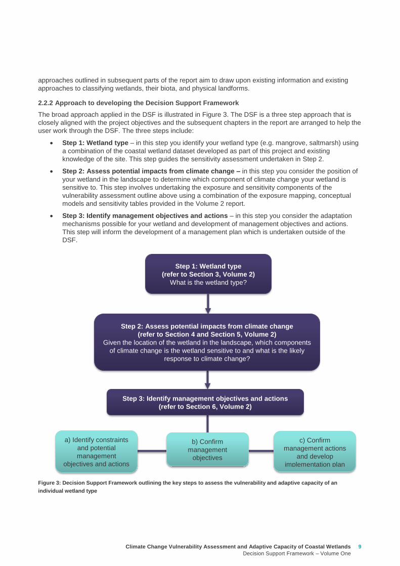
Climate Change Vulnerability Assessment and Adaptive Capacity of Coastal Wetlands
Decision Support Framework ndash Volume One
9
approaches outlined in subsequent parts of the report aim to draw upon existing information and existing
approaches to classifying wetlands their biota and physical landforms
222 Approach to developing the Decision Support Framework
The broad approach applied in the DSF is illustrated in Figure 3 The DSF is a three step approach that is
closely aligned with the project objectives and the subsequent chapters in the report are arranged to help the
user work through the DSF The three steps include
Step 1 Wetland type ndash in this step you identify your wetland type (eg mangrove saltmarsh) using
a combination of the coastal wetland dataset developed as part of this project and existing
knowledge of the site This step guides the sensitivity assessment undertaken in Step 2
Step 2 Assess potential impacts from climate change ndash in this step you consider the position of
your wetland in the landscape to determine which component of climate change your wetland is
sensitive to This step involves undertaking the exposure and sensitivity components of the
vulnerability assessment outline above using a combination of the exposure mapping conceptual
models and sensitivity tables provided in the Volume 2 report
Step 3 Identify management objectives and actions ndash in this step you consider the adaptation
mechanisms possible for your wetland and development of management objectives and actions
This step will inform the development of a management plan which is undertaken outside of the
DSF
Figure 3 Decision Support Framework outlining the key steps to assess the vulnerability and adaptive capacity of an
individual wetland type
Step 1 Wetland type
(refer to Section 3 Volume 2)
What is the wetland type
Step 2 Assess potential impacts from climate change
(refer to Section 4 and Section 5 Volume 2)
Given the location of the wetland in the landscape which components
of climate change is the wetland sensitive to and what is the likely
response to climate change
Step 3 Identify management objectives and actions
(refer to Section 6 Volume 2)
a) Identify constraints
and potential
management
objectives and actions
b) Confirm
management
objectives
c) Confirm
management actions
and develop
implementation plan
10 Climate Change Vulnerability Assessment and Adaptive Capacity of Coastal Wetlands
Decision Support Framework ndash Volume One
The following sections provide guidance on undertaking the three steps (Figure 3) to assess the vulnerability
and adaptive capacity of coastal wetlands to the impacts of climate change and the development of
management objectives and actions to manage the impacts of climate change both at an individual wetland
type scale and a landscape scale
A DSF template was also developed as part of this project to allow wetland planners and managers to work
through the DSF in a step by step process The template provides a consistent and concise approach to
identifying wetland types their vulnerability and adaptive capacity to climate change and developing agreed
set of management objectives and actions that can be adopted for the wetland This template could also be
used to support existing management plans or as the basis for the development of one The DSF is provided
in a booklet in Appendix C A case study of the application of the DSF was undertaken for the Powlett
Estuary and is provided in Appendix D and discussed in Section 4 This case study has also been applied in
Section 31 to Section 33 to provide examples of how each step of the DSF is completed
31 Step 1 ndash How to identify your wetland type
In this step you identify your wetland type This will guide the sensitivity component of the risk assessment
because different types of coastal wetlands will respond in different ways to different climate change
components and to the different drivers these components generate
1 Using the coastal wetland dataset (geospatial database) for Victoria generated as part of this project
(refer to Section 25 of Volume Two) determine at your selected site
a) The wetland category the wetland belongs to (eg marine embayment estuarine coastal floodplain
etc) (refer to Section 24 of Volume Two for detailed description of categories)
b) The wetland typeEVC group the wetland belongs to (eg mangroves saltmarsh freshwater
wetland estuary)
2 Confirm the wetland typeEVC group during either a site visit or with existing literature or local site
knowledge Descriptions of individual wetland categories and types are provided in Section 23 and
Section 24 of Volume Two and can be used an additional source of information to confirm the wetland
typeEVC
3 If your wetland type is an estuary search your location on the interactive map on the Oz Coasts website
(httpwwwozcoastsgovausearch_datamap_searchjsp) to determine its classification (eg wave
dominated or tide dominated) and sub-classification (eg wave tide dominated delta or estuary coastal
lagoon strandplain tidal flat creek) Using local knowledge determine the estuaries geomorphology
(eg permanently opened permanently closed or intermittently opened) This information is important to
capture in the DSF because the function of an estuary varies between the different classifications and
geomorphology and this is important when considering the impacts of climate change For example in
the case of the Powlett River if the estuary was permanently closed then that may help mitigate some of
impact of sea level However if the estuary was to shift to a permanently open estuary then the ecology
of the estuary and associated wetlands would change due to the impacts of sea level rise
It is important to note that at some sites there might be multiple wetland typesEVC groups that make up a
wetland In this case the risk assessment should be undertaken at a landscape scale and all wetland
typesEVC groups identified at the site should be considered when assessing the impacts of potential climate
change components (Step 2) and identifying management objectives and actions for the site (Step 3)
3 Decision Support Framework user guide
Climate Change Vulnerability Assessment and Adaptive Capacity of Coastal Wetlands
Decision Support Framework ndash Volume One
11
32 Step 2 ndash How to determine the potential impacts from climate change on your wetland
In this step you consider the position of your wetland in the landscape to determine which components of
climate change your wetland is sensitive to The outcomes of this step will determine the requirement of a
management or adaptation plan for the wetland and if so help guide the identification of management
objectives and actions (Step 3)
1 Identify the climate change scenario RCP (45 and 85) and timeframe (2050 2070 2090) (see Section
333 in Volume Two) which will be used to inform management of your wetland Multiple RCPs and
timeframes can be used in this process for example consider medium case (ie RCP 45) and worst
case (ie Business as usual RCP 85) scenarios There are also short term and long term management
timeframes that need to be considered for example to inform when to bring forward or delay certain
actions based on which climate change outcomes become most obvious or likely
2 Using the maps of exposure of climate change components to coastal wetlands in Victoria generated as
part of this project (refer to Section 334 in Volume Two) for the RCPs and timeframes selected identify
those components of climate change that your wetland is exposed
a) Sea level rise ndash any wetland within the area of coastal inundation boundary (Appendix F of Volume
Two)
b) Increased carbon dioxide concentration - all wetlands will be exposed to the carbon dioxide
concentration component of climate change and therefore no map is provided as part of this project
c) Altered rainfall ndash consider the likely effects of predicted change in rainfall (Appendix F of Volume
Two)
d) Increased temperature - consider the likely effects of predicted change in temperature Appendix F of
Volume Two)
3 For each climate change component note the magnitude of change predicted under the climate change
scenario(s) selected at a site specific scale for example
a) Sea level rise ndash examine the coastal inundation mapping at your wetland site or alternatively use
DELWPrsquos Coastal Inundation dataset (available at wwwdatavicgovau) to produce your own
mapping (see case study application in Appendix D)Separate maps can be produced for sea level
rise and storm surges
b) Increased carbon dioxide concentration ndash no information is available to make predictions of the
magnitude of change at a site specific scale
c) Altered rainfall ndash examine details of the magnitude of change (mean surface temperature change)
predicted for the site Section 332 of Volume Two Also document any seasonal changes predicted
(also see Section 332 of Volume Two)
d) Increased temperature - examine details of the magnitude of change in rainfall predicted for the site
Section 332 of Volume Two Also document any seasonal changes predicted (also see Section
332 of Volume Two)
4 Under each climate change copmonent listed in the DSF populate the sensitivity ranking (positive
negative and neutral) for those climate change components to which you wetland is exposed to The
sensitivity of the wetland type to the climate change component will be based on the rankings provided in
Appendix A of this report and Section 42 of Volume Two If multiple wetland typesEVC groups are
identified at the site (see DSF step in Section 31) then separate sensitivity rankings should be populated
for each wetland typeEVC group For example see Powlett River Estuary sensitivity analysis in Table 1
12 Climate Change Vulnerability Assessment and Adaptive Capacity of Coastal Wetlands
Decision Support Framework ndash Volume One
Table 1 Sensitivity analysis for Powlett River Estuary
5 Based on the conceptual models for each climate change component provided in Section 41 of Volume
Two and the adaptive capacity summary provided in Section 43 of Volume Two populate the likely
outcome of climate change for the wetland type A summary of the likely outcomes of climate change for
coastal wetlands is provided below (Table 2)
Table 2 Summary of the likely outcome of climate change for coastal wetlands
Climate change component Estuary Saltmarsh Estuarine
Wetland
Swamp
scrub
Swampy
riparian
woodland
Sea level rise and storm surge
Chronic salinisation Neutral Positive Neutral Negative Negative
Episodic salinisation Negative Negative Negative Negative Negative
Erosion shoreline recession Negative Negative Negative Negative Negative
Increased carbon dioxide concentration
Altered C3 and C4 relationship Neutral Negative Neutral Neutral Neutral
Carbonate dissolution Neutral Neutral Neutral Neutral Neutral
Decreased rainfall
Chronic salinisation Neutral Positive Neutral Negative Negative
Increased air temperature
Phonological impacts altered primary productivity Positive Positive Positive Positive Positive
Increased water temperature
Phonological impacts altered primary productivity Neutral Neutral Neutral Neutral Neutral
Climate change
component Likely outcomes for coastal wetland
Increased sea
level and storm
surge
More permanent inundation or increased frequency and duration of inundation of wetlands
Change in salinity and water regime in wetlands due to saline intrusion
Changes in vegetation distribution along the elevational gradient from the sea with possible
landward migration
Conversion of currently intertidal seagrass beds to subtidal systems and an increase in
depth of subtidal systems
Replacement of areas currently vegetated with saltmarshes by more inundation-tolerant
mangroves
Replacement of areas currently vegetated with glycophytic (eg Phragmites australis) or
brackish-water plants (eg Melaleuca ericifolia) by saltmarshes
Changes in the floristic distribution of saltmarsh taxa along the elevational gradient from
the sea
Excessive sedimentation and erosion along shoreline impacts mangroves and coastal saltmarsh
effects can occur at both the establishment phase of young plants and adult plants
Changes in distribution of plant propagules via altered currents and tidal patterns
Breakage of young plants by wind or waves during their establishment
Modification of patterns and rates of coastal sedimentation and erosion affecting the area
suitable for mangrove or saltmarsh colonisation
Geomorphic changes to estuary mouth and coastal barriers dunes due to sea level rise and
storm surges (eg increased rates of erosion)
Saline intrusion into the upper estuary and lower freshwater reaches of the rivers due to
increased sea levels and storm surge activity Causes rise in saline conditions along riparian
zone
Saline intrusion into groundwater results in a changed wetland environment
Climate Change Vulnerability Assessment and Adaptive Capacity of Coastal Wetlands
Decision Support Framework ndash Volume One
13
For example the estuary and saltmarsh wetlands of the Powlett River Estuary have the following likely
outcome
Estuary
Potential in change from intermittently open estuary mouth to permanently opened or permanently
closed estuaryndash may become more similar to Andersons Inlet
Saline intrusion into the upper estuary and lower freshwater reaches of the river due to increased
sea levels and storm surge activity and reduced rainfall
Saline intrusion into groundwater results in a changed species composition year round
Saltmarsh
Permanent inundation or increased frequency and duration of inundation
Change in salinity and water regime
Changes in its distribution along the elevational gradient from the sea (migrates landwards)
Possible invasion by mangroves if geomorphic changes result in a more permanent estuary opening
Increased pressure from weed invasion
Increased
carbon dioxide
concentration
Competitive interactions between plants will be affected C3 plants will be advantaged (eg
mangroves and most but not all saltmash plants and mangroves)
Acidification of coastal waters causing major impacts on phytoplankton and possibly on
submerged angiosperms such as seagrasses Aquatic organisms that build calcareous or
carbonate shells from aragonite (eg crustaceans) and some macroalgae that have calcified
tissues may also be affected
Increased pressure from weed invasion
Decreased
rainfall
Change in water and salinity regime due to reduced freshwater inflows decreased rainfall and
increased flooding causing longer periods between freshwater inundation and development of
hypersaline conditions
Replacement of areas of coastal wetlands currently vegetated with glycophytic (eg Phragmites
australis) or brackish-water plants (eg Melaleuca ericifoia) by saltmarshes as a result of
increased salinity
Changes in primary productivity and distributions of mangrove communities probably towards
increased vigour and a wider distribution
Modification of patterns and rates of coastal sedimentation and erosion with effects on the area
suitable for mangrove or saltmarsh colonisation
Saline intrusion into groundwater due to reduced groundwater recharge results in a changed
wetland environment
Saline intrusion into the upper estuary and lower freshwater reaches of the river due to reduced
rainfallcatchment runoff
Increased pressure from weed invasion
Increased
temperature
Impacts on flowering and germination of plants and the breeding success of invertebrates fish
and birds
Disruption of life histories of stenothermal invertebrates and fish with consequences for growth
mortality and secondary productivity
Increased rates of primary production by saltmarshes and mangroves unless other factors (eg
hypersalinity lowered nutrient availability etc) intervene
Changes in primary productivity and distributions of mangrove communities probably towards
increased vigour and a wider distribution
Change in water and salinity regime due to increased evaporation losses causing reduction in
permanence and an increase in ephemerality in coast wetlands
Increased pressure from weed invasion
14 Climate Change Vulnerability Assessment and Adaptive Capacity of Coastal Wetlands
Decision Support Framework ndash Volume One
Saltmarsh are C3 plants so potentially advantaged by increases in atmospheric CO2 concentrations
Increased pressure from weed invasion
Saline intrusion into groundwater results in a changed species composition year round
6 Based on the main adaptive mechanisms and the main factors limiting adaptive capacity of your wetland
(summary table provided in Appendix B and further detail contained in Section 43 of Volume Two)
populate the table to reflect the likely adaptive capacity of your wetland type to climate change For
example see analysis on the Powlett River Estuary adaptive capacity in Table 3
Table 3 Adaptive capacity of Powlett River Estuary
Based on your knowledge of the wetland and its site specific characteristics (eg presence of barriers for
migration) specific assessments of opportunities and constraints to adaptive capacity can also be
undertaken to further inform this part of the DSF
33 Step 3 ndash What are your management objective and actions for the site
In this step you consider the adaptation mechanisms possible for your wetland and develop management
objectives and actions The outcomes of this step will inform the development of management and
implementation plans which would be undertaken outside of the DSF
1 Identify the constraints to management for the site which may include barriers to migration land
ownership available funding and knowledge and data availability (see Section 51 of Volume Two) For
example the Powlett River Estuary has the following likely management constraints
Barriers to migration
Powlett Road may restrict inland migration
Rail trail towards Dayleston may restrict inland migration
Small cluster of housing north east of the Estuary mouth may restrict inland migration
Land ownership
The land in which wetlands could migrate in to is predominately private land used for agriculture
(grazing and cropping)
Funding
Limited funding available ndash not currently a priority site for intervention
Wetland
type
Adaptive
capacity Main adaptive mechanism Main limiting factors
Saltmarsh Low Sediment accretion movement
to higher elevations positive
response to increase
temperature (variable responses
to increased CO2)
Rate of sea level rise storm
surge intensity and shoreline
erosion seawalls and other
physical impediments impact of
increased atmospheric CO2
impacts on floristic composition
Estuarine
wetland
Moderate Positive response to
temperature neutral to most
other impacts until sea levels
make the sites intertidal
Salinisation and waterlogging
due to storm surges
Swamp
scrub
Low Positive response to
temperature
Salinisation and waterlogging
(ie changes to wetting and
drying regimes)
Swampy
Riparian
woodland
Low Positive response to
temperature
Salinisation and waterlogging
(ie changes to wetting and
drying regimes)
Climate Change Vulnerability Assessment and Adaptive Capacity of Coastal Wetlands
Decision Support Framework ndash Volume One
15
Whilst there is good collaboration between agencies and landholders there are different priorities for
the funding available and therefore so some actions are difficult to agree to
Limitations to knowledge and data
What geomorphic changes to the estuary mouth are likely to occur as a result of climate change (ie
changes in estuary dynamics)
Understanding the economic value of the estuary and coastal wetlands (eg value of wetlands
versus the value of agricultural land)
What happens to Acid Sulfate Soils as a result of climate change
Other potential constraints
Current State policies and procedures for statutory planning changes and land purchase to enable
long term change in land use
Community understanding and expectation around estuary opening and closing
2 Taking into consideration the main constraints to management of the site develop and document in
consultation with relevant agencies and community stakeholders a management objective for the site in
regards to climate change adaptation using the broad management objectives provided in Table 4
(further discussed in Section 52 of Volume Two)
Table 4 Decision Support Framework ndash broad management objectives
Broad Management Objectives
1 Savemaintain existing wetland in current position
2 Facilitate landward migration of existing wetland type
3 Facilitate transition to new wetland type in current location
4 No intervention
It is also important to consider wetland values current threats to the wetland local and regional
objectives and adjacent habitat typeszones wetland buffer zones and transition zone between wetland
and terrestrial habitats (further detail on these considerations provided in Section 52 of Volume Two)
For example based on the pre-existing management objectives for the Powlett River Estuary the site
could have the following management objective
To enhance and significantly increase Swamp scrub Swampy riparian woodland and estuarine wetland
vegetation communities through the facilitation of landward migration
Combinations of the management objectives listed above may also be identified across a range of time
scales in response to the degree of exposure of the wetland to the components of climate change (ie
scenario planning) this is further discussed in Section 52 of Volume Two
3 Based on the management objective identified any pre-existing management actions and the
management actions provided in Section 53 of Volume Two (summary provided in Table 5 below) select
the most appropriatefeasible management actions to enable objectives to be achieved
The development of objectives and actions is iterative and requires consideration of constraints and
assessment of the feasibility of management options Hence this step may require an evaluation of a
range of actions to identify those that are most feasible and likely to enable objectives to be met If it
turns out actions are not feasible then objectives may need to be reviewed
Monitoring is a critical part of all actions because it is used to inform timing of implementation and
adaptive management For example the landward migration of the wetland will take many years and so
some actions may not be required until landward movement has commenced or reached a certain
extent or may not be needed at all if monitoring reveals that the climate change component does not
manifest at that location Other actions may require immediate implementation even though the benefits
of that actions may not be realised until some time in the future (eg land use planning rules or land
16 Climate Change Vulnerability Assessment and Adaptive Capacity of Coastal Wetlands
Decision Support Framework ndash Volume One
acquisition may be required now so that space is available in future years when climate change
components manifest themselves)
Table 5 Decision Support Framework ndash how management actions relate to various management objectives
The suite of actions and timing of implementation are very much siteregion specific For example the
following management actions (new and adaption of existing management actions in place for the site)
could be set for the Powlett River Estuary
Table 6 Decision Support Framework ndash example management actions for the Powlett River Estuary
Management Actions
Save maintain
existing wetland in
current position
Facilitate landward
migration of existing
wetland type
Facilitate
transition to new
wetland type in
current location
No
intervention
Influence private land
management -
Land acquisition planning - - -
Active revegetation -
Invasive species control -
New infrastructure on
seaward side of wetland - - -
Infrastructure removal
modification on landward
side of wetland - - -
Education and community
engagement -
Fire Management - - -
Management Action Timeframe Responsibility
Complete a study to assess the likely geomorphic changes to the estuary as
a result of climate change
2 years WGCMA
Undertake scenario planning - refine management actions and objectives for
Estuary based on finding of geomorphic study This could identify nearby
systems that could form a template for what Powlett River might look like in
the future (eg Andersons Inlet)
2-5 years WGCMA
Review Bass Coast Planning Scheme to understand any implications to
future management actions works at the Powlett Estuary Provide feedback
to the State Government on any issues associated with State policies and
procedures for statutory planning that may constrain long term management
of the Estuary
2-5 years WGCMA
Resolve issues and complexities around the impacts of climate change (sea
level rise) on crown land boundaries
2-5 years State
Government
Resolve issues associated with State policies and procedures for statutory
planning that may constrain long term management of the Estuary
2-5 years State
Government
Estuary Management Plan Action E31 (see above) ndash to become 2 actions
a Investigate opportunities for land purchase within the current inundation
areas of the estuary
8 years WGCMA
Climate Change Vulnerability Assessment and Adaptive Capacity of Coastal Wetlands
Decision Support Framework ndash Volume One
17
4 Following the identification of objectives and actions the last step is to develop a management plan (or
update existing plan) that provides the specific details around actions responsibilities monitoring and
timeframes for implementation
b Investigate opportunities for land purchase within the future inundation
areas of the estuary
Estuary Management Plan Action E32 (see above) ndash include
consideration of future inundation eg ldquoDesign and implement a program of
stewardship payment for the seasonal inundation of estuary floodplain from
estuary mouth closures under both current and future inundation conditionsrdquo
8 years WGCMA
Estuary Management Plan Action E 39 (see above) ndash to become 2 actions
a Investigate opportunities to encourage the conversion of current Crown
land water frontage grazing licences to riparian management licences
b Investigate issues and opportunities related to sea level rise impacts on
Crown Land Water frontage grazing licences and riparian management
licences (including how to define boundaries if existing boundaries are
inundated by sea level rise)
8 years WGCMA
Estuary Management Plan Action E44 (see above) ndash Undertake detailed
risk assessment of potential and active acid sulfate soils
8 years WGCMA
Estuary Management Plan Action E49 (see above) ndash Continue to build
understanding of and plan for risks associated with climate change
8 years WGCMA
18 Climate Change Vulnerability Assessment and Adaptive Capacity of Coastal Wetlands
Decision Support Framework ndash Volume One
In order to provide validation that the DSF can provide an assessment of the vulnerability and adaptive
capacity of a coastal wetland in Victoria to the impacts of climate change and guidance to wetland managers
on potential management objectives and actions for those coastal wetland systems likely to be affected by
climate change the DSF was applied to a case study wetland in Victoria
The case study wetland was selected by DELWP from a list of potential wetlands provided by the wetland
managers from the working group established as part of the project Wetland managers included
representatives from the DELWP Parks Victoria West Gippsland Catchment Management Authority (CMA)
East Gippsland CMA Port Phillip and Westernport CMA Glenelg Hopkins CMA and Corangamite CMA
The wetland selected was the Powlett River Estuary in the West Gippsland CMA region This decision was
based on existing information available for the site (an existing estuary management plan was available) its
value (listed as a Nationally Important Wetland and a habitat for the critically endangered Orange-bellied
Parrot) and that the site provided a good balance between covering a number of different coastal wetland
types (estuary saltmarsh riparian scrub estuarine wetland heathlands and woodlands) but without being
too complex and large
Consultation with West Gippsland CMA was undertaken throughout the case study application to ensure that
local knowledge was incorporated and so that the wetland manager could provide input to setting the
wetland management objectives and actions The completed application of the DSF for the Powlett River
Estuary is provided in Appendix D
Through the case study application it became apparent that Step 1 (wetland type) could be largely
completed by applying local knowledge of the wetland ecosystems found within the site Step 2 (assess the
potential impacts from climate change) however requires more technical knowledge of the wetlands
sensitivity and adaptive capacity to climate change and therefore requires close consultation with the
supporting technical information contained in Volume 2 Volume 2 provides enough information for a wetland
manager with limited climate change knowledge to complete this component of the DSF Step 3 is then a
combination of applying local knowledge to set management objectives and then using a combination of
local knowledge and the supporting technical information contained in Volume 2 to develop management
actions
The maps included in the case study application use only publically available data (the coastal wetland
dataset developed as part of this project and DELWPs coastal inundation dataset) and their manipulation
and interrogation is well within the GIS capability within the relevant wetland managerrsquos organisations
The case study application of the DSF demonstrated its effectiveness at providing a framework for assessing
potential impacts from climate change on Victorian coastal wetlands and will be a useful tool for assisting
wetland managers to 1) understand and 2) develop objectives and actions for managing coastal wetlands in
response to a changing climate
4 Case study application
Climate Change Vulnerability Assessment and Adaptive Capacity of Coastal Wetlands
Decision Support Framework ndash Volume One
19
Barbier EB Hacker SD Kennedy C Koch EW Stier AC amp Silliman BR (2011) The value of estuarine and
coastal ecosystem services Ecological Monographs 81169-93
Boon PI (2012) Coastal wetlands of temperate eastern Australia will Cinderella ever go to the ball Marine
and Freshwater Research 63 845-855
Boon PI Allen T Carr G Frood D Harty C McMahon A Mathews S Rosengren N Sinclair S White M amp
Yugovic J (2015a) Coastal wetlands of Victoria south-eastern Australia providing the inventory and
condition information needed for their effective management and conservation Aquatic Conservation Marine
and Freshwater Ecosystems 25 454-479
Costanza R de Groot R Sutton P van der Ploeg S Anderson SJ Kubiszewski I et al (2014) Changes in
the global value of ecosystem services Global Environmental Change 26152-8
Creighton C Boon PI Sheaves M amp Brookes J (2015) Revitalising Australiarsquos estuaries ndash what benefits at
what cost Marine and Freshwater Research 66 493-507
CSIRO and BOM (2015a) Southern slopes cluster report Climate change in Australia projections for
Australiarsquos natural resource management regions Full Report CSIRO and Bureau of Meteorology
Canberra Available on-line at httpwwwclimatechangeinaustraliagovauenimpacts-and-adaptationnrm-
regions
CSIRO and BOM (2015b) Climate change in Australia Projections for Australias NRM regions Southern
slopes Summary report CSIRO and Bureau of Meteorology Canberra Available on-line at
httpwwwclimatechangeinaustraliagovauenimpacts-and-adaptationnrm-regions
Finlayson CM Davis JA Gell PA Kingsford RT and Parton KA (2013) The status of wetlands and the
predicted effects of climate global climate change the situation in Australia Aquatic Sciences 75 73-93
Friess DA Krauss KW Horstman EM Balke T Bouma TJ Galli D amp Webb EL (2012) Are all intertidal
wetlands naturally created equal Bottlenecks thresholds and knowledge gaps to mangrove and saltmarsh
ecosystems Biological Reviews 87 346-366
Gilman EL Ellison J Duke NC amp Field C (2008) Threats to mangroves from climate change and adaptation
options a review Aquatic Botany 89 237-250
Johnston EM Hedge LH and Mayer-Pinto M (2015) The urgent need to understand port and harbour
ecosystems Marine and Freshwater Research 66 i-ii
Morton RM (1990) Community structure density and standing crop of fishes in a subtropical Australian
mangrove area Marine Biology 105 385-94
Morris L (2013) Chapter 2 Implications of future climate change for seagrass and soft sediments In
Implications of future climate change for Victorians marine environments Eds Klemke J amp Arundel H Report
to Glenelg Hopkins CMA
Nielsen D and M Brock 2009 Modified water regime and salinity as a consequence of climate change
prospects for wetlands of Southern Australia Climatic Change 95523-533
Osland MJ Enwright NM Day RH Gabler CA Stagg CL and Grace JB (2016) Beyond just sea-level rises
considering macroclimatic drivers within coastal wetland vulnerability assessments to climate change Global
Change Biology 22 1-11
Prahalad VN Kirkpatrick JB amp Mount RE (2011) Tasmanian coastal saltmarsh community transitions
associated with climate change and relative sea level rise 1975minus2009 Australian Journal of Botany 59 741-
748
SKM (2013) Indicative Assessment of Climate Change Vulnerability for Wetlands in Victoria Report
prepared for Department of Sustainability and Environment (now DELWP)
Zann LP amp Dutton I (2000) The social values and perceptions of Australians concerning the marine
environment In State of the Environment Report for Australia Technical summary Edited by LP Zann
Pages 127-134 Ocean Rescue 2000 amp Department of the Environment Sport and Territories Canberra
5 References
20 Climate Change Vulnerability Assessment and Adaptive Capacity of Coastal Wetlands
Decision Support Framework ndash Volume One
Wetland Type and corresponding EVC
group
Climate change components and ecological consequences
Increased Sea level and storm surges Increased carbon dioxide
concentration
Decreased rainfall Higher air
temperature
Higher water
temperature
Chronic
salinisation
Episodic
salinisation
Erosion
shoreline
recession
Altered C3
and C4
relationship
Carbonate
dissolution
Chronic
salinisation
Altered
sediment
load
Phenological
impacts
altered primary
productivity
Phenological
impacts altered
primary
productivity
Marine
Embayment
Mangrove Positive Neutral to
Negative
Negative Positive Neutral Positive Positive Positive Neutral
Seagrass (not mapped) Positive Negative Neutral Neutral Positive Positive Negative Positive Positive
Saltmarsh Positive Negative Negative Negative Neutral Positive Positive Positive Neutral
Estuarine -
Intertidal
Mangrove Positive Neutral to
Negative
Negative Positive Neutral Positive Positive Positive Neutral
Saltmarsh Positive Negative Negative Negative Neutral Positive Positive Positive Neutral
Estuarine -
supratidal
Heathlands Neutral Neutral Negative Neutral Neutral Neutral Neutral Positive Neutral
Herb-rich woodlands Neutral Neutral Negative Neutral Neutral Neutral Neutral Positive Neutral
Coastal scrubs and
woodlands
Neutral Neutral Negative Neutral Neutral Neutral Neutral Positive Neutral
Wetland - estuarine semi-
permanent saline
Neutral Negative Negative Neutral Neutral Neutral Positive Positive Neutral
Coastal
floodplain
Riparian scrubs or
swampy scrubs and
woodlands
Negative Negative Negative Neutral Neutral Negative Positive Positive Neutral
Coastal brackish wetlands Negative Negative Negative Neutral Neutral Negative Positive Positive Neutral
Freshwater wetlands Negative Negative Negative Neutral Neutral Negative Positive Positive Neutral
Dune
systems
Freshwater wetlands Neutral Neutral Negative Neutral Neutral Neutral Neutral Positive Neutral
Appendix A Sensitivity tables
Climate Change Vulnerability Assessment and Adaptive Capacity of Coastal Wetlands
Decision Support Framework ndash Volume One
21
1 where adaptive capacity is unknown data gaps limit the ability to make clear assessment of adaptive capacity
Appendix B Adaptive capacity of wetland types
Wetland Type Adaptive
capacity1 Main adaptive mechanism Main limiting factor to
adaptation
Marine
Embayment
estuarine -
intertidal
Mangrove Adaptable Sediment accretion movement to higher
elevations positive response to increased temperature and increased atmospheric CO2
Rate of sea-level rise storm surge intensity and shoreline erosion seawalls and other
physical impediments
Seagrass (not mapped)
Adaptable Positive response to increased salinity
Storm surge intensity smothering by catchment-
derived sediments reductions in underwater light fields
consequent to catchment-associated processes
Saltmarsh Adaptable Sediment accretion movement to higher
elevations positive response to increased temperature
(Variable responses to increased CO2)
Rate of sea-level rise storm surge intensity and shoreline erosion seawalls and other
physical impediments impacts of increased atmospheric CO2
impacts on floristic composition
Estuarine ndash
supratidal
Heathlands Unknown Positive response to temperature neutral to most other impacts until sea levels
make the sites intertidal
Salinisation and waterlogging due to storm surge
Herb-rich woodlands
Unknown Positive response to temperature neutral to most other impacts until sea levels
make the sites intertidal
Salinisation and waterlogging due to storm surge
Coastal scrubs and woodlands
Unknown Positive response to temperature neutral to most other impacts until sea levels
make the sites intertidal
Salinisation and waterlogging due to storm surge
Wetland - estuarine semi-permanent saline
Unknown Positive response to temperature neutral to most other impacts until sea levels
make the sites intertidal
Salinisation and waterlogging due to storm surge
Coastal
floodplain
Riparian scrubs or swampy scrubs and woodlands
Non-adaptable
Positive response to temperature
Salinisation and waterlogging (ie changes to wetting and
drying regimes)
Coastal brackish wetlands
Non-adaptable
Positive response to temperature
Salinisation and waterlogging (ie changes to wetting and
drying regimes)
Freshwater wetlands
Non-adaptable
Positive response to temperature
Salinisation and changes to wetting and drying regimes
Dune systems
Freshwater wetlands
Unknown Positive response to temperature neutral to most
other impacts
Physical loss of habitat salinisation possible changes to
wetting and drying regimes
22 Climate Change Vulnerability Assessment and Adaptive Capacity of Coastal Wetlands
Decision Support Framework ndash Volume One
Appendix C Decision Support Framework template
Climate Change Vulnerability Assessment and Adaptive Capacity of Coastal Wetlands
Decision Support Framework ndash Volume One
23
Coastal Wetlands and Climate Change
Decision Support Framework
Site Name Insert wetland name
Purpose
This document provides a Decision Support Framework to enable wetland managers to assess the
vulnerability and adaptive capacity of wetlands to climate change at an individual wetland or local landscape
scale The DELWP Climate Change Vulnerability Assessment and Adaptive Capacity of Coastal Wetlands
report provides the background and supporting material for this assessment and should be used in
conjunction with each stage of the assessment process outlined below
The broad approach applied in the Decision Support Framework is illustrated below It is a three step
approach that includes
Step 1 Wetland type ndash in this step you identify your wetland type (eg mangrove saltmarsh) using
a combination of the coastal wetland dataset developed as part of this project and your existing
knowledge of the site This step guides the sensitivity assessment undertaken in step 2
Step 2 Assess potential impacts from climate change ndash in this step you consider the position of
your wetland in the landscape so you can determine which component of climate change the
wetland is most sensitive to This step involves undertaking the exposure and sensitivity
components of the vulnerability assessment outlined above using the exposure mapping the
conceptual models and the sensitivity tables provided in the supporting documents
Step 3 Identify management objectives and actions ndash in this step you consider the adaptation
mechanisms possible for your wetland and develop management objectives and actions This step
will inform the development of a management plan which is undertaken outside of the DSF
Step 2 Assess potential impacts from climate change
(refer to Section 4 and Section 5 Volume 2)
Given the location of the wetland in the landscape which components of climate change is the
wetland sensitive to and what is the likely response to climate change
Step 3 Identify management objectives and actions
(refer to Section 6 Volume 2)
a) Identify constraints and
potential management
objectives and actions
b) Confirm
management
objectives
c) Confirm management
actions and develop
implementation plan
Step 1 Wetland type
(refer to Section 3 Volume 2)
What is the wetland type
24 Climate Change Vulnerability Assessment and Adaptive Capacity of Coastal Wetlands
Decision Support Framework ndash Volume One
Decision Support Framework
1 Wetland identification (Section 2 Volume Two)
Name Insert wetland name
Location address Insert generic location description
Easting Northing
Bioregion Refer to httpwwwdepivicgovauenvironment-and-wildlifebiodiversityevc-benchmarks
Wetland category
(Section 24 Volume
Two)
Tidal wetlands
Marine embayment
Estuarine (intertidal)
Estuarine (supratidal)
Non-tidal wetland
Coastal floodplain
Dune system
Wetland type EVC
group(s)
(Section 23 Volume
Two and supporting
geospatial dataset)
Seagrass
Saltmarsh
Mangroves
Brackish wetland
Freshwater wetland (floodplain)
Freshwater wetland (dune)
Riparian swampy scrub
Estuarine wetland
Estuarine scrubs heathlands and
woodlands
Estuary classification
(if relevant)
httpwwwozcoastsgov
ausearch_datamap_se
archjsp
Classification
Wave dominated
Sub-classification
Wave dominated delta
Tide dominated delta
Wave dominated estuary
Tide dominated estuary
Tide dominated
Coastal lagoon
Strandplain
Tidal flat creek
Other
Estuary
geomorphology (if
relevant)
Permanently open
Permanently closed
Intermittently opened and closed
Wetland values See Section 44 of Volume Two for more detail
Climate Change Vulnerability Assessment and Adaptive Capacity of Coastal Wetlands
Decision Support Framework ndash Volume One
25
Decision Support Framework
Decision Support Framework
Insert location map including location of individual wetland EVC types
26 Climate Change Vulnerability Assessment and Adaptive Capacity of Coastal Wetlands
Decision Support Framework ndash Volume One
Decision Support Framework
2 Potential impacts from climate change to the wetland (Section 4 Volume Two)
What is the
climate change
scenario
timeframe
Select climate change scenario timeframe detailed in Section 333 of Volume 2
Given the
position of the
wetland in the
landscape how
exposed is the
wetland to sea
level rise and
storm surge
climate change
components
Insert exposure map for sea level rise and storm surges (See Appendix F of Volume Two Coastal Inundation
dataset is publically available at wwwdatavicgovau)
Sea level rise
Storm surges
Climate Change Vulnerability Assessment and Adaptive Capacity of Coastal Wetlands
Decision Support Framework ndash Volume One
27
Decision Support Framework
Decision Support Framework
Site specific
infrastructure
dynamics that
would influence
the impact from
sea level rise
and storm
surges
Identify any specific infrastructure dynamics that may increase or decrease the impact from sea level rise
and storm surges (eg presence of artificial barriers to restrict seawater intrusion)
Given the
position of the
wetland in the
landscape how
exposed is the
wetland to
temperature and
rainfall climate
change
components
Insert climate change projections for temperature and rainfall based on current CSIRO-BOM (2015)
modelling provided in Section 332 of Volume Two
Temperature
Based on CSIRO-BOM (2015) modelling the following predictions are made in regards to change in
temperature
Magnitude of change
(mean surface temp
change)
Seasonality
Rainfall
Based on CSIRO-BOM (2015) modelling the following predictions are made in regards to change in rainfall
Magnitude of change
(change in rainfall) Seasonality
Wetland
sensitivity
Insert wetland type and sensitivity to climate change components (positive [highlight green] negative
[highlight red] neutral [highlight yellow] NA) provided in Appendix A of Volume One
Climate change component and
impacts on coastal wetlands
Insert
wetland
type
Insert
wetland
type
Insert
wetland
type
Insert
wetland
type
Sea level
Chronic salinisation
Episodic salinisation
Erosion shoreline recession
Carbon dioxide
Altered C3 and C4 relationship
Carbonate dissolution
Rainfall
Chronic salinisation
Temperature (air)
Phenological impacts altered primary
productivity
Temperature (water)
Phenological impacts altered primary
productivity
Positive = positive response to climate change negative = negative response to climate change neutral =
unlikely to have any response to climate change NA = not exposed
28 Climate Change Vulnerability Assessment and Adaptive Capacity of Coastal Wetlands
Decision Support Framework ndash Volume One
Decision Support Framework
Likely outcome Based on the Table 2 in Section 32 of Volume One and the conceptual models presented in Section 41 of
Volume Two
Adaptive
capacity
General adaptive capacity of wetland types present
Describe based on the conceptual models presented in Section 41 of Volume Two and populated table
based on table provided in Section 43 of Volume Two
Wetland
type
Adaptive
capacity Main adaptive mechanism Main limiting factor
Site specific adaptive capacity
Need to consider site specific opportunities and constraints to adaptive capacity based on site specific
characteristics
3 Management objectives and actions (Section 5 of Volume Two)
Constraints to
management
See Section 51 of Volume Two report for more detail
Barriers to migration
Land ownership
Funding
Limitations to knowledge and data
Other potential constraints
Pre-existing threats Identify pre-existing threats that may impact the wetlands capacity to cope with change
Pre-existing
management
objectives
Document local and regional management objectives in pre-existing management plans and
strategies
Proposed management
objective in relation to
climate change
Based on wetland values and existing objectives define the management objective for the wetland in
relation to climate change See Section 52 of Volume Two for more detail
Climate Change Vulnerability Assessment and Adaptive Capacity of Coastal Wetlands
Decision Support Framework ndash Volume One
29
Decision Support Framework
Decision Support Framework
Management actions to
address climate
change impacts and
management
objectives
Identify a suite of management actions for the site See Section 53 of Volume Two for more details
May include existing and new management actions
Existing actions
Management Action Timeframe
New actions
Management Action Timeframe Responsibility
4 Recommendations
Identify any recommendations for management of the wetland eg addressing data gaps further investigation required
development of management or implementation plan
5 Key management resource documents
Insert useful resource documents and web links associated with management at the site including but not limited to
1 Peters G Morris K Frood D Papas P and Roberts J (2015) A Guide to managing livestock grazing in Victorias
wetlands Decision framework and guidelines - Version 10 Arthur Rylah Institute for Environmental Research Technical
Report Series Report number 265
2 Morris K and Papas P (2012) Wetland conceptual models associations between wetland values threats and management
interventions Version one Arthur Rylah Institute for Environmental Research Technical Report Series Report number 237
3 DELWP wetland buffers guidelines (in prep)
4 DELWP wetland revegetation guidelines (in prep)
5 DELWP wetland invasive species management guidelines (in prep)
6 SKM (2005) Guidelines for the design and operation of environmentally friendly wetland regulators (MDBC project report
R2002) Report by Sinclair Knight Merz for the MDBC
6 Key references
Insert key reference supporting documents used to populate decision support framework template
Appendix D Decision Support Framework case study application
30 Climate Change Vulnerability Assessment and Adaptive Capacity of Coastal Wetlands
Decision Support Framework ndash Volume One
Climate Change Vulnerability Assessment and Adaptive Capacity of Coastal Wetlands
Decision Support Framework ndash Volume One
31
Coastal Wetlands and Climate Change
Decision Support Framework
Site Name Powlett River Estuary
Purpose
This document provides a Decision Support Framework to enable wetland managers to assess the
vulnerability and adaptive capacity of wetlands to climate change at an individual wetland or local landscape
scale The DELWP Climate Change Vulnerability Assessment and Adaptive Capacity of Coastal Wetlands
report provides the background and supporting material for this assessment and should be used in
conjunction with each stage of the assessment process outlined below
The broad approach applied in the Decision Support Framework is illustrated below It is a three step
approach that includes
Step 1 Wetland type ndash in this step you identify your wetland type (eg mangrove saltmarsh) using
a combination of the coastal wetland dataset developed as part of this project and your existing
knowledge of the site This step guides the sensitivity assessment undertaken in step 2
Step 2 Assess potential impacts from climate change ndash in this step you consider the position of
your wetland in the landscape so you can determine which component of climate change the
wetland is most sensitive to This step involves undertaking the exposure and sensitivity
components of the vulnerability assessment outlined above using the exposure mapping the
conceptual models and the sensitivity tables provided in the supporting documents
Step 3 Identify management objectives and actions ndash in this step you consider the adaptation
mechanisms possible for your wetland and develop management objectives and actions This step
will inform the development of a management plan which is undertaken outside of the DSF
Step 2 Assess potential impacts from climate change
(refer to Section 4 and Section 5 Volume 2)
Given the location of the wetland in the landscape which components of climate change is the
wetland sensitive to and what is the likely response to climate change
Step 3 Identify management objectives and actions
(refer to Section 6 Volume 2)
a) Identify constraints and
potential management
objectives and actions
b) Confirm
management
objectives
c) Confirm management
actions and develop
implementation plan
Step 1 Wetland type
(refer to Section 3 Volume 2)
What is the wetland type
32 Climate Change Vulnerability Assessment and Adaptive Capacity of Coastal Wetlands
Decision Support Framework ndash Volume One
Decision Support Framework
1 Wetland identification (Section 2 Volume Two)
Name Powlett River Estuary
Location address Located in the West Gippsland Catchment Management Authority (CMA) region near the coast
between Kilcunda and Wonthaggi
Easting 370380205 Northing 5728345662
Bioregion Gippsland Plain
Wetland category
(Section 24 Volume
Two)
Tidal wetlands
Marine embayment
Estuarine (intertidal)
Estuarine (supratidal)
Non-tidal wetland
Coastal floodplain
Dune system
Wetland type EVC
group(s)
(Section 23 Volume
Two and supporting
geospatial dataset)
Seagrass
Saltmarsh
Mangroves
Brackish wetland
Freshwater wetland (floodplain)
Freshwater wetland (dune)
Riparian swampy scrub
Estuarine wetland
Estuarine scrubs heathlands and
woodlands
Estuary classification
(if relevant)
httpwwwozcoastsgov
ausearch_datamap_se
archjsp
Classification
Wave dominated
Sub-classification
Wave dominated delta
Tide dominated delta
Wave dominated estuary
Tide dominated estuary
Tide dominated
Coastal lagoon
Strandplain
Tidal flat creek
Other
Estuary
geomorphology (if
relevant)
Permanently open
Permanently closed
Intermittently opened and closed
Climate Change Vulnerability Assessment and Adaptive Capacity of Coastal Wetlands
Decision Support Framework ndash Volume One
33
Decision Support Framework
Decision Support Framework
Wetland values
The Powlett River Estuary has a diverse range of bird plant and fish communities
5 different EVCs including coastal saltmarsh (Coastal Tussock Saltmarsh and Wet Saltmarsh
Herbland) protected under the Environmental Protection and Biodiversity Conservation Act
1999 (EPBC Act)
22 fish species including the Australian Grayling which is listed threatened under the Flora
and Fauna Guarantee Act 1988 (FFG Act) and vulnerable under the EPBC Act
31 State Australian and Internationally listed bird species including the critically endangered
Orange-bellied Parrot (WGCMA 2015)
The Powlett River Estuary also has significant social and economic value
Recreational activities ndash fishing sightseeing swimming walking bird watching picnics etc
Coastal dunes near the mouth of the Estuary have Aboriginal cultural heritage significance
(number of coastal midden sites recorded)
Landholders commonly graze along the river upstream of the Mouth of Powlett Road
Water source for irrigation and stock and domestic water use (WGCMA 2015)
34 Climate Change Vulnerability Assessment and Adaptive Capacity of Coastal Wetlands
Decision Support Framework ndash Volume One
Decision Support Framework
2 Potential impacts from climate change to the wetland (Section 4 Volume Two)
What is the
climate change
scenario
timeframe
Based on CSIRO-BOM (20015) modelling RCP 45 (moderate response to climate change) and RCP 85
(worst case scenario business as usual response to climate change)
Timeframes 2050 2070 and 2090 were all considered
Given the
position of the
wetland in the
landscape how
exposed is the
wetland to sea
level rise and
storm surge
climate change
components
Sea level rise
Climate Change Vulnerability Assessment and Adaptive Capacity of Coastal Wetlands
Decision Support Framework ndash Volume One
35
Decision Support Framework
Decision Support Framework
Storm surges
Site specific
infrastructure
dynamics that
would influence
the impact from
sea level rise
and storm
surges
There is currently no infrastructure at the Powlett River Estuary that would influence the extent of inundation
from the projected sea level rise and storm surges
When the mouth of the estuary is closed this may help mitigate some of impact of sea level
Given the
position of the
wetland in the
landscape how
exposed is the
wetland to
temperature and
rainfall climate
change
components
Temperature
Based on CSIRO-BOM (2015) modelling the following predictions are made in regards to change in
temperature
Magnitude of change
(mean surface temp
change)
Seasonality
RCP 45
2050 = 05 to 1degC
2070 = gt1 to 15degC
2090 = gt1 to 15degC
RCP 85
2050 = gt15 to 2degC
2070 = gt2 to 25degC
2090 = gt3 to 35deg
Temperature increases are similar in all seasons with some models
simulating to some extent larger increases in summer and autumn
than in other seasons
Projected changes for both daily maximum and minimum
temperature generally follow those of the mean temperature
although there is somewhat lower warming in daily minimum
temperatures than daily maximum temperatures in autumn winter
and spring
Increase in the temperature reached on the hottest days an increase
in the frequency of very hot days and duration of warm spells
36 Climate Change Vulnerability Assessment and Adaptive Capacity of Coastal Wetlands
Decision Support Framework ndash Volume One
Decision Support Framework
Given the
position of the
wetland in the
landscape how
exposed is the
wetland to
temperature and
rainfall climate
change
components
Rainfall
Based on CSIRO-BOM (2015) modelling the following predictions are made in regards to change in rainfall
Magnitude of change
(change in rainfall) Seasonality
RCP 45
2050 = 25 to 75
2070 = gt -25 to 25
2090 = gt -25 to 25
RCP 85
2050 = gt - 75 to -25
2070 = gt - 75 to -25
2090 = gt -125 to - 75
Rainfall declines are strongest in winter and spring Projected
reductions in winter rainfall in the Victoria NSW East region are up
to 30 in 2090 under high emissions
There is little change projected in autumn and either increases or
decreases in summer rainfall are possible
Tendency for heavier rainfall interspersed by longer dry periods
with some extremely dry and wet years with natural variability
continuing to be a major driver of rainfall for the near future (2030)
Intensity of heavy rainfall events is predicted to increase with
timing and magnitude also driven by natural variability
A decline in the number but an increase in the intensity of east
coast lows impacting on average rainfall and heavy rain events
Time spent in drought is predicted to increase over the course of
this century in line with changes to average rainfall and the
frequency and duration of extreme droughts will increase
Wetland
sensitivity
Climate change component and
impacts on coastal wetlands Saltmarsh
Estuarine
Wetland
Swamp
scrub
Swampy
riparian
woodland
Sea level
Chronic salinisation Positive Neutral Negative Negative
Episodic salinization Negative Negative Negative Negative
Erosion shoreline recession Negative Negative Negative Negative
Carbon dioxide
Altered C3 and C4 relationship Negative Neutral Neutral Neutral
Carbonate dissolution Neutral Neutral Neutral Neutral
Rainfall
Chronic salinisation Positive Neutral Negative Negative
Temperature (air)
Phenological impacts altered primary
productivity
Positive Positive Positive Positive
Temperature (water)
Phenological impacts altered primary
productivity
Neutral Neutral Neutral Neutral
Positive = positive response to climate change negative = negative response to climate change neutral =
unlikely to have any response to climate change NA = not exposed
Likely outcome Estuary
Potential change from intermittently open estuary mouth to permanently opened or more permanently
closed estuary depending on regional changes to rainfallcatchment runoff river discharge eustatic
sea levels and storm surges May become more similar to Andersons Inlet (marine embayment) to
the east
Saline intrusion into the upper estuary and lower freshwater reaches of the river due to increased sea
levels and storm surge activity and reduced rainfallcatchment runoff
Climate Change Vulnerability Assessment and Adaptive Capacity of Coastal Wetlands
Decision Support Framework ndash Volume One
37
Decision Support Framework
Decision Support Framework
Saline intrusion into groundwater results in a changed in species composition year round
Saltmarsh
More permanent inundation or increased frequency and duration of inundation
Change in salinity and water regime
Changes in distribution along the elevational gradient from the sea with possible landward migration
Possible invasion by mangroves if geomorphic changes result in a more permanent estuary opening
(eg similar to Andersons Inlet)
Many of the saltmarsh taxa at the site are C3 plants so potentially advantaged by increases in
atmospheric CO2 concentrations
Increased pressure from weed invasion from surrounding agricultural land
Saline intrusion into groundwater results in a changed wetland environment
Estuarine Wetland
Change in salinity and water regime (eg reduced freshwater inflows and saline intrusion increased
evaporation losses)
Increased pressure from weed invasion
Saline intrusion into groundwater results in a changed wetland environment
Riparian scrub and swampy riparian woodland
Change in salinity and water regime (eg reduced freshwater inflows and saline intrusion decreased
rainfall increased extreme flood events)
Rise in saline conditions along riparian zone
Replacement with saltmarsh as a result of increased salinity
Increased pressure from weed invasion
Saline intrusion into groundwater results in a changed species composition year round
Adaptive
capacity
General adaptive capacity of wetland types present
Wetland
type
Adaptive
capacity Main adaptive mechanism Main limiting factor
Saltmarsh Low Sediment accretion movement
to higher elevations positive
response to increase
temperature (variable
responses to increased CO2)
Rate of sea level rise storm surge
intensity and shoreline erosion
seawalls and other physical
impediments impact of increased
atmospheric CO2 impacts on floristic
composition
Estuarine
wetland
Moderate Positive response to
temperature neutral to most
other impacts until sea levels
make the sites intertidal
Salinisation and waterlogging due to
storm surges
Swamp
scrub
Low Positive response to
temperature
Salinisation and waterlogging (ie
changes to wetting and drying regimes)
Swampy
Riparian
woodland
Low Positive response to
temperature
Salinisation and waterlogging (ie
changes to wetting and drying regimes)
38 Climate Change Vulnerability Assessment and Adaptive Capacity of Coastal Wetlands
Decision Support Framework ndash Volume One
Decision Support Framework
Site specific adaptive capacity
Not completed as part of case study ndash requires specific assessments of opportunities and constraints to
adaptive capacity based on site specific characteristics
3 Management objectives and actions (Section 5 of Volume Two)
Constraints to
management
Barriers to migration
Mouth of Powlett Road is a barrier to wetland migration
Rail trail towards Dayleston provides a barrier to landward migration
Small cluster of housing north east of the estuary mouth similarly constrains landward
migration
Land ownership
The land in which wetlands could migrate in to is predominately private land used for
agriculture (grazing and cropping)
Funding
Limited funding available ndash not a priority site State wide nor Ramsar listed
Whilst there is good collaboration between agencies and landholders there are different
priorities for the funding available and therefore so some actions are difficult to implement An
example includes raising roads and carparks that experience inundation during closure
events or buying back regularly inundated marginal farmland
Limitations to knowledge and data
Uncertainty around the likely geomorphic changes to the estuary mouth (ie change in estuary
dynamic)
Understanding the economic value of the estuary coastal wetlands (eg value of wetlands
versus the value of agricultural land)
Uncertainty around acid sulfate soils as a result of climate change
Other potential constraints
Current State policies and procedures for statutory planning changes and land buyback to
enable long term management
Community understanding and expectation around estuary opening and closing
Pre-existing threats The key pre-existing threats identified in the Powlett River Estuary Management Plan that may
influence the resilience of the estuary to climate change impacts include
Degraded water quality
Degraded riparian vegetation (large trees in particular)
Trampling and bank erosion associated with pedestrian access
Rural drainage and drain clearing
Channelisation of the river channel
Vehicle access
Livestock access
Pest plants and animals
Inappropriate recreation causing dune erosion
Disturbance of acid sulfate soils
Climate Change Vulnerability Assessment and Adaptive Capacity of Coastal Wetlands
Decision Support Framework ndash Volume One
39
Decision Support Framework
Decision Support Framework
Pre-existing
management
objectives
Regional catchment strategy
No coastal wetland specific actions objectives for the Powlett River
West Gippsland Waterways Strategy (2014-2022)
Regional objectives relating to the Powlett River Estuary as a coastal wetland
Maintain and improve the habitat and condition of waterways to support waterway dependent
animals and plants
Maintain the ecological character of significant wetlands and estuaries
Catchment objectives for Powlett River Estuary relating to coastal wetlands include
Riparian vegetation provides improved visual amenity and contributes to community use of
waterways
The extent of freshwater wetlands is maintained and their condition is improved
Powlett Estuary Management Plan
Swamp scrub swampy riparian woodland and estuarine wetland vegetation communities are
enhanced and significantly increased in the area
West Gippsland Regional NRM Climate Change Strategy (2016)
The strategy outlines approaches and options to support climate change adaptation and mitigation
The objectives of the adaptation and management strategies are linked to the 20 year objectives in
the Regional Catchment Strategy The Powlett River Estuary is located within the Bunurong Coastal
planning area The estuary is listed as one of the most vulnerable estuary assets to climate change
across the region
Reports are available at lthttpwwwwgcmavicgovauour-regionwaterwayspowlett-river-estuarygt
[Verified 17052016 ]
Proposed management
objective in relation to
climate change
The following management objective is based the existing geomorphic characteristics of the estuary
(ie intermittently closed estuary)
To enhance and significantly increase Swamp scrub Swampy riparian woodland and estuarine
wetland vegetation extent through the facilitation of landward migration of these communities over the
next 50 years
Climate change also poses a threat to non-wetland EVCs (eg Coast Banksia Woodland) and
therefore even though they are not considered in this coastal wetland risk assessment they are still a
management consideration for the CMA in the coastal zone
Management actions to
address climate
change impacts and
management
objectives
Existing actions
Existing management actions provided in Section 81 of the Estuary Management Plan (WGCMA
2015) that are related to climate change are listed below
Management Action Timeframe
E31 Investigate opportunities for land purchase within the inundation
areas of the estuary
8 years
E32 Design and implement a program of stewardship payment for the
seasonal inundation of estuary floodplain from estuary mouth closures
Priority should be given to enhancing coastal saltmarsh and estuarine
wetland communities Payments should be calculated and prioritised
based on potential value to estuary health and ability to minimise artificial
estuary mouth openings
8 years
E 39 Investigate opportunities to encourage the conversion of Crown land
water frontage grazing licences to riparian management licences
8 years
E 43 Undertake hydraulic modelling and bathymetry survey of the Powlett 8 years
40 Climate Change Vulnerability Assessment and Adaptive Capacity of Coastal Wetlands
Decision Support Framework ndash Volume One
Decision Support Framework
estuary floodplain to understand the impacts and benefits of the structures
(including levees and drains) and landforms that affect the movement of
water before during and after artificial estuary mouth opening before
considering any updates changes or removal of these floodplain features
E 44 Undertake a detailed risk assessment including on-ground mapping
to identify potential and active acid sulphate soils with the Powlett estuarine
floodplain
8 years
E 46 Investigate the use of the saltmarsh wetlands and estuary channel
by recreational fish species and other native fish species particularly Black
Bream and prioritise areas for further protection
8 years
E 49 Continue to build understanding of and plan for the risks associated
with climate change including sea level rise This includes future flood
risk
8 years
New actions
The following additional management actions should be considered
Management Action Timeframe Responsibility
Complete a study to assess the likely geomorphic changes
to the estuary as a result of climate change
2 years WGCMA
Undertake scenario planning in consultation with Bass Coast
Shire Council VicRoads and Parks Victoria- refine
management actions and objectives for Estuary based on
finding of geomorphic study This could identify nearby
systems that could form a template for what Powlett River
might look like in the future (eg Andersons Inlet)
2-5 years WGCMA
Review Bass Coast Planning Scheme to understand any
implications to future management actions works at the
Powlett Estuary Provide feedback to the State Government
on any issues associated with State policies and procedures
for statutory planning that may constrain long term
management of the Estuary
2-5 years WGCMA
Consultation with other relevant managers in the area
(including Council VicRoads and Parks Victoria) to discuss
potential issues associated road repairs culverts and other
flood mitigation measures in the area that may arise as a
result of climate change
2-5 years WGCMA
Resolve issues and complexities around the impacts of
climate change (sea level rise) on crown land boundaries
2-5 years State
Government
Resolve issues associated with State policies and
procedures for statutory planning that may constrain long
term management of the Estuary
2-5 years State
Government
Community engagement and education program to provide
the community with an understanding of the predicted
impacts of climate change and enable them to play an active
role in management
2-5 years WGCMA
Estuary Management Plan Action E31 (see above) ndash to
become 2 actions
a Investigate opportunities for land purchase within the
8 years WGCMA
Climate Change Vulnerability Assessment and Adaptive Capacity of Coastal Wetlands
Decision Support Framework ndash Volume One
41
Decision Support Framework
Decision Support Framework
current inundation areas of the estuary
b Investigate opportunities for land purchase within the
future inundation areas of the estuary
Estuary Management Plan Action E32 (see above) ndash
include consideration of future inundation eg ldquoDesign and
implement a program of stewardship payment for the
seasonal inundation of estuary floodplain from estuary
mouth closures under both current and future inundation
conditionsrdquo
8 years WGCMA
Estuary Management Plan Action E 39 (see above) ndash to
become 2 actions
a Investigate opportunities to encourage the conversion of
current Crown land water frontage grazing licences to
riparian management licences
b Investigate issues and opportunities related to sea level
rise impacts on Crown Land Water frontage grazing licences
and riparian management licences (including how to define
boundaries if existing boundaries are inundated by sea level
rise)
8 years WGCMA
Estuary Management Plan Action E44 (see above) ndash
Undertake detailed risk assessment of potential and active
acid sulfate soils
8 years WGCMA
Estuary Management Plan Action E49 (see above) ndash
Continue to build understanding of and plan for risks
associated with climate change
8 years WGCMA
4 Recommendations
1 Climate change threats are currently implied within the management actions in the Powlett River Estuary Management Plan It
is recommended that additional material on climate change impacts be included and climate change threats addressed more
explicitly in the management actions This would meet Action E49 in particular
2 Management objectives also need to consider management for a 30-50 year timeframe ie take in to consideration longer
term climate change impacts including on estuary mouth dynamics A distinction between responses to current and future
threats should be made
5 Key management resource documents
1 Peters G Morris K Frood D Papas P and Roberts J (2015) A Guide to managing livestock grazing in Victorias
wetlands Decision framework and guidelines - Version 10 Arthur Rylah Institute for Environmental Research Technical
Report Series Report number 265
2 Morris K and Papas P (2012) Wetland conceptual models associations between wetland values threats and management
interventions Version one Arthur Rylah Institute for Environmental Research Technical Report Series Report number 237
3 DELWP wetland buffers guidelines (in prep)
4 DELWP wetland revegetation guidelines (in prep)
5 DELWP wetland invasive species management guidelines (in prep)
6 SKM (2005) Guidelines for the design and operation of environmentally friendly wetland regulators (MDBC project report
R2002) Report by Sinclair Knight Merz for the MDBC
42 Climate Change Vulnerability Assessment and Adaptive Capacity of Coastal Wetlands
Decision Support Framework ndash Volume One
Decision Support Framework
6 Key references
1 WGCMA (2012) West Gippsland Regional Catchment Strategy 2013-2019 West Gippsland Catchment Management
Authority
2 WGCMA (2014) West Gippsland Waterway Strategy 2014-2022 West Gippsland Catchment Management Authority
3 WGCMA (2015) Powlett River Estuary Management Plan West Gippsland Catchment Management Authority
4 WGCMA (2016) West Gippsland Regional NRM Climate Change Strategy ndash Final Draft West Gippsland Catchment
Management Authority
5 CSIRO and BOM (2015) Southern Slopes Cluster Report Climate Change in Australia Projections for Australiarsquos Natural
Resource Management Regions Cluster Reports eds Ekstroumlm M et al CSIRO and Bureau of Meteorology Australia
Climate Change Vulnerability Assessment and Adaptive Capacity of Coastal Wetlands
Decision Support Framework ndash Volume One
43
Decision Support Framework
Decision Support Framework
delwpvicgovau delwpvicgovau
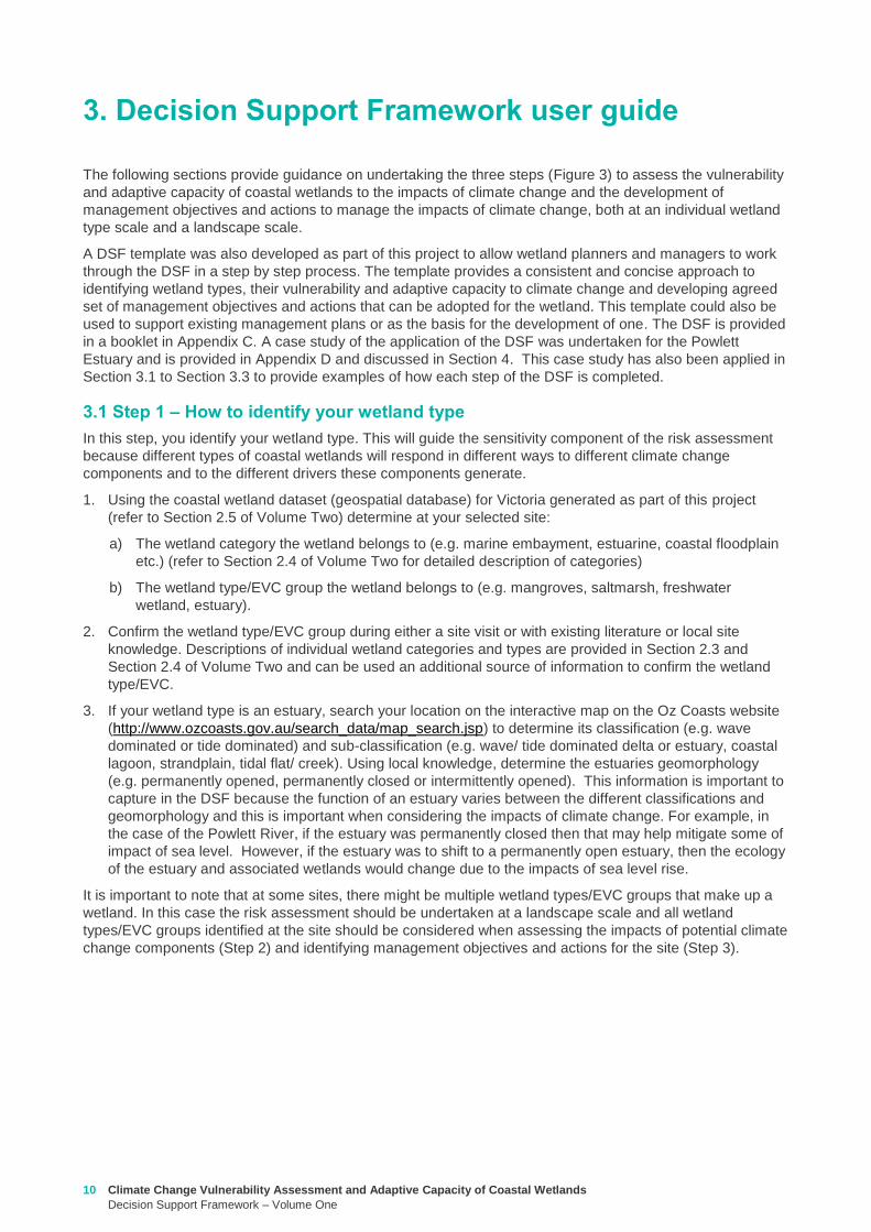
Climate Change Vulnerability Assessment and Adaptive Capacity of Coastal Wetlands
Decision Support Framework ndash Volume One
11
32 Step 2 ndash How to determine the potential impacts from climate change on your wetland
In this step you consider the position of your wetland in the landscape to determine which components of
climate change your wetland is sensitive to The outcomes of this step will determine the requirement of a
management or adaptation plan for the wetland and if so help guide the identification of management
objectives and actions (Step 3)
1 Identify the climate change scenario RCP (45 and 85) and timeframe (2050 2070 2090) (see Section
333 in Volume Two) which will be used to inform management of your wetland Multiple RCPs and
timeframes can be used in this process for example consider medium case (ie RCP 45) and worst
case (ie Business as usual RCP 85) scenarios There are also short term and long term management
timeframes that need to be considered for example to inform when to bring forward or delay certain
actions based on which climate change outcomes become most obvious or likely
2 Using the maps of exposure of climate change components to coastal wetlands in Victoria generated as
part of this project (refer to Section 334 in Volume Two) for the RCPs and timeframes selected identify
those components of climate change that your wetland is exposed
a) Sea level rise ndash any wetland within the area of coastal inundation boundary (Appendix F of Volume
Two)
b) Increased carbon dioxide concentration - all wetlands will be exposed to the carbon dioxide
concentration component of climate change and therefore no map is provided as part of this project
c) Altered rainfall ndash consider the likely effects of predicted change in rainfall (Appendix F of Volume
Two)
d) Increased temperature - consider the likely effects of predicted change in temperature Appendix F of
Volume Two)
3 For each climate change component note the magnitude of change predicted under the climate change
scenario(s) selected at a site specific scale for example
a) Sea level rise ndash examine the coastal inundation mapping at your wetland site or alternatively use
DELWPrsquos Coastal Inundation dataset (available at wwwdatavicgovau) to produce your own
mapping (see case study application in Appendix D)Separate maps can be produced for sea level
rise and storm surges
b) Increased carbon dioxide concentration ndash no information is available to make predictions of the
magnitude of change at a site specific scale
c) Altered rainfall ndash examine details of the magnitude of change (mean surface temperature change)
predicted for the site Section 332 of Volume Two Also document any seasonal changes predicted
(also see Section 332 of Volume Two)
d) Increased temperature - examine details of the magnitude of change in rainfall predicted for the site
Section 332 of Volume Two Also document any seasonal changes predicted (also see Section
332 of Volume Two)
4 Under each climate change copmonent listed in the DSF populate the sensitivity ranking (positive
negative and neutral) for those climate change components to which you wetland is exposed to The
sensitivity of the wetland type to the climate change component will be based on the rankings provided in
Appendix A of this report and Section 42 of Volume Two If multiple wetland typesEVC groups are
identified at the site (see DSF step in Section 31) then separate sensitivity rankings should be populated
for each wetland typeEVC group For example see Powlett River Estuary sensitivity analysis in Table 1
12 Climate Change Vulnerability Assessment and Adaptive Capacity of Coastal Wetlands
Decision Support Framework ndash Volume One
Table 1 Sensitivity analysis for Powlett River Estuary
5 Based on the conceptual models for each climate change component provided in Section 41 of Volume
Two and the adaptive capacity summary provided in Section 43 of Volume Two populate the likely
outcome of climate change for the wetland type A summary of the likely outcomes of climate change for
coastal wetlands is provided below (Table 2)
Table 2 Summary of the likely outcome of climate change for coastal wetlands
Climate change component Estuary Saltmarsh Estuarine
Wetland
Swamp
scrub
Swampy
riparian
woodland
Sea level rise and storm surge
Chronic salinisation Neutral Positive Neutral Negative Negative
Episodic salinisation Negative Negative Negative Negative Negative
Erosion shoreline recession Negative Negative Negative Negative Negative
Increased carbon dioxide concentration
Altered C3 and C4 relationship Neutral Negative Neutral Neutral Neutral
Carbonate dissolution Neutral Neutral Neutral Neutral Neutral
Decreased rainfall
Chronic salinisation Neutral Positive Neutral Negative Negative
Increased air temperature
Phonological impacts altered primary productivity Positive Positive Positive Positive Positive
Increased water temperature
Phonological impacts altered primary productivity Neutral Neutral Neutral Neutral Neutral
Climate change
component Likely outcomes for coastal wetland
Increased sea
level and storm
surge
More permanent inundation or increased frequency and duration of inundation of wetlands
Change in salinity and water regime in wetlands due to saline intrusion
Changes in vegetation distribution along the elevational gradient from the sea with possible
landward migration
Conversion of currently intertidal seagrass beds to subtidal systems and an increase in
depth of subtidal systems
Replacement of areas currently vegetated with saltmarshes by more inundation-tolerant
mangroves
Replacement of areas currently vegetated with glycophytic (eg Phragmites australis) or
brackish-water plants (eg Melaleuca ericifolia) by saltmarshes
Changes in the floristic distribution of saltmarsh taxa along the elevational gradient from
the sea
Excessive sedimentation and erosion along shoreline impacts mangroves and coastal saltmarsh
effects can occur at both the establishment phase of young plants and adult plants
Changes in distribution of plant propagules via altered currents and tidal patterns
Breakage of young plants by wind or waves during their establishment
Modification of patterns and rates of coastal sedimentation and erosion affecting the area
suitable for mangrove or saltmarsh colonisation
Geomorphic changes to estuary mouth and coastal barriers dunes due to sea level rise and
storm surges (eg increased rates of erosion)
Saline intrusion into the upper estuary and lower freshwater reaches of the rivers due to
increased sea levels and storm surge activity Causes rise in saline conditions along riparian
zone
Saline intrusion into groundwater results in a changed wetland environment
Climate Change Vulnerability Assessment and Adaptive Capacity of Coastal Wetlands
Decision Support Framework ndash Volume One
13
For example the estuary and saltmarsh wetlands of the Powlett River Estuary have the following likely
outcome
Estuary
Potential in change from intermittently open estuary mouth to permanently opened or permanently
closed estuaryndash may become more similar to Andersons Inlet
Saline intrusion into the upper estuary and lower freshwater reaches of the river due to increased
sea levels and storm surge activity and reduced rainfall
Saline intrusion into groundwater results in a changed species composition year round
Saltmarsh
Permanent inundation or increased frequency and duration of inundation
Change in salinity and water regime
Changes in its distribution along the elevational gradient from the sea (migrates landwards)
Possible invasion by mangroves if geomorphic changes result in a more permanent estuary opening
Increased pressure from weed invasion
Increased
carbon dioxide
concentration
Competitive interactions between plants will be affected C3 plants will be advantaged (eg
mangroves and most but not all saltmash plants and mangroves)
Acidification of coastal waters causing major impacts on phytoplankton and possibly on
submerged angiosperms such as seagrasses Aquatic organisms that build calcareous or
carbonate shells from aragonite (eg crustaceans) and some macroalgae that have calcified
tissues may also be affected
Increased pressure from weed invasion
Decreased
rainfall
Change in water and salinity regime due to reduced freshwater inflows decreased rainfall and
increased flooding causing longer periods between freshwater inundation and development of
hypersaline conditions
Replacement of areas of coastal wetlands currently vegetated with glycophytic (eg Phragmites
australis) or brackish-water plants (eg Melaleuca ericifoia) by saltmarshes as a result of
increased salinity
Changes in primary productivity and distributions of mangrove communities probably towards
increased vigour and a wider distribution
Modification of patterns and rates of coastal sedimentation and erosion with effects on the area
suitable for mangrove or saltmarsh colonisation
Saline intrusion into groundwater due to reduced groundwater recharge results in a changed
wetland environment
Saline intrusion into the upper estuary and lower freshwater reaches of the river due to reduced
rainfallcatchment runoff
Increased pressure from weed invasion
Increased
temperature
Impacts on flowering and germination of plants and the breeding success of invertebrates fish
and birds
Disruption of life histories of stenothermal invertebrates and fish with consequences for growth
mortality and secondary productivity
Increased rates of primary production by saltmarshes and mangroves unless other factors (eg
hypersalinity lowered nutrient availability etc) intervene
Changes in primary productivity and distributions of mangrove communities probably towards
increased vigour and a wider distribution
Change in water and salinity regime due to increased evaporation losses causing reduction in
permanence and an increase in ephemerality in coast wetlands
Increased pressure from weed invasion
14 Climate Change Vulnerability Assessment and Adaptive Capacity of Coastal Wetlands
Decision Support Framework ndash Volume One
Saltmarsh are C3 plants so potentially advantaged by increases in atmospheric CO2 concentrations
Increased pressure from weed invasion
Saline intrusion into groundwater results in a changed species composition year round
6 Based on the main adaptive mechanisms and the main factors limiting adaptive capacity of your wetland
(summary table provided in Appendix B and further detail contained in Section 43 of Volume Two)
populate the table to reflect the likely adaptive capacity of your wetland type to climate change For
example see analysis on the Powlett River Estuary adaptive capacity in Table 3
Table 3 Adaptive capacity of Powlett River Estuary
Based on your knowledge of the wetland and its site specific characteristics (eg presence of barriers for
migration) specific assessments of opportunities and constraints to adaptive capacity can also be
undertaken to further inform this part of the DSF
33 Step 3 ndash What are your management objective and actions for the site
In this step you consider the adaptation mechanisms possible for your wetland and develop management
objectives and actions The outcomes of this step will inform the development of management and
implementation plans which would be undertaken outside of the DSF
1 Identify the constraints to management for the site which may include barriers to migration land
ownership available funding and knowledge and data availability (see Section 51 of Volume Two) For
example the Powlett River Estuary has the following likely management constraints
Barriers to migration
Powlett Road may restrict inland migration
Rail trail towards Dayleston may restrict inland migration
Small cluster of housing north east of the Estuary mouth may restrict inland migration
Land ownership
The land in which wetlands could migrate in to is predominately private land used for agriculture
(grazing and cropping)
Funding
Limited funding available ndash not currently a priority site for intervention
Wetland
type
Adaptive
capacity Main adaptive mechanism Main limiting factors
Saltmarsh Low Sediment accretion movement
to higher elevations positive
response to increase
temperature (variable responses
to increased CO2)
Rate of sea level rise storm
surge intensity and shoreline
erosion seawalls and other
physical impediments impact of
increased atmospheric CO2
impacts on floristic composition
Estuarine
wetland
Moderate Positive response to
temperature neutral to most
other impacts until sea levels
make the sites intertidal
Salinisation and waterlogging
due to storm surges
Swamp
scrub
Low Positive response to
temperature
Salinisation and waterlogging
(ie changes to wetting and
drying regimes)
Swampy
Riparian
woodland
Low Positive response to
temperature
Salinisation and waterlogging
(ie changes to wetting and
drying regimes)
Climate Change Vulnerability Assessment and Adaptive Capacity of Coastal Wetlands
Decision Support Framework ndash Volume One
15
Whilst there is good collaboration between agencies and landholders there are different priorities for
the funding available and therefore so some actions are difficult to agree to
Limitations to knowledge and data
What geomorphic changes to the estuary mouth are likely to occur as a result of climate change (ie
changes in estuary dynamics)
Understanding the economic value of the estuary and coastal wetlands (eg value of wetlands
versus the value of agricultural land)
What happens to Acid Sulfate Soils as a result of climate change
Other potential constraints
Current State policies and procedures for statutory planning changes and land purchase to enable
long term change in land use
Community understanding and expectation around estuary opening and closing
2 Taking into consideration the main constraints to management of the site develop and document in
consultation with relevant agencies and community stakeholders a management objective for the site in
regards to climate change adaptation using the broad management objectives provided in Table 4
(further discussed in Section 52 of Volume Two)
Table 4 Decision Support Framework ndash broad management objectives
Broad Management Objectives
1 Savemaintain existing wetland in current position
2 Facilitate landward migration of existing wetland type
3 Facilitate transition to new wetland type in current location
4 No intervention
It is also important to consider wetland values current threats to the wetland local and regional
objectives and adjacent habitat typeszones wetland buffer zones and transition zone between wetland
and terrestrial habitats (further detail on these considerations provided in Section 52 of Volume Two)
For example based on the pre-existing management objectives for the Powlett River Estuary the site
could have the following management objective
To enhance and significantly increase Swamp scrub Swampy riparian woodland and estuarine wetland
vegetation communities through the facilitation of landward migration
Combinations of the management objectives listed above may also be identified across a range of time
scales in response to the degree of exposure of the wetland to the components of climate change (ie
scenario planning) this is further discussed in Section 52 of Volume Two
3 Based on the management objective identified any pre-existing management actions and the
management actions provided in Section 53 of Volume Two (summary provided in Table 5 below) select
the most appropriatefeasible management actions to enable objectives to be achieved
The development of objectives and actions is iterative and requires consideration of constraints and
assessment of the feasibility of management options Hence this step may require an evaluation of a
range of actions to identify those that are most feasible and likely to enable objectives to be met If it
turns out actions are not feasible then objectives may need to be reviewed
Monitoring is a critical part of all actions because it is used to inform timing of implementation and
adaptive management For example the landward migration of the wetland will take many years and so
some actions may not be required until landward movement has commenced or reached a certain
extent or may not be needed at all if monitoring reveals that the climate change component does not
manifest at that location Other actions may require immediate implementation even though the benefits
of that actions may not be realised until some time in the future (eg land use planning rules or land
16 Climate Change Vulnerability Assessment and Adaptive Capacity of Coastal Wetlands
Decision Support Framework ndash Volume One
acquisition may be required now so that space is available in future years when climate change
components manifest themselves)
Table 5 Decision Support Framework ndash how management actions relate to various management objectives
The suite of actions and timing of implementation are very much siteregion specific For example the
following management actions (new and adaption of existing management actions in place for the site)
could be set for the Powlett River Estuary
Table 6 Decision Support Framework ndash example management actions for the Powlett River Estuary
Management Actions
Save maintain
existing wetland in
current position
Facilitate landward
migration of existing
wetland type
Facilitate
transition to new
wetland type in
current location
No
intervention
Influence private land
management -
Land acquisition planning - - -
Active revegetation -
Invasive species control -
New infrastructure on
seaward side of wetland - - -
Infrastructure removal
modification on landward
side of wetland - - -
Education and community
engagement -
Fire Management - - -
Management Action Timeframe Responsibility
Complete a study to assess the likely geomorphic changes to the estuary as
a result of climate change
2 years WGCMA
Undertake scenario planning - refine management actions and objectives for
Estuary based on finding of geomorphic study This could identify nearby
systems that could form a template for what Powlett River might look like in
the future (eg Andersons Inlet)
2-5 years WGCMA
Review Bass Coast Planning Scheme to understand any implications to
future management actions works at the Powlett Estuary Provide feedback
to the State Government on any issues associated with State policies and
procedures for statutory planning that may constrain long term management
of the Estuary
2-5 years WGCMA
Resolve issues and complexities around the impacts of climate change (sea
level rise) on crown land boundaries
2-5 years State
Government
Resolve issues associated with State policies and procedures for statutory
planning that may constrain long term management of the Estuary
2-5 years State
Government
Estuary Management Plan Action E31 (see above) ndash to become 2 actions
a Investigate opportunities for land purchase within the current inundation
areas of the estuary
8 years WGCMA
Climate Change Vulnerability Assessment and Adaptive Capacity of Coastal Wetlands
Decision Support Framework ndash Volume One
17
4 Following the identification of objectives and actions the last step is to develop a management plan (or
update existing plan) that provides the specific details around actions responsibilities monitoring and
timeframes for implementation
b Investigate opportunities for land purchase within the future inundation
areas of the estuary
Estuary Management Plan Action E32 (see above) ndash include
consideration of future inundation eg ldquoDesign and implement a program of
stewardship payment for the seasonal inundation of estuary floodplain from
estuary mouth closures under both current and future inundation conditionsrdquo
8 years WGCMA
Estuary Management Plan Action E 39 (see above) ndash to become 2 actions
a Investigate opportunities to encourage the conversion of current Crown
land water frontage grazing licences to riparian management licences
b Investigate issues and opportunities related to sea level rise impacts on
Crown Land Water frontage grazing licences and riparian management
licences (including how to define boundaries if existing boundaries are
inundated by sea level rise)
8 years WGCMA
Estuary Management Plan Action E44 (see above) ndash Undertake detailed
risk assessment of potential and active acid sulfate soils
8 years WGCMA
Estuary Management Plan Action E49 (see above) ndash Continue to build
understanding of and plan for risks associated with climate change
8 years WGCMA
18 Climate Change Vulnerability Assessment and Adaptive Capacity of Coastal Wetlands
Decision Support Framework ndash Volume One
In order to provide validation that the DSF can provide an assessment of the vulnerability and adaptive
capacity of a coastal wetland in Victoria to the impacts of climate change and guidance to wetland managers
on potential management objectives and actions for those coastal wetland systems likely to be affected by
climate change the DSF was applied to a case study wetland in Victoria
The case study wetland was selected by DELWP from a list of potential wetlands provided by the wetland
managers from the working group established as part of the project Wetland managers included
representatives from the DELWP Parks Victoria West Gippsland Catchment Management Authority (CMA)
East Gippsland CMA Port Phillip and Westernport CMA Glenelg Hopkins CMA and Corangamite CMA
The wetland selected was the Powlett River Estuary in the West Gippsland CMA region This decision was
based on existing information available for the site (an existing estuary management plan was available) its
value (listed as a Nationally Important Wetland and a habitat for the critically endangered Orange-bellied
Parrot) and that the site provided a good balance between covering a number of different coastal wetland
types (estuary saltmarsh riparian scrub estuarine wetland heathlands and woodlands) but without being
too complex and large
Consultation with West Gippsland CMA was undertaken throughout the case study application to ensure that
local knowledge was incorporated and so that the wetland manager could provide input to setting the
wetland management objectives and actions The completed application of the DSF for the Powlett River
Estuary is provided in Appendix D
Through the case study application it became apparent that Step 1 (wetland type) could be largely
completed by applying local knowledge of the wetland ecosystems found within the site Step 2 (assess the
potential impacts from climate change) however requires more technical knowledge of the wetlands
sensitivity and adaptive capacity to climate change and therefore requires close consultation with the
supporting technical information contained in Volume 2 Volume 2 provides enough information for a wetland
manager with limited climate change knowledge to complete this component of the DSF Step 3 is then a
combination of applying local knowledge to set management objectives and then using a combination of
local knowledge and the supporting technical information contained in Volume 2 to develop management
actions
The maps included in the case study application use only publically available data (the coastal wetland
dataset developed as part of this project and DELWPs coastal inundation dataset) and their manipulation
and interrogation is well within the GIS capability within the relevant wetland managerrsquos organisations
The case study application of the DSF demonstrated its effectiveness at providing a framework for assessing
potential impacts from climate change on Victorian coastal wetlands and will be a useful tool for assisting
wetland managers to 1) understand and 2) develop objectives and actions for managing coastal wetlands in
response to a changing climate
4 Case study application
Climate Change Vulnerability Assessment and Adaptive Capacity of Coastal Wetlands
Decision Support Framework ndash Volume One
19
Barbier EB Hacker SD Kennedy C Koch EW Stier AC amp Silliman BR (2011) The value of estuarine and
coastal ecosystem services Ecological Monographs 81169-93
Boon PI (2012) Coastal wetlands of temperate eastern Australia will Cinderella ever go to the ball Marine
and Freshwater Research 63 845-855
Boon PI Allen T Carr G Frood D Harty C McMahon A Mathews S Rosengren N Sinclair S White M amp
Yugovic J (2015a) Coastal wetlands of Victoria south-eastern Australia providing the inventory and
condition information needed for their effective management and conservation Aquatic Conservation Marine
and Freshwater Ecosystems 25 454-479
Costanza R de Groot R Sutton P van der Ploeg S Anderson SJ Kubiszewski I et al (2014) Changes in
the global value of ecosystem services Global Environmental Change 26152-8
Creighton C Boon PI Sheaves M amp Brookes J (2015) Revitalising Australiarsquos estuaries ndash what benefits at
what cost Marine and Freshwater Research 66 493-507
CSIRO and BOM (2015a) Southern slopes cluster report Climate change in Australia projections for
Australiarsquos natural resource management regions Full Report CSIRO and Bureau of Meteorology
Canberra Available on-line at httpwwwclimatechangeinaustraliagovauenimpacts-and-adaptationnrm-
regions
CSIRO and BOM (2015b) Climate change in Australia Projections for Australias NRM regions Southern
slopes Summary report CSIRO and Bureau of Meteorology Canberra Available on-line at
httpwwwclimatechangeinaustraliagovauenimpacts-and-adaptationnrm-regions
Finlayson CM Davis JA Gell PA Kingsford RT and Parton KA (2013) The status of wetlands and the
predicted effects of climate global climate change the situation in Australia Aquatic Sciences 75 73-93
Friess DA Krauss KW Horstman EM Balke T Bouma TJ Galli D amp Webb EL (2012) Are all intertidal
wetlands naturally created equal Bottlenecks thresholds and knowledge gaps to mangrove and saltmarsh
ecosystems Biological Reviews 87 346-366
Gilman EL Ellison J Duke NC amp Field C (2008) Threats to mangroves from climate change and adaptation
options a review Aquatic Botany 89 237-250
Johnston EM Hedge LH and Mayer-Pinto M (2015) The urgent need to understand port and harbour
ecosystems Marine and Freshwater Research 66 i-ii
Morton RM (1990) Community structure density and standing crop of fishes in a subtropical Australian
mangrove area Marine Biology 105 385-94
Morris L (2013) Chapter 2 Implications of future climate change for seagrass and soft sediments In
Implications of future climate change for Victorians marine environments Eds Klemke J amp Arundel H Report
to Glenelg Hopkins CMA
Nielsen D and M Brock 2009 Modified water regime and salinity as a consequence of climate change
prospects for wetlands of Southern Australia Climatic Change 95523-533
Osland MJ Enwright NM Day RH Gabler CA Stagg CL and Grace JB (2016) Beyond just sea-level rises
considering macroclimatic drivers within coastal wetland vulnerability assessments to climate change Global
Change Biology 22 1-11
Prahalad VN Kirkpatrick JB amp Mount RE (2011) Tasmanian coastal saltmarsh community transitions
associated with climate change and relative sea level rise 1975minus2009 Australian Journal of Botany 59 741-
748
SKM (2013) Indicative Assessment of Climate Change Vulnerability for Wetlands in Victoria Report
prepared for Department of Sustainability and Environment (now DELWP)
Zann LP amp Dutton I (2000) The social values and perceptions of Australians concerning the marine
environment In State of the Environment Report for Australia Technical summary Edited by LP Zann
Pages 127-134 Ocean Rescue 2000 amp Department of the Environment Sport and Territories Canberra
5 References
20 Climate Change Vulnerability Assessment and Adaptive Capacity of Coastal Wetlands
Decision Support Framework ndash Volume One
Wetland Type and corresponding EVC
group
Climate change components and ecological consequences
Increased Sea level and storm surges Increased carbon dioxide
concentration
Decreased rainfall Higher air
temperature
Higher water
temperature
Chronic
salinisation
Episodic
salinisation
Erosion
shoreline
recession
Altered C3
and C4
relationship
Carbonate
dissolution
Chronic
salinisation
Altered
sediment
load
Phenological
impacts
altered primary
productivity
Phenological
impacts altered
primary
productivity
Marine
Embayment
Mangrove Positive Neutral to
Negative
Negative Positive Neutral Positive Positive Positive Neutral
Seagrass (not mapped) Positive Negative Neutral Neutral Positive Positive Negative Positive Positive
Saltmarsh Positive Negative Negative Negative Neutral Positive Positive Positive Neutral
Estuarine -
Intertidal
Mangrove Positive Neutral to
Negative
Negative Positive Neutral Positive Positive Positive Neutral
Saltmarsh Positive Negative Negative Negative Neutral Positive Positive Positive Neutral
Estuarine -
supratidal
Heathlands Neutral Neutral Negative Neutral Neutral Neutral Neutral Positive Neutral
Herb-rich woodlands Neutral Neutral Negative Neutral Neutral Neutral Neutral Positive Neutral
Coastal scrubs and
woodlands
Neutral Neutral Negative Neutral Neutral Neutral Neutral Positive Neutral
Wetland - estuarine semi-
permanent saline
Neutral Negative Negative Neutral Neutral Neutral Positive Positive Neutral
Coastal
floodplain
Riparian scrubs or
swampy scrubs and
woodlands
Negative Negative Negative Neutral Neutral Negative Positive Positive Neutral
Coastal brackish wetlands Negative Negative Negative Neutral Neutral Negative Positive Positive Neutral
Freshwater wetlands Negative Negative Negative Neutral Neutral Negative Positive Positive Neutral
Dune
systems
Freshwater wetlands Neutral Neutral Negative Neutral Neutral Neutral Neutral Positive Neutral
Appendix A Sensitivity tables
Climate Change Vulnerability Assessment and Adaptive Capacity of Coastal Wetlands
Decision Support Framework ndash Volume One
21
1 where adaptive capacity is unknown data gaps limit the ability to make clear assessment of adaptive capacity
Appendix B Adaptive capacity of wetland types
Wetland Type Adaptive
capacity1 Main adaptive mechanism Main limiting factor to
adaptation
Marine
Embayment
estuarine -
intertidal
Mangrove Adaptable Sediment accretion movement to higher
elevations positive response to increased temperature and increased atmospheric CO2
Rate of sea-level rise storm surge intensity and shoreline erosion seawalls and other
physical impediments
Seagrass (not mapped)
Adaptable Positive response to increased salinity
Storm surge intensity smothering by catchment-
derived sediments reductions in underwater light fields
consequent to catchment-associated processes
Saltmarsh Adaptable Sediment accretion movement to higher
elevations positive response to increased temperature
(Variable responses to increased CO2)
Rate of sea-level rise storm surge intensity and shoreline erosion seawalls and other
physical impediments impacts of increased atmospheric CO2
impacts on floristic composition
Estuarine ndash
supratidal
Heathlands Unknown Positive response to temperature neutral to most other impacts until sea levels
make the sites intertidal
Salinisation and waterlogging due to storm surge
Herb-rich woodlands
Unknown Positive response to temperature neutral to most other impacts until sea levels
make the sites intertidal
Salinisation and waterlogging due to storm surge
Coastal scrubs and woodlands
Unknown Positive response to temperature neutral to most other impacts until sea levels
make the sites intertidal
Salinisation and waterlogging due to storm surge
Wetland - estuarine semi-permanent saline
Unknown Positive response to temperature neutral to most other impacts until sea levels
make the sites intertidal
Salinisation and waterlogging due to storm surge
Coastal
floodplain
Riparian scrubs or swampy scrubs and woodlands
Non-adaptable
Positive response to temperature
Salinisation and waterlogging (ie changes to wetting and
drying regimes)
Coastal brackish wetlands
Non-adaptable
Positive response to temperature
Salinisation and waterlogging (ie changes to wetting and
drying regimes)
Freshwater wetlands
Non-adaptable
Positive response to temperature
Salinisation and changes to wetting and drying regimes
Dune systems
Freshwater wetlands
Unknown Positive response to temperature neutral to most
other impacts
Physical loss of habitat salinisation possible changes to
wetting and drying regimes
22 Climate Change Vulnerability Assessment and Adaptive Capacity of Coastal Wetlands
Decision Support Framework ndash Volume One
Appendix C Decision Support Framework template
Climate Change Vulnerability Assessment and Adaptive Capacity of Coastal Wetlands
Decision Support Framework ndash Volume One
23
Coastal Wetlands and Climate Change
Decision Support Framework
Site Name Insert wetland name
Purpose
This document provides a Decision Support Framework to enable wetland managers to assess the
vulnerability and adaptive capacity of wetlands to climate change at an individual wetland or local landscape
scale The DELWP Climate Change Vulnerability Assessment and Adaptive Capacity of Coastal Wetlands
report provides the background and supporting material for this assessment and should be used in
conjunction with each stage of the assessment process outlined below
The broad approach applied in the Decision Support Framework is illustrated below It is a three step
approach that includes
Step 1 Wetland type ndash in this step you identify your wetland type (eg mangrove saltmarsh) using
a combination of the coastal wetland dataset developed as part of this project and your existing
knowledge of the site This step guides the sensitivity assessment undertaken in step 2
Step 2 Assess potential impacts from climate change ndash in this step you consider the position of
your wetland in the landscape so you can determine which component of climate change the
wetland is most sensitive to This step involves undertaking the exposure and sensitivity
components of the vulnerability assessment outlined above using the exposure mapping the
conceptual models and the sensitivity tables provided in the supporting documents
Step 3 Identify management objectives and actions ndash in this step you consider the adaptation
mechanisms possible for your wetland and develop management objectives and actions This step
will inform the development of a management plan which is undertaken outside of the DSF
Step 2 Assess potential impacts from climate change
(refer to Section 4 and Section 5 Volume 2)
Given the location of the wetland in the landscape which components of climate change is the
wetland sensitive to and what is the likely response to climate change
Step 3 Identify management objectives and actions
(refer to Section 6 Volume 2)
a) Identify constraints and
potential management
objectives and actions
b) Confirm
management
objectives
c) Confirm management
actions and develop
implementation plan
Step 1 Wetland type
(refer to Section 3 Volume 2)
What is the wetland type
24 Climate Change Vulnerability Assessment and Adaptive Capacity of Coastal Wetlands
Decision Support Framework ndash Volume One
Decision Support Framework
1 Wetland identification (Section 2 Volume Two)
Name Insert wetland name
Location address Insert generic location description
Easting Northing
Bioregion Refer to httpwwwdepivicgovauenvironment-and-wildlifebiodiversityevc-benchmarks
Wetland category
(Section 24 Volume
Two)
Tidal wetlands
Marine embayment
Estuarine (intertidal)
Estuarine (supratidal)
Non-tidal wetland
Coastal floodplain
Dune system
Wetland type EVC
group(s)
(Section 23 Volume
Two and supporting
geospatial dataset)
Seagrass
Saltmarsh
Mangroves
Brackish wetland
Freshwater wetland (floodplain)
Freshwater wetland (dune)
Riparian swampy scrub
Estuarine wetland
Estuarine scrubs heathlands and
woodlands
Estuary classification
(if relevant)
httpwwwozcoastsgov
ausearch_datamap_se
archjsp
Classification
Wave dominated
Sub-classification
Wave dominated delta
Tide dominated delta
Wave dominated estuary
Tide dominated estuary
Tide dominated
Coastal lagoon
Strandplain
Tidal flat creek
Other
Estuary
geomorphology (if
relevant)
Permanently open
Permanently closed
Intermittently opened and closed
Wetland values See Section 44 of Volume Two for more detail
Climate Change Vulnerability Assessment and Adaptive Capacity of Coastal Wetlands
Decision Support Framework ndash Volume One
25
Decision Support Framework
Decision Support Framework
Insert location map including location of individual wetland EVC types
26 Climate Change Vulnerability Assessment and Adaptive Capacity of Coastal Wetlands
Decision Support Framework ndash Volume One
Decision Support Framework
2 Potential impacts from climate change to the wetland (Section 4 Volume Two)
What is the
climate change
scenario
timeframe
Select climate change scenario timeframe detailed in Section 333 of Volume 2
Given the
position of the
wetland in the
landscape how
exposed is the
wetland to sea
level rise and
storm surge
climate change
components
Insert exposure map for sea level rise and storm surges (See Appendix F of Volume Two Coastal Inundation
dataset is publically available at wwwdatavicgovau)
Sea level rise
Storm surges
Climate Change Vulnerability Assessment and Adaptive Capacity of Coastal Wetlands
Decision Support Framework ndash Volume One
27
Decision Support Framework
Decision Support Framework
Site specific
infrastructure
dynamics that
would influence
the impact from
sea level rise
and storm
surges
Identify any specific infrastructure dynamics that may increase or decrease the impact from sea level rise
and storm surges (eg presence of artificial barriers to restrict seawater intrusion)
Given the
position of the
wetland in the
landscape how
exposed is the
wetland to
temperature and
rainfall climate
change
components
Insert climate change projections for temperature and rainfall based on current CSIRO-BOM (2015)
modelling provided in Section 332 of Volume Two
Temperature
Based on CSIRO-BOM (2015) modelling the following predictions are made in regards to change in
temperature
Magnitude of change
(mean surface temp
change)
Seasonality
Rainfall
Based on CSIRO-BOM (2015) modelling the following predictions are made in regards to change in rainfall
Magnitude of change
(change in rainfall) Seasonality
Wetland
sensitivity
Insert wetland type and sensitivity to climate change components (positive [highlight green] negative
[highlight red] neutral [highlight yellow] NA) provided in Appendix A of Volume One
Climate change component and
impacts on coastal wetlands
Insert
wetland
type
Insert
wetland
type
Insert
wetland
type
Insert
wetland
type
Sea level
Chronic salinisation
Episodic salinisation
Erosion shoreline recession
Carbon dioxide
Altered C3 and C4 relationship
Carbonate dissolution
Rainfall
Chronic salinisation
Temperature (air)
Phenological impacts altered primary
productivity
Temperature (water)
Phenological impacts altered primary
productivity
Positive = positive response to climate change negative = negative response to climate change neutral =
unlikely to have any response to climate change NA = not exposed
28 Climate Change Vulnerability Assessment and Adaptive Capacity of Coastal Wetlands
Decision Support Framework ndash Volume One
Decision Support Framework
Likely outcome Based on the Table 2 in Section 32 of Volume One and the conceptual models presented in Section 41 of
Volume Two
Adaptive
capacity
General adaptive capacity of wetland types present
Describe based on the conceptual models presented in Section 41 of Volume Two and populated table
based on table provided in Section 43 of Volume Two
Wetland
type
Adaptive
capacity Main adaptive mechanism Main limiting factor
Site specific adaptive capacity
Need to consider site specific opportunities and constraints to adaptive capacity based on site specific
characteristics
3 Management objectives and actions (Section 5 of Volume Two)
Constraints to
management
See Section 51 of Volume Two report for more detail
Barriers to migration
Land ownership
Funding
Limitations to knowledge and data
Other potential constraints
Pre-existing threats Identify pre-existing threats that may impact the wetlands capacity to cope with change
Pre-existing
management
objectives
Document local and regional management objectives in pre-existing management plans and
strategies
Proposed management
objective in relation to
climate change
Based on wetland values and existing objectives define the management objective for the wetland in
relation to climate change See Section 52 of Volume Two for more detail
Climate Change Vulnerability Assessment and Adaptive Capacity of Coastal Wetlands
Decision Support Framework ndash Volume One
29
Decision Support Framework
Decision Support Framework
Management actions to
address climate
change impacts and
management
objectives
Identify a suite of management actions for the site See Section 53 of Volume Two for more details
May include existing and new management actions
Existing actions
Management Action Timeframe
New actions
Management Action Timeframe Responsibility
4 Recommendations
Identify any recommendations for management of the wetland eg addressing data gaps further investigation required
development of management or implementation plan
5 Key management resource documents
Insert useful resource documents and web links associated with management at the site including but not limited to
1 Peters G Morris K Frood D Papas P and Roberts J (2015) A Guide to managing livestock grazing in Victorias
wetlands Decision framework and guidelines - Version 10 Arthur Rylah Institute for Environmental Research Technical
Report Series Report number 265
2 Morris K and Papas P (2012) Wetland conceptual models associations between wetland values threats and management
interventions Version one Arthur Rylah Institute for Environmental Research Technical Report Series Report number 237
3 DELWP wetland buffers guidelines (in prep)
4 DELWP wetland revegetation guidelines (in prep)
5 DELWP wetland invasive species management guidelines (in prep)
6 SKM (2005) Guidelines for the design and operation of environmentally friendly wetland regulators (MDBC project report
R2002) Report by Sinclair Knight Merz for the MDBC
6 Key references
Insert key reference supporting documents used to populate decision support framework template
Appendix D Decision Support Framework case study application
30 Climate Change Vulnerability Assessment and Adaptive Capacity of Coastal Wetlands
Decision Support Framework ndash Volume One
Climate Change Vulnerability Assessment and Adaptive Capacity of Coastal Wetlands
Decision Support Framework ndash Volume One
31
Coastal Wetlands and Climate Change
Decision Support Framework
Site Name Powlett River Estuary
Purpose
This document provides a Decision Support Framework to enable wetland managers to assess the
vulnerability and adaptive capacity of wetlands to climate change at an individual wetland or local landscape
scale The DELWP Climate Change Vulnerability Assessment and Adaptive Capacity of Coastal Wetlands
report provides the background and supporting material for this assessment and should be used in
conjunction with each stage of the assessment process outlined below
The broad approach applied in the Decision Support Framework is illustrated below It is a three step
approach that includes
Step 1 Wetland type ndash in this step you identify your wetland type (eg mangrove saltmarsh) using
a combination of the coastal wetland dataset developed as part of this project and your existing
knowledge of the site This step guides the sensitivity assessment undertaken in step 2
Step 2 Assess potential impacts from climate change ndash in this step you consider the position of
your wetland in the landscape so you can determine which component of climate change the
wetland is most sensitive to This step involves undertaking the exposure and sensitivity
components of the vulnerability assessment outlined above using the exposure mapping the
conceptual models and the sensitivity tables provided in the supporting documents
Step 3 Identify management objectives and actions ndash in this step you consider the adaptation
mechanisms possible for your wetland and develop management objectives and actions This step
will inform the development of a management plan which is undertaken outside of the DSF
Step 2 Assess potential impacts from climate change
(refer to Section 4 and Section 5 Volume 2)
Given the location of the wetland in the landscape which components of climate change is the
wetland sensitive to and what is the likely response to climate change
Step 3 Identify management objectives and actions
(refer to Section 6 Volume 2)
a) Identify constraints and
potential management
objectives and actions
b) Confirm
management
objectives
c) Confirm management
actions and develop
implementation plan
Step 1 Wetland type
(refer to Section 3 Volume 2)
What is the wetland type
32 Climate Change Vulnerability Assessment and Adaptive Capacity of Coastal Wetlands
Decision Support Framework ndash Volume One
Decision Support Framework
1 Wetland identification (Section 2 Volume Two)
Name Powlett River Estuary
Location address Located in the West Gippsland Catchment Management Authority (CMA) region near the coast
between Kilcunda and Wonthaggi
Easting 370380205 Northing 5728345662
Bioregion Gippsland Plain
Wetland category
(Section 24 Volume
Two)
Tidal wetlands
Marine embayment
Estuarine (intertidal)
Estuarine (supratidal)
Non-tidal wetland
Coastal floodplain
Dune system
Wetland type EVC
group(s)
(Section 23 Volume
Two and supporting
geospatial dataset)
Seagrass
Saltmarsh
Mangroves
Brackish wetland
Freshwater wetland (floodplain)
Freshwater wetland (dune)
Riparian swampy scrub
Estuarine wetland
Estuarine scrubs heathlands and
woodlands
Estuary classification
(if relevant)
httpwwwozcoastsgov
ausearch_datamap_se
archjsp
Classification
Wave dominated
Sub-classification
Wave dominated delta
Tide dominated delta
Wave dominated estuary
Tide dominated estuary
Tide dominated
Coastal lagoon
Strandplain
Tidal flat creek
Other
Estuary
geomorphology (if
relevant)
Permanently open
Permanently closed
Intermittently opened and closed
Climate Change Vulnerability Assessment and Adaptive Capacity of Coastal Wetlands
Decision Support Framework ndash Volume One
33
Decision Support Framework
Decision Support Framework
Wetland values
The Powlett River Estuary has a diverse range of bird plant and fish communities
5 different EVCs including coastal saltmarsh (Coastal Tussock Saltmarsh and Wet Saltmarsh
Herbland) protected under the Environmental Protection and Biodiversity Conservation Act
1999 (EPBC Act)
22 fish species including the Australian Grayling which is listed threatened under the Flora
and Fauna Guarantee Act 1988 (FFG Act) and vulnerable under the EPBC Act
31 State Australian and Internationally listed bird species including the critically endangered
Orange-bellied Parrot (WGCMA 2015)
The Powlett River Estuary also has significant social and economic value
Recreational activities ndash fishing sightseeing swimming walking bird watching picnics etc
Coastal dunes near the mouth of the Estuary have Aboriginal cultural heritage significance
(number of coastal midden sites recorded)
Landholders commonly graze along the river upstream of the Mouth of Powlett Road
Water source for irrigation and stock and domestic water use (WGCMA 2015)
34 Climate Change Vulnerability Assessment and Adaptive Capacity of Coastal Wetlands
Decision Support Framework ndash Volume One
Decision Support Framework
2 Potential impacts from climate change to the wetland (Section 4 Volume Two)
What is the
climate change
scenario
timeframe
Based on CSIRO-BOM (20015) modelling RCP 45 (moderate response to climate change) and RCP 85
(worst case scenario business as usual response to climate change)
Timeframes 2050 2070 and 2090 were all considered
Given the
position of the
wetland in the
landscape how
exposed is the
wetland to sea
level rise and
storm surge
climate change
components
Sea level rise
Climate Change Vulnerability Assessment and Adaptive Capacity of Coastal Wetlands
Decision Support Framework ndash Volume One
35
Decision Support Framework
Decision Support Framework
Storm surges
Site specific
infrastructure
dynamics that
would influence
the impact from
sea level rise
and storm
surges
There is currently no infrastructure at the Powlett River Estuary that would influence the extent of inundation
from the projected sea level rise and storm surges
When the mouth of the estuary is closed this may help mitigate some of impact of sea level
Given the
position of the
wetland in the
landscape how
exposed is the
wetland to
temperature and
rainfall climate
change
components
Temperature
Based on CSIRO-BOM (2015) modelling the following predictions are made in regards to change in
temperature
Magnitude of change
(mean surface temp
change)
Seasonality
RCP 45
2050 = 05 to 1degC
2070 = gt1 to 15degC
2090 = gt1 to 15degC
RCP 85
2050 = gt15 to 2degC
2070 = gt2 to 25degC
2090 = gt3 to 35deg
Temperature increases are similar in all seasons with some models
simulating to some extent larger increases in summer and autumn
than in other seasons
Projected changes for both daily maximum and minimum
temperature generally follow those of the mean temperature
although there is somewhat lower warming in daily minimum
temperatures than daily maximum temperatures in autumn winter
and spring
Increase in the temperature reached on the hottest days an increase
in the frequency of very hot days and duration of warm spells
36 Climate Change Vulnerability Assessment and Adaptive Capacity of Coastal Wetlands
Decision Support Framework ndash Volume One
Decision Support Framework
Given the
position of the
wetland in the
landscape how
exposed is the
wetland to
temperature and
rainfall climate
change
components
Rainfall
Based on CSIRO-BOM (2015) modelling the following predictions are made in regards to change in rainfall
Magnitude of change
(change in rainfall) Seasonality
RCP 45
2050 = 25 to 75
2070 = gt -25 to 25
2090 = gt -25 to 25
RCP 85
2050 = gt - 75 to -25
2070 = gt - 75 to -25
2090 = gt -125 to - 75
Rainfall declines are strongest in winter and spring Projected
reductions in winter rainfall in the Victoria NSW East region are up
to 30 in 2090 under high emissions
There is little change projected in autumn and either increases or
decreases in summer rainfall are possible
Tendency for heavier rainfall interspersed by longer dry periods
with some extremely dry and wet years with natural variability
continuing to be a major driver of rainfall for the near future (2030)
Intensity of heavy rainfall events is predicted to increase with
timing and magnitude also driven by natural variability
A decline in the number but an increase in the intensity of east
coast lows impacting on average rainfall and heavy rain events
Time spent in drought is predicted to increase over the course of
this century in line with changes to average rainfall and the
frequency and duration of extreme droughts will increase
Wetland
sensitivity
Climate change component and
impacts on coastal wetlands Saltmarsh
Estuarine
Wetland
Swamp
scrub
Swampy
riparian
woodland
Sea level
Chronic salinisation Positive Neutral Negative Negative
Episodic salinization Negative Negative Negative Negative
Erosion shoreline recession Negative Negative Negative Negative
Carbon dioxide
Altered C3 and C4 relationship Negative Neutral Neutral Neutral
Carbonate dissolution Neutral Neutral Neutral Neutral
Rainfall
Chronic salinisation Positive Neutral Negative Negative
Temperature (air)
Phenological impacts altered primary
productivity
Positive Positive Positive Positive
Temperature (water)
Phenological impacts altered primary
productivity
Neutral Neutral Neutral Neutral
Positive = positive response to climate change negative = negative response to climate change neutral =
unlikely to have any response to climate change NA = not exposed
Likely outcome Estuary
Potential change from intermittently open estuary mouth to permanently opened or more permanently
closed estuary depending on regional changes to rainfallcatchment runoff river discharge eustatic
sea levels and storm surges May become more similar to Andersons Inlet (marine embayment) to
the east
Saline intrusion into the upper estuary and lower freshwater reaches of the river due to increased sea
levels and storm surge activity and reduced rainfallcatchment runoff
Climate Change Vulnerability Assessment and Adaptive Capacity of Coastal Wetlands
Decision Support Framework ndash Volume One
37
Decision Support Framework
Decision Support Framework
Saline intrusion into groundwater results in a changed in species composition year round
Saltmarsh
More permanent inundation or increased frequency and duration of inundation
Change in salinity and water regime
Changes in distribution along the elevational gradient from the sea with possible landward migration
Possible invasion by mangroves if geomorphic changes result in a more permanent estuary opening
(eg similar to Andersons Inlet)
Many of the saltmarsh taxa at the site are C3 plants so potentially advantaged by increases in
atmospheric CO2 concentrations
Increased pressure from weed invasion from surrounding agricultural land
Saline intrusion into groundwater results in a changed wetland environment
Estuarine Wetland
Change in salinity and water regime (eg reduced freshwater inflows and saline intrusion increased
evaporation losses)
Increased pressure from weed invasion
Saline intrusion into groundwater results in a changed wetland environment
Riparian scrub and swampy riparian woodland
Change in salinity and water regime (eg reduced freshwater inflows and saline intrusion decreased
rainfall increased extreme flood events)
Rise in saline conditions along riparian zone
Replacement with saltmarsh as a result of increased salinity
Increased pressure from weed invasion
Saline intrusion into groundwater results in a changed species composition year round
Adaptive
capacity
General adaptive capacity of wetland types present
Wetland
type
Adaptive
capacity Main adaptive mechanism Main limiting factor
Saltmarsh Low Sediment accretion movement
to higher elevations positive
response to increase
temperature (variable
responses to increased CO2)
Rate of sea level rise storm surge
intensity and shoreline erosion
seawalls and other physical
impediments impact of increased
atmospheric CO2 impacts on floristic
composition
Estuarine
wetland
Moderate Positive response to
temperature neutral to most
other impacts until sea levels
make the sites intertidal
Salinisation and waterlogging due to
storm surges
Swamp
scrub
Low Positive response to
temperature
Salinisation and waterlogging (ie
changes to wetting and drying regimes)
Swampy
Riparian
woodland
Low Positive response to
temperature
Salinisation and waterlogging (ie
changes to wetting and drying regimes)
38 Climate Change Vulnerability Assessment and Adaptive Capacity of Coastal Wetlands
Decision Support Framework ndash Volume One
Decision Support Framework
Site specific adaptive capacity
Not completed as part of case study ndash requires specific assessments of opportunities and constraints to
adaptive capacity based on site specific characteristics
3 Management objectives and actions (Section 5 of Volume Two)
Constraints to
management
Barriers to migration
Mouth of Powlett Road is a barrier to wetland migration
Rail trail towards Dayleston provides a barrier to landward migration
Small cluster of housing north east of the estuary mouth similarly constrains landward
migration
Land ownership
The land in which wetlands could migrate in to is predominately private land used for
agriculture (grazing and cropping)
Funding
Limited funding available ndash not a priority site State wide nor Ramsar listed
Whilst there is good collaboration between agencies and landholders there are different
priorities for the funding available and therefore so some actions are difficult to implement An
example includes raising roads and carparks that experience inundation during closure
events or buying back regularly inundated marginal farmland
Limitations to knowledge and data
Uncertainty around the likely geomorphic changes to the estuary mouth (ie change in estuary
dynamic)
Understanding the economic value of the estuary coastal wetlands (eg value of wetlands
versus the value of agricultural land)
Uncertainty around acid sulfate soils as a result of climate change
Other potential constraints
Current State policies and procedures for statutory planning changes and land buyback to
enable long term management
Community understanding and expectation around estuary opening and closing
Pre-existing threats The key pre-existing threats identified in the Powlett River Estuary Management Plan that may
influence the resilience of the estuary to climate change impacts include
Degraded water quality
Degraded riparian vegetation (large trees in particular)
Trampling and bank erosion associated with pedestrian access
Rural drainage and drain clearing
Channelisation of the river channel
Vehicle access
Livestock access
Pest plants and animals
Inappropriate recreation causing dune erosion
Disturbance of acid sulfate soils
Climate Change Vulnerability Assessment and Adaptive Capacity of Coastal Wetlands
Decision Support Framework ndash Volume One
39
Decision Support Framework
Decision Support Framework
Pre-existing
management
objectives
Regional catchment strategy
No coastal wetland specific actions objectives for the Powlett River
West Gippsland Waterways Strategy (2014-2022)
Regional objectives relating to the Powlett River Estuary as a coastal wetland
Maintain and improve the habitat and condition of waterways to support waterway dependent
animals and plants
Maintain the ecological character of significant wetlands and estuaries
Catchment objectives for Powlett River Estuary relating to coastal wetlands include
Riparian vegetation provides improved visual amenity and contributes to community use of
waterways
The extent of freshwater wetlands is maintained and their condition is improved
Powlett Estuary Management Plan
Swamp scrub swampy riparian woodland and estuarine wetland vegetation communities are
enhanced and significantly increased in the area
West Gippsland Regional NRM Climate Change Strategy (2016)
The strategy outlines approaches and options to support climate change adaptation and mitigation
The objectives of the adaptation and management strategies are linked to the 20 year objectives in
the Regional Catchment Strategy The Powlett River Estuary is located within the Bunurong Coastal
planning area The estuary is listed as one of the most vulnerable estuary assets to climate change
across the region
Reports are available at lthttpwwwwgcmavicgovauour-regionwaterwayspowlett-river-estuarygt
[Verified 17052016 ]
Proposed management
objective in relation to
climate change
The following management objective is based the existing geomorphic characteristics of the estuary
(ie intermittently closed estuary)
To enhance and significantly increase Swamp scrub Swampy riparian woodland and estuarine
wetland vegetation extent through the facilitation of landward migration of these communities over the
next 50 years
Climate change also poses a threat to non-wetland EVCs (eg Coast Banksia Woodland) and
therefore even though they are not considered in this coastal wetland risk assessment they are still a
management consideration for the CMA in the coastal zone
Management actions to
address climate
change impacts and
management
objectives
Existing actions
Existing management actions provided in Section 81 of the Estuary Management Plan (WGCMA
2015) that are related to climate change are listed below
Management Action Timeframe
E31 Investigate opportunities for land purchase within the inundation
areas of the estuary
8 years
E32 Design and implement a program of stewardship payment for the
seasonal inundation of estuary floodplain from estuary mouth closures
Priority should be given to enhancing coastal saltmarsh and estuarine
wetland communities Payments should be calculated and prioritised
based on potential value to estuary health and ability to minimise artificial
estuary mouth openings
8 years
E 39 Investigate opportunities to encourage the conversion of Crown land
water frontage grazing licences to riparian management licences
8 years
E 43 Undertake hydraulic modelling and bathymetry survey of the Powlett 8 years
40 Climate Change Vulnerability Assessment and Adaptive Capacity of Coastal Wetlands
Decision Support Framework ndash Volume One
Decision Support Framework
estuary floodplain to understand the impacts and benefits of the structures
(including levees and drains) and landforms that affect the movement of
water before during and after artificial estuary mouth opening before
considering any updates changes or removal of these floodplain features
E 44 Undertake a detailed risk assessment including on-ground mapping
to identify potential and active acid sulphate soils with the Powlett estuarine
floodplain
8 years
E 46 Investigate the use of the saltmarsh wetlands and estuary channel
by recreational fish species and other native fish species particularly Black
Bream and prioritise areas for further protection
8 years
E 49 Continue to build understanding of and plan for the risks associated
with climate change including sea level rise This includes future flood
risk
8 years
New actions
The following additional management actions should be considered
Management Action Timeframe Responsibility
Complete a study to assess the likely geomorphic changes
to the estuary as a result of climate change
2 years WGCMA
Undertake scenario planning in consultation with Bass Coast
Shire Council VicRoads and Parks Victoria- refine
management actions and objectives for Estuary based on
finding of geomorphic study This could identify nearby
systems that could form a template for what Powlett River
might look like in the future (eg Andersons Inlet)
2-5 years WGCMA
Review Bass Coast Planning Scheme to understand any
implications to future management actions works at the
Powlett Estuary Provide feedback to the State Government
on any issues associated with State policies and procedures
for statutory planning that may constrain long term
management of the Estuary
2-5 years WGCMA
Consultation with other relevant managers in the area
(including Council VicRoads and Parks Victoria) to discuss
potential issues associated road repairs culverts and other
flood mitigation measures in the area that may arise as a
result of climate change
2-5 years WGCMA
Resolve issues and complexities around the impacts of
climate change (sea level rise) on crown land boundaries
2-5 years State
Government
Resolve issues associated with State policies and
procedures for statutory planning that may constrain long
term management of the Estuary
2-5 years State
Government
Community engagement and education program to provide
the community with an understanding of the predicted
impacts of climate change and enable them to play an active
role in management
2-5 years WGCMA
Estuary Management Plan Action E31 (see above) ndash to
become 2 actions
a Investigate opportunities for land purchase within the
8 years WGCMA
Climate Change Vulnerability Assessment and Adaptive Capacity of Coastal Wetlands
Decision Support Framework ndash Volume One
41
Decision Support Framework
Decision Support Framework
current inundation areas of the estuary
b Investigate opportunities for land purchase within the
future inundation areas of the estuary
Estuary Management Plan Action E32 (see above) ndash
include consideration of future inundation eg ldquoDesign and
implement a program of stewardship payment for the
seasonal inundation of estuary floodplain from estuary
mouth closures under both current and future inundation
conditionsrdquo
8 years WGCMA
Estuary Management Plan Action E 39 (see above) ndash to
become 2 actions
a Investigate opportunities to encourage the conversion of
current Crown land water frontage grazing licences to
riparian management licences
b Investigate issues and opportunities related to sea level
rise impacts on Crown Land Water frontage grazing licences
and riparian management licences (including how to define
boundaries if existing boundaries are inundated by sea level
rise)
8 years WGCMA
Estuary Management Plan Action E44 (see above) ndash
Undertake detailed risk assessment of potential and active
acid sulfate soils
8 years WGCMA
Estuary Management Plan Action E49 (see above) ndash
Continue to build understanding of and plan for risks
associated with climate change
8 years WGCMA
4 Recommendations
1 Climate change threats are currently implied within the management actions in the Powlett River Estuary Management Plan It
is recommended that additional material on climate change impacts be included and climate change threats addressed more
explicitly in the management actions This would meet Action E49 in particular
2 Management objectives also need to consider management for a 30-50 year timeframe ie take in to consideration longer
term climate change impacts including on estuary mouth dynamics A distinction between responses to current and future
threats should be made
5 Key management resource documents
1 Peters G Morris K Frood D Papas P and Roberts J (2015) A Guide to managing livestock grazing in Victorias
wetlands Decision framework and guidelines - Version 10 Arthur Rylah Institute for Environmental Research Technical
Report Series Report number 265
2 Morris K and Papas P (2012) Wetland conceptual models associations between wetland values threats and management
interventions Version one Arthur Rylah Institute for Environmental Research Technical Report Series Report number 237
3 DELWP wetland buffers guidelines (in prep)
4 DELWP wetland revegetation guidelines (in prep)
5 DELWP wetland invasive species management guidelines (in prep)
6 SKM (2005) Guidelines for the design and operation of environmentally friendly wetland regulators (MDBC project report
R2002) Report by Sinclair Knight Merz for the MDBC
42 Climate Change Vulnerability Assessment and Adaptive Capacity of Coastal Wetlands
Decision Support Framework ndash Volume One
Decision Support Framework
6 Key references
1 WGCMA (2012) West Gippsland Regional Catchment Strategy 2013-2019 West Gippsland Catchment Management
Authority
2 WGCMA (2014) West Gippsland Waterway Strategy 2014-2022 West Gippsland Catchment Management Authority
3 WGCMA (2015) Powlett River Estuary Management Plan West Gippsland Catchment Management Authority
4 WGCMA (2016) West Gippsland Regional NRM Climate Change Strategy ndash Final Draft West Gippsland Catchment
Management Authority
5 CSIRO and BOM (2015) Southern Slopes Cluster Report Climate Change in Australia Projections for Australiarsquos Natural
Resource Management Regions Cluster Reports eds Ekstroumlm M et al CSIRO and Bureau of Meteorology Australia
Climate Change Vulnerability Assessment and Adaptive Capacity of Coastal Wetlands
Decision Support Framework ndash Volume One
43
Decision Support Framework
Decision Support Framework
delwpvicgovau delwpvicgovau
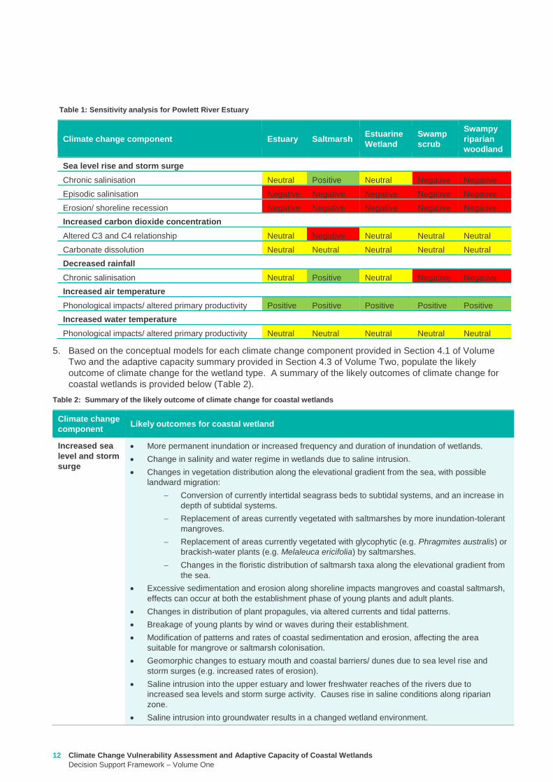
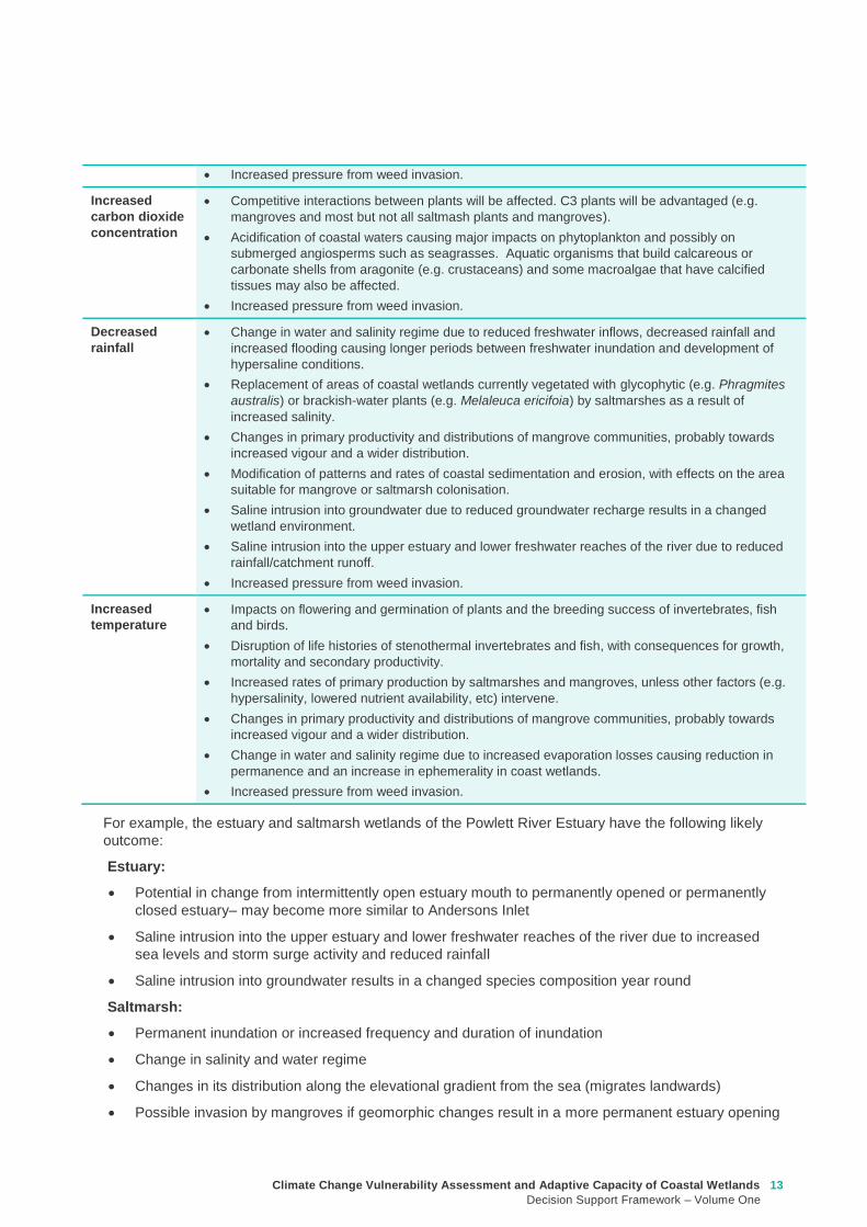
Climate Change Vulnerability Assessment and Adaptive Capacity of Coastal Wetlands
Decision Support Framework ndash Volume One
13
For example the estuary and saltmarsh wetlands of the Powlett River Estuary have the following likely
outcome
Estuary
Potential in change from intermittently open estuary mouth to permanently opened or permanently
closed estuaryndash may become more similar to Andersons Inlet
Saline intrusion into the upper estuary and lower freshwater reaches of the river due to increased
sea levels and storm surge activity and reduced rainfall
Saline intrusion into groundwater results in a changed species composition year round
Saltmarsh
Permanent inundation or increased frequency and duration of inundation
Change in salinity and water regime
Changes in its distribution along the elevational gradient from the sea (migrates landwards)
Possible invasion by mangroves if geomorphic changes result in a more permanent estuary opening
Increased pressure from weed invasion
Increased
carbon dioxide
concentration
Competitive interactions between plants will be affected C3 plants will be advantaged (eg
mangroves and most but not all saltmash plants and mangroves)
Acidification of coastal waters causing major impacts on phytoplankton and possibly on
submerged angiosperms such as seagrasses Aquatic organisms that build calcareous or
carbonate shells from aragonite (eg crustaceans) and some macroalgae that have calcified
tissues may also be affected
Increased pressure from weed invasion
Decreased
rainfall
Change in water and salinity regime due to reduced freshwater inflows decreased rainfall and
increased flooding causing longer periods between freshwater inundation and development of
hypersaline conditions
Replacement of areas of coastal wetlands currently vegetated with glycophytic (eg Phragmites
australis) or brackish-water plants (eg Melaleuca ericifoia) by saltmarshes as a result of
increased salinity
Changes in primary productivity and distributions of mangrove communities probably towards
increased vigour and a wider distribution
Modification of patterns and rates of coastal sedimentation and erosion with effects on the area
suitable for mangrove or saltmarsh colonisation
Saline intrusion into groundwater due to reduced groundwater recharge results in a changed
wetland environment
Saline intrusion into the upper estuary and lower freshwater reaches of the river due to reduced
rainfallcatchment runoff
Increased pressure from weed invasion
Increased
temperature
Impacts on flowering and germination of plants and the breeding success of invertebrates fish
and birds
Disruption of life histories of stenothermal invertebrates and fish with consequences for growth
mortality and secondary productivity
Increased rates of primary production by saltmarshes and mangroves unless other factors (eg
hypersalinity lowered nutrient availability etc) intervene
Changes in primary productivity and distributions of mangrove communities probably towards
increased vigour and a wider distribution
Change in water and salinity regime due to increased evaporation losses causing reduction in
permanence and an increase in ephemerality in coast wetlands
Increased pressure from weed invasion
14 Climate Change Vulnerability Assessment and Adaptive Capacity of Coastal Wetlands
Decision Support Framework ndash Volume One
Saltmarsh are C3 plants so potentially advantaged by increases in atmospheric CO2 concentrations
Increased pressure from weed invasion
Saline intrusion into groundwater results in a changed species composition year round
6 Based on the main adaptive mechanisms and the main factors limiting adaptive capacity of your wetland
(summary table provided in Appendix B and further detail contained in Section 43 of Volume Two)
populate the table to reflect the likely adaptive capacity of your wetland type to climate change For
example see analysis on the Powlett River Estuary adaptive capacity in Table 3
Table 3 Adaptive capacity of Powlett River Estuary
Based on your knowledge of the wetland and its site specific characteristics (eg presence of barriers for
migration) specific assessments of opportunities and constraints to adaptive capacity can also be
undertaken to further inform this part of the DSF
33 Step 3 ndash What are your management objective and actions for the site
In this step you consider the adaptation mechanisms possible for your wetland and develop management
objectives and actions The outcomes of this step will inform the development of management and
implementation plans which would be undertaken outside of the DSF
1 Identify the constraints to management for the site which may include barriers to migration land
ownership available funding and knowledge and data availability (see Section 51 of Volume Two) For
example the Powlett River Estuary has the following likely management constraints
Barriers to migration
Powlett Road may restrict inland migration
Rail trail towards Dayleston may restrict inland migration
Small cluster of housing north east of the Estuary mouth may restrict inland migration
Land ownership
The land in which wetlands could migrate in to is predominately private land used for agriculture
(grazing and cropping)
Funding
Limited funding available ndash not currently a priority site for intervention
Wetland
type
Adaptive
capacity Main adaptive mechanism Main limiting factors
Saltmarsh Low Sediment accretion movement
to higher elevations positive
response to increase
temperature (variable responses
to increased CO2)
Rate of sea level rise storm
surge intensity and shoreline
erosion seawalls and other
physical impediments impact of
increased atmospheric CO2
impacts on floristic composition
Estuarine
wetland
Moderate Positive response to
temperature neutral to most
other impacts until sea levels
make the sites intertidal
Salinisation and waterlogging
due to storm surges
Swamp
scrub
Low Positive response to
temperature
Salinisation and waterlogging
(ie changes to wetting and
drying regimes)
Swampy
Riparian
woodland
Low Positive response to
temperature
Salinisation and waterlogging
(ie changes to wetting and
drying regimes)
Climate Change Vulnerability Assessment and Adaptive Capacity of Coastal Wetlands
Decision Support Framework ndash Volume One
15
Whilst there is good collaboration between agencies and landholders there are different priorities for
the funding available and therefore so some actions are difficult to agree to
Limitations to knowledge and data
What geomorphic changes to the estuary mouth are likely to occur as a result of climate change (ie
changes in estuary dynamics)
Understanding the economic value of the estuary and coastal wetlands (eg value of wetlands
versus the value of agricultural land)
What happens to Acid Sulfate Soils as a result of climate change
Other potential constraints
Current State policies and procedures for statutory planning changes and land purchase to enable
long term change in land use
Community understanding and expectation around estuary opening and closing
2 Taking into consideration the main constraints to management of the site develop and document in
consultation with relevant agencies and community stakeholders a management objective for the site in
regards to climate change adaptation using the broad management objectives provided in Table 4
(further discussed in Section 52 of Volume Two)
Table 4 Decision Support Framework ndash broad management objectives
Broad Management Objectives
1 Savemaintain existing wetland in current position
2 Facilitate landward migration of existing wetland type
3 Facilitate transition to new wetland type in current location
4 No intervention
It is also important to consider wetland values current threats to the wetland local and regional
objectives and adjacent habitat typeszones wetland buffer zones and transition zone between wetland
and terrestrial habitats (further detail on these considerations provided in Section 52 of Volume Two)
For example based on the pre-existing management objectives for the Powlett River Estuary the site
could have the following management objective
To enhance and significantly increase Swamp scrub Swampy riparian woodland and estuarine wetland
vegetation communities through the facilitation of landward migration
Combinations of the management objectives listed above may also be identified across a range of time
scales in response to the degree of exposure of the wetland to the components of climate change (ie
scenario planning) this is further discussed in Section 52 of Volume Two
3 Based on the management objective identified any pre-existing management actions and the
management actions provided in Section 53 of Volume Two (summary provided in Table 5 below) select
the most appropriatefeasible management actions to enable objectives to be achieved
The development of objectives and actions is iterative and requires consideration of constraints and
assessment of the feasibility of management options Hence this step may require an evaluation of a
range of actions to identify those that are most feasible and likely to enable objectives to be met If it
turns out actions are not feasible then objectives may need to be reviewed
Monitoring is a critical part of all actions because it is used to inform timing of implementation and
adaptive management For example the landward migration of the wetland will take many years and so
some actions may not be required until landward movement has commenced or reached a certain
extent or may not be needed at all if monitoring reveals that the climate change component does not
manifest at that location Other actions may require immediate implementation even though the benefits
of that actions may not be realised until some time in the future (eg land use planning rules or land
16 Climate Change Vulnerability Assessment and Adaptive Capacity of Coastal Wetlands
Decision Support Framework ndash Volume One
acquisition may be required now so that space is available in future years when climate change
components manifest themselves)
Table 5 Decision Support Framework ndash how management actions relate to various management objectives
The suite of actions and timing of implementation are very much siteregion specific For example the
following management actions (new and adaption of existing management actions in place for the site)
could be set for the Powlett River Estuary
Table 6 Decision Support Framework ndash example management actions for the Powlett River Estuary
Management Actions
Save maintain
existing wetland in
current position
Facilitate landward
migration of existing
wetland type
Facilitate
transition to new
wetland type in
current location
No
intervention
Influence private land
management -
Land acquisition planning - - -
Active revegetation -
Invasive species control -
New infrastructure on
seaward side of wetland - - -
Infrastructure removal
modification on landward
side of wetland - - -
Education and community
engagement -
Fire Management - - -
Management Action Timeframe Responsibility
Complete a study to assess the likely geomorphic changes to the estuary as
a result of climate change
2 years WGCMA
Undertake scenario planning - refine management actions and objectives for
Estuary based on finding of geomorphic study This could identify nearby
systems that could form a template for what Powlett River might look like in
the future (eg Andersons Inlet)
2-5 years WGCMA
Review Bass Coast Planning Scheme to understand any implications to
future management actions works at the Powlett Estuary Provide feedback
to the State Government on any issues associated with State policies and
procedures for statutory planning that may constrain long term management
of the Estuary
2-5 years WGCMA
Resolve issues and complexities around the impacts of climate change (sea
level rise) on crown land boundaries
2-5 years State
Government
Resolve issues associated with State policies and procedures for statutory
planning that may constrain long term management of the Estuary
2-5 years State
Government
Estuary Management Plan Action E31 (see above) ndash to become 2 actions
a Investigate opportunities for land purchase within the current inundation
areas of the estuary
8 years WGCMA
Climate Change Vulnerability Assessment and Adaptive Capacity of Coastal Wetlands
Decision Support Framework ndash Volume One
17
4 Following the identification of objectives and actions the last step is to develop a management plan (or
update existing plan) that provides the specific details around actions responsibilities monitoring and
timeframes for implementation
b Investigate opportunities for land purchase within the future inundation
areas of the estuary
Estuary Management Plan Action E32 (see above) ndash include
consideration of future inundation eg ldquoDesign and implement a program of
stewardship payment for the seasonal inundation of estuary floodplain from
estuary mouth closures under both current and future inundation conditionsrdquo
8 years WGCMA
Estuary Management Plan Action E 39 (see above) ndash to become 2 actions
a Investigate opportunities to encourage the conversion of current Crown
land water frontage grazing licences to riparian management licences
b Investigate issues and opportunities related to sea level rise impacts on
Crown Land Water frontage grazing licences and riparian management
licences (including how to define boundaries if existing boundaries are
inundated by sea level rise)
8 years WGCMA
Estuary Management Plan Action E44 (see above) ndash Undertake detailed
risk assessment of potential and active acid sulfate soils
8 years WGCMA
Estuary Management Plan Action E49 (see above) ndash Continue to build
understanding of and plan for risks associated with climate change
8 years WGCMA
18 Climate Change Vulnerability Assessment and Adaptive Capacity of Coastal Wetlands
Decision Support Framework ndash Volume One
In order to provide validation that the DSF can provide an assessment of the vulnerability and adaptive
capacity of a coastal wetland in Victoria to the impacts of climate change and guidance to wetland managers
on potential management objectives and actions for those coastal wetland systems likely to be affected by
climate change the DSF was applied to a case study wetland in Victoria
The case study wetland was selected by DELWP from a list of potential wetlands provided by the wetland
managers from the working group established as part of the project Wetland managers included
representatives from the DELWP Parks Victoria West Gippsland Catchment Management Authority (CMA)
East Gippsland CMA Port Phillip and Westernport CMA Glenelg Hopkins CMA and Corangamite CMA
The wetland selected was the Powlett River Estuary in the West Gippsland CMA region This decision was
based on existing information available for the site (an existing estuary management plan was available) its
value (listed as a Nationally Important Wetland and a habitat for the critically endangered Orange-bellied
Parrot) and that the site provided a good balance between covering a number of different coastal wetland
types (estuary saltmarsh riparian scrub estuarine wetland heathlands and woodlands) but without being
too complex and large
Consultation with West Gippsland CMA was undertaken throughout the case study application to ensure that
local knowledge was incorporated and so that the wetland manager could provide input to setting the
wetland management objectives and actions The completed application of the DSF for the Powlett River
Estuary is provided in Appendix D
Through the case study application it became apparent that Step 1 (wetland type) could be largely
completed by applying local knowledge of the wetland ecosystems found within the site Step 2 (assess the
potential impacts from climate change) however requires more technical knowledge of the wetlands
sensitivity and adaptive capacity to climate change and therefore requires close consultation with the
supporting technical information contained in Volume 2 Volume 2 provides enough information for a wetland
manager with limited climate change knowledge to complete this component of the DSF Step 3 is then a
combination of applying local knowledge to set management objectives and then using a combination of
local knowledge and the supporting technical information contained in Volume 2 to develop management
actions
The maps included in the case study application use only publically available data (the coastal wetland
dataset developed as part of this project and DELWPs coastal inundation dataset) and their manipulation
and interrogation is well within the GIS capability within the relevant wetland managerrsquos organisations
The case study application of the DSF demonstrated its effectiveness at providing a framework for assessing
potential impacts from climate change on Victorian coastal wetlands and will be a useful tool for assisting
wetland managers to 1) understand and 2) develop objectives and actions for managing coastal wetlands in
response to a changing climate
4 Case study application
Climate Change Vulnerability Assessment and Adaptive Capacity of Coastal Wetlands
Decision Support Framework ndash Volume One
19
Barbier EB Hacker SD Kennedy C Koch EW Stier AC amp Silliman BR (2011) The value of estuarine and
coastal ecosystem services Ecological Monographs 81169-93
Boon PI (2012) Coastal wetlands of temperate eastern Australia will Cinderella ever go to the ball Marine
and Freshwater Research 63 845-855
Boon PI Allen T Carr G Frood D Harty C McMahon A Mathews S Rosengren N Sinclair S White M amp
Yugovic J (2015a) Coastal wetlands of Victoria south-eastern Australia providing the inventory and
condition information needed for their effective management and conservation Aquatic Conservation Marine
and Freshwater Ecosystems 25 454-479
Costanza R de Groot R Sutton P van der Ploeg S Anderson SJ Kubiszewski I et al (2014) Changes in
the global value of ecosystem services Global Environmental Change 26152-8
Creighton C Boon PI Sheaves M amp Brookes J (2015) Revitalising Australiarsquos estuaries ndash what benefits at
what cost Marine and Freshwater Research 66 493-507
CSIRO and BOM (2015a) Southern slopes cluster report Climate change in Australia projections for
Australiarsquos natural resource management regions Full Report CSIRO and Bureau of Meteorology
Canberra Available on-line at httpwwwclimatechangeinaustraliagovauenimpacts-and-adaptationnrm-
regions
CSIRO and BOM (2015b) Climate change in Australia Projections for Australias NRM regions Southern
slopes Summary report CSIRO and Bureau of Meteorology Canberra Available on-line at
httpwwwclimatechangeinaustraliagovauenimpacts-and-adaptationnrm-regions
Finlayson CM Davis JA Gell PA Kingsford RT and Parton KA (2013) The status of wetlands and the
predicted effects of climate global climate change the situation in Australia Aquatic Sciences 75 73-93
Friess DA Krauss KW Horstman EM Balke T Bouma TJ Galli D amp Webb EL (2012) Are all intertidal
wetlands naturally created equal Bottlenecks thresholds and knowledge gaps to mangrove and saltmarsh
ecosystems Biological Reviews 87 346-366
Gilman EL Ellison J Duke NC amp Field C (2008) Threats to mangroves from climate change and adaptation
options a review Aquatic Botany 89 237-250
Johnston EM Hedge LH and Mayer-Pinto M (2015) The urgent need to understand port and harbour
ecosystems Marine and Freshwater Research 66 i-ii
Morton RM (1990) Community structure density and standing crop of fishes in a subtropical Australian
mangrove area Marine Biology 105 385-94
Morris L (2013) Chapter 2 Implications of future climate change for seagrass and soft sediments In
Implications of future climate change for Victorians marine environments Eds Klemke J amp Arundel H Report
to Glenelg Hopkins CMA
Nielsen D and M Brock 2009 Modified water regime and salinity as a consequence of climate change
prospects for wetlands of Southern Australia Climatic Change 95523-533
Osland MJ Enwright NM Day RH Gabler CA Stagg CL and Grace JB (2016) Beyond just sea-level rises
considering macroclimatic drivers within coastal wetland vulnerability assessments to climate change Global
Change Biology 22 1-11
Prahalad VN Kirkpatrick JB amp Mount RE (2011) Tasmanian coastal saltmarsh community transitions
associated with climate change and relative sea level rise 1975minus2009 Australian Journal of Botany 59 741-
748
SKM (2013) Indicative Assessment of Climate Change Vulnerability for Wetlands in Victoria Report
prepared for Department of Sustainability and Environment (now DELWP)
Zann LP amp Dutton I (2000) The social values and perceptions of Australians concerning the marine
environment In State of the Environment Report for Australia Technical summary Edited by LP Zann
Pages 127-134 Ocean Rescue 2000 amp Department of the Environment Sport and Territories Canberra
5 References
20 Climate Change Vulnerability Assessment and Adaptive Capacity of Coastal Wetlands
Decision Support Framework ndash Volume One
Wetland Type and corresponding EVC
group
Climate change components and ecological consequences
Increased Sea level and storm surges Increased carbon dioxide
concentration
Decreased rainfall Higher air
temperature
Higher water
temperature
Chronic
salinisation
Episodic
salinisation
Erosion
shoreline
recession
Altered C3
and C4
relationship
Carbonate
dissolution
Chronic
salinisation
Altered
sediment
load
Phenological
impacts
altered primary
productivity
Phenological
impacts altered
primary
productivity
Marine
Embayment
Mangrove Positive Neutral to
Negative
Negative Positive Neutral Positive Positive Positive Neutral
Seagrass (not mapped) Positive Negative Neutral Neutral Positive Positive Negative Positive Positive
Saltmarsh Positive Negative Negative Negative Neutral Positive Positive Positive Neutral
Estuarine -
Intertidal
Mangrove Positive Neutral to
Negative
Negative Positive Neutral Positive Positive Positive Neutral
Saltmarsh Positive Negative Negative Negative Neutral Positive Positive Positive Neutral
Estuarine -
supratidal
Heathlands Neutral Neutral Negative Neutral Neutral Neutral Neutral Positive Neutral
Herb-rich woodlands Neutral Neutral Negative Neutral Neutral Neutral Neutral Positive Neutral
Coastal scrubs and
woodlands
Neutral Neutral Negative Neutral Neutral Neutral Neutral Positive Neutral
Wetland - estuarine semi-
permanent saline
Neutral Negative Negative Neutral Neutral Neutral Positive Positive Neutral
Coastal
floodplain
Riparian scrubs or
swampy scrubs and
woodlands
Negative Negative Negative Neutral Neutral Negative Positive Positive Neutral
Coastal brackish wetlands Negative Negative Negative Neutral Neutral Negative Positive Positive Neutral
Freshwater wetlands Negative Negative Negative Neutral Neutral Negative Positive Positive Neutral
Dune
systems
Freshwater wetlands Neutral Neutral Negative Neutral Neutral Neutral Neutral Positive Neutral
Appendix A Sensitivity tables
Climate Change Vulnerability Assessment and Adaptive Capacity of Coastal Wetlands
Decision Support Framework ndash Volume One
21
1 where adaptive capacity is unknown data gaps limit the ability to make clear assessment of adaptive capacity
Appendix B Adaptive capacity of wetland types
Wetland Type Adaptive
capacity1 Main adaptive mechanism Main limiting factor to
adaptation
Marine
Embayment
estuarine -
intertidal
Mangrove Adaptable Sediment accretion movement to higher
elevations positive response to increased temperature and increased atmospheric CO2
Rate of sea-level rise storm surge intensity and shoreline erosion seawalls and other
physical impediments
Seagrass (not mapped)
Adaptable Positive response to increased salinity
Storm surge intensity smothering by catchment-
derived sediments reductions in underwater light fields
consequent to catchment-associated processes
Saltmarsh Adaptable Sediment accretion movement to higher
elevations positive response to increased temperature
(Variable responses to increased CO2)
Rate of sea-level rise storm surge intensity and shoreline erosion seawalls and other
physical impediments impacts of increased atmospheric CO2
impacts on floristic composition
Estuarine ndash
supratidal
Heathlands Unknown Positive response to temperature neutral to most other impacts until sea levels
make the sites intertidal
Salinisation and waterlogging due to storm surge
Herb-rich woodlands
Unknown Positive response to temperature neutral to most other impacts until sea levels
make the sites intertidal
Salinisation and waterlogging due to storm surge
Coastal scrubs and woodlands
Unknown Positive response to temperature neutral to most other impacts until sea levels
make the sites intertidal
Salinisation and waterlogging due to storm surge
Wetland - estuarine semi-permanent saline
Unknown Positive response to temperature neutral to most other impacts until sea levels
make the sites intertidal
Salinisation and waterlogging due to storm surge
Coastal
floodplain
Riparian scrubs or swampy scrubs and woodlands
Non-adaptable
Positive response to temperature
Salinisation and waterlogging (ie changes to wetting and
drying regimes)
Coastal brackish wetlands
Non-adaptable
Positive response to temperature
Salinisation and waterlogging (ie changes to wetting and
drying regimes)
Freshwater wetlands
Non-adaptable
Positive response to temperature
Salinisation and changes to wetting and drying regimes
Dune systems
Freshwater wetlands
Unknown Positive response to temperature neutral to most
other impacts
Physical loss of habitat salinisation possible changes to
wetting and drying regimes
22 Climate Change Vulnerability Assessment and Adaptive Capacity of Coastal Wetlands
Decision Support Framework ndash Volume One
Appendix C Decision Support Framework template
Climate Change Vulnerability Assessment and Adaptive Capacity of Coastal Wetlands
Decision Support Framework ndash Volume One
23
Coastal Wetlands and Climate Change
Decision Support Framework
Site Name Insert wetland name
Purpose
This document provides a Decision Support Framework to enable wetland managers to assess the
vulnerability and adaptive capacity of wetlands to climate change at an individual wetland or local landscape
scale The DELWP Climate Change Vulnerability Assessment and Adaptive Capacity of Coastal Wetlands
report provides the background and supporting material for this assessment and should be used in
conjunction with each stage of the assessment process outlined below
The broad approach applied in the Decision Support Framework is illustrated below It is a three step
approach that includes
Step 1 Wetland type ndash in this step you identify your wetland type (eg mangrove saltmarsh) using
a combination of the coastal wetland dataset developed as part of this project and your existing
knowledge of the site This step guides the sensitivity assessment undertaken in step 2
Step 2 Assess potential impacts from climate change ndash in this step you consider the position of
your wetland in the landscape so you can determine which component of climate change the
wetland is most sensitive to This step involves undertaking the exposure and sensitivity
components of the vulnerability assessment outlined above using the exposure mapping the
conceptual models and the sensitivity tables provided in the supporting documents
Step 3 Identify management objectives and actions ndash in this step you consider the adaptation
mechanisms possible for your wetland and develop management objectives and actions This step
will inform the development of a management plan which is undertaken outside of the DSF
Step 2 Assess potential impacts from climate change
(refer to Section 4 and Section 5 Volume 2)
Given the location of the wetland in the landscape which components of climate change is the
wetland sensitive to and what is the likely response to climate change
Step 3 Identify management objectives and actions
(refer to Section 6 Volume 2)
a) Identify constraints and
potential management
objectives and actions
b) Confirm
management
objectives
c) Confirm management
actions and develop
implementation plan
Step 1 Wetland type
(refer to Section 3 Volume 2)
What is the wetland type
24 Climate Change Vulnerability Assessment and Adaptive Capacity of Coastal Wetlands
Decision Support Framework ndash Volume One
Decision Support Framework
1 Wetland identification (Section 2 Volume Two)
Name Insert wetland name
Location address Insert generic location description
Easting Northing
Bioregion Refer to httpwwwdepivicgovauenvironment-and-wildlifebiodiversityevc-benchmarks
Wetland category
(Section 24 Volume
Two)
Tidal wetlands
Marine embayment
Estuarine (intertidal)
Estuarine (supratidal)
Non-tidal wetland
Coastal floodplain
Dune system
Wetland type EVC
group(s)
(Section 23 Volume
Two and supporting
geospatial dataset)
Seagrass
Saltmarsh
Mangroves
Brackish wetland
Freshwater wetland (floodplain)
Freshwater wetland (dune)
Riparian swampy scrub
Estuarine wetland
Estuarine scrubs heathlands and
woodlands
Estuary classification
(if relevant)
httpwwwozcoastsgov
ausearch_datamap_se
archjsp
Classification
Wave dominated
Sub-classification
Wave dominated delta
Tide dominated delta
Wave dominated estuary
Tide dominated estuary
Tide dominated
Coastal lagoon
Strandplain
Tidal flat creek
Other
Estuary
geomorphology (if
relevant)
Permanently open
Permanently closed
Intermittently opened and closed
Wetland values See Section 44 of Volume Two for more detail
Climate Change Vulnerability Assessment and Adaptive Capacity of Coastal Wetlands
Decision Support Framework ndash Volume One
25
Decision Support Framework
Decision Support Framework
Insert location map including location of individual wetland EVC types
26 Climate Change Vulnerability Assessment and Adaptive Capacity of Coastal Wetlands
Decision Support Framework ndash Volume One
Decision Support Framework
2 Potential impacts from climate change to the wetland (Section 4 Volume Two)
What is the
climate change
scenario
timeframe
Select climate change scenario timeframe detailed in Section 333 of Volume 2
Given the
position of the
wetland in the
landscape how
exposed is the
wetland to sea
level rise and
storm surge
climate change
components
Insert exposure map for sea level rise and storm surges (See Appendix F of Volume Two Coastal Inundation
dataset is publically available at wwwdatavicgovau)
Sea level rise
Storm surges
Climate Change Vulnerability Assessment and Adaptive Capacity of Coastal Wetlands
Decision Support Framework ndash Volume One
27
Decision Support Framework
Decision Support Framework
Site specific
infrastructure
dynamics that
would influence
the impact from
sea level rise
and storm
surges
Identify any specific infrastructure dynamics that may increase or decrease the impact from sea level rise
and storm surges (eg presence of artificial barriers to restrict seawater intrusion)
Given the
position of the
wetland in the
landscape how
exposed is the
wetland to
temperature and
rainfall climate
change
components
Insert climate change projections for temperature and rainfall based on current CSIRO-BOM (2015)
modelling provided in Section 332 of Volume Two
Temperature
Based on CSIRO-BOM (2015) modelling the following predictions are made in regards to change in
temperature
Magnitude of change
(mean surface temp
change)
Seasonality
Rainfall
Based on CSIRO-BOM (2015) modelling the following predictions are made in regards to change in rainfall
Magnitude of change
(change in rainfall) Seasonality
Wetland
sensitivity
Insert wetland type and sensitivity to climate change components (positive [highlight green] negative
[highlight red] neutral [highlight yellow] NA) provided in Appendix A of Volume One
Climate change component and
impacts on coastal wetlands
Insert
wetland
type
Insert
wetland
type
Insert
wetland
type
Insert
wetland
type
Sea level
Chronic salinisation
Episodic salinisation
Erosion shoreline recession
Carbon dioxide
Altered C3 and C4 relationship
Carbonate dissolution
Rainfall
Chronic salinisation
Temperature (air)
Phenological impacts altered primary
productivity
Temperature (water)
Phenological impacts altered primary
productivity
Positive = positive response to climate change negative = negative response to climate change neutral =
unlikely to have any response to climate change NA = not exposed
28 Climate Change Vulnerability Assessment and Adaptive Capacity of Coastal Wetlands
Decision Support Framework ndash Volume One
Decision Support Framework
Likely outcome Based on the Table 2 in Section 32 of Volume One and the conceptual models presented in Section 41 of
Volume Two
Adaptive
capacity
General adaptive capacity of wetland types present
Describe based on the conceptual models presented in Section 41 of Volume Two and populated table
based on table provided in Section 43 of Volume Two
Wetland
type
Adaptive
capacity Main adaptive mechanism Main limiting factor
Site specific adaptive capacity
Need to consider site specific opportunities and constraints to adaptive capacity based on site specific
characteristics
3 Management objectives and actions (Section 5 of Volume Two)
Constraints to
management
See Section 51 of Volume Two report for more detail
Barriers to migration
Land ownership
Funding
Limitations to knowledge and data
Other potential constraints
Pre-existing threats Identify pre-existing threats that may impact the wetlands capacity to cope with change
Pre-existing
management
objectives
Document local and regional management objectives in pre-existing management plans and
strategies
Proposed management
objective in relation to
climate change
Based on wetland values and existing objectives define the management objective for the wetland in
relation to climate change See Section 52 of Volume Two for more detail
Climate Change Vulnerability Assessment and Adaptive Capacity of Coastal Wetlands
Decision Support Framework ndash Volume One
29
Decision Support Framework
Decision Support Framework
Management actions to
address climate
change impacts and
management
objectives
Identify a suite of management actions for the site See Section 53 of Volume Two for more details
May include existing and new management actions
Existing actions
Management Action Timeframe
New actions
Management Action Timeframe Responsibility
4 Recommendations
Identify any recommendations for management of the wetland eg addressing data gaps further investigation required
development of management or implementation plan
5 Key management resource documents
Insert useful resource documents and web links associated with management at the site including but not limited to
1 Peters G Morris K Frood D Papas P and Roberts J (2015) A Guide to managing livestock grazing in Victorias
wetlands Decision framework and guidelines - Version 10 Arthur Rylah Institute for Environmental Research Technical
Report Series Report number 265
2 Morris K and Papas P (2012) Wetland conceptual models associations between wetland values threats and management
interventions Version one Arthur Rylah Institute for Environmental Research Technical Report Series Report number 237
3 DELWP wetland buffers guidelines (in prep)
4 DELWP wetland revegetation guidelines (in prep)
5 DELWP wetland invasive species management guidelines (in prep)
6 SKM (2005) Guidelines for the design and operation of environmentally friendly wetland regulators (MDBC project report
R2002) Report by Sinclair Knight Merz for the MDBC
6 Key references
Insert key reference supporting documents used to populate decision support framework template
Appendix D Decision Support Framework case study application
30 Climate Change Vulnerability Assessment and Adaptive Capacity of Coastal Wetlands
Decision Support Framework ndash Volume One
Climate Change Vulnerability Assessment and Adaptive Capacity of Coastal Wetlands
Decision Support Framework ndash Volume One
31
Coastal Wetlands and Climate Change
Decision Support Framework
Site Name Powlett River Estuary
Purpose
This document provides a Decision Support Framework to enable wetland managers to assess the
vulnerability and adaptive capacity of wetlands to climate change at an individual wetland or local landscape
scale The DELWP Climate Change Vulnerability Assessment and Adaptive Capacity of Coastal Wetlands
report provides the background and supporting material for this assessment and should be used in
conjunction with each stage of the assessment process outlined below
The broad approach applied in the Decision Support Framework is illustrated below It is a three step
approach that includes
Step 1 Wetland type ndash in this step you identify your wetland type (eg mangrove saltmarsh) using
a combination of the coastal wetland dataset developed as part of this project and your existing
knowledge of the site This step guides the sensitivity assessment undertaken in step 2
Step 2 Assess potential impacts from climate change ndash in this step you consider the position of
your wetland in the landscape so you can determine which component of climate change the
wetland is most sensitive to This step involves undertaking the exposure and sensitivity
components of the vulnerability assessment outlined above using the exposure mapping the
conceptual models and the sensitivity tables provided in the supporting documents
Step 3 Identify management objectives and actions ndash in this step you consider the adaptation
mechanisms possible for your wetland and develop management objectives and actions This step
will inform the development of a management plan which is undertaken outside of the DSF
Step 2 Assess potential impacts from climate change
(refer to Section 4 and Section 5 Volume 2)
Given the location of the wetland in the landscape which components of climate change is the
wetland sensitive to and what is the likely response to climate change
Step 3 Identify management objectives and actions
(refer to Section 6 Volume 2)
a) Identify constraints and
potential management
objectives and actions
b) Confirm
management
objectives
c) Confirm management
actions and develop
implementation plan
Step 1 Wetland type
(refer to Section 3 Volume 2)
What is the wetland type
32 Climate Change Vulnerability Assessment and Adaptive Capacity of Coastal Wetlands
Decision Support Framework ndash Volume One
Decision Support Framework
1 Wetland identification (Section 2 Volume Two)
Name Powlett River Estuary
Location address Located in the West Gippsland Catchment Management Authority (CMA) region near the coast
between Kilcunda and Wonthaggi
Easting 370380205 Northing 5728345662
Bioregion Gippsland Plain
Wetland category
(Section 24 Volume
Two)
Tidal wetlands
Marine embayment
Estuarine (intertidal)
Estuarine (supratidal)
Non-tidal wetland
Coastal floodplain
Dune system
Wetland type EVC
group(s)
(Section 23 Volume
Two and supporting
geospatial dataset)
Seagrass
Saltmarsh
Mangroves
Brackish wetland
Freshwater wetland (floodplain)
Freshwater wetland (dune)
Riparian swampy scrub
Estuarine wetland
Estuarine scrubs heathlands and
woodlands
Estuary classification
(if relevant)
httpwwwozcoastsgov
ausearch_datamap_se
archjsp
Classification
Wave dominated
Sub-classification
Wave dominated delta
Tide dominated delta
Wave dominated estuary
Tide dominated estuary
Tide dominated
Coastal lagoon
Strandplain
Tidal flat creek
Other
Estuary
geomorphology (if
relevant)
Permanently open
Permanently closed
Intermittently opened and closed
Climate Change Vulnerability Assessment and Adaptive Capacity of Coastal Wetlands
Decision Support Framework ndash Volume One
33
Decision Support Framework
Decision Support Framework
Wetland values
The Powlett River Estuary has a diverse range of bird plant and fish communities
5 different EVCs including coastal saltmarsh (Coastal Tussock Saltmarsh and Wet Saltmarsh
Herbland) protected under the Environmental Protection and Biodiversity Conservation Act
1999 (EPBC Act)
22 fish species including the Australian Grayling which is listed threatened under the Flora
and Fauna Guarantee Act 1988 (FFG Act) and vulnerable under the EPBC Act
31 State Australian and Internationally listed bird species including the critically endangered
Orange-bellied Parrot (WGCMA 2015)
The Powlett River Estuary also has significant social and economic value
Recreational activities ndash fishing sightseeing swimming walking bird watching picnics etc
Coastal dunes near the mouth of the Estuary have Aboriginal cultural heritage significance
(number of coastal midden sites recorded)
Landholders commonly graze along the river upstream of the Mouth of Powlett Road
Water source for irrigation and stock and domestic water use (WGCMA 2015)
34 Climate Change Vulnerability Assessment and Adaptive Capacity of Coastal Wetlands
Decision Support Framework ndash Volume One
Decision Support Framework
2 Potential impacts from climate change to the wetland (Section 4 Volume Two)
What is the
climate change
scenario
timeframe
Based on CSIRO-BOM (20015) modelling RCP 45 (moderate response to climate change) and RCP 85
(worst case scenario business as usual response to climate change)
Timeframes 2050 2070 and 2090 were all considered
Given the
position of the
wetland in the
landscape how
exposed is the
wetland to sea
level rise and
storm surge
climate change
components
Sea level rise
Climate Change Vulnerability Assessment and Adaptive Capacity of Coastal Wetlands
Decision Support Framework ndash Volume One
35
Decision Support Framework
Decision Support Framework
Storm surges
Site specific
infrastructure
dynamics that
would influence
the impact from
sea level rise
and storm
surges
There is currently no infrastructure at the Powlett River Estuary that would influence the extent of inundation
from the projected sea level rise and storm surges
When the mouth of the estuary is closed this may help mitigate some of impact of sea level
Given the
position of the
wetland in the
landscape how
exposed is the
wetland to
temperature and
rainfall climate
change
components
Temperature
Based on CSIRO-BOM (2015) modelling the following predictions are made in regards to change in
temperature
Magnitude of change
(mean surface temp
change)
Seasonality
RCP 45
2050 = 05 to 1degC
2070 = gt1 to 15degC
2090 = gt1 to 15degC
RCP 85
2050 = gt15 to 2degC
2070 = gt2 to 25degC
2090 = gt3 to 35deg
Temperature increases are similar in all seasons with some models
simulating to some extent larger increases in summer and autumn
than in other seasons
Projected changes for both daily maximum and minimum
temperature generally follow those of the mean temperature
although there is somewhat lower warming in daily minimum
temperatures than daily maximum temperatures in autumn winter
and spring
Increase in the temperature reached on the hottest days an increase
in the frequency of very hot days and duration of warm spells
36 Climate Change Vulnerability Assessment and Adaptive Capacity of Coastal Wetlands
Decision Support Framework ndash Volume One
Decision Support Framework
Given the
position of the
wetland in the
landscape how
exposed is the
wetland to
temperature and
rainfall climate
change
components
Rainfall
Based on CSIRO-BOM (2015) modelling the following predictions are made in regards to change in rainfall
Magnitude of change
(change in rainfall) Seasonality
RCP 45
2050 = 25 to 75
2070 = gt -25 to 25
2090 = gt -25 to 25
RCP 85
2050 = gt - 75 to -25
2070 = gt - 75 to -25
2090 = gt -125 to - 75
Rainfall declines are strongest in winter and spring Projected
reductions in winter rainfall in the Victoria NSW East region are up
to 30 in 2090 under high emissions
There is little change projected in autumn and either increases or
decreases in summer rainfall are possible
Tendency for heavier rainfall interspersed by longer dry periods
with some extremely dry and wet years with natural variability
continuing to be a major driver of rainfall for the near future (2030)
Intensity of heavy rainfall events is predicted to increase with
timing and magnitude also driven by natural variability
A decline in the number but an increase in the intensity of east
coast lows impacting on average rainfall and heavy rain events
Time spent in drought is predicted to increase over the course of
this century in line with changes to average rainfall and the
frequency and duration of extreme droughts will increase
Wetland
sensitivity
Climate change component and
impacts on coastal wetlands Saltmarsh
Estuarine
Wetland
Swamp
scrub
Swampy
riparian
woodland
Sea level
Chronic salinisation Positive Neutral Negative Negative
Episodic salinization Negative Negative Negative Negative
Erosion shoreline recession Negative Negative Negative Negative
Carbon dioxide
Altered C3 and C4 relationship Negative Neutral Neutral Neutral
Carbonate dissolution Neutral Neutral Neutral Neutral
Rainfall
Chronic salinisation Positive Neutral Negative Negative
Temperature (air)
Phenological impacts altered primary
productivity
Positive Positive Positive Positive
Temperature (water)
Phenological impacts altered primary
productivity
Neutral Neutral Neutral Neutral
Positive = positive response to climate change negative = negative response to climate change neutral =
unlikely to have any response to climate change NA = not exposed
Likely outcome Estuary
Potential change from intermittently open estuary mouth to permanently opened or more permanently
closed estuary depending on regional changes to rainfallcatchment runoff river discharge eustatic
sea levels and storm surges May become more similar to Andersons Inlet (marine embayment) to
the east
Saline intrusion into the upper estuary and lower freshwater reaches of the river due to increased sea
levels and storm surge activity and reduced rainfallcatchment runoff
Climate Change Vulnerability Assessment and Adaptive Capacity of Coastal Wetlands
Decision Support Framework ndash Volume One
37
Decision Support Framework
Decision Support Framework
Saline intrusion into groundwater results in a changed in species composition year round
Saltmarsh
More permanent inundation or increased frequency and duration of inundation
Change in salinity and water regime
Changes in distribution along the elevational gradient from the sea with possible landward migration
Possible invasion by mangroves if geomorphic changes result in a more permanent estuary opening
(eg similar to Andersons Inlet)
Many of the saltmarsh taxa at the site are C3 plants so potentially advantaged by increases in
atmospheric CO2 concentrations
Increased pressure from weed invasion from surrounding agricultural land
Saline intrusion into groundwater results in a changed wetland environment
Estuarine Wetland
Change in salinity and water regime (eg reduced freshwater inflows and saline intrusion increased
evaporation losses)
Increased pressure from weed invasion
Saline intrusion into groundwater results in a changed wetland environment
Riparian scrub and swampy riparian woodland
Change in salinity and water regime (eg reduced freshwater inflows and saline intrusion decreased
rainfall increased extreme flood events)
Rise in saline conditions along riparian zone
Replacement with saltmarsh as a result of increased salinity
Increased pressure from weed invasion
Saline intrusion into groundwater results in a changed species composition year round
Adaptive
capacity
General adaptive capacity of wetland types present
Wetland
type
Adaptive
capacity Main adaptive mechanism Main limiting factor
Saltmarsh Low Sediment accretion movement
to higher elevations positive
response to increase
temperature (variable
responses to increased CO2)
Rate of sea level rise storm surge
intensity and shoreline erosion
seawalls and other physical
impediments impact of increased
atmospheric CO2 impacts on floristic
composition
Estuarine
wetland
Moderate Positive response to
temperature neutral to most
other impacts until sea levels
make the sites intertidal
Salinisation and waterlogging due to
storm surges
Swamp
scrub
Low Positive response to
temperature
Salinisation and waterlogging (ie
changes to wetting and drying regimes)
Swampy
Riparian
woodland
Low Positive response to
temperature
Salinisation and waterlogging (ie
changes to wetting and drying regimes)
38 Climate Change Vulnerability Assessment and Adaptive Capacity of Coastal Wetlands
Decision Support Framework ndash Volume One
Decision Support Framework
Site specific adaptive capacity
Not completed as part of case study ndash requires specific assessments of opportunities and constraints to
adaptive capacity based on site specific characteristics
3 Management objectives and actions (Section 5 of Volume Two)
Constraints to
management
Barriers to migration
Mouth of Powlett Road is a barrier to wetland migration
Rail trail towards Dayleston provides a barrier to landward migration
Small cluster of housing north east of the estuary mouth similarly constrains landward
migration
Land ownership
The land in which wetlands could migrate in to is predominately private land used for
agriculture (grazing and cropping)
Funding
Limited funding available ndash not a priority site State wide nor Ramsar listed
Whilst there is good collaboration between agencies and landholders there are different
priorities for the funding available and therefore so some actions are difficult to implement An
example includes raising roads and carparks that experience inundation during closure
events or buying back regularly inundated marginal farmland
Limitations to knowledge and data
Uncertainty around the likely geomorphic changes to the estuary mouth (ie change in estuary
dynamic)
Understanding the economic value of the estuary coastal wetlands (eg value of wetlands
versus the value of agricultural land)
Uncertainty around acid sulfate soils as a result of climate change
Other potential constraints
Current State policies and procedures for statutory planning changes and land buyback to
enable long term management
Community understanding and expectation around estuary opening and closing
Pre-existing threats The key pre-existing threats identified in the Powlett River Estuary Management Plan that may
influence the resilience of the estuary to climate change impacts include
Degraded water quality
Degraded riparian vegetation (large trees in particular)
Trampling and bank erosion associated with pedestrian access
Rural drainage and drain clearing
Channelisation of the river channel
Vehicle access
Livestock access
Pest plants and animals
Inappropriate recreation causing dune erosion
Disturbance of acid sulfate soils
Climate Change Vulnerability Assessment and Adaptive Capacity of Coastal Wetlands
Decision Support Framework ndash Volume One
39
Decision Support Framework
Decision Support Framework
Pre-existing
management
objectives
Regional catchment strategy
No coastal wetland specific actions objectives for the Powlett River
West Gippsland Waterways Strategy (2014-2022)
Regional objectives relating to the Powlett River Estuary as a coastal wetland
Maintain and improve the habitat and condition of waterways to support waterway dependent
animals and plants
Maintain the ecological character of significant wetlands and estuaries
Catchment objectives for Powlett River Estuary relating to coastal wetlands include
Riparian vegetation provides improved visual amenity and contributes to community use of
waterways
The extent of freshwater wetlands is maintained and their condition is improved
Powlett Estuary Management Plan
Swamp scrub swampy riparian woodland and estuarine wetland vegetation communities are
enhanced and significantly increased in the area
West Gippsland Regional NRM Climate Change Strategy (2016)
The strategy outlines approaches and options to support climate change adaptation and mitigation
The objectives of the adaptation and management strategies are linked to the 20 year objectives in
the Regional Catchment Strategy The Powlett River Estuary is located within the Bunurong Coastal
planning area The estuary is listed as one of the most vulnerable estuary assets to climate change
across the region
Reports are available at lthttpwwwwgcmavicgovauour-regionwaterwayspowlett-river-estuarygt
[Verified 17052016 ]
Proposed management
objective in relation to
climate change
The following management objective is based the existing geomorphic characteristics of the estuary
(ie intermittently closed estuary)
To enhance and significantly increase Swamp scrub Swampy riparian woodland and estuarine
wetland vegetation extent through the facilitation of landward migration of these communities over the
next 50 years
Climate change also poses a threat to non-wetland EVCs (eg Coast Banksia Woodland) and
therefore even though they are not considered in this coastal wetland risk assessment they are still a
management consideration for the CMA in the coastal zone
Management actions to
address climate
change impacts and
management
objectives
Existing actions
Existing management actions provided in Section 81 of the Estuary Management Plan (WGCMA
2015) that are related to climate change are listed below
Management Action Timeframe
E31 Investigate opportunities for land purchase within the inundation
areas of the estuary
8 years
E32 Design and implement a program of stewardship payment for the
seasonal inundation of estuary floodplain from estuary mouth closures
Priority should be given to enhancing coastal saltmarsh and estuarine
wetland communities Payments should be calculated and prioritised
based on potential value to estuary health and ability to minimise artificial
estuary mouth openings
8 years
E 39 Investigate opportunities to encourage the conversion of Crown land
water frontage grazing licences to riparian management licences
8 years
E 43 Undertake hydraulic modelling and bathymetry survey of the Powlett 8 years
40 Climate Change Vulnerability Assessment and Adaptive Capacity of Coastal Wetlands
Decision Support Framework ndash Volume One
Decision Support Framework
estuary floodplain to understand the impacts and benefits of the structures
(including levees and drains) and landforms that affect the movement of
water before during and after artificial estuary mouth opening before
considering any updates changes or removal of these floodplain features
E 44 Undertake a detailed risk assessment including on-ground mapping
to identify potential and active acid sulphate soils with the Powlett estuarine
floodplain
8 years
E 46 Investigate the use of the saltmarsh wetlands and estuary channel
by recreational fish species and other native fish species particularly Black
Bream and prioritise areas for further protection
8 years
E 49 Continue to build understanding of and plan for the risks associated
with climate change including sea level rise This includes future flood
risk
8 years
New actions
The following additional management actions should be considered
Management Action Timeframe Responsibility
Complete a study to assess the likely geomorphic changes
to the estuary as a result of climate change
2 years WGCMA
Undertake scenario planning in consultation with Bass Coast
Shire Council VicRoads and Parks Victoria- refine
management actions and objectives for Estuary based on
finding of geomorphic study This could identify nearby
systems that could form a template for what Powlett River
might look like in the future (eg Andersons Inlet)
2-5 years WGCMA
Review Bass Coast Planning Scheme to understand any
implications to future management actions works at the
Powlett Estuary Provide feedback to the State Government
on any issues associated with State policies and procedures
for statutory planning that may constrain long term
management of the Estuary
2-5 years WGCMA
Consultation with other relevant managers in the area
(including Council VicRoads and Parks Victoria) to discuss
potential issues associated road repairs culverts and other
flood mitigation measures in the area that may arise as a
result of climate change
2-5 years WGCMA
Resolve issues and complexities around the impacts of
climate change (sea level rise) on crown land boundaries
2-5 years State
Government
Resolve issues associated with State policies and
procedures for statutory planning that may constrain long
term management of the Estuary
2-5 years State
Government
Community engagement and education program to provide
the community with an understanding of the predicted
impacts of climate change and enable them to play an active
role in management
2-5 years WGCMA
Estuary Management Plan Action E31 (see above) ndash to
become 2 actions
a Investigate opportunities for land purchase within the
8 years WGCMA
Climate Change Vulnerability Assessment and Adaptive Capacity of Coastal Wetlands
Decision Support Framework ndash Volume One
41
Decision Support Framework
Decision Support Framework
current inundation areas of the estuary
b Investigate opportunities for land purchase within the
future inundation areas of the estuary
Estuary Management Plan Action E32 (see above) ndash
include consideration of future inundation eg ldquoDesign and
implement a program of stewardship payment for the
seasonal inundation of estuary floodplain from estuary
mouth closures under both current and future inundation
conditionsrdquo
8 years WGCMA
Estuary Management Plan Action E 39 (see above) ndash to
become 2 actions
a Investigate opportunities to encourage the conversion of
current Crown land water frontage grazing licences to
riparian management licences
b Investigate issues and opportunities related to sea level
rise impacts on Crown Land Water frontage grazing licences
and riparian management licences (including how to define
boundaries if existing boundaries are inundated by sea level
rise)
8 years WGCMA
Estuary Management Plan Action E44 (see above) ndash
Undertake detailed risk assessment of potential and active
acid sulfate soils
8 years WGCMA
Estuary Management Plan Action E49 (see above) ndash
Continue to build understanding of and plan for risks
associated with climate change
8 years WGCMA
4 Recommendations
1 Climate change threats are currently implied within the management actions in the Powlett River Estuary Management Plan It
is recommended that additional material on climate change impacts be included and climate change threats addressed more
explicitly in the management actions This would meet Action E49 in particular
2 Management objectives also need to consider management for a 30-50 year timeframe ie take in to consideration longer
term climate change impacts including on estuary mouth dynamics A distinction between responses to current and future
threats should be made
5 Key management resource documents
1 Peters G Morris K Frood D Papas P and Roberts J (2015) A Guide to managing livestock grazing in Victorias
wetlands Decision framework and guidelines - Version 10 Arthur Rylah Institute for Environmental Research Technical
Report Series Report number 265
2 Morris K and Papas P (2012) Wetland conceptual models associations between wetland values threats and management
interventions Version one Arthur Rylah Institute for Environmental Research Technical Report Series Report number 237
3 DELWP wetland buffers guidelines (in prep)
4 DELWP wetland revegetation guidelines (in prep)
5 DELWP wetland invasive species management guidelines (in prep)
6 SKM (2005) Guidelines for the design and operation of environmentally friendly wetland regulators (MDBC project report
R2002) Report by Sinclair Knight Merz for the MDBC
42 Climate Change Vulnerability Assessment and Adaptive Capacity of Coastal Wetlands
Decision Support Framework ndash Volume One
Decision Support Framework
6 Key references
1 WGCMA (2012) West Gippsland Regional Catchment Strategy 2013-2019 West Gippsland Catchment Management
Authority
2 WGCMA (2014) West Gippsland Waterway Strategy 2014-2022 West Gippsland Catchment Management Authority
3 WGCMA (2015) Powlett River Estuary Management Plan West Gippsland Catchment Management Authority
4 WGCMA (2016) West Gippsland Regional NRM Climate Change Strategy ndash Final Draft West Gippsland Catchment
Management Authority
5 CSIRO and BOM (2015) Southern Slopes Cluster Report Climate Change in Australia Projections for Australiarsquos Natural
Resource Management Regions Cluster Reports eds Ekstroumlm M et al CSIRO and Bureau of Meteorology Australia
Climate Change Vulnerability Assessment and Adaptive Capacity of Coastal Wetlands
Decision Support Framework ndash Volume One
43
Decision Support Framework
Decision Support Framework
delwpvicgovau delwpvicgovau
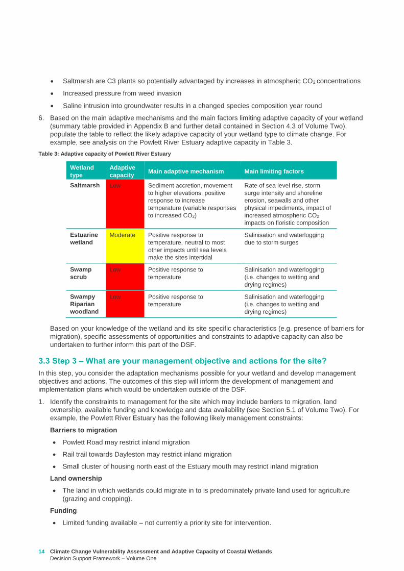
Climate Change Vulnerability Assessment and Adaptive Capacity of Coastal Wetlands
Decision Support Framework ndash Volume One
15
Whilst there is good collaboration between agencies and landholders there are different priorities for
the funding available and therefore so some actions are difficult to agree to
Limitations to knowledge and data
What geomorphic changes to the estuary mouth are likely to occur as a result of climate change (ie
changes in estuary dynamics)
Understanding the economic value of the estuary and coastal wetlands (eg value of wetlands
versus the value of agricultural land)
What happens to Acid Sulfate Soils as a result of climate change
Other potential constraints
Current State policies and procedures for statutory planning changes and land purchase to enable
long term change in land use
Community understanding and expectation around estuary opening and closing
2 Taking into consideration the main constraints to management of the site develop and document in
consultation with relevant agencies and community stakeholders a management objective for the site in
regards to climate change adaptation using the broad management objectives provided in Table 4
(further discussed in Section 52 of Volume Two)
Table 4 Decision Support Framework ndash broad management objectives
Broad Management Objectives
1 Savemaintain existing wetland in current position
2 Facilitate landward migration of existing wetland type
3 Facilitate transition to new wetland type in current location
4 No intervention
It is also important to consider wetland values current threats to the wetland local and regional
objectives and adjacent habitat typeszones wetland buffer zones and transition zone between wetland
and terrestrial habitats (further detail on these considerations provided in Section 52 of Volume Two)
For example based on the pre-existing management objectives for the Powlett River Estuary the site
could have the following management objective
To enhance and significantly increase Swamp scrub Swampy riparian woodland and estuarine wetland
vegetation communities through the facilitation of landward migration
Combinations of the management objectives listed above may also be identified across a range of time
scales in response to the degree of exposure of the wetland to the components of climate change (ie
scenario planning) this is further discussed in Section 52 of Volume Two
3 Based on the management objective identified any pre-existing management actions and the
management actions provided in Section 53 of Volume Two (summary provided in Table 5 below) select
the most appropriatefeasible management actions to enable objectives to be achieved
The development of objectives and actions is iterative and requires consideration of constraints and
assessment of the feasibility of management options Hence this step may require an evaluation of a
range of actions to identify those that are most feasible and likely to enable objectives to be met If it
turns out actions are not feasible then objectives may need to be reviewed
Monitoring is a critical part of all actions because it is used to inform timing of implementation and
adaptive management For example the landward migration of the wetland will take many years and so
some actions may not be required until landward movement has commenced or reached a certain
extent or may not be needed at all if monitoring reveals that the climate change component does not
manifest at that location Other actions may require immediate implementation even though the benefits
of that actions may not be realised until some time in the future (eg land use planning rules or land
16 Climate Change Vulnerability Assessment and Adaptive Capacity of Coastal Wetlands
Decision Support Framework ndash Volume One
acquisition may be required now so that space is available in future years when climate change
components manifest themselves)
Table 5 Decision Support Framework ndash how management actions relate to various management objectives
The suite of actions and timing of implementation are very much siteregion specific For example the
following management actions (new and adaption of existing management actions in place for the site)
could be set for the Powlett River Estuary
Table 6 Decision Support Framework ndash example management actions for the Powlett River Estuary
Management Actions
Save maintain
existing wetland in
current position
Facilitate landward
migration of existing
wetland type
Facilitate
transition to new
wetland type in
current location
No
intervention
Influence private land
management -
Land acquisition planning - - -
Active revegetation -
Invasive species control -
New infrastructure on
seaward side of wetland - - -
Infrastructure removal
modification on landward
side of wetland - - -
Education and community
engagement -
Fire Management - - -
Management Action Timeframe Responsibility
Complete a study to assess the likely geomorphic changes to the estuary as
a result of climate change
2 years WGCMA
Undertake scenario planning - refine management actions and objectives for
Estuary based on finding of geomorphic study This could identify nearby
systems that could form a template for what Powlett River might look like in
the future (eg Andersons Inlet)
2-5 years WGCMA
Review Bass Coast Planning Scheme to understand any implications to
future management actions works at the Powlett Estuary Provide feedback
to the State Government on any issues associated with State policies and
procedures for statutory planning that may constrain long term management
of the Estuary
2-5 years WGCMA
Resolve issues and complexities around the impacts of climate change (sea
level rise) on crown land boundaries
2-5 years State
Government
Resolve issues associated with State policies and procedures for statutory
planning that may constrain long term management of the Estuary
2-5 years State
Government
Estuary Management Plan Action E31 (see above) ndash to become 2 actions
a Investigate opportunities for land purchase within the current inundation
areas of the estuary
8 years WGCMA
Climate Change Vulnerability Assessment and Adaptive Capacity of Coastal Wetlands
Decision Support Framework ndash Volume One
17
4 Following the identification of objectives and actions the last step is to develop a management plan (or
update existing plan) that provides the specific details around actions responsibilities monitoring and
timeframes for implementation
b Investigate opportunities for land purchase within the future inundation
areas of the estuary
Estuary Management Plan Action E32 (see above) ndash include
consideration of future inundation eg ldquoDesign and implement a program of
stewardship payment for the seasonal inundation of estuary floodplain from
estuary mouth closures under both current and future inundation conditionsrdquo
8 years WGCMA
Estuary Management Plan Action E 39 (see above) ndash to become 2 actions
a Investigate opportunities to encourage the conversion of current Crown
land water frontage grazing licences to riparian management licences
b Investigate issues and opportunities related to sea level rise impacts on
Crown Land Water frontage grazing licences and riparian management
licences (including how to define boundaries if existing boundaries are
inundated by sea level rise)
8 years WGCMA
Estuary Management Plan Action E44 (see above) ndash Undertake detailed
risk assessment of potential and active acid sulfate soils
8 years WGCMA
Estuary Management Plan Action E49 (see above) ndash Continue to build
understanding of and plan for risks associated with climate change
8 years WGCMA
18 Climate Change Vulnerability Assessment and Adaptive Capacity of Coastal Wetlands
Decision Support Framework ndash Volume One
In order to provide validation that the DSF can provide an assessment of the vulnerability and adaptive
capacity of a coastal wetland in Victoria to the impacts of climate change and guidance to wetland managers
on potential management objectives and actions for those coastal wetland systems likely to be affected by
climate change the DSF was applied to a case study wetland in Victoria
The case study wetland was selected by DELWP from a list of potential wetlands provided by the wetland
managers from the working group established as part of the project Wetland managers included
representatives from the DELWP Parks Victoria West Gippsland Catchment Management Authority (CMA)
East Gippsland CMA Port Phillip and Westernport CMA Glenelg Hopkins CMA and Corangamite CMA
The wetland selected was the Powlett River Estuary in the West Gippsland CMA region This decision was
based on existing information available for the site (an existing estuary management plan was available) its
value (listed as a Nationally Important Wetland and a habitat for the critically endangered Orange-bellied
Parrot) and that the site provided a good balance between covering a number of different coastal wetland
types (estuary saltmarsh riparian scrub estuarine wetland heathlands and woodlands) but without being
too complex and large
Consultation with West Gippsland CMA was undertaken throughout the case study application to ensure that
local knowledge was incorporated and so that the wetland manager could provide input to setting the
wetland management objectives and actions The completed application of the DSF for the Powlett River
Estuary is provided in Appendix D
Through the case study application it became apparent that Step 1 (wetland type) could be largely
completed by applying local knowledge of the wetland ecosystems found within the site Step 2 (assess the
potential impacts from climate change) however requires more technical knowledge of the wetlands
sensitivity and adaptive capacity to climate change and therefore requires close consultation with the
supporting technical information contained in Volume 2 Volume 2 provides enough information for a wetland
manager with limited climate change knowledge to complete this component of the DSF Step 3 is then a
combination of applying local knowledge to set management objectives and then using a combination of
local knowledge and the supporting technical information contained in Volume 2 to develop management
actions
The maps included in the case study application use only publically available data (the coastal wetland
dataset developed as part of this project and DELWPs coastal inundation dataset) and their manipulation
and interrogation is well within the GIS capability within the relevant wetland managerrsquos organisations
The case study application of the DSF demonstrated its effectiveness at providing a framework for assessing
potential impacts from climate change on Victorian coastal wetlands and will be a useful tool for assisting
wetland managers to 1) understand and 2) develop objectives and actions for managing coastal wetlands in
response to a changing climate
4 Case study application
Climate Change Vulnerability Assessment and Adaptive Capacity of Coastal Wetlands
Decision Support Framework ndash Volume One
19
Barbier EB Hacker SD Kennedy C Koch EW Stier AC amp Silliman BR (2011) The value of estuarine and
coastal ecosystem services Ecological Monographs 81169-93
Boon PI (2012) Coastal wetlands of temperate eastern Australia will Cinderella ever go to the ball Marine
and Freshwater Research 63 845-855
Boon PI Allen T Carr G Frood D Harty C McMahon A Mathews S Rosengren N Sinclair S White M amp
Yugovic J (2015a) Coastal wetlands of Victoria south-eastern Australia providing the inventory and
condition information needed for their effective management and conservation Aquatic Conservation Marine
and Freshwater Ecosystems 25 454-479
Costanza R de Groot R Sutton P van der Ploeg S Anderson SJ Kubiszewski I et al (2014) Changes in
the global value of ecosystem services Global Environmental Change 26152-8
Creighton C Boon PI Sheaves M amp Brookes J (2015) Revitalising Australiarsquos estuaries ndash what benefits at
what cost Marine and Freshwater Research 66 493-507
CSIRO and BOM (2015a) Southern slopes cluster report Climate change in Australia projections for
Australiarsquos natural resource management regions Full Report CSIRO and Bureau of Meteorology
Canberra Available on-line at httpwwwclimatechangeinaustraliagovauenimpacts-and-adaptationnrm-
regions
CSIRO and BOM (2015b) Climate change in Australia Projections for Australias NRM regions Southern
slopes Summary report CSIRO and Bureau of Meteorology Canberra Available on-line at
httpwwwclimatechangeinaustraliagovauenimpacts-and-adaptationnrm-regions
Finlayson CM Davis JA Gell PA Kingsford RT and Parton KA (2013) The status of wetlands and the
predicted effects of climate global climate change the situation in Australia Aquatic Sciences 75 73-93
Friess DA Krauss KW Horstman EM Balke T Bouma TJ Galli D amp Webb EL (2012) Are all intertidal
wetlands naturally created equal Bottlenecks thresholds and knowledge gaps to mangrove and saltmarsh
ecosystems Biological Reviews 87 346-366
Gilman EL Ellison J Duke NC amp Field C (2008) Threats to mangroves from climate change and adaptation
options a review Aquatic Botany 89 237-250
Johnston EM Hedge LH and Mayer-Pinto M (2015) The urgent need to understand port and harbour
ecosystems Marine and Freshwater Research 66 i-ii
Morton RM (1990) Community structure density and standing crop of fishes in a subtropical Australian
mangrove area Marine Biology 105 385-94
Morris L (2013) Chapter 2 Implications of future climate change for seagrass and soft sediments In
Implications of future climate change for Victorians marine environments Eds Klemke J amp Arundel H Report
to Glenelg Hopkins CMA
Nielsen D and M Brock 2009 Modified water regime and salinity as a consequence of climate change
prospects for wetlands of Southern Australia Climatic Change 95523-533
Osland MJ Enwright NM Day RH Gabler CA Stagg CL and Grace JB (2016) Beyond just sea-level rises
considering macroclimatic drivers within coastal wetland vulnerability assessments to climate change Global
Change Biology 22 1-11
Prahalad VN Kirkpatrick JB amp Mount RE (2011) Tasmanian coastal saltmarsh community transitions
associated with climate change and relative sea level rise 1975minus2009 Australian Journal of Botany 59 741-
748
SKM (2013) Indicative Assessment of Climate Change Vulnerability for Wetlands in Victoria Report
prepared for Department of Sustainability and Environment (now DELWP)
Zann LP amp Dutton I (2000) The social values and perceptions of Australians concerning the marine
environment In State of the Environment Report for Australia Technical summary Edited by LP Zann
Pages 127-134 Ocean Rescue 2000 amp Department of the Environment Sport and Territories Canberra
5 References
20 Climate Change Vulnerability Assessment and Adaptive Capacity of Coastal Wetlands
Decision Support Framework ndash Volume One
Wetland Type and corresponding EVC
group
Climate change components and ecological consequences
Increased Sea level and storm surges Increased carbon dioxide
concentration
Decreased rainfall Higher air
temperature
Higher water
temperature
Chronic
salinisation
Episodic
salinisation
Erosion
shoreline
recession
Altered C3
and C4
relationship
Carbonate
dissolution
Chronic
salinisation
Altered
sediment
load
Phenological
impacts
altered primary
productivity
Phenological
impacts altered
primary
productivity
Marine
Embayment
Mangrove Positive Neutral to
Negative
Negative Positive Neutral Positive Positive Positive Neutral
Seagrass (not mapped) Positive Negative Neutral Neutral Positive Positive Negative Positive Positive
Saltmarsh Positive Negative Negative Negative Neutral Positive Positive Positive Neutral
Estuarine -
Intertidal
Mangrove Positive Neutral to
Negative
Negative Positive Neutral Positive Positive Positive Neutral
Saltmarsh Positive Negative Negative Negative Neutral Positive Positive Positive Neutral
Estuarine -
supratidal
Heathlands Neutral Neutral Negative Neutral Neutral Neutral Neutral Positive Neutral
Herb-rich woodlands Neutral Neutral Negative Neutral Neutral Neutral Neutral Positive Neutral
Coastal scrubs and
woodlands
Neutral Neutral Negative Neutral Neutral Neutral Neutral Positive Neutral
Wetland - estuarine semi-
permanent saline
Neutral Negative Negative Neutral Neutral Neutral Positive Positive Neutral
Coastal
floodplain
Riparian scrubs or
swampy scrubs and
woodlands
Negative Negative Negative Neutral Neutral Negative Positive Positive Neutral
Coastal brackish wetlands Negative Negative Negative Neutral Neutral Negative Positive Positive Neutral
Freshwater wetlands Negative Negative Negative Neutral Neutral Negative Positive Positive Neutral
Dune
systems
Freshwater wetlands Neutral Neutral Negative Neutral Neutral Neutral Neutral Positive Neutral
Appendix A Sensitivity tables
Climate Change Vulnerability Assessment and Adaptive Capacity of Coastal Wetlands
Decision Support Framework ndash Volume One
21
1 where adaptive capacity is unknown data gaps limit the ability to make clear assessment of adaptive capacity
Appendix B Adaptive capacity of wetland types
Wetland Type Adaptive
capacity1 Main adaptive mechanism Main limiting factor to
adaptation
Marine
Embayment
estuarine -
intertidal
Mangrove Adaptable Sediment accretion movement to higher
elevations positive response to increased temperature and increased atmospheric CO2
Rate of sea-level rise storm surge intensity and shoreline erosion seawalls and other
physical impediments
Seagrass (not mapped)
Adaptable Positive response to increased salinity
Storm surge intensity smothering by catchment-
derived sediments reductions in underwater light fields
consequent to catchment-associated processes
Saltmarsh Adaptable Sediment accretion movement to higher
elevations positive response to increased temperature
(Variable responses to increased CO2)
Rate of sea-level rise storm surge intensity and shoreline erosion seawalls and other
physical impediments impacts of increased atmospheric CO2
impacts on floristic composition
Estuarine ndash
supratidal
Heathlands Unknown Positive response to temperature neutral to most other impacts until sea levels
make the sites intertidal
Salinisation and waterlogging due to storm surge
Herb-rich woodlands
Unknown Positive response to temperature neutral to most other impacts until sea levels
make the sites intertidal
Salinisation and waterlogging due to storm surge
Coastal scrubs and woodlands
Unknown Positive response to temperature neutral to most other impacts until sea levels
make the sites intertidal
Salinisation and waterlogging due to storm surge
Wetland - estuarine semi-permanent saline
Unknown Positive response to temperature neutral to most other impacts until sea levels
make the sites intertidal
Salinisation and waterlogging due to storm surge
Coastal
floodplain
Riparian scrubs or swampy scrubs and woodlands
Non-adaptable
Positive response to temperature
Salinisation and waterlogging (ie changes to wetting and
drying regimes)
Coastal brackish wetlands
Non-adaptable
Positive response to temperature
Salinisation and waterlogging (ie changes to wetting and
drying regimes)
Freshwater wetlands
Non-adaptable
Positive response to temperature
Salinisation and changes to wetting and drying regimes
Dune systems
Freshwater wetlands
Unknown Positive response to temperature neutral to most
other impacts
Physical loss of habitat salinisation possible changes to
wetting and drying regimes
22 Climate Change Vulnerability Assessment and Adaptive Capacity of Coastal Wetlands
Decision Support Framework ndash Volume One
Appendix C Decision Support Framework template
Climate Change Vulnerability Assessment and Adaptive Capacity of Coastal Wetlands
Decision Support Framework ndash Volume One
23
Coastal Wetlands and Climate Change
Decision Support Framework
Site Name Insert wetland name
Purpose
This document provides a Decision Support Framework to enable wetland managers to assess the
vulnerability and adaptive capacity of wetlands to climate change at an individual wetland or local landscape
scale The DELWP Climate Change Vulnerability Assessment and Adaptive Capacity of Coastal Wetlands
report provides the background and supporting material for this assessment and should be used in
conjunction with each stage of the assessment process outlined below
The broad approach applied in the Decision Support Framework is illustrated below It is a three step
approach that includes
Step 1 Wetland type ndash in this step you identify your wetland type (eg mangrove saltmarsh) using
a combination of the coastal wetland dataset developed as part of this project and your existing
knowledge of the site This step guides the sensitivity assessment undertaken in step 2
Step 2 Assess potential impacts from climate change ndash in this step you consider the position of
your wetland in the landscape so you can determine which component of climate change the
wetland is most sensitive to This step involves undertaking the exposure and sensitivity
components of the vulnerability assessment outlined above using the exposure mapping the
conceptual models and the sensitivity tables provided in the supporting documents
Step 3 Identify management objectives and actions ndash in this step you consider the adaptation
mechanisms possible for your wetland and develop management objectives and actions This step
will inform the development of a management plan which is undertaken outside of the DSF
Step 2 Assess potential impacts from climate change
(refer to Section 4 and Section 5 Volume 2)
Given the location of the wetland in the landscape which components of climate change is the
wetland sensitive to and what is the likely response to climate change
Step 3 Identify management objectives and actions
(refer to Section 6 Volume 2)
a) Identify constraints and
potential management
objectives and actions
b) Confirm
management
objectives
c) Confirm management
actions and develop
implementation plan
Step 1 Wetland type
(refer to Section 3 Volume 2)
What is the wetland type
24 Climate Change Vulnerability Assessment and Adaptive Capacity of Coastal Wetlands
Decision Support Framework ndash Volume One
Decision Support Framework
1 Wetland identification (Section 2 Volume Two)
Name Insert wetland name
Location address Insert generic location description
Easting Northing
Bioregion Refer to httpwwwdepivicgovauenvironment-and-wildlifebiodiversityevc-benchmarks
Wetland category
(Section 24 Volume
Two)
Tidal wetlands
Marine embayment
Estuarine (intertidal)
Estuarine (supratidal)
Non-tidal wetland
Coastal floodplain
Dune system
Wetland type EVC
group(s)
(Section 23 Volume
Two and supporting
geospatial dataset)
Seagrass
Saltmarsh
Mangroves
Brackish wetland
Freshwater wetland (floodplain)
Freshwater wetland (dune)
Riparian swampy scrub
Estuarine wetland
Estuarine scrubs heathlands and
woodlands
Estuary classification
(if relevant)
httpwwwozcoastsgov
ausearch_datamap_se
archjsp
Classification
Wave dominated
Sub-classification
Wave dominated delta
Tide dominated delta
Wave dominated estuary
Tide dominated estuary
Tide dominated
Coastal lagoon
Strandplain
Tidal flat creek
Other
Estuary
geomorphology (if
relevant)
Permanently open
Permanently closed
Intermittently opened and closed
Wetland values See Section 44 of Volume Two for more detail
Climate Change Vulnerability Assessment and Adaptive Capacity of Coastal Wetlands
Decision Support Framework ndash Volume One
25
Decision Support Framework
Decision Support Framework
Insert location map including location of individual wetland EVC types
26 Climate Change Vulnerability Assessment and Adaptive Capacity of Coastal Wetlands
Decision Support Framework ndash Volume One
Decision Support Framework
2 Potential impacts from climate change to the wetland (Section 4 Volume Two)
What is the
climate change
scenario
timeframe
Select climate change scenario timeframe detailed in Section 333 of Volume 2
Given the
position of the
wetland in the
landscape how
exposed is the
wetland to sea
level rise and
storm surge
climate change
components
Insert exposure map for sea level rise and storm surges (See Appendix F of Volume Two Coastal Inundation
dataset is publically available at wwwdatavicgovau)
Sea level rise
Storm surges
Climate Change Vulnerability Assessment and Adaptive Capacity of Coastal Wetlands
Decision Support Framework ndash Volume One
27
Decision Support Framework
Decision Support Framework
Site specific
infrastructure
dynamics that
would influence
the impact from
sea level rise
and storm
surges
Identify any specific infrastructure dynamics that may increase or decrease the impact from sea level rise
and storm surges (eg presence of artificial barriers to restrict seawater intrusion)
Given the
position of the
wetland in the
landscape how
exposed is the
wetland to
temperature and
rainfall climate
change
components
Insert climate change projections for temperature and rainfall based on current CSIRO-BOM (2015)
modelling provided in Section 332 of Volume Two
Temperature
Based on CSIRO-BOM (2015) modelling the following predictions are made in regards to change in
temperature
Magnitude of change
(mean surface temp
change)
Seasonality
Rainfall
Based on CSIRO-BOM (2015) modelling the following predictions are made in regards to change in rainfall
Magnitude of change
(change in rainfall) Seasonality
Wetland
sensitivity
Insert wetland type and sensitivity to climate change components (positive [highlight green] negative
[highlight red] neutral [highlight yellow] NA) provided in Appendix A of Volume One
Climate change component and
impacts on coastal wetlands
Insert
wetland
type
Insert
wetland
type
Insert
wetland
type
Insert
wetland
type
Sea level
Chronic salinisation
Episodic salinisation
Erosion shoreline recession
Carbon dioxide
Altered C3 and C4 relationship
Carbonate dissolution
Rainfall
Chronic salinisation
Temperature (air)
Phenological impacts altered primary
productivity
Temperature (water)
Phenological impacts altered primary
productivity
Positive = positive response to climate change negative = negative response to climate change neutral =
unlikely to have any response to climate change NA = not exposed
28 Climate Change Vulnerability Assessment and Adaptive Capacity of Coastal Wetlands
Decision Support Framework ndash Volume One
Decision Support Framework
Likely outcome Based on the Table 2 in Section 32 of Volume One and the conceptual models presented in Section 41 of
Volume Two
Adaptive
capacity
General adaptive capacity of wetland types present
Describe based on the conceptual models presented in Section 41 of Volume Two and populated table
based on table provided in Section 43 of Volume Two
Wetland
type
Adaptive
capacity Main adaptive mechanism Main limiting factor
Site specific adaptive capacity
Need to consider site specific opportunities and constraints to adaptive capacity based on site specific
characteristics
3 Management objectives and actions (Section 5 of Volume Two)
Constraints to
management
See Section 51 of Volume Two report for more detail
Barriers to migration
Land ownership
Funding
Limitations to knowledge and data
Other potential constraints
Pre-existing threats Identify pre-existing threats that may impact the wetlands capacity to cope with change
Pre-existing
management
objectives
Document local and regional management objectives in pre-existing management plans and
strategies
Proposed management
objective in relation to
climate change
Based on wetland values and existing objectives define the management objective for the wetland in
relation to climate change See Section 52 of Volume Two for more detail
Climate Change Vulnerability Assessment and Adaptive Capacity of Coastal Wetlands
Decision Support Framework ndash Volume One
29
Decision Support Framework
Decision Support Framework
Management actions to
address climate
change impacts and
management
objectives
Identify a suite of management actions for the site See Section 53 of Volume Two for more details
May include existing and new management actions
Existing actions
Management Action Timeframe
New actions
Management Action Timeframe Responsibility
4 Recommendations
Identify any recommendations for management of the wetland eg addressing data gaps further investigation required
development of management or implementation plan
5 Key management resource documents
Insert useful resource documents and web links associated with management at the site including but not limited to
1 Peters G Morris K Frood D Papas P and Roberts J (2015) A Guide to managing livestock grazing in Victorias
wetlands Decision framework and guidelines - Version 10 Arthur Rylah Institute for Environmental Research Technical
Report Series Report number 265
2 Morris K and Papas P (2012) Wetland conceptual models associations between wetland values threats and management
interventions Version one Arthur Rylah Institute for Environmental Research Technical Report Series Report number 237
3 DELWP wetland buffers guidelines (in prep)
4 DELWP wetland revegetation guidelines (in prep)
5 DELWP wetland invasive species management guidelines (in prep)
6 SKM (2005) Guidelines for the design and operation of environmentally friendly wetland regulators (MDBC project report
R2002) Report by Sinclair Knight Merz for the MDBC
6 Key references
Insert key reference supporting documents used to populate decision support framework template
Appendix D Decision Support Framework case study application
30 Climate Change Vulnerability Assessment and Adaptive Capacity of Coastal Wetlands
Decision Support Framework ndash Volume One
Climate Change Vulnerability Assessment and Adaptive Capacity of Coastal Wetlands
Decision Support Framework ndash Volume One
31
Coastal Wetlands and Climate Change
Decision Support Framework
Site Name Powlett River Estuary
Purpose
This document provides a Decision Support Framework to enable wetland managers to assess the
vulnerability and adaptive capacity of wetlands to climate change at an individual wetland or local landscape
scale The DELWP Climate Change Vulnerability Assessment and Adaptive Capacity of Coastal Wetlands
report provides the background and supporting material for this assessment and should be used in
conjunction with each stage of the assessment process outlined below
The broad approach applied in the Decision Support Framework is illustrated below It is a three step
approach that includes
Step 1 Wetland type ndash in this step you identify your wetland type (eg mangrove saltmarsh) using
a combination of the coastal wetland dataset developed as part of this project and your existing
knowledge of the site This step guides the sensitivity assessment undertaken in step 2
Step 2 Assess potential impacts from climate change ndash in this step you consider the position of
your wetland in the landscape so you can determine which component of climate change the
wetland is most sensitive to This step involves undertaking the exposure and sensitivity
components of the vulnerability assessment outlined above using the exposure mapping the
conceptual models and the sensitivity tables provided in the supporting documents
Step 3 Identify management objectives and actions ndash in this step you consider the adaptation
mechanisms possible for your wetland and develop management objectives and actions This step
will inform the development of a management plan which is undertaken outside of the DSF
Step 2 Assess potential impacts from climate change
(refer to Section 4 and Section 5 Volume 2)
Given the location of the wetland in the landscape which components of climate change is the
wetland sensitive to and what is the likely response to climate change
Step 3 Identify management objectives and actions
(refer to Section 6 Volume 2)
a) Identify constraints and
potential management
objectives and actions
b) Confirm
management
objectives
c) Confirm management
actions and develop
implementation plan
Step 1 Wetland type
(refer to Section 3 Volume 2)
What is the wetland type
32 Climate Change Vulnerability Assessment and Adaptive Capacity of Coastal Wetlands
Decision Support Framework ndash Volume One
Decision Support Framework
1 Wetland identification (Section 2 Volume Two)
Name Powlett River Estuary
Location address Located in the West Gippsland Catchment Management Authority (CMA) region near the coast
between Kilcunda and Wonthaggi
Easting 370380205 Northing 5728345662
Bioregion Gippsland Plain
Wetland category
(Section 24 Volume
Two)
Tidal wetlands
Marine embayment
Estuarine (intertidal)
Estuarine (supratidal)
Non-tidal wetland
Coastal floodplain
Dune system
Wetland type EVC
group(s)
(Section 23 Volume
Two and supporting
geospatial dataset)
Seagrass
Saltmarsh
Mangroves
Brackish wetland
Freshwater wetland (floodplain)
Freshwater wetland (dune)
Riparian swampy scrub
Estuarine wetland
Estuarine scrubs heathlands and
woodlands
Estuary classification
(if relevant)
httpwwwozcoastsgov
ausearch_datamap_se
archjsp
Classification
Wave dominated
Sub-classification
Wave dominated delta
Tide dominated delta
Wave dominated estuary
Tide dominated estuary
Tide dominated
Coastal lagoon
Strandplain
Tidal flat creek
Other
Estuary
geomorphology (if
relevant)
Permanently open
Permanently closed
Intermittently opened and closed
Climate Change Vulnerability Assessment and Adaptive Capacity of Coastal Wetlands
Decision Support Framework ndash Volume One
33
Decision Support Framework
Decision Support Framework
Wetland values
The Powlett River Estuary has a diverse range of bird plant and fish communities
5 different EVCs including coastal saltmarsh (Coastal Tussock Saltmarsh and Wet Saltmarsh
Herbland) protected under the Environmental Protection and Biodiversity Conservation Act
1999 (EPBC Act)
22 fish species including the Australian Grayling which is listed threatened under the Flora
and Fauna Guarantee Act 1988 (FFG Act) and vulnerable under the EPBC Act
31 State Australian and Internationally listed bird species including the critically endangered
Orange-bellied Parrot (WGCMA 2015)
The Powlett River Estuary also has significant social and economic value
Recreational activities ndash fishing sightseeing swimming walking bird watching picnics etc
Coastal dunes near the mouth of the Estuary have Aboriginal cultural heritage significance
(number of coastal midden sites recorded)
Landholders commonly graze along the river upstream of the Mouth of Powlett Road
Water source for irrigation and stock and domestic water use (WGCMA 2015)
34 Climate Change Vulnerability Assessment and Adaptive Capacity of Coastal Wetlands
Decision Support Framework ndash Volume One
Decision Support Framework
2 Potential impacts from climate change to the wetland (Section 4 Volume Two)
What is the
climate change
scenario
timeframe
Based on CSIRO-BOM (20015) modelling RCP 45 (moderate response to climate change) and RCP 85
(worst case scenario business as usual response to climate change)
Timeframes 2050 2070 and 2090 were all considered
Given the
position of the
wetland in the
landscape how
exposed is the
wetland to sea
level rise and
storm surge
climate change
components
Sea level rise
Climate Change Vulnerability Assessment and Adaptive Capacity of Coastal Wetlands
Decision Support Framework ndash Volume One
35
Decision Support Framework
Decision Support Framework
Storm surges
Site specific
infrastructure
dynamics that
would influence
the impact from
sea level rise
and storm
surges
There is currently no infrastructure at the Powlett River Estuary that would influence the extent of inundation
from the projected sea level rise and storm surges
When the mouth of the estuary is closed this may help mitigate some of impact of sea level
Given the
position of the
wetland in the
landscape how
exposed is the
wetland to
temperature and
rainfall climate
change
components
Temperature
Based on CSIRO-BOM (2015) modelling the following predictions are made in regards to change in
temperature
Magnitude of change
(mean surface temp
change)
Seasonality
RCP 45
2050 = 05 to 1degC
2070 = gt1 to 15degC
2090 = gt1 to 15degC
RCP 85
2050 = gt15 to 2degC
2070 = gt2 to 25degC
2090 = gt3 to 35deg
Temperature increases are similar in all seasons with some models
simulating to some extent larger increases in summer and autumn
than in other seasons
Projected changes for both daily maximum and minimum
temperature generally follow those of the mean temperature
although there is somewhat lower warming in daily minimum
temperatures than daily maximum temperatures in autumn winter
and spring
Increase in the temperature reached on the hottest days an increase
in the frequency of very hot days and duration of warm spells
36 Climate Change Vulnerability Assessment and Adaptive Capacity of Coastal Wetlands
Decision Support Framework ndash Volume One
Decision Support Framework
Given the
position of the
wetland in the
landscape how
exposed is the
wetland to
temperature and
rainfall climate
change
components
Rainfall
Based on CSIRO-BOM (2015) modelling the following predictions are made in regards to change in rainfall
Magnitude of change
(change in rainfall) Seasonality
RCP 45
2050 = 25 to 75
2070 = gt -25 to 25
2090 = gt -25 to 25
RCP 85
2050 = gt - 75 to -25
2070 = gt - 75 to -25
2090 = gt -125 to - 75
Rainfall declines are strongest in winter and spring Projected
reductions in winter rainfall in the Victoria NSW East region are up
to 30 in 2090 under high emissions
There is little change projected in autumn and either increases or
decreases in summer rainfall are possible
Tendency for heavier rainfall interspersed by longer dry periods
with some extremely dry and wet years with natural variability
continuing to be a major driver of rainfall for the near future (2030)
Intensity of heavy rainfall events is predicted to increase with
timing and magnitude also driven by natural variability
A decline in the number but an increase in the intensity of east
coast lows impacting on average rainfall and heavy rain events
Time spent in drought is predicted to increase over the course of
this century in line with changes to average rainfall and the
frequency and duration of extreme droughts will increase
Wetland
sensitivity
Climate change component and
impacts on coastal wetlands Saltmarsh
Estuarine
Wetland
Swamp
scrub
Swampy
riparian
woodland
Sea level
Chronic salinisation Positive Neutral Negative Negative
Episodic salinization Negative Negative Negative Negative
Erosion shoreline recession Negative Negative Negative Negative
Carbon dioxide
Altered C3 and C4 relationship Negative Neutral Neutral Neutral
Carbonate dissolution Neutral Neutral Neutral Neutral
Rainfall
Chronic salinisation Positive Neutral Negative Negative
Temperature (air)
Phenological impacts altered primary
productivity
Positive Positive Positive Positive
Temperature (water)
Phenological impacts altered primary
productivity
Neutral Neutral Neutral Neutral
Positive = positive response to climate change negative = negative response to climate change neutral =
unlikely to have any response to climate change NA = not exposed
Likely outcome Estuary
Potential change from intermittently open estuary mouth to permanently opened or more permanently
closed estuary depending on regional changes to rainfallcatchment runoff river discharge eustatic
sea levels and storm surges May become more similar to Andersons Inlet (marine embayment) to
the east
Saline intrusion into the upper estuary and lower freshwater reaches of the river due to increased sea
levels and storm surge activity and reduced rainfallcatchment runoff
Climate Change Vulnerability Assessment and Adaptive Capacity of Coastal Wetlands
Decision Support Framework ndash Volume One
37
Decision Support Framework
Decision Support Framework
Saline intrusion into groundwater results in a changed in species composition year round
Saltmarsh
More permanent inundation or increased frequency and duration of inundation
Change in salinity and water regime
Changes in distribution along the elevational gradient from the sea with possible landward migration
Possible invasion by mangroves if geomorphic changes result in a more permanent estuary opening
(eg similar to Andersons Inlet)
Many of the saltmarsh taxa at the site are C3 plants so potentially advantaged by increases in
atmospheric CO2 concentrations
Increased pressure from weed invasion from surrounding agricultural land
Saline intrusion into groundwater results in a changed wetland environment
Estuarine Wetland
Change in salinity and water regime (eg reduced freshwater inflows and saline intrusion increased
evaporation losses)
Increased pressure from weed invasion
Saline intrusion into groundwater results in a changed wetland environment
Riparian scrub and swampy riparian woodland
Change in salinity and water regime (eg reduced freshwater inflows and saline intrusion decreased
rainfall increased extreme flood events)
Rise in saline conditions along riparian zone
Replacement with saltmarsh as a result of increased salinity
Increased pressure from weed invasion
Saline intrusion into groundwater results in a changed species composition year round
Adaptive
capacity
General adaptive capacity of wetland types present
Wetland
type
Adaptive
capacity Main adaptive mechanism Main limiting factor
Saltmarsh Low Sediment accretion movement
to higher elevations positive
response to increase
temperature (variable
responses to increased CO2)
Rate of sea level rise storm surge
intensity and shoreline erosion
seawalls and other physical
impediments impact of increased
atmospheric CO2 impacts on floristic
composition
Estuarine
wetland
Moderate Positive response to
temperature neutral to most
other impacts until sea levels
make the sites intertidal
Salinisation and waterlogging due to
storm surges
Swamp
scrub
Low Positive response to
temperature
Salinisation and waterlogging (ie
changes to wetting and drying regimes)
Swampy
Riparian
woodland
Low Positive response to
temperature
Salinisation and waterlogging (ie
changes to wetting and drying regimes)
38 Climate Change Vulnerability Assessment and Adaptive Capacity of Coastal Wetlands
Decision Support Framework ndash Volume One
Decision Support Framework
Site specific adaptive capacity
Not completed as part of case study ndash requires specific assessments of opportunities and constraints to
adaptive capacity based on site specific characteristics
3 Management objectives and actions (Section 5 of Volume Two)
Constraints to
management
Barriers to migration
Mouth of Powlett Road is a barrier to wetland migration
Rail trail towards Dayleston provides a barrier to landward migration
Small cluster of housing north east of the estuary mouth similarly constrains landward
migration
Land ownership
The land in which wetlands could migrate in to is predominately private land used for
agriculture (grazing and cropping)
Funding
Limited funding available ndash not a priority site State wide nor Ramsar listed
Whilst there is good collaboration between agencies and landholders there are different
priorities for the funding available and therefore so some actions are difficult to implement An
example includes raising roads and carparks that experience inundation during closure
events or buying back regularly inundated marginal farmland
Limitations to knowledge and data
Uncertainty around the likely geomorphic changes to the estuary mouth (ie change in estuary
dynamic)
Understanding the economic value of the estuary coastal wetlands (eg value of wetlands
versus the value of agricultural land)
Uncertainty around acid sulfate soils as a result of climate change
Other potential constraints
Current State policies and procedures for statutory planning changes and land buyback to
enable long term management
Community understanding and expectation around estuary opening and closing
Pre-existing threats The key pre-existing threats identified in the Powlett River Estuary Management Plan that may
influence the resilience of the estuary to climate change impacts include
Degraded water quality
Degraded riparian vegetation (large trees in particular)
Trampling and bank erosion associated with pedestrian access
Rural drainage and drain clearing
Channelisation of the river channel
Vehicle access
Livestock access
Pest plants and animals
Inappropriate recreation causing dune erosion
Disturbance of acid sulfate soils
Climate Change Vulnerability Assessment and Adaptive Capacity of Coastal Wetlands
Decision Support Framework ndash Volume One
39
Decision Support Framework
Decision Support Framework
Pre-existing
management
objectives
Regional catchment strategy
No coastal wetland specific actions objectives for the Powlett River
West Gippsland Waterways Strategy (2014-2022)
Regional objectives relating to the Powlett River Estuary as a coastal wetland
Maintain and improve the habitat and condition of waterways to support waterway dependent
animals and plants
Maintain the ecological character of significant wetlands and estuaries
Catchment objectives for Powlett River Estuary relating to coastal wetlands include
Riparian vegetation provides improved visual amenity and contributes to community use of
waterways
The extent of freshwater wetlands is maintained and their condition is improved
Powlett Estuary Management Plan
Swamp scrub swampy riparian woodland and estuarine wetland vegetation communities are
enhanced and significantly increased in the area
West Gippsland Regional NRM Climate Change Strategy (2016)
The strategy outlines approaches and options to support climate change adaptation and mitigation
The objectives of the adaptation and management strategies are linked to the 20 year objectives in
the Regional Catchment Strategy The Powlett River Estuary is located within the Bunurong Coastal
planning area The estuary is listed as one of the most vulnerable estuary assets to climate change
across the region
Reports are available at lthttpwwwwgcmavicgovauour-regionwaterwayspowlett-river-estuarygt
[Verified 17052016 ]
Proposed management
objective in relation to
climate change
The following management objective is based the existing geomorphic characteristics of the estuary
(ie intermittently closed estuary)
To enhance and significantly increase Swamp scrub Swampy riparian woodland and estuarine
wetland vegetation extent through the facilitation of landward migration of these communities over the
next 50 years
Climate change also poses a threat to non-wetland EVCs (eg Coast Banksia Woodland) and
therefore even though they are not considered in this coastal wetland risk assessment they are still a
management consideration for the CMA in the coastal zone
Management actions to
address climate
change impacts and
management
objectives
Existing actions
Existing management actions provided in Section 81 of the Estuary Management Plan (WGCMA
2015) that are related to climate change are listed below
Management Action Timeframe
E31 Investigate opportunities for land purchase within the inundation
areas of the estuary
8 years
E32 Design and implement a program of stewardship payment for the
seasonal inundation of estuary floodplain from estuary mouth closures
Priority should be given to enhancing coastal saltmarsh and estuarine
wetland communities Payments should be calculated and prioritised
based on potential value to estuary health and ability to minimise artificial
estuary mouth openings
8 years
E 39 Investigate opportunities to encourage the conversion of Crown land
water frontage grazing licences to riparian management licences
8 years
E 43 Undertake hydraulic modelling and bathymetry survey of the Powlett 8 years
40 Climate Change Vulnerability Assessment and Adaptive Capacity of Coastal Wetlands
Decision Support Framework ndash Volume One
Decision Support Framework
estuary floodplain to understand the impacts and benefits of the structures
(including levees and drains) and landforms that affect the movement of
water before during and after artificial estuary mouth opening before
considering any updates changes or removal of these floodplain features
E 44 Undertake a detailed risk assessment including on-ground mapping
to identify potential and active acid sulphate soils with the Powlett estuarine
floodplain
8 years
E 46 Investigate the use of the saltmarsh wetlands and estuary channel
by recreational fish species and other native fish species particularly Black
Bream and prioritise areas for further protection
8 years
E 49 Continue to build understanding of and plan for the risks associated
with climate change including sea level rise This includes future flood
risk
8 years
New actions
The following additional management actions should be considered
Management Action Timeframe Responsibility
Complete a study to assess the likely geomorphic changes
to the estuary as a result of climate change
2 years WGCMA
Undertake scenario planning in consultation with Bass Coast
Shire Council VicRoads and Parks Victoria- refine
management actions and objectives for Estuary based on
finding of geomorphic study This could identify nearby
systems that could form a template for what Powlett River
might look like in the future (eg Andersons Inlet)
2-5 years WGCMA
Review Bass Coast Planning Scheme to understand any
implications to future management actions works at the
Powlett Estuary Provide feedback to the State Government
on any issues associated with State policies and procedures
for statutory planning that may constrain long term
management of the Estuary
2-5 years WGCMA
Consultation with other relevant managers in the area
(including Council VicRoads and Parks Victoria) to discuss
potential issues associated road repairs culverts and other
flood mitigation measures in the area that may arise as a
result of climate change
2-5 years WGCMA
Resolve issues and complexities around the impacts of
climate change (sea level rise) on crown land boundaries
2-5 years State
Government
Resolve issues associated with State policies and
procedures for statutory planning that may constrain long
term management of the Estuary
2-5 years State
Government
Community engagement and education program to provide
the community with an understanding of the predicted
impacts of climate change and enable them to play an active
role in management
2-5 years WGCMA
Estuary Management Plan Action E31 (see above) ndash to
become 2 actions
a Investigate opportunities for land purchase within the
8 years WGCMA
Climate Change Vulnerability Assessment and Adaptive Capacity of Coastal Wetlands
Decision Support Framework ndash Volume One
41
Decision Support Framework
Decision Support Framework
current inundation areas of the estuary
b Investigate opportunities for land purchase within the
future inundation areas of the estuary
Estuary Management Plan Action E32 (see above) ndash
include consideration of future inundation eg ldquoDesign and
implement a program of stewardship payment for the
seasonal inundation of estuary floodplain from estuary
mouth closures under both current and future inundation
conditionsrdquo
8 years WGCMA
Estuary Management Plan Action E 39 (see above) ndash to
become 2 actions
a Investigate opportunities to encourage the conversion of
current Crown land water frontage grazing licences to
riparian management licences
b Investigate issues and opportunities related to sea level
rise impacts on Crown Land Water frontage grazing licences
and riparian management licences (including how to define
boundaries if existing boundaries are inundated by sea level
rise)
8 years WGCMA
Estuary Management Plan Action E44 (see above) ndash
Undertake detailed risk assessment of potential and active
acid sulfate soils
8 years WGCMA
Estuary Management Plan Action E49 (see above) ndash
Continue to build understanding of and plan for risks
associated with climate change
8 years WGCMA
4 Recommendations
1 Climate change threats are currently implied within the management actions in the Powlett River Estuary Management Plan It
is recommended that additional material on climate change impacts be included and climate change threats addressed more
explicitly in the management actions This would meet Action E49 in particular
2 Management objectives also need to consider management for a 30-50 year timeframe ie take in to consideration longer
term climate change impacts including on estuary mouth dynamics A distinction between responses to current and future
threats should be made
5 Key management resource documents
1 Peters G Morris K Frood D Papas P and Roberts J (2015) A Guide to managing livestock grazing in Victorias
wetlands Decision framework and guidelines - Version 10 Arthur Rylah Institute for Environmental Research Technical
Report Series Report number 265
2 Morris K and Papas P (2012) Wetland conceptual models associations between wetland values threats and management
interventions Version one Arthur Rylah Institute for Environmental Research Technical Report Series Report number 237
3 DELWP wetland buffers guidelines (in prep)
4 DELWP wetland revegetation guidelines (in prep)
5 DELWP wetland invasive species management guidelines (in prep)
6 SKM (2005) Guidelines for the design and operation of environmentally friendly wetland regulators (MDBC project report
R2002) Report by Sinclair Knight Merz for the MDBC
42 Climate Change Vulnerability Assessment and Adaptive Capacity of Coastal Wetlands
Decision Support Framework ndash Volume One
Decision Support Framework
6 Key references
1 WGCMA (2012) West Gippsland Regional Catchment Strategy 2013-2019 West Gippsland Catchment Management
Authority
2 WGCMA (2014) West Gippsland Waterway Strategy 2014-2022 West Gippsland Catchment Management Authority
3 WGCMA (2015) Powlett River Estuary Management Plan West Gippsland Catchment Management Authority
4 WGCMA (2016) West Gippsland Regional NRM Climate Change Strategy ndash Final Draft West Gippsland Catchment
Management Authority
5 CSIRO and BOM (2015) Southern Slopes Cluster Report Climate Change in Australia Projections for Australiarsquos Natural
Resource Management Regions Cluster Reports eds Ekstroumlm M et al CSIRO and Bureau of Meteorology Australia
Climate Change Vulnerability Assessment and Adaptive Capacity of Coastal Wetlands
Decision Support Framework ndash Volume One
43
Decision Support Framework
Decision Support Framework
delwpvicgovau delwpvicgovau
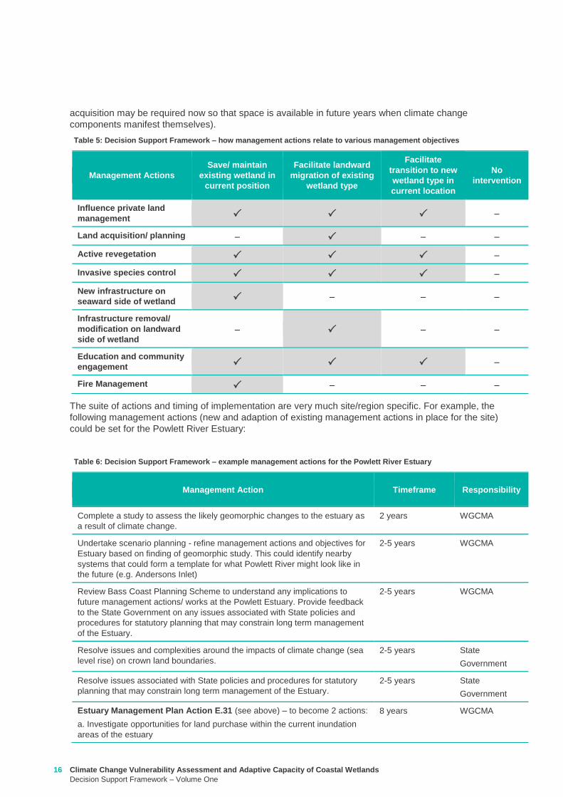
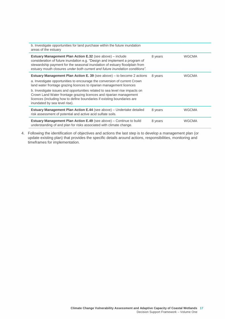
Climate Change Vulnerability Assessment and Adaptive Capacity of Coastal Wetlands
Decision Support Framework ndash Volume One
17
4 Following the identification of objectives and actions the last step is to develop a management plan (or
update existing plan) that provides the specific details around actions responsibilities monitoring and
timeframes for implementation
b Investigate opportunities for land purchase within the future inundation
areas of the estuary
Estuary Management Plan Action E32 (see above) ndash include
consideration of future inundation eg ldquoDesign and implement a program of
stewardship payment for the seasonal inundation of estuary floodplain from
estuary mouth closures under both current and future inundation conditionsrdquo
8 years WGCMA
Estuary Management Plan Action E 39 (see above) ndash to become 2 actions
a Investigate opportunities to encourage the conversion of current Crown
land water frontage grazing licences to riparian management licences
b Investigate issues and opportunities related to sea level rise impacts on
Crown Land Water frontage grazing licences and riparian management
licences (including how to define boundaries if existing boundaries are
inundated by sea level rise)
8 years WGCMA
Estuary Management Plan Action E44 (see above) ndash Undertake detailed
risk assessment of potential and active acid sulfate soils
8 years WGCMA
Estuary Management Plan Action E49 (see above) ndash Continue to build
understanding of and plan for risks associated with climate change
8 years WGCMA
18 Climate Change Vulnerability Assessment and Adaptive Capacity of Coastal Wetlands
Decision Support Framework ndash Volume One
In order to provide validation that the DSF can provide an assessment of the vulnerability and adaptive
capacity of a coastal wetland in Victoria to the impacts of climate change and guidance to wetland managers
on potential management objectives and actions for those coastal wetland systems likely to be affected by
climate change the DSF was applied to a case study wetland in Victoria
The case study wetland was selected by DELWP from a list of potential wetlands provided by the wetland
managers from the working group established as part of the project Wetland managers included
representatives from the DELWP Parks Victoria West Gippsland Catchment Management Authority (CMA)
East Gippsland CMA Port Phillip and Westernport CMA Glenelg Hopkins CMA and Corangamite CMA
The wetland selected was the Powlett River Estuary in the West Gippsland CMA region This decision was
based on existing information available for the site (an existing estuary management plan was available) its
value (listed as a Nationally Important Wetland and a habitat for the critically endangered Orange-bellied
Parrot) and that the site provided a good balance between covering a number of different coastal wetland
types (estuary saltmarsh riparian scrub estuarine wetland heathlands and woodlands) but without being
too complex and large
Consultation with West Gippsland CMA was undertaken throughout the case study application to ensure that
local knowledge was incorporated and so that the wetland manager could provide input to setting the
wetland management objectives and actions The completed application of the DSF for the Powlett River
Estuary is provided in Appendix D
Through the case study application it became apparent that Step 1 (wetland type) could be largely
completed by applying local knowledge of the wetland ecosystems found within the site Step 2 (assess the
potential impacts from climate change) however requires more technical knowledge of the wetlands
sensitivity and adaptive capacity to climate change and therefore requires close consultation with the
supporting technical information contained in Volume 2 Volume 2 provides enough information for a wetland
manager with limited climate change knowledge to complete this component of the DSF Step 3 is then a
combination of applying local knowledge to set management objectives and then using a combination of
local knowledge and the supporting technical information contained in Volume 2 to develop management
actions
The maps included in the case study application use only publically available data (the coastal wetland
dataset developed as part of this project and DELWPs coastal inundation dataset) and their manipulation
and interrogation is well within the GIS capability within the relevant wetland managerrsquos organisations
The case study application of the DSF demonstrated its effectiveness at providing a framework for assessing
potential impacts from climate change on Victorian coastal wetlands and will be a useful tool for assisting
wetland managers to 1) understand and 2) develop objectives and actions for managing coastal wetlands in
response to a changing climate
4 Case study application
Climate Change Vulnerability Assessment and Adaptive Capacity of Coastal Wetlands
Decision Support Framework ndash Volume One
19
Barbier EB Hacker SD Kennedy C Koch EW Stier AC amp Silliman BR (2011) The value of estuarine and
coastal ecosystem services Ecological Monographs 81169-93
Boon PI (2012) Coastal wetlands of temperate eastern Australia will Cinderella ever go to the ball Marine
and Freshwater Research 63 845-855
Boon PI Allen T Carr G Frood D Harty C McMahon A Mathews S Rosengren N Sinclair S White M amp
Yugovic J (2015a) Coastal wetlands of Victoria south-eastern Australia providing the inventory and
condition information needed for their effective management and conservation Aquatic Conservation Marine
and Freshwater Ecosystems 25 454-479
Costanza R de Groot R Sutton P van der Ploeg S Anderson SJ Kubiszewski I et al (2014) Changes in
the global value of ecosystem services Global Environmental Change 26152-8
Creighton C Boon PI Sheaves M amp Brookes J (2015) Revitalising Australiarsquos estuaries ndash what benefits at
what cost Marine and Freshwater Research 66 493-507
CSIRO and BOM (2015a) Southern slopes cluster report Climate change in Australia projections for
Australiarsquos natural resource management regions Full Report CSIRO and Bureau of Meteorology
Canberra Available on-line at httpwwwclimatechangeinaustraliagovauenimpacts-and-adaptationnrm-
regions
CSIRO and BOM (2015b) Climate change in Australia Projections for Australias NRM regions Southern
slopes Summary report CSIRO and Bureau of Meteorology Canberra Available on-line at
httpwwwclimatechangeinaustraliagovauenimpacts-and-adaptationnrm-regions
Finlayson CM Davis JA Gell PA Kingsford RT and Parton KA (2013) The status of wetlands and the
predicted effects of climate global climate change the situation in Australia Aquatic Sciences 75 73-93
Friess DA Krauss KW Horstman EM Balke T Bouma TJ Galli D amp Webb EL (2012) Are all intertidal
wetlands naturally created equal Bottlenecks thresholds and knowledge gaps to mangrove and saltmarsh
ecosystems Biological Reviews 87 346-366
Gilman EL Ellison J Duke NC amp Field C (2008) Threats to mangroves from climate change and adaptation
options a review Aquatic Botany 89 237-250
Johnston EM Hedge LH and Mayer-Pinto M (2015) The urgent need to understand port and harbour
ecosystems Marine and Freshwater Research 66 i-ii
Morton RM (1990) Community structure density and standing crop of fishes in a subtropical Australian
mangrove area Marine Biology 105 385-94
Morris L (2013) Chapter 2 Implications of future climate change for seagrass and soft sediments In
Implications of future climate change for Victorians marine environments Eds Klemke J amp Arundel H Report
to Glenelg Hopkins CMA
Nielsen D and M Brock 2009 Modified water regime and salinity as a consequence of climate change
prospects for wetlands of Southern Australia Climatic Change 95523-533
Osland MJ Enwright NM Day RH Gabler CA Stagg CL and Grace JB (2016) Beyond just sea-level rises
considering macroclimatic drivers within coastal wetland vulnerability assessments to climate change Global
Change Biology 22 1-11
Prahalad VN Kirkpatrick JB amp Mount RE (2011) Tasmanian coastal saltmarsh community transitions
associated with climate change and relative sea level rise 1975minus2009 Australian Journal of Botany 59 741-
748
SKM (2013) Indicative Assessment of Climate Change Vulnerability for Wetlands in Victoria Report
prepared for Department of Sustainability and Environment (now DELWP)
Zann LP amp Dutton I (2000) The social values and perceptions of Australians concerning the marine
environment In State of the Environment Report for Australia Technical summary Edited by LP Zann
Pages 127-134 Ocean Rescue 2000 amp Department of the Environment Sport and Territories Canberra
5 References
20 Climate Change Vulnerability Assessment and Adaptive Capacity of Coastal Wetlands
Decision Support Framework ndash Volume One
Wetland Type and corresponding EVC
group
Climate change components and ecological consequences
Increased Sea level and storm surges Increased carbon dioxide
concentration
Decreased rainfall Higher air
temperature
Higher water
temperature
Chronic
salinisation
Episodic
salinisation
Erosion
shoreline
recession
Altered C3
and C4
relationship
Carbonate
dissolution
Chronic
salinisation
Altered
sediment
load
Phenological
impacts
altered primary
productivity
Phenological
impacts altered
primary
productivity
Marine
Embayment
Mangrove Positive Neutral to
Negative
Negative Positive Neutral Positive Positive Positive Neutral
Seagrass (not mapped) Positive Negative Neutral Neutral Positive Positive Negative Positive Positive
Saltmarsh Positive Negative Negative Negative Neutral Positive Positive Positive Neutral
Estuarine -
Intertidal
Mangrove Positive Neutral to
Negative
Negative Positive Neutral Positive Positive Positive Neutral
Saltmarsh Positive Negative Negative Negative Neutral Positive Positive Positive Neutral
Estuarine -
supratidal
Heathlands Neutral Neutral Negative Neutral Neutral Neutral Neutral Positive Neutral
Herb-rich woodlands Neutral Neutral Negative Neutral Neutral Neutral Neutral Positive Neutral
Coastal scrubs and
woodlands
Neutral Neutral Negative Neutral Neutral Neutral Neutral Positive Neutral
Wetland - estuarine semi-
permanent saline
Neutral Negative Negative Neutral Neutral Neutral Positive Positive Neutral
Coastal
floodplain
Riparian scrubs or
swampy scrubs and
woodlands
Negative Negative Negative Neutral Neutral Negative Positive Positive Neutral
Coastal brackish wetlands Negative Negative Negative Neutral Neutral Negative Positive Positive Neutral
Freshwater wetlands Negative Negative Negative Neutral Neutral Negative Positive Positive Neutral
Dune
systems
Freshwater wetlands Neutral Neutral Negative Neutral Neutral Neutral Neutral Positive Neutral
Appendix A Sensitivity tables
Climate Change Vulnerability Assessment and Adaptive Capacity of Coastal Wetlands
Decision Support Framework ndash Volume One
21
1 where adaptive capacity is unknown data gaps limit the ability to make clear assessment of adaptive capacity
Appendix B Adaptive capacity of wetland types
Wetland Type Adaptive
capacity1 Main adaptive mechanism Main limiting factor to
adaptation
Marine
Embayment
estuarine -
intertidal
Mangrove Adaptable Sediment accretion movement to higher
elevations positive response to increased temperature and increased atmospheric CO2
Rate of sea-level rise storm surge intensity and shoreline erosion seawalls and other
physical impediments
Seagrass (not mapped)
Adaptable Positive response to increased salinity
Storm surge intensity smothering by catchment-
derived sediments reductions in underwater light fields
consequent to catchment-associated processes
Saltmarsh Adaptable Sediment accretion movement to higher
elevations positive response to increased temperature
(Variable responses to increased CO2)
Rate of sea-level rise storm surge intensity and shoreline erosion seawalls and other
physical impediments impacts of increased atmospheric CO2
impacts on floristic composition
Estuarine ndash
supratidal
Heathlands Unknown Positive response to temperature neutral to most other impacts until sea levels
make the sites intertidal
Salinisation and waterlogging due to storm surge
Herb-rich woodlands
Unknown Positive response to temperature neutral to most other impacts until sea levels
make the sites intertidal
Salinisation and waterlogging due to storm surge
Coastal scrubs and woodlands
Unknown Positive response to temperature neutral to most other impacts until sea levels
make the sites intertidal
Salinisation and waterlogging due to storm surge
Wetland - estuarine semi-permanent saline
Unknown Positive response to temperature neutral to most other impacts until sea levels
make the sites intertidal
Salinisation and waterlogging due to storm surge
Coastal
floodplain
Riparian scrubs or swampy scrubs and woodlands
Non-adaptable
Positive response to temperature
Salinisation and waterlogging (ie changes to wetting and
drying regimes)
Coastal brackish wetlands
Non-adaptable
Positive response to temperature
Salinisation and waterlogging (ie changes to wetting and
drying regimes)
Freshwater wetlands
Non-adaptable
Positive response to temperature
Salinisation and changes to wetting and drying regimes
Dune systems
Freshwater wetlands
Unknown Positive response to temperature neutral to most
other impacts
Physical loss of habitat salinisation possible changes to
wetting and drying regimes
22 Climate Change Vulnerability Assessment and Adaptive Capacity of Coastal Wetlands
Decision Support Framework ndash Volume One
Appendix C Decision Support Framework template
Climate Change Vulnerability Assessment and Adaptive Capacity of Coastal Wetlands
Decision Support Framework ndash Volume One
23
Coastal Wetlands and Climate Change
Decision Support Framework
Site Name Insert wetland name
Purpose
This document provides a Decision Support Framework to enable wetland managers to assess the
vulnerability and adaptive capacity of wetlands to climate change at an individual wetland or local landscape
scale The DELWP Climate Change Vulnerability Assessment and Adaptive Capacity of Coastal Wetlands
report provides the background and supporting material for this assessment and should be used in
conjunction with each stage of the assessment process outlined below
The broad approach applied in the Decision Support Framework is illustrated below It is a three step
approach that includes
Step 1 Wetland type ndash in this step you identify your wetland type (eg mangrove saltmarsh) using
a combination of the coastal wetland dataset developed as part of this project and your existing
knowledge of the site This step guides the sensitivity assessment undertaken in step 2
Step 2 Assess potential impacts from climate change ndash in this step you consider the position of
your wetland in the landscape so you can determine which component of climate change the
wetland is most sensitive to This step involves undertaking the exposure and sensitivity
components of the vulnerability assessment outlined above using the exposure mapping the
conceptual models and the sensitivity tables provided in the supporting documents
Step 3 Identify management objectives and actions ndash in this step you consider the adaptation
mechanisms possible for your wetland and develop management objectives and actions This step
will inform the development of a management plan which is undertaken outside of the DSF
Step 2 Assess potential impacts from climate change
(refer to Section 4 and Section 5 Volume 2)
Given the location of the wetland in the landscape which components of climate change is the
wetland sensitive to and what is the likely response to climate change
Step 3 Identify management objectives and actions
(refer to Section 6 Volume 2)
a) Identify constraints and
potential management
objectives and actions
b) Confirm
management
objectives
c) Confirm management
actions and develop
implementation plan
Step 1 Wetland type
(refer to Section 3 Volume 2)
What is the wetland type
24 Climate Change Vulnerability Assessment and Adaptive Capacity of Coastal Wetlands
Decision Support Framework ndash Volume One
Decision Support Framework
1 Wetland identification (Section 2 Volume Two)
Name Insert wetland name
Location address Insert generic location description
Easting Northing
Bioregion Refer to httpwwwdepivicgovauenvironment-and-wildlifebiodiversityevc-benchmarks
Wetland category
(Section 24 Volume
Two)
Tidal wetlands
Marine embayment
Estuarine (intertidal)
Estuarine (supratidal)
Non-tidal wetland
Coastal floodplain
Dune system
Wetland type EVC
group(s)
(Section 23 Volume
Two and supporting
geospatial dataset)
Seagrass
Saltmarsh
Mangroves
Brackish wetland
Freshwater wetland (floodplain)
Freshwater wetland (dune)
Riparian swampy scrub
Estuarine wetland
Estuarine scrubs heathlands and
woodlands
Estuary classification
(if relevant)
httpwwwozcoastsgov
ausearch_datamap_se
archjsp
Classification
Wave dominated
Sub-classification
Wave dominated delta
Tide dominated delta
Wave dominated estuary
Tide dominated estuary
Tide dominated
Coastal lagoon
Strandplain
Tidal flat creek
Other
Estuary
geomorphology (if
relevant)
Permanently open
Permanently closed
Intermittently opened and closed
Wetland values See Section 44 of Volume Two for more detail
Climate Change Vulnerability Assessment and Adaptive Capacity of Coastal Wetlands
Decision Support Framework ndash Volume One
25
Decision Support Framework
Decision Support Framework
Insert location map including location of individual wetland EVC types
26 Climate Change Vulnerability Assessment and Adaptive Capacity of Coastal Wetlands
Decision Support Framework ndash Volume One
Decision Support Framework
2 Potential impacts from climate change to the wetland (Section 4 Volume Two)
What is the
climate change
scenario
timeframe
Select climate change scenario timeframe detailed in Section 333 of Volume 2
Given the
position of the
wetland in the
landscape how
exposed is the
wetland to sea
level rise and
storm surge
climate change
components
Insert exposure map for sea level rise and storm surges (See Appendix F of Volume Two Coastal Inundation
dataset is publically available at wwwdatavicgovau)
Sea level rise
Storm surges
Climate Change Vulnerability Assessment and Adaptive Capacity of Coastal Wetlands
Decision Support Framework ndash Volume One
27
Decision Support Framework
Decision Support Framework
Site specific
infrastructure
dynamics that
would influence
the impact from
sea level rise
and storm
surges
Identify any specific infrastructure dynamics that may increase or decrease the impact from sea level rise
and storm surges (eg presence of artificial barriers to restrict seawater intrusion)
Given the
position of the
wetland in the
landscape how
exposed is the
wetland to
temperature and
rainfall climate
change
components
Insert climate change projections for temperature and rainfall based on current CSIRO-BOM (2015)
modelling provided in Section 332 of Volume Two
Temperature
Based on CSIRO-BOM (2015) modelling the following predictions are made in regards to change in
temperature
Magnitude of change
(mean surface temp
change)
Seasonality
Rainfall
Based on CSIRO-BOM (2015) modelling the following predictions are made in regards to change in rainfall
Magnitude of change
(change in rainfall) Seasonality
Wetland
sensitivity
Insert wetland type and sensitivity to climate change components (positive [highlight green] negative
[highlight red] neutral [highlight yellow] NA) provided in Appendix A of Volume One
Climate change component and
impacts on coastal wetlands
Insert
wetland
type
Insert
wetland
type
Insert
wetland
type
Insert
wetland
type
Sea level
Chronic salinisation
Episodic salinisation
Erosion shoreline recession
Carbon dioxide
Altered C3 and C4 relationship
Carbonate dissolution
Rainfall
Chronic salinisation
Temperature (air)
Phenological impacts altered primary
productivity
Temperature (water)
Phenological impacts altered primary
productivity
Positive = positive response to climate change negative = negative response to climate change neutral =
unlikely to have any response to climate change NA = not exposed
28 Climate Change Vulnerability Assessment and Adaptive Capacity of Coastal Wetlands
Decision Support Framework ndash Volume One
Decision Support Framework
Likely outcome Based on the Table 2 in Section 32 of Volume One and the conceptual models presented in Section 41 of
Volume Two
Adaptive
capacity
General adaptive capacity of wetland types present
Describe based on the conceptual models presented in Section 41 of Volume Two and populated table
based on table provided in Section 43 of Volume Two
Wetland
type
Adaptive
capacity Main adaptive mechanism Main limiting factor
Site specific adaptive capacity
Need to consider site specific opportunities and constraints to adaptive capacity based on site specific
characteristics
3 Management objectives and actions (Section 5 of Volume Two)
Constraints to
management
See Section 51 of Volume Two report for more detail
Barriers to migration
Land ownership
Funding
Limitations to knowledge and data
Other potential constraints
Pre-existing threats Identify pre-existing threats that may impact the wetlands capacity to cope with change
Pre-existing
management
objectives
Document local and regional management objectives in pre-existing management plans and
strategies
Proposed management
objective in relation to
climate change
Based on wetland values and existing objectives define the management objective for the wetland in
relation to climate change See Section 52 of Volume Two for more detail
Climate Change Vulnerability Assessment and Adaptive Capacity of Coastal Wetlands
Decision Support Framework ndash Volume One
29
Decision Support Framework
Decision Support Framework
Management actions to
address climate
change impacts and
management
objectives
Identify a suite of management actions for the site See Section 53 of Volume Two for more details
May include existing and new management actions
Existing actions
Management Action Timeframe
New actions
Management Action Timeframe Responsibility
4 Recommendations
Identify any recommendations for management of the wetland eg addressing data gaps further investigation required
development of management or implementation plan
5 Key management resource documents
Insert useful resource documents and web links associated with management at the site including but not limited to
1 Peters G Morris K Frood D Papas P and Roberts J (2015) A Guide to managing livestock grazing in Victorias
wetlands Decision framework and guidelines - Version 10 Arthur Rylah Institute for Environmental Research Technical
Report Series Report number 265
2 Morris K and Papas P (2012) Wetland conceptual models associations between wetland values threats and management
interventions Version one Arthur Rylah Institute for Environmental Research Technical Report Series Report number 237
3 DELWP wetland buffers guidelines (in prep)
4 DELWP wetland revegetation guidelines (in prep)
5 DELWP wetland invasive species management guidelines (in prep)
6 SKM (2005) Guidelines for the design and operation of environmentally friendly wetland regulators (MDBC project report
R2002) Report by Sinclair Knight Merz for the MDBC
6 Key references
Insert key reference supporting documents used to populate decision support framework template
Appendix D Decision Support Framework case study application
30 Climate Change Vulnerability Assessment and Adaptive Capacity of Coastal Wetlands
Decision Support Framework ndash Volume One
Climate Change Vulnerability Assessment and Adaptive Capacity of Coastal Wetlands
Decision Support Framework ndash Volume One
31
Coastal Wetlands and Climate Change
Decision Support Framework
Site Name Powlett River Estuary
Purpose
This document provides a Decision Support Framework to enable wetland managers to assess the
vulnerability and adaptive capacity of wetlands to climate change at an individual wetland or local landscape
scale The DELWP Climate Change Vulnerability Assessment and Adaptive Capacity of Coastal Wetlands
report provides the background and supporting material for this assessment and should be used in
conjunction with each stage of the assessment process outlined below
The broad approach applied in the Decision Support Framework is illustrated below It is a three step
approach that includes
Step 1 Wetland type ndash in this step you identify your wetland type (eg mangrove saltmarsh) using
a combination of the coastal wetland dataset developed as part of this project and your existing
knowledge of the site This step guides the sensitivity assessment undertaken in step 2
Step 2 Assess potential impacts from climate change ndash in this step you consider the position of
your wetland in the landscape so you can determine which component of climate change the
wetland is most sensitive to This step involves undertaking the exposure and sensitivity
components of the vulnerability assessment outlined above using the exposure mapping the
conceptual models and the sensitivity tables provided in the supporting documents
Step 3 Identify management objectives and actions ndash in this step you consider the adaptation
mechanisms possible for your wetland and develop management objectives and actions This step
will inform the development of a management plan which is undertaken outside of the DSF
Step 2 Assess potential impacts from climate change
(refer to Section 4 and Section 5 Volume 2)
Given the location of the wetland in the landscape which components of climate change is the
wetland sensitive to and what is the likely response to climate change
Step 3 Identify management objectives and actions
(refer to Section 6 Volume 2)
a) Identify constraints and
potential management
objectives and actions
b) Confirm
management
objectives
c) Confirm management
actions and develop
implementation plan
Step 1 Wetland type
(refer to Section 3 Volume 2)
What is the wetland type
32 Climate Change Vulnerability Assessment and Adaptive Capacity of Coastal Wetlands
Decision Support Framework ndash Volume One
Decision Support Framework
1 Wetland identification (Section 2 Volume Two)
Name Powlett River Estuary
Location address Located in the West Gippsland Catchment Management Authority (CMA) region near the coast
between Kilcunda and Wonthaggi
Easting 370380205 Northing 5728345662
Bioregion Gippsland Plain
Wetland category
(Section 24 Volume
Two)
Tidal wetlands
Marine embayment
Estuarine (intertidal)
Estuarine (supratidal)
Non-tidal wetland
Coastal floodplain
Dune system
Wetland type EVC
group(s)
(Section 23 Volume
Two and supporting
geospatial dataset)
Seagrass
Saltmarsh
Mangroves
Brackish wetland
Freshwater wetland (floodplain)
Freshwater wetland (dune)
Riparian swampy scrub
Estuarine wetland
Estuarine scrubs heathlands and
woodlands
Estuary classification
(if relevant)
httpwwwozcoastsgov
ausearch_datamap_se
archjsp
Classification
Wave dominated
Sub-classification
Wave dominated delta
Tide dominated delta
Wave dominated estuary
Tide dominated estuary
Tide dominated
Coastal lagoon
Strandplain
Tidal flat creek
Other
Estuary
geomorphology (if
relevant)
Permanently open
Permanently closed
Intermittently opened and closed
Climate Change Vulnerability Assessment and Adaptive Capacity of Coastal Wetlands
Decision Support Framework ndash Volume One
33
Decision Support Framework
Decision Support Framework
Wetland values
The Powlett River Estuary has a diverse range of bird plant and fish communities
5 different EVCs including coastal saltmarsh (Coastal Tussock Saltmarsh and Wet Saltmarsh
Herbland) protected under the Environmental Protection and Biodiversity Conservation Act
1999 (EPBC Act)
22 fish species including the Australian Grayling which is listed threatened under the Flora
and Fauna Guarantee Act 1988 (FFG Act) and vulnerable under the EPBC Act
31 State Australian and Internationally listed bird species including the critically endangered
Orange-bellied Parrot (WGCMA 2015)
The Powlett River Estuary also has significant social and economic value
Recreational activities ndash fishing sightseeing swimming walking bird watching picnics etc
Coastal dunes near the mouth of the Estuary have Aboriginal cultural heritage significance
(number of coastal midden sites recorded)
Landholders commonly graze along the river upstream of the Mouth of Powlett Road
Water source for irrigation and stock and domestic water use (WGCMA 2015)
34 Climate Change Vulnerability Assessment and Adaptive Capacity of Coastal Wetlands
Decision Support Framework ndash Volume One
Decision Support Framework
2 Potential impacts from climate change to the wetland (Section 4 Volume Two)
What is the
climate change
scenario
timeframe
Based on CSIRO-BOM (20015) modelling RCP 45 (moderate response to climate change) and RCP 85
(worst case scenario business as usual response to climate change)
Timeframes 2050 2070 and 2090 were all considered
Given the
position of the
wetland in the
landscape how
exposed is the
wetland to sea
level rise and
storm surge
climate change
components
Sea level rise
Climate Change Vulnerability Assessment and Adaptive Capacity of Coastal Wetlands
Decision Support Framework ndash Volume One
35
Decision Support Framework
Decision Support Framework
Storm surges
Site specific
infrastructure
dynamics that
would influence
the impact from
sea level rise
and storm
surges
There is currently no infrastructure at the Powlett River Estuary that would influence the extent of inundation
from the projected sea level rise and storm surges
When the mouth of the estuary is closed this may help mitigate some of impact of sea level
Given the
position of the
wetland in the
landscape how
exposed is the
wetland to
temperature and
rainfall climate
change
components
Temperature
Based on CSIRO-BOM (2015) modelling the following predictions are made in regards to change in
temperature
Magnitude of change
(mean surface temp
change)
Seasonality
RCP 45
2050 = 05 to 1degC
2070 = gt1 to 15degC
2090 = gt1 to 15degC
RCP 85
2050 = gt15 to 2degC
2070 = gt2 to 25degC
2090 = gt3 to 35deg
Temperature increases are similar in all seasons with some models
simulating to some extent larger increases in summer and autumn
than in other seasons
Projected changes for both daily maximum and minimum
temperature generally follow those of the mean temperature
although there is somewhat lower warming in daily minimum
temperatures than daily maximum temperatures in autumn winter
and spring
Increase in the temperature reached on the hottest days an increase
in the frequency of very hot days and duration of warm spells
36 Climate Change Vulnerability Assessment and Adaptive Capacity of Coastal Wetlands
Decision Support Framework ndash Volume One
Decision Support Framework
Given the
position of the
wetland in the
landscape how
exposed is the
wetland to
temperature and
rainfall climate
change
components
Rainfall
Based on CSIRO-BOM (2015) modelling the following predictions are made in regards to change in rainfall
Magnitude of change
(change in rainfall) Seasonality
RCP 45
2050 = 25 to 75
2070 = gt -25 to 25
2090 = gt -25 to 25
RCP 85
2050 = gt - 75 to -25
2070 = gt - 75 to -25
2090 = gt -125 to - 75
Rainfall declines are strongest in winter and spring Projected
reductions in winter rainfall in the Victoria NSW East region are up
to 30 in 2090 under high emissions
There is little change projected in autumn and either increases or
decreases in summer rainfall are possible
Tendency for heavier rainfall interspersed by longer dry periods
with some extremely dry and wet years with natural variability
continuing to be a major driver of rainfall for the near future (2030)
Intensity of heavy rainfall events is predicted to increase with
timing and magnitude also driven by natural variability
A decline in the number but an increase in the intensity of east
coast lows impacting on average rainfall and heavy rain events
Time spent in drought is predicted to increase over the course of
this century in line with changes to average rainfall and the
frequency and duration of extreme droughts will increase
Wetland
sensitivity
Climate change component and
impacts on coastal wetlands Saltmarsh
Estuarine
Wetland
Swamp
scrub
Swampy
riparian
woodland
Sea level
Chronic salinisation Positive Neutral Negative Negative
Episodic salinization Negative Negative Negative Negative
Erosion shoreline recession Negative Negative Negative Negative
Carbon dioxide
Altered C3 and C4 relationship Negative Neutral Neutral Neutral
Carbonate dissolution Neutral Neutral Neutral Neutral
Rainfall
Chronic salinisation Positive Neutral Negative Negative
Temperature (air)
Phenological impacts altered primary
productivity
Positive Positive Positive Positive
Temperature (water)
Phenological impacts altered primary
productivity
Neutral Neutral Neutral Neutral
Positive = positive response to climate change negative = negative response to climate change neutral =
unlikely to have any response to climate change NA = not exposed
Likely outcome Estuary
Potential change from intermittently open estuary mouth to permanently opened or more permanently
closed estuary depending on regional changes to rainfallcatchment runoff river discharge eustatic
sea levels and storm surges May become more similar to Andersons Inlet (marine embayment) to
the east
Saline intrusion into the upper estuary and lower freshwater reaches of the river due to increased sea
levels and storm surge activity and reduced rainfallcatchment runoff
Climate Change Vulnerability Assessment and Adaptive Capacity of Coastal Wetlands
Decision Support Framework ndash Volume One
37
Decision Support Framework
Decision Support Framework
Saline intrusion into groundwater results in a changed in species composition year round
Saltmarsh
More permanent inundation or increased frequency and duration of inundation
Change in salinity and water regime
Changes in distribution along the elevational gradient from the sea with possible landward migration
Possible invasion by mangroves if geomorphic changes result in a more permanent estuary opening
(eg similar to Andersons Inlet)
Many of the saltmarsh taxa at the site are C3 plants so potentially advantaged by increases in
atmospheric CO2 concentrations
Increased pressure from weed invasion from surrounding agricultural land
Saline intrusion into groundwater results in a changed wetland environment
Estuarine Wetland
Change in salinity and water regime (eg reduced freshwater inflows and saline intrusion increased
evaporation losses)
Increased pressure from weed invasion
Saline intrusion into groundwater results in a changed wetland environment
Riparian scrub and swampy riparian woodland
Change in salinity and water regime (eg reduced freshwater inflows and saline intrusion decreased
rainfall increased extreme flood events)
Rise in saline conditions along riparian zone
Replacement with saltmarsh as a result of increased salinity
Increased pressure from weed invasion
Saline intrusion into groundwater results in a changed species composition year round
Adaptive
capacity
General adaptive capacity of wetland types present
Wetland
type
Adaptive
capacity Main adaptive mechanism Main limiting factor
Saltmarsh Low Sediment accretion movement
to higher elevations positive
response to increase
temperature (variable
responses to increased CO2)
Rate of sea level rise storm surge
intensity and shoreline erosion
seawalls and other physical
impediments impact of increased
atmospheric CO2 impacts on floristic
composition
Estuarine
wetland
Moderate Positive response to
temperature neutral to most
other impacts until sea levels
make the sites intertidal
Salinisation and waterlogging due to
storm surges
Swamp
scrub
Low Positive response to
temperature
Salinisation and waterlogging (ie
changes to wetting and drying regimes)
Swampy
Riparian
woodland
Low Positive response to
temperature
Salinisation and waterlogging (ie
changes to wetting and drying regimes)
38 Climate Change Vulnerability Assessment and Adaptive Capacity of Coastal Wetlands
Decision Support Framework ndash Volume One
Decision Support Framework
Site specific adaptive capacity
Not completed as part of case study ndash requires specific assessments of opportunities and constraints to
adaptive capacity based on site specific characteristics
3 Management objectives and actions (Section 5 of Volume Two)
Constraints to
management
Barriers to migration
Mouth of Powlett Road is a barrier to wetland migration
Rail trail towards Dayleston provides a barrier to landward migration
Small cluster of housing north east of the estuary mouth similarly constrains landward
migration
Land ownership
The land in which wetlands could migrate in to is predominately private land used for
agriculture (grazing and cropping)
Funding
Limited funding available ndash not a priority site State wide nor Ramsar listed
Whilst there is good collaboration between agencies and landholders there are different
priorities for the funding available and therefore so some actions are difficult to implement An
example includes raising roads and carparks that experience inundation during closure
events or buying back regularly inundated marginal farmland
Limitations to knowledge and data
Uncertainty around the likely geomorphic changes to the estuary mouth (ie change in estuary
dynamic)
Understanding the economic value of the estuary coastal wetlands (eg value of wetlands
versus the value of agricultural land)
Uncertainty around acid sulfate soils as a result of climate change
Other potential constraints
Current State policies and procedures for statutory planning changes and land buyback to
enable long term management
Community understanding and expectation around estuary opening and closing
Pre-existing threats The key pre-existing threats identified in the Powlett River Estuary Management Plan that may
influence the resilience of the estuary to climate change impacts include
Degraded water quality
Degraded riparian vegetation (large trees in particular)
Trampling and bank erosion associated with pedestrian access
Rural drainage and drain clearing
Channelisation of the river channel
Vehicle access
Livestock access
Pest plants and animals
Inappropriate recreation causing dune erosion
Disturbance of acid sulfate soils
Climate Change Vulnerability Assessment and Adaptive Capacity of Coastal Wetlands
Decision Support Framework ndash Volume One
39
Decision Support Framework
Decision Support Framework
Pre-existing
management
objectives
Regional catchment strategy
No coastal wetland specific actions objectives for the Powlett River
West Gippsland Waterways Strategy (2014-2022)
Regional objectives relating to the Powlett River Estuary as a coastal wetland
Maintain and improve the habitat and condition of waterways to support waterway dependent
animals and plants
Maintain the ecological character of significant wetlands and estuaries
Catchment objectives for Powlett River Estuary relating to coastal wetlands include
Riparian vegetation provides improved visual amenity and contributes to community use of
waterways
The extent of freshwater wetlands is maintained and their condition is improved
Powlett Estuary Management Plan
Swamp scrub swampy riparian woodland and estuarine wetland vegetation communities are
enhanced and significantly increased in the area
West Gippsland Regional NRM Climate Change Strategy (2016)
The strategy outlines approaches and options to support climate change adaptation and mitigation
The objectives of the adaptation and management strategies are linked to the 20 year objectives in
the Regional Catchment Strategy The Powlett River Estuary is located within the Bunurong Coastal
planning area The estuary is listed as one of the most vulnerable estuary assets to climate change
across the region
Reports are available at lthttpwwwwgcmavicgovauour-regionwaterwayspowlett-river-estuarygt
[Verified 17052016 ]
Proposed management
objective in relation to
climate change
The following management objective is based the existing geomorphic characteristics of the estuary
(ie intermittently closed estuary)
To enhance and significantly increase Swamp scrub Swampy riparian woodland and estuarine
wetland vegetation extent through the facilitation of landward migration of these communities over the
next 50 years
Climate change also poses a threat to non-wetland EVCs (eg Coast Banksia Woodland) and
therefore even though they are not considered in this coastal wetland risk assessment they are still a
management consideration for the CMA in the coastal zone
Management actions to
address climate
change impacts and
management
objectives
Existing actions
Existing management actions provided in Section 81 of the Estuary Management Plan (WGCMA
2015) that are related to climate change are listed below
Management Action Timeframe
E31 Investigate opportunities for land purchase within the inundation
areas of the estuary
8 years
E32 Design and implement a program of stewardship payment for the
seasonal inundation of estuary floodplain from estuary mouth closures
Priority should be given to enhancing coastal saltmarsh and estuarine
wetland communities Payments should be calculated and prioritised
based on potential value to estuary health and ability to minimise artificial
estuary mouth openings
8 years
E 39 Investigate opportunities to encourage the conversion of Crown land
water frontage grazing licences to riparian management licences
8 years
E 43 Undertake hydraulic modelling and bathymetry survey of the Powlett 8 years
40 Climate Change Vulnerability Assessment and Adaptive Capacity of Coastal Wetlands
Decision Support Framework ndash Volume One
Decision Support Framework
estuary floodplain to understand the impacts and benefits of the structures
(including levees and drains) and landforms that affect the movement of
water before during and after artificial estuary mouth opening before
considering any updates changes or removal of these floodplain features
E 44 Undertake a detailed risk assessment including on-ground mapping
to identify potential and active acid sulphate soils with the Powlett estuarine
floodplain
8 years
E 46 Investigate the use of the saltmarsh wetlands and estuary channel
by recreational fish species and other native fish species particularly Black
Bream and prioritise areas for further protection
8 years
E 49 Continue to build understanding of and plan for the risks associated
with climate change including sea level rise This includes future flood
risk
8 years
New actions
The following additional management actions should be considered
Management Action Timeframe Responsibility
Complete a study to assess the likely geomorphic changes
to the estuary as a result of climate change
2 years WGCMA
Undertake scenario planning in consultation with Bass Coast
Shire Council VicRoads and Parks Victoria- refine
management actions and objectives for Estuary based on
finding of geomorphic study This could identify nearby
systems that could form a template for what Powlett River
might look like in the future (eg Andersons Inlet)
2-5 years WGCMA
Review Bass Coast Planning Scheme to understand any
implications to future management actions works at the
Powlett Estuary Provide feedback to the State Government
on any issues associated with State policies and procedures
for statutory planning that may constrain long term
management of the Estuary
2-5 years WGCMA
Consultation with other relevant managers in the area
(including Council VicRoads and Parks Victoria) to discuss
potential issues associated road repairs culverts and other
flood mitigation measures in the area that may arise as a
result of climate change
2-5 years WGCMA
Resolve issues and complexities around the impacts of
climate change (sea level rise) on crown land boundaries
2-5 years State
Government
Resolve issues associated with State policies and
procedures for statutory planning that may constrain long
term management of the Estuary
2-5 years State
Government
Community engagement and education program to provide
the community with an understanding of the predicted
impacts of climate change and enable them to play an active
role in management
2-5 years WGCMA
Estuary Management Plan Action E31 (see above) ndash to
become 2 actions
a Investigate opportunities for land purchase within the
8 years WGCMA
Climate Change Vulnerability Assessment and Adaptive Capacity of Coastal Wetlands
Decision Support Framework ndash Volume One
41
Decision Support Framework
Decision Support Framework
current inundation areas of the estuary
b Investigate opportunities for land purchase within the
future inundation areas of the estuary
Estuary Management Plan Action E32 (see above) ndash
include consideration of future inundation eg ldquoDesign and
implement a program of stewardship payment for the
seasonal inundation of estuary floodplain from estuary
mouth closures under both current and future inundation
conditionsrdquo
8 years WGCMA
Estuary Management Plan Action E 39 (see above) ndash to
become 2 actions
a Investigate opportunities to encourage the conversion of
current Crown land water frontage grazing licences to
riparian management licences
b Investigate issues and opportunities related to sea level
rise impacts on Crown Land Water frontage grazing licences
and riparian management licences (including how to define
boundaries if existing boundaries are inundated by sea level
rise)
8 years WGCMA
Estuary Management Plan Action E44 (see above) ndash
Undertake detailed risk assessment of potential and active
acid sulfate soils
8 years WGCMA
Estuary Management Plan Action E49 (see above) ndash
Continue to build understanding of and plan for risks
associated with climate change
8 years WGCMA
4 Recommendations
1 Climate change threats are currently implied within the management actions in the Powlett River Estuary Management Plan It
is recommended that additional material on climate change impacts be included and climate change threats addressed more
explicitly in the management actions This would meet Action E49 in particular
2 Management objectives also need to consider management for a 30-50 year timeframe ie take in to consideration longer
term climate change impacts including on estuary mouth dynamics A distinction between responses to current and future
threats should be made
5 Key management resource documents
1 Peters G Morris K Frood D Papas P and Roberts J (2015) A Guide to managing livestock grazing in Victorias
wetlands Decision framework and guidelines - Version 10 Arthur Rylah Institute for Environmental Research Technical
Report Series Report number 265
2 Morris K and Papas P (2012) Wetland conceptual models associations between wetland values threats and management
interventions Version one Arthur Rylah Institute for Environmental Research Technical Report Series Report number 237
3 DELWP wetland buffers guidelines (in prep)
4 DELWP wetland revegetation guidelines (in prep)
5 DELWP wetland invasive species management guidelines (in prep)
6 SKM (2005) Guidelines for the design and operation of environmentally friendly wetland regulators (MDBC project report
R2002) Report by Sinclair Knight Merz for the MDBC
42 Climate Change Vulnerability Assessment and Adaptive Capacity of Coastal Wetlands
Decision Support Framework ndash Volume One
Decision Support Framework
6 Key references
1 WGCMA (2012) West Gippsland Regional Catchment Strategy 2013-2019 West Gippsland Catchment Management
Authority
2 WGCMA (2014) West Gippsland Waterway Strategy 2014-2022 West Gippsland Catchment Management Authority
3 WGCMA (2015) Powlett River Estuary Management Plan West Gippsland Catchment Management Authority
4 WGCMA (2016) West Gippsland Regional NRM Climate Change Strategy ndash Final Draft West Gippsland Catchment
Management Authority
5 CSIRO and BOM (2015) Southern Slopes Cluster Report Climate Change in Australia Projections for Australiarsquos Natural
Resource Management Regions Cluster Reports eds Ekstroumlm M et al CSIRO and Bureau of Meteorology Australia
Climate Change Vulnerability Assessment and Adaptive Capacity of Coastal Wetlands
Decision Support Framework ndash Volume One
43
Decision Support Framework
Decision Support Framework
delwpvicgovau delwpvicgovau
Climate Change Vulnerability Assessment and Adaptive Capacity of Coastal Wetlands
Decision Support Framework ndash Volume One
19
Barbier EB Hacker SD Kennedy C Koch EW Stier AC amp Silliman BR (2011) The value of estuarine and
coastal ecosystem services Ecological Monographs 81169-93
Boon PI (2012) Coastal wetlands of temperate eastern Australia will Cinderella ever go to the ball Marine
and Freshwater Research 63 845-855
Boon PI Allen T Carr G Frood D Harty C McMahon A Mathews S Rosengren N Sinclair S White M amp
Yugovic J (2015a) Coastal wetlands of Victoria south-eastern Australia providing the inventory and
condition information needed for their effective management and conservation Aquatic Conservation Marine
and Freshwater Ecosystems 25 454-479
Costanza R de Groot R Sutton P van der Ploeg S Anderson SJ Kubiszewski I et al (2014) Changes in
the global value of ecosystem services Global Environmental Change 26152-8
Creighton C Boon PI Sheaves M amp Brookes J (2015) Revitalising Australiarsquos estuaries ndash what benefits at
what cost Marine and Freshwater Research 66 493-507
CSIRO and BOM (2015a) Southern slopes cluster report Climate change in Australia projections for
Australiarsquos natural resource management regions Full Report CSIRO and Bureau of Meteorology
Canberra Available on-line at httpwwwclimatechangeinaustraliagovauenimpacts-and-adaptationnrm-
regions
CSIRO and BOM (2015b) Climate change in Australia Projections for Australias NRM regions Southern
slopes Summary report CSIRO and Bureau of Meteorology Canberra Available on-line at
httpwwwclimatechangeinaustraliagovauenimpacts-and-adaptationnrm-regions
Finlayson CM Davis JA Gell PA Kingsford RT and Parton KA (2013) The status of wetlands and the
predicted effects of climate global climate change the situation in Australia Aquatic Sciences 75 73-93
Friess DA Krauss KW Horstman EM Balke T Bouma TJ Galli D amp Webb EL (2012) Are all intertidal
wetlands naturally created equal Bottlenecks thresholds and knowledge gaps to mangrove and saltmarsh
ecosystems Biological Reviews 87 346-366
Gilman EL Ellison J Duke NC amp Field C (2008) Threats to mangroves from climate change and adaptation
options a review Aquatic Botany 89 237-250
Johnston EM Hedge LH and Mayer-Pinto M (2015) The urgent need to understand port and harbour
ecosystems Marine and Freshwater Research 66 i-ii
Morton RM (1990) Community structure density and standing crop of fishes in a subtropical Australian
mangrove area Marine Biology 105 385-94
Morris L (2013) Chapter 2 Implications of future climate change for seagrass and soft sediments In
Implications of future climate change for Victorians marine environments Eds Klemke J amp Arundel H Report
to Glenelg Hopkins CMA
Nielsen D and M Brock 2009 Modified water regime and salinity as a consequence of climate change
prospects for wetlands of Southern Australia Climatic Change 95523-533
Osland MJ Enwright NM Day RH Gabler CA Stagg CL and Grace JB (2016) Beyond just sea-level rises
considering macroclimatic drivers within coastal wetland vulnerability assessments to climate change Global
Change Biology 22 1-11
Prahalad VN Kirkpatrick JB amp Mount RE (2011) Tasmanian coastal saltmarsh community transitions
associated with climate change and relative sea level rise 1975minus2009 Australian Journal of Botany 59 741-
748
SKM (2013) Indicative Assessment of Climate Change Vulnerability for Wetlands in Victoria Report
prepared for Department of Sustainability and Environment (now DELWP)
Zann LP amp Dutton I (2000) The social values and perceptions of Australians concerning the marine
environment In State of the Environment Report for Australia Technical summary Edited by LP Zann
Pages 127-134 Ocean Rescue 2000 amp Department of the Environment Sport and Territories Canberra
5 References
20 Climate Change Vulnerability Assessment and Adaptive Capacity of Coastal Wetlands
Decision Support Framework ndash Volume One
Wetland Type and corresponding EVC
group
Climate change components and ecological consequences
Increased Sea level and storm surges Increased carbon dioxide
concentration
Decreased rainfall Higher air
temperature
Higher water
temperature
Chronic
salinisation
Episodic
salinisation
Erosion
shoreline
recession
Altered C3
and C4
relationship
Carbonate
dissolution
Chronic
salinisation
Altered
sediment
load
Phenological
impacts
altered primary
productivity
Phenological
impacts altered
primary
productivity
Marine
Embayment
Mangrove Positive Neutral to
Negative
Negative Positive Neutral Positive Positive Positive Neutral
Seagrass (not mapped) Positive Negative Neutral Neutral Positive Positive Negative Positive Positive
Saltmarsh Positive Negative Negative Negative Neutral Positive Positive Positive Neutral
Estuarine -
Intertidal
Mangrove Positive Neutral to
Negative
Negative Positive Neutral Positive Positive Positive Neutral
Saltmarsh Positive Negative Negative Negative Neutral Positive Positive Positive Neutral
Estuarine -
supratidal
Heathlands Neutral Neutral Negative Neutral Neutral Neutral Neutral Positive Neutral
Herb-rich woodlands Neutral Neutral Negative Neutral Neutral Neutral Neutral Positive Neutral
Coastal scrubs and
woodlands
Neutral Neutral Negative Neutral Neutral Neutral Neutral Positive Neutral
Wetland - estuarine semi-
permanent saline
Neutral Negative Negative Neutral Neutral Neutral Positive Positive Neutral
Coastal
floodplain
Riparian scrubs or
swampy scrubs and
woodlands
Negative Negative Negative Neutral Neutral Negative Positive Positive Neutral
Coastal brackish wetlands Negative Negative Negative Neutral Neutral Negative Positive Positive Neutral
Freshwater wetlands Negative Negative Negative Neutral Neutral Negative Positive Positive Neutral
Dune
systems
Freshwater wetlands Neutral Neutral Negative Neutral Neutral Neutral Neutral Positive Neutral
Appendix A Sensitivity tables
Climate Change Vulnerability Assessment and Adaptive Capacity of Coastal Wetlands
Decision Support Framework ndash Volume One
21
1 where adaptive capacity is unknown data gaps limit the ability to make clear assessment of adaptive capacity
Appendix B Adaptive capacity of wetland types
Wetland Type Adaptive
capacity1 Main adaptive mechanism Main limiting factor to
adaptation
Marine
Embayment
estuarine -
intertidal
Mangrove Adaptable Sediment accretion movement to higher
elevations positive response to increased temperature and increased atmospheric CO2
Rate of sea-level rise storm surge intensity and shoreline erosion seawalls and other
physical impediments
Seagrass (not mapped)
Adaptable Positive response to increased salinity
Storm surge intensity smothering by catchment-
derived sediments reductions in underwater light fields
consequent to catchment-associated processes
Saltmarsh Adaptable Sediment accretion movement to higher
elevations positive response to increased temperature
(Variable responses to increased CO2)
Rate of sea-level rise storm surge intensity and shoreline erosion seawalls and other
physical impediments impacts of increased atmospheric CO2
impacts on floristic composition
Estuarine ndash
supratidal
Heathlands Unknown Positive response to temperature neutral to most other impacts until sea levels
make the sites intertidal
Salinisation and waterlogging due to storm surge
Herb-rich woodlands
Unknown Positive response to temperature neutral to most other impacts until sea levels
make the sites intertidal
Salinisation and waterlogging due to storm surge
Coastal scrubs and woodlands
Unknown Positive response to temperature neutral to most other impacts until sea levels
make the sites intertidal
Salinisation and waterlogging due to storm surge
Wetland - estuarine semi-permanent saline
Unknown Positive response to temperature neutral to most other impacts until sea levels
make the sites intertidal
Salinisation and waterlogging due to storm surge
Coastal
floodplain
Riparian scrubs or swampy scrubs and woodlands
Non-adaptable
Positive response to temperature
Salinisation and waterlogging (ie changes to wetting and
drying regimes)
Coastal brackish wetlands
Non-adaptable
Positive response to temperature
Salinisation and waterlogging (ie changes to wetting and
drying regimes)
Freshwater wetlands
Non-adaptable
Positive response to temperature
Salinisation and changes to wetting and drying regimes
Dune systems
Freshwater wetlands
Unknown Positive response to temperature neutral to most
other impacts
Physical loss of habitat salinisation possible changes to
wetting and drying regimes
22 Climate Change Vulnerability Assessment and Adaptive Capacity of Coastal Wetlands
Decision Support Framework ndash Volume One
Appendix C Decision Support Framework template
Climate Change Vulnerability Assessment and Adaptive Capacity of Coastal Wetlands
Decision Support Framework ndash Volume One
23
Coastal Wetlands and Climate Change
Decision Support Framework
Site Name Insert wetland name
Purpose
This document provides a Decision Support Framework to enable wetland managers to assess the
vulnerability and adaptive capacity of wetlands to climate change at an individual wetland or local landscape
scale The DELWP Climate Change Vulnerability Assessment and Adaptive Capacity of Coastal Wetlands
report provides the background and supporting material for this assessment and should be used in
conjunction with each stage of the assessment process outlined below
The broad approach applied in the Decision Support Framework is illustrated below It is a three step
approach that includes
Step 1 Wetland type ndash in this step you identify your wetland type (eg mangrove saltmarsh) using
a combination of the coastal wetland dataset developed as part of this project and your existing
knowledge of the site This step guides the sensitivity assessment undertaken in step 2
Step 2 Assess potential impacts from climate change ndash in this step you consider the position of
your wetland in the landscape so you can determine which component of climate change the
wetland is most sensitive to This step involves undertaking the exposure and sensitivity
components of the vulnerability assessment outlined above using the exposure mapping the
conceptual models and the sensitivity tables provided in the supporting documents
Step 3 Identify management objectives and actions ndash in this step you consider the adaptation
mechanisms possible for your wetland and develop management objectives and actions This step
will inform the development of a management plan which is undertaken outside of the DSF
Step 2 Assess potential impacts from climate change
(refer to Section 4 and Section 5 Volume 2)
Given the location of the wetland in the landscape which components of climate change is the
wetland sensitive to and what is the likely response to climate change
Step 3 Identify management objectives and actions
(refer to Section 6 Volume 2)
a) Identify constraints and
potential management
objectives and actions
b) Confirm
management
objectives
c) Confirm management
actions and develop
implementation plan
Step 1 Wetland type
(refer to Section 3 Volume 2)
What is the wetland type
24 Climate Change Vulnerability Assessment and Adaptive Capacity of Coastal Wetlands
Decision Support Framework ndash Volume One
Decision Support Framework
1 Wetland identification (Section 2 Volume Two)
Name Insert wetland name
Location address Insert generic location description
Easting Northing
Bioregion Refer to httpwwwdepivicgovauenvironment-and-wildlifebiodiversityevc-benchmarks
Wetland category
(Section 24 Volume
Two)
Tidal wetlands
Marine embayment
Estuarine (intertidal)
Estuarine (supratidal)
Non-tidal wetland
Coastal floodplain
Dune system
Wetland type EVC
group(s)
(Section 23 Volume
Two and supporting
geospatial dataset)
Seagrass
Saltmarsh
Mangroves
Brackish wetland
Freshwater wetland (floodplain)
Freshwater wetland (dune)
Riparian swampy scrub
Estuarine wetland
Estuarine scrubs heathlands and
woodlands
Estuary classification
(if relevant)
httpwwwozcoastsgov
ausearch_datamap_se
archjsp
Classification
Wave dominated
Sub-classification
Wave dominated delta
Tide dominated delta
Wave dominated estuary
Tide dominated estuary
Tide dominated
Coastal lagoon
Strandplain
Tidal flat creek
Other
Estuary
geomorphology (if
relevant)
Permanently open
Permanently closed
Intermittently opened and closed
Wetland values See Section 44 of Volume Two for more detail
Climate Change Vulnerability Assessment and Adaptive Capacity of Coastal Wetlands
Decision Support Framework ndash Volume One
25
Decision Support Framework
Decision Support Framework
Insert location map including location of individual wetland EVC types
26 Climate Change Vulnerability Assessment and Adaptive Capacity of Coastal Wetlands
Decision Support Framework ndash Volume One
Decision Support Framework
2 Potential impacts from climate change to the wetland (Section 4 Volume Two)
What is the
climate change
scenario
timeframe
Select climate change scenario timeframe detailed in Section 333 of Volume 2
Given the
position of the
wetland in the
landscape how
exposed is the
wetland to sea
level rise and
storm surge
climate change
components
Insert exposure map for sea level rise and storm surges (See Appendix F of Volume Two Coastal Inundation
dataset is publically available at wwwdatavicgovau)
Sea level rise
Storm surges
Climate Change Vulnerability Assessment and Adaptive Capacity of Coastal Wetlands
Decision Support Framework ndash Volume One
27
Decision Support Framework
Decision Support Framework
Site specific
infrastructure
dynamics that
would influence
the impact from
sea level rise
and storm
surges
Identify any specific infrastructure dynamics that may increase or decrease the impact from sea level rise
and storm surges (eg presence of artificial barriers to restrict seawater intrusion)
Given the
position of the
wetland in the
landscape how
exposed is the
wetland to
temperature and
rainfall climate
change
components
Insert climate change projections for temperature and rainfall based on current CSIRO-BOM (2015)
modelling provided in Section 332 of Volume Two
Temperature
Based on CSIRO-BOM (2015) modelling the following predictions are made in regards to change in
temperature
Magnitude of change
(mean surface temp
change)
Seasonality
Rainfall
Based on CSIRO-BOM (2015) modelling the following predictions are made in regards to change in rainfall
Magnitude of change
(change in rainfall) Seasonality
Wetland
sensitivity
Insert wetland type and sensitivity to climate change components (positive [highlight green] negative
[highlight red] neutral [highlight yellow] NA) provided in Appendix A of Volume One
Climate change component and
impacts on coastal wetlands
Insert
wetland
type
Insert
wetland
type
Insert
wetland
type
Insert
wetland
type
Sea level
Chronic salinisation
Episodic salinisation
Erosion shoreline recession
Carbon dioxide
Altered C3 and C4 relationship
Carbonate dissolution
Rainfall
Chronic salinisation
Temperature (air)
Phenological impacts altered primary
productivity
Temperature (water)
Phenological impacts altered primary
productivity
Positive = positive response to climate change negative = negative response to climate change neutral =
unlikely to have any response to climate change NA = not exposed
28 Climate Change Vulnerability Assessment and Adaptive Capacity of Coastal Wetlands
Decision Support Framework ndash Volume One
Decision Support Framework
Likely outcome Based on the Table 2 in Section 32 of Volume One and the conceptual models presented in Section 41 of
Volume Two
Adaptive
capacity
General adaptive capacity of wetland types present
Describe based on the conceptual models presented in Section 41 of Volume Two and populated table
based on table provided in Section 43 of Volume Two
Wetland
type
Adaptive
capacity Main adaptive mechanism Main limiting factor
Site specific adaptive capacity
Need to consider site specific opportunities and constraints to adaptive capacity based on site specific
characteristics
3 Management objectives and actions (Section 5 of Volume Two)
Constraints to
management
See Section 51 of Volume Two report for more detail
Barriers to migration
Land ownership
Funding
Limitations to knowledge and data
Other potential constraints
Pre-existing threats Identify pre-existing threats that may impact the wetlands capacity to cope with change
Pre-existing
management
objectives
Document local and regional management objectives in pre-existing management plans and
strategies
Proposed management
objective in relation to
climate change
Based on wetland values and existing objectives define the management objective for the wetland in
relation to climate change See Section 52 of Volume Two for more detail
Climate Change Vulnerability Assessment and Adaptive Capacity of Coastal Wetlands
Decision Support Framework ndash Volume One
29
Decision Support Framework
Decision Support Framework
Management actions to
address climate
change impacts and
management
objectives
Identify a suite of management actions for the site See Section 53 of Volume Two for more details
May include existing and new management actions
Existing actions
Management Action Timeframe
New actions
Management Action Timeframe Responsibility
4 Recommendations
Identify any recommendations for management of the wetland eg addressing data gaps further investigation required
development of management or implementation plan
5 Key management resource documents
Insert useful resource documents and web links associated with management at the site including but not limited to
1 Peters G Morris K Frood D Papas P and Roberts J (2015) A Guide to managing livestock grazing in Victorias
wetlands Decision framework and guidelines - Version 10 Arthur Rylah Institute for Environmental Research Technical
Report Series Report number 265
2 Morris K and Papas P (2012) Wetland conceptual models associations between wetland values threats and management
interventions Version one Arthur Rylah Institute for Environmental Research Technical Report Series Report number 237
3 DELWP wetland buffers guidelines (in prep)
4 DELWP wetland revegetation guidelines (in prep)
5 DELWP wetland invasive species management guidelines (in prep)
6 SKM (2005) Guidelines for the design and operation of environmentally friendly wetland regulators (MDBC project report
R2002) Report by Sinclair Knight Merz for the MDBC
6 Key references
Insert key reference supporting documents used to populate decision support framework template
Appendix D Decision Support Framework case study application
30 Climate Change Vulnerability Assessment and Adaptive Capacity of Coastal Wetlands
Decision Support Framework ndash Volume One
Climate Change Vulnerability Assessment and Adaptive Capacity of Coastal Wetlands
Decision Support Framework ndash Volume One
31
Coastal Wetlands and Climate Change
Decision Support Framework
Site Name Powlett River Estuary
Purpose
This document provides a Decision Support Framework to enable wetland managers to assess the
vulnerability and adaptive capacity of wetlands to climate change at an individual wetland or local landscape
scale The DELWP Climate Change Vulnerability Assessment and Adaptive Capacity of Coastal Wetlands
report provides the background and supporting material for this assessment and should be used in
conjunction with each stage of the assessment process outlined below
The broad approach applied in the Decision Support Framework is illustrated below It is a three step
approach that includes
Step 1 Wetland type ndash in this step you identify your wetland type (eg mangrove saltmarsh) using
a combination of the coastal wetland dataset developed as part of this project and your existing
knowledge of the site This step guides the sensitivity assessment undertaken in step 2
Step 2 Assess potential impacts from climate change ndash in this step you consider the position of
your wetland in the landscape so you can determine which component of climate change the
wetland is most sensitive to This step involves undertaking the exposure and sensitivity
components of the vulnerability assessment outlined above using the exposure mapping the
conceptual models and the sensitivity tables provided in the supporting documents
Step 3 Identify management objectives and actions ndash in this step you consider the adaptation
mechanisms possible for your wetland and develop management objectives and actions This step
will inform the development of a management plan which is undertaken outside of the DSF
Step 2 Assess potential impacts from climate change
(refer to Section 4 and Section 5 Volume 2)
Given the location of the wetland in the landscape which components of climate change is the
wetland sensitive to and what is the likely response to climate change
Step 3 Identify management objectives and actions
(refer to Section 6 Volume 2)
a) Identify constraints and
potential management
objectives and actions
b) Confirm
management
objectives
c) Confirm management
actions and develop
implementation plan
Step 1 Wetland type
(refer to Section 3 Volume 2)
What is the wetland type
32 Climate Change Vulnerability Assessment and Adaptive Capacity of Coastal Wetlands
Decision Support Framework ndash Volume One
Decision Support Framework
1 Wetland identification (Section 2 Volume Two)
Name Powlett River Estuary
Location address Located in the West Gippsland Catchment Management Authority (CMA) region near the coast
between Kilcunda and Wonthaggi
Easting 370380205 Northing 5728345662
Bioregion Gippsland Plain
Wetland category
(Section 24 Volume
Two)
Tidal wetlands
Marine embayment
Estuarine (intertidal)
Estuarine (supratidal)
Non-tidal wetland
Coastal floodplain
Dune system
Wetland type EVC
group(s)
(Section 23 Volume
Two and supporting
geospatial dataset)
Seagrass
Saltmarsh
Mangroves
Brackish wetland
Freshwater wetland (floodplain)
Freshwater wetland (dune)
Riparian swampy scrub
Estuarine wetland
Estuarine scrubs heathlands and
woodlands
Estuary classification
(if relevant)
httpwwwozcoastsgov
ausearch_datamap_se
archjsp
Classification
Wave dominated
Sub-classification
Wave dominated delta
Tide dominated delta
Wave dominated estuary
Tide dominated estuary
Tide dominated
Coastal lagoon
Strandplain
Tidal flat creek
Other
Estuary
geomorphology (if
relevant)
Permanently open
Permanently closed
Intermittently opened and closed
Climate Change Vulnerability Assessment and Adaptive Capacity of Coastal Wetlands
Decision Support Framework ndash Volume One
33
Decision Support Framework
Decision Support Framework
Wetland values
The Powlett River Estuary has a diverse range of bird plant and fish communities
5 different EVCs including coastal saltmarsh (Coastal Tussock Saltmarsh and Wet Saltmarsh
Herbland) protected under the Environmental Protection and Biodiversity Conservation Act
1999 (EPBC Act)
22 fish species including the Australian Grayling which is listed threatened under the Flora
and Fauna Guarantee Act 1988 (FFG Act) and vulnerable under the EPBC Act
31 State Australian and Internationally listed bird species including the critically endangered
Orange-bellied Parrot (WGCMA 2015)
The Powlett River Estuary also has significant social and economic value
Recreational activities ndash fishing sightseeing swimming walking bird watching picnics etc
Coastal dunes near the mouth of the Estuary have Aboriginal cultural heritage significance
(number of coastal midden sites recorded)
Landholders commonly graze along the river upstream of the Mouth of Powlett Road
Water source for irrigation and stock and domestic water use (WGCMA 2015)
34 Climate Change Vulnerability Assessment and Adaptive Capacity of Coastal Wetlands
Decision Support Framework ndash Volume One
Decision Support Framework
2 Potential impacts from climate change to the wetland (Section 4 Volume Two)
What is the
climate change
scenario
timeframe
Based on CSIRO-BOM (20015) modelling RCP 45 (moderate response to climate change) and RCP 85
(worst case scenario business as usual response to climate change)
Timeframes 2050 2070 and 2090 were all considered
Given the
position of the
wetland in the
landscape how
exposed is the
wetland to sea
level rise and
storm surge
climate change
components
Sea level rise
Climate Change Vulnerability Assessment and Adaptive Capacity of Coastal Wetlands
Decision Support Framework ndash Volume One
35
Decision Support Framework
Decision Support Framework
Storm surges
Site specific
infrastructure
dynamics that
would influence
the impact from
sea level rise
and storm
surges
There is currently no infrastructure at the Powlett River Estuary that would influence the extent of inundation
from the projected sea level rise and storm surges
When the mouth of the estuary is closed this may help mitigate some of impact of sea level
Given the
position of the
wetland in the
landscape how
exposed is the
wetland to
temperature and
rainfall climate
change
components
Temperature
Based on CSIRO-BOM (2015) modelling the following predictions are made in regards to change in
temperature
Magnitude of change
(mean surface temp
change)
Seasonality
RCP 45
2050 = 05 to 1degC
2070 = gt1 to 15degC
2090 = gt1 to 15degC
RCP 85
2050 = gt15 to 2degC
2070 = gt2 to 25degC
2090 = gt3 to 35deg
Temperature increases are similar in all seasons with some models
simulating to some extent larger increases in summer and autumn
than in other seasons
Projected changes for both daily maximum and minimum
temperature generally follow those of the mean temperature
although there is somewhat lower warming in daily minimum
temperatures than daily maximum temperatures in autumn winter
and spring
Increase in the temperature reached on the hottest days an increase
in the frequency of very hot days and duration of warm spells
36 Climate Change Vulnerability Assessment and Adaptive Capacity of Coastal Wetlands
Decision Support Framework ndash Volume One
Decision Support Framework
Given the
position of the
wetland in the
landscape how
exposed is the
wetland to
temperature and
rainfall climate
change
components
Rainfall
Based on CSIRO-BOM (2015) modelling the following predictions are made in regards to change in rainfall
Magnitude of change
(change in rainfall) Seasonality
RCP 45
2050 = 25 to 75
2070 = gt -25 to 25
2090 = gt -25 to 25
RCP 85
2050 = gt - 75 to -25
2070 = gt - 75 to -25
2090 = gt -125 to - 75
Rainfall declines are strongest in winter and spring Projected
reductions in winter rainfall in the Victoria NSW East region are up
to 30 in 2090 under high emissions
There is little change projected in autumn and either increases or
decreases in summer rainfall are possible
Tendency for heavier rainfall interspersed by longer dry periods
with some extremely dry and wet years with natural variability
continuing to be a major driver of rainfall for the near future (2030)
Intensity of heavy rainfall events is predicted to increase with
timing and magnitude also driven by natural variability
A decline in the number but an increase in the intensity of east
coast lows impacting on average rainfall and heavy rain events
Time spent in drought is predicted to increase over the course of
this century in line with changes to average rainfall and the
frequency and duration of extreme droughts will increase
Wetland
sensitivity
Climate change component and
impacts on coastal wetlands Saltmarsh
Estuarine
Wetland
Swamp
scrub
Swampy
riparian
woodland
Sea level
Chronic salinisation Positive Neutral Negative Negative
Episodic salinization Negative Negative Negative Negative
Erosion shoreline recession Negative Negative Negative Negative
Carbon dioxide
Altered C3 and C4 relationship Negative Neutral Neutral Neutral
Carbonate dissolution Neutral Neutral Neutral Neutral
Rainfall
Chronic salinisation Positive Neutral Negative Negative
Temperature (air)
Phenological impacts altered primary
productivity
Positive Positive Positive Positive
Temperature (water)
Phenological impacts altered primary
productivity
Neutral Neutral Neutral Neutral
Positive = positive response to climate change negative = negative response to climate change neutral =
unlikely to have any response to climate change NA = not exposed
Likely outcome Estuary
Potential change from intermittently open estuary mouth to permanently opened or more permanently
closed estuary depending on regional changes to rainfallcatchment runoff river discharge eustatic
sea levels and storm surges May become more similar to Andersons Inlet (marine embayment) to
the east
Saline intrusion into the upper estuary and lower freshwater reaches of the river due to increased sea
levels and storm surge activity and reduced rainfallcatchment runoff
Climate Change Vulnerability Assessment and Adaptive Capacity of Coastal Wetlands
Decision Support Framework ndash Volume One
37
Decision Support Framework
Decision Support Framework
Saline intrusion into groundwater results in a changed in species composition year round
Saltmarsh
More permanent inundation or increased frequency and duration of inundation
Change in salinity and water regime
Changes in distribution along the elevational gradient from the sea with possible landward migration
Possible invasion by mangroves if geomorphic changes result in a more permanent estuary opening
(eg similar to Andersons Inlet)
Many of the saltmarsh taxa at the site are C3 plants so potentially advantaged by increases in
atmospheric CO2 concentrations
Increased pressure from weed invasion from surrounding agricultural land
Saline intrusion into groundwater results in a changed wetland environment
Estuarine Wetland
Change in salinity and water regime (eg reduced freshwater inflows and saline intrusion increased
evaporation losses)
Increased pressure from weed invasion
Saline intrusion into groundwater results in a changed wetland environment
Riparian scrub and swampy riparian woodland
Change in salinity and water regime (eg reduced freshwater inflows and saline intrusion decreased
rainfall increased extreme flood events)
Rise in saline conditions along riparian zone
Replacement with saltmarsh as a result of increased salinity
Increased pressure from weed invasion
Saline intrusion into groundwater results in a changed species composition year round
Adaptive
capacity
General adaptive capacity of wetland types present
Wetland
type
Adaptive
capacity Main adaptive mechanism Main limiting factor
Saltmarsh Low Sediment accretion movement
to higher elevations positive
response to increase
temperature (variable
responses to increased CO2)
Rate of sea level rise storm surge
intensity and shoreline erosion
seawalls and other physical
impediments impact of increased
atmospheric CO2 impacts on floristic
composition
Estuarine
wetland
Moderate Positive response to
temperature neutral to most
other impacts until sea levels
make the sites intertidal
Salinisation and waterlogging due to
storm surges
Swamp
scrub
Low Positive response to
temperature
Salinisation and waterlogging (ie
changes to wetting and drying regimes)
Swampy
Riparian
woodland
Low Positive response to
temperature
Salinisation and waterlogging (ie
changes to wetting and drying regimes)
38 Climate Change Vulnerability Assessment and Adaptive Capacity of Coastal Wetlands
Decision Support Framework ndash Volume One
Decision Support Framework
Site specific adaptive capacity
Not completed as part of case study ndash requires specific assessments of opportunities and constraints to
adaptive capacity based on site specific characteristics
3 Management objectives and actions (Section 5 of Volume Two)
Constraints to
management
Barriers to migration
Mouth of Powlett Road is a barrier to wetland migration
Rail trail towards Dayleston provides a barrier to landward migration
Small cluster of housing north east of the estuary mouth similarly constrains landward
migration
Land ownership
The land in which wetlands could migrate in to is predominately private land used for
agriculture (grazing and cropping)
Funding
Limited funding available ndash not a priority site State wide nor Ramsar listed
Whilst there is good collaboration between agencies and landholders there are different
priorities for the funding available and therefore so some actions are difficult to implement An
example includes raising roads and carparks that experience inundation during closure
events or buying back regularly inundated marginal farmland
Limitations to knowledge and data
Uncertainty around the likely geomorphic changes to the estuary mouth (ie change in estuary
dynamic)
Understanding the economic value of the estuary coastal wetlands (eg value of wetlands
versus the value of agricultural land)
Uncertainty around acid sulfate soils as a result of climate change
Other potential constraints
Current State policies and procedures for statutory planning changes and land buyback to
enable long term management
Community understanding and expectation around estuary opening and closing
Pre-existing threats The key pre-existing threats identified in the Powlett River Estuary Management Plan that may
influence the resilience of the estuary to climate change impacts include
Degraded water quality
Degraded riparian vegetation (large trees in particular)
Trampling and bank erosion associated with pedestrian access
Rural drainage and drain clearing
Channelisation of the river channel
Vehicle access
Livestock access
Pest plants and animals
Inappropriate recreation causing dune erosion
Disturbance of acid sulfate soils
Climate Change Vulnerability Assessment and Adaptive Capacity of Coastal Wetlands
Decision Support Framework ndash Volume One
39
Decision Support Framework
Decision Support Framework
Pre-existing
management
objectives
Regional catchment strategy
No coastal wetland specific actions objectives for the Powlett River
West Gippsland Waterways Strategy (2014-2022)
Regional objectives relating to the Powlett River Estuary as a coastal wetland
Maintain and improve the habitat and condition of waterways to support waterway dependent
animals and plants
Maintain the ecological character of significant wetlands and estuaries
Catchment objectives for Powlett River Estuary relating to coastal wetlands include
Riparian vegetation provides improved visual amenity and contributes to community use of
waterways
The extent of freshwater wetlands is maintained and their condition is improved
Powlett Estuary Management Plan
Swamp scrub swampy riparian woodland and estuarine wetland vegetation communities are
enhanced and significantly increased in the area
West Gippsland Regional NRM Climate Change Strategy (2016)
The strategy outlines approaches and options to support climate change adaptation and mitigation
The objectives of the adaptation and management strategies are linked to the 20 year objectives in
the Regional Catchment Strategy The Powlett River Estuary is located within the Bunurong Coastal
planning area The estuary is listed as one of the most vulnerable estuary assets to climate change
across the region
Reports are available at lthttpwwwwgcmavicgovauour-regionwaterwayspowlett-river-estuarygt
[Verified 17052016 ]
Proposed management
objective in relation to
climate change
The following management objective is based the existing geomorphic characteristics of the estuary
(ie intermittently closed estuary)
To enhance and significantly increase Swamp scrub Swampy riparian woodland and estuarine
wetland vegetation extent through the facilitation of landward migration of these communities over the
next 50 years
Climate change also poses a threat to non-wetland EVCs (eg Coast Banksia Woodland) and
therefore even though they are not considered in this coastal wetland risk assessment they are still a
management consideration for the CMA in the coastal zone
Management actions to
address climate
change impacts and
management
objectives
Existing actions
Existing management actions provided in Section 81 of the Estuary Management Plan (WGCMA
2015) that are related to climate change are listed below
Management Action Timeframe
E31 Investigate opportunities for land purchase within the inundation
areas of the estuary
8 years
E32 Design and implement a program of stewardship payment for the
seasonal inundation of estuary floodplain from estuary mouth closures
Priority should be given to enhancing coastal saltmarsh and estuarine
wetland communities Payments should be calculated and prioritised
based on potential value to estuary health and ability to minimise artificial
estuary mouth openings
8 years
E 39 Investigate opportunities to encourage the conversion of Crown land
water frontage grazing licences to riparian management licences
8 years
E 43 Undertake hydraulic modelling and bathymetry survey of the Powlett 8 years
40 Climate Change Vulnerability Assessment and Adaptive Capacity of Coastal Wetlands
Decision Support Framework ndash Volume One
Decision Support Framework
estuary floodplain to understand the impacts and benefits of the structures
(including levees and drains) and landforms that affect the movement of
water before during and after artificial estuary mouth opening before
considering any updates changes or removal of these floodplain features
E 44 Undertake a detailed risk assessment including on-ground mapping
to identify potential and active acid sulphate soils with the Powlett estuarine
floodplain
8 years
E 46 Investigate the use of the saltmarsh wetlands and estuary channel
by recreational fish species and other native fish species particularly Black
Bream and prioritise areas for further protection
8 years
E 49 Continue to build understanding of and plan for the risks associated
with climate change including sea level rise This includes future flood
risk
8 years
New actions
The following additional management actions should be considered
Management Action Timeframe Responsibility
Complete a study to assess the likely geomorphic changes
to the estuary as a result of climate change
2 years WGCMA
Undertake scenario planning in consultation with Bass Coast
Shire Council VicRoads and Parks Victoria- refine
management actions and objectives for Estuary based on
finding of geomorphic study This could identify nearby
systems that could form a template for what Powlett River
might look like in the future (eg Andersons Inlet)
2-5 years WGCMA
Review Bass Coast Planning Scheme to understand any
implications to future management actions works at the
Powlett Estuary Provide feedback to the State Government
on any issues associated with State policies and procedures
for statutory planning that may constrain long term
management of the Estuary
2-5 years WGCMA
Consultation with other relevant managers in the area
(including Council VicRoads and Parks Victoria) to discuss
potential issues associated road repairs culverts and other
flood mitigation measures in the area that may arise as a
result of climate change
2-5 years WGCMA
Resolve issues and complexities around the impacts of
climate change (sea level rise) on crown land boundaries
2-5 years State
Government
Resolve issues associated with State policies and
procedures for statutory planning that may constrain long
term management of the Estuary
2-5 years State
Government
Community engagement and education program to provide
the community with an understanding of the predicted
impacts of climate change and enable them to play an active
role in management
2-5 years WGCMA
Estuary Management Plan Action E31 (see above) ndash to
become 2 actions
a Investigate opportunities for land purchase within the
8 years WGCMA
Climate Change Vulnerability Assessment and Adaptive Capacity of Coastal Wetlands
Decision Support Framework ndash Volume One
41
Decision Support Framework
Decision Support Framework
current inundation areas of the estuary
b Investigate opportunities for land purchase within the
future inundation areas of the estuary
Estuary Management Plan Action E32 (see above) ndash
include consideration of future inundation eg ldquoDesign and
implement a program of stewardship payment for the
seasonal inundation of estuary floodplain from estuary
mouth closures under both current and future inundation
conditionsrdquo
8 years WGCMA
Estuary Management Plan Action E 39 (see above) ndash to
become 2 actions
a Investigate opportunities to encourage the conversion of
current Crown land water frontage grazing licences to
riparian management licences
b Investigate issues and opportunities related to sea level
rise impacts on Crown Land Water frontage grazing licences
and riparian management licences (including how to define
boundaries if existing boundaries are inundated by sea level
rise)
8 years WGCMA
Estuary Management Plan Action E44 (see above) ndash
Undertake detailed risk assessment of potential and active
acid sulfate soils
8 years WGCMA
Estuary Management Plan Action E49 (see above) ndash
Continue to build understanding of and plan for risks
associated with climate change
8 years WGCMA
4 Recommendations
1 Climate change threats are currently implied within the management actions in the Powlett River Estuary Management Plan It
is recommended that additional material on climate change impacts be included and climate change threats addressed more
explicitly in the management actions This would meet Action E49 in particular
2 Management objectives also need to consider management for a 30-50 year timeframe ie take in to consideration longer
term climate change impacts including on estuary mouth dynamics A distinction between responses to current and future
threats should be made
5 Key management resource documents
1 Peters G Morris K Frood D Papas P and Roberts J (2015) A Guide to managing livestock grazing in Victorias
wetlands Decision framework and guidelines - Version 10 Arthur Rylah Institute for Environmental Research Technical
Report Series Report number 265
2 Morris K and Papas P (2012) Wetland conceptual models associations between wetland values threats and management
interventions Version one Arthur Rylah Institute for Environmental Research Technical Report Series Report number 237
3 DELWP wetland buffers guidelines (in prep)
4 DELWP wetland revegetation guidelines (in prep)
5 DELWP wetland invasive species management guidelines (in prep)
6 SKM (2005) Guidelines for the design and operation of environmentally friendly wetland regulators (MDBC project report
R2002) Report by Sinclair Knight Merz for the MDBC
42 Climate Change Vulnerability Assessment and Adaptive Capacity of Coastal Wetlands
Decision Support Framework ndash Volume One
Decision Support Framework
6 Key references
1 WGCMA (2012) West Gippsland Regional Catchment Strategy 2013-2019 West Gippsland Catchment Management
Authority
2 WGCMA (2014) West Gippsland Waterway Strategy 2014-2022 West Gippsland Catchment Management Authority
3 WGCMA (2015) Powlett River Estuary Management Plan West Gippsland Catchment Management Authority
4 WGCMA (2016) West Gippsland Regional NRM Climate Change Strategy ndash Final Draft West Gippsland Catchment
Management Authority
5 CSIRO and BOM (2015) Southern Slopes Cluster Report Climate Change in Australia Projections for Australiarsquos Natural
Resource Management Regions Cluster Reports eds Ekstroumlm M et al CSIRO and Bureau of Meteorology Australia
Climate Change Vulnerability Assessment and Adaptive Capacity of Coastal Wetlands
Decision Support Framework ndash Volume One
43
Decision Support Framework
Decision Support Framework
delwpvicgovau delwpvicgovau
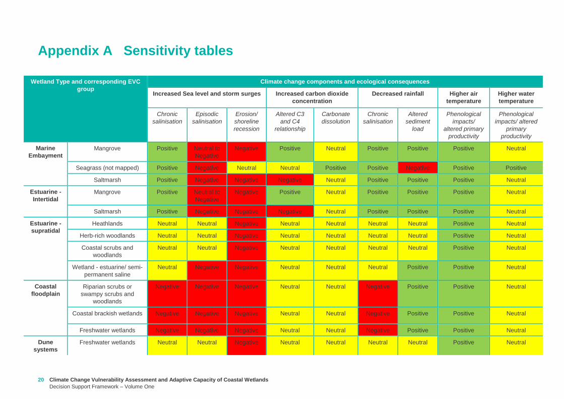
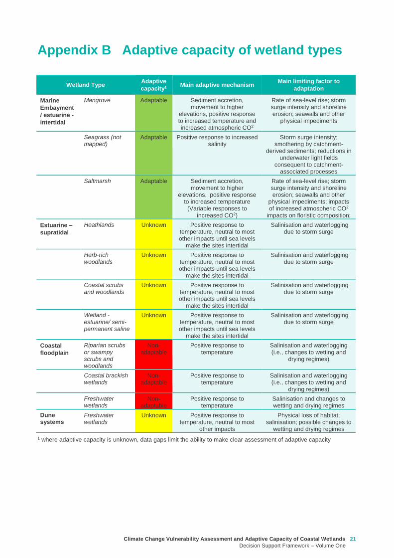
Climate Change Vulnerability Assessment and Adaptive Capacity of Coastal Wetlands
Decision Support Framework ndash Volume One
21
1 where adaptive capacity is unknown data gaps limit the ability to make clear assessment of adaptive capacity
Appendix B Adaptive capacity of wetland types
Wetland Type Adaptive
capacity1 Main adaptive mechanism Main limiting factor to
adaptation
Marine
Embayment
estuarine -
intertidal
Mangrove Adaptable Sediment accretion movement to higher
elevations positive response to increased temperature and increased atmospheric CO2
Rate of sea-level rise storm surge intensity and shoreline erosion seawalls and other
physical impediments
Seagrass (not mapped)
Adaptable Positive response to increased salinity
Storm surge intensity smothering by catchment-
derived sediments reductions in underwater light fields
consequent to catchment-associated processes
Saltmarsh Adaptable Sediment accretion movement to higher
elevations positive response to increased temperature
(Variable responses to increased CO2)
Rate of sea-level rise storm surge intensity and shoreline erosion seawalls and other
physical impediments impacts of increased atmospheric CO2
impacts on floristic composition
Estuarine ndash
supratidal
Heathlands Unknown Positive response to temperature neutral to most other impacts until sea levels
make the sites intertidal
Salinisation and waterlogging due to storm surge
Herb-rich woodlands
Unknown Positive response to temperature neutral to most other impacts until sea levels
make the sites intertidal
Salinisation and waterlogging due to storm surge
Coastal scrubs and woodlands
Unknown Positive response to temperature neutral to most other impacts until sea levels
make the sites intertidal
Salinisation and waterlogging due to storm surge
Wetland - estuarine semi-permanent saline
Unknown Positive response to temperature neutral to most other impacts until sea levels
make the sites intertidal
Salinisation and waterlogging due to storm surge
Coastal
floodplain
Riparian scrubs or swampy scrubs and woodlands
Non-adaptable
Positive response to temperature
Salinisation and waterlogging (ie changes to wetting and
drying regimes)
Coastal brackish wetlands
Non-adaptable
Positive response to temperature
Salinisation and waterlogging (ie changes to wetting and
drying regimes)
Freshwater wetlands
Non-adaptable
Positive response to temperature
Salinisation and changes to wetting and drying regimes
Dune systems
Freshwater wetlands
Unknown Positive response to temperature neutral to most
other impacts
Physical loss of habitat salinisation possible changes to
wetting and drying regimes
22 Climate Change Vulnerability Assessment and Adaptive Capacity of Coastal Wetlands
Decision Support Framework ndash Volume One
Appendix C Decision Support Framework template
Climate Change Vulnerability Assessment and Adaptive Capacity of Coastal Wetlands
Decision Support Framework ndash Volume One
23
Coastal Wetlands and Climate Change
Decision Support Framework
Site Name Insert wetland name
Purpose
This document provides a Decision Support Framework to enable wetland managers to assess the
vulnerability and adaptive capacity of wetlands to climate change at an individual wetland or local landscape
scale The DELWP Climate Change Vulnerability Assessment and Adaptive Capacity of Coastal Wetlands
report provides the background and supporting material for this assessment and should be used in
conjunction with each stage of the assessment process outlined below
The broad approach applied in the Decision Support Framework is illustrated below It is a three step
approach that includes
Step 1 Wetland type ndash in this step you identify your wetland type (eg mangrove saltmarsh) using
a combination of the coastal wetland dataset developed as part of this project and your existing
knowledge of the site This step guides the sensitivity assessment undertaken in step 2
Step 2 Assess potential impacts from climate change ndash in this step you consider the position of
your wetland in the landscape so you can determine which component of climate change the
wetland is most sensitive to This step involves undertaking the exposure and sensitivity
components of the vulnerability assessment outlined above using the exposure mapping the
conceptual models and the sensitivity tables provided in the supporting documents
Step 3 Identify management objectives and actions ndash in this step you consider the adaptation
mechanisms possible for your wetland and develop management objectives and actions This step
will inform the development of a management plan which is undertaken outside of the DSF
Step 2 Assess potential impacts from climate change
(refer to Section 4 and Section 5 Volume 2)
Given the location of the wetland in the landscape which components of climate change is the
wetland sensitive to and what is the likely response to climate change
Step 3 Identify management objectives and actions
(refer to Section 6 Volume 2)
a) Identify constraints and
potential management
objectives and actions
b) Confirm
management
objectives
c) Confirm management
actions and develop
implementation plan
Step 1 Wetland type
(refer to Section 3 Volume 2)
What is the wetland type
24 Climate Change Vulnerability Assessment and Adaptive Capacity of Coastal Wetlands
Decision Support Framework ndash Volume One
Decision Support Framework
1 Wetland identification (Section 2 Volume Two)
Name Insert wetland name
Location address Insert generic location description
Easting Northing
Bioregion Refer to httpwwwdepivicgovauenvironment-and-wildlifebiodiversityevc-benchmarks
Wetland category
(Section 24 Volume
Two)
Tidal wetlands
Marine embayment
Estuarine (intertidal)
Estuarine (supratidal)
Non-tidal wetland
Coastal floodplain
Dune system
Wetland type EVC
group(s)
(Section 23 Volume
Two and supporting
geospatial dataset)
Seagrass
Saltmarsh
Mangroves
Brackish wetland
Freshwater wetland (floodplain)
Freshwater wetland (dune)
Riparian swampy scrub
Estuarine wetland
Estuarine scrubs heathlands and
woodlands
Estuary classification
(if relevant)
httpwwwozcoastsgov
ausearch_datamap_se
archjsp
Classification
Wave dominated
Sub-classification
Wave dominated delta
Tide dominated delta
Wave dominated estuary
Tide dominated estuary
Tide dominated
Coastal lagoon
Strandplain
Tidal flat creek
Other
Estuary
geomorphology (if
relevant)
Permanently open
Permanently closed
Intermittently opened and closed
Wetland values See Section 44 of Volume Two for more detail
Climate Change Vulnerability Assessment and Adaptive Capacity of Coastal Wetlands
Decision Support Framework ndash Volume One
25
Decision Support Framework
Decision Support Framework
Insert location map including location of individual wetland EVC types
26 Climate Change Vulnerability Assessment and Adaptive Capacity of Coastal Wetlands
Decision Support Framework ndash Volume One
Decision Support Framework
2 Potential impacts from climate change to the wetland (Section 4 Volume Two)
What is the
climate change
scenario
timeframe
Select climate change scenario timeframe detailed in Section 333 of Volume 2
Given the
position of the
wetland in the
landscape how
exposed is the
wetland to sea
level rise and
storm surge
climate change
components
Insert exposure map for sea level rise and storm surges (See Appendix F of Volume Two Coastal Inundation
dataset is publically available at wwwdatavicgovau)
Sea level rise
Storm surges
Climate Change Vulnerability Assessment and Adaptive Capacity of Coastal Wetlands
Decision Support Framework ndash Volume One
27
Decision Support Framework
Decision Support Framework
Site specific
infrastructure
dynamics that
would influence
the impact from
sea level rise
and storm
surges
Identify any specific infrastructure dynamics that may increase or decrease the impact from sea level rise
and storm surges (eg presence of artificial barriers to restrict seawater intrusion)
Given the
position of the
wetland in the
landscape how
exposed is the
wetland to
temperature and
rainfall climate
change
components
Insert climate change projections for temperature and rainfall based on current CSIRO-BOM (2015)
modelling provided in Section 332 of Volume Two
Temperature
Based on CSIRO-BOM (2015) modelling the following predictions are made in regards to change in
temperature
Magnitude of change
(mean surface temp
change)
Seasonality
Rainfall
Based on CSIRO-BOM (2015) modelling the following predictions are made in regards to change in rainfall
Magnitude of change
(change in rainfall) Seasonality
Wetland
sensitivity
Insert wetland type and sensitivity to climate change components (positive [highlight green] negative
[highlight red] neutral [highlight yellow] NA) provided in Appendix A of Volume One
Climate change component and
impacts on coastal wetlands
Insert
wetland
type
Insert
wetland
type
Insert
wetland
type
Insert
wetland
type
Sea level
Chronic salinisation
Episodic salinisation
Erosion shoreline recession
Carbon dioxide
Altered C3 and C4 relationship
Carbonate dissolution
Rainfall
Chronic salinisation
Temperature (air)
Phenological impacts altered primary
productivity
Temperature (water)
Phenological impacts altered primary
productivity
Positive = positive response to climate change negative = negative response to climate change neutral =
unlikely to have any response to climate change NA = not exposed
28 Climate Change Vulnerability Assessment and Adaptive Capacity of Coastal Wetlands
Decision Support Framework ndash Volume One
Decision Support Framework
Likely outcome Based on the Table 2 in Section 32 of Volume One and the conceptual models presented in Section 41 of
Volume Two
Adaptive
capacity
General adaptive capacity of wetland types present
Describe based on the conceptual models presented in Section 41 of Volume Two and populated table
based on table provided in Section 43 of Volume Two
Wetland
type
Adaptive
capacity Main adaptive mechanism Main limiting factor
Site specific adaptive capacity
Need to consider site specific opportunities and constraints to adaptive capacity based on site specific
characteristics
3 Management objectives and actions (Section 5 of Volume Two)
Constraints to
management
See Section 51 of Volume Two report for more detail
Barriers to migration
Land ownership
Funding
Limitations to knowledge and data
Other potential constraints
Pre-existing threats Identify pre-existing threats that may impact the wetlands capacity to cope with change
Pre-existing
management
objectives
Document local and regional management objectives in pre-existing management plans and
strategies
Proposed management
objective in relation to
climate change
Based on wetland values and existing objectives define the management objective for the wetland in
relation to climate change See Section 52 of Volume Two for more detail
Climate Change Vulnerability Assessment and Adaptive Capacity of Coastal Wetlands
Decision Support Framework ndash Volume One
29
Decision Support Framework
Decision Support Framework
Management actions to
address climate
change impacts and
management
objectives
Identify a suite of management actions for the site See Section 53 of Volume Two for more details
May include existing and new management actions
Existing actions
Management Action Timeframe
New actions
Management Action Timeframe Responsibility
4 Recommendations
Identify any recommendations for management of the wetland eg addressing data gaps further investigation required
development of management or implementation plan
5 Key management resource documents
Insert useful resource documents and web links associated with management at the site including but not limited to
1 Peters G Morris K Frood D Papas P and Roberts J (2015) A Guide to managing livestock grazing in Victorias
wetlands Decision framework and guidelines - Version 10 Arthur Rylah Institute for Environmental Research Technical
Report Series Report number 265
2 Morris K and Papas P (2012) Wetland conceptual models associations between wetland values threats and management
interventions Version one Arthur Rylah Institute for Environmental Research Technical Report Series Report number 237
3 DELWP wetland buffers guidelines (in prep)
4 DELWP wetland revegetation guidelines (in prep)
5 DELWP wetland invasive species management guidelines (in prep)
6 SKM (2005) Guidelines for the design and operation of environmentally friendly wetland regulators (MDBC project report
R2002) Report by Sinclair Knight Merz for the MDBC
6 Key references
Insert key reference supporting documents used to populate decision support framework template
Appendix D Decision Support Framework case study application
30 Climate Change Vulnerability Assessment and Adaptive Capacity of Coastal Wetlands
Decision Support Framework ndash Volume One
Climate Change Vulnerability Assessment and Adaptive Capacity of Coastal Wetlands
Decision Support Framework ndash Volume One
31
Coastal Wetlands and Climate Change
Decision Support Framework
Site Name Powlett River Estuary
Purpose
This document provides a Decision Support Framework to enable wetland managers to assess the
vulnerability and adaptive capacity of wetlands to climate change at an individual wetland or local landscape
scale The DELWP Climate Change Vulnerability Assessment and Adaptive Capacity of Coastal Wetlands
report provides the background and supporting material for this assessment and should be used in
conjunction with each stage of the assessment process outlined below
The broad approach applied in the Decision Support Framework is illustrated below It is a three step
approach that includes
Step 1 Wetland type ndash in this step you identify your wetland type (eg mangrove saltmarsh) using
a combination of the coastal wetland dataset developed as part of this project and your existing
knowledge of the site This step guides the sensitivity assessment undertaken in step 2
Step 2 Assess potential impacts from climate change ndash in this step you consider the position of
your wetland in the landscape so you can determine which component of climate change the
wetland is most sensitive to This step involves undertaking the exposure and sensitivity
components of the vulnerability assessment outlined above using the exposure mapping the
conceptual models and the sensitivity tables provided in the supporting documents
Step 3 Identify management objectives and actions ndash in this step you consider the adaptation
mechanisms possible for your wetland and develop management objectives and actions This step
will inform the development of a management plan which is undertaken outside of the DSF
Step 2 Assess potential impacts from climate change
(refer to Section 4 and Section 5 Volume 2)
Given the location of the wetland in the landscape which components of climate change is the
wetland sensitive to and what is the likely response to climate change
Step 3 Identify management objectives and actions
(refer to Section 6 Volume 2)
a) Identify constraints and
potential management
objectives and actions
b) Confirm
management
objectives
c) Confirm management
actions and develop
implementation plan
Step 1 Wetland type
(refer to Section 3 Volume 2)
What is the wetland type
32 Climate Change Vulnerability Assessment and Adaptive Capacity of Coastal Wetlands
Decision Support Framework ndash Volume One
Decision Support Framework
1 Wetland identification (Section 2 Volume Two)
Name Powlett River Estuary
Location address Located in the West Gippsland Catchment Management Authority (CMA) region near the coast
between Kilcunda and Wonthaggi
Easting 370380205 Northing 5728345662
Bioregion Gippsland Plain
Wetland category
(Section 24 Volume
Two)
Tidal wetlands
Marine embayment
Estuarine (intertidal)
Estuarine (supratidal)
Non-tidal wetland
Coastal floodplain
Dune system
Wetland type EVC
group(s)
(Section 23 Volume
Two and supporting
geospatial dataset)
Seagrass
Saltmarsh
Mangroves
Brackish wetland
Freshwater wetland (floodplain)
Freshwater wetland (dune)
Riparian swampy scrub
Estuarine wetland
Estuarine scrubs heathlands and
woodlands
Estuary classification
(if relevant)
httpwwwozcoastsgov
ausearch_datamap_se
archjsp
Classification
Wave dominated
Sub-classification
Wave dominated delta
Tide dominated delta
Wave dominated estuary
Tide dominated estuary
Tide dominated
Coastal lagoon
Strandplain
Tidal flat creek
Other
Estuary
geomorphology (if
relevant)
Permanently open
Permanently closed
Intermittently opened and closed
Climate Change Vulnerability Assessment and Adaptive Capacity of Coastal Wetlands
Decision Support Framework ndash Volume One
33
Decision Support Framework
Decision Support Framework
Wetland values
The Powlett River Estuary has a diverse range of bird plant and fish communities
5 different EVCs including coastal saltmarsh (Coastal Tussock Saltmarsh and Wet Saltmarsh
Herbland) protected under the Environmental Protection and Biodiversity Conservation Act
1999 (EPBC Act)
22 fish species including the Australian Grayling which is listed threatened under the Flora
and Fauna Guarantee Act 1988 (FFG Act) and vulnerable under the EPBC Act
31 State Australian and Internationally listed bird species including the critically endangered
Orange-bellied Parrot (WGCMA 2015)
The Powlett River Estuary also has significant social and economic value
Recreational activities ndash fishing sightseeing swimming walking bird watching picnics etc
Coastal dunes near the mouth of the Estuary have Aboriginal cultural heritage significance
(number of coastal midden sites recorded)
Landholders commonly graze along the river upstream of the Mouth of Powlett Road
Water source for irrigation and stock and domestic water use (WGCMA 2015)
34 Climate Change Vulnerability Assessment and Adaptive Capacity of Coastal Wetlands
Decision Support Framework ndash Volume One
Decision Support Framework
2 Potential impacts from climate change to the wetland (Section 4 Volume Two)
What is the
climate change
scenario
timeframe
Based on CSIRO-BOM (20015) modelling RCP 45 (moderate response to climate change) and RCP 85
(worst case scenario business as usual response to climate change)
Timeframes 2050 2070 and 2090 were all considered
Given the
position of the
wetland in the
landscape how
exposed is the
wetland to sea
level rise and
storm surge
climate change
components
Sea level rise
Climate Change Vulnerability Assessment and Adaptive Capacity of Coastal Wetlands
Decision Support Framework ndash Volume One
35
Decision Support Framework
Decision Support Framework
Storm surges
Site specific
infrastructure
dynamics that
would influence
the impact from
sea level rise
and storm
surges
There is currently no infrastructure at the Powlett River Estuary that would influence the extent of inundation
from the projected sea level rise and storm surges
When the mouth of the estuary is closed this may help mitigate some of impact of sea level
Given the
position of the
wetland in the
landscape how
exposed is the
wetland to
temperature and
rainfall climate
change
components
Temperature
Based on CSIRO-BOM (2015) modelling the following predictions are made in regards to change in
temperature
Magnitude of change
(mean surface temp
change)
Seasonality
RCP 45
2050 = 05 to 1degC
2070 = gt1 to 15degC
2090 = gt1 to 15degC
RCP 85
2050 = gt15 to 2degC
2070 = gt2 to 25degC
2090 = gt3 to 35deg
Temperature increases are similar in all seasons with some models
simulating to some extent larger increases in summer and autumn
than in other seasons
Projected changes for both daily maximum and minimum
temperature generally follow those of the mean temperature
although there is somewhat lower warming in daily minimum
temperatures than daily maximum temperatures in autumn winter
and spring
Increase in the temperature reached on the hottest days an increase
in the frequency of very hot days and duration of warm spells
36 Climate Change Vulnerability Assessment and Adaptive Capacity of Coastal Wetlands
Decision Support Framework ndash Volume One
Decision Support Framework
Given the
position of the
wetland in the
landscape how
exposed is the
wetland to
temperature and
rainfall climate
change
components
Rainfall
Based on CSIRO-BOM (2015) modelling the following predictions are made in regards to change in rainfall
Magnitude of change
(change in rainfall) Seasonality
RCP 45
2050 = 25 to 75
2070 = gt -25 to 25
2090 = gt -25 to 25
RCP 85
2050 = gt - 75 to -25
2070 = gt - 75 to -25
2090 = gt -125 to - 75
Rainfall declines are strongest in winter and spring Projected
reductions in winter rainfall in the Victoria NSW East region are up
to 30 in 2090 under high emissions
There is little change projected in autumn and either increases or
decreases in summer rainfall are possible
Tendency for heavier rainfall interspersed by longer dry periods
with some extremely dry and wet years with natural variability
continuing to be a major driver of rainfall for the near future (2030)
Intensity of heavy rainfall events is predicted to increase with
timing and magnitude also driven by natural variability
A decline in the number but an increase in the intensity of east
coast lows impacting on average rainfall and heavy rain events
Time spent in drought is predicted to increase over the course of
this century in line with changes to average rainfall and the
frequency and duration of extreme droughts will increase
Wetland
sensitivity
Climate change component and
impacts on coastal wetlands Saltmarsh
Estuarine
Wetland
Swamp
scrub
Swampy
riparian
woodland
Sea level
Chronic salinisation Positive Neutral Negative Negative
Episodic salinization Negative Negative Negative Negative
Erosion shoreline recession Negative Negative Negative Negative
Carbon dioxide
Altered C3 and C4 relationship Negative Neutral Neutral Neutral
Carbonate dissolution Neutral Neutral Neutral Neutral
Rainfall
Chronic salinisation Positive Neutral Negative Negative
Temperature (air)
Phenological impacts altered primary
productivity
Positive Positive Positive Positive
Temperature (water)
Phenological impacts altered primary
productivity
Neutral Neutral Neutral Neutral
Positive = positive response to climate change negative = negative response to climate change neutral =
unlikely to have any response to climate change NA = not exposed
Likely outcome Estuary
Potential change from intermittently open estuary mouth to permanently opened or more permanently
closed estuary depending on regional changes to rainfallcatchment runoff river discharge eustatic
sea levels and storm surges May become more similar to Andersons Inlet (marine embayment) to
the east
Saline intrusion into the upper estuary and lower freshwater reaches of the river due to increased sea
levels and storm surge activity and reduced rainfallcatchment runoff
Climate Change Vulnerability Assessment and Adaptive Capacity of Coastal Wetlands
Decision Support Framework ndash Volume One
37
Decision Support Framework
Decision Support Framework
Saline intrusion into groundwater results in a changed in species composition year round
Saltmarsh
More permanent inundation or increased frequency and duration of inundation
Change in salinity and water regime
Changes in distribution along the elevational gradient from the sea with possible landward migration
Possible invasion by mangroves if geomorphic changes result in a more permanent estuary opening
(eg similar to Andersons Inlet)
Many of the saltmarsh taxa at the site are C3 plants so potentially advantaged by increases in
atmospheric CO2 concentrations
Increased pressure from weed invasion from surrounding agricultural land
Saline intrusion into groundwater results in a changed wetland environment
Estuarine Wetland
Change in salinity and water regime (eg reduced freshwater inflows and saline intrusion increased
evaporation losses)
Increased pressure from weed invasion
Saline intrusion into groundwater results in a changed wetland environment
Riparian scrub and swampy riparian woodland
Change in salinity and water regime (eg reduced freshwater inflows and saline intrusion decreased
rainfall increased extreme flood events)
Rise in saline conditions along riparian zone
Replacement with saltmarsh as a result of increased salinity
Increased pressure from weed invasion
Saline intrusion into groundwater results in a changed species composition year round
Adaptive
capacity
General adaptive capacity of wetland types present
Wetland
type
Adaptive
capacity Main adaptive mechanism Main limiting factor
Saltmarsh Low Sediment accretion movement
to higher elevations positive
response to increase
temperature (variable
responses to increased CO2)
Rate of sea level rise storm surge
intensity and shoreline erosion
seawalls and other physical
impediments impact of increased
atmospheric CO2 impacts on floristic
composition
Estuarine
wetland
Moderate Positive response to
temperature neutral to most
other impacts until sea levels
make the sites intertidal
Salinisation and waterlogging due to
storm surges
Swamp
scrub
Low Positive response to
temperature
Salinisation and waterlogging (ie
changes to wetting and drying regimes)
Swampy
Riparian
woodland
Low Positive response to
temperature
Salinisation and waterlogging (ie
changes to wetting and drying regimes)
38 Climate Change Vulnerability Assessment and Adaptive Capacity of Coastal Wetlands
Decision Support Framework ndash Volume One
Decision Support Framework
Site specific adaptive capacity
Not completed as part of case study ndash requires specific assessments of opportunities and constraints to
adaptive capacity based on site specific characteristics
3 Management objectives and actions (Section 5 of Volume Two)
Constraints to
management
Barriers to migration
Mouth of Powlett Road is a barrier to wetland migration
Rail trail towards Dayleston provides a barrier to landward migration
Small cluster of housing north east of the estuary mouth similarly constrains landward
migration
Land ownership
The land in which wetlands could migrate in to is predominately private land used for
agriculture (grazing and cropping)
Funding
Limited funding available ndash not a priority site State wide nor Ramsar listed
Whilst there is good collaboration between agencies and landholders there are different
priorities for the funding available and therefore so some actions are difficult to implement An
example includes raising roads and carparks that experience inundation during closure
events or buying back regularly inundated marginal farmland
Limitations to knowledge and data
Uncertainty around the likely geomorphic changes to the estuary mouth (ie change in estuary
dynamic)
Understanding the economic value of the estuary coastal wetlands (eg value of wetlands
versus the value of agricultural land)
Uncertainty around acid sulfate soils as a result of climate change
Other potential constraints
Current State policies and procedures for statutory planning changes and land buyback to
enable long term management
Community understanding and expectation around estuary opening and closing
Pre-existing threats The key pre-existing threats identified in the Powlett River Estuary Management Plan that may
influence the resilience of the estuary to climate change impacts include
Degraded water quality
Degraded riparian vegetation (large trees in particular)
Trampling and bank erosion associated with pedestrian access
Rural drainage and drain clearing
Channelisation of the river channel
Vehicle access
Livestock access
Pest plants and animals
Inappropriate recreation causing dune erosion
Disturbance of acid sulfate soils
Climate Change Vulnerability Assessment and Adaptive Capacity of Coastal Wetlands
Decision Support Framework ndash Volume One
39
Decision Support Framework
Decision Support Framework
Pre-existing
management
objectives
Regional catchment strategy
No coastal wetland specific actions objectives for the Powlett River
West Gippsland Waterways Strategy (2014-2022)
Regional objectives relating to the Powlett River Estuary as a coastal wetland
Maintain and improve the habitat and condition of waterways to support waterway dependent
animals and plants
Maintain the ecological character of significant wetlands and estuaries
Catchment objectives for Powlett River Estuary relating to coastal wetlands include
Riparian vegetation provides improved visual amenity and contributes to community use of
waterways
The extent of freshwater wetlands is maintained and their condition is improved
Powlett Estuary Management Plan
Swamp scrub swampy riparian woodland and estuarine wetland vegetation communities are
enhanced and significantly increased in the area
West Gippsland Regional NRM Climate Change Strategy (2016)
The strategy outlines approaches and options to support climate change adaptation and mitigation
The objectives of the adaptation and management strategies are linked to the 20 year objectives in
the Regional Catchment Strategy The Powlett River Estuary is located within the Bunurong Coastal
planning area The estuary is listed as one of the most vulnerable estuary assets to climate change
across the region
Reports are available at lthttpwwwwgcmavicgovauour-regionwaterwayspowlett-river-estuarygt
[Verified 17052016 ]
Proposed management
objective in relation to
climate change
The following management objective is based the existing geomorphic characteristics of the estuary
(ie intermittently closed estuary)
To enhance and significantly increase Swamp scrub Swampy riparian woodland and estuarine
wetland vegetation extent through the facilitation of landward migration of these communities over the
next 50 years
Climate change also poses a threat to non-wetland EVCs (eg Coast Banksia Woodland) and
therefore even though they are not considered in this coastal wetland risk assessment they are still a
management consideration for the CMA in the coastal zone
Management actions to
address climate
change impacts and
management
objectives
Existing actions
Existing management actions provided in Section 81 of the Estuary Management Plan (WGCMA
2015) that are related to climate change are listed below
Management Action Timeframe
E31 Investigate opportunities for land purchase within the inundation
areas of the estuary
8 years
E32 Design and implement a program of stewardship payment for the
seasonal inundation of estuary floodplain from estuary mouth closures
Priority should be given to enhancing coastal saltmarsh and estuarine
wetland communities Payments should be calculated and prioritised
based on potential value to estuary health and ability to minimise artificial
estuary mouth openings
8 years
E 39 Investigate opportunities to encourage the conversion of Crown land
water frontage grazing licences to riparian management licences
8 years
E 43 Undertake hydraulic modelling and bathymetry survey of the Powlett 8 years
40 Climate Change Vulnerability Assessment and Adaptive Capacity of Coastal Wetlands
Decision Support Framework ndash Volume One
Decision Support Framework
estuary floodplain to understand the impacts and benefits of the structures
(including levees and drains) and landforms that affect the movement of
water before during and after artificial estuary mouth opening before
considering any updates changes or removal of these floodplain features
E 44 Undertake a detailed risk assessment including on-ground mapping
to identify potential and active acid sulphate soils with the Powlett estuarine
floodplain
8 years
E 46 Investigate the use of the saltmarsh wetlands and estuary channel
by recreational fish species and other native fish species particularly Black
Bream and prioritise areas for further protection
8 years
E 49 Continue to build understanding of and plan for the risks associated
with climate change including sea level rise This includes future flood
risk
8 years
New actions
The following additional management actions should be considered
Management Action Timeframe Responsibility
Complete a study to assess the likely geomorphic changes
to the estuary as a result of climate change
2 years WGCMA
Undertake scenario planning in consultation with Bass Coast
Shire Council VicRoads and Parks Victoria- refine
management actions and objectives for Estuary based on
finding of geomorphic study This could identify nearby
systems that could form a template for what Powlett River
might look like in the future (eg Andersons Inlet)
2-5 years WGCMA
Review Bass Coast Planning Scheme to understand any
implications to future management actions works at the
Powlett Estuary Provide feedback to the State Government
on any issues associated with State policies and procedures
for statutory planning that may constrain long term
management of the Estuary
2-5 years WGCMA
Consultation with other relevant managers in the area
(including Council VicRoads and Parks Victoria) to discuss
potential issues associated road repairs culverts and other
flood mitigation measures in the area that may arise as a
result of climate change
2-5 years WGCMA
Resolve issues and complexities around the impacts of
climate change (sea level rise) on crown land boundaries
2-5 years State
Government
Resolve issues associated with State policies and
procedures for statutory planning that may constrain long
term management of the Estuary
2-5 years State
Government
Community engagement and education program to provide
the community with an understanding of the predicted
impacts of climate change and enable them to play an active
role in management
2-5 years WGCMA
Estuary Management Plan Action E31 (see above) ndash to
become 2 actions
a Investigate opportunities for land purchase within the
8 years WGCMA
Climate Change Vulnerability Assessment and Adaptive Capacity of Coastal Wetlands
Decision Support Framework ndash Volume One
41
Decision Support Framework
Decision Support Framework
current inundation areas of the estuary
b Investigate opportunities for land purchase within the
future inundation areas of the estuary
Estuary Management Plan Action E32 (see above) ndash
include consideration of future inundation eg ldquoDesign and
implement a program of stewardship payment for the
seasonal inundation of estuary floodplain from estuary
mouth closures under both current and future inundation
conditionsrdquo
8 years WGCMA
Estuary Management Plan Action E 39 (see above) ndash to
become 2 actions
a Investigate opportunities to encourage the conversion of
current Crown land water frontage grazing licences to
riparian management licences
b Investigate issues and opportunities related to sea level
rise impacts on Crown Land Water frontage grazing licences
and riparian management licences (including how to define
boundaries if existing boundaries are inundated by sea level
rise)
8 years WGCMA
Estuary Management Plan Action E44 (see above) ndash
Undertake detailed risk assessment of potential and active
acid sulfate soils
8 years WGCMA
Estuary Management Plan Action E49 (see above) ndash
Continue to build understanding of and plan for risks
associated with climate change
8 years WGCMA
4 Recommendations
1 Climate change threats are currently implied within the management actions in the Powlett River Estuary Management Plan It
is recommended that additional material on climate change impacts be included and climate change threats addressed more
explicitly in the management actions This would meet Action E49 in particular
2 Management objectives also need to consider management for a 30-50 year timeframe ie take in to consideration longer
term climate change impacts including on estuary mouth dynamics A distinction between responses to current and future
threats should be made
5 Key management resource documents
1 Peters G Morris K Frood D Papas P and Roberts J (2015) A Guide to managing livestock grazing in Victorias
wetlands Decision framework and guidelines - Version 10 Arthur Rylah Institute for Environmental Research Technical
Report Series Report number 265
2 Morris K and Papas P (2012) Wetland conceptual models associations between wetland values threats and management
interventions Version one Arthur Rylah Institute for Environmental Research Technical Report Series Report number 237
3 DELWP wetland buffers guidelines (in prep)
4 DELWP wetland revegetation guidelines (in prep)
5 DELWP wetland invasive species management guidelines (in prep)
6 SKM (2005) Guidelines for the design and operation of environmentally friendly wetland regulators (MDBC project report
R2002) Report by Sinclair Knight Merz for the MDBC
42 Climate Change Vulnerability Assessment and Adaptive Capacity of Coastal Wetlands
Decision Support Framework ndash Volume One
Decision Support Framework
6 Key references
1 WGCMA (2012) West Gippsland Regional Catchment Strategy 2013-2019 West Gippsland Catchment Management
Authority
2 WGCMA (2014) West Gippsland Waterway Strategy 2014-2022 West Gippsland Catchment Management Authority
3 WGCMA (2015) Powlett River Estuary Management Plan West Gippsland Catchment Management Authority
4 WGCMA (2016) West Gippsland Regional NRM Climate Change Strategy ndash Final Draft West Gippsland Catchment
Management Authority
5 CSIRO and BOM (2015) Southern Slopes Cluster Report Climate Change in Australia Projections for Australiarsquos Natural
Resource Management Regions Cluster Reports eds Ekstroumlm M et al CSIRO and Bureau of Meteorology Australia
Climate Change Vulnerability Assessment and Adaptive Capacity of Coastal Wetlands
Decision Support Framework ndash Volume One
43
Decision Support Framework
Decision Support Framework
delwpvicgovau delwpvicgovau
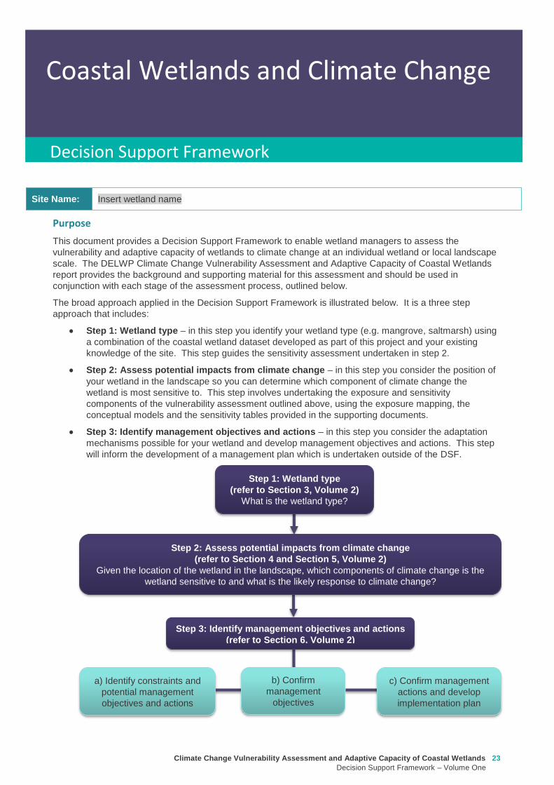
Climate Change Vulnerability Assessment and Adaptive Capacity of Coastal Wetlands
Decision Support Framework ndash Volume One
23
Coastal Wetlands and Climate Change
Decision Support Framework
Site Name Insert wetland name
Purpose
This document provides a Decision Support Framework to enable wetland managers to assess the
vulnerability and adaptive capacity of wetlands to climate change at an individual wetland or local landscape
scale The DELWP Climate Change Vulnerability Assessment and Adaptive Capacity of Coastal Wetlands
report provides the background and supporting material for this assessment and should be used in
conjunction with each stage of the assessment process outlined below
The broad approach applied in the Decision Support Framework is illustrated below It is a three step
approach that includes
Step 1 Wetland type ndash in this step you identify your wetland type (eg mangrove saltmarsh) using
a combination of the coastal wetland dataset developed as part of this project and your existing
knowledge of the site This step guides the sensitivity assessment undertaken in step 2
Step 2 Assess potential impacts from climate change ndash in this step you consider the position of
your wetland in the landscape so you can determine which component of climate change the
wetland is most sensitive to This step involves undertaking the exposure and sensitivity
components of the vulnerability assessment outlined above using the exposure mapping the
conceptual models and the sensitivity tables provided in the supporting documents
Step 3 Identify management objectives and actions ndash in this step you consider the adaptation
mechanisms possible for your wetland and develop management objectives and actions This step
will inform the development of a management plan which is undertaken outside of the DSF
Step 2 Assess potential impacts from climate change
(refer to Section 4 and Section 5 Volume 2)
Given the location of the wetland in the landscape which components of climate change is the
wetland sensitive to and what is the likely response to climate change
Step 3 Identify management objectives and actions
(refer to Section 6 Volume 2)
a) Identify constraints and
potential management
objectives and actions
b) Confirm
management
objectives
c) Confirm management
actions and develop
implementation plan
Step 1 Wetland type
(refer to Section 3 Volume 2)
What is the wetland type
24 Climate Change Vulnerability Assessment and Adaptive Capacity of Coastal Wetlands
Decision Support Framework ndash Volume One
Decision Support Framework
1 Wetland identification (Section 2 Volume Two)
Name Insert wetland name
Location address Insert generic location description
Easting Northing
Bioregion Refer to httpwwwdepivicgovauenvironment-and-wildlifebiodiversityevc-benchmarks
Wetland category
(Section 24 Volume
Two)
Tidal wetlands
Marine embayment
Estuarine (intertidal)
Estuarine (supratidal)
Non-tidal wetland
Coastal floodplain
Dune system
Wetland type EVC
group(s)
(Section 23 Volume
Two and supporting
geospatial dataset)
Seagrass
Saltmarsh
Mangroves
Brackish wetland
Freshwater wetland (floodplain)
Freshwater wetland (dune)
Riparian swampy scrub
Estuarine wetland
Estuarine scrubs heathlands and
woodlands
Estuary classification
(if relevant)
httpwwwozcoastsgov
ausearch_datamap_se
archjsp
Classification
Wave dominated
Sub-classification
Wave dominated delta
Tide dominated delta
Wave dominated estuary
Tide dominated estuary
Tide dominated
Coastal lagoon
Strandplain
Tidal flat creek
Other
Estuary
geomorphology (if
relevant)
Permanently open
Permanently closed
Intermittently opened and closed
Wetland values See Section 44 of Volume Two for more detail
Climate Change Vulnerability Assessment and Adaptive Capacity of Coastal Wetlands
Decision Support Framework ndash Volume One
25
Decision Support Framework
Decision Support Framework
Insert location map including location of individual wetland EVC types
26 Climate Change Vulnerability Assessment and Adaptive Capacity of Coastal Wetlands
Decision Support Framework ndash Volume One
Decision Support Framework
2 Potential impacts from climate change to the wetland (Section 4 Volume Two)
What is the
climate change
scenario
timeframe
Select climate change scenario timeframe detailed in Section 333 of Volume 2
Given the
position of the
wetland in the
landscape how
exposed is the
wetland to sea
level rise and
storm surge
climate change
components
Insert exposure map for sea level rise and storm surges (See Appendix F of Volume Two Coastal Inundation
dataset is publically available at wwwdatavicgovau)
Sea level rise
Storm surges
Climate Change Vulnerability Assessment and Adaptive Capacity of Coastal Wetlands
Decision Support Framework ndash Volume One
27
Decision Support Framework
Decision Support Framework
Site specific
infrastructure
dynamics that
would influence
the impact from
sea level rise
and storm
surges
Identify any specific infrastructure dynamics that may increase or decrease the impact from sea level rise
and storm surges (eg presence of artificial barriers to restrict seawater intrusion)
Given the
position of the
wetland in the
landscape how
exposed is the
wetland to
temperature and
rainfall climate
change
components
Insert climate change projections for temperature and rainfall based on current CSIRO-BOM (2015)
modelling provided in Section 332 of Volume Two
Temperature
Based on CSIRO-BOM (2015) modelling the following predictions are made in regards to change in
temperature
Magnitude of change
(mean surface temp
change)
Seasonality
Rainfall
Based on CSIRO-BOM (2015) modelling the following predictions are made in regards to change in rainfall
Magnitude of change
(change in rainfall) Seasonality
Wetland
sensitivity
Insert wetland type and sensitivity to climate change components (positive [highlight green] negative
[highlight red] neutral [highlight yellow] NA) provided in Appendix A of Volume One
Climate change component and
impacts on coastal wetlands
Insert
wetland
type
Insert
wetland
type
Insert
wetland
type
Insert
wetland
type
Sea level
Chronic salinisation
Episodic salinisation
Erosion shoreline recession
Carbon dioxide
Altered C3 and C4 relationship
Carbonate dissolution
Rainfall
Chronic salinisation
Temperature (air)
Phenological impacts altered primary
productivity
Temperature (water)
Phenological impacts altered primary
productivity
Positive = positive response to climate change negative = negative response to climate change neutral =
unlikely to have any response to climate change NA = not exposed
28 Climate Change Vulnerability Assessment and Adaptive Capacity of Coastal Wetlands
Decision Support Framework ndash Volume One
Decision Support Framework
Likely outcome Based on the Table 2 in Section 32 of Volume One and the conceptual models presented in Section 41 of
Volume Two
Adaptive
capacity
General adaptive capacity of wetland types present
Describe based on the conceptual models presented in Section 41 of Volume Two and populated table
based on table provided in Section 43 of Volume Two
Wetland
type
Adaptive
capacity Main adaptive mechanism Main limiting factor
Site specific adaptive capacity
Need to consider site specific opportunities and constraints to adaptive capacity based on site specific
characteristics
3 Management objectives and actions (Section 5 of Volume Two)
Constraints to
management
See Section 51 of Volume Two report for more detail
Barriers to migration
Land ownership
Funding
Limitations to knowledge and data
Other potential constraints
Pre-existing threats Identify pre-existing threats that may impact the wetlands capacity to cope with change
Pre-existing
management
objectives
Document local and regional management objectives in pre-existing management plans and
strategies
Proposed management
objective in relation to
climate change
Based on wetland values and existing objectives define the management objective for the wetland in
relation to climate change See Section 52 of Volume Two for more detail
Climate Change Vulnerability Assessment and Adaptive Capacity of Coastal Wetlands
Decision Support Framework ndash Volume One
29
Decision Support Framework
Decision Support Framework
Management actions to
address climate
change impacts and
management
objectives
Identify a suite of management actions for the site See Section 53 of Volume Two for more details
May include existing and new management actions
Existing actions
Management Action Timeframe
New actions
Management Action Timeframe Responsibility
4 Recommendations
Identify any recommendations for management of the wetland eg addressing data gaps further investigation required
development of management or implementation plan
5 Key management resource documents
Insert useful resource documents and web links associated with management at the site including but not limited to
1 Peters G Morris K Frood D Papas P and Roberts J (2015) A Guide to managing livestock grazing in Victorias
wetlands Decision framework and guidelines - Version 10 Arthur Rylah Institute for Environmental Research Technical
Report Series Report number 265
2 Morris K and Papas P (2012) Wetland conceptual models associations between wetland values threats and management
interventions Version one Arthur Rylah Institute for Environmental Research Technical Report Series Report number 237
3 DELWP wetland buffers guidelines (in prep)
4 DELWP wetland revegetation guidelines (in prep)
5 DELWP wetland invasive species management guidelines (in prep)
6 SKM (2005) Guidelines for the design and operation of environmentally friendly wetland regulators (MDBC project report
R2002) Report by Sinclair Knight Merz for the MDBC
6 Key references
Insert key reference supporting documents used to populate decision support framework template
Appendix D Decision Support Framework case study application
30 Climate Change Vulnerability Assessment and Adaptive Capacity of Coastal Wetlands
Decision Support Framework ndash Volume One
Climate Change Vulnerability Assessment and Adaptive Capacity of Coastal Wetlands
Decision Support Framework ndash Volume One
31
Coastal Wetlands and Climate Change
Decision Support Framework
Site Name Powlett River Estuary
Purpose
This document provides a Decision Support Framework to enable wetland managers to assess the
vulnerability and adaptive capacity of wetlands to climate change at an individual wetland or local landscape
scale The DELWP Climate Change Vulnerability Assessment and Adaptive Capacity of Coastal Wetlands
report provides the background and supporting material for this assessment and should be used in
conjunction with each stage of the assessment process outlined below
The broad approach applied in the Decision Support Framework is illustrated below It is a three step
approach that includes
Step 1 Wetland type ndash in this step you identify your wetland type (eg mangrove saltmarsh) using
a combination of the coastal wetland dataset developed as part of this project and your existing
knowledge of the site This step guides the sensitivity assessment undertaken in step 2
Step 2 Assess potential impacts from climate change ndash in this step you consider the position of
your wetland in the landscape so you can determine which component of climate change the
wetland is most sensitive to This step involves undertaking the exposure and sensitivity
components of the vulnerability assessment outlined above using the exposure mapping the
conceptual models and the sensitivity tables provided in the supporting documents
Step 3 Identify management objectives and actions ndash in this step you consider the adaptation
mechanisms possible for your wetland and develop management objectives and actions This step
will inform the development of a management plan which is undertaken outside of the DSF
Step 2 Assess potential impacts from climate change
(refer to Section 4 and Section 5 Volume 2)
Given the location of the wetland in the landscape which components of climate change is the
wetland sensitive to and what is the likely response to climate change
Step 3 Identify management objectives and actions
(refer to Section 6 Volume 2)
a) Identify constraints and
potential management
objectives and actions
b) Confirm
management
objectives
c) Confirm management
actions and develop
implementation plan
Step 1 Wetland type
(refer to Section 3 Volume 2)
What is the wetland type
32 Climate Change Vulnerability Assessment and Adaptive Capacity of Coastal Wetlands
Decision Support Framework ndash Volume One
Decision Support Framework
1 Wetland identification (Section 2 Volume Two)
Name Powlett River Estuary
Location address Located in the West Gippsland Catchment Management Authority (CMA) region near the coast
between Kilcunda and Wonthaggi
Easting 370380205 Northing 5728345662
Bioregion Gippsland Plain
Wetland category
(Section 24 Volume
Two)
Tidal wetlands
Marine embayment
Estuarine (intertidal)
Estuarine (supratidal)
Non-tidal wetland
Coastal floodplain
Dune system
Wetland type EVC
group(s)
(Section 23 Volume
Two and supporting
geospatial dataset)
Seagrass
Saltmarsh
Mangroves
Brackish wetland
Freshwater wetland (floodplain)
Freshwater wetland (dune)
Riparian swampy scrub
Estuarine wetland
Estuarine scrubs heathlands and
woodlands
Estuary classification
(if relevant)
httpwwwozcoastsgov
ausearch_datamap_se
archjsp
Classification
Wave dominated
Sub-classification
Wave dominated delta
Tide dominated delta
Wave dominated estuary
Tide dominated estuary
Tide dominated
Coastal lagoon
Strandplain
Tidal flat creek
Other
Estuary
geomorphology (if
relevant)
Permanently open
Permanently closed
Intermittently opened and closed
Climate Change Vulnerability Assessment and Adaptive Capacity of Coastal Wetlands
Decision Support Framework ndash Volume One
33
Decision Support Framework
Decision Support Framework
Wetland values
The Powlett River Estuary has a diverse range of bird plant and fish communities
5 different EVCs including coastal saltmarsh (Coastal Tussock Saltmarsh and Wet Saltmarsh
Herbland) protected under the Environmental Protection and Biodiversity Conservation Act
1999 (EPBC Act)
22 fish species including the Australian Grayling which is listed threatened under the Flora
and Fauna Guarantee Act 1988 (FFG Act) and vulnerable under the EPBC Act
31 State Australian and Internationally listed bird species including the critically endangered
Orange-bellied Parrot (WGCMA 2015)
The Powlett River Estuary also has significant social and economic value
Recreational activities ndash fishing sightseeing swimming walking bird watching picnics etc
Coastal dunes near the mouth of the Estuary have Aboriginal cultural heritage significance
(number of coastal midden sites recorded)
Landholders commonly graze along the river upstream of the Mouth of Powlett Road
Water source for irrigation and stock and domestic water use (WGCMA 2015)
34 Climate Change Vulnerability Assessment and Adaptive Capacity of Coastal Wetlands
Decision Support Framework ndash Volume One
Decision Support Framework
2 Potential impacts from climate change to the wetland (Section 4 Volume Two)
What is the
climate change
scenario
timeframe
Based on CSIRO-BOM (20015) modelling RCP 45 (moderate response to climate change) and RCP 85
(worst case scenario business as usual response to climate change)
Timeframes 2050 2070 and 2090 were all considered
Given the
position of the
wetland in the
landscape how
exposed is the
wetland to sea
level rise and
storm surge
climate change
components
Sea level rise
Climate Change Vulnerability Assessment and Adaptive Capacity of Coastal Wetlands
Decision Support Framework ndash Volume One
35
Decision Support Framework
Decision Support Framework
Storm surges
Site specific
infrastructure
dynamics that
would influence
the impact from
sea level rise
and storm
surges
There is currently no infrastructure at the Powlett River Estuary that would influence the extent of inundation
from the projected sea level rise and storm surges
When the mouth of the estuary is closed this may help mitigate some of impact of sea level
Given the
position of the
wetland in the
landscape how
exposed is the
wetland to
temperature and
rainfall climate
change
components
Temperature
Based on CSIRO-BOM (2015) modelling the following predictions are made in regards to change in
temperature
Magnitude of change
(mean surface temp
change)
Seasonality
RCP 45
2050 = 05 to 1degC
2070 = gt1 to 15degC
2090 = gt1 to 15degC
RCP 85
2050 = gt15 to 2degC
2070 = gt2 to 25degC
2090 = gt3 to 35deg
Temperature increases are similar in all seasons with some models
simulating to some extent larger increases in summer and autumn
than in other seasons
Projected changes for both daily maximum and minimum
temperature generally follow those of the mean temperature
although there is somewhat lower warming in daily minimum
temperatures than daily maximum temperatures in autumn winter
and spring
Increase in the temperature reached on the hottest days an increase
in the frequency of very hot days and duration of warm spells
36 Climate Change Vulnerability Assessment and Adaptive Capacity of Coastal Wetlands
Decision Support Framework ndash Volume One
Decision Support Framework
Given the
position of the
wetland in the
landscape how
exposed is the
wetland to
temperature and
rainfall climate
change
components
Rainfall
Based on CSIRO-BOM (2015) modelling the following predictions are made in regards to change in rainfall
Magnitude of change
(change in rainfall) Seasonality
RCP 45
2050 = 25 to 75
2070 = gt -25 to 25
2090 = gt -25 to 25
RCP 85
2050 = gt - 75 to -25
2070 = gt - 75 to -25
2090 = gt -125 to - 75
Rainfall declines are strongest in winter and spring Projected
reductions in winter rainfall in the Victoria NSW East region are up
to 30 in 2090 under high emissions
There is little change projected in autumn and either increases or
decreases in summer rainfall are possible
Tendency for heavier rainfall interspersed by longer dry periods
with some extremely dry and wet years with natural variability
continuing to be a major driver of rainfall for the near future (2030)
Intensity of heavy rainfall events is predicted to increase with
timing and magnitude also driven by natural variability
A decline in the number but an increase in the intensity of east
coast lows impacting on average rainfall and heavy rain events
Time spent in drought is predicted to increase over the course of
this century in line with changes to average rainfall and the
frequency and duration of extreme droughts will increase
Wetland
sensitivity
Climate change component and
impacts on coastal wetlands Saltmarsh
Estuarine
Wetland
Swamp
scrub
Swampy
riparian
woodland
Sea level
Chronic salinisation Positive Neutral Negative Negative
Episodic salinization Negative Negative Negative Negative
Erosion shoreline recession Negative Negative Negative Negative
Carbon dioxide
Altered C3 and C4 relationship Negative Neutral Neutral Neutral
Carbonate dissolution Neutral Neutral Neutral Neutral
Rainfall
Chronic salinisation Positive Neutral Negative Negative
Temperature (air)
Phenological impacts altered primary
productivity
Positive Positive Positive Positive
Temperature (water)
Phenological impacts altered primary
productivity
Neutral Neutral Neutral Neutral
Positive = positive response to climate change negative = negative response to climate change neutral =
unlikely to have any response to climate change NA = not exposed
Likely outcome Estuary
Potential change from intermittently open estuary mouth to permanently opened or more permanently
closed estuary depending on regional changes to rainfallcatchment runoff river discharge eustatic
sea levels and storm surges May become more similar to Andersons Inlet (marine embayment) to
the east
Saline intrusion into the upper estuary and lower freshwater reaches of the river due to increased sea
levels and storm surge activity and reduced rainfallcatchment runoff
Climate Change Vulnerability Assessment and Adaptive Capacity of Coastal Wetlands
Decision Support Framework ndash Volume One
37
Decision Support Framework
Decision Support Framework
Saline intrusion into groundwater results in a changed in species composition year round
Saltmarsh
More permanent inundation or increased frequency and duration of inundation
Change in salinity and water regime
Changes in distribution along the elevational gradient from the sea with possible landward migration
Possible invasion by mangroves if geomorphic changes result in a more permanent estuary opening
(eg similar to Andersons Inlet)
Many of the saltmarsh taxa at the site are C3 plants so potentially advantaged by increases in
atmospheric CO2 concentrations
Increased pressure from weed invasion from surrounding agricultural land
Saline intrusion into groundwater results in a changed wetland environment
Estuarine Wetland
Change in salinity and water regime (eg reduced freshwater inflows and saline intrusion increased
evaporation losses)
Increased pressure from weed invasion
Saline intrusion into groundwater results in a changed wetland environment
Riparian scrub and swampy riparian woodland
Change in salinity and water regime (eg reduced freshwater inflows and saline intrusion decreased
rainfall increased extreme flood events)
Rise in saline conditions along riparian zone
Replacement with saltmarsh as a result of increased salinity
Increased pressure from weed invasion
Saline intrusion into groundwater results in a changed species composition year round
Adaptive
capacity
General adaptive capacity of wetland types present
Wetland
type
Adaptive
capacity Main adaptive mechanism Main limiting factor
Saltmarsh Low Sediment accretion movement
to higher elevations positive
response to increase
temperature (variable
responses to increased CO2)
Rate of sea level rise storm surge
intensity and shoreline erosion
seawalls and other physical
impediments impact of increased
atmospheric CO2 impacts on floristic
composition
Estuarine
wetland
Moderate Positive response to
temperature neutral to most
other impacts until sea levels
make the sites intertidal
Salinisation and waterlogging due to
storm surges
Swamp
scrub
Low Positive response to
temperature
Salinisation and waterlogging (ie
changes to wetting and drying regimes)
Swampy
Riparian
woodland
Low Positive response to
temperature
Salinisation and waterlogging (ie
changes to wetting and drying regimes)
38 Climate Change Vulnerability Assessment and Adaptive Capacity of Coastal Wetlands
Decision Support Framework ndash Volume One
Decision Support Framework
Site specific adaptive capacity
Not completed as part of case study ndash requires specific assessments of opportunities and constraints to
adaptive capacity based on site specific characteristics
3 Management objectives and actions (Section 5 of Volume Two)
Constraints to
management
Barriers to migration
Mouth of Powlett Road is a barrier to wetland migration
Rail trail towards Dayleston provides a barrier to landward migration
Small cluster of housing north east of the estuary mouth similarly constrains landward
migration
Land ownership
The land in which wetlands could migrate in to is predominately private land used for
agriculture (grazing and cropping)
Funding
Limited funding available ndash not a priority site State wide nor Ramsar listed
Whilst there is good collaboration between agencies and landholders there are different
priorities for the funding available and therefore so some actions are difficult to implement An
example includes raising roads and carparks that experience inundation during closure
events or buying back regularly inundated marginal farmland
Limitations to knowledge and data
Uncertainty around the likely geomorphic changes to the estuary mouth (ie change in estuary
dynamic)
Understanding the economic value of the estuary coastal wetlands (eg value of wetlands
versus the value of agricultural land)
Uncertainty around acid sulfate soils as a result of climate change
Other potential constraints
Current State policies and procedures for statutory planning changes and land buyback to
enable long term management
Community understanding and expectation around estuary opening and closing
Pre-existing threats The key pre-existing threats identified in the Powlett River Estuary Management Plan that may
influence the resilience of the estuary to climate change impacts include
Degraded water quality
Degraded riparian vegetation (large trees in particular)
Trampling and bank erosion associated with pedestrian access
Rural drainage and drain clearing
Channelisation of the river channel
Vehicle access
Livestock access
Pest plants and animals
Inappropriate recreation causing dune erosion
Disturbance of acid sulfate soils
Climate Change Vulnerability Assessment and Adaptive Capacity of Coastal Wetlands
Decision Support Framework ndash Volume One
39
Decision Support Framework
Decision Support Framework
Pre-existing
management
objectives
Regional catchment strategy
No coastal wetland specific actions objectives for the Powlett River
West Gippsland Waterways Strategy (2014-2022)
Regional objectives relating to the Powlett River Estuary as a coastal wetland
Maintain and improve the habitat and condition of waterways to support waterway dependent
animals and plants
Maintain the ecological character of significant wetlands and estuaries
Catchment objectives for Powlett River Estuary relating to coastal wetlands include
Riparian vegetation provides improved visual amenity and contributes to community use of
waterways
The extent of freshwater wetlands is maintained and their condition is improved
Powlett Estuary Management Plan
Swamp scrub swampy riparian woodland and estuarine wetland vegetation communities are
enhanced and significantly increased in the area
West Gippsland Regional NRM Climate Change Strategy (2016)
The strategy outlines approaches and options to support climate change adaptation and mitigation
The objectives of the adaptation and management strategies are linked to the 20 year objectives in
the Regional Catchment Strategy The Powlett River Estuary is located within the Bunurong Coastal
planning area The estuary is listed as one of the most vulnerable estuary assets to climate change
across the region
Reports are available at lthttpwwwwgcmavicgovauour-regionwaterwayspowlett-river-estuarygt
[Verified 17052016 ]
Proposed management
objective in relation to
climate change
The following management objective is based the existing geomorphic characteristics of the estuary
(ie intermittently closed estuary)
To enhance and significantly increase Swamp scrub Swampy riparian woodland and estuarine
wetland vegetation extent through the facilitation of landward migration of these communities over the
next 50 years
Climate change also poses a threat to non-wetland EVCs (eg Coast Banksia Woodland) and
therefore even though they are not considered in this coastal wetland risk assessment they are still a
management consideration for the CMA in the coastal zone
Management actions to
address climate
change impacts and
management
objectives
Existing actions
Existing management actions provided in Section 81 of the Estuary Management Plan (WGCMA
2015) that are related to climate change are listed below
Management Action Timeframe
E31 Investigate opportunities for land purchase within the inundation
areas of the estuary
8 years
E32 Design and implement a program of stewardship payment for the
seasonal inundation of estuary floodplain from estuary mouth closures
Priority should be given to enhancing coastal saltmarsh and estuarine
wetland communities Payments should be calculated and prioritised
based on potential value to estuary health and ability to minimise artificial
estuary mouth openings
8 years
E 39 Investigate opportunities to encourage the conversion of Crown land
water frontage grazing licences to riparian management licences
8 years
E 43 Undertake hydraulic modelling and bathymetry survey of the Powlett 8 years
40 Climate Change Vulnerability Assessment and Adaptive Capacity of Coastal Wetlands
Decision Support Framework ndash Volume One
Decision Support Framework
estuary floodplain to understand the impacts and benefits of the structures
(including levees and drains) and landforms that affect the movement of
water before during and after artificial estuary mouth opening before
considering any updates changes or removal of these floodplain features
E 44 Undertake a detailed risk assessment including on-ground mapping
to identify potential and active acid sulphate soils with the Powlett estuarine
floodplain
8 years
E 46 Investigate the use of the saltmarsh wetlands and estuary channel
by recreational fish species and other native fish species particularly Black
Bream and prioritise areas for further protection
8 years
E 49 Continue to build understanding of and plan for the risks associated
with climate change including sea level rise This includes future flood
risk
8 years
New actions
The following additional management actions should be considered
Management Action Timeframe Responsibility
Complete a study to assess the likely geomorphic changes
to the estuary as a result of climate change
2 years WGCMA
Undertake scenario planning in consultation with Bass Coast
Shire Council VicRoads and Parks Victoria- refine
management actions and objectives for Estuary based on
finding of geomorphic study This could identify nearby
systems that could form a template for what Powlett River
might look like in the future (eg Andersons Inlet)
2-5 years WGCMA
Review Bass Coast Planning Scheme to understand any
implications to future management actions works at the
Powlett Estuary Provide feedback to the State Government
on any issues associated with State policies and procedures
for statutory planning that may constrain long term
management of the Estuary
2-5 years WGCMA
Consultation with other relevant managers in the area
(including Council VicRoads and Parks Victoria) to discuss
potential issues associated road repairs culverts and other
flood mitigation measures in the area that may arise as a
result of climate change
2-5 years WGCMA
Resolve issues and complexities around the impacts of
climate change (sea level rise) on crown land boundaries
2-5 years State
Government
Resolve issues associated with State policies and
procedures for statutory planning that may constrain long
term management of the Estuary
2-5 years State
Government
Community engagement and education program to provide
the community with an understanding of the predicted
impacts of climate change and enable them to play an active
role in management
2-5 years WGCMA
Estuary Management Plan Action E31 (see above) ndash to
become 2 actions
a Investigate opportunities for land purchase within the
8 years WGCMA
Climate Change Vulnerability Assessment and Adaptive Capacity of Coastal Wetlands
Decision Support Framework ndash Volume One
41
Decision Support Framework
Decision Support Framework
current inundation areas of the estuary
b Investigate opportunities for land purchase within the
future inundation areas of the estuary
Estuary Management Plan Action E32 (see above) ndash
include consideration of future inundation eg ldquoDesign and
implement a program of stewardship payment for the
seasonal inundation of estuary floodplain from estuary
mouth closures under both current and future inundation
conditionsrdquo
8 years WGCMA
Estuary Management Plan Action E 39 (see above) ndash to
become 2 actions
a Investigate opportunities to encourage the conversion of
current Crown land water frontage grazing licences to
riparian management licences
b Investigate issues and opportunities related to sea level
rise impacts on Crown Land Water frontage grazing licences
and riparian management licences (including how to define
boundaries if existing boundaries are inundated by sea level
rise)
8 years WGCMA
Estuary Management Plan Action E44 (see above) ndash
Undertake detailed risk assessment of potential and active
acid sulfate soils
8 years WGCMA
Estuary Management Plan Action E49 (see above) ndash
Continue to build understanding of and plan for risks
associated with climate change
8 years WGCMA
4 Recommendations
1 Climate change threats are currently implied within the management actions in the Powlett River Estuary Management Plan It
is recommended that additional material on climate change impacts be included and climate change threats addressed more
explicitly in the management actions This would meet Action E49 in particular
2 Management objectives also need to consider management for a 30-50 year timeframe ie take in to consideration longer
term climate change impacts including on estuary mouth dynamics A distinction between responses to current and future
threats should be made
5 Key management resource documents
1 Peters G Morris K Frood D Papas P and Roberts J (2015) A Guide to managing livestock grazing in Victorias
wetlands Decision framework and guidelines - Version 10 Arthur Rylah Institute for Environmental Research Technical
Report Series Report number 265
2 Morris K and Papas P (2012) Wetland conceptual models associations between wetland values threats and management
interventions Version one Arthur Rylah Institute for Environmental Research Technical Report Series Report number 237
3 DELWP wetland buffers guidelines (in prep)
4 DELWP wetland revegetation guidelines (in prep)
5 DELWP wetland invasive species management guidelines (in prep)
6 SKM (2005) Guidelines for the design and operation of environmentally friendly wetland regulators (MDBC project report
R2002) Report by Sinclair Knight Merz for the MDBC
42 Climate Change Vulnerability Assessment and Adaptive Capacity of Coastal Wetlands
Decision Support Framework ndash Volume One
Decision Support Framework
6 Key references
1 WGCMA (2012) West Gippsland Regional Catchment Strategy 2013-2019 West Gippsland Catchment Management
Authority
2 WGCMA (2014) West Gippsland Waterway Strategy 2014-2022 West Gippsland Catchment Management Authority
3 WGCMA (2015) Powlett River Estuary Management Plan West Gippsland Catchment Management Authority
4 WGCMA (2016) West Gippsland Regional NRM Climate Change Strategy ndash Final Draft West Gippsland Catchment
Management Authority
5 CSIRO and BOM (2015) Southern Slopes Cluster Report Climate Change in Australia Projections for Australiarsquos Natural
Resource Management Regions Cluster Reports eds Ekstroumlm M et al CSIRO and Bureau of Meteorology Australia
Climate Change Vulnerability Assessment and Adaptive Capacity of Coastal Wetlands
Decision Support Framework ndash Volume One
43
Decision Support Framework
Decision Support Framework
delwpvicgovau delwpvicgovau
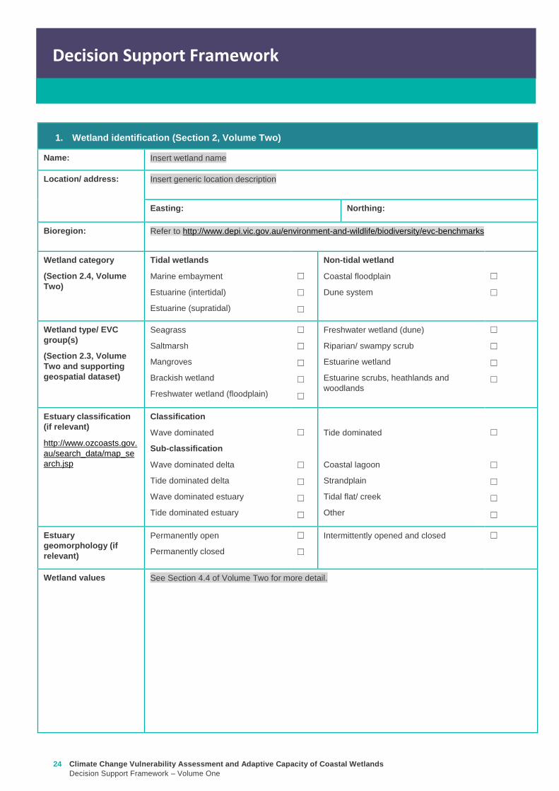
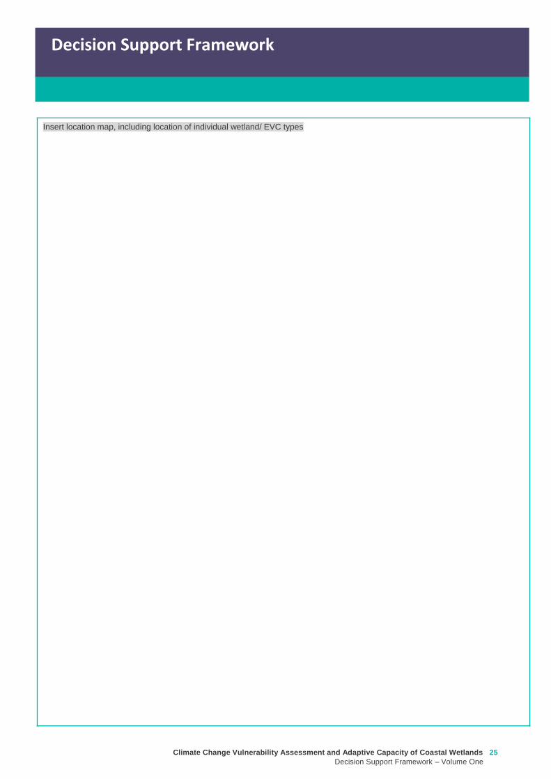
Climate Change Vulnerability Assessment and Adaptive Capacity of Coastal Wetlands
Decision Support Framework ndash Volume One
25
Decision Support Framework
Decision Support Framework
Insert location map including location of individual wetland EVC types
26 Climate Change Vulnerability Assessment and Adaptive Capacity of Coastal Wetlands
Decision Support Framework ndash Volume One
Decision Support Framework
2 Potential impacts from climate change to the wetland (Section 4 Volume Two)
What is the
climate change
scenario
timeframe
Select climate change scenario timeframe detailed in Section 333 of Volume 2
Given the
position of the
wetland in the
landscape how
exposed is the
wetland to sea
level rise and
storm surge
climate change
components
Insert exposure map for sea level rise and storm surges (See Appendix F of Volume Two Coastal Inundation
dataset is publically available at wwwdatavicgovau)
Sea level rise
Storm surges
Climate Change Vulnerability Assessment and Adaptive Capacity of Coastal Wetlands
Decision Support Framework ndash Volume One
27
Decision Support Framework
Decision Support Framework
Site specific
infrastructure
dynamics that
would influence
the impact from
sea level rise
and storm
surges
Identify any specific infrastructure dynamics that may increase or decrease the impact from sea level rise
and storm surges (eg presence of artificial barriers to restrict seawater intrusion)
Given the
position of the
wetland in the
landscape how
exposed is the
wetland to
temperature and
rainfall climate
change
components
Insert climate change projections for temperature and rainfall based on current CSIRO-BOM (2015)
modelling provided in Section 332 of Volume Two
Temperature
Based on CSIRO-BOM (2015) modelling the following predictions are made in regards to change in
temperature
Magnitude of change
(mean surface temp
change)
Seasonality
Rainfall
Based on CSIRO-BOM (2015) modelling the following predictions are made in regards to change in rainfall
Magnitude of change
(change in rainfall) Seasonality
Wetland
sensitivity
Insert wetland type and sensitivity to climate change components (positive [highlight green] negative
[highlight red] neutral [highlight yellow] NA) provided in Appendix A of Volume One
Climate change component and
impacts on coastal wetlands
Insert
wetland
type
Insert
wetland
type
Insert
wetland
type
Insert
wetland
type
Sea level
Chronic salinisation
Episodic salinisation
Erosion shoreline recession
Carbon dioxide
Altered C3 and C4 relationship
Carbonate dissolution
Rainfall
Chronic salinisation
Temperature (air)
Phenological impacts altered primary
productivity
Temperature (water)
Phenological impacts altered primary
productivity
Positive = positive response to climate change negative = negative response to climate change neutral =
unlikely to have any response to climate change NA = not exposed
28 Climate Change Vulnerability Assessment and Adaptive Capacity of Coastal Wetlands
Decision Support Framework ndash Volume One
Decision Support Framework
Likely outcome Based on the Table 2 in Section 32 of Volume One and the conceptual models presented in Section 41 of
Volume Two
Adaptive
capacity
General adaptive capacity of wetland types present
Describe based on the conceptual models presented in Section 41 of Volume Two and populated table
based on table provided in Section 43 of Volume Two
Wetland
type
Adaptive
capacity Main adaptive mechanism Main limiting factor
Site specific adaptive capacity
Need to consider site specific opportunities and constraints to adaptive capacity based on site specific
characteristics
3 Management objectives and actions (Section 5 of Volume Two)
Constraints to
management
See Section 51 of Volume Two report for more detail
Barriers to migration
Land ownership
Funding
Limitations to knowledge and data
Other potential constraints
Pre-existing threats Identify pre-existing threats that may impact the wetlands capacity to cope with change
Pre-existing
management
objectives
Document local and regional management objectives in pre-existing management plans and
strategies
Proposed management
objective in relation to
climate change
Based on wetland values and existing objectives define the management objective for the wetland in
relation to climate change See Section 52 of Volume Two for more detail
Climate Change Vulnerability Assessment and Adaptive Capacity of Coastal Wetlands
Decision Support Framework ndash Volume One
29
Decision Support Framework
Decision Support Framework
Management actions to
address climate
change impacts and
management
objectives
Identify a suite of management actions for the site See Section 53 of Volume Two for more details
May include existing and new management actions
Existing actions
Management Action Timeframe
New actions
Management Action Timeframe Responsibility
4 Recommendations
Identify any recommendations for management of the wetland eg addressing data gaps further investigation required
development of management or implementation plan
5 Key management resource documents
Insert useful resource documents and web links associated with management at the site including but not limited to
1 Peters G Morris K Frood D Papas P and Roberts J (2015) A Guide to managing livestock grazing in Victorias
wetlands Decision framework and guidelines - Version 10 Arthur Rylah Institute for Environmental Research Technical
Report Series Report number 265
2 Morris K and Papas P (2012) Wetland conceptual models associations between wetland values threats and management
interventions Version one Arthur Rylah Institute for Environmental Research Technical Report Series Report number 237
3 DELWP wetland buffers guidelines (in prep)
4 DELWP wetland revegetation guidelines (in prep)
5 DELWP wetland invasive species management guidelines (in prep)
6 SKM (2005) Guidelines for the design and operation of environmentally friendly wetland regulators (MDBC project report
R2002) Report by Sinclair Knight Merz for the MDBC
6 Key references
Insert key reference supporting documents used to populate decision support framework template
Appendix D Decision Support Framework case study application
30 Climate Change Vulnerability Assessment and Adaptive Capacity of Coastal Wetlands
Decision Support Framework ndash Volume One
Climate Change Vulnerability Assessment and Adaptive Capacity of Coastal Wetlands
Decision Support Framework ndash Volume One
31
Coastal Wetlands and Climate Change
Decision Support Framework
Site Name Powlett River Estuary
Purpose
This document provides a Decision Support Framework to enable wetland managers to assess the
vulnerability and adaptive capacity of wetlands to climate change at an individual wetland or local landscape
scale The DELWP Climate Change Vulnerability Assessment and Adaptive Capacity of Coastal Wetlands
report provides the background and supporting material for this assessment and should be used in
conjunction with each stage of the assessment process outlined below
The broad approach applied in the Decision Support Framework is illustrated below It is a three step
approach that includes
Step 1 Wetland type ndash in this step you identify your wetland type (eg mangrove saltmarsh) using
a combination of the coastal wetland dataset developed as part of this project and your existing
knowledge of the site This step guides the sensitivity assessment undertaken in step 2
Step 2 Assess potential impacts from climate change ndash in this step you consider the position of
your wetland in the landscape so you can determine which component of climate change the
wetland is most sensitive to This step involves undertaking the exposure and sensitivity
components of the vulnerability assessment outlined above using the exposure mapping the
conceptual models and the sensitivity tables provided in the supporting documents
Step 3 Identify management objectives and actions ndash in this step you consider the adaptation
mechanisms possible for your wetland and develop management objectives and actions This step
will inform the development of a management plan which is undertaken outside of the DSF
Step 2 Assess potential impacts from climate change
(refer to Section 4 and Section 5 Volume 2)
Given the location of the wetland in the landscape which components of climate change is the
wetland sensitive to and what is the likely response to climate change
Step 3 Identify management objectives and actions
(refer to Section 6 Volume 2)
a) Identify constraints and
potential management
objectives and actions
b) Confirm
management
objectives
c) Confirm management
actions and develop
implementation plan
Step 1 Wetland type
(refer to Section 3 Volume 2)
What is the wetland type
32 Climate Change Vulnerability Assessment and Adaptive Capacity of Coastal Wetlands
Decision Support Framework ndash Volume One
Decision Support Framework
1 Wetland identification (Section 2 Volume Two)
Name Powlett River Estuary
Location address Located in the West Gippsland Catchment Management Authority (CMA) region near the coast
between Kilcunda and Wonthaggi
Easting 370380205 Northing 5728345662
Bioregion Gippsland Plain
Wetland category
(Section 24 Volume
Two)
Tidal wetlands
Marine embayment
Estuarine (intertidal)
Estuarine (supratidal)
Non-tidal wetland
Coastal floodplain
Dune system
Wetland type EVC
group(s)
(Section 23 Volume
Two and supporting
geospatial dataset)
Seagrass
Saltmarsh
Mangroves
Brackish wetland
Freshwater wetland (floodplain)
Freshwater wetland (dune)
Riparian swampy scrub
Estuarine wetland
Estuarine scrubs heathlands and
woodlands
Estuary classification
(if relevant)
httpwwwozcoastsgov
ausearch_datamap_se
archjsp
Classification
Wave dominated
Sub-classification
Wave dominated delta
Tide dominated delta
Wave dominated estuary
Tide dominated estuary
Tide dominated
Coastal lagoon
Strandplain
Tidal flat creek
Other
Estuary
geomorphology (if
relevant)
Permanently open
Permanently closed
Intermittently opened and closed
Climate Change Vulnerability Assessment and Adaptive Capacity of Coastal Wetlands
Decision Support Framework ndash Volume One
33
Decision Support Framework
Decision Support Framework
Wetland values
The Powlett River Estuary has a diverse range of bird plant and fish communities
5 different EVCs including coastal saltmarsh (Coastal Tussock Saltmarsh and Wet Saltmarsh
Herbland) protected under the Environmental Protection and Biodiversity Conservation Act
1999 (EPBC Act)
22 fish species including the Australian Grayling which is listed threatened under the Flora
and Fauna Guarantee Act 1988 (FFG Act) and vulnerable under the EPBC Act
31 State Australian and Internationally listed bird species including the critically endangered
Orange-bellied Parrot (WGCMA 2015)
The Powlett River Estuary also has significant social and economic value
Recreational activities ndash fishing sightseeing swimming walking bird watching picnics etc
Coastal dunes near the mouth of the Estuary have Aboriginal cultural heritage significance
(number of coastal midden sites recorded)
Landholders commonly graze along the river upstream of the Mouth of Powlett Road
Water source for irrigation and stock and domestic water use (WGCMA 2015)
34 Climate Change Vulnerability Assessment and Adaptive Capacity of Coastal Wetlands
Decision Support Framework ndash Volume One
Decision Support Framework
2 Potential impacts from climate change to the wetland (Section 4 Volume Two)
What is the
climate change
scenario
timeframe
Based on CSIRO-BOM (20015) modelling RCP 45 (moderate response to climate change) and RCP 85
(worst case scenario business as usual response to climate change)
Timeframes 2050 2070 and 2090 were all considered
Given the
position of the
wetland in the
landscape how
exposed is the
wetland to sea
level rise and
storm surge
climate change
components
Sea level rise
Climate Change Vulnerability Assessment and Adaptive Capacity of Coastal Wetlands
Decision Support Framework ndash Volume One
35
Decision Support Framework
Decision Support Framework
Storm surges
Site specific
infrastructure
dynamics that
would influence
the impact from
sea level rise
and storm
surges
There is currently no infrastructure at the Powlett River Estuary that would influence the extent of inundation
from the projected sea level rise and storm surges
When the mouth of the estuary is closed this may help mitigate some of impact of sea level
Given the
position of the
wetland in the
landscape how
exposed is the
wetland to
temperature and
rainfall climate
change
components
Temperature
Based on CSIRO-BOM (2015) modelling the following predictions are made in regards to change in
temperature
Magnitude of change
(mean surface temp
change)
Seasonality
RCP 45
2050 = 05 to 1degC
2070 = gt1 to 15degC
2090 = gt1 to 15degC
RCP 85
2050 = gt15 to 2degC
2070 = gt2 to 25degC
2090 = gt3 to 35deg
Temperature increases are similar in all seasons with some models
simulating to some extent larger increases in summer and autumn
than in other seasons
Projected changes for both daily maximum and minimum
temperature generally follow those of the mean temperature
although there is somewhat lower warming in daily minimum
temperatures than daily maximum temperatures in autumn winter
and spring
Increase in the temperature reached on the hottest days an increase
in the frequency of very hot days and duration of warm spells
36 Climate Change Vulnerability Assessment and Adaptive Capacity of Coastal Wetlands
Decision Support Framework ndash Volume One
Decision Support Framework
Given the
position of the
wetland in the
landscape how
exposed is the
wetland to
temperature and
rainfall climate
change
components
Rainfall
Based on CSIRO-BOM (2015) modelling the following predictions are made in regards to change in rainfall
Magnitude of change
(change in rainfall) Seasonality
RCP 45
2050 = 25 to 75
2070 = gt -25 to 25
2090 = gt -25 to 25
RCP 85
2050 = gt - 75 to -25
2070 = gt - 75 to -25
2090 = gt -125 to - 75
Rainfall declines are strongest in winter and spring Projected
reductions in winter rainfall in the Victoria NSW East region are up
to 30 in 2090 under high emissions
There is little change projected in autumn and either increases or
decreases in summer rainfall are possible
Tendency for heavier rainfall interspersed by longer dry periods
with some extremely dry and wet years with natural variability
continuing to be a major driver of rainfall for the near future (2030)
Intensity of heavy rainfall events is predicted to increase with
timing and magnitude also driven by natural variability
A decline in the number but an increase in the intensity of east
coast lows impacting on average rainfall and heavy rain events
Time spent in drought is predicted to increase over the course of
this century in line with changes to average rainfall and the
frequency and duration of extreme droughts will increase
Wetland
sensitivity
Climate change component and
impacts on coastal wetlands Saltmarsh
Estuarine
Wetland
Swamp
scrub
Swampy
riparian
woodland
Sea level
Chronic salinisation Positive Neutral Negative Negative
Episodic salinization Negative Negative Negative Negative
Erosion shoreline recession Negative Negative Negative Negative
Carbon dioxide
Altered C3 and C4 relationship Negative Neutral Neutral Neutral
Carbonate dissolution Neutral Neutral Neutral Neutral
Rainfall
Chronic salinisation Positive Neutral Negative Negative
Temperature (air)
Phenological impacts altered primary
productivity
Positive Positive Positive Positive
Temperature (water)
Phenological impacts altered primary
productivity
Neutral Neutral Neutral Neutral
Positive = positive response to climate change negative = negative response to climate change neutral =
unlikely to have any response to climate change NA = not exposed
Likely outcome Estuary
Potential change from intermittently open estuary mouth to permanently opened or more permanently
closed estuary depending on regional changes to rainfallcatchment runoff river discharge eustatic
sea levels and storm surges May become more similar to Andersons Inlet (marine embayment) to
the east
Saline intrusion into the upper estuary and lower freshwater reaches of the river due to increased sea
levels and storm surge activity and reduced rainfallcatchment runoff
Climate Change Vulnerability Assessment and Adaptive Capacity of Coastal Wetlands
Decision Support Framework ndash Volume One
37
Decision Support Framework
Decision Support Framework
Saline intrusion into groundwater results in a changed in species composition year round
Saltmarsh
More permanent inundation or increased frequency and duration of inundation
Change in salinity and water regime
Changes in distribution along the elevational gradient from the sea with possible landward migration
Possible invasion by mangroves if geomorphic changes result in a more permanent estuary opening
(eg similar to Andersons Inlet)
Many of the saltmarsh taxa at the site are C3 plants so potentially advantaged by increases in
atmospheric CO2 concentrations
Increased pressure from weed invasion from surrounding agricultural land
Saline intrusion into groundwater results in a changed wetland environment
Estuarine Wetland
Change in salinity and water regime (eg reduced freshwater inflows and saline intrusion increased
evaporation losses)
Increased pressure from weed invasion
Saline intrusion into groundwater results in a changed wetland environment
Riparian scrub and swampy riparian woodland
Change in salinity and water regime (eg reduced freshwater inflows and saline intrusion decreased
rainfall increased extreme flood events)
Rise in saline conditions along riparian zone
Replacement with saltmarsh as a result of increased salinity
Increased pressure from weed invasion
Saline intrusion into groundwater results in a changed species composition year round
Adaptive
capacity
General adaptive capacity of wetland types present
Wetland
type
Adaptive
capacity Main adaptive mechanism Main limiting factor
Saltmarsh Low Sediment accretion movement
to higher elevations positive
response to increase
temperature (variable
responses to increased CO2)
Rate of sea level rise storm surge
intensity and shoreline erosion
seawalls and other physical
impediments impact of increased
atmospheric CO2 impacts on floristic
composition
Estuarine
wetland
Moderate Positive response to
temperature neutral to most
other impacts until sea levels
make the sites intertidal
Salinisation and waterlogging due to
storm surges
Swamp
scrub
Low Positive response to
temperature
Salinisation and waterlogging (ie
changes to wetting and drying regimes)
Swampy
Riparian
woodland
Low Positive response to
temperature
Salinisation and waterlogging (ie
changes to wetting and drying regimes)
38 Climate Change Vulnerability Assessment and Adaptive Capacity of Coastal Wetlands
Decision Support Framework ndash Volume One
Decision Support Framework
Site specific adaptive capacity
Not completed as part of case study ndash requires specific assessments of opportunities and constraints to
adaptive capacity based on site specific characteristics
3 Management objectives and actions (Section 5 of Volume Two)
Constraints to
management
Barriers to migration
Mouth of Powlett Road is a barrier to wetland migration
Rail trail towards Dayleston provides a barrier to landward migration
Small cluster of housing north east of the estuary mouth similarly constrains landward
migration
Land ownership
The land in which wetlands could migrate in to is predominately private land used for
agriculture (grazing and cropping)
Funding
Limited funding available ndash not a priority site State wide nor Ramsar listed
Whilst there is good collaboration between agencies and landholders there are different
priorities for the funding available and therefore so some actions are difficult to implement An
example includes raising roads and carparks that experience inundation during closure
events or buying back regularly inundated marginal farmland
Limitations to knowledge and data
Uncertainty around the likely geomorphic changes to the estuary mouth (ie change in estuary
dynamic)
Understanding the economic value of the estuary coastal wetlands (eg value of wetlands
versus the value of agricultural land)
Uncertainty around acid sulfate soils as a result of climate change
Other potential constraints
Current State policies and procedures for statutory planning changes and land buyback to
enable long term management
Community understanding and expectation around estuary opening and closing
Pre-existing threats The key pre-existing threats identified in the Powlett River Estuary Management Plan that may
influence the resilience of the estuary to climate change impacts include
Degraded water quality
Degraded riparian vegetation (large trees in particular)
Trampling and bank erosion associated with pedestrian access
Rural drainage and drain clearing
Channelisation of the river channel
Vehicle access
Livestock access
Pest plants and animals
Inappropriate recreation causing dune erosion
Disturbance of acid sulfate soils
Climate Change Vulnerability Assessment and Adaptive Capacity of Coastal Wetlands
Decision Support Framework ndash Volume One
39
Decision Support Framework
Decision Support Framework
Pre-existing
management
objectives
Regional catchment strategy
No coastal wetland specific actions objectives for the Powlett River
West Gippsland Waterways Strategy (2014-2022)
Regional objectives relating to the Powlett River Estuary as a coastal wetland
Maintain and improve the habitat and condition of waterways to support waterway dependent
animals and plants
Maintain the ecological character of significant wetlands and estuaries
Catchment objectives for Powlett River Estuary relating to coastal wetlands include
Riparian vegetation provides improved visual amenity and contributes to community use of
waterways
The extent of freshwater wetlands is maintained and their condition is improved
Powlett Estuary Management Plan
Swamp scrub swampy riparian woodland and estuarine wetland vegetation communities are
enhanced and significantly increased in the area
West Gippsland Regional NRM Climate Change Strategy (2016)
The strategy outlines approaches and options to support climate change adaptation and mitigation
The objectives of the adaptation and management strategies are linked to the 20 year objectives in
the Regional Catchment Strategy The Powlett River Estuary is located within the Bunurong Coastal
planning area The estuary is listed as one of the most vulnerable estuary assets to climate change
across the region
Reports are available at lthttpwwwwgcmavicgovauour-regionwaterwayspowlett-river-estuarygt
[Verified 17052016 ]
Proposed management
objective in relation to
climate change
The following management objective is based the existing geomorphic characteristics of the estuary
(ie intermittently closed estuary)
To enhance and significantly increase Swamp scrub Swampy riparian woodland and estuarine
wetland vegetation extent through the facilitation of landward migration of these communities over the
next 50 years
Climate change also poses a threat to non-wetland EVCs (eg Coast Banksia Woodland) and
therefore even though they are not considered in this coastal wetland risk assessment they are still a
management consideration for the CMA in the coastal zone
Management actions to
address climate
change impacts and
management
objectives
Existing actions
Existing management actions provided in Section 81 of the Estuary Management Plan (WGCMA
2015) that are related to climate change are listed below
Management Action Timeframe
E31 Investigate opportunities for land purchase within the inundation
areas of the estuary
8 years
E32 Design and implement a program of stewardship payment for the
seasonal inundation of estuary floodplain from estuary mouth closures
Priority should be given to enhancing coastal saltmarsh and estuarine
wetland communities Payments should be calculated and prioritised
based on potential value to estuary health and ability to minimise artificial
estuary mouth openings
8 years
E 39 Investigate opportunities to encourage the conversion of Crown land
water frontage grazing licences to riparian management licences
8 years
E 43 Undertake hydraulic modelling and bathymetry survey of the Powlett 8 years
40 Climate Change Vulnerability Assessment and Adaptive Capacity of Coastal Wetlands
Decision Support Framework ndash Volume One
Decision Support Framework
estuary floodplain to understand the impacts and benefits of the structures
(including levees and drains) and landforms that affect the movement of
water before during and after artificial estuary mouth opening before
considering any updates changes or removal of these floodplain features
E 44 Undertake a detailed risk assessment including on-ground mapping
to identify potential and active acid sulphate soils with the Powlett estuarine
floodplain
8 years
E 46 Investigate the use of the saltmarsh wetlands and estuary channel
by recreational fish species and other native fish species particularly Black
Bream and prioritise areas for further protection
8 years
E 49 Continue to build understanding of and plan for the risks associated
with climate change including sea level rise This includes future flood
risk
8 years
New actions
The following additional management actions should be considered
Management Action Timeframe Responsibility
Complete a study to assess the likely geomorphic changes
to the estuary as a result of climate change
2 years WGCMA
Undertake scenario planning in consultation with Bass Coast
Shire Council VicRoads and Parks Victoria- refine
management actions and objectives for Estuary based on
finding of geomorphic study This could identify nearby
systems that could form a template for what Powlett River
might look like in the future (eg Andersons Inlet)
2-5 years WGCMA
Review Bass Coast Planning Scheme to understand any
implications to future management actions works at the
Powlett Estuary Provide feedback to the State Government
on any issues associated with State policies and procedures
for statutory planning that may constrain long term
management of the Estuary
2-5 years WGCMA
Consultation with other relevant managers in the area
(including Council VicRoads and Parks Victoria) to discuss
potential issues associated road repairs culverts and other
flood mitigation measures in the area that may arise as a
result of climate change
2-5 years WGCMA
Resolve issues and complexities around the impacts of
climate change (sea level rise) on crown land boundaries
2-5 years State
Government
Resolve issues associated with State policies and
procedures for statutory planning that may constrain long
term management of the Estuary
2-5 years State
Government
Community engagement and education program to provide
the community with an understanding of the predicted
impacts of climate change and enable them to play an active
role in management
2-5 years WGCMA
Estuary Management Plan Action E31 (see above) ndash to
become 2 actions
a Investigate opportunities for land purchase within the
8 years WGCMA
Climate Change Vulnerability Assessment and Adaptive Capacity of Coastal Wetlands
Decision Support Framework ndash Volume One
41
Decision Support Framework
Decision Support Framework
current inundation areas of the estuary
b Investigate opportunities for land purchase within the
future inundation areas of the estuary
Estuary Management Plan Action E32 (see above) ndash
include consideration of future inundation eg ldquoDesign and
implement a program of stewardship payment for the
seasonal inundation of estuary floodplain from estuary
mouth closures under both current and future inundation
conditionsrdquo
8 years WGCMA
Estuary Management Plan Action E 39 (see above) ndash to
become 2 actions
a Investigate opportunities to encourage the conversion of
current Crown land water frontage grazing licences to
riparian management licences
b Investigate issues and opportunities related to sea level
rise impacts on Crown Land Water frontage grazing licences
and riparian management licences (including how to define
boundaries if existing boundaries are inundated by sea level
rise)
8 years WGCMA
Estuary Management Plan Action E44 (see above) ndash
Undertake detailed risk assessment of potential and active
acid sulfate soils
8 years WGCMA
Estuary Management Plan Action E49 (see above) ndash
Continue to build understanding of and plan for risks
associated with climate change
8 years WGCMA
4 Recommendations
1 Climate change threats are currently implied within the management actions in the Powlett River Estuary Management Plan It
is recommended that additional material on climate change impacts be included and climate change threats addressed more
explicitly in the management actions This would meet Action E49 in particular
2 Management objectives also need to consider management for a 30-50 year timeframe ie take in to consideration longer
term climate change impacts including on estuary mouth dynamics A distinction between responses to current and future
threats should be made
5 Key management resource documents
1 Peters G Morris K Frood D Papas P and Roberts J (2015) A Guide to managing livestock grazing in Victorias
wetlands Decision framework and guidelines - Version 10 Arthur Rylah Institute for Environmental Research Technical
Report Series Report number 265
2 Morris K and Papas P (2012) Wetland conceptual models associations between wetland values threats and management
interventions Version one Arthur Rylah Institute for Environmental Research Technical Report Series Report number 237
3 DELWP wetland buffers guidelines (in prep)
4 DELWP wetland revegetation guidelines (in prep)
5 DELWP wetland invasive species management guidelines (in prep)
6 SKM (2005) Guidelines for the design and operation of environmentally friendly wetland regulators (MDBC project report
R2002) Report by Sinclair Knight Merz for the MDBC
42 Climate Change Vulnerability Assessment and Adaptive Capacity of Coastal Wetlands
Decision Support Framework ndash Volume One
Decision Support Framework
6 Key references
1 WGCMA (2012) West Gippsland Regional Catchment Strategy 2013-2019 West Gippsland Catchment Management
Authority
2 WGCMA (2014) West Gippsland Waterway Strategy 2014-2022 West Gippsland Catchment Management Authority
3 WGCMA (2015) Powlett River Estuary Management Plan West Gippsland Catchment Management Authority
4 WGCMA (2016) West Gippsland Regional NRM Climate Change Strategy ndash Final Draft West Gippsland Catchment
Management Authority
5 CSIRO and BOM (2015) Southern Slopes Cluster Report Climate Change in Australia Projections for Australiarsquos Natural
Resource Management Regions Cluster Reports eds Ekstroumlm M et al CSIRO and Bureau of Meteorology Australia
Climate Change Vulnerability Assessment and Adaptive Capacity of Coastal Wetlands
Decision Support Framework ndash Volume One
43
Decision Support Framework
Decision Support Framework
delwpvicgovau delwpvicgovau
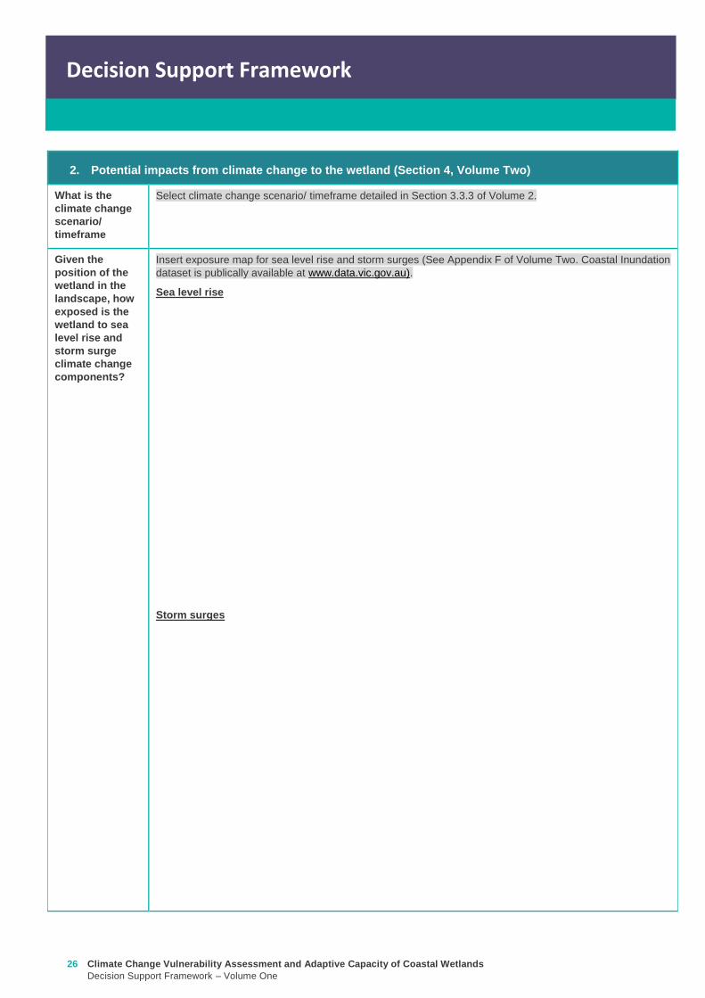
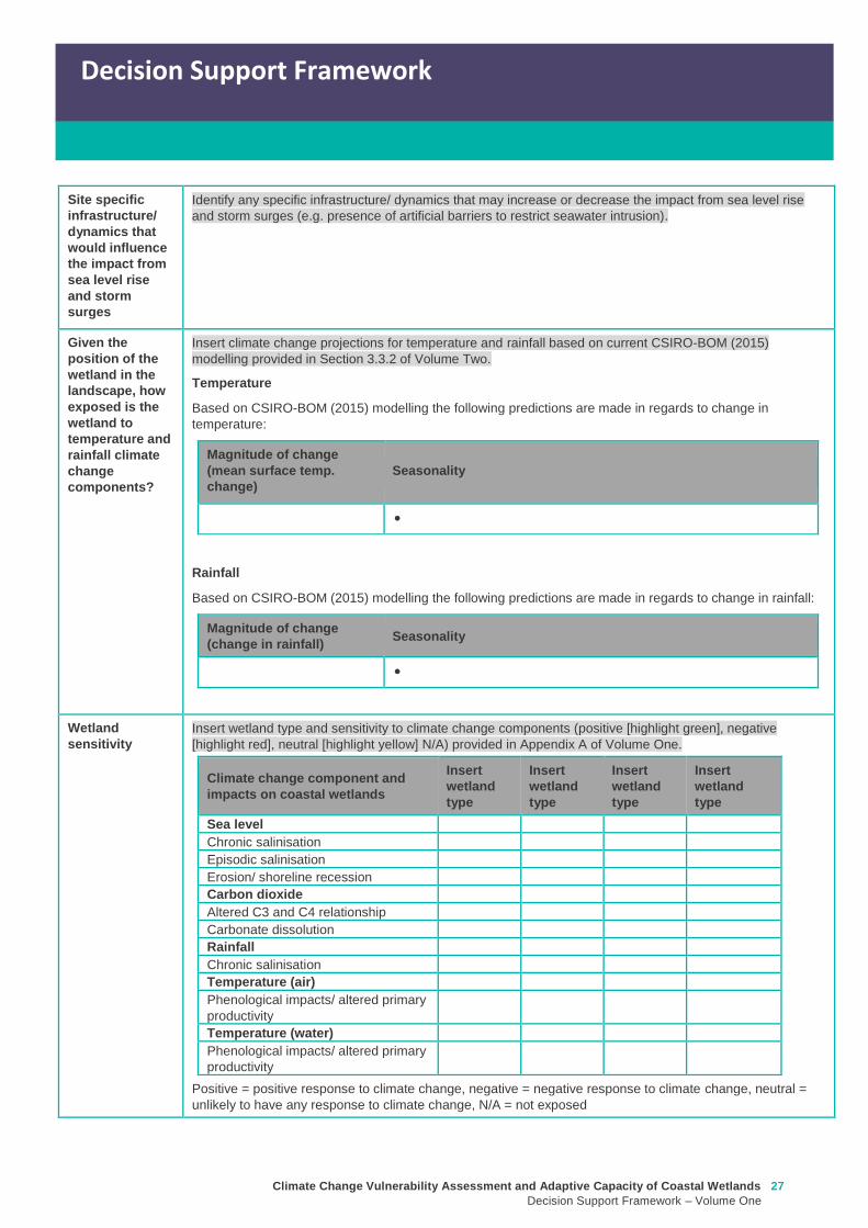
Climate Change Vulnerability Assessment and Adaptive Capacity of Coastal Wetlands
Decision Support Framework ndash Volume One
27
Decision Support Framework
Decision Support Framework
Site specific
infrastructure
dynamics that
would influence
the impact from
sea level rise
and storm
surges
Identify any specific infrastructure dynamics that may increase or decrease the impact from sea level rise
and storm surges (eg presence of artificial barriers to restrict seawater intrusion)
Given the
position of the
wetland in the
landscape how
exposed is the
wetland to
temperature and
rainfall climate
change
components
Insert climate change projections for temperature and rainfall based on current CSIRO-BOM (2015)
modelling provided in Section 332 of Volume Two
Temperature
Based on CSIRO-BOM (2015) modelling the following predictions are made in regards to change in
temperature
Magnitude of change
(mean surface temp
change)
Seasonality
Rainfall
Based on CSIRO-BOM (2015) modelling the following predictions are made in regards to change in rainfall
Magnitude of change
(change in rainfall) Seasonality
Wetland
sensitivity
Insert wetland type and sensitivity to climate change components (positive [highlight green] negative
[highlight red] neutral [highlight yellow] NA) provided in Appendix A of Volume One
Climate change component and
impacts on coastal wetlands
Insert
wetland
type
Insert
wetland
type
Insert
wetland
type
Insert
wetland
type
Sea level
Chronic salinisation
Episodic salinisation
Erosion shoreline recession
Carbon dioxide
Altered C3 and C4 relationship
Carbonate dissolution
Rainfall
Chronic salinisation
Temperature (air)
Phenological impacts altered primary
productivity
Temperature (water)
Phenological impacts altered primary
productivity
Positive = positive response to climate change negative = negative response to climate change neutral =
unlikely to have any response to climate change NA = not exposed
28 Climate Change Vulnerability Assessment and Adaptive Capacity of Coastal Wetlands
Decision Support Framework ndash Volume One
Decision Support Framework
Likely outcome Based on the Table 2 in Section 32 of Volume One and the conceptual models presented in Section 41 of
Volume Two
Adaptive
capacity
General adaptive capacity of wetland types present
Describe based on the conceptual models presented in Section 41 of Volume Two and populated table
based on table provided in Section 43 of Volume Two
Wetland
type
Adaptive
capacity Main adaptive mechanism Main limiting factor
Site specific adaptive capacity
Need to consider site specific opportunities and constraints to adaptive capacity based on site specific
characteristics
3 Management objectives and actions (Section 5 of Volume Two)
Constraints to
management
See Section 51 of Volume Two report for more detail
Barriers to migration
Land ownership
Funding
Limitations to knowledge and data
Other potential constraints
Pre-existing threats Identify pre-existing threats that may impact the wetlands capacity to cope with change
Pre-existing
management
objectives
Document local and regional management objectives in pre-existing management plans and
strategies
Proposed management
objective in relation to
climate change
Based on wetland values and existing objectives define the management objective for the wetland in
relation to climate change See Section 52 of Volume Two for more detail
Climate Change Vulnerability Assessment and Adaptive Capacity of Coastal Wetlands
Decision Support Framework ndash Volume One
29
Decision Support Framework
Decision Support Framework
Management actions to
address climate
change impacts and
management
objectives
Identify a suite of management actions for the site See Section 53 of Volume Two for more details
May include existing and new management actions
Existing actions
Management Action Timeframe
New actions
Management Action Timeframe Responsibility
4 Recommendations
Identify any recommendations for management of the wetland eg addressing data gaps further investigation required
development of management or implementation plan
5 Key management resource documents
Insert useful resource documents and web links associated with management at the site including but not limited to
1 Peters G Morris K Frood D Papas P and Roberts J (2015) A Guide to managing livestock grazing in Victorias
wetlands Decision framework and guidelines - Version 10 Arthur Rylah Institute for Environmental Research Technical
Report Series Report number 265
2 Morris K and Papas P (2012) Wetland conceptual models associations between wetland values threats and management
interventions Version one Arthur Rylah Institute for Environmental Research Technical Report Series Report number 237
3 DELWP wetland buffers guidelines (in prep)
4 DELWP wetland revegetation guidelines (in prep)
5 DELWP wetland invasive species management guidelines (in prep)
6 SKM (2005) Guidelines for the design and operation of environmentally friendly wetland regulators (MDBC project report
R2002) Report by Sinclair Knight Merz for the MDBC
6 Key references
Insert key reference supporting documents used to populate decision support framework template
Appendix D Decision Support Framework case study application
30 Climate Change Vulnerability Assessment and Adaptive Capacity of Coastal Wetlands
Decision Support Framework ndash Volume One
Climate Change Vulnerability Assessment and Adaptive Capacity of Coastal Wetlands
Decision Support Framework ndash Volume One
31
Coastal Wetlands and Climate Change
Decision Support Framework
Site Name Powlett River Estuary
Purpose
This document provides a Decision Support Framework to enable wetland managers to assess the
vulnerability and adaptive capacity of wetlands to climate change at an individual wetland or local landscape
scale The DELWP Climate Change Vulnerability Assessment and Adaptive Capacity of Coastal Wetlands
report provides the background and supporting material for this assessment and should be used in
conjunction with each stage of the assessment process outlined below
The broad approach applied in the Decision Support Framework is illustrated below It is a three step
approach that includes
Step 1 Wetland type ndash in this step you identify your wetland type (eg mangrove saltmarsh) using
a combination of the coastal wetland dataset developed as part of this project and your existing
knowledge of the site This step guides the sensitivity assessment undertaken in step 2
Step 2 Assess potential impacts from climate change ndash in this step you consider the position of
your wetland in the landscape so you can determine which component of climate change the
wetland is most sensitive to This step involves undertaking the exposure and sensitivity
components of the vulnerability assessment outlined above using the exposure mapping the
conceptual models and the sensitivity tables provided in the supporting documents
Step 3 Identify management objectives and actions ndash in this step you consider the adaptation
mechanisms possible for your wetland and develop management objectives and actions This step
will inform the development of a management plan which is undertaken outside of the DSF
Step 2 Assess potential impacts from climate change
(refer to Section 4 and Section 5 Volume 2)
Given the location of the wetland in the landscape which components of climate change is the
wetland sensitive to and what is the likely response to climate change
Step 3 Identify management objectives and actions
(refer to Section 6 Volume 2)
a) Identify constraints and
potential management
objectives and actions
b) Confirm
management
objectives
c) Confirm management
actions and develop
implementation plan
Step 1 Wetland type
(refer to Section 3 Volume 2)
What is the wetland type
32 Climate Change Vulnerability Assessment and Adaptive Capacity of Coastal Wetlands
Decision Support Framework ndash Volume One
Decision Support Framework
1 Wetland identification (Section 2 Volume Two)
Name Powlett River Estuary
Location address Located in the West Gippsland Catchment Management Authority (CMA) region near the coast
between Kilcunda and Wonthaggi
Easting 370380205 Northing 5728345662
Bioregion Gippsland Plain
Wetland category
(Section 24 Volume
Two)
Tidal wetlands
Marine embayment
Estuarine (intertidal)
Estuarine (supratidal)
Non-tidal wetland
Coastal floodplain
Dune system
Wetland type EVC
group(s)
(Section 23 Volume
Two and supporting
geospatial dataset)
Seagrass
Saltmarsh
Mangroves
Brackish wetland
Freshwater wetland (floodplain)
Freshwater wetland (dune)
Riparian swampy scrub
Estuarine wetland
Estuarine scrubs heathlands and
woodlands
Estuary classification
(if relevant)
httpwwwozcoastsgov
ausearch_datamap_se
archjsp
Classification
Wave dominated
Sub-classification
Wave dominated delta
Tide dominated delta
Wave dominated estuary
Tide dominated estuary
Tide dominated
Coastal lagoon
Strandplain
Tidal flat creek
Other
Estuary
geomorphology (if
relevant)
Permanently open
Permanently closed
Intermittently opened and closed
Climate Change Vulnerability Assessment and Adaptive Capacity of Coastal Wetlands
Decision Support Framework ndash Volume One
33
Decision Support Framework
Decision Support Framework
Wetland values
The Powlett River Estuary has a diverse range of bird plant and fish communities
5 different EVCs including coastal saltmarsh (Coastal Tussock Saltmarsh and Wet Saltmarsh
Herbland) protected under the Environmental Protection and Biodiversity Conservation Act
1999 (EPBC Act)
22 fish species including the Australian Grayling which is listed threatened under the Flora
and Fauna Guarantee Act 1988 (FFG Act) and vulnerable under the EPBC Act
31 State Australian and Internationally listed bird species including the critically endangered
Orange-bellied Parrot (WGCMA 2015)
The Powlett River Estuary also has significant social and economic value
Recreational activities ndash fishing sightseeing swimming walking bird watching picnics etc
Coastal dunes near the mouth of the Estuary have Aboriginal cultural heritage significance
(number of coastal midden sites recorded)
Landholders commonly graze along the river upstream of the Mouth of Powlett Road
Water source for irrigation and stock and domestic water use (WGCMA 2015)
34 Climate Change Vulnerability Assessment and Adaptive Capacity of Coastal Wetlands
Decision Support Framework ndash Volume One
Decision Support Framework
2 Potential impacts from climate change to the wetland (Section 4 Volume Two)
What is the
climate change
scenario
timeframe
Based on CSIRO-BOM (20015) modelling RCP 45 (moderate response to climate change) and RCP 85
(worst case scenario business as usual response to climate change)
Timeframes 2050 2070 and 2090 were all considered
Given the
position of the
wetland in the
landscape how
exposed is the
wetland to sea
level rise and
storm surge
climate change
components
Sea level rise
Climate Change Vulnerability Assessment and Adaptive Capacity of Coastal Wetlands
Decision Support Framework ndash Volume One
35
Decision Support Framework
Decision Support Framework
Storm surges
Site specific
infrastructure
dynamics that
would influence
the impact from
sea level rise
and storm
surges
There is currently no infrastructure at the Powlett River Estuary that would influence the extent of inundation
from the projected sea level rise and storm surges
When the mouth of the estuary is closed this may help mitigate some of impact of sea level
Given the
position of the
wetland in the
landscape how
exposed is the
wetland to
temperature and
rainfall climate
change
components
Temperature
Based on CSIRO-BOM (2015) modelling the following predictions are made in regards to change in
temperature
Magnitude of change
(mean surface temp
change)
Seasonality
RCP 45
2050 = 05 to 1degC
2070 = gt1 to 15degC
2090 = gt1 to 15degC
RCP 85
2050 = gt15 to 2degC
2070 = gt2 to 25degC
2090 = gt3 to 35deg
Temperature increases are similar in all seasons with some models
simulating to some extent larger increases in summer and autumn
than in other seasons
Projected changes for both daily maximum and minimum
temperature generally follow those of the mean temperature
although there is somewhat lower warming in daily minimum
temperatures than daily maximum temperatures in autumn winter
and spring
Increase in the temperature reached on the hottest days an increase
in the frequency of very hot days and duration of warm spells
36 Climate Change Vulnerability Assessment and Adaptive Capacity of Coastal Wetlands
Decision Support Framework ndash Volume One
Decision Support Framework
Given the
position of the
wetland in the
landscape how
exposed is the
wetland to
temperature and
rainfall climate
change
components
Rainfall
Based on CSIRO-BOM (2015) modelling the following predictions are made in regards to change in rainfall
Magnitude of change
(change in rainfall) Seasonality
RCP 45
2050 = 25 to 75
2070 = gt -25 to 25
2090 = gt -25 to 25
RCP 85
2050 = gt - 75 to -25
2070 = gt - 75 to -25
2090 = gt -125 to - 75
Rainfall declines are strongest in winter and spring Projected
reductions in winter rainfall in the Victoria NSW East region are up
to 30 in 2090 under high emissions
There is little change projected in autumn and either increases or
decreases in summer rainfall are possible
Tendency for heavier rainfall interspersed by longer dry periods
with some extremely dry and wet years with natural variability
continuing to be a major driver of rainfall for the near future (2030)
Intensity of heavy rainfall events is predicted to increase with
timing and magnitude also driven by natural variability
A decline in the number but an increase in the intensity of east
coast lows impacting on average rainfall and heavy rain events
Time spent in drought is predicted to increase over the course of
this century in line with changes to average rainfall and the
frequency and duration of extreme droughts will increase
Wetland
sensitivity
Climate change component and
impacts on coastal wetlands Saltmarsh
Estuarine
Wetland
Swamp
scrub
Swampy
riparian
woodland
Sea level
Chronic salinisation Positive Neutral Negative Negative
Episodic salinization Negative Negative Negative Negative
Erosion shoreline recession Negative Negative Negative Negative
Carbon dioxide
Altered C3 and C4 relationship Negative Neutral Neutral Neutral
Carbonate dissolution Neutral Neutral Neutral Neutral
Rainfall
Chronic salinisation Positive Neutral Negative Negative
Temperature (air)
Phenological impacts altered primary
productivity
Positive Positive Positive Positive
Temperature (water)
Phenological impacts altered primary
productivity
Neutral Neutral Neutral Neutral
Positive = positive response to climate change negative = negative response to climate change neutral =
unlikely to have any response to climate change NA = not exposed
Likely outcome Estuary
Potential change from intermittently open estuary mouth to permanently opened or more permanently
closed estuary depending on regional changes to rainfallcatchment runoff river discharge eustatic
sea levels and storm surges May become more similar to Andersons Inlet (marine embayment) to
the east
Saline intrusion into the upper estuary and lower freshwater reaches of the river due to increased sea
levels and storm surge activity and reduced rainfallcatchment runoff
Climate Change Vulnerability Assessment and Adaptive Capacity of Coastal Wetlands
Decision Support Framework ndash Volume One
37
Decision Support Framework
Decision Support Framework
Saline intrusion into groundwater results in a changed in species composition year round
Saltmarsh
More permanent inundation or increased frequency and duration of inundation
Change in salinity and water regime
Changes in distribution along the elevational gradient from the sea with possible landward migration
Possible invasion by mangroves if geomorphic changes result in a more permanent estuary opening
(eg similar to Andersons Inlet)
Many of the saltmarsh taxa at the site are C3 plants so potentially advantaged by increases in
atmospheric CO2 concentrations
Increased pressure from weed invasion from surrounding agricultural land
Saline intrusion into groundwater results in a changed wetland environment
Estuarine Wetland
Change in salinity and water regime (eg reduced freshwater inflows and saline intrusion increased
evaporation losses)
Increased pressure from weed invasion
Saline intrusion into groundwater results in a changed wetland environment
Riparian scrub and swampy riparian woodland
Change in salinity and water regime (eg reduced freshwater inflows and saline intrusion decreased
rainfall increased extreme flood events)
Rise in saline conditions along riparian zone
Replacement with saltmarsh as a result of increased salinity
Increased pressure from weed invasion
Saline intrusion into groundwater results in a changed species composition year round
Adaptive
capacity
General adaptive capacity of wetland types present
Wetland
type
Adaptive
capacity Main adaptive mechanism Main limiting factor
Saltmarsh Low Sediment accretion movement
to higher elevations positive
response to increase
temperature (variable
responses to increased CO2)
Rate of sea level rise storm surge
intensity and shoreline erosion
seawalls and other physical
impediments impact of increased
atmospheric CO2 impacts on floristic
composition
Estuarine
wetland
Moderate Positive response to
temperature neutral to most
other impacts until sea levels
make the sites intertidal
Salinisation and waterlogging due to
storm surges
Swamp
scrub
Low Positive response to
temperature
Salinisation and waterlogging (ie
changes to wetting and drying regimes)
Swampy
Riparian
woodland
Low Positive response to
temperature
Salinisation and waterlogging (ie
changes to wetting and drying regimes)
38 Climate Change Vulnerability Assessment and Adaptive Capacity of Coastal Wetlands
Decision Support Framework ndash Volume One
Decision Support Framework
Site specific adaptive capacity
Not completed as part of case study ndash requires specific assessments of opportunities and constraints to
adaptive capacity based on site specific characteristics
3 Management objectives and actions (Section 5 of Volume Two)
Constraints to
management
Barriers to migration
Mouth of Powlett Road is a barrier to wetland migration
Rail trail towards Dayleston provides a barrier to landward migration
Small cluster of housing north east of the estuary mouth similarly constrains landward
migration
Land ownership
The land in which wetlands could migrate in to is predominately private land used for
agriculture (grazing and cropping)
Funding
Limited funding available ndash not a priority site State wide nor Ramsar listed
Whilst there is good collaboration between agencies and landholders there are different
priorities for the funding available and therefore so some actions are difficult to implement An
example includes raising roads and carparks that experience inundation during closure
events or buying back regularly inundated marginal farmland
Limitations to knowledge and data
Uncertainty around the likely geomorphic changes to the estuary mouth (ie change in estuary
dynamic)
Understanding the economic value of the estuary coastal wetlands (eg value of wetlands
versus the value of agricultural land)
Uncertainty around acid sulfate soils as a result of climate change
Other potential constraints
Current State policies and procedures for statutory planning changes and land buyback to
enable long term management
Community understanding and expectation around estuary opening and closing
Pre-existing threats The key pre-existing threats identified in the Powlett River Estuary Management Plan that may
influence the resilience of the estuary to climate change impacts include
Degraded water quality
Degraded riparian vegetation (large trees in particular)
Trampling and bank erosion associated with pedestrian access
Rural drainage and drain clearing
Channelisation of the river channel
Vehicle access
Livestock access
Pest plants and animals
Inappropriate recreation causing dune erosion
Disturbance of acid sulfate soils
Climate Change Vulnerability Assessment and Adaptive Capacity of Coastal Wetlands
Decision Support Framework ndash Volume One
39
Decision Support Framework
Decision Support Framework
Pre-existing
management
objectives
Regional catchment strategy
No coastal wetland specific actions objectives for the Powlett River
West Gippsland Waterways Strategy (2014-2022)
Regional objectives relating to the Powlett River Estuary as a coastal wetland
Maintain and improve the habitat and condition of waterways to support waterway dependent
animals and plants
Maintain the ecological character of significant wetlands and estuaries
Catchment objectives for Powlett River Estuary relating to coastal wetlands include
Riparian vegetation provides improved visual amenity and contributes to community use of
waterways
The extent of freshwater wetlands is maintained and their condition is improved
Powlett Estuary Management Plan
Swamp scrub swampy riparian woodland and estuarine wetland vegetation communities are
enhanced and significantly increased in the area
West Gippsland Regional NRM Climate Change Strategy (2016)
The strategy outlines approaches and options to support climate change adaptation and mitigation
The objectives of the adaptation and management strategies are linked to the 20 year objectives in
the Regional Catchment Strategy The Powlett River Estuary is located within the Bunurong Coastal
planning area The estuary is listed as one of the most vulnerable estuary assets to climate change
across the region
Reports are available at lthttpwwwwgcmavicgovauour-regionwaterwayspowlett-river-estuarygt
[Verified 17052016 ]
Proposed management
objective in relation to
climate change
The following management objective is based the existing geomorphic characteristics of the estuary
(ie intermittently closed estuary)
To enhance and significantly increase Swamp scrub Swampy riparian woodland and estuarine
wetland vegetation extent through the facilitation of landward migration of these communities over the
next 50 years
Climate change also poses a threat to non-wetland EVCs (eg Coast Banksia Woodland) and
therefore even though they are not considered in this coastal wetland risk assessment they are still a
management consideration for the CMA in the coastal zone
Management actions to
address climate
change impacts and
management
objectives
Existing actions
Existing management actions provided in Section 81 of the Estuary Management Plan (WGCMA
2015) that are related to climate change are listed below
Management Action Timeframe
E31 Investigate opportunities for land purchase within the inundation
areas of the estuary
8 years
E32 Design and implement a program of stewardship payment for the
seasonal inundation of estuary floodplain from estuary mouth closures
Priority should be given to enhancing coastal saltmarsh and estuarine
wetland communities Payments should be calculated and prioritised
based on potential value to estuary health and ability to minimise artificial
estuary mouth openings
8 years
E 39 Investigate opportunities to encourage the conversion of Crown land
water frontage grazing licences to riparian management licences
8 years
E 43 Undertake hydraulic modelling and bathymetry survey of the Powlett 8 years
40 Climate Change Vulnerability Assessment and Adaptive Capacity of Coastal Wetlands
Decision Support Framework ndash Volume One
Decision Support Framework
estuary floodplain to understand the impacts and benefits of the structures
(including levees and drains) and landforms that affect the movement of
water before during and after artificial estuary mouth opening before
considering any updates changes or removal of these floodplain features
E 44 Undertake a detailed risk assessment including on-ground mapping
to identify potential and active acid sulphate soils with the Powlett estuarine
floodplain
8 years
E 46 Investigate the use of the saltmarsh wetlands and estuary channel
by recreational fish species and other native fish species particularly Black
Bream and prioritise areas for further protection
8 years
E 49 Continue to build understanding of and plan for the risks associated
with climate change including sea level rise This includes future flood
risk
8 years
New actions
The following additional management actions should be considered
Management Action Timeframe Responsibility
Complete a study to assess the likely geomorphic changes
to the estuary as a result of climate change
2 years WGCMA
Undertake scenario planning in consultation with Bass Coast
Shire Council VicRoads and Parks Victoria- refine
management actions and objectives for Estuary based on
finding of geomorphic study This could identify nearby
systems that could form a template for what Powlett River
might look like in the future (eg Andersons Inlet)
2-5 years WGCMA
Review Bass Coast Planning Scheme to understand any
implications to future management actions works at the
Powlett Estuary Provide feedback to the State Government
on any issues associated with State policies and procedures
for statutory planning that may constrain long term
management of the Estuary
2-5 years WGCMA
Consultation with other relevant managers in the area
(including Council VicRoads and Parks Victoria) to discuss
potential issues associated road repairs culverts and other
flood mitigation measures in the area that may arise as a
result of climate change
2-5 years WGCMA
Resolve issues and complexities around the impacts of
climate change (sea level rise) on crown land boundaries
2-5 years State
Government
Resolve issues associated with State policies and
procedures for statutory planning that may constrain long
term management of the Estuary
2-5 years State
Government
Community engagement and education program to provide
the community with an understanding of the predicted
impacts of climate change and enable them to play an active
role in management
2-5 years WGCMA
Estuary Management Plan Action E31 (see above) ndash to
become 2 actions
a Investigate opportunities for land purchase within the
8 years WGCMA
Climate Change Vulnerability Assessment and Adaptive Capacity of Coastal Wetlands
Decision Support Framework ndash Volume One
41
Decision Support Framework
Decision Support Framework
current inundation areas of the estuary
b Investigate opportunities for land purchase within the
future inundation areas of the estuary
Estuary Management Plan Action E32 (see above) ndash
include consideration of future inundation eg ldquoDesign and
implement a program of stewardship payment for the
seasonal inundation of estuary floodplain from estuary
mouth closures under both current and future inundation
conditionsrdquo
8 years WGCMA
Estuary Management Plan Action E 39 (see above) ndash to
become 2 actions
a Investigate opportunities to encourage the conversion of
current Crown land water frontage grazing licences to
riparian management licences
b Investigate issues and opportunities related to sea level
rise impacts on Crown Land Water frontage grazing licences
and riparian management licences (including how to define
boundaries if existing boundaries are inundated by sea level
rise)
8 years WGCMA
Estuary Management Plan Action E44 (see above) ndash
Undertake detailed risk assessment of potential and active
acid sulfate soils
8 years WGCMA
Estuary Management Plan Action E49 (see above) ndash
Continue to build understanding of and plan for risks
associated with climate change
8 years WGCMA
4 Recommendations
1 Climate change threats are currently implied within the management actions in the Powlett River Estuary Management Plan It
is recommended that additional material on climate change impacts be included and climate change threats addressed more
explicitly in the management actions This would meet Action E49 in particular
2 Management objectives also need to consider management for a 30-50 year timeframe ie take in to consideration longer
term climate change impacts including on estuary mouth dynamics A distinction between responses to current and future
threats should be made
5 Key management resource documents
1 Peters G Morris K Frood D Papas P and Roberts J (2015) A Guide to managing livestock grazing in Victorias
wetlands Decision framework and guidelines - Version 10 Arthur Rylah Institute for Environmental Research Technical
Report Series Report number 265
2 Morris K and Papas P (2012) Wetland conceptual models associations between wetland values threats and management
interventions Version one Arthur Rylah Institute for Environmental Research Technical Report Series Report number 237
3 DELWP wetland buffers guidelines (in prep)
4 DELWP wetland revegetation guidelines (in prep)
5 DELWP wetland invasive species management guidelines (in prep)
6 SKM (2005) Guidelines for the design and operation of environmentally friendly wetland regulators (MDBC project report
R2002) Report by Sinclair Knight Merz for the MDBC
42 Climate Change Vulnerability Assessment and Adaptive Capacity of Coastal Wetlands
Decision Support Framework ndash Volume One
Decision Support Framework
6 Key references
1 WGCMA (2012) West Gippsland Regional Catchment Strategy 2013-2019 West Gippsland Catchment Management
Authority
2 WGCMA (2014) West Gippsland Waterway Strategy 2014-2022 West Gippsland Catchment Management Authority
3 WGCMA (2015) Powlett River Estuary Management Plan West Gippsland Catchment Management Authority
4 WGCMA (2016) West Gippsland Regional NRM Climate Change Strategy ndash Final Draft West Gippsland Catchment
Management Authority
5 CSIRO and BOM (2015) Southern Slopes Cluster Report Climate Change in Australia Projections for Australiarsquos Natural
Resource Management Regions Cluster Reports eds Ekstroumlm M et al CSIRO and Bureau of Meteorology Australia
Climate Change Vulnerability Assessment and Adaptive Capacity of Coastal Wetlands
Decision Support Framework ndash Volume One
43
Decision Support Framework
Decision Support Framework
delwpvicgovau delwpvicgovau
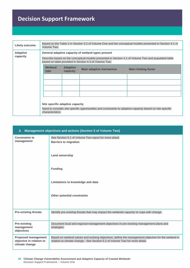
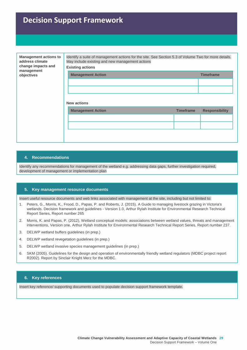
Climate Change Vulnerability Assessment and Adaptive Capacity of Coastal Wetlands
Decision Support Framework ndash Volume One
29
Decision Support Framework
Decision Support Framework
Management actions to
address climate
change impacts and
management
objectives
Identify a suite of management actions for the site See Section 53 of Volume Two for more details
May include existing and new management actions
Existing actions
Management Action Timeframe
New actions
Management Action Timeframe Responsibility
4 Recommendations
Identify any recommendations for management of the wetland eg addressing data gaps further investigation required
development of management or implementation plan
5 Key management resource documents
Insert useful resource documents and web links associated with management at the site including but not limited to
1 Peters G Morris K Frood D Papas P and Roberts J (2015) A Guide to managing livestock grazing in Victorias
wetlands Decision framework and guidelines - Version 10 Arthur Rylah Institute for Environmental Research Technical
Report Series Report number 265
2 Morris K and Papas P (2012) Wetland conceptual models associations between wetland values threats and management
interventions Version one Arthur Rylah Institute for Environmental Research Technical Report Series Report number 237
3 DELWP wetland buffers guidelines (in prep)
4 DELWP wetland revegetation guidelines (in prep)
5 DELWP wetland invasive species management guidelines (in prep)
6 SKM (2005) Guidelines for the design and operation of environmentally friendly wetland regulators (MDBC project report
R2002) Report by Sinclair Knight Merz for the MDBC
6 Key references
Insert key reference supporting documents used to populate decision support framework template
Appendix D Decision Support Framework case study application
30 Climate Change Vulnerability Assessment and Adaptive Capacity of Coastal Wetlands
Decision Support Framework ndash Volume One
Climate Change Vulnerability Assessment and Adaptive Capacity of Coastal Wetlands
Decision Support Framework ndash Volume One
31
Coastal Wetlands and Climate Change
Decision Support Framework
Site Name Powlett River Estuary
Purpose
This document provides a Decision Support Framework to enable wetland managers to assess the
vulnerability and adaptive capacity of wetlands to climate change at an individual wetland or local landscape
scale The DELWP Climate Change Vulnerability Assessment and Adaptive Capacity of Coastal Wetlands
report provides the background and supporting material for this assessment and should be used in
conjunction with each stage of the assessment process outlined below
The broad approach applied in the Decision Support Framework is illustrated below It is a three step
approach that includes
Step 1 Wetland type ndash in this step you identify your wetland type (eg mangrove saltmarsh) using
a combination of the coastal wetland dataset developed as part of this project and your existing
knowledge of the site This step guides the sensitivity assessment undertaken in step 2
Step 2 Assess potential impacts from climate change ndash in this step you consider the position of
your wetland in the landscape so you can determine which component of climate change the
wetland is most sensitive to This step involves undertaking the exposure and sensitivity
components of the vulnerability assessment outlined above using the exposure mapping the
conceptual models and the sensitivity tables provided in the supporting documents
Step 3 Identify management objectives and actions ndash in this step you consider the adaptation
mechanisms possible for your wetland and develop management objectives and actions This step
will inform the development of a management plan which is undertaken outside of the DSF
Step 2 Assess potential impacts from climate change
(refer to Section 4 and Section 5 Volume 2)
Given the location of the wetland in the landscape which components of climate change is the
wetland sensitive to and what is the likely response to climate change
Step 3 Identify management objectives and actions
(refer to Section 6 Volume 2)
a) Identify constraints and
potential management
objectives and actions
b) Confirm
management
objectives
c) Confirm management
actions and develop
implementation plan
Step 1 Wetland type
(refer to Section 3 Volume 2)
What is the wetland type
32 Climate Change Vulnerability Assessment and Adaptive Capacity of Coastal Wetlands
Decision Support Framework ndash Volume One
Decision Support Framework
1 Wetland identification (Section 2 Volume Two)
Name Powlett River Estuary
Location address Located in the West Gippsland Catchment Management Authority (CMA) region near the coast
between Kilcunda and Wonthaggi
Easting 370380205 Northing 5728345662
Bioregion Gippsland Plain
Wetland category
(Section 24 Volume
Two)
Tidal wetlands
Marine embayment
Estuarine (intertidal)
Estuarine (supratidal)
Non-tidal wetland
Coastal floodplain
Dune system
Wetland type EVC
group(s)
(Section 23 Volume
Two and supporting
geospatial dataset)
Seagrass
Saltmarsh
Mangroves
Brackish wetland
Freshwater wetland (floodplain)
Freshwater wetland (dune)
Riparian swampy scrub
Estuarine wetland
Estuarine scrubs heathlands and
woodlands
Estuary classification
(if relevant)
httpwwwozcoastsgov
ausearch_datamap_se
archjsp
Classification
Wave dominated
Sub-classification
Wave dominated delta
Tide dominated delta
Wave dominated estuary
Tide dominated estuary
Tide dominated
Coastal lagoon
Strandplain
Tidal flat creek
Other
Estuary
geomorphology (if
relevant)
Permanently open
Permanently closed
Intermittently opened and closed
Climate Change Vulnerability Assessment and Adaptive Capacity of Coastal Wetlands
Decision Support Framework ndash Volume One
33
Decision Support Framework
Decision Support Framework
Wetland values
The Powlett River Estuary has a diverse range of bird plant and fish communities
5 different EVCs including coastal saltmarsh (Coastal Tussock Saltmarsh and Wet Saltmarsh
Herbland) protected under the Environmental Protection and Biodiversity Conservation Act
1999 (EPBC Act)
22 fish species including the Australian Grayling which is listed threatened under the Flora
and Fauna Guarantee Act 1988 (FFG Act) and vulnerable under the EPBC Act
31 State Australian and Internationally listed bird species including the critically endangered
Orange-bellied Parrot (WGCMA 2015)
The Powlett River Estuary also has significant social and economic value
Recreational activities ndash fishing sightseeing swimming walking bird watching picnics etc
Coastal dunes near the mouth of the Estuary have Aboriginal cultural heritage significance
(number of coastal midden sites recorded)
Landholders commonly graze along the river upstream of the Mouth of Powlett Road
Water source for irrigation and stock and domestic water use (WGCMA 2015)
34 Climate Change Vulnerability Assessment and Adaptive Capacity of Coastal Wetlands
Decision Support Framework ndash Volume One
Decision Support Framework
2 Potential impacts from climate change to the wetland (Section 4 Volume Two)
What is the
climate change
scenario
timeframe
Based on CSIRO-BOM (20015) modelling RCP 45 (moderate response to climate change) and RCP 85
(worst case scenario business as usual response to climate change)
Timeframes 2050 2070 and 2090 were all considered
Given the
position of the
wetland in the
landscape how
exposed is the
wetland to sea
level rise and
storm surge
climate change
components
Sea level rise
Climate Change Vulnerability Assessment and Adaptive Capacity of Coastal Wetlands
Decision Support Framework ndash Volume One
35
Decision Support Framework
Decision Support Framework
Storm surges
Site specific
infrastructure
dynamics that
would influence
the impact from
sea level rise
and storm
surges
There is currently no infrastructure at the Powlett River Estuary that would influence the extent of inundation
from the projected sea level rise and storm surges
When the mouth of the estuary is closed this may help mitigate some of impact of sea level
Given the
position of the
wetland in the
landscape how
exposed is the
wetland to
temperature and
rainfall climate
change
components
Temperature
Based on CSIRO-BOM (2015) modelling the following predictions are made in regards to change in
temperature
Magnitude of change
(mean surface temp
change)
Seasonality
RCP 45
2050 = 05 to 1degC
2070 = gt1 to 15degC
2090 = gt1 to 15degC
RCP 85
2050 = gt15 to 2degC
2070 = gt2 to 25degC
2090 = gt3 to 35deg
Temperature increases are similar in all seasons with some models
simulating to some extent larger increases in summer and autumn
than in other seasons
Projected changes for both daily maximum and minimum
temperature generally follow those of the mean temperature
although there is somewhat lower warming in daily minimum
temperatures than daily maximum temperatures in autumn winter
and spring
Increase in the temperature reached on the hottest days an increase
in the frequency of very hot days and duration of warm spells
36 Climate Change Vulnerability Assessment and Adaptive Capacity of Coastal Wetlands
Decision Support Framework ndash Volume One
Decision Support Framework
Given the
position of the
wetland in the
landscape how
exposed is the
wetland to
temperature and
rainfall climate
change
components
Rainfall
Based on CSIRO-BOM (2015) modelling the following predictions are made in regards to change in rainfall
Magnitude of change
(change in rainfall) Seasonality
RCP 45
2050 = 25 to 75
2070 = gt -25 to 25
2090 = gt -25 to 25
RCP 85
2050 = gt - 75 to -25
2070 = gt - 75 to -25
2090 = gt -125 to - 75
Rainfall declines are strongest in winter and spring Projected
reductions in winter rainfall in the Victoria NSW East region are up
to 30 in 2090 under high emissions
There is little change projected in autumn and either increases or
decreases in summer rainfall are possible
Tendency for heavier rainfall interspersed by longer dry periods
with some extremely dry and wet years with natural variability
continuing to be a major driver of rainfall for the near future (2030)
Intensity of heavy rainfall events is predicted to increase with
timing and magnitude also driven by natural variability
A decline in the number but an increase in the intensity of east
coast lows impacting on average rainfall and heavy rain events
Time spent in drought is predicted to increase over the course of
this century in line with changes to average rainfall and the
frequency and duration of extreme droughts will increase
Wetland
sensitivity
Climate change component and
impacts on coastal wetlands Saltmarsh
Estuarine
Wetland
Swamp
scrub
Swampy
riparian
woodland
Sea level
Chronic salinisation Positive Neutral Negative Negative
Episodic salinization Negative Negative Negative Negative
Erosion shoreline recession Negative Negative Negative Negative
Carbon dioxide
Altered C3 and C4 relationship Negative Neutral Neutral Neutral
Carbonate dissolution Neutral Neutral Neutral Neutral
Rainfall
Chronic salinisation Positive Neutral Negative Negative
Temperature (air)
Phenological impacts altered primary
productivity
Positive Positive Positive Positive
Temperature (water)
Phenological impacts altered primary
productivity
Neutral Neutral Neutral Neutral
Positive = positive response to climate change negative = negative response to climate change neutral =
unlikely to have any response to climate change NA = not exposed
Likely outcome Estuary
Potential change from intermittently open estuary mouth to permanently opened or more permanently
closed estuary depending on regional changes to rainfallcatchment runoff river discharge eustatic
sea levels and storm surges May become more similar to Andersons Inlet (marine embayment) to
the east
Saline intrusion into the upper estuary and lower freshwater reaches of the river due to increased sea
levels and storm surge activity and reduced rainfallcatchment runoff
Climate Change Vulnerability Assessment and Adaptive Capacity of Coastal Wetlands
Decision Support Framework ndash Volume One
37
Decision Support Framework
Decision Support Framework
Saline intrusion into groundwater results in a changed in species composition year round
Saltmarsh
More permanent inundation or increased frequency and duration of inundation
Change in salinity and water regime
Changes in distribution along the elevational gradient from the sea with possible landward migration
Possible invasion by mangroves if geomorphic changes result in a more permanent estuary opening
(eg similar to Andersons Inlet)
Many of the saltmarsh taxa at the site are C3 plants so potentially advantaged by increases in
atmospheric CO2 concentrations
Increased pressure from weed invasion from surrounding agricultural land
Saline intrusion into groundwater results in a changed wetland environment
Estuarine Wetland
Change in salinity and water regime (eg reduced freshwater inflows and saline intrusion increased
evaporation losses)
Increased pressure from weed invasion
Saline intrusion into groundwater results in a changed wetland environment
Riparian scrub and swampy riparian woodland
Change in salinity and water regime (eg reduced freshwater inflows and saline intrusion decreased
rainfall increased extreme flood events)
Rise in saline conditions along riparian zone
Replacement with saltmarsh as a result of increased salinity
Increased pressure from weed invasion
Saline intrusion into groundwater results in a changed species composition year round
Adaptive
capacity
General adaptive capacity of wetland types present
Wetland
type
Adaptive
capacity Main adaptive mechanism Main limiting factor
Saltmarsh Low Sediment accretion movement
to higher elevations positive
response to increase
temperature (variable
responses to increased CO2)
Rate of sea level rise storm surge
intensity and shoreline erosion
seawalls and other physical
impediments impact of increased
atmospheric CO2 impacts on floristic
composition
Estuarine
wetland
Moderate Positive response to
temperature neutral to most
other impacts until sea levels
make the sites intertidal
Salinisation and waterlogging due to
storm surges
Swamp
scrub
Low Positive response to
temperature
Salinisation and waterlogging (ie
changes to wetting and drying regimes)
Swampy
Riparian
woodland
Low Positive response to
temperature
Salinisation and waterlogging (ie
changes to wetting and drying regimes)
38 Climate Change Vulnerability Assessment and Adaptive Capacity of Coastal Wetlands
Decision Support Framework ndash Volume One
Decision Support Framework
Site specific adaptive capacity
Not completed as part of case study ndash requires specific assessments of opportunities and constraints to
adaptive capacity based on site specific characteristics
3 Management objectives and actions (Section 5 of Volume Two)
Constraints to
management
Barriers to migration
Mouth of Powlett Road is a barrier to wetland migration
Rail trail towards Dayleston provides a barrier to landward migration
Small cluster of housing north east of the estuary mouth similarly constrains landward
migration
Land ownership
The land in which wetlands could migrate in to is predominately private land used for
agriculture (grazing and cropping)
Funding
Limited funding available ndash not a priority site State wide nor Ramsar listed
Whilst there is good collaboration between agencies and landholders there are different
priorities for the funding available and therefore so some actions are difficult to implement An
example includes raising roads and carparks that experience inundation during closure
events or buying back regularly inundated marginal farmland
Limitations to knowledge and data
Uncertainty around the likely geomorphic changes to the estuary mouth (ie change in estuary
dynamic)
Understanding the economic value of the estuary coastal wetlands (eg value of wetlands
versus the value of agricultural land)
Uncertainty around acid sulfate soils as a result of climate change
Other potential constraints
Current State policies and procedures for statutory planning changes and land buyback to
enable long term management
Community understanding and expectation around estuary opening and closing
Pre-existing threats The key pre-existing threats identified in the Powlett River Estuary Management Plan that may
influence the resilience of the estuary to climate change impacts include
Degraded water quality
Degraded riparian vegetation (large trees in particular)
Trampling and bank erosion associated with pedestrian access
Rural drainage and drain clearing
Channelisation of the river channel
Vehicle access
Livestock access
Pest plants and animals
Inappropriate recreation causing dune erosion
Disturbance of acid sulfate soils
Climate Change Vulnerability Assessment and Adaptive Capacity of Coastal Wetlands
Decision Support Framework ndash Volume One
39
Decision Support Framework
Decision Support Framework
Pre-existing
management
objectives
Regional catchment strategy
No coastal wetland specific actions objectives for the Powlett River
West Gippsland Waterways Strategy (2014-2022)
Regional objectives relating to the Powlett River Estuary as a coastal wetland
Maintain and improve the habitat and condition of waterways to support waterway dependent
animals and plants
Maintain the ecological character of significant wetlands and estuaries
Catchment objectives for Powlett River Estuary relating to coastal wetlands include
Riparian vegetation provides improved visual amenity and contributes to community use of
waterways
The extent of freshwater wetlands is maintained and their condition is improved
Powlett Estuary Management Plan
Swamp scrub swampy riparian woodland and estuarine wetland vegetation communities are
enhanced and significantly increased in the area
West Gippsland Regional NRM Climate Change Strategy (2016)
The strategy outlines approaches and options to support climate change adaptation and mitigation
The objectives of the adaptation and management strategies are linked to the 20 year objectives in
the Regional Catchment Strategy The Powlett River Estuary is located within the Bunurong Coastal
planning area The estuary is listed as one of the most vulnerable estuary assets to climate change
across the region
Reports are available at lthttpwwwwgcmavicgovauour-regionwaterwayspowlett-river-estuarygt
[Verified 17052016 ]
Proposed management
objective in relation to
climate change
The following management objective is based the existing geomorphic characteristics of the estuary
(ie intermittently closed estuary)
To enhance and significantly increase Swamp scrub Swampy riparian woodland and estuarine
wetland vegetation extent through the facilitation of landward migration of these communities over the
next 50 years
Climate change also poses a threat to non-wetland EVCs (eg Coast Banksia Woodland) and
therefore even though they are not considered in this coastal wetland risk assessment they are still a
management consideration for the CMA in the coastal zone
Management actions to
address climate
change impacts and
management
objectives
Existing actions
Existing management actions provided in Section 81 of the Estuary Management Plan (WGCMA
2015) that are related to climate change are listed below
Management Action Timeframe
E31 Investigate opportunities for land purchase within the inundation
areas of the estuary
8 years
E32 Design and implement a program of stewardship payment for the
seasonal inundation of estuary floodplain from estuary mouth closures
Priority should be given to enhancing coastal saltmarsh and estuarine
wetland communities Payments should be calculated and prioritised
based on potential value to estuary health and ability to minimise artificial
estuary mouth openings
8 years
E 39 Investigate opportunities to encourage the conversion of Crown land
water frontage grazing licences to riparian management licences
8 years
E 43 Undertake hydraulic modelling and bathymetry survey of the Powlett 8 years
40 Climate Change Vulnerability Assessment and Adaptive Capacity of Coastal Wetlands
Decision Support Framework ndash Volume One
Decision Support Framework
estuary floodplain to understand the impacts and benefits of the structures
(including levees and drains) and landforms that affect the movement of
water before during and after artificial estuary mouth opening before
considering any updates changes or removal of these floodplain features
E 44 Undertake a detailed risk assessment including on-ground mapping
to identify potential and active acid sulphate soils with the Powlett estuarine
floodplain
8 years
E 46 Investigate the use of the saltmarsh wetlands and estuary channel
by recreational fish species and other native fish species particularly Black
Bream and prioritise areas for further protection
8 years
E 49 Continue to build understanding of and plan for the risks associated
with climate change including sea level rise This includes future flood
risk
8 years
New actions
The following additional management actions should be considered
Management Action Timeframe Responsibility
Complete a study to assess the likely geomorphic changes
to the estuary as a result of climate change
2 years WGCMA
Undertake scenario planning in consultation with Bass Coast
Shire Council VicRoads and Parks Victoria- refine
management actions and objectives for Estuary based on
finding of geomorphic study This could identify nearby
systems that could form a template for what Powlett River
might look like in the future (eg Andersons Inlet)
2-5 years WGCMA
Review Bass Coast Planning Scheme to understand any
implications to future management actions works at the
Powlett Estuary Provide feedback to the State Government
on any issues associated with State policies and procedures
for statutory planning that may constrain long term
management of the Estuary
2-5 years WGCMA
Consultation with other relevant managers in the area
(including Council VicRoads and Parks Victoria) to discuss
potential issues associated road repairs culverts and other
flood mitigation measures in the area that may arise as a
result of climate change
2-5 years WGCMA
Resolve issues and complexities around the impacts of
climate change (sea level rise) on crown land boundaries
2-5 years State
Government
Resolve issues associated with State policies and
procedures for statutory planning that may constrain long
term management of the Estuary
2-5 years State
Government
Community engagement and education program to provide
the community with an understanding of the predicted
impacts of climate change and enable them to play an active
role in management
2-5 years WGCMA
Estuary Management Plan Action E31 (see above) ndash to
become 2 actions
a Investigate opportunities for land purchase within the
8 years WGCMA
Climate Change Vulnerability Assessment and Adaptive Capacity of Coastal Wetlands
Decision Support Framework ndash Volume One
41
Decision Support Framework
Decision Support Framework
current inundation areas of the estuary
b Investigate opportunities for land purchase within the
future inundation areas of the estuary
Estuary Management Plan Action E32 (see above) ndash
include consideration of future inundation eg ldquoDesign and
implement a program of stewardship payment for the
seasonal inundation of estuary floodplain from estuary
mouth closures under both current and future inundation
conditionsrdquo
8 years WGCMA
Estuary Management Plan Action E 39 (see above) ndash to
become 2 actions
a Investigate opportunities to encourage the conversion of
current Crown land water frontage grazing licences to
riparian management licences
b Investigate issues and opportunities related to sea level
rise impacts on Crown Land Water frontage grazing licences
and riparian management licences (including how to define
boundaries if existing boundaries are inundated by sea level
rise)
8 years WGCMA
Estuary Management Plan Action E44 (see above) ndash
Undertake detailed risk assessment of potential and active
acid sulfate soils
8 years WGCMA
Estuary Management Plan Action E49 (see above) ndash
Continue to build understanding of and plan for risks
associated with climate change
8 years WGCMA
4 Recommendations
1 Climate change threats are currently implied within the management actions in the Powlett River Estuary Management Plan It
is recommended that additional material on climate change impacts be included and climate change threats addressed more
explicitly in the management actions This would meet Action E49 in particular
2 Management objectives also need to consider management for a 30-50 year timeframe ie take in to consideration longer
term climate change impacts including on estuary mouth dynamics A distinction between responses to current and future
threats should be made
5 Key management resource documents
1 Peters G Morris K Frood D Papas P and Roberts J (2015) A Guide to managing livestock grazing in Victorias
wetlands Decision framework and guidelines - Version 10 Arthur Rylah Institute for Environmental Research Technical
Report Series Report number 265
2 Morris K and Papas P (2012) Wetland conceptual models associations between wetland values threats and management
interventions Version one Arthur Rylah Institute for Environmental Research Technical Report Series Report number 237
3 DELWP wetland buffers guidelines (in prep)
4 DELWP wetland revegetation guidelines (in prep)
5 DELWP wetland invasive species management guidelines (in prep)
6 SKM (2005) Guidelines for the design and operation of environmentally friendly wetland regulators (MDBC project report
R2002) Report by Sinclair Knight Merz for the MDBC
42 Climate Change Vulnerability Assessment and Adaptive Capacity of Coastal Wetlands
Decision Support Framework ndash Volume One
Decision Support Framework
6 Key references
1 WGCMA (2012) West Gippsland Regional Catchment Strategy 2013-2019 West Gippsland Catchment Management
Authority
2 WGCMA (2014) West Gippsland Waterway Strategy 2014-2022 West Gippsland Catchment Management Authority
3 WGCMA (2015) Powlett River Estuary Management Plan West Gippsland Catchment Management Authority
4 WGCMA (2016) West Gippsland Regional NRM Climate Change Strategy ndash Final Draft West Gippsland Catchment
Management Authority
5 CSIRO and BOM (2015) Southern Slopes Cluster Report Climate Change in Australia Projections for Australiarsquos Natural
Resource Management Regions Cluster Reports eds Ekstroumlm M et al CSIRO and Bureau of Meteorology Australia
Climate Change Vulnerability Assessment and Adaptive Capacity of Coastal Wetlands
Decision Support Framework ndash Volume One
43
Decision Support Framework
Decision Support Framework
delwpvicgovau delwpvicgovau
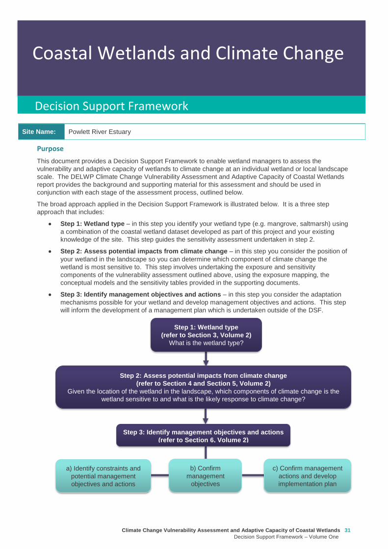
Climate Change Vulnerability Assessment and Adaptive Capacity of Coastal Wetlands
Decision Support Framework ndash Volume One
31
Coastal Wetlands and Climate Change
Decision Support Framework
Site Name Powlett River Estuary
Purpose
This document provides a Decision Support Framework to enable wetland managers to assess the
vulnerability and adaptive capacity of wetlands to climate change at an individual wetland or local landscape
scale The DELWP Climate Change Vulnerability Assessment and Adaptive Capacity of Coastal Wetlands
report provides the background and supporting material for this assessment and should be used in
conjunction with each stage of the assessment process outlined below
The broad approach applied in the Decision Support Framework is illustrated below It is a three step
approach that includes
Step 1 Wetland type ndash in this step you identify your wetland type (eg mangrove saltmarsh) using
a combination of the coastal wetland dataset developed as part of this project and your existing
knowledge of the site This step guides the sensitivity assessment undertaken in step 2
Step 2 Assess potential impacts from climate change ndash in this step you consider the position of
your wetland in the landscape so you can determine which component of climate change the
wetland is most sensitive to This step involves undertaking the exposure and sensitivity
components of the vulnerability assessment outlined above using the exposure mapping the
conceptual models and the sensitivity tables provided in the supporting documents
Step 3 Identify management objectives and actions ndash in this step you consider the adaptation
mechanisms possible for your wetland and develop management objectives and actions This step
will inform the development of a management plan which is undertaken outside of the DSF
Step 2 Assess potential impacts from climate change
(refer to Section 4 and Section 5 Volume 2)
Given the location of the wetland in the landscape which components of climate change is the
wetland sensitive to and what is the likely response to climate change
Step 3 Identify management objectives and actions
(refer to Section 6 Volume 2)
a) Identify constraints and
potential management
objectives and actions
b) Confirm
management
objectives
c) Confirm management
actions and develop
implementation plan
Step 1 Wetland type
(refer to Section 3 Volume 2)
What is the wetland type
32 Climate Change Vulnerability Assessment and Adaptive Capacity of Coastal Wetlands
Decision Support Framework ndash Volume One
Decision Support Framework
1 Wetland identification (Section 2 Volume Two)
Name Powlett River Estuary
Location address Located in the West Gippsland Catchment Management Authority (CMA) region near the coast
between Kilcunda and Wonthaggi
Easting 370380205 Northing 5728345662
Bioregion Gippsland Plain
Wetland category
(Section 24 Volume
Two)
Tidal wetlands
Marine embayment
Estuarine (intertidal)
Estuarine (supratidal)
Non-tidal wetland
Coastal floodplain
Dune system
Wetland type EVC
group(s)
(Section 23 Volume
Two and supporting
geospatial dataset)
Seagrass
Saltmarsh
Mangroves
Brackish wetland
Freshwater wetland (floodplain)
Freshwater wetland (dune)
Riparian swampy scrub
Estuarine wetland
Estuarine scrubs heathlands and
woodlands
Estuary classification
(if relevant)
httpwwwozcoastsgov
ausearch_datamap_se
archjsp
Classification
Wave dominated
Sub-classification
Wave dominated delta
Tide dominated delta
Wave dominated estuary
Tide dominated estuary
Tide dominated
Coastal lagoon
Strandplain
Tidal flat creek
Other
Estuary
geomorphology (if
relevant)
Permanently open
Permanently closed
Intermittently opened and closed
Climate Change Vulnerability Assessment and Adaptive Capacity of Coastal Wetlands
Decision Support Framework ndash Volume One
33
Decision Support Framework
Decision Support Framework
Wetland values
The Powlett River Estuary has a diverse range of bird plant and fish communities
5 different EVCs including coastal saltmarsh (Coastal Tussock Saltmarsh and Wet Saltmarsh
Herbland) protected under the Environmental Protection and Biodiversity Conservation Act
1999 (EPBC Act)
22 fish species including the Australian Grayling which is listed threatened under the Flora
and Fauna Guarantee Act 1988 (FFG Act) and vulnerable under the EPBC Act
31 State Australian and Internationally listed bird species including the critically endangered
Orange-bellied Parrot (WGCMA 2015)
The Powlett River Estuary also has significant social and economic value
Recreational activities ndash fishing sightseeing swimming walking bird watching picnics etc
Coastal dunes near the mouth of the Estuary have Aboriginal cultural heritage significance
(number of coastal midden sites recorded)
Landholders commonly graze along the river upstream of the Mouth of Powlett Road
Water source for irrigation and stock and domestic water use (WGCMA 2015)
34 Climate Change Vulnerability Assessment and Adaptive Capacity of Coastal Wetlands
Decision Support Framework ndash Volume One
Decision Support Framework
2 Potential impacts from climate change to the wetland (Section 4 Volume Two)
What is the
climate change
scenario
timeframe
Based on CSIRO-BOM (20015) modelling RCP 45 (moderate response to climate change) and RCP 85
(worst case scenario business as usual response to climate change)
Timeframes 2050 2070 and 2090 were all considered
Given the
position of the
wetland in the
landscape how
exposed is the
wetland to sea
level rise and
storm surge
climate change
components
Sea level rise
Climate Change Vulnerability Assessment and Adaptive Capacity of Coastal Wetlands
Decision Support Framework ndash Volume One
35
Decision Support Framework
Decision Support Framework
Storm surges
Site specific
infrastructure
dynamics that
would influence
the impact from
sea level rise
and storm
surges
There is currently no infrastructure at the Powlett River Estuary that would influence the extent of inundation
from the projected sea level rise and storm surges
When the mouth of the estuary is closed this may help mitigate some of impact of sea level
Given the
position of the
wetland in the
landscape how
exposed is the
wetland to
temperature and
rainfall climate
change
components
Temperature
Based on CSIRO-BOM (2015) modelling the following predictions are made in regards to change in
temperature
Magnitude of change
(mean surface temp
change)
Seasonality
RCP 45
2050 = 05 to 1degC
2070 = gt1 to 15degC
2090 = gt1 to 15degC
RCP 85
2050 = gt15 to 2degC
2070 = gt2 to 25degC
2090 = gt3 to 35deg
Temperature increases are similar in all seasons with some models
simulating to some extent larger increases in summer and autumn
than in other seasons
Projected changes for both daily maximum and minimum
temperature generally follow those of the mean temperature
although there is somewhat lower warming in daily minimum
temperatures than daily maximum temperatures in autumn winter
and spring
Increase in the temperature reached on the hottest days an increase
in the frequency of very hot days and duration of warm spells
36 Climate Change Vulnerability Assessment and Adaptive Capacity of Coastal Wetlands
Decision Support Framework ndash Volume One
Decision Support Framework
Given the
position of the
wetland in the
landscape how
exposed is the
wetland to
temperature and
rainfall climate
change
components
Rainfall
Based on CSIRO-BOM (2015) modelling the following predictions are made in regards to change in rainfall
Magnitude of change
(change in rainfall) Seasonality
RCP 45
2050 = 25 to 75
2070 = gt -25 to 25
2090 = gt -25 to 25
RCP 85
2050 = gt - 75 to -25
2070 = gt - 75 to -25
2090 = gt -125 to - 75
Rainfall declines are strongest in winter and spring Projected
reductions in winter rainfall in the Victoria NSW East region are up
to 30 in 2090 under high emissions
There is little change projected in autumn and either increases or
decreases in summer rainfall are possible
Tendency for heavier rainfall interspersed by longer dry periods
with some extremely dry and wet years with natural variability
continuing to be a major driver of rainfall for the near future (2030)
Intensity of heavy rainfall events is predicted to increase with
timing and magnitude also driven by natural variability
A decline in the number but an increase in the intensity of east
coast lows impacting on average rainfall and heavy rain events
Time spent in drought is predicted to increase over the course of
this century in line with changes to average rainfall and the
frequency and duration of extreme droughts will increase
Wetland
sensitivity
Climate change component and
impacts on coastal wetlands Saltmarsh
Estuarine
Wetland
Swamp
scrub
Swampy
riparian
woodland
Sea level
Chronic salinisation Positive Neutral Negative Negative
Episodic salinization Negative Negative Negative Negative
Erosion shoreline recession Negative Negative Negative Negative
Carbon dioxide
Altered C3 and C4 relationship Negative Neutral Neutral Neutral
Carbonate dissolution Neutral Neutral Neutral Neutral
Rainfall
Chronic salinisation Positive Neutral Negative Negative
Temperature (air)
Phenological impacts altered primary
productivity
Positive Positive Positive Positive
Temperature (water)
Phenological impacts altered primary
productivity
Neutral Neutral Neutral Neutral
Positive = positive response to climate change negative = negative response to climate change neutral =
unlikely to have any response to climate change NA = not exposed
Likely outcome Estuary
Potential change from intermittently open estuary mouth to permanently opened or more permanently
closed estuary depending on regional changes to rainfallcatchment runoff river discharge eustatic
sea levels and storm surges May become more similar to Andersons Inlet (marine embayment) to
the east
Saline intrusion into the upper estuary and lower freshwater reaches of the river due to increased sea
levels and storm surge activity and reduced rainfallcatchment runoff
Climate Change Vulnerability Assessment and Adaptive Capacity of Coastal Wetlands
Decision Support Framework ndash Volume One
37
Decision Support Framework
Decision Support Framework
Saline intrusion into groundwater results in a changed in species composition year round
Saltmarsh
More permanent inundation or increased frequency and duration of inundation
Change in salinity and water regime
Changes in distribution along the elevational gradient from the sea with possible landward migration
Possible invasion by mangroves if geomorphic changes result in a more permanent estuary opening
(eg similar to Andersons Inlet)
Many of the saltmarsh taxa at the site are C3 plants so potentially advantaged by increases in
atmospheric CO2 concentrations
Increased pressure from weed invasion from surrounding agricultural land
Saline intrusion into groundwater results in a changed wetland environment
Estuarine Wetland
Change in salinity and water regime (eg reduced freshwater inflows and saline intrusion increased
evaporation losses)
Increased pressure from weed invasion
Saline intrusion into groundwater results in a changed wetland environment
Riparian scrub and swampy riparian woodland
Change in salinity and water regime (eg reduced freshwater inflows and saline intrusion decreased
rainfall increased extreme flood events)
Rise in saline conditions along riparian zone
Replacement with saltmarsh as a result of increased salinity
Increased pressure from weed invasion
Saline intrusion into groundwater results in a changed species composition year round
Adaptive
capacity
General adaptive capacity of wetland types present
Wetland
type
Adaptive
capacity Main adaptive mechanism Main limiting factor
Saltmarsh Low Sediment accretion movement
to higher elevations positive
response to increase
temperature (variable
responses to increased CO2)
Rate of sea level rise storm surge
intensity and shoreline erosion
seawalls and other physical
impediments impact of increased
atmospheric CO2 impacts on floristic
composition
Estuarine
wetland
Moderate Positive response to
temperature neutral to most
other impacts until sea levels
make the sites intertidal
Salinisation and waterlogging due to
storm surges
Swamp
scrub
Low Positive response to
temperature
Salinisation and waterlogging (ie
changes to wetting and drying regimes)
Swampy
Riparian
woodland
Low Positive response to
temperature
Salinisation and waterlogging (ie
changes to wetting and drying regimes)
38 Climate Change Vulnerability Assessment and Adaptive Capacity of Coastal Wetlands
Decision Support Framework ndash Volume One
Decision Support Framework
Site specific adaptive capacity
Not completed as part of case study ndash requires specific assessments of opportunities and constraints to
adaptive capacity based on site specific characteristics
3 Management objectives and actions (Section 5 of Volume Two)
Constraints to
management
Barriers to migration
Mouth of Powlett Road is a barrier to wetland migration
Rail trail towards Dayleston provides a barrier to landward migration
Small cluster of housing north east of the estuary mouth similarly constrains landward
migration
Land ownership
The land in which wetlands could migrate in to is predominately private land used for
agriculture (grazing and cropping)
Funding
Limited funding available ndash not a priority site State wide nor Ramsar listed
Whilst there is good collaboration between agencies and landholders there are different
priorities for the funding available and therefore so some actions are difficult to implement An
example includes raising roads and carparks that experience inundation during closure
events or buying back regularly inundated marginal farmland
Limitations to knowledge and data
Uncertainty around the likely geomorphic changes to the estuary mouth (ie change in estuary
dynamic)
Understanding the economic value of the estuary coastal wetlands (eg value of wetlands
versus the value of agricultural land)
Uncertainty around acid sulfate soils as a result of climate change
Other potential constraints
Current State policies and procedures for statutory planning changes and land buyback to
enable long term management
Community understanding and expectation around estuary opening and closing
Pre-existing threats The key pre-existing threats identified in the Powlett River Estuary Management Plan that may
influence the resilience of the estuary to climate change impacts include
Degraded water quality
Degraded riparian vegetation (large trees in particular)
Trampling and bank erosion associated with pedestrian access
Rural drainage and drain clearing
Channelisation of the river channel
Vehicle access
Livestock access
Pest plants and animals
Inappropriate recreation causing dune erosion
Disturbance of acid sulfate soils
Climate Change Vulnerability Assessment and Adaptive Capacity of Coastal Wetlands
Decision Support Framework ndash Volume One
39
Decision Support Framework
Decision Support Framework
Pre-existing
management
objectives
Regional catchment strategy
No coastal wetland specific actions objectives for the Powlett River
West Gippsland Waterways Strategy (2014-2022)
Regional objectives relating to the Powlett River Estuary as a coastal wetland
Maintain and improve the habitat and condition of waterways to support waterway dependent
animals and plants
Maintain the ecological character of significant wetlands and estuaries
Catchment objectives for Powlett River Estuary relating to coastal wetlands include
Riparian vegetation provides improved visual amenity and contributes to community use of
waterways
The extent of freshwater wetlands is maintained and their condition is improved
Powlett Estuary Management Plan
Swamp scrub swampy riparian woodland and estuarine wetland vegetation communities are
enhanced and significantly increased in the area
West Gippsland Regional NRM Climate Change Strategy (2016)
The strategy outlines approaches and options to support climate change adaptation and mitigation
The objectives of the adaptation and management strategies are linked to the 20 year objectives in
the Regional Catchment Strategy The Powlett River Estuary is located within the Bunurong Coastal
planning area The estuary is listed as one of the most vulnerable estuary assets to climate change
across the region
Reports are available at lthttpwwwwgcmavicgovauour-regionwaterwayspowlett-river-estuarygt
[Verified 17052016 ]
Proposed management
objective in relation to
climate change
The following management objective is based the existing geomorphic characteristics of the estuary
(ie intermittently closed estuary)
To enhance and significantly increase Swamp scrub Swampy riparian woodland and estuarine
wetland vegetation extent through the facilitation of landward migration of these communities over the
next 50 years
Climate change also poses a threat to non-wetland EVCs (eg Coast Banksia Woodland) and
therefore even though they are not considered in this coastal wetland risk assessment they are still a
management consideration for the CMA in the coastal zone
Management actions to
address climate
change impacts and
management
objectives
Existing actions
Existing management actions provided in Section 81 of the Estuary Management Plan (WGCMA
2015) that are related to climate change are listed below
Management Action Timeframe
E31 Investigate opportunities for land purchase within the inundation
areas of the estuary
8 years
E32 Design and implement a program of stewardship payment for the
seasonal inundation of estuary floodplain from estuary mouth closures
Priority should be given to enhancing coastal saltmarsh and estuarine
wetland communities Payments should be calculated and prioritised
based on potential value to estuary health and ability to minimise artificial
estuary mouth openings
8 years
E 39 Investigate opportunities to encourage the conversion of Crown land
water frontage grazing licences to riparian management licences
8 years
E 43 Undertake hydraulic modelling and bathymetry survey of the Powlett 8 years
40 Climate Change Vulnerability Assessment and Adaptive Capacity of Coastal Wetlands
Decision Support Framework ndash Volume One
Decision Support Framework
estuary floodplain to understand the impacts and benefits of the structures
(including levees and drains) and landforms that affect the movement of
water before during and after artificial estuary mouth opening before
considering any updates changes or removal of these floodplain features
E 44 Undertake a detailed risk assessment including on-ground mapping
to identify potential and active acid sulphate soils with the Powlett estuarine
floodplain
8 years
E 46 Investigate the use of the saltmarsh wetlands and estuary channel
by recreational fish species and other native fish species particularly Black
Bream and prioritise areas for further protection
8 years
E 49 Continue to build understanding of and plan for the risks associated
with climate change including sea level rise This includes future flood
risk
8 years
New actions
The following additional management actions should be considered
Management Action Timeframe Responsibility
Complete a study to assess the likely geomorphic changes
to the estuary as a result of climate change
2 years WGCMA
Undertake scenario planning in consultation with Bass Coast
Shire Council VicRoads and Parks Victoria- refine
management actions and objectives for Estuary based on
finding of geomorphic study This could identify nearby
systems that could form a template for what Powlett River
might look like in the future (eg Andersons Inlet)
2-5 years WGCMA
Review Bass Coast Planning Scheme to understand any
implications to future management actions works at the
Powlett Estuary Provide feedback to the State Government
on any issues associated with State policies and procedures
for statutory planning that may constrain long term
management of the Estuary
2-5 years WGCMA
Consultation with other relevant managers in the area
(including Council VicRoads and Parks Victoria) to discuss
potential issues associated road repairs culverts and other
flood mitigation measures in the area that may arise as a
result of climate change
2-5 years WGCMA
Resolve issues and complexities around the impacts of
climate change (sea level rise) on crown land boundaries
2-5 years State
Government
Resolve issues associated with State policies and
procedures for statutory planning that may constrain long
term management of the Estuary
2-5 years State
Government
Community engagement and education program to provide
the community with an understanding of the predicted
impacts of climate change and enable them to play an active
role in management
2-5 years WGCMA
Estuary Management Plan Action E31 (see above) ndash to
become 2 actions
a Investigate opportunities for land purchase within the
8 years WGCMA
Climate Change Vulnerability Assessment and Adaptive Capacity of Coastal Wetlands
Decision Support Framework ndash Volume One
41
Decision Support Framework
Decision Support Framework
current inundation areas of the estuary
b Investigate opportunities for land purchase within the
future inundation areas of the estuary
Estuary Management Plan Action E32 (see above) ndash
include consideration of future inundation eg ldquoDesign and
implement a program of stewardship payment for the
seasonal inundation of estuary floodplain from estuary
mouth closures under both current and future inundation
conditionsrdquo
8 years WGCMA
Estuary Management Plan Action E 39 (see above) ndash to
become 2 actions
a Investigate opportunities to encourage the conversion of
current Crown land water frontage grazing licences to
riparian management licences
b Investigate issues and opportunities related to sea level
rise impacts on Crown Land Water frontage grazing licences
and riparian management licences (including how to define
boundaries if existing boundaries are inundated by sea level
rise)
8 years WGCMA
Estuary Management Plan Action E44 (see above) ndash
Undertake detailed risk assessment of potential and active
acid sulfate soils
8 years WGCMA
Estuary Management Plan Action E49 (see above) ndash
Continue to build understanding of and plan for risks
associated with climate change
8 years WGCMA
4 Recommendations
1 Climate change threats are currently implied within the management actions in the Powlett River Estuary Management Plan It
is recommended that additional material on climate change impacts be included and climate change threats addressed more
explicitly in the management actions This would meet Action E49 in particular
2 Management objectives also need to consider management for a 30-50 year timeframe ie take in to consideration longer
term climate change impacts including on estuary mouth dynamics A distinction between responses to current and future
threats should be made
5 Key management resource documents
1 Peters G Morris K Frood D Papas P and Roberts J (2015) A Guide to managing livestock grazing in Victorias
wetlands Decision framework and guidelines - Version 10 Arthur Rylah Institute for Environmental Research Technical
Report Series Report number 265
2 Morris K and Papas P (2012) Wetland conceptual models associations between wetland values threats and management
interventions Version one Arthur Rylah Institute for Environmental Research Technical Report Series Report number 237
3 DELWP wetland buffers guidelines (in prep)
4 DELWP wetland revegetation guidelines (in prep)
5 DELWP wetland invasive species management guidelines (in prep)
6 SKM (2005) Guidelines for the design and operation of environmentally friendly wetland regulators (MDBC project report
R2002) Report by Sinclair Knight Merz for the MDBC
42 Climate Change Vulnerability Assessment and Adaptive Capacity of Coastal Wetlands
Decision Support Framework ndash Volume One
Decision Support Framework
6 Key references
1 WGCMA (2012) West Gippsland Regional Catchment Strategy 2013-2019 West Gippsland Catchment Management
Authority
2 WGCMA (2014) West Gippsland Waterway Strategy 2014-2022 West Gippsland Catchment Management Authority
3 WGCMA (2015) Powlett River Estuary Management Plan West Gippsland Catchment Management Authority
4 WGCMA (2016) West Gippsland Regional NRM Climate Change Strategy ndash Final Draft West Gippsland Catchment
Management Authority
5 CSIRO and BOM (2015) Southern Slopes Cluster Report Climate Change in Australia Projections for Australiarsquos Natural
Resource Management Regions Cluster Reports eds Ekstroumlm M et al CSIRO and Bureau of Meteorology Australia
Climate Change Vulnerability Assessment and Adaptive Capacity of Coastal Wetlands
Decision Support Framework ndash Volume One
43
Decision Support Framework
Decision Support Framework
delwpvicgovau delwpvicgovau
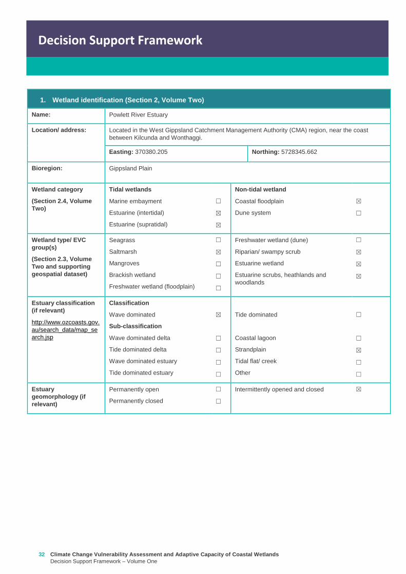
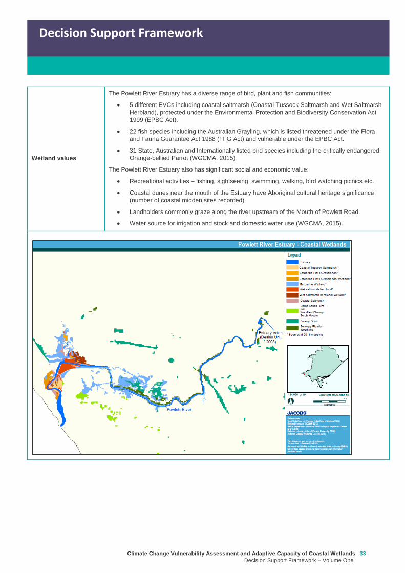
Climate Change Vulnerability Assessment and Adaptive Capacity of Coastal Wetlands
Decision Support Framework ndash Volume One
33
Decision Support Framework
Decision Support Framework
Wetland values
The Powlett River Estuary has a diverse range of bird plant and fish communities
5 different EVCs including coastal saltmarsh (Coastal Tussock Saltmarsh and Wet Saltmarsh
Herbland) protected under the Environmental Protection and Biodiversity Conservation Act
1999 (EPBC Act)
22 fish species including the Australian Grayling which is listed threatened under the Flora
and Fauna Guarantee Act 1988 (FFG Act) and vulnerable under the EPBC Act
31 State Australian and Internationally listed bird species including the critically endangered
Orange-bellied Parrot (WGCMA 2015)
The Powlett River Estuary also has significant social and economic value
Recreational activities ndash fishing sightseeing swimming walking bird watching picnics etc
Coastal dunes near the mouth of the Estuary have Aboriginal cultural heritage significance
(number of coastal midden sites recorded)
Landholders commonly graze along the river upstream of the Mouth of Powlett Road
Water source for irrigation and stock and domestic water use (WGCMA 2015)
34 Climate Change Vulnerability Assessment and Adaptive Capacity of Coastal Wetlands
Decision Support Framework ndash Volume One
Decision Support Framework
2 Potential impacts from climate change to the wetland (Section 4 Volume Two)
What is the
climate change
scenario
timeframe
Based on CSIRO-BOM (20015) modelling RCP 45 (moderate response to climate change) and RCP 85
(worst case scenario business as usual response to climate change)
Timeframes 2050 2070 and 2090 were all considered
Given the
position of the
wetland in the
landscape how
exposed is the
wetland to sea
level rise and
storm surge
climate change
components
Sea level rise
Climate Change Vulnerability Assessment and Adaptive Capacity of Coastal Wetlands
Decision Support Framework ndash Volume One
35
Decision Support Framework
Decision Support Framework
Storm surges
Site specific
infrastructure
dynamics that
would influence
the impact from
sea level rise
and storm
surges
There is currently no infrastructure at the Powlett River Estuary that would influence the extent of inundation
from the projected sea level rise and storm surges
When the mouth of the estuary is closed this may help mitigate some of impact of sea level
Given the
position of the
wetland in the
landscape how
exposed is the
wetland to
temperature and
rainfall climate
change
components
Temperature
Based on CSIRO-BOM (2015) modelling the following predictions are made in regards to change in
temperature
Magnitude of change
(mean surface temp
change)
Seasonality
RCP 45
2050 = 05 to 1degC
2070 = gt1 to 15degC
2090 = gt1 to 15degC
RCP 85
2050 = gt15 to 2degC
2070 = gt2 to 25degC
2090 = gt3 to 35deg
Temperature increases are similar in all seasons with some models
simulating to some extent larger increases in summer and autumn
than in other seasons
Projected changes for both daily maximum and minimum
temperature generally follow those of the mean temperature
although there is somewhat lower warming in daily minimum
temperatures than daily maximum temperatures in autumn winter
and spring
Increase in the temperature reached on the hottest days an increase
in the frequency of very hot days and duration of warm spells
36 Climate Change Vulnerability Assessment and Adaptive Capacity of Coastal Wetlands
Decision Support Framework ndash Volume One
Decision Support Framework
Given the
position of the
wetland in the
landscape how
exposed is the
wetland to
temperature and
rainfall climate
change
components
Rainfall
Based on CSIRO-BOM (2015) modelling the following predictions are made in regards to change in rainfall
Magnitude of change
(change in rainfall) Seasonality
RCP 45
2050 = 25 to 75
2070 = gt -25 to 25
2090 = gt -25 to 25
RCP 85
2050 = gt - 75 to -25
2070 = gt - 75 to -25
2090 = gt -125 to - 75
Rainfall declines are strongest in winter and spring Projected
reductions in winter rainfall in the Victoria NSW East region are up
to 30 in 2090 under high emissions
There is little change projected in autumn and either increases or
decreases in summer rainfall are possible
Tendency for heavier rainfall interspersed by longer dry periods
with some extremely dry and wet years with natural variability
continuing to be a major driver of rainfall for the near future (2030)
Intensity of heavy rainfall events is predicted to increase with
timing and magnitude also driven by natural variability
A decline in the number but an increase in the intensity of east
coast lows impacting on average rainfall and heavy rain events
Time spent in drought is predicted to increase over the course of
this century in line with changes to average rainfall and the
frequency and duration of extreme droughts will increase
Wetland
sensitivity
Climate change component and
impacts on coastal wetlands Saltmarsh
Estuarine
Wetland
Swamp
scrub
Swampy
riparian
woodland
Sea level
Chronic salinisation Positive Neutral Negative Negative
Episodic salinization Negative Negative Negative Negative
Erosion shoreline recession Negative Negative Negative Negative
Carbon dioxide
Altered C3 and C4 relationship Negative Neutral Neutral Neutral
Carbonate dissolution Neutral Neutral Neutral Neutral
Rainfall
Chronic salinisation Positive Neutral Negative Negative
Temperature (air)
Phenological impacts altered primary
productivity
Positive Positive Positive Positive
Temperature (water)
Phenological impacts altered primary
productivity
Neutral Neutral Neutral Neutral
Positive = positive response to climate change negative = negative response to climate change neutral =
unlikely to have any response to climate change NA = not exposed
Likely outcome Estuary
Potential change from intermittently open estuary mouth to permanently opened or more permanently
closed estuary depending on regional changes to rainfallcatchment runoff river discharge eustatic
sea levels and storm surges May become more similar to Andersons Inlet (marine embayment) to
the east
Saline intrusion into the upper estuary and lower freshwater reaches of the river due to increased sea
levels and storm surge activity and reduced rainfallcatchment runoff
Climate Change Vulnerability Assessment and Adaptive Capacity of Coastal Wetlands
Decision Support Framework ndash Volume One
37
Decision Support Framework
Decision Support Framework
Saline intrusion into groundwater results in a changed in species composition year round
Saltmarsh
More permanent inundation or increased frequency and duration of inundation
Change in salinity and water regime
Changes in distribution along the elevational gradient from the sea with possible landward migration
Possible invasion by mangroves if geomorphic changes result in a more permanent estuary opening
(eg similar to Andersons Inlet)
Many of the saltmarsh taxa at the site are C3 plants so potentially advantaged by increases in
atmospheric CO2 concentrations
Increased pressure from weed invasion from surrounding agricultural land
Saline intrusion into groundwater results in a changed wetland environment
Estuarine Wetland
Change in salinity and water regime (eg reduced freshwater inflows and saline intrusion increased
evaporation losses)
Increased pressure from weed invasion
Saline intrusion into groundwater results in a changed wetland environment
Riparian scrub and swampy riparian woodland
Change in salinity and water regime (eg reduced freshwater inflows and saline intrusion decreased
rainfall increased extreme flood events)
Rise in saline conditions along riparian zone
Replacement with saltmarsh as a result of increased salinity
Increased pressure from weed invasion
Saline intrusion into groundwater results in a changed species composition year round
Adaptive
capacity
General adaptive capacity of wetland types present
Wetland
type
Adaptive
capacity Main adaptive mechanism Main limiting factor
Saltmarsh Low Sediment accretion movement
to higher elevations positive
response to increase
temperature (variable
responses to increased CO2)
Rate of sea level rise storm surge
intensity and shoreline erosion
seawalls and other physical
impediments impact of increased
atmospheric CO2 impacts on floristic
composition
Estuarine
wetland
Moderate Positive response to
temperature neutral to most
other impacts until sea levels
make the sites intertidal
Salinisation and waterlogging due to
storm surges
Swamp
scrub
Low Positive response to
temperature
Salinisation and waterlogging (ie
changes to wetting and drying regimes)
Swampy
Riparian
woodland
Low Positive response to
temperature
Salinisation and waterlogging (ie
changes to wetting and drying regimes)
38 Climate Change Vulnerability Assessment and Adaptive Capacity of Coastal Wetlands
Decision Support Framework ndash Volume One
Decision Support Framework
Site specific adaptive capacity
Not completed as part of case study ndash requires specific assessments of opportunities and constraints to
adaptive capacity based on site specific characteristics
3 Management objectives and actions (Section 5 of Volume Two)
Constraints to
management
Barriers to migration
Mouth of Powlett Road is a barrier to wetland migration
Rail trail towards Dayleston provides a barrier to landward migration
Small cluster of housing north east of the estuary mouth similarly constrains landward
migration
Land ownership
The land in which wetlands could migrate in to is predominately private land used for
agriculture (grazing and cropping)
Funding
Limited funding available ndash not a priority site State wide nor Ramsar listed
Whilst there is good collaboration between agencies and landholders there are different
priorities for the funding available and therefore so some actions are difficult to implement An
example includes raising roads and carparks that experience inundation during closure
events or buying back regularly inundated marginal farmland
Limitations to knowledge and data
Uncertainty around the likely geomorphic changes to the estuary mouth (ie change in estuary
dynamic)
Understanding the economic value of the estuary coastal wetlands (eg value of wetlands
versus the value of agricultural land)
Uncertainty around acid sulfate soils as a result of climate change
Other potential constraints
Current State policies and procedures for statutory planning changes and land buyback to
enable long term management
Community understanding and expectation around estuary opening and closing
Pre-existing threats The key pre-existing threats identified in the Powlett River Estuary Management Plan that may
influence the resilience of the estuary to climate change impacts include
Degraded water quality
Degraded riparian vegetation (large trees in particular)
Trampling and bank erosion associated with pedestrian access
Rural drainage and drain clearing
Channelisation of the river channel
Vehicle access
Livestock access
Pest plants and animals
Inappropriate recreation causing dune erosion
Disturbance of acid sulfate soils
Climate Change Vulnerability Assessment and Adaptive Capacity of Coastal Wetlands
Decision Support Framework ndash Volume One
39
Decision Support Framework
Decision Support Framework
Pre-existing
management
objectives
Regional catchment strategy
No coastal wetland specific actions objectives for the Powlett River
West Gippsland Waterways Strategy (2014-2022)
Regional objectives relating to the Powlett River Estuary as a coastal wetland
Maintain and improve the habitat and condition of waterways to support waterway dependent
animals and plants
Maintain the ecological character of significant wetlands and estuaries
Catchment objectives for Powlett River Estuary relating to coastal wetlands include
Riparian vegetation provides improved visual amenity and contributes to community use of
waterways
The extent of freshwater wetlands is maintained and their condition is improved
Powlett Estuary Management Plan
Swamp scrub swampy riparian woodland and estuarine wetland vegetation communities are
enhanced and significantly increased in the area
West Gippsland Regional NRM Climate Change Strategy (2016)
The strategy outlines approaches and options to support climate change adaptation and mitigation
The objectives of the adaptation and management strategies are linked to the 20 year objectives in
the Regional Catchment Strategy The Powlett River Estuary is located within the Bunurong Coastal
planning area The estuary is listed as one of the most vulnerable estuary assets to climate change
across the region
Reports are available at lthttpwwwwgcmavicgovauour-regionwaterwayspowlett-river-estuarygt
[Verified 17052016 ]
Proposed management
objective in relation to
climate change
The following management objective is based the existing geomorphic characteristics of the estuary
(ie intermittently closed estuary)
To enhance and significantly increase Swamp scrub Swampy riparian woodland and estuarine
wetland vegetation extent through the facilitation of landward migration of these communities over the
next 50 years
Climate change also poses a threat to non-wetland EVCs (eg Coast Banksia Woodland) and
therefore even though they are not considered in this coastal wetland risk assessment they are still a
management consideration for the CMA in the coastal zone
Management actions to
address climate
change impacts and
management
objectives
Existing actions
Existing management actions provided in Section 81 of the Estuary Management Plan (WGCMA
2015) that are related to climate change are listed below
Management Action Timeframe
E31 Investigate opportunities for land purchase within the inundation
areas of the estuary
8 years
E32 Design and implement a program of stewardship payment for the
seasonal inundation of estuary floodplain from estuary mouth closures
Priority should be given to enhancing coastal saltmarsh and estuarine
wetland communities Payments should be calculated and prioritised
based on potential value to estuary health and ability to minimise artificial
estuary mouth openings
8 years
E 39 Investigate opportunities to encourage the conversion of Crown land
water frontage grazing licences to riparian management licences
8 years
E 43 Undertake hydraulic modelling and bathymetry survey of the Powlett 8 years
40 Climate Change Vulnerability Assessment and Adaptive Capacity of Coastal Wetlands
Decision Support Framework ndash Volume One
Decision Support Framework
estuary floodplain to understand the impacts and benefits of the structures
(including levees and drains) and landforms that affect the movement of
water before during and after artificial estuary mouth opening before
considering any updates changes or removal of these floodplain features
E 44 Undertake a detailed risk assessment including on-ground mapping
to identify potential and active acid sulphate soils with the Powlett estuarine
floodplain
8 years
E 46 Investigate the use of the saltmarsh wetlands and estuary channel
by recreational fish species and other native fish species particularly Black
Bream and prioritise areas for further protection
8 years
E 49 Continue to build understanding of and plan for the risks associated
with climate change including sea level rise This includes future flood
risk
8 years
New actions
The following additional management actions should be considered
Management Action Timeframe Responsibility
Complete a study to assess the likely geomorphic changes
to the estuary as a result of climate change
2 years WGCMA
Undertake scenario planning in consultation with Bass Coast
Shire Council VicRoads and Parks Victoria- refine
management actions and objectives for Estuary based on
finding of geomorphic study This could identify nearby
systems that could form a template for what Powlett River
might look like in the future (eg Andersons Inlet)
2-5 years WGCMA
Review Bass Coast Planning Scheme to understand any
implications to future management actions works at the
Powlett Estuary Provide feedback to the State Government
on any issues associated with State policies and procedures
for statutory planning that may constrain long term
management of the Estuary
2-5 years WGCMA
Consultation with other relevant managers in the area
(including Council VicRoads and Parks Victoria) to discuss
potential issues associated road repairs culverts and other
flood mitigation measures in the area that may arise as a
result of climate change
2-5 years WGCMA
Resolve issues and complexities around the impacts of
climate change (sea level rise) on crown land boundaries
2-5 years State
Government
Resolve issues associated with State policies and
procedures for statutory planning that may constrain long
term management of the Estuary
2-5 years State
Government
Community engagement and education program to provide
the community with an understanding of the predicted
impacts of climate change and enable them to play an active
role in management
2-5 years WGCMA
Estuary Management Plan Action E31 (see above) ndash to
become 2 actions
a Investigate opportunities for land purchase within the
8 years WGCMA
Climate Change Vulnerability Assessment and Adaptive Capacity of Coastal Wetlands
Decision Support Framework ndash Volume One
41
Decision Support Framework
Decision Support Framework
current inundation areas of the estuary
b Investigate opportunities for land purchase within the
future inundation areas of the estuary
Estuary Management Plan Action E32 (see above) ndash
include consideration of future inundation eg ldquoDesign and
implement a program of stewardship payment for the
seasonal inundation of estuary floodplain from estuary
mouth closures under both current and future inundation
conditionsrdquo
8 years WGCMA
Estuary Management Plan Action E 39 (see above) ndash to
become 2 actions
a Investigate opportunities to encourage the conversion of
current Crown land water frontage grazing licences to
riparian management licences
b Investigate issues and opportunities related to sea level
rise impacts on Crown Land Water frontage grazing licences
and riparian management licences (including how to define
boundaries if existing boundaries are inundated by sea level
rise)
8 years WGCMA
Estuary Management Plan Action E44 (see above) ndash
Undertake detailed risk assessment of potential and active
acid sulfate soils
8 years WGCMA
Estuary Management Plan Action E49 (see above) ndash
Continue to build understanding of and plan for risks
associated with climate change
8 years WGCMA
4 Recommendations
1 Climate change threats are currently implied within the management actions in the Powlett River Estuary Management Plan It
is recommended that additional material on climate change impacts be included and climate change threats addressed more
explicitly in the management actions This would meet Action E49 in particular
2 Management objectives also need to consider management for a 30-50 year timeframe ie take in to consideration longer
term climate change impacts including on estuary mouth dynamics A distinction between responses to current and future
threats should be made
5 Key management resource documents
1 Peters G Morris K Frood D Papas P and Roberts J (2015) A Guide to managing livestock grazing in Victorias
wetlands Decision framework and guidelines - Version 10 Arthur Rylah Institute for Environmental Research Technical
Report Series Report number 265
2 Morris K and Papas P (2012) Wetland conceptual models associations between wetland values threats and management
interventions Version one Arthur Rylah Institute for Environmental Research Technical Report Series Report number 237
3 DELWP wetland buffers guidelines (in prep)
4 DELWP wetland revegetation guidelines (in prep)
5 DELWP wetland invasive species management guidelines (in prep)
6 SKM (2005) Guidelines for the design and operation of environmentally friendly wetland regulators (MDBC project report
R2002) Report by Sinclair Knight Merz for the MDBC
42 Climate Change Vulnerability Assessment and Adaptive Capacity of Coastal Wetlands
Decision Support Framework ndash Volume One
Decision Support Framework
6 Key references
1 WGCMA (2012) West Gippsland Regional Catchment Strategy 2013-2019 West Gippsland Catchment Management
Authority
2 WGCMA (2014) West Gippsland Waterway Strategy 2014-2022 West Gippsland Catchment Management Authority
3 WGCMA (2015) Powlett River Estuary Management Plan West Gippsland Catchment Management Authority
4 WGCMA (2016) West Gippsland Regional NRM Climate Change Strategy ndash Final Draft West Gippsland Catchment
Management Authority
5 CSIRO and BOM (2015) Southern Slopes Cluster Report Climate Change in Australia Projections for Australiarsquos Natural
Resource Management Regions Cluster Reports eds Ekstroumlm M et al CSIRO and Bureau of Meteorology Australia
Climate Change Vulnerability Assessment and Adaptive Capacity of Coastal Wetlands
Decision Support Framework ndash Volume One
43
Decision Support Framework
Decision Support Framework
delwpvicgovau delwpvicgovau
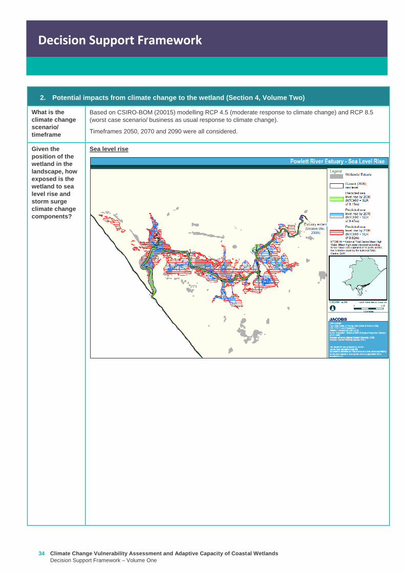
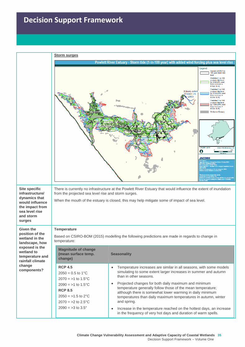
Climate Change Vulnerability Assessment and Adaptive Capacity of Coastal Wetlands
Decision Support Framework ndash Volume One
35
Decision Support Framework
Decision Support Framework
Storm surges
Site specific
infrastructure
dynamics that
would influence
the impact from
sea level rise
and storm
surges
There is currently no infrastructure at the Powlett River Estuary that would influence the extent of inundation
from the projected sea level rise and storm surges
When the mouth of the estuary is closed this may help mitigate some of impact of sea level
Given the
position of the
wetland in the
landscape how
exposed is the
wetland to
temperature and
rainfall climate
change
components
Temperature
Based on CSIRO-BOM (2015) modelling the following predictions are made in regards to change in
temperature
Magnitude of change
(mean surface temp
change)
Seasonality
RCP 45
2050 = 05 to 1degC
2070 = gt1 to 15degC
2090 = gt1 to 15degC
RCP 85
2050 = gt15 to 2degC
2070 = gt2 to 25degC
2090 = gt3 to 35deg
Temperature increases are similar in all seasons with some models
simulating to some extent larger increases in summer and autumn
than in other seasons
Projected changes for both daily maximum and minimum
temperature generally follow those of the mean temperature
although there is somewhat lower warming in daily minimum
temperatures than daily maximum temperatures in autumn winter
and spring
Increase in the temperature reached on the hottest days an increase
in the frequency of very hot days and duration of warm spells
36 Climate Change Vulnerability Assessment and Adaptive Capacity of Coastal Wetlands
Decision Support Framework ndash Volume One
Decision Support Framework
Given the
position of the
wetland in the
landscape how
exposed is the
wetland to
temperature and
rainfall climate
change
components
Rainfall
Based on CSIRO-BOM (2015) modelling the following predictions are made in regards to change in rainfall
Magnitude of change
(change in rainfall) Seasonality
RCP 45
2050 = 25 to 75
2070 = gt -25 to 25
2090 = gt -25 to 25
RCP 85
2050 = gt - 75 to -25
2070 = gt - 75 to -25
2090 = gt -125 to - 75
Rainfall declines are strongest in winter and spring Projected
reductions in winter rainfall in the Victoria NSW East region are up
to 30 in 2090 under high emissions
There is little change projected in autumn and either increases or
decreases in summer rainfall are possible
Tendency for heavier rainfall interspersed by longer dry periods
with some extremely dry and wet years with natural variability
continuing to be a major driver of rainfall for the near future (2030)
Intensity of heavy rainfall events is predicted to increase with
timing and magnitude also driven by natural variability
A decline in the number but an increase in the intensity of east
coast lows impacting on average rainfall and heavy rain events
Time spent in drought is predicted to increase over the course of
this century in line with changes to average rainfall and the
frequency and duration of extreme droughts will increase
Wetland
sensitivity
Climate change component and
impacts on coastal wetlands Saltmarsh
Estuarine
Wetland
Swamp
scrub
Swampy
riparian
woodland
Sea level
Chronic salinisation Positive Neutral Negative Negative
Episodic salinization Negative Negative Negative Negative
Erosion shoreline recession Negative Negative Negative Negative
Carbon dioxide
Altered C3 and C4 relationship Negative Neutral Neutral Neutral
Carbonate dissolution Neutral Neutral Neutral Neutral
Rainfall
Chronic salinisation Positive Neutral Negative Negative
Temperature (air)
Phenological impacts altered primary
productivity
Positive Positive Positive Positive
Temperature (water)
Phenological impacts altered primary
productivity
Neutral Neutral Neutral Neutral
Positive = positive response to climate change negative = negative response to climate change neutral =
unlikely to have any response to climate change NA = not exposed
Likely outcome Estuary
Potential change from intermittently open estuary mouth to permanently opened or more permanently
closed estuary depending on regional changes to rainfallcatchment runoff river discharge eustatic
sea levels and storm surges May become more similar to Andersons Inlet (marine embayment) to
the east
Saline intrusion into the upper estuary and lower freshwater reaches of the river due to increased sea
levels and storm surge activity and reduced rainfallcatchment runoff
Climate Change Vulnerability Assessment and Adaptive Capacity of Coastal Wetlands
Decision Support Framework ndash Volume One
37
Decision Support Framework
Decision Support Framework
Saline intrusion into groundwater results in a changed in species composition year round
Saltmarsh
More permanent inundation or increased frequency and duration of inundation
Change in salinity and water regime
Changes in distribution along the elevational gradient from the sea with possible landward migration
Possible invasion by mangroves if geomorphic changes result in a more permanent estuary opening
(eg similar to Andersons Inlet)
Many of the saltmarsh taxa at the site are C3 plants so potentially advantaged by increases in
atmospheric CO2 concentrations
Increased pressure from weed invasion from surrounding agricultural land
Saline intrusion into groundwater results in a changed wetland environment
Estuarine Wetland
Change in salinity and water regime (eg reduced freshwater inflows and saline intrusion increased
evaporation losses)
Increased pressure from weed invasion
Saline intrusion into groundwater results in a changed wetland environment
Riparian scrub and swampy riparian woodland
Change in salinity and water regime (eg reduced freshwater inflows and saline intrusion decreased
rainfall increased extreme flood events)
Rise in saline conditions along riparian zone
Replacement with saltmarsh as a result of increased salinity
Increased pressure from weed invasion
Saline intrusion into groundwater results in a changed species composition year round
Adaptive
capacity
General adaptive capacity of wetland types present
Wetland
type
Adaptive
capacity Main adaptive mechanism Main limiting factor
Saltmarsh Low Sediment accretion movement
to higher elevations positive
response to increase
temperature (variable
responses to increased CO2)
Rate of sea level rise storm surge
intensity and shoreline erosion
seawalls and other physical
impediments impact of increased
atmospheric CO2 impacts on floristic
composition
Estuarine
wetland
Moderate Positive response to
temperature neutral to most
other impacts until sea levels
make the sites intertidal
Salinisation and waterlogging due to
storm surges
Swamp
scrub
Low Positive response to
temperature
Salinisation and waterlogging (ie
changes to wetting and drying regimes)
Swampy
Riparian
woodland
Low Positive response to
temperature
Salinisation and waterlogging (ie
changes to wetting and drying regimes)
38 Climate Change Vulnerability Assessment and Adaptive Capacity of Coastal Wetlands
Decision Support Framework ndash Volume One
Decision Support Framework
Site specific adaptive capacity
Not completed as part of case study ndash requires specific assessments of opportunities and constraints to
adaptive capacity based on site specific characteristics
3 Management objectives and actions (Section 5 of Volume Two)
Constraints to
management
Barriers to migration
Mouth of Powlett Road is a barrier to wetland migration
Rail trail towards Dayleston provides a barrier to landward migration
Small cluster of housing north east of the estuary mouth similarly constrains landward
migration
Land ownership
The land in which wetlands could migrate in to is predominately private land used for
agriculture (grazing and cropping)
Funding
Limited funding available ndash not a priority site State wide nor Ramsar listed
Whilst there is good collaboration between agencies and landholders there are different
priorities for the funding available and therefore so some actions are difficult to implement An
example includes raising roads and carparks that experience inundation during closure
events or buying back regularly inundated marginal farmland
Limitations to knowledge and data
Uncertainty around the likely geomorphic changes to the estuary mouth (ie change in estuary
dynamic)
Understanding the economic value of the estuary coastal wetlands (eg value of wetlands
versus the value of agricultural land)
Uncertainty around acid sulfate soils as a result of climate change
Other potential constraints
Current State policies and procedures for statutory planning changes and land buyback to
enable long term management
Community understanding and expectation around estuary opening and closing
Pre-existing threats The key pre-existing threats identified in the Powlett River Estuary Management Plan that may
influence the resilience of the estuary to climate change impacts include
Degraded water quality
Degraded riparian vegetation (large trees in particular)
Trampling and bank erosion associated with pedestrian access
Rural drainage and drain clearing
Channelisation of the river channel
Vehicle access
Livestock access
Pest plants and animals
Inappropriate recreation causing dune erosion
Disturbance of acid sulfate soils
Climate Change Vulnerability Assessment and Adaptive Capacity of Coastal Wetlands
Decision Support Framework ndash Volume One
39
Decision Support Framework
Decision Support Framework
Pre-existing
management
objectives
Regional catchment strategy
No coastal wetland specific actions objectives for the Powlett River
West Gippsland Waterways Strategy (2014-2022)
Regional objectives relating to the Powlett River Estuary as a coastal wetland
Maintain and improve the habitat and condition of waterways to support waterway dependent
animals and plants
Maintain the ecological character of significant wetlands and estuaries
Catchment objectives for Powlett River Estuary relating to coastal wetlands include
Riparian vegetation provides improved visual amenity and contributes to community use of
waterways
The extent of freshwater wetlands is maintained and their condition is improved
Powlett Estuary Management Plan
Swamp scrub swampy riparian woodland and estuarine wetland vegetation communities are
enhanced and significantly increased in the area
West Gippsland Regional NRM Climate Change Strategy (2016)
The strategy outlines approaches and options to support climate change adaptation and mitigation
The objectives of the adaptation and management strategies are linked to the 20 year objectives in
the Regional Catchment Strategy The Powlett River Estuary is located within the Bunurong Coastal
planning area The estuary is listed as one of the most vulnerable estuary assets to climate change
across the region
Reports are available at lthttpwwwwgcmavicgovauour-regionwaterwayspowlett-river-estuarygt
[Verified 17052016 ]
Proposed management
objective in relation to
climate change
The following management objective is based the existing geomorphic characteristics of the estuary
(ie intermittently closed estuary)
To enhance and significantly increase Swamp scrub Swampy riparian woodland and estuarine
wetland vegetation extent through the facilitation of landward migration of these communities over the
next 50 years
Climate change also poses a threat to non-wetland EVCs (eg Coast Banksia Woodland) and
therefore even though they are not considered in this coastal wetland risk assessment they are still a
management consideration for the CMA in the coastal zone
Management actions to
address climate
change impacts and
management
objectives
Existing actions
Existing management actions provided in Section 81 of the Estuary Management Plan (WGCMA
2015) that are related to climate change are listed below
Management Action Timeframe
E31 Investigate opportunities for land purchase within the inundation
areas of the estuary
8 years
E32 Design and implement a program of stewardship payment for the
seasonal inundation of estuary floodplain from estuary mouth closures
Priority should be given to enhancing coastal saltmarsh and estuarine
wetland communities Payments should be calculated and prioritised
based on potential value to estuary health and ability to minimise artificial
estuary mouth openings
8 years
E 39 Investigate opportunities to encourage the conversion of Crown land
water frontage grazing licences to riparian management licences
8 years
E 43 Undertake hydraulic modelling and bathymetry survey of the Powlett 8 years
40 Climate Change Vulnerability Assessment and Adaptive Capacity of Coastal Wetlands
Decision Support Framework ndash Volume One
Decision Support Framework
estuary floodplain to understand the impacts and benefits of the structures
(including levees and drains) and landforms that affect the movement of
water before during and after artificial estuary mouth opening before
considering any updates changes or removal of these floodplain features
E 44 Undertake a detailed risk assessment including on-ground mapping
to identify potential and active acid sulphate soils with the Powlett estuarine
floodplain
8 years
E 46 Investigate the use of the saltmarsh wetlands and estuary channel
by recreational fish species and other native fish species particularly Black
Bream and prioritise areas for further protection
8 years
E 49 Continue to build understanding of and plan for the risks associated
with climate change including sea level rise This includes future flood
risk
8 years
New actions
The following additional management actions should be considered
Management Action Timeframe Responsibility
Complete a study to assess the likely geomorphic changes
to the estuary as a result of climate change
2 years WGCMA
Undertake scenario planning in consultation with Bass Coast
Shire Council VicRoads and Parks Victoria- refine
management actions and objectives for Estuary based on
finding of geomorphic study This could identify nearby
systems that could form a template for what Powlett River
might look like in the future (eg Andersons Inlet)
2-5 years WGCMA
Review Bass Coast Planning Scheme to understand any
implications to future management actions works at the
Powlett Estuary Provide feedback to the State Government
on any issues associated with State policies and procedures
for statutory planning that may constrain long term
management of the Estuary
2-5 years WGCMA
Consultation with other relevant managers in the area
(including Council VicRoads and Parks Victoria) to discuss
potential issues associated road repairs culverts and other
flood mitigation measures in the area that may arise as a
result of climate change
2-5 years WGCMA
Resolve issues and complexities around the impacts of
climate change (sea level rise) on crown land boundaries
2-5 years State
Government
Resolve issues associated with State policies and
procedures for statutory planning that may constrain long
term management of the Estuary
2-5 years State
Government
Community engagement and education program to provide
the community with an understanding of the predicted
impacts of climate change and enable them to play an active
role in management
2-5 years WGCMA
Estuary Management Plan Action E31 (see above) ndash to
become 2 actions
a Investigate opportunities for land purchase within the
8 years WGCMA
Climate Change Vulnerability Assessment and Adaptive Capacity of Coastal Wetlands
Decision Support Framework ndash Volume One
41
Decision Support Framework
Decision Support Framework
current inundation areas of the estuary
b Investigate opportunities for land purchase within the
future inundation areas of the estuary
Estuary Management Plan Action E32 (see above) ndash
include consideration of future inundation eg ldquoDesign and
implement a program of stewardship payment for the
seasonal inundation of estuary floodplain from estuary
mouth closures under both current and future inundation
conditionsrdquo
8 years WGCMA
Estuary Management Plan Action E 39 (see above) ndash to
become 2 actions
a Investigate opportunities to encourage the conversion of
current Crown land water frontage grazing licences to
riparian management licences
b Investigate issues and opportunities related to sea level
rise impacts on Crown Land Water frontage grazing licences
and riparian management licences (including how to define
boundaries if existing boundaries are inundated by sea level
rise)
8 years WGCMA
Estuary Management Plan Action E44 (see above) ndash
Undertake detailed risk assessment of potential and active
acid sulfate soils
8 years WGCMA
Estuary Management Plan Action E49 (see above) ndash
Continue to build understanding of and plan for risks
associated with climate change
8 years WGCMA
4 Recommendations
1 Climate change threats are currently implied within the management actions in the Powlett River Estuary Management Plan It
is recommended that additional material on climate change impacts be included and climate change threats addressed more
explicitly in the management actions This would meet Action E49 in particular
2 Management objectives also need to consider management for a 30-50 year timeframe ie take in to consideration longer
term climate change impacts including on estuary mouth dynamics A distinction between responses to current and future
threats should be made
5 Key management resource documents
1 Peters G Morris K Frood D Papas P and Roberts J (2015) A Guide to managing livestock grazing in Victorias
wetlands Decision framework and guidelines - Version 10 Arthur Rylah Institute for Environmental Research Technical
Report Series Report number 265
2 Morris K and Papas P (2012) Wetland conceptual models associations between wetland values threats and management
interventions Version one Arthur Rylah Institute for Environmental Research Technical Report Series Report number 237
3 DELWP wetland buffers guidelines (in prep)
4 DELWP wetland revegetation guidelines (in prep)
5 DELWP wetland invasive species management guidelines (in prep)
6 SKM (2005) Guidelines for the design and operation of environmentally friendly wetland regulators (MDBC project report
R2002) Report by Sinclair Knight Merz for the MDBC
42 Climate Change Vulnerability Assessment and Adaptive Capacity of Coastal Wetlands
Decision Support Framework ndash Volume One
Decision Support Framework
6 Key references
1 WGCMA (2012) West Gippsland Regional Catchment Strategy 2013-2019 West Gippsland Catchment Management
Authority
2 WGCMA (2014) West Gippsland Waterway Strategy 2014-2022 West Gippsland Catchment Management Authority
3 WGCMA (2015) Powlett River Estuary Management Plan West Gippsland Catchment Management Authority
4 WGCMA (2016) West Gippsland Regional NRM Climate Change Strategy ndash Final Draft West Gippsland Catchment
Management Authority
5 CSIRO and BOM (2015) Southern Slopes Cluster Report Climate Change in Australia Projections for Australiarsquos Natural
Resource Management Regions Cluster Reports eds Ekstroumlm M et al CSIRO and Bureau of Meteorology Australia
Climate Change Vulnerability Assessment and Adaptive Capacity of Coastal Wetlands
Decision Support Framework ndash Volume One
43
Decision Support Framework
Decision Support Framework
delwpvicgovau delwpvicgovau
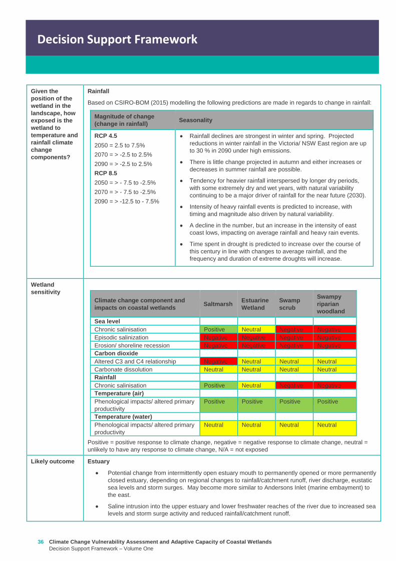
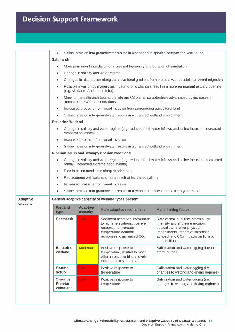
Climate Change Vulnerability Assessment and Adaptive Capacity of Coastal Wetlands
Decision Support Framework ndash Volume One
37
Decision Support Framework
Decision Support Framework
Saline intrusion into groundwater results in a changed in species composition year round
Saltmarsh
More permanent inundation or increased frequency and duration of inundation
Change in salinity and water regime
Changes in distribution along the elevational gradient from the sea with possible landward migration
Possible invasion by mangroves if geomorphic changes result in a more permanent estuary opening
(eg similar to Andersons Inlet)
Many of the saltmarsh taxa at the site are C3 plants so potentially advantaged by increases in
atmospheric CO2 concentrations
Increased pressure from weed invasion from surrounding agricultural land
Saline intrusion into groundwater results in a changed wetland environment
Estuarine Wetland
Change in salinity and water regime (eg reduced freshwater inflows and saline intrusion increased
evaporation losses)
Increased pressure from weed invasion
Saline intrusion into groundwater results in a changed wetland environment
Riparian scrub and swampy riparian woodland
Change in salinity and water regime (eg reduced freshwater inflows and saline intrusion decreased
rainfall increased extreme flood events)
Rise in saline conditions along riparian zone
Replacement with saltmarsh as a result of increased salinity
Increased pressure from weed invasion
Saline intrusion into groundwater results in a changed species composition year round
Adaptive
capacity
General adaptive capacity of wetland types present
Wetland
type
Adaptive
capacity Main adaptive mechanism Main limiting factor
Saltmarsh Low Sediment accretion movement
to higher elevations positive
response to increase
temperature (variable
responses to increased CO2)
Rate of sea level rise storm surge
intensity and shoreline erosion
seawalls and other physical
impediments impact of increased
atmospheric CO2 impacts on floristic
composition
Estuarine
wetland
Moderate Positive response to
temperature neutral to most
other impacts until sea levels
make the sites intertidal
Salinisation and waterlogging due to
storm surges
Swamp
scrub
Low Positive response to
temperature
Salinisation and waterlogging (ie
changes to wetting and drying regimes)
Swampy
Riparian
woodland
Low Positive response to
temperature
Salinisation and waterlogging (ie
changes to wetting and drying regimes)
38 Climate Change Vulnerability Assessment and Adaptive Capacity of Coastal Wetlands
Decision Support Framework ndash Volume One
Decision Support Framework
Site specific adaptive capacity
Not completed as part of case study ndash requires specific assessments of opportunities and constraints to
adaptive capacity based on site specific characteristics
3 Management objectives and actions (Section 5 of Volume Two)
Constraints to
management
Barriers to migration
Mouth of Powlett Road is a barrier to wetland migration
Rail trail towards Dayleston provides a barrier to landward migration
Small cluster of housing north east of the estuary mouth similarly constrains landward
migration
Land ownership
The land in which wetlands could migrate in to is predominately private land used for
agriculture (grazing and cropping)
Funding
Limited funding available ndash not a priority site State wide nor Ramsar listed
Whilst there is good collaboration between agencies and landholders there are different
priorities for the funding available and therefore so some actions are difficult to implement An
example includes raising roads and carparks that experience inundation during closure
events or buying back regularly inundated marginal farmland
Limitations to knowledge and data
Uncertainty around the likely geomorphic changes to the estuary mouth (ie change in estuary
dynamic)
Understanding the economic value of the estuary coastal wetlands (eg value of wetlands
versus the value of agricultural land)
Uncertainty around acid sulfate soils as a result of climate change
Other potential constraints
Current State policies and procedures for statutory planning changes and land buyback to
enable long term management
Community understanding and expectation around estuary opening and closing
Pre-existing threats The key pre-existing threats identified in the Powlett River Estuary Management Plan that may
influence the resilience of the estuary to climate change impacts include
Degraded water quality
Degraded riparian vegetation (large trees in particular)
Trampling and bank erosion associated with pedestrian access
Rural drainage and drain clearing
Channelisation of the river channel
Vehicle access
Livestock access
Pest plants and animals
Inappropriate recreation causing dune erosion
Disturbance of acid sulfate soils
Climate Change Vulnerability Assessment and Adaptive Capacity of Coastal Wetlands
Decision Support Framework ndash Volume One
39
Decision Support Framework
Decision Support Framework
Pre-existing
management
objectives
Regional catchment strategy
No coastal wetland specific actions objectives for the Powlett River
West Gippsland Waterways Strategy (2014-2022)
Regional objectives relating to the Powlett River Estuary as a coastal wetland
Maintain and improve the habitat and condition of waterways to support waterway dependent
animals and plants
Maintain the ecological character of significant wetlands and estuaries
Catchment objectives for Powlett River Estuary relating to coastal wetlands include
Riparian vegetation provides improved visual amenity and contributes to community use of
waterways
The extent of freshwater wetlands is maintained and their condition is improved
Powlett Estuary Management Plan
Swamp scrub swampy riparian woodland and estuarine wetland vegetation communities are
enhanced and significantly increased in the area
West Gippsland Regional NRM Climate Change Strategy (2016)
The strategy outlines approaches and options to support climate change adaptation and mitigation
The objectives of the adaptation and management strategies are linked to the 20 year objectives in
the Regional Catchment Strategy The Powlett River Estuary is located within the Bunurong Coastal
planning area The estuary is listed as one of the most vulnerable estuary assets to climate change
across the region
Reports are available at lthttpwwwwgcmavicgovauour-regionwaterwayspowlett-river-estuarygt
[Verified 17052016 ]
Proposed management
objective in relation to
climate change
The following management objective is based the existing geomorphic characteristics of the estuary
(ie intermittently closed estuary)
To enhance and significantly increase Swamp scrub Swampy riparian woodland and estuarine
wetland vegetation extent through the facilitation of landward migration of these communities over the
next 50 years
Climate change also poses a threat to non-wetland EVCs (eg Coast Banksia Woodland) and
therefore even though they are not considered in this coastal wetland risk assessment they are still a
management consideration for the CMA in the coastal zone
Management actions to
address climate
change impacts and
management
objectives
Existing actions
Existing management actions provided in Section 81 of the Estuary Management Plan (WGCMA
2015) that are related to climate change are listed below
Management Action Timeframe
E31 Investigate opportunities for land purchase within the inundation
areas of the estuary
8 years
E32 Design and implement a program of stewardship payment for the
seasonal inundation of estuary floodplain from estuary mouth closures
Priority should be given to enhancing coastal saltmarsh and estuarine
wetland communities Payments should be calculated and prioritised
based on potential value to estuary health and ability to minimise artificial
estuary mouth openings
8 years
E 39 Investigate opportunities to encourage the conversion of Crown land
water frontage grazing licences to riparian management licences
8 years
E 43 Undertake hydraulic modelling and bathymetry survey of the Powlett 8 years
40 Climate Change Vulnerability Assessment and Adaptive Capacity of Coastal Wetlands
Decision Support Framework ndash Volume One
Decision Support Framework
estuary floodplain to understand the impacts and benefits of the structures
(including levees and drains) and landforms that affect the movement of
water before during and after artificial estuary mouth opening before
considering any updates changes or removal of these floodplain features
E 44 Undertake a detailed risk assessment including on-ground mapping
to identify potential and active acid sulphate soils with the Powlett estuarine
floodplain
8 years
E 46 Investigate the use of the saltmarsh wetlands and estuary channel
by recreational fish species and other native fish species particularly Black
Bream and prioritise areas for further protection
8 years
E 49 Continue to build understanding of and plan for the risks associated
with climate change including sea level rise This includes future flood
risk
8 years
New actions
The following additional management actions should be considered
Management Action Timeframe Responsibility
Complete a study to assess the likely geomorphic changes
to the estuary as a result of climate change
2 years WGCMA
Undertake scenario planning in consultation with Bass Coast
Shire Council VicRoads and Parks Victoria- refine
management actions and objectives for Estuary based on
finding of geomorphic study This could identify nearby
systems that could form a template for what Powlett River
might look like in the future (eg Andersons Inlet)
2-5 years WGCMA
Review Bass Coast Planning Scheme to understand any
implications to future management actions works at the
Powlett Estuary Provide feedback to the State Government
on any issues associated with State policies and procedures
for statutory planning that may constrain long term
management of the Estuary
2-5 years WGCMA
Consultation with other relevant managers in the area
(including Council VicRoads and Parks Victoria) to discuss
potential issues associated road repairs culverts and other
flood mitigation measures in the area that may arise as a
result of climate change
2-5 years WGCMA
Resolve issues and complexities around the impacts of
climate change (sea level rise) on crown land boundaries
2-5 years State
Government
Resolve issues associated with State policies and
procedures for statutory planning that may constrain long
term management of the Estuary
2-5 years State
Government
Community engagement and education program to provide
the community with an understanding of the predicted
impacts of climate change and enable them to play an active
role in management
2-5 years WGCMA
Estuary Management Plan Action E31 (see above) ndash to
become 2 actions
a Investigate opportunities for land purchase within the
8 years WGCMA
Climate Change Vulnerability Assessment and Adaptive Capacity of Coastal Wetlands
Decision Support Framework ndash Volume One
41
Decision Support Framework
Decision Support Framework
current inundation areas of the estuary
b Investigate opportunities for land purchase within the
future inundation areas of the estuary
Estuary Management Plan Action E32 (see above) ndash
include consideration of future inundation eg ldquoDesign and
implement a program of stewardship payment for the
seasonal inundation of estuary floodplain from estuary
mouth closures under both current and future inundation
conditionsrdquo
8 years WGCMA
Estuary Management Plan Action E 39 (see above) ndash to
become 2 actions
a Investigate opportunities to encourage the conversion of
current Crown land water frontage grazing licences to
riparian management licences
b Investigate issues and opportunities related to sea level
rise impacts on Crown Land Water frontage grazing licences
and riparian management licences (including how to define
boundaries if existing boundaries are inundated by sea level
rise)
8 years WGCMA
Estuary Management Plan Action E44 (see above) ndash
Undertake detailed risk assessment of potential and active
acid sulfate soils
8 years WGCMA
Estuary Management Plan Action E49 (see above) ndash
Continue to build understanding of and plan for risks
associated with climate change
8 years WGCMA
4 Recommendations
1 Climate change threats are currently implied within the management actions in the Powlett River Estuary Management Plan It
is recommended that additional material on climate change impacts be included and climate change threats addressed more
explicitly in the management actions This would meet Action E49 in particular
2 Management objectives also need to consider management for a 30-50 year timeframe ie take in to consideration longer
term climate change impacts including on estuary mouth dynamics A distinction between responses to current and future
threats should be made
5 Key management resource documents
1 Peters G Morris K Frood D Papas P and Roberts J (2015) A Guide to managing livestock grazing in Victorias
wetlands Decision framework and guidelines - Version 10 Arthur Rylah Institute for Environmental Research Technical
Report Series Report number 265
2 Morris K and Papas P (2012) Wetland conceptual models associations between wetland values threats and management
interventions Version one Arthur Rylah Institute for Environmental Research Technical Report Series Report number 237
3 DELWP wetland buffers guidelines (in prep)
4 DELWP wetland revegetation guidelines (in prep)
5 DELWP wetland invasive species management guidelines (in prep)
6 SKM (2005) Guidelines for the design and operation of environmentally friendly wetland regulators (MDBC project report
R2002) Report by Sinclair Knight Merz for the MDBC
42 Climate Change Vulnerability Assessment and Adaptive Capacity of Coastal Wetlands
Decision Support Framework ndash Volume One
Decision Support Framework
6 Key references
1 WGCMA (2012) West Gippsland Regional Catchment Strategy 2013-2019 West Gippsland Catchment Management
Authority
2 WGCMA (2014) West Gippsland Waterway Strategy 2014-2022 West Gippsland Catchment Management Authority
3 WGCMA (2015) Powlett River Estuary Management Plan West Gippsland Catchment Management Authority
4 WGCMA (2016) West Gippsland Regional NRM Climate Change Strategy ndash Final Draft West Gippsland Catchment
Management Authority
5 CSIRO and BOM (2015) Southern Slopes Cluster Report Climate Change in Australia Projections for Australiarsquos Natural
Resource Management Regions Cluster Reports eds Ekstroumlm M et al CSIRO and Bureau of Meteorology Australia
Climate Change Vulnerability Assessment and Adaptive Capacity of Coastal Wetlands
Decision Support Framework ndash Volume One
43
Decision Support Framework
Decision Support Framework
delwpvicgovau delwpvicgovau
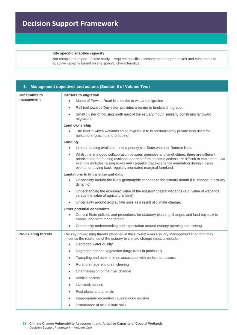
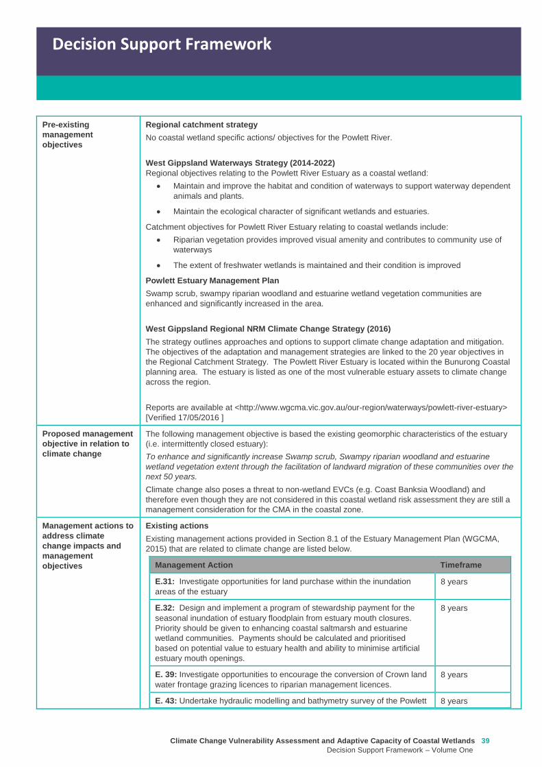
Climate Change Vulnerability Assessment and Adaptive Capacity of Coastal Wetlands
Decision Support Framework ndash Volume One
39
Decision Support Framework
Decision Support Framework
Pre-existing
management
objectives
Regional catchment strategy
No coastal wetland specific actions objectives for the Powlett River
West Gippsland Waterways Strategy (2014-2022)
Regional objectives relating to the Powlett River Estuary as a coastal wetland
Maintain and improve the habitat and condition of waterways to support waterway dependent
animals and plants
Maintain the ecological character of significant wetlands and estuaries
Catchment objectives for Powlett River Estuary relating to coastal wetlands include
Riparian vegetation provides improved visual amenity and contributes to community use of
waterways
The extent of freshwater wetlands is maintained and their condition is improved
Powlett Estuary Management Plan
Swamp scrub swampy riparian woodland and estuarine wetland vegetation communities are
enhanced and significantly increased in the area
West Gippsland Regional NRM Climate Change Strategy (2016)
The strategy outlines approaches and options to support climate change adaptation and mitigation
The objectives of the adaptation and management strategies are linked to the 20 year objectives in
the Regional Catchment Strategy The Powlett River Estuary is located within the Bunurong Coastal
planning area The estuary is listed as one of the most vulnerable estuary assets to climate change
across the region
Reports are available at lthttpwwwwgcmavicgovauour-regionwaterwayspowlett-river-estuarygt
[Verified 17052016 ]
Proposed management
objective in relation to
climate change
The following management objective is based the existing geomorphic characteristics of the estuary
(ie intermittently closed estuary)
To enhance and significantly increase Swamp scrub Swampy riparian woodland and estuarine
wetland vegetation extent through the facilitation of landward migration of these communities over the
next 50 years
Climate change also poses a threat to non-wetland EVCs (eg Coast Banksia Woodland) and
therefore even though they are not considered in this coastal wetland risk assessment they are still a
management consideration for the CMA in the coastal zone
Management actions to
address climate
change impacts and
management
objectives
Existing actions
Existing management actions provided in Section 81 of the Estuary Management Plan (WGCMA
2015) that are related to climate change are listed below
Management Action Timeframe
E31 Investigate opportunities for land purchase within the inundation
areas of the estuary
8 years
E32 Design and implement a program of stewardship payment for the
seasonal inundation of estuary floodplain from estuary mouth closures
Priority should be given to enhancing coastal saltmarsh and estuarine
wetland communities Payments should be calculated and prioritised
based on potential value to estuary health and ability to minimise artificial
estuary mouth openings
8 years
E 39 Investigate opportunities to encourage the conversion of Crown land
water frontage grazing licences to riparian management licences
8 years
E 43 Undertake hydraulic modelling and bathymetry survey of the Powlett 8 years
40 Climate Change Vulnerability Assessment and Adaptive Capacity of Coastal Wetlands
Decision Support Framework ndash Volume One
Decision Support Framework
estuary floodplain to understand the impacts and benefits of the structures
(including levees and drains) and landforms that affect the movement of
water before during and after artificial estuary mouth opening before
considering any updates changes or removal of these floodplain features
E 44 Undertake a detailed risk assessment including on-ground mapping
to identify potential and active acid sulphate soils with the Powlett estuarine
floodplain
8 years
E 46 Investigate the use of the saltmarsh wetlands and estuary channel
by recreational fish species and other native fish species particularly Black
Bream and prioritise areas for further protection
8 years
E 49 Continue to build understanding of and plan for the risks associated
with climate change including sea level rise This includes future flood
risk
8 years
New actions
The following additional management actions should be considered
Management Action Timeframe Responsibility
Complete a study to assess the likely geomorphic changes
to the estuary as a result of climate change
2 years WGCMA
Undertake scenario planning in consultation with Bass Coast
Shire Council VicRoads and Parks Victoria- refine
management actions and objectives for Estuary based on
finding of geomorphic study This could identify nearby
systems that could form a template for what Powlett River
might look like in the future (eg Andersons Inlet)
2-5 years WGCMA
Review Bass Coast Planning Scheme to understand any
implications to future management actions works at the
Powlett Estuary Provide feedback to the State Government
on any issues associated with State policies and procedures
for statutory planning that may constrain long term
management of the Estuary
2-5 years WGCMA
Consultation with other relevant managers in the area
(including Council VicRoads and Parks Victoria) to discuss
potential issues associated road repairs culverts and other
flood mitigation measures in the area that may arise as a
result of climate change
2-5 years WGCMA
Resolve issues and complexities around the impacts of
climate change (sea level rise) on crown land boundaries
2-5 years State
Government
Resolve issues associated with State policies and
procedures for statutory planning that may constrain long
term management of the Estuary
2-5 years State
Government
Community engagement and education program to provide
the community with an understanding of the predicted
impacts of climate change and enable them to play an active
role in management
2-5 years WGCMA
Estuary Management Plan Action E31 (see above) ndash to
become 2 actions
a Investigate opportunities for land purchase within the
8 years WGCMA
Climate Change Vulnerability Assessment and Adaptive Capacity of Coastal Wetlands
Decision Support Framework ndash Volume One
41
Decision Support Framework
Decision Support Framework
current inundation areas of the estuary
b Investigate opportunities for land purchase within the
future inundation areas of the estuary
Estuary Management Plan Action E32 (see above) ndash
include consideration of future inundation eg ldquoDesign and
implement a program of stewardship payment for the
seasonal inundation of estuary floodplain from estuary
mouth closures under both current and future inundation
conditionsrdquo
8 years WGCMA
Estuary Management Plan Action E 39 (see above) ndash to
become 2 actions
a Investigate opportunities to encourage the conversion of
current Crown land water frontage grazing licences to
riparian management licences
b Investigate issues and opportunities related to sea level
rise impacts on Crown Land Water frontage grazing licences
and riparian management licences (including how to define
boundaries if existing boundaries are inundated by sea level
rise)
8 years WGCMA
Estuary Management Plan Action E44 (see above) ndash
Undertake detailed risk assessment of potential and active
acid sulfate soils
8 years WGCMA
Estuary Management Plan Action E49 (see above) ndash
Continue to build understanding of and plan for risks
associated with climate change
8 years WGCMA
4 Recommendations
1 Climate change threats are currently implied within the management actions in the Powlett River Estuary Management Plan It
is recommended that additional material on climate change impacts be included and climate change threats addressed more
explicitly in the management actions This would meet Action E49 in particular
2 Management objectives also need to consider management for a 30-50 year timeframe ie take in to consideration longer
term climate change impacts including on estuary mouth dynamics A distinction between responses to current and future
threats should be made
5 Key management resource documents
1 Peters G Morris K Frood D Papas P and Roberts J (2015) A Guide to managing livestock grazing in Victorias
wetlands Decision framework and guidelines - Version 10 Arthur Rylah Institute for Environmental Research Technical
Report Series Report number 265
2 Morris K and Papas P (2012) Wetland conceptual models associations between wetland values threats and management
interventions Version one Arthur Rylah Institute for Environmental Research Technical Report Series Report number 237
3 DELWP wetland buffers guidelines (in prep)
4 DELWP wetland revegetation guidelines (in prep)
5 DELWP wetland invasive species management guidelines (in prep)
6 SKM (2005) Guidelines for the design and operation of environmentally friendly wetland regulators (MDBC project report
R2002) Report by Sinclair Knight Merz for the MDBC
42 Climate Change Vulnerability Assessment and Adaptive Capacity of Coastal Wetlands
Decision Support Framework ndash Volume One
Decision Support Framework
6 Key references
1 WGCMA (2012) West Gippsland Regional Catchment Strategy 2013-2019 West Gippsland Catchment Management
Authority
2 WGCMA (2014) West Gippsland Waterway Strategy 2014-2022 West Gippsland Catchment Management Authority
3 WGCMA (2015) Powlett River Estuary Management Plan West Gippsland Catchment Management Authority
4 WGCMA (2016) West Gippsland Regional NRM Climate Change Strategy ndash Final Draft West Gippsland Catchment
Management Authority
5 CSIRO and BOM (2015) Southern Slopes Cluster Report Climate Change in Australia Projections for Australiarsquos Natural
Resource Management Regions Cluster Reports eds Ekstroumlm M et al CSIRO and Bureau of Meteorology Australia
Climate Change Vulnerability Assessment and Adaptive Capacity of Coastal Wetlands
Decision Support Framework ndash Volume One
43
Decision Support Framework
Decision Support Framework
delwpvicgovau delwpvicgovau
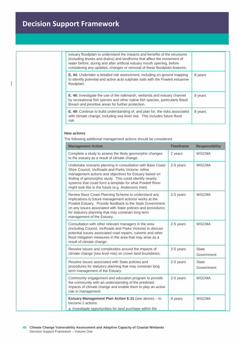
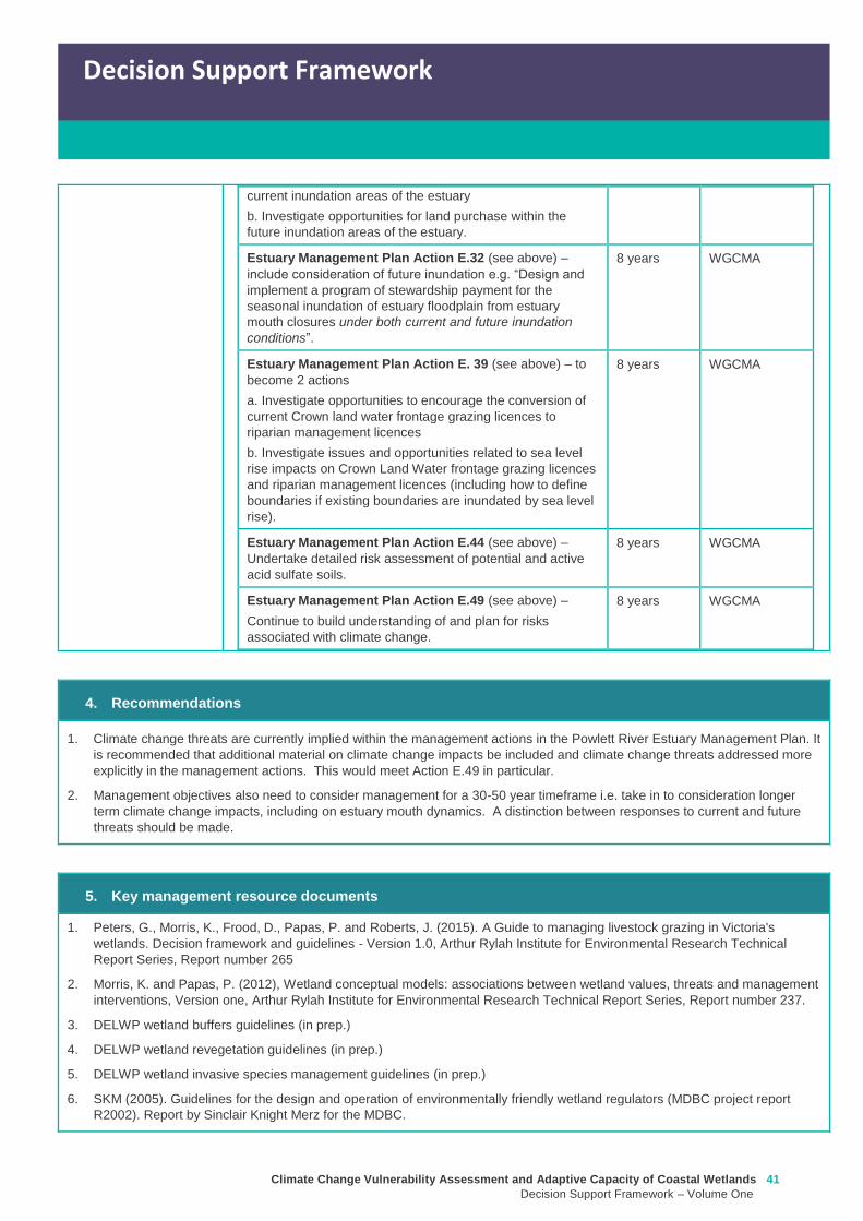
Climate Change Vulnerability Assessment and Adaptive Capacity of Coastal Wetlands
Decision Support Framework ndash Volume One
41
Decision Support Framework
Decision Support Framework
current inundation areas of the estuary
b Investigate opportunities for land purchase within the
future inundation areas of the estuary
Estuary Management Plan Action E32 (see above) ndash
include consideration of future inundation eg ldquoDesign and
implement a program of stewardship payment for the
seasonal inundation of estuary floodplain from estuary
mouth closures under both current and future inundation
conditionsrdquo
8 years WGCMA
Estuary Management Plan Action E 39 (see above) ndash to
become 2 actions
a Investigate opportunities to encourage the conversion of
current Crown land water frontage grazing licences to
riparian management licences
b Investigate issues and opportunities related to sea level
rise impacts on Crown Land Water frontage grazing licences
and riparian management licences (including how to define
boundaries if existing boundaries are inundated by sea level
rise)
8 years WGCMA
Estuary Management Plan Action E44 (see above) ndash
Undertake detailed risk assessment of potential and active
acid sulfate soils
8 years WGCMA
Estuary Management Plan Action E49 (see above) ndash
Continue to build understanding of and plan for risks
associated with climate change
8 years WGCMA
4 Recommendations
1 Climate change threats are currently implied within the management actions in the Powlett River Estuary Management Plan It
is recommended that additional material on climate change impacts be included and climate change threats addressed more
explicitly in the management actions This would meet Action E49 in particular
2 Management objectives also need to consider management for a 30-50 year timeframe ie take in to consideration longer
term climate change impacts including on estuary mouth dynamics A distinction between responses to current and future
threats should be made
5 Key management resource documents
1 Peters G Morris K Frood D Papas P and Roberts J (2015) A Guide to managing livestock grazing in Victorias
wetlands Decision framework and guidelines - Version 10 Arthur Rylah Institute for Environmental Research Technical
Report Series Report number 265
2 Morris K and Papas P (2012) Wetland conceptual models associations between wetland values threats and management
interventions Version one Arthur Rylah Institute for Environmental Research Technical Report Series Report number 237
3 DELWP wetland buffers guidelines (in prep)
4 DELWP wetland revegetation guidelines (in prep)
5 DELWP wetland invasive species management guidelines (in prep)
6 SKM (2005) Guidelines for the design and operation of environmentally friendly wetland regulators (MDBC project report
R2002) Report by Sinclair Knight Merz for the MDBC
42 Climate Change Vulnerability Assessment and Adaptive Capacity of Coastal Wetlands
Decision Support Framework ndash Volume One
Decision Support Framework
6 Key references
1 WGCMA (2012) West Gippsland Regional Catchment Strategy 2013-2019 West Gippsland Catchment Management
Authority
2 WGCMA (2014) West Gippsland Waterway Strategy 2014-2022 West Gippsland Catchment Management Authority
3 WGCMA (2015) Powlett River Estuary Management Plan West Gippsland Catchment Management Authority
4 WGCMA (2016) West Gippsland Regional NRM Climate Change Strategy ndash Final Draft West Gippsland Catchment
Management Authority
5 CSIRO and BOM (2015) Southern Slopes Cluster Report Climate Change in Australia Projections for Australiarsquos Natural
Resource Management Regions Cluster Reports eds Ekstroumlm M et al CSIRO and Bureau of Meteorology Australia
Climate Change Vulnerability Assessment and Adaptive Capacity of Coastal Wetlands
Decision Support Framework ndash Volume One
43
Decision Support Framework
Decision Support Framework
delwpvicgovau delwpvicgovau

Climate Change Vulnerability Assessment and Adaptive Capacity of Coastal Wetlands
Decision Support Framework ndash Volume One
43
Decision Support Framework
Decision Support Framework
delwpvicgovau delwpvicgovau