Embed Size (px)
Citation preview
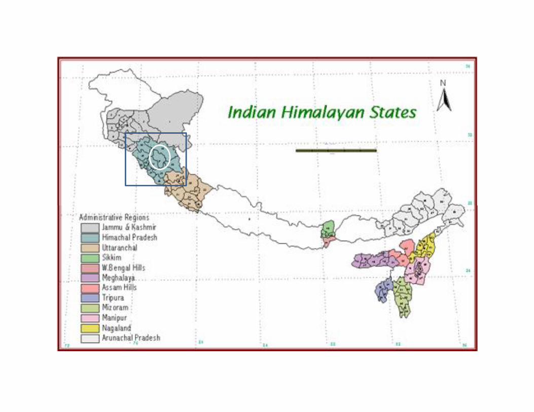
Climate Change Vulnerability, Hazards & RiskAssessment and Adaptation Projects for
Kullu District
Climate Change Vulnerability, Hazards & RiskAssessment and Adaptation Projects for
Kullu District
Dr. Mustafa Ali KhanTeam Leader, IHCAP
IHCAP: Supporting Country System
• Anchored under framework agreement on technical andscientific cooperation, 2003 between the Government ofSwitzerland and the Government of India
• IHCAP functions as a “technical and knowledge partner” forimplementation of the National Mission for Sustaining theHimalayan Ecosystem (NMSHE)
• IHCAP Goal: “resilience of vulnerable communities in theHimalayas is strengthened and knowledge and capacities ofresearch institutions, communities and decision-makers areconnected and enhanced”
• IHCAP Phase 1 (2012-15); Phase 2 (2016-19)
COLLABORATION WITH GOVERNMENT OF HIMACHAL PRADESH
• Since 2012, SDC and Department of Environment, Science andTechnology (DEST) are cooperating under Indian Himalayas ClimateAdaptation Programme (IHCAP)
• Focus areas:– Capacity Building and Training Programme on Climate Change Adaptation
Planning and Implementation for State Government officials– Technical Assistance for development of an adaptation project on climate
smart agriculture under National Adaptation Fund for Climate Change– Indo-Swiss Collaborative Research on Integrated Vulnerability, Risks and
Hazard Assessment in Kullu district– Design of adaptation measures for Kullu district
ACTIVITIES IN HIMACHAL PRADESH (2016-2019)
2016• Submission of detailed project on three priority adaptation
measures to the State government: November 2016
Planned Activities (2017-19)• Training programme on climate change adaptation planning and
implementation: 2017-19– Opportunity to integrate modules on DRR
• Common framework for Vulnerability, Risks and HazardAssessment (being developed by IISc) and training to StateClimate Change Cells/Centre: 2017-18
• Media awareness workshop: 2018• Multi Stakeholder Science Policy Practice Forum
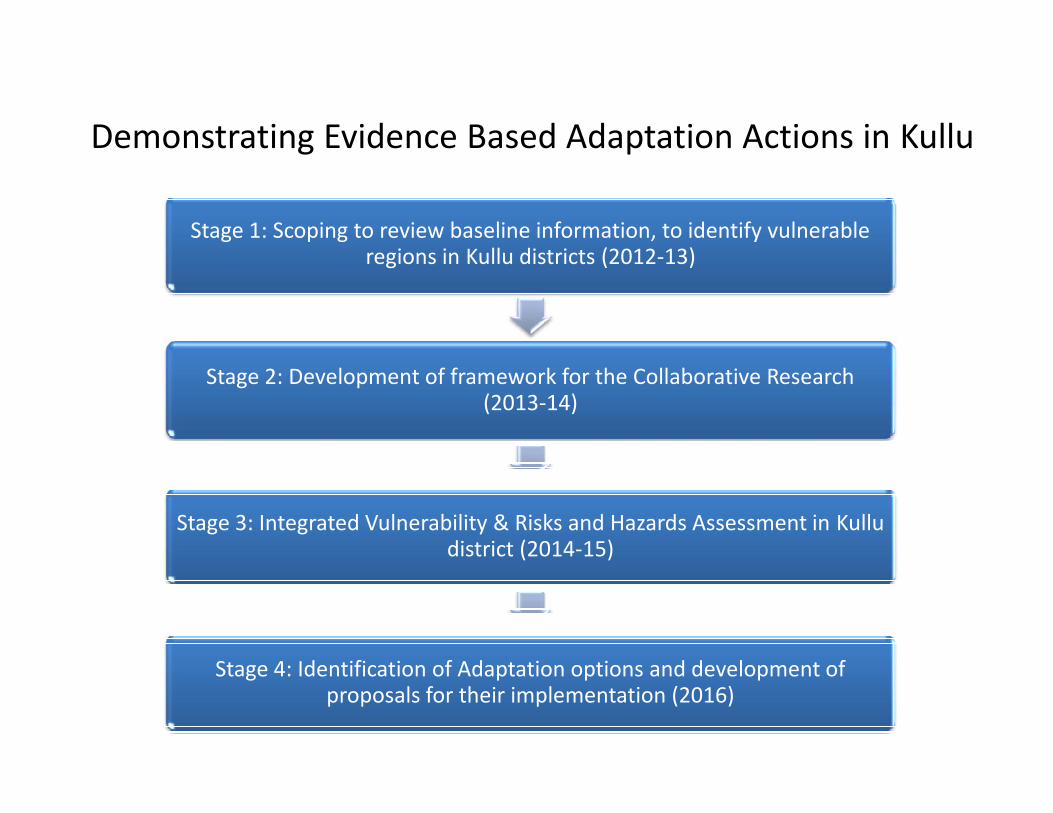
Demonstrating Evidence Based Adaptation Actions in Kullu
Stage 1: Scoping to review baseline information, to identify vulnerableregions in Kullu districts (2012-13)
Stage 2: Development of framework for the Collaborative Research(2013-14)
Stage 2: Development of framework for the Collaborative Research(2013-14)
Stage 3: Integrated Vulnerability & Risks and Hazards Assessment in Kulludistrict (2014-15)
Stage 4: Identification of Adaptation options and development ofproposals for their implementation (2016)
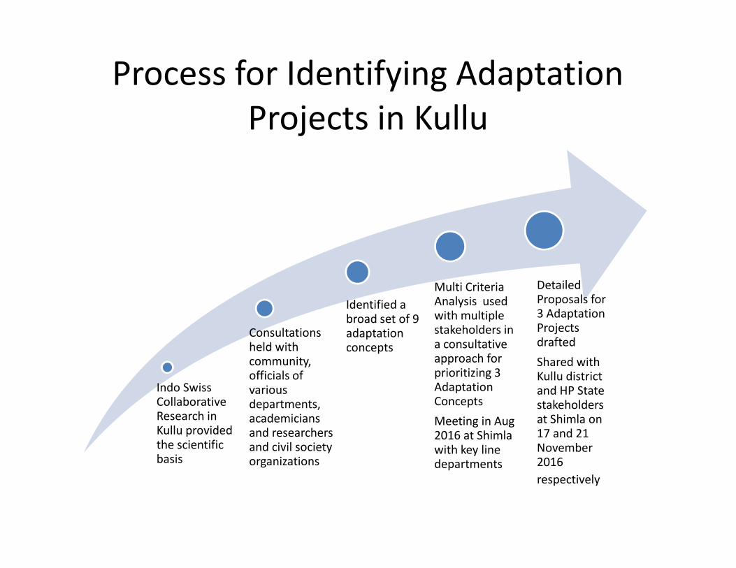
Process for Identifying AdaptationProjects in Kullu
Multi CriteriaAnalysis usedwith multiplestakeholders ina consultativeapproach forprioritizing 3AdaptationConceptsMeeting in Aug2016 at Shimlawith key linedepartments
DetailedProposals for3 AdaptationProjectsdraftedShared withKullu districtand HP Statestakeholdersat Shimla on17 and 21November2016respectively
Indo SwissCollaborativeResearch inKullu providedthe scientificbasis
Consultationsheld withcommunity,officials ofvariousdepartments,academiciansand researchersand civil societyorganizations
Identified abroad set of 9adaptationconcepts
Multi CriteriaAnalysis usedwith multiplestakeholders ina consultativeapproach forprioritizing 3AdaptationConceptsMeeting in Aug2016 at Shimlawith key linedepartments
DetailedProposals for3 AdaptationProjectsdraftedShared withKullu districtand HP Statestakeholdersat Shimla on17 and 21November2016respectively
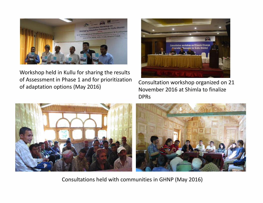
Workshop held in Kullu for sharing the resultsof Assessment in Phase 1 and for prioritizationof adaptation options (May 2016)
Consultation workshop organized on 21November 2016 at Shimla to finalizeDPRs
Consultations held with communities in GHNP (May 2016)
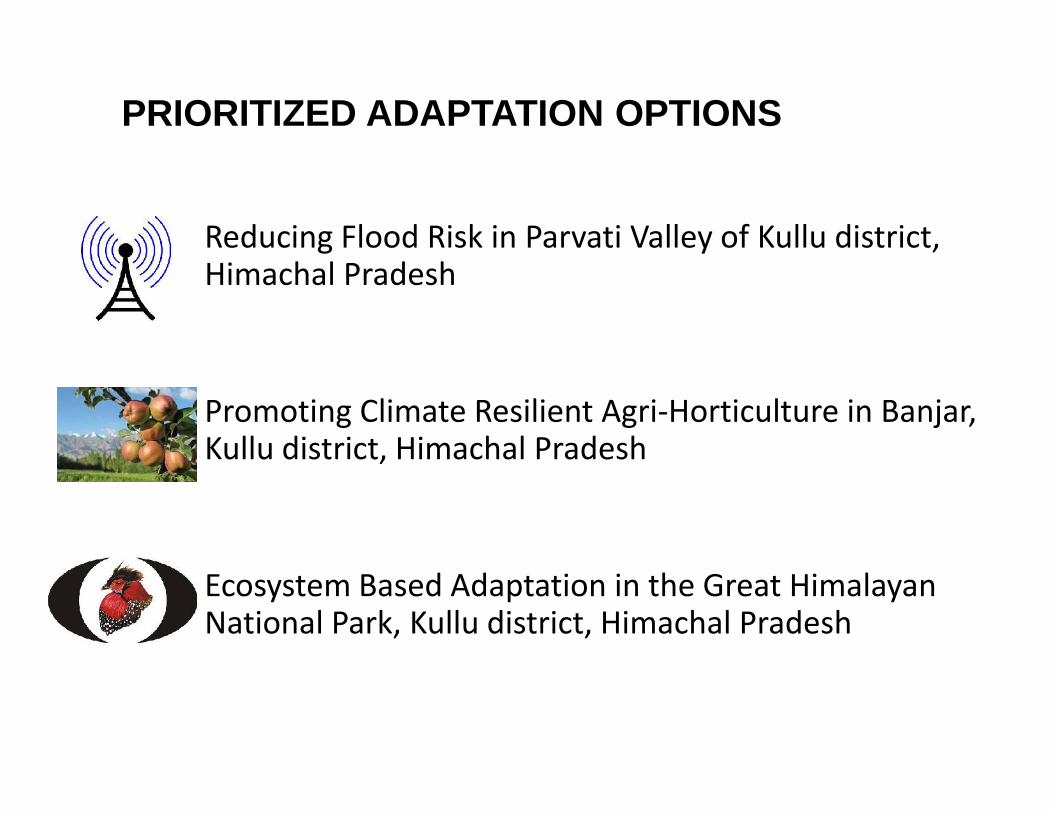
PRIORITIZED ADAPTATION OPTIONS
Reducing Flood Risk in Parvati Valley of Kullu district,Himachal Pradesh
Promoting Climate Resilient Agri-Horticulture in Banjar,Kullu district, Himachal Pradesh
Ecosystem Based Adaptation in the Great HimalayanNational Park, Kullu district, Himachal Pradesh
Reducing Flood Risk in Parvati Valley of Kullu district,Himachal Pradesh
Promoting Climate Resilient Agri-Horticulture in Banjar,Kullu district, Himachal Pradesh
Ecosystem Based Adaptation in the Great HimalayanNational Park, Kullu district, Himachal Pradesh
Climate Vulnerability,Hazards and Risk
Kullu District
Overview and Key Findings
Climate Vulnerability,Hazards and Risk
Kullu District
Overview and Key Findings
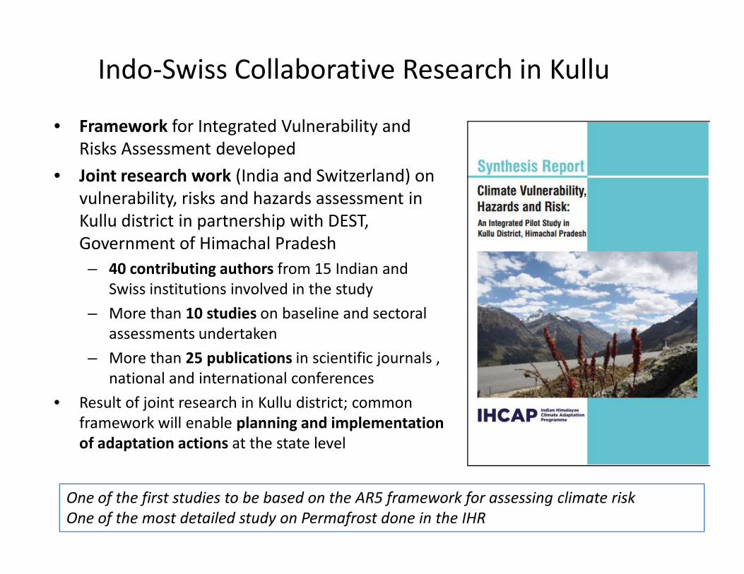
Indo-Swiss Collaborative Research in Kullu
• Framework for Integrated Vulnerability andRisks Assessment developed
• Joint research work (India and Switzerland) onvulnerability, risks and hazards assessment inKullu district in partnership with DEST,Government of Himachal Pradesh– 40 contributing authors from 15 Indian and
Swiss institutions involved in the study– More than 10 studies on baseline and sectoral
assessments undertaken– More than 25 publications in scientific journals ,
national and international conferences• Result of joint research in Kullu district; common
framework will enable planning and implementationof adaptation actions at the state level
One of the first studies to be based on the AR5 framework for assessing climate riskOne of the most detailed study on Permafrost done in the IHR
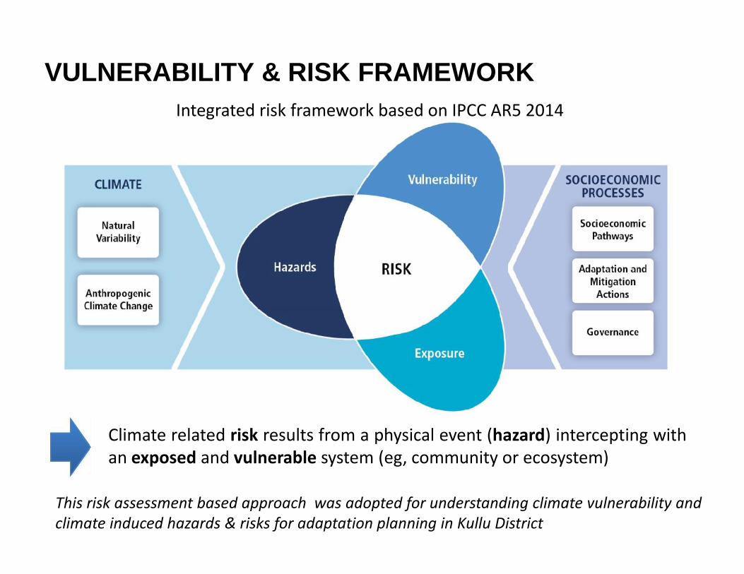
VULNERABILITY & RISK FRAMEWORKIntegrated risk framework based on IPCC AR5 2014
Climate related risk results from a physical event (hazard) intercepting withan exposed and vulnerable system (eg, community or ecosystem)
This risk assessment based approach was adopted for understanding climate vulnerability andclimate induced hazards & risks for adaptation planning in Kullu District
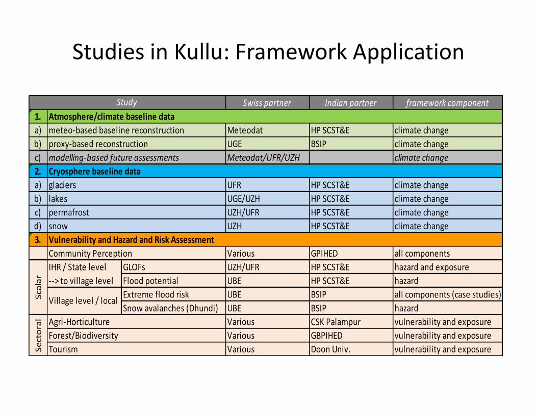
Studies in Kullu: Framework Application
Swiss partner Indian partner framework component1.a) Meteodat HP SCST&E climate changeb) UGE BSIP climate changec) Meteodat/UFR/UZH climate change2.a) UFR HP SCST&E climate changeb) UGE/UZH HP SCST&E climate changec) UZH/UFR HP SCST&E climate changed) UZH HP SCST&E climate change3.
Various GPIHED all componentsGLOFs UZH/UFR HP SCST&E hazard and exposureFlood potential UBE HP SCST&E hazardExtreme flood risk UBE BSIP all components (case studies)Snow avalanches (Dhundi) UBE BSIP hazard
Various CSK Palampur vulnerability and exposureVarious GBPIHED vulnerability and exposureVarious Doon Univ. vulnerability and exposure
Scal
ar
IHR / State level--> to village level
Village level / local
Sect
oral Agri-Horticulture
Forest/BiodiversityTourism
Community Perception
Study
meteo-based baseline reconstructionproxy-based reconstructionmodelling-based future assessments
Atmosphere/climate baseline data
Cryosphere baseline data
Vulnerability and Hazard and Risk Assessment
glaciers
permafrostsnow
lakes
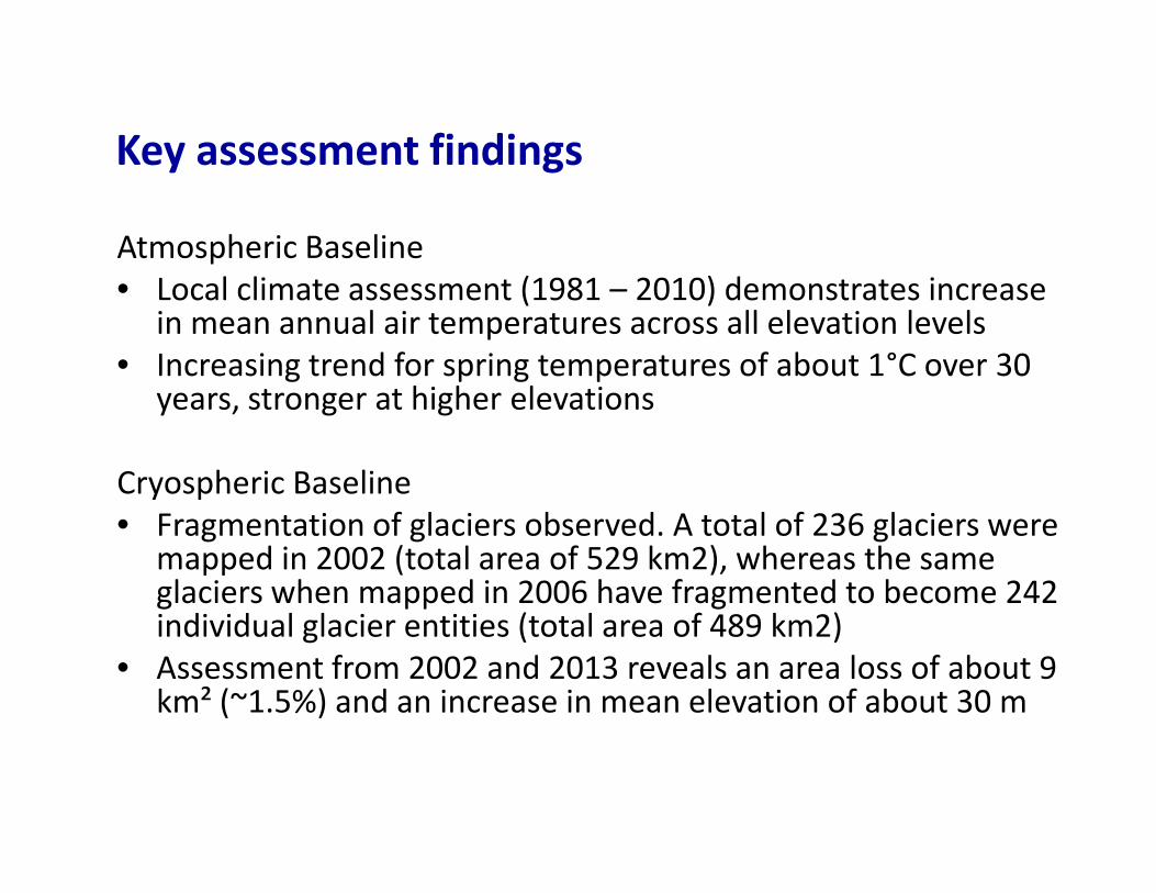
Key assessment findings
Atmospheric Baseline• Local climate assessment (1981 – 2010) demonstrates increase
in mean annual air temperatures across all elevation levels• Increasing trend for spring temperatures of about 1°C over 30
years, stronger at higher elevations
Cryospheric Baseline• Fragmentation of glaciers observed. A total of 236 glaciers were
mapped in 2002 (total area of 529 km2), whereas the sameglaciers when mapped in 2006 have fragmented to become 242individual glacier entities (total area of 489 km2)
• Assessment from 2002 and 2013 reveals an area loss of about 9km² (~1.5%) and an increase in mean elevation of about 30 m
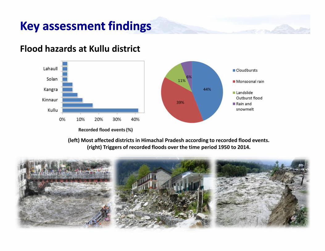
Key assessment findingsKey assessment findingsFlood hazards at Kullu district
(left) Most affected districts in Himachal Pradesh according to recorded flood events.(right) Triggers of recorded floods over the time period 1950 to 2014.
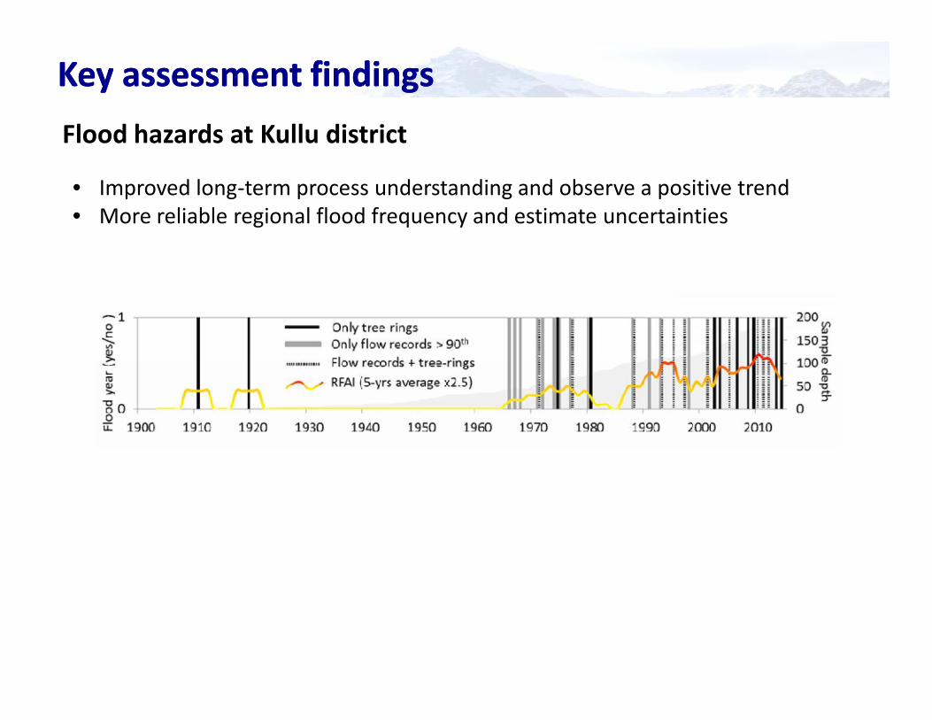
Flood hazards at Kullu district
• Improved long-term process understanding and observe a positive trend• More reliable regional flood frequency and estimate uncertainties
Key assessment findingsKey assessment findings
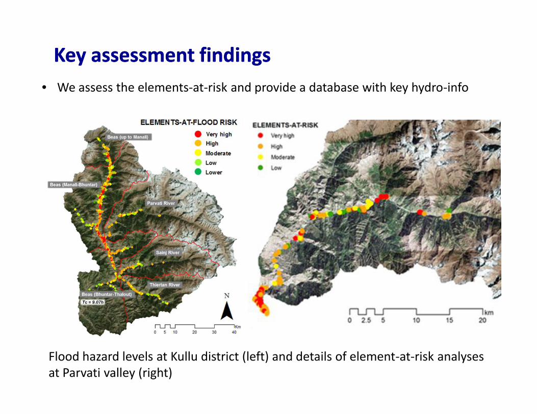
Key assessment findingsKey assessment findings• We assess the elements-at-risk and provide a database with key hydro-info
Flood hazard levels at Kullu district (left) and details of element-at-risk analysesat Parvati valley (right)
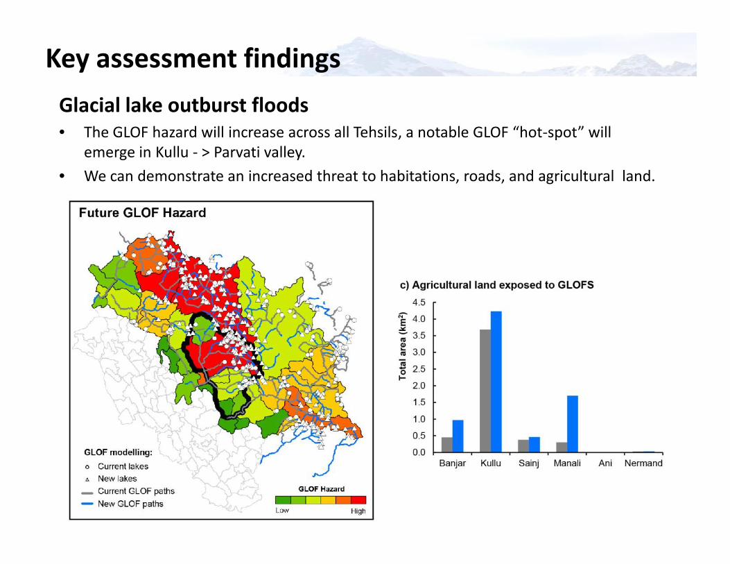
Key assessment findingsGlacial lake outburst floods• The GLOF hazard will increase across all Tehsils, a notable GLOF “hot-spot” will
emerge in Kullu - > Parvati valley.• We can demonstrate an increased threat to habitations, roads, and agricultural land.
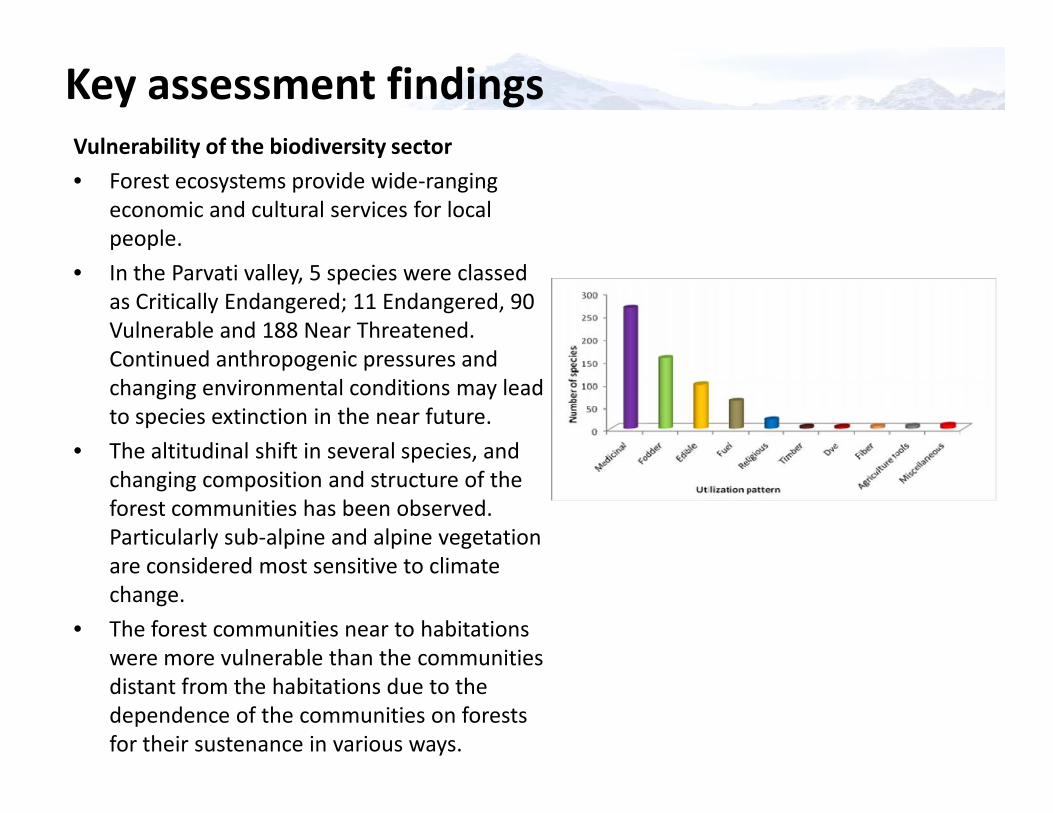
Key assessment findingsVulnerability of the biodiversity sector• Forest ecosystems provide wide-ranging
economic and cultural services for localpeople.
• In the Parvati valley, 5 species were classedas Critically Endangered; 11 Endangered, 90Vulnerable and 188 Near Threatened.Continued anthropogenic pressures andchanging environmental conditions may leadto species extinction in the near future.
• The altitudinal shift in several species, andchanging composition and structure of theforest communities has been observed.Particularly sub-alpine and alpine vegetationare considered most sensitive to climatechange.
• The forest communities near to habitationswere more vulnerable than the communitiesdistant from the habitations due to thedependence of the communities on forestsfor their sustenance in various ways.
Vulnerability of the biodiversity sector• Forest ecosystems provide wide-ranging
economic and cultural services for localpeople.
• In the Parvati valley, 5 species were classedas Critically Endangered; 11 Endangered, 90Vulnerable and 188 Near Threatened.Continued anthropogenic pressures andchanging environmental conditions may leadto species extinction in the near future.
• The altitudinal shift in several species, andchanging composition and structure of theforest communities has been observed.Particularly sub-alpine and alpine vegetationare considered most sensitive to climatechange.
• The forest communities near to habitationswere more vulnerable than the communitiesdistant from the habitations due to thedependence of the communities on forestsfor their sustenance in various ways.
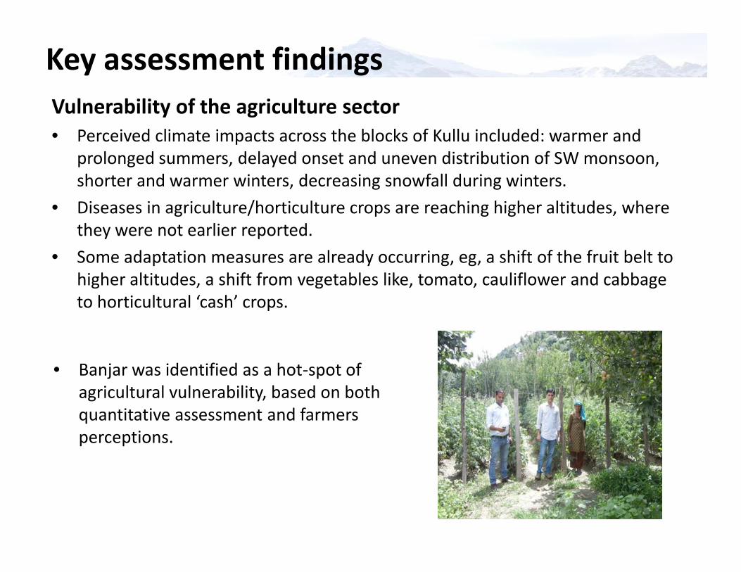
Key assessment findingsVulnerability of the agriculture sector• Perceived climate impacts across the blocks of Kullu included: warmer and
prolonged summers, delayed onset and uneven distribution of SW monsoon,shorter and warmer winters, decreasing snowfall during winters.
• Diseases in agriculture/horticulture crops are reaching higher altitudes, wherethey were not earlier reported.
• Some adaptation measures are already occurring, eg, a shift of the fruit belt tohigher altitudes, a shift from vegetables like, tomato, cauliflower and cabbageto horticultural ‘cash’ crops.
Vulnerability of the agriculture sector• Perceived climate impacts across the blocks of Kullu included: warmer and
prolonged summers, delayed onset and uneven distribution of SW monsoon,shorter and warmer winters, decreasing snowfall during winters.
• Diseases in agriculture/horticulture crops are reaching higher altitudes, wherethey were not earlier reported.
• Some adaptation measures are already occurring, eg, a shift of the fruit belt tohigher altitudes, a shift from vegetables like, tomato, cauliflower and cabbageto horticultural ‘cash’ crops.
• Banjar was identified as a hot-spot ofagricultural vulnerability, based on bothquantitative assessment and farmersperceptions.
Climate Change Adaptation Projects forKullu District
Climate Change Adaptation Projects forKullu District
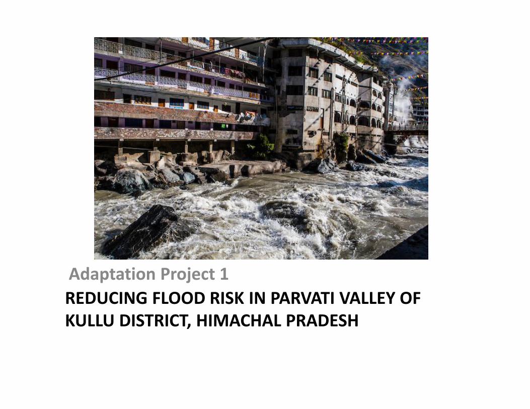
REDUCING FLOOD RISK IN PARVATI VALLEY OFKULLU DISTRICT, HIMACHAL PRADESH
Adaptation Project 1

Rationale• Considerable increase in the
formation of supra-glacial lakesdue to retreat of glaciers
• High risk of floods due to climatechange coupled with humaninduced activities
• Threat to the downstreaminhabited areas, roadinfrastructure, agricultural landand hydroelectric projects.
• Formal monitoring andevaluation system required
• Flood analyses has highlightedParvati valley as one of the mostvulnerable valleys in Kullu
12 1430 35 31
77
020406080
100
Tota
l No.
of L
akes
Years
Parvati Valley
Total no. of lakes Area (>10 hact.)
Number of glacial lakes mapped manually from satellitedata for Parvati Valley in Kullu district for the years1989, 2002, 2006, 2011, 2013, 2014
• Considerable increase in theformation of supra-glacial lakesdue to retreat of glaciers
• High risk of floods due to climatechange coupled with humaninduced activities
• Threat to the downstreaminhabited areas, roadinfrastructure, agricultural landand hydroelectric projects.
• Formal monitoring andevaluation system required
• Flood analyses has highlightedParvati valley as one of the mostvulnerable valleys in KulluFlood hazard levels at Kullu district (left) and details of
element-at-risk analyses at Parvati valley (right)
Number of glacial lakes mapped manually from satellitedata for Parvati Valley in Kullu district for the years1989, 2002, 2006, 2011, 2013, 2014
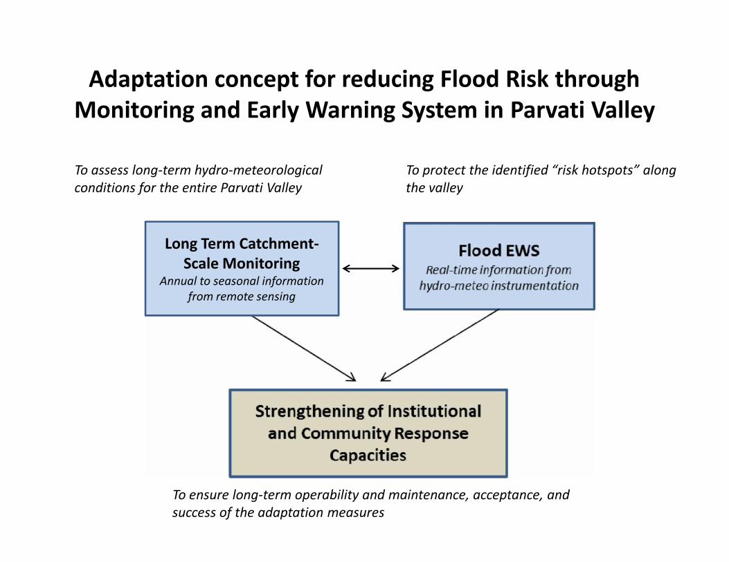
Adaptation concept for reducing Flood Risk throughMonitoring and Early Warning System in Parvati Valley
To assess long-term hydro-meteorologicalconditions for the entire Parvati Valley
To protect the identified “risk hotspots” alongthe valley
Long Term Catchment-Scale Monitoring
Annual to seasonal informationfrom remote sensing
To ensure long-term operability and maintenance, acceptance, andsuccess of the adaptation measures
Long Term Catchment-Scale Monitoring
Annual to seasonal informationfrom remote sensing
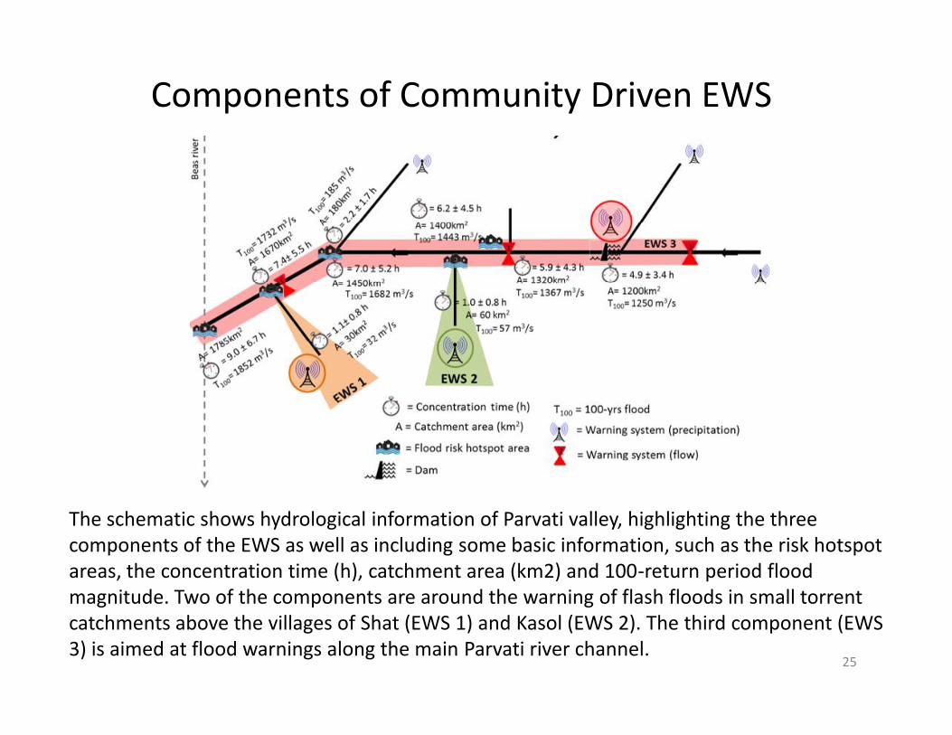
Components of Community Driven EWS
25
The schematic shows hydrological information of Parvati valley, highlighting the threecomponents of the EWS as well as including some basic information, such as the risk hotspotareas, the concentration time (h), catchment area (km2) and 100-return period floodmagnitude. Two of the components are around the warning of flash floods in small torrentcatchments above the villages of Shat (EWS 1) and Kasol (EWS 2). The third component (EWS3) is aimed at flood warnings along the main Parvati river channel.
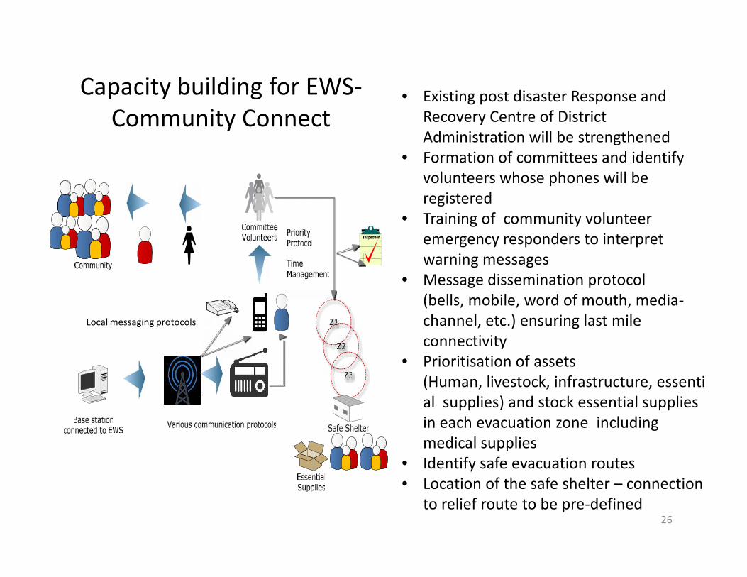
Capacity building for EWS-Community Connect
• Existing post disaster Response andRecovery Centre of DistrictAdministration will be strengthened
• Formation of committees and identifyvolunteers whose phones will beregistered
• Training of community volunteeremergency responders to interpretwarning messages
• Message dissemination protocol(bells, mobile, word of mouth, media-channel, etc.) ensuring last mileconnectivity
• Prioritisation of assets(Human, livestock, infrastructure, essential supplies) and stock essential suppliesin each evacuation zone includingmedical supplies
• Identify safe evacuation routes• Location of the safe shelter – connection
to relief route to be pre-defined26
• Existing post disaster Response andRecovery Centre of DistrictAdministration will be strengthened
• Formation of committees and identifyvolunteers whose phones will beregistered
• Training of community volunteeremergency responders to interpretwarning messages
• Message dissemination protocol(bells, mobile, word of mouth, media-channel, etc.) ensuring last mileconnectivity
• Prioritisation of assets(Human, livestock, infrastructure, essential supplies) and stock essential suppliesin each evacuation zone includingmedical supplies
• Identify safe evacuation routes• Location of the safe shelter – connection
to relief route to be pre-defined
Local messaging protocols
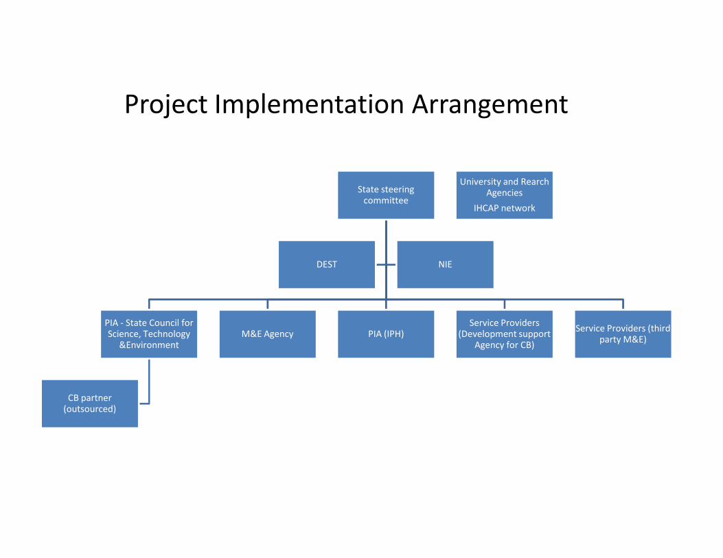
Project Implementation Arrangement
State steeringcommittee
DEST NIE
University and RearchAgencies
IHCAP network
PIA - State Council forScience, Technology
&Environment
CB partner(outsourced)
M&E Agency PIA (IPH)Service Providers
(Development supportAgency for CB)
Service Providers (thirdparty M&E)
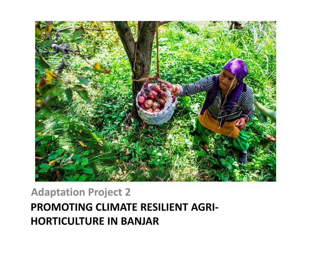
PROMOTING CLIMATE RESILIENT AGRI-HORTICULTURE IN BANJAR
Adaptation Project 2
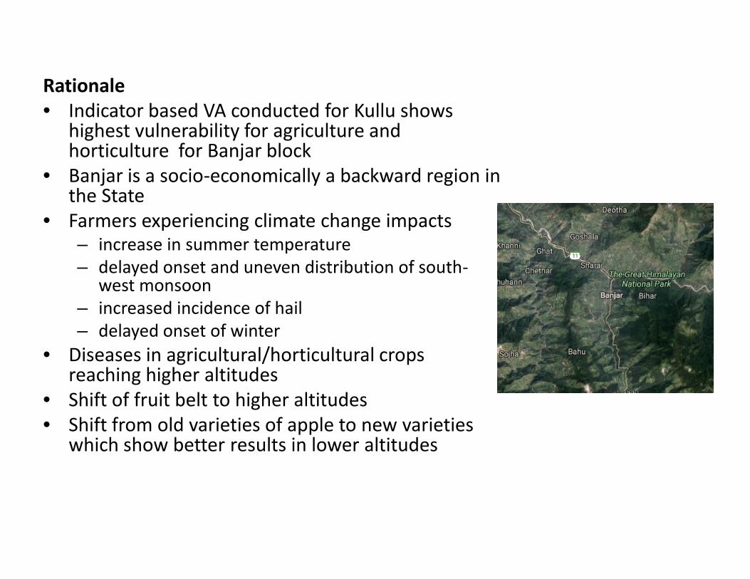
Rationale• Indicator based VA conducted for Kullu shows
highest vulnerability for agriculture andhorticulture for Banjar block
• Banjar is a socio-economically a backward region inthe State
• Farmers experiencing climate change impacts– increase in summer temperature– delayed onset and uneven distribution of south-
west monsoon– increased incidence of hail– delayed onset of winter
• Diseases in agricultural/horticultural cropsreaching higher altitudes
• Shift of fruit belt to higher altitudes• Shift from old varieties of apple to new varieties
which show better results in lower altitudes
Rationale: Climate Stress and Impact
Climate Stress
• Increase in spring temperaturein range of 1°C over the last 30years.
• The increase of springtemperature resulting to upwardshift of the snowline withrelated impacts onprecipitation, snow melt, glaciermass balance and lower chillinghours.
Impact
• Low chilling hours impactingyield and quality of appleproduction at low altitude
• Frequent pest incidence.• Increased variability in the
rainfall pattern leading toincreased demand forirrigation
• Increase in spring temperaturein range of 1°C over the last 30years.
• The increase of springtemperature resulting to upwardshift of the snowline withrelated impacts onprecipitation, snow melt, glaciermass balance and lower chillinghours.
• Low chilling hours impactingyield and quality of appleproduction at low altitude
• Frequent pest incidence.• Increased variability in the
rainfall pattern leading toincreased demand forirrigation
Future Climate Projection(Based on Himachal Pradesh State Action Plan on Climate Change)
• Temperature is projected to increase by 0.9±0.6°C to 2.6±0.7°C by2030s.
• The net increase in temperature ranges will be in the range of 1.7°Cto 2.2°C with respect to the 1970s.
The increase in temperature will further reduce the chilling hoursavailability
Increased temperature will increase the evapotranspiration rateand water requirement for cultivation
• Variability in the rainfall pattern and erratic rainfall pattern Further worsen the surface water and ground water availability due
to reduce percolation of water/ground water recharge Non timely availability of rainfall will impact the breeding
Baseline Scenario andProblem Statement
• Current variety of apple plants hasa chilling hours of 1000-1200 hrs.
• The availability of chilling hoursbelow 1000 hrs is impacting appleproduction.
• Agriculture and horticulturepractice in the state is mostly rain-fed with lower availability of microirrigation facility
• Rainfall pattern has become moreerratic and intense
• Unavailability of infrastructure forprotecting fruit crops againstclimate extremes (hail netpenetration is less than 2%)
• Incidence of climate extremeevents have increased in therecent past
Intervention• Promotion of high density spur
and low chilling variety ofapple(600-800 hrs) and climateresilient pomegranate variety.
• Creation of controlledatmosphere storage unit forstorage of apple as temperaturevariation impacts quality.
• Creation of water source(poly/geo lined tank) and sourceto irrigation point linkage tofacilitate higher penetration ofirrigation facilities.
• Dissemination of hail netscoupled with pollinators colonyto the farmers.
• Current variety of apple plants hasa chilling hours of 1000-1200 hrs.
• The availability of chilling hoursbelow 1000 hrs is impacting appleproduction.
• Agriculture and horticulturepractice in the state is mostly rain-fed with lower availability of microirrigation facility
• Rainfall pattern has become moreerratic and intense
• Unavailability of infrastructure forprotecting fruit crops againstclimate extremes (hail netpenetration is less than 2%)
• Incidence of climate extremeevents have increased in therecent past
• Promotion of high density spurand low chilling variety ofapple(600-800 hrs) and climateresilient pomegranate variety.
• Creation of controlledatmosphere storage unit forstorage of apple as temperaturevariation impacts quality.
• Creation of water source(poly/geo lined tank) and sourceto irrigation point linkage tofacilitate higher penetration ofirrigation facilities.
• Dissemination of hail netscoupled with pollinators colonyto the farmers.
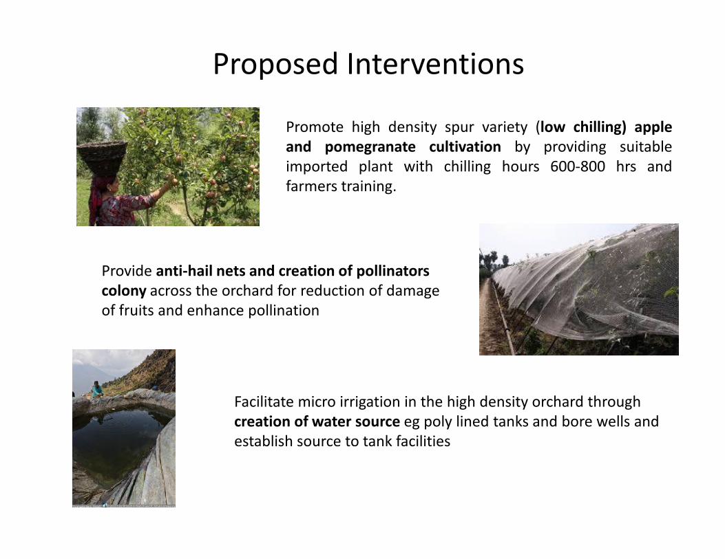
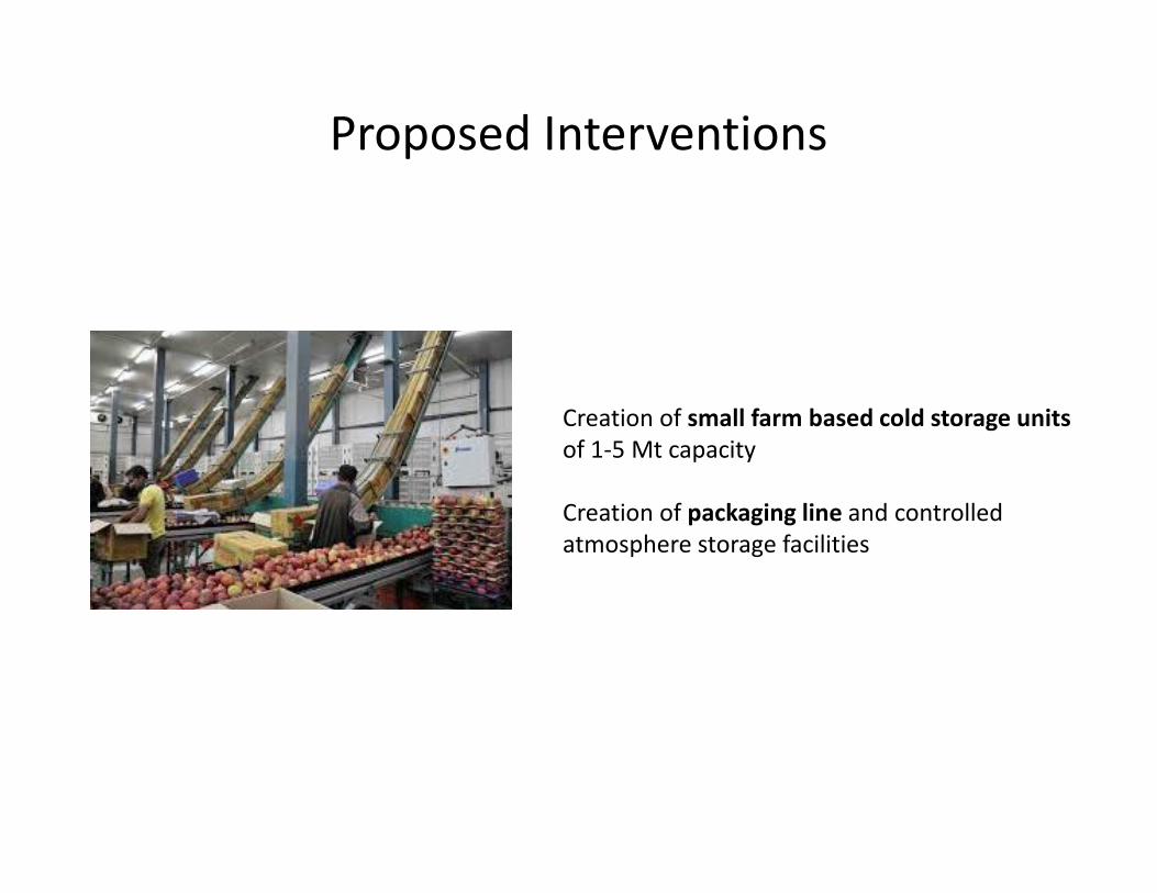
Proposed Interventions
Promote high density spur variety (low chilling) appleand pomegranate cultivation by providing suitableimported plant with chilling hours 600-800 hrs andfarmers training.
Provide anti-hail nets and creation of pollinatorscolony across the orchard for reduction of damageof fruits and enhance pollination
Provide anti-hail nets and creation of pollinatorscolony across the orchard for reduction of damageof fruits and enhance pollination
Facilitate micro irrigation in the high density orchard throughcreation of water source eg poly lined tanks and bore wells andestablish source to tank facilities
Proposed Interventions
Creation of small farm based cold storage unitsof 1-5 Mt capacity
Creation of packaging line and controlledatmosphere storage facilities
Creation of small farm based cold storage unitsof 1-5 Mt capacity
Creation of packaging line and controlledatmosphere storage facilities
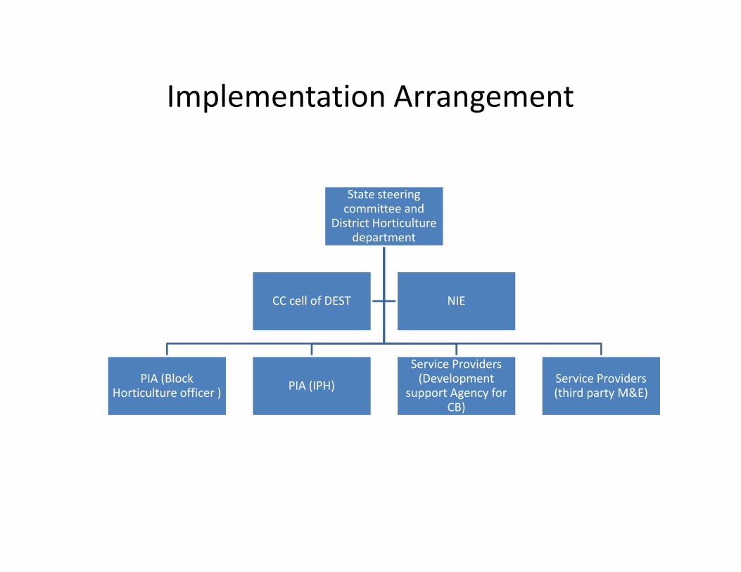
Implementation Arrangement
State steeringcommittee and
District Horticulturedepartment
PIA (BlockHorticulture officer ) PIA (IPH)
Service Providers(Development
support Agency forCB)
Service Providers(third party M&E)
CC cell of DEST NIE
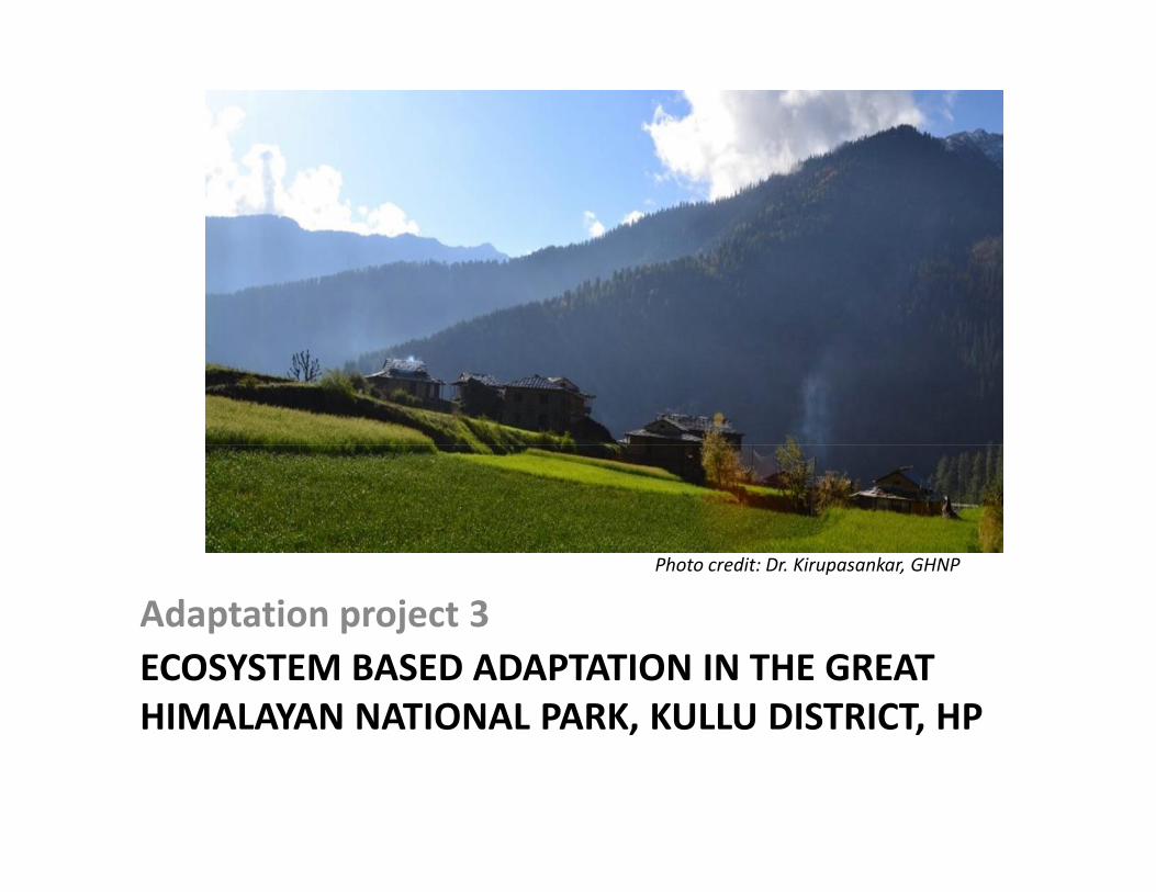
ECOSYSTEM BASED ADAPTATION IN THE GREATHIMALAYAN NATIONAL PARK, KULLU DISTRICT, HP
Adaptation project 3Photo credit: Dr. Kirupasankar, GHNP
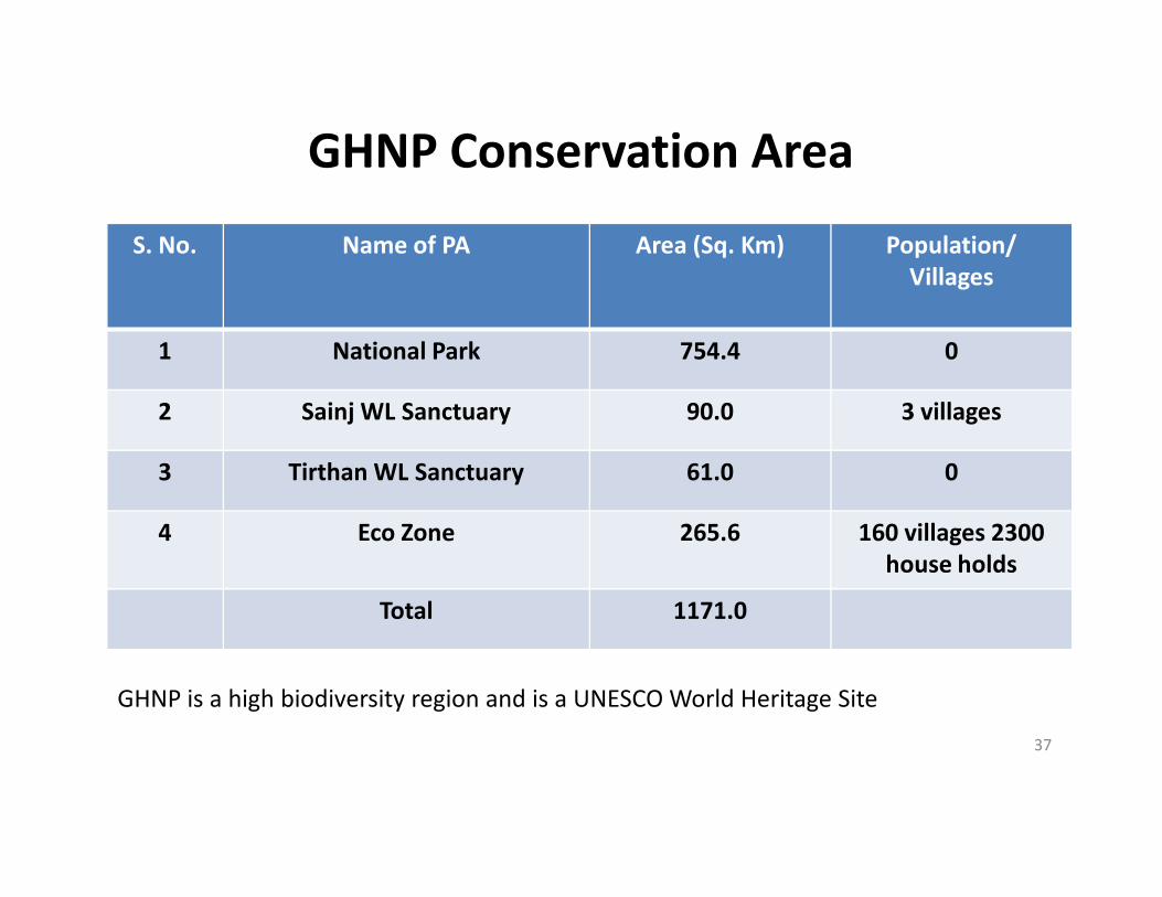
GHNP Conservation AreaS. No. Name of PA Area (Sq. Km) Population/
Villages
1 National Park 754.4 0
2 Sainj WL Sanctuary 90.0 3 villages
Tirthan WL Sanctuary 61.03 Tirthan WL Sanctuary 61.0 0
4 Eco Zone 265.6 160 villages 2300house holds
Total 1171.0
37
GHNP is a high biodiversity region and is a UNESCO World Heritage Site
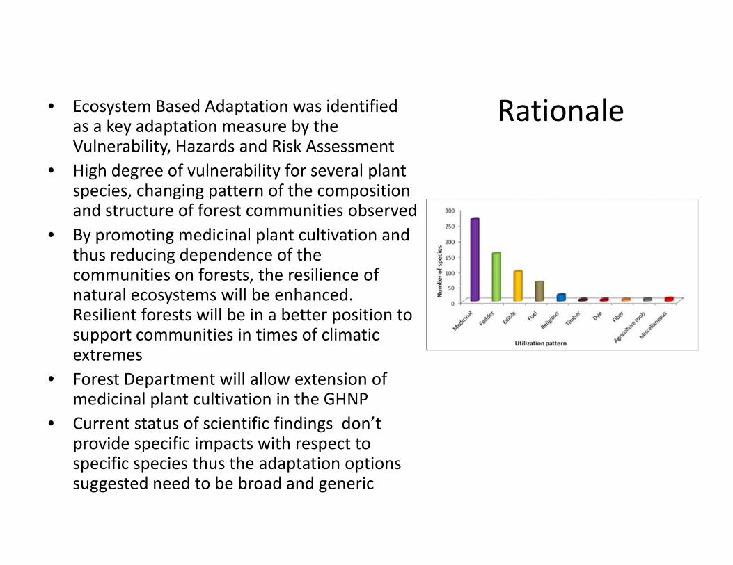
Rationale• Ecosystem Based Adaptation was identifiedas a key adaptation measure by theVulnerability, Hazards and Risk Assessment
• High degree of vulnerability for several plantspecies, changing pattern of the compositionand structure of forest communities observed
• By promoting medicinal plant cultivation andthus reducing dependence of thecommunities on forests, the resilience ofnatural ecosystems will be enhanced.Resilient forests will be in a better position tosupport communities in times of climaticextremes
• Forest Department will allow extension ofmedicinal plant cultivation in the GHNP
• Current status of scientific findings don’tprovide specific impacts with respect tospecific species thus the adaptation optionssuggested need to be broad and generic
• Ecosystem Based Adaptation was identifiedas a key adaptation measure by theVulnerability, Hazards and Risk Assessment
• High degree of vulnerability for several plantspecies, changing pattern of the compositionand structure of forest communities observed
• By promoting medicinal plant cultivation andthus reducing dependence of thecommunities on forests, the resilience ofnatural ecosystems will be enhanced.Resilient forests will be in a better position tosupport communities in times of climaticextremes
• Forest Department will allow extension ofmedicinal plant cultivation in the GHNP
• Current status of scientific findings don’tprovide specific impacts with respect tospecific species thus the adaptation optionssuggested need to be broad and generic
Rationale: Stress and impact on the medicinal plant sector(Based on Himachal Pradesh State Action Plan on Climate Change)
• Increase in the spring temperature, upward shift of the snowline erraticprecipitation pattern, snow melt and reduced glacier mass balance
Loss of biodiversity, altitudinal shift, delineation of the plantcommunity/habitat loss,
Invasion of non-native species including exotic, invasive and noxious species Change in plant phenology• Increase anthropogenic pressure including unscientific and overexploitation
of species with ethno – medicinal value Species/habitat loss Affecting the traditional practices related to health care Loss of the rich knowledge base associated with these plant based health
care practices.
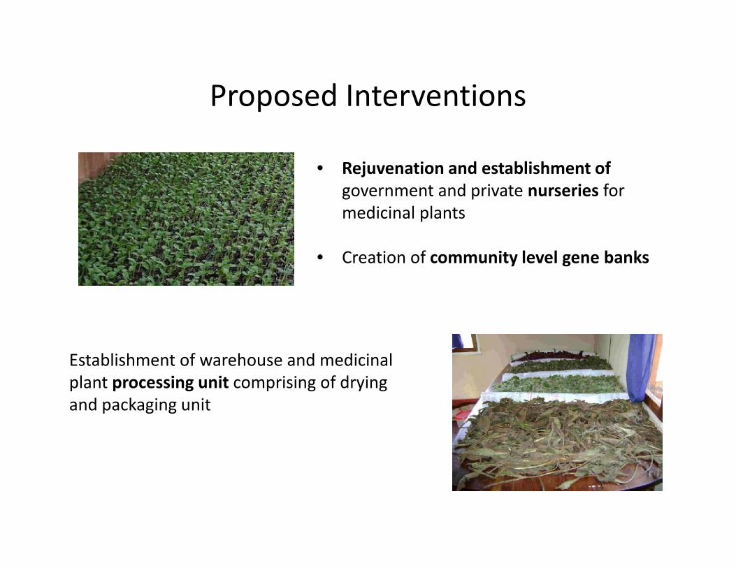
Proposed Interventions
• Rejuvenation and establishment ofgovernment and private nurseries formedicinal plants
• Creation of community level gene banks
Establishment of warehouse and medicinalplant processing unit comprising of dryingand packaging unit
Proposed Interventions
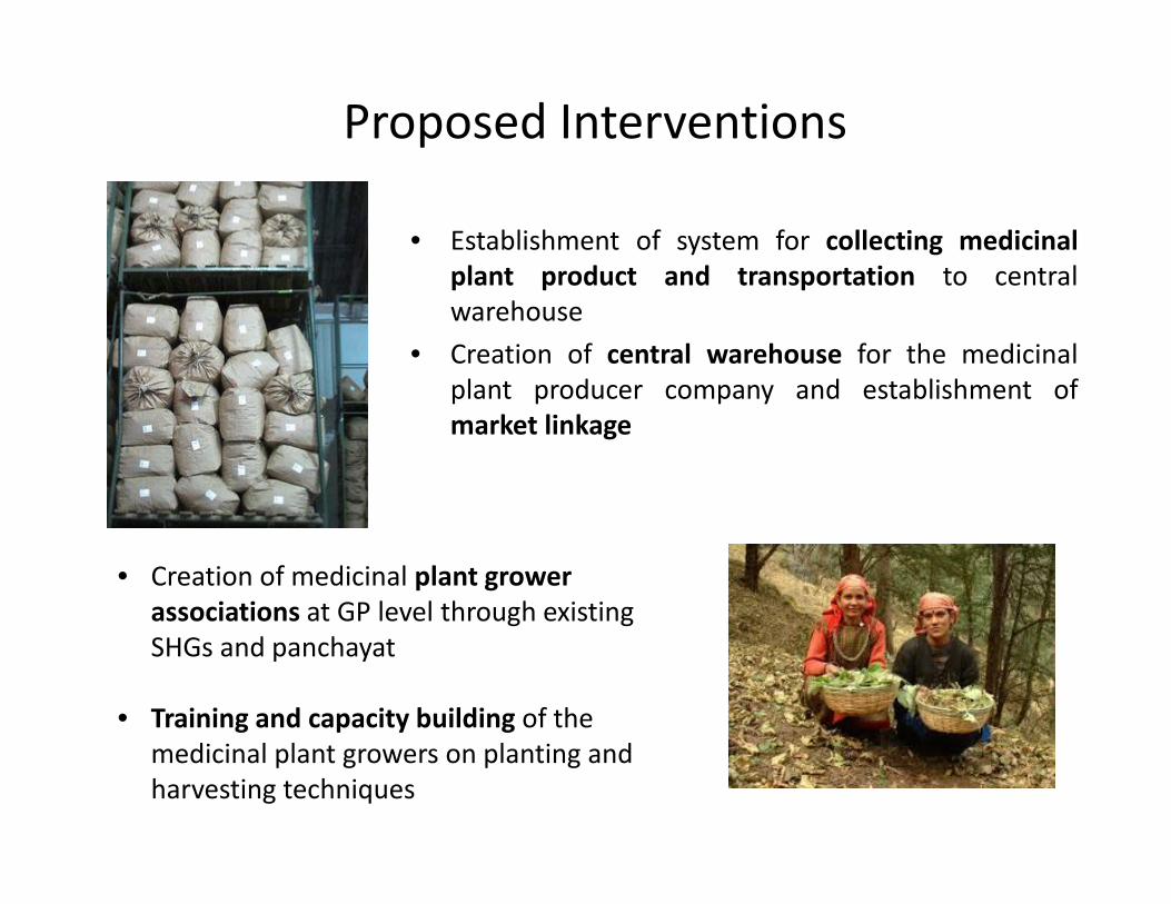
• Establishment of system for collecting medicinalplant product and transportation to centralwarehouse
• Creation of central warehouse for the medicinalplant producer company and establishment ofmarket linkage
• Creation of medicinal plant growerassociations at GP level through existingSHGs and panchayat
• Training and capacity building of themedicinal plant growers on planting andharvesting techniques
• Establishment of system for collecting medicinalplant product and transportation to centralwarehouse
• Creation of central warehouse for the medicinalplant producer company and establishment ofmarket linkage
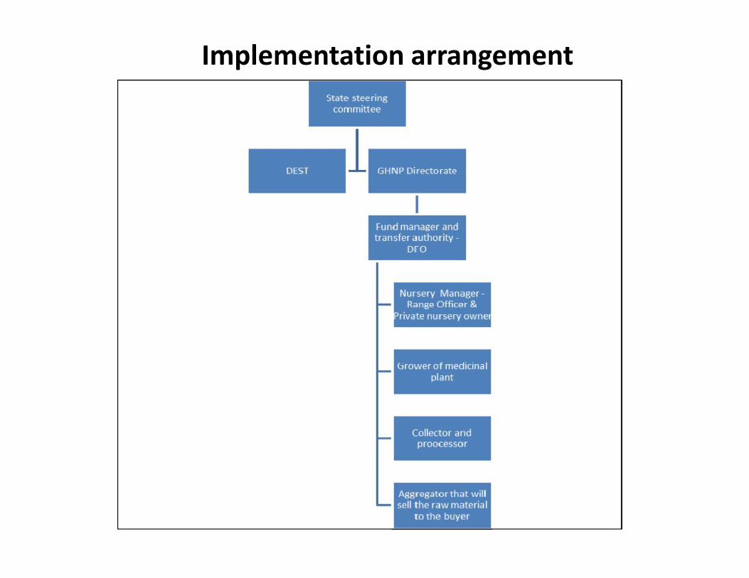
Implementation arrangement
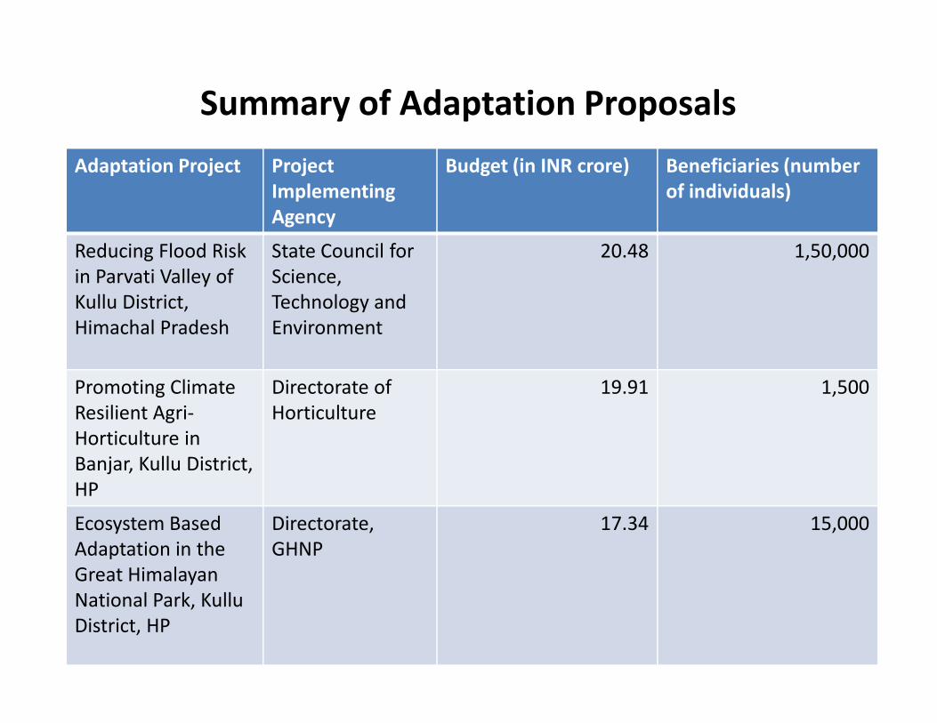
Summary of Adaptation ProposalsAdaptation Project Project
ImplementingAgency
Budget (in INR crore) Beneficiaries (numberof individuals)
Reducing Flood Riskin Parvati Valley ofKullu District,Himachal Pradesh
State Council forScience,Technology andEnvironment
20.48 1,50,000
Promoting ClimateResilient Agri-Horticulture inBanjar, Kullu District,HP
Directorate ofHorticulture
19.91 1,500
Ecosystem BasedAdaptation in theGreat HimalayanNational Park, KulluDistrict, HP
Directorate,GHNP
17.34 15,000
• Indo Swiss collaborative research studies forcreation of evidence base on climate changeimpacts
• Multi stakeholder consultations for developingadaptation project proposals
• Adaptation proposals (DPRs) handed over toDEST, Government of Himachal Pradesh
Recap
• Indo Swiss collaborative research studies forcreation of evidence base on climate changeimpacts
• Multi stakeholder consultations for developingadaptation project proposals
• Adaptation proposals (DPRs) handed over toDEST, Government of Himachal Pradesh
Next Steps
• DEST, Government of Himachal Pradesh tosecure funds for implementing the adaptationactions
• Funds may be from state, national orinternational sources
• DEST, Government of Himachal Pradesh tosecure funds for implementing the adaptationactions
• Funds may be from state, national orinternational sources
Thank youwww.ihcap.in