Embed Size (px)
Citation preview

New Hill WalkersClothiNg | EquipmENt | NavigatioN | hazards | EmErgENCiEs
Climb it, walk it, proteCt it.
0161 445 6111 [email protected]
The British Mountaineering Council secures access to crags and uplands » we offer member discounts at over 600 outdoor retailers nationwide » we’ve been the only public voice for climbers, hill walkers and mountaineers in England and Wales since 1944 » we have over 70,000 members, and the numbers are rising… join us.

3introduction
2 | Introduction
The British hills offer beauty, challenge and adventure, as well as the opportunity to keep fit and healthy. So it is no wonder that hill walking is such a popular activity, attracting people of all ages. Walking in the uplands requires a collection of skills, including navigation and hazard avoidance. It is important that participants are prepared with some basic equipment and knowledge in order to enjoy hill walking safely.
this booklet is intended for those who are relatively or completely new to the activity of hill walking. it aims to highlight some of the more important
aspects and provide a reference base of resources for learning the required skills. No amount of reading or training can make hill walking completely safe, but if you adopt a progressive approach to your days out, developing hill skills incrementally and building upon past experience, you can minimise the risks and maximise your enjoyment.
Where to goWith hundreds of hills and mountains from the scottish highlands to the tors of dartmoor the upland areas of Britain hold a lifetime of hill walking pleasure. Classic areas include the lake district and snowdonia, whilst adventures at lower altitudes can be found in popular areas such as the peak district and the Yorkshire dales.
there are walking guidebooks to most areas, describing popular walking routes. Enjoyment and satisfaction can also be gained from planning your own routes.
How to learnonce you know the skills you need, how do you go about gaining them? Books and dvds can provide basic knowledge of the core skills, but there is no substitute for going out and developing your skills in the hills and mountains.
You might choose to begin your adventures alone, with another novice, or in the company of someone more experienced. Whichever you choose, adopt a progressive approach, building upon past experience as you learn.
Not sure where to go?
Get a guidebook
Books and DVDs are a great
source of advice
Walking in open country
2 BmC – New Hill Walkers
2. introduction . . . . . . . . . . . . . . . . . . . . . . . . . . . . . . . . . . . . . . . . . . . . . . . . . . . . . . . . . . . . . . . . . . . . . . . . . . . 33. Know your hill skills! . . . . . . . . . . . . . . . . . . . . . . . . . . . . . . . . . . . . . . . . . . . . . . . . . . . . . . . . . 44. Clothing and Equipment . . . . . . . . . . . . . . . . . . . . . . . . . . . . . . . . . . . . . . . . . . . . . . . . . . . 65. Navigation . . . . . . . . . . . . . . . . . . . . . . . . . . . . . . . . . . . . . . . . . . . . . . . . . . . . . . . . . . . . . . . . . . . . . . . . . . . 126. hazards . . . . . . . . . . . . . . . . . . . . . . . . . . . . . . . . . . . . . . . . . . . . . . . . . . . . . . . . . . . . . . . . . . . . . . . . . . . . . . . . 167. Walking in Winter . . . . . . . . . . . . . . . . . . . . . . . . . . . . . . . . . . . . . . . . . . . . . . . . . . . . . . . . . . . . 208. access and the Environment . . . . . . . . . . . . . . . . . . . . . . . . . . . . . . . . . . . . . . . . 229. Emergency procedures . . . . . . . . . . . . . . . . . . . . . . . . . . . . . . . . . . . . . . . . . . . . . . . . . . 25
BMC Participation Statement The BMC recognises that climbing, hill walking and mountaineering are activities with a danger of personal injury or death. Participants in these activities should be aware of and accept these risks and be responsible for their own actions and involvement.
1 | Contents
New Hill WalkersCopyright © 2011 British mountaineering Council
published by British Mountaineering Council 177–179 Burton road, manchester m20 2BB www.thebmc.co.uk
this book contains a number of illustrations provided by mountain leader training uK, siabod Cottage, Capel Curig, Conwy ll24 0Es www.mltuk.org
the BmC acknowledges the financial support of sport England in producing this booklet www.sportengland.org
photos and other images have been provided by Rob Dyer, Alex Messenger, Cicerone, Lowe Alpine, Lyme Disease Action, Sea to Summit and Trail magazine.
produced by vertebrate graphics, sheffield – www.v-graphics.co.uk vg711gWhere you see this logo the BmC has used paper from recycled or sustainable sources
Some possible first stepsJoin a BmC club: www.thebmc.co.uk/clubsEmploy a qualified instructor: www.mlta.co.uk and www.ami.org.ukgo on a course: www.pyb.co.uk
4 BmC – New Hill Walkers
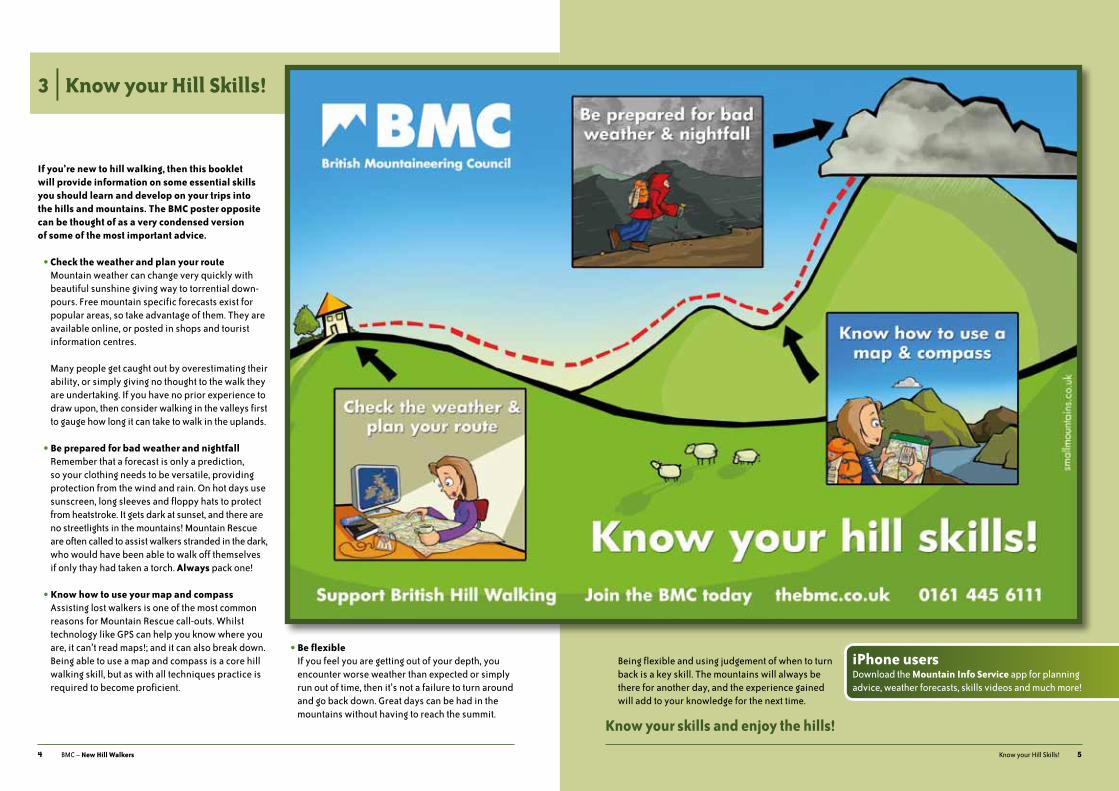
If you’re new to hill walking, then this booklet will provide information on some essential skills you should learn and develop on your trips into the hills and mountains. The BMC poster opposite can be thought of as a very condensed version of some of the most important advice.
• Check the weather and plan your routemountain weather can change very quickly with beautiful sunshine giving way to torrential down- pours. Free mountain specific forecasts exist for popular areas, so take advantage of them. they are available online, or posted in shops and tourist information centres. many people get caught out by overestimating their ability, or simply giving no thought to the walk they are undertaking. if you have no prior experience to draw upon, then consider walking in the valleys first to gauge how long it can take to walk in the uplands.
• Be prepared for bad weather and nightfallremember that a forecast is only a prediction, so your clothing needs to be versatile, providing protection from the wind and rain. on hot days use sunscreen, long sleeves and floppy hats to protect from heatstroke. it gets dark at sunset, and there are no streetlights in the mountains! mountain rescue are often called to assist walkers stranded in the dark, who would have been able to walk off themselves if only thay had taken a torch. Always pack one!
• Know how to use your map and compassassisting lost walkers is one of the most common reasons for mountain rescue call-outs. Whilst technology like gps can help you know where you are, it can’t read maps!; and it can also break down. Being able to use a map and compass is a core hill walking skill, but as with all techniques practice is required to become proficient.
• Be flexibleif you feel you are getting out of your depth, you encounter worse weather than expected or simply run out of time, then it’s not a failure to turn around and go back down. great days can be had in the mountains without having to reach the summit.
3 | Know your Hill Skills!
5Know your hill skills!
Being flexible and using judgement of when to turn back is a key skill. the mountains will always be there for another day, and the experience gained will add to your knowledge for the next time.
Know your skills and enjoy the hills!
iPhone usersdownload the Mountain Info Service app for planning advice, weather forecasts, skills videos and much more!

6 BmC – New Hill Walkers
There is not much gear that is vital, but it’s important to have appropriate equipment for the activity and prevailing weather.
ClotHIngWhen out in the hills you will need, as a minimum:
• shoes or boots to keep you upright;
• insulating layers to keep you warm;
• waterproofs to keep you dry.
Footwearit is important to choose shoes or boots that are both comfortable and provide adequate support. No foot- wear is perfectly suited for all seasons and terrain. a lightweight summer shoe would be completely inappropriate in winter, for example, just as wearing winter mountaineering boots on a hot sunny day could result in overheated and blistered feet.
shoes are great on level terrain such as lowland valley tracks. With little ankle support provided, they are unsuitable on uneven ground and steep climbs.
Boot construction varies greatly and affects how ‘soft’ or ‘firm’ a boot feels. summer boots tend to flex more than winter boots. When walking on bare rock a soft sole can mould to the uneven surface better than a
firm sole. For this reason summer boots can feel more comfortable. however, a boot with a more rigid sole can grip small edges more effectively. such differences demonstrate why a softer boot is great for trail walking and a firmer boot better suited to scrambling.
a useful way to gauge how much support a boot will give is by twisting it. holding the heel in one hand and the toe box in the other see how easy the boot will twist. the easier it twists the less support the boot will provide on steep uneven terrain or steep grassy slopes. Conversely, if most of your walking is along well defined paths with gentle inclines, a softer boot may suit you better.
some boots can be used for summer and winter walking. But whatever you choose, make sure the boot is appro- priate for the most demanding conditions you plan to walk in. if you are very heavy with large feet, or very light with small feet you could also consider choosing a more or less substantial boot as appropriate.
a good outdoor retailer will be able to help you find the right boot for your activity and foot shape. try the boots on with your own appropriate walking socks. specialist walking socks have design features that affect the fit of your boot, so bear this in mind when selecting your boot size. a good fit will give you room around the toes and hold the heel to prevent it lifting too much. many shops will let you take the boots home for an indoor
4 | Clothing and Equipment
7Clothing and Equipment
trial and then let you return them if they’re not quite right. Walking up and down a flight of stairs can help you decide if your foot is held firmly in the boot.
Your first long walk in a new pair of boots will help break them in. the stiffer and heavier they are, the more breaking in will be required. Be aware of any rub points, and if you notice any, stop and apply tape or a plaster which should prevent blisters developing.
Socksgood socks regulate your foot temperature and help to prevent blisters by providing a snug fit. as with your clothing, socks need to wick moisture away from your skin, as overheated feet will be uncomfortable and prone to developing blisters. Choose socks that are padded in the heel, ball and toes where the most pressure is applied. some people like to wear two pairs of socks consisting of a snug thin inner one and a thicker outer one. this system can reduce friction on your feet, as the sock layers will move against each other instead of your feet moving against the sock.
Insulating layersJust as we use layers of clothing in our everyday lives to regulate body temperature, the same is true when exploring the hills. the range of temperatures experienced in one day will often be greater in the hills than in cities. Clothing to deal with such variation is therefore required. With the weight of your rucksack contents an important consideration, choosing items that fulfil a range of functions is a good idea. Water- proofs double up as windproofs for example.
You may already own clothing that fits the bill very well. You’ll need light comfortable clothing while you walk, something warm for when it gets colder and something waterproof in case the heavens open. it is better to wear several relatively thin layers than a single thick one, because the layers trap air which is a good insulator, and you can regulate your temperature more effectively by adding or removing layers.
materials which do not absorb moisture are better because wet clothes will make you feel cold. Wool has always been recognised as a good material for hill walkers. synthetic materials such as fleece are also used for outdoor clothing. Cotton is not good and jeans are particularly cold when wet.
most people already have some suitable insulating layers before they start hill walking, such as a thin wicking baselayer and light woollen midlayer. the base- layer should wick moisture away from your body, and so keep your skin dry and prevent excessive chilling every time you stop. as well as providing insulation, a thin midlayer also allows moisture to wick. Fleece jackets are excellent as a third insulating layer.
all these layers should be relatively snug on your body. if too tight they will be uncomfortable, but if loose and baggy then instead of trapping warm air you’re likely to have cold drafts instead! leg muscles produce a lot of heat when we walk and thermal leg wear is likely only to be necessary in cold conditions.
Head and hands on cold days, a hat or balaclava and scarf or neck gaiter will reduce the heat lost through the head and neck.
Fleece jackets are good thermal layers
Summer shoe – flexible sole, breathable upper Summer and autumn boot – stiffer sole, ankle support,
water repellent upper

8 BmC – New Hill Walkers
Fleece is probably the most popular material as it is light and flexible, and can be wrung dry if it gets very wet. Keep your head warm and you will be warm!
on hot sunny days, a sunhat and neckerchief will protect the head and neck from sunburn and overheating. if the body absorbs more heat than it can dissipate then heatstroke (also known as hyperthermia or sunstroke) could ensue, which is a serious medical condition.
gloves need not be over specialised. a simple pair of woollen or fleece gloves or mittens will be fine. a spare pair weighs very little but at times can be vital. gloves that can retain warmth when wet are a real advantage, such as thick woollen ones or those with a windproof outer.
Waterproofs a waterproof outer layer of jacket and trousers will keep you dry, and in combination with your insulating layers will prevent a reduction in body temperature which can in extreme circumstances lead to the development of hypothermia. Nowadays, just about all waterproofs are made from breathable fabrics, allowing body moisture to escape, whilst keeping the rain out.
Non breathable fabrics do not let perspiration escape, so you can get increasingly damp as the day wears on.
a hill walking jacket should be big enough to get warm layers underneath, but not so big that it flaps around. it should have an easily accessible pocket that can accommodate a map, and large pockets for carrying hats, gloves and so on. Waist and hood drawcords and adjustable wrist closures help to seal out the weather and retain warmth. a stiffened hood will provide good visibility; the alternative is one that slaps you in the face with every gust of wind! You’ll need to be able to put your overtrousers on and remove them whilst wearing your boots, so make sure there are zips down the side.
gaiters can be invaluable on boggy ground and rainy days. they also prevent vegetation from entering your boots. in winter, gaiters are indispensible for keeping snow out of your boots and preventing your feet from becoming wet and cold. if worn with waterproof trousers, wear the gaiters underneath, not with the trousers tucked in, or water will be ‘conveniently’ channelled into your boots!
9Clothing and Equipment
EquIpmEnta suggested kit list at the end of this chapter provides guidance on what to take on your hill walks. Consider your day ahead, and pack accordingly.
Rucksacka rucksack is the most convenient way to carry your equipment, and should be neither too big nor too small. there are many different sizes to choose from. When moorland walking, a 30 litre rucksack is probably adequate; if heading into the mountains, a 45 litre rucksack would be better.
When full, the rucksack should distribute the load evenly and be comfortable to wear. it should sit close to the wearer’s back, allowing an upright posture to be maintained, and not restrict the movement of the head. all walkers should consider their own back anatomy in relation to the rucksack they choose. the shoulder-waist-hip ratios are different between men and women, and so some rucksacks are specially designed for women.
a slim rucksack with no side pockets is less likely to get caught on obstructions. Compression straps
along the side of the rucksack allow a slim profile to be maintained, and can be used to secure walking poles when not in use. lid pockets are very useful for gloves, hats and snacks, etc.
Finally, consider how to pack your rucksack. regularly used items should be easily accessible in the lid pocket or top of the rucksack. heavy items, such as water bottles or thermos flasks, should be packed close to the back in the middle portion of the rucksack. light items, such as fleece clothing, can be packed further away from the back of the rucksack. distributing weight in this way will result in better stability when walking. packing kit in a selection of drybags is the best way to prevent it getting wet. on rainy days especially, not having to expose all your kit to the elements at one time makes life much easier. heavy duty carrier bags are a cheaper alternative to drybags.
Food and drinkas crucial as taking suitable equipment is having sufficient food and drink. the amount required will vary depending on weather conditions, distance and terrain walked.
a good breakfast will set you up for a day’s walk, and whilst out, consuming little and often is the best way to keep hydrated and maintain your energy. it is sensible to have some emergency food, like high energy bars, tucked out of the way ‘just in case’. You do not need to take any ‘specialist’ food; sandwiches, snacks and some fruit will work fine.
When it comes to drinks, water will do the job perfectly well. in cold weather a hot drink is likely to be very welcome, with a metal thermos flask being more robust than a glass one.
A waterproof outer layer will keep you dry A rucksack keeps your hands free for important tasks

10 BmC – New Hill Walkers
Skin and eye protectiona cooling mountain breeze on a hot sunny day can easily lead to the assumption that there is little chance of getting sunburn. this is obviously far from true! if the sun is out, applying sunscreen and lip-salve in advance and then regularly throughout the day is the way to go.
it goes without saying that sunglasses can make life more comfortable on a sunny summer’s day. in winter, not wearing eye protection can make it very hard to move around or even lead to snow blindness. this is a reversible condition caused by unprotected eyes being exposed to uv light reflected from the snow, and is akin to parts of the eyes being sunburnt.
in scotland especially, midges can be the bane of the summer hill walker, but repellents containing dEEt work well to stop them biting. some people do not like using dEEt based repellents, preferring those containing natural ingredients such as Citronella, but these are not as effective as dEEt based products. if camping in the summer, consider taking a mesh head net for extra protection.
Trekking polestrekking poles are increasingly popular, and are best used as a pair. poor technique can negate any positive benefits, and there are pros and cons to using them.
after a long day out in the hills, aching knees on the descent is very common. poles can transfer some of the impact of walking from the lower legs and knees to the arms and shoulders. poles also help with stability, particularly useful when carrying a heavy sack, walking on uneven ground or in winter when patches of ice can occur unexpectedly.
however, the wrist, elbow and shoulder joints are not designed to prop up your body – we’re bipedal after all! if you’re not careful, protecting your knees can simply mean aggravating other joints. if you are very tired and do not need the poles for stability, it may be best to pack them away if there is the chance of tripping yourself up on one! using poles prevents your hands from being free for other things. don’t fall into the trap of not eating, drinking or checking your map simply because you cannot be bothered to take your poles off.
EmErgEnCy EquIpmEntWhilst emergencies are a rare occurrence in the hills, the equipment to help you deal with them is relatively modest. here are some suggestions:
First Aid kitWhen dealing with an injured hill walker, help may not be close at hand. therefore, taking a first aid kit and seeking out some basic first aid training is a very good idea.
11Clothing and Equipment
Group sheltergetting lost in poor visibility or dealing with even a minor injury can escalate into something more serious for the whole party if people get cold. spare clothing should be carried for this reason, but a group shelter is the most effective way to keep warm. made from light ripstop nylon, a group shelter is shaped like a very large upside down bowl. the warmer temperature inside the shelter is created by retained body heat and protection from wind.
Bivi bagmade from tough polythene, a bivi bag provides individual shelter in case of emergency. Effective and inexpensive, they can also be used in conjunction with a group shelter. more expensive survival bag designs can provide greater insulating properties than a standard polythene bivi bag.
Torchit is not uncommon for mountain rescue teams to assist able bodied walkers off the hills who have simply got caught out after dark. Whether underestimating how long a walk will take, or getting lost and staying out for longer than planned, heading back home in the dark need not be a reason to panic if everyone has a torch. a headtorch is best, and many inexpensive models are widely available. always take a torch and make sure you also have some spare batteries.
Mobile phonemobile phones can be a godsend when needing to contact the emergency services, but should not be thought of as a ‘safety net’, tempting walkers to objectives outside of their experience and ability.
Whistlea whistle is a great way to attract attention – the international distress signal is six blasts in quick succession, repeated after a one-minute interval. Flashing your torch in a similar manner will also be recognised as a distress signal.
Watchtime flies when you’re having fun, so keep track of it. You’ll also need it to time navigation legs.
A suggested kit check list• map and compass• torch, plus spare battery and bulb• watch• walking boots and socks• shorts / trousers• wicking baselayer• insulating midlayer• fleece jacket• waterproof jacket• waterproof overtrousers• hat and scarf• gloves / mittens• gaiters• rucksack• drink• food• emergency food• sunhat / sunglasses / sunscreen• insect repellent (seasonal)• spare gloves• spare socks• whistle• mobile phone• first aid kit• bivi bag• group shelter • trekking poles (optional)
Poles can protect your knees and improve stability on descents Group shelter – potential lifesaver in emergencies, and handy for
lunch stops on chilly days
Further Information on Clothing and EquipmentBook: Safety on Mountains (BmC)
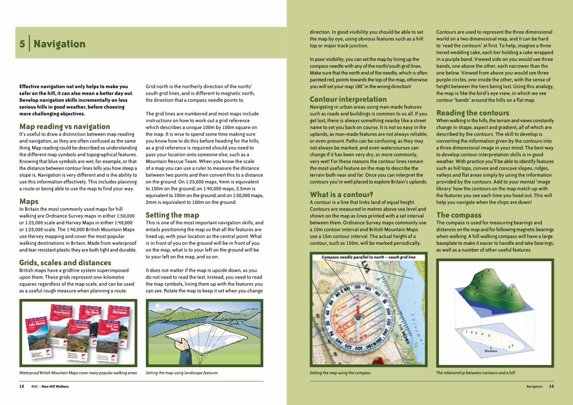
direction. in good visibility you should be able to set the map by eye, using obvious features such as a hill top or major track junction.
in poor visibility, you can set the map by lining up the compass needle with any of the north/south grid lines. make sure that the north end of the needle, which is often painted red, points towards the top of the map, otherwise you will set your map 180° in the wrong direction!
Contour interpretationNavigating in urban areas using man-made features such as roads and buildings is common to us all. if you get lost, there is always something nearby like a street name to set you back on course. it is not so easy in the uplands, as man-made features are not always reliable, or even present. paths can be confusing, as they may not always be marked, and even watercourses can change if it has been very dry, or more commonly, very wet! For these reasons the contour lines remain the most useful feature on the map to describe the terrain both near and far. once you can interpret the contours you’re well placed to explore Britain’s uplands.
What is a contour?a contour is a line that links land of equal height. Contours are measured in metres above sea level and shown on the map as lines printed with a set interval between them. ordnance survey maps commonly use a 10m contour interval and British mountain maps use a 15m contour interval. the actual height of a contour, such as 150m, will be marked periodically.
Contours are used to represent the three dimensional world on a two dimensional map, and it can be hard to ‘read the contours’ at first. to help, imagine a three tiered wedding cake, each tier holding a cake wrapped in a purple band. viewed side on you would see three bands, one above the other, each narrower than the one below. viewed from above you would see three purple circles, one inside the other, with the sense of height between the tiers being lost. using this analogy, the map is like the bird’s eye view, in which we see contour ‘bands’ around the hills on a flat map.
Reading the contoursWhen walking in the hills, the terrain and views constantly change in shape, aspect and gradient, all of which are described by the contours. the skill to develop is converting the information given by the contours into a three dimensional image in your mind. the best way to develop contour interpretation skills is in good weather. With practice you’ll be able to identify features such as hill tops, convex and concave slopes, ridges, valleys and flat areas simply by using the information provided by the contours. add to your mental ‘image library’ how the contours on the map match up with the features you see each time you head out. this will help you navigate when the chips are down!
The compassthe compass is used for measuring bearings and distances on the map and for following magnetic bearings when walking. a hill walking compass will have a large baseplate to make it easier to handle and take bearings, as well as a number of other useful features.
12 BmC – New Hill Walkers
Effective navigation not only helps to make you safer on the hill, it can also mean a better day out. Develop navigation skills incrementally on less serious hills in good weather, before choosing more challenging objectives.
Map reading vs navigationit’s useful to draw a distinction between map reading and navigation, as they are often confused as the same thing. map reading could be described as understanding the different map symbols and topographical features. Knowing that blue symbols are wet, for example, or that the distance between contour lines tells you how steep a slope is. Navigation is very different and is the ability to use this information effectively. this includes planning a route or being able to use the map to find your way.
Mapsin Britain the most commonly used maps for hill walking are ordnance survey maps in either 1:50,000 or 1:25,000 scale and harvey maps in either 1:40,000 or 1:25,000 scale. the 1:40,000 British mountain maps use harvey mapping and cover the most popular walking destinations in Britain. made from waterproof and tear resistant plastic they are both light and durable.
Grids, scales and distancesBritish maps have a gridline system superimposed upon them. these grids represent one-kilometre squares regardless of the map scale, and can be used as a useful rough measure when planning a route.
grid north is the northerly direction of the north/south grid lines, and is different to magnetic north, the direction that a compass needle points to.
the grid lines are numbered and most maps include instructions on how to work out a grid reference which describes a unique 100m by 100m square on the map. it is wise to spend some time making sure you know how to do this before heading for the hills, as a grid reference is required should you need to pass your location onto someone else, such as a mountain rescue team. When you know the scale of a map you can use a ruler to measure the distance between two points and then convert this to a distance on the ground. on 1:25,000 maps, 4mm is equivalent to 100m on the ground; on 1:40,000 maps, 2.5mm is equivalent to 100m on the ground; and on 1:50,000 maps, 2mm is equivalent to 100m on the ground.
Setting the mapthis is one of the most important navigation skills, and entails positioning the map so that all the features are lined up, with your location as the central point. What is in front of you on the ground will be in front of you on the map, what is to your left on the ground will be to your left on the map, and so on.
it does not matter if the map is upside down, as you do not need to read the text. instead, you need to read the map symbols, lining them up with the features you can see. rotate the map to keep it set when you change
5 | navigation
13Navigation
Waterproof British Mountain Maps cover many popular walking areas Setting the map using landscape features Setting the map using the compass The relationship between contours and a hill
25
1 3 4
1
2
3
4
5
Shoreline2 3
2
3
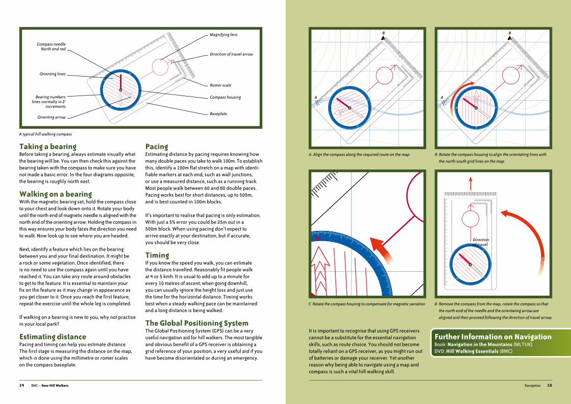
B Rotate the compass housing to align the orientating lines with
the north-south grid lines on the map
D Remove the compass from the map, rotate the compass so that
the north end of the needle and the orientating arrow are
aligned and then proceed following the direction of travel arrow
A Align the compass along the required route on the map
C Rotate the compass housing to compensate for magnetic variation
14 BmC – New Hill Walkers
Taking a bearingBefore taking a bearing, always estimate visually what the bearing will be. You can then check this against the bearing taken with the compass to make sure you have not made a basic error. in the four diagrams opposite, the bearing is roughly north east.
Walking on a bearingWith the magnetic bearing set, hold the compass close to your chest and look down onto it. rotate your body until the north end of magnetic needle is aligned with the north end of the orienting arrow. holding the compass in this way ensures your body faces the direction you need to walk. Now look up to see where you are headed.
Next, identify a feature which lies on the bearing between you and your final destination. it might be a rock or some vegetation. once identified, there is no need to use the compass again until you have reached it. You can take any route around obstacles to get to the feature. it is essential to maintain your fix on the feature as it may change in appearance as you get closer to it. once you reach the first feature, repeat the exercise until the whole leg is completed.
if walking on a bearing is new to you, why not practise in your local park?
Estimating distancepacing and timing can help you estimate distance. the first stage is measuring the distance on the map, which is done using the millimetre or romer scales on the compass baseplate.
PacingEstimating distance by pacing requires knowing how many double paces you take to walk 100m. to establish this, identify a 100m flat stretch on a map with identi- fiable markers at each end, such as wall junctions, or use a measured distance, such as a running track. most people walk between 60 and 80 double paces. pacing works best for short distances, up to 500m, and is best counted in 100m blocks.
it’s important to realise that pacing is only estimation. With just a 5% error you could be 25m out in a 500m block. When using pacing don’t expect to arrive exactly at your destination, but if accurate, you should be very close.
Timingif you know the speed you walk, you can estimate the distance travelled. reasonably fit people walk at 4 or 5 kmh. it is usual to add up to a minute for every 10 metres of ascent; when going downhill, you can usually ignore the height loss and just use the time for the horizontal distance. timing works best when a steady walking pace can be maintained and a long distance is being walked.
The Global Positioning Systemthe global positioning system (gps) can be a very useful navigation aid for hill walkers. the most tangible and obvious benefit of a gps receiver is obtaining a grid reference of your position, a very useful aid if you have become disorientated or during an emergency.
15Navigation
it is important to recognise that using gps receivers cannot be a substitute for the essential navigation skills, such as route choice. You should not become totally reliant on a gps receiver, as you might run out of batteries or damage your receiver. Yet another reason why being able to navigate using a map and compass is such a vital hill walking skill.
A typical hill walking compass
Further Information on NavigationBook: Navigation in the Mountains (mltuK)dvd: Hill Walking Essentials (BmC)
N
W
S
E
N
W
S
E
Magnifying lens
Direction of travel arrow
Compass needle North end red
Orienting lines
Orienting arrow
Bearing numberslines normally in 2°
increments
Romer scale
Compass housing
Baseplate
A
B
A
B
Direction of travel

16 BmC – New Hill Walkers
Just as a young child has to learn about hazards in their world, novice hill walkers will encounter challenges which are new to them.
Identifying hazardsimagine stepping into the road only to see a car speeding towards you. instantly you would identify the hazard, assess the risk, and then act appropriately - get out of the way! When it comes to hazards in the hills, follow the same process of identify, assess and act.
listen to your instincts, and stop if something doesn’t feel ‘quite right’. Changing your plans due to unforeseen circumstances is a sign of good judgement. Carrying blindly on with the hope that ‘things will work them- selves out’ is not!
it is important to realise that you cannot avoid hazards. Before setting out ask yourself what hazards are presented by group composition, animals, terrain and weather. reassess hazards throughout the day.
Group compositionmanaging group dynamics is not always easy. if there is a mismatch between group members in ability and fitness, then consideration needs to be given to how everyone’s aspirations can be met. make an honest appraisal of what is realistic for the whole group.
learning from experienced hill walkers is undoubtedly effective and rewarding for all involved. this does not mean that those with less experience are not also able to make key decisions about their own safety and participation.
Cowsmost members of the public are wary of bulls, but few realise that cows, particularly those protecting newly- born calves, can also be dangerous. people have been attacked or trampled to death by cows while quietly walking their dog. the cows are thought to have been trying to protect their young by driving off the dogs.
if you approach a field of cows and there happen to be calves, try to choose a different route to avoid them.
the countryside is a great place to exercise dogs, but it is every owner’s duty to make sure their dog is not a danger or nuisance to farm animals, wildlife or other people. By law, farmers are entitled to destroy a dog that injures or worries their animals, therefore dog walkers should keep their dogs on their lead at any time of the year when near farm animals, particularly during the lambing season.
there will be circumstances when you should release your dog from its lead. if you find yourself in a field of wary cattle, move away carefully and quietly. if you feel threatened by cattle release your dog from its lead; let it run free rather than try to protect it and endangering yourself. the dog will outrun the cows and you. remove the lead to avoid the risk of strangulation.
those without canine companions should also move away carefully and quietly. the cows will probably leave you alone once they establish that you pose no threat.
6 | Hazards
17hazards
Ticksticks are small arachnids, which live off the blood of birds and mammals – including you. ticks climb tall grass, shrubs, bushes and low level tree branches. When you or an animal brush past they can attach themselves almost anywhere but prefer dark creases like the armpit, groin and back of the knee.
lyme disease is caused by a bacteria carried by ticks in many popular walking areas. Being bitten by a tick does not mean you will contract lyme disease, but taking steps to prevent tick bites is the best plan to follow. avoid unnecessary bushwacking, keep your arms and legs covered, and check your clothes and skin frequently. Where possible, use an effective tool and technique to remove ticks.
symptoms of lyme disease typically show a few days to several weeks after being bitten. Early signs might include a red ring-shaped rash which gradually spreads from the site of the tick bite, usually with a fading centre. if left untreated a whole range of symptoms can develop, including a flu-like illness, swollen glands, mild headaches, tiredness and aching muscles and joints.
For more information watch the tick awareness film on both the BmC Hill Walking Essentials dvd and the BmC website at www.thebmc.co.uk/ticks
Terrainlook at the map before leaving and see where your route will take you. if you know what to expect you will be much better placed to deal with it.
Movement skillsa simple slip is one of the most common causes of injury to hill walkers; the more uneven or steeper the ground, the greater the potential for a slip. those new to hill walking may find the uneven and variable terrain challenging at first. Wearing a pair of good boots is important, but using them effectively is what will get you around the hills.
small steps will help you position your centre of balance over your feet as you walk. making a stable platform with each step, using as much of the sole as possible is also important. it is easier to make such a platform on grassy and muddy slopes with stiffer boots than with trail shoes and soft boots.
Walking up, down and acrosssteep ground is always easier to ascend in control than it is to traverse or descend. the ground ahead is close at hand when ascending, and with short steps, foot placements are easy to spot. on descents, in contrast, you have to extend downwards with each step, making placements more difficult to settle on. trekking poles can help greatly in these situations. practice in secure places on short slopes.
Removing a tick with fine ended tweezers and specialist tools
A feeding tick’s body becomes swollen with blood
Most cows are just curious
Descending can be trickier than ascending
18 BmC – New Hill Walkers
the tendency when traversing is to creep down the slope. in some situations this may not be a problem, but traversing a steep slope for a long time can be very tiring.
Grass slopessteep grass slopes can be extremely hazardous, not only in wet conditions, but also when the grass is long and dry. it is not the ground underfoot that defines the seriousness of a situation, but the consequences of a fall. an unbroken steep grassy slope may be more serious than a steeper, but short rocky slope.
Screescree, composed of loose surface rocks, is commonly encountered in the mountains, and is often tiring to ascend. in wet conditions, scree can be difficult to cross, being both unstable and slippery, and great care should be taken. scree running, which is sliding down with the flow of the scree instead of taking small foot- steps, should be avoided, as it accelerates erosion and is environmentally damaging.
Rocksmany classic walking routes may have one or more short rocky steps, sections where care and attention is required. though not technically demanding, the consequences of a fall in the wrong place could be very serious. Confidence in your movement skills is vital; be aware that rock steps can be more challenging in descent than ascent. therefore, if a bit more adventure is what makes you tick, adopt a progressive approach to your days out, building on past experiences as you develop new skills.
loose rock tumbling down the hillside is also a hazard. if walking where you think there might be loose rock above, consider if any people or animals could dislodge rocks onto you.
Hidden hazardsa convex slope is shaped like a dome, shallow at the top and steeply sided. this means that the view of what lies ahead is often obscured. in descent, a convex slope may hide real dangers such as a line of cliffs, a steep grass slope or a snow patch.
the contours describing a convex slope will be further apart near the top and closer together as the slope steepens. Noticing such patterns on a map will help
with route planning, and map symbols will show if any hazards lie en route.
Water hazardsit is fair to say that high rainfall is a characteristic of our hills and mountains. Consequently, the water levels of streams, rivers, bogs and lakes can vary greatly throughout the year. prolonged heavy rainfall can lead to flash flooding, with paths being trans-formed into streams.
unless intending to swim in a mountain lake, no one plans to get wet when out walking. Considering that people do drown in upland rivers and lakes, avoiding water hazards is the best policy.
Weatheralways get a weather forecast, a mountain specific one if possible as there are major differences between urban and upland weather. these are available online for some areas at www.mwis.org.uk and www.metoffice.gov.uk. use the information from the forecast as part of your planning. Be aware that the weather can be more extreme in the hills than in the cities. general forecasts are for sea level, and you can pretty much guarantee that it will be colder, wetter and windier the higher you climb.
hill walkers should develop their understanding of the typical British weather systems, and learn how to interpret a sea level forecast for the mountain environ- ment, including the crucial connection between a forecast and how the weather will feel. as forecasts are just a prediction, the weather you experience could be more or less severe than predicted.
19hazards
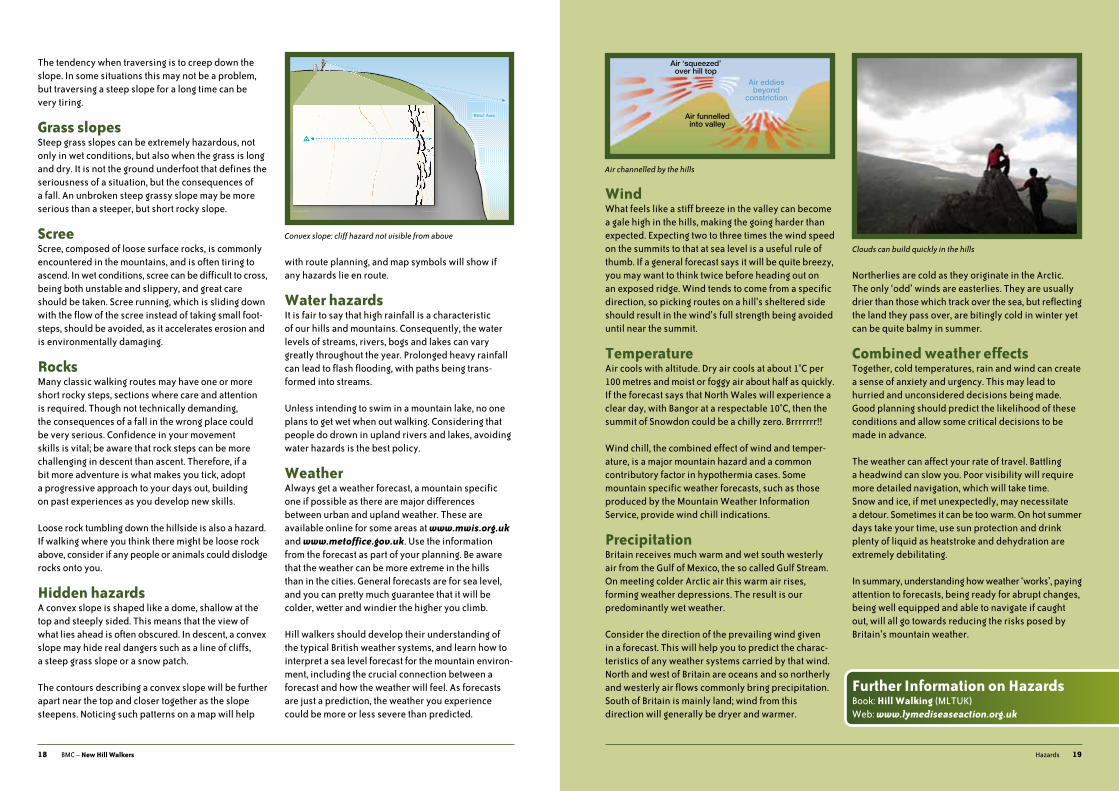
WindWhat feels like a stiff breeze in the valley can become a gale high in the hills, making the going harder than expected. Expecting two to three times the wind speed on the summits to that at sea level is a useful rule of thumb. if a general forecast says it will be quite breezy, you may want to think twice before heading out on an exposed ridge. Wind tends to come from a specific direction, so picking routes on a hill’s sheltered side should result in the wind’s full strength being avoided until near the summit.
Temperatureair cools with altitude. dry air cools at about 1°C per 100 metres and moist or foggy air about half as quickly. if the forecast says that North Wales will experience a clear day, with Bangor at a respectable 10°C, then the summit of snowdon could be a chilly zero. Brrrrrrr!!
Wind chill, the combined effect of wind and temper- ature, is a major mountain hazard and a common contributory factor in hypothermia cases. some mountain specific weather forecasts, such as those produced by the mountain Weather information service, provide wind chill indications.
PrecipitationBritain receives much warm and wet south westerly air from the gulf of mexico, the so called gulf stream. on meeting colder arctic air this warm air rises, forming weather depressions. the result is our predominantly wet weather.
Consider the direction of the prevailing wind given in a forecast. this will help you to predict the charac- teristics of any weather systems carried by that wind. North and west of Britain are oceans and so northerly and westerly air flows commonly bring precipitation. south of Britain is mainly land; wind from this direction will generally be dryer and warmer.
Northerlies are cold as they originate in the arctic. the only ‘odd’ winds are easterlies. they are usually drier than those which track over the sea, but reflecting the land they pass over, are bitingly cold in winter yet can be quite balmy in summer.
Combined weather effectstogether, cold temperatures, rain and wind can create a sense of anxiety and urgency. this may lead to hurried and unconsidered decisions being made. good planning should predict the likelihood of these conditions and allow some critical decisions to be made in advance.
the weather can affect your rate of travel. Battling a headwind can slow you. poor visibility will require more detailed navigation, which will take time. snow and ice, if met unexpectedly, may necessitate a detour. sometimes it can be too warm. on hot summer days take your time, use sun protection and drink plenty of liquid as heatstroke and dehydration are extremely debilitating.
in summary, understanding how weather ‘works’, paying attention to forecasts, being ready for abrupt changes, being well equipped and able to navigate if caught out, will all go towards reducing the risks posed by Britain’s mountain weather.
Air ‘squeezed’over hill top
Air eddiesbeyond
constriction
Air funnelledinto valley
Air channelled by the hills
‘Blind’ Area
Convex slope: cliff hazard not visible from above
Clouds can build quickly in the hills
Further Information on HazardsBook: Hill Walking (mltuK)Web: www.lymediseaseaction.org.uk

20 BmC – New Hill Walkers
The hills and mountains can be snow and ice free over Christmas, but crampons and axes are often essential when climbing Ben Nevis in April. When venturing into the mountains in winter, the terrain underfoot is what’s relevant. Moving around in the winter environment requires specific skills and equipment over and above those used in spring, summer and autumn.
Clothing and equipmentas it is colder in winter you will need more clothes. Just as in summer, a flexible clothing system is required, along with some extra insulating layers. good insulation for the head, neck and hands is essential. always take a spare pair of gloves or mitts; if you lose one you can incapacitate your hands, or worse still, get frostbite. ski goggles will enable you to look forward when snow is being blasted into your face by strong winds. on clear days, sunglasses and sunscreen will protect the eyes and face.
a pair of winter walking boots will keep your feet warm and provide you with the required grip and support. Crampons are attached to your boots for safer travel over hard packed snow or ice. apart from knowing how to use them effectively, what is most important is ensuring the crampons are compatible with your boots, and then fitting them properly. an axe is a vital piece of winter equipment and has a variety of functions; it can be used for support and to stop you should you slip.
Walking is more physical in winter, so more energy from food is required. taking on enough fluid is important too. a hot flask provides a welcome winter warmer; if possible, fill your water bottle with hot water, to prevent it freezing.
Finally, with this extra food, fluid, clothing and equip- ment you will need a good sized rucksack between 40 and 50 litres to carry it all.
Winter hazardsin winter the wind can be so strong as to blow you over, a potentially very serious situation if walking on a steep slope or ridge. Needless to say, a forecast will help you plan your day appropriately. don’t forget to take into account that winter days are short; in the scottish highlands in mid-winter there is less than seven hours of daylight.
Navigating in winter is more difficult. snow cover can hide features, and the ground can appear different from indications given by the map’s contours. in summer, if you make an error, you are unlikely to walk off a cliff edge, as you will most likely see the drop first. Not so in winter when white-out conditions or a cornice can obscure your view. Before exploring the winter hills, sharpen up on your summer navigation.
in a single day you could walk over a variety of terrain, including: unfrozen and frozen ground; soft, hard packed or frozen snow; and patches of ice and ice covered rock. You need to be prepared for sudden changes in terrain; a patch of ice on a path could catch you unawares. the points about movement skills noted on page 17 are of even greater importance in winter as the consequences of a slip can be more serious. You can leave a relatively safe spot for one with real objective danger in only a few footsteps. Feel confident moving around in summer first, and then progressively develop your movement skills in winter.
7 | Walking in Winter
21Walking in Winter
avalanches occur when one layer of deposited snow slides on another or the whole snow cover slides on the ground. 90% of all avalanches involving human subjects are triggered by their victims. the evolution of the snowpack is determined by the weather; by studying weather information before setting out and observing snowpack conditions en route hazard assessments can be made. on most hills in Britain, avalanche hazard can be avoided by sensible choice of route.
When snow is deposited on the leeward edge of a ridge or plateau, cornices are formed. these over- hanging banks of snow are extremely serious hazards. Cornices obscure cliff edges, and can collapse under your weight. Care should also be taken when walking underneath them.
Winter walking on Snowdon
This book and
DVD show the
techniques and
skills required for
walking in winter
Further Information on Walking in WinterBook: Winter Skills (mltuK)dvd: Winter Essentials (BmC)
22 BmC – New Hill Walkers
Mountain landscapes may seem vast and our presence in them inconsequential. However, all land belongs to someone so we must act in a considerate and responsible manner.
Access in England & Walesaccess is all about balancing rights, responsibilities and restrictions. a right of access must be used responsibly. on occasion, restrictions based on a least restrictive approach may be needed to protect conservation interests. ignoring restrictions could at worst lead to access being withdrawn for everyone.
the Countryside Rights of Way Act 2000 (CRoW) is the main piece of legislation governing access to the uplands of England and Wales. if you are unsure of your rights and responsibilities, then visit www.countrysideaccess.gov.uk
the Public Rights of Way (PRoW) network in England and Wales is a unique asset. the restrictions that are sometimes used on CRoW access land do not affect public rights of way, so you can walk along them even when surrounding access land is closed. however, public rights of way can sometimes be diverted, removed, created or have the rights suspended.
Where necessary the BmC liaises with landowners and conservation bodies to negotiate voluntary access arrangements. the BmC also has a network of over 30 local access representatives to ensure any access or conservation issues are resolved.
Walking with dogsit is a criminal offence to allow your dog to worry stock. on open access land in England and Wales dogs must be kept on a short lead from 1st march to 31st July and at all times when in the vicinity of livestock. they may be excluded at all times on some grouse moors. in fields of adult animals they must be kept under close control on a short lead. dogs can cause other problems – disturbing wildlife, barking, disrupting
other users, defecating near paths. always consider the interests of others who use the land.
Access in Scotlanddifferent access legislation applies to scotland, where there is freedom of access across almost all land. these rights were made statutory through the Land Reform (Scotland) Act 2003. For guidance see the Scottish Outdoor Access Code at www.outdooraccess-scotland.com
8 | Access and the Environment
23access and the Environment
Tread lightlymuch can be done to minimise erosion and disturbance by applying common sense:
Pathspaths have been constructed in many areas to protect and repair mountains from the erosion that is caused by the sheer volume of visitors. use these paths wher- ever possible rather than taking shortcuts. paths are often only the width of one person; walk in single file on such sections.
Wild firespeat and vegetation which grow in upland areas can become dry and flammable. accidental fires can destroy habitats and kill wildlife. do not light fires on moorlands, not even gas stoves or barbecues, and never stub matches or cigarettes out in the vegetation. respect all warning signs and if you see a fire, don’t assume that someone else has called the emergency services. Note your location and dial 999.
BoundariesClimbing over walls and fences will damage them; use stiles and gates wherever possible.
Littertake litter home with you – if you’ve carried it in, you can carry it out. Where possible, pick up other people’s litter, especially non-biodegradable material. organic litter takes longer to break down than most people think; it also attracts certain predator species, so take it home. reduce the litter you need to carry out with you by repackaging your food before you set out.
Transporttraffic congestion and parking problems are an issue in many popular upland areas. You can make a difference by taking public transport, car sharing and using designated parking places.
Shop locallythe local spending of hill walkers is vital to the conserv- ation and development of many upland areas. Wherever possible, support local independent businesses such as grocers, outdoor retailers, cafes and restaurants.
Sanitationthere’s a reluctance to talk about what is one of our most natural functions! and yet by not thinking carefully about this we can endanger human health and potentially poison the upland environment.
a mountain stream is often seen as the epitome of purity – so don’t pollute it. streams are a vital source of fresh water for hill farmers and for campers. it will also be a home to, or a water source for, wildlife. Ensure you are at least 30 metres away from running water when you defecate. When camping, defecate and urinate downhill from your campsite; collect drinking water from above your camp.
it can be an unpleasant and unnecessary souvenir to encounter human waste on or close to a path. Be considerate of others and defecate at least 50 metres from paths. Carry a lightweight trowel to carefully cut out and replace the top turf. dig a 15 cm (6”) deep hole to bury your excrement. if this is not possible, keep well away from paths and spread the excrement thinly to increase the rate of its decomposition (squashing it under a boulder will slow decomposition). on especially sensitive high plateaux, excrement should be carried down to less sensitive locations for burial, or even better, carried out. in snow, dig down into the soil. give a thought to the consequences when the snow melts!
the smell from urine and excrement is unpleasant. avoid going to the toilet in enclosed spaces (caves, ruined buildings etc). Consider using a ‘pee bottle’.
toilet paper is slow to decompose and may be dug up by animals. Carry it out if possible. Come prepared with plastic bags – dog poo bags are ideal for the purpose. tampons and sanitary towels should be carried out – plastic screw-top containers are convenient.
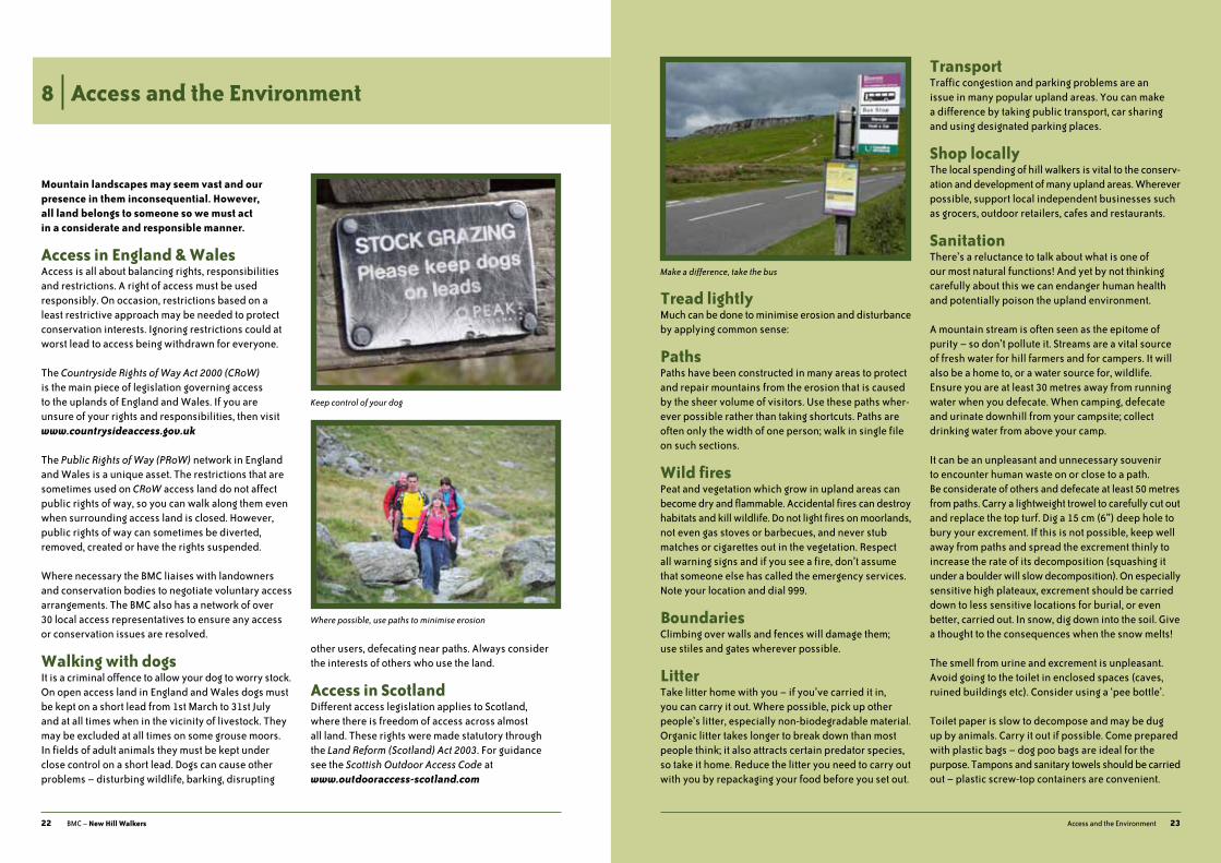
Keep control of your dog
Make a difference, take the bus
Where possible, use paths to minimise erosion
24 BmC – New Hill Walkers
Camping in the hillsspending a night in a tent can be an unforgettable experience – and hopefully a positive one! a multi-day trip in the hills, carrying all you require in a rucksack provides a great sense of freedom and with careful planning is relatively straightforward to achieve.
in a valley with road access use a recognised campsite, as you should only wild camp if high in the hills, away from civilisation. Wild camping is not permitted by right on open access land in England and Wales without express permission of the landowner, but it is permitted in scotland on the proviso that you follow the Scottish Outdoor Access Code (SOAC). When high in the hills the legal situation is the same as in the valleys, but your impact can be more easily managed.
Camping equipmentadditional equipment over and above that required for a day’s hill walking includes: tent; sleeping bag and sleeping mat; stove and utensils; water container; more food; and a bigger rucksack to carry it all in!
For an overnight camping trip high in the hills you are likely to need a rucksack of at least 50 litres capacity. think carefully about how large a sack you would feel happy to carry as this will help to focus your mind when choosing what to take, and what to leave behind.
on returning from your trip review what you took. some packing decisions come down to comfort. in the end, it’s all about compromise!
Choose a tent which is light, strong and easy to put up. Winds are much stronger in the hills than in the valleys, and a tent designed for valley camping may be unsuit- able for the uplands. as with all aspects of hill walking, get a forecast, plan a route and assess if you and your kit are up to the challenge.
Camping and the environmentWith no facilities at hand you need to think carefully about your impact – both physical and visual. When- ever you wild camp leave the site as you find it. Keep your group small and as discreet as possible. Camp in one place for 1 or 2 nights only and on dry / well-drained ground that won’t be easily damaged. if you have to wash, dispose of soapy water well away from water courses.
25Emergency procedures
9 | Emergency procedures
Mountain incidents range from inconvenient to life threatening. There is no golden rule on how to act but there are some well established principles.
What to dostay calm and assess the situation. Consider what should be done immediately to safeguard everyone. if possible determine your exact position on the map and consider the options for walking down, sending for help, or finding shelter.
Whilst mobile phones can be very useful any temptation to use them to call mountain rescue in non-emergency circumstances should be resisted. if you are not sure whether it is an emergency, investigate a little yourself before summoning outside help.
Walking downif someone is injured, only minor injuries should come within the scope of treatment and evacuation by other group members. For all other cases make the casualty safe, start first aid, and send for the appropriate emergency service.
Sending for helpWhen phoning dial 999 and ask for:
POLICE and then MOUNTAIN RESCUE.
When connected provide:
1 location of the incident
2 Number and names of people in the party and their condition.
3 any injuries and names of casualties.
Be ready to provide the following additional information:
• Number of the phone you are using and any other phones in the group.
• the nature of the incident – what happened?
• time of the incident.
• Equipment which is at the accident site (warm clothing, group shelter etc.).
• any distinguishing feature / marker / colour at the accident site.
if there is no coverage at your location consider walking uphill to find a better signal. if no signal can be obtained, one or more reliable members of the party, with full information about the accident, should be sent to find the nearest telephone. at least one person should stay with the casualty.
a text message can be sent to summon help when poor reception does not allow voice calls. You must text ‘register’ to 999 in order to use this service. Complete this one-off registration before you set off!
a helicopter may arrive before the mountain rescue team. Extinguish all flames and secure all equipment.
Lack of helpYou have a difficult decision when a casualty is injured, and you are alone and unable to make a phone call. try to summon help by shouting, giving the distress call of 6 whistle blasts or 6 flashes with a torch, repeated regularly. if there is no response, assess the relative dangers of leaving the casualty or failing to get help. act decisively in the interest of the casualty, but not in ways that will endanger you.
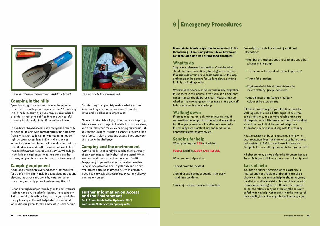
Tea tastes even better after a good walkLightweight collapsible camping trowel Inset: Closed trowel
Further Information on Access and the EnvironmentBook: Green Guide to the Uplands (BmC)Web: www.thebmc.co.uk/greenguides

First Aidmany people do not consider the importance of first aid training until standing next to an injured companion on a remote mountainside. a large range of first aid publications and courses are available, many of which are tailored to hill walkers.
Finding shelteran unintentional night out can result from a navigational error or unexpected conditions. it is one of those things a hill walker should be prepared for, although it can often be avoided with good planning, taking a torch and making an early start.
group shelters and bivi bags provide protection from the elements. if you are caught out, consider the following:
• seek shelter from the elements.
• put all your spare clothing on, including hats and gloves.
• sit on anything that will provide insulation from the ground, such as your rucksack.
• seek warmth from other party members by huddling together.
• Keep an eye on other people for signs of hypothermia.
Come first light, if everyone is fine, continue with your journey. get word out as soon as possible to put a stop to any search that might have begun.
Support Mountain Rescuemountain rescue teams are run by volunteers and depend upon charitable donations to operate. Your consideration and support go a long way to ensure the service continues. Collection boxes are located in pubs and outdoor shops in most upland areas. You can also donate online at www.mountain.rescue.org.uk and www.mrcofs.org
the official handbooks of mountain Leader training’s award schemes, packed with advice for walkers
Award-winning maps covering many of britain’s best walking areas
A pocket guide to safety on the hill
bMc books & dVds covering the skills and techniques for summer and winter walking, as well as essential information on caring for the mountain environment
order direct at www.bmcshop.co.uk
bmC online shop
Great titles from the
26 BmC – New Hill Walkers
Some rescues require helicopter evacuation Take a first aid kit – and know how to use it!
Further Information on Emergency ProceduresBook: Call Out Mountain Rescue? (mrEW)