Embed Size (px)
Citation preview


Climbing a Few of Japan’s 100 Famous Mountains –
Volume 3: Mt. Gassan
Daniel H. Wieczorek and Kazuya Numazawa
COPYRIGHTED
MATERIAL

Climbing a Few of Japan’s 100 Famous Mountains –
Volume 3: Mt. Gassan
Copyright © 2014 Daniel H. Wieczorek and Kazuya Numazawa
All rights reserved.
ISBN: 149487217X ISBN-13: 978-1494872175
COPYRIGHTED
MATERIAL

DEDICATION
This work is dedicated, first of all, to my partner, Kazuya Numazawa. He always keeps my interest in photography up and makes me keep striving for the perfect photo. He also often makes me think of the expression “when the going gets tough, the tough keep going.” Without my partner it has to also be noted that I most likely would not have climbed any of these mountains.
Secondly, it is dedicated to my mother and father, bless them, for tolerating and even encouraging my photography hobby from the time I was 12 years old.
And, finally, it is dedicated to my friends who
have encouraged me to create books of photographs which I have taken while doing mountain climbing.
COPYRIGHTED
MATERIAL

Other books by Daniel H. Wieczorek and Kazuya Numazawa
“Outdoor Photography of Japan: Through the Seasons”; ISBN/EAN13: 146110520X / 9781461105206; 362 Pages; June 10, 2011; Also available as a Kindle Edition “Some Violets of Eastern Japan”; ISBN/EAN13: 1463767684 / 9781463767686; 104 Pages; August 20, 2011; Also available as a Kindle Edition “2014 Photo Calendar – Japan's Flowers, Plants & Trees”; ISBN/EAN13: 1482315203 / 978-1482315202; 30 Pages; February 4, 2013 “2014 Photo Calendar – Japan Mountain Scenery”; ISBN/EAN13: 1482371383 / 978-1482371383; 30 Pages; February 15, 2013 “Climbing a Few of Japan's 100 Famous Mountains – Volume 1: Mt. Daisetsu (Mt. Asahidake)”; ISBN/EAN13: 1493777203 / 9781493777204; 66 Pages; December 2013 “Climbing a Few of Japan's 100 Famous Mountains – Volume 2: Mt. Chokai (Choukai)”; ISBN/EAN13: 1494368404 / 9781494368401; 72 Pages; December 2013
Other books by Daniel H. Wieczorek
“English – Ilokano and Ilokano – English Dictionary”; ISBN/EAN13: 1456599720 / 978-1456599720; 100 Pages; March 4, 2011; Also available as a Kindle Edition “English – Ilokano and Ilokano – English Dictionary – With Some Notes on Ilokano Culture”; ISBN/EAN13: 147752276X / 978-1477522769; 150 Pages; May 22, 2012; Also available as a Kindle Edition “A Book of Anagrams – An Ancient Word Game”; ISBN/EAN13: 1468180878 / 978-1468180879; 116 Pages; January 6, 2012; Also available as a Kindle Edition “A Book of Anagrams – An Ancient Word Game – Volume #2”; ISBN/EAN13: 1470015528 / 978-1470015527; 152 Pages; February 2, 2012; Also available as a Kindle Edition “Forest Resource & Allowable Cut – Fairbanks Working Circle (Alaska)”; ISBN/EAN13: 1475056834 / 978-1475056839; 122 Pages; March 23, 2012; Also available as a Kindle Edition “2014 Photo Calendar – Showing Japan Mountains and Mountain Flowers”; ISBN/EAN13: 1482003031 / 978-1482003031; 30 Pages; January 23, 2013
COPYRIGHTED
MATERIAL

FOREWORD
What is the purpose of this series of books? It is to show you, in photographs, some of the astounding sights and scenery we have seen while climbing the mountains included herein. At this time we have climbed 14 of Japan’s 100 Famous Mountains. The ones we have climbed are: 1) Mt. Daisetsu (2,290 m) (大雪山) = Mt. Asahidake (旭岳 ); 2) Mt. Chokai (2,236 m) (鳥海山); 3) Mt. Gassan (1,984 m) (月山); 4) Mt. Hakkoda (1,584 m) (八甲田山); 5) Mt. Zao (1,841 m) (蔵王山); 6) Mt. Kumotori (2,017 m) (雲取山 ); 7) Mt. Kusatsu-Shirane (2,171 m) (草津白根山 ); 8) Mt. Shibutsu (2,228 m) (至仏山); 9) Mt. Kiso-Komagatake (2,956 m) (木曾駒ヶ岳); 10) Mt. Kitadake (North Peak) (3,192 m) (北岳); 11) Mt. Mizugaki (2,230 m) (瑞牆山 ); 12) Mt. Shiroumadake (2,932 m) (白馬岳); 13) Mt. Tateyama (3,015 m) (立山); and 14) Mt. Yatsugatake (2,899 m) (八ヶ岳).
By the way, I (Daniel) did all of the writing and Kazuya did a fair percentage of the photography. So, do not be surprised from time to time when you see references such as “Kazuya” and “that’s me…”.
Daniel and Kazuya’s “Outdoor Photography of Japan: Through the Seasons” includes some of the same photos as this work, but this work may be thought of as a subset of that work because that work includes adventures to many mountains beyond the 14 famous mountains which are found in this series of books. In addition, the photos in that book were more than 50% flower photos. This series includes less than 1% flower photos, and only where the flower is a part of a mountain scene. In addition, this series includes many photos which were not included in that work.
COPYRIGHTED
MATERIAL

vi
COPYRIGHTED
MATERIAL

vii
TABLE OF CONTENTS
1 Japan’s 100 Famous Mountains 1
2 Mt. Gassan 7
COPYRIGHTED
MATERIAL

viii
COPYRIGHTED
MATERIAL

COPYRIGHTED
MATERIAL

COPYRIGHTED
MATERIAL

1
1) JAPAN’S 100 FAMOUS MOUNTAINS
What are Japan’s 100 famous mountains? A selection of famous mountains in Japan has been compiled since the Edo period (1603 – 1867) and the list has been revised several times since the very first list appeared. At the current time
the list of 100 famous mountains includes those shown below. Also shown is the Japanese pronunciation, elevation in meters and feet, the Japanese kanji, the Region the mountain is in and a few a.k.a. (also known as) names.
Hokkaido: 1. Mt. Akan (Akandake) 1,499 4,918 阿寒岳 2. Mt. Asahi (Asahidake) a.k.a.
Mt. Daisetsu (Daisetsuzan) 2,290 7,513 旭岳 a.k.a. (大雪山) 3. Mt. Poroshiri (Poroshiridake) 2,052 6,734 幌尻岳 4. Mt. Rausu (Rausudake) 1,660 5,446 羅臼岳 5. Mt. Rishiri (Rishiridake) 1,721 5,646 利尻岳 6. Mt. Shari (Sharidake) 1,545 5,069 斜里岳 7. Mt. Tokachi (Tochidake) 2,077 6,814 十勝岳 8. Mt. Tomuraushi (Tomuraushiyama) 2,141 7,024 トムラウシ山 9. Mt. Yotei (Yoteizan) a.k.a.
(Mt. Shiribeshi) (Shiribeshiyama) 1,893 6,211 羊蹄山 a.k.a. (後方羊蹄山)
Tohoku Region: 10. Mt. Adatara (Adatarayama) 1,700 5,577 安達太良山 11. Mt. Aizu-Komagatake (Aizukomagatake) 2,132 6,995 会津駒ケ岳 12. Mt. Asahi (Asahirenpou) 1,870 6,135 朝日連峰 13. Mt. Azuma (Azumayama) 2,035 6,676 吾妻山 14. Mt. Bandai (Bandaisan) 1,819 5,968 磐梯山 15. Mt. Chōkai (Chōkaisan) 2,236 7,336 鳥海山 16. Mt. Gassan (Gassan) 1,984 6,509 月山 17. Mt. Hachimantai (Hachimantai) 1,614 5,295 八幡平 18. Mt. Hakkōda (Hakkōdasan) 1,584 5,197 八甲田山 19. Mt. Hayachine (Hayachinesan) 1,917 6,289 早池峰山 20. Mt. Hiuchigatake (Hiuchigatake) 2,356 7,730 燧ケ岳 21. Mt. Iide (Iiderenpou) 2,105 6,906 飯豊連峰 22. Mt. Iwaki (Iwakisan) 1,625 5,331 岩木山 23. Mt. Iwate (Iwatesan) 2,038 6,686 岩手山 24. Mt. Zaō (Zaōsan) 1,841 6,040 蔵王山
Kanto Region: 25. Mt. Akagi (Akagiyama) 1,828 5,997 赤城山 26. Mt. Asama (Asamayama) 2,568 8,425 浅間山
COPYRIGHTED
MATERIAL

2
27. Mt. Azumaya (Azumayasan) 2,354 7,723 四阿山 28. Mt. Hiragatake (Hiragatake) 2,141 7,024 平ヶ岳 29. Mt. Hotaka (Hotakayama) 2,158 7,080 武尊山 30. Mt. Kumotori (Kumotoriyama) 2,017 6,617 雲取山 31. Mt. Kusatsu-Shirane (Kusatsu-Shiranesan) 2,171 7,123 草津白根山 32. Mt. Nantai (Nantaisan) 2,486 8,156 男体山 33. Mt. Nasu (Nasudake) 1,915 6,283 那須岳 34. Mt. Nikko-Shirane (Nikko-Shiranesan) 2,578 8,458 日光白根山 35. Mt. Ryokami (Ryoukamisan) 1,723 5,653 両神山 36. Mt. Shibutsu (Shibutsusan) 2,228 7,310 至仏山 37. Mt. Sukai (Sukaisan) 2,144 7,034 皇海山 38. Mt. Tanigawa (Tanigawadake) 1,963 6,440 谷川岳 39. Mt. Tanzawa (Tanzawasan) 1,567 5,141 丹沢山 40. Mt. Tsukuba (Tsukubasan) 877 2,877 筑波山
Chubu Region: 41. Mt. Ainodake (Ainodake) 3,189 10,463 間ノ岳 42. Mt. Akaishi (Akaishidake) 3,120 10,236 赤石岳 43. Mt. Amagi (Amagisan) 1,406 4,613 天城山 44. Mt. Amakazari (Amakazariyama) 1,963 6,440 雨飾山 45. Mt. Daibosatsu (Daibosatsurei) 2,057 6,749 大菩薩嶺 46. Mt. Ena (Enasan) 2,191 7,188 恵那山 47. Mt. Fuji (Fujisan) 3,776 12,388 富士山 48. Mt. Goryū (Goryūdake) 2,814 9,232 五竜岳 49. Mt. Hakusan (Hakusan) 2,702 8,865 白山 50. Mt. Hijiri (Hijiridake) 3,013 9,885 聖岳 51. Mt. Hiuchi (Hiuchiyama) 2,462 8,077 火打山 52. Mt. Hōō (Hōōsan) 2,840 9,318 鳳凰山 53. Mt. Hotaka (Hotakadake) 3,190 10,466 穂高岳 54. Mt. Jōnen (Jōnendake) 2,857 9,373 常念岳 55. Mt. Kai-Komagatake (Kaikomagatake) 2,967 9,734 甲斐駒ケ岳 56. Mt. Kasa (Kasagatake) 2,897 9,505 笠ヶ岳 57. Mt. Kashima Yarigatake
(Kashimayarigatake) 2,889 9,478 鹿島槍ヶ岳 58. Mt. Kinpu (Kinpusan) 2,599 8,527 金峰山 59. Mt. Kirigamine (Kirigamine) 1,925 6,316 霧ヶ峰 60. Mt. Kiso-Komagatake (Kisokomagatake) 2,956 9,698 木曽駒ケ岳 61. Mt. Kitadake (Kitadake) 3,192 10,472 北岳 62. Mt. Kobushi (Kobushidake) 2,475 8,120 甲武信岳
COPYRIGHTED
MATERIAL

3
63. Mt. Kuro (Kurodake) a.k.a. (Mt. Suisho) (Suishodake) 2,978 9,770 黒岳 a.k.a. (水晶岳)
64. Mt. Kurobe-Gorō (Kurobegorōdake) 2,840 9,318 黒部五郎岳 65. Mt. Makihata (Makihatayama) 1,967 6,453 巻機山 66. Mt. Mizugaki (Mizugakiyama) 2,230 7,316 瑞牆山 67. Mt. Myoko (Myokosan) 2,454 8,051 妙高山 68. Mt. Naeba (Naebasan) 2,145 7,037 苗場山 69. Mt. Norikura (Norikuradake) 3,026 9,928 乗鞍岳 70. Mt. Ontake (Ontakesan) 3,067 10,062 御嶽山 71. Mt. Senjōgatake (Senjōgatake) 3,033 9,951 仙丈ケ岳 72. Mt. Shiomi (Shiomidake) 3,047 9,997 塩見岳 73. Mt. Shiroumadake (Shiroumadake) 2,932 9,619 白馬岳 74. Mt. Takatsuma (Takatsumayama) 2,353 7,720 高妻山 75. Mt. Tateshina (Tateshinayama) 2,530 8,301 蓼科山 76. Mt. Tateyama (Tateyama) 3,015 9,892 立山 77. Mt. Tekari (Tekaridake) 2,591 8,501 光岳 78. Mt. Tsurugi (Tsurugidake) 2,999 9,839 剱岳 79. Mt. Uonuma-Komagatake a.k.a.
(Echigo-Komagatake) 2,003 6,572 魚沼駒ヶ岳 a.k.a. (越後駒ケ岳) 80. Mt. Utsugi (Utsugidake) 2,864 9,396 空木岳 81. Mt. Warusawa (Warusawadake) 3,141 10,305 悪沢岳 82. Mt. Washiba (Washibadake) 2,924 9,593 鷲羽岳 83. Mt. Yake (Yakedake) 2,444 8,018 焼岳 84. Mt. Yakushi (Yakushidake) 2,926 9,600 薬師岳 85. Mt. Yarigatake (Yarigatake) 3,180 10,433 槍ヶ岳 86. Mt. Yatsugatake (Yatsugatake) 2,899 9,511 八ヶ岳 87. Utsukushigahara Highland
(Utsukushigahara) 2,034 6,673 美ヶ原
Western Japan: 88. Mt. Arashima (Arashimadake) 1,523 4,997 荒島岳 89. Mt. Aso (Asosan) 1,592 5,223 阿蘇山 90. Mt. Daisen (Daisen) 1,729 5,673 大山 91. Mt. Ibuki (Ibukiyama) 1,377 4,518 伊吹山 92. Mt. Ishizuchi (Ishizuchisan) 1,982 6,503 石鎚山 93. Mt. Kaimon (Kaimondake) 924 3,031 開聞岳 94. Mt. Kirishima (Kirishimayama) 1,700 5,577 霧島山 95. Mt. Kujū (Kujūsan) 1,791 5,876 九重山 96. Mt. Miya-no-ura (Miyanouradake) 1,936 6,352 宮之浦岳 97. Mt. Ōmine (Ōminesan) 1,915 6,283 大峰山 98. Mt. Sobo (Sobosan) 1,756 5,761 祖母山
COPYRIGHTED
MATERIAL

4
99. Mt. Tsurugi (Tsurugisan) 1,955 6,414 剣山 100. The Wide Mountain of Ōdai
(Ōdaigaharayama) 1,695 5,561 大台ケ原山
My partner and I have climbed (or in one, case merely ascended) the 14 mountains which are shaded, underlined and in bold text. You’ll probably note that we have not climbed Mt. Fuji and wonder why? The reason is simple – too many people and not enough interesting sights.
Using photographs and a minimum amount of text we are telling (showing) you the stories of climbing the 14 mountains shown above. We started at the beginning of the 100 mountains list and are working our way through it. That means that the first climb we showed you, in Volume 1, was on Hokkaido and it was a climb of Mt. Daisetsu (2,290.9 m = 7,516 ft) (大雪山), which is also known as Mt. Asahidake. Mt. Daisetsu is the name of the entire mountain range, while Mount Asahi (旭岳 Asahidake) is the tallest mountain in that mountain range and also the tallest mountain in Hokkaido Prefecture, Japan. It is part of the Daisetsuzan Volcanic Group and it is located in the northern part of Daisetsuzan National Park.
The second mountain we showed you, in Volume 2, was in the Tohoku Region and the mountain name was Mt. Chokai (or Choukai) (2,236 m = 7,336 ft) (鳥海山). Mt. Chokai is located on the southern border of Akita Prefecture and the northern border of Yamagata Prefecture. It is still an active volcano and it is the second tallest mountain in the Tohoku Region of Japan.
The third mountain we’ll show you – in this volume – is also in the Tohoku Region and it is Mt. Gassan (1,984 m = 6,509 ft) (月山). Mt. Gassan is the highest peak in the Dewa Sanzan trio of sacred mountains. It lies between Mt. Chokai to the north, and Mt. Asahi to the south, in Yamagata Prefecture. Being a sacred mountain, it is famous for the shrine at the summit and in the summer you can often see
large groups of white-clothed pilgrims hiking to or from the summit.
The fourth mountain we will show you is also in the Tohoku Region of Japan and the mountain will be Mt. Hakkoda (1,584 m = 5,197 ft) (八甲田山). The Hakkoda Mountains are a volcanic mountain range that lie south of Aomori City, in Aomori Prefecture Japan. The peak name is actually Mt. Hakkoda – Odake. Odake is the tallest peak in the Hakkoda Range.
The fifth mountain we’ll show you is Mt. Zao (1,841 m = 6,040 ft) (蔵王山). It is also in the Tohoku Region and also in Yamagata Prefecture. We did not actually make it to the summit of this mountain. We visited it in the winter and it was very cold and windy. We took an automobile as far as possible and then transferred to a gondola car and went only a little bit beyond the top of the gondola – to about the 1,661 m (= 5,449 ft) level of the mountain. We do, however, have some impressive photos from that trip.
The sixth mountain you’ll see in this series of books will be Mt. Kumotori (2,017.7 m = 6,620 ft) (雲取山). This is in the Kanto Region and the peak divides the prefectures of Tokyo, Yamanashi and Saitama. Its summit is the highest point in Tokyo. It separates the Okutama Mountains and the Okuchichibu Mountains. No matter which direction you choose to come to this mountain from, the summit is a long hike from the nearest bus stop, road end or train station.
The seventh mountain will be Mt. Kusatsu-Shirane (2,171 m = 7,123 ft) (草津白根山 ). This peak is also in the Kanto Region of Japan, in Gunma Prefecture. It is called Mt. Kusatsu-Shirane to differentiate it from Mt. Nikko-Shirane, which is on the opposite side of Gunma Prefecture. There is a beautifully colored volcanic pond here known as Yu-gama.
COPYRIGHTED
MATERIAL

5
Another volcanic pond close-by is Yumiike and there is a dry crater named Karagama Crater.
The eighth mountain, also in the Kanto Region, in Gunma Prefecture, will be Mt. Shibutsu (2,228 m = 7,310 ft) (至仏山 ). It separates Oze Marsh (Oze National Park) from the remainder of Gunma Prefecture. It is an interesting mountain composed primarily of serpentinite. There is also a lesser peak known as Mt. Koshibutsu (2,162 m = 7,093 ft).
The ninth mountain we’ll take you to is Mt. Kiso-Komagatake (2,956 m = 9,698 ft) (木曾駒ヶ岳). It can be found in Nagano Prefecture, in the Chubu Region. It is located in Japan’s Central Alps Mountain Range and is the highest peak in that range.
Then we’ll very briefly take you to the tenth of Japan’s 100 famous mountains which we have climbed – Mt. Kitadake (North Peak) (3,193 m = 10,476 ft) (北岳 ). This is Japan’s second highest mountain after Mt. Fuji and is known as “the Leader of the Southern Alps”. It is in Yamanashi Prefecture, in the Chubu Region.
Mt. Mizugaki (2,230 m = 7,317 ft) (瑞牆山) is the eleventh mountain that will be addressed in this series of books. It too is in the Chubu Region. It is in Yamanashi Prefecture. It lies across the valley from the Southern Alps, slightly southeast of Yatsugatake and northwest of the Daibosatsu ridgeline. Granite towers, blocks and obelisks protrude from the summit of this mountains. It is truly an amazing sight to see from its lower slopes.
Then we’ll continue on to the twelfth mountain and that is also in the Chubu Region. It is Mt. Shiroumadake (2,932 m = 9,620 ft) (白馬岳 ). It is the tallest peak in the Hakuba section of the Hida Mountains, also known as Japan’s Northern Alps Mountain Range. It is in Nagano Prefecture.
After that, for the thirteenth mountain, we’ll take you to another Chubu Region mountain – Mt. Tateyama (3,015 m = 9,892 ft) (立山). It can be found in the southeastern portion of Toyama Prefecture and it also is a mountain in
the Northern Alps Mountain Range, or Hida Mountains. It is one of the tallest peaks in the Hida Mountains and is the highest peak in Toyama Prefecture.
The fourteenth and final mountain we’ll cover in this series of books is also in the Chubu Region – Mt. Yatsugatake (Mt. Akadake – 2,899 m = 9,511 ft) (八ヶ岳). Yatsugatake means “eight peaks” and the highest mountain in this range is Mt. Akadake. Actually there are many more than eight peaks, but in Japanese the kanji character for Hachi (八 ) sometimes implies “many” or “several.
According to legend, Yatsugatake was once higher than Mount Fuji, but Konohana-Sakuyahime, the goddess of Mount Fuji, tore it down out of jealousy, leaving the collection of peaks we have today. This could possibly be true considering that Yatsugatake is older than Fuji and as Fuji rose in prominence Yatsugatake wore away.
Another version of this legend says that a long time ago, Yatsugatake was an ordinary mountain with only one peak, and it was as high as or higher then Mt. Fuji. Yatsugatake’s god and Mt. Fuji’s goddess began quarreling over their height. Each of them insisted that he/she was taller. The Amitabha Buddha, who was entrusted to arbitrate the dispute, set a valley between the tops of the two mountains and filled it with water. The water submerged the summit of Mt. Fuji, revealing that Yatsugatake was indeed, taller. Mt. Fuji’s goddess, who was unyielding, was very angry so she kept striking Yatsugatake with a long stick until it was divided into several peaks, all lower than Mt. Fuji. That is why Mt. Yatsugatake now has so many peaks. Interesting!
By the way – dake or take (岳) = peak or high peak. Some authors prefer to leave this term off when referring to a Japanese mountain, for example they will refer to Mt. Kitadake as Mt. Kita and use the argument that it is redundant to use the –dake portion of the name. We prefer to use the dake suffix for completeness. If one is to be absolutely correct it should probably be called Kita Peak, not Mt. Kita.
COPYRIGHTED
MATERIAL

6
“Mountains are the cathedrals where I practice my religion.” ― Anatoli Boukreev “Climb the mountains and get their good tidings. Nature's peace will flow into you as sunshine flows into trees. The winds will blow their own freshness into you, and the storms their energy, while cares will drop away from you like the leaves of Autumn.” ― John Muir, The Mountains of California “Chasing angels or fleeing demons, go to the mountains.” ― Jeffrey Rasley
COPYRIGHTED
MATERIAL

7
2) MT. GASSAN
This is the third climb that we are showing
you in this series of books. It is a climb of Mt.
Gassan (1,984 m = 6,509 ft) (月山 ). Mt.
Gassan is the highest peak in the Dewa Sanzan
trio of sacred mountains. It lies between Mt.
Chokai to the north, and Mt. Asahi to the
south, in Yamagata Prefecture. Being a sacred
mountain, it is famous for the shrine at the
summit and in the summer you can often see
large groups of white-clothed pilgrims hiking
to or from the summit and we will show you a
photo or two of them. Dewa Sanzan means
“Three Mountains of Dewa” and indeed
comprises the three sacred mountains of Mt.
Hagurosan (羽黒山), Mt. Gassan (月山) and
Mt. Yudonosan (湯殿山), clustered together in
the ancient province of Dewa (modern-day
Yamagata Prefecture).
COPYRIGHTED
MATERIAL

8
We have been on Mt. Gassan three times,
but we have only summited it two times. On
August 10, 2005 we went to Mt. Gassan with
Kazuya’s parents just to see some of the lower
elevation sights and flowers. Then on August
12 and 13, 2008 we summited and descended
Mt. Gassan. Our third visit – and second
climb and descent – was on August 6 and 7,
2011.
Both times that we stayed overnight on the
mountain we stayed in the very nice summit
hut. Both of those times the hut had a
minimal number of guests and we could not
understand how they could survive financially.
Apparently Yamagata Prefecture makes up for
any shortcoming of money that this hut
encounters. They gave us a private room for
both of our stays there. They have very nice
bedding and quite adequate meals as well as
beer, Japanese Saké and an assortment of
snacks to go with your alcoholic drinks.
If you have no interest in flowers then
there is not very much reason to challenge this
mountain. The scenery is nice at the summit
due to a very wide and large summit plateau,
the climb is not too difficult and the crowds
are not terrible, but the variety of wildflowers
to be found here is just absolutely amazing.
As promised above, this series of books will
not concentrate on flowers however, and for
that reason very few flower photos will be
shown.
Getting to the start of the climb is a bit
difficult unless you are driving your own car.
We, however, used public transit and the
following photo shows the bus stop where one
catches the bus to come to this mountain if
one wants to approach from it’s southern
climbing route. Note the bus schedule,
enlarged to show that only 4 buses per day are
available to get you to the starting point. The
name of this bus stop is the “Nishikawa” bus
stop. It is near the Nishikawa Interchange of
the Yamagata Expressway.
The second following photo shows the bus
which takes you to the starting point. You’ll
notice that it is a mini-bus; not many people
use it so there is no need for a large size bus.
When you arrive at the end of the line on
this bus route there are a few inns in which
you can stay overnight if you are arriving late
in the day and want to wait until the following
day to begin your ascent. From here, you walk
up to the end of the road and then take a
simple chair lift up to the point where most
people begin their ascent. We’ll show you a
map quite soon so that you can get a better
idea of the lay of the land, so to speak.
COPYRIGHTED
MATERIAL

9
COPYRIGHTED
MATERIAL

10
On the following page is the map which we
promised. On this map, the 1. annotation
indicates the bus stop shown on this page.
The Japanese writing there indicates that it is a
45 minute bus ride to the Nishikawa bus stop
and also says that there is space for 500 cars in
the parking lot here. We must wonder if the
parking lot ever becomes full. The 2.
annotation on the map shows the chair lift.
On the page following the map, the upper
photo shows the top of the chair lift and the
person standing there taking photographs is
me. This photo was taken in 2011 and the
weather was wonderful.
The lower photo on the page after the map
shows a view of the top of the chair lift from
approximately 100 meters up the trail or
somewhere thereabouts. This photo was taken
in 2008 and, as you can see, the clouds are
rolling around us as we hike. Note how nice
and wide the trail is at this point. It is also
“rocked” as you can see in the photo.
COPYRIGHTED
MATERIAL

11
COPYRIGHTED
MATERIAL

12
COPYRIGHTED
MATERIAL

13
Okay, let’s continue. Now we are headed up the trail which goes to the left at the top of the chair lift and we are going to be at Ubagatake (annotation 3. on the map) in a short time. For us it was about a 40 minute climb from the top of the chair lift to Ubagatake, but we stop very often and spend 5 or 10 minutes taking photos of flowers and scenery, so if you’re not as enthusiastic about photos as we are, then you
can expect to do this part of the climb more quickly. There is a lot of very nice scenery on this route to Ubagatake and the flowers are amazing.
Below is one shot which shows a very large snowfield. This was about half of the distance from the top of the chair lift to the summit of Ubagatake. Note some people in the upper left corner.
On the following page is another photo taken
between the top of the chair lift and Ubagatake. It shows a small pond which is quite literally
surrounded by flowers. Our style is to stop and take several photos like this, as well as several macro-photos of the flowers themselves.
COPYRIGHTED
MATERIAL

14
COPYRIGHTED
MATERIAL

15
The lower photo on the facing page is
another scenery shot which we were able to
capture as we got closer to Ubagatake. Such
amazing green colors, who knew that greens
like this could exist?
The following photo is basically the same as the lower one on the facing page, but it is shifted more to the left. Again, note the brilliant greens and also note the snowfield that we will eventually climb past. You can also see several climbers in this photo if you study it a bit.
The following image shows 2 separate
photos of each of us at Ubagatake, which is
the 1669.7 m peak just to the left of the 3.
annotation on the map back on page 11. Note
how happy we look, it’s because we are having
a great time. These 2 photos were taken in
2008 when we summited this mountain for the
first time.
COPYRIGHTED
MATERIAL

16
A view from Ubagatake with some beautiful green colors.
COPYRIGHTED
MATERIAL

17
Ubagatake is the first place where either
one of us ever saw Edelweiss in bloom.
That was on our 2008 climb and we have
seen it in several places since then. The
species which we saw was Leontopodium
fauriei. We just have to show you one photo
of it (below). In this photo the flowers are
well past their peak of beauty, but one of the
things about Edelweiss is that the flowers
hang on for a long time.
Below is a photo of this same species of
Edelweiss which was taken at a different place
and at a different time of the year – when the
flowers were at their peak. It is included here
merely to show you what a flower at its peak
looks like.
COPYRIGHTED
MATERIAL

18
COPYRIGHTED
MATERIAL

19
The previous photo, taken during our 2011 climb, was shot just after we had left Ubagatake and were headed towards the 4. annotation on the map (page 11). You’ll probably notice the trail down below us – if you look at the map you can see the lower trail to the right.
Now we’re going to show you more incredible green scenery. You can see on the map, that between Ubagatake and the next junction to the north (Ushikubi) (牛首 ), the junction closest to the 4. annotation, the trail follows along a ridge. As we follow along that
ridge we’ll see some very nice scenery, a large snowfield and then after a while we’ll arrive at the very long slope which marks the 4. annotation.
In the photo below you’ll surely notice that a portion of it has been outlined. That outlined area indicates the approximate area which you can see in the photo on the following page. Both of these photos were taken during our 2008 climb. On the left side of the photo immediately below you will notice some snowfields.
COPYRIGHTED
MATERIAL

20
Okay, this photo immediately above is
zoomed in to that outlined area of the photo on
page 19. Note how it is sunny near the center of
the photo, but that the clouds are creating
shadows over most of the remainder of the
photo. On both of our climbs of this mountain
the weather was similar to this – clouds coming
and going, threatening to rain on us and then
disappearing and getting sunny again. It was
weird weather, but very fortunately we did not
get rained on. Also, very fortunately, the clouds
did keep disappearing so that we could have
some nice views and get plenty of photos.
Now we’ll show you a few more photos
which were taken along the trail between
Ubagatake and Ushikubi (牛首).
The upper facing page photo shows me with
a big smile as we hike along this excellent trail,
notice that I am shaded – there is a cloud rolling
by at the moment.
The lower photo on the facing page shows a
steaming snowfield – interesting.
COPYRIGHTED
MATERIAL

21
COPYRIGHTED
MATERIAL

22
The photo immediately above shows
Kazuya with a big smile and in this photo you
can get a better feel for what this trail is like.
It is not smooth, you have to more or less
constantly keep watching your feet or else one
of those edges is going to catch you and knock
you down. In both of these photos which we
took of each other, you may note all of the
flowers – we are both surrounded by flowers
on all sides. Remember, we previously said
that if you have no interest in flowers then
there is not very much reason to challenge this
mountain. You can see that the trail is not
steep, nor is it challenging. You can find 5
and 6 year old children hiking on this
mountain – although it seemed that at some
point the parents had to give in and help them
along. It’s a long hike, even if not that
difficult.
The next photo shows the boardwalk which
serves as the trail through this semi-wet area
and also shows the beautiful green colors here.
The boardwalk begins after the rocky trail
ends, between Ubagatake and Ushikubi. This
is a 2008 photo. You can again see several
snowfields in this photo.
COPYRIGHTED
MATERIAL

23
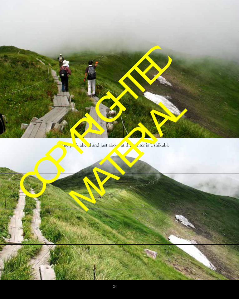
The next 2 photos also show that portion
of the trail which is boardwalk. The lady is
apparently asking the gentleman which way the
trail goes, as you can see him pointing the
direction to her. What you should especially
note here is the clouds. This photo was taken
at 12:12 PM on August 6, 2011.
The lower photo on the following page,
with no people showing (where did they go?)
was taken at 12:15 PM on the same date. One
of the reasons we are showing you these 2
photos is so that you can appreciate just how
quickly the conditions can change on the
mountain. Surely you have read that it can
happen like this, but have you ever
experienced it? This is why a person has to
always come prepared for any and every
possible type of weather.
COPYRIGHTED
MATERIAL
24
The peak ahead and just about at the center is Ushikubi.
COPYRIGHTED
MATERIAL
25
COPYRIGHTED
MATERIAL

26
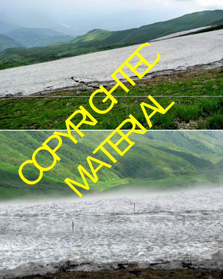
On the previous page we showed you two
photos of a snowfield which was very prevalent
in both 2008 and also 2011. In fact, in 2011
there was a person skiing on it. The snowfield is
not excessively large, so the skier was able to ski
for only about 2 minutes and then had to walk
back up to the top of it and do it again. It did
not look like very much fun to us, but who are
we to judge? If you study the upper photo (a
2008 photo) very closely you can even find the
top of the chair lift. In the lower photo (a 2011
photo) you’ll notice some wooden stakes stuck
in the snow. It appeared that they were placed
by that skier to mark the safe zone to ski within.
This following photo was taken in 2011, most
likely just as we were rounding the summit area
of Ushikubi. Note how beautiful the weather is
right now. You’ll also note that we are back on
a rock trail. The peak ahead – in the distance –
is the summit area of Mt. Gassan.
COPYRIGHTED
MATERIAL

27
The photo above was taken just after we
rounded the peak of Ushikubi, and the area
ahead is what is designated with the 4.
annotation on the map. You’ll note on the map
that immediately after Ushikubi the area to the
north drops off very steeply. This photo shows
that the clouds are coming up against that steep
slope on the left and are probably getting ready
to come rolling to this side of that steep slope.
The next photo shows the long slope which
is shown by the 4. annotation on the map back
on page 11. This photo was taken near the
bottom of that slope and you can see several
people in this photo trudging up this final slope
before they reach the summit. The photo does
not give a good indication of how steep this
slope actually is; it is steeper than it appears,
although not excessively steep. This is where
many of the younger hikers get too tired to
continue and have to be either carried or at least
helped by their parents. It looked very difficult
for people who were carrying young children.
COPYRIGHTED
MATERIAL

28
The following two photos, shown on the
facing page, were taken when we were probably
about one-half of the distance up that slope
referred to above, which is marked by the 4.
annotation on the map. The first photo was
taken on August 12, 2008 at 2:07 PM and the
lower photo was taken on August 6, 2011 at 1:43
PM. Two interesting things which you should
note in these 2 photos is, #1, the difference in
the weather – in 2008 it was quite a bit hazier
than it was in 2011, and #2 the difference in the
size of the snowfields down below us. In 2008
the snowfields were noticeably larger than in
2011. In the lower photo you can also see some
people taking a break alongside the trail;
remember, just above we told you that this trail
is steeper than it appears in these photos. Please
try to keep that in mind.
COPYRIGHTED
MATERIAL

29
COPYRIGHTED
MATERIAL

30
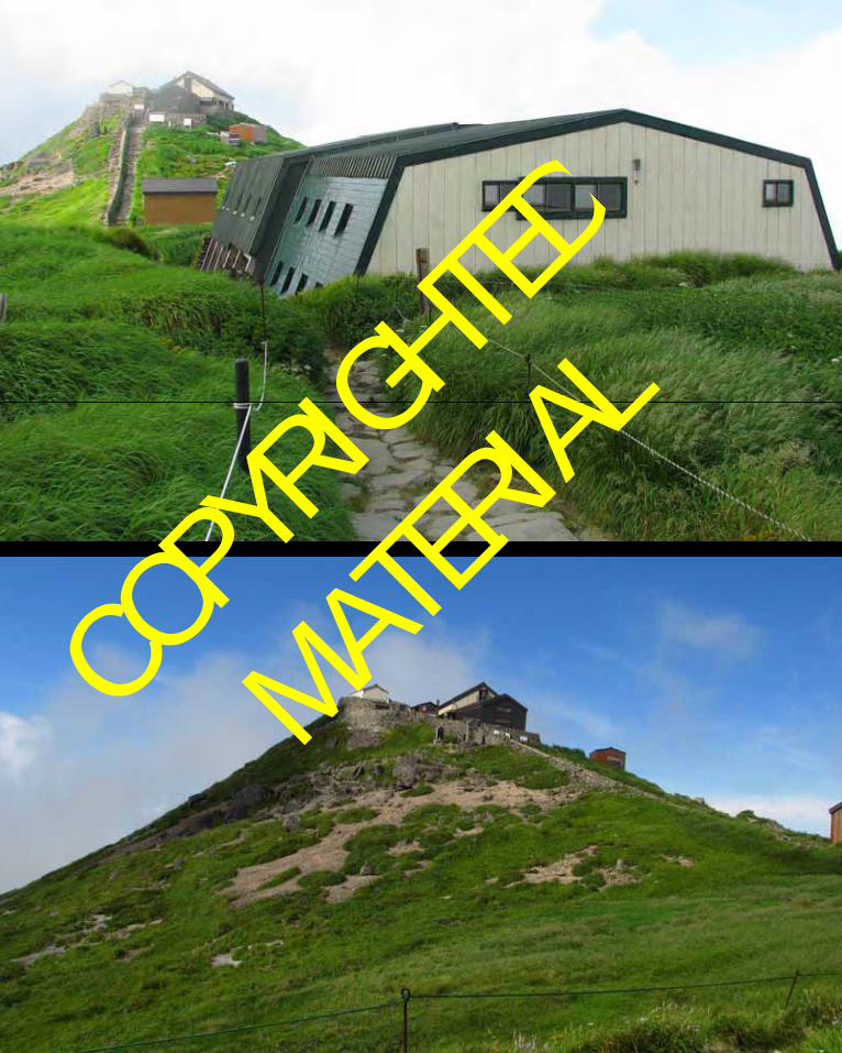
Then, after you arrive at the top of this slope
you suddenly see the summit hut! This is the
hut which offers accommodation. In this photo,
taken on August 12, 2008 at 2:47 PM it is
probably difficult for you to know that we are in
the clouds. The photo gives the impression that
the hut is right at the very summit of the
mountain and that from here it is down on all
sides. Well, be patient and we’ll show you
another photo which was taken after the clouds
parted for us. The clouds continued to come
and go on this date.
The next photo, taken on the same date, but
49 minutes later – at 3:36 PM – is a shot which
was taken from a spot very close to the same as
the above photo. In this photo you can see that
the mountain does not drop off on all sides
from the hut, as one would think from the
above photo. As you can see, there is a
Buddhist Shrine at the very summit of the
mountain.
You can enter this shrine for a fee of ¥500
and one of the monks will say some prayers and
go through a purification ritual for you. We
entered the shrine in 2008 – the first time we
were here – but we did not enter it in 2011.
COPYRIGHTED
MATERIAL
31
COPYRIGHTED
MATERIAL

32
The previous photo was taken on August 6,
2011 at 3:08 PM from a scenic overlook which
is only about a two minute walk from the hut.
After drinking some water and purchasing a
cold beer and a snack at the hut we walked out
here to enjoy our cold and very refreshing can
of beer. This photo shows the shrine area at
the summit of the mountain in full sun and at
maximum beauty, with all of the green
vegetation and the blue sky.
The following photo was also taken on
August 6, 2011, but it was taken at 3:21 PM, a
mere 13 minutes after the one just previous.
You can easily discern that it is still sunny, but at
this moment a thin cloud is passing by.
Amazingly rapid change in the weather, eh!
Now, we have no more photos until it is
approaching sunset time. And the next photo, a
flower photo, is included to show you the great
abundance of wildflowers which you will see
here. If you don’t appreciate wildflowers then
please just ignore it. It is quite amazing though.
COPYRIGHTED
MATERIAL

33
The next 2 photos, both taken on our 2008
climb of this mountain, show the setting sun.
We experienced the most incredible sunset on
this, the 12th of August, 2008. We probably shot
100 or more photos of this sunset.
The upper photo on the following page was
shot at 6:40 PM and the lower one was shot at
6:41 PM. It nearly looks like the sun is setting
through oil or something. If you are very astute
you might notice that the lower photo looks,
somehow, familiar – the reason is because a
small cropped out portion of that photo is part
of what makes up our logo, which you saw on
the first page of this book, which you see on all
of our website pages and which is included
immediately below to refresh your memory.
COPYRIGHTED
MATERIAL

34
COPYRIGHTED
MATERIAL

35
The following photo shows a scene which
was shot during the sunset period when we
climbed this mountain in 2011. It was shot on
August 6, 2011 at 6:46 PM and shows that a sea
of clouds has rolled in below us. The people
who live down in the valley below are now
100% covered by clouds. A very beautiful
photo, no?
The next photo was also taken on August 6,
2011, which was only 4 minutes after the one
just above. It shows some very interesting
colors. During the sunset time on this climb
we were only given fleeting glances of the sun
itself and in this photo the bright area at the
bottom left corner is where the sun is hiding
behind the clouds.
COPYRIGHTED
MATERIAL

36
Okay, that ends the ascent of Mt. Gassan and
it’s now time for dinner in the hut and then
shortly after that it till be time to sleep. Now,
we have to get up early in the morning, catch
some sunrise photos, eat breakfast in the hut and
then pack up and make our descent. We have
descended, both in 2008 and also in 2011 via the
trail to the north from the summit – the one
which is marked with the 6. annotation on the
map. But, before we descend, let’s take some
sunrise time photos.
The upper photo on the facing page was
taken at 4:42 AM on August 13, 2008, it is,
obviously before sunrise. The lower photo was
taken at 4:44 AM, just 2 minutes later. We will
not catch our first glimpse of the sun until about
4:50 AM. Don’t worry, we’ll also show you one
of those photos.
COPYRIGHTED
MATERIAL

37
COPYRIGHTED
MATERIAL

38
Here, just below is that photo which we
promised just above – the one where you can
actually see the sun rising. The time is now 4:52
AM, August 13th, 2008.
The following photo, on the facing page,
shows the sun after it has fully risen above the
horizon, but not 100% risen above the cloud
layer. It was shot at 4:56 AM. There is again a
sea of clouds down in the valley below us. It is
a sure thing that the people who live down
there are not seeing the sun as it rises. They
are probably wondering, in fact, if they are
going to get rained upon today! If we recall
correctly, they did not get rained upon.
The lower photo on the facing page is
included to show you the orange-red
coloration on everything we see due to this
sunrise. You’ll notice it on the small snowfield,
the white flowers, the seedheads of the grass –
literally everything.
COPYRIGHTED
MATERIAL

39
COPYRIGHTED
MATERIAL

40
COPYRIGHTED
MATERIAL

41
The two photos on the facing page are
included to show you the shadow of this
mountain. They were both shot at 5:20 AM. The
lower photo is a zoomed version of the upper
photo. If you read Volume 2 of this series of
books you were given the opportunity to see the
shadow of Mt. Chokai on the Sea of Japan. This
shadow is not as amazing as that, but it’s always at
least somewhat amazing to see the shadow of a
mountain which you are at the top of. We have
seen this from the tops of several mountains we
have climbed and we have never been able to
stop ourselves from taking some photos of it.
The photo just below gives you a final look at
the hut where we stayed – and where you can also
stay if you so desire. This was taken as we hiked
north and we were just about right beside the
small shrine which you have seen in previous
photos. It was taken at 5:23 AM on August 7,
during our 2011 climb.
COPYRIGHTED
MATERIAL

42
The following photo was taken on August
7, 2011 at 5:25 AM and it is interesting for the
fog in the various valleys which you can see.
You should also note the abundance of small
ponds down on the plateau immediately below
us. Each of those blue spots is a pond.
In the upper photo on the facing page you’ll
see Kazuya hiking on the boardwalk which is
just to the north of the shrine. In fact, that
green grassy knoll on the right side of the photo
hides the shrine. That means that the photo was
taken looking back to the south.
The lower photo on the facing page shows a
scenic shot taken from approximately the same
location, however, it was shot looking to the
north. The mountain far off in the distance is
Mt. Chokai, which was the subject of Volume 2
in this series of books.
COPYRIGHTED
MATERIAL

43
COPYRIGHTED
MATERIAL

44
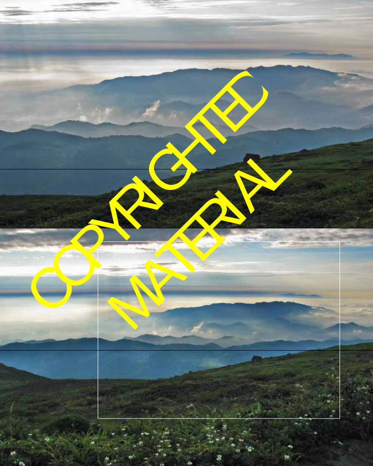
Now let’s have one shot zoomed in to Mt.
Chokai. This shot below was taken on August 7,
2011 at 5:49 AM. It is certainly not the best
possible photo, but considering that the distance
between the 2 mountains is at least 130 km (81
miles), it’s not really a terrible photo!
The following two photos, on the facing
page, both show some very interesting clouds,
sun rays and colors. They were both shot on
August 7, 2011 at 5:55 AM.. The upper image
shows the approximate area which is outlined in
the lower image. Please also note the abundance
of wildflowers in the immediate foreground in
the lower photo.
COPYRIGHTED
MATERIAL
45
COPYRIGHTED
MATERIAL

46
This photo shows me on the trail, which is again rock and not as easy to walk on as it may appear. This shot was taken on that long stretch
of trail between the 5. and 6. annotations on the map. Note that you can once again see Mt. Chokai off in the distance in this photo.
COPYRIGHTED
MATERIAL

47
The previous photo is both interesting and also strange. It was taken at 6:19 AM on August 13, 2008 as we were descending the mountain and we looked down and saw this diamond shining in our eyes. Of course it is a
small pond which just happened to be reflecting the sun in such a way so that we had this amazing view. Naturally, it disappeared about one minute later. Here is one more photo of this amazing phenomenon.
COPYRIGHTED
MATERIAL

48
This photo shows the hut which is indicated by the 6. annotation on the map back on page 11. It was taken from very close to the point which shows 1828 as the elevation on the map
(オモワシ山) (Omowashi-yama). In this photo the weather and sky is still mostly haze free and you can still see Mt. Chokai off in the distance. It was taken on August 13, 2008 at 7:17 AM.
COPYRIGHTED
MATERIAL

49
The lower photo on the facing page, taken
during our 2011 descent, shows the same hut as
the photo above. This photo is included to
show the group of white-clothed pilgrims
hiking to or from the summit. We mentioned
earlier that due to the fact that this is a sacred
mountain these groups can often be seen.
Their garb is truly amazing – they are
TOTALLY dressed in white, they even
purchase white backpacks somewhere for these
pilgrimages. We have no idea where white
backpacks can be found, possibly at the
Buddhist clothing stores, or maybe special
items for winter camouflage, who knows?
The following two photos show the lower
hut, marked with the 7. annotation on the map.
As you can see on the map, there are several
ponds around this hut. The first photo, with
the sunny blue sky was taken on August 13,
2008 at 8:18 AM.
This next photo, which shows virtually the
same scene as the photo above, is included for
two reasons. First, it is included to show the
difference in the weather we had during our
COPYRIGHTED
MATERIAL

50
two descents of this mountain. It was taken
on August 7, 2011 at 8:08 AM. Note that
although it was cloudier in 2011, we could
actually see Mt. Chokai better. The second
reason this next photo is included is to show
you another group of white-clothed pilgrims,
apparently hiking towards the summit. We
often saw these groups higher on the
mountain also, but for some reason we never
took any photos of them until we reached this
point.
You’ll note on the map (page 11) that there
is one more annotation – 8. – which is used to
mark the end of the descent along the trail and
the parking lot where you can catch a bus to
take you to a few different destinations. At
this point we are not far from this bus stop
and parking lot.
COPYRIGHTED
MATERIAL

51
This photo immediately above just could
not be omitted. It is just too amazingly
beautiful. It was taken near the ponds which
you saw above and shows a beautifully colored
butterfly sitting on a thistle.
As stated near the start of this chapter –
Mt. Gassan is the highest peak in the Dewa
Sanzan trio of sacred mountains. Dewa
Sanzan means “Three Mountains of Dewa”
and indeed comprises the three sacred
mountains of Mt. Hagurosan (羽黒山 ), Mt.
Gassan (月山) and Mt. Yudonosan (湯殿山),
clustered together in the ancient province of
Dewa (modern-day Yamagata Prefecture).
COPYRIGHTED
MATERIAL

52
One of the destinations one can decide to go
to from the parking lot and bus stop at the 8. annotation is the Mt. Hagurosan Shrine area. From the bus stop there, one can choose more destinations to travel to than one can from the Mt. Gassan bus stop (annotation 8.). The Sanjin Gosaiden Shrine, at the base of Mt. Hagurosan is very famous, and we visited that shrine after our 2011 descent. It is quite picturesque and very large and for this reason we have chosen two photos taken during our visit to it which we want to show you.
You should note well that these photos are not of the actual Hagurosan Shrine. These two
photos are of the Sanjin Gosaiden Shrine. This central shrine for Mt. Hagurosan, Mt. Gassan and Mt. Yudanosan is the most famous in Japan. Among the powerful sights at the shrine are the 2.1 m- thick thatched roof and the completely lacquered interior. It is definitely worth visiting (text taken from an information sheet at the shrine). The following photo is another of Sanjin Gosaiden Shrine and it is a two-shot panorama – 2 portrait-mode shots! It gives a better impression of the size of this shrine than the above photo does and also shows some of the intricate beauty which one can see here. Of course you can also see the 2.1 m thick thatched roof.
COPYRIGHTED
MATERIAL

53
And that is the final photo for this, Volume
3, of this series of books on “Climbing a Few of Japan’s 100 Famous Mountains”. Please return for Volume 4.
We sincerely hope that you are enjoying this series of books. If you would like any further
information about any of these mountains there is a great abundance of it available on the internet. If you want to e-mail me with specific questions you may do so through the link on my website, which is http://danwiz.com. I hope to maintain this site as long as I am alive.
THE END
COPYRIGHTED
MATERIAL

54
COPYRIGHTED
MATERIAL

55
ABOUT THE AUTHORS
Daniel Wieczorek was born in 1947 in Ionia, Michigan. He graduated from the University of Michigan with a B.S. in Forestry in 1969. He moved to Oregon to work in the field of forestry in 1971. That was followed by a move to Alaska in 1975, where he continued his career in forestry. After about a 14 year career in forestry, Daniel decided to do something different and he served as a Peace Corps Volunteer in The Philippines from 1985 – 1987. Upon completion of his Peace Corps service he returned to Alaska, where he attended the University of Alaska – Fairbanks
and received an M.B.A. in 1991. This was followed by a move to South Korea in 1992, where Daniel taught English to Korean people wishing to improve their English Language skills. Daniel’s next stop was in New York City, where he worked as temporary staff at Deutsche Bank from 1998 – 2001. He left NYC in March 2001 and moved on to his present home in Mitaka City, Tokyo, Japan. He is teaching English in Japan and at this time he’s been teaching as a career for about 17 years. He has been hiking, climbing and doing photography since he was about 12 years old.
Kazuya Numazawa was born in 1979 in Shinjo in Yamagata Prefecture, Japan. He was raised in Funagata Town in Yamagata Prefecture. He graduated from Tokyo University in 2005.
Since that time he has worked in several fields, but primarily in Cram Schools around the Mitaka Area.
Daniel and Kazuya met in 2001 and they have been hiking, mountain climbing and doing
photography together since that time and generally enjoying life together.
COPYRIGHTED
MATERIAL

56
NOTES ________________________________________________________________________________________________________________________________________________________________________________________________________________________________________________________________________________________________________________________________________________________________________________________________________________________________________________________________________________________________________________________________________________________________________________________________________________________________________________________________________________________________________________________________________________________________________________________________________________________________________________________________________________________________________________________________________________________________________________________________________________________________________________________________________
COPYRIGHTED
MATERIAL

57
___________________________________________________________________________________________________________________________________________________________________________________________________________________________________________________________________________________________________________________________________________________________________________________________________________________________________________________________________________________________________________________________________________________________________________________________________________________________________________________________________________________________________________________________________________________________________________________________________________________________________________________________________________________________________________________________________________________________________________________________________________________________________________________________________________________________________________________
COPYRIGHTED
MATERIAL

58
Photo Credits:
Daniel’s Photos:
Pages 7, 11, 12 bottom, 13, 14 top, 15, 16 all, 17, 18 all, 19, 20, 21 bottom, 22, 23, 24 top, 25 all, 26, 27,
28, 29 all, 30, 31 all, 32, 33 bottom, 34 all, 35, 36, 37 all, 38, 39 all, 40 all, 41, 42, 43 all, 44, 45 bottom,
46 bottom, 47, 48 all, 49, 50, 51, 52, 53.
Kazuya’s Photos:
Pages 9, 10, 12 top, 16 top, 21 top, 24 bottom, 33 top, 45 top, 46 top.
COPYRIGHTED
MATERIAL