Embed Size (px)
Citation preview
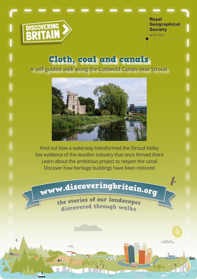
Find out how a waterway transformed the Stroud ValleySee evidence of the woollen industry that once thrived there
Learn about the ambitious project to reopen the canalDiscover how heritage buildings have been restored
Cloth, coal and canals A self-guided walk along the Cotswold Canals near Stroud
www.discoveringbritain.orgthe stories of our landscapesdiscovered through walks
2
�Created in collaboration
with
3
Contents
�Introduction 4
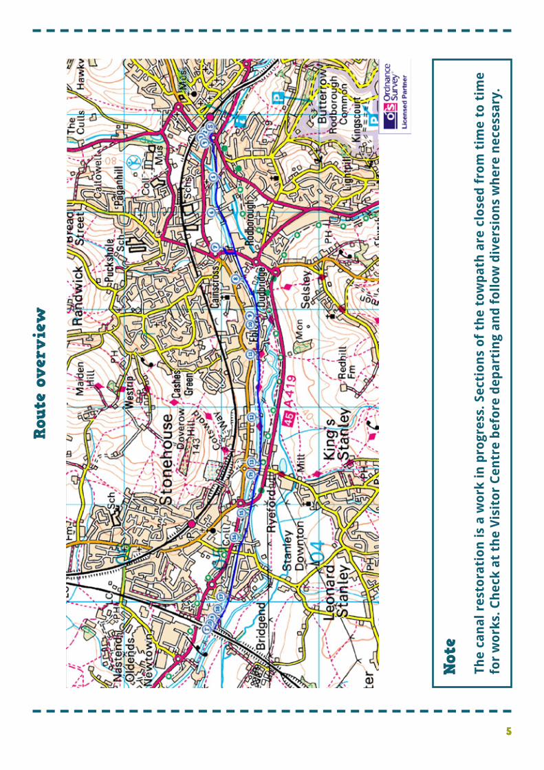
�Route overview 5
�Practical information 6
�Detailed route maps and stopping points 8
�Commentary 11
�Credits 42
�Other waterways walks 43
�Discovering Britain is a project of the Royal Geographical Society (with IBG)
�The digital and print maps used for Discovering Britain are licensed to the RGS-IBG from Ordnance Survey
�© The Royal Geographical Society with the Institute of British Geographers, London, 2013
�Cover image: St Cyr’s Church alongside the Stroudwater Navigation © Sara Chardin
4
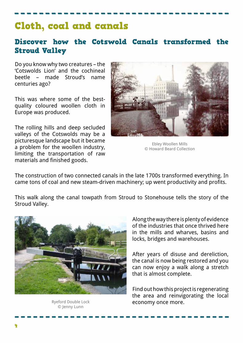
�Do you know why two creatures – the ‘Cotswolds Lion’ and the cochineal beetle – made Stroud’s name centuries ago? � �This was where some of the best-quality coloured woollen cloth in Europe was produced. � �The rolling hills and deep secluded valleys of the Cotswolds may be a picturesque landscape but it became a problem for the woollen industry, limiting the transportation of raw materials and finished goods. � �The construction of two connected canals in the late 1700s transformed everything. In came tons of coal and new steam-driven machinery; up went productivity and profits. � �This walk along the canal towpath from Stroud to Stonehouse tells the story of the Stroud Valley.
� �Along the way there is plenty of evidence of the industries that once thrived here in the mills and wharves, basins and locks, bridges and warehouses. � �After years of disuse and dereliction, the canal is now being restored and you can now enjoy a walk along a stretch that is almost complete. � �Find out how this project is regenerating the area and reinvigorating the local economy once more.
Ebley Woollen Mills© Howard Beard Collection
�Ryeford Double Lock �© Jenny Lunn
Cloth, coal and canals Discover how the Cotswold Canals transformed the Stroud Valley
5
Note
�The
can
al r
esto
rati
on
is
a w
ork
in
pro
gres
s. S
ecti
on
s o
f th
e to
wp
ath
are
clo
sed
fro
m t
ime
to t
ime
for
wo
rks.
Ch
eck
at
the
Vis
ito
r C
entr
e b
efo
re d
epar
tin
g an
d f
oll
ow
div
ersi
on
s w
her
e n
eces
sary
.
�Rout
e ov
ervi
ew
6
�Location � �Start point � � �Finish point � �Getting there � � � � � � � � � � � � � �Directions from railway station to start � � � �Walk distance � �Level � �Terrain � � �Suitable for
�Stroud, Gloucestershire
Cotswold Canals Visitor Centre, Bell House, Wallbridge Lock, Stroud, GL5 3JS
The Ocean, off Bristol Road, Stonehouse, GL10 3RA
�Car – Stroud is about 10 miles south of Gloucester and 13 miles west of Cirencester. It is easily accessible from the M5 (Junction 13) and M4 (Junction 18). There are car parks at Cheapside and Brunel Mall (charges apply); limited street parking is available. � �Train – The nearest station is Stroud (200 metres). It is served by long distance trains running between London Paddington and Gloucester and Cheltenham via Swindon. � �Bus – Stroud is well served by regional and local buses � �Bicycle – National Cycle Route 45 (Chester to Salisbury) passes through Stroud and Stonehouse � �Leave the station on the Gloucester-bound side (not the main exit). Go out of the car park and turn right down Cheapside. At the bottom take the second left (the first left is a road that is used as a car park; the third road is marked ‘All Through Traffic’). At the end of the red brick building turn left round the corner to the canal lock. There is a cafe straight ahead and the Visitor Centre is up the stairs on the left. � �3 ½ miles � �Gentle – A level route along the canal towpath � �Most of the canal towpath is surfaced but it can be muddy in places after rain; work is ongoing to make the path smoother. � �Families – Take care by the side of the canal and especially around locks � �Prams and pushchairs – Most of the path is surfaced and any steps can be bypassed � �Dogs – Should be kept under control along the towpath
Practical information
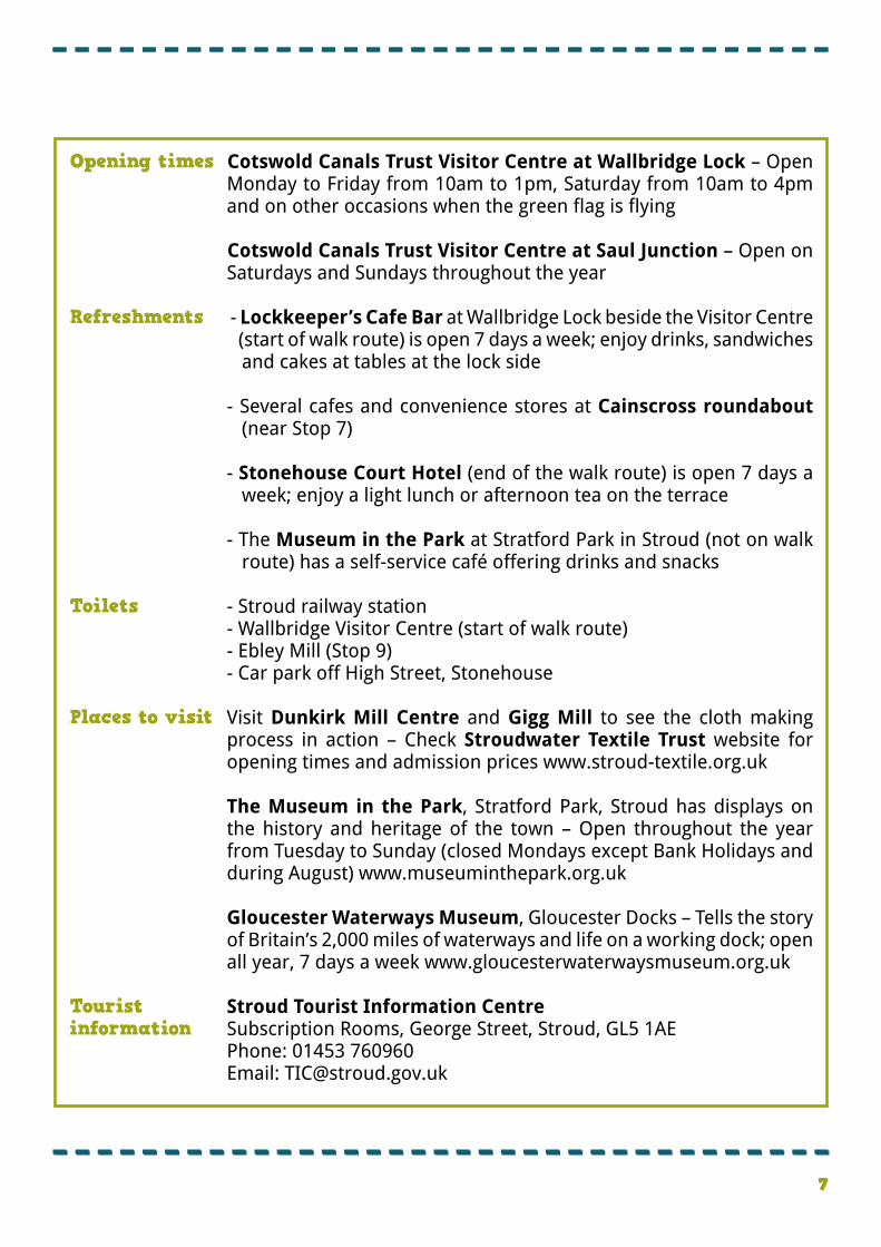
7 �7
�Opening times � � � � � � �Refreshments � � � � � � � � � � � � �Toilets � � � � �Places to visit � � � � � � � � � � � � �Tourist information
�Cotswold Canals Trust Visitor Centre at Wallbridge Lock – Open Monday to Friday from 10am to 1pm, Saturday from 10am to 4pm and on other occasions when the green flag is flying � �Cotswold Canals Trust Visitor Centre at Saul Junction – Open on Saturdays and Sundays throughout the year � - Lockkeeper’s Cafe Bar at Wallbridge Lock beside the Visitor Centre (start of walk route) is open 7 days a week; enjoy drinks, sandwiches and cakes at tables at the lock side
- Several cafes and convenience stores at Cainscross roundabout (near Stop 7)
- Stonehouse Court Hotel (end of the walk route) is open 7 days a week; enjoy a light lunch or afternoon tea on the terrace
- The Museum in the Park at Stratford Park in Stroud (not on walk route) has a self-service café offering drinks and snacks
- Stroud railway station- Wallbridge Visitor Centre (start of walk route)- Ebley Mill (Stop 9)- Car park off High Street, Stonehouse
Visit Dunkirk Mill Centre and Gigg Mill to see the cloth making process in action – Check Stroudwater Textile Trust website for opening times and admission prices www.stroud-textile.org.uk
The Museum in the Park, Stratford Park, Stroud has displays on the history and heritage of the town – Open throughout the year from Tuesday to Sunday (closed Mondays except Bank Holidays and during August) www.museuminthepark.org.uk
Gloucester Waterways Museum, Gloucester Docks – Tells the story of Britain’s 2,000 miles of waterways and life on a working dock; open all year, 7 days a week www.gloucesterwaterwaysmuseum.org.uk
Stroud Tourist Information CentreSubscription Rooms, George Street, Stroud, GL5 1AEPhone: 01453 760960Email: [email protected]
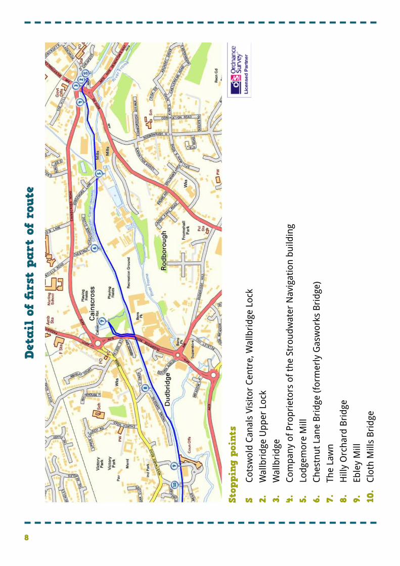
8
�Det
ail
of fi
rst
part
of
rout
e
�Stop
ping
poi
nts
�S �2. �3. �4.
�5.
�6.
�7.
�8. �9. �10.
Cot
swol
d C
anal
s Vi
sito
r C
entr
e, W
allb
rid
ge L
ock
Wal
lbri
dge
Up
per
Loc
k
Wal
lbri
dge
Com
pan
y of
Pro
pri
etor
s of
th
e St
rou
dw
ater
Nav
igat
ion
bu
ildin
g
Lod
gem
ore
Mill
Ch
estn
ut
Lan
e B
rid
ge (f
orm
erly
Gas
wor
ks B
rid
ge)
The
Law
n
Hill
y O
rch
ard
Bri
dge
Eble
y M
ill
Clo
th M
ills
Bri
dge
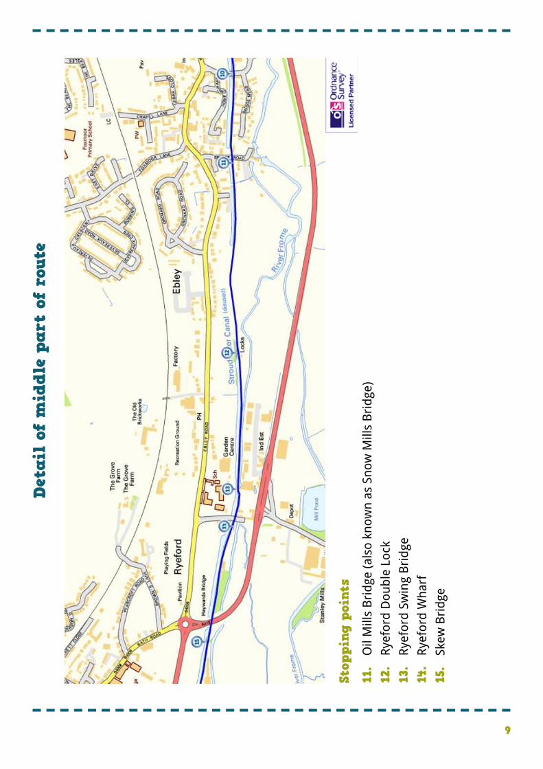
9
�Stop
ping
poi
nts
�11.
�12.
�13.
�14.
�15.
Oil
Mill
s B
rid
ge (a
lso
know
n a
s Sn
ow M
ills
Bri
dge
)
Rye
ford
Dou
ble
Loc
k
Rye
ford
Sw
ing
Bri
dge
Rye
ford
Wh
arf
Skew
Bri
dge
�Det
ail
of m
iddl
e pa
rt o
f ro
ute
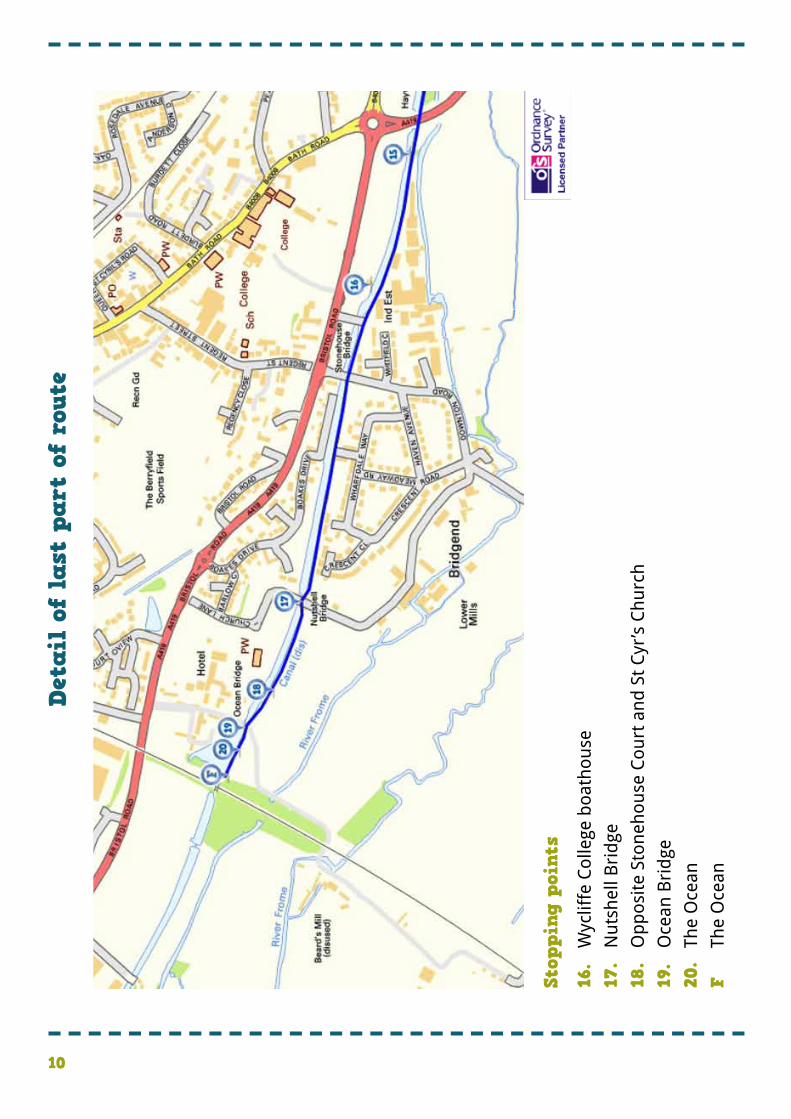
10
�Stop
ping
poi
nts
�16.
�17.
�18.
�19.
�20.
�F
Wyc
liffe
Col
lege
boa
thou
se
Nu
tsh
ell B
rid
ge
Op
pos
ite
Ston
ehou
se C
ourt
an
d S
t C
yr’s
Ch
urc
h
Oce
an B
rid
ge
The
Oce
an
The
Oce
an
�Det
ail
of l
ast
part
of
rout
e
11
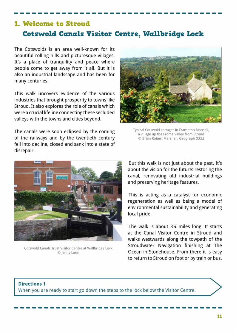
1. Welcome to StroudCotswold Canals Visitor Centre, Wallbridge Lock
�Directions 1 �When you are ready to start go down the steps to the lock below the Visitor Centre.
�The Cotswolds is an area well-known for its beautiful rolling hills and picturesque villages. It’s a place of tranquility and peace where people come to get away from it all. But it is also an industrial landscape and has been for many centuries. � �This walk uncovers evidence of the various industries that brought prosperity to towns like Stroud. It also explores the role of canals which were a crucial lifeline connecting these secluded valleys with the towns and cities beyond. � �The canals were soon eclipsed by the coming of the railways and by the twentieth century fell into decline, closed and sank into a state of disrepair.
� �But this walk is not just about the past. It’s about the vision for the future: restoring the canal, renovating old industrial buildings and preserving heritage features. � �This is acting as a catalyst for economic regeneration as well as being a model of environmental sustainability and generating local pride. � �The walk is about 3¼ miles long. It starts at the Canal Visitor Centre in Stroud and walks westwards along the towpath of the Stroudwater Navigation finishing at The Ocean in Stonehouse. From there it is easy to return to Stroud on foot or by train or bus.
Typical Cotswold cottages in Frampton Mansell, a village up the Frome Valley from Stroud© Brian Robert Marshall, Geograph (CCL)
Cotswold Canals Trust Visitor Centre at Wallbridge Lock© Jenny Lunn
12
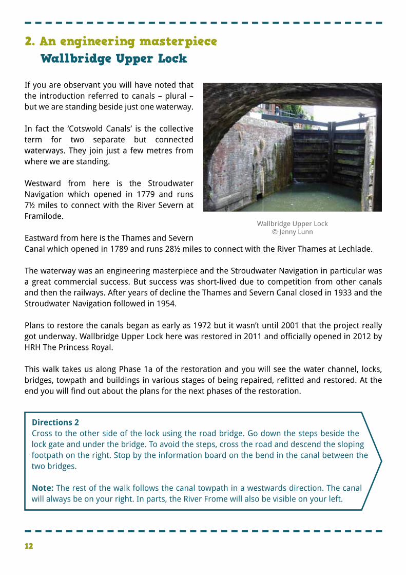
�If you are observant you will have noted that the introduction referred to canals – plural – but we are standing beside just one waterway. � �In fact the ‘Cotswold Canals’ is the collective term for two separate but connected waterways. They join just a few metres from where we are standing. � �Westward from here is the Stroudwater Navigation which opened in 1779 and runs 7½ miles to connect with the River Severn at Framilode. � �Eastward from here is the Thames and Severn Canal which opened in 1789 and runs 28½ miles to connect with the River Thames at Lechlade. � �The waterway was an engineering masterpiece and the Stroudwater Navigation in particular was a great commercial success. But success was short-lived due to competition from other canals and then the railways. After years of decline the Thames and Severn Canal closed in 1933 and the Stroudwater Navigation followed in 1954. � �Plans to restore the canals began as early as 1972 but it wasn’t until 2001 that the project really got underway. Wallbridge Upper Lock here was restored in 2011 and officially opened in 2012 by HRH The Princess Royal. � �This walk takes us along Phase 1a of the restoration and you will see the water channel, locks, bridges, towpath and buildings in various stages of being repaired, refitted and restored. At the end you will find out about the plans for the next phases of the restoration.
2. An engineering masterpiece Wallbridge Upper Lock
�Directions 2 �Cross to the other side of the lock using the road bridge. Go down the steps beside the lock gate and under the bridge. To avoid the steps, cross the road and descend the sloping footpath on the right. Stop by the information board on the bend in the canal between the two bridges. � �Note: The rest of the walk follows the canal towpath in a westwards direction. The canal will always be on your right. In parts, the River Frome will also be visible on your left.
Wallbridge Upper Lock© Jenny Lunn
13
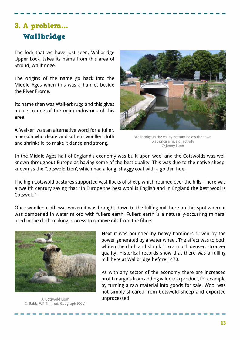
�The lock that we have just seen, Wallbridge Upper Lock, takes its name from this area of Stroud, Wallbridge. � �The origins of the name go back into the Middle Ages when this was a hamlet beside the River Frome. � �Its name then was Walkerbrugg and this gives a clue to one of the main industries of this area. � �A ‘walker’ was an alternative word for a fuller, a person who cleans and softens woollen cloth and shrinks it to make it dense and strong. � �In the Middle Ages half of England’s economy was built upon wool and the Cotswolds was well known throughout Europe as having some of the best quality. This was due to the native sheep, known as the ‘Cotswold Lion’, which had a long, shaggy coat with a golden hue. � �The high Cotswold pastures supported vast flocks of sheep which roamed over the hills. There was a twelfth century saying that “In Europe the best wool is English and in England the best wool is Cotswold”. � �Once woollen cloth was woven it was brought down to the fulling mill here on this spot where it was dampened in water mixed with fullers earth. Fullers earth is a naturally-occurring mineral used in the cloth-making process to remove oils from the fibres.
� �Next it was pounded by heavy hammers driven by the power generated by a water wheel. The effect was to both whiten the cloth and shrink it to a much denser, stronger quality. Historical records show that there was a fulling mill here at Wallbridge before 1470. � �As with any sector of the economy there are increased profit margins from adding value to a product, for example by turning a raw material into goods for sale. Wool was not simply sheared from Cotswold sheep and exported unprocessed.
3. A problem…Wallbridge
A ‘Cotswold Lion’© Rabbi WP Thinrod, Geograph (CCL)
Wallbridge in the valley bottom below the town was once a hive of activity
© Jenny Lunn
14
�Directions 3 �Walk along the towpath away from Wallbridge Lock and under the new Stroud Brewery Bridge. Pass a building on the left. Part way along the fence on the left is a gate. Stop by the gate looking at the front of the building. If the gate is open, go through for a better view.
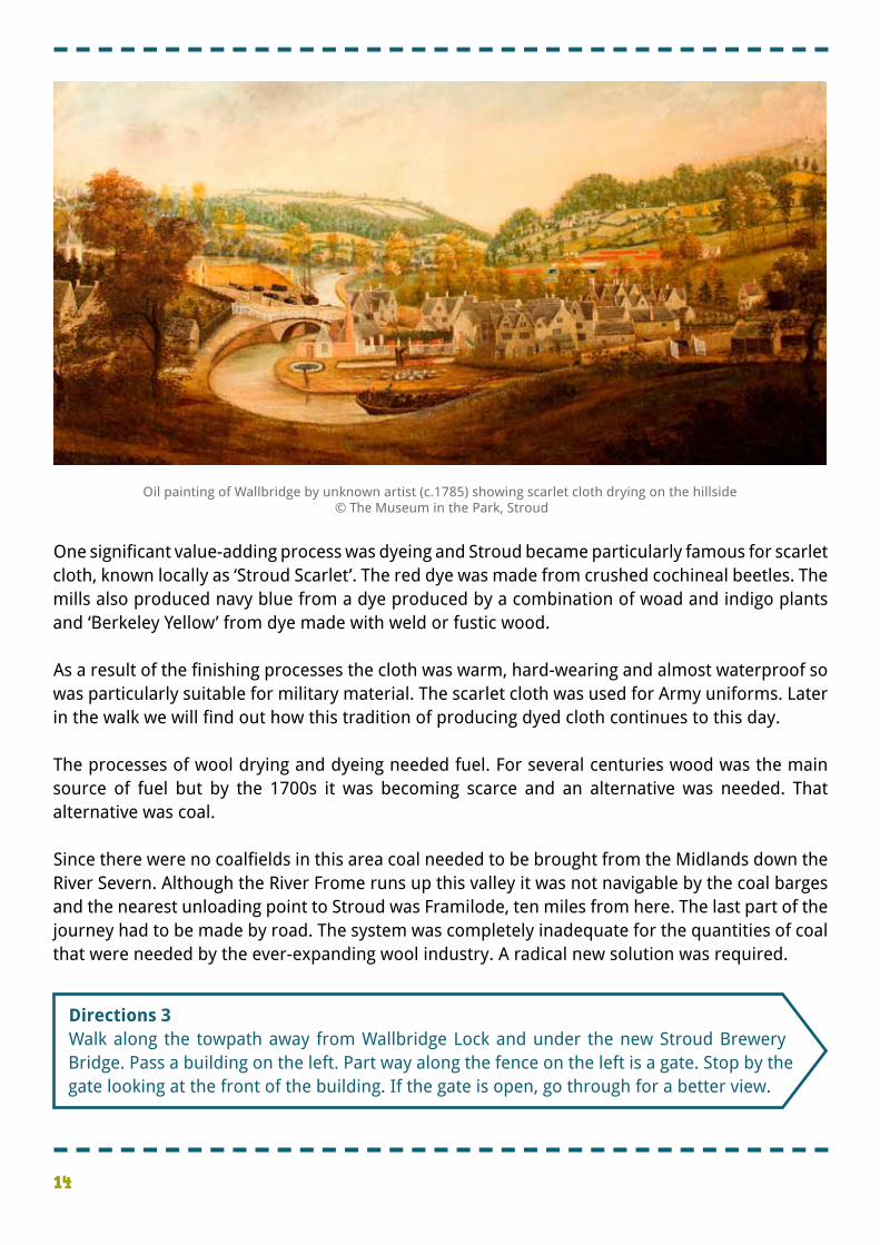
�One significant value-adding process was dyeing and Stroud became particularly famous for scarlet cloth, known locally as ‘Stroud Scarlet’. The red dye was made from crushed cochineal beetles. The mills also produced navy blue from a dye produced by a combination of woad and indigo plants and ‘Berkeley Yellow’ from dye made with weld or fustic wood. � �As a result of the finishing processes the cloth was warm, hard-wearing and almost waterproof so was particularly suitable for military material. The scarlet cloth was used for Army uniforms. Later in the walk we will find out how this tradition of producing dyed cloth continues to this day. � �The processes of wool drying and dyeing needed fuel. For several centuries wood was the main source of fuel but by the 1700s it was becoming scarce and an alternative was needed. That alternative was coal. � �Since there were no coalfields in this area coal needed to be brought from the Midlands down the River Severn. Although the River Frome runs up this valley it was not navigable by the coal barges and the nearest unloading point to Stroud was Framilode, ten miles from here. The last part of the journey had to be made by road. The system was completely inadequate for the quantities of coal that were needed by the ever-expanding wool industry. A radical new solution was required.
Oil painting of Wallbridge by unknown artist (c.1785) showing scarlet cloth drying on the hillside © The Museum in the Park, Stroud

15
�At the last stop we found out about the increasing amounts of coal needed by the wool industry but the difficulty in transporting it to the towns up these Cotswold valleys. � �By the early 1700s the industry was prospering and pressure for improving navigability between the River Severn and Stroud was growing. Ideas proposed by local manufacturers date back to the 1730s. � �There were two successive schemes which tried to upgrade the river but these ran into problems. John Kemmett, an ironmaster from Tewkesbury, succeeded in straightening much of the meandering course of the river but his proposal to lift cargo from one barge to another instead of using locks was never practicable. � �The third attempt to solve the problem involved building a waterway separate from the river which is the Stroudwater Canal that you see today. It was opened in 1779 – fifty years after the initial ideas were proposed!
4. …and a solutionCompany of Proprietors building
Top: ‘The Case of the Stroud Water Navigation’, making the case of the canal, published 1776Bottom: Plan of the Navigable Canal from the Town of Stroud to the River Severn at Framilode surveyed in 1775
Courtesy of The Junction Heritage Project (www.cotswoldcanalsheritage.org.uk) Ref: D1180
16
�There was huge local support for the canal here in Stroud. In fact about 70 per cent of the shares in the canal company were held by people involved in cloth-making or who had made their fortunes from wool. � �On the other hand clothiers a bit further downstream were concerned that the canal would bring benefits to their competitors upstream and nothing but disruption for themselves. They were particularly concerned about losing water to the canal since their mills depended entirely on the river for power.
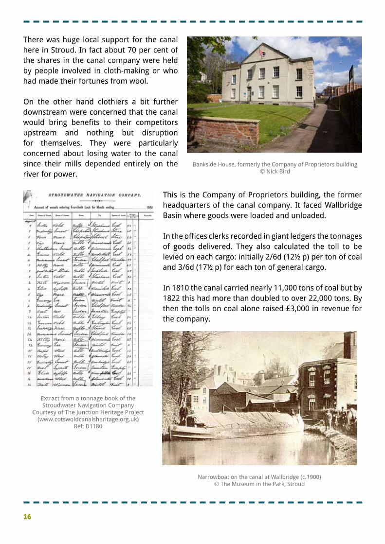
� �This is the Company of Proprietors building, the former headquarters of the canal company. It faced Wallbridge Basin where goods were loaded and unloaded. � �In the offices clerks recorded in giant ledgers the tonnages of goods delivered. They also calculated the toll to be levied on each cargo: initially 2/6d (12½ p) per ton of coal and 3/6d (17½ p) for each ton of general cargo. � �In 1810 the canal carried nearly 11,000 tons of coal but by 1822 this had more than doubled to over 22,000 tons. By then the tolls on coal alone raised £3,000 in revenue for the company.
Bankside House, formerly the Company of Proprietors building© Nick Bird
Extract from a tonnage book of the Stroudwater Navigation Company
Courtesy of The Junction Heritage Project (www.cotswoldcanalsheritage.org.uk)
Ref: D1180
Narrowboat on the canal at Wallbridge (c.1900) © The Museum in the Park, Stroud
17
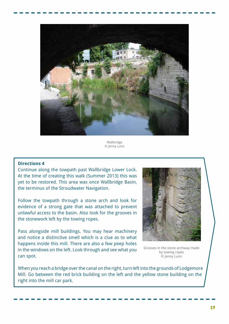
�Directions 4 �Continue along the towpath past Wallbridge Lower Lock. At the time of creating this walk (Summer 2013) this was yet to be restored. This area was once Wallbridge Basin, the terminus of the Stroudwater Navigation. � �Follow the towpath through a stone arch and look for evidence of a strong gate that was attached to prevent unlawful access to the basin. Also look for the grooves in the stonework left by the towing ropes. � �Pass alongside mill buildings. You may hear machinery and notice a distinctive smell which is a clue as to what happens inside this mill. There are also a few peep holes in the windows on the left. Look through and see what you can spot. � �When you reach a bridge over the canal on the right, turn left into the grounds of Lodgemore Mill. Go between the red brick building on the left and the yellow stone building on the right into the mill car park.
Grooves in the stone archway made by towing ropes© Jenny Lunn
Wallbridge© Jenny Lunn
18
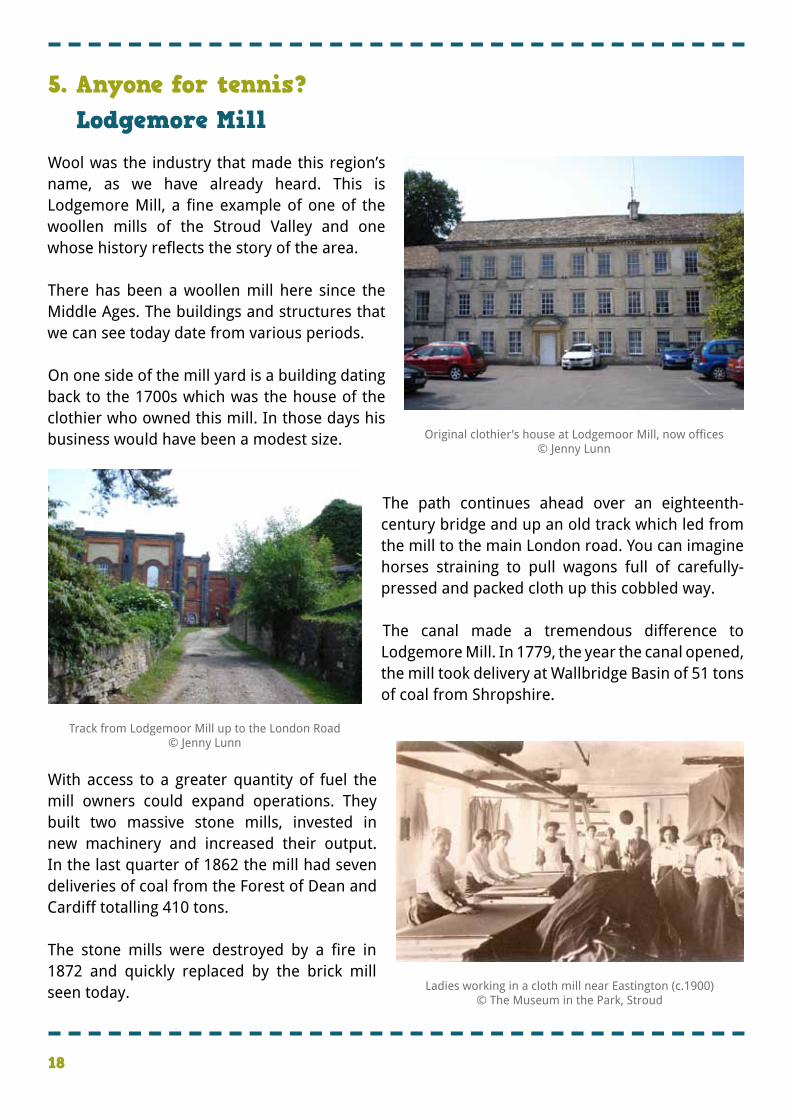
�Wool was the industry that made this region’s name, as we have already heard. This is Lodgemore Mill, a fine example of one of the woollen mills of the Stroud Valley and one whose history reflects the story of the area. � �There has been a woollen mill here since the Middle Ages. The buildings and structures that we can see today date from various periods. � �On one side of the mill yard is a building dating back to the 1700s which was the house of the clothier who owned this mill. In those days his business would have been a modest size.
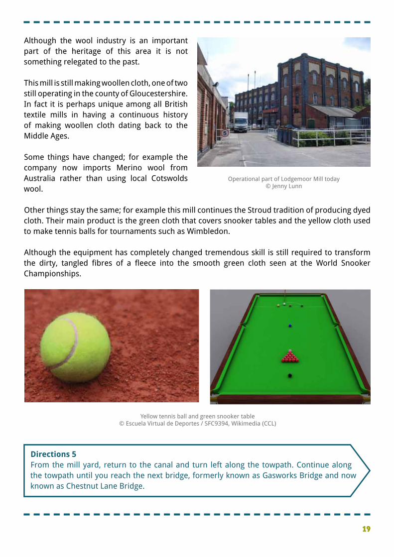
� � �The path continues ahead over an eighteenth-century bridge and up an old track which led from the mill to the main London road. You can imagine horses straining to pull wagons full of carefully-pressed and packed cloth up this cobbled way. � �The canal made a tremendous difference to Lodgemore Mill. In 1779, the year the canal opened, the mill took delivery at Wallbridge Basin of 51 tons of coal from Shropshire. �
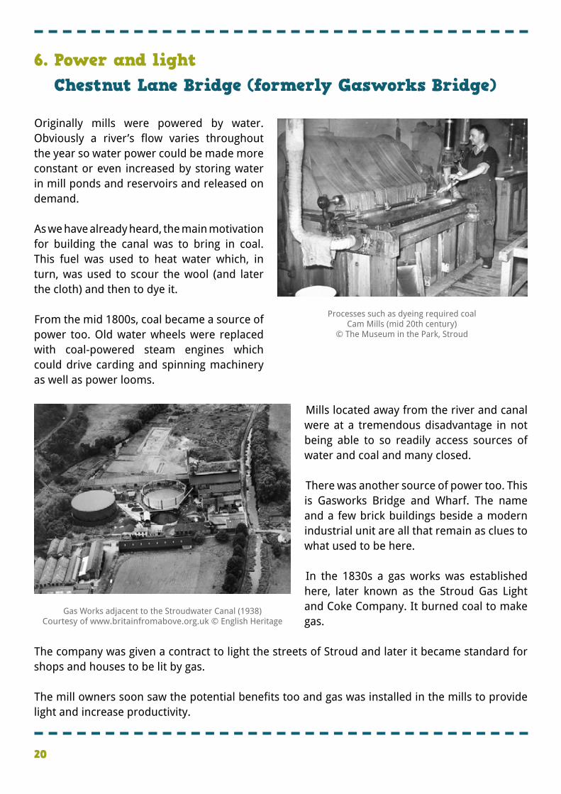
�With access to a greater quantity of fuel the mill owners could expand operations. They built two massive stone mills, invested in new machinery and increased their output. In the last quarter of 1862 the mill had seven deliveries of coal from the Forest of Dean and Cardiff totalling 410 tons. � �The stone mills were destroyed by a fire in 1872 and quickly replaced by the brick mill seen today.
5. Anyone for tennis?Lodgemore Mill
Original clothier’s house at Lodgemoor Mill, now offices© Jenny Lunn
Ladies working in a cloth mill near Eastington (c.1900) © The Museum in the Park, Stroud
Track from Lodgemoor Mill up to the London Road© Jenny Lunn
19
�Directions 5 �From the mill yard, return to the canal and turn left along the towpath. Continue along the towpath until you reach the next bridge, formerly known as Gasworks Bridge and now known as Chestnut Lane Bridge.
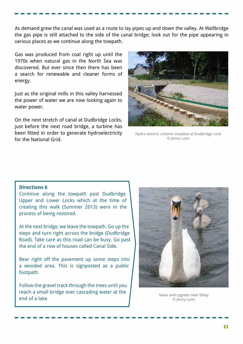
�Although the wool industry is an important part of the heritage of this area it is not something relegated to the past. � �This mill is still making woollen cloth, one of two still operating in the county of Gloucestershire. In fact it is perhaps unique among all British textile mills in having a continuous history of making woollen cloth dating back to the Middle Ages. � �Some things have changed; for example the company now imports Merino wool from Australia rather than using local Cotswolds wool. � �Other things stay the same; for example this mill continues the Stroud tradition of producing dyed cloth. Their main product is the green cloth that covers snooker tables and the yellow cloth used to make tennis balls for tournaments such as Wimbledon. � �Although the equipment has completely changed tremendous skill is still required to transform the dirty, tangled fibres of a fleece into the smooth green cloth seen at the World Snooker Championships.
Yellow tennis ball and green snooker table © Escuela Virtual de Deportes / SFC9394, Wikimedia (CCL)
Operational part of Lodgemoor Mill today© Jenny Lunn
20
�Originally mills were powered by water. Obviously a river’s flow varies throughout the year so water power could be made more constant or even increased by storing water in mill ponds and reservoirs and released on demand. � �As we have already heard, the main motivation for building the canal was to bring in coal. This fuel was used to heat water which, in turn, was used to scour the wool (and later the cloth) and then to dye it. � �From the mid 1800s, coal became a source of power too. Old water wheels were replaced with coal-powered steam engines which could drive carding and spinning machinery as well as power looms.
� �Mills located away from the river and canal were at a tremendous disadvantage in not being able to so readily access sources of water and coal and many closed. � �There was another source of power too. This is Gasworks Bridge and Wharf. The name and a few brick buildings beside a modern industrial unit are all that remain as clues to what used to be here. � � In the 1830s a gas works was established here, later known as the Stroud Gas Light and Coke Company. It burned coal to make gas. �
�The company was given a contract to light the streets of Stroud and later it became standard for shops and houses to be lit by gas. � �The mill owners soon saw the potential benefits too and gas was installed in the mills to provide light and increase productivity.
6. Power and lightChestnut Lane Bridge (formerly Gasworks Bridge)
Gas Works adjacent to the Stroudwater Canal (1938) Courtesy of www.britainfromabove.org.uk © English Heritage
Processes such as dyeing required coal Cam Mills (mid 20th century)
© The Museum in the Park, Stroud
21
�As demand grew the canal was used as a route to lay pipes up and down the valley. At Wallbridge the gas pipe is still attached to the side of the canal bridge; look out for the pipe appearing in various places as we continue along the towpath. � �Gas was produced from coal right up until the 1970s when natural gas in the North Sea was discovered. But ever since then there has been a search for renewable and cleaner forms of energy. � �Just as the original mills in this valley harnessed the power of water we are now looking again to water power. � �On the next stretch of canal at Dudbridge Locks, just before the next road bridge, a turbine has been fitted in order to generate hydroelectricity for the National Grid.
�Directions 6 �Continue along the towpath past Dudbridge Upper and Lower Locks which at the time of creating this walk (Summer 2013) were in the process of being restored. � �At the next bridge, we leave the towpath. Go up the steps and turn right across the bridge (Dudbridge Road). Take care as this road can be busy. Go past the end of a row of houses called Canal Side. � �Bear right off the pavement up some steps into a wooded area. This is signposted as a public footpath. � �Follow the gravel track through the trees until you reach a small bridge over cascading water at the end of a lake.
Hydro electric scheme installed at Dudbridge Lock© Jenny Lunn
Swan and cygnets near Ebley© Jenny Lunn
22
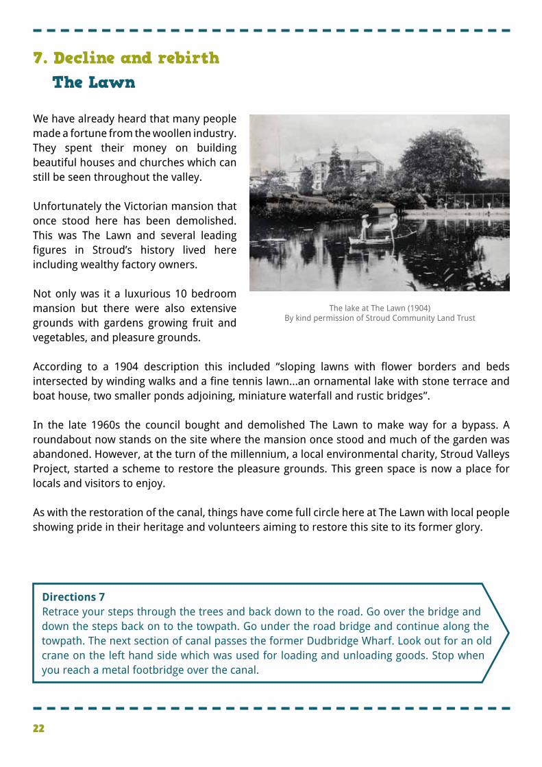
�We have already heard that many people made a fortune from the woollen industry. They spent their money on building beautiful houses and churches which can still be seen throughout the valley. � �Unfortunately the Victorian mansion that once stood here has been demolished. This was The Lawn and several leading figures in Stroud’s history lived here including wealthy factory owners. � �Not only was it a luxurious 10 bedroom mansion but there were also extensive grounds with gardens growing fruit and vegetables, and pleasure grounds. � �According to a 1904 description this included “sloping lawns with flower borders and beds intersected by winding walks and a fine tennis lawn...an ornamental lake with stone terrace and boat house, two smaller ponds adjoining, miniature waterfall and rustic bridges”. � �In the late 1960s the council bought and demolished The Lawn to make way for a bypass. A roundabout now stands on the site where the mansion once stood and much of the garden was abandoned. However, at the turn of the millennium, a local environmental charity, Stroud Valleys Project, started a scheme to restore the pleasure grounds. This green space is now a place for locals and visitors to enjoy. � �As with the restoration of the canal, things have come full circle here at The Lawn with local people showing pride in their heritage and volunteers aiming to restore this site to its former glory.
7. Decline and rebirthThe Lawn
The lake at The Lawn (1904) By kind permission of Stroud Community Land Trust
�Directions 7 �Retrace your steps through the trees and back down to the road. Go over the bridge and down the steps back on to the towpath. Go under the road bridge and continue along the towpath. The next section of canal passes the former Dudbridge Wharf. Look out for an old crane on the left hand side which was used for loading and unloading goods. Stop when you reach a metal footbridge over the canal.
23
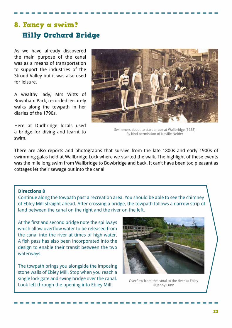
�As we have already discovered the main purpose of the canal was as a means of transportation to support the industries of the Stroud Valley but it was also used for leisure. � �A wealthy lady, Mrs Witts of Bownham Park, recorded leisurely walks along the towpath in her diaries of the 1790s. � �Here at Dudbridge locals used a bridge for diving and learnt to swim. � �There are also reports and photographs that survive from the late 1800s and early 1900s of swimming galas held at Wallbridge Lock where we started the walk. The highlight of these events was the mile long swim from Wallbridge to Bowbridge and back. It can’t have been too pleasant as cottages let their sewage out into the canal!
�Directions 8 �Continue along the towpath past a recreation area. You should be able to see the chimney of Ebley Mill straight ahead. After crossing a bridge, the towpath follows a narrow strip of land between the canal on the right and the river on the left. � �At the first and second bridge note the spillways which allow overflow water to be released from the canal into the river at times of high water. A fish pass has also been incorporated into the design to enable their transit between the two waterways. � �The towpath brings you alongside the imposing stone walls of Ebley Mill. Stop when you reach a single lock gate and swing bridge over the canal. Look left through the opening into Ebley Mill.
8. Fancy a swim?Hilly Orchard Bridge
Swimmers about to start a race at Wallbridge (1935)By kind permission of Neville Nelder
Overflow from the canal to the river at Ebley© Jenny Lunn
24
�Directions 9 �Look at the mosaic on the stone plinth which was designed by pupils from nearby St Matthew’s Primary School. It incorporates images of the mill, a water wheel and teasels which were used to raise the nap of the cloth. Do take time to explore the site of Ebley Mill. When you are ready, return to the canal towpath and walk towards the red brick road bridge (Cloth Mills Bridge). Stop just before the bridge looking back to Ebley Mill.
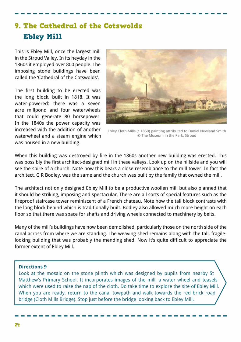
�This is Ebley Mill, once the largest mill in the Stroud Valley. In its heyday in the 1860s it employed over 800 people. The imposing stone buildings have been called the ‘Cathedral of the Cotswolds’. � �The first building to be erected was the long block, built in 1818. It was water-powered: there was a seven acre millpond and four waterwheels that could generate 80 horsepower. In the 1840s the power capacity was increased with the addition of another waterwheel and a steam engine which was housed in a new building. � �When this building was destroyed by fire in the 1860s another new building was erected. This was possibly the first architect-designed mill in these valleys. Look up on the hillside and you will see the spire of a church. Note how this bears a close resemblance to the mill tower. In fact the architect, G R Bodley, was the same and the church was built by the family that owned the mill. � �The architect not only designed Ebley Mill to be a productive woollen mill but also planned that it should be striking, imposing and spectacular. There are all sorts of special features such as the fireproof staircase tower reminiscent of a French chateau. Note how the tall block contrasts with the long block behind which is traditionally built. Bodley also allowed much more height on each floor so that there was space for shafts and driving wheels connected to machinery by belts. � �Many of the mill’s buildings have now been demolished, particularly those on the north side of the canal across from where we are standing. The weaving shed remains along with the tall, fragile-looking building that was probably the mending shed. Now it’s quite difficult to appreciate the former extent of Ebley Mill.
9. The Cathedral of the CotswoldsEbley Mill
Ebley Cloth Mills (c.1850) painting attributed to Daniel Newland Smith © The Museum in the Park, Stroud
25
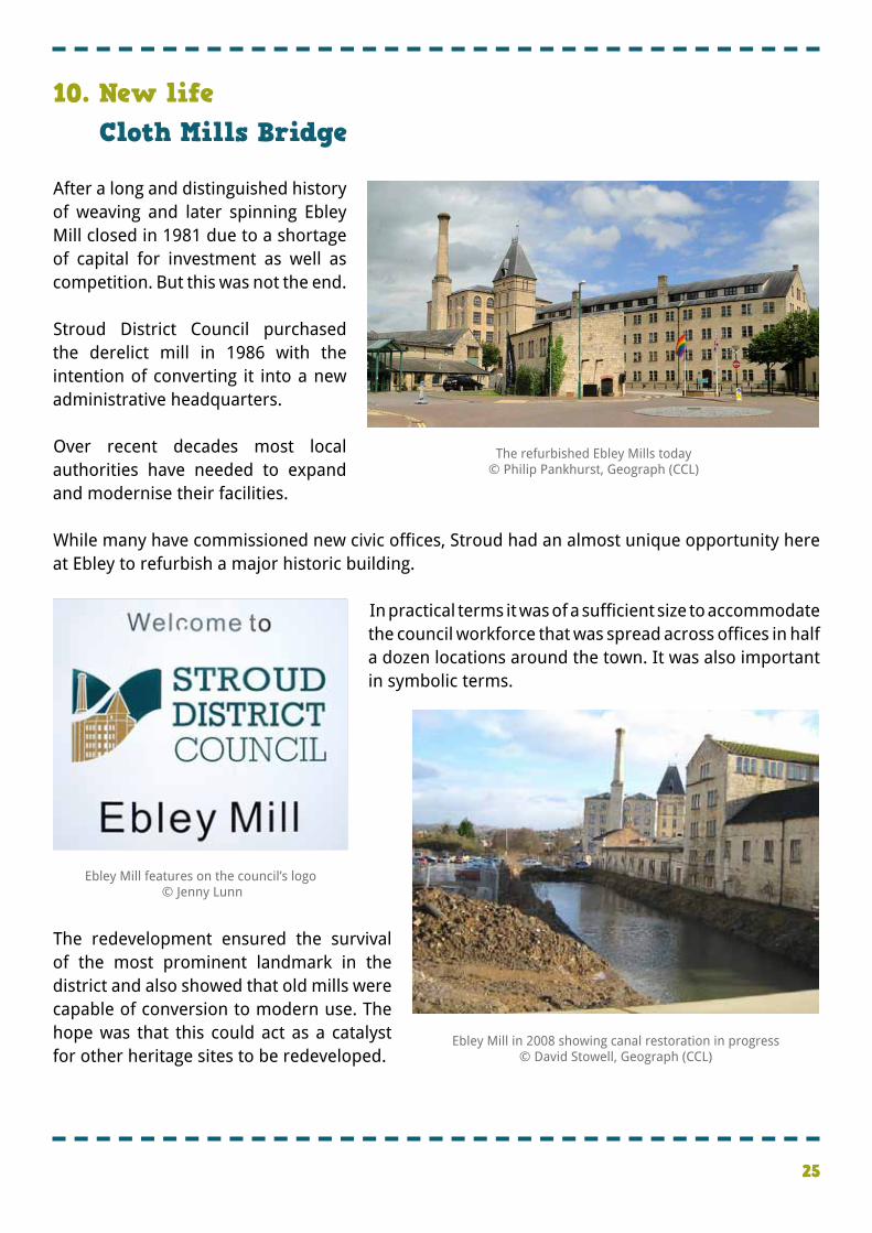
�After a long and distinguished history of weaving and later spinning Ebley Mill closed in 1981 due to a shortage of capital for investment as well as competition. But this was not the end. � �Stroud District Council purchased the derelict mill in 1986 with the intention of converting it into a new administrative headquarters. � �Over recent decades most local authorities have needed to expand and modernise their facilities. � �While many have commissioned new civic offices, Stroud had an almost unique opportunity here at Ebley to refurbish a major historic building.
� �In practical terms it was of a sufficient size to accommodate the council workforce that was spread across offices in half a dozen locations around the town. It was also important in symbolic terms. � � � � � � � � � �
�The redevelopment ensured the survival of the most prominent landmark in the district and also showed that old mills were capable of conversion to modern use. The hope was that this could act as a catalyst for other heritage sites to be redeveloped.
10. New lifeCloth Mills Bridge
Ebley Mill features on the council’s logo © Jenny Lunn
The refurbished Ebley Mills today© Philip Pankhurst, Geograph (CCL)
Ebley Mill in 2008 showing canal restoration in progress© David Stowell, Geograph (CCL)
26
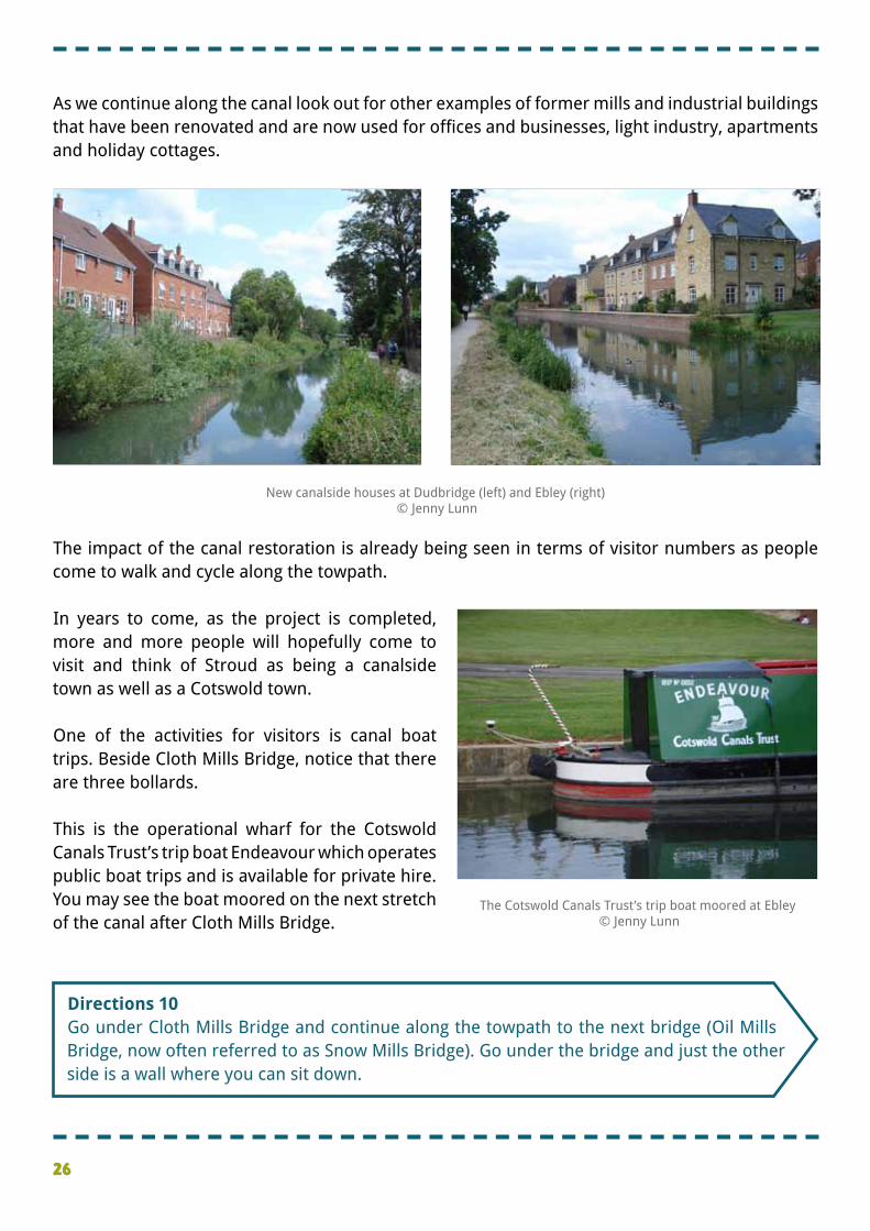
�As we continue along the canal look out for other examples of former mills and industrial buildings that have been renovated and are now used for offices and businesses, light industry, apartments and holiday cottages.
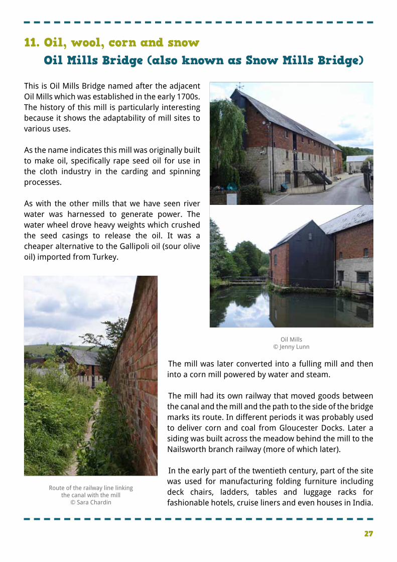
�The impact of the canal restoration is already being seen in terms of visitor numbers as people come to walk and cycle along the towpath. � �In years to come, as the project is completed, more and more people will hopefully come to visit and think of Stroud as being a canalside town as well as a Cotswold town. � �One of the activities for visitors is canal boat trips. Beside Cloth Mills Bridge, notice that there are three bollards. � �This is the operational wharf for the Cotswold Canals Trust’s trip boat Endeavour which operates public boat trips and is available for private hire. You may see the boat moored on the next stretch of the canal after Cloth Mills Bridge.
�Directions 10 �Go under Cloth Mills Bridge and continue along the towpath to the next bridge (Oil Mills Bridge, now often referred to as Snow Mills Bridge). Go under the bridge and just the other side is a wall where you can sit down.
The Cotswold Canals Trust’s trip boat moored at Ebley © Jenny Lunn
New canalside houses at Dudbridge (left) and Ebley (right) © Jenny Lunn
27
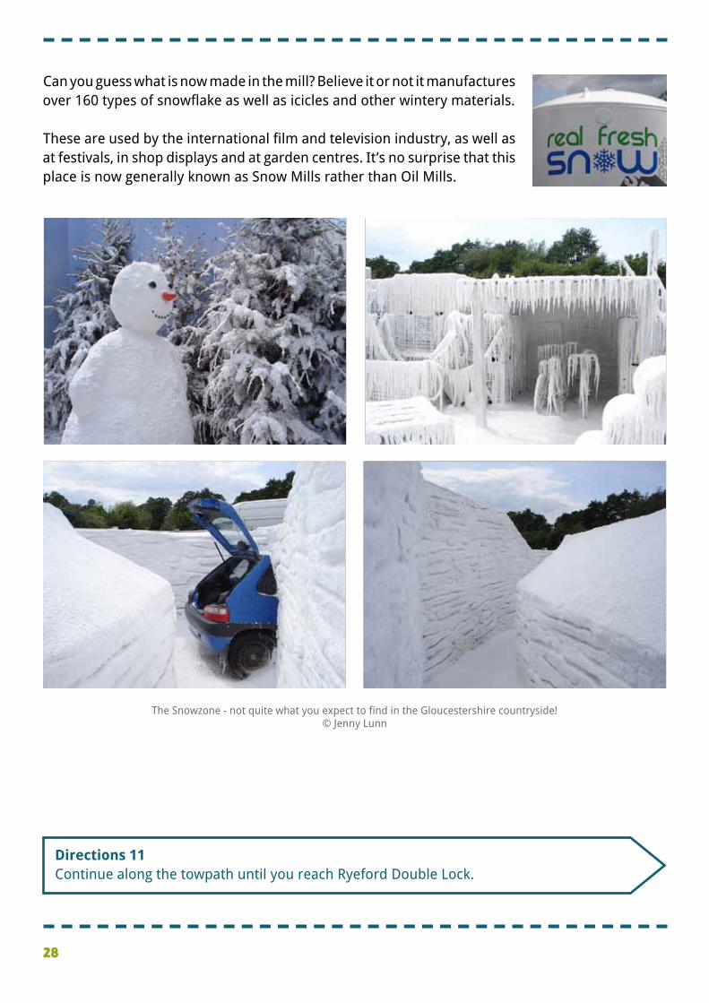
�This is Oil Mills Bridge named after the adjacent Oil Mills which was established in the early 1700s. The history of this mill is particularly interesting because it shows the adaptability of mill sites to various uses. � �As the name indicates this mill was originally built to make oil, specifically rape seed oil for use in the cloth industry in the carding and spinning processes. � �As with the other mills that we have seen river water was harnessed to generate power. The water wheel drove heavy weights which crushed the seed casings to release the oil. It was a cheaper alternative to the Gallipoli oil (sour olive oil) imported from Turkey.
� � � � � � � � � �The mill was later converted into a fulling mill and then into a corn mill powered by water and steam. � �The mill had its own railway that moved goods between the canal and the mill and the path to the side of the bridge marks its route. In different periods it was probably used to deliver corn and coal from Gloucester Docks. Later a siding was built across the meadow behind the mill to the Nailsworth branch railway (more of which later). � � In the early part of the twentieth century, part of the site was used for manufacturing folding furniture including deck chairs, ladders, tables and luggage racks for fashionable hotels, cruise liners and even houses in India.
11. Oil, wool, corn and snowOil Mills Bridge (also known as Snow Mills Bridge)
Route of the railway line linking the canal with the mill
© Sara Chardin
Oil Mills © Jenny Lunn
28
�Can you guess what is now made in the mill? Believe it or not it manufactures over 160 types of snowflake as well as icicles and other wintery materials. � �These are used by the international film and television industry, as well as at festivals, in shop displays and at garden centres. It’s no surprise that this place is now generally known as Snow Mills rather than Oil Mills.
�Directions 11 �Continue along the towpath until you reach Ryeford Double Lock.
The Snowzone - not quite what you expect to find in the Gloucestershire countryside!© Jenny Lunn
29
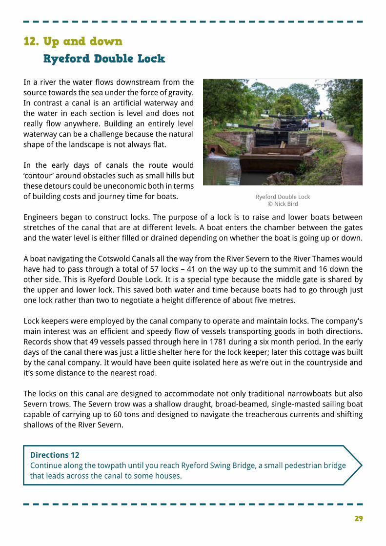
�In a river the water flows downstream from the source towards the sea under the force of gravity. In contrast a canal is an artificial waterway and the water in each section is level and does not really flow anywhere. Building an entirely level waterway can be a challenge because the natural shape of the landscape is not always flat. � �In the early days of canals the route would ‘contour’ around obstacles such as small hills but these detours could be uneconomic both in terms of building costs and journey time for boats. � �Engineers began to construct locks. The purpose of a lock is to raise and lower boats between stretches of the canal that are at different levels. A boat enters the chamber between the gates and the water level is either filled or drained depending on whether the boat is going up or down. � �A boat navigating the Cotswold Canals all the way from the River Severn to the River Thames would have had to pass through a total of 57 locks – 41 on the way up to the summit and 16 down the other side. This is Ryeford Double Lock. It is a special type because the middle gate is shared by the upper and lower lock. This saved both water and time because boats had to go through just one lock rather than two to negotiate a height difference of about five metres. � �Lock keepers were employed by the canal company to operate and maintain locks. The company’s main interest was an efficient and speedy flow of vessels transporting goods in both directions. Records show that 49 vessels passed through here in 1781 during a six month period. In the early days of the canal there was just a little shelter here for the lock keeper; later this cottage was built by the canal company. It would have been quite isolated here as we’re out in the countryside and it’s some distance to the nearest road. � �The locks on this canal are designed to accommodate not only traditional narrowboats but also Severn trows. The Severn trow was a shallow draught, broad-beamed, single-masted sailing boat capable of carrying up to 60 tons and designed to navigate the treacherous currents and shifting shallows of the River Severn.
12. Up and downRyeford Double Lock
Ryeford Double Lock© Nick Bird
�Directions 12 �Continue along the towpath until you reach Ryeford Swing Bridge, a small pedestrian bridge that leads across the canal to some houses.
30
�Directions 13 �Continue along the towpath. Go under the brick arch of Ryeford Bridge and stop immediately the other side where there is a bench that you can take advantage of.
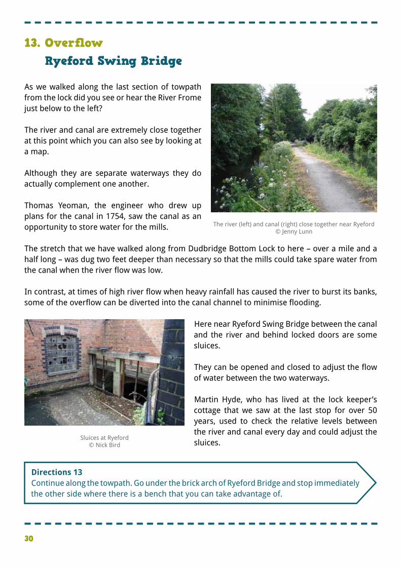
�As we walked along the last section of towpath from the lock did you see or hear the River Frome just below to the left? � �The river and canal are extremely close together at this point which you can also see by looking at a map. � �Although they are separate waterways they do actually complement one another. � �Thomas Yeoman, the engineer who drew up plans for the canal in 1754, saw the canal as an opportunity to store water for the mills. � �The stretch that we have walked along from Dudbridge Bottom Lock to here – over a mile and a half long – was dug two feet deeper than necessary so that the mills could take spare water from the canal when the river flow was low. � �In contrast, at times of high river flow when heavy rainfall has caused the river to burst its banks, some of the overflow can be diverted into the canal channel to minimise flooding.
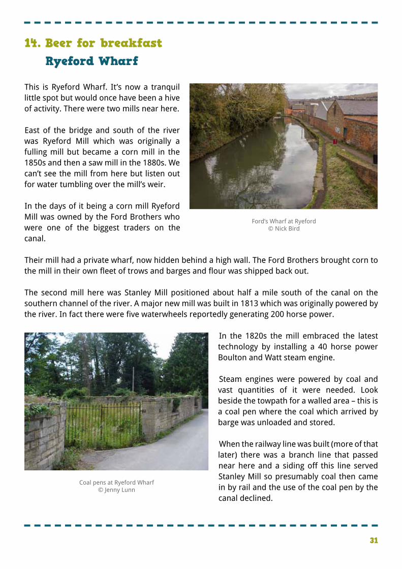
� �Here near Ryeford Swing Bridge between the canal and the river and behind locked doors are some sluices. � �They can be opened and closed to adjust the flow of water between the two waterways. � �Martin Hyde, who has lived at the lock keeper’s cottage that we saw at the last stop for over 50 years, used to check the relative levels between the river and canal every day and could adjust the sluices.
13. OverflowRyeford Swing Bridge
The river (left) and canal (right) close together near Ryeford© Jenny Lunn
Sluices at Ryeford© Nick Bird
31
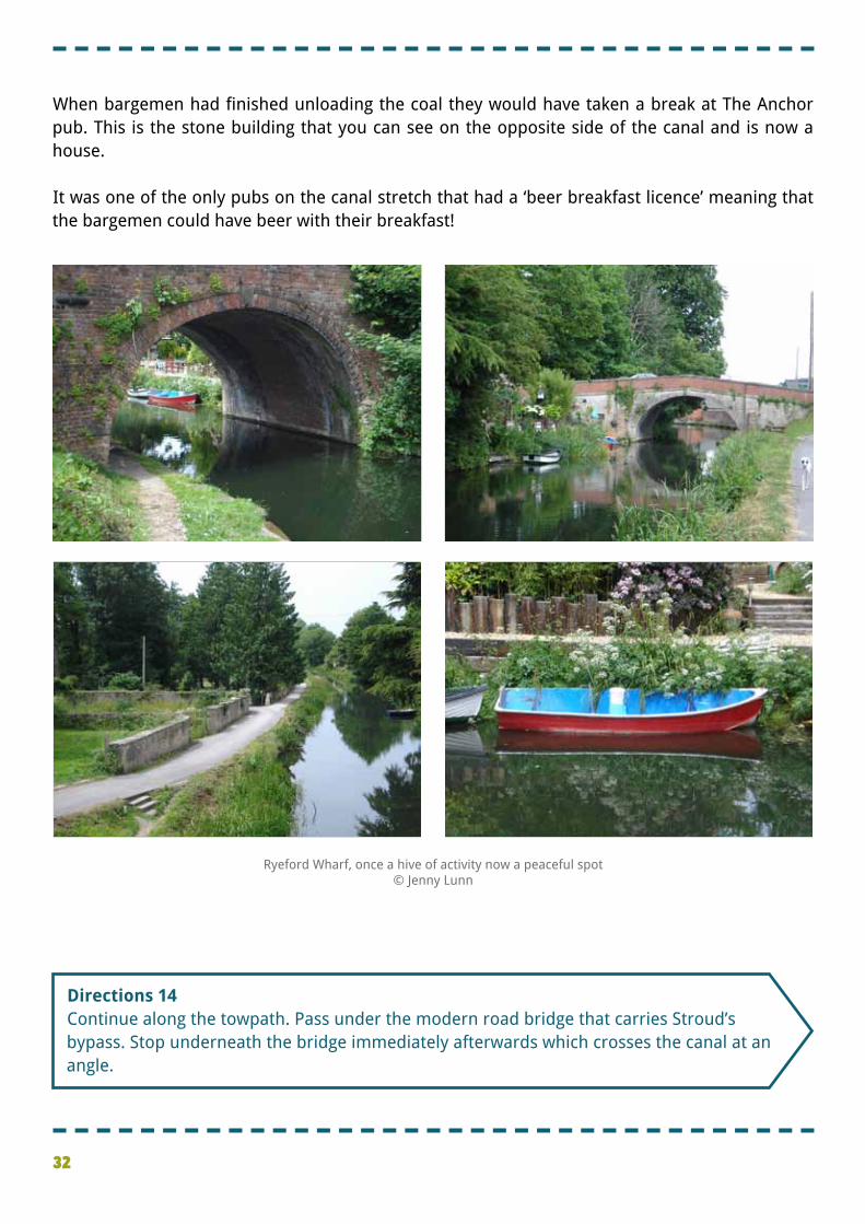
�This is Ryeford Wharf. It’s now a tranquil little spot but would once have been a hive of activity. There were two mills near here. � �East of the bridge and south of the river was Ryeford Mill which was originally a fulling mill but became a corn mill in the 1850s and then a saw mill in the 1880s. We can’t see the mill from here but listen out for water tumbling over the mill’s weir. � �In the days of it being a corn mill Ryeford Mill was owned by the Ford Brothers who were one of the biggest traders on the canal. � �Their mill had a private wharf, now hidden behind a high wall. The Ford Brothers brought corn to the mill in their own fleet of trows and barges and flour was shipped back out. � �The second mill here was Stanley Mill positioned about half a mile south of the canal on the southern channel of the river. A major new mill was built in 1813 which was originally powered by the river. In fact there were five waterwheels reportedly generating 200 horse power.
� � In the 1820s the mill embraced the latest technology by installing a 40 horse power Boulton and Watt steam engine. � �Steam engines were powered by coal and vast quantities of it were needed. Look beside the towpath for a walled area – this is a coal pen where the coal which arrived by barge was unloaded and stored. � �When the railway line was built (more of that later) there was a branch line that passed near here and a siding off this line served Stanley Mill so presumably coal then came in by rail and the use of the coal pen by the canal declined.
Coal pens at Ryeford Wharf© Jenny Lunn
Ford’s Wharf at Ryeford© Nick Bird
14. Beer for breakfastRyeford Wharf
32
�Directions 14 �Continue along the towpath. Pass under the modern road bridge that carries Stroud’s bypass. Stop underneath the bridge immediately afterwards which crosses the canal at an angle.
�When bargemen had finished unloading the coal they would have taken a break at The Anchor pub. This is the stone building that you can see on the opposite side of the canal and is now a house. � �It was one of the only pubs on the canal stretch that had a ‘beer breakfast licence’ meaning that the bargemen could have beer with their breakfast!
Ryeford Wharf, once a hive of activity now a peaceful spot© Jenny Lunn
33
�This bridge is a former railway bridge. As we heard earlier mill owners had been strong proponents of the building of the canals. � �With the development of the railway network the next generation of mill owners was keen to ensure that they benefited from it. � �The railways were a much faster way of transporting heavy goods over long distances. � �Stroud was connected to the railway network in 1845 by the Cheltenham and Great Western Union Railway which linked the Great Western Railway at Swindon with Cheltenham. If you came by train today you would have used this route, known as the Golden Valley Line. � �Meanwhile Samuel Marling, the owner of Ebley Mill and Stanley Mill, together with other mill owners in the Nailsworth Valley wanted their own railway so they lobbied parliament. The 5¾ mile long Stonehouse and Nailsworth Railway that crossed this bridge was completed in 1867. It was a branch line off the Midland Railway. The line’s backers had plans to extend the line southwards and link it to the Great Western Railway but it ran into financial trouble very quickly and the plans came to nothing. � �While the Great Western Railway built by Brunel was designed to carry passengers as fast as possible this branch line was designed as a goods line and there were sidings to each mill along the route. Raw materials (including wool from Germany and fuel such as coal) could be brought in while finished goods could be transported quickly out to markets. � �This branch line closed in 1966 but, as with many other abandoned railway lines in Britain, a new use has been found. It is now a cycle path and part of National Cycle Route 45 which runs all the way from Salisbury to Chester. It’s great to see these former industrial routeways – both canals and railway lines – given a new life and purpose as leisure routeways.
15. A new lease of lifeSkew Bridge
�Directions 15 �Continue along the towpath. Shortly before the next modern bridge stop opposite an old, derelict building made from corrugated iron.
Nailsworth - ‘The Station in the Valley’ (c.1900)© The Museum in the Park, Stroud
34
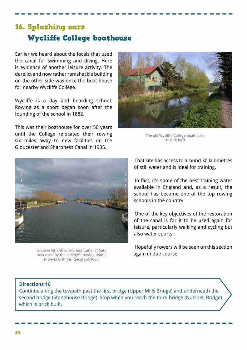
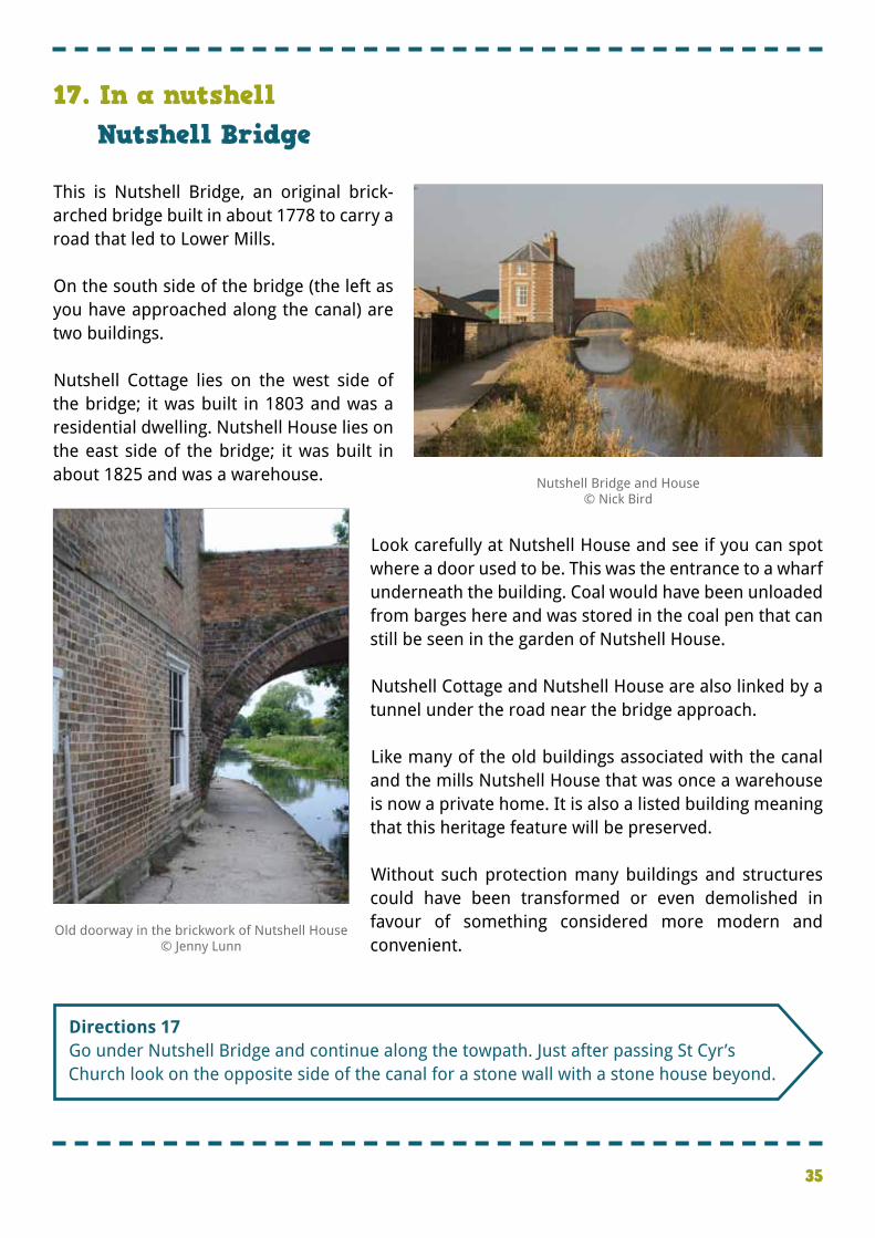
�Earlier we heard about the locals that used the canal for swimming and diving. Here is evidence of another leisure activity. The derelict and now rather ramshackle building on the other side was once the boat house for nearby Wycliffe College. � �Wycliffe is a day and boarding school. Rowing as a sport began soon after the founding of the school in 1882. � �This was their boathouse for over 50 years until the College relocated their rowing six miles away to new facilities on the Gloucester and Sharpness Canal in 1935.
� �That site has access to around 30 kilometres of still water and is ideal for training. � � In fact, it’s some of the best training water available in England and, as a result, the school has become one of the top rowing schools in the country. � �One of the key objectives of the restoration of the canal is for it to be used again for leisure, particularly walking and cycling but also water sports. � �Hopefully rowers will be seen on this section again in due course.
16. Splashing oarsWycliffe College boathouse
The old Wycliffe College boathouse© Nick Bird
�Directions 16 �Continue along the towpath past the first bridge (Upper Mills Bridge) and underneath the second bridge (Stonehouse Bridge). Stop when you reach the third bridge (Nutshell Bridge) which is brick built.
Gloucester and Sharpness Canal at Saul now used by the college’s rowing teams
© David Griffiths, Geograph (CCL)
35
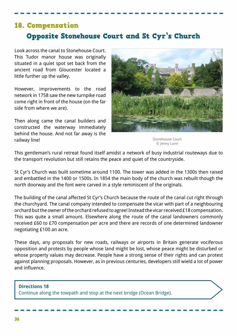
�This is Nutshell Bridge, an original brick-arched bridge built in about 1778 to carry a road that led to Lower Mills. � �On the south side of the bridge (the left as you have approached along the canal) are two buildings. � �Nutshell Cottage lies on the west side of the bridge; it was built in 1803 and was a residential dwelling. Nutshell House lies on the east side of the bridge; it was built in about 1825 and was a warehouse.
�
�Look carefully at Nutshell House and see if you can spot where a door used to be. This was the entrance to a wharf underneath the building. Coal would have been unloaded from barges here and was stored in the coal pen that can still be seen in the garden of Nutshell House. � �Nutshell Cottage and Nutshell House are also linked by a tunnel under the road near the bridge approach. � �Like many of the old buildings associated with the canal and the mills Nutshell House that was once a warehouse is now a private home. It is also a listed building meaning that this heritage feature will be preserved. � �Without such protection many buildings and structures could have been transformed or even demolished in favour of something considered more modern and convenient.
17. In a nutshellNutshell Bridge
Nutshell Bridge and House© Nick Bird
Old doorway in the brickwork of Nutshell House© Jenny Lunn
�Directions 17 �Go under Nutshell Bridge and continue along the towpath. Just after passing St Cyr’s Church look on the opposite side of the canal for a stone wall with a stone house beyond.
36
�Look across the canal to Stonehouse Court. This Tudor manor house was originally situated in a quiet spot set back from the ancient road from Gloucester located a little further up the valley. � �However, improvements to the road network in 1758 saw the new turnpike road come right in front of the house (on the far side from where we are). � �Then along came the canal builders and constructed the waterway immediately behind the house. And not far away is the railway line! � �This gentleman’s rural retreat found itself amidst a network of busy industrial routeways due to the transport revolution but still retains the peace and quiet of the countryside. � �St Cyr’s Church was built sometime around 1100. The tower was added in the 1300s then raised and embattled in the 1400 or 1500s. In 1854 the main body of the church was rebuilt though the north doorway and the font were carved in a style reminiscent of the originals. � �The building of the canal affected St Cyr’s Church because the route of the canal cut right through the churchyard. The canal company intended to compensate the vicar with part of a neighbouring orchard but the owner of the orchard refused to agree! Instead the vicar received £18 compensation. �This was quite a small amount. Elsewhere along the route of the canal landowners commonly received £60 to £70 compensation per acre and there are records of one determined landowner negotiating £100 an acre. � �These days, any proposals for new roads, railways or airports in Britain generate vociferous opposition and protests by people whose land might be lost, whose peace might be disturbed or whose property values may decrease. People have a strong sense of their rights and can protest against planning proposals. However, as in previous centuries, developers still wield a lot of power and influence.
18. CompensationOpposite Stonehouse Court and St Cyr’s Church
Stonehouse Court© Jenny Lunn
�Directions 18 �Continue along the towpath and stop at the next bridge (Ocean Bridge).
37
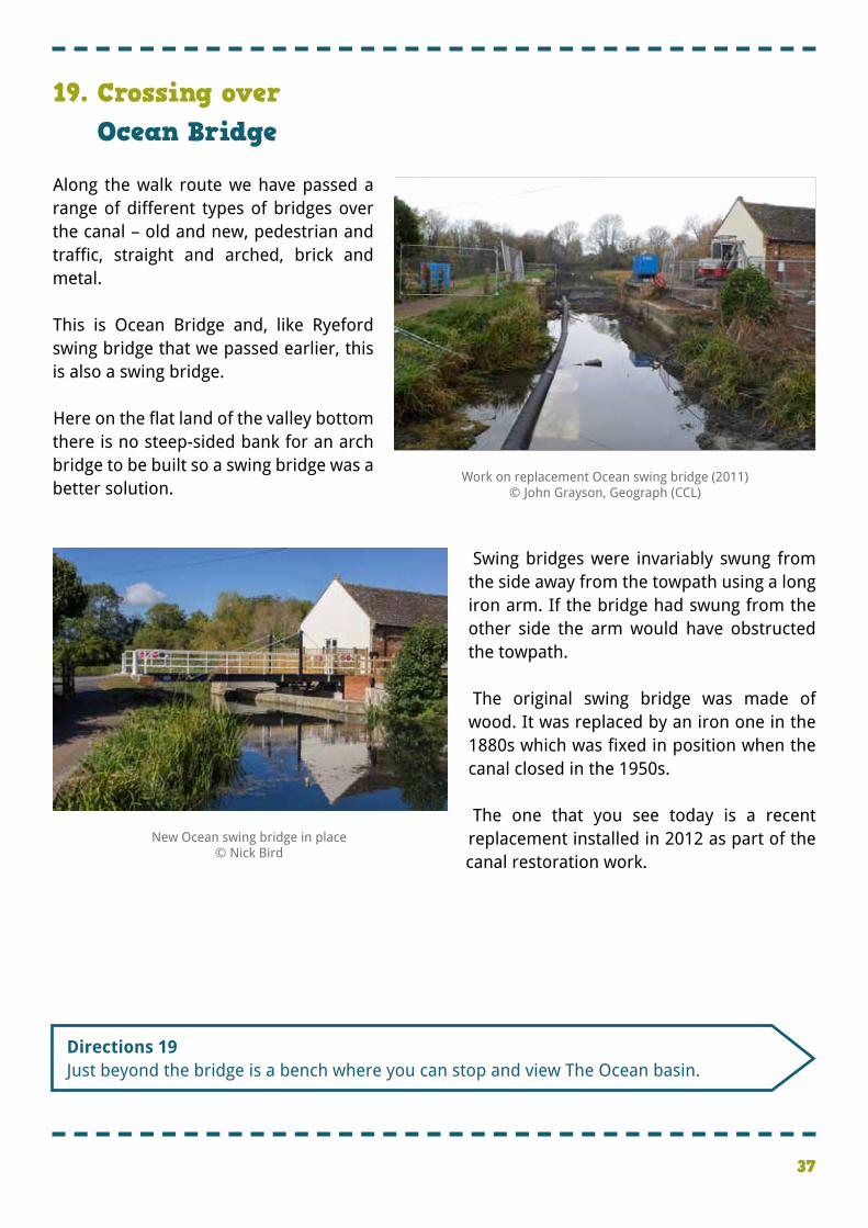
�Along the walk route we have passed a range of different types of bridges over the canal – old and new, pedestrian and traffic, straight and arched, brick and metal. � �This is Ocean Bridge and, like Ryeford swing bridge that we passed earlier, this is also a swing bridge. � �Here on the flat land of the valley bottom there is no steep-sided bank for an arch bridge to be built so a swing bridge was a better solution. �
� Swing bridges were invariably swung from the side away from the towpath using a long iron arm. If the bridge had swung from the other side the arm would have obstructed the towpath. � � The original swing bridge was made of wood. It was replaced by an iron one in the 1880s which was fixed in position when the canal closed in the 1950s. � � The one that you see today is a recent replacement installed in 2012 as part of the canal restoration work.
19. Crossing overOcean Bridge
Work on replacement Ocean swing bridge (2011) © John Grayson, Geograph (CCL)
�Directions 19 �Just beyond the bridge is a bench where you can stop and view The Ocean basin.
New Ocean swing bridge in place © Nick Bird
38
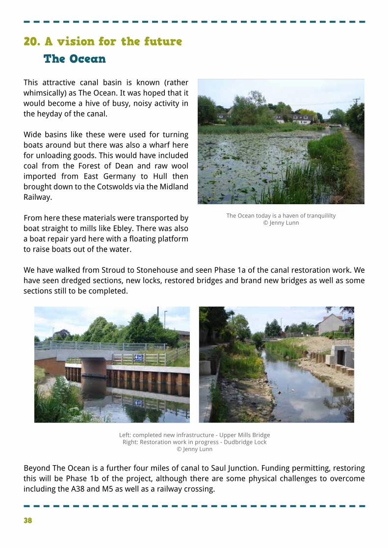
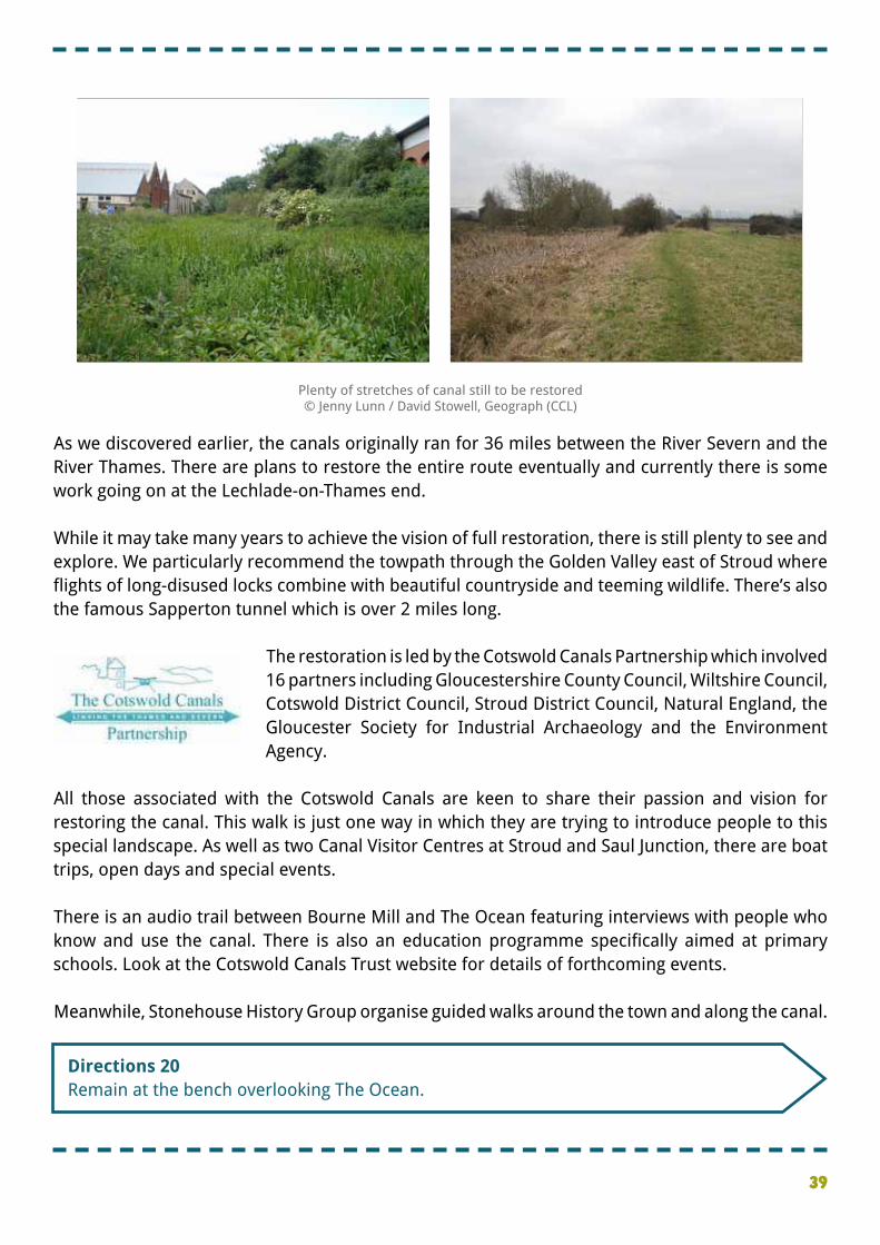
�This attractive canal basin is known (rather whimsically) as The Ocean. It was hoped that it would become a hive of busy, noisy activity in the heyday of the canal. � �Wide basins like these were used for turning boats around but there was also a wharf here for unloading goods. This would have included coal from the Forest of Dean and raw wool imported from East Germany to Hull then brought down to the Cotswolds via the Midland Railway. � �From here these materials were transported by boat straight to mills like Ebley. There was also a boat repair yard here with a floating platform to raise boats out of the water. � �We have walked from Stroud to Stonehouse and seen Phase 1a of the canal restoration work. We have seen dredged sections, new locks, restored bridges and brand new bridges as well as some sections still to be completed. �
�Beyond The Ocean is a further four miles of canal to Saul Junction. Funding permitting, restoring this will be Phase 1b of the project, although there are some physical challenges to overcome including the A38 and M5 as well as a railway crossing.
20. A vision for the futureThe Ocean
The Ocean today is a haven of tranquililty© Jenny Lunn
Left: completed new infrastructure - Upper Mills BridgeRight: Restoration work in progress - Dudbridge Lock
© Jenny Lunn
39
�Directions 20 �Remain at the bench overlooking The Ocean.
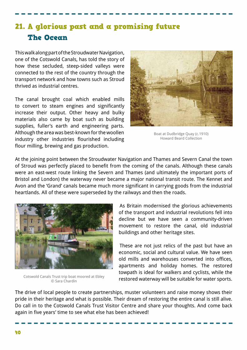
�As we discovered earlier, the canals originally ran for 36 miles between the River Severn and the River Thames. There are plans to restore the entire route eventually and currently there is some work going on at the Lechlade-on-Thames end. � �While it may take many years to achieve the vision of full restoration, there is still plenty to see and explore. We particularly recommend the towpath through the Golden Valley east of Stroud where flights of long-disused locks combine with beautiful countryside and teeming wildlife. There’s also the famous Sapperton tunnel which is over 2 miles long.
� �The restoration is led by the Cotswold Canals Partnership which involved 16 partners including Gloucestershire County Council, Wiltshire Council, Cotswold District Council, Stroud District Council, Natural England, the Gloucester Society for Industrial Archaeology and the Environment Agency. �
�All those associated with the Cotswold Canals are keen to share their passion and vision for restoring the canal. This walk is just one way in which they are trying to introduce people to this special landscape. As well as two Canal Visitor Centres at Stroud and Saul Junction, there are boat trips, open days and special events. � �There is an audio trail between Bourne Mill and The Ocean featuring interviews with people who know and use the canal. There is also an education programme specifically aimed at primary schools. Look at the Cotswold Canals Trust website for details of forthcoming events. � �Meanwhile, Stonehouse History Group organise guided walks around the town and along the canal.
Plenty of stretches of canal still to be restored © Jenny Lunn / David Stowell, Geograph (CCL)
40
�This walk along part of the Stroudwater Navigation, one of the Cotswold Canals, has told the story of how these secluded, steep-sided valleys were connected to the rest of the country through the transport network and how towns such as Stroud thrived as industrial centres. � �The canal brought coal which enabled mills to convert to steam engines and significantly increase their output. Other heavy and bulky materials also came by boat such as building supplies, fuller’s earth and engineering parts. Although the area was best-known for the woollen industry other industries flourished including flour milling, brewing and gas production. � �At the joining point between the Stroudwater Navigation and Thames and Severn Canal the town of Stroud was perfectly placed to benefit from the coming of the canals. Although these canals were an east-west route linking the Severn and Thames (and ultimately the important ports of Bristol and London) the waterway never became a major national transit route. The Kennet and Avon and the ‘Grand’ canals became much more significant in carrying goods from the industrial heartlands. All of these were superseded by the railways and then the roads.
� � As Britain modernised the glorious achievements of the transport and industrial revolutions fell into decline but we have seen a community-driven movement to restore the canal, old industrial buildings and other heritage sites. � � These are not just relics of the past but have an economic, social and cultural value. We have seen old mills and warehouses converted into offices, apartments and holiday homes. The restored towpath is ideal for walkers and cyclists, while the restored waterway will be suitable for water sports. �
�The drive of local people to create partnerships, muster volunteers and raise money shows their pride in their heritage and what is possible. Their dream of restoring the entire canal is still alive. Do call in to the Cotswold Canals Trust Visitor Centre and share your thoughts. And come back again in five years’ time to see what else has been achieved!
21. A glorious past and a promising futureThe Ocean
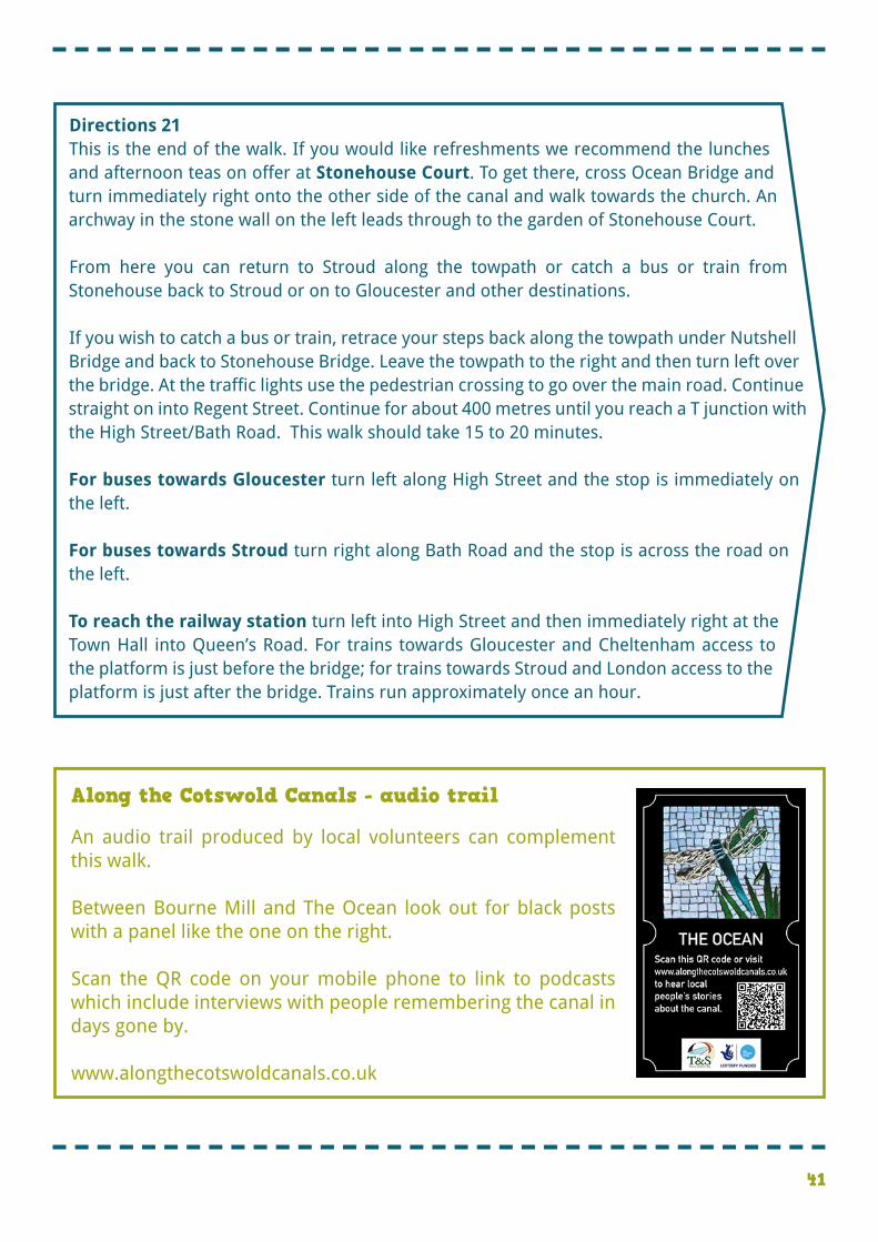
Boat at Dudbridge Quay (c.1910)Howard Beard Collection
Cotswold Canals Trust trip boat moored at Ebley© Sara Chardin
41
�Along the Cotswold Canals - audio trail
�An audio trail produced by local volunteers can complement this walk. � �Between Bourne Mill and The Ocean look out for black posts with a panel like the one on the right. � �Scan the QR code on your mobile phone to link to podcasts which include interviews with people remembering the canal in days gone by. � �www.alongthecotswoldcanals.co.uk
�Directions 21 �This is the end of the walk. If you would like refreshments we recommend the lunches and afternoon teas on offer at Stonehouse Court. To get there, cross Ocean Bridge and turn immediately right onto the other side of the canal and walk towards the church. An archway in the stone wall on the left leads through to the garden of Stonehouse Court. � �From here you can return to Stroud along the towpath or catch a bus or train from Stonehouse back to Stroud or on to Gloucester and other destinations. � �If you wish to catch a bus or train, retrace your steps back along the towpath under Nutshell Bridge and back to Stonehouse Bridge. Leave the towpath to the right and then turn left over the bridge. At the traffic lights use the pedestrian crossing to go over the main road. Continue straight on into Regent Street. Continue for about 400 metres until you reach a T junction with the High Street/Bath Road. This walk should take 15 to 20 minutes. �For buses towards Gloucester turn left along High Street and the stop is immediately on the left.
For buses towards Stroud turn right along Bath Road and the stop is across the road on the left.
To reach the railway station turn left into High Street and then immediately right at the Town Hall into Queen’s Road. For trains towards Gloucester and Cheltenham access to the platform is just before the bridge; for trains towards Stroud and London access to the platform is just after the bridge. Trains run approximately once an hour.
42
The RGS-IBG would like to thank the following people and organisations for their assistance in producing this Discovering Britain walk:
Sara Chardin, Regeneration Officer (Tourism), Stroud District Council for first proposing this collaborative walk, coordinating all parties and taking part in the audio recording
Clive Field, Manager of Canal Visitor Centres, Cotswold Canals Trust for always providing a warm and enthusiastic welcome, as well as taking part in the audio recording
Jill Field, Saul Canal Visitor Centre Manager, Cotswold Canals Trust for being a good walking companion and taking part in the audio recording
Ian MacKintosh, Trustee, Stroudwater Textile Trust for valued contributions to the text on the woollen industry, taking part in the audio recording and researching archive images
David Marshall, Canal Partnership Manager, Stroud District Council for taking part in the audio recording
Jenny Lunn for editing the walk resources, acting as narrator and providing photographs
Caroline Millar for editing the audio files
The Museum in the Park, Stroud for kind permission to reproduce archive images
Nick Bird for allowing us to use his contemporary photographs of the canal
Howard Beard for permission to use archive images from his collection
Neville Nelder for sharing his picture of swimmers at Wallbridge
The Junction Heritage Project for permission to reproduce documents from the Canal Company records
Stroud Community Land Trust for permission to reproduce an image of The Lawn
English Heritage for permission to use images from the Britain from Above collection
John Grayson, David Griffiths, Brian Robert Marshall, Philip Pankhurst, David Stowell, Rabbi WP Thinrod, Escuela Virtual de Deportes and SFC9394 for additional images
Credits
43
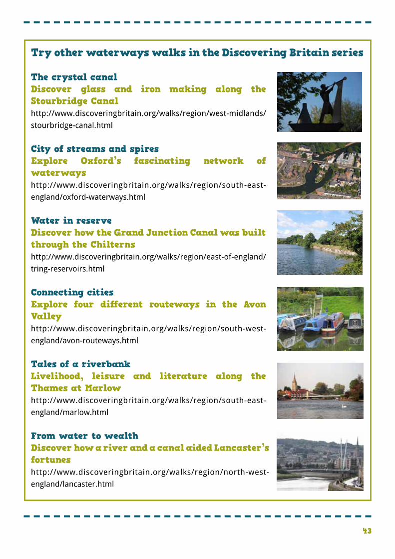
�Try other waterways walks in the Discovering Britain series
The crystal canal Discover glass and iron making along the Stourbridge Canalhttp://www.discoveringbritain.org/walks/region/west-midlands/
stourbridge-canal.html
City of streams and spiresExplore Oxford’s fascinating network of waterwayshttp://www.discoveringbritain.org/walks/region/south-east-
england/oxford-waterways.html
Water in reserveDiscover how the Grand Junction Canal was built through the Chilternshttp://www.discoveringbritain.org/walks/region/east-of-england/
tring-reservoirs.html
Connecting cities Explore four different routeways in the Avon Valley http://www.discoveringbritain.org/walks/region/south-west-
england/avon-routeways.html
Tales of a riverbankLivelihood, leisure and literature along the Thames at Marlowhttp://www.discoveringbritain.org/walks/region/south-east-
england/marlow.html
From water to wealthDiscover how a river and a canal aided Lancaster’s fortunes http://www.discoveringbritain.org/walks/region/north-west-
england/lancaster.html

Britain’s landscapes are wonderful. There is a tremendous variety within our shores – whether in the
countryside, in towns and cities or at the seaside. And every landscape has a story to tell about our past and present.
Discovering Britain is an exciting series of geographically-themed walks that aim to bring these stories alive and inspire everyone to
explore and learn more about Britain. Each walk looks at a particular landscape, finding out about how forces of nature, people, events
and the economy have created what you see today.
The self-guided walks are fun, informative and inspiring. Prepare to discover something new, to be surprised and to find the unexpected.
Visit www.discoveringbritain.org to Send your review of this walk
Search for other walksSuggest a new walk