Embed Size (px)
Citation preview

U.S. Department of the InteriorU.S. Geological Survey
Data Series 599
Prepared in cooperation with the Department of Energy, National Energy Technology Laboratory
Coal Database for Cook Inlet and North Slope, Alaska


Coal Database for Cook Inlet and North Slope, Alaska
By Gary D. Stricker, Brianne D. Spear, Jennifer M. Sprowl, John D. Dietrich, Michael I. McCauley, and Scott A. Kinney
Prepared in cooperation with the Department of Energy, National Energy Technology Laboratory
Data Series 599
U.S. Department of the InteriorU.S. Geological Survey

U.S. Department of the InteriorKEN SALAZAR, Secretary
U.S. Geological SurveyMarcia K. McNutt, Director
U.S. Geological Survey, Reston, Virginia: 2011
For more information on the USGS—the Federal source for science about the Earth, its natural and living resources, natural hazards, and the environment, visit http://www.usgs.gov or call 1-888-ASK-USGS
For an overview of USGS information products, including maps, imagery, and publications, visit http://www.usgs.gov/pubprod
To order this and other USGS information products, visit http://store.usgs.gov
Any use of trade, product, or firm names is for descriptive purposes only and does not imply endorsement by the U.S. Government.
Although this report is in the public domain, permission must be secured from the individual copyright owners to reproduce any copyrighted materials contained within this report.
Suggested citation: Stricker, G.D., Spear, B.D., Sprowl, J.M., Dietrich, J.D., McCauley, M.I., and Kinney, S.A., 2011, Coal database for Cook Inlet and North Slope, Alaska: U.S. Geological Survey Digital Data Series 599, 11 p.

iii
Acknowledgments Thanks are extended to Michael Brownfield (U.S. Geological Survey, Denver, Colo.);
Timothy Grant (National Energy Technology Laboratory, Department of Energy, Pittsburgh, Penn.); and William Keefer, Margaret Ellis, and Christopher Potter (U.S. Geological Survey, Denver, Colo.) for meticulous editorial reviews of the manuscript and accompanying GIS-based dataset. The Department of Energy, National Energy Technology Laboratory (Interagency Agreement DE FE0000086), Pittsburgh, Penn., funded the collection, creation, and management of the GIS dataset for is study.
We extend special thanks for the contributions of Wayne Musteen and Kyle Trainor that were necessary for the completion of this work. Also Gregory Gunther and Christopher Skinner for help with the online product.

iv
Contents
Abstract ...........................................................................................................................................................1Introduction.....................................................................................................................................................1General Geology of Alaska ...........................................................................................................................4North Slope Coal Province ...........................................................................................................................4Cook Inlet Coal Province...............................................................................................................................4Sources of Data..............................................................................................................................................9Description of Data Tables ...........................................................................................................................9References Cited............................................................................................................................................9
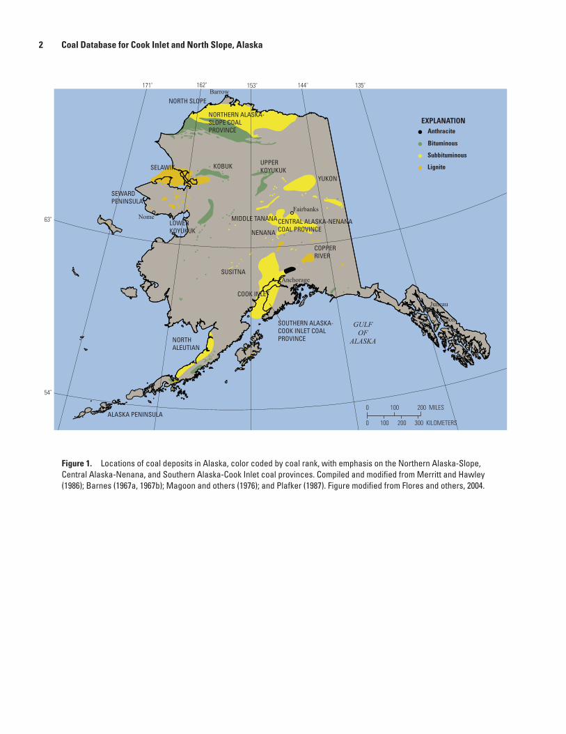
Figures 1. Map showing locations of coal deposits in Alaska, color coded by coal
rank, with emphasis on the Northern Alaska-Slope, Central Alaska-Nenana, and Southern Alaska-Cook Inlet coal provinces .......................................2
2. Map showing the North Slope province, coal data points, and location of chronostratigraphic column on figure 3. ..............................................................5
3. Chronostratigraphic column for the Colville Basin, northern Alaska ..................................6 4. Map showing Cook Inlet province and coal data points. .....................................................7 5. Generalized time-transgressive stratigraphy in the Tertiary Cook Inlet province .............8
Table 1. Coal resource estimates for Alaska using the classification system
of Wood and others (1983)...........................................................................................................3
v
Conversion Factors
Inch/Pound to SI
Multiply By To obtain
Lengthinch 2.54 centimeter (cm)foot (ft) 0.3048 meter (m)mile (mi) 1.609 kilometer (km)
Areasquare mile (mi2) 2.590 square kilometer (km2)
Masston, short (2,000 lb) 0.9072 metric ton
Horizontal coordinate information is referenced to North American Datum of 1927 (NAD 27).
Elevation, as used in this report, refers to distance above the vertical datum. Vertical coordinate information is referenced to mean sea level.


Abstract This database is a compilation of published and noncon-
fidential unpublished coal data from Alaska. Although coal occurs in isolated areas throughout Alaska, this study includes data only from the Cook Inlet and North Slope areas. The data include entries from and interpretations of oil and gas well logs, coal-core geophysical logs (such as density, gamma, and resistivity), seismic shot hole lithology descriptions, measured coal sections, and isolated coal outcrops.
Introduction Coal occurs in isolated areas throughout Alaska (fig. 1).
This report presents updated coal databases for the (1) Tertiary Kenai Group in the Southern Alaska-Cook Inlet province, referred to as Cook Inlet, and for the (2) Cretaceous Nanushuk and Cretaceous and Tertiary Prince Creek Formations and Tertiary Sagavanirktok Formation in the Northern Alaska-Slope coal province, referred to as North Slope. The purpose of the report is to provide dissemination and accessibility of the compiled coal data for the aforementioned coal-bearing areas in Alaska to U.S. Geological Survey customers and to the Department of Energy, National Energy Technology Laboratory, Pittsburgh, Penn., which funded this study through Interagency Agreement DE FE0000086.
This report does not focus on the classification of the coal resources or on the volume of coal that is estimated for Alaska. Table 1 shows previously published coal resource estimates for Alaska coal using the coal classification system of Wood and others (1983). These estimates are from work by Hopkins (1951), Wahrhaftig and Hickcox (1955), Barnes and Cobb (1959), Barnes (1967a), Renshaw (1983), McGee and Emmel (1986), Merritt and Belowich (1984), Merritt and Hawley (1986), Affolter and Stricker (1987), Sable and Stricker (1987), Stricker (1991), and Wahrhaftig and others (1994). These investigators applied a variety of resource categories. The classification categories for reporting coal resources as defined by Wood and others (1983) are based on degree of geologic assurance as measured by nearness to points of con-trol and the relative quality and quantity of geologic data. The categories are (1) measured, (2) indicated, (3) inferred, and (4)
hypothetical. The sum of the measured and indicated resources is termed “demonstrated resource.” The sum of the measured, indicated, and inferred is termed “identified resource.” The level of certainty for the existence of a quantity of resource is also based mainly on correlations of coal beds and enclosed rocks in relation to the thickness, overburden, rank, quality, and areal extent of the coal. 1. Measured coal resources have the highest degree of
geologic assurance. Resource estimates are based partly on measurements from outcrops, trenches, drill holes, and mine workings. The area of measured coal resources is within 0.25-mi (0.4-km) radius of a point of thickness measurement.
2. Indicated coal resources have a moderate degree of geo-logic assurance. The area of indicated coal resources is between 0.25- and 0.75-mi (0.4- and 1.2-km) radii from a point of thickness measurement.
3. Inferred coal resources have a low degree of geologic assurance. The area of inferred coal resources is between 0.75- and 3-mi (1.2- and 4.8-km) radii from a point of thickness measurement. Estimates of coal thickness, extent, and quantity are based on inferred continuity, beyond measured and indicated resources, for which there is geologic evidence.
4. Hypothetical or undiscovered coal resources have the lowest degree of geologic assurance of these categories. Estimates of coal thickness, extent, and quantity are based on measurements and continuity of coal beyond parameters used in the inferred resources. The area of hypothetical coal resources is beyond a 3-mi (4.8-km) radius from a point of thickness measurement. Total iden-tified resources shown in table 1 are 120,000 million short tons (109,000 million metric tons) for the North Slope and 2,900 to 12,000 million short tons (2,600 to 10,900 million metric tons) for the Cook Inlet; hypothetical resources for the same areas are 3,900,000 and 970,000 to 1,600,000 million short tons, respectively (3,500,000 and 880,000 to 1,450,000 million metric tons, respectively). Approximately 3 percent of the total coal resource for the North Slope is in the identified category and 0.30 to 0.75 percent of the total coal resource for the Cook Inlet is in the hypothetical category.
Coal Database for Cook Inlet and North Slope, Alaska
By Gary D. Stricker, Brianne D. Spear, Jennifer M. Sprowl, John D. Dietrich, Michael I. McCauley, and Scott A. Kinney
2 Coal Database for Cook Inlet and North Slope, Alaska
Figure 1. Locations of coal deposits in Alaska, color coded by coal rank, with emphasis on the Northern Alaska-Slope, Central Alaska-Nenana, and Southern Alaska-Cook Inlet coal provinces. Compiled and modified from Merritt and Hawley (1986); Barnes (1967a, 1967b); Magoon and others (1976); and Plafker (1987). Figure modified from Flores and others, 2004.
NORTH SLOPEBarrow
Fairbanks
Anchorage
Nome
GULFOF
ALASKA
Juneau
Angoon
54˚
63˚
0
0
EXPLANATIONAnthracite
Bituminous
Subbituminous
Lignite
SOUTHERN ALASKA-COOK INLET COALPROVINCE
ALASKA PENINSULA
NORTHALEUTIAN
COOK INLET
SUSITNA
COPPERRIVER
NENANA
YUKON
135˚144˚
UPPERKOYUKUK
KOBUKSELAWIK
SEWARDPENINSULA
LOWERKOYUKUK
MIDDLE TANANACENTRAL ALASKA-NENANACOAL PROVINCE
153˚162˚171˚
NORTHERN ALASKA-SLOPE COALPROVINCE
100
100
200 MILES
200 300 KILOMETERS

Introduction 3
Table 1. Coal resource estimates for Alaska using the classification system of Wood and others (1983). From Flores and others (2004). [Resource estimates are in millions of short tons (multiply by 0.9072 to convert to metric tons)]
Coal province and coalfield, or age
Total for Northern Alaska-Slope
Total for Central Alaska-Nenana
Total for Southern Alaska-Cook Inlet
Total coal resources for Provinces
Source of estimates: (a) Stricker (1991); (b) Merritt and Hawley (1986); (c) Barnes (1967a);(d) Affolter and Stricker (1987); (e) McGee and Emmel (1986); (f) Hopkins (1951); (g) Merritt andBelowich (1984); (h) Barnes and Cobb (1959); (i) Renshaw (1983); and (j) Barnes (1967b).
Northern Alaska-Slope(North Slope)
Central Alaska-Nenana
Southern Alaska-Cook Inlet
(Cook Inlet)
Resource Classifications
Identified
Cretaceous
Tertiary
Healy Creek
Matanuska
Susitna-Belugaa
Broad Pass
Kenai (on shore)
Kenai (off shore)
Lignite Creek
Jarvis Creek
Wood River
Wood River
Rex Creek
Rex Creek
Tatlanika Creek
Tatlanika Creek
670,000a
3,200,000a120,000j
1,000b–1,360c 2,000b
7,000b4,100c–4,900b
2,400c–11,100b 34,800b
13e–77c
0.3f–64c 13f–500b
175b
275b
70b 130b
350b
290b
2,400i
6,400–7,700 10,000
400b
15c
9.5c 113c
117c
137c–200g
318c–400h 34,000e–35,000b
900,000d–1,500,000b
2,900–12,000 970,000–1,600,000
129,000–140,000 4,900,000–5,500,000
153c
45c 241c
120,000 3,900,000
InferredMeasured Indicated
HypotheticalDemonstrated
Undiscovered

4 Coal Database for Cook Inlet and North Slope, Alaska
General Geology of Alaska For a summary of the geology of Alaska, the reader is
directed to the geologic map of Alaska by Beikman (1980), reports by Plafker and Berg (1994) and by Flores and others (2004), and to publications included on the reference lists in those publications.
North Slope Coal Province The North Slope coal province (fig. 2) is the largest
coal province in Alaska at approximately 32,000 mi2 (82,880 km2). This province also has the largest resource estimate of 3.9 trillion short tons (3.5 trillion metric tons) hypothetical (Stricker, 1991) and 120 billion short tons (109 billion metric tons) identified (Barnes, 1967a) in Cretaceous and Tertiary rocks. Known coal deposits in the North Slope coal prov-ince are from the Mississippian Kekiktuk Formation of the Endicott Group (Tailleur, 1965), the Cretaceous Nanushuk Formation, the Cretaceous and Tertiary Prince Creek Forma-tion, and the Tertiary Sagavanirktok Formation (Mull and others, 2003) (fig. 3). Coal beds of the Kekiktuk Formation crop out at Cape Lisburne at the western edge of the North Slope (Tailleur, 1965; Barnes, 1967b; Conwell and Triplehorn, 1976) and as thin beds in the eastern Brooks Range (Sable, written commun., 1969 and referenced in Sable and Stricker, 1987, p. 208) and have not been assessed. These coals were also penetrated in several deep test wells that range in depth from 7,190 to 19,900 ft (2,190 to 6,070 m), in the National Petroleum Reserve in Alaska (NPRA) (Sable and Stricker, 1987). Outcrops of this coal are sparse and there are neither measured sections nor locality data for the coal occurrences. Also, because the coal is at depths greater than 7,190 ft (2,190 m; Sable and Stricker, 1987), which is deeper than the 6,000-ft (1,830 m) overburden cutoff depth of Wood and others (1983, p. 9), data from the Mississippian Kekiktuk Formation are not included in this report.
The Albian to Cenomanian Nanushuk Formation and the Campanian to Paleocene Prince Creek Formation, revised by Mull and others (2003), consist of sedimentary units shed east-ward and northeastward from ancient highlands in the present Chukchi Basin and Brooks Range into the deep Colville Basin that lies between the Brooks Range and the Barrow arch. Peat deposits accumulated in coastal plains formed on river-dominated deltas (Ahlbrandt and others, 1979; Roehler and Stricker, 1979; Huffman and others, 1985). The coal-bearing Nanushuk Formation is as thick as 5,000 ft (1,500 m) in the western part of the North Slope province and thins to zero eastward. The contact between the Cretaceous and Tertiary rocks in the North Slope coal province is gradational (Mole-naar, 1983; Molenaar and others, 1984) and difficult to define.
The Tertiary Sagavanirktok Formation represents the final filling of the Colville Basin in the eastern part of the North Slope coal province. Molenaar and others (1987) reported that
the Sagavanirktok Formation is as thick as 7,500 ft (2,300 m). Roberts and others (1992) reported two coal zones in the Sagavanirktok Formation: a lower zone as much as 850 ft (260 m) thick with 12 coal beds and an upper zone as much as 360 ft (119 m) thick with 7 coal beds. The two coal zones are sepa-rated by as much as 295 ft (90 m) of interbedded sandstone and mudstone.
Cook Inlet Coal Province The Cook Inlet coal province, the second largest coal
province in Alaska, includes an area of approximately 22,200 mi2 (57,500 km2), about half of which lies beneath the waters of Cook Inlet (fig. 4). Most of the Tertiary coal-bearing rocks in the province are the Kenai Group (Calderwood and Fack-ler, 1972). The Kenai Group consists of the following time-transgressive units—from oldest to youngest—the Hemlock Conglomerate and Tyonek, Beluga, and Sterling Formations (fig. 5). This thick Tertiary coal-bearing section (Oligocene to Pliocene) filled a deep trough in the arc-trench gap between the Aleutian volcanic arc and the Aleutian Trench (Fisher and Magoon, 1978; Wahrhaftig and others, 1994; Flores and oth-ers, 2004). For a detailed description of the tectonic setting for the Cook Inlet coal province, see Wahrhaftig and others (1994) and Flores and others (2004). Swenson (1997) suggested that the rock units are a laterally equivalent facies related to a dynamic nonmarine depositional basin. The coarsest facies, consisting of conglomerates and sandstones, were deposited in an alluvial fan system, which transported sediments from the uplifted Aleutian volcanic arc and accretionary complex margins (Flores and others, 2004). In the basin center, an axial-fluvial system reworked these alluvial fan deposits along with sediments that were transported into the basin from as far north as the present location of Fairbanks in central Alaska. Mires are interpreted as low lying and developed on meander belts deposited by laterally aggrading streams or anastomos-ing streams during vertical aggregation within the axial fluvial system (Flores and others, 2004). The Kenai Group is more than 25,000 ft (7,620 m) thick and all of the formations are coal bearing.
The Hemlock Conglomerate is unconformable in places and gradational and interfingering in others with the under-lying West Foreland Formation (fig. 5). It consists mainly of pebble to boulder conglomerate units with a maximum thickness of about 2,772 ft (845 m). Coal and carbonaceous shale beds are sparse, vary from 2 inches to 2.5 ft (5 cm to 0.75 m) thick, and were interpreted to have accumulated in mires developed on abandoned flood plains and meander belts (Flores and others, 2004).
The Tyonek Formation consists of a sequence of sand-stones, siltstones, mudstones, carbonaceous shales, and coal beds as much as 7,640 ft (2,330 m) thick (fig. 67; Calderwood and Fackler, 1972). The coal beds are generally lobe shaped and are interpreted as having been deposited in mires associ-ated with alluvial-fan deltas (Flores and others, 2004). At

Cook Inlet Coal Province
5160˚
70˚
150˚ 140˚170˚
B R O O K S R A N G E
0
0 25
25
50
50
100 KILOMETERS
100 MILES
Well points
North Slope province
EXPLANATION
A R C T I C O C E A N
C H U K C H I S E A B E A U F O R T S E A
KOTZEBUE SOUND
Barrow
Point Lay
GULFOF
ALASKA
BERING SEA
ALASKA
CA
NA
DA
area enlarged
CapeBeaufortCape
Lisburne
National Petroleum Reserve in Alaska boundary
Barrow
Arch
0 1,000 KILOMETERS
0 1,000 MILES
Figure 2. The North Slope province, coal data points, and location of chronostratigraphic column on figure 3.

6 Coal Database for Cook Inlet and North Slope, Alaska
< ? >< ? >
< ? >
< ? >
< ? >
LCU
.
???
A A'
Nuwok Member ofSagavanirktok Formation
NanushukFormation
upper
lower
undivided
Quaternary sediments andGubik Formation, undivided
Chandler River area (SW)Proximal
Kavik River area (NE)Distal
Franklin Bluffs Member
Saga
vani
rkto
k For
mat
ion
White Hills Member
Prince Creek Formation
Schrader Bluff Formation
Canning Formation
Tuluvak FormationSeabee Formation
Torok Formation
Okpi
krua
kFo
rmat
ion
Kong
akut
Form
atio
n
LOW
ER C
RETA
CEOU
SUP
PER
CRET
ACE
OUS
TERT
IARY
Hue Shale
pebble shale unitKemik
csms
Kingak Shale(part)
FortressMtn.Fm.
AGE(Ma)
Quaternary
Pliocene
Miocene
Oligocene
Eocene
Paleocene
Campanian
SantonianConiacian
Turonian
Cenomanian
Albian
Aptian
Neo
com
ian
Barremian
Hauterivian
Valanginian
Berriasian
Maastrichtian
Sagwon Member
0
10
20
30
40
50
60
70
80
90
100
110
120
130
140
Figure 3. Chronostratigraphic column for the Colville Basin, northern Alaska. Abbreviations or symbols are as follows: <?>, uncertain relation; CS, cobblestone sandstone of Fortress Mountain Formation (informal unit of Mull and others, 2003); ms, manganiferous shale unit (informal term); Kemik, Kemik Sandstone (formation) as revised by Molenaar and others (1987); LCU, Lower Cretaceous unconformity. Geologic time scale from Gradstein and Ogg (1996). Modified from Mull and others (2003).

Cook Inlet Coal Province
7
160˚ 150˚
60˚
Well points
Cook Inlet province
EXPLANATION
0
0 25
25
50
50
100 KILOMETERS
100 MILES
GULF OF ALASKA
BRISTOL BAY
Kodiak Island
Anchorage
Homer
Alaska Peninsula
0
0 1,000 MILES
1,000 KILOMETERS
Gulfof
Alaska
Bering sea
ALASKA
CA
NA
DA
areaenlarged
Barabara Point
Figure 4. Cook Inlet province and coal data points.

8 Coal Database for Cook Inlet and North Slope, Alaska
QUATERNARY
PLIOCENEN
EOGE
NE
MIO
CEN
E
PALE
OGEN
E
HemlockConglomerate
TyonekFormation
BelugaFormation
SterlingFormation
WestForeland Formation
PALEOCENE
10
20
30
40
50
60
OLIGOCENE
EOCENE
KEN
AI G
ROUP
TIME(MillionYears)
PERIOD/SUBPERIOD/EPOCHLITHOSTRATIGRAPHIC UNITS
Formation
Unnamed
Unnamed
NO RECORD
Figure 5. Generalized time-transgressive stratigraphy in the Tertiary Cook Inlet province. Modified from Flores and others, 2004 (as modified from McGowen and others, written commun., 1997 and referenced in Swenson, 1997).

References Cited 9
those sites, abandoned alluvial-ridge braid belts of the fan deltas served as raised platforms where mires developed as much as 28 ft (8.5 m) of minable coal as described at the Diamond Chuitna coal-mine lease area by Flores and others (1994, 1997). The total coal isopach maps of Hartman and others (1971) and Hite (1976) show thinning to the northeast, southeast, and southwest toward the zone of minimum sand-stone content. The southwest-northeast orientation of the net coal thickness isopach suggests that the coal accumulated in low-lying tidal sand flat and supratidal mires. Direct evidence of tidal influence in the Tyonek Formation by Stricker and Flores (1996) at Barabara Point, southwest of Kachemak Bay in the eastern Cook Inlet, was described. The tidal deposits overlie a sequence of conglomerate, sandstone, siltstone, and mudstone and contain coal beds that are a few inches to 2 ft (few centimeters to 0.6 m) thick.
The Beluga Formation, which is as much as 4,900 ft (1,500 m) thick, is composed of interbedded conglomerate, sandstone, siltstone, mudstone, carbonaceous shale, and coal (Calderwood and Fackler, 1972). Sandstones are the most abundant rock type and coal beds are the least common. Flores and Stricker (1993) suggested that the coal beds accumulated in mires on abandoned braid belts and anastomosed stream belts. Coal beds are numerous with individual beds as thick as 6.6 ft (2 m) (Barnes and Cobb, 1959).
The Sterling Formation is as much as 10,990 ft (3,350 m) thick and consists of sandstone, conglomeratic sandstone, siltstone, mudstone, carbonaceous shale, and coal (Kirschner and Lyon, 1973; Hayes and others, 1976; Hite, 1976; Hartman and others, 1971; Calderwood and Fackler, 1972). Coal beds are generally no more than 3 ft (1 m) thick, but a few are as thick as 8 ft (2.5 m) (Barnes and Cobb, 1959; Calderwood and Fackler, 1972).
Sources of Data General sources of coal data included in this database
are the Alaska Oil and Gas Conservation Commission, Alaska Department of Natural Resources, U.S. Geological Survey, Diamond Alaska Coal Company (now Pac Rim Coal, Inc.), U.S. Bureau of Mines, and U.S. Bureau of Land Management–Alaska. Another, more specific data source is listed in the “Metadata” section of the database.
Description of Data Tables Data are reported in the following two tables; alaska_
northslope.gbd for the North Slope coal province and alaska_cookinlet.gbd for the Cook Inlet coal province. Both tables contain the same number of data columns and the same column headings. Locations of data for drill holes are found in columns Wh_Lat (wellhead latitude in decimal degrees) and Wh_Long (wellhead longitude in decimal degrees); display
of the data points in the ArcReader application is shown using Universal Transverse Mercator (UTM) projection, North American Datum of 1927. All elevations are in feet in relation to mean sea level datum. Thicknesses of rock units are in feet. For measured sections and outcrop data points, elevations are reported when they could be determined. In some cases, sec-tions were measured along a stream course or along an ocean shore line; changes in elevation between units in the section are therefore non existent and could not be determined and. as such, are not reported.
References Cited
Affolter, R.H., and Stricker, G.D., 1987, Offshore Alaska coal, in Scholl, D.W., Grantz, Arthur, and Vedder, J.G., eds., Geology and resource potential of the continental margin of western North America and adjacent ocean basins— Beaufort Sea to Baja California: Houston, Tex., Circum-Pacific Council for Energy and Mineral Resources, Earth Science Series, v. 6, p. 639–647.
Ahlbrandt, T.S., Huffman, A.C., Jr., Fox, J.E., and Pasternak, Ira, 1979, Depositional framework and reservoir quality studies of selected Nanushuk Group outcrops, North Slope, Alaska, in Ahlbrandt, T.S., ed., Preliminary geologic, pet-rologic, and paleontologic results of the study of Nanushuk Group rocks, North Slope, Alaska: U.S. Geological Survey Circular 794, p. 14–31.
Barnes, F.F., 1967a, Coal resources of Alaska: U.S. Geological Survey Bulletin 1242–B, B1–B36, pl. 1.
Barnes, F.F., 1967b, Coal resources of the Cape Lisburne-Colville River region, Alaska: U.S. Geological Survey Bulletin 1242–E, p. EI–E37.
Barnes, F.F., and Cobb, E.H., 1959, Geology and coal resources of the Homer District, Kenai coal field, Alaska: U.S. Geological Survey Bulletin 1058–F, p. 217–260.
Beikman, H.M., 1980, Geologic map of Alaska: U.S. Geological Survey, scale 1:2,500,000.
Calderwood, K.W., and Fackler, W.C., 1972, Proposed strati-graphic nomenclature for Kenai Group, Cook Inlet basin, Alaska: American Association of Petroleum Geologists Bulletin, v. 56, p. 739–754.
Conwell, C.N., and Triplehorn, D.M., 1976, High-quality coal near Point Hope, northwestern Alaska, in Short notes on Alaskan geology, 1976: Alaska Division of Geological and Geophysical Surveys Geologic Report 51, p. 31–35.
Fisher, M.A., and Magoon, L.B., 1978, Geologic framework of Lower Cook Inlet, Alaska: American Association of Petroleum Geologists Bulletin, v. 62, p. 373–402.

10 Coal Database for Cook Inlet and North Slope, Alaska
Flores, R.M., and Stricker, G.D., 1993, Interfluve-channel facies models in the Miocene Beluga Formation near Homer, South Kenai Peninsula, Alaska, in Rao, P.D., and Walsh, D.E., eds., Focus on Alaska coal ´86 (proceedings of the conference): Anchorage, May, 1993, University of Alaska Mineral Industry Research Laboratory Report 94, p. 140–166..
Flores, R.M., Stricker, G.D., and Roberts, S.B., 1994, Miocene Tyonek braided-stream deposits in the Chuit Creek-Chuitna River drainage basin, Alaska, in Till, A.B., and Moore, T.E., eds., Geological studies in Alaska by the U.S. Geologi-cal Survey, 1993: U.S. Geological Survey Bulletin 2107, p. 95–114.
Flores, R.M., Stricker, G.D., and Stiles, R.B., 1997, Tidal influence on deposition and quality of coals in the Miocene Tyonek Formation, Beluga coal field, upper Cook Inlet, Alaska, in Dumoulin, J.A., and Gray, J.E., eds., Geologic studies in Alaska by the Geological Survey, 1995: U.S. Geological Survey Professional Paper 1574, p. 95–114.
Flores, R.M., Stricker, G.D., and Kinney, S.A., 2004, Alaska coal geology, resources, and coalbed methane potential: U.S. Geological Survey Digital Data Series 77, CD-R. (Also available at http://pubs.usgs.gov/dds/2004/77/.)
Gradstein, F.M., and Ogg, J., 1996, A Phanerozoic time scale: Episodes, v. 19, p. 3–5, 1 chart.
Hartman, D.C., Pessel, G.H., and McGee, D.L., 1971, Pre-liminary report, Kenai Group of Cook Inlet, Alaska: Alaska Division of Geological and Geophysical Surveys Special Report 5, 4 p., 11 pls.
Hayes, J.B., Harms, J.C., and Wilson, T., Jr., 1976, Con-trasts between braided and meandering stream deposits, Beluga and Sterling Formations (Tertiary), Cook Inlet, Alaska, in Miller, T.P., ed., Recent and ancient sedimentary environments in Alaska: Proceedings, Alaska Geological Society Symposium, April 2–4, 1975, Anchorage, Alaska Geological Society, p. J1–J27.
Hite, D.M., 1976, Some sedimentary aspects of the Kenai Group, Cook Inlet, Alaska, in Miller, T.P., ed., Recent and ancient sedimentary environments in Alaska: Proceedings, Alaska Geological Society Symposium, April 2–4, 1975, Anchorage, Alaska Geological Society, p. I1–I23.
Hopkins, D.M., 1951, Lignite deposits near Broad Pass Station, Alaska: U.S. Geological Survey Bulletin 963–E, p. 187–191, 1 pl.
Huffman, A.C., Jr., Ahlbrandt, T.S., Pasternack, Ira, Stricker, G.D., and Fox, J.E., 1985, Depositional and sedimentologic factors affecting the reservoir potential of the Cretaceous Nanushuk Group, central North Slope, Alaska, in Huffman, A.C., Jr., ed., Geology of the Nanushuk Group and related rocks, central North Slope, Alaska: U.S. Geological Survey Bulletin 1614, p. 61–74.
Kirschner, C.E., and Lyon, C.A., 1973, Stratigraphic and tectonic development of Cook Inlet Petroleum Province, in Pitcher, M.G., ed., Arctic geology: American Association of Petroleum Geologists Memoir 19, p. 396–407.
Magoon, L.B., Adkison, W.L., and Egbert, R.M., 1976, Map showing geology, wildcat wells, Tertiary plant fossil locali-ties, K-Ar age dates, and petroleum operations, Cook Inlet Area, Alaska: U.S. Geological Survey Miscellaneous Inves-tigations Series Map 1–1019, 3 sheets, scale 1:250,000.
McGee, D.L., and Emmel, K.S., 1986, Alaska coal resources: Alaska Division of Geological and Geophysical Surveys Public Data File 86–19, 24 p.
Merritt, R.D., and Belowich, M.A., 1984, Coal geology and resources of the Matanuska Valley, Alaska: Alaska Division of Geological and Geophysical Surveys Report of Investiga-tions 84–24, 64 p., 3 pls.
Merritt, R.D., and Hawley, C.C., compilers, 1986, Map of Alaska’s coal resources: Fairbanks, Alaska Division of Geological and Geophysical Surveys, scale 1:2,500,000.
Molenaar, C.M., 1983, Depositional relations of Cretaceous and Lower Tertiary rocks, northeastern Alaska: American Association of Petroleum Geologists Bulletin, v. 67, p. 1066–1080.
Molenaar, C.M., Bird, K.J., and Kirk, A.R., 1987, Cretaceous and Tertiary stratigraphy of northeastern Alaska, in Tailleur, I.L., and Weimer, Paul, eds., Alaskan North Slope geology: Society of Economic Paleontologists and Mineralogists, Pacific Section, Book 50, v. 2, p. 513–528.
Molenaar, C.M., Kirk, A.R., Magoon, L.B., and Huffman, A.C., Jr., 1984, Twenty-two measured sections of Creta-ceous-lower Tertiary rocks, eastern North Slope, Alaska: U.S. Geological Survey Open-File Report 84–695, 19 p.
Mull, C.G., Houseknecht, D.W., and Bird, K.J., 2003, Revised Cretaceous and Tertiary stratigraphic nomenclature in the Colville basin, northern Alaska: U.S. Geological Survey Professional Paper 1673, 51 p., version 1.0, accessed Sept. 29, 2010, at http://pubs.usgs.gov/pp/p1673/ .

References Cited 11
Plafker, George, 1987, Regional geology and potential of the northern Gulf of Alaska continental margin, in Scholl, D.W., Grantz, Arthur, and Vedder, J.G., eds., Geology and resource potential of the continental margin of western North America and adjacent ocean basins—Beaufort Sea to Baja California: Houston, Tex., Circum-Pacific Council for Energy and Mineral Resources, Earth Science Series, v. 6, p. 229–268.
Plafker, George, and Berg, H.C., 1994, Introduction, in Plafker, George, and Berg, H.C., eds., The geology of Alaska: Geological Society of America, The geology of North America, v. G–1, p. 1–16.
Renshaw, D.E., 1983, Matanuska-Susitna borough: summary of mineral resources: Referenced in Coal geology and resources of the Matanuska Valley, Alaska: Alaska Division of Geological and Geophysical Surveys Report of Investiga-tions 84-24, p 10.
Roberts, S.B., Stricker, G.D., and Affolter, R.H., 1992, Reeval-uation of coal resources in the Late Cretaceous-Tertiary Sagavanirktok Formation, North Slope, Alaska, in Brad-ley, D.C., and Ford, A.B., eds., Geologic studies in Alaska by the Geological Survey, 1990: U.S. Geological Survey Bulletin 1999, p. 196–203.
Roehler, H.W., and Stricker, G.D., 1979, Stratigraphy and sedimentation of the Torok, Kukpowruk, and Corwin Formations in the Kokolik-Utukok River region, National Petroleum Reserve in Alaska: U.S. Geological Survey Open-File Report 79–995, 80 p.
Sable, E.G., and Stricker, G.D., 1987, Coal in the National Petroleum Reserve in Alaska (NPRA)—Framework geol-ogy and resources, in Tailleur, I.L., and Weimer, Paul, eds., Alaskan North Slope geology: Bakersfield, Calif., Pacific Section, Society of Economic Paleontologists and Mineralo-gists Special Publication 50, p. 195–215.
Stricker, G.D., 1991, Economic Alaskan coal deposits, in Gluskoter, H.J., Rice, D.D., and Taylor, R.B., eds., Economic geology, U.S.: Boulder, Colo., Geologi-cal Society of America, The geology of North America, v. P–2, p. 591–602.
Stricker, G.D., and Flores, R.M., 1996, Miocene fluvial-tidal sedimentation in a residual forearc basin of the northeast Pacific Rim—Cook Inlet, Alaska case study: American Association of Petroleum Geologists Annual Convention, Abstracts with Program, San Diego, Calif., p. A–135.
Swenson, R.F., 1997, Introduction to Tertiary tectonics and sedimentation in the Cook Inlet Basin, in Karl, S.M., Vaughn, N.R., and Ryherd, T.J., eds., 1997 Guide to the geology of the Kenai Peninsula, Alaska: Anchorage, Alaska Geological Society, p. 18–27.
Tailleur, I.L., 1965, Low-volatile bituminous coal of Mis-sissippian age on the Lisburne Peninsula, northwestern Alaska: U.S. Geological Survey Professional Paper 525–B, p. B34–B38.
Wahrhaftig, Clyde, and Hickcox, C.A., 1955, Geology and coal deposits, Jarvis Creek coal field, Alaska: U.S. Geological Survey Bulletin 989–G, p. 353–367, pls. 10–12.
Wahrhaftig, Clyde, Bartsch-Winkler, Susan, and Stricker, G.D., 1994, Coal in Alaska, in Plafker, George, and Berg, H.C., eds., The geology of Alaska: Geological Soci-ety of America, The geology of North America, v. G–1, p. 937–978.
Wood, G.H., Jr., Kehn, T.M., Carter, M.D., and Culbertson, W.C., 1983, Coal resource classification system of the U.S. Geological Survey: U.S. Geological Survey Circular 891, 65 p.
Wood, G.H., Jr., and Bour, W.V., III, 1988, Coal map of North America: U.S. Geological Survey Special Geologic Map, scale 1:5,000,000.
Publishing support provided by: Denver Publishing Service Center
For more information concerning this publication, contact:Center Director, USGS Central Energy Resources Science CenterBox 25046, Mail Stop 939Denver, CO 80225(303) 236-1647
Or visit the Central Energy Resources Science Center Web site at:http://energy.cr.usgs.gov/

Stricker and others— Coal D
atabase for Cook Inlet and North Slope, A
laska—U.S. Geological Survey Data Series 599