Embed Size (px)
Citation preview

Unofficial English version provided by the author of the Italian paper published in: BOLLETTINO DELLA SOCIETA GEOGRAFICA ITALIANA
ROMA - Serie XIII, vol. VII (2014), pp. 81-92
MARINA MARENGO
COASTAL FRINGES BETWEEN OPENING AND ISOLATION. INSULARITY AND ÎLÉITÉ AT SAINT-MALO: BASED ON LITERARY MEMORY.
Abstract - The aim of this study is to investigate, using a geo-literary approach, some of the fundamental
concepts regarding city-island identity, starting with specific constitutive ideas of a literary work.
Moreover, this essay is a contribution to the area of study regarding regional literature and the roman de
terroir: a unique feature of French literature
Keywords
Geo-literary approach – insularity – îléité – archipelagic relationships – regional French literature
1- Introduction
This work focuses on the processes of opening/closure and the consequent centrality/marginality of
certain coastal fringes. This specific case concerns Brittany and particularly Saint-Malo. This city,
founded as a coastal island, is an ideal case study for detailed research into the concepts of insularity
and îléité (Bonnemaison, 1991 e 1997; Gombaud, 2007), and concepts that follow on from these, such
as archipelago and network.
Brittany and the city of Saint-Malo were by no means a random choice. These concepts came to light
in a broader research of Breton geo-literature. They emerged not only from the literary texts, but also
from fieldwork investigation, which was carried out alongside the theoretical and literary research1.
These two areas of study identified a set of specific features representing insularity and îléité in this
urban centre as well as the tendency to reproduce stereotype Breton and malouines images. In any case,
these images were exogenous to the city since they were created by outsiders to Saint-Malo and the
region (Bertho, 1980).
2. Malouin fiction between insularity and îléité: the regionalist novel as a geographical case study
This research and the considerations regarding coastal fringes are based on the three volumes of the
literary saga Ces Messieurs de Saint-Malo by Bernard Simiot, an exemplary case of French regional
1 This refers to the ‘Breton’ portion of a more extensive research on Le roman du terroir: histoires de territoires et territorialisations dans les contextes urbains et ruraux français.
Unofficial English version provided by the author of the Italian paper published in: BOLLETTINO DELLA SOCIETA GEOGRAFICA ITALIANA
ROMA - Serie XIII, vol. VII (2014), pp. 81-92
literature (Baron, 2011)2. The writer built the temporality of his novels on specific and founding
spatiality. His literary work on the spatial and temporal dimension portrays a set of characteristics that
are inherent in local and regional processes of change and on different geographical scales (European
and planetary: the discovery voyages, colonisation) in concentric, centrifugal progression. In short,
starting from Saint-Malo, the Ille-et-Vilaine and Brittany reaching Paris and some European capitals
and lastly extending globally across the ocean routes3.
The scene set by the author provides five types of imaginary and progressively concentric spatial-
temporality, which contribute to the spread of a specific model of coastal, Breton and Malouine
spatiality. This typological structure is the guiding concept linking the social, cultural and economic
changes through space and time in this French town and its inhabitants:
1- The local dimension, insular and îléenne, which concerns the daily spatiality of the characters
described in the minute details of their socio-territorial identity. A concept of îléité seen as a closure
particularly towards the nearby hinterland.
2- The «Atlantic-coastal» dimension is defined through the creation and consolidation of the network
of relationships among the ship-owners of Saint-Malo – a concept of open îlêité as the main pivot of a
local maritime and terrestrial network, a concept of archipelago between land and sea.
3- The “hexagonal” dimension, a concept in progress, based on the economic and financial start-ups
and bankruptcies of the different generations of Malouins.
4- The «corsair» dimension, a strong spatiality anchored in the local spatial imaginary: Saint-Malo was a
focal point in the Course d’Etat.
5- The ocean and international dimension, from the foundation of the East India Company to the
process of colonisation, triangular trade and contraband, as well as «licenses» and the discovery
voyages.
2 The saga consists of three volumes : Ces messieurs de Saint-Malo, Albin Michel, Paris, 1983 ; Le Temps des Carbec, Albin Michel, Paris, 1986 ; Rendez-vous à la malouinière, Albin Michel, Paris, 1989. The Italian translation of the first volume entitled, Saga dei Signori di Saint-Malo, Milano, Rusconi, 1991 was used for this essay. 3A summary of the saga’s plot. The story begins in the 17th century when a small tradesman from Saint-Malo, Mathieu
Carbec, buys three shares in the East India Company, which was set up a short time before by Colbert. This courageous act takes place at a time when many middle class, maritime Bretons, seek new ways to make money (South American silver piasters), important official positions and noble titles. The plot created by Simiot follows Mathieu Carbec’s descendants through the centuries as they accumulate material riches, prestige and power, without worrying too much whether their wealth comes from deep-sea fishing, privateering, or tax fraud, trading spices and fabric or slaves. The story reaches up to the end of World War II. Saint-Malo has been bombed. The devastated city reminds us of the little fishing port it once was. Numbering the stones of their destroyed house, the post-war Carbec family start planning new adventures and opportunities for themselves and their city.

Unofficial English version provided by the author of the Italian paper published in: BOLLETTINO DELLA SOCIETA GEOGRAFICA ITALIANA
ROMA - Serie XIII, vol. VII (2014), pp. 81-92
Considering these dimensions together enables us to understand the processes that this small coastal
town underwent. This essay will focus on the first two socio-spatial dimensions, originating from
insularity and îléité, as well as malouin archipelagic dynamics4.
3- The island: a founding element of stormy relations
A starting point for our research is the definition of insularity given by the author, Louis-André
Sanguin: «[…] a geographical peculiarity that is lived and perceived as a particular feature even by
outsiders, so that reality is transformed into myth. It should be understood that the feeling of insularity
is not stable, on the contrary it consists of a wide range of opportunities (Sanguin, 1997, p. 11) ». This is
a generalist definition that urges us to find a more conceptual meaning to discover the founding
motivations of malouin insularity. These motivations emerge forcefully from the descriptions of
Catherine Laurent: «In the proto-historic era, the island that would become Saint-Malo centuries later,
was just a rock surrounded by marshes and it was referred to as Canalch. From the Iron Age there were
traces of an agglomeration on the tip of Alet, located south-west of Canalch, at the mouth of the Rance
estuary (1986, p. 1)». The progressive rise of the sea level, changed this area considerably; the marshes
that separated Saint-Malo-de-l’Isle from Alet «[…] were transformed into coastal areas with tidal
influences, but it also became a protected harbour […]. This new situation meant that the island could
be defended better. In fact the Sillon (a thin strip of sand which connected Saint-Malo to the mainland
in later centuries) had not yet formed (ibidem) ».
The transformation of the island into a peninsular or «quasi-island», as Abraham Moles would say
(1982), took place as a result of the stabilising process of one of the coastal strips «[…] that connects
Saint-Malo to the mainland in the North-East. This ribbon of land, Sillon was not viable at high tide,
but the city was accessible at low tide through the Saint-Thomas gate. From as early as 1509, the
Malouins started to consolidate the Sillon and build the first rudimentary paving (Laurent, 1986, p. 3)».
However, for centuries they were faced with the peculiarity of this urban centre: «A gust of wind made
the door rattle […] he sensed that the time of high tide was near […]. He left without looking back,
taking long strides to reach Sillon before it was covered by water and Saint-Malo, separated from the
mainland, would set sail for the open sea of the night (Simiot, 1991, vol. 1, p. 18)».
The Sillon was progressively transformed from a trai d’union into an isthmus. The rock, which became a
city, continued to «break away» from the mainland for centuries, despite the efforts of nature and man
to reduce the «split», until: «the roadway was consolidated in the 18th century after being damaged in
4 The other dimensions have been analysed in essays and presentations at conventions and congresses cited in the
bibliography. Some interpretations by Italian scholars have also been quoted in the bibliography.

Unofficial English version provided by the author of the Italian paper published in: BOLLETTINO DELLA SOCIETA GEOGRAFICA ITALIANA
ROMA - Serie XIII, vol. VII (2014), pp. 81-92
equinoxial storms (1754-1762) and rebuilt in granite up to the jetty of Saint-Vincent. In 1794 it was
paved with stone slabs for pedestrians and sandstone for vehicles (Laurent, 1986, p. 3)».
The «sandy» link with the mainland, which later became a permanent connection, should have
contributed to a change in the Malouin representation, given that «You cannot reach an island on foot,
so the islands that can be reached on foot at low tide […] fail in some way their insular duty; in reality,
they are not “real” islands (Moles, 1982, p. 282)». Despite these changes, deeply ingrained concepts
were embedded in the collective memory. There was a need to perpetuate a «control of the perimeter»
(ibidem), summarised by the novelist in a description of the daily dimension «I’m going to sail around
the walls and bring you back a couple of lovely fish (1991, vol. 1, p. 250)».
This is no longer a case of insularity or physical isolation (Tissier, 1984), but rather a deeper and
intangible position. If insularity «[…] is isolation, îléité, is a split; a broken connection with the rest of
the world and therefore a space outside the realm of space and time, a bare and absolute space. There
are various levels of îléité, but an island is considered more of an island when the split is strong and
permanent, or at least when it is perceived as such (Bonnemaison, 1991, p. 119)».
4. Îléité or the Land-Sea opposition: a «disjointed» territorial split
Bernard Simiot succinctly describes the îléenne situation of Saint-Malo: «despite being attached to the
terra firma by the Sillon dam, the city remained an island which owed its prestige to the adventurous
courage of its inhabitants (Simiot, 1991, vol. 1, p. 456)».
Joël Bonnemaison elaborates the concept of this ancestral split with the mainland by underlining that
îléité «[…] consists of the awareness of insularity, or rather of the myths and symbols that surround the
feeling of insularity (Bonnemaison, 1997, p. 122)».
Analysing the historic path of Saint-Malo and its inhabitants, two basic features emerge which can
explain why îléité has persisted. (1) The fortification of the island and consequently, the separation
/closure of the city and its inhabitants to the outside. (2) An inherent autonomy of the collective
identity of Saint-Malo, mainly arising from its maritime fortunes.
4.1 The «mineral» split
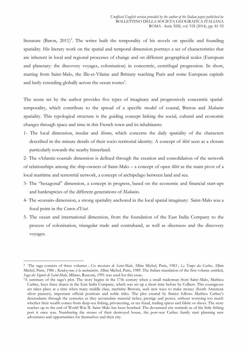
The rocky island became a «closed city» from the Middle Ages onwards, mainly due to the progressive
building of the city walls «[…] between the 3th and 15th centuries […]. These defensive fortifications
enclosed a much smaller area than the current city […]. The part between the Carrée and Poissonnerie
towers was occupied by the sea and made a natural port, the Mer-Bonne inlet (Laurent, 1986, p. 1)» (fig.
1).
Unofficial English version provided by the author of the Italian paper published in: BOLLETTINO DELLA SOCIETA GEOGRAFICA ITALIANA
ROMA - Serie XIII, vol. VII (2014), pp. 81-92
Fig. 1 - Saint-Malo and its port in the 18th century
Source: Le Lannou M., Itinéraires de Bretagne. Guide géographique et touristique, Paris, Baillière et Fils Eds., 1938.
Compared to its historic rivals/partners on the Atlantic coast, Saint-Malo’s unusual geographical
position made it much less attractive: «Saint-Malo, encased in its corset of stone and attached to terra
firma only by the narrow sandy strip of the Sillon, unlike Nantes, Rouen or La Rochelle, did not
possess a hinterland with which to trade and exchange the necessary products for daily life (Simiot,
1991, vol. 1, p. 292)». There was a stark asymmetry with its principal Breton rivals: «Nantes, whose
inhabitants kept up a constant rivalry with the Malouins, was becoming an important market place
thanks to its geographical location sheltered from enemy attacks, its river transport and the vineyards
on its hinterland (ibidem, p. 456)».

Unofficial English version provided by the author of the Italian paper published in: BOLLETTINO DELLA SOCIETA GEOGRAFICA ITALIANA
ROMA - Serie XIII, vol. VII (2014), pp. 81-92
In times of war, siege, famine or prolonged adverse weather, the Malouins had to face supply problems
owing to the absence of a real hinterland: «Enclosed by their city walls […] the granaries and cellars
were almost empty. Only those with some savings could afford to buy cabbage and a few eggs that cost
a fortune (ibidem, p. 608)». The small fishing hamlets along the coast, now part of Saint-Malo,
sometimes offered unexpected solutions: «“At Paramé they had a vegetable garden that never froze”,
said Rose Lemoal. “If you don’t want you children to go hungry, it might be a good idea to plant
something there” […] The next day, Marie-Léone and Rose Lemoal loaded a cart with spades and hoes
and set off for Paramé, to prepare a small area of the vegetable garden (ibidem, p. 567)». Although the
distances were short, travelling was very difficult, so as time went on, “annexing” the hinterland became
more desirable than maintaining the island-continent split. However, the city and its inhabitants had a
lifestyle and character traits that the coastal inhabitants did not readily accept: «Just five leagues, that is
all, and yet there was an abyss between the squire’s house and the walls of Saint-Malo. Two universes.
On one side, the sea opened to the world, […] on the other, the mean land with its enclosed spaces
[…] the Squire of Couesnon preferred his terrestrial universe. When he crossed San-Malo’s gate, he felt
as if he were entering a dangerous world, where everything was for sale and a man’s only worth was the
weight of gold ingots he owned (ibidem, pp. 108-109)». In short, there was a distinct conflict between
the opulent, brazen dynamism of the walled city and the poor but serene immobility of the Clos-Poulet:
«[…] M. de Couesnon rode off at a trot […] in front of him lay a flat green and brown land of cabbage
plots and reaped fields in a patchwork of hedges with an occasional oak tree here and there (ibidem, p.
118-119)».
Nevertheless, the distinct separation between the city and the nearby coastal area did not hinder Saint-
Malo’s economic growth or its urban and demographic expansion. These processes were rapid and
powerful, requiring: «[…] a considerable impetus to build new houses. The city’s population between
1651 and 1660 was approximately 15,000, and 20,000 at the end of the 17th century. The land registry
highlighted the reticence with which concessions were given for new buildings: the lots were irregular
strips, the houses had to be narrow and long (Laurent, 1986, p. 2)». Bernard Simiot confirms this rapid
increase of urban and demographic density in his descriptions: «It was suffocating in this city all heaped
together with more than ten thousand inhabitants crammed into tall wood and glass houses, lining
stinking alley-ways (Simiot, 1991, vol. 1, p. 22)». It was so densely over built that: «Tens or maybe
hundreds of rooves, it was difficult to count, touched, and overlapped in a mix of tiles, slate and
shingle. He had to twist his neck to catch a glimpse of the sky (ibidem, p. 251)». These difficult living
conditions, added to the risk of fire and epidemics, compelled the richer inhabitants to «[…] build large
homes on the city walls, so that they could dominate the sea at a glance (ibidem, p. 472)».

Unofficial English version provided by the author of the Italian paper published in: BOLLETTINO DELLA SOCIETA GEOGRAFICA ITALIANA
ROMA - Serie XIII, vol. VII (2014), pp. 81-92
4.2 Corsair îléité
The history of Saint-Malo attests the enterprises of its inhabitants: «Its exceptional development began
in the 14th century and continued for another two centuries. By the end of the Middle Ages, the port
of Saint-Malo was already involved in coastal and short-sea shipping, but Malouin ships could also be
found as far away as Lisbon, Madera and northern England […] these trading contacts allowed them to
sell Breton cloth, Bordeaux wines and spices. […] The Malouins’ participation in the great discoveries,
together with Jacques Cartier, and the development of cod fishing in the waters of Newfoundland were
the crucial stages of the trading success of Saint-Malo’s port. By the end of the 17th century it had
ascended to the position of first French port (Laurent, 1986, p. 2)».
Recounting this trajectory, one should not forget that: «[…] the Malouins set off from a tiny island to
conquer the world (Simiot, 1991, vol. 1, p. 336)». Its winning card was the dynamism of the middle
class: «[…] from the end of the 16th century, its ships were illegally trading with Spain, and its South
American market, selling Breton and Norman cloth and lace as well as colonial products such as
indigo. Moreover, many Malouin fortunes were made through trading gold from the Americas. In
addition, the Malouin fishing trade established commercial ties with Marseilles and the Italian ports
(Laurent, 1986, p. 2)».
The strength of the Malouins came from their profound and indissoluble relationship with the sea. This
distinctive feature was also recognised by the State and in fact, «[…] Colbert had a maritime school
opened in Saint-Malo. Young Malouins set sail at fourteen to learn the art of navigation, but between
voyages, the most ambitious ones attended lessons held by Maître Denis Beauvoisin, a hydrography
teacher, for free (Simiot, 1991, vol. 1, p. 145) ».
The audacious Malouin ship builders applied for exploration licences, despite the bans imposed by
French international relations. This was seen as a way of pushing forward into the «South Sea», the
Pacific Ocean containing inexhaustible treasure to replenish the coffers of Saint-Malo: «gold and silver
are not in the Antilles, but on the other side of the Indies, on America’s western coast (ibidem, pp.
397)».
Colonisation and exotic markets were a crucial mile stone in the global influence of Saint-Malo
Nevertheless, the rich ship builders decided to follow the example of other French merchants,
particularly their friends/foes of Nantes, by entering triangular trading routes: «With shells from the
Maldives and cotton fabric from Pondichéry, you can buy negroes in Africa and feed them on
Newfoundland cod. In the Antilles you trade negroes for raw sugar which you then refine in your

Unofficial English version provided by the author of the Italian paper published in: BOLLETTINO DELLA SOCIETA GEOGRAFICA ITALIANA
ROMA - Serie XIII, vol. VII (2014), pp. 81-92
factories in France and sell to the wholesale merchants who will in turn buy shells and Indian fabric
(ibidem, pp. 334)» (fig. 2).
History recounts the actions and defines the financial and trading spatiality of the Malouin ship owners,
but it is memory that transmits the fame of the local corsairs down through the centuries. Saint-Malo
was in fact a focal point in the Course d’Etat. The kings of France issued privateering licenses to
numerous captains of the city. It was an activity requiring a sharp-wit and courage, but also allowed
them to accumulate substantial fortunes. Saint-Malo’s pride in its captains and ship owners, gave rise,
not only to wealth, but also the accumulation and transmission of tales and legends about its corsairs:
«The people of Saint-Malo kept the legends alive about the corsairs in their families and carefully
embellished them, in the same way as a fire is stoked with dry wood and the flame is roused by blowing
on it. They had rigged their ships on the request of the kings of France for four centuries. They had
helped Philippe Auguste to drive John Lackland out of Normandy, and assisted Saint Louis Luigi in
forcing Henry III to leave Saintonge, they plundered the Channel and sunk the British fleet in the bay
of Mont-Saint-Michel, discovered Newfoundland and Canada, and besieged La Rochelle at the time of
Luigi XIII (ibidem, p. 35)».
Some ship builders and corsairs, at the height of their success, would trade this way in the British
Channel where the Dutch and many British ships had to pass.
The corsair mentality nourished and perpetuated the feeling of îléité as we mentioned before. Abraham
Moles explains that: «[…] the island and its inhabitants followed the laws of proxemics: the ‘central’
seat of power was far away and for this reason it lost its importance and opposing strength; its prestige
became abstract and for this reason its coercive power (Moles, 1982, p. 285)». The Malouin case has no
relationship with Breton irredentism. It refers instead to the awareness and the value of these sailors,
not only in terms of their economic success, but also for their courage and audacity: «They have never
refused their shields to the king, but they will certainly not get more from us by treating us badly. On
the return of the Marie-Léone, I lent him almost five hundred thousand piasters which will never be
repaid (Simiot, 1991, vol. 1, p. 563)».
The economic expansion of Saint-Malo went hand in hand with the ship builders’ ability to «navigate»
the intricacies of French and European finance: «If you want to convert your piasters and ducats, all
you have to do is contact a discreet business agent […] They come from Lions, Bordeaux and Paris.
The most important ones are from Geneva […] they have obtained free circulation for themselves and
money throughout the kingdom in exchange for loans to the king (ibidem, p. 257)».
Their unquestionable skill in avoiding the inspections of the Hôtel des Monnaies’ emissaries,
contributed to the accumulation of vast family fortunes. Moreover, the prestigious, but by now
Unofficial English version provided by the author of the Italian paper published in: BOLLETTINO DELLA SOCIETA GEOGRAFICA ITALIANA
ROMA - Serie XIII, vol. VII (2014), pp. 81-92
bankrupt East India Company was added to their list of illustrious prey: «Capitain Le Coz explained
that the Malouin ship-owners were becoming aware of the financial situation in Paris. They had already
stated that they were not willing to pay the East India Company’s debts, and instead they were ready to
set up a new Saint-Malo Company, with directors who would run the business as merchants and not as
State (ibidem, p. 535)».
5. The archipelagic dimensions of Saint-Malo: complex references between opening and closure.
This essay, which focuses on the concepts of insularity and îléité as described in a popular French novel,
requires a final consideration that inevitably leads to further and deeper conceptual reflections. What
emerges from scientific literature and the novel of Bernard Simiot is that this rocky and inhospitable
island that became a peninsular and then a mainland, developed a powerful network of relations over
the centuries, particularly from the oceanic and maritime aspect. This is demonstrated by its social
network and the intense economic and financial relations that developed in and around this liquid
medium. Depending on the era and the process of socio- economic and cultural development of Saint-
Malo and its inhabitants, these relations extended near and far. The continental aspect, however, always
remained one-step behind and relied on the «maritime» needs of the city and its courageous captains.
Broader terrestrial and continental relations, national and international, were defined according to the
requirements and strategies of the ship builders and financiers, such as: acquiring noble titles,
administrative roles, navigation and exploration licences, and the management of the considerable
fortunes of the Messieurs de Saint-Malo. It is somewhat paradoxical that the most important hubs of this
network became firmly anchored on this neglected mainland of the malouin archipelago. The «solidity»
of these «anchoring places», contrary to the dominating liquid dimension, offered new possibilities for
social and economic advancement, as well as increasing ship builder and corsair fortunes.
These complex structures, developing horizontally and vertically, allow us to penetrate this opaque
maritime/terrestrial archipelagic network. Joël Bonnemaison effectively summarises this unusual
network, never free from the ambiguous Malouin behaviour between opening and closure: «[…] living
on an island does not mean living in a closed world, separated from the world, but rather on a shore, an
interface which seeks contact, exchange and circulation. An island needs “a way out” […] the issue is
profoundly cultural; the island needs external allies, but remains nevertheless the centre of its own
world (Bonnemaison, 1997, pp. 128-129)». In the specific case of Saint-Malo, the asymmetric
relationship between land and sea, combined with the binomial term insularity-îléité, can be summarised
in three main stages; the last one is still in progress. (Fig. 2):

Unofficial English version provided by the author of the Italian paper published in: BOLLETTINO DELLA SOCIETA GEOGRAFICA ITALIANA
ROMA - Serie XIII, vol. VII (2014), pp. 81-92
Fig. 2 The binomial insularity-îléité of Saint-Malo in time
1. The «mineral» stage from its foundation until the Middle Age: island-rock, island-
unconquerable fortress are the origin of the «split» land-sea, which last over time and in the
local memory.

Unofficial English version provided by the author of the Italian paper published in: BOLLETTINO DELLA SOCIETA GEOGRAFICA ITALIANA
ROMA - Serie XIII, vol. VII (2014), pp. 81-92
2. The «corsair» stage from the 15th century to the Restoration: the phase of Saint-Malo’s great
economic, urban and demographic development. The expression and assertion of îléité
constituted a resource, a defence against the royal institutions (l’Hotel des Monnaies!) which often
threatened Malouin success and profit.
3. The «vernacular«» stage (Brinckerhoff, 2003; Collignon, 2005) from the 19th century to the
present day: the «split» caused by îléité has become no more than a stereotypical element
integrated in local memory.
Saint-Malo, now «terra firma», remains a corsair city that has transformed its îléité into an emblem and
uses it in cultural-territorial marketing strategies because «Even though there are no longer any islands,
we still look for them; their value remains despite the disappearance of their market (Moles, 1982, p.
288)».
BIBLIOGRAPHY
BARON C., Littérature et géographie: lieux, espaces, paysages et écritures, in «LHT», 2011, 8
(http://www.fabula.org/lht/8/8dossier).
BERTHO C., L’invention de la Bretagne, in «Actes de la Recherche en Sciences Sociales», 1980, 35, pp, 45-
62.
BONNEMAISON J., La sagesse des Îles, in A.-L. SANGUIN (ed.), op. cit., 1997, pp. 11-19.
BONNEMAISON J., Vivre dans l’île, une approche de l’îléité océanienne, in «L’Espace Géographique», 1991,
2, pp. 119-125.
BRINCKERHOFF JACKSON J., A la découverte du paysage vernaculaire, Paris, Actes Sud/ENSP, 2003.
CAVALLO F.L., L’insularità tra teoria geografica e archetipo culturale, in «Riv. Geogr. It.», 2002, 2, pp. 281-
313.
CLAVAL P., Le thème régional dans la littérature francaise, in «L’Espace Géographique», 1987, 1, pp. 60-73.
COLLIGNON B., Que sait-on des savoir géographiques vernaculaires?, in B. COLLIGNON (a cura di), La
géographie vernaculaire, numero tematico di Géographies, Bulletin de l’Association de géographes français, 2005, 3,
pp. 321-331.
COLLOT M., Pour une géographie littéraire, in « LHT », 2011, 8
(<http://www.fabula.org/lht/8/8dossier/242-collot>).
GOMBAUD S., Iles, insularité et îléité. Le relativisme dans l'étude des espaces archipélagiques, Thèse de doctorat
de l'Univ. De la Réunion, 2007.

Unofficial English version provided by the author of the Italian paper published in: BOLLETTINO DELLA SOCIETA GEOGRAFICA ITALIANA
ROMA - Serie XIII, vol. VII (2014), pp. 81-92
LAURENT C., Saint-Malo Ille-et-Vilaine, in Ch. Higounet, J.B. Marquette, Ph. Wolff (eds.), Atlas
Historique des villes de France, Paris, Ed. du CNRS, 1986, pp. 3.
LE LANNOU M., A proposito dell’isolamento delle isole , in «Atti XX Congr. Geogr. It», Roma, 29 marzo –
3 aprile 1967, vol. IV, Roma, Società Geografica Italiana, 1971, pp. 7-10.
LE LANNOU M., Itinéraires de Bretagne, Guide géographique et touristique, Paris, Baillière et Fils Eds., 1938.
LO MONACO M., L’insularità nella bibliografia geografica, in Atti dei Convegni Lincei, 62, 1984.
MARENGO M., The City of Paper: Saint-Malo and its concentric spatiality in the saga “Ces Messieurs de Saint-
Malo” by Bernard Simiot, in «Plurimondi», VI, 12, 2013 (a), in print.
MARENGO M., Parole e paesaggi letterari bretoni nella saga “Ces Messieurs de Saint-Malo” di Bernard Simiot, in
C. Pongetti, M.A., Bestini, M. Ugolini (a cura di), Volume in onore di Peris Persi, 2013 (b), in print.
MARENGO M., “Cacadou” ou la colonisation en cage d’osier: de l’Orient à Saint-Malo et retour dans la saga “Ces
Messieurs de Saint-Malo” de Bernard Simiot, in EUGEO Congress − Session “Geography and Literature”, Rome
5-7 settembre 2013 (c), in print.
MARENGO M., Saint-Malo “ville de plume”: narrazioni asimmetriche fra realtà e saghe letterarie, in VI Congresso
AISU − Sessione “Città e non-città: confini urbani, rapporto con la campagna, spazio costruito e spazio naturale”,
Catania, 12-14 settembre 2013 (d), in print.
MOLES A., Nissonologie ou science des îles, in «L’Espace Géographique», 1982, 4, pp. 280-288.
MORIMOUTOU J., RACAULT J. (eds.), L’insularité. Thématique et représentations, Paris, L’Harmattan,
1995.
PERON F., L'île, espace culturel. Formes d'attaches aux lieux en Bretagne, in «Géographie et Cultures», 1992,
2, pp. 3- 34.
RACHELI G., Isole e insularità futura, Paolo Sorba Editore, La Maddalena, 1996.
SANGUIN A.-L. (ed.), Vivre dans une île. Une géographie des insularités, Paris, l'Harmattan -Coll.
Géographie et Cultures, 1997.
SCARAMELLINI G., Isole, insularità, isolamento nella costruzione della geografia contemporanea, in N.
BRAZZELLI (ed.), Isole: coordinate geografiche e immaginazione letteraria, Milano, Mimesis, 2012, pp. 13-32.
SIMIOT B., Ces messieurs de Saint-Malo, Paris, Albin Michel, 1983 [Trad. It.: La Saga dei Signori di Saint-
Malo, Milano, Rusconi, 1991].
SIMIOT B., Le Temps des Carbec, Paris, Albin Michel, 1986.
SIMIOT B., Rendez-vous à la malouinière, Paris, Albin Michel, 1989.
TISSIER J.-L., Ile, Insularité, Isolement, in Documents pour l'histoire du vocabulaire scientifique, 1984, 3, Paris,
Greco, pp. 49-67.

Unofficial English version provided by the author of the Italian paper published in: BOLLETTINO DELLA SOCIETA GEOGRAFICA ITALIANA
ROMA - Serie XIII, vol. VII (2014), pp. 81-92
TURCO A., Insularità e modello centro-periferia. L’isola di Creta nelle sue relazioni con l’esterno, Milano, Unicopli,
1980.
VALLEGA A., Governo del mare e sviluppo sostenibile, Milano, Mursia, 1993.
ZANELLA G., La nozione di isolamento insulare e il suo valore antropogeografico, in Atti dei Convegni Lincei, 62,
1984.
Università degli Studi di Siena, Dipartimento di Scienze della Formazione, Scienze Umane e della Comunicazione Interculturale. [email protected]