Embed Size (px)
Citation preview

Coastal Management Strategy
DRAFT January 2017

Contents
1. INTRODUCTION ................................................................................ 3
1.1. PURPOSE .................................................................................... 4
1.2. VISION ........................................................................................ 4
1.3. OBJECTIVES ............................................................................... 4
1.4. STUDY AREA .............................................................................. 4
1.5. PREVIOUS PLANNING STUDIES .............................................. 6
1.6. CONSULTATION ....................................................................... 6
1.7. APPROACH ................................................................................ 6
1.8. DOCUMENT STRUCTURE ......................................................... 7
2. POLICY FRAMEWORK....................................................................... 8
2.1. STATE PLANNING STRATEGY .................................................. 8
2.2. STATE PLANNING POLICY 2.6 – STATE COASTAL PLANNING .
.................................................................................................... 8
2.3. COASTAL PLANNING AND MANAGEMENT MANUAL ........ 8
2.4. CITY OF KARRATHA TOWN PLANNING SCHEME NO. 8 ..... 9
2.5. CITY OF KARRATHA LOCAL PLANNING STRATEGY (DRAFT) .................................................................................................... 9
2.6. CITY OF KARRATHA ENVIRONMENTAL STRATEGY ............. 9
3. LOCAL CHARACTERISTCS .............................................................. 10
3.1. NATURAL ENVIRONMENT..................................................... 10
3.2. LANDFORMS AND COASTAL PROCESSES .......................... 13
3.3. MANAGING COASTAL VULNERABILITY ............................... 17
4. SOCIOECONOMIC ENVIRONMENT ............................................. 18
4.1. HISTORIC COASTAL USE AND ACTIVITY ............................. 18
4.2. ABORIGINAL HERITAGE VALUE ............................................ 18
4.3. NATIVE TITLE ........................................................................... 18
4.4. LAND USES .............................................................................. 18
7.1. RESERVES AND MANAGEMENT ............................................ 20
8. FUTURE MANAGEMENT ................................................................. 23
8.1. OVERVIEW ................................................................................ 23
8.2. CONSERVATION OF COASTAL BIODIVERSITY .................... 23
8.3. BALANCING THE PROVISION OF LAND AND ACCESS FOR
INDUSTRIAL DEVELOPMENT .................................................... 24
8.4 PROTECTION OF EXISTING AND FUTURE RESIDENTIAL,
COMMUNITY AND HERITAGE ASSETS .................................... 25
8.4. MANAGEMENT OF SUSTAINABLE COASTAL RECREATION .. ................................................................................................... 27
9. MANAGEMENT OBJECTIVES .......................................................... 30
9.1. THE NEED TO MANAGE ......................................................... 30
9.2. MANAGEMENT OF THREATS ................................................ 30
9.3. COMMUNITY INPUT ............................................................... 30
10. MANAGEMENT OPPORTUNITIES.............................................. 32
10.1. ABORIGINAL JOINT MANAGEMENT .................................... 32
10.2. VOLUNTEER PROGRAM ......................................................... 32
10.3. COMMUNITY EDUCATION AND AWARENESS ................... 32
10.4. FUNDING OPPORTUNITIES ................................................... 32
10.5. MONITORING AND EVALUATION PROGRAM .................... 32
11. MANGEMENT STRATEGIES ........................................................ 33

1. INTRODUCTION
The City of Karratha coastline stretches for approximately 350km. It is home to
a diverse and precious coastal ecosystem and unique cultural heritage, while
supporting an economic powerhouse of national and international importance.
As such, the environmental, social and economic values of the coastal
environment need to be kept in a constant balance as changes occur. Seasonal
coastal processes (e.g. storm surge and erosion) and longer term changing
climatic conditions create a highly dynamic environment. It is therefore
important for existing and proposed developments and uses within the coastal
environment to be considered in that context. This includes planning and
management that minimises coastal hazard risks.
This Coastal Management Strategy (CMS) has been developed through both
technical studies and community and stakeholder engagement. This has
included reviewing and collating the large amount of background material and
scientific coastal modelling undertaken over recent times. This CMS provides a
framework for the long term management of the coastal environment, taking a
quadruple bottom line approach that considers social, economic, environmental
and governance factors.
The vast majority of residents living, recreating and working within the City of
Karratha have a strong connection with the coastal environment. This has the
potential to degrade the coastal environment. As such, coastal access, use and
management responsibility are key issues addressed by this CMS.
This CMS collates and interprets the various coastal demands and influences
in order to define a range of appropriate short, medium and long term
management strategies. Through this CMS the City of Karratha (City) takes
responsibility for ensuring each of the management strategies are delivered,
either directly or via support of the appropriate agency and/or stakeholder.

1.1. PURPOSE
This CMS is the City’s overarching coastal management document. The
purpose of the CMS is to ensure the City has a consistent and transparent
approach towards existing and planned coastal management policies, plans
and strategies.
This CMS establishes a framework for the use, management and conservation
of the City’s coastal environment. The beaches, islands and estuarine
environments along the City’s coastline support a high diversity of activity
including; a unique marine ecology, urban settlements, major industrial
infrastructure and diverse recreational pursuits. The interaction of these various
activities needs coordinated planning and management. Balancing multiple
uses while maintaining a healthy coastal environment is a shared responsibility.
All tiers of government, private industry, community and Traditional Owners
have a role in the sustainable use, development and management of the City’s
coastal environment.
Over the last decade the City has undertaken various coastal planning
strategies and management plans to guide use, development and management
across the coastal environment. With ever increasing development and use
occurring within the coastal environment, this CMS provides much needed
alignment of the various coastal policies and procedures prepared both by the
City and other organisations and agencies.
1.2. VISION
The vision of this CMS was developed in response to feedback from community
and stakeholder consultation, and in respect of the work already undertaken
through a range of existing documentation. This includes the objectives of the
City’s Environmental Strategy and recently drafted Local Planning Strategy. The
vision aligns with the intent of State Planning Policy 2.6 – State Coastal Planning
(SPP2.6) in consideration of economic, social and environmental
characteristics:
The City of Karratha coastal environment is recognised for its social,
cultural, economic and environmental values that are of significant state,
national and international significance. Coastal land uses will be managed
in a balanced, equitable way that ensures the preservation of all coastal
values now and into the future.
1.3. OBJECTIVES
In consideration of existing and anticipated coastal challenges, four strategic
objectives have been developed to guide the preparation of the CMS and
ultimately achieve the vision for the City’s coastline.
1.4. STUDY AREA
The City’s municipality comprises an area of approximately 15,278km2. It is
bordered by the Town of Port Hedland (east), the Shire of Ashburton (south)
and the Indian Ocean (north and west). Figure No.1 depicts the location and
extent of the municipality. This CMS applies to the coastal environment within
the City’s municipality including the coastal hinterland and near coast areas.
The extent of influence over which this CMS prevails is not delineated by a
physical boundary. Coastal influences can vary seasonally, as such a limit of
application cannot be precisely defined. However, practical boundaries will be
defined through the development of individual Foreshore Management Plans.
The City’s coastline stretches approximately 350km and comprises a diverse
range of marine environments. The coastline includes sandy beaches, rocky
ridges, tidal mudflats and mangrove environments. There are five (5) major river
catchments connecting to the coastline; the Robe, Fortescue, Maitland, Harding
and Sherlock Rivers.
Settlements
Within the municipality there are six (6) population settlements located within,
or in close proximity to the coast including; Karratha, Dampier, Roebourne,
Wickham, Point Samson and Cossack. These settlements are serviced by
various coastal recreation nodes including; Dampier Foreshore, Hearson Cove,
Karratha Back Beach, Cleaverville, Wickham Boat Beach, Point Samson
Foreshore and Cossack/ Settlers Beach. In addition, there are a range of more
remote coastal recreation areas including Balla Balla, Fortescue River, Maitland
River and Gnoorea Point/ 40 Mile Beach.
In light of the above, and in consideration of previous coastal planning strategies
undertaken by the City, ten (10) priority coastal nodes have been identified for
more detailed consideration and planning including; Karratha, Point Samson,
Wickham, Dampier, Cossack, Cleaverville, Hearson Cove, Gnoorea Point/ 40
Mile Beach, Balla Balla, and the Fortescue River Mouth.
Land Use
The vast majority of the City’s coastal environment comprises of Crown Land
reserved under the City’s Town Planning Scheme No. 8 (TPS8) for
‘Conservation, Recreation and Natural Landscapes’. Moving inland from the
coastal environment, the majority of land is zoned ‘Rural’ under the provisions
of TPS8. The majority of the southwestern portion of the Burrup Peninsula,
which surrounds the Dampier town site, has been zoned for ‘Strategic Industry’
under the provisions of TPS8.
Development and use within the coastal environment comprises of a range of
uses including urban, industrial, pastoral, recreation, tourism and conservation.
There are five (5) pastoral leases within the municipality which adjoin the
coastline including; Sherlock, Warambie, Mount Welcome, Karratha and Mardie
Stations. In addition, there are large expanses of the coastline that are subject
to mining tenements comprising both live and pending licences.
The municipality is a major State and National hub for the processing and
exportation of iron ore, salt and natural gas. As such there are a number of deep
water ports, onshore processing and export support facilities existing along the
City’s coastline. In addition, Dampier Salt has a significant salt extraction facility
within the coastal environment.

Native Title
The majority of land within the municipality is within the determined Ngarluma/ Yindjibarndi Native Title Claim (WAD6017/96
and WAD 165/08). While a number of Indigenous Land Use Agreements (ILUA) are in place for the use and development
of land within the determination area, the majority of the coastline is not covered by any ILUA.
The majority of the western area of the municipality is currently under two separate Native Title Claims which have been
accepted for registration, namely; Yaburara & Mardudhunera (WAD127/1997) and Kuruma Marthudunera (combined)
(WAD6090/1998). The Yaburara & Mardudhunera (WAD127/1997) claim is yet to be determined. The Kuruma
Marthudunera (combined) (WAD6090/1998) has been determined and it was considered that Native Title does exist in parts
of the determination area.
Marine Environment
The North-West Commonwealth Marine Reserve Network (Reserve Network) covers an area of approximately 335,437km2.
The Reserve Network contains thirteen marine reserves ranging in size from 304km2 to 146,000 m2. There are two reserves
adjoining the City’s coastline, namely; the Dampier Archipelago and Montebello Islands Commonwealth Marine Reserves.
These reserves are currently under the management control of the Department of Parks and Wildlife (DPaW) as further
detailed within this CMS. DPaW managed reserves that abut City managed lands provide opportunities for partnerships and
joint management arrangements.
Figure 1 – Study Area

1.5. PREVIOUS PLANNING STUDIES
This CMS is underpinned by a significant body of work on environmental and
cultural values, coastal processes, strategic land use planning and foreshore
management planning. In 2005 the City completed a draft Coastal Management
Strategy which was never formally adopted. Since 2005, a significant amount of
investigation has been undertaken to provide greater detail on coastal
processes, acceptable uses and management responsibility of coastal areas. A
summary of the various documents that have informed the development of this
CMS are summarised within Figure No.2.
1.6. CONSULTATION
In support of this CMS, the City prepared and implemented a Stakeholder
Engagement Plan (SEP) to ensure opportunity was provided to the local
community and relevant stakeholders to voice their concerns, interests and
opinions in regards to management of the coastal environment. The results from
the SEP have been collated with the findings obtained through the literature
review to provide a comprehensive understanding of influencing values and
priorities.
In addition, the stakeholder engagement process provided an opportunity for
the City to enhance partnerships between community groups, government and
non-government organisations. Through the SEP, eighty individual stakeholder
groups where identified and targeted through a range of relevant consultation
mechanisms. The objectives of the SEP were to ensure:
• All community members affected by coastal management decisions
are to be provided with the opportunity to influence those decisions.
• Different stakeholder perspectives are considered during
engagement. This includes engaging in a way that suits preferences
and needs of stakeholders.
• Stakeholders gain a clear understanding of the purpose of the
engagement and are provided sufficient information and enough time
to contribute effectively; and
• Ongoing and effective communication through the life of the project,
including provision of follow-up feedback after engagement has
concluded.
The comments gathered through the consultation have been captured within
this CMS and used to guide the development of strategies and actions. Key
influencing results from the consultation are addressed within the Management
Objectives section of this CMS.
1.7. APPROACH
The management measures outlined within the CMS recognise the cumulative
nature of development impacts. The State Government’s vision for sustainable
growth and prosperity is underpinned by diversity, liveability, connectedness
and collaboration (State Planning Strategy, 2012). Therefore, planning for land
use and development within the coastal environment requires the competing
impacts to be managed at sustainable levels. This CMS incorporates a
quadruple bottom line assessment to evaluate the various impacts and costs
associated with management of the City’s coastal areas.
Through this quadruple approach, this CMS provides a comprehensive decision
making framework for the ongoing planning and management of the City’s
coastal environment.
Figure 2 – Summary of Documents Used for CMS Development.

Table 1 – Quadruple Bottomline
Considerations Description
Environmental Understanding the value of features and processes
within the coastal environment.
Social Understanding the value of the coastal environment to
the community and Traditional Owners.
Economic Understanding the value of economic operations
within the coastal environment.
Governance Understanding the roles and responsibilities for
management of the coastal environment.
The City’s draft Local Planning Strategy (LPS) identifies areas earmarked for
future development and use. The recommendations outlined within the LPS
inform relevant management measures recommended within this CMS. The
following points outline the methodology undertaken in the preparation of this
CMS:
• Interpret and incorporate recommendations within relevant
Commonwealth, State and Local coastal policies and strategies;
• Review the defined coastline vulnerability in regards to existing and
proposed development in the short, medium and long term;
• Review land tenure, management responsibility and quality of the
natural environment within the coastal environment;
• Identify the existing and proposed land uses within the coastal
environment;
• Identify key issues impacting the sustainable use and management
of the coastal environment;
• Engage with stakeholders to identify key coastal access areas and
the use, development and management being undertaken in those
areas;
• Develop sustainable coastal hazard risk management strategies
including consideration to avoidance, retreat, accommodation and
protection;
• Recommend development controls and guidelines for coastal land
use and development through the incorporation of appropriate
provisions in the City’s Local Planning Scheme, Local Planning
Policies and/ or Local Laws.
1.8. DOCUMENT STRUCTURE
The CMS is a municipality wide coastal management document which collates
information from a range of sources to articulate key coastal processes and local
socioeconomic, environmental and governance characteristics. The structure of
this CMS provides an understanding of the overarching coastal policy
framework and local characteristics before articulating the future management
consideration and the development of strategies and actions.
Figure 3 – Document Structure
Introduction
Coastal Planning Framework
Local Characterisitics
Future Management
Management Strategies

2. POLICY FRAMEWORK
2.1. STATE PLANNING STRATEGY
The Western Australian Planning Commission (WAPC) published the State
Planning Strategy 2050 in 2014. The document provides the strategic context
and basis for the integration and coordination of land-use planning and
development across the State’s regions and local jurisdictions. The Strategy is
established on six interrelated state planning principles which underpins a vision
that:
By 2050, Western Australia will have a diverse range of interconnected and
vibrant local communities and regional centres. The people in these
communities will be healthy, resilient, active, prosperous, respectful of
cultural difference and participate in the public domain. Standards of living
will continue to be amongst the highest in the world. Improved connections
and smarter technologies will enhance the State’s ability to attract global and
domestic investment capital where and when it is most needed. A ‘can do’
attitude will prevail, inspiring new ways of thinking and working, which will
deliver optimal outcomes for the economy and communities of Western
Australia.
The vision is implemented through a number of Principles, Strategic Goals and
Actions. The provisions relevant to the strategic management of the City’s
coastal environment are identified as:
- Environment Principle – Conserve the State’s natural assets
through sustainable development:
o State’s biodiversity and natural resources are well-
managed so that short-term gains do not compromise
future opportunities.
- Strategic Goal 5 – Conservation:
o Increase the resilience of the State’s natural environment
by limiting the clearing of native vegetation, maximising
natural habitat protection and rehabilitation, avoiding
development in environmentally sensitive areas, and
reducing the fragmentation of vegetation by urban and
industrial development.
- Spatial Dimensions – Northern Sector:
o Harmony must be found between conservation of the
Northern sector’s unique environment and its
opportunities for economic development.
- Interrelated State Strategic Directions – Environment:
o To conserve biodiversity, achieve resilient ecosystems,
protect significant landscapes and manage the State’s
natural resources in a sustainable manner.
o Vulnerability mapping for the coastline will identify the
areas of highest risk, so that adaptation strategies can
continue to be implemented to anticipate sea level rise
and extreme weather events.
o Planning and development decisions are required to
account for the economic, social and environmental value
of natural resources and assets in the public interest.
o Consideration of the cumulative impacts upon the
environment and natural resources, particularly
vulnerable areas of the State, will require ongoing
collaboration at all scales of planning and across all tiers
of government.
2.2. STATE PLANNING POLICY 2.6 – STATE COASTAL PLANNING
The State Planning Policy 2.6 – State Coastal Planning (SPP2.6) promotes
increased community consultation in decision making. SPP2.6 outlines the need
to balance environmental management with support of social and economic
growth. The precautionary principle, withholding potential damaging actions, is
also strongly advised by the WAPC as a prudent step toward a more sustainable
future.
SPP2.6 and the supporting Guidelines provide a framework for coordinating
coastal uses to ensure an integrated approach to coastal planning and coastal
management. SPP2.6 outlines objectives, policy measures and guidelines for
coastal management, planning and development. This CMS has been prepared
to ensure consistency with the objectives of SPP2.6 namely to:
- Protect, conserve and enhance coastal values, particularly in
areas of landscape, nature conservation, indigenous and cultural
significance;
- Provide for public foreshore areas and access to these on the
coast;
- Ensure the identification of appropriate areas for the sustainable
use of the coast for housing tourism, recreation, ocean access,
maritime industry, commercial and other activities; and
- Ensure that the location of coastal facilities and development
takes into account coastal processes including erosion, accretion,
storm surge, tides, wave conditions, sea level change and
biophysical criteria.
In addition, this CMS has been prepared to ensure that as a minimum, the
objectives set out in the Coastal Planning Policy Guidelines have been
addressed and take into account the following:
- Coastal processes, coastal hazards, landform & stability, natural
vulnerability, climate change, ecological values, water quality,
recreation & public access, marine resource & access, landscape,
seascape & visual landscape, Indigenous heritage, cultural
heritage and land capacity.
2.3. COASTAL PLANNING AND MANAGEMENT MANUAL
The WAPC Coastal Planning and Management Manual (Manual) outlines a
hierarchy of plans to facilitate inclusive and coordinated coastal management:
- Regional Plans:
o Cover hundreds of kilometres, several local government
areas and set broad direction for land use and/or
management of an area.
- Local Plans:
o Such as coastal and foreshore management plans are
more detailed, address management of all or part of a
local government area, and provide sufficient detail for
management of key coastal nodes.
- Site Plans:
o Provide direction for on ground management of a
particular location.
This CMS is a Local Plan under the hierarchy outlined within the Manual, it has
been prepared to complement the City’s draft Local Planning Strategy. While
the CMS covers the whole of the City’s coastline, more detailed planning of
specific coastal nodes will be undertaken through site specific Foreshore
Management Plans. The Coastal Vulnerability Studies and Storm Surge
Mapping for Karratha, Dampier, Point Samson, Wickham and Roebourne
outline the proposed risks to these areas in respect to coastal hazards and risk
and storm surge inundation.

2.4. CITY OF KARRATHA TOWN PLANNING SCHEME NO. 8
At the local level, the City’s coastal management objectives and statutory
provisions are guided by Town Planning Scheme No. 8 (TPS8). The statutory
provisions within TPS8 establish special control areas for flood management,
set parameters for considering storm surge risk and outline the approach to
prepare Local Planning Policies. Specifically, Clause 1.6 within TPS8 outlines
an objective to:
Facilitate community input into planning for the appropriate balance between
economic and social development, conservation of the natural environment,
and improvements in lifestyle and amenity.
Within TSP8, particular regard is given to the natural environment on the Burrup
Peninsula, Cape Lambert, Point Samson, Cossack, Dampier Archipelago,
Maitland River (Mairee Pool) and portions of pastoral stations containing or
adjoining coastal recreation nodes such as Gnoorea and Cleaverville. This CMS
aligns with current statutory provisions outlined within TPS8 and associated
Local Planning Policies.
2.5. CITY OF KARRATHA LOCAL PLANNING STRATEGY (DRAFT)
The purpose of the draft Local Planning Strategy (LPS) is to ensure future
growth of the City to 2031. The draft LPS sets a strategic planning direction, that
takes advantage of identified opportunities and acknowledges development
constraints to ensure that future growth of the City supports a vision for:
A cohesive and vibrant community, celebrating diversity and working
together to create a sense of place and a sustainable future.
The LPS outlines four (4) key themes which consider a triple bottom line
approach to balance the future growth of the City, through:
- Theme 1: Community
o Deals with issues associated with population
characteristics, housing, community facilities and
services, recreation and open space;
- Theme 2: Economy
o Deals with retail and commercial space, economic
development and diversification including tourism,
industry and support to major projects;
- Theme 3: Environment
o Deals with issues associated with minimising risk from
natural hazards, protecting recognised environmental
values and landscapes, urban design and public realm
enhancement, protection from inappropriate
development; and
- Theme 4: Infrastructure
o Deals with ensuring there is adequate utility and transport
infrastructure capacity to service future growth.
Under the key theme of Environment, the draft LPS outlines the following
objectives:
- To encourage appropriate recognition and management of the
City’s climate and natural environment;
- To promote and celebrate the City’s unique natural and manmade
heritage, character and sense of place; and
- To ensure planning and management of rural and environmentally
sensitive land enables appropriate and sustainable use of the land
and its resources.
In addition to the above, the draft LPS sets an overarching City wide strategic
plan, plus five specific settlement level plans. These settlement level plans
guide the growth and development of the major population centres of Karratha,
Dampier, Roebourne, Wickham and Point Samson.
2.6. CITY OF KARRATHA ENVIRONMENTAL STRATEGY
The City’s Environmental Strategy provides a framework to achieve better
environmental management outcomes. The Environmental Strategy has
identified key outcomes with regards to the management of the coast, namely:
- Recognition and enhancement of natural, cultural and recreational
values of the coast;
- No further loss or degradation of coastal habitat; and
- Management of assets and protection of values in areas
susceptible to coastal vulnerability.
The Environmental Strategy has also identified thirty-three (33) proposed
management actions to achieve its objectives. These actions include the
development of a climate change strategy and a coastal recreation plan, the
ongoing development of foreshore management plans, the delivery of education
programs and the on ground implementation of threat eradication programs.
The Environmental Strategy, its objectives and proposed actions has been used
to guide and inform the development of this CMS.

3. LOCAL CHARACTERISTCS
3.1. NATURAL ENVIRONMENT
Climate
Temperature
The City is within the arid-tropical, semi-desert Pilbara region. Climate is
controlled largely by the seasonal migration of a belt of high-pressure anti-
cyclonic systems lying across the continent for about six months of the year. It
is also influenced by northern tropical rainfall systems. The area experiences a
long winter from May to November while summer weather conditions prevail
from December to March. There are brief transitional periods between these
seasons.
Summer is hot, with a mean daily temperature of 36.2C reached in January and
February, while winter is mild with a corresponding temperature of 26.1C in July.
Mean daily minimum temperatures range from 26.5C in February to 12.2C in
July. The general trend for Karratha indicates gradually increasing
temperatures.
Figure 4 – Karratha and Roebourne climate trend – temperature.
Rainfall and Cyclones
Rainfall is generally erratic from year to year, but still exhibits seasonal
characteristics. The average annual rainfall is low being only 230mm, with an
initial peak between January and March (due to a combination of thunderstorms
and cyclonic rains) and a lower trough in May and June.
Tropical cyclones deliver extreme weather systems which affect the region
between November and April. Cyclones develop in the Timor Sea and travel
southwest along the northern coast of Western Australia, following a variable
and frequently unpredictable path. Winds circulate in a clockwise direction about
the eye of the cyclone, with coastal areas potentially affected by gale and
hurricane force winds (160 km/hr). On average the region can be expected to
experience two to three cyclones per year.
The trend in rainfall does not indicate an obvious decline or increase for the
municipality (Figure No. 4). More significant than annual rainfall amount, is the
change in distribution of events. There is a clear trend in recent rainfall records
towards less frequent, more significant events which may have implications for
City operations.
Figure 5 – Karratha and Roebourne climate trend – rainfall.
Vegetation
The coastal flora communities experience significant and harsh environmental
conditions including windborne salt, extreme tidal movement, periodic cyclone
events, dramatic water erosion, extreme temperatures, high evaporation leaving
hyper saline flats, silt deposition during flood and tidal events and strong wind
erosion from varying directions. The vegetation communities able to tolerate
these conditions include mangroves, shrubs (including wattles, creepers, herbs
and succulents) and grassland (including soft spinifex and other grass
communities). There are no prescribed threatened ecological communities
along the City’s coastline.
Mangroves line the upper banks of tidal creeks. Their presence indicates the
importance of tidal creeks as habitats for a wide variety of marine organisms.
This section of the Pilbara coast provides some of the best examples of tropical
arid-zone mangroves in the world. Pockets of mangrove species (called
Mangals) are highly productive ecosystems. They provide a sheltered
environment, a haven for juvenile fish and crustaceans and support a wide
variety of animal life. The root systems of mangroves bind silty mud allowing
coastal areas to experience severe storms without extensive damage.
Destruction or removal of mangrove communities destabilises coastal areas,
potentially leading to severe coastal erosion and loss of biodiversity.
Vegetation communities found along the coast include Mangal systems along
creek and river courses, and a wide variety of spinifex, shrubs, steppe and
grassland. Flora surveys have been confined largely to DPaW managed land
including parts of the Burrup Peninsula and islands in the Dampier Archipelago.
Invasive weeds including Buffel grass and Kapok bush are a significant problem
along the coastline and dominate many disturbed areas. Populations of Prickly
Pear have occurred on islands and have spread to the mainland. Cacti have
become weeds, along with the Date Palm, Mesquite, Parkinsonia, Passion Vine,
Tamarisk, Thistles and Ruby Dock. In conjunction with various partners, DPaW
undertakes successful control of weed invasions across some areas of the
municipality.
Figure 6 – Common City of Karratha Coastal Weeds.
Fauna
Fauna diversity in the region is strongly influenced by the arid climate and
specific vegetation communities. Due to these two factors, endemic reptiles
including Gecko and Goanna species are prominent. The coastal islands
function as refuges for vulnerable species that are either rare or extinct on the
mainland such as the Western Chestnut Mouse. The coastal environment and
offshore islands are also significant breeding sites for turtles and seabirds.
Surveys of the Burrup Peninsula and Dolphin Island show the 141 vertebrate
species are widely distributed across these areas. None of the identified species
are classified as rare under Section 14 of the Wildlife Conservation Act 1950
(WA).
Seabed habitats of the North West Shelf support the highest biodiversity
recorded anywhere in the world, with a remarkable array of marine fauna

including tropical fish, sea turtles, migratory whales, hard and soft corals,
sponges and many crustaceans. Below the water, there are a number of reefs
with great productivity and diversity found relatively close to the coastline. High
conservation status species such as turtles (Green, Loggerhead, Flat Back,
Hawksbill and Leatherback), Dugongs, migratory seabirds/ waders and Whale
Sharks all inhabit the Pilbara waters. The types of fauna found within the coastal
environment is listed in Table No. 2.
Table 2 – Types of Fauna Existing wihtin the City of Karratha Coastal Environment.
A recent CSRIO study into the management of the Pilbara’s conservation
significant flora and fauna, revealed a comprehensive list of significant flora and
fauna species within the Pilbara IBRA (Interim Biogeographic Regionalisation
of Australia) subregions. The Pilbara IBRA subregions consists of: Chichester,
Fortescue, Hamersley and Roebourne. The City of Karratha sits within the
Roebourne subregion.
The significant flora and fauna species found within the Roebourne subregion
are listed in Table No.3 and Table No.4. The presence of these significant
species within coastal areas will require confirmation through site specific flora
and fauna surveys. These surveys should be undertaken through the
development of specific Foreshore Management Plans and/ or development
applications.
Figure 7 - Pilbara IBRA Subregions (CSIRO)
Type of Animal Species
Marine Turtles
Flatback, Loggerhead, Hawksbill, Green and Leatherback
turtles frequent the islands, Wickham Boat Beach,
Cleaverville, Cape Preston and Gnoorea Point.
Mammals
Mammals include the Western Grey Kangaroo, Euro and
Rothschild’s Rock Wallaby, echidnas and carnivorous
marsupials, rats, mice, wild dogs, foxes, feral cats and the
Flying Fox.
Birds
Water birds including the Wader, Stilts, Cranes,
Oystercatchers, Pelicans, Nankeen Heron, Ibis,
Cormorants, Frigate Birds, Storks, Plovers and Dotterels.
Birds of prey and carrion eaters include the osprey, owl,
eagles, hawks, kites, falcons and crows.
Also found are; Bustard, Quail, Thick Knees, Pigeons,
Doves, Parrots, Cuckoos, Cuckoo-Shrikes, Nightjars,
Kingfishers, Swallows, Pipits, Fantails, Wagtails, Robins,
Thickheads, Old world Warblers, Australian Wrens and
Warblers, Honeyeaters, Pardalotes, Finches, Silvereyes,
Wood Swallows, Magpies and Bowerbirds.
Type of Animal Species
Reptiles and
Amphibians
Reptiles and amphibians include Sea Turtles (mentioned
above), Tree Frogs, Southern Frogs, nine (9) species of
Geckos, two (2) species of Legless Lizards, three (3)
species of Dragons, four (4) species of Goannas, eight (8)
species of Skinks, Blind Snakes, Olive Pythons, Desert
Death Adders, Yellow Face Whip Snake and Mulga
Snake.
Of the Skink species the endemic Cape Lambert Slider
(Lerista nevinae) and Four-chained Slider (Lerista
quadrivincula) are rated respectively as ‘rare or likely to
become extinct’ and ‘of the highest priority’.
Lerista nevinae

Table 3 – Conservation Significant Species, Roebourne Subregion.

3.2. LANDFORMS AND COASTAL PROCESSES
The City’s coastal environment is a large and complex natural system with a
variety of social, economic and environmental uses. Coastal planning and
management requires understanding of the forces affecting the shoreline, and
what effect these forces have on landforms, sediment mobility and changes in
the shape of the coastline. Understanding the short, medium and long term
changes in the coastal landform makes it possible to appropriately plan the use
of the coast, and determine the impact planned land uses will have on coastal
processes.
Geology, Geomorphology and Landforms
Analysis of the geology and landforms of an area is an important factor in
coastal management in that it provides a history of coastal evolution essential
to our understanding of present shoreline configuration.
Coastal dynamics within the region are recognised to be a complex interplay
between rock features, fluvial systems and coastal floodplains, requiring
assessment to be undertaken at a range of scales, with active and adaptive
coastal management (Eliot, l et al. 2013).
The surface geology across the City is diverse and ranges from very soft to hard
foundations. In coastal areas, soils are predominantly alluvial and colluvial sand
with silt and clay deposited on floodplains. Further inland, clay soils surround
rocky and stony soils which extend towards the Karratha Hills (see figure 6).
Coastal Processes
A range of coastal processes occur across the City which act to shape the
coastal landform and subsequently control the extent of use of the coast. The
most significant coastal process controlling the future use and development of
the coastal environment stems from cyclones and storm events. In addition,
coastal currents and seasonal winds combine to effect the movement of
sedimentation along the shoreline. These storm events combine with the
significant tidal movements experienced in the Pilbara region to create
inundation and erosion hazard risks across the coastal environment.
Swell, Wind and Waves
Knowledge of the prevailing swell patterns is important. Swells affect sediment
transport by influencing the direction of littoral drift along sections of the coast.
The City’s coastline is subject to a low westerly swell that originates in the
‘Roaring Forties’ in the Southern Indian Ocean. The swell generates a littoral
drift that moves sediment to the northeast along the north coast of Western
Australia (Woods, 1980).
Waves shaping the regional coastline come predominantly from the southeast
during winter, and from the west and southwest during summer months (ERMP,
1979). Afternoon west-north-westerly sea breezes blow regularly throughout the
year, producing choppy seas along the coast. Local variations in wave direction
are apparent in the Dampier Archipelago. Wind velocity influences both the
height and energy of waves. Along the Dampier coastline, wind generated
waves are variable, but generally small being less than 1.3m in height
(Semeniuk et al. 1982). Storm events are accompanied by larger wave activity
with the strongest winds and highest waves occurring during cyclones.
Tides and Tidal Currents
Tides are an important factor affecting the coastal environment in that they
increase the range of wave and current action along the coast (Wright et al
1982).
The large tidal range along the City’s coastline creates a wide inter-tidal zone
which is inhabited by a diverse range of plant and animal life. High tides which
occur during storms and cyclones can contribute significantly to the degree of
beach erosion, by increasing the reach of storm waves. Daily activity patterns
along the coast are significantly influenced by the tidal regime of the region.
Boat launching and swimming, for example, can be restricted to the high tide in
some locations, whereas fossicking and beach combing can be pursued during
low tide.
Storm Surge
Coastal vulnerability studies have been completed for the Karratha and Dampier
foreshore areas. In addition, stormwater, flood and coastal management plans
have been completed for Roebourne, Point Samson, Cossack and Wickham.
These studies evaluate the combined effects of storm surge, inundation and/or
shoreline movement.
The Karratha Coastal Vulnerability Study was completed in 2012. This study
demonstrates that predicted climate change will increase flood inundation levels
and realign the shoreline. In particular, the tidal creek around western Nickol
Bay is predicted to expand destabilising fringing mangroves. Destabilisation of
mangroves along west and east Karratha is also predicted to occur. The
Dampier Coastal Vulnerability Study was completed in 2012. This study shows
that existing urban development in Dampier is unlikely to be affected by an
extreme storm surge event. However, it does indicate the current Dampier
shoreline is likely to change within the 100-year timeframe due to ongoing
climatic events.
Based on the outcomes of the various vulnerability and flood studies undertaken
over existing settlements, it is clear that having regard for coastal processes is
an important consideration as part of planning the installation of any future
coastal infrastructure.
Climate Change
The City’s coastal environment is vulnerable to a range of changing factors
including significant tidal ranges, storm surges (including wave set-up), sea
level rise and potential tsunamis. Low lying coastal areas of the City are

Figure 8 – Surface Geology in the City of Karratha

particularly vulnerable to inundation during tropical cyclones, storms and
tsunami events. Modelling has been undertaken to identify the extent of likely
flooding in a 100-year and 500-year ARI event. This modelling indicates that all
town sites are affected by these storm events to varying degrees over the 100-
year planning timeframe. The impact of projected climate change
varies depending on the underlying geology across the coastal environment.
These changes include tidal creek expansion, tidal flat and mangrove
destabilisation and breaching of coastal protection systems including dunes,
rock features and bunding. Stronger and more variable wind has over time
connected, what were once islands, to the mainland of the Pilbara coast. This
trend is expected to continue to impact dune systems into the future. The Point
Samson town site and its surrounds is a good example of a landscape that has
formed as a result of historical accretion.
Tidal creek expansion is expected for the Western Nickol Bay and Nickol River
Delta in response to sea level rise. Western Nickol Bay has a projected
expansion in length and width of 60% by 2060, with the potential to reach 180%
by 2110. The Nickol River Delta is projected to disappear over time due to sea
level rise.
Tidal flat and mangrove destabilisation is likely to occur in the Western Nickol
Bay and West Karratha areas over the longer term. Destabilisation of fringing
mangroves at Western Nickol Bay is projected to occur due to increased
sediment transport between 2070 and 2090. A breach of the dune system
adjacent to the airport is likely to occur due to insufficient material (sediment)
storage. The West Karratha area includes the majority of the Karratha town site
which is protected by a largely continuous coastal dune. Destabilisation of the
fringing mangroves, and sediment demand from the coastal dune, is likely to
result in general scarp formation, with more focused erosion adjacent to tidal
creeks. Breaching of the coastal dune is likely to occur by 2110 during extreme
cyclone events.
There are two central coastal hazard risks resulting from changing climate along
the City coastline, namely; coastal erosion through storm surge and sea level
rise, and coastal inundation through cyclonic flooding.
Sediment Cells and Geomorphology
Sediment cells are compartmentalised areas along the coast, classified
according to the landforms and associated coastal processes that are contained
within. The delineation of sediment cells identifies connections between marine
and terrestrial landforms allowing better coastal management by grouping areas
for coastal stability assessment, consideration of historical trends,
contemporary processes and projection of future coastal change.
The landform of a coastal area is typically the product of historic environmental
conditions. The various types of materials, coastal landforms and coastal
processes interact over time to develop a sedimentary budget (the difference
between overall erosion and accretion events). The sedimentary nature of the
City’s coastline comprises of an ancient hard rock terrain overlain by coral reefs,
floodplains and river deltas deposited over the past 2 million years. In places,
these sediments have been lithified to form coastal limestone outcropping. In
other areas, mobile sediments are intermittently delivered to the coast by
numerous rivers and flowing streams, most notably the Fortescue River.
The sedimentary landforms of the City’s coastal environment impose
restrictions upon the type of land use that each node is capable of supporting.
Dunes, mud and silt flats are unconsolidated and susceptible to erosion if
vegetation is disturbed. The mud and silt flats are particularly sensitive to
changes in sea level especially when fringing mangroves are cleared and/or
destroyed by erosion. Similar to mud and silt flats, the presence of expansive
clays in silty sand can create major engineering problems along the coastal
plain.
Rocks on the surface of the coast line can also be weakened through
weathering and erode to form scree slopes. Development on the Burrup
Peninsula in particular needs to consider these engineering issues. Generally,
the older Precambrian rocky hill areas provide the most stable development
sites within the City’s coastal environment.
In 2013, the Department of Planning commissioned the Geology,
Geomorphology and Vulnerability of the Pilbara Coast (Geology Study). The
study area included the Shires of Ashburton, East Pilbara and Roebourne and
the Town of Port Hedland. The report categorises the City’s coastline into five
tertiary sediment cells based on grouping similar geomorphology (see figure 9).
A summary of the geomorphic processes is outlined in Table No. 5. The report
also provides a range of mapping including the mapping of sediment cell and
their associated landform stability. This information will be used in the high level
consideration of future land use planning for the City, and guide management
actions for the coast, especially outside of established coastal settlements.
Figure 9 – Tertitary Sedmintary Cells Along the City of Karratha Coast.

Table 4 – Geomorphic Processes of the Tertiary Cells.
Location Landforms and Sediment Cells Coastal Vulnerability
Cape Preston and Regnard Bay
Rock-controlled coast, with high
sediment supply from the Fortescue
River and low sediment supply to
Regnard Bay.
Aerial imagery shows limited historical change at the vegetation line with most changes at, or
below, the water line and on floodplains. The rocky points provide structural control, limiting
potential long-term coastal movement, with the most significant change occurring on western-
facing beaches and at entrances to tidal creeks.
The potential influence of sea level rise upon this section of the coast is significant, as it represents a large change
relative to the shallow depths across rock platforms, and may drastically reduce the capacity for low-lying rock
features to provide structural control.
The higher topography present across much of the Cape Preston headland determines the inundation issues are
predominantly restricted to lower-lying tidal wetlands south and east of Cape Preston. The Regnard Bay coast has
limited supply of sediment and coast-defining rock features. This causes high sensitivity to all forms of climate
variation.
Dampier
Rocky shoreline, with low sediment
supply (see figure 8 – Hearson Cove).
Aerial imagery shows the shoreline has historically been relatively stable and is strongly
controlled by underlying, alongshore and supratidal rock features. The majority of the observed
change is in response to human interventions, including facilities and coastal protection works.
Erosion is occurring at coastal road embankments and at eastern areas of embayments.
Is relatively insensitive to weather systems and environmental change, due to presence of high mainly rocky
topography. Exceptions largely occur at artificial or highly modified sections of the coast.
Karratha
Low-lying sedimentary coast,
structurally controlled by rock outcrops.
The majority of observed change is vertical variation and/ or modifications to channel networks.
In the Western Nickol Bay there is evidence of increased tidal exchange suggesting the mudflats
may be deepening, with increased capacity to capture sediment. At the Karratha town site there
has been little change to Karratha town beach, with some localised lowering of the mud flats and
loss of mangroves.
Mixture of low-lying mangrove fringed coast, and rocky land with higher topography. Significant coastal dunes are
present along the landward side of the western coastal lagoon and adjacent to the Karratha town site. The sheltered
and structurally controlled nature of Nickol Bay limits the susceptibility of the low-lying shore to variation of weather
conditions. However, this part of the coast is highly susceptible to extreme events and sea level rise. The coastal
dunes and the higher rocky topography are expected to provide a fair level of protection over a planning horizon of
100 years, although extreme events may cause dune breaching, or cause flooding through existing gaps in the
dunes.
Cleaverville and Anketell Coast
Mixture of rocky coast and tidal
lowlands (see figure 9 – Wickham Boat
Beach).
Aerial imagery shows limited change on the rock controlled coast with tidal lowlands. The
majority of observed change is localised spit growth, modification of subtidal channels and tidal
creeks.
Highly controlled by rock structures and relatively intolerant to variations in weather conditions.
The low-lying sections of coast are subject to tidal flows and therefore have the capacity for significant coastal
change in response to sea level adjustments, including floodplain infill and extension of tidal creeks.
Point Samson
Low-lying floodplain, with relict barrier
system and tidal creeks.
Interaction of low-lying sedimentary features with irregular rock formations. The rock provides a
degree of control which restricts coastal mobility, giving limited change of the vegetation line. In
contrast, sedimentary features such as mudflats, terraces and spits are highly dynamic, with a
cycle of erosion during extreme events, followed by a general pattern of recovery, albeit
sometimes significantly less than erosion.
Is partly controlled by rock structures, which act as training systems for channels, including the tidal creeks adjacent
to Point Samson and Cossack.
The low-lying nature of much of the coast determines that inundation during extreme events is a significant issue,
although the barrier systems provide a large degree of protection against direct wave attack.

3.3. MANAGING COASTAL VULNERABILITY
The City has taken a precautionary approach to the management of the coastal
environment. This includes investigating coastal hazards and vulnerabilities,
incorporating modelling into policy work and constructing a risk management
framework for assessing coastal development proposals. In addition, available
flood modelling will be used to plan and implement upgrades to the drainage
network to reduce the risk of flooding.
The City will evaluate land use and development in the context of likely effects
of 100-year and 500-year ARI events as appropriate. The extent of potential
coastal hazards and shoreline stability will determine town site expansion areas
across the municipality. The City will ensure the impacts from coastal hazard
risks are avoided or reduced to acceptable levels through Foreshore
Management Plans and/or through Coastal Hazard Risk Management and
Adaption Plans. This approach allows for the incorporation of the most current
scientific information as it becomes available.
The consideration of sea level rise for coastal development and infrastructure
has also been undertaken through the use of recommended coastal setbacks.
In addition to risks of inundation from storm surge and sea level rise, coastal
erosion will be investigated for new development in the coastal environment.
Consideration of erosion will include allowances within the 100-year planning
horizon for:
• The current risk of storm erosion;
• Historic shoreline movement trends;
• Erosion caused by future sea level rise; and
• Allowance for uncertainty.
Furthermore, understanding how sediment cells function, provides guidance on
the type of management solutions most suitable for specific coastal nodes.
Marine and terrestrial landforms are connected. Development or construction in
one sediment cell may have effects on other cells. There are four key sediment
cell considerations in coastal planning:
1. Coastal stabilisation works can transfer stresses along the coast,
which is manageable if there is a balance of erosion and accretion
within a sediment cell.
2. Coastal stability issues that affect an entire cell will require an
improvement of coastal resilience, for example through transferring
sand from the nearshore to the beach and dune system.
3. Erosion and accretion occurring differently between cells will require
long-term management for effective balancing.
4. Erosion or accretion occurring across multiple cells implies a
significant dominant issue for management consideration, which can
be addressed by identifying sacrificial coastal nodes.
To manage coastal vulnerability, the City has completed a Coastal Hazard Risk
Management Adaptation Plan (CHRMAP). The CHRMAP provides guidance to
applicants and decision makers looking to develop buildings and infrastructure
on land identified as being affected by the 500-year ARI storm surge event. The
CHRMAP enables the City to determine where a coastal hazard risk is
acceptable and if so, under what management conditions. If development is not
covered by existing mapping, or if the existing mapping is not adequate, the
onus is on proponents to undertake the necessary coastal hazard identification
process in accordance with the requirements of the CHRMAP.

4. SOCIOECONOMIC
ENVIRONMENT
4.1. HISTORIC COASTAL USE AND ACTIVITY
Following European settlement of the Roebourne area, whaling and pearling
industries were established along the coast. However, it was the pastoral
industry established in the nineteenth century that proved to be the mainstay of
the regional economy up until the 1960’s. There are currently six (6) pastoral
leases that are adjacent to the coastal environment, the largest being Mardie
Station which abuts approximately 30% of the City coastline. Post 1960’s the
iron ore industry provided much of the economic impetus and infrastructure. In
addition to the mining and pastoral industries, aquaculture and tourism are
continuing to provide additional diversified growth for the region.
Resource developments in the Pilbara since the 1960’s have led to the creation
of significant infrastructure including ports and urban centres. The City of
Karratha is one of the major locations in the state for the exploration, processing
and exportation of iron ore, natural gas and salt. As such, a number of deep
water ports and onshore processing and export support facilities have been
developed along the City coastline. Additional facilities are also being planned
at Anketell (near Wickham), Cape Preston and Balla Balla.
Town sites located on or near the coast include the regional centre of Karratha
and the towns of Dampier, Roebourne, Wickham and Point Samson. These
coastal settlements are serviced by coastal recreation nodes such as
Cossack/Settlers Beach, Dampier Foreshore, Hearson Cove, Karratha Back
Beach, Cleaverville, Point Samson Foreshore and Wickham Boat Beach. More
remotely located are a number of managed coastal camping areas at Forty Mile
– Gnoorea Point and Cleaverville, and unmanaged coastal camping areas at
the Fortescue River Mouth and Balla Balla. All of these locations are well
patronised, with a considerable number of people visiting these areas,
particularly during the cooler months between April and September. In addition,
there are a significant number of informal access routes which provide access
along the regional coastline.
Offshore, the Dampier Archipelago comprises 42 islands. This Archipelago,
together with the associated marine areas lying within 45km of the Dampier
town site, is the richest area of marine biodiversity in Western Australia (DEC
2009). The Archipelago also contains the largest concentration of rock art in the
world and is ‘a virtually continuous cultural landscape providing a detailed
record of both sacred and secular life reaching from the present back into the
past, perhaps to the first settlement of Australia’ (Burrup Technical Report, p.
6). Long standing Aboriginal traditions of ritual and complex land management
practices have shaped the nature of the environment to its near current form.
The Dampier Archipelago is also a significant recreational area for residents
and visitors.
The establishment of ports and industry within the Dampier Archipelago has
resulted in the creation of an artificial peninsula known as the Burrup Peninsula.
The Murujuga National Park comprises much of the Burrup Peninsula. Murujuga
has been listed in the National Trust of Australia Endangered Places register.
In 2009, nearly all of the remaining rock art areas of the Dampier Archipelago
were placed on the National Heritage List. The towns of Karratha, Roebourne,
Wickham and Point Samson are all within close proximity to the Dampier
Archipelago.
4.2. ABORIGINAL HERITAGE VALUE
The Yaburara Aboriginal language group are recognised as the original
inhabitants of Murujuga (Burrup Peninsula). Over two thousand Aboriginal
heritage sites have been identified across the municipality and protected under
the Aboriginal Heritage Act 1972. This demonstrates the volume of
internationally significant archaeological relicts found across the region. Midden
sites, stone scatters, rock engravings, standing stones and stone arrangements
used for hunting and ceremonial practices are not uncommon, particularly on
Murujuga and Depuch Island. Over time a number of Aboriginal burial sites
concentrated within sand dunes, have been unearthed. These sand dunes and
coastal verges also contain concentrations of shell middens and grinding
stones.
The Aboriginal heritage sites across the municipality provide profound cultural
meaning and strength to Traditional Owners. Significant concern is raised where
the desecration of burial sites occurs due to the commonly accepted
recreational pastime of driving vehicles over sand dunes, as well as other
activities such as sand extraction and unrestricted access. Surveying for
Aboriginal heritage sites is an ongoing process and in undeveloped areas is a
requirement prior to development.
4.3. NATIVE TITLE
Native Title has been determined over the majority of the City’s coastal
environment to the benefit of the Ngarluma people through the
Ngarluma/Yindjibarndi Native Title Determination (WAD6017/96 and WAD
165/08). The Federal Court determined that exclusive and non-exclusive Native
Title rights and interests exist, except where identified in the determination as
being extinguished. While a number of Indigenous Land Use Agreements
(ILUA) are in place for the use and development of land within the determination
area, specifically the various town sites, the majority of the coastline is not
covered by any ILUA. In addition, the majority of the western area of the
municipality is currently under two separate Native Title Claims. These claims
are the Yaburara & Mardudhunera (WAD127/1997) (yet to be determined) and
the Kuruma Marthudunera (combined) (WAD6090/1998) (has been determined
to have Native Title in the claimant area).
Only the vesting of certain reserves may extinguish Native Title. Unvested
reserves, pastoral leases and Unallocated Crown Land (UCL) are generally
subject to native title rights and interests despite their usage. In order to pursue
management responsibility for areas of the coastal environment currently within
Native Title determined areas, the City will be required to negotiate an
Indigenous Land Use Agreement (ILUA) with the Native Title holders. The
benefits of developing ILUAs are that they provide a framework for formalising
agreements for the future use and management of areas, especially when areas
are important for Aboriginal heritage. There are opportunities for coastal
management considerations to be incorporated into an ILUA and pursued in
partnership between the City and the Native Title holders.
4.4. LAND USES
The City’s Town Planning Scheme No. 8 (TPS8) prescribes various types of
zones and reserves across the municipality. Under the provisions of TPS8, the
vast majority of the City’s coastal environment is reserved for ‘Conservation,
Recreation and Natural Landscapes’. Moving inland from the coastline, the
majority of land is zoned ‘Rural’, apart from the southwestern portion of the
Burrup Peninsula, surrounding the Dampier town site, which has been zoned
for ‘Strategic Industry’. The various settlements across the municipality are also
covered by TPS8 comprising a range of various zones and reserves to facilitate
orderly urban development.
Outside of the designated settlements, the vast majority of land within the City’s
coastal zone is currently under ownership of the State of Western Australia. The
land comprises a mixture of reserves, leases (predominately pastoral leases)
and UCL. While the various reserves and leases have identified land uses
and/or purposes, parcels of UCL have no identified use or purpose.
In addition to the identified zones and reserves under TPS8, there are a number
of mining tenements across the municipality, including within the coastal
environment. The Department of Mines and Petroleum (DMP) is the
responsible agency for administering mining registrations and titles. The DMP
is not required to refer tenement and mining applications on UCL to other

agencies, including the City. This can have significant consequences where a
mining tenement is granted close to an identified foreshore node or settlement.
One way that this potentially could be minimised is to establish City managed
‘buffer’ reserves around intended nodes. As the majority of land within the
municipality is under Native Title determination, this would most likely invoke a
Future Act process under the Native Title Act 1993. The type of Future Act will
depend on the purpose and intent of the reservation. The City is currently
undertaking a process of establishing a ‘buffer’ reserve at Point Samson.
Identification of potential future buffer areas for incorporation into City reserves
will be completed during the development of the City’s Local Biodiversity
Strategy. Once identified buffer areas could be formalised through the Local
Planning Strategy. Buffers will also be determined in light of the recently
adopted Basic Raw Materials Local Planning Policy 2.6. There are two (2) areas
along the City’s coastline which are subject to an Improvement Plan/Scheme.
These are Improvement Plan No. 42: Anketell Strategic Industrial Area gazetted
on 8 May 2015, and Improvement Plan No. 44: Maitland Improvement Plan
gazetted on 21 July 2016. Anketell Improvement Scheme has been advertised.
Improvement Plans are strategic instruments used to facilitate the development
of land in areas identified by the WAPC as requiring special planning.
Improvement Plans are still subject to Local Planning Scheme requirements,
whereas Improvement Schemes have priority over Local Planning Schemes. By
preparing an Improvement Plan the WAPC is signalling its intention to be the
development control authority in these areas and to have responsibility for
determining applications. In the case of the Anketell, potential impacts have
been identified for access to the Cleaverville foreshore area. The City’s
response to any Improvement Plan and/or Scheme will consider the impact they
may have on foreshore areas and the City’s ability to implement a particular
coastal management recommendation.
The City supports commercial and/or tourist operations being located within
coastal nodes, either within existing City reserves, or on adjacent lots as long
as the nature and scale of the proposal is appropriate. The City will work with
proponents to facilitate future development.
COASTAL LAND TENURE
Vesting of land within the coastal environment includes Freehold, State Nature
Reserves, Crown Reserves, Pastoral Leases, Aboriginal and mining interests,
Unallocated Crown Land and Special Crown leases. As a general rule, lot
boundaries extend to the high water mark. However, an examination of the
survey plan for individual lots would be necessary to determine if any lots extend
further to the low water mark.
Definitive land tenure such as reserves, leases and freehold land can only apply
to the defined lot on a survey plan. Subsequently in the majority of cases there
will be a strip of Unallocated Crown Land seaward of the High Water Mark.
Pastoral boundaries adjoining the coastline begin 40 metres above the mean
high tide. Marine Reserve Area jurisdiction extends 40 metres landward of the
high water mark (meeting the pastoral lease boundary).
The majority of the City coastal environment comprises of Crown Reserves
adjoining pastoral and mining leases. The exception is the coastal recreation
nodes around the settlements of Dampier, Karratha, Wickham, Point Samson,
Cossack and Roebourne where a complex array of tenure and usage has been
established. Pastoral leases that have land extending into the coastal area are
Mardie, Karratha, Mt Welcome, Warambie, Sherlock and Mallina. The complex
nature and future consideration of tenure around recreation nodes is outlined
within Table No. 6 (location of each node is represented in Figure 11). In
addition, Appendix No. 1 contains diagrams that detail the current and proposed
future tenure for each of the coastal nodes.
Table 5 – Tenure Arrangements at Coastal Nodes.
Coastal Location Current Tenure Future Tenure Changes
1. Fortescue River Mouth
- UCL - Reserve –
Public Purpose - Cape Preston
Marine Park - Native Title.
Possible change of vesting of UCL and Public Purposes to be vested with the City and change of purpose to reflect proposed land use, i.e. recreation and camping. Any change will require a future act process under the Native Title Act 1993.
2. Gnoorea Point - UCL - Reserve -
Recreation and Preservation
- Construction and Launching Facilities (unvested)
Inclusion of ‘Camping’ into the purpose of the City of Karratha vested reserve.
Unvested reserve 46598, purpose ‘Construction and Launching Facilities’, should be vested by way of a management order to determine future management responsibility and purpose.
All UCL subject to a future act process under the Native Title Act 1993.
3. Dampier - Rio Tinto Lease
- Crown Reserves (vested and unvested)
- Private Landholdings
A Management Order is being considered that will consolidate crown reserves into reserves vested with the City. This includes areas currently leased and managed by the Rio Tinto.
4. Hearson Cove - Parks and Recreation
- National Park (vested with Murujuga Aboriginal Corp. and DPaW
- Industrial Development (unvested but managed by DSD.
Investigation is required into the development of a formalised industrial buffer zone, between the National Park and neighbouring industry.
5. Balla Balla - UCL - Common
purposes (vested with CofK)
- Crown reserves (unvested)
A number of unvested reserves exist in this area for different purposes i.e. Cemetery, Public Utility and Stock Route. Although unvested, these areas are subject to non-exclusive Native Title Rights under the Ngarluma/Yindjibarndi claim. Any change of vesting would require a future act process.
6. Karratha Back Beach
- Parks and Recreation (vested with the CofK)
- UCL (1. North of Millstream Road 2. Coastal Fringe)
UCL is subject to the Ngarluma/Yindjibarndi determination. There is the possibility of incorporating UCL fringe into reserve 36708 by way of management order to the City.
7. Point Samson - UCL - Recreation
(vested with the CofK)
- Industry Purposes (vested with DSD).
- Harbour Purposes (vested with DoT)
Investigation into creation of a reserve for ‘Conservation, Recreation and Landscape Protection’ in current UCL as a buffer between industry, the town site and current recreation reserves.

8.Cleaverville - Recreation and Camping (vested with the CofK)
- Harbour Purposes (vested with DoT)
Reserve 51015 is vested with the Department of Transport and set aside for ’Harbour Purposes’. Consultation with Department of Transport may be required (especially for jetties, boat ramps etc.). Reserve 33775 is vested with the City and set aside for “Recreation and Camping”. The native title rights over this reserve are not extinguished and therefore
9.Wickham - UCL - Recreation
(vested with CofK)
- Harbour Purposes (vested with DoT)
All UCL is subject to a future act process under the Native Title Act 1993. Any works around the current yacht club and boat ramp will require consultation with the Dept. of Transport.
10.Cossack - UCL - Recreation
(vested with CofK)
- Use and Benefit of Aboriginals (vested with the Aboriginal Lands Trust)
N/A
7.1. RESERVES AND MANAGEMENT
Figure No. 10 depicts the location plan of the ten coastal nodes within the City
of Karratha. The City has responsibility for the management of many of these
coastal nodes/reserves under various management orders. Coastal
management outside of reserves vested to the City, is the responsibility of
various agencies. It is not the intention of this CMS to prescribe management
actions of land under jurisdiction of other authorities (e.g. port areas). Rather,
the approach is to work in partnership with these agencies to consider the
implications of development and use both within, and around these areas.
Generally, where a reserve is set aside for a particular public purpose, the use
of that land is limited to that purpose. For reserve purposes such as ‘Recreation’
the use can broadly be applied to any recreational activity, including ancillary
and associated uses such as kiosks, club houses and overnight camping.
However, the ‘Recreation’ purpose does not extend to commercial facilities such
as restaurants, hotels or caravan parks. Other purposes such as ‘Common’ and
‘Public Utility’ may require a change of purpose to better reflect other intended
uses. Reserves set aside for the ‘Use and Benefit of Aboriginal People’ are only
available to Aboriginal people for use, and are generally created to allow
construction of Community Living Areas. Apart from the land tenure created
under the Land Administration Act 1997, there are other forms of land tenure
created under other legislation. The Port Authorities Act 1999 allows the Pilbara
Ports Authority (PPA), to declare areas of water and coastal strips under its
jurisdiction. The PPA has control and responsibility of managing activities within
their declared areas (see Figure No.11). for development proposals. This is
undertaken through a variety of legislative provisions, including the granting of
leases, controlling water vessel movements and requiring approval. The PPA
provides for the future development of trade and commerce for the economic
benefit of the State of Western Australia.
The Department of Parks and Wildlife (DPaW) is responsible for areas declared
as Marine Parks, Marine Management Areas and Marine Nature Reserves
under the Conservation and Land Management Act 1984. Under this legislation,
DPaW controls fishing and other related activities. The Dampier Archipelago
and Cape Preston Marine Conservation Reserves are protected by under their
reserve status. The Dampier Archipelago, Burrup Peninsula and Dolphin/
Legendre Islands are under responsibility of DPaW (see Figure No. 12,
Department of Parks and Wildlife Managed Reserves).
The Department of Transport (DoT) also has responsibility over portions of the
coastal environment under various legislation. Under the Jetties Act 1926, DoT
has responsibility for issuing licences and policing for the construction of jetty
and boat launching ramps. DoT also has legislative responsibility in respect to
safety issues associated to moorings and other coastal infrastructure, as well
as coastal planning and environmental protection (including the allocation of
coastal adaption and protection grants). Under the Marine and Harbours Act
1981, DoT has responsibility for enforcing the law relating to the liability of
owners of ships for damage to harbours and jetties.

Figure 11 – PPA Areas of Jurisidiction
Figure 10 – Location Plan of Coastal Nodes

Figure 12 – Department of Parks and Wildlife Managed Reserves

8. FUTURE MANAGEMENT
8.1. OVERVIEW
The City has identified four key coastal challenges that need consideration to
ensure the sustainability of the coast and its future management:
• Conservation of coastal biodiversity.
• Balancing the provision of land and access for industrial
development.
• Protection of existing and future residential, community and heritage
assets.
• Management of sustainable coastal recreation.
The City’s coastal environment is expansive and comprises a wide range of
social, economic and environmental priorities. This section of the CMS provides
the context to each of the identified key coastal challenges which then inform
the development of specific strategies and actions.
8.2. CONSERVATION OF COASTAL BIODIVERSITY
The City’s natural environment comprises of unique ecological values found
nowhere else in the world. Many of these values are under direct threat of
extinction through increasing human impacts. The City aims to manage the
coastal environment, ensuring a balance between the need to provide
recreational and industrial opportunities, with the requirement to mitigate the
associated impacts on the natural environment.
Table 6 – Threats to the Natural Environment
Direct Threats
Coastal development and land clearing.
Recreational activities including fishing, boating, four-wheel driving and
camping.
Increasing rubbish/ waste associated with increased development and use.
Riverine outflow transporting eroded material and transforming the coastline.
Commercial activities, namely commercial fishing.
Establishment and spread of weed species.
Indirect Threats
Coastal development.
Domestic and industrial pollution from boat pollutants, oil pollutants and point
sources.
Impacts from shipping including dredging, ballast water and introduction of
marine pests.
Solid waste and storm water disposal.
Contaminated Soil Dumping.
Site-specific management practices shall be detailed within Foreshore
Management Plans and through subsequent applications for development.
However, management practices can be categorised into three high level
themes, namely:
• Flora and weeds;
• Fauna and feral animals; and
• The marine environment.
Flora and Weeds
Mangroves which occur frequently along the coast have been identified as a
priority coastal community requiring protection. The Biodiversity Audit for the
Pilbara (CALM, 2002), identified specific communities that require protection.
These areas include Balla Balla, Sherlock Bay and Ronsard Island areas, as
well as the mouths of the Harding and Cane Rivers, the Cossack to Harding
delta complex, Dixon Island, Nickol Bay, West Intercourse Island, Maitland river
delta, Fortescue River delta and Robe River delta.
The Environmental Protection Authority (EPA) objective for tropical arid zone
mangroves of the Pilbara coastline (Pilbara mangroves), is to maintain
ecological function and sustainability. To this end, proposals which, if
implemented, would potentially impact on Pilbara mangroves shall be subject to
a formal Environmental Impact Assessment (EIA) under the Environmental
Protection Act 1986.
The EPA in its Guidance Statement for Protection of Tropical Arid Zone
Mangroves along the Pilbara Coastline, has recommended a series of
management actions to ensure no development should take place that would
significantly reduce the mangrove habitat or ecological function of the
mangroves in these areas. The proposed management actions include:
- Monitoring to detect change in biodiversity, coverage and productivity;
- Avoiding the impacts of dredging (including the disposal of dredge
spoil onto mangroves);
- Avoiding the direct removal of mangroves or filling of habitat wherever
possible; and
- Avoiding disturbance of supporting processes on which mangroves
depend.
In addition to the protection of Mangroves, a priority coastal management action
is the control of invasive weeds. Areas of Buffel grass and Kapok bush are
widespread along the coastline, particularly where disturbance has occurred.
Populations of Prickly Pear have occurred on the islands and spread to the
mainland. These populations of Prickly Pear are being successfully controlled
on the islands. Cacti are common in domestic garden landscapes. Other
species identified as weeds include the Date Palm, Mesquite, Parkinsonian,
Passion Vine, Tamarisk, Thistles and Ruby Dock.
Very little formal assessment of the present location, density, impact and variety
of environmental weed species has been carried out in the Pilbara. DPaW and
the Department of Agriculture and Food are currently carrying out eradication
programs on pastoral stations and conservation reserves across the region.
In order to ascertain the impact of weed species, the City will undertake coastal
weed surveying through the implementation of Foreshore Management Plans.
Management and control of weeds is a complex and resource consuming
responsibility. In the absence of a clear weed eradication strategy (i.e. outside
of Foreshore Management Plans) priority should be given to eradication of
WONS (Weeds of National Significance) on City reserves and freehold land.
Where weed infestations appear on land outside of the City’s management, it
should be reported to the responsible authority and to DPaW.
Fauna and Feral Animals
The impacts of feral animals such as the Domestic Cat and the European Fox
have historically had and continue to have, a devastating effect on Australian
wildlife. This is also evident in relation to the variety of fauna living within the
coastal environment and islands. Examples of other introduced animals include
the House Mouse on Dixon Island, the European Red Fox and the Feral Cat. It
is estimated that 15% of native mammal species in the Pilbara are already
extinct as outlined within the draft City of Karratha Coastal Management

Strategy, 2005. While the role of the City is limited in relation to management of
feral animals, the City can provide support and resources to assist other
organisations such as DPaW and Rangelands NRM.
The EPA report, Environmental Protection and Ecological Sustainability of the
Rangelands in Western Australia Position Statement No. 5 (2004), assesses
the condition and usage of the rangelands across the State. This Position
Statement makes recommendations in regards to the imposition of conditions
on pastoral leases, which have significantly impacted on coastal biodiversity
through overgrazing. The land degradation of the past is exacerbated by the
total grazing pressure of current stock (as well as through the impact of
introduced species such as rabbits). The task for coastal managers is to ensure
that management and use of resources in rangeland environments that abut the
coast is ecologically sustainable.
The Marine Environment
High conservation status species such as Turtles, Dugongs, Migratory
Seabirds/ Waders and Whale Sharks all inhabit Pilbara waters. There are six
(6) species of Sea Turtle which inhabit local waters, three (3) of which nest on
various beaches within the municipality. The Flatback, Hawkesbill, Green
Turtles also frequent a range of islands within the region.
Flatback and Hawkesbill Turtle rookeries are located on Wickham Boat Beach,
Cleaverville, Cape Preston and Gnoorea. The beaches that attract nesting
turtles usually possess suitable feeding grounds in near shore areas and
reasonable access to the ocean during lower tides. On shore sand for nesting
also needs to be of suitable depth and quality for incubation of eggs.
Common threats to marine turtles include net entanglement, nest disturbance
by trampling and vehicle movement, and predation by Foxes and Goannas. The
continuation of the West Pilbara Turtle Program (a joint initiative between Rio
Tinto and DPaW) is essential to ensure ongoing assessment of population
numbers along the City coast.
The identification of sensitive areas (e.g. Turtle rookeries), the restriction of
vehicle access and the introduction of feral animal eradication programs, will
help to conserve marine and coastal foreshore areas for marine fauna. Marine
water quality is also impacted by storm water discharge, construction within or
adjacent to the coastal zone and pollutants entering the marine environment
from commercial shipping and recreational boating.
8.3. BALANCING THE PROVISION OF LAND AND ACCESS FOR INDUSTRIAL DEVELOPMENT
The Pilbara region is recognised internationally as a major resources hub and
is one of Australia’s largest resources producing and exporting regions. In
2014/15, the Pilbara accounted for 46% of the of the nation’s mineral and
petroleum production, including offshore petroleum, and 29% of its merchandise
exports including from offshore ports.
Continued growth is forecast with ongoing long term demand from across the
globe for local resources. A significant part of the coastal environment is
covered by mining tenements, including exploration licences. There is currently
a Ministerial Temporary Reserves registered which covers the Burrup
Peninsula. The balance of land outside of specific mining tenements consists of
pastoral leases and Crown Reserves. The City is one of two major service and
extraction hubs in the northwest of Australia, where government and industry
infrastructure such as ports, rail, freight and commerce intersect. The City’s
ports provide vital support to the resources sector and are significant in the
evolution of the existing settlements and their associated amenity.
In order to facilitate the forecasted rise in iron ore exportation, the State is
leading the development of a multi-user deep water port and industrial precinct

at Anketell. This facility is proposed to be a deep water multi-use port with
associated rail, stockpile locations and a 1,250ha supporting industrial precinct.
The staged development of the facility is outlined within the Anketell Port Master
Plan. Stage 1 of the development focuses on developing key infrastructure
comprising rail, iron ore stockyards and marine export facilities.
Major Industry and Ports
Industrial development within coastal areas impacts the coastal foreshore,
upper coastal area and marine environment through dredging, wharf
infrastructure development and pollutant runoff. In addition, site preparation
including the removal of mangroves or other stabilising plants, infill of natural
estuaries and lagoons and removal of coastal habitats on a large scale are all
potential impacts.
The resources sector holds approximately 25% of the coast in leasehold, with
significant established infrastructure located in coastal areas either near existing
settlements, or within the coastal hinterland. Some mining leases also retain
pastoral businesses (for example Rio Tinto hold the Karratha Station lease).
The three major resource and energy companies operate within the City,
namely Rio Tinto Iron Ore Limited, Woodside Energy Ltd and Citic Pacific
Mining. All three companies operate in coastal environments including:
• North West Shelf Venture Karratha Gas Plant (Woodside);
• Pluto LNG Park and Pluto A Platform (Woodside);
• Dampier Port upgrades and operations (Rio Tinto);
• Cape Lambert Port upgrades and operations (Rio Tinto); and
• Sino Iron project at Cape Preston Port (Citic Pacific Mining).
Dampier Salt is another major land use within the coastal environment. The
Dampier Salt operation in Dampier currently produces 4.2 million tonnes of salt
per year, with a total operating area of over 10,000 hectares.
In addition to the above, there is further infrastructure planned for Cape Preston
East Port and Balla Balla port and rail. The locations of the various ports,
infrastructure and major industries within the City’s coastal environment are
outlined within Figure No.13.
Basic Raw Materials
Basic raw materials are used primarily in construction, land development and
road infrastructure. Basic raw materials are typically high volume/low value
resources that are consumed locally rather than exported. Within the City, there
is competition for basic raw materials between the domestic construction
industry and the enormous requirements of large infrastructure projects (e.g.
ports and railway lines). In addition to the economic aspects arising from
competing urban development and industry needs, the extraction of basic raw
materials can impact on other community values including; residential amenity,
access, heritage and environmental values.
The granting of mining tenements (mining leases and exploration licences) or
the carrying out of any mining operation is generally authorised under the Mining
Act 1978 which is administered by the Department of Mines and Petroleum
(DMP). The DMP maintains a database for all mine sites including extractive
industries (Basic Raw Materials), however there is currently no mechanism for
ensuring that the City is made aware of applications as they occur across the
municipality on Crown Land. However, the City is the regulatory authority for
approving the extraction of basic raw materials on private land or Crown Land
under management order to the City. The City aims to minimise the potential for
land use conflict between coastal recreation and proposals for basic raw
material extraction.
The City has developed Local Planning Policy DP26 – Basic Raw Materials.
This policy provides a framework which informs decision making on proposed
extractive industry projects. With very little freehold land along the coastline,
there is limited ability to place controls over basic raw material extraction over
the majority of the coastal environment
Easily accessible and removable supplies of basic raw materials in the City are
scarce; some coastal deposits are being mined as a result. While there are
several mineral leases already granted over coastal dunes, to date only
Hearson Cove and Cleaverville have been mined. There is also a significant
sand extraction operation at Mulataga (behind Karratha Back Beach). The
islands of the Dampier Archipelago represent potential limestone resources for
a variety of industrial uses, notably iron-ore processing, steel making and
cement manufacture. Accessibility to beach sand is also important to aid in
ameliorating significant erosion events.
It is necessary to ensure basic raw materials are conveniently accessible and
in close proximity of town sites or areas of industrial development. However, it
is important that extraction of these materials does not compromise other land
uses, such as recreational use. Should conflicts exist, the City will generally not
support extraction unless agreed management practices can be put in place. In
addition, the DMP recommends a conservative approach for generic buffer
distances around sand quarries/pits. It is considered that a 500m buffer distance
to extraction areas be applied pursuant to the EPA Guidance Statement 3
Separation Distances between Industrial and Sensitive Land Uses (2005). The taking of sand in can lead to significant detrimental impacts, particularly
because of the vulnerability of the Pilbara coastal environment to storm surge
and the associated impacts on coastal settlements. Removal of sand from
primary dune systems can lead to erosion, recession of the beachfront and
reduced natural protection. Therefore, any application for extractive industries
should be undertaken in conjunction with the development of a Coastal Hazard
Risk Management and Adaption Plan indicating how coastal hazard risks within
the coastal foreshore reserve and on the adjacent coastline will be mitigated.
This will include applications that may reduce the supply of sediment to the
coastal zone from rivers and creeks. It is worth noting here, that a large area on
the Burrup Peninsula and to the west of Karratha which is currently exempt from
mining under Section 19 of the Mining Act 1978 will expire in February 2017
Other Industrial Development The warm sheltered waters of the Dampier Archipelago provide an environment
suitable for both pearling and aquaculture. There are ongoing developments of
pearling and aquaculture operations within the City, however, with the impact of
high business costs during construction booms and the significant risk proposed
by the frequency and severity of tropical storms, these industries generally have
only been viable for low-volume, high-value products such as pearls.
8.4 PROTECTION OF EXISTING AND FUTURE RESIDENTIAL, COMMUNITY AND HERITAGE ASSETS
Urban development places significant pressure on the conservation and
protection of coastal ecosystems and processes. This is a key management
issue, primarily because the settlements of Karratha, Dampier and Point
Samson are already located immediately adjacent to coastal areas.
The Pilbara Cities envisions the City of Karratha to grow to 30,000 by 2020 with
an ultimate aspirational population target of 50,000 permanent residents by
2031. This aspirational population increase in combination with continued
attraction to the Pilbara region for tourism and recreation will increase pressures
on the City’s coastal environment.
The City’s population growth is highly dependent on the level of economic
activity which to date has had a cyclical fluctuation associated with the
resources sector. Given the City’s historical population pattern, it is important
that this CMS is able to provide a framework for managing fluctuating population
cycles while protecting coastal values.

.
Figure 13 : Major Industries Along the Coast.
Figure 13 – Major Industries Along the Coast

Table 7 – Population Forecast
Location 2011 2016 2021 2026 2031 2036
Karratha 17,096 24,050 28,540 33,904 40,914 49,426
Dampier 1,351 1,340 1,463 2,066 2,201 2,228
Wickham &
Point Samson
2,538 2,670 3,194 3,380 3,359 3,380
Roebourne
Town
1,280 1,307 1,334 1,378 1,405 1,440
Shire
Remainder
1,662 1,136 1,027 1,005 983 950
Total 23,926 30,503 35,560 41,733 48,894 57,424
The most significant changes will occur on informal coastal sites within the
Nickol Bay subregion and at already highly frequented recreational nodes
including Cleaverville, 40 Mile/Goonera Point and along the Burrup Peninsula.
Uncontrolled, increased use of these coastal areas will increase the potential
for erosion, destruction of coastal ecosystems and loss of cultural heritage.
Population growth pressures will also increase the use and operational costs of
current and future coastal infrastructure. Planning sustainable coastal facilities
that accomodate projected future coastal usage will improve the lifestyle for
residents and visitors while maintaining the integrity of the coastal environment.
Coastal infrastructure and amenities should be designed in accordance with the
policy measures outlined within SPP2.6 and its supporting guidelines.
Coastal growth pressures can lead to decreased water catchment quality and
increased runoff entering coastal and estuarine environments. Integration of
sustainable urban design principles such as those outlined in the ‘Better Urban
Water Management’ will reduce negative impacts on water outflow to the coast.
Increased urban development is also likely to increase the introduction and
spread of animals and feral weeds. The control of weeds and protection of
native flora and fauna should be undertaken in accordance with the
management strategies outlined within ‘Priority Threat Management for Pilbara
Species of Conservation Significance’ (CSIRO, 2014).
Low-lying coastal areas within major settlements are more vulnerable to coastal
processes. Several existing developed areas within Karratha, Dampier,
Roebourne and Point Samson are subject to coastal inundation during 100-year
and/ or 500-year ARI storm events. Climate change projections suggest
increased occurrence and severity of tropical cyclones within the northwest
region into the future. These changes are expected to further increase coastal
vulnerability over the long term. Future planning and development needs to
adopt coastal hazard risk management and adaptation planning measures as
outlined within the City of Karratha’s Coastal Hazard Risk Management
Adaptation Planning, SPP2.6 and its supporting guidelines.
8.4. MANAGEMENT OF SUSTAINABLE COASTAL RECREATION
Recreation pursuits by local residents and tourists in the Pilbara are largely
centred within the coastal environment. Local residents frequently undertake a
range of activities within the coastal foreshore and offshore environments
including, four-wheel-driving, camping and boat related activities. In addition,
the ongoing diversification of the region through increased tourism is placing
increased pressure on coastal recreation and camping nodes. There are a
variety of considerations that need to be incorporated into the management of
recreational use of the coastal environment. Recreational management needs
to balance a range of factors including:
• Quality coastal nodes which attract public recreation;
• Convenient access to the coastal nodes;
• Control over off-road vehicle access along the coast;
• Recreation and customary fishing; and
• Protection of Aboriginal Heritage sites.
Provision of Foreshore Nodes for Public Access and Recreation
Many sites along the coastline attract recreational pursuits and/or provide
access through to offshore islands. Population forecasts for the City predict a
growing middle age, working population which increases the number of people
with the available finances and motivation for recreational pursuits. This growth
will place increased pressure upon available coastal recreational sites. As a
result, coastal nodes need to be managed and developed for the intensification
of active usage. The protection and management of these areas will require the
provision of adequate access to selected sites and an appropriate range of
recreational facilities commensurate with the Pilbara Cities’ vision. This CMS
identifies ten coastal nodes where recreational activity is to be initially directed
and managed through Foreshore Management Plans. By focussing suitable
coastal recreational development in coastal nodes will help alleviate pressures
on the wider coastal environment. The location of each coastal node is identified
within Figure No.9.
Foreshore Management Plans
Foreshore Management Plans (FMP’s) provide guidance for the ongoing use
and management of foreshore areas. FMPs are at a site specific scale and
comprise of on-ground actions. However, FMP’s are still strategic in nature and
the implementation of actions may require future detailed planning and
engineering. Figure No.14 outlines the hierarchy of coastal management
documents, with the CMS being the overarching strategic document.
Figure 14 – Hierachy of Management Documents
The City has already undertaken foreshore management planning for a number
of coastal nodes. Table No. 9 details which FMPs have been completed,
outlining the threatening processes and strategic actions arising from these
plans. In general FMPs are designed to consider the impacts of use and
development within coastal nodes and determine mitigating actions that ensure
the long term protection of the natural assets. Potential impacts from
development include the obstruction of views or vistas and the clearance of
vegetation to position roads, buildings, structures, camping areas and signage.
Balancing the recreational assets and infrastructure needs for each coastal
node against the fundamental requirement for landform stability and ecological
health is the key consideration for FMPs.
The construction of BBQs, shelters, seating, bollards, access ways and fencing
are acceptable works within reserves for recreation, camping, conservation and
coastal management. However, larger scale developments, including
residential buildings, need further consideration in relation to coastal hazard risk
management and adaptation planning.

Table 8 –Key Outcomes of Current Foreshore Mangement Plans
Foreshore Management Plan / Objective for Management Threatening Processes Strategic Actions
Point Samson Management Plan and Foreshore Works Plan:
- A designated coastal tourism node, the management plan describes environmental, cultural, and recreational and resource values and makes recommendations regarding future management of impacts.
- Unauthorised access from off-road vehicles and informal walkways. - Use conflict, with conservation and recreational land uses in close proximity to
industrial areas. - Excessive litter on some foreshore areas. - Aging signage infrastructure - Impact on rocky reefs from high visitor numbers. - Weeds within dune vegetation
- Joint management between the City, the community and the Native Title Holders (the Ngarluma people).
- Rehabilitation of dune areas with fencing and vegetation. - Fenced pedestrian access ways. - Walk trails between bays. - Provision of low maintenance amenity such as shade, seating and BBQ’s.
Dampier Town Site and Foreshore Enhancement Plan and Implementation
Works.
N/A (Implementation Plan not a FMP) - The Foreshore Enhancement Plan was designed to plan a local recreational node that linked the town and the foreshore and incorporated a coastal tourism focus.
Karratha Foreshore Management Plan:
- Karratha is the key regional centre in the municipality, the management plan describes foreshore values and details actions to mitigate impacts.
- Unauthorised access from off-road vehicles. - Excessive litter. - Removal of vegetation for firewood - Conflict of uses - Weeds.
- Joint management between City and Ngarluma; - A dual use path. - Walk trails through conservation area and between Off-Road Vehicle areas. - Car parks. - Shelters and seating. - Signage to control access and activity;
Wickham Boat Beach:
- An important community hub, a focus for coastal activities and an ecological hotspot, the Wickham FMP provides a framework that guides ongoing use and management of the foreshore area.
- Unauthorised and uncontrolled access to the foreshore area. - Lack of amenity leading to unregulated recreational pursuits. - No signage uniformity or education on appropriate coastal uses. - Vulnerable cultural and ecological areas in need of protection. - Lack of governance model for management.
- Formalise 4WD access to work towards one entry and one exit point to the beach. - Revegetate and rehabilitate degraded and eroded fore dune areas. - Formalise parking amenity and pedestrian access. - Install fencing and signage. - Low key and low maintenance amenity such as shade structures. - Determine shared management opportunities.
Hearson Cove FMP:
- The purpose of the Hearson Cove Foreshore Management Plan is to provide a framework that guides the ongoing use and management of this significant foreshore area.
- Unauthorised and uncontrolled access to the foreshore area. - Lack of amenity leading to unregulated recreational pursuits. - No signage uniformity or education on appropriate coastal uses. - Vulnerable cultural and ecological areas in need of protection. - Lack of governance model for management.
- Formalise 4WD access to work towards one entry and one exit point to the beach. - Revegetate and rehabilitate degraded and eroded fore dune areas. - Formalise parking amenity and pedestrian access. - Install fencing and signage. - Low key and low maintenance amenity such as shade structures. - Determine shared management opportunities.
Cleaverville FMP:
- Cleaverville is the closest and most popular coastal camping location to the Karratha town site. The preparation of a Foreshore Management Plan for the Cleaverville Area was commenced in 2005 but has not been completed.
- Vehicles and foot traffic traversing the primary dune to create camping and parking areas
- Vehicles driving on the beaches and foreshore areas in some locations are endangering the few remaining turtle nesting sites.
- The removal of fuel for fires. - Souveniring of shells and benthic species such as octopus and clam are having an
unknown impact. - Weeds species within the dunes
- Provision of educational and information signage. - Monitored and documenting human impacts to establish visitor impacts, servicing, provision
of utilities and environmental consequences. - An investigation into the equity of access for people with disabilities and address
accordingly where future infrastructure planning is undertaken. - Consideration of marine based tourism ventures. - The need for the installation of remote composting toilets. - The provision and ongoing maintenance of new shelters and picnic facilities for future day
visitor areas.
Gnoorea (Forty Mile) Point FMP
- A popular remote fishing and camping destination for northwest visitors and locals. The Foreshore Management Plan provides guidance for the management of the foreshore reserve.
- Erosion of dune areas and destruction of dune vegetation. - Uncontrolled camping and four-wheel drive access. - Litter. - Hydrocarbon, asbestos and heavy metal contamination resulting from inappropriate
handling, storage and disposal of hazardous material by campers. - Lack of effective nature-based camp ground management. - The removal of shells and coral. - Localised over-fishing. - The removal of vegetation for fires. - Weeds
- Delineate camping areas and provides for short and long term stays - Indicate car parks and designated day use areas. - Identify Indigenous culture and business opportunities. - Investigate the use of dry composting toilets. - Provide separate pedestrian beach access. - Recommends closure of undesirable tracks.
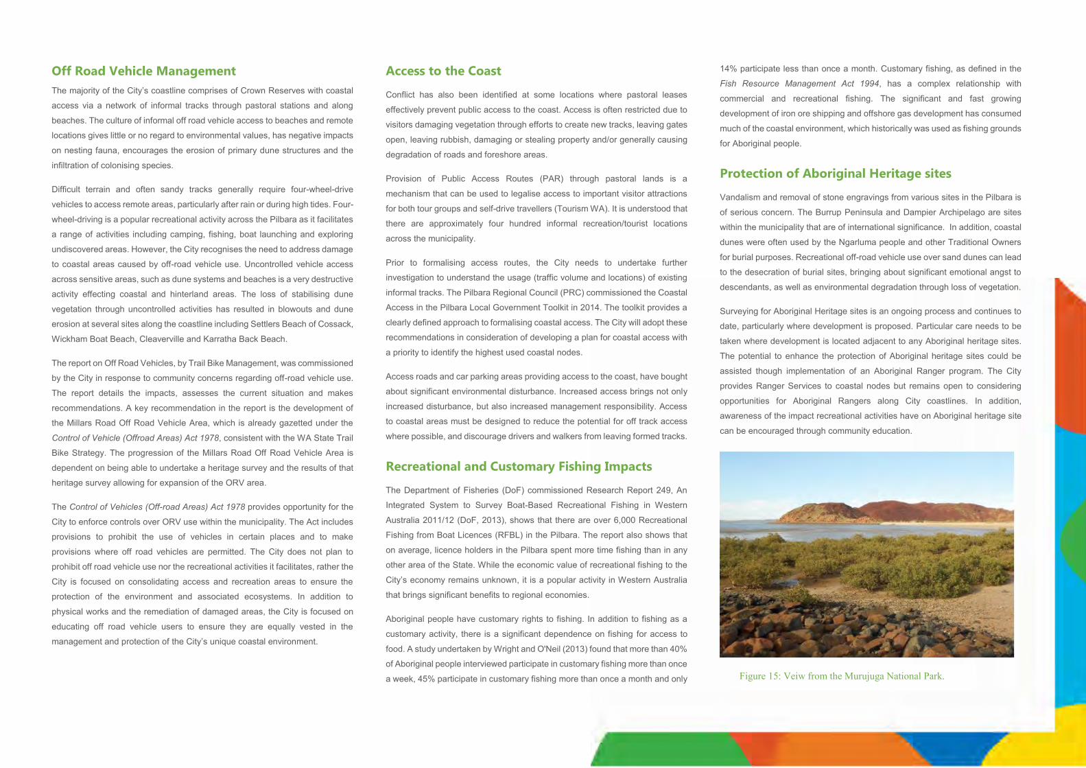
Off Road Vehicle Management
The majority of the City’s coastline comprises of Crown Reserves with coastal
access via a network of informal tracks through pastoral stations and along
beaches. The culture of informal off road vehicle access to beaches and remote
locations gives little or no regard to environmental values, has negative impacts
on nesting fauna, encourages the erosion of primary dune structures and the
infiltration of colonising species.
Difficult terrain and often sandy tracks generally require four-wheel-drive
vehicles to access remote areas, particularly after rain or during high tides. Four-
wheel-driving is a popular recreational activity across the Pilbara as it facilitates
a range of activities including camping, fishing, boat launching and exploring
undiscovered areas. However, the City recognises the need to address damage
to coastal areas caused by off-road vehicle use. Uncontrolled vehicle access
across sensitive areas, such as dune systems and beaches is a very destructive
activity effecting coastal and hinterland areas. The loss of stabilising dune
vegetation through uncontrolled activities has resulted in blowouts and dune
erosion at several sites along the coastline including Settlers Beach of Cossack,
Wickham Boat Beach, Cleaverville and Karratha Back Beach.
The report on Off Road Vehicles, by Trail Bike Management, was commissioned
by the City in response to community concerns regarding off-road vehicle use.
The report details the impacts, assesses the current situation and makes
recommendations. A key recommendation in the report is the development of
the Millars Road Off Road Vehicle Area, which is already gazetted under the
Control of Vehicle (Offroad Areas) Act 1978, consistent with the WA State Trail
Bike Strategy. The progression of the Millars Road Off Road Vehicle Area is
dependent on being able to undertake a heritage survey and the results of that
heritage survey allowing for expansion of the ORV area.
The Control of Vehicles (Off-road Areas) Act 1978 provides opportunity for the
City to enforce controls over ORV use within the municipality. The Act includes
provisions to prohibit the use of vehicles in certain places and to make
provisions where off road vehicles are permitted. The City does not plan to
prohibit off road vehicle use nor the recreational activities it facilitates, rather the
City is focused on consolidating access and recreation areas to ensure the
protection of the environment and associated ecosystems. In addition to
physical works and the remediation of damaged areas, the City is focused on
educating off road vehicle users to ensure they are equally vested in the
management and protection of the City’s unique coastal environment.
Access to the Coast
Conflict has also been identified at some locations where pastoral leases
effectively prevent public access to the coast. Access is often restricted due to
visitors damaging vegetation through efforts to create new tracks, leaving gates
open, leaving rubbish, damaging or stealing property and/or generally causing
degradation of roads and foreshore areas.
Provision of Public Access Routes (PAR) through pastoral lands is a
mechanism that can be used to legalise access to important visitor attractions
for both tour groups and self-drive travellers (Tourism WA). It is understood that
there are approximately four hundred informal recreation/tourist locations
across the municipality.
Prior to formalising access routes, the City needs to undertake further
investigation to understand the usage (traffic volume and locations) of existing
informal tracks. The Pilbara Regional Council (PRC) commissioned the Coastal
Access in the Pilbara Local Government Toolkit in 2014. The toolkit provides a
clearly defined approach to formalising coastal access. The City will adopt these
recommendations in consideration of developing a plan for coastal access with
a priority to identify the highest used coastal nodes.
Access roads and car parking areas providing access to the coast, have bought
about significant environmental disturbance. Increased access brings not only
increased disturbance, but also increased management responsibility. Access
to coastal areas must be designed to reduce the potential for off track access
where possible, and discourage drivers and walkers from leaving formed tracks.
Recreational and Customary Fishing Impacts The Department of Fisheries (DoF) commissioned Research Report 249, An
Integrated System to Survey Boat-Based Recreational Fishing in Western
Australia 2011/12 (DoF, 2013), shows that there are over 6,000 Recreational
Fishing from Boat Licences (RFBL) in the Pilbara. The report also shows that
on average, licence holders in the Pilbara spent more time fishing than in any
other area of the State. While the economic value of recreational fishing to the
City’s economy remains unknown, it is a popular activity in Western Australia
that brings significant benefits to regional economies.
Aboriginal people have customary rights to fishing. In addition to fishing as a
customary activity, there is a significant dependence on fishing for access to
food. A study undertaken by Wright and O'Neil (2013) found that more than 40%
of Aboriginal people interviewed participate in customary fishing more than once
a week, 45% participate in customary fishing more than once a month and only
14% participate less than once a month. Customary fishing, as defined in the
Fish Resource Management Act 1994, has a complex relationship with
commercial and recreational fishing. The significant and fast growing
development of iron ore shipping and offshore gas development has consumed
much of the coastal environment, which historically was used as fishing grounds
for Aboriginal people.
Protection of Aboriginal Heritage sites Vandalism and removal of stone engravings from various sites in the Pilbara is
of serious concern. The Burrup Peninsula and Dampier Archipelago are sites
within the municipality that are of international significance. In addition, coastal
dunes were often used by the Ngarluma people and other Traditional Owners
for burial purposes. Recreational off-road vehicle use over sand dunes can lead
to the desecration of burial sites, bringing about significant emotional angst to
descendants, as well as environmental degradation through loss of vegetation.
Surveying for Aboriginal Heritage sites is an ongoing process and continues to
date, particularly where development is proposed. Particular care needs to be
taken where development is located adjacent to any Aboriginal heritage sites.
The potential to enhance the protection of Aboriginal heritage sites could be
assisted though implementation of an Aboriginal Ranger program. The City
provides Ranger Services to coastal nodes but remains open to considering
opportunities for Aboriginal Rangers along City coastlines. In addition,
awareness of the impact recreational activities have on Aboriginal heritage site
can be encouraged through community education.
Figure 15: Veiw from the Murujuga National Park.
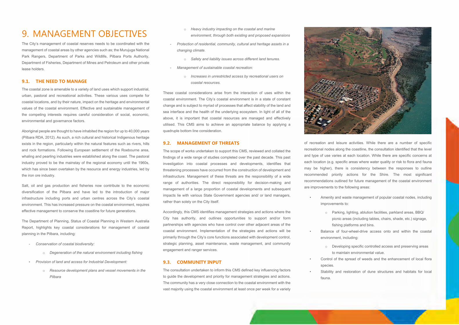
9. MANAGEMENT OBJECTIVES The City’s management of coastal reserves needs to be coordinated with the
management of coastal areas by other agencies such as; the Murujuga National
Park Rangers, Department of Parks and Wildlife, Pilbara Ports Authority,
Department of Fisheries, Department of Mines and Petroleum and other private
lease holders.
9.1. THE NEED TO MANAGE
The coastal zone is amenable to a variety of land uses which support industrial,
urban, pastoral and recreational activities. These various uses compete for
coastal locations, and by their nature, impact on the heritage and environmental
values of the coastal environment. Effective and sustainable management of
the competing interests requires careful consideration of social, economic,
environmental and governance factors.
Aboriginal people are thought to have inhabited the region for up to 40,000 years
(Pilbara RDA, 2012). As such, a rich cultural and historical Indigenous heritage
exists in the region, particularly within the natural features such as rivers, hills
and rock formations. Following European settlement of the Roebourne area,
whaling and pearling industries were established along the coast. The pastoral
industry proved to be the mainstay of the regional economy until the 1960s,
which has since been overtaken by the resource and energy industries, led by
the iron ore industry.
Salt, oil and gas production and fisheries now contribute to the economic
diversification of the Pilbara and have led to the introduction of major
infrastructure including ports and urban centres across the City’s coastal
environment. This has increased pressure on the coastal environment, requires
effective management to conserve the coastline for future generations.
The Department of Planning, Status of Coastal Planning in Western Australia
Report, highlights key coastal considerations for management of coastal
planning in the Pilbara, including:
- Conservation of coastal biodiversity:
o Degeneration of the natural environment including fishing
- Provision of land and access for Industrial Development:
o Resource development plans and vessel movements in the
Pilbara
o Heavy industry impacting on the coastal and marine
environment, through both existing and proposed expansions
- Protection of residential, community, cultural and heritage assets in a
changing climate.
o Safety and liability issues across different land tenures.
- Management of sustainable coastal recreation:
o Increases in unrestricted access by recreational users on
coastal resources.
These coastal considerations arise from the interaction of uses within the
coastal environment. The City’s coastal environment is in a state of constant
change and is subject to myriad of processes that affect stability of the land and
sea interface and the health of the underlying ecosystem. In light of all of the
above, it is important that coastal resources are managed and effectively
utilised. This CMS aims to achieve an appropriate balance by applying a
quadruple bottom line consideration.
9.2. MANAGEMENT OF THREATS
The scope of works undertaken to support this CMS, reviewed and collated the
findings of a wide range of studies completed over the past decade. This past
investigation into coastal processes and developments, identifies that
threatening processes have occurred from the construction of development and
infrastructure. Management of these threats are the responsibility of a wide
range of authorities. The direct responsibility for decision-making and
management of a large proportion of coastal developments and subsequent
impacts lie with various State Government agencies and/ or land managers,
rather than solely on the City itself.
Accordingly, this CMS identifies management strategies and actions where the
City has authority, and outlines opportunities to support and/or form
partnerships with agencies who have control over other adjacent areas of the
coastal environment. Implementation of the strategies and actions will be
primarily through the City’s core functions associated with development control,
strategic planning, asset maintenance, waste management, and community
engagement and ranger services.
9.3. COMMUNITY INPUT
The consultation undertaken to inform this CMS defined key influencing factors
to guide the development and priority for management strategies and actions.
The community has a very close connection to the coastal environment with the
vast majority using the coastal environment at least once per week for a variety
of recreation and leisure activities. While there are a number of specific
recreational nodes along the coastline, the consultation identified that the level
and type of use varies at each location. While there are specific concerns at
each location (e.g. specific areas where water quality or risk to flora and fauna
may be higher), there is consistency between the responses to outline
recommended priority actions for the Shire. The most significant
recommendations outlined for future management of the coastal environment
are improvements to the following areas:
• Amenity and waste management of popular coastal nodes, including
improvements to:
o Parking, lighting, ablution facilities, parkland areas, BBQ/
picnic areas (including tables, chairs, shade, etc.) signage,
fishing platforms and bins.
• Balance of four-wheel-drive access onto and within the coastal
environment, including:
o Developing specific controlled access and preserving areas
to maintain environmental value.
• Control of the spread of weeds and the enhancement of local flora
species.
• Stability and restoration of dune structures and habitats for local
fauna.
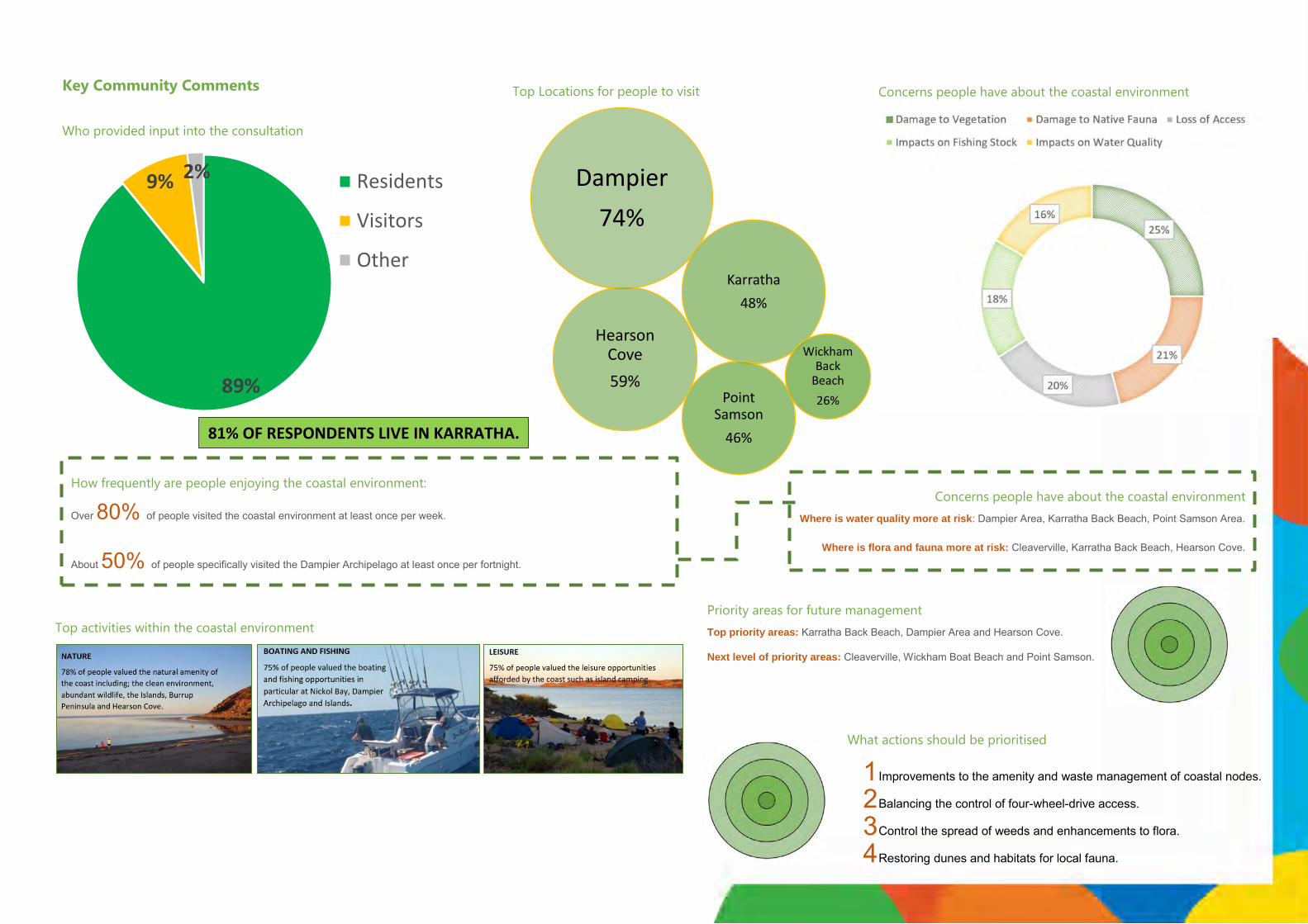
Key Community Comments
Who provided input into the consultation
89%
9% 2% Residents
Visitors
Other
81% OF RESPONDENTS LIVE IN KARRATHA.
Top Locations for people to visit
Concerns people have about the coastal environment
How frequently are people enjoying the coastal environment:
Over 80% of people visited the coastal environment at least once per week.
About 50% of people specifically visited the Dampier Archipelago at least once per fortnight.
Concerns people have about the coastal environment
Where is water quality more at risk: Dampier Area, Karratha Back Beach, Point Samson Area.
Where is flora and fauna more at risk: Cleaverville, Karratha Back Beach, Hearson Cove.
Priority areas for future management
Top priority areas: Karratha Back Beach, Dampier Area and Hearson Cove.
Next level of priority areas: Cleaverville, Wickham Boat Beach and Point Samson.
What actions should be prioritised
1 Improvements to the amenity and waste management of coastal nodes.
2 Balancing the control of four-wheel-drive access.
3 Control the spread of weeds and enhancements to flora.
4 Restoring dunes and habitats for local fauna.
Top activities within the coastal environment
Dampier
74%
Hearson Cove
59%
Karratha
48%
Point Samson
46%
Wickham Back
Beach
26%
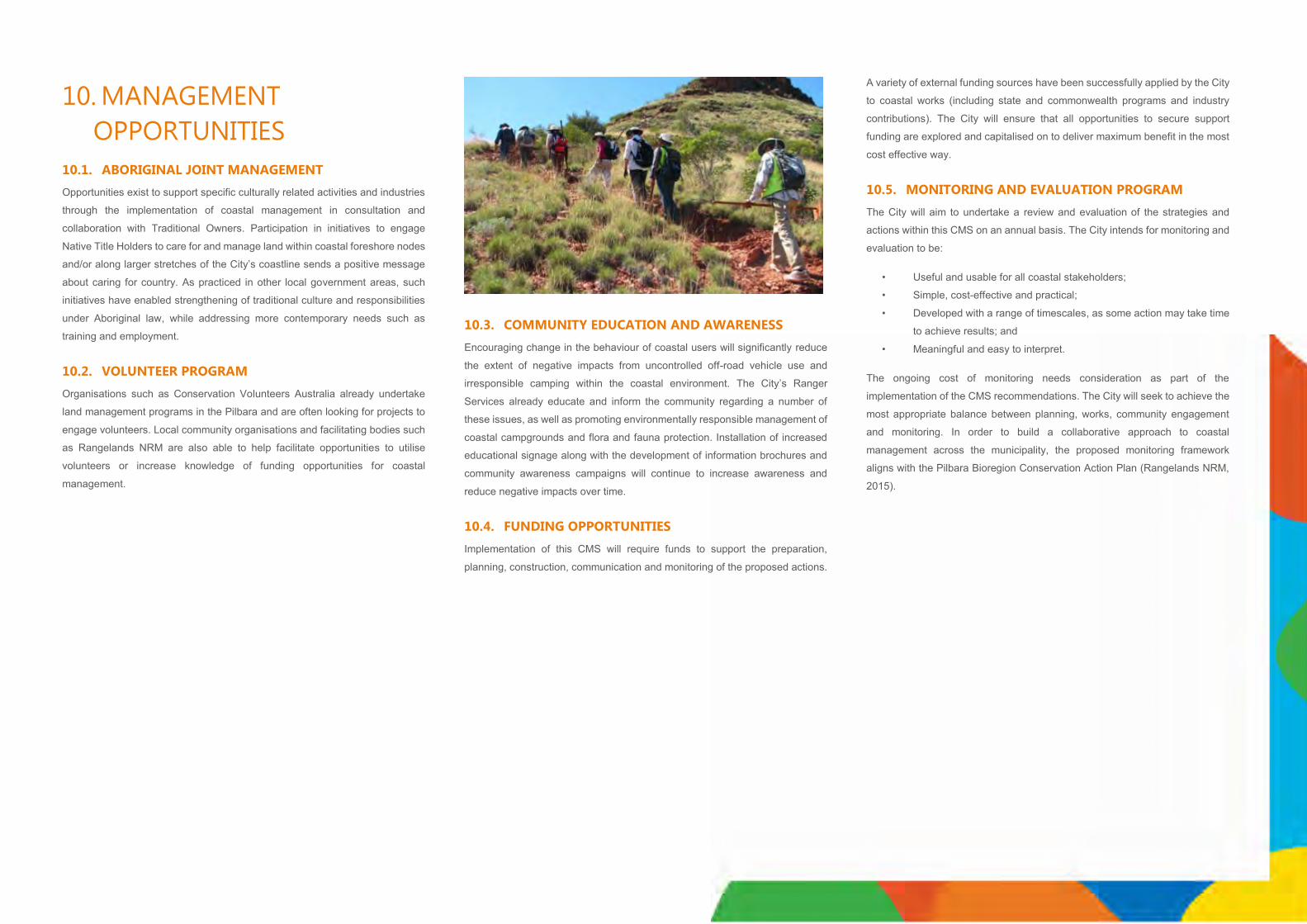
10. MANAGEMENT
OPPORTUNITIES
10.1. ABORIGINAL JOINT MANAGEMENT
Opportunities exist to support specific culturally related activities and industries
through the implementation of coastal management in consultation and
collaboration with Traditional Owners. Participation in initiatives to engage
Native Title Holders to care for and manage land within coastal foreshore nodes
and/or along larger stretches of the City’s coastline sends a positive message
about caring for country. As practiced in other local government areas, such
initiatives have enabled strengthening of traditional culture and responsibilities
under Aboriginal law, while addressing more contemporary needs such as
training and employment.
10.2. VOLUNTEER PROGRAM
Organisations such as Conservation Volunteers Australia already undertake
land management programs in the Pilbara and are often looking for projects to
engage volunteers. Local community organisations and facilitating bodies such
as Rangelands NRM are also able to help facilitate opportunities to utilise
volunteers or increase knowledge of funding opportunities for coastal
management.
10.3. COMMUNITY EDUCATION AND AWARENESS
Encouraging change in the behaviour of coastal users will significantly reduce
the extent of negative impacts from uncontrolled off-road vehicle use and
irresponsible camping within the coastal environment. The City’s Ranger
Services already educate and inform the community regarding a number of
these issues, as well as promoting environmentally responsible management of
coastal campgrounds and flora and fauna protection. Installation of increased
educational signage along with the development of information brochures and
community awareness campaigns will continue to increase awareness and
reduce negative impacts over time.
10.4. FUNDING OPPORTUNITIES
Implementation of this CMS will require funds to support the preparation,
planning, construction, communication and monitoring of the proposed actions.
A variety of external funding sources have been successfully applied by the City
to coastal works (including state and commonwealth programs and industry
contributions). The City will ensure that all opportunities to secure support
funding are explored and capitalised on to deliver maximum benefit in the most
cost effective way.
10.5. MONITORING AND EVALUATION PROGRAM
The City will aim to undertake a review and evaluation of the strategies and
actions within this CMS on an annual basis. The City intends for monitoring and
evaluation to be:
• Useful and usable for all coastal stakeholders;
• Simple, cost-effective and practical;
• Developed with a range of timescales, as some action may take time
to achieve results; and
• Meaningful and easy to interpret.
The ongoing cost of monitoring needs consideration as part of the
implementation of the CMS recommendations. The City will seek to achieve the
most appropriate balance between planning, works, community engagement
and monitoring. In order to build a collaborative approach to coastal
management across the municipality, the proposed monitoring framework
aligns with the Pilbara Bioregion Conservation Action Plan (Rangelands NRM,
2015).

11. MANGEMENT STRATEGIES Management Opportunities
Theme Strategies Actions Timeframe Internal Service
1 – 2 Years 2 – 5 Years 5 – 10 Years
1. Strategic and Statutory Alignment
Align strategies and actions outlined within the CMS with local and regional research, planning and management.
1.1 Implement actions in coordination with existing initiatives, programs and strategies.
1.2 Collect, consolidate and disseminate research and survey data undertaken by external agencies and organisations.
1.3 Develop key performance indicators to implement actions from the CMS.
1.4 Undertake annual review of CMS outcomes to confirm effective implementation and ensure consistency with other local and regional strategies.
Planning Services
2. Management Develop partnerships with other authorities and stakeholders to increase the capacity and effectiveness of managing the coastal environment.
2.1 Undertake land tenure audit to clarify the extent and range of ownership/ management of all land within the City’s coastal environment.
2.2 Develop suitable partnership(s)/ agreement(s) with various land managers to clarify the extent of responsibilities and opportunities to share resources to improve management and enforcement across the coastal environment.
2.3 Develop and implement a beach monitoring program, which firstly defines the holistic assessment area and outlines a range of success criteria determined on the type of land tenure and responsibility.
2.4 Investigate and define opportunities for an Aboriginal Rangers Program on City managed reserves through partnership(s) with relevant Native Title groups and Aboriginal Corporations.
2.5 Support programs and initiatives that actively engage the local community in managing the City managed reserves (e.g. school programs, clean-up days, etc.).
Planning Services
3. Funding Identify and secure funding to support the planning and management of the coastal environment.
3.1 Develop a Funding Attraction Strategy which links the defined coastal management objectives to the priority areas of funding agencies and vested stakeholders. The strategy should outline an approach to secure existing coastal specific funding and identify opportunities from wider funding programs (e.g. investigate availability of Indigenous specific funding to support development of an Aboriginal Ranger Program).
3.2 As a priority seek funding to complete Foreshore Management Plans for the priority coastal node locations. 3.3 Advocate for longer term support and consistent funding to ensure that longer term strategies can be achieved. 3.4 Encourage and support community groups and research organisation to obtain funding to investigate biodiversity
protection and management within the City’s coastal environment.
Planning Services and Community Engagement
4. Education Increase community awareness and ownership of the coastal environment.
4.1 Develop a Coastal Education Program to ensure ongoing public education and engagement programs (e.g. developing coastal signage) to encourage biodiversity conversation. This needs to demonstrate the environmental loss and management challenges from inappropriate use and development of the coast.
4.2 Investigate opportunities to incorporate Aboriginal heritage awareness within coastal education initiatives. 4.3 Ensure the cost of implementing public education and engagement programs are defined and incorporated into
funding submissions and the City’s long term financial planning. 4.4 Continue to undertake community and visitor surveys to understand the effectiveness of coastal management
strategies.
Planning Services and Community Engagement

Conservation of Coastal Biodiversity
Theme Strategies Actions Timeframe Internal Service
1 – 2 Years 2 – 5 Years 5 – 10 Years
5. Priority Locations
In collaboration with coastal land managers/ owners, identify priority locations for coastal biodiversity protection and enhancement.
5.1 Develop an inventory in ongoing collaboration with relevant agencies, (e.g. categories and priorities) of significant natural landscapes, flora and fauna, ecological communities, cultural heritage values and lookouts.
5.2 Undertake gap analysis (in ongoing collaboration with relevant agencies) of flora and fauna surveys within the costal environment and prioritise location requiring further investigation.
5.3 Define the significant importance of various coastal locations (in ongoing collaboration with relevant agencies), and incorporate these across relevant agency strategies (e.g. Foreshore Management Plans).
5.4 Install interpretative signage in priority locations where important fauna, such as turtles and seabirds, are present.
5.5 Assess and modify existing beach access and coastal development (e.g. lighting) to avoid negative impacts on fauna habitats.
Planning Services
Infrastructure Services
6. Spread of Weeds
In collaboration with coastal land managers/ owners, identify and reduce the spread of invasive weed species.
6.1 Inspect, monitor and map locations of invasive weeds across City reserves. Where appropriate, ensure flora surveys are undertaken in the development of Foreshore Management Plans.
6.2 Develop and implement a shared approach/ strategy for long-term weed control and flora rehabilitation in collaboration with relevant coastal managers and owners,.
Planning Services and Ranger Services
7. Destructive and Feral Fauna
In collaboration with coastal land managers/ owners, develop feral fauna eradication program(s) and grazing controls.
7.1 Develop an inventory (e.g. categories and priorities) of native fauna populations and habitants (in ongoing collaboration with relevant agencies and coastal land managers/ owners).
7.2 Develop a strategy which outlines how to share resources to eradicate feral fauna and protect native fauna (in ongoing collaboration with relevant agencies and coastal land managers/ owners).
7.3 Develop a strategy to protect native fauna habitats from cattle grazing, especially in regards to rare fauna (in ongoing collaboration with relevant agencies and coastal land managers/ owners).
Planning Services and Ranger Services
8. Dune and Erosion Control
In collaboration with coastal land managers/ owners, identify vulnerable coastal dune systems and encourage improvement strategies.
8.1. Survey and identify low, medium and high risk erosion locations and conduct regular monitoring for signs of natural or man-made disturbance as they occur (e.g. informal tracks, loss of vegetation cover, etc.).
8.2. Identify physical mechanisms, including fencing, to control inappropriate beach access.
8.3. Increase community responsibility and ownership of dune systems and the high priority for protection.
8.4. Encourage revegetation of coastal dune systems.
8.5. Continue to undertake foreshore and dune works as identified within the City’s Foreshore Works Plans, and look to include additional works as they are identified.
8.6. Investigate the benefits of establishing a plant nursery for raising tube-stock for revegetation planting.
Planning Services and Ranger Services

Balancing the Provision of Land and Access for Industrial Development
Theme Strategies Actions Timeframe Internal Service
1 – 2 Years 2 – 5 Years 5 – 10 Years
9. Control of Industrial Emissions and Impacts
Support industrial and port development in a way that minimises and mitigates emissions, while protecting the surrounding biodiversity and sensitive land uses.
9.1 Establish ongoing discussions with industrial operators, or representative bodies, to align priorities and negotiate opportunities where industrial operations can offset impacts through contribute to biodiversity values (e.g. management funding, delineation of conservation estates, revegetation programs, etc.).
9.2 Progress and implement land use buffers around industrial areas and infrastructure within the City’s Local Planning Scheme in accordance within State Planning Policy 4.1 – State Industrial Buffer.
9.3 Ensure where development applications for industrial development within or adjacent to the coastal environment are submitted with the City, a multi-agency referral and consideration is undertaken.
Partnerships
Planning Services.
10. Industrial Coastal Access
Define coastal access specific to industrial areas and ports while managing and maintaining community access to the coast.
10.1 Collate and disseminate information to the community and visitors on existing industrial, marine and land based, access routes to outline the location and purpose of restricted areas.
10.2 Ensure the community has the opportunity to provide comments when development applications are received which propose to restrict existing recreational coastal access.
Planning Services
11. Extraction of Basic Raw Materials
Ensure the extraction of basic raw materials is undertaken with respect to the natural environment and community interests.
11.1 Implement the City’s Local Planning Policy DP26 – Basic Raw Materials Policy for applications on privately owned land.
11.2 Establish ongoing discussions with the Department of Mines and Petroleum (DMP) to discuss applications on Crown owned land to identify the City’s priorities and concerns for basic raw materials, as outlined within DP26.
11.3 Ensure responses to referrals from the DMP are made when they are received.
Planning Services
Protection of Existing and Future Residential, Community and Heritage Assets
Theme Strategies Actions Timeframe Internal Service
1 – 2 Years 2 – 5 Years 5 – 10 Years
12. Settlements Planning and development of coastal settlements is undertaken equitably across the coastal environment consistent with community use and values.
12.1 Ensure that development is focused within identified coastal nodes, and prior to further expansion of these coastal nodes, Foreshore Management Plan are prepared to address site specific considerations.
12.2 Investigate the opportunities for the Fortescue River and Balla Balla reserves being vested to the City for management, with the possibility of an Aboriginal Ranger Service having responsibility.
Planning Services
13. Coastal Hazard Risk
Development and use of land within the coastal environment is undertaken with consideration of coastal hazard risks.
13.1 Scheme Amendments, Subdivision and Development Applications should address the potential coastal hazard risk, including sea level rise, in accordance with State Planning Policy 2.6 – State Coastal Planning Policy.
13.2 Review the existing City of Karratha Coastal Hazard Risk Management Adaptation Plan in consideration of all existing coastal vulnerability studies and flood management plans.
Planning Services
14. Cultural Protection
Increase the awareness and protection of Aboriginal cultural heritage sites across the coastal environment.
14.1 Engage with Native Title Holders and Aboriginal Corporations to identify opportunities to increase the involvement Aboriginal people in coastal management.
14.2 Develop partnerships with Native Title Holders and Aboriginal Corporations to develop interpretive signage at historic and/ or cultural significance.
14.3 Support the identification and protection of Aboriginal Heritage sites through appropriate registration and culturally sensitive approach to recreational activities and coastal development.
Community Engagement Planning Services
15. Stormwater Runoff
Manage the physical interactions between stormwater catchment runoff and coastal processes.
15.1 Implement the actions as outlined within the City of Karratha Water Management Strategy, and the specific District and Urban Water Management Strategies.
15.2 Implement the actions as outlined within the City of Karratha Water Action Conservation Plan aimed at conserving water, improving onsite infiltration of storm water and removing pollutants from storm water runoff.
Infrastructure Services
All Staff

Management of Sustainable Coastal Recreation
Theme Strategies Actions Timeframe Internal Service
1 – 2 Years 2 – 5 Years 5 – 10 Years
16. Recreation Coastal Access
Formalise and control public access onto and within the coastal environment.
16.1 Undertake coastal usage audit at coastal nodes and informal beach locations to define the type and frequency of access onto and within these locations, and identify any existing control mechanisms and signage.
16.2 Identify priority coastal nodes and locations and implement and maintain a range of control mechanisms including formal parking, access tracks, fencing and signage. This should be outlined within a separate Coastal Access Strategy and/ or included within the City’s asset management planning.
16.3 Ensure community consultation is undertaken prior to any changes to coastal access being undertaken. 16.4 Continue to control informal camping within the City’s coastal reserves.
Planning Services and Ranger Services
17. Infrastructure Development
Recreation infrastructure is designed and constructed for use by the widest possible population, into the future and in consideration of whole of life costs.
17.1 Complete Foreshore Management Plans to identify recreational developments/ upgrades to sustainably meet population demands.
17.2 Prioritise new amenity infrastructure development across coastal nodes as outlined by the community and/ or as required to preserve biodiversity or prevent erosion.
17.3 Ensure that infrastructure is designed with consideration of coastal hazard risks over the asset life span.
17.4 Undertake a review of the City asset management and long term financial planning, as appropriate, to incorporate the cost of maintenance of existing infrastructure and the provision of new infrastructure.
17.5 Ensure disability inclusion principles are incorporated within the design and construction of new recreational infrastructure and amenities.
17.6 Undertake regular monitoring of recreational infrastructure.
Asset Management
Leisure Planning
18. Recreational Fishing
Control the impact of recreational fishing through land use planning, community education and mitigation options.
18.1 Incorporate ‘No Take Zone’ controls for designated areas within community education programs. 18.2 Review facilities and practises for fish waste disposal at boat ramps, jetties and coastal nodes to determine if
best practise are being undertaken, and look to establish partnerships to improve standards. 18.3 Assist agencies, organisation and community groups to increase awareness of recreational fishing on
selected beaches within identified fauna nesting areas.
Planning Services
Community Engagement
19. Vehicle Management
Balance the use and impacts of off-road-vehicle onto and within the coastal environment.
19.1 Enforce the provisions as outlined within the Control of Vehicle (Off-Road Areas) Act 1978 as outlined within the City’s Off-Road Vehicle Information brochure.
19.2 Review community and visitor awareness of off-road access and safety within the coastal environment, and incorporate increased awareness within community education initiatives.
19.3 Implement the management recommendations within the Off Road Vehicle Report.
19.4 Require that signage is installed at select beaches to deter vehicle access during fauna nesting periods.
19.5 Investigate opportunities to provide additional off-road-vehicle areas to compensate use of the coastal environment should access be restricted at certain locations.
Ranger Services
Infrastructure Services
Planning Services
20. Waste Control Maintain and improve the experience and responsibility of the community and visitors.
20.1 Require that adequate bins are provided across at identified coastal nodes, and incorporate signage at less formal coastal nodes to encourage the community and visitors to clean up and take rubbish with them.
20.2 Monitor the coastal environment to identify dumping areas for vegetation/ garden waste, industrial waste and other debris within the coastal environment. Where regular dumping is occurring, develop strategies to target illegal dumping.
Ranger Services


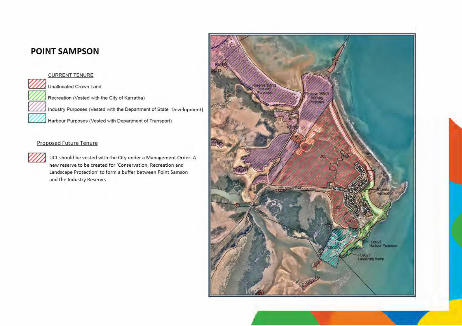


Wickham Boat Beach

Author Title Date
Acil Tasman FIFO and Regional Impact Assessments Jan 2009
AEC Group Pilbara Tourism Product Development Plan 2014
Astron Engineering Cleaverille Beach – Existing Environment And Management Issues (Draft)
Dec 1998
Astron Engineering Karratha Accommodation Study May 1999
Bob O’Sullivan Coastal Strategy Plan (Draft) Nov 2008
BoM Cape Lambert Storm Surge Study April 1998
BoM Climate Statistics for Australian Locations: Karratha Aero, Dampier Salt, Roebourne, Cossack and Roebourne Aero
March 2013
CARDNO DRAFT Point Samson Structure Plan 2015
CBRE Industrial Land Supply Analysis – Pilbara Region 2013
Chamber of Minerals & Energy and PWC
State Growth Outlook 2011
Chamber of Minerals and Energy of WA & PWC
WA State Growth Outlook 2011 April 2011
City of Karratha Coastal Management Strategy, Stakeholder Engagement Plan.
2016
City of Karratha Draft Local Planning Strategy 2016
City of Karratha Storm Surge Risk Policy – DP19 2016
City of Karratha Local Government Heritage Inventory 2014
City of Karratha Coastal Hazard Risk Management Adaptation Plan
2016
City of Karratha DRAFT Dampier Community Hub Management Plans
2014
City of Karratha Operational Economic Development Strategy 2014-16
2014
CODA Pilbara Vernacular Handbook Dec 2011
CSRIO Priority Threat Management for Pilbara Species of Conservation Significance
2014
CSIRO Pilbara Regional Mining Climate Change Workshop Outcomes
Dec 2011
CSIRO Priority Threat Management for Pilbara Species of Conservation Significance
2014
Dampier Port Authority Dampier Port Authority – Development Guidelines
Dec 2006
Dampier Port Authority Port of Dampier – Land Use and Infrastructure Plan 2014
2014
Dept of Agriculture Salinity Investigations at Karratha Sep 1975
Dept of Conservation and Land Management
Burrup Peninsula Recreation and Tourism Masterplan
Feb 1999
Dept. Conservation and Land Management
The Biodiversity Audit for the Pilbara 2002
Dept of Conservation and Land Management
Indicative Management Plan for the Proposed Dampier Archipelago Marine Park and Cape Preston Marine Management Area
2005
Author Title Date
Dept of Conservation and Land Management
Dampier Archipelago Nature Reserves Management Plan
May 1990
Dept of Conversation and Land Management
Murujuga National Park Management Plan 2013
Dept of Environment & Conversation
Biodiversity Conservation Strategy for WA (Draft)
2006
Dept of Environment and Conservation
Proposed Burrup Peninsula Conservation Reserve Management Plan (Draft)
2006
Dept. of Fisheries An integrated system to survey boat-based recreational fishing in Western Australia 2011/12.
2013
Dept of Housing and Pilbara Development Commission
Pilbara Towns Housing Study
Dept of Mineral & Petroleum Resources
King Bay – Hearson Cove Precinct Plan Aug 2002
Dept. of Planning Geology, Geomorphology and Vulnerability of the Pilbara Coast
2013.
Dept of Water Pilbara Coast Water Study Feb 2009
Dept of Water Pilbara Groundwater Allocation Plan (Draft) 2012
Dept of Water Pilbara Regional Water Plan Nov 2008
Dept of Water Pilbara Regional Water Plan June 2010
Dept of Water Pilbara Regional Water Plan (Draft) Nov 2008
Dept of Water State Water Plan 2007
Dept Regional Development and Lands
Pilbara Cities Vision 2012
EPA Environmental Protection and Ecological Sustainability of the Rangelands in WA, Position Statement No. 4
2004
EPA Guidance for the Assessment of Environmental Factors No. 51: Terrestrial Flora and Vegetation Surveys for Environmental Impact Assessment in Western Australia
2004
EPA Guidance for the Assessment of Environmental Factors No. 56: Terrestrial Fauna Surveys for Environmental Impact Assessment in Western Australia
2004
EPA Guidance for the Assessment of Environmental Factors No. 3: Separation Distances Between Industrial and Sensitive Land Uses
2005
EPCAD Pty Ltd Dampier Enhancement Initiative 2014
Essential Environmental
Pilbara Strategic Regional Land Use Plans (Draft)
Sep 2010
Essential Environmental/ RDA Pilbara
Pilbara State of the Environment Report June 2013
Essential Environmental
Gnoorea (40 Mile) Foreshore Management Plan (Draft)
2013
Essential Environmental
Karratha Foreshore Management Plan (Draft) 2013
Author Title Date
Essential Environmental
Point Samson Foreshore Management Plan (Draft)
2013
Geographia & CCS Strategic Management
Karratha 2020 Vision and Accommodation Plan Jan 2009
GHD Burrup Industrial Estate – Optimal Use of Sites Jan 2010
GHD Burrup Support Industry Land Investigation Aug 2007
GHD Karratha Drainage Management Plan Oct 2010
GHD Pilbara Towns Water Supply Infrastructure Modelling and Planning Study
Oct 2008
Global Environment Monitoring Systems
West Pilbara Cyclone Surge Inundation Study June 2009
Gresley Abas DRAFT Dampier Hub Design Development Report
2014
Haig, T./ Dept of Water The Pilbara Coast Water Study 2009
Hassell Karratha Vernacular 2011
Heritage Council Cossack – Conservation Policy 1996
Heuris Partners Ltd Planning for Resources Growth in the Pilbara – Employment and Population Projections
Aug 2008
Heuris Partners Ltd Planning for Resources Growth: Revised Employment and Population Projections
April 2010
JDA Consultant Hydrologists
Dampier Coastal Vulnerability Study Mar 2012
JDA Consultant Hydrologists
Karratha Coastal Vulnerability Study Aug 2012
JCY Architects Karratha Cultural Precinct – Concept Design Report Vol. 1
Jan 2014
Landcorp Karratha City Masterplan 2010
Landcorp Karratha City of the North Town Revitalisation May 2010
Landcorp Karratha City Revitalisation Brochure June 2010
Landcorp Karratha Community Revitalisation Plan May 2010
Landcorp Karratha Implementation Plan 2010
Landcorp Karratha Town Centre Revitalisation Project Dec 2009
Loechel, B., Hodgkinson, J.H. and Moffat, K.
Pilbara Regional Mining Climate Change Adaptation Workshop: Report on Workshop Outcomes
2011
MacroPlan Dimassi Karratha Homemaker Centre WA – Assessment of Market Potential
2014
Main Roads/ GHD Karratha-Wickham Coastal Route Feasibility Study
2012
MetOcean Engineers Pty Ltd
Cyclic and Non-Cyclic Ocean Waves Study April 2004
Murdoch University Pilbara Regional Sustainability Strategy June 2005
O’Brien Planning Consultants
Municipal Heritage Inventory Part 1 & 2 April 1996
Appendix Two: References Appendix Two: References Appendix Two: References

Author Title Date
Pilbara Area Consultative Committee Inc
The Pilbara Plan
Pilbara Development Commission
Pilbara Commercial Property and Land Snapshot
Dec. 2013
Pilbara Development Commission
Pilbara Housing And Land Snapshot Oct. 2014
Pilbara Development Commission
Pilbara Infrastructure Needs Current & Future (Draft)
1998
Pilbara Development Commission
Pilbara Regional Priority Plan Oct 2005
Pilbara Development Commission
Pilbara/Gascoyne Islands Ecotourism Management Strategy
1995
Pilbara Development Commission
Summary of Housing and Accommodation Initiatives in the Pilbara
July 2009
Pilbara Iron – Rio Tinto Understanding the Pilbara Region and its Economy
Pilbara Regional Council
Coastal Access in the Pilbara, Local Government Toolkit
2014
Rangelands NRM Pilbara Bioregion Conservation Action Plan 2015
Regional Development Australia Pilbara
Pilbara Report Investment Prospectus 2012 2012
Regional Development Australia Pilbara
Regional Development Australia Strategic Plan 2011-2014
2010
Regional Development Australia Pilbara
Regional Development Policy Framework 2012-2017
2011
Rehbein Airport Consulting
Karratha Airport Masterplan (Draft) Jan 2013
Riley Consulting Supplementary Transport Paper for LPS 2014
Rio Tinto Cape Lambert Port B Development Mar 2009
Rio Tinto Wickham Town Structure Plan
2011
Roberts Day Group DRAFT Karratha Revitalisation Strategy 2015
RPS Group Transient Worker Accommodation April 2011
SGS Economics and planning for DPI
Karratha Primary Trade Area Retail and Commercial Strategy
Feb 2008
SGS Economics and planning for DPI
Karratha Primary Trade Area Retail and Commercial Strategy - Part B
July 2009
Shire of Roebourne Cleaverville Area Foreshore Management Plan 2005
Shire of Roebourne Coastal Management Strategy (Draft) June 2005
Shire of Roebourne Foreshore Management Plan (Draft) July 2005
Shire of Roebourne Karratha Open Space Strategy (Draft) June 2008
Shire of Roebourne Environmental Strategy 2013
Shire of Roebourne Shire of Roebourne Major Land Transaction Business Plan (Draft)
2013
Shire of Roebourne Strategic Community Plan 2011 - 2021 2011
Shire of Roebourne Strategic Community Plan 2012 - 2022 2012
Author Title Date
Shire of Roebourne Strategic Plan 2009 – 2013 2009
Syme Marmion and Co Extractive Industry and Sustainable Regional Development
June 2010
Syme Marmion and Co Industrial Land in the Eastern Corridor of the Shire of Roebourne
Aug 2013
Syme Marmion and Co Shire of Roebourne Workforce Plan (Draft)
2012
Taylor Burrell Barnett Wickham South Development Plan Nov 2010
Taylor Burrell Barnett Wickham Townsite Structure Plan Jan 2011
Trail Bike Management Pty Ltd
Towards an effective Off Road Vehicle Strategy 2012
UDLA Wickham Boat Beach Foreshore Management Plan
2016
UDLA Hearson Cove Foreshore Management Plan 2016
UDLA Roebourne Structure Plan 2014
UDLA Cossack Visioning Document 2014
Urbis Dampier Townsite Redevelopment and Revitalisation Strategy (Draft)
July 2013
WA Tropical Cyclone Industrial Liaison Committee
Karratha Storm Surge Inundation Study Nov 1996
WAPC Karratha Area Development Strategy April 1998
WAPC Karratha Land Development Program – Land Release Plan
April 1997
WAPC Karratha Land Use Survey 1997 April 1997
WAPC Karratha Regional Hotspots Land Supply Update Dec 2010
WAPC Local Planning Manual Mar 2010
WAPC Pilbara Framework Regional Profile + Appendices
Aug 2009
WAPC Pilbara Infrastructure Priorities June 2010
WAPC Pilbara Planning and Infrastructure Framework Jan 2012
WAPC Planning Provisions for Affordable Housing Discussion Paper
Oct 2013
WAPC State Coastal Planning Policy Guidelines July 2013
WAPC State Planning Strategy (Draft) 2012
WAPC Status of Coastal Planning in WA Jan 2010
WAPC WA Tomorrow Forecast Summary – LGAs of WA
Feb 2012
WAPC WA Tomorrow Forecast Summary – Roebourne Feb 2012
Water Reform Implementation Committee
A blueprint for Water Reform in WA Dec 2006
Wright and O’Neill Ancient Traditions Carry On. FISH, June 2014 Vol. 22.
June 2014
Appendix Two: References Appendix Two: References


![Hydro-Meteorological Trends in Southwest Coastal ...saciwaters.org/periurban/pdfs/peer-reviewed-papers... · the world [2]. Cyclone, storm surge induced flooding, riverine coastal](https://img.pdfslide.net/doc/110x75/601efb99750b226b2f1dfc9d/hydro-meteorological-trends-in-southwest-coastal-the-world-2-cyclone-storm.jpg)