Embed Size (px)
Citation preview

© Amec Foster Wheeler 2016.
Coastal SC CRS Users Group Activity 420 - Open Space Preservation
May 18, 2017

420 – Open Space Preservation
2 © Amec Foster Wheeler 2016.
Objectives: (1) Prevent flood damage by keeping floodprone lands
free of development, and (2) Protect and enhance the natural functions of floodplains.
Manual Page 420-3

420 – Open Space Preservation
3 © Amec Foster Wheeler 2016.
422.a Open space preservation (OSP) Credit criteria (1) Parcel must be in the regulatory floodplain SFHA + areas regulated in the X Zone
Manual Page 420-4

420 – Open Space Preservation
4 © Amec Foster Wheeler 2016.
(2) Parcel must be “open space” “Open space” = no buildings, storage, or filling
Manual Page 420-4

420 – Open Space Preservation
© Amec Foster Wheeler 2016. 5
“Open space” does not include (a) Parcels not counted in the impact adjustment map
(open bodies of water, federal land, etc..)
Manual Page 420-4

420 – Open Space Preservation
© Amec Foster Wheeler 2016. 6
“Open space” does not include (b) Areas with impervious surfaces
Manual Page 420-4

420 – Open Space Preservation
© Amec Foster Wheeler 2016. 7
“Open space” does not include (c) Areas with buildings on them
Manual Page 420-4

420 – Open Space Preservation
© Amec Foster Wheeler 2016. 8
“Open space” does not include (d) Where fill, storage, or other encroachments are allowed
Manual Page 420-5

420 – Open Space Preservation
© Amec Foster Wheeler 2016. 9
“Open space” does not include (e) Streets, railroad, levee, linear rights of way, etc..
Manual Page 420-5

420 – Open Space Preservation
© Amec Foster Wheeler 2016. 10
“Open space” does not include (e) Streets, railroad, levee, linear rights of way, etc.. Including ditch or channel rights of way
Manual Page 420-5

420 – Open Space Preservation
© Amec Foster Wheeler 2016. 11
“Open space” does not include (e) Streets, railroad, levee, linear rights of way, etc.. Exception: waterside greenways
Manual Page 420-5

420 – Open Space Preservation
© Amec Foster Wheeler 2016. 12
“Open space” does not include (f) Land not intended to be preserved as open space
Manual Page 420-6

420 – Open Space Preservation
© Amec Foster Wheeler 2016. 13
(3) Parcel must be preserved as “open space” (a) Publicly owned land, city park, beach, school field, etc.
Manual Page 420-6

420 – Open Space Preservation
© Amec Foster Wheeler 2016. 14
(3) Parcel must be preserved as “open space” (b) Private wildlife or nature preserve, church camp,
scout camp, hunting club, non-profit golf course
Manual Page 420-6
420 – Open Space Preservation
© Amec Foster Wheeler 2016. 15
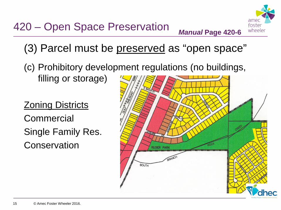
(3) Parcel must be preserved as “open space” (c) Prohibitory development regulations (no buildings,
filling or storage)
Zoning Districts Commercial Single Family Res. Conservation
Manual Page 420-6

420 – Open Space Preservation
© Amec Foster Wheeler 2016. 16

402 – Impact Adjustment for Areas
© Amec Foster Wheeler 2016. 17
Impact adjustment: how much of the flood problem is covered by the activity? 400 Series: How much of the SFHA is affected? Need an impact adjustment ratio: percentage of the
SFHA affected by the activity Example for open space:
rOSP = aOSP aSFHA
Need an Impact Adjustment Map
Manual Page 400-4
402 – Impact Adjustment for Areas
18 © Amec Foster Wheeler 2017.
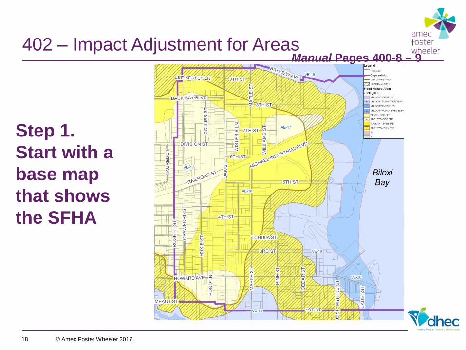
Step 1. Start with a base map that shows the SFHA
Manual Pages 400-8 – 9

402 – Impact Adjustment for Areas
19 © Amec Foster Wheeler 2017.
Step 2. Can exclude areas not part of impact adjustment
1. Open water > 10 acres
Manual Pages 400-8 – 9

402 – Impact Adjustment for Areas
20 © Amec Foster Wheeler 2017.
1. Open water > 10 acres
Manual Page 400-10

402 – Impact Adjustment for Areas
21 © Amec Foster Wheeler 2017.
1. Open water > 10 acres
Manual Pages 400-8 – 9

402 – Impact Adjustment for Areas
22 © Amec Foster Wheeler 2017.
Manual Page 400-8

402 – Impact Adjustment for Areas
23 © Amec Foster Wheeler 2017.

402 – Impact Adjustment for Areas
24 © Amec Foster Wheeler 2017.

402 – Impact Adjustment for Areas
25 © Amec Foster Wheeler 2017.
Step 3. Mark each area to be credited
Manual Page 400-10

402 – Impact Adjustment for Areas
26 © Amec Foster Wheeler 2017.
403.e. Calculating areas Calculations do not have to be super
accurate ► GIS is easiest, if you have it
► Known property dimensions
► Grid square technique
All measurements in acres
Manual Page 400-11

420 – Open Space Preservation Manual Page 420-9
Mark the areas Calculate acreage Add up to equal aOSP

Documentation (a) Map or list of all parcels to be credited (b) Documentation that each parcel will be preserved (c) If credit for prohibitory regulations – the regulations (d) If outside the SFHA – the regulations for the area (e) Impact adjustment map
Manual Pages 420-10 – 11 420 – Open Space Preservation

422.b Deed restrictions (DR) Extra credit to guarantee parcel stays open
Manual Page 420-12 420 – Open Space Preservation

422.b Deed restrictions (DR) (1) Parcel must qualify for OSP (2) Deed restriction must cover:
A. No new buildings may be allowed on the property, B. The restriction runs with the land, and C. The restriction cannot be changed by a future owner
Manual Page 420-12 420 – Open Space Preservation
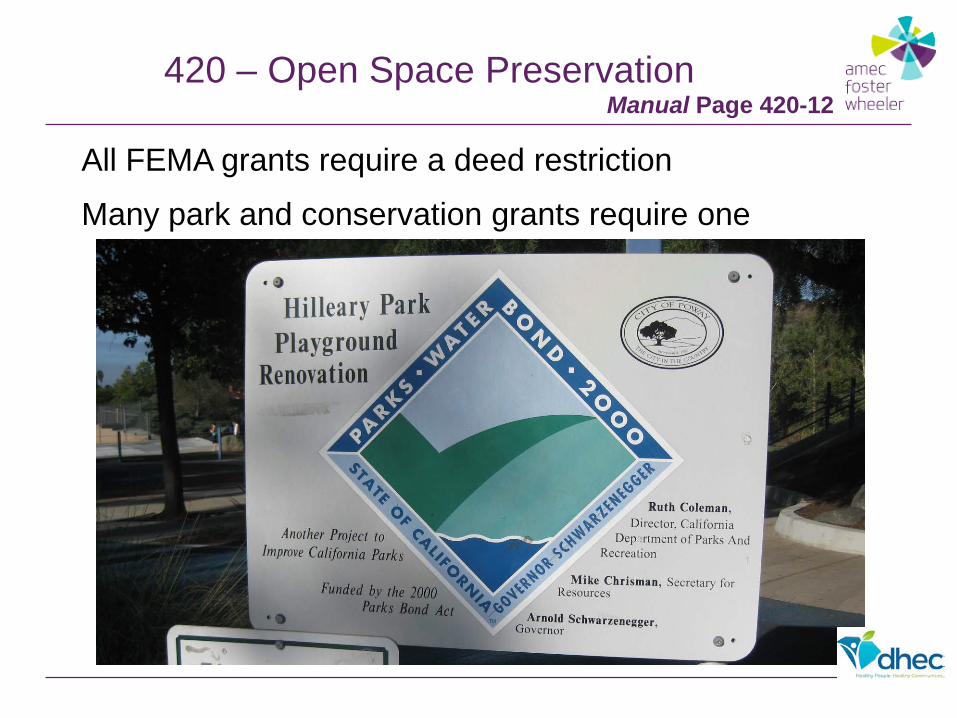
All FEMA grants require a deed restriction Many park and conservation grants require one
Manual Page 420-12 420 – Open Space Preservation

422.c Natural functions open space (NFOS) Open space in its natural state provides more benefits: • Flood storage • Reduced sedimentation • Water quality • Aquifer recharge • Richer soils • Biodiversity • Habitat
Manual Page 420-14 420 – Open Space Preservation

422.c Natural functions open space (NFOS) Credit criteria: 1. All NFOS(1 – 4)
(a) OSP credit (b) NFOS1 is a prerequisite
for the others (c) Is managed to stay in
its natural state (d) Plot on impact
adjustment map
Manual Page 420-14 420 – Open Space Preservation

NFOS1 Parcel in its natural state Examples: • Areas not built on • Restored to natural state • Designated by recognized program Not credited: • Scenic designation • Recreational areas • Clear cutting allowed • Dune/beach nourishment
Manual Page 420-15 420 – Open Space Preservation

NFOS2 Parcel in its natural state Designated in Plan: • Areas not built on • Restored to natural state • Designated by recognized program • Parcels credited in NFOS1 Types of Plans • Habitat Protections • Habitat Conservation • Habitat Restoration • Fish & Wildlife or State Approved
Manual Page 420-16 420 – Open Space Preservation

NFOS3 Parcel in its natural state Designated as Critical Habitat: • Areas not built on • Restored to natural state • Designated by recognized program • Parcels credited in NFOS1 • Threatened or endangered spiecies Types of Plans • Habitat Protections • Habitat Conservation • Habitat Restoration • Fish & Wildlife or State Approved
Manual Page 420-16 420 – Open Space Preservation

NFOS4 – Parcel in a designated open space corridor
Manual Page 420-16 420 – Open Space Preservation

NFOS Documentation (1) Report or (2) Letter or form signed by a professional
Manual Pages 420-17 420 – Open Space Preservation

Questions
© Amec Foster Wheeler 2016. 39