Embed Size (px)
Citation preview
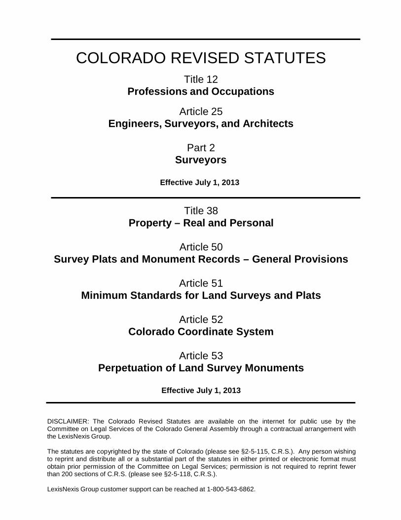
COLORADO REVISED STATUTES
Title 12 Professions and Occupations
Article 25 Engineers, Surveyors, and Architects
Part 2
Surveyors
Effective July 1, 2013
Title 38 Property – Real and Personal
Article 50
Survey Plats and Monument Records – General Provisions
Article 51 Minimum Standards for Land Surveys and Plats
Article 52
Colorado Coordinate System
Article 53 Perpetuation of Land Survey Monuments
Effective July 1, 2013
DISCLAIMER: The Colorado Revised Statutes are available on the internet for public use by the Committee on Legal Services of the Colorado General Assembly through a contractual arrangement with the LexisNexis Group.
The statutes are copyrighted by the state of Colorado (please see §2-5-115, C.R.S.). Any person wishing to reprint and distribute all or a substantial part of the statutes in either printed or electronic format must obtain prior permission of the Committee on Legal Services; permission is not required to reprint fewer than 200 sections of C.R.S. (please see §2-5-118, C.R.S.).
LexisNexis Group customer support can be reached at 1-800-543-6862.
ARTICLE 25: PART 2: SURVEYORS AND RELATED STATUTES
Effective July 1, 2013 i.
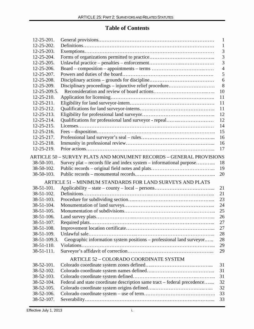
Table of Contents
12-25-201. General provisions.…………………………………………………………… 1 12-25-202. Definitions……………………………………………………………………. 1 12-25-203. Exemptions…………………………………………………………………… 3 12-25-204. Forms of organizations permitted to practice……………….………………... 3 12-25-205. Unlawful practice – penalties – enforcement………………...………………. 3 12-25-206. Board – composition – appointments – terms …………………………..…… 4 12-25-207. Powers and duties of the board………………………………………………. 5 12-25-208. Disciplinary actions – grounds for discipline………………………………… 6 12-25-209. Disciplinary proceedings – injunctive relief procedure………………………. 8 12-25-209.5. Reconsideration and review of board actions…………………………...….. 10 12-25-210. Application for licensing………………………………….………………….. 11 12-25-211. Eligibility for land surveyor-intern…………………………………………… 11 12-25-212. Qualifications for land surveyor-interns……..……………………………….. 11 12-25-213. Eligibility for professional land surveyor…………………………………….. 12 12-25-214. Qualifications for professional land surveyor - repeal……..………………… 12 12-25-215. Licenses………………………………………….…………………………… 14 12-25-216. Fees – disposition……………………………………………………………... 15 12-25-217. Professional land surveyor’s seal – rules……………………………………... 16 12-25-218. Immunity in professional review……………………………………………... 16 12-25-219. Prior actions…………………………………………………………………... 17
ARTICLE 50 – SURVEY PLATS AND MONUMENT RECORDS – GENERAL PROVISIONS 38-50-101. Survey plat – records file and index system – informational purpose………... 18 38-50-102. Public records – original field notes and plats………………………………... 19 38-50-103. Public records – monumental records.………………………………………... 20
ARTICLE 51 – MINIMUM STANDARDS FOR LAND SURVEYS AND PLATS 38-51-101. Applicability – state – county – local – persons…………………….………... 21 38-51-102. Definitions…………………………………..………………………………... 21 38-51-103. Procedure for subdividing section…..………………………………………... 23 38-51-104. Monumentation of land surveys…….………………………………………... 24 38-51-105. Monumentation of subdivisions……………….…………………….………... 25 38-51-106. Land survey plats…………………...……………………………….………... 26 38-51-107. Required plats……………………………………………………….………... 27 38-51-108. Improvement location certificate……………………………………………... 27 38-51-109. Unlawful sale………………………..………………………………………... 28 38-51-109.3. Geographic information system positions – professional land surveyor.….. 28 38-51-110. Violations……………………………………………………………………... 29 38-51-111. Surveyor’s affidavit of correction…………..………………………………... 29
ARTICLE 52 – COLORADO COORDINATE SYSTEM 38-52-101. Colorado coordinate system zones defined…..…………………….………... 31 38-52-102. Colorado coordinate system names defined…..…………………….………... 31 38-52-103. Colorado coordinate system defined…………..…………………….………... 31 38-52-104. Federal and state coordinate description same tract – federal precedence….... 32 38-52-105. Colorado coordinate system origins defined…..…………………….…..…... 32 38-52-106. Colorado coordinate system – use of term……………………………………. 33 38-52-107. Severability………………………………………………………….………... 33
ARTICLE 25: PART 2: SURVEYORS AND RELATED STATUTES
Effective July 1, 2013 ii.
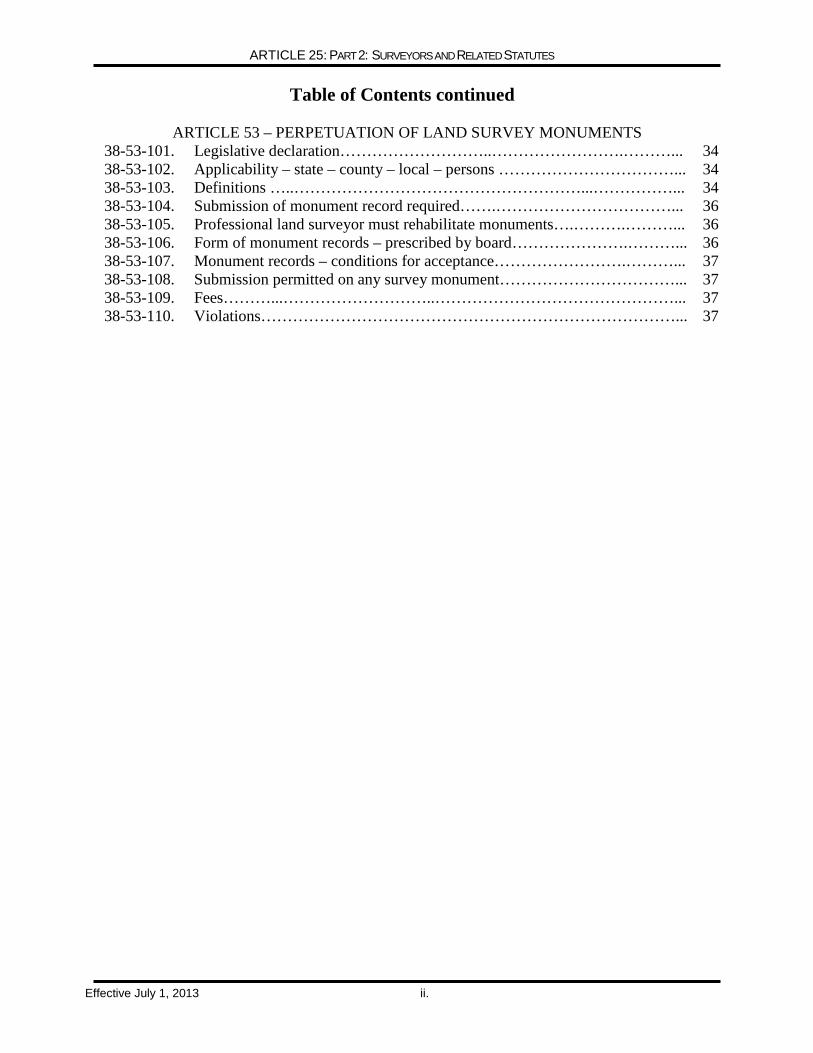
Table of Contents continued
ARTICLE 53 – PERPETUATION OF LAND SURVEY MONUMENTS
38-53-101. Legislative declaration………………………..…………………….………... 34 38-53-102. Applicability – state – county – local – persons ……………………………... 34 38-53-103. Definitions …..………………………………………………...……………... 34 38-53-104. Submission of monument record required…….……………………………... 36 38-53-105. Professional land surveyor must rehabilitate monuments….……….………... 36 38-53-106. Form of monument records – prescribed by board………………….………... 36 38-53-107. Monument records – conditions for acceptance…………………….………... 37 38-53-108. Submission permitted on any survey monument……………………………... 37 38-53-109. Fees………...………………………..………………………………………... 37 38-53-110. Violations……………………………………………………………………... 37
TITLE 12, ARTICLE 12, PART 2: SURVEYORS AND RELATED STATUTES
Effective July 1, 2013 Page 1 of 37
PART 2 SURVEYORS
12-25-201. General provisions.
In order to safeguard life, health, and property and to promote the public welfare, the practice of
professional land surveying in Colorado is hereby declared to be subject to regulation. It shall be unlawful for any individual to practice professional land surveying in Colorado or to use in connection with such individual's name, or to otherwise assume, or to advertise any title or description tending to convey the impression that such individual is a professional land surveyor, unless such individual has been duly licensed or is exempted under the provisions of this part 2. The practice of professional land surveying shall be deemed a privilege granted by the state of Colorado based on the qualifications of the individual as evidenced by such individual's licensing.
12-25-202. Definitions.
As used in this part 2, unless the context otherwise requires: (1) "Basic control for engineering projects" means survey markers set on or in the vicinity of a
construction project to enable all components of the project to be built in compliance with plans and specifications with respect to the project location, orientation, elevation, and relationship to property, easement, or right-of-way boundaries.
(1.5) "Board" means the state board of licensure for architects, professional engineers, and
professional land surveyors, created by section 12-25-106. (2) (Deleted by amendment, L. 2004, p. 1297, § 20, effective May 28, 2004.) (3) "Certificate" means the media issued by the board to evidence licensing or enrollment. (3.3) "Geodetic surveying" means the performance of surveys in which measure or account is
taken of the shape, size, and gravitational forces of the earth to determine or predetermine the horizontal or vertical positions of points, monuments, or stations for use in the practice of professional land surveying or for stating the geodetic position of control points, monuments, or stations by using a coordinate system or derivative thereof recognized by the national geodetic survey.
(3.5) "Land surveyor-intern" means an individual enrolled by the board after demonstrating such
individual's competency, as required by section 12-25-212. (4) "License" means the formal legal permission to practice land surveying granted by the board. (5) Repealed. (6) (a) "Professional land surveying" means the application of special knowledge of principles of
mathematics, methods of measurement, and law for the determination and preservation of land boundaries. "Professional land surveying" specifically includes:
TITLE 12, ARTICLE 12, PART 2: SURVEYORS AND RELATED STATUTES
Effective July 1, 2013 Page 2 of 37
(I) Restoration and rehabilitation of corners and boundaries in the United States public land survey system;
(II) Obtaining and evaluating boundary evidence; (III) Determination of the areas and elevations of land parcels; (IV) Subdivision of land parcels into smaller parcels and layout of alignment and grades for
streets or roads to serve such smaller parcels; (V) Measuring and platting underground mine workings; (VI) Preparation of the boundary control portions of geographic information systems and land
information systems except as allowed otherwise by section 38-51-109.3, C.R.S.; (VII) Establishment, restoration, and rehabilitation of land survey monuments and bench marks; (VIII) Preparation of land survey plats, condominium plats, monument records, property
descriptions that result from the practice of professional land surveying, and survey reports; (IX) Surveying, monumenting, and platting of easements and rights-of-way; (X) Geodetic surveying; (X.5) Basic control for engineering projects; and (XI) Any other activities incidental to and necessary for the adequate performance of the services
described in this paragraph (a). (b) An individual practices or offers to practice "professional land surveying" within the meaning
and intent of this part 2 if the individual engages therein or, by oral claim, sign, letterhead, or card or in any other way holds himself or herself out to be a professional land surveyor or as being able to perform any professional land surveying service or if the individual performs any professional land surveying service or work.
(c) Professional land surveying may include other types of surveying. (7) "Professional land surveyor" means an individual who practices professional land surveying
and who is currently licensed with the board after demonstrating competency to practice, as required by section 12-25-214.
(8) and (9) (Deleted by amendment, L. 2004, p. 1297, § 20, effective May 28, 2004.) (10) "Responsible charge" means personal responsibility for the control and direction of
professional land surveying work. (11) (Deleted by amendment, L. 94, p. 1495, § 20, effective July 1, 1994.)

TITLE 12, ARTICLE 12, PART 2: SURVEYORS AND RELATED STATUTES
Effective July 1, 2013 Page 3 of 37
(12) "Surveyor quorum of the board" means not less than the three professional land surveyor members of the board and one of the nonengineering, non-land surveyor members of the board.
12-25-203. Exemptions.
(1) This part 2 shall not be construed to prevent or to affect: (a) The work of an employee or subordinate of a professional land surveyor if such work is
performed under the responsible charge of the professional land surveyor; (b) The practice of employees of the federal government duly authorized under 43 U.S.C. sec.
772 and 43 CFR 9180.0-3, while engaged in the practice of surveying within the course of their federal employment in the state of Colorado; or
(c) The rights of any other legally recognized profession.
12-25-204. Forms of organizations permitted to practice. (1) A partnership, corporation, limited liability company, joint stock association, or other entity is
not eligible for licensure under this part 2. (2) An entity may practice or offer to practice land surveying in this state only if the individual in
responsible charge of the entity's land surveying activities in this state is a professional land surveyor. All professional land surveying documents, plats, and reports issued by or for the entity must bear the seal and signature of the professional land surveyor who is in responsible charge of and directly responsible for the land surveying work.
12-25-205. Unlawful practice - penalties – enforcement.
(1) It is unlawful for any individual to practice or offer to practice professional land surveying in
Colorado without being licensed in accordance with the provisions of this part 2, or for any individual or entity to use or employ the words "land surveyor", "land surveying", or "professional land surveyor" or words of similar meaning or any modification or derivative except as authorized in this part 2.
(2) It is unlawful for any individual, partnership, professional association, joint stock company,
limited liability company, or corporation to practice, or offer to practice, land surveying in this state unless the individual in responsible charge has complied with the provisions of this part 2.
(3) Repealed. (3.5) The practice of professional land surveying in violation of any of the provisions of this part
2 shall be either: (a) Restrained by injunction in an action brought by the attorney general or by the district
attorney of the proper district in the county in which the violation occurs; or (b) (I) Ceased by order of the board pursuant to section 12-25-209 (8.2) to (8.9).
TITLE 12, ARTICLE 12, PART 2: SURVEYORS AND RELATED STATUTES
Effective July 1, 2013 Page 4 of 37
(II) (Deleted by amendment, L. 2006, p. 784, § 18, effective July 1, 2006.) (4) Any person who practices or offers or attempts to practice professional land surveying
without an active license issued under this part 2 commits a class 2 misdemeanor and shall be punished as provided in section 18-1.3-501, C.R.S., for the first offense, and, for the second or any subsequent offense, the person commits a class 6 felony and shall be punished as provided in section 18-1.3-401, C.R.S.
(5) It is the duty of all duly constituted officers of the law of Colorado, or any political
subdivision thereof, to enforce the provisions of this part 2 and to prosecute any person violating this part 2.
(6) The attorney general or the attorney general's assistant shall act as legal advisor to the board
and render such timely legal assistance as may be necessary in carrying out the provisions of this part 2. With the concurrence of the attorney general, the board may employ counsel and assistance necessary to aid in the enforcement of this part 2, and the compensation and expenses therefor shall be paid from the funds of the board.
(7) Any individual practicing professional land surveying, as defined in this part 2, who is not
licensed or exempt shall not collect compensation of any kind for such practice, and, if compensation has been paid, such compensation shall be refunded in full.
(8) After finding that an individual has unlawfully engaged in the practice of professional land
surveying, the board may assess a fine against such unlawfully engaged individual in an amount not less than fifty dollars and not more than five thousand dollars for each violation proven by the board. Any moneys collected as an administrative fine pursuant to this subsection (8) shall be transmitted to the state treasurer, who shall credit such moneys to the general fund.
12-25-206. Board - composition - appointments – terms.
(1) A professional land surveyor who is a member of the board shall be a citizen of the United
States and a resident of Colorado for at least one year. (2) A professional land surveyor who is designated as a land surveyor member of the board shall
have been licensed as a land surveyor for at least five years. (3) The board shall have a surveyor quorum of the board, as defined in section 12-25-202 (12).
The surveyor quorum shall advise the board concerning issues relating to land surveyors. (4) The governor, in making appointments of professional land surveyors to the board, shall
endeavor to select the highest qualified members of the profession willing to serve on the board. Staggered appointments shall be made so that not more than one member's term expires in any one year, and thereafter appointments shall be for terms of four years each. Appointees shall be limited to two full terms each. Each board member shall hold office until the expiration of the term for which such member is appointed or until a successor has been duly appointed.
(5) In the event of a professional land surveyor vacancy on the board due to resignation, death, or
any cause resulting in an unexpired term, the governor shall fill such vacancy promptly to allow the surveyor quorum of the board to function.

TITLE 12, ARTICLE 12, PART 2: SURVEYORS AND RELATED STATUTES
Effective July 1, 2013 Page 5 of 37
(6) The governor may remove any professional land surveyor member of the board for official misconduct, incompetence, or neglect of duty.
(7) The surveyor quorum of the board shall elect or appoint annually a chairman, a vice-
chairman, and a secretary.
12-25-207. Powers and duties of the board. (1) In order to carry into effect this part 2, the board shall: (a) Promulgate under the provisions of section 24-4-103, C.R.S., such rules as it may deem
necessary and proper; (b) Require each applicant for licensing to demonstrate competence by means of examination and
education and may require work examples as it deems necessary and sufficient for licensing; (c) Keep a record of its proceedings and of all applications for licensing under this part 2. The
application record for each applicant shall include: (I) Name, age, and residence of the applicant; (II) Date of application; (III) Place of business; (IV) Education of the applicant; (V) Surveying and other applicable experience of the applicant; (VI) Type of examination required; (VII) Date and type of action by the board; (VIII) Repealed. (IX) Such other information as may be deemed necessary by the board. (d) (I) (Deleted by amendment, L. 2003, p. 1306, § 2, effective April 22, 2003.) (II) Make available through printed or electronic means the following: (A) The surveying statutes administered by the board; (B) A list of the names and addresses of record of all currently licensed professional land
surveyors; (C) A list containing the license numbers in numerical sequence and the names of all current and
previously licensed professional land surveyors;
TITLE 12, ARTICLE 12, PART 2: SURVEYORS AND RELATED STATUTES
Effective July 1, 2013 Page 6 of 37
(D) The rules of conduct for professional land surveyors adopted pursuant to paragraph (a) of this subsection (1); and
(E) The rules of the board and such other pertinent information as the board deems necessary. (e) Provide for and administer examinations to be given as often as practicable. Examinations
must be identified only by numbers and anonymously graded. After reviewing and approving the examination results, the board shall record and communicate each examinee's examination results to the examinee. The board shall ensure that the passing score on surveying examinations is set to measure the level of minimum competency. The board shall publish and make available to interested applicants a list of the subjects included in the surveying examinations that are developed by the board, such subjects being consistent with and related to the various aspects of surveying.
(f) Adopt and have an official seal. (2) The division of professions and occupations in the department of regulatory agencies may
employ at least one investigator to investigate complaints relative to the provisions of this part 2.
12-25-208. Disciplinary actions - grounds for discipline. (1) The board has the power to deny, suspend, revoke, or refuse to renew the license of, or place
on probation, limit the scope of practice of, or require additional training of any professional land surveyor or land surveyor-intern for:
(a) Engaging in fraud, misrepresentation, or deceit in obtaining or attempting to obtain a license
or enrollment; (b) Failing to meet the generally accepted standards of the practice of land surveying through act
or omission; (c) A felony that is related to the ability to practice land surveying. A certified copy of the
judgment of a court of competent jurisdiction of such conviction or plea shall be presumptive evidence of such conviction or plea for the purposes of any hearing under this part 2. A plea of nolo contendere, or its equivalent, accepted by the court shall be considered as a conviction.
(d) (Deleted by amendment, L. 88, p. 510, § 18, effective July 1, 1988.) (e) Violating, attempting to violate, or aiding or abetting the violation or attempted violation of: (I) Any provision of this part 2 or article 50, 51, 52, or 53 of title 38, C.R.S.; (II) Any rule adopted by the board in conformance with the provisions of this part 2; or (III) Any order of the board issued in conformance with the provisions of this part 2; (f) Using false, deceptive, or misleading advertising; (g) Performing services beyond one's competency, training, or education;
TITLE 12, ARTICLE 12, PART 2: SURVEYORS AND RELATED STATUTES
Effective July 1, 2013 Page 7 of 37
(h) Failing to report to the board any professional land surveyor known to have violated any provision of this part 2 or any board order or rule;
(i) Habitual or excessive use or abuse of alcohol, controlled substances, or any habit-forming
drug; (j) Using any schedule I controlled substance, as set forth in section 18-18-203, C.R.S.; (k) Failing to report to the board any malpractice claim against such professional land surveyor or
any partnership, limited liability company, corporation, or joint stock association of which such professional land surveyor is a member, which claim is settled or in which judgment is rendered, within sixty days after the effective date of such settlement or judgment, if such claim concerned surveying services performed or supervised by such land surveyor;
(l) Failing to pay any fine assessed pursuant to this article; (m) Violating any law or regulation governing the practice of professional land surveying in
another state or jurisdiction. A plea of nolo contendere or its equivalent accepted by the board of another state or jurisdiction may be considered to be the same as a finding of guilty for purposes of any hearing under this part 2.
(n) Attempting to use an expired, revoked, suspended, or nonexistent license, practicing or
offering to practice when not qualified, or falsely claiming that the individual is licensed; or (o) Using in any manner a license, license number, or certificate that has not been issued to the
individual by the board. (2) (a) When a complaint or investigation discloses an instance of misconduct that, in the opinion
of the board, does not warrant formal action by the board but that should not be dismissed as being without merit, the board may issue and send a letter of admonition by first-class mail to the professional land surveyor or land surveyor-intern at his or her last-known address.
(b) When the board sends a letter of admonition to a professional land surveyor or land surveyor-
intern, the board shall advise the professional land surveyor or land surveyor-intern that he or she has the right to request in writing, within twenty days after receipt of the letter, that formal disciplinary proceedings be initiated to adjudicate the propriety of the conduct upon which the letter of admonition is based.
(c) If the request for adjudication is timely made, the letter of admonition shall be deemed
vacated and the matter shall be processed by means of formal disciplinary proceedings. (3) (Deleted by amendment, L. 94, p. 1499, § 26, effective July 1, 1994.) (4) (a) In addition to any other penalty that may be imposed pursuant to this section, the board
may fine any professional land surveyor violating any provision of this article or any rule promulgated pursuant to this article not less than fifty dollars and not more than five thousand dollars for each violation proven by the board.
(b) All fines collected pursuant to this subsection (4) shall be credited to the general fund.
TITLE 12, ARTICLE 12, PART 2: SURVEYORS AND RELATED STATUTES
Effective July 1, 2013 Page 8 of 37
(5) The board may issue a letter of concern to a professional land surveyor or land surveyor-intern based on any of the grounds specified in subsection (1) of this section without conducting a hearing as specified in section 12-25-209 (4) when an instance of potentially unsatisfactory conduct comes to the board's attention but, in the board's judgment, does not warrant formal action by the board. Letters of concern shall be confidential and shall not be disclosed to members of the public or in any court action unless the board is a party.
12-25-209. Disciplinary proceedings - injunctive relief procedure.
(1) The board upon its own motion may, and upon the receipt of a signed complaint in writing
from any person shall, investigate the activities of any professional land surveyor, land surveyor-intern, or other person who presents grounds for disciplinary action as specified in this part 2.
(2) Repealed. (3) All charges, unless dismissed by the board, shall be referred to administrative hearing by the
board within five years after the date on which said charges were filed. (4) Disciplinary hearings shall be conducted by the board or by an administrative law judge
appointed pursuant to part 10 of article 30 of title 24, C.R.S., and shall be held in the manner prescribed in article 4 of title 24, C.R.S.
(5) and (6) Repealed. (7) (a) The board or an administrative law judge shall have the power to administer oaths, take
affirmations of witnesses, and issue subpoenas to compel the attendance of witnesses and the production of all relevant papers, books, records, documentary evidence, and materials in any hearing, investigation, accusation, or other matter coming before the board pursuant to this part 2.
(b) Upon failure of any witness to comply with such subpoena or process, the district court of the
county in which the subpoenaed person or licensee resides or conducts business, upon application by the board or director with notice to the subpoenaed person or licensee, may issue to the person or licensee an order requiring that person or licensee to appear before the board or director; to produce the relevant papers, books, records, documentary evidence, or materials if so ordered; or to give evidence touching the matter under investigation or in question. Failure to obey the order of the court may be punished by the court as a contempt of court.
(8) (a) The board is authorized to apply for injunctive relief, in the manner provided by the
Colorado rules of civil procedure, to enforce the provisions of this part 2, or to restrain any violation thereof. In such proceedings, it shall not be necessary to allege or prove either that an adequate remedy at law does not exist or that substantial or irreparable damage would result from the continued violation thereof. The members of the board, its staff, and the attorney general shall not be held personally liable in any such proceeding.
(b) (I) If the board has reason to believe that any individual has engaged in, or is engaging in, any
act or practice which constitutes a violation of any provision of this article, the board may initiate proceedings to determine if such a violation has occurred. Hearings shall be conducted in accordance with the provisions of article 4 of title 24, C.R.S.

TITLE 12, ARTICLE 12, PART 2: SURVEYORS AND RELATED STATUTES
Effective July 1, 2013 Page 9 of 37
(II) (Deleted by amendment, L. 2006, p. 785, § 19, effective July 1, 2006.) (c) In any action brought pursuant to this subsection (8), evidence of the commission of a single
act prohibited by this article shall be sufficient to justify the issuance of an injunction or a cease-and-desist order.
(8.2) (a) If it appears to the board, based upon credible evidence as presented in a written
complaint by any person, that a licensee is acting in a manner that is an imminent threat to the health and safety of the public or a person is acting or has acted without the required license, the board may issue an order to cease and desist such activity. The order shall set forth the statutes and rules alleged to have been violated, the facts alleged to have constituted the violation, and the requirement that all unlawful acts or unlicensed practices immediately cease.
(b) Within ten days after service of the order to cease and desist pursuant to paragraph (a) of this
subsection (8.2), the respondent may request a hearing on the question of whether acts or practices in violation of this part 2 have occurred. Such hearing shall be conducted pursuant to sections 24-4-104 and 24-4-105, C.R.S.
(8.4) (a) If it appears to the board, based upon credible evidence as presented in a written
complaint by any person, that a person has violated any other portion of this part 2, then, in addition to any specific powers granted pursuant to this part 2, the board may issue to such person an order to show cause as to why the board should not issue a final order directing such person to cease and desist from the unlawful act or unlicensed practice.
(b) A person against whom an order to show cause has been issued pursuant to paragraph (a) of
this subsection (8.4) shall be promptly notified by the board of the issuance of the order, along with a copy of the order, the factual and legal basis for the order, and the date set by the board for a hearing on the order. Such notice may be served by personal service, by first-class United States mail, postage prepaid, or as may be practicable upon any person against whom such order is issued. Personal service or mailing of an order or document pursuant to this subsection (8.4) shall constitute notice thereof to the person.
(c) (I) The hearing on an order to show cause shall be commenced no sooner than ten and no later
than forty-five calendar days after the date of transmission or service of the notification by the board as provided in paragraph (b) of this subsection (8.4). The hearing may be continued by agreement of all parties based upon the complexity of the matter, number of parties to the matter, and legal issues presented in the matter, but in no event shall the hearing commence later than sixty calendar days after the date of transmission or service of the notification.
(II) If a person against whom an order to show cause has been issued pursuant to paragraph (a) of
this subsection (8.4) does not appear at the hearing, the board may present evidence that notification was properly sent or served upon such person pursuant to paragraph (b) of this subsection (8.4) and such other evidence related to the matter as the board deems appropriate. The board shall issue the order within ten days after the board's determination related to reasonable attempts to notify the respondent, and the order shall become final as to that person by operation of law. Such hearing shall be conducted pursuant to sections 24-4-104 and 24-4-105, C.R.S.
(III) If the board reasonably finds that the person against whom the order to show cause was
issued is acting or has acted without the required license or has or is about to engage in acts or
TITLE 12, ARTICLE 12, PART 2: SURVEYORS AND RELATED STATUTES
Effective July 1, 2013 Page 10 of 37
practices constituting violations of this part 2, a final cease-and-desist order may be issued directing such person to cease and desist from further unlawful acts or unlicensed practices.
(IV) The board shall provide notice, in the manner set forth in paragraph (b) of this subsection
(8.4), of the final cease-and-desist order within ten calendar days after the hearing conducted pursuant to this paragraph (c) to each person against whom the final order has been issued. The final order issued pursuant to subparagraph (III) of this paragraph (c) shall be effective when issued and shall be a final order for purposes of judicial review.
(8.5) If it appears to the board, based upon credible evidence presented to the board, that a person
has engaged in or is about to engage in any unlicensed act or practice, any act or practice constituting a violation of this part 2, any rule promulgated pursuant to this part 2, any order issued pursuant to this part 2, or any act or practice constituting grounds for administrative sanction pursuant to this part 2, the board may enter into a stipulation with such person.
(8.7) If any person fails to comply with a final cease-and-desist order or a stipulation, the board
may request the attorney general or the district attorney for the judicial district in which the alleged violation exists to bring, and if so requested such attorney shall bring, suit for a temporary restraining order and for injunctive relief to prevent any further or continued violation of the final order.
(8.9) A person aggrieved by the final cease-and-desist order may seek judicial review of the
board's determination or of the board's final order as provided in subsection (10) of this section. (9) Repealed. (10) The court of appeals shall have initial jurisdiction to review all final actions and orders that
are subject to judicial review of the board. Such proceedings shall be conducted in accordance with section 24-4-106 (11), C.R.S.
(11) When a complaint or an investigation discloses an instance of misconduct that, in the
opinion of the board, warrants formal action, the complaint shall not be resolved by a deferred settlement, action, judgment, or prosecution.
(12) When a complaint or investigation discloses an instance of conduct that does not warrant
formal action by the board and, in the opinion of the board, the complaint should be dismissed, but the board has noticed indications of possible errant conduct by the licensee that could lead to serious consequences if not corrected, a confidential letter of concern may be issued and sent to the licensee.
12-25-209.5. Reconsideration and review of board actions.
The board, on its own motion or upon application, at any time after the imposition of any
discipline as provided in section 12-25-209, may reconsider its prior action and reinstate or restore such license or terminate probation or reduce the severity of its prior disciplinary action. The taking of any such further action, or the holding of a hearing with respect thereto, shall rest in the sole discretion of the board. The professional land surveyor or land surveyor-intern in any action before the board shall have the right to appeal any decision of the board to a court of competent jurisdiction.
TITLE 12, ARTICLE 12, PART 2: SURVEYORS AND RELATED STATUTES
Effective July 1, 2013 Page 11 of 37
12-25-210. Application for licensing. (1) Each application for licensing shall be in a form specified by the board and shall contain
statements made under oath showing the applicant's education and showing a detailed summary of the applicant's surveying experience. Each application must contain a statement indicating whether the applicant has ever been convicted of a felony in this or in any other state, or has ever had a surveyor's license revoked, suspended, or not renewed, or has been reprimanded or fined relative to surveying in this or any other state. Applications that are not complete are defective, and the board shall take no action on defective applications except to give notice to the applicant of the defects. A nonrefundable application fee in an amount set by the board shall accompany each application.
(2) No new application shall be required of an individual requiring reexamination by the board,
and such individual shall be notified when the next examination will be held. (3) Whenever the board is reviewing or considering the conviction of a crime, it shall be
governed by the provisions of section 24-5-101, C.R.S. (4) No individual whose license or enrollment has been revoked shall be allowed to reapply for
licensure or enrollment earlier than two years after the effective date of the revocation.
12-25-211. Eligibility for land surveyor-intern. To be eligible for enrollment as a land surveyor-intern, an applicant shall provide documentation
of the applicant's technical competence.
12-25-212. Qualifications for land surveyor-interns. (1) (a) An applicant may qualify for enrollment as a land surveyor-intern by endorsement if the
applicant is enrolled in good standing in another jurisdiction requiring qualifications substantially equivalent to those currently required of applicants under this part 2 or if, at the time of initial enrollment in such jurisdiction, the applicant met the requirements for enrollment then in existence under Colorado law.
(b) Upon completion of the application and approval by the board, the applicant shall be enrolled
as a land surveyor-intern if the applicant is otherwise qualified pursuant to section 12-25-211. (2) (a) An applicant may qualify for enrollment as a land surveyor-intern by graduation and
examination if the applicant passes the fundamentals of surveying examination. (b) In order to be admitted to the examination pursuant to paragraph (a) of this subsection (2), the
applicant must have satisfied either of the following requirements: (I) The applicant graduated from a board-approved surveying or surveying technology
curriculum that is at least four years. (II) The applicant has senior status in a board-approved surveying or surveying technology
curriculum that is at least four years.
TITLE 12, ARTICLE 12, PART 2: SURVEYORS AND RELATED STATUTES
Effective July 1, 2013 Page 12 of 37
(c) Upon passing the examination and upon submission of official transcripts to the board verifying graduation or impending graduation, the applicant shall be enrolled as a land surveyor-intern if the applicant is otherwise qualified pursuant to section 12-25-211.
(3) (a) An applicant may qualify for enrollment as a land surveyor-intern by education,
experience, and examination if such applicant passes the fundamentals of surveying examination. (b) In order to be admitted to the examination pursuant to paragraph (a) of this subsection (3), the
applicant must: (I) (A) Have graduated from high school or the equivalent; and (B) Have a cumulative record of four years or more of progressive land surveying experience, of
which a maximum of one year of educational credit may be substituted; or (II) (A) Have graduated from a board-approved two-year surveying curriculum; and (B) Have a cumulative record of two years or more of progressive land surveying experience. (c) Upon passing the examination and the submission of evidence of experience satisfactory to
the board, the applicant shall be enrolled as a land surveyor-intern if the applicant is otherwise qualified pursuant to section 12-25-211.
12-25-213. Eligibility for professional land surveyor.
To be eligible for licensing as a professional land surveyor, an applicant shall provide
documentation of technical competence.
12-25-214. Qualifications for professional land surveyor – repeal. (1) (a) An applicant may qualify for licensing as a professional land surveyor by endorsement
and examination if such applicant passes the required examination or examinations pertaining to Colorado law.
(b) In order to be admitted to the examination pursuant to paragraph (a) of this subsection (1), the
applicant shall be licensed in good standing in another jurisdiction requiring qualifications substantially equivalent to those currently required of applicants under this part 2 or, at the time of initial licensure in such jurisdiction, have met the requirements for licensure then in existence under Colorado law.
(c) Upon passing the examination, the applicant shall be licensed as a professional land surveyor
if the applicant is otherwise qualified pursuant to section 12-25-213. (2) (a) An applicant may qualify for licensing as a professional land surveyor by education,
experience, and examination if such applicant passes the principle and practice of surveying examination and the examination pertaining to Colorado law.
(b) To be admitted to an examination pursuant to paragraph (a) of this subsection (2), the
applicant shall meet the requirements stated in at least one of the following:
TITLE 12, ARTICLE 12, PART 2: SURVEYORS AND RELATED STATUTES
Effective July 1, 2013 Page 13 of 37
(I) (A) Have graduated from a board-approved surveying curriculum of four or more years; and (B) Have two years of progressive land surveying experience under the supervision of a
professional land surveyor or an exempted federal employee defined in section 12-25-203 (1) (b); and
(C) Have been enrolled as a land surveyor-intern in this state; or (D) Repealed. (II) (A) Have graduated from a nonboard-approved surveying curriculum of four or more years;
and (B) Have four years of progressive land surveying experience of which at least two must be
under the supervision of a professional land surveyor or an exempted federal employee as defined in section 12-25-203 (1) (b); and
(C) Have been enrolled as a land surveyor-intern in this state; or (D) Repealed. (III) (A) Have graduated from a board-approved two-year surveying curriculum or from a four-
year engineering curriculum that included surveying course work as specified by the board by rule; and
(B) Have six years of progressive land surveying experience of which four years shall have been
under the supervision of a professional land surveyor or an exempt federal employee as defined under 12-25-203 (1) (b); and
(C) Have been enrolled as a land surveyor-intern in this state; or (IV) (A) Have obtained a bachelor's degree in a nonsurveying curriculum; (B) Have completed surveying and other related course work, as specified by the board by rule; (C) Have six years of progressive land surveying experience, of which four years shall have been
under the supervision of a professional land surveyor or an exempted federal employee as defined in section 12-25-203; and
(D) Have been enrolled as a land surveyor-intern in this state. (c) Upon passing the examinations and the submission of evidence of experience satisfactory to
the board, the applicant shall be licensed as a professional land surveyor if such applicant is otherwise qualified pursuant to section 12-25-213.
(3) The board may allow an applicant to substitute for one year of experience the satisfactory
completion of one academic year in a curriculum approved by the board. The substitution of education for experience shall not exceed three years.
TITLE 12, ARTICLE 12, PART 2: SURVEYORS AND RELATED STATUTES
Effective July 1, 2013 Page 14 of 37
(4) (a) An applicant may qualify for licensure as a professional land surveyor by experience and examination if such applicant passes the principles and practice of land surveying examination and the examination pertaining to Colorado law.
(b) In order to be admitted to an examination pursuant to paragraph (a) of this subsection (4), the
applicant shall: (I) Have graduated from high school or its equivalent; (II) Have ten years of progressive land surveying experience of which at least six years must
have been under the supervision of a professional land surveyor or an exempted federal employee as defined in section 12-25-203 (1) (b); and
(III) Have been enrolled as a land surveyor-intern in this state. (c) Upon passage of the examination pursuant to paragraph (a) of this subsection (4), the
applicant shall be licensed as a professional land surveyor if such applicant is otherwise qualified pursuant to section 12-25-213.
(d) The board may allow an applicant to substitute for one year of experience the satisfactory
completion of one academic year in a curriculum approved by the board. The substitution of education for experience shall not exceed three years.
(e) This subsection (4) is repealed, effective July 1, 2020. (5) (a) A professional land surveyor who has been duly licensed to practice professional land
surveying in this state and who is over sixty-five years of age, upon application, may be classified as a retired professional land surveyor. Individuals who are so classified shall lose their licensure, shall not practice professional land surveying, and shall pay a fee to retain retired professional land surveyor status.
(b) (I) A retired professional land surveyor shall be reinstated to the status of a professional land
surveyor upon payment of the renewal fee. No other fee shall be assessed against such retired professional land surveyor as a penalty.
(II) For any professional land surveyor who has been retired for two or more years, the board
may require reexamination unless the board is satisfied of the retired professional land surveyor's continued competence.
(6) (Deleted by amendment, L. 2004, p. 1302, § 30, effective May 28, 2004.)
12-25-215. Licenses. (1) The board, upon acceptance of an applicant who has demonstrated competence in
professional land surveying and upon receipt of payment of the required fee, shall license and issue a unique license number to the applicant.
(2) The board, upon acceptance of a qualified land surveyor-intern and upon receipt of payment
of the required fee, shall enroll the qualified land surveyor-intern.
TITLE 12, ARTICLE 12, PART 2: SURVEYORS AND RELATED STATUTES
Effective July 1, 2013 Page 15 of 37
(3) A license may be issued at any time but shall expire in conformance with section 24-34-102, C.R.S. A license shall be renewed at the time of such expiration.
(4) All licenses shall be renewed or reinstated pursuant to a schedule established by the director
of the division of professions and occupations within the department of regulatory agencies and shall be renewed or reinstated pursuant to section 24-34-102 (8), C.R.S. The director of the division of professions and occupations within the department of regulatory agencies may establish renewal fees and delinquency fees for reinstatement pursuant to section 24-34-105, C.R.S. If a person fails to renew his or her license pursuant to the schedule established by the director of the division of professions and occupations, the license shall expire. Any person whose license has expired is subject to the penalties provided in this article or section 24-34-102 (8), C.R.S.
(5) Repealed. (6) A professional land surveyor shall give notice to the board, in writing, of any change of
address within thirty days after the change.
12-25-216. Fees – disposition. (1) Pursuant to section 24-34-105, C.R.S., the board shall charge and collect fees for the
following: (a) With respect to professional land surveyors: (I) Renewal of a license; (II) Replacement of a paper certificate or renewal card, if requested by the licensee; (III) Application for licensure by endorsement and examination; (IV) Application for the principles and practice of surveying examination or the legal aspects of
surveying examination; (V) Issuance of a paper certificate of licensure, if requested by the licensee; (VI) Late renewal of a license; (VII) Reexamination for the principles and practice of surveying examination or the legal aspects
of surveying examination; (VIII) Renewal of an expired license; (IX) Listing as a retired professional land surveyor; (b) With respect to land surveyor-interns: (I) (Deleted by amendment, L. 2004, p. 1303, § 32, effective May 28, 2004.) (II) (Deleted by amendment, L. 94, p. 1506, § 34, effective July 1, 1994.)

TITLE 12, ARTICLE 12, PART 2: SURVEYORS AND RELATED STATUTES
Effective July 1, 2013 Page 16 of 37
(III) Application for the fundamentals of surveying examination; (IV) Reexamination for the fundamentals of surveying examination; (V) Application for enrollment as a land surveyor-intern by endorsement. (2) All moneys collected by the board in administering this part 2 shall be transmitted to the state
treasurer, who shall credit the same pursuant to section 24-34-105, C.R.S., and the general assembly shall make annual appropriations pursuant to said section for expenditures required for the administration of this part 2, which expenditures shall be made from such appropriations upon vouchers and warrants drawn pursuant to law. The division shall employ, subject to section 13 of article XII of the state constitution, such clerical or other assistants as are necessary for the performance of its duties.
(3) Repealed.
12-25-217. Professional land surveyor's seal – rules. (1) Upon receiving a license from the board, a professional land surveyor may obtain a crimp
type seal, a rubber stamp type seal, or an electronic type seal of a design approved by the board. The seal must contain the licensed professional land surveyor's name and license number and the designation "Colorado licensed professional land surveyor". Colorado land surveyors licensed before July 1, 2004, may continue to use their prior existing seals.
(2) All documents, plats, and reports resulting from the practice of land surveying shall be
identified with and bear the seal or exact copy thereof, signature, and date of signature of the land surveyor in responsible charge.
(3) A professional land surveyor shall use a seal and signature only when the work to which the
seal is applied was prepared under the professional land surveyor's responsible charge. (4) The board shall adopt rules governing use of the seal and the retention, use, and distribution
of sealed documents and copies thereof.
12-25-218. Immunity in professional review. Any member of the board, any member of the board's staff, any person acting as a witness or
consultant to the board, any witness testifying in a proceeding authorized under this part 2, and any person who lodges a complaint pursuant to this part 2 shall be immune from liability in any civil action brought against him or her for acts occurring while acting in his or her capacity as board member, staff, consultant, or witness, respectively, if such individual was acting in good faith within the scope of his or her respective capacity, made a reasonable effort to obtain the facts of the matter as to which he or she acted, and acted in the reasonable belief that the action taken by him or her was warranted by the facts. Any person participating in good faith in lodging a complaint or participating in any investigative or administrative proceeding pursuant to this part 2 shall be immune from any civil or criminal liability that may result from such participation.
TITLE 12, ARTICLE 12, PART 2: SURVEYORS AND RELATED STATUTES
Effective July 1, 2013 Page 17 of 37
12-25-219. Prior actions. (1) The board shall take over, assume, and continue all actions and requirements regarding land
surveyors from its predecessor, the state board of registration for professional engineers and professional land surveyors. There shall be no legal discontinuity, and previously licensed land surveyors shall continue their licensure as professional land surveyors.
(2) The name change from the state board of licensure for professional engineers and
professional land surveyors to the state board of licensure for architects, professional engineers, and professional land surveyors shall not be construed to change the entity. There shall be no legal discontinuity, and previously licensed land surveyors shall continue their licensure as land surveyors, and any obligations of the board or of persons to the board shall not be affected by the name change.
____________________
TITLE 12, ARTICLE 12, PART 2: SURVEYORS AND RELATED STATUTES
Effective July 1, 2013 Page 18 of 37
ARTICLE 50. SURVEY PLATS AND MONUMENT RECORDS –
GENERAL PROVISIONS
38-50-101. Survey plat - records file and index system - informational purpose. (1) Survey plats required pursuant to section 38-51-107 and this section shall: (a) Comply with section 38-51-106; (b) Depending on the location of the land, contain the following information in the title block: (I) For parcels of land located within the United States rectangular survey system, the section,
township, range, and principal meridian; or (II) For grants and unsurveyed parcels of land, information relating to the system of indexing the
county assessor already has in place; (c) Within twelve months after the date the monument is accepted in the field by a professional
land surveyor performing a monumented land survey or is set by a professional land surveyor, be deposited with the public office designated by the county commissioners.
(2) (a) (I) The county commissioners of each county shall designate the county surveyor to create
and maintain a survey plat records file and index system for plats. (II) If a county surveyor has not been elected or appointed or if the office is vacant, another
county official shall be designated to create and maintain such file and index system. (III) If the county surveyor is unable to index in a timely manner, the county surveyor may
designate another county official to do such indexing. (b) (I) Each plat deposited with the county shall be given a reception number or a book and page
number, or both, which shall be set forth on the plat. (II) (A) Surveyed lands located within the United States rectangular survey system shall be
indexed by section, township, range, and principal meridian. (B) Grant lands and unsurveyed lands shall be indexed by the system of indexing the county
assessor already has in place. (III) Survey plats submitted for depositing shall be indexed in a timely manner, but not more than
ten working days after the date the survey plat is deposited. (3) (a) Each plat submitted for depositing shall: (I) Bear original signatures and seals; and (II) Be made:
TITLE 12, ARTICLE 12, PART 2: SURVEYORS AND RELATED STATUTES
Effective July 1, 2013 Page 19 of 37
(A) From a dimensionally stable polyester sheet such as cronar or mylar or other product of equal quality;
(B) At least three mils thick; and (C) With nonfading permanent print. (b) The dimensions of each plat, as specified by county requirements, shall be at least eighteen
inches wide by twenty-four inches long and no more than twenty-four inches wide by thirty-six inches long with a minimum two-inch margin on the left side and a minimum of one-half inch margins at the top, bottom, and right side of the plat.
(c) Subject to approval by the board of county commissioners, a county may make aperture cards
or film-processed copies capable of legible reproduction from polyester sheets as specified in sub-subparagraph (A) of subparagraph (II) of paragraph (a) of this subsection (3) for the purpose of recording.
(4) (a) The fee for depositing plats shall not exceed the amount of the fee collected for the
recording of subdivision plats established in section 30-1-103 (2) (f), C.R.S. (b) The fee for the county surveyor or, if a county surveyor has not been elected or appointed or
if the office is vacant, another county official to index and maintain the plats as designated by the county commissioners shall not exceed the amount of the fee collected for the recording of subdivision plats established in section 30-1-103 (2) (f), C.R.S.
(c) The fees provided for by this subsection (4) shall be collected by the public office at which
plats are deposited. (5) (a) Plats shall be deposited in accordance with this section for the sole purpose of recording
information on surveying monumentation in order to provide survey data for subsequent land surveys and shall not be construed to affect, in any manner whatsoever, the description of a subdivision, line, or corner contained in the official plats and field notes filed and of record or to subdivide property.
(b) No plat deposited in accordance with this section shall constitute notice pursuant to section
38-35-109. (c) Subdivision plats which create parcels of land of thirty-five acres or more shall be filed in the
county clerk and recorder's office for the county in which the property is located pursuant to section 38-35-109.
(6) Notwithstanding any other provision of law, a county surveyor or any other local government
official that maintains a survey plat records file and index system for plats may establish a program to accept plats for recording and filing, with appropriate permanency protocols, by any electronic means it deems appropriate.
38-50-102. Public records - original field notes and plats.
(1) The board of county commissioners for each county is authorized to employ some competent
person, at the expense of the county, to make copies of the original field notes and plats of surveys of
TITLE 12, ARTICLE 12, PART 2: SURVEYORS AND RELATED STATUTES
Effective July 1, 2013 Page 20 of 37
all lands surveyed or to be surveyed after March 14, 1877, by the officers appointed by the federal government, within their respective counties.
(2) The board of county commissioners shall: (a) Procure books in which the copies made pursuant to subsection (1) of this section shall be
maintained; (b) Obtain stationery; and (c) Fix the compensation of the person employed to procure and make copies of field notes and
plats pursuant to subsection (1) of this section whether by contract or otherwise which shall be paid out of the county treasury in the same manner as other expenses are paid.
(3) (a) The copies of field notes and plats made pursuant to subsection (1) of this section shall be
filed in the office of the county clerk and recorder of the proper county and shall thereafter be a part of the public records of such county.
(b) Records or copies made and maintained pursuant to this section, when certified by the county
clerk and recorder, shall be evidence in all courts and places in this state.
38-50-103. Public records - monument records. (1) The state board of licensure for architects, professional engineers, and professional land
surveyors, created in section 12-25-106, C.R.S., shall employ personnel at the expense of such board's licensed professional land surveyors to maintain a record-keeping and indexing system for all monument records submitted in accordance with section 38-53-104.
(2) (a) The state board of licensure for architects, professional engineers, and professional land
surveyors shall provide, free of charge, a copy of each monument record submitted in accordance with section 38-53-104 to the county clerk and recorder for the county in which the monument is located.
(b) Each county clerk and recorder shall maintain copies of monument records in a county
record-keeping and indexing system and, upon receipt of each monument record provided pursuant to paragraph (a) of this subsection (2), shall list it in the system.
(c) Records maintained pursuant to this section shall be open to public inspection during normal
business hours. (3) Certified copies of monument records of the state board of licensure for architects,
professional engineers, and professional land surveyors shall be evidence in all courts and places in this state.
(4) No fee shall be charged by the state board of licensure for architects, professional engineers,
and professional land surveyors for the submission of monument records. The cost of maintaining the record-keeping and indexing system for monument records shall be recouped as part of the renewal fees charged to licensees, which fees shall be calculated to cover the costs of the staff and equipment necessary to maintain the record-keeping and indexing system.
TITLE 12, ARTICLE 12, PART 2: SURVEYORS AND RELATED STATUTES
Effective July 1, 2013 Page 21 of 37
ARTICLE 51. MINIMUM STANDARDS FOR LAND
SURVEYS AND PLATS
38-51-101. Applicability - state - county - local – persons. The provisions of this article shall apply to all agencies of state, county, and local government as
well as to individuals, corporations, and partnerships engaged in the private practice of land surveying. This article shall not apply to the location or relocation of mining claims pursuant to article 43 of title 34, C.R.S.
38-51-102. Definitions.
As used in this article, unless the context otherwise requires: (1) "Accessory" means any physical evidence in the vicinity of a survey monument, the relative
location of which is of public record and which is used to help perpetuate the location of the monument. Accessories shall be construed to include the accessories recorded in the original survey notes and additional reference points and dimensions furnished by subsequent land surveyors or attested to in writing by persons having personal knowledge of the original location of the monument.
(2) "Aliquot corner" means any section corner or quarter section corner and any other corner in
the public land survey system created by subdividing land according to the rules of procedure set forth in section 38-51-103.
(3) "Bench mark" means any relatively immovable point on the earth whose elevation above or
below an adopted datum is known. (4) "Block" means a parcel of land within a platted subdivision bounded on all sides by streets or
avenues, other physical boundaries such as a body of water, or the exterior boundary of a platted subdivision.
(5) "Board" means the state board of licensure for architects, professional engineers, and
professional land surveyors, created in section 12-25-106, C.R.S. (6) "Control corner" means any land survey corner the position of which controls the location of
the boundaries of a tract or parcel of land. (6.3) "Corner" means a point of reference determined by the surveying process. (7) "Exemption plat" or "subdivision exemption plat" means a subdivision plat which includes all
of the information required by section 38-51-106 and which depicts a division of land or the creation of an interest in property for which the board of county commissioners has granted an exemption from subdivision regulations pursuant to section 30-28-101 (10) (d), C.R.S.
(7.5) "Geographic information system land position" or "GIS land position" means a location in a
geographic information system intended to control the mapping location of the boundaries of a tract
TITLE 12, ARTICLE 12, PART 2: SURVEYORS AND RELATED STATUTES
Effective July 1, 2013 Page 22 of 37
or parcel of land that may be field surveyed, scaled, calculated, plotted by photogrammetric or remote sensing methods, or located by physical or cultural features.
(8) "Improvement location certificate" means a representation of the boundaries of a parcel of
land and the improvements thereon, prepared pursuant to section 38-51-108. (9) "Improvement survey plat" means a land survey plat as defined in subsection (12) of this
section resulting from a monumented land survey showing the location of all structures, visible utilities, fences, hedges, or walls situated on the described parcel and within five feet of all boundaries of such parcel, any conflicting boundary evidence or visible encroachments, and all easements, underground utilities, and tunnels for which properly recorded evidence is available from the county clerk and recorder, a title insurance company, or other sources as specified on the improvement survey plat.
(10) "Irregular parcel" means a parcel of land which is not uniquely defined on a subdivision plat
but which is described by any of the following methods: (a) A metes and bounds description; (b) A book and page or reception number reference; (c) Any so-called "assessor's tract"; or (d) A description which calls only for the owner's or adjoiner's name. (11) "Land survey" means a series of observations and measurements made pursuant to sections
38-51-103, 38-51-104, and 38-51-105 for the purpose of locating or restoring any real property boundary.
(12) "Land survey plat" means a plat that shows the information developed by a monumented
land survey or shows one or more set monuments pursuant to sections 38-51-104 and 38-51-105 and includes all information required by section 38-51-106.
(12.3) "Monument" means the object or physical structure that marks the corner point. (13) "Monumented land survey" means a land survey in which monuments are either found or set
pursuant to sections 38-51-103, 38-51-104, and 38-51-105 to mark the boundaries of a specified parcel of land.
(14) "Monument record" means a written and illustrated document describing the physical
appearance of a bench mark or survey monument and its accessories. (15) "Platted subdivision" means a group of lots, tracts, or parcels of land created by recording a
map which meets the requirements of section 38-51-106 and which shows the boundaries of such lots, tracts, or parcels and the original parcel from which they were created.
(16) "Professional land surveyor" means a person licensed pursuant to part 2 of article 25 of title
12, C.R.S.
TITLE 12, ARTICLE 12, PART 2: SURVEYORS AND RELATED STATUTES
Effective July 1, 2013 Page 23 of 37
(16.1) "Professional land surveyor of record" means the professional land surveyor whose signature and seal appear on an original subdivision plat, land survey plat, or parcel description currently recorded in the office of the clerk and recorder in which the subdivision plat, land survey plat, or parcel description is situated.
(17) "Property description" means a written, narrative description, of a parcel of real property or
an easement for the purpose of perpetuating location of title. (18) "Public land survey monument" means any land boundary monument established on the
ground by a cadastral survey of the United States government and any mineral survey monument established by a United States mineral surveyor and made a part of the United States public land records.
(19) "Responsible charge" means control and direction of surveying work. (20) "Subdivision plat" means a map of a platted subdivision recorded for the purpose of creating
land parcels which can be identified uniquely by reference to such map. (21) "Surveyor's affidavit of correction" means an affidavit prepared and executed by a
professional land surveyor of record in accordance with section 38-51-111.
38-51-103. Procedure for subdividing section. (1) Whenever a professional land surveyor conducts a survey for the purpose of locating a parcel
of land which is described in terms of the nomenclature of the public land survey system, such professional land surveyor shall proceed according to the applicable rules contained in the current "Manual of Instructions for the Survey of the Public Lands of the United States" published by the United States government printing office; except that all monumentation shall conform to section 38-51-104.
(2) (a) A section may be subdivided by: (I) Surveying all necessary aliquot lines in the field; or (II) Computing the location of the required aliquot corners after making a field survey which
includes all required control corners of the section. (b) Any section subdivided pursuant to paragraph (a) of this subsection (2) shall include all
control corners that were originally monumented by the United States government, which must either be found or restored in the field according to the standards set forth in section 38-51-104.
(c) Monument records shall be filed pursuant to section 38-53-104, describing each such corner. (d) For any section subdivided pursuant to this subsection (2) the location of original aliquot
corners of, and procedures used in, the governing official United States government survey, where applicable, shall take precedence.
TITLE 12, ARTICLE 12, PART 2: SURVEYORS AND RELATED STATUTES
Effective July 1, 2013 Page 24 of 37
38-51-104. Monumentation of land surveys. (1) (a) The corners of lots, tracts, other parcels of land, aliquot corners not described in
subsection (4) of this section, and any line points or reference points which are set to perpetuate the location of any land boundary or easement shall, when established on the ground by a land survey, be marked by reasonably permanent markers solidly embedded in the ground.
(b) A durable cap bearing the license number of the professional land surveyor responsible for
the establishment of the monument shall be affixed securely to the top of each such monument embedded pursuant to this subsection (1).
(2) If the points designated in subsection (1) of this section fall on solid bedrock, concrete, stone
curbs, gutters, or walks, a durable metal disk or cap shall be securely anchored in the rock or concrete and stamped with the license number of the professional land surveyor responsible for the establishment of the monument or marker.
(3) (a) If the monuments or markers required by subsection (1) of this section cannot practicably
be set because of steep terrain, water, marsh, or existing structures, or if they would be lost as a result of proposed street, road, or other construction, one or more reference monuments shall be set.
(b) (I) The letters "RM" or "WC" and the surveyor's license number shall be affixed to the
monument. (II) For purposes of this paragraph (b), "RM" means reference monument and "WC" means
witness corner. (c) Reference monuments shall be set as close as practicable to the true corner and shall meet the
same physical standards required to set the true corner. (d) If only one reference monument is used, such reference monument shall be set on the actual
boundary line or a prolongation thereof, otherwise at least two reference monuments shall be set. (4) For any monument required by this section that marks the location of a section corner, quarter
section corner, or sixteenth section corner, such monument shall meet the physical standards specified by rule and regulation promulgated by the board pursuant to section 24-4-103, C.R.S.
(5) (a) The top of the monument for any corner required by this section which is within the traffic
area of a publicly named dedicated or deeded street, road, or highway shall be placed one-half foot below the roadway surface.
(b) If the roadway surface is pavement two inches thick or greater, the monument shall include a
monument box the top of which shall be set flush with the surface of the pavement. (6) No marker required by this section shall bear the license number of more than one
professional land surveyor but may bear the name of an individual surveyor or surveying firm in addition to the required license number.

TITLE 12, ARTICLE 12, PART 2: SURVEYORS AND RELATED STATUTES
Effective July 1, 2013 Page 25 of 37
38-51-105. Monumentation of subdivisions. (1) (a) Prior to recording a plat, the external boundaries of any platted subdivisions shall be
monumented on the ground by reasonably permanent monuments solidly embedded in the ground. (b) A durable cap bearing the license number of the professional land surveyor responsible for
the establishment of the monument shall be affixed securely to the top of each such monument embedded pursuant to this subsection (1).
(c) Monuments shall be set no more than fourteen hundred feet apart along any straight boundary
line, at all angle points, at the beginning, end, and points of change of direction or change of radius of any curved boundaries defined by circular arcs, and at the beginning and end of any spiral curve.
(2) The professional land surveyor who prepares the original subdivision plat, exemption plat, or
subdivision exemption plat shall provide external boundary monuments as required in subsection (1) of this section.
(3) (a) Before a sales contract for any lot, tract, or parcel within a subdivision is executed, all
boundaries of the block within which such lot, tract, or parcel is located shall be marked with monuments in accordance with subsection (1) of this section.
(b) The seller of the lot, section, or parcel shall provide for the services of a professional land
surveyor to establish block monumentation and lot markers as required pursuant to subsection (4) of this section.
(4) (a) Block monumentation may be set on the center lines of streets or on offset lines from such
streets as designated on the recorded plat. (b) The corners of any lot, tract, or parcel sold separately shall be marked within one year of the
effective date of the sales contract. (c) For any structure to be built on a lot, tract, or parcel before the corners have been marked
pursuant to this section, the seller of such lot, tract, or parcel shall retain a professional land surveyor to establish control lines on the ground as necessary to assure the proper location of the structure.
(5) For any complete block sold as a unit, it shall become the responsibility of the subsequent
seller of any separate lot, tract, or parcel within such block to retain a professional land surveyor to establish lot markers as required pursuant to subsection (4) of this section.
(6) For any points designated in subsection (1), (2), or (3) of this section that fall on solid
bedrock, concrete, stone curbs, gutters, or walks, a durable metal disk or cap shall be securely anchored in the rock or concrete and stamped with the license number of the professional land surveyor responsible for the establishment of the monument or marker.
(7) (a) If any monuments or markers required by subsection (1), (2), or (3) of this section cannot
practicably be set because of steep terrain, water, marsh, or existing structures, or if they would be lost as a result of proposed street, road, or other construction, one or more reference monuments shall be set.

TITLE 12, ARTICLE 12, PART 2: SURVEYORS AND RELATED STATUTES
Effective July 1, 2013 Page 26 of 37
(b) (I) The letters "RM" or "WC" shall be affixed to the monument in addition to the surveyor's license number.
(II) For purposes of this paragraph (b), "RM" means reference monument and "WC" means
witness corner. (c) Reference monuments shall be set as close as practicable to the true corner and shall meet the
same physical standards required to set the true corner. (d) If only one reference monument is used, such reference monument shall be set on the actual
boundary line or a prolongation thereof, otherwise at least two reference monuments shall be set. (8) For any monument required by this section which marks the location of a section corner,
quarter section corner, or sixteenth section corner, such monument shall meet the physical standards specified by rule and regulation promulgated by the board pursuant to section 24-4-103, C.R.S.
(9) (a) The top of the monument for any corner required by this section which is within the traffic
area of a publicly named dedicated or deeded street, road, or highway shall be placed one-half foot below the roadway surface.
(b) If the roadway surface is pavement two inches thick or greater, the monument shall include a
monument box the top of which shall be set flush with the surface of the pavement. (10) No marker required by this section shall bear the license number of more than one
professional land surveyor but may bear the name of an individual surveyor or surveying firm in addition to the required license number. 38-51-106. Land survey plats.
(1) All land survey plats shall include but shall not be limited to the following: (a) A scale drawing of the boundaries of the land parcel; (b) (I) All recorded and apparent rights-of-way and easements, and, if research for recorded
rights-of-way and easements is done by someone other than the professional land surveyor who prepares the plat, the source from which such recorded rights-of-way and easements were obtained; or
(II) If the client wishes not to show rights-of-way and easements on the land survey plat, a
statement that such client did not want rights-of-way and easements shown; (c) All field-measured dimensions necessary to establish the boundaries on the ground and all
dimensions for newly created parcels necessary to establish the boundaries on the ground; (d) A statement by the professional land surveyor that the survey was performed by such
surveyor or under such surveyor's responsible charge; (e) A statement by the professional land surveyor explaining how bearings, if used, were
determined;

TITLE 12, ARTICLE 12, PART 2: SURVEYORS AND RELATED STATUTES
Effective July 1, 2013 Page 27 of 37
(f) A description of all monuments, both found and set, that mark the boundaries of the property and of all control monuments used in conducting the survey. If any such boundary monument or control monument marks the location of a lost or obliterated public land survey monument that was restored as a part of the survey on which the plat is based, the professional land surveyor shall briefly describe the evidence and the procedure used for such restoration. If any such boundary monument or control monument marks the location of a quarter section corner or sixteenth section corner that was established as a part of the survey, the professional land surveyor shall briefly describe the evidence and procedure used for such establishment, unless the corner location was established by the mathematical procedure as outlined in section 38-51-103.
(g) A statement of the scale or representative fraction of the drawing, and a bar-type or graphical
scale; (h) A north arrow; (i) A written property description, which shall include but shall not be limited to a reference to
the county and state together with the section, township, range, and principal meridian or established subdivision, block and lot number, or any other method of describing the land as established by the general land office or bureau of land management;
(j) The signature and seal of the professional land surveyor; (k) Any conflicting boundary evidence; and (l) A statement defining the lineal units used including but not limited to meters, chains, feet, and
U.S. survey feet. If it is necessary to define conversion factors, the factors shall be a function of the meter as defined by the United States department of commerce, national institute of standards and technology. 38-51-107. Required plats.
(1) Every professional land surveyor who accepts a monument while performing a monumented
land survey shall prepare and deposit a plat if such monument is not of record either in the clerk and recorder's office of the county in which the monument lies or in the public office designated by the county commissioners pursuant to section 38-50-101 (2) or if such monument is set pursuant to section 38-51-104.
(2) No plat shall be required to be prepared or deposited if the monuments accepted or set are
within a platted subdivision that was filed in the clerk and recorder's office within the previous twenty years.
(3) Plats required pursuant to this section shall comply with section 38-50-101.
38-51-108. Improvement location certificate.
(1) A professional land surveyor may prepare an improvement location certificate for the use of a
specific client based upon the professional land surveyor's general knowledge of land boundaries and monuments in a given area whether or not the client is the owner or buyer; except that, if the client is
TITLE 12, ARTICLE 12, PART 2: SURVEYORS AND RELATED STATUTES
Effective July 1, 2013 Page 28 of 37
not the owner or buyer, the professional land surveyor shall provide a copy of the certificate to the owner or buyer.
(2) (a) (I) A certificate prepared pursuant to subsection (1) of this section shall not be designated
as or construed as being a land survey plat or improvement survey plat. (II) Such certificate shall be prominently labeled "improvement location certificate" and contain
a statement in the following form
IMPROVEMENT LOCATION CERTIFICATE I hereby certify that this improvement location certificate was prepared for ... (individual or firm) ...., that it is not a land survey plat or improvement survey plat, and that it is not to be relied upon for the establishment of fence, building, or other future improvement lines. This certificate is valid only for use by ... (individual or firm) ... and describes the parcel's appearance on ... (date) ... I further certify that the improvements on the above described parcel on this date, .... (insert date) ...., except utility connections, are entirely within the boundaries of the parcel, except as shown, that there are no encroachments upon the described premises by improvements on any adjoining premises, except as indicated, and that there is no apparent evidence or sign of any easement crossing or burdening any part of said parcel, except as noted.
Stamp By.............(Signed)............ or Seal Date..................................
(b) A professional land surveyor shall assume full liability for each improvement location certificate done by such professional land surveyor or under such professional land surveyor's responsible charge pursuant to paragraph (a) of this subsection (2).
38-51-109. Unlawful sale.
(1) It is unlawful for any person to offer to sell, to sell, or otherwise to receive remuneration for
any map or plat which purports to be a survey map or plat unless such map or plat conforms with the standards, requirements, and terminology of the provisions of this article.
(2) It is unlawful for any person to offer to sell, to sell, or otherwise to receive remuneration for
any document, sketch, or diagram which purports to be an improvement location certificate unless such document, sketch, or diagram conforms with the standards, requirements, and terminology of this article.
38-51-109.3. Geographic information system positions - professional land surveyor.
(1) A professional land surveyor shall be exempt from the requirements of section 38-51-103
when making a GIS land position determination. A GIS land position made by a professional land surveyor shall have the following limitations:
(a) It does not meet the requirements of a land survey as defined in section 38-51-102 (11).
TITLE 12, ARTICLE 12, PART 2: SURVEYORS AND RELATED STATUTES
Effective July 1, 2013 Page 29 of 37
(b) It shall not establish the location of any aliquot or control corner as they are defined in subsections (2) and (6) of section 38-51-102 until complete research and corner evaluation are performed to meet the requirements as provided in this article.
38-51-110. Violations.
(1) It is the responsibility of the district attorneys of this state to prosecute any person suspected
of willfully and knowingly violating this article. (2) Any person, including the responsible official of any agency of state, county, or local
government, who willfully and knowingly violates this article is guilty of a misdemeanor and, upon conviction thereof, shall be punished by a fine of not less than one hundred fifty dollars or more than one thousand five hundred dollars.
(3) (a) The board may revoke the licensure of any professional land surveyor convicted under the
provisions of this article. (b) Any person whose licensure is revoked pursuant to paragraph (a) of this subsection (3) shall
be entitled to a hearing on such revocation pursuant to article 4 of title 24, C.R.S., and may appeal any decision of the board to a court of competent jurisdiction. 38-51-111. Surveyor's affidavit of correction.
(1) If an error described in subsection (2) of this section is discovered on any subdivision plat,
land survey plat, or any other survey plat or parcel description duly recorded in the clerk and recorder's office of the county in which the subdivision, land, or parcel is situated, the professional land surveyor of record may prepare and record in that clerk and recorder's office a surveyor's affidavit of correction to correct the error.
(2) The following errors may be corrected by a surveyor's affidavit of correction: (a) Any bearing, distance, or elevation that has been omitted or labeled incorrectly; (b) Any text that has been misspelled or mislabeled; (c) Any error or omission, if the error or omission is ascertainable from the data shown on the
recorded plat or parcel description; or (d) An error within a parcel description shown on a recorded plat. (3) The surveyor's affidavit of correction shall contain a reference to the recording information of
the document being corrected and the signature and seal of the professional land surveyor of record, and shall not be subject to review before being recorded pursuant to subsection (4) of this section. The professional land surveyor of record shall submit a copy of the surveyor's affidavit of correction to the appropriate reviewing authority, citing the specific provision under subsection (2) of this section that applies to the error being corrected.

TITLE 12, ARTICLE 12, PART 2: SURVEYORS AND RELATED STATUTES
Effective July 1, 2013 Page 30 of 37
(4) The clerk and recorder of the county in which a surveyor's affidavit of correction is submitted for recording shall record the affidavit in the clerk and recorder's office of the county in which the property lies and provide at least one of the following:
(a) A clerk's note referring to the surveyor's affidavit of correction upon the recorded plat or
parcel description; or (b) An electronic reference to the surveyor's affidavit of correction for the recorded plat or parcel
description. (5) Nothing in this section shall be construed to permit changes in courses, distances, or
elevations for the purpose of redesigning any lot, tract, or parcel configurations. (6) A surveyor's affidavit of correction shall not be recorded for a correction not listed in
subsection (2) of this section. ___________________________
TITLE 12, ARTICLE 12, PART 2: SURVEYORS AND RELATED STATUTES
Effective July 1, 2013 Page 31 of 37
ARTICLE 52. COLORADO COORDINATE SYSTEM
38-52-101. Colorado coordinate system zones defined.
(1) The systems of plane coordinates which have been established by the national ocean
service/national geodetic survey (formerly the United States coast and geodetic survey) or its successors for defining and stating the geographic positions or locations of points on the surface of the earth within the state of Colorado are, on and after July 1, 1988, to be known and designated as the Colorado coordinate system of 1927 and the Colorado coordinate system of 1983.
(2) For the purpose of the use of these systems, the state is divided into a north zone, a central
zone, and a south zone. (3) The area now included in the following counties shall constitute the north zone: Moffat,
Routt, Jackson, Larimer, Weld, Logan, Sedgwick, Rio Blanco, Grand, Boulder, Gilpin, Adams, Morgan, Washington, Phillips, and Yuma.
(4) The area now included in the following counties shall constitute the central zone: Garfield,
Eagle, Summit, Clear Creek, Jefferson, Denver, Arapahoe, Lincoln, Kit Carson, Mesa, Delta, Pitkin, Gunnison, Lake, Chaffee, Park, Fremont, Teller, Douglas, El Paso, Elbert, and Cheyenne.
(5) The area now included in the following counties shall constitute the south zone: Montrose,
Ouray, Hinsdale, Saguache, Custer, Pueblo, Crowley, Kiowa, San Miguel, San Juan, Mineral, Rio Grande, Alamosa, Huerfano, Otero, Bent, Prowers, Dolores, Montezuma, La Plata, Archuleta, Conejos, Costilla, Las Animas, and Baca. 38-52-102. Colorado coordinate system names defined.
(1) As established for use in the north zone, the Colorado coordinate system of 1927 or the
Colorado coordinate system of 1983 shall be named; and, in any land description in which it is used, it shall be designated the Colorado coordinate system of 1927 north zone or the Colorado coordinate system of 1983 north zone.
(2) As established for use in the central zone, the Colorado coordinate system of 1927 or the
Colorado coordinate system of 1983 shall be named; and, in any land description in which it is used, it shall be designated the Colorado coordinate system of 1927 central zone or the Colorado coordinate system of 1983 central zone.
(3) As established for use in the south zone, the Colorado coordinate system of 1927 or the
Colorado coordinate system of 1983 shall be named; and, in any land description in which it is used, it shall be designated the Colorado coordinate system of 1927 south zone or the Colorado coordinate system of 1983 south zone. 38-52-103. Colorado coordinate system defined.
(1) The plane coordinate values for a point on the earth's surface, used to express the geographic
position or location of such point in the appropriate zone of this system, shall consist of two distances
TITLE 12, ARTICLE 12, PART 2: SURVEYORS AND RELATED STATUTES
Effective July 1, 2013 Page 32 of 37
expressed in United States survey feet and decimals of a foot when using the Colorado coordinate system of 1927. One of these distances, to be known as the x-coordinate, shall give the position in an east-west direction; the other, to be known as the y-coordinate, shall give the position in a north-south direction. These coordinates shall be made to depend upon and conform to plane rectangular coordinate values for the monumented points of the North American horizontal geodetic control network as published by the national ocean survey/national geodetic survey (formerly the United States coast and geodetic survey), or its successors, and the plane coordinates of which have been computed on the systems defined in this article. Any such station may be used for establishing a survey connection to either Colorado coordinate system.
(2) For the purposes of converting coordinates of the Colorado coordinate system of 1983 from
meters to feet, the U.S. Survey Foot shall be used. The conversion factor is: One meter equals 3937/1200 feet.
38-52-104. Federal and state coordinate description same tract - federal precedence.
(1) Whenever coordinates based on the Colorado coordinate system are used to describe any tract
of land which in the same document is also described by reference to any subdivision, line, or corner of the United States public land surveys, the description by coordinates shall be construed as supplemental to the basic description of such subdivision, line, or corner contained in the official plats and field notes filed of record, and, in the event of any conflict, the description by reference to the subdivision, line, or corner of the United States public land surveys shall prevail over the description by coordinates, unless said coordinates are upheld by adjudication, at which time the coordinate description will prevail.
(2) Nothing in this article shall require any purchaser or mortgagee to rely on a description, any
part of which depends exclusively upon the Colorado coordinate system, unless such description has been adjudicated as provided in this section. 38-52-105. Colorado coordinate system origins defined.
(1) For the purposes of more precisely defining the Colorado coordinate system of 1927, the
following definitions by the United States coast and geodetic survey (now the national ocean survey/national geodetic survey) are adopted:
(a) The "Colorado coordinate system of 1927 north zone" is a Lambert conformal conic
projection of the Clarke spheroid of 1866, having standard parallels at north latitudes 39 degrees 43 minutes and 40 degrees 47 minutes along which parallels the scale shall be exact. The origin of coordinates is at the intersection of the meridian 105 degrees 30 minutes west of Greenwich and the parallel 39 degrees 20 minutes north latitude. This origin is given the coordinates: x - 2,000,000 feet and y - 0 feet.
(b) The "Colorado coordinate system of 1927 central zone" is a Lambert conformal conic
projection of the Clarke spheroid of 1866, having standard parallels at north latitudes 38 degrees 27 minutes and 39 degrees 45 minutes north latitude along which parallels the scale shall be exact. The origin of coordinates is at the intersection of the meridian 105 degrees 30 minutes west of Greenwich and the parallel 37 degrees 50 minutes north latitude. This origin is given the coordinates: x 2,000,000 feet and y - 0 feet.

TITLE 12, ARTICLE 12, PART 2: SURVEYORS AND RELATED STATUTES
Effective July 1, 2013 Page 33 of 37
(c) The "Colorado coordinate system of 1927 south zone" is a Lambert conformal conic projection of the Clarke spheroid of 1866, having standard parallels at north latitudes 37 degrees 14 minutes and 38 degrees 26 minutes along which parallels the scale shall be exact. The origin of coordinates is at the intersection of the meridian 105 degrees 30 minutes west of Greenwich and the parallel 36 degrees 40 minutes north latitude. This origin is given the coordinates: x - 2,000,000 feet and y - 0 feet.
(2) For the purposes of more precisely defining the Colorado coordinate system of 1983, the
following definition by the national ocean service/national geodetic survey is adopted: (a) The "Colorado coordinate system of 1983 north zone" is a Lambert conformal conic
projection of the North American datum of 1983, having standard parallels at north latitude of 39 degrees 43 minutes and 40 degrees 47 minutes along which parallels the scale shall be exact. The origin of coordinates is at the intersection of the meridian 105 degrees 30 minutes west of Greenwich and the parallel 39 degrees 20 minutes north latitude. This origin is given the coordinates: x - 914,401.8289 meters and y - 304,800.6096 meters.
(b) The "Colorado coordinate system of 1983 central zone" is a Lambert conformal conic
projection of the North American datum of 1983, having standard parallels at north latitudes 38 degrees 27 minutes and 39 degrees 45 minutes along which parallels the scale shall be exact. The origin of coordinates is at the intersection of the meridian 105 degrees 30 minutes west of Greenwich and the parallel 37 degrees 50 minutes north latitude. This origin is given the coordinates: x - 914,401.8289 meters and y - 304,800.6096 meters.
(c) The "Colorado coordinate system of 1983 south zone" is a Lambert conformal conic
projection of the North American datum of 1983, having standard parallels at north latitudes 37 degrees 14 minutes and 38 degrees 26 minutes along which parallels the scale shall be exact. The origin of coordinates is at the intersection of the meridian 105 degrees 30 minutes west of Greenwich and the parallel 36 degrees 40 minutes north latitude. This origin is given the coordinates: x - 914,401.8289 meters and y - 304,800.6096 meters.
38-52-106. Colorado coordinate system - use of term.
The use of the term "Colorado coordinate system of 1927 north zone, central zone, or south
zone" or "Colorado coordinate system of 1983 north zone, central zone, or south zone" on any map, report of survey, or other document shall be limited to coordinates based on the Colorado coordinate systems as defined in this article. Such map, report, or document shall include a statement describing the standard of accuracy, as defined by the national ocean survey/national geodetic survey, maintained in developing the coordinates shown therein.
38-52-107. Severability.
If any provision of this article is declared invalid, such invalidity shall not affect any other portion of this article, which can be given effect without the invalid provision; and, to this end, the provisions of this article are declared severable.
_________________
TITLE 12, ARTICLE 12, PART 2: SURVEYORS AND RELATED STATUTES
Effective July 1, 2013 Page 34 of 37
ARTICLE 53. PERPETUATION OF LAND SURVEY MONUMENTS
38-53-101. Legislative declaration.
It is hereby declared to be a public policy of this state to encourage the establishment and
preservation of accurate land boundaries, including durable monuments and complete public records, and to minimize the occurrence of land boundary disputes and discrepancies. 38-53-102. Applicability - state - county - local – persons.
The provisions of this article shall apply to all agencies of state, county, and local government as
well as to individuals, corporations, and partnerships engaged in the private practice of land surveying.
38-53-103. Definitions.
As used in this article, unless the context otherwise requires: (1) "Accessory" means any physical evidence in the vicinity of a survey monument, the relative
location of which is of public record and which is used to help perpetuate the location of the monument. Accessories shall be construed to include the accessories recorded in the original survey notes and additional reference points and dimensions furnished by subsequent land surveyors or attested to in writing by persons having personal knowledge of the original location of the monument.
(2) "Aliquot corner" means any section corner or quarter section corner and any other corner in
the public land survey system created by subdividing land according to the rules of procedure set forth in section 38-51-103.
(3) "Bench mark" means any relatively immovable point on the earth whose elevation above or
below an adopted datum is known. (4) "Block" means a parcel of land within a platted subdivision bounded on all sides by streets or
avenues, other physical boundaries such as a body of water, or the exterior boundary of a platted subdivision.
(5) "Board" means the state board of licensure for architects, professional engineers, and
professional land surveyors, created in section 12-25-106, C.R.S. (6) "Control corner" means any land survey corner the position of which controls the location of
the boundaries of a tract or parcel of land. (6.3) "Corner" means a point of reference determined by the surveying process. (7) "Exemption plat" or "subdivision exemption plat" means a subdivision plat which includes all
of the information required by section 38-51-106 and which depicts a division of land or the creation

TITLE 12, ARTICLE 12, PART 2: SURVEYORS AND RELATED STATUTES
Effective July 1, 2013 Page 35 of 37
of an interest in property for which the board of county commissioners has granted an exemption from subdivision regulations pursuant to section 30-28-101 (10) (d), C.R.S.
(8) "Improvement location certificate" means a representation of the boundaries of a parcel of
land and the improvements thereon, prepared pursuant to section 38-51-108. (9) "Improvement survey plat" means a land survey plat as defined in subsection (12) of this
section, resulting from a monumented land survey showing the location of all structures, visible utilities, fences, hedges, or walls situated on the described parcel and within five feet of all boundaries of such parcel, any conflicting boundary evidence or visible encroachments, and all easements, underground utilities, or tunnels, for which property recorded evidence is available from the county clerk and recorder, a title insurance company, or other source as specified on the improvement survey plat.
(10) "Irregular parcel" means a parcel of land which is not uniquely defined on a subdivision plat
but which is described by any of the following methods: (a) A metes and bounds description; (b) A book and page or reception number reference; (c) Any so-called "assessor's tract"; or (d) A description which calls only for the owner's or adjoiner's name. (11) "Land survey" means a series of observations and measurements made pursuant to sections
38-51-103, 38-51-104, and 38-51-105 for the purpose of locating or restoring any real property boundary.
(12) "Land survey plat" means a plat that shows the information developed by a monumented
land survey or shows one or more set monuments pursuant to sections 38-51-104 and 38-51-105 and includes all information required by section 38-51-106.
(12.3) "Monument" means the object or physical structure that marks the corner point. (13) "Monumented land survey" means a land survey in which monuments are either found or set
pursuant to sections 38-51-103, 38-51-104, and 38-51-105 to mark the boundaries of a specified parcel of land.
(14) "Monument record" means a written and illustrated document describing the physical
appearance of a bench mark or survey monument and its accessories. (15) "Platted subdivision" means a group of lots, tracts, or parcels of land created by recording a
map which meets the requirements of section 38-51-106 and which shows the boundaries of such lots, tracts, or parcels and the original parcel from which they were created.
(16) "Professional land surveyor" means a person licensed pursuant to part 2 of article 25 of title
12, C.R.S.

TITLE 12, ARTICLE 12, PART 2: SURVEYORS AND RELATED STATUTES
Effective July 1, 2013 Page 36 of 37
(17) "Property description" means a written, narrative description of a parcel of real property or an easement for the purpose of perpetuating location of title.
(18) "Public land survey monument" means any land boundary monument established on the
ground by a cadastral survey of the United States government and any mineral survey monument established by a United States mineral surveyor and made a part of the United States public land records.
(19) "Responsible charge" means control and direction of surveying work. (20) "Subdivision plat" means a map of a platted subdivision recorded for the purpose of creating
land parcels which can be identified uniquely by reference to such map. 38-53-104. Submission of monument record required.
(1) (a) If a professional land surveyor conducts a survey that uses any monument representing a
public land survey monument location, quarter section corner, sixteenth section corner, government land office or bureau of land management (government) lot corner as defined by the nomenclature of the United States public land survey system, or any United States geological survey or United States coast and geodetic survey (also known as the national ocean service/national geodetic survey) monument as a control corner, the professional land surveyor shall submit a monument record describing such monument with the board if the monument and its accessories are not substantially described in an existing monument record previously submitted pursuant to this section or its predecessor.
(b) If a professional land surveyor establishes, restores, or rehabilitates any public land survey
monument corner location or section corner, quarter section corner, or sixteenth section corner as defined by the nomenclature of the United States public land survey system, the professional land surveyor shall submit a monument record.
(c) Any monument record submitted pursuant to this section must describe at least two
accessories or reference points. (2) A professional land surveyor shall submit a monument record within six months after the date
on which the monument was used as control or was established, restored, or rehabilitated. 38-53-105. Professional land surveyor must rehabilitate monuments.
For any monument record of a public land survey corner which is required to be submitted
pursuant to this article, the professional land surveyor shall restore or rehabilitate the corner monument so it is readily identifiable and reasonably durable, if field conditions require it. 38-53-106. Form of monument records - prescribed by board.
The board shall adopt and revise as necessary the form and technical specifications for
submission of monument records, including the information to be included with, or as part of, the records.
TITLE 12, ARTICLE 12, PART 2: SURVEYORS AND RELATED STATUTES
Effective July 1, 2013 Page 37 of 37
38-53-107. Monument records - conditions for acceptance. The board shall not accept a monument record unless it complies with the form and technical
specifications established by the board under section 38-53-106 and is signed, sealed, or otherwise authenticated by the professional land surveyor who was in responsible charge of the work.
38-53-108. Submission permitted on any survey monument.
A professional land surveyor may submit a monument record describing any land survey
monument, accessory, or bench mark with the board.
38-53-109. Fees. The board shall not charge a fee for submissions related to public land survey monuments and
their accessories and aliquot corners or bench marks. For all other filings, the board may establish a fee pursuant to section 24-34-105, C.R.S., which shall be payable to the board at the time of submission. 38-53-110. Violations.
(1) It is the responsibility of the district attorneys of this state to prosecute any person suspected of willfully and knowingly violating this article.
(2) Any person, including the responsible official of any agency of state, county, or local
government, who willfully and knowingly violates this article is guilty of a misdemeanor and, upon conviction thereof, shall be punished by a fine of not less than one hundred fifty dollars or more than one thousand five hundred dollars.
(3) (a) The board may revoke the licensure of any professional land surveyor convicted under the
provisions of this article. (b) Any person whose licensure is revoked pursuant to paragraph (a) of this subsection (3) shall
be entitled to a hearing on such revocation, pursuant to article 4 of title 24, C.R.S., and may appeal any decision of the board to a court of competent jurisdiction.