Embed Size (px)
Citation preview
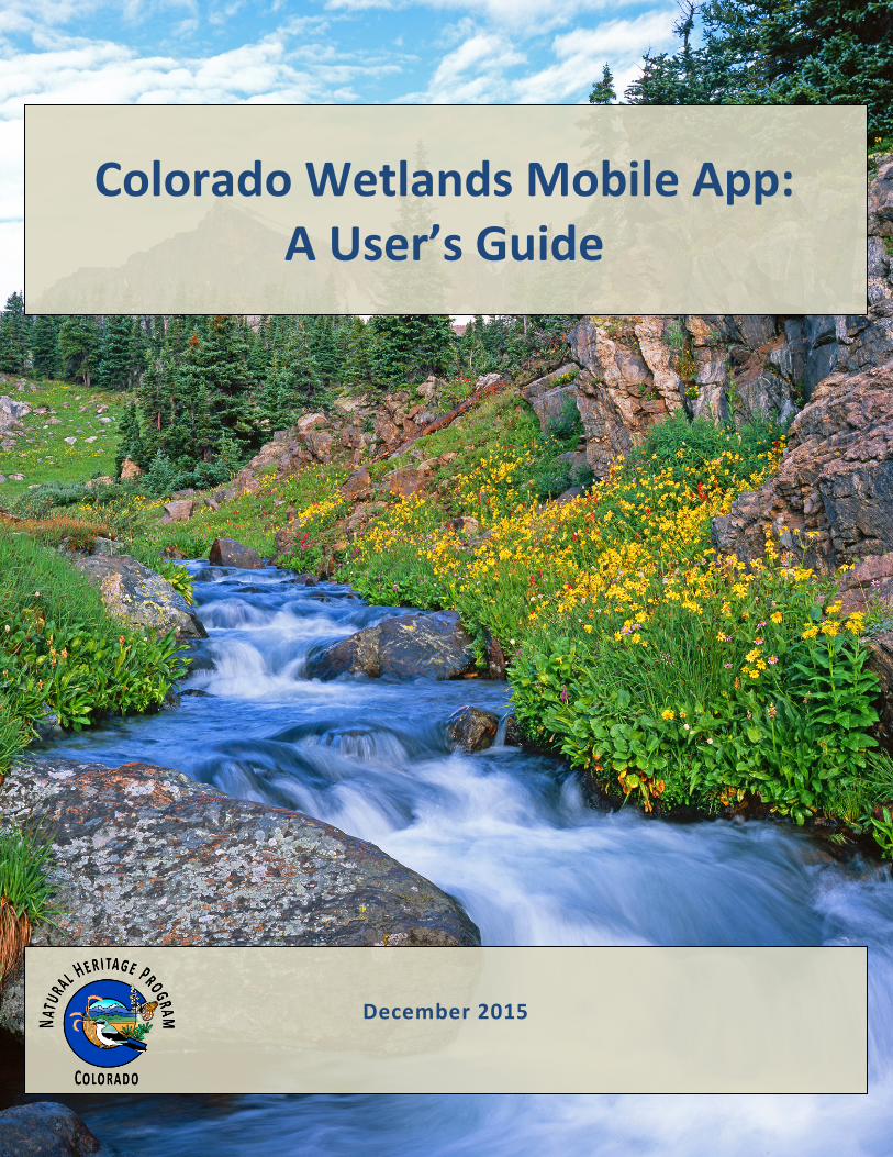
Colorado Wetlands Mobile App: A User’s Guide
December 2015

CNHP’s mission is to preserve the natural diversity of life by contributing the essential scientific foundation that leads to lasting conservation of Colorado's biological wealth.
Colorado Natural Heritage Program Warner College of Natural Resources
Colorado State University 1475 Campus Delivery Fort Collins, CO 80523
Report Prepared for:
EPA Region 8 Wetlands Program 1595 Wynkoop Street, 8EPR-EP
Denver, CO 80202-1129
Recommended Citation: Lemly, J., D. Culver, K. Holfelder, and G. Smith. 2015. Colorado Wetlands Mobile App: A User’s Guide.
Colorado Natural Heritage Program, Colorado State University, Fort Collins, Colorado.
Front Cover: © John Fielder, used by permission.
Colorado Wetlands Mobile App: A User’s Guide
Joanna Lemly, Denise Culver, Kirstin Holfelder, and Gabrielle Smith Colorado Natural Heritage Program
Warner College of Natural Resources Colorado State University
Fort Collins, Colorado 80523
December 2015
ii Colorado Natural Heritage Program © 2015
ACKNOWLEDGMENTS
The App development team at Colorado Natural Heritage Program (CNHP) would like to thank U.S. Environmental Protection Agency (EPA) Region 8 and Colorado Department of Transportation (CDOT) for their financial support and encouragement of this project. Special thanks to Toney Ott, EPA Project Officer, for her support of the project. Rebecca Pierce, CDOT Wetlands Program Manager, provided matching funds and technical review along the way.
Each of the four members of the App development team played different roles. The full development team collaboratively designed the App interface. Kirstin Holfelder, CNHP Web and Database Developer, developed the code that drives the App. Gabrielle Smith, CNHP Wetland Mapping Specialist, created the GIS Services that all allow the App to show wetland maps and contributed to the architecture of the Mapping Section. Denise Culver, CNHP Ecologist, adapted content from her two previous publications on wetland plants to best fit the App format. Joanna Lemly, CNHP Wetland Ecologist, provided overall project management.
Many others contributed to the development of and content within the App. Expert technical assistance on App development was provided by Gordon Holfelder. Technical IT assistance within CNHP was provided by Michael Menefee, Gabe Scott, and Rob Fredericks. Cora Marrama helped compile the searchable plant characteristics. Numerous photographers and illustrators contributed image. Full lists can be found in the Field Guide to Colorado’s Wetland Plants: Identification, Ecology and Conservation by Denise Culver and Joanna Lemly and Common Wetland Plants of Colorado’s Eastern Plains: A Pocket Guide by Denise Culver, both available through CNHP.
We thank external reviewers of an early Beta version of the App, including Billy Bunch of EPA Region 8; Jill Handwerk of CNHP; Audrey Harvey of the Southern Utes Indian Tribe; Gwen Kittel of NatureServe; Bernadette Kuhn of CNHP; Colin Lee, formerly of Bird Conservancy of the Rockies and Natural Resource Conservation Service; Teresa Magee of EPA Office of Research and Development; Sarah Marshall, season field technician with CNHP; Rob Schorr of CNHP; Kelly Uhing of City and County of Denver; and Cathreine Wiechmann of CNHP.
During the course of this project, we gained tremendous feedback and ideas from our colleagues at CNHP, especially Dave Anderson, Laurie Gilligan, Jill Handwerk, Bernadette Kuhn, Rob Schorr, Pam Smith, Joe Stevens, Jeremy Sueltenfuss and Catherine Wiechmann. Finally, we would like to thank Mary Olivas and Carmen Morales with Colorado State University for accounting support and grant administration.
Colorado Wetlands Mobile App: A User’s Guide iii
TABLE OF CONTENTS
WHAT IS THE COLORADO WETLANDS MOBILE APP? ............................................................................1
1.0 HOME SCREEN ..............................................................................................................................2
2.0 INTRODUCTION SCREEN ...............................................................................................................3
3.0 WETLAND PLANTS SECTION ..........................................................................................................5
3.1 Wetland Plant List ............................................................................................................................... 5
3.2 Search Screen ...................................................................................................................................... 7
3.3 Wetland Plants Help Screen .............................................................................................................. 11
3.4 Wetland Plant Profile Pages .............................................................................................................. 12
3.4.1 Images ........................................................................................................................................ 12
3.4.2 General Description Page ........................................................................................................... 13
3.4.3 Similar Species List ..................................................................................................................... 18
3.4.4 Ecology Page .............................................................................................................................. 19
3.4.5 Range Page ................................................................................................................................. 21
3.4.6 References ................................................................................................................................. 22
4.0 WETLAND MAPS SECTION ........................................................................................................... 23
4.1 Wetland Maps Screen ....................................................................................................................... 23
4.2 Wetland Maps Help Screen............................................................................................................... 25
5.0 WETLAND TYPES SECTION ........................................................................................................... 27
6.0 ACKNOWLEDGEMENTS SCREEN .................................................................................................. 28

iv Colorado Natural Heritage Program © 2015
Colorado Wetlands Mobile App: A User’s Guide 1
WHAT IS THE COLORADO WETLANDS MOBILE APP? The Colorado Wetlands Mobile App delivers information about Colorado’s wetlands to users via smartphones or tablets. It was created by the Colorado Natural Heritage Program (CNHP) through a U.S. Environmental Protection Agency (EPA) Region 8 Wetland Program Development Grant (WPDG). The App is free and available to the public from the major App distribution points, including Apple App Store and Google Play Store. CNHP’s main objective in creating the App was to provide wetland professionals and public citizens alike with information to guide conservation and appreciate of the state’s value wetland resource.
The App contains three main sections:
• Wetland Plants: Detailed descriptions and photos of 711 plant species found in Colorado’s wetland and riparian areas. The plants are searchable through many different search criteria and filters.
• Wetland Maps: Access to digital National Wetland Inventory (NWI) maps. The App shows NWI maps for the entire state of Colorado and can use location information from the device to show mapped wetland where the user is located. The Maps screen can also be used to search for wetland plants potentially found at the user’s location.
• Wetland Types: Brief description of the most common wetland and riparian types found in Colorado. Wetland types can also be used as a filter for searching plant species.
Information contained in the App is derived from three main sources. The wetland plant descriptions were adapted from two publications produced by CNHP, also with EPA Region 8 funding: Field Guide to Colorado’s Wetland Plants: Identification, Ecology and Conservation by Denise Culver and Joanna Lemly and Common Wetland Plants of Colorado’s Eastern Plains: A Pocket Guide by Denise Culver. The wetland maps are National Wetland Inventory maps, produced in partnership with the U.S. Fish and Wildlife Service and many other funding partners. The wetland types are based on NatureServe Ecological Systems, modified for Colorado.
While the App itself is intuitive and contains much of the background and instructional information needed to make full use of the information it contains, this user’s guide provides background information and full documentation for a more complete understanding of its functionality. This user’s guide specifically applies to the January 2016 release of the App. Minor changes may be made in future versions.

2 Colorado Natural Heritage Program © 2015
1.0 HOME SCREEN The Home Screen is the first screen the user encounters when opening the App (Figure 1). The Home Screen contains a menu with five choices:
• Introduction • Wetland Plants • Wetland Maps • Wetland Types • Acknowledgements
Each of these five buttons takes the user deeper into App content, as explained in sections below.
Figure 1. Home Screen of the Colorado Wetland Mobile App.
Colorado Wetlands Mobile App: A User’s Guide 3
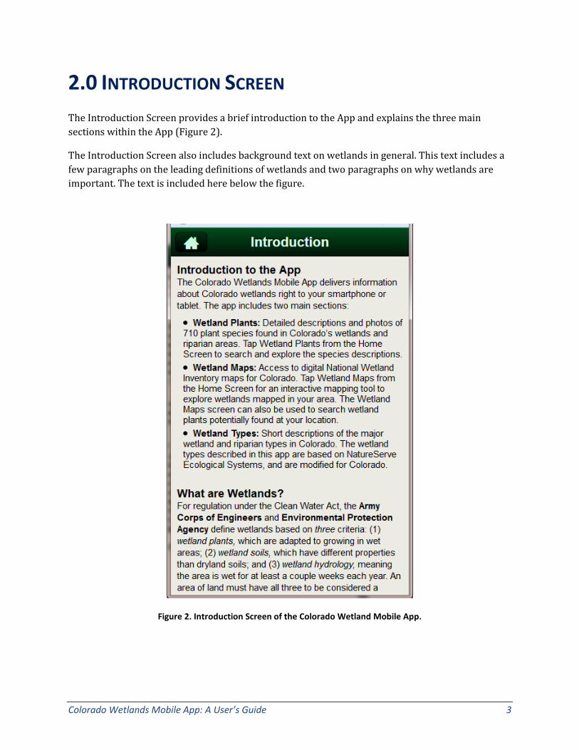
2.0 INTRODUCTION SCREEN The Introduction Screen provides a brief introduction to the App and explains the three main sections within the App (Figure 2).
The Introduction Screen also includes background text on wetlands in general. This text includes a few paragraphs on the leading definitions of wetlands and two paragraphs on why wetlands are important. The text is included here below the figure.
Figure 2. Introduction Screen of the Colorado Wetland Mobile App.
4 Colorado Natural Heritage Program © 2015
What are Wetlands? For regulation under the Clean Water Act, the Army Corps of Engineers and Environmental Protection Agency define wetlands based on three criteria: (1) wetland plants, which are adapted to growing in wet areas; (2) wetland soils, which have different properties than dryland soils; and (3) wetland hydrology, meaning the area is wet for at least a couple weeks each year. An area of land must have all three to be considered a wetland. Their official definition is:
"Those areas that are inundated or saturated by surface or groundwater at a frequency and duration sufficient to support, and that under normal circumstance do support, a prevalence of vegetation typically adapted for life in saturated soil conditions."
For mapping and habitat management, the U.S. Fish and Wildlife Service define wetlands more broadly. An area can be considered a wetland if it has either wetland plants or undrained wetland soils. This definition recognizes that some areas provide many functions of wetlands without exhibiting all three characteristics required by the Clean Water Act criteria. For example, riparian areas, which often do not meet all three criteria, perform many of the same functions as other wetland types, including maintenance of water quality, storage of floodwaters and enhancement of biodiversity, especially in the western United States. Their official definition is:
"Lands transitional between terrestrial and aquatic systems where the water table is usually at or near the surface or the land is covered by shallow water.”
Why are Colorado Wetlands Important? Colorado is one of the most biologically diverse states in the Intermountain West, with nearly 3,600 plant and animal species. Wetland and riparian areas are transitional lands between terrestrial and aquatic habitats and are among the most diverse ecosystems in the state. Colorado’s wetlands range from alpine wet meadows high in the mountains to marshes on the plains. Though they cover only 2% of the landscape, wetlands and riparian areas are by far the most ecologically and economically significant ecosystem in Colorado.
Wetlands provide many functions that are valued by society. These include groundwater recharge, nutrient cycling, primary production, carbon sequestration and export, sediment transport, and channel stabilization. One of the most important functions valued by society is the role of wetlands in providing clean water. Wetland vegetation acts as a filter or sponge for water and sediment that may contain heavy metals, pesticides or fertilizers. Wetland vegetation also provides a buffer for flood zones, especially along larger rivers that flow through Colorado’s cities and towns. In addition, wetlands play a key role in many of the recreational activities Colorado is best known for, including hunting, fishing, wildlife viewing and rafting.

Colorado Wetlands Mobile App: A User’s Guide 5
3.0 WETLAND PLANTS SECTION The Wetland Plants Section contains several screens that help the user navigate through the 711 plants included in the App.
3.1 Wetland Plant List
The first screen the user is presented after tapping on the Wetland Plant button is the Wetland Plant List Screen (Figure 3). Each plant species is presented with a thumbnail photo, along with its scientific name, common name, family name, and major group. If the user has arrived at this list from the Home Screen, the list will contain all 711 plant species. The user can see how many plants are in the list by looking at the thin grey bar at the top of the list that says how many species are shown and if any filters are applied. The list can be sorted by Scientific Name, Common Name, Family, and Group by selecting the options from the upper right corner.
Figure 3. Plant List Screen of the Colorado Wetlands Mobile App.
6 Colorado Natural Heritage Program © 2015
At the bottom of the Plant List Screen, there are five buttons.
1) The button with a house will take the user back to the Home Screen.
2) The Search button opens up the Search Screen, described in Section 3.2 below.
3) The Terms button opens up a glossary of botanical terms.
4) The Maps button opens up the Wetland Maps Screen, described in Section 4.1 below.
5) The button with a question mark opens up the Wetland Plants Help Screen, described in Section 3.3 below.
Clicking on any one species in the Plant List opens up the plant’s Profile Pages, described in Section 3.4 below.

Colorado Wetlands Mobile App: A User’s Guide 7
3.2 Search Screen
The Search Screen (Figure 4) presents the user with a long list of search criteria and filters to use to narrow the plant list. The following search criteria and filters are available. Many are defined in more detail in Section 3.4, Plant Profile Page. Once search criteria have been selected, the user can tap “Go” to apply the criteria. This will bring the user back to the Plant List, but with the search criteria applied. The number of results obtained with the search criteria will be shown at the top of the filtered Plant List, indicating success at filtering.
Figure 4. Search Screen of the Colorado Wetlands Mobile App.

8 Colorado Natural Heritage Program © 2015
Search criteria include:
• Name: Scientific or Common Name. This is a text field that will search for any part of the scientific or common name. The search text can be in the beginning, middle or end of the name and still be found.
• Family: Scientific family name. Similar text field as Name.
• Group: The eight main groups of plants included in the App. These eight groups were also used in the Field Guide to Colorado Wetland Plants and Common Wetland Plants of Colorado’s Eastern Plains. The eight groups are:
o Aquatic Herbs o Dicot Herbs o Ferns and Fern Allies o Grasses o Monocot Herbs o Rushes o Sedges o Woody Plants
• Flower / Fruit Color: The predominant color of the plants flowers (in most cases) or fruits (for some plants). The potential colors are:
o White o Orange o Pink o Red o Purple o Blue o Yellow o Brown o Green
• Leaf Arrangement: The predominant leaf arrangement. The potential arrangements are: o Alternate o Opposite o Whorled o Basal
• Leaf Division: The predominant leaf division. The potential divisions are: o Simple o Compound
• Leaf Shape: The predominant shape of the plant’s leaves. The potential shapes are: o Linear/Lanceolate/Elliptic o Round/Ovate o Wide Base
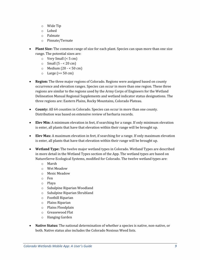
Colorado Wetlands Mobile App: A User’s Guide 9
o Wide Tip o Lobed o Palmate o Pinnate/Ternate
• Plant Size: The common range of size for each plant. Species can span more than one size range. The potential sizes are:
o Very Small (< 5 cm) o Small (5 - < 20 cm) o Medium (20 - < 50 cm) o Large (>= 50 cm)
• Region: The three major regions of Colorado. Regions were assigned based on county occurrence and elevation ranges. Species can occur in more than one region. These three regions are similar to the regions used by the Army Corps of Engineers for the Wetland Delineation Manual Regional Supplements and wetland indicator status designations. The three regions are: Eastern Plains, Rocky Mountains, Colorado Plateau.
• County: All 64 counties in Colorado. Species can occur in more than one county. Distribution was based on extensive review of herbaria records.
• Elev Min: A minimum elevation in feet, if searching for a range. If only minimum elevation is enter, all plants that have that elevation within their range will be brought up.
• Elev Max: A maximum elevation in feet, if searching for a range. If only maximum elevation is enter, all plants that have that elevation within their range will be brought up.
• Wetland Type: The twelve major wetland types in Colorado. Wetland Types are described in more detail in the Wetland Types section of the App. The wetland types are based on NatureServe Ecological Systems, modified for Colorado. The twelve wetland types are:
o Marsh o Wet Meadow o Mesic Meadow o Fen o Playa o Subalpine Riparian Woodland o Subalpine Riparian Shrubland o Foothill Riparian o Plains Riparian o Plains Floodplain o Greasewood Flat o Hanging Garden
• Native Status: The national determination of whether a species is native, non-native, or both. Native status also includes the Colorado Noxious Weed lists.

10 Colorado Natural Heritage Program © 2015
• Wetland Status: The wetland indicator status, based on the Army Corps of Engineers National Wetland Plant List, as of 2012. The wetland indicator status in specific to three regions in Colorado (AW: Arid West, WM: Western Mountains, GP: Great Plains). Searching on a wetland indicator status will bring up any plant with that status in any of the three regions. The wetland indicator statuses are:
o OBL o FACW o FAC o FACU o UPL
• G Rank: The global rarity rank, as assigned by the Natural Heritage Network. There are many combinations of global ranks, so this field is a text string for easiest searching. See the Plant Help Section below for more information on G and S ranks.
• S Rank: The state rarity rank for Colorado, as assigned by the Natural Heritage Network. There are many combinations of state ranks, so this field is a text string for easiest searching. See the Plant Help Section below for more information on G and S ranks.
• Federal Status: A filter for plants listed as threatened or sensitive by the U.S. Fish and Wildlife Service, Bureau of Land Management, or U.S. Forest Service.
• Animal Use: A filter that relates to which animal groups regularly use the species. More detail on animal use can be found in the plant profile for each species. The animal groups include:
o Birds: Cranes & Rails o Birds: Game Fowl o Birds: Gulls o Birds: Grebes o Birds: Passerines o Birds: Waterfowl o Elk, Deer, Moose o Muskrat, Beaver o Amphibians, Reptiles o Insects
Colorado Wetlands Mobile App: A User’s Guide 11
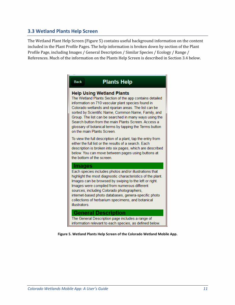
3.3 Wetland Plants Help Screen
The Wetland Plant Help Screen (Figure 5) contains useful background information on the content included in the Plant Profile Pages. The help information is broken down by section of the Plant Profile Page, including Images / General Description / Similar Species / Ecology / Range / References. Much of the information on the Plants Help Screen is described in Section 3.4 below.
Figure 5. Wetland Plants Help Screen of the Colorado Wetland Mobile App.

12 Colorado Natural Heritage Program © 2015
3.4 Wetland Plant Profile Pages
Users can get to the Wetland Plant Profile Pages for each species by clicking on a species from the list, either the full list or a filtered list. Each Plant Profile description is broken into six pages. Users can move between pages using buttons at the bottom of the screen for Images / General Description / Similar Species / Ecology / Range / References. Each is described below. Users can also move between species profile pages by using the arrows in the upper right hand corner.
3.4.1 Images Each species includes photos and/or illustrations that highlight the most diagnostic characteristics of the plant (Figure 6). Images can be browsed by swiping to the left or right. Images were compiled from numerous different sources, including Colorado photographers, internet-based photo databases, genera-specific photo collections of herbaria specimens, and botanical illustrators.
Figure 6. Example images from the Colorado Wetland Mobile App.

Colorado Wetlands Mobile App: A User’s Guide 13
3.4.2 General Description Page The General Description Page includes a range of interesting information relevant to each species, all defined below, along with key characteristics of the plant (Figure 7). The descriptions are grouped for ease of reading. Many of the descriptors on this page can be used as search criteria and filters on the Search Screen, as described in Section 3.2.
Figure 7. Example General Description Page from the Colorado Wetlands Mobile App.

14 Colorado Natural Heritage Program © 2015
Nomenclature
• Scientific Name: USDA-NRCS PLANTS National Database is the primary nomenclature used for scientific names. This nomenclature differs in some instances from state-based floras (e.g., Weber and Wittmann 2012, Ackerfield 2012), but is best for comparing across state borders and between various national datasets.
• Family: Family names used in the app are derived from PLANTS National Database. If a species is treated in a different family in one of the state floras or in Flora of North America, the alternate family name is listed in parenthesis.
• Common Name: Common names are generally derived from PLANTS National Database. In cases where there is more than one common name, both are listed.
• Synonyms: Major synonyms are listed for each species. A special effort was made to include all names used by Weber and Wittmann (2012), Ackerfield (2012), and the most recent Flora of North America treatments (Flora of North America 1993+).
• USDA PLANTS Symbol: The unique alpha-numeric symbol for each species used within PLANTS National Database. The symbols begin with the first two letters of the genus name and the first two letters of the species name, followed by the first letter of the subspecies or varieties, if applicable. If the letters in any code are the same for more than one taxon, a number is included at the end of the code to make each code unique.
• ITIS TSN: The Integrated Taxonomic Information System (ITIS) Taxonomic Serial Number (TSN). Like the USDA PLANTS Symbol, this is a unique numeric code used to differentiate species and is used by many national and international agencies.

Colorado Wetlands Mobile App: A User’s Guide 15
Conservation Status
• Federal Status: Notes whether a species is listed as threatened under the federal Endangered Species Act or considered sensitive by the Bureau of Land Management (BLM) or U.S. Forest Service (USFS).
• Global / State Ranks: From the Natural Heritage Network, which ranks the rarity of species on a Global (G) and Subnational/State (S) level. Basic ranks are shown in Table 1 below. State ranks are included for all six states within EPA Region 8 (CO, WY, UT, MT, SD, ND).
Table 1. Explanation of Global and State Ranks
Rank Interpretation
1 Critically Imperiled (typically 5 or fewer occurrences or less than 1,000 individuals)
2 Imperiled (typically 6 to 20 occurrences or between 1,000 and 3,000 individuals)
3 Vulnerable to Extirpation (typically 21 to 100 occurrences or between 3,000 and 10,000 individuals)
4 Apparently Secure (usually more than 100 occurrences and more than 10,000 individuals)
5 Demonstrably Widespread, Abundant, and Secure (typically with considerably more than 100 occurrences and more than 10,000 individuals)
NR Not Ranked (not enough information is available on which to base a rank)
NA Not Applicable (rarity ranking is not applicable because the species is not native to the state)
16 Colorado Natural Heritage Program © 2015
Biology
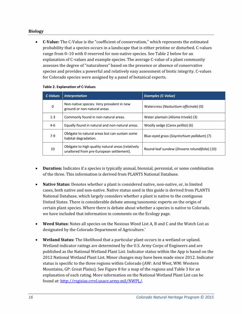
• C-Value: The C-Value is the "coefficient of conservatism," which represents the estimated probability that a species occurs in a landscape that is either pristine or disturbed. C-values range from 0–10 with 0 reserved for non-native species. See Table 2 below for an explanation of C-values and example species. The average C-value of a plant community assesses the degree of “naturalness” based on the presence or absence of conservative species and provides a powerful and relatively easy assessment of biotic integrity. C-values for Colorado species were assigned by a panel of botanical experts.
Table 2. Explanation of C-Values
C-Values Interpretation Examples (C-Value)
0 Non-native species. Very prevalent in new ground or non-natural areas. Watercress (Nasturtium officinale) (0)
1-3 Commonly found in non-natural areas. Water plantain (Alisma trivale) (3)
4-6 Equally found in natural and non-natural areas. Woolly sedge (Carex pellita) (6)
7-9 Obligate to natural areas but can sustain some habitat degradation. Blue-eyed grass (Sisyrinchium pallidum) (7)
10 Obligate to high quality natural areas (relatively unaltered from pre-European settlement). Round-leaf sundew (Drosera rotundifolia) (10)
• Duration: Indicates if a species is typically annual, biennial, perennial, or some combination of the three. This information is derived from PLANTS National Database.
• Native Status: Denotes whether a plant is considered native, non-native, or, in limited cases, both native and non-native. Native status used in this guide is derived from PLANTS National Database, which largely considers whether a plant is native to the contiguous United States. There is considerable debate among taxonomic experts on the origin of certain plant species. Where there is debate about whether a species is native to Colorado, we have included that information in comments on the Ecology page.
• Weed Status: Notes all species on the Noxious Weed List A, B and C and the Watch List as designated by the Colorado Department of Agriculture.'
• Wetland Status: The likelihood that a particular plant occurs in a wetland or upland. Wetland indicator ratings are determined by the U.S. Army Corps of Engineers and are published as the National Wetland Plant List. Indicator status within the App is based on the 2012 National Wetland Plant List. Minor changes may have been made since 2012. Indicator status is specific to the three regions within Colorado (AW: Arid West, WM: Western Mountains, GP: Great Plains). See Figure 8 for a map of the regions and Table 3 for an explanation of each rating. More information on the National Wetland Plant List can be found at: http://rsgisias.crrel.usace.army.mil/NWPL/.

Colorado Wetlands Mobile App: A User’s Guide 17
Figure 8. U.S. Army Corps Engineers regions for Colorado, as used in the National Wetland Plant list.
Table 3. Explanation of C-Values
Indicator Code Indicator Status Comment
OBL Obligate Wetland Almost always occurs in wetlands.
FACW Facultative Wetland Usually occurs in wetlands, but may occur in non-wetlands.
FAC Facultative Occurs in wetland and non-wetlands.
FACU Facultative Upland Usually occurs in non-wetlands, but may occur in wetlands.
UPL Obligate Upland Almost never occurs in wetlands.
NI No Indicator Insufficient information available to determine indicator status
Key Characteristics:
Perhaps the most important part of this page, the key characteristics include up to five bullets that detail the most important and distinguishing characteristics of the species. In general, the first bullet describes overall plant size, plant habit, stem characteristics, and rooting structure. The second bullet describes the most important features of the leaves, including the size, shape, position on the plant, presence of hairs, etc. If there is more than one type of leaf, both are described in detail. Remaining bullets describe important features of the inflorescence, flowers and flower parts, and seeds. The key characteristics vary by family and genus, as each has particular characteristics of importance.

18 Colorado Natural Heritage Program © 2015
3.4.3 Similar Species List The Similar Species List includes look-alikes that could be easily mistaken for the main species (Figure 9). If a similar species has a full description in the App, it will appear in an interactive list. If it is not included in the app, it is described in brief in General Comments above the list and the USDA PLANTS Code, Wetland Indicator Status, and ITIS TSN are provided. General Comments may also include distinguishing characteristics of two or more subspecies or distinguishing characteristics of the entire genus.
Figure 9. Example Similar Species List from the Colorado Wetlands Mobile App.
Colorado Wetlands Mobile App: A User’s Guide 19
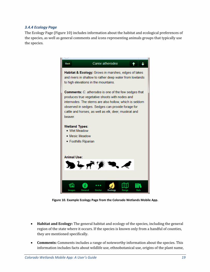
3.4.4 Ecology Page The Ecology Page (Figure 10) includes information about the habitat and ecological preferences of the species, as well as general comments and icons representing animals groups that typically use the species.
Figure 10. Example Ecology Page from the Colorado Wetlands Mobile App.
• Habitat and Ecology: The general habitat and ecology of the species, including the general region of the state where it occurs. If the species is known only from a handful of counties, they are mentioned specifically.
• Comments: Comments includes a range of noteworthy information about the species. This information includes facts about wildlife use, ethnobotanical use, origins of the plant name,
20 Colorado Natural Heritage Program © 2015
and evolutionary strategies of the plant or plant family. In cases where there is debate over nomenclature or over whether the plant is native to Colorado, that information is also included in comments.<
• Wetland Types: A list of wetland and riparian types in which the species is likely to occur. The wetland types are based on NatureServe Ecological Systems, modified for Colorado. Ecological Systems are dynamic assemblages or complexes of plant communities that occur together on the landscape are tied together by similar ecological processes, underlying abiotic environmental factors or gradients and form a readily identifiable unit on the ground.
• Animal Use: Along with animal use described in comments, the animal use icons are a quick reference for which animal and bird groups use each plant species.
Table 4. Explanation of Animal Use Icons
Symbol Common Name for Groups Order and Common Families
Birds: Cranes & Rails Gruiformes—Rails, Coots, and Cranes
Birds: Game Fowl Galliformes—Grouse, Quail, Ptarmigan
Birds: Gulls Chararadriifomes—Gulls, Sandpipers, Phalaropes, Snipes, Avocets
Birds: Grebes Podicipediformes—Grebes
Birds: Herons Pelecaniformes—Cormorants, Pelicans, Herons, Egrets, Bitterns
Birds: Passerines Passeriformes—Flycatchers, Ovenbirds, Dippers, Wrens, Pipits, Sparrows, Blackbirds
Birds: Waterfowl Anseriformes—Ducks, Geese, Dabbling and Wood Ducks, and Bay Ducks
Elk, Deer, Moose Large Mammals—Moose, Elk, Deer, Sheep, Domestic Livestock
Muskrat, Beaver Small Mammals—Beaver, Muskrats, Shrews, Pikas, Rabbits
Colorado Wetlands Mobile App: A User’s Guide 21
Amphibs, Reptiles Amphibians—Toads, Frogs, Snakes, Salamander, Turtles
Insects Insects—Butterfly , Moths, Flies, Ants
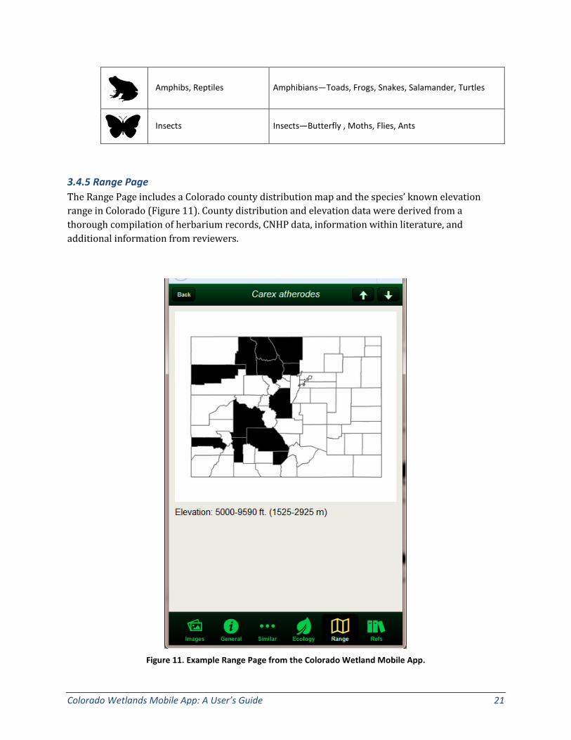
3.4.5 Range Page The Range Page includes a Colorado county distribution map and the species’ known elevation range in Colorado (Figure 11). County distribution and elevation data were derived from a thorough compilation of herbarium records, CNHP data, information within literature, and additional information from reviewers.
Figure 11. Example Range Page from the Colorado Wetland Mobile App.
22 Colorado Natural Heritage Program © 2015
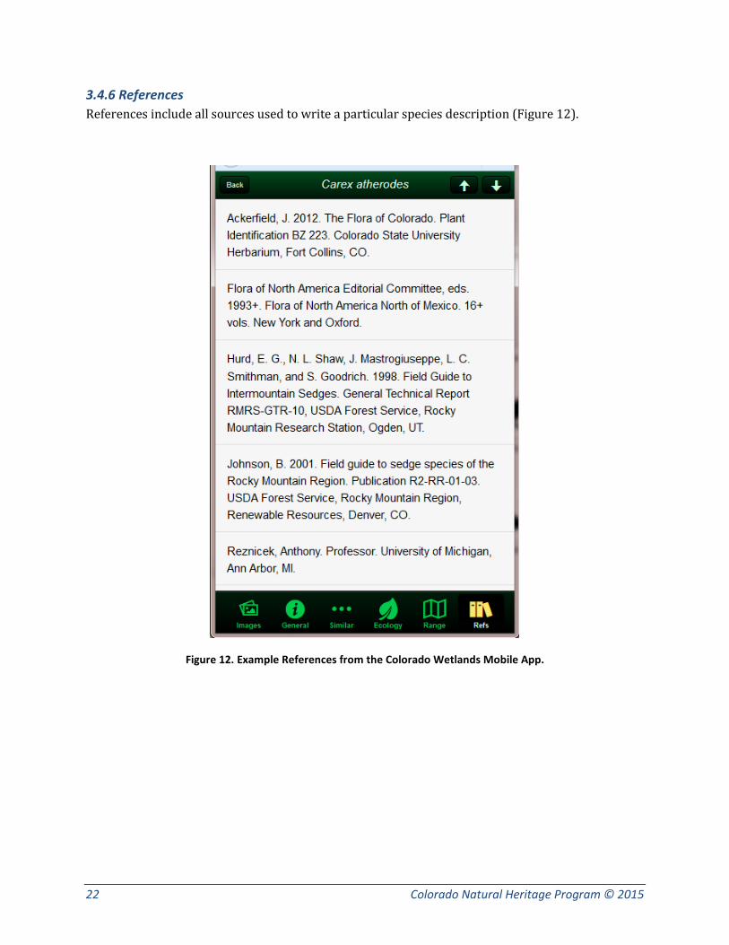
3.4.6 References References include all sources used to write a particular species description (Figure 12).
Figure 12. Example References from the Colorado Wetlands Mobile App.
Colorado Wetlands Mobile App: A User’s Guide 23
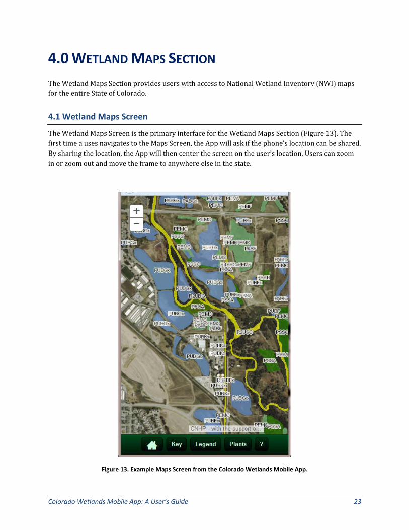
4.0 WETLAND MAPS SECTION The Wetland Maps Section provides users with access to National Wetland Inventory (NWI) maps for the entire State of Colorado.
4.1 Wetland Maps Screen
The Wetland Maps Screen is the primary interface for the Wetland Maps Section (Figure 13). The first time a uses navigates to the Maps Screen, the App will ask if the phone’s location can be shared. By sharing the location, the App will then center the screen on the user’s location. Users can zoom in or zoom out and move the frame to anywhere else in the state.
Figure 13. Example Maps Screen from the Colorado Wetlands Mobile App.

24 Colorado Natural Heritage Program © 2015
At the bottom of the Map Screen, there are five buttons.
1) The button with a house will take the user back to the Home Screen.
2) The Key button opens a pop-up with a key to the NWI classification codes (Figure 14).
3) The Legend button opens a pop-up with a color-coded legend to the main NWI classes (Figure 14).
4) The Plants button opens brings the user to the Plant List page, but a filter will be applied based on the user’s location, specifically the county in which the user is located and an elevation range +/- 500 ft. from the user’s actual elevation. This will narrow the list to plants most likely within the vicinity of the user’s location.
5) The button with a question mark opens up the Wetland Maps Help Screen, described in Section 4.2 below.
Figure 14. Key to the NWI classification codes used in the Wetland Maps Section (left). Legend to the main NWI classes (right).
Colorado Wetlands Mobile App: A User’s Guide 25
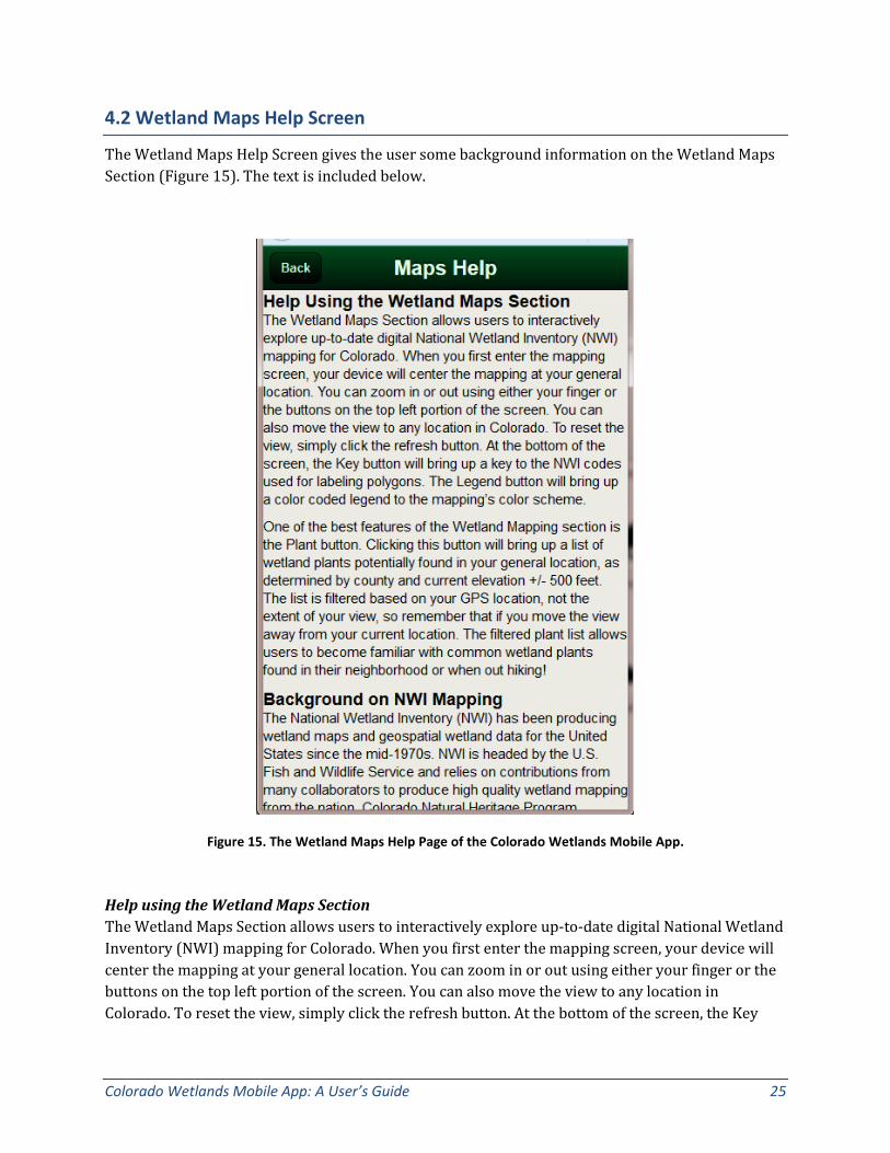
4.2 Wetland Maps Help Screen
The Wetland Maps Help Screen gives the user some background information on the Wetland Maps Section (Figure 15). The text is included below.
Figure 15. The Wetland Maps Help Page of the Colorado Wetlands Mobile App.
Help using the Wetland Maps Section The Wetland Maps Section allows users to interactively explore up-to-date digital National Wetland Inventory (NWI) mapping for Colorado. When you first enter the mapping screen, your device will center the mapping at your general location. You can zoom in or out using either your finger or the buttons on the top left portion of the screen. You can also move the view to any location in Colorado. To reset the view, simply click the refresh button. At the bottom of the screen, the Key
26 Colorado Natural Heritage Program © 2015
button will bring up a key to the NWI codes used for labeling polygons. The Legend button will bring up a color coded legend to the mapping’s color scheme.
One of the best features of the Wetland Mapping section is the Plant button. Clicking this button will bring up a list of wetland plants potentially found in your general location, as determined by county and current elevation +/- 500 feet. The list is filtered based on your GPS location, not the extent of your view, so remember that if you move the view away from your current location. The filtered plant list allows users to become familiar with common wetland plants found in their neighborhood or when out hiking!
Background on NWI Mapping The National Wetland Inventory (NWI) has been producing wetland maps and geospatial wetland data for the United States since the mid-1970s. NWI is headed by the U.S. Fish and Wildlife Service and relies on contributions from many collaborators to produce high quality wetland mapping from the nation. Colorado Natural Heritage Program (CNHP) and Colorado Parks and Wildlife (CPW) have worked closely with NWI since 2008 to create a complete digital map of wetlands for Colorado. Much of the mapping displayed in this app was originally created in the 1970s and 1980s as paper maps based on coarse air photography and only recently converted to digital data by CNHP and CPW. However, CNHP has created updated mapping in many areas of the state, included the northern Front Range and Park County.
For more information, please see:
• NWI home page: http://www.fws.gov/wetlands/index.html • CNHP’s webpage on mapping: http://www.cnhp.colostate.edu/cwic/location.asp
Colorado Wetlands Mobile App: A User’s Guide 27
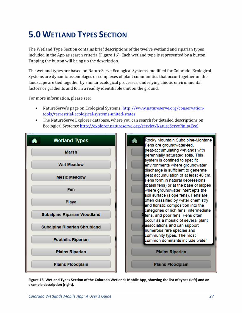
5.0 WETLAND TYPES SECTION The Wetland Type Section contains brief descriptions of the twelve wetland and riparian types included in the App as search criteria (Figure 16). Each wetland type is represented by a button. Tapping the button will bring up the description.
The wetland types are based on NatureServe Ecological Systems, modified for Colorado. Ecological Systems are dynamic assemblages or complexes of plant communities that occur together on the landscape are tied together by similar ecological processes, underlying abiotic environmental factors or gradients and form a readily identifiable unit on the ground.
For more information, please see:
• NatureServe’s page on Ecological Systems: http://www.natureserve.org/conservation-tools/terrestrial-ecological-systems-united-states
• The NatureServe Explorer database, where you can search for detailed descriptions on Ecological Systems: http://explorer.natureserve.org/servlet/NatureServe?init=Ecol
Figure 16. Wetland Types Section of the Colorado Wetlands Mobile App, showing the list of types (left) and an example description (right).
28 Colorado Natural Heritage Program © 2015
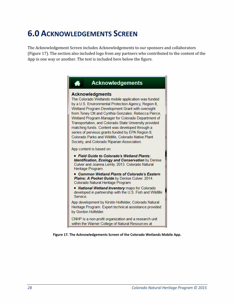
6.0 ACKNOWLEDGEMENTS SCREEN The Acknowledgement Screen includes Acknowledgements to our sponsors and collaborators (Figure 17). The section also included logo from any partners who contributed to the content of the App in one way or another. The text is included here below the figure.
Figure 17. The Acknowledgements Screen of the Colorado Wetlands Mobile App.

Colorado Wetlands Mobile App: A User’s Guide 29
Acknowledgements The Colorado Wetlands mobile application was funded by a U.S. Environmental Protection Agency, Region 8, Wetland Program Development Grant with oversight from Toney Ott and Cynthia Gonzales. Rebecca Pierce, Wetland Program Manager for Colorado Department of Transportation, and Colorado State University provided matching funds. Content was developed through a series of pervious grants funded by EPA Region 8, Colorado Parks and Wildlife, Colorado Native Plant Society, and Colorado Riparian Association.
App content is based on:
• Field Guide to Colorado’s Wetland Plants: Identification, Ecology and Conservation by Denise Culver and Joanna Lemly. 2013. Colorado Natural Heritage Program.
• Common Wetland Plants of Colorado’s Eastern Plains: A Pocket Guide by Denise Culver. 2014. Colorado Natural Heritage Program.
• National Wetland Inventory maps for Colorado developed in partnership with the U.S. Fish and Wildlife Service.
App development by Kirstin Holfelder, Colorado Natural Heritage Program, Expert technical assistance provided by Gordon Holfelder.
CNHP is a non-profit organization and a research unit within the Warner College of Natural Resources at Colorado State University. CNHP is a member of the NatureServe Network, an international network of natural heritage programs that use the same scientific methodology to monitor the status of species and natural communities from state, national, and global perspectives. The overarching mission of CNHP is:
“To preserve the natural diversity of life by contributing the essential scientific foundation that leads to lasting conservation of Colorado’s biological wealth.”