Embed Size (px)
Citation preview
Comments - Environmental Permit Review Maine Department of Inland Fisheries and Wildlife
Inland Fisheries and Wildlife Division Comments Bureau of Resource Management Comments
Applicant’s Name: Central Maine Power Company Project #: Regulatory Agency: MDEP Project Type: New England Clean Energy Connect Project
Project Manager: James Beyer
Comments Due Date: --- Date Comments Sent: 3-15-2018 Biologists (review coordinators): John Perry, Bob Stratton Biologists (Fisheries Division): Tim Obrey, Jason Seiders, Liz Thorndike Biologists (Wildlife Division): Phillip deMaynadier, Chuck Hulsey, Doug Kane, Keel Kemper, Cory Mosby, Bob Stratton, Beth Swartz, Charlie Todd, Derek Yorks
After review of the application and consideration of the proposal’s probable effect on the environment, and on our agency’s programs and responsibilities, we provide the following comments: Project Description: Central Maine Power Company (“CMP”, the Applicant) proposes to construct the New England Clean Energy Connect (“NECEC”), a High Voltage Direct Current (“HVDC”) transmission line and related facilities capable of delivering up to 1,200 MW of electric generation from the Canadian border to the New England Control Area in response to the Request for Proposals for Long-Term Contracts for Clean Energy Projects issued by the Massachusetts Department of Energy Resources and the Electric Distribution Companies of Massachusetts. The proposed NECEC Project is composed of the following components: Segments 1, 2, & 3 – HVDC Components and Associated Upgrades
• New 145.3-mile +/-320kV HVDC Transmission Line from the Canadian border to a new converter substation located north of Merrill Road in Lewiston;
• New 1.2-mile 345kV to +/-320kV Transmission Line from the new Merrill Road Converter Station to the existing Larrabee Road Substation;
• Partial rebuild of 0.8 miles of 34.5kV Section 72 AC Transmission Line outside of the Larrabee Road Substation to make room in the corridor for the 1.2 mile 345kV Transmission Line;
• New 345kV to +/-320kV HVDC 1200MW Merrill Road Converter Station; • Addition of 345kV Transmission Line Terminal at the existing Larrabee Road Substation;
Segment 4 – 345kV STATCOM Substation and 115kV Rebuilds
• New 345kV +/-200MVAR STATCOM Fickett Road Substation; • New 0.3-mile 345kV AC Transmission Line from the existing Surowiec Substation in Pownal to
a new substation on Fickett Road in Pownal; • Rebuild 16.1 miles of 115kV Section 64 AC Transmission Line from the existing Larrabee Road
Substation to the existing Surowiec Substation; • Rebuild 9.3 miles of 115kV Section 62 AC Transmission Line from the existing Crowley Road
2
Substation in Lewiston to the existing Surowiec Substation; Segment 5 – New 345kV Transmission Line and Associated Rebuilds
• New 26.5-mile 345kV AC Transmission Line from the existing Coopers Mills Substation in Windsor to the existing Maine Yankee Substation in Wiscasset;
• Partial rebuild of 0.3 mile of 345kV Section 3025 between Larrabee Road Substation and Coopers Mills Substation;
• Partial rebuild of 0.8 mile of 345kV Section 392 between Maine Yankee Substation and Coopers Mills Substation; and,
• Partial rebuild of 0.8 mile each of 115kV Section 60/88 outside of Coopers Mills Substation. Consultation summary: MDIFW first learned of the details of this project during a State and Federal Interagency Meeting on May 23, 2017 when the Applicant and their consultant (Burns & McDonnell, also considered the “Applicant” for purposes of this review) formally introduced the Project. It was explained at that time that the Project was initiated two years prior at which time baseline environmental studies were initiated and ongoing (namely wetland mapping and vernal pool surveys). The general concept of the current Project proposal was described and there were general discussions, as well as concerns raised by both State and Federal agencies regarding the expedited permitting schedule of the Project and the need to update and collect further field data. At that time, MDIFW provided very preliminary comments on the scope and provided our Agency’s list of recommended pre-construction studies. On June 5, 2017, MDIFW responded to Applicant’s Environmental Review request. As attachments to the response, MDIFW also included Final Performance Standards for Overhead Utility ROW Projects for Deer Wintering Areas, Inland Waterfowl and Wading Bird Habitats, Significant Vernal Pools, and Riparian Buffers. In addition, a shapefile of the project layout with known and mapped MDIFW species and habitat resources of concern was also sent to the Applicant and their consultant. On June 7, 2017, MDIFW, USFWS, and the Maine Natural Areas Program met with the applicant to specifically discuss concerns and needs related to natural resources. Several subsequent related correspondences have ensued. The majority of MDIFW’s review has been focused on the “new” section of the proposal, a 53.5-mile long transmission corridor which will enter Maine in Beattie Township before it joins with an existing transmission line in West Forks. It is our Agency’s understanding that the Applicant has indicated that it will follow the same techniques for the co-location portions of the NECEC Project that were utilized for the Maine Power Reliability Program (MPRP) Project, including employing lessons learned from that 5-year-long construction experience. While MDEP previously adopted those measures for the permitting of the MPRP Project, our Agency has some concerns and recommendations for the major portion of the NECEC Project (49%) proposed to be co-located in existing corridors that will be widened. As noted in the June 7, 2017 meeting, the MPRP was unique in its proposal, site conditions, and circumstances. It included mitigation based on demonstrated unavoidable impacts, prescribed timing constraints, materials and methods. It consisted of an existing, previously impacted route and not an uncut right of way. Given the scale of the Project, most of our recommendations specifically address the new impacts of the newly proposed corridor, though the same concerns are relevant for new impact areas on existing corridors.
3
Consistent with our Agency’s reviews of construction of new transmission line corridors, MDIFW provides the following comments and recommendations. Wildlife Concerns MDIFW makes note that in several instances, pertaining to particular State-listed Endangered, Threatened, or Special Concern species, the application states that
Based on information provided by MDIFW, there are no documented occurrences of {species type} within the Project corridor.
Or …no occurrences of the {species type} have been documented within the Project vicinity.
It should be emphasized that while MDIFW databases may not indicate the presence of a particular State-listed Endangered, Threatened, or Special Concern Species within the 53.5-mile long transmission corridor Project area, it is because, to our knowledge, no formal surveys have been conducted. MDIFW reiterates that it is likely that State-listed Endangered, Threatened, or Special Concern Species are resident or transient in the Project area based on location, habitats present, and life history requirements of the individual species present. MDIFW’s recommendations are made accordingly. Northern bog lemming Northern bog lemming, a State Threatened species, are afforded special protection under Maine’s Endangered Species Act (MESA, 12 M.R.S §12801 et seq.). MDIFW has had several discussions with the Applicant regarding the potential for northern bog lemming to occur in the Project area. As staff have indicated, the habitats of interest for northern bog lemming are alpine sedge meadows, krummholz, spruce-fir forest with dense herbaceous and mossy understories, wet meadows, and mossy stream-sides, that are > 1,000 feet MSL (above Mean Sea Level) in western mountain and northern areas of Maine. Northern bog lemmings are presumed to be present in these habitats and, to protect this species, MDIFW recommends that these areas be avoided. MDIFW staff have reviewed the entire Project shapefile through desktop analysis and identified one area along the corridor that potentially contains habitat features that are suitable for northern bog lemming, located south and west of Moose Mountain in Skinner Township. Refer to yellow delineation in the figure below.

4
MDIFW recommends that the Applicant conduct a review of the land within this area for the habitat features suitable for northern bog lemming. If those habitat features are present, and the applicant wishes to verify presence, we recommend the Applicant perform surveys to document presence/probable absence. Surveys can be conducted in one of two ways.
1) Transects can be walked through NBL habitat and document any presence of run-ways, latrines, and green scat; or
2) If a more definitive method of NBL identification is desired on the part of the applicant, scats can be collected and genetically analyzed to identify if they are NBL, or other species of rodents. For a full description of the methods to conduct this level of genetic work please contact the MDIFW Small Mammal Biologist (207-941-4473). If evidence of lemmings is present either in the form of green scats, latrines, runways, and/or genetic confirmation, MDIFW will consider the area as occupied and recommendations will be to avoid these wetlands.
Alternatively, in consultation with MDIFW, the applicant may elect to forgo field surveys along this reach and avoid direct and indirect impacts to any suitable habitat areas, including no clearing or use of construction-related equipment (i.e. cranes, crane mats, etc.) within these areas. Brook Floater
There are two locations where the project footprint intersects a mapped habitat polygon for this species of State-Threatened freshwater mussel: the West Branch Sheepscot River in Windsor (Segment 5, Maps 414-416) and the Carrabassett River in Anson (Segment 3, Map 199). Because the applicant is not proposing any in-stream construction or new forest clearing within these mapped habitats, MDIFW does not anticipate new impacts to the Brook Floater as a result of project activities.
5
However, at both of these sites, a riparian buffer along significant stretches of the river is either entirely lacking or has been diminished to a thin strip as a result of past clearing for transmission line ROW, agriculture, and other uses. The Brook Floater, which is one of the most endangered freshwater mussels in the Northeast and currently under review for potential Federal listing, is a species that requires free-flowing streams and rivers of high water quality. Protecting stream integrity through maintenance of an effective riparian buffer is a valuable conservation tool for this species. As such, on lands within 100 feet of the shores of both rivers, or the upland edge of contiguous wetlands, that are owned or controlled by the applicant, MDIFW recommends that Central Maine Power improve the riparian buffer integrity by allowing woody vegetation to regrow to the greatest height possible. Roaring Brook Mayfly The Roaring Brook Mayfly is a State-Threatened species that is restricted to clean, cold, high elevation perennial streams along the northern Appalachian Mountain range and may be New England’s only endemic mayfly. It is currently known from only 14 streams in Maine and one site each in New Hampshire and Vermont. The project footprint intersects a mapped habitat polygon for this State-Threatened mayfly on an unnamed tributary of Mountain Brook in Johnson Mountain Twp. (Segment 1, Maps 76-77). The applicant proposes to clear approximately 1,100 linear feet of currently forested right-of-way through the riparian management zone associated with this occurrence-- permanently converting a significant portion of forested riparian buffer to non-forested vegetation. MDIFW believes this activity will have a permanent adverse effect by significantly degrading habitat quality for Roaring Brook Mayfly along this stretch of the stream. Additionally, as there have been extremely few other projects in this region of the state, our data on species occurrence in this area is sparse. Because the northernmost segment of the Project runs through the known distribution of the Roaring Brook Mayfly and this region has not been comprehensively surveyed, the potential exists for project activities to impact undiscovered populations of this globally rare mayfly. Given the geographic range of this species, as well as the elevation of the project and presumed cold water/excellent water quality of most of the streams, the assumption is that this species is present in other portions of the Project search area. All known occurrences of this species are in streams draining off slopes above 1,000 feet elevation MSL with coarse substrates (rocks, cobble, boulders) and bordered by relatively undisturbed mixed or hardwood forest. To protect this species, MDIFW recommends a 250-foot riparian management zone for streams meeting these location preferences, extending from each bank. Alternatively, if an applicant wishes to verify presence, MDIFW recommends that--within the project segment running from the Quebec/Maine border through Johnson Mountain Township--pre-construction surveys be conducted during the appropriate timing window (September) in suitable streams where forest clearing or other permanent project impacts are proposed within a 250-foot riparian management zone on either side of the stream or the upland edge of contiguous wetlands. To identify high priority survey sites and plan an effective survey effort following MDIFW’s recommended survey protocols, the applicant should consult with the Department before initiating any surveys for Roaring Brook Mayfly (contact Beth Swartz at [email protected]). Alternatively, in consultation with MDIFW, the applicant may elect to forgo surveys on any or all potentially suitable streams as long as the Department’s “Recommended Management Guidelines for Land Use in or Adjacent to Roaring Brook Mayfly and Northern Spring Salamander Habitat” are implemented (Attachment 1).
6
Golden and Bald Eagles Golden eagles are listed as Endangered under MESA. While most documented golden eagle sightings have occurred in northwestern Maine, smaller numbers of transients have been documented elsewhere in the State at various times of the year. In Maine, golden eagle activity typically peaks during fall and spring migrations, although a few golden eagles have been documented to overwinter in Maine. In addition, both resident and transient bald eagles utilize the Project area. Bald eagles have gone through a remarkable recovery in Maine and, as such, the formal status of the population has changed. Until recently, bald eagles were classified as Species of Special Concern, but no longer. Bald eagles continue to be protected under the federal Bald Eagle and Golden Eagle Protection Act (Eagle Act), as well as other federal laws. It is recommended that the Applicant contact the US Fish and Wildlife Service (Maine Field Office, Orland) for guidance. The entire upper Kennebec River provides year-round foraging opportunity for eagles due to open water in the winter. Eagles likely use the river for navigation or are attracted to carcasses. Additionally, the River also likely serves as a movement corridor for north/south migrations of waterfowl. Therefore, we recommend that some form of markers/diverters be installed along the proposed transmission line crossing of the upper Kennebec River as they have been shown to reduce/prevent bird collisions. Because more visible markers are more effective at reducing collisions, our Agency recommends markers/diverters with that are yellow with stripes to make them more visible to birds. These should be installed in conjunction with the typical aviation marker balls (if required). The Applicant would need to make sure the markers/diverters remain in place for life of project. MDIFW is open to further discussions regarding the best types that will not only be visible to birds but also those that will remain securely in place. Wood Turtle
The wood turtle is categorized as a Species of Special Concern1. The project footprint intersects a documented occurrence for the wood turtle on the Sheepscot River in Alna and Whitefield (Segment 5, Maps 386-388). As part of its review for potential impacts to Wood Turtles, MDIFW conducted a desktop habitat analysis and identified an additional 15 streams that intersect or parallel the project footprint and have a high potential to be occupied by wood turtles. Due to the scale, the polygons representing these 16 streams buffered by a 300-foot riparian management zone were unable to be attached to this document; however, they are available from MDIFW (contact Derek Yorks at [email protected]).
While for much of the year wood turtles confine their activities to slow-moving, clear-water rivers and streams, during late spring and summer they extensively utilize the surrounding uplands including forests, floodplains, meadows, and hayfields. The patchily-vegetated, sunny openings of powerline rights-of-way can also provide good habitat for wood turtles during these times. However, construction activities conducted by motorized vehicles and heavy machinery pose a significant threat to wood turtles present in the uplands. In order to avoid direct mortality, MDIFW recommends restricting all harvest
1 Special Concern species are defined by MDIFW as species that do not meet the criteria as Endangered or Threatened, but are particularly vulnerable and could easily become Endangered, Threatened, or Extirpated due to restricted distribution, low or declining numbers, specialized habitat needs or limits, or other factors.
7
and construction activity within the 16 mapped habitats to the time of year when wood turtles are inactive and confined to the stream channel: specifically, October 15 to April 15. Where stream crossings are proposed, temporary bridges should be built prior to any motorized equipment crossing. Cleared openings within the mapped habitats should be allowed to regrow to high shrubs and other non-capable woody vegetation, rather than be maintained in a vegetative state that would require periodic mowing which can be lethal to wood turtles. The Department’s “Forest Management Recommendations for the Wood Turtle” is included as Attachment 2 and provides other specific guidelines to avoid and minimize harm to this rare turtle. All observations of wood turtles during project construction should be reported to MDIFW (contact Derek Yorks at [email protected]). Northern Spring Salamander The northern spring salamander is categorized as a Species of Special Concern. The project footprint does not intersect any currently mapped known occurrences of the northern spring salamander. However, because the northern half of the project overlaps with the species’ core distribution in the foothills and mountains of central and western Maine, there is high potential for the project to impact undocumented occurrences. Furthermore, as there have been extremely few other projects in this region of the state, our data on species occurrence in this area is sparse. That said, given the geographic range of these species, as well as the elevation of the project and presumed cold water/excellent water quality of most of the streams, the assumption is that these species are present in the Project search area. Most occurrences in Maine are known from elevations ranging between 500 and 2,000 feet MSL in relatively steep gradient, first or second order streams underlain by coarse substrates (rock, cobble, gravel) and bordered by hardwood or mixed forest. This species can also be found in larger third-order streams and rivers if the habitat is appropriate as described above. To protect this species, MDIFW recommends a 250-foot riparian management zone for streams meeting these location preferences, extending from each bank. To effectively target streams with the highest potential for spring salamander, MDIFW recommends that the applicant simultaneously conduct surveys for this species at the same sites to be surveyed for Roaring Brook mayfly. Surveys should be conducted following the Department’s recommended survey protocols (contact Phillip deMaynadier at [email protected]). Alternately, the applicant may elect to forgo surveys at potentially suitable streams where the Department’s “Recommended Management Guidelines for Land Use in or Adjacent to Roaring Brook Mayfly and Northern Spring Salamander Habitat” (Attachment 1) are implemented. Great blue heron The great blue heron is a State Species of Special Concern due to a 64% decline in the coastal breeding population observed from 1983 to 2009. Since 2009, MDIFW has been monitoring the statewide population to determine if the decline seen along the coast is also occurring statewide. Not all great blue heron colonies have been mapped in Maine. MDIFW agrees with the Applicant’s proposal described in Section 7.4.4.9 of the application. Section 7.4.4.9 states that if a heron colony is discovered near or within the transmission Project, the Applicant will contact an MDIFW biologist for confirmation and under guidance from MDIFW, mitigation efforts may be developed and implemented. Based on recommendations from MDIFW, prior to initial transmission line clearing, CMP will complete surveys for heron colonies within or immediately
8
adjacent (within 75-feet) to existing IWWH’s within the NECEC Project, between April 20 and May 31 prior to each year of construction. MDIFW stresses that surveyors should be aware that heron colonies can also be found in upland areas in live trees. Bats Of the eight species of bats that occur in Maine, the three Myotis species are protected under MESA. The three Myotis species include little brown bat (State Endangered), northern long-eared bat (State Endangered), and eastern small-footed bat (State Threatened). The five remaining bat species are listed as Special Concern: big brown bat, red bat, hoary bat, silver-haired bat, and tri-colored bat. While a comprehensive statewide inventory for bats has not been completed, based on historical evidence it is likely that several of these species occur within the project area during migration and/or the breeding season. However, as the project is not located near known hibernaculum or known maternity roosts, our Agency does not anticipate significant impacts to any of the bat species as a result of this project. Significant Vernal Pools MDIFW provided comments requesting additional information on Significant Vernal Pools to MDEP on December 20, 2017, for forwarding to the Applicant. To date, we have not received a response. As explained in the email, our questions, comments, and information needs were preliminary. The contents of the email are reproduced below:
The vernal pool portion of this review is complex and time consuming, given the number of pools intersecting with the project footprint (approximately 150). The applications appear to provide only minimal documentation of proposed impacts to and mitigation for SVPs, so we are asking for additional information from the applicant before we can complete a thorough review. The applications were also submitted prior to MDEP notifying the applicant of the official pool statuses - consequently there are discrepancies that the applicant will need to address.
The following is a summary of issues needing to be addressed before a comprehensive review of the vernal pool impacts can be completed:
1. The applicant needs to update the status of pools where MDIFW’s official
determination differs from the consultant’s pre-application assessment. These discrepancies should be addressed by a) proposing strategies to avoid or minimize impacts to “Significant” or “Potentially Significant” pools that were not treated as such in the application; b) updating documentation of impacts to individual pools; and c) updating the determination of total impacts to vernal pools and the associated compensatory mitigation proposal. The following is a list of discrepancies noted by MDIFW during a review of the Natural Resource Maps for the entire project footprint. The MDEP pool status and IFW Pool ID are noted in parentheses after the applicant’s pool ID (that was recorded on the maps). Pools where the discrepancy in
9
status was between SVP and PSVP are NOT noted below, since these pools would be treated the same. [To help the applicant update its pool statuses, we will create an Excel spreadsheet listing the official MDIFW status of each pool by the NECEC pool ID. We’ll send this in a separate email.]
a. VP-161-11 (SVP #353) – Segment 4, Map 356; not considered in application as SVP; the applicant did not submit a data form for this pool, however it was previously surveyed in 2007 as part of the Maine Power Reliability Project and determined to be Significant; it is currently mapped incorrectly in MDIFW/MDEP database but photos and drawings for the original survey match the location and shapefile submitted by NECEC
b. VP-81-05 (PSVP #3336) – Segment 3, Map 179; not considered in application as PSVP (inappropriate survey timing)
c. PSVP-83-05 (NSP/straddle pool #3341) - Segment 3, Maps 183-184; considered in application as PSVP and buffer mapped in combination with adjacent SVP
d. PSVP-86-10 (NSP/straddle pool #3355) - Segment 3, Map 190; considered in application as PSVP and buffer mapped in combination with adjacent SVP
e. PSVP-86-07 (NSP #3353) - Segment 3, Map 191; considered in application as PSVP and buffer mapped in combination with adjacent SVPs (pool likely unnatural in origin and permanent in hydrology, but does provide significant habitat for indicator species)
f. PSVP-90-01 (NSP #3358) - Segment 3, Map 200; considered in application as PSVP
g. VP-111-03 (PSVP #3377) – Segment 3, Map 246; not considered in application as PSVP (origin is uncertain but pool provides significant habitat for indicator species)
h. VP-119-02 (PSVP #3410) – Segment 3, Map 264; not considered in application as PSVP (inappropriate survey timing)
i. VP-135-03 (SVP #441) – Segment 3, Maps 298-299; not considered in application as SVP
j. VP-135-05 (SVP #327) – Segment 3, Maps 299; not considered in application as SVP
k. PSVP-222-09 (NSP/straddle pool #3407) - Segment 2, Map 152; considered in application as PSVP
l. PSVP-20-3 (NSP #3284) - Segment 1, Maps 46-47; considered in application as PSVP; pool and buffer appear to be entirely outside project area
m. PSVP-39-3 (NSP #3285) - Segment 1, Map 89; considered in application as PSVP (pool likely unnatural in origin and permanent in hydrology, but does provide significant habitat for indicator species)
10
An updated copy of the Natural Resource Map should be provided to MDIFW for all SVPs or PSVPs where proposed impacts are altered as a result of the above status changes. 2. In order to expedite completion of MDIFW’s review of proposed impacts to vernal
pools, we request that the applicant provide a table that summarizes the impacts to each formally designated SVP and PSVP that intersects the project area. A good example of a summary table for a similar large scale project is attached. At a minimum, this table should include:
a. Pool ID
b. MDIFW Pool Status
c. Segment and Natural Resource Map # pool is found on
d. Proposed Permanent Impacts to Pool
e. Total area of Critical Terrestrial Habitat (CTH) buffer (within applicant’s ownership or control)
f. Existing (i.e., pre-project) impacts to CTH buffer (within applicant’s ownership or control)
g. Proposed impacts to CTH buffer (within applicant’s ownership or control)
h. Total (i.e., post-project) area and percent CTH impacted (within applicant’s ownership or control)
i. Type(s) of impacts to CTH
The applicant should take note of the following when constructing a vernal pool impact summary table:
� Existing and proposed impacts and clearings to the CTH should include all non-forested footprints such as fields, roads, development, transmission line ROWs, etc. that are of unnatural origin. Temporary cleared openings and existing forest management roads that will not be widened or made unavailable to future forest management use are exempt.
� All impacts should be calculated on a per landowner basis. MDIFW and DEP implement the SVP habitat management standard of maintaining ≥75% of the Critical Terrestrial Habitat in forested condition on a per owner basis – i.e., on lands within the 250 foot buffer that the applicant owns or controls (e.g., via management rights, lease agreement, easement, deeded right-of-way, etc.).
� Calculate all impacts on an individual pool basis – do not combine calculations for SVPs or PSVPs with overlapping Critical Terrestrial Habitat buffers. There are numerous instances on the Natural Resource Maps in the application where overlapping buffers for adjacent pools are combined into a single buffer. The percent of
11
existing and proposed habitat impact needs to be calculated based on the buffer around each individual pool.
� Calculate the Total percent impact to the CTH to include both existing and proposed impacts.
3. Clarification needed from DEP/the applicant: we could not locate in the application a summary of impacts to and compensation for permanent clearing of forested uplands (or wetlands) within the Critical Terrestrial Habitat of SVPs and PSVPs. The application appears to only address the impact of permanent fill in an SVP (i.e., pole placement), while acknowledging that where clearing will occur, vegetation will be maintained in functionally beneficial shrub-scrub vegetation. However, it’s MDIFW’s understanding that the applicant still has to compensate for forest clearing in the CTH buffer, just at a discounted ratio that recognizes the partial habitat value that is conserved following conversion of forest to shrub-scrub (vs. forest to pavement or development, etc). Unless we’ve missed it – which is possible given the application materials are so voluminous – we are not seeing documentation where the applicant has measured this specific impact and associated compensatory mitigation at all. Ideally, a summary table will be created that would shed some light on the forest clearing impact.
4. Clarification needed from DEP/the applicant: Has the applicant applied for and received a Permit By Rule for any of the vernal pool impacts? We have seen applicants of ROW projects receive PBRs in the past based on incorrect calculations of percent impact (i.e., they calculated % impact using the total area of the CTH buffer vs. the area in their ownership or control, which is how it’s supposed to be done). Our concern is that this could lead to inappropriate issuance of PBRs and significant miscalculation of compensation due on a large ROW project.
As soon as the applicant updates their SVP resource layer and provides the requested information above, MDIFW will strive to complete the SVP component of the review as quickly as possible. Fisheries Concerns Impacts to coldwater fisheries Not surprisingly for a Project of this magnitude, numerous streams were delineated within the Project area, including both perennial and intermittent streams. Section 7.5.1 of the application states that field survey data identified 724 waterbodies as being intersected by the NECEC transmission line corridor, of which the majority are currently spanned by existing transmission lines. Of those 724 waterbodies, 184 will spanned by construction access roads. Regardless of whether the stream is currently spanned or not, it is clear that there will be a tremendous amount of clearing associated with the Project, not only for the new 53.5-mile long transmission corridor but for the remainder of the Project as well, where existing cleared corridors will be expanded.
12
Many of the streams in the new 53.5-mile long transmission corridor Project area are characterized as intermittent, and likely first-order streams. In the description of the streams in the NECEC Waterbody Table (Exhibit 7-7), the notation for brook trout under streams designated as intermittent, is “N/A”. Please address what the “N/A” designation refers to and how these streams were classified as “intermittent”. Regardless of whether they are perennial or intermittent in nature, these waters provide critical linkages to downstream resources for many species, including wild brook trout. Movement by instream migrants links headwaters with downstream and terrestrial ecosystems, as do exports such as emerging and drifting insects. Evidence suggests that headwater streams are critically important to downstream ecosystems and that small streams, including intermittent streams, can provide crucial rearing habitat, cold water for thermal refugia, and abundant food for juvenile salmonids on a seasonal basis and therefore should be protected. Maintaining adequate buffers along coldwater streams is critical to the protection of water temperatures, water quality, and inputs of coarse woody debris necessary to support conditions required by brook trout and other aquatic life. The application and the accompanying NECEC Construction Vegetation Clearing Plan (Exhibit 10-1) proposes to provide a 25-foot buffer around all streams along the Project. It is MDIFW’s position that this minimal buffer will not be adequate to protect coldwater resources. Moreover, it was unclear from the application where avoidance or minimization efforts were considered during the Project design, such as evaluating the utilization of taller structures and closer spacing of taller poles that would reduce canopy disruption and allow much taller capable vegetation to grow, thus maintaining necessary shading and allowing more functional riparian buffers. To minimize impacts to these systems, MDIFW recommends adherence to our comments provided to the Applicant on June 5, 2017, including our 2012 Recommended Performance Standards for Riparian Buffers in Overhead Utility ROW Projects. To reiterate, MDIFW recommends that the previously recommended 100-foot buffer be maintained along all streams, including perennial, intermittent, and ephemeral streams, within the Project area. To be effective, these 100-foot buffers should be measured from the upland edge of stream or associated fringe and floodplain wetlands. As proposed, without the protection of 100-foot buffers at all streams, the quality of fisheries and habitat in these watersheds will be impaired. This is also critically important for the other stream-dependent species of concern noted earlier in this document. If the Applicant is unable to minimize impacts to riparian corridors per our previously submitted recommendations and our 2012 Recommended Performance Standards for Riparian Buffers in Overhead Utility ROW Projects, it is our Agency’s position that impacts to riparian buffers of 100 feet extending from each streambank and, where present, the upland edge of contiguous wetlands, merit mitigation. Road crossings and proposed culvert mitigation sites To the Applicant’s credit, the use of existing logging roads has drastically minimized the amount of linear impacts to streams. As proposed, there will be no instream construction associated with this Project--all temporary crossings will completely span each stream and will be constructed and maintained in a manner that will prevent sediment from entering waterbodies. That said, should the need arise that existing roads and associated culverts built during previous forestry operations need to be modified or replaced for construction of this Project, MDIFW recommends that culverts be replaced with appropriately-sized structures that will restore lost stream connectivity and
13
significantly enhance life history requirements in these streams. MDIFW recommends that any new, modified, and replacement stream crossings, including temporary crossings, be sized to span 1.2 times the bankfull width of the stream. In addition, we recommend that stream crossings be open bottomed (i.e. natural bottom). Any proposed permanent replacement structures should be reviewed and approved by MDIFW fisheries staff prior to installation. Work Window For the protection of coldwater fisheries, any instream work that should arise during construction should occur during the standard summer work window of between July 15 and September 30. Finally, all riparian vegetation should be allowed to grow back to the maximum extent possible. Unconditional Access to Project Site for MDIFW Staff As a condition of the permit, we request that MDIFW staff be allowed unconditional access to the Project area, specifically including but not limited to the new 53.5-mile long transmission corridor, to ensure the adequacy and appropriateness of recommended species and habitat conservation measures. As an Agency, we are seeking to include similar language for other projects with listed species and significant resource concerns as a way for evaluation and continual improvement of our recommendations for the protection and enhancement of affected species.

14
Attachment 1: Recommended Management Guidelines for Land Use in or Adjacent to Roaring Brook Mayfly and Northern Spring Salamander Habitat
15
RECOMMENDED MANAGEMENT GUIDELINES
FOR LAND USE IN OR ADJACENT TO ROARING BROOK MAYFLY AND NORTHERN SPRING SALAMANDER HABITAT
To protect the integrity of stream habitats with documented or potential occurrences of Roaring Brook Mayfly (Threatened) or Northern Spring Salamander (Special Concern), MDIFW recommends the following guidelines for development and/or forestry activities proposed in or near the stream channel. These management guidelines are based on the best professional judgment of MDIFW Wildlife Biologists and modeled after previously published standards for protecting rare aquatic and stream-side fauna (Carlson and Sweeney 1999, Elliott 1999, Mitchell et al. 2006, deMaynadier et al. 2007). The goal of these recommendations is to avoid or minimize impacts to these rare species and their habitat. If impacts are unavoidable and could lead to Take of the Roaring Brook Mayfly, MDIFW may recommend an Incidental Take Plan be developed to ensure compliance with Maine’s Endangered Species Act [12MRSA, Chpt. 925, §12808]. Streams having potentially suitable habitat should be surveyed for the presence of Roaring Brook Mayfly or Spring Salamander prior to any disturbance of the streambed or riparian vegetation in preparation for development projects, using survey protocols recommended and approved by MDIFW. In the absence of surveys, suitable stream habitat should be considered as potentially occupied and protected using the following guidelines:
Management Guidelines
• No construction activities, use of machinery, or other disturbances should occur within the stream channel except as necessary to place stream crossing structures per the standards below.
• Maintain a riparian management zone of 250 feet on both sides of the stream, within which the first 25 feet from the stream be retained as a no-cut and no-disturbance zone; and the remaining 25-250 feet be maintained with no less than 60-70% forest canopy cover in an evenly distributed stand.
• On slopes facing the stream, maintain an unscarified filter strip of at least the width indicated below between the normal highwater mark of the stream and any exposed mineral soil created by management activities. These recommendations follow minimum performance standards for timber harvest as defined in the Maine Land Use Regulation Commission’s Rules and Regulations (Chapter 10.27E)1.
Average Slope of Land Width of Strip (%) (Feet Along Surface of Ground) ___________________________________________________________________ 0 25 10 45 20 65 30 85
40 105 50 125 60 145 70 165
16
• No development or permanent land use conversion should occur within the 250 foot riparian management zone. Permanent land use conversion includes any alteration that prevents succession of riparian vegetation to its formerly natural state (e.g., roads, turbine pads and laydown areas, buildings, transmission line ROWs).
• Stream-crossings should be avoided. If crossings are unavoidable, they should be minimized to a narrow trail with forest canopy cover maintained to the greatest extent possible. Crossing structures should span at least 1.5 times the bankfull width of the stream channel and provide an openness ratio2 of at least 0.60 meters. In the case of permanent crossings, a spanning arch or bridge structure is recommended. Current, published Best Management Practices (e.g., Moesswilde 2004) for stream crossings should be followed in order to prevent erosion, sedimentation, alteration of stream flow, or other impacts to stream habitat.
• Avoid the use of herbicides or pesticides within the 250 foot riparian management zone. Exceptions may be considered depending on product and circumstance following consultation with MDIFW biologists.
References Cited:
Carlson, B.D. and J.M. Sweeney. 1999. Threatened and Endangered Species in Forests of Maine: A Guide to Assist with Forestry Activities. A cooperative publication of Champion International Corp., U.S. Fish and Wildlife Service, Maine Department of Inland Fisheries and Wildlife, Maine Natural Areas Program, and the University of Maine Cooperative Extension Service. deMaynadier, P., T. Hodgman, and B. Vickery. 2007. Forest Management Recommendations for Maine's Riparian Ecosystems. Unpublished technical report submitted to the Maine Department of Inland Fisheries and Wildlife, Bangor, ME. Elliott, C.A. (ed.). 1999. Biodiversity in the Forests of Maine: Guidelines for Land Management. University of Maine Cooperative Extension Bulletin #7147, Orono, Maine. Mitchell, J.C., A.R. Breisch, and K.A. Buhlmann. 2006. Habitat Management Guidelines for Amphibians and Reptiles of the Northeastern United States. Partners in Amphibian and Reptile Conservation, Tech. Pub. HMG-3, Montgomery, AL. Moesswilde, M. 2004. Best Management Practices for Forestry: Protecting Maine’s Water Quality. Maine Department of Conservation, Maine Forest Service, Augusta, ME.
1 text available at http://www.maine.gov/doc/lurc/reference/rulechapters/chapter10_1-20-09.pdf
2 The openness aspect or “ratio” of a structure is defined as the width times the height of the structure, which is then divided by the total length of the structure (Maine DOT publication “Waterway and Wildlife Crossing Policy and Design Guide”, 3rd edition, July 2008)
version 12/29/2017

17
Attachment 2: Forest Management Recommendations for the Wood Turtle
18
MAINE DEPARTMENT OF
INLAND FISHERIES AND WILDLIFE
Forest Management Recommendations for the Wood Turtle (Glyptemys insculpta)
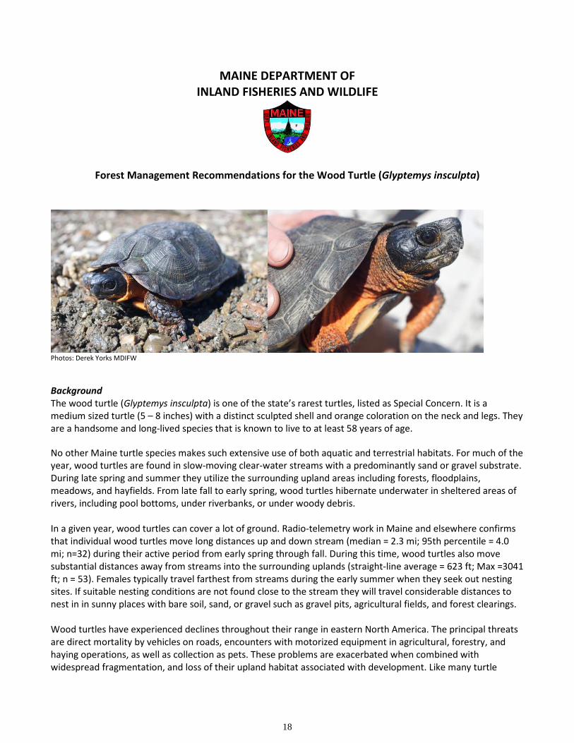
Photos: Derek Yorks MDIFW
Background
The wood turtle (Glyptemys insculpta) is one of the state’s rarest turtles, listed as Special Concern. It is a
medium sized turtle (5 – 8 inches) with a distinct sculpted shell and orange coloration on the neck and legs. They
are a handsome and long-lived species that is known to live to at least 58 years of age.
No other Maine turtle species makes such extensive use of both aquatic and terrestrial habitats. For much of the
year, wood turtles are found in slow-moving clear-water streams with a predominantly sand or gravel substrate.
During late spring and summer they utilize the surrounding upland areas including forests, floodplains,
meadows, and hayfields. From late fall to early spring, wood turtles hibernate underwater in sheltered areas of
rivers, including pool bottoms, under riverbanks, or under woody debris.
In a given year, wood turtles can cover a lot of ground. Radio-telemetry work in Maine and elsewhere confirms
that individual wood turtles move long distances up and down stream (median = 2.3 mi; 95th percentile = 4.0
mi; n=32) during their active period from early spring through fall. During this time, wood turtles also move
substantial distances away from streams into the surrounding uplands (straight-line average = 623 ft; Max =3041
ft; n = 53). Females typically travel farthest from streams during the early summer when they seek out nesting
sites. If suitable nesting conditions are not found close to the stream they will travel considerable distances to
nest in in sunny places with bare soil, sand, or gravel such as gravel pits, agricultural fields, and forest clearings.
Wood turtles have experienced declines throughout their range in eastern North America. The principal threats
are direct mortality by vehicles on roads, encounters with motorized equipment in agricultural, forestry, and
haying operations, as well as collection as pets. These problems are exacerbated when combined with
widespread fragmentation, and loss of their upland habitat associated with development. Like many turtle
19
species, wood turtles are long-lived and slow to mature, making them particularly vulnerable to adult mortality.
It can take years to replace adult turtles when they are killed and even a small number of annual deaths can be
devastating to a population. To thrive, wood turtles require an intact matrix of riverine and upland habitat that
is free of intensive human activity.
Forest management can be a compatible land use for wood turtles if precautions are made. Timing
considerations are critical. Their activity period begins in early spring and continues into the fall so a late fall or
winter harvest is preferable.
Management Recommendations
A high diversity of Maine’s wildlife species require or make use of intact riparian forest habitat. The following
practices, adapted from “Threatened and Endangered Species in Forests of Maine: A guide to Assist with
Forestry Activities” (1999), are recommended for the wood turtle to protect the riparian and upland habitats
this species requires.
Extent: Maintain a forested riparian management zone within 300 ft of the banks of streams and rivers hosting
documented wood turtle occurrences, and for 2.0 miles upstream and 2.0 miles downstream.
Activity within the Riparian Management Zone (0 to 300 ft):
• Refrain from active cutting operations and motorized vehicle access between April 15th and October
15th
• Avoid any motorized harvest activity within 50 ft of the high water shoreline
• Manage with single-tree or small group-selection cuts that maintain 60-70% canopy cover within 100 ft
and a forested condition within 300 ft of the stream bank
• Harvest only during dry or frozen ground conditions
• Avoid or minimize the construction of permanent roads or openings.
• Build temporary bridges across all perennial streams prior to any motorized equipment crossing