Embed Size (px)
Citation preview

WORLD METEOROLOGICAL ORGANIZATION
COMMISSION FOR AERONAUTICAL METEOROLOGY
ABRIDGED FINAL REPORT OF THE
SEVENTH SESSION Montreal, 14 April. 7 May 1982
(Held in part conjointly with the Communications/Meteorology Divisional Meeting (1982) of ICAO)
I WMO. No. 602 I Secretariat of the World Meteorological Organization - Geneva - Switzerland
1982

'.(:
© 1982, World Meteorological Organization
ISBN 92 - 63 "':10602 - 9
NOTE
The designations employed and the presentation of material in this publication do not imply the expression of any opinion whatsoever on the part of the Secretariat of the World Meteorological Organization concerning. the legal status of any country, territory. city or area, or of its authorities, or concerning the. delimitation of its frontiers or bOlWdaries.
CON TEN T S
Agenda ••••••••••••• 0 ••••••••••••••••••••••••••••••••••••••••••••••••••••••• v
Part I - Separate meetings of the Commission for Aeronautical Meteorology
List of persons attending the session ...............................•...... XI
General summary of the work of the seSSl.on ••....••.....•••.....••...••....• 1
Resolutions adopted by the session 12
Final Session No. No.
1 2/1
2 2/2
3 8/1
4 13/1
Advisory Working Group of the Commission for Aeronautical Meteorology ••.•.•••.•••••••••••••.•••.••.••• 12
Working Group on Meteorological Observations and Information Distribution Arrangements for Local Aeronautical Users ••••••••••••.••••••••••.•••••.•.• 13
Working Group on the Provision of Meteorological Information Required Before and During Flight •••.••••••.•
Revision of the resolutions and recommendations of the Commission for Aeronautical Meteorology •••••.•••••
14
15
Recommendations adopted by the session •.•••••••.••••••••••••••••••••••••••• 16
1
2
3
4
Annexes
I
II
Session No.
8/1
9/1
Publication of a Guide on Meteorological Office ·Practices .............................................. 0 •• 16
Technical Regulations, Volume II, C.3.2 -Aeronautical Climatology................................. 16
11/1
13/1
Radiosonde ascents ....................... 0 •••••••••••••••
Revision of resolutions of the Executive Committee based on previous recommendations of the Commission for
17
Aeronautical Meteorology ••••••••••.•.•••••••••••••••••••• 17
Annex to paragraph 10 of the general summary Proposals for amendments to coding procedures for FM 51-V TAF
Annex to Recommendation 2 (CAeM-VII) WMO Technical Regulations, Volume I~C.3.2 - Aeronautical Climatology ...........
18
20

IV CONTENTS
Page
. List of documents relating to Agenda items 1-2 and 8-18 ••••••••••••••••••••• 29
PART II - Meetings held conjointly with the Communications/Meteorology (COM/MET) Divisional Meeting (1982) of ICAD

AGENDA
Agenda item No.
1.
1.1
1.2
1.3
1.4
2.
Opening and organization of the session
Consideration of the report on credentials
Adoption of the agenda
Establishment of committees
Working arrangements and other organizational matters
Report by the president of the Commission and by the chairmen of working groups and rapporteurs
3.* Review of the Area Forecast System
3.1
3.2
3.3
(Agenda item 3 of the ICAO Communications/Meteorology Divisional Meeting (1982))
Future aeronautical requirements to be met by the Area Forecast System (Agenda item 3.1 of the ICAO Communications/Meteorology Division Meeting (1982))
Development of a new Area Forecast System (Agenda item 3.2 of the ICAO Communications/Meteorology Divisional Meeting. (1982))
Improvements in the existing Area Forecast System (Agenda item 3.3 of the ICAO Communications/ Meteorology Divisional Meeting (1982))
Relevant documents
PINK 1; PINK 1 REV.
PINK 1; PINK 1 REV.
1; CORR. 1 1; 2; PINK 1; PINK 1 REV.
PINK 1; PINK 1 REV.
PINK 1; PINK 1 REV.
22; 23; 24; 31; 33; PINK 4
8; 9; 45; 95; 99;
10; 15; 18; 19; 41; 42; 50; 51; 52; 55; 56; 57; 57 CORR; 62; 69; 70; 83; 88; 93; 94; 97; 100; 100 CORR; 101; 104; 105; 106
14; 46; 65; 66; 73; 86; 102; 103
Res.
1; 2

VI
Agenda item No.
.. AGENDA
4.* Dissemination of Area Forecdsts (Agenda item 4 of the ICAO Communications/Meteorology Divisional Meeting (1982»
4.1
4.2
5.*
5.1**
5.2**
5.3**
5.4
Improvement in the dissemination arrangements of exisiting Area Forecast Systems (Agenda item 4.1 of the ICAO Communications/ Meteorology Divisional Meeting (1982»
Dissemination arrangements for a new Area Forecast System (Agenda item 4.1 of the ICAO Communications/ Meteorology Divisional Meeting (1982»
Planning of future operational meteorological (OPMET) data exchanges (Agenda item 5 of the ICAO Communications/Meteorology Divisional Meeting (1982»
Review of existing OPMET data exchanges (Agenda item 5.1 of the ICAO Communications/Meteorology Divisional Meeting (1982»
Principles on which future OPMET data exchanges should be based (Agenda item 5.2 of the ICAO Communications/Meteorology Divisional Meeting (1982»
Development of improved specifications and/or guidance material for OPMET data exchanges for inclusion in ICAO documents other than Annex 3 (Agenda item 5.3 of the ICAO Communications/Meteorology Divisional Meeting (1982»
Development of improved specifications and/or guidance material for OPMET data exchanges for inclusion in Annex 3 (Agenda item 5.4 of the ICAO Communications/Meteorology Divisional Meeting (1982»
Relevant documents
11; 58; 59; 60; 64
16; 17; 18; 19; 50; 67; 68; 76; 77; 79; 89; 96
WP/3
WP/8; WP/91; WP/130; WP/133
WP/9; WP/92; WP/93; WP/96; WP/12l; WP/127; WP/130; WP/137
WP/lO; WP/97; WP/122; WP/128
4; 90
Res.
* Agenda items 3, 4.and 5 were considered by the conjoint session.
Rec.
** Agenda items 5.1, 5.2 and 5.3 were considered by the ICAO component only.

Agenda item No.
6*
6.1
6.2
6,3
6.4
AGENDA
Observing and reporting of visibili tv, runw'oy visual range (RVR) and slant visual range (SVR) (Agenda item 6 of the ICAO Communications/Meteorology Divisional Meeting (1982))
Observing and reporting of visibility (Agenda item 6.1 of the lCAO Communications/ Meteorology Divisional Meeting (1982))
Assessing and reporting of runway visual range (Agenda item 6.2 of the ICAO Communications/ Meteorology Divisional Meeting (1982) )
Review of progress in forecasting of runway visual range (Agenda item 6.3 of the ICAO Communications/ Meteorology Divisional Meeting (1982))
Review of progress on slant visual range (Agenda item 6.4 of the lCAD Communications/Meteorology Divisional Meeting (1982)
7.* Message contents and formats (Agenda item 7 of the ICAD Communications/Meteorology Divisional Meeting (1982)
7.1
7.2
8.
Updating of OPMET messages (Agenda item 7.1 of the ICAO Communications/Meteorology Divisional Meeting (1982)
Development of a format for the ground-to-ground exchange of OFIS messages (Agenda item 7.2 of the ICAO Communications/Meteorology Divisional Meeting (1982))
Provision of meteorological information to aircraft before and during flight
Relevant documents
75; 80
47; 53; 81
6; 6 ADD; 43; 48; 71; 84; 85
12
7; 54; 98
5; 5 ADD; 13; 49; 49 CORR; 61;63; 72; 74; 82; 87; 91; 92;
20; 44; 78; 78 CORR.
23; PINK 2; PINK 2 REV.
3
* Agenda items 6 and 7 were considered by the conjoint session.
VII
Rec.
1
VIII
Agenda item No.
9.
10.
10.1
10.2
ll.
12.
13.
14.
AGENDA
Review of WMO Technical Regulations Volume II, C.3.2 - Aeronautical climatology
Aerodrome and TREND-type landing forecasts
Evaluation of the quality of TAF and TREND
Visibility forecasting
Use of aircraft reports, weather radar and satellite information in aeronautical meteorology
Meteorological services for general aviation
Review of previous resolutions and recommendations of the Commission and relevant EC resolutions
Consideration of the future activities of the Commission and development of a work plan for the Commission and its working groups
15. Establishment of working groups and nomination of rapporteurs
16. Election of officers
17. Date and place of eighth session
18. Closure of the session
Relevant documents
27; PINK 7
PINK 3; PINK 3 REV.
21; 25; PINK 3; PINK 3 REV.
PINK 3; PINK 3 REV.
24; 28; 30; PINK 9; PINK 9 ADD.
26; 32; PINK 8; PINK 8 ADD.
29; PINK 5 PINK 5 REV.
34; PINK 6; PINK 6 REV.
PINK 10
Res.
2
3
4 4

PAR T I
SEPARATE MEETINGS OF THE
COMMISSION FOR AERONAUTICAL METEOROLOGY
(Agenda items 1-2 and 8-18)

LIST OF PERSONS ATTENDING THE SESSION
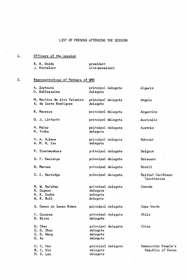
1. Officers of the session
R. R. Dodds president J. Kastelein vice-president
2. Representatives of Members of WMO
A. Zerhouni 'principal delegate Algeria D. Belhosseine delegate
M. Martins de Alva Teixeira principal delegate Angola A. da Costa Rodrigues delegate
R. Maresco principal delegate Argentina
D. J. Linforth principal delegate Australia
H. Maier principal delegate Austria H. Trnka delegate
Y. A. Sulman principal delegate Bahrain A. M. H. Isa delegate
P. Slootmaekers principal delegate Belgium
S. F. Kesianye principal delegate Botswana
R. Merces principal delegate Brazil
C. E. Berridge principal delegate Bri tish Caribbean Territories
M. w. Balshaw principal delegate Canada R. Gagnon delegate R. R. Dodds delegate w. R. Bell delegate
S. Gomes de Sousa Ramos principal delegate Cape Verde
F. Caceres principal delegate Chile R. Rivas delegate
D. Chen principal delegate China G. D. Zhou delegate C. D. Hong delegate D. Xu delegate
H. C. Han principal delegate Democratic People's B. C. Kim delegate Republic of Korea M. S. Lee delegate

XII LIST OF PERSONS ATTENDING THE SESSION
2. Representatives of Members of 1'11'10 (contd. )
T. Pallesen principal delegate Denmark
C. E. Berridge principal delegate Dominica
M. M. Hamada principal delegate Egypt M. Bakir delegate
R. Krishna principal delegate Fiji
J. T. Riissonen principal delegate Finland
J. M. Renard principal delegate France J-P. Ghuysen delegate P. Leluin delegate
J. P. Antchoue principal delegate Gabon
E. Neuber principal delegate German Democratic Republic
S. Mildner principal delegate Germany, Federal F. Quiring delegate Republic of
A. Martins Pereira principal delegate Guinea-Bissau
K. S. Tsui prinCipal delegate Hong Kong
K. Vissy principal delegate Hungary
B. H. Johnsson principal delegate Iceland
A. K. Mukherjee principal delegate India
A. M. Razavi principal delegate Iran
H. Al-Douri principal delegate Iraq
P. A. Lyons principal delegate Ireland
N. Margolin principal delegate Israel
A. Nania principal delegate Italy E. Chiavarelli delegate A. Ruscio delegate E. Arcori delegate M. Salussolia delegate L. Vignoli delegate
J. T. Blake principal delegate Jamaica
M. Ochiai principal delegate Japan
A. I. Abandah principal delegate Jordan J. K. El-Salem delegate
LIST OF PERSONS ATTENDING THE SESSION XIII
2. Representatives of Members of M'lO (contd.)
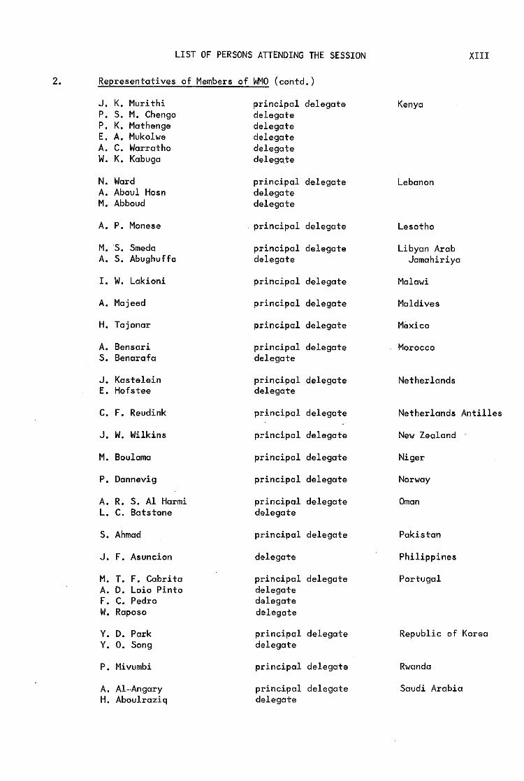
J. K. Mud thi principal delegate Kenya P. S. M. Chengo delegate P. K. Mathenge delegate E. A. Mukolwe delegate A. C. Warratho delegate W. K. Kabuga delegate
N. Ward principal delegate Lebanon A. Aboul Hosn delegate M. Abboud delegate
A. P. Manese principal delegate Lesotho
M. S. Smeda principal delegate Libyan Arab A. S. Abughuffa delegate Jamahiriya
I. W. Lakioni principal delegate Malawi
A. Majeed principal delegate Maldives
H. Tajonar principal delegate Mexico
A. Bensari principal delegate Morocco S. Benarafa delegate
J. Kastelein principal delegate Netherlands E. Hofstee delegate
C. F. Reudink principal delegate Netherlands Antilles
J. W. Wilkins principal delegate New Zealand
M. Boulama principal delegate Niger
P. Dannevig principal delegate Norway
A. R. S. Al Harmi principal delegate Oman L. C. Batstone delegate
S. Ahmad principal delegate Pakistan
J. F. Asuncion delegate Philippines
M. T. F. Cabrita principal delegate Portugal A. D. Loio Pinto delegate F. C. Pedro delegate W. Raposo delegate
Y. D. Park principal delegate Republic of Korea Y. O. Song delegate
P. Mivumbi principal delegate Rwanda
A. AI-Angary principal delegate Saudi Arabia H. Aboulraziq delegate

XIV LIST OF PERSONS ATTENDING THE SESSION
2. Representatives of Members of ~O (contd.)
N. Fall principal delegate
P. ( principal delegate Rodr1guez Fr~nco
F. Meli ton Garcia delegate
S. Ro.enqvist principal delegate
J. H. Strobel principal delegate
S. Komolavanij principal delegate
C. B. Daniel principal delegate
T. Kechrid principal delegate K-E. Zegolli delegate
D. Bourtsev principal delegate
V. Ivanov principal delegate L. Obriadin delegate
D. H. Johnson principal delegate K. Bryant delegate R. J. Sowden delegate
P. A. Mwingira principal delegate S. A. Malisa delegate
C. H. Sprinkle principal delegate J. C. Davies delegate C. E. Lambert delegate R. Decker delegate J. Blasic delegate
F. A. Suju Raffo principal delegate J. E. Geurrero Vargas delegate J. J. Infante delegate
A. O. Nasser principal delegate
B. Itooma principal delegate
Senegal
Spain
Sweden
Switzerland
Thailand
Trinidad and Tobago
Tunisia
Ukrainian Soviet Sacialist Republic
Unian of Soviet Socialist Republics
United Kingdom of Great Britain and Northern Ireland
United Republic of Tanzania
United States of America
Venezuela
Yemen
Zaire
3. Observers from international organizations
D. B. A. Mandengue
H. M. Koemans J. W. Connolly E. A. Epple
O. Gierloff A. Aagaard S. Calabrese
Agency for the Safety of Air Navigation in Africa and Madagascar (ASECNA)
International Council of Aircraft Owner and Pilot Associations (IAOPA)
International Air Transport Association (lATA)

LIST OF PERSONS ATTENDING THE SESSION
3. Observers from international organizations (contd.)
M. E. Nancoo
M. N. Morss
4. WMO Secretariat
G. K. Weiss J. Luo E. Cormenzana
International Civil Aviation Organization (ICAO)
International Federation of Airline Pilots' Association (IFALPA)
Representative of the Secretary-General
xv

GENERAL SUMMARY OF THE WORK OF THE SESSION
1. OPENING AND ORGANIZATION OF THE SESSION (Agenda item 1)
The seventh session of the Commission for Aeronautical Meteorology (CAeM) was held at the lCAO Headquarters in Montreal, Canada, from 14 April to 7 May 1982. Port of the session (from 20 April to 30 April, 3 May to 6 May) was held conjointly with the ICAO Communications/Meteorology (COM/MET) Divisional Meeting (1982).
The session was opened by the president of the Commission, Mr. R. R. Dodds, at 10.30 a.m. on 14 April 1982. In his speech, the president greeted all the participants and welcomed, in particular, the new members to their first meeting of CAeM. This conjoint meeting was to be of particular importance for members of the WMO Commission for Aeronautical Meteorology as, among other subjects, a proposal for a new area forecast system was to be considered.
The president of the Commission referred to the ~~O World Weather Watch which comprised the Global Observing System, the Global Telecommunication System and the Global Data-processing System. Development of these systems oVer the past decade had made it possible for Members in the developed world to provide grid-point information in digital form for computer flight planning. This meeting was to consider a proposal to make this information available for use by airlines in all regions of the world.
The World Weather Watch was dependent upon surface and upper-air obser~tions in all parts of the world. Therefore, all Members of WMO, both large and small, contributed substantially to the success of the programme. In addition, commercial shipping provided essential observations in oceanic areas and airlines provided aircraft reports on intercontinental flights in accordance with procedures developed by ICAO regional air navigation agreements. In this connexion, however, it should be noted that the new Area Forecast System, if adopted,would not meet all the requirements of operators. Meteorological authorities in each State would continue to be responsible for aerodrome reports, aerodrome forecasts and the issue of SIGMET messages.
The meeting was addressed by Mr. F. Carcano, president of the ICAO Air Navigation Commission, who welcomed the participants to Montreal. He said there had always been good relations between the two sister organizations, ICAO and WMO. The CAeM session, being held in part conjointly with the ICAO COM/MET Divisional Meeting (1982), was evidence of that fact. He looked forward to continued co-operation not only at this session, but also in the future.
On behalf of the Secretary-General, a warm welcome was extended to the participants by Dr. G. K. Weiss, Director of the World Weather Watch Department. He pointed out that the large number of Members participating in this session showed clearly the interest Members of the Organization held in the work of CAeM. He expressed his gratitude to ICAD for hosting this CAeM session and providing excellent facilities for the session at ICAO Headquarters. He outlined the continued importance of aviation meteorology and the need to find solutions to current problems in this field.
There were 131 participants in the session. These included delegates from 72 members and observers from 5 international organizations. A complete list of participants is given at the beginning of this report.

2 GENERAL SUMMARY
1.1 Consideration of the report on credentials (Agenda item 1.1)
At the first plenary meeting the representative of the Secretary-General presented a provisional list of participants, which was accepted as a first report on credentials, and further reports were submitted to the seventh session at ensuing plenary meetings. It was decided not to set up a Credentials Committee.
1.2 Adoption of the agenda (Agenda item 1.2)
The provisional agenda, with some minor amendments made at the conjoint session, was adopted. The final agenda is reproduced at the beginning of this report, together with an indication of relevant documents and the numbers of resolutions and recommendations.
1.3 Establishment of Committees (Agenda item 1.3)
In accordance with Resolution 23 of the WMO General Regulations, the Commission established a Nominations Committee and a Co-ordination Committee. It was agreed not to establish working committees but to work in a committee of the whole. The Nominations Committee was composed of the principal delegates of Canada, Finland, Thailand, Tunisia and Venezuela. The Co-ordination Committee was composed of the president and vice-president of CAeM and the representative of the Secrery-General.
1.4 Working arrangements and other organizational matters (Agenda item 1.4)
The Commission approved various organizational aspects of the work of the session at its first plenary meeting. The Commission noted that, in accordance with General Regulation Ill, the president of the Commission would approve the minutes of plenary meetings which were not approved during the session after consultation with the participants.
2. REPORT BY THE PRESIDENT OF THE COMMISSION AND BY THE CHAIRMEN OF WORKING GROUPS AND RAPPORTEURS (Agenda item 2)
2.1 The Commission noted with appreciation the report submitted on the acti-vities of CAeM since its sixth session in 1976. All items in the report requiring action by the Commission were considered under the relevant agenda items.
2.2 The Commission noted the valuable work carried out by the Advisory Working Group. Therefore it felt that this group should be re-established with slightly amended terms of reference. Resolution 1 (CAeM-VII) was adopted.
2.3 The Commission also considered the reports of the chairmen of the CAeM working groups and rapporteurs. It expressed its satisfaction at the results achieved. All items in the reports requ~r~ng action by the Commission were considered under the appropriate parts of the agenda.
2.4 Under this item, the Commission discussed in detail the report of the chairman of the Working Group on Aeronautical Requirements for Meteorological Observations and Specialized Instruments (ARMOSI). It noted that this group had made useful contributions. However, the working group could not complete its work. Therefore the Commission decided to establish a working group which would continue the work initiated by the ARMOSI working group. In order to ensure more effective action and to avoid overlapping with CIMO, the Commission reviewed and introduced considerable changes into the terms of reference concerning meteorological observations and information distribution arrangements for local users. The Commission felt that the group should pay particular attention to the development and use of automatic observing systems suitable for meeting aeronautical requirements o Furthermore, it was

GENERAL SUMMARY 3
agreed that the group should work in close co-operation with CIMO. Resolution 2 (CAeM-VII) was adopted.
NOTE: Agenda items 3 to 7 inclusive were considered conjointly with the ICAO Communications/Meteorology (COM/MET) Divisional Meeting; the report on these discussions is reproduced in Part II of this report.
8. PROVISION OF METEOROLOGICAL INFORMATION TO AIRCRAFT BEFORE AND DURING FLIGHT (Agenda item 8)
8.1 The Commission noted with appreciation the report of the chairman of the Working Group on the Provision of Meteorological Information Required Before and During Flight (PROMET), Mr. S. Mildner (Federal Republic of Germany). The Commission also expressed its satisfaction as regards the important work carried out by the group during the intersessional period, particularly since 1978. Major items dealt with by the working group were the following:
(a) Area Forecast System
The working group provided meteorological expertise either directly or through participation of members' of the working group in the ICAO Area Forecast Panel. The lCAO Area Forecast Panel acknowledged these contributions and requested the Working Group on PROMET to study and report on a number of important items. These studies were completed by the group and the following three reports were submitted as documents/working papers to the conjoint session of CAeM-VII and the ICAO COM/MET Divisional Meeting:
(i) Model charts and the presentation of meteorological information in area forecast'charts provided as flight documentation;
(ii) Significant weather forecasts and amendments in plain language;
(iii) Improved code (WINTEM) for the transmission and presentation of wind and temperature forecasts in alphanumeric form.
The conclusions of the session on these matters were recorded under Agenda item 3;
(b) Flight documentation
The working group reviewed the models and forms which were part of the flight documentation. Proposals for amendments to the Technical Regulations/Annex 3 Chapter (3.3) were prepared. These amendments were submitted to the conjoint WMO CAeM-VII/ICAO COM/MET Divisional Meeting. The conclusions of the conjoint session were recorded under Agenda item 3;
(c) In-flight services
Based on the findings of the ICAO Operational Flight Information Service (OFIS) Panel, th~ working group discussed the subject of in-flight services and submitted a proposal on revisions of aeronautical codes in respect of coding instructions for cloud information and on handling of operational meteorological (OPMET) messages by computers. The conclusions reached on these matters were recorded under Agenda item 7.

4 GENERAL SUMMARY
(d) Aerodrome forecasts
The working group arranged for a survey on the quality of TAF and TREND-type forecasts. The results of this survey were considered under Agenda item 10. In conjunction with the studies of the Working Group on TAF and TREND-type Forecasts, the group also conducted a detailed survey on forecasting of visibility and runway visual range (RVR). A report summarizing its replies on visibility and RVR was submitted to the conjoint WHO CAeM-VII/ICAO COM/MET Divisional Meeting. The conclusions of the session were recorded under Agenda item 6.
8.2 The session noted that there was a need for continuation of the work on scientific, technical and organizational aspects for the provision of improved meteorological information required before and during flight. Therefore, it was agreed to establish a working group. It was agreed that this working group should carry out its tasks in close collaboration and consultation with ICAO and the users of aeronautical meteorological information, in particular lATA, IFALPA and IAOPA. Resolution 3 (CAeM-VII) was adopted.
8.3 The Commission discussed the implementation of the prOV1S10ns of Annex 3/ Technical Regulations (C.3.1) and felt that more guidance material may assist Members to implement ICAO and WHO decisions fully. The guidance material may also help to bring about more uniformity in procedures and practices followed for providing meteorological information for general aviation and helicopter operations. Recommendation 1 (CAeM-VII) was adopted.
9. REVIEW OF WHO TECHNICAL REGULATIONS, VOLUME II, C.3.2. - AERONAUTICAL CLIMATOLOGY (Agenda item 9)
9.1 At the sixth session of the Commission it had been decided that the Rapporteur on Aeronautical Climatology (Mr. Kroarup, Denmark) should finalize the text for WMO Technical Regulations, Volume II, C.3.2., taking into account the advice and comments mode by members of the Commission and ICAO. The proposed text was completed by the rapporteur and the president of CAeM decided to put it to the vote by correspondence. The exchonge of opinion preceding the formal voting showed the preference of members to be that the decision on the adoption of the draft recommendation on WMO Technical Regulations, Volume II, C.3.2., be deferred until the seventh session of the Commission.
9.2 Some members felt that the proposed text was, in respect of aerodrome climatological tables and aerodrome climatological summaries, too elaborate qnd complex for implementation by members. Therefore, a simplified version, taking into account aeronautical needs, was prepared by Mr. J. Kastelein (Netherlands), vicepresident of CAeM, and submitted to the session for consideration.
9.3 The Commission noted the provisions of ICAO Annex 3/WHO Technical Regulations, Volume II, (C.3.2)8. It felt that in the WHO Technical Regulations there should be flexibility in the presentation of aerodrome climatological tables which should be prepared upon request by aeronautical users to meet specific needs. In respect of aerodrome climatological summaries, the Commission was of the opinion that the number of models required to be prepared and published by the meteorological authority should be kept to a minimum and their format simple. The Commission felt that recommendations on the format of aeronautical climatological memoranda would assist members in their preparation.
9.4 The Commission felt that members should, for regular and alternate aero-dromes, collect, process and store observational data in a suitable form for prep a-

GENERAL SUMMARY 5
ration of aeronautical climatological information. The Commission felt that if it were impracticable to process and store data on a national level, members should make use of computer facilities available for international use.
9.5 Recommendation 2 (CAeM-VII) was adopted.
9.6 The Commission was informed that the requirements for aeronautical climatological information were changing. Therefore, it was felt that ICAO Annex 3/ WMO Technical Regulations, Volume II, (C.3.2)8 should be reviewed by WMO and ICAO. The meeting noted that, in the opinion of lATA, the routine preparation of aerodrome climatological tables and summaries is considered costly compared to the use of such publications due to the fact that the threshold values used for the tables or summaries frequently do not coincide with those needed for specific investigations. The material may also, in some cases, become outdated after some years due to changes in environmental conditions and observational techniques and instrumentation. It was the view of lATA that the observational data should be stored in suitable digital form and that the required climatological data should only be prepared on request in tabular form tailored to meet individual needs for specific purposes. The meeting also noted that lATA has no requirement for the descriptive climatological memoranda for particular areas and air routes., The Commission invited the Secretary-General to inform lCAO of the need to undertake the updating of ICAO Annex 3/WMO Technical Regulations, Volume II, (C.3.2)8 as soon as possible. .
10. AERODROME AND TREND-TYPE LANDING FORECASTS (Agenda item 10)
The Commission discussed a proposal referred to the Commission by the eighth session of RA IV to introduce a simplified coding practice for code form FM 5l-V TAF forecasting severe tropical cyclone conditions below operational limits at aerodromes. The main purpose of the proposal was to introduce the acronym CYCON (abbreviation of CYclone CONditions). It is recognized that some countries may have a problem in adequately meeting the'stated aeronautical requirements during cyclone conditions due to workload conditions. It was noted that any changes in aeronautical coding procedures have to be implemented on a warld-wide basis. The Commission requested WMO to approach ICAO for the purpose of examining the operating requirements at an aerodrome during cyclone conditions. At the same time it was suggested that world-wide tests on the basis of the proposal considered by the session be conducted as early as practically possible. The proposal is given in Annex I.
10.1 Evaluation of the quality of TAF and TREND (Agenda item 10.1)
10.1.1 The Commission noted the results of a survey concerning the routine preparation of terminal aerodrome forecasts (TAF) and TREND-type landing forecasts by members. It noted that all the replies received indicated that TAFs were prepared regularly and that the vast majority of members prepare and issue TREND-type landing forecasts. In respect of the evaluations of the quality of TAF and TREND-type landing forecasts, the Commission noted that only a few members have introduced regular verification procedures. However, a number of studies were being carried out in various countries on the quality of TAFs and TREND-type landing forecasts prepared under various organizational arrangements, for example, preparation of the forecasts at the aerodrome or at a remote meteorological office/centre. The Commission felt that the evaluation and verification of forecasts was very important for the quality control of existing services and the evaluation of new forecast techniques. These activities should be continued on a national level. In order to assist members in this task and to strive for international uniformity, the Commission felt strongly that guidance material for the evaluation of the quality of TAF and TREND-type landing forecasts shauld be developed. It agreed to request its Working Group on the Provision of Meteorological Information Required Before and During Flight to develop such guidance material.
6 GENERAL SUMMARY
10.1.2 The Commission stressed the need for making information on experience gained in the evaluation and verification of forecast techniques available to members. It also encouraged members to arrange for discussions of the results by forecasters on a national level.
10.2 Visibility forecasting (Agenda item 10.2).
The Commission noted that matters relating to visibility would be discussed under Agenda item 6. Furthermore it requested its Working Group on the Pravision of Meteorological Information Required Before and During Flight to continue studies on visibility forecasting.
11. USE OF AIRCRAFT REPORTS, WEATHER RADAR AND SATELLITE INFORMATION IN AERONAUTICAL METEOROLOGY (Agenda item 11)
11.1 The Commission reviewed the implementation of the air-to-ground trans-mission of aircraft observations, their relay to MET offices and subsequent distribution on the GT5 as basic data. It noted that in many parts of the world very few AIREPs were available as operational and basic data. The Commission reviewed the regulatory material for AIREPs and felt that no change was necessary, but that problems due to difficulties or overlaading of air-to-ground communications, lack of co-ordination between ATS and MET and shortcomings in local and international distribution arrangements hampered implementation. Recently, the ICAO Annex 3/WMO Technical Regulations, Volume II, (C.3.2)5.10.5 was amended to facilitate the distribution of AIREPS as basic data on the GTS. During the discussions, difficulties in the collection of post-flight reports were also mentioned.
11.2 The Commission noted that a number of surveys and monitoring of the flow of AIREPs had been carried out by ICAO and WMO and that some slight increase in the number of available AIREPs was noticed. However, major gaps continued to exist. Therefore, the Commission felt that follow-up action towards the full implementation of Rec. 10/1 - Guidance Material on Air-Reporting and Rec. 10/2 - Improvements in the Implementation of Transmission of Air-Reports of the conjoint CAeM-VI/Ninth Air Navigation Conference - should continue.
11.3 The Commission also felt that an end-to-end survey on the implementation of current procedures governing the making, transmission and distribution of AIREPs in a well-chosen small area would permit existing shortcomings to be identified· more precisely.
11.4 The Commission noted with appreciation the report of the Rapporteur on Automated Aircraft Meteorological Observations, Mr. S. Mildner, Federal Republic of Germany, Due to the demonstrated high value of ASDAR and AIDS data for FGGE and WWW, the Executive Committee encouraged members to continue their efforts to work towards an operational automated aircraft meteorological observing and reporting system. The Commission was also informed that a number of members indicated their willingness to participate in the development of operational AMDAR hardware for installation on board wide-bodied aircraft. The Executive Committee established an Interim ASDAR Committee with a view to developing an operational automated aircraft reporting system within the framework of WWW. These efforts should provide upper wind and temperature data for use as basic data for analysis and prediction purposes. As a follow-up to Rec. 10/3 - Automated Air-Reporting, the Commission requested the Secretary-General to keep members and international organizations concerned informed on the progress made in this field. lATA wished to state that at this moment there was no aeronautical operational requirement stated by ICAO for ASDAR/AMDAR data. Therefore, lATA stated that the installation of ASDAR/AMDAR equipment on board wide-bodied aircraft would need to be arranged by Meteorological Services and national airlines concerned on an individual basis.
GENERAL SUMMARY 7
11.5 The Commission examined the methods used by members for passing meteoro-logical radar information to ATS units to meet the requirements stated in lCAOAnnex 31 WMO Technical Regulations, Volume II, (C.3.1 )4.4.1. The Commission noted that CIMO felt that WMO Technical Notes No. 78 - Use of ground-based radars in meteorology and No. 110 - Use of weather radar for aviation - were out of date and needed some revision. A ClMO rapporteur had been charged with the responsibility of preparing up-todate material on the use of radar observations in meteorology. While the new material under preparation was primarily aimed for use by meteorologists, the Commission felt that the inclusion of a section on the transmission of interpreted radar information to users such as ATS units would be appropriate. With reference to Rec. loll of CAeM-VI/Ninth Air Navigation Conference, the Commission felt that th~ newly established Working Group on Meteorological Observations and Information Distribution Arrangements for Local Aeronautical Users should prepare in consultation with CIMO updated material for a revised Technical Note No. 110 - Use of weather radar for aviation.
11.6 The Commission considered the need for the preparation and publication of a new guide on meteorological observing and information distribution systems at aerodromes. It felt that such a guide would be very useful and invited its president, in consultation with the Secretary-General and ICAO, to study the possibilities of completing this guide in the intersessional period between the seventh and eighth sessions of the Commissions.
11.7 The Commission considered Recommendation 18 (CAeM-V) - Radiosonde Ascents. It noted that a considerable amount of qualitative satellite data such as vertical soundings and wind data are being distributed on the GTS, but felt that there should be no reduction in, or limitation of radiosonde ascents until an optimum mix of the various observing sub-systems had been determined. The Commissio~ therefore, decided to replace the above-mentioned recommendation by a new one. Recommendation 3 (CAeM-VII) was adopted.
12. METEOROLOGICAL SERVICES FOR GENERAL AVIATION (Agenda item 12)
12.1 The Commission noted with appreciation the report of the Rapporteur on Meteorological Service for General Aviation, Mr. C. H. Sprinkle, U.S.A. The report summarized in on excellent manner the results of an inquiry on meteorological services for general aviation carried out in 1981. The Commission also noted with appreciation a report by the Working Group on the Provision of Meteorological Information Required Before and During Flight. These reports identified the areas where additional efforts would be required to provide meteorological services to the expanding field of general aviation (GA).
12.2 The Commission noted with appreciation a document submitted by the Federal Republic of Germany, giving information on arrangements for general aviation pilots to obtain updated weather information through specialized broadcasts and direct transmissions on Flight Information Service frequenciese The session considered this service as being useful to GA pilots during the in-flight phase.
12.3 The Commission noted the rapid growth of general aviation in many parts of the world and its great dependency on weather. The relatively high percentage of weather-related accidents and the need for an improved cost-effective meteorological service for general aviation were mentioned.
12.4 The Commission noted that the leAD Annex 3/WMO Technical Regulations contain specific provisions for low-level flights, which may apply to many international general aviation (IGA) flights. ICAO Air Navigation Plans (ANPs) contain specific provisions relating to meteorological services for lGA and include a list of aerodromes at which service is required. In addition to the above lCAO efforts, regional

8 GENERAL SUMMARY
planning groups were actively engaged in determining requirements for GA.
12.5 The Commission reviewed the need for further development of the aeronau-tical requirements for meteorological services including the need for improving the delivery of weather information to aircraft prior to departure and during flight. The Commission noted that a considerable number of designated "REG-GA" aerodromes are not providing meteorological reports or forecasts. The Commission requested the SecretaryGeneral to invite ICAO to continue its efforts to develop aeronautical requirements for meteorological services for general aviation and to study, in consultation with v.t10, the possibility of increasing, from among the existing "REG-GA" aerodromes, the number of those providing meteorological reports and/or forecasts.
12.6 The Commission felt that information for low-level flights was needed in the form of messages and charts tailored to the requirements of GA. This could be SIGMET-type warnings for light GA aircraft, VOLMET broadcasts and low-level significant weather charts. Since GA operations extend beyond national boundaries and GA long-distance flights become more frequent, there is a growing need for further standardization of meteorological products and services to GA. The Commission requested its Working Group on the Provision of Meteorological Information Required Before and During Flight to study the standardization of codes and message formats for meteorological information for GA and also the presentation of weather information for GA in chart form.
12.7 The Commission endorsed the conclusion of the Working Group on the Provision of Meteorological Information Required Before and During Flight that more attention should be given to the training of pilots and forecasters. This could be accomplished through:
(0) Closer co-operation between meteorologists and pilot training schools;
(b) Development of further guidance material for meteorological training of GA pilots;
(c) Supplementing theoretical knowledge by practical in-flight experience under the supervision of a teaching pilot.
The Commission invited Members, IAOPA and ICAO to consider the above suggestions. The Commission also felt that a WMO Technical Note on the meteorological aspect of lowlevel flights could assist in the preparation of national training material. The· Commission invited tis president to arrange for the preparation of the Technical Note.
12.8 The Commission noted the particular influence of local weather effects and low-level weather phenomena on GA operations. The provision of meteorological information to GA would, therefore, require a higher degree of resolution in meteorological observations and forecasts. Observing networks with an adequate density would thus be a prerequisite for such a service. The Commission urged Members and regional associations concerned to consider the possibilities for maintaining sufficiently dense observing networks and reporting those weather elements (e.g. cloud amounts and heights, visibility) which are operationally important for GA.
12.9 The meteorological processes in the boundary layer were considered of importance for weather forecasting for low-level flights. Recent scientific advances in this area, published in numerous articles, were difficult to assess by aeronautical forecasters. Therefore, the Commission felt that a Technical Note on boundary layer physics and its application to aviation weather forecasting could facilitate the introduction of new methods for the preparation of products for GA operations. The president of CAeM was invited to arrange for the preparation of a Technical Note on the above subject.

13.
GENERAL SUMMARY
REVIEW OF PREVIOUS RESOLUTIONS AND RECOMMENDATIONS OF THE COMMISSION AND RELEVANT EXECUTIVE COMMITTEE RESOLUTIONS (Agenda item 13)
9
13.1 The Commission reviewed the resolutions and recommendations stemming from previous sessions it held separately. It also reviewed recommendations adopted during conjoint meetings with the Ninth Air Navigation Conference (1976) of ICAO, which were still in force and were addressed either to WHO or jointly to WHO and ICAO, with a view to identifying those for which further WHO action was required. The conclusions of the session are contained in Resolution 4 (CAeM-VII). As regards the recommendations addressed jointly to WHO and ICAO, it was recommended that ICAO be informed of those recommendations on which action in the field of responsibility of IVMO was considered to be completed.
13.2 The Commission also examined the resolutions of the Executive Committee in the field of aeronautical meteorology with a view to recommending to the Executive Committee those resolutions which should be cancelled. Recommendation 4 (CAeM-VII) was adopted.
14. CONSIDERATION OF THE FUTURE ACTIVITIES OF THE COMMISSION AND DEVELOPMENT OF A WORK PLAN FOR THE COMMISSION AND ITS WORKING GROUPS (Agenda item 14)
14.1 The Commission discussed the work programme of CAeM in the intersessional period up to its next session .. It agreed that the following topics should be included in the programme which would require close consultation with ICAO on many aspects:
(1) Assistance in the implementation and operation of the World Area Forecast System including the delivery of products to states/ m'embersi
(2) Consideration of meteorological services for general aviation to meet requirements stated by rCAO;
(3) Consideration of the meteorological support to helicopter operations to meet requirements identified by ICAO;
(4) Improvement in the quality of aerodrome and significant weather forecasts;
(5) Review of specialized instruments, meteorological observing systems and data bases used for meeting aeronautical requirements, in consultation with other WHO bodies as appropriate;
(6) Preparation of guidance material (jointly or in consultation with ICAO) on aerodrome meteorological office practices;
(7) Consideration of the use of data banks in support of meteorological services to aviation;
(8) Establish priorities for research in support of aeronautical meteorology;
(9) Specialized training of personnel engaged in aeronautical meteorological activities;
(10) Review of the need for basic data in support of aviation;

10 GENERAL SUMMARY
(11) Preparation of technical notes on scientific/technical topics related to the aviation meteorology programme;
(12) Preparation of WWW planning reports on the use of WWW in support of the Area Forecast System and other aviation meteorology activities.
14.2 In addition to the above topics, the Commission may be required to deal with ~dditional subjects in the field of aviation meteorology as may be referred to the Commission by other WMO bodies and international organizations, in particular ICAO.
15. ESTABLISHMENT OF WORKING GROUPS AND NOMINATION OF RAPPORTEURS (Agenda item 15)
15.1 The Commission established the working groups considered necessary for the work of the Commission between the seventh and eighth sessions. In respect of the Advisory Working Group and.the Working Group on Meteorological Observations and Information Distribution Arrangements for Local Aeronautical Users, the Commission decided that these working groups should have a small number of members.
15.2 The Commission stressed the importance of the Working Group on the Provision of Meteorological Information Required Before and During Flight. It was agreed that the group be given a core membership and invite members operating WAFCs and RAFCs and the other members willing to participate actively in the work of the group to nominate experts. It was mentioned that, due to the limited funds available for the support of working groups, it will not be possible to finance the attendance of
·all members of the group, except those qualifying under Regulation 35(2) of the WMO General Regulations, i.e. the core members.
15.3 The Commission authorized its president to invite additional experts, as required, to participate in the work of CAeM working groups, if this is deemed necessary.
16. ELECTION OF OFFICERS (Agenda item 16)
Mr. J. Kastelein (Netherlands) and Mr. N. Fall (Senegal) were unanimou$ly elected president and vice-president, respectively.
17. DATE AND PLACE OF THE EIGHTH SESSION (Agenda item 17)
In the absence of any formal invitation from members represented at the session, the Commission decided that the date and place of its eighth session should be fixed at a later date and requested its president to make the necessary arrangements in consultation with the Secretary-General.
18. CLOSURE OF THE SESSION (Agenda item 18)
18.1 Mr. J. M. Renard, principal delegate of France, paid tribute to Mr. Dodds, president of CAeM, for the contribution and guidance given to the Commission during his tenure of office. He particularly praised the impartiality with which he had conducted the debates during the seventh session. Mr. Renard took this opportunity to mention that holding a completely separate session of CAeM would have many advantages. He added that this is the practice followed by the other technical commissions.
GENERAL SUMMARY 11
18.2 Mr. J. Kastelein (Netherlands), the newly elected president of the Commis-sion, expressed his appreciation for the high honour bestowed on him and said that he hoped to carry out his task successfully with the efficient collaboration of his colleagues. He mentioned the increasing importance of aviation meteorology, stressing the fact that, to obtain the support required for the CAeM programme outlined by the session, it is essential that the necessity of a sustained effort in the field of aeronautical meteorology is generally recognized within WMO. Mr. Kastelein also expressed his thanks to the president of CAeM, Mr. Dodds, for the excellent manner in which he hod conducted the work of the Commission since its sixth session.
18.3 Mr. N. Fall (Senegal), the newly elected vice-president of the Commission, thanked his colleagues and said that he would support the president in every possible way and would seek the collaboration of all Members of the Commission. He also con-gratulated the president of CAeM and the session for the successful completion of the meeting.
18.4 The session was closed at 5.00 p.m. on Friday, 30 April 1982.

RESOLUTIONS ADOPTED BY THE SESSION
Res. 1 (CAeM VII) - ADVISORY WORKING GROUP OF THE COMMISSION FOR AERONAUTICAL METEOROLOGY
THE COMMISSION FOR AERONAUTICAL METEOROLOGY,
NOTING:
(1) Resolution 1 (CAeM-VI) - Advisory Working Group of the Commission for Aeronautical Meteorology,
(2) The very efficient work carried out by the Advisory Working Group since the sixth session of the Commission,
CONSIDERING that a working group would be useful for advising the president of the Commission and for assisting him in his duties of co-ordination and planning,
DECIDES:
(1) To re-establish the Advisory Working Group of the Commission for Aeronautical Meteorology with the following terms of reference:
follows:
(a) To advise the president of the Commission, as necessary, in the performance of h~duties;
(b) To assist the president in identifying priorities in requirements for research in support of aeronautical meteorology;
(c) To assist the president as regards the specialized training of personnel engaged in aeronautical meteorological activities;
(d) To assist the president in the preparation and review of technical notes and planning reports on scientific/technical topics related to the aviation meteorology programme;
(e) To assist the president in short- and long-term planning of the work of the Commission and of its working graups and to keep under review the work of the Commission;
(2) That the composition of the Advisory Working Group should be as
President of CAeM (chairman)
Vice-president of CAeM
Chairman of the Working Group on the Provision of Infarmation Required Before and During Flight
Chairman of the Working Group on Meteorological Observations and Information Distribution Arrangements to Lacal Aeronautical Users
RESOLUTION 2 13
An expert designated by the U.S.S.R.
An expert designated by the U.S.A.
Res. 2 (CAeM-VII) - WORKING GROUP ON METEOROLOGICAL OBSERVATIONS AND INFORMATION DISTRIBUTION ARRANGEMENTS FOR LOCAL AERONAUTICAL USERS
THE COMMISSION FOR AERONAUTICAL METEOROLOGY,
CONSIDERING:
(1) The need to provide advice on meteorological observing arrangements at aeronautical meteorological stations which are adequate to meet stated aeronautical requirements and conform to WMO standard observing practices and instrument specifications,
(2) The need to distribute meteorological information - including observations, processed observational data (e.g., radar images) and forecasts - in a convenient form to meet the needs of local users,
DECIDES:
(1) To establish a Working Group on Meteorological Observations and Information Distribution Arrangements for Local Aeronautical Users with the following terms of reference:
the group:
(a) To provide advice on meteorological observing arrangements which are adequate to meet stated aeronautical requirements, in particular:
(i) To develop functional statements for specialized instruments and methods of observation, e.g., visibility, RVR, SVR, vertical visibility and low-level wind shear, to meet operational requirements, and to keep ClMO informed;
(ii) To meet aeronautical requirements (in consultation with rCAO) for the evaluation of observing techniques including the automation of observations;
(b) To provide advice on arrangements for the distribution of meteorological data and information, preferably integrated with other locally available information distribution systems, which would meet the requirements for the rapid distribution, accessibility and presentation of the information to users;
(c) To prepare, as a matter of urgency, guidance material on (a) and (b) above;
(d) To keep"in contact and liaise with aeronautical users of meteorologicol information (see (a) and (b) above) and ClMO;
(2) To invite the following Members to designate an expert to serve on
Argentina France Germdn Democratic Republic

14 RESOLUTION 3
Sweden United States of America
(3) To authorize, in accordance with Regulation 31 of the General Regulations, the president of the Commission to select the chairman of the group;
REQUESTS the Secretary-General to invite ICAO, lATA, IAOPA and IFALPA to participate in the work of the group.
Res. 3 (CAeM VII) - WORKING GROUP ON THE PROVISION OF METEOROLOGICAL INFORMATION REQUIRED BEFORE AND DURING FLIGHT
THE COMMISSION FOR AERONAUTICAL METEOROLOGY,
CONSIDERING:
(1) The need to improve the quality of meteorological information required for air operations,
(2) The operational and technological advances in the field of meteorology and data processing,
DECIDES:
(1) To establish a Working Group on the Provision of Meteorological Information Required Before and During Flight with the following terms of peference:
(a) To advise on the implementation and operation of the new Area Forecast System and co-ordinate as appropriate with the World Weather Watch, including suggestions on the use of WWW facilities for implementing the AFS;
(b) To formulate proposals for the amendment of aeronautical codes and meteorological message formats to meet agreed operational requirements;
(c) To promote and formulate proposals for the introduction of improved forecasting methods, including methods for area meteorological watch, in the operational work of aerodrome meteorological offices, including numerical product interpretation and advanced short-range prediction methods;
(d) To prepare guidelines on verification and evaluation methods of TAF and TREND-type forecasts;
(e) To act as the Commission focal point for exchange of information with aeronautical users on all aspects relating to the provision and distribution of meteorological information to meet stated requirements;
(f) To promote and formulate proposals for the introduction of improved methods of area meteorological watch;
(g) To keep under continuous review the regulatory and guidance material related to the provision of services to aviation;

RESOLUTION 4
(2) To give the Working Group the following membership;
(a) One expert designated by each of the following Members;
Australia Brazil Japan Kenya U.S.S.R. U.S.A.
15
(b) Additional experts to be nominated by embers having accepted responsibility for the operation of a WAFC or RAFC;
(c) Experts nominated by other embers wishing to participate actively in the work of the group.
(3) To designate, in accordance with Regulation 31 of the General Regulations, Mr. S. Mildner (Germany, Federal Republic of) as chairman of the working group.
REQUESTS the Secretary-General to invite ICAO, lATA, IFALPA and IAOPA to participate in the work of the group.
Res. 4 (CAeM) - REVISION OF THE RESOLUTIONS AND RECOMMENDATIONS OF THE COMMISSION FOR AERONAUTICAL METEOROLOGY
THE COMMISSION FOR AERONAUTICAL METEOROLOGY,
CONSIDERING that some of the resolutions adopted prior to its seventh session are now obsolete,
CONSIDERING that all recommendations adopted prior to its seventh session and still in.force have been reconsidered,
NOTING
(1) The action taken on the recommendations adopted prior to its seventh session,
(2) The action taken by the competent bodi~s on its Recommendations 3 (CAeM-IV), 1, 2, 3, 4, 6 (CAeM-VI) which are now redundant,
DECIDES:
(1) Not to keep in force any of its resolutions adapted prior to its seventh session;
(2) To keep in force· Recommendation 5 (CAeM-VI).

RECOMMENDATIONS ADOPTED BY THE SESSION
Rec. 1 (CAeM-VII) PUBLICATION OF A GUIDE ON METEOROLOGICAL OFFICE PRACTICES
THE COMMISSION FOR AERONAUTICAL METEOROLOGY
CONSIDERING:
The need to prepare guidance material for the establishment and operation of meteorological offices providing services to aviation,
RECOMMENDS:
The preparation of a guide on meteorological office practices and its publication in the four working languages of the Organization;
REQUESTS the Secretary General to assist in the preparation of the draft of the guide;
AUTHORIZES the president of CAeM, in consultation with the chairman of the CAeM Working Group on the Provision of Meteorological Information Required Before and During Flight and ICAO, to approve the guide.
Rec. 2 (CAeM-VII) - TECHNICAL REGULATIONS, VOLUME II, C.3.2 - AERONAUTICAL CLIMATOLOGY
CAeM-VI,
THE COMMISSION FOR AERONAUTICAL METEOROLOGY,
NOTING:
(1) Technical Regulations (C.3.2)8,
(2) Paragraph 7.3 of the general summary of the abridged report of
CONSIDERING that it is necessary to include C.3.2 - Aeronautical Climatology in the Technical Regulations,
RECOMMENDS that the text of C.3.2 of the Technical Regulations, given in the annex* to this recommendation should be adopted and come into force at the earliest possible date;
Regulations AUTHORIZES the president of CAeM to introduce minor changes. in Technical C.3.2 as required.
* See Annex II

RECOMMENDATIONS 3, 4 17
Rec. 3 (CAeM-VII) - RADIOSONDE ASCENTS
THE COMMISSION FOR AERONAUTICAL METEOROLOGY,
NOTING:
(1) That several new techniques are being used or developed to derive horizontal and vertical distributions of temperature and moisture throughout the atmosphere,
(2) That within the Integrated WWW System Study, the design of an optimum observing system comprising various abserving techniques has been initiated,
CONSIDERING:
(1) That CBS is studying the best mix of observing systems, but this has yet to be determined,
(2) The need for adequate observatians for aeronautical meteorology,
RECOMMENDS that there should be no reduction in, or limitation of, radiosonde ascents until an optimum mix of the various observing sub-systems of the GOS has been determined.
Rec. 4 (CAeM-VII) - REVISION OF RESOLUTIONS OF THE EXECUTIVE COMMITTEE BASED ON PREVIOUS RECOMMENDATIONS OF THE COMMISSION FOR AERONAUTICAL METEOROLOGY
THE COMMISSION FOR AERONAUTICAL METEOROLOGY,
NOTING with satisfaction the' action taken by the Executive Committee on the previous recommendations of the Commission for Aeronautical Meteorology,
CONSIDERING that many of these recommendations have become redundant in the meantime,
RECOMMENDS that Resolution 14 (EC-XXXIII) no longer be considered necessary_

ANNEX I
Annex to paragraph 10 of the general summary
PROPOSALS FOR AMENDMENTS TO CODING PROCEDURES FOR FM 5l-V TAF
MANUAL ON CODES, VOLUME I, SECTION A
c. LIST OF CODE FORMS WITH NOTES AND REGULATIONS
FM 5l-V TAF - Aerodrome forecast ================================
1. Amend CODE FORM to read:
TAF CCCC dddff/f f m m
( VVVV w'w l N CCh h h ( or 5 5_'S S
( CAVOK ( or CYCON
(OGFGFTFTF) (61 h.h.h.tL) c 1. ~ 1.
(GGG G e e Tnn (or
(GG
2. Add the following NOTES to Regulation 51.3.1:
NOTES:
(1) The term "mean wind speed" is used in the sense of Regulation 15.4.1.
(2) See Regulation 51.7.2.2.
3. Amend the NOTE to Regulation 51.3.3 to read:
~:
(1) If after a change
included, or nat,
group the wind is reported again, If f m m
in accordance with these same criteria.
(2) See Regulation 51.7.2.2.
4. Amend Regulation 51.7 to read:
51.7 Code words
51.7.1 Code word CAVOK {text of-present Regulation 51.7)
shauld be

ANNEX I 19
51.7 .2 Code word CYCON
51.7.2.1 When it is expected that, due to the passage of a tropical cyclone, the values for horizontal visibility and lowest cloud base are reduced by heavy precipitation and either the horizontal visibility or height of the lowest clouds be less than the operational minimum for th=laerodrome concerned, and the mean wind speed will exceed 17 m s (33 knots), the code word CYCON shall be included in lieu of the groups VVVV, w'w and N CCH h h •
5 5 5 5
NOTE: See Note (1) to Regulation 51.3.1.
51.7.2.2 When including the code word CYCON, the group dddff/f f shall be encoded as follows: m m
ddd
ff
f f m m
NOTES:
VRB
expected highest mean wind speed during the period of cyclone conditions
expected maximum wind speed during the period of cyclone conditions.
(1) See Regulation 15.4.4.
(2) See Note (1) to Regulation 51.3.1.
(C.3.2)1
GENERAL PROVISIONS
(C.3.2)1.1
(Recommendation)
ANNEX II
Annex to Recommendation 2 (CAeM-VII)
WMO TECIi'IICAL REGLLATIONS, VOLUME II
C.3.2 - AERONAUTICAL CLIMATOLOGY
Aeronautical climatological information should be based on observations made over a period of at least five consecutive years and that period should be indicated in the information supplied. The period should be updated or extended by the addition of more recent data as soon as practicable.
(C.3.2)1.2
(Recommendation)
Meteorological observations for regular and alternate aerodromes should be collected, processed and stored in a form suitable for the preparation of aerodrome climatological information in any form or forms and within the time period as agreed between the Meteorological Authority and the aeronautical user or users.
NOTE: As it is possible for the collection, processing and storage of observational data to be effected by computer facilities available for international use, in cases where it is impracticable to meet the requirements for aeronautical climatological information on a national basis, the responsibility for the preparation of the required aeronautical climatological information may be delegated by agreement between the Meteorological Authorities concerned.
(Recommendation)
Aerodrome climatological tables and summaries should contain information on the location, height and exposure of the sensors from which the observations are derived.
(C.3.2)1.4
(Recommendation)
Aerodrome climatological tables and summaries should contain information regarding the total number of observations and the observing times on which they are based.

ANNEX II
{C.3.2)2
AERODROME CLIMATOLOGICAL TABLES
{C.3.2)2.l
(Recommendation)
Aerodrome climatological tables should be prepared in a form suitable to meet the specific request of the aeronautical user. Where appropriate the layout for the climatological tables may follow the models for the climatological summaries.
{C.3.2)2.2
(Recommendation)
21
Aerodrome climatological tables should be supplied for specified between the Meteorological Authority and the aeronautical user. logical tables may include the following information:
intervals as agreed Aerodrome climato-
Frequencies of specified wind directions and speeds;
Frequencies of specified range of RVR/visibility;
Mean number of days with occurrence of specified weather phenomena, for example, sandstorms, fog, freezing rain, thunderstorms;
Frequencies of specified range of the height of the operationally significant cloud base;
Frequencies of specified range, intervals of s~rface temperatures; and
Mean atmospheric pressure at aerodrome level.
Upon request, frequencies of simultaneous occurrence of specified values of two or more of the elements listed above may be provided to meet user requirements.
NOTE 1:
NOTE 2:
{C.3.2)3
Climatologicdl information on low visibility conditions should be based on measurements of RVR for those aerodromes where such observations are required under {C.3.l)4.7.3.
Procedures governing light intensity settings and other particulars used for RVR assessment should be specified.
AERODROME CLIMATOLOGICAL SUMMARIES
{C.3.2)3.1
(Recommendation)
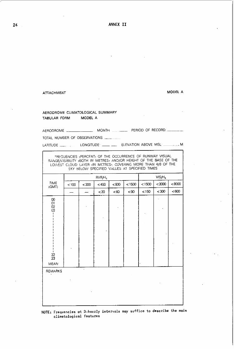
Aerodrome climatological summaries should, in general, follow the format of the models given in the attachment hereto.

22 ANNEX II
(C.3.2)3.2
(Recommendation)
Aerodrome climatological summaries should include the following information on meteorological conditions at an aerodrome:
(C.3.2)4
Frequencies of the occurrence of runway visual range/visibility and/or height of the base of the lowest cloud layer covering more than 4/8 of the sky below specified values at specified times (Model A);
Frequencies of visibility below specified values at specified times (Model B);
Frequencies of the height of the base of the lowest cloud layer covering more than 4/8 of the sky below specified values at specified times (Model C);
Frequencies of occurrence of concurrent wind direction (in 300 sectors) and speed within the specified ranges (Model D);
Frequencies of surface temperature (screen) in specified ranges of 50 Celsius at specified times (Model E);
Mean atmospheric pressure at aerodrome level (no model included).
AERONAUTICAL DESCRIPTIVE CLIMATOLOGICAL MEMORANDA
(C.3.2)4.1
(Recommendation)
Aeronautical descriptive climatological memoranda should consist of a description of meteorological conditions for a specific area or an air route or part of an air route over the territory of one or several Members. Such memoranda may provide part of the climatological information for the surface and/or the upper air in diagram or chart form.
(C.3.2)4.2
(Recommendation)
Aeronautical descriptive climatological memoranda should be preceded by a summary giving topog~aphical features of meteorological significance of the area described.
(C.3.2)4.3
(Recommendation)
An aeronautical descriptive climatological memorandum should include the following information:
(a) Monthly or seasonal means and variability of upper air temperatures and wind components at the standard pressure levels 850, 700, 500, 400, 300, 250, 200, 100 and 70 mb;
ANNEX II 23
(b) Monthly or seasonal means and variability of tropopause heights (or pressures) and temperatures, and the height of the freezing level;
(c) Wherever possible, chart(s) and/or description of the monthly or seasonal distribution of turbulence, icing, thunderstorms and sandstorms.
Information on data of type (a) or (b) should be prepared in the form of charts, cross-sections or other diagrams, or in the form of tables. Additional information on the aistribution in time and/or space of other parameters over the area concerned may be included in an aeronautical descriptive climatological memorandum.
Upper air data presented in an aeronautical descriptive climatological memorandum may cover a selection only of the levels mentioned under (a) above, in accordance with the cruising levels normally employed in the area.
(C.3.2)4.4
(Recommendation)
An aeronautical descriptive climatological memorandum for an area where there is a significant number of low-level flight operations should contain additional information concerning monthly or seasonal frequencies, extent and/or duration of fog, low cloud and other phenomena causing widespread reduction in visibility. This information may equally be presented in the form of charts, diagrams or tables.
24 ANNEX II
ATIACHMENT MODEL A
AERODROME CLIMATOLOGICAL SUMMARY
TABULAR FORM MODEL A
AERODROME ___ _ MONTH PERIOD OF RECORD: _____ _
TOTAL NUMBER OF OBSERVATIONS . ______ _
LATITUDE ________ LONGITUDE __ _ ELEVATION ABOVE MSL ____ M
.OREQUENCIES ,PERCENT, OF THE OCCURRENCE OF RUNWAY VISUAL RAi\GE/VISiBILITY ,BOTH IN METRES, AND/OR HE'GHT OF THE BASE OF THE
LO\\-EST CLOUD LAYER >IN METRES,. COVERING MORE THAN 4/8 OF THE SKY BELOW SPECIFIED VALUES AT SPECIFIED TIMES
RVR/H, VIS/H,
TIME <100 <200 <400 IGMT;
<800 <1500 <1500 <3000 <8000
- - <3C <60 <90 <150 <300 <600
00 01 02 03 , -, , , , , , , , , , , , , , 22 23
MEAN
REMARKS
NOTE: Frequencies at 3-hourly intervals may suffice to describe the main climatological features

ANNEX II
ATTACHMENT MODEL B
AERODROME CLIMATOLOGICAL SUMMARY
TABULAR FORM MODEL B
AE'lOC'lOlv'E _~_____ MONTH __ _ __ PERIOD OF RECORD ___ _
T,7AL NU.!:BER OF OBSERVATiONS
LONGITL:ClE ELEVATION ABOVE MSL ____ M
FREQUENCIES ,PERCENTI OF VISIBILITY BELOW SPECIFIED VALUES liN METRESj AT SPECIFIED TIMES
TIME VISIBILITY
(GMT) <200 <400 <600 <600 <1500 <3000 <5000 <8000
00 01 02 03 , , , , , , , , , , , , , , , 22 23
I MEAN
NOTE; Frequencies at 3-hourly intervals may suffice to describe the main climatological features
25

26 ANNEX II
ATIACHMENT MODEL C
AERODROME CLIMATOLOGICAL SUMMARY
TABULAR FORM MODEL C
AERODROME. __ _ MONTH _~ ___ PERIOD OF RECORD __ _
TOTAL NUMBER OF OBSERVATIONS
LATITUDE _.__ LONGITUDE _.~ __ ~ ELEV.ATION --',BOVE MSL. ____ M
FREOUENCIES !PERCENTi OF THE HEIGHT OF THE BASE ilN METRES, OF -THE LOWEST CLOUD LAYER COVERING MORE THAN 4/8 OF THE SKY BELOW
SPECIFIED VALUES AT SPECIFIED TIMES
TIME H,
(GMTi <30 <60 <90 <160 <300 <450
00 01 02 03 , , , , , , , , , , , , , , , 22 23
IV1EAN
NOTE: Frequencies at 3-hourly intervals may suffice to describe the main climatological features

ANNEX II
ATTACHMENT MODEL D
AERODROME CLIMATOLOGICAL SUMMARY
TABULAR FORM MODEL D
AERODROME: ____ -'- MONTH: __ _ PERIOD OF RECORD __ _
TOTAL NUMBER OF OBSERVATIONS: __ _ OBSERVING TIMES: LATITUDE: __ _ LONGITUDE: __ _ ELEVATION ABOVE MSL: ___ M
FREOUENCIES (PERCENT) OF OCCURRENCES OF CONC;URRENT WIND DIRECTION (IN 30° SECTORS) AND SPEED (IN KNOTS) WITHIN
SPECIFIED RANGES
WIND DIRECTION
CALM
VARIABLE 35-36-01 02-03-04 05-05-07 05-09-10 11-12-13 14-15-16 17-18-19 20-21-22 23-24-25 26-27-28 29-30-31 32-33-34
TOTAL
WIND SPEED
27

28 ANNEX II
ATIACHMENT MODEL E
AERODROME CLIMATOLOGICAL SUMMARY
TABULAR FORM MODEL E
AEROOROME ____ _ MONTH _____ PERIOD OF RECORD: __ _
TOTAL NUMBER OF OBSERVATIONS_
LATITUDE ___ _ LONGITUDE ____ .. ELEVATION ABOVE MSL ___ M
FREOUENCIES (PERCENTI OF SURFACE TEMPERATURE (SCREEN) IN SPECIFIED RANGES OF 5' C AT SPECIFIED TIMES
TEMPERATURE TIME (GMT) -10- -5- 0-5 5-10 10-15 15-20 20-25 25-30 -5 0
00 01 02 03
I I I I I I I I I I I I I I I
22 23
MEAN
NOTE 1: The range 5-10 comprises the values 50 to 99 inclusive NOTE 2: Frequencies at 3-hourly intervals may suffice to describe the moin
climatological features

Doc. No.
1
1 CORR. 1
2
21
22
23
24
25
26
27
28
LIST OF DOCUMENTS
(relating to Agenda items 1-2 and 8-18)
I. "DOC" SERIES
Title
Provisional agenda
Corrigendum to the provisional agenda
Explanatory memorandum relating to the provisional agenda
Aerodrome and TREND-type landing forecasts - Evaluation of the quality of TAF and TREND -Code form FM 51-V TAF
Report by the Rapporteur on Meteorological Service for General Aviation
Report of the Working Group on the Provision of Meteorological Information Required Before and During Flight (PROMET)
Agenda item
1.2
1.2
1.2
10.1
2
~.2 and 8
Report by the Rapporteur on 2 and 11 Automated Aircraft Meteorological Observations
Evaluation of the quality of 10.1 TAF and TREND
Meteorological Services for 12 International General Aviation
Review of WMO Technical 9 Regulations Volume II, C.3.2 -Aeronautical Climatology
Provision of meteorological . 11 radar information to ATS units
Submi tted by
Secretary-General
Secretary-General
Secretary-General
Secretary-General
Rapporteur
Chairman,working group
Rapporteur
Chairman, Working Group on PROMET
Chairman, Working Group on PROMET
Secretary-General
Secretary-General

30
Doc. No.
29
30
31
32
33
34
1
2
3
4
LIST OF DOCUMENTS
Title
Review of previous resolutions and recommendaUons of the Commission and of relevant Executive Committee resolutions·
Use of aircraft reports
Report py the president of CAeM
Meteorological services for international general aviation -Provision of meteorological information to aircraft in flight
Report of the Working Group on Aeronautical Requirements for Meteorological Observations and Specialized Instruments
Consideration of the future activities of the Commission and development of a work plan for the Commission and its working groups
Agenda item
13
11
2
12
2
14
II. "PINK" SERIES
Report to plenary on agenda item 1 - Opening and organization of the session REV.
1
Report to plenary on agenda B item B - Provision of meteorological information to aircraft before and during.flight REV.
Report to plenary on agenda 10 item 10 - Aerodrome and TREND-type landing forecasts REV.
Report to plenary on agenda 2 item 2 - Report by the president of the Commission and by the chairmen of working groups and rapporteurs
Submitted by
Secretary-General
France
President of CAeM
Federal Republic of Germany
Chairman, working group
President of CAeM
President of CAeM
President of CAeM
President of CAeM
President of CAeM

Doc. No.
5
6
7
8
9
10
LIST OF DOCUMENTS
Title
Report to plena·ry on agenda item 13 - Review of previous resolutions and recommendations of the Commission and relevant Executive Committee resolutions REV.
Report to plenary on agenda item 14 - Consideration of the future activities of the Commission and development of a work plan for the Commission and its working groups REV.
Report to plenary on agenda item 9 - Review of Technical Regulations C.3.2 - Aeronautical Climatology
Report to plenary on agenda item 12 - Meteorological services for general aviation ADD. 1
Report to plenary on agenda item 11 - Use of aircraft reports, weather radar and satellite information in aeronautical meteorology ADD. 1
Report to plenary on agenda item 16 - Report of the Nominations Committee
Agenda item
13
14
9
12
11
16
31
Submitted by
Secretariat
President of CAeM
Chairman, ad hoc working group
President of CAeM
President of CAeM
Chairman, Nominations Committee


PAR T II
MEETINGS HELD CONJOINTLY WITH THE
COMMUNICATIONS/METEOROLOGY DIVISIONAL MEETING (1982)
(Agenda items 3, 4, 5, 6 and 7)


List of
History 1. 2. 3. 4. 5. 6. 7.
CONTENTS
recommendations .................................................. .
of the meeting •................................................... Duration ........................................................ Q
Representation •.................. ~ .......................•....... Officers ........................................................ .
..Secretariat ...................................................... . Approval of the agenda •••••••••••••••••••••••••••••••••••••.••••• Working arrangements ............................................. . Films and presentations ......... 0 ••••••••••••••••••••••••••••••••
List of representatives ................................................... .
Agenda of the meeting
Report on the agenda Agenda item 3
3.1
3.2
3.3
Agenda item 4 4.1
4.2
Agenda item 5
5.4
Agenda item 6
6.1 6.2
6.3
6.4
Review of the area forecast system Future aeronautical requirements to be met by the area forecast system ••••••••••••••• Development of a neW area forecast system ............................................. .. Improvements in the existing area forecast systems. 6 ••• e ....................... ' ••••
Dissemination of area forecasts Improvements in the dissemination arrangements of existing area forecast systems .................................. . Dissemination arrangements for a new area forecast system ........................ ..
Planning of future operational meteorological (OPMET) data exchanges Development of improved specifications and/or guidance material for OPMET data exchanges for inclusion in Annex 3 ............ e ................................. ..
Observing and reporting of visibility, runway visual range (RVR) and slant visual range (SVR) Observing and reporting of visibility •.........•• Assessing and reporting of runway visual range ..................................... .. Review of progress in forecasting of runway visual range .............•............. Review of progress on slant visual range ........................... 0 ........... 0
i-I
ii-I ii't"l ii-I ii-I ii-l ii-I ii-2 ii-2
iii-l
iv-l
3.1-1
3.2-1
3.3-1
4.1-1
4.2-1
5.4-1
6.1-1
6,2-1
6.3-1
6.4-1

Report on the agenda Agenda item 7
7.1 7.2
CONTENTS
(contd.) Message contents an~ formats Updating of OPMET messages ••••••••••••••••••••• Development of a format for the ground-to-ground exchange of OFIS messages •••••••••••••••••••••••••••••••
7.1-1
7.2-1
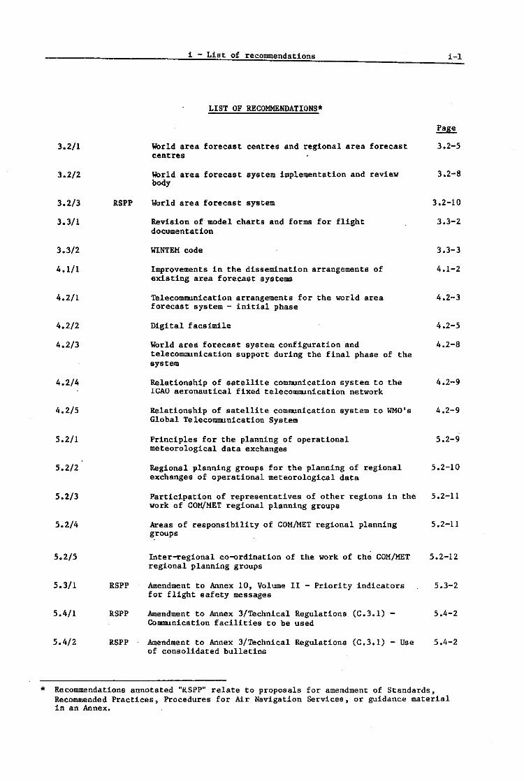
*
3.2/1
3.2/2
3.2/3
3.3/1
3.3/2
4.1/1
4.2/1
4.2/2
4.2/3
4.2/4
4.2/5
5.2/1
5.2/2
5.2/3
5.2/4
5.2/5
5.3/1
5.4/1
5.4/2
RSPP
RSPP
RSPP
RSPP
i-List of recommendations
LIST OF RECOMMENDATIONS.
WOrld area forecast centres and regional area forecast centres
World area forecast system implementat-ion and review body
WOrld area forecast system
Revision of model charts and forms for flight documentation
WlNTEM code
Improvements in the dissemination arrangements of existing area forecast systems
Telecommunication arrangements for the world area forecast system - initial phase
Digital facsimile
World area forecast system configuration and telecommunication support during the final phase of the system
Relationship of satellite communication system to the ICAO aeronautical fixed telecommunication network
Relationship of satellite communication system to WHO's Global Telecommunication System
Principles for the planning of operational meteorological data exchanges
Regional planning groups for the planning of regional exchanges of operational meteorological data
Participation of representatives of other regions in the work of COM/MET regional planning groups
Areas of responsibility of COM/MET regional planning groups
Inter-regional co-ordlnation of the work of the COM/MET regional planning groups
Amendment to Annex 10, Volume II - Priority indicators for flight safety messages
Amendment to Annex 3/Technical Regulations (C.3.I) -Communication facilities to be used
Amendment to Annex 3/Technical Regulations (C.3.I) - Use of consolidated bulletins
i 1
3.2-5
3.2-8
3.2-10
3.3-2
3.3-3
4.1-2
4.2-3
4.2-5
4.2-8
4.2-9
4.2-9
5.2-9
5.2-10
5.2-11
5.2-11
5.2-12
5.3-2
5.4-2
5.4-2
Recommendations annotated "RSPP" relate to proposals for amendment of Standards, Recommended Practices) Procedures for Air Navigation Services, or guidance material in an Annex.

i-2
5.4/3 RSPP
6.1/1
6.2/1 RSPP
6.2/2
6.2/3
6.3/1
6.4/1
7.1/1
7.1/2
7.1/3
7.2/1
7.2/2
i-List of recommendations
LIST OF RECOMMENDATIONS* (cont'd)
Amendment to Annex 3/Technical Regulations (C.3.1) -Transit time requirements
Requirement for study of the operational aspects related to meteorological optical range and visibility
Amendments to Annex 3/Technical Regulations (e.3.1) related to the assessment and reporting of runway visual range
Requirement for further studies related to the assessment of runway visual range
Requirement for examination by IeAO of the operational aspect of proposed changes in the procedures for reporting of runway visual range
Studies on short-term runway visual range forecasts
Slant visual range studies
Operational flight information service broadcasts - Need to amend Annex 3/Technical Regulations (e.3.1)
Requirements for further studies related to SPEer criteria and the use of change groups in aerodrome forecasts
Procedures for interrogation of international operational meteorological data banks
Development of a format for the ground-to-ground exchange of operational flight information
Principles governing the development of a code for operational flight information service messages
5.4-5
6.1-3
6.2-3
6.2-4
6.2-5
6.3-1
6.4-1
7.1-3
7.1-4
7.1-6
7.2-2
7.2-3
* Recommendations ·annotated "RSPP" relate to proposals for amendment of Standards, Recommended Practices, Procedures for Air Navigation Services, or guidance material in an Annex.

11 - History of the meeting ii I
HISTORY OF THE MEETING
1. Duration
1.1 The Communications/Meteorology (COM/MET) Divisional Meeting (1982) was opened by the President of the Council, Dr. A. Kotaite, at 1130 hours on 14 April in the Assembly Hall of the headquarters of the organization in Montreal. At the opening Plenary the meeting was also addressed by the President of the Air Navigation Commission, Mr. F. Carcafto and by Mr. R.R. Dodds, President of the Oommission for Aeronautical Meteorology. The meeting was held in part conjointly with the Seventh Session of the Commission for Aeronautical Meteorology (CAeM-VII) of the World Meteorological Organization (WMO). Agenda Items 3, 4, 5.4, 6 and 7 were considered jointly with the CAeM-VII. The closing Plenary was held on 7 May 1982.
2. Representation
2.1 The COM/MET Divisional Meeting (1982) was attended by 242 representatives from sixty-two Contracting States, one non-Contracting State and eight international organizations. A list of participants in both the COM/MET Divisional Meeting and the CAeM-VII may be found on pages iii-l to ii1-12, showing a combined attendance of 285 participants representing eighty-three Oontracting States/WMO Members, one non-Contracting State and ten international organizations.
3. Officers
3.1 The following officers were elected at the first Plenary meeting;
Chairman First Vice-Chairman Second Vice-Chairman
J.E. Sansom (Australia) P.I. Hegedus (Brazil) Y.A. SuI man (Bahrain)
4. Secretariat
4.1 The Secretary of the meeting was Mr. J.H. Legere, Chief of the Communications (COM) Section. He was assisted by officers of the Air Navigation Bureau and the regional offices of rCAO, and by officers of the WMO Secretariat as indicated in paragrayh 6 below.
4.2 General administrative arrangements for the meeting were made under the direction of Mr. C. Van Diest, Chief, Administrative Services Hranch. Translation and interpretation services were provided by the Language Branch under the direction of its Acting Chief, Mr. R. Bidmade, assisted by Mr. P.J. Broomfield (Interpretation), Mr. R. Bidmade (English translation), Messrs. T.C. Nguyen and J. Fromen (French translation), Messrs. Y.A. Komov and V.A. Bulanov (Russian translation) and Mr. N.R. Jane and Mrs. A. ColI (Spanish translation). Miss A.K. Craig and Mrs. G. Brown acted as precis writers for the Plenary meetings.
4.3 The physical arrangements for the meeting were made by Mr. F.O. Novotny, Chief, Conference and General Services Sectionj Mr. W. Zuercher, Acting Document Control Officer; Mr. J. Quesnel, Acting Chief, Printing Unit; Mr. R.G. Faulkner, Supervisor, Central Typing Unitj and Mr .• ~. Vaage, Chief, Registry and Distribution Section.
5. Approval of the agenda
5.1 was adopted at interchanged.
The agenda transmitted to the meeting by the Air Navigation Commission the first Plenary meeting with the order of Agenda Items 3.2 and 3.3 It Is reproduced at page iv-I.

H2 ii ~istory of the meeting
6. Working arrangements
6.1 The organization plan submitted to States in advance of the meeting waS approved without change at the opening Plenary_ The plan called for the establishment of three commdttees.
6.2 The three committees were constituted as shown below. Each committee est~blished working groups, as necessary, to facilitate progress.
Committee A
Chairman Vice-Chairman Secretary
Committee B
Chairman Vice-Chairman Secretary
Committee C
Chairman Vi ce-Chai rman Secretary
to consider Agenda Items 1 and 2
W. Dammers (Netherlands, Kingdom of the) M. Ormazabal (Chile) J.L. Whittaker, assisted by F. Kitazawa, A.N. Delgado and R.M. Shafer (rCAO)
to consider Agenda Items 3, 6 and 7
J.K. Murithi (Kenya) K. Vissy (Hungary) M.E. Nancoo (ICAO) and Dr. G.K. Weiss (WMO) assisted by F.A.L. Oliveira, T. Fox, R.I. Hill and M.C.F. Heijl (leAD) and E. Cormenzana and J. Luo (WMO)
to consider Agenda Items 4 and 5
A. Zerhouni (Algeria) J.F. Asuncion (Philippines) U. Schwarz (ICAO Consultant) assisted by F.A.L. Oliveira, J.L. Whittaker, J.H. Legere and M.E. Nancoo (rCAO) and E. Cormenzana (WHO)
Other specialist officers of the ICAO Secretariat provided advice to the meeting as required.
6.3 A Co-ordinating Group was established in accordance with the Directive~ to DiVisional-type Air Navigation Meetings and Rules of Procedure for their Conduct (Doc 8143-AN/873/2), and met when necessary throughout the meeting. The members were the Chairman and Vice-Chairman of the meeting and the Chairmen and Vice-Chairmen of the three committees. The Secretary of the meeting, the. Secretaries of the committees and representatives of the various Secretariat services catering to the meeting attended all meetings of the Co-ordinating Group. The group was able to co-ordinate the activities of the meeting using the services and accommodations available.
7. Films and presentations
7.1 The ICAD film "Making of a Standard" was presented several times for the benefit of representatives. A demonstration of the TELIDON digital communication and display system for alphanumeric and graphical information was sponsored by the Delegation of Canada. A technical presentation on international satellite communication facilities was made by the representative of INTELSAT. A technical presentation on the VIDEOMETER for measurement of runway visual range was sponsored by the Delegation of Belgium. A number of other presentations and displays of interest to delegates were made available to representatives at locations outside the lCAD headquarters building during the course of the meeting.

Country
ALGERIA
ANGOLA
ARGENTINA
AUSTRALIA
AUSTRIA
BAHRAIN
BELGIUM
BOTSWANA
BRAZIL
CS Non-CS M Non-M
BRITISH CARIBBEAN TERRITORIES
iii - List of representatives
LIST OF REPRESENTATIVES
- Contracting State Pr. D - Principal Delegate - Non-Contracting State - Member - Non-Member
WHO
CS M
CS M
CS M
CS M
CS M
CS M
CS M
M
CS H
M
A. D. N.
M. A.
o - Delegate Alt - Alternate Adv - Adviser CObs - Chief Observe r Obs - Observer
Name
Zerhouni Belhosseine 'Boukachabia
Teixeira Rodrigues
J.M. Marucchi R. Maresco
J.E. Sansom D.J. Linforth C.J. Noble F .W. Russell G.R. Souter
H. Maier O. Schneider H. Trnka
Y~A. Sulman A.H.R. Isa
P.-H.J. Slootmaekers P.A.A. Nadin
S.F. Kesianye
P. I. Hegedus R. Merces W. Machado N. Medeiros
C.E. Eerridge
ICAO
0 Alt Alt
0 Alt
0 Alt
0 Alt Alt Alt Alt
D Alt Alt
0 Alt
0 Alt
0 Alt Alt Alt
11i-1
WMO
Pro 0 D
Pro D
0
Pro 0
Pro II
Pro II
0
Pro II 0
Pro lJ
Pre D
Pro lJ
Pr. D

iii-2 iii - List of representatives
Country WMO ICAO WMO
CANAOA CS M R,F. North 0 M.W. Balshaw Alt Pro 0 J.T. Bradley Alt W.R. Bell Mv 0 J. Campbell Mv A.S. Carew Mv R.R. Dodds Mv 0 R. Gagnon Mv 0 C.L. Hung Mv T.J. Kurtz Mv N. Ostiguy il<\v R.J. Pearson Mv A.F. Val Mv
CAPE VEROE M S. Gomes De Sous a Ramos Pro 0
CHILE CS M M. Ormazabal D F. Caceres Alt Pro D G. Donoso Alt R. Rivas Alt D C. Dinator Ramirez Mv
CHINA CS M G.O. Zhou D D O. Chen Pro D C.D. ll<ing Alt 0 S.J. Wang Alt O. Xu 0
CZECHOSLOVAKIA CS J. Mika 0
CS M Y.R. Han 0 H.C. Han Alt Pro 0 Y.K. ll<ing Alt B.C. Kim Alt U I.B. Kim Alt M.S. Lee Alt 0
DENMARK CS M T. Pallesen D Pro D S. Jensen Alt L .. J. larsen Alt
DOMINICA M C.E. Eerridge Pre D
EGYPT CS M S. Anber 0 M.M. Hamada Alt Pro 0 M. Bakir Alt D
FIJI CS M A. Ali D R. Krishna Pro 0 N.G. Singh Alt
FINLAND CS M J.T. tliissanen D Pro D J.T. Suominen Alt

iii - List of representatives 11i-3
Country ICAO WMO
FRANCE CS M J.-P. Ghuysen D J.M. Renard Alt D R. Chartier AIt C. Costantini AIt A.R. Elbaz Alt P. Leluin Alt D F .E. Morlsseau AIt J.-M. Rainer AIt D D. Stammler AIt M.R. Reddan Adv J.P. Richecoeur Adv
GABON M J.-P. Antchoue Pro D
GERMAN DEMOCRATIC Non-GS M E. Neuber Pro D REPUBLIC H. Gross CObs
D. Dechert Obs
GERMANY, FEDERAL REPUBLIC CS M S. MUdner D Pro D OF F. Quiring Alt D
H.J. Muller AIt
GUINEA-BISSAU CS M A.M. Pereira Pro D J.N. Henriques Adv
HAITI CS J.-A. Auguste D
HONG KONG M K.S. Tsu! Pro D
HUNGARY M K. Vissy Pro D
ICELAND CS M B.H. Jonsson D Pro D
INDIA M A. K. Mukherjee Pro D
INDONESIA CS A. Djunaedi D A.T.E. Liando AIt F .E .. Iuntungan AIt S. Setiawan AIt
IRAN CS M A. Valef! D A. Noshref Razavi AIt Pro D E. Ertefai Alt
IRAQ M H. AI-Douri Pro U
IRELAND CS M P.A. Lyons D Pro D J.E. Lawrence AIt
ISRAEL M N. Margolin Pro D

1ii-4 lii - List of representatives
Country ICAO liMO Name ICAO
ITALY CS M E. Chiavarelli D D A. Nania Pro D A. Roseio Alt D M. Sa1u88011& Alt D E. Arcari Mv D L. V1gnol1 Mv D
JAMAICA CS M L. Fraser D J.T. Blake Alt Pro D D.M. Clarke Alt W.A. Roberts Mv
JAPAN CS M M. Och1a1 D Pre D H. Ak1 Alt S. Fukuda Alt T. Ishizuka Alt H. Iwashita Mv
JORDAN M A. I. Abandah Pre D J.K. EI-Salem D
KENYA CS M J.K. Mur1th1 D Pre D P. S.M. Chengo Alt D P. K. Mathenge Alt D E .A. Mukolwe Alt D A.C. Warratho Alt D W.K. Kabuga Mv D
LEBANON CS M N. Ward D Pre D A. Aboul Hosn . Alt D M. Abboud Alt D
LESOTHO M A. P. l-Jonese Pro D
LIBYAN ARAB JAMAHIRIYA M M. S. Smeda Pro D
A.S. Abughuffa D
MALAWI CS M .I.W. Lakioni D Pro D
MALDIVES M A. Majeed Pro D
MEXICO CS M H. Tajonar D Pro D E. Sanchez Alt
MOROCCO CS M A. Bensari Pro D S. Benarafa Alt D
NETHERLANDS, KINGDOM OF CS M W. Dammers D THE J. Kastelein Alt Pro D
E. Hofstee Alt C.F. Reud1nk Alt D H.G. N..tssbaum Mv
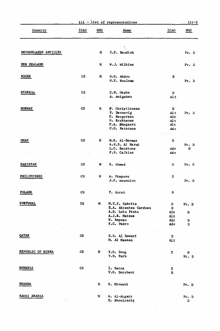
iii - List of representatives 11i-5
country ICAO WHO Name ICAO WHO
NETHERLANDS ANTILLES M C.F. Reudink Pro D
NEW ZEALAND M W.J. Wilkins Pro D
.!!!2§!. CS M G.M. Abdou D M.Y. Boulama Pro D
NIGERIA CS C.N. Okeke D A. Anigekwu Alt
NORWAY CS M ~. Christiansen D P. Dannevig Alt Pro D E. Bergersen Alt O. Brekk.enes Alt F.A. ~egaard Alt C.G. Peterson Adv
~ CS M M.R. Al-liaomar D A.R.S. Al Harmi Pro D L.C. Batstone Adv D F.E. Calkins Adv
PAKISTAN CS M S. Ahmad D Pro D
PHILIPPINES CS M A. Prepuse D J.F. Asuncion Pr.D
POLAND CS T. Kurek D
PORTUGAL CS M M.T.F. Cabrlta D Pre D E.A. Abrantes Cardoso D A.D. Loio Pinto Alt D A.J.B. Mateus Alt W. Raposo Alt D F.C. Pedro Adv D
QATAR CS S.D. Al Kawari D M. AI Hassan Alt
REPUBLIC OF KOREA CS M y.o. Song D D Y.D. Park Pro D
ROMANIA CS I. Barca D V.G. Dorobant D
RWANDA M P. Mivumbi Pro D
SAUDI ARABIA M A. Al-Angary Pro D H. Aboulrazlq D

iii 6 iit - List of representatives
Country ICAO WHO ICAO
SENEGAL CS M A.B. Diagne D N. Fall Alt Pro D
SINGAPORE CS F.S. lIo D C. Ong Alt
SOUTH AFRlCA* CS S.L. Huekwell D H.J .C. Van Den Berg Alt
SPAIN CS M A. Lorente-Areas D F. Cal. D P. Rodriguez Franco Alt Pr. D F. Meliton Alt D L. Mur Escalona Alt P. Tena Alt M. Huerta Adv
SWEDEN CS M A.J. Gustafsson D S. Rosenqvist Alt Pre D J. Brask Alt B. IIellroth Alt C.-A. Johansson Alt L.-o. Turesson Alt
SWITZERLAND CS M H.J.T. Doswald D J.H. Strobel Pro D H. Candrian Alt C. Castella Alt P. Gasser Alt H. Saxer Alt J. Walker Adv
THAILAND CS M T. Obayawataya D S. Komolavanij Alt Pro D
TRINIDAD AND TOBAGO CS M J.M. Ahwai D C.B. Daniel Alt Pre D A. Sankarsingh Adv
TUNISIA Cs M E. Ellouz D T. Kechrid Pr. D M. Hadjaij Alt H. Lamloum Alt R. Onlha Alt K.-E. Zegolli D
UKRAINIAN SOVIET SOCIALIST M D. Bourtsev Pre D REPUBLIC
* Suspended by Resolution 38 (Congress-VII) from exercising its rights and enjoying privileges as a Member of WHO.
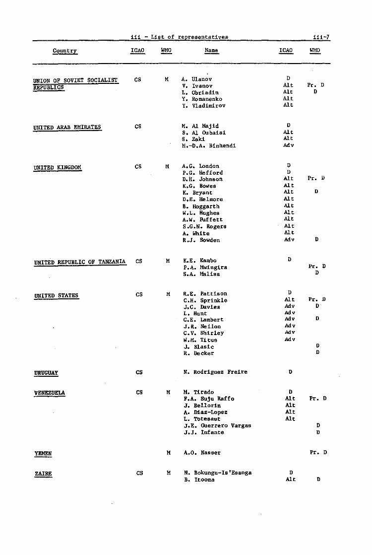
iii - List of representatives i11-7
Country Name WMO
UNION OF SOVIET SOCIALIST CS M A. Ulanov 0
REPUBLICS V. Ivanov Alt Pro 0 L. Obriadin Alt 0 Y. RDmanenko Alt Y. Vladim1roy Alt
UNITED ARAB EMIRATES CS M. Al Majid D
S. Al Clubai.i Alt S. Zaki Alt H.-D.A. Binnendi Ady
UNITED KINGOOM CS M A.G. London 0 FlOG. Hefford 0 D. il. Johnson Alt Pro II
K.G. Bowes Alt K. Bryant Alt 0
D.E. Helmore Alt B. Hoggart h Alt W.L. Hughes Alt A.W. Puffett Alt S .G.N. Roger. Alt A. White Alt R.J. Sowden Ady D
UNITED REPUBLIC OF TANZANIA CS M K.E. Rambo D P.A. Mwingira Pro D S.A. Malisa D
UNITED STATES CS M R.E. Pattison II
C.H. Sprinkle Alt Pr. D J.C. Davies Adv D L. Hunt Ady C.E. Lambert Ady D
J.R. Neilon Adv C. v. Shirley My W.M. Titus Ady J. Blasle II
R. Decker D
URUGUAY CS N. Rodriguez Freire D
VENEZUELA CS M M. Tirado D F.A. Suju Raffo Alt Pro D J. Bellor1n Alt A. Maz-Lopez Alt L .. Totesaut Alt J.E. Guerrero Vargas D J.J. Infante D
YEMEN M A.O. Nasser Pr. D
ZAIRE CS M N. Bokungu-Is'Esanga D B. Itooma Alt D

iii-8 iii - List of representatives
International organizations
AGENCE POUR LA SECURITE DE LA NAVIGATION AERIENNE EN AFRIQUE ET A MADAGASCAR (ASECNA)
EUROPEAN ORGANIZATION FOR THE SAFETY OF AIR-NAVIGATION (EUROCONTROL)
INTERNATIONAL AIR TRANSPORT ASSOCIATION (fATA)
Name
D.B.A. Mandengue M. Boukoulou
E.G. fI.auff
O. G1erloff A. Aagaard V.J. Adam H. Bosman Jansen S. Calabrese J. Clark P.R. Ingleton K.H. King C.R. Schoen
INTERNATIONAL CIVIL AIRPORTS ASSOCIATION J.T. Bradley (ICAA)
INTERNATIONAL CIVIL AVIATION ORGANIZATION M.E. Nancoo (rCAO)
INTERNATIONAL COUNCIL OF AIRCRAFT OWNER AND PILOT ASSOCIATIONS (IAOPA)
INTERNATIONAL FEDERATION OF AIR LINE PILOTS' ASSOCIATIONS (IFALPA)
SOCIETE INTERNATIONALE DE TELECOMMUNICATIONS AERONAUTIQUES (SITA)
WORLD METEOROLOGICAL ORGANIZATION (WHO)
H.M. Koemans J.W. Connolly B.A. Epple
M. lobrss W.J. Palmer E.P. Smart
s. Lasher
G.P. Giraudbit
G.K. Weiss J. Luo E. Cormenzana
ICAO
CObs Obs
Obs
CObs Obs Obs Obs Obs Obs Obs Obs Obs
CObs Obs Obs
CObs Obs Obs
Obs
Obs
CObs Obs Obs
WHO
Obs
Obs Obs
Obs
Obs
Obs
Obs Obs Obs
Obs
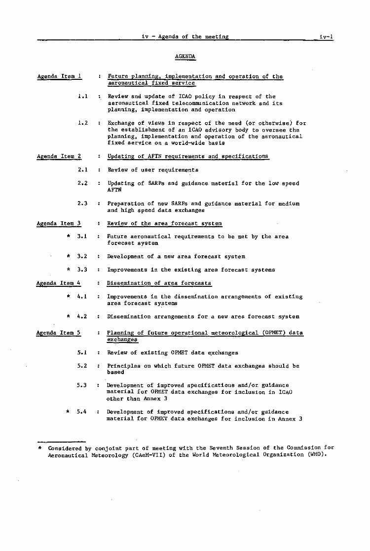
Agenda Item 1
1.1
1.2
Agenda Item 2
2.1
2.2
2.3
Agenda Item 3
* 3.1
* 3.2
* 3.3
Agenda Item 4
* 4.1
• 4.2
Agenda Item 5
5.1
5.2
5.3
• 5.4
iv - Agenda of the meeting
AGENDA
Future planning, implementation and operation of the aeronautical fixed service
Review and update of ICAO policy in respect of the aeronautical fixed telecommunication network and its planning, implementation and operation
Exchange of views in respect of the need (or otherwise) for the establishment of an ICAO advisory body to oversee the planning, implementation and operation of the aeronautical fixed service on a world~ide basis
Updating of AFTN requirements and specifications
Review of user requirements
Updating of &ARPa and guidance material for the low speed AFTN
Preparation of new SARPs and guidance material for medium and high speed data exchanges
Review of the area forecast system
Future aeronautical requirements to be met by the area forecast system
Development of a new area forecast system
Improvements in the existing area forecast systems
Dissemination of area forecasts
Improvements in the dissemination arrangements of existing area forecast sy~tems
Dissemination arrangements for a new area forecast system
Planning of future operational meteorological (OPMET) data exchanges
Review of existing OPMET data e,xchanges
Principles on which future OPMET data exchanges should be based
Development of improved specifications and/or guidance material for OPHET data exchanges for inclusion in ICAO other than Annex 3
Development of improved speCifications and/or gUidance material for OPMET data exchanges for inclusion in Annex 3
iv-l
* Considered by conjoint part of meeting with the Seventh Session of the Commission for Aeronautical Meteorology (CAeM-VII) of the World Meteorological Organization (WHO).

iv-2
Agenda Item 6
* 6.1
* 6.2
* 6.3
* 6.4
Agenda Item 7
* 7.1
• 7.2
iv - Agenda of the meeting
Observing and reporting of visibility! runway visual range (RVR) and slant visual range (SVR)
Observing and reporting of visi~illty
~~sessing and reporting of runway visual range
Review of progress on forecasting of runway visual range
Review of progress on slant visual range
Message contents and formats
Updating of OPI1ET messages
Development of a format for the ground-to-ground exchange of OFIS messages
* Considered by conjo~nt part of meeting with the Seventh Session of the· Commission for Aeronautical Meteorology (CAeM-VlI) of the World Meteorological Organization (WMO).

Report on Agenda Item 3.1
Agenda Item 3 Review of the area forecast system
3.1 Future aeronautical requiremen~s to be met by the area forecast system
3.1.1 Introduction
3.1-1
3.1.1.1 Under directives from the ICAO Air Navigation Commission) the report of the second meeting of the Area Forecast Panel (AFP) constituted the background documentation for discussions under Agenda Item 3. Consideration of Agenda Item 3.1 in particular was based upon the report on Agenda Item 1 of AFP/2.
3.1.1.2 AFP/2 had noted that the area forecast system developed in the 19608 to provide meteorological information for flights that rarely exceeded FL 360 in altitude and 3 000 NM in distance) was unlikely to be adequate for the 19808, when Borne aircraft cruise above FL 500 (supersonic aircraft even above FL 600), and flight stages of 6 000 NM or more were becoming common. It was also realized that flight planning methods had changed, with more airlines carrying out centralized computer flight planning for which global meteorological data were 'required. At the same time, there was also a steady increase in low level international general aviation flights (mostly short range), with the result that the total extent of requirements had increased.
3.1.1.3 As far as the aim of the study of the requirements was concerned, the panel had noted the instructions of the Air Navigation ComDdssion calling for a more efficient, uniform and economical system. The panel agreed that this meant the development of a system which met the requirements of as many users as practicable in a costeffective manner. Among the users are operators and pilots concerned with scheduled, non-scheduled commercial operations and international general aviation operations, as well as aeronautical meteorological offices which have to supply the information to operators and pilots, and air traffic services units, which carry out track selections and monitor flight progress.
3.1.1.4 The meeting confirmed the view of AFP/2 that the operational require-ments· to be studied were those presently catered for by the area forecast system, I.e. J
the meteorological information needed for the en-route stage of flight. This did not include information for the operations in the vicinity of aerodromes (aerodrome forecasts and reports). Also, non-routine warnings such as SIGMET messages would be, as hitherto, excluded.
3.1.1.5 The meeting considered the aeronautical requirements that should be met by th~ area forecast system and adopted with minor variations the requireQents developed by AFP/2. 'These requirements are:
1. The area forecast system should be designed to meet aeronautical user requirements for meteorological information on en-route conditions in an efficient, cost-effective and timely manner. In view of the increaSing number of inter-regional, long-range flight operations, the system should be designed as an integrated, worldwide and uniform system.
2. Meteorological information on en-route conditions for pre-flight and in-flight planning by operators and pilots, and for the selection of organized tracks by air traffic services should comprise the following forecasts operationally relevant to the required purpose:
a) upper wind and temperature information, from FL 50 upwards;
b) tropopause heightsj
c} maximum wind speed, direction and levelj and
d) significant weather information from FL 100 upwards and jetstream information.

3.1-2 Report on Agenda Item 3.1
3.1.1.6 print of the amendment of
3. For users processing the meteorological information by computer, the area forecast system should provide the forecasts listed under paragraph 2 a), b) and c) above in the form of a coherent set of digital data for grid points in a'standardized format.
4. The requirements to be met by the area forecast system should be reviewed periodically and a continuous dialogue maintained between users and providers by means of direct contact, or through the agency of appropriate ICAO regional planning and implementation bodies.
It was decided that these requirements should be implicit in the bluenew area forecast system and, therefore, will be embodied in proposals for Annex 3 to be developed under Agenda Item 3.2.
3.1.1.7 It was noted by the meeting that AFP/2 had encountered difficulties with current usage of certain terms in connexion with the statement of requirements for area forecasts, such as the terms "meteorological authority", "users", "providers", etc., and that the panel had agreed to use the following definitions!
Provider State
A State meteorological authority operating a world area forecast centre (WAFC) and/or a regional area forecast centre (RAFC).
User State
A State meteorological authority (as defined in Annex 3, Section 1.1).
End user
Aircraft operators, flight crew members, ATS units and other aeronautical users.
User
Term which encompasses "user State" and "end user".
3.1.1.8 However, during the discussions throughout Agenda Item 3, it became clear that current ICAO usage of the terms "provider", "user" and "meteorological authority" sufficed, insofar as the preparation of amendments to Annex 3/Technical Regulations (C.3.1) related to area forecast system questions is concerned.
3.1.1.9 It was agreed that it would be useful to develop a definition for "area forecast products" as follows:
Area forecast products
Operational meteorological data, processed and prepared by a designated meteorological centre and issued within the framework of the area forecast system, comprising plain language, numeric and digital grid point forecasts and graphic forecasts covering specified validity periods and geographical areas.
- - - - - - - - - -
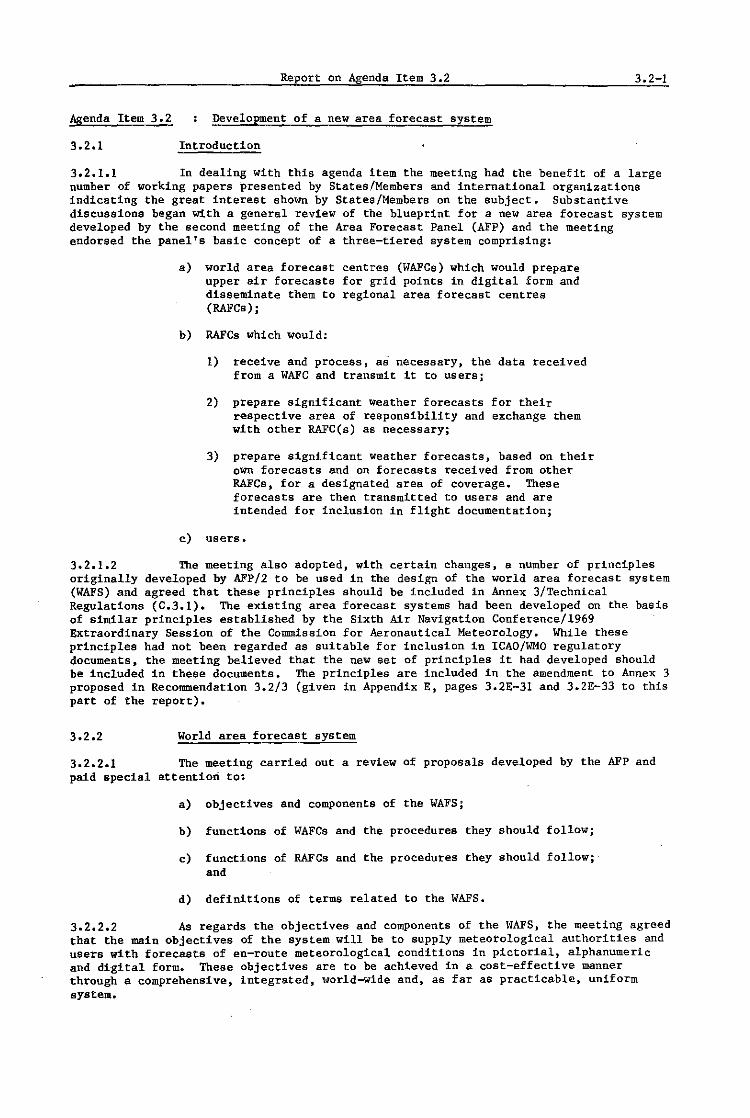
Report on Agenda Item 3.2 3.2-1
Agenda Item 3.2 Development of a new area forecast system
3.2.1 Introduction
3.2.1.1 In dealing with this agenda item the meeting had the benefit of a large number of working papers presented by States/Members and international organizations indicating the great interest shown by States/Members on the subject. Substantive discussions began with a general review of the blueprint for a new area forecast system developed by the second meeting of the Area Forecast Panel (AFP) and the meeting endorsed the panel's basic concept of a three-tiered system comprising:
a) world area forecast centres (WAFCs) which would prepare upper air forecasts for grid points in digital form and disseminate them to regional area forecast centres (RAFCs);
b) RAFCs which would:
1) receive and process, as necessary, the data received from a WAFC and transmit it to users;
2) prepare significant weather forecasts for their respective area of responsibility and exchange them with other RAFC(s) as necessaryj
3) prepare significant weather forecasts, based on their own forecasts and on forecasts received from other RAFCs, for a designated area of coverage. These forecasts are then transmitted to users and are intended for inclusion in flight documentation;
c) users.
3.2.1.2 The meeting also adopted, with certain changes, a number of principles originally developed by AFP/2 to be used in the design of the world area forecast system (WAFS) and agreed that these principles should be included in Annex 3/Technical Regulations (C.3.1). The existing area forecast systems had been developed on the basis of similar principles established by the Sixth Air Navigation Conference/1969 Extraordinary Session of the Commission for Aeronautical Meteorology. While these principles had not been regarded as suitable for inclusion in ICAO/WMO regulatory documents, the meeting believed that the new set of principles it had developed should be included in these documents. The principles are included in the amendment to Annex 3 proposed in Recommendation 3.2/3 (given in Appendix E, pages 3.2E-31 and 3.2E-33 to this part of the report).
3.2.2 World area forecast system
3.2.2.1 The meeting carried out a review of proposals developed by the AFP and paid special attention to:
a) objectives and components of the WAFS;
b) functions of WAFCs and the procedures they should follow;
c) functions of RAFCs and the procedures they should follow; and
d) definitions of terms related to the WAFS.
3.2.2.2 As regards the objectives and components of the WAFS, the meeting agreed that the main objectives of the system will be to supply meteorological authorities and users with forecasts of en-route meteorological conditions in pictorial, alphanumeric and digital forme These objectives are to be achieved in a cost-effective manner through a comprehenSive, integrated, world-wide and, as far as practicable, uniform system.

3.2-2 Report on Agenda Item 3.2
3.2.2.3 The impact which the introduction of the WAFS will have on the provision of meteorological services to international civil aviation by developing countries was considered by the meeting. It was noted that the WAFS, by providing meteorological authorities with high quality global forecasts, would enable States/Members to concentrate resources towards the improvement of forecasts for terminal areas which are critical from the point of view of aircraft operations. It was noted that the latter forecasts were not covered by the WAFS which was only designed to provide forecasts of en-route conditions.
3.2.3 WAFCs - Functions and procedures
3.2.3.1 The functions of WAFCs and the procedures they would follow, as developed by AFP/2, formed the basis for discussion on this subject. The meeting agreed in principle with this material and that it should be included in the appropriate part of Annex 3/Technical Regulations (C.3.1). These are contained in Appendix E to this part of the report.
3.2.3.2 The plan for the WAFS envisages that WAFCs will only prepare, in the initial phase, global upper air digital data for grid points. However, it was foreseen that at a later stage the WAFCs might also be able to prepare significant weather forecast in grid point format. It was agreed that it would be premature to include any mention of this possibility in the leAD/WHO regulatory documents, until such time as the capability has been developed by the WAFCs.
3.2.4 RAFCs - Functions and procedures
3.2.4.1 Discussions on this subject were also based on material developed by AFP/2 and the relevant proposals were endorsed in principle for inclusion in the appropriate part of Annex 3/Technical Regulations (C.3.1) (see Appendix E to this part of the report).
3.2.4.2 When discussing the detailed functions of RAFCs, the meeting examined the need for upper air and significant weather charts to be prepared four times per day in tropical regions. It was noted that in those regions the upper wind regime tended to be fairly steady, possibly indicating that two upper air forecasts per day might be sufficient. However, it was recognized that there were significant meteorological features which warranted more frequent forecasts and that in any case the charts provided in flight documentation normally includ~d higher latitudes where the frequency of forecasts of four times per day was considered necessary.
3.2.4.3 In the case of significant weather charts, a frequency of forecasts of four times per day was considered to be desirable in order to ensure that forecasts cover adequately the development of local weather systems in all time zones around the world.
3.2.5 Designation of WAFCs and RAFCs
3.2.5.1 The meeting noted that AFP/2 had envisaged a need for two WAFCs and had made proposals for the designation of these centres as London and Washington. The meeting endorsed these designations on the grounds that these centres had demonstrated a current capability to meet the global requirements and were already routinely providing digital data for large areas of the globe for flight planning purposes. With regard to the RAFCs, AFP/2 had expressed the view that there should be one RAFC per service area and had been able to make proposals for the designation of the RAFC for four of the eight service areas it had defined. For the remaining four service areas, the panel identified two or three centres for each of these service areas which could be designated as an RAFC.
3.2.5.2 Concern was expressed that the new area forecast system being developed should not involve States/Members in the expenditure of available resources for equipment which, in view of the phases planned for the system, could become redundant before the usual amortization period of the equipment. Similarly, several States/Members stressed the important bearing that existing telecommunications facilities and links will have on decisions regarding the WAFS.

Report on Agenda Item 3~2 3.2-3
3.2.5.3 During the debate, the view was expressed that all existing seventeen area forecast centres should be. retained in the new system, so as to utilize available expertise and improve the service provided to operators. However, the meeting was of the opinion that a reduction in the number of centres was desirable, and proceeded in its deliberations accordingly.
3.205.4 The meeting then reviewed Recommendation 2.1/1 - DeSignation of world area forecast centres, and 2.2/1 - Designation of regional area forecast centres which had been developed by AFP/2 and which the ICAO Air Navigation Commission had decided should be submitted to the COM/MET Divisional Meeting/CAeH-VIl. As the deSignation of WAFCs and RAPCs was considered to be interconnected. a decision was made to combine these recommendations into a single recommendation calling for leAO to invite specified States/Members to accept responsibility for WAPCs and RAPCs, and for WHO to arrange for the necessary World Weather Watch (WWW) support to those centres.
3.2.5.5 During the discussions on the subject of WAFCs, a certain number of delegations accepted the suggestion that a study be made of the possibility of establishing a WAFC as an international institution under the auspices of rCAO and WHO. The study would pay particular attention to the development of the international statute of such a centre and to the evaluation of the cost of its installation and operation as compared with the cost of WAFCs as proposed by AFP/2. This suggestion was not supported by the meeting.
3.2.5.6 Although it was considered that an aim of the new area forecast system was to achieve a maximum reduction in the number of RAFes, it was also recognized that. for technical reasons and during the interim period until the implementation of the final phase of the new system, it would be necessary to share the regional responsibility for those service areas referred to in paragraph 3.2.5.1. It was therefore decided that. for service area 3 (depicted in Appendix A to this part of the report), Melbourne and Wellington should share the responsibility; for service area 5, Brasilia and Buenos Aires·; for service area 6. Dakar and Las Palmas; and for service area 7. Frankfurt, London and Paris. resulting in a total of thirteen RAFCs.
3.2.5.7 Several delegations stressed the importance of taking into account the telecommunications facilities available for the choice of RAFes.
3.2.5.8 With respect to the selection of RAFes in service area 7, the view was expressed that the possibility should be considered of establishing an ad hoc working group to analyse the proposal that the RAPe functions be performed by an appropriate . body from service area 7. This working group could also consider how costs and benef~ts could be shared among participating countries. This was noted by the meeting.
3.2.5.9 Some States/Members, and the users. took the view that the AFP/2 proposal that there should only be eight RAFes was realistic and would ultimately be Significantly more cost-effective. Recognizing that an interim period while changes to communications arrangements and operating practices/procedures would be necessary. they saw the goal of a single RAFe in each service area as the desirable solution well prior to the implementation of a final phase. perhaps a decade hence, when new technology could remove requirements for RAFCs. However, lATA and several European States took the view that it was technically pOSSible, and would prove most cost-effective, to establish in service area 7 a single collocated world and regional centre as is proposed for the larger service area 8.
3.2.5.10 A number of delegations pointed out that thirteen RAFCs would be the maximum for the successful operation of the new system. The Union of Soviet Socialist Republics and several other StateS/Members stressed that in service area 7 the number of centres should not be more than two, preferably Frankfurt and Paris. as originally proposed by the Federal Republic of Germany and France. It was further mentioned that an additional area forecast centre in service area 2, such as New Delhi, could be usefully operated during the interim period until the implementation of the final phase of the area forecast system. The meeting agreed that this problem might be considered during further deliberations within leAD. Subsequently the Indian Delegate formally offered New Delhi as an additional centre for service area 2, recognizing the difficulties expressed by Japan in providing service to meet the requirements of the entire service area. A number of delegations felt that this matter did not need to be further considered by ICAO.
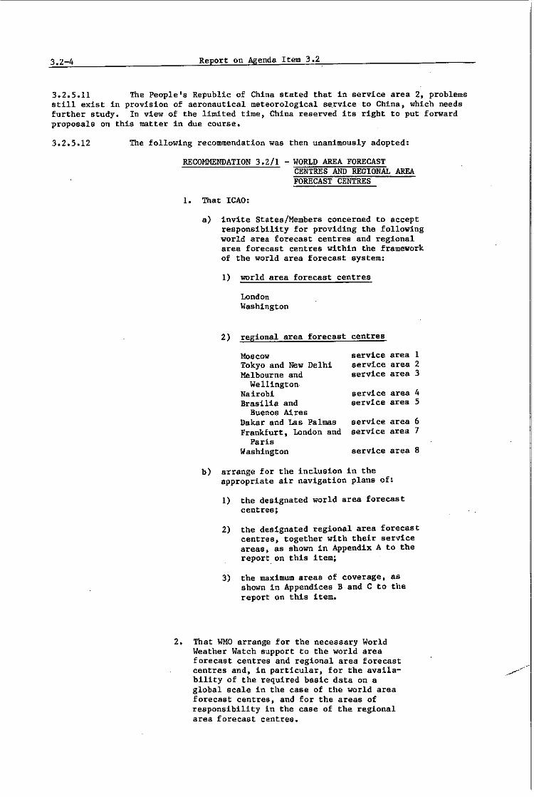
3.2-4 Report on Agenda Item 3.2
3.2.5.11 The People's Republic of China stated that in service area 2, problems still exist in provision of aeronautical meteorological se.rvlce to China, which needs further study. In view of the limited time, China reserved its right to put forward proposals on this matter in due course.
3.2.5.12 The following recommendation was then unanimously adopted:
RECOMMENDATION 3.2/1 - WORLD AREA FORECAST CENTRES AND REGIONAL AREA FORECAST CENTRES
1. That ICAD:
a) invite States/Members concerned to accept responsibility for providing the following world area forecast centres and regional area forecast centres within the framework of the world area forecast system:
1) world area forecast centres
2)
London Washington
reg,ional area forecast
Moscow Tokyo and New Delhi Melbourne and
Wellington Nairobi Brasilia and
Buenos Ai res Dakar and Las Palma.s Frankfurt, London and
Paris Washington
centres
service service service
service service
service service
service
area area area
area area
area area
area
b) arrange for the inclusion in the appropriate air navigation plans of:
1) the deSignated world area forecast centres;
1 2 3
4 5
6 7
8
2) the designated regional area forecast centres, together with their service areas, as shown in Appendix A to the report. on this item;
3) the maximum areas of coverage. as shown in Appendices Band C to the report on this item.
2. That WMO arrange for the necessary World Weather Watch support to the world area forecast centres and regional area forecast centres and, in particular, for the availability of the required basic data on a global scale in the case of the world area forecast centres, and for the areas of responsibility in the case of the regional area forecast centres.

Report on Agenda Item 3.2 3.2-5
3.2.5.13 Some States/Members expressed the opinion that Recommendation 3.2/1 did not meet the requirements and principles for choosing RAFCs, namely, one -centre for each service area and led to the elimination of only two of the operating RAFCs of the existing area forecast system which also operated regional meteorological centres (RMCs) and regional telecommunication hubs (RTHs) in the WWW system. Those States/Members thought the decision to be unjustified and could give rise to technical difficulties in the different regions. They would have preferred the existing system to continue until the final stage of the new system could be implemented.
3.2.6 Machinery for the further development of the WAFS
3.2.6.1 The meeting noted that AFP/2 had decided that "regional planning processes should not be applied to the basic world-wide concept because the new area forecast system will be a world-wide integrated system" (Doc 9351, AFP/2, page 2.2-1, paragraph 2.2.1.2).
3.2.6.2 Although AFP/2 did not indicate how changes to facilities and services, which it regarded as part of the "world-wide concept", should be carried out, it did agree that "it may be found appropriate to establish co-ordlnating groups to review requirements and maintain a dialogue between users and providers, but that only such groups as may be considered necessary should be established" (Doc 9351, AFP/2, page 1-2, paragraph 1.3.3). The panel also agreed that "the requirements to be met by the area forecast system should be reviewed periodically and a continuous dialogue maintained between users and providers by means of direct contact, or through the agency of appropriate ICAO regional planning and implementation bodies" (Doc 9351, AFP/2, page 1-4, paragraph 4).
3.2.6.3 After considering the above views of AFP/2, the meeting agreed that there was indeed a need for a world-wide body to assist in planning and co-ordination of the implementation of the new WAFS. It would also propose such changes to the system as changing requirements and circumstances made necessary.
3.2.6.4 It was agreed that this body would best consist of experts deSignated by the WAFCs and RAFCs, together with representatives of WMO, International Air Transport Association (lATA), International Federation of Air Line Pilots' Associations (IFALPA) and International Council of Aircraft Owner and Pilot Associations (IAOPA). As far as WMO participation is concerned, in the light of WMO's Eighth Congress report, paragraph 3.2.1.7, provision should be made for WMO to be involved in decision making processes in matters where WWW facilities are used in support of the WAFS.
3.2.6.5 It was suggested that such a body might not have to meet too frequently, as it would concentrate on the basic world-wide concepts and much of its work could be done by correspondence. In respect of more limited aspects, standing working groups of the world~ide body could be established and headed by the RAFCs. Each working group would be open to all the users in the service area of the RAFC and would take care of the day-to-day co-ordination needs. It could also initiate proposals for more fundamental changes in respect of the transmission programmes and schedules of the RAFCs. Much of that work could probably be done by correspondence, and the ICAO regional offices would assist in such correspondence activities. They would also arrange informal meetings of the working groups as and when necessary. In conformity with established procedures, the agreements reached would be communicated by the working groups to the Air Navigation Commission and the Council for approval and inclusion in the relevant air navigation plan publications.
3.2.6.6 It was noted that several States/Members indicated strong reservations against establishing any new, large and permanent body to supervise and/or control the implementation or, in particular, the ongoing operation of the WAFS. It was also noted that the COM/MET Divisional Meeting (1982) would be able to establish at most only the major recommendations on the general principles, definitions, responsibilities, areas, locations and outputs of any new system. There was a general view that some follow-up work would be required to plan and co-ordinate implementation of a world~ide system. This work would have to involve experts from the WAFCs and RAFCs. Proposals on many of the functional and operational details still had to be developed, further reviewed and co-ordinated and, in some cases, referred to other appropriate bodies of reAO, WMO, States/Members and users for acceptance and approval. In some cases, existing plans, practices, regulations and agreements would require formal revision or extensiono

3.2-6 Report on Agenda Item 3~2
3.2.6.7 It was further noted that concerns were expressed by severa-l States! Members indicating the need for further consultation and evaluation of the opportunities and impacts that the new system would have on other existing and future meteorological programmes and systems within the various regions. Optimum and timely adjustments in many existing programmes would be necessary in some regions to achieve the objectives and to maximize the benefits to all participants of the new WAFS.
3.2.6.8 recommendation:
3.2.7
In view of the above, the meeting developed the following
RECOMMENDATION 3.2/2 - WORLD AREA FORECAST SYSTEM IMPLEMENTATION AND REVIEW BODY
That ICAO arrange for the establishment of an ad hoc body to assist in planning and co-ordinatlng the implementation of the new world area forecast system. The body should be composed of a representative from each world area forecast centre and regional area forecast centre, WHO, lATA, IFALPA and IAOPA. 'The body shall have the terms of reference shown in Appendix D to the report on this agenda item.
Note: It is expected that the body as a whole should not have to meet more than once or twice between world-wide IeAO meetings and that much of its work could be accomplished by correspondence and by small ad hoc working groups.
Amendments to Annex 3
3.2.7.1 The meeting noted that AFP/2 had developed proposals for the amendments to Annex 3/Technical Regulations (C.3.1) related to the introduction of the WAF;). Included in these proposals were recommendations on the minimum flight documentation to be provided to aircrews. The IFALPA observer considered that these proposals did not adequately meet the needs of pilots and that J in essence, information for at least three flight levels should be provided. Information for the three levels concerned could, if found desirable, be given in the form of one upper air chart for the intended flight level together with WINTEM-type data for the adjacent levels above and below. He also proposed that the significant weather charts supplied should cover all levels from the highest used, down to the lowest practicable, e.g., FL 100 - especially over land areas.
3.2.7.2 The meeting decided that the AFP/2. proposals already covered adequately_ IFALPA's requirements for additional information, as they specified a minimum world-wide requirement but at the same time leaving the door open for agreements to be reached between meteorological authorities and users regarding additional information. It was noted that, in any case, the amendments to Annex 3/Technical Regulations (C.3.l) proposed by the meeting would, after initial consideration by the ICAO Air Navigation Commission, be sent to States/Members and international organizations for comment. At that stage the proposals could be examined in detail by operations experts in the civil aviation administrations and by interested international organizations. It was also recognized that, from a technical point of view, meteorological authorities could, if so requested, provide information additional to that included in the minimum flight documentation. However, the increased cost that this would entail would have to be borne by the users. The meeting, therefore, did not support the foregoing proposals by IFALPA.
3.2.7.3 Proposals were made by the observer from IAOPA regarding the i~clusion in Annex 3/Technical Regulations (C.3.1) of a definition of "general aviation" and for the substitution of FL 125 for FL 100 as the upper limit for low level flights. With respect to the former proposal, it was pointed out that, as the term "general aviation" did not appear in Annex 3/Technical Regulations (C.3.l), it would not be appropriate to include the definition of the term. In the case of the proposal for a change to the upper limit for low level flights, it was considered that a decision at this time would be prema_ture and that this should await the outcome of work being carried out by the ICAO Visual Flight Rules Operations Panel.

Report on Agenda Item 3.2 3.2-7
3.2.7.4 The meeting reviewed and amended. as necessary. the proposals made by AFP/2 for the amendment to Annex 3/Technical Regulations (C.3.1) in the light of discussions on the various aspects of the new system. The revised proposals are given at Appendix E to this part of the report.
3.2.7.5
3.2 .. 8
The following recommendation was formulated:
RSPP RECOMMENDATION 3.2/3 - WORlD AREA FORECAST SYSTEM
That, in order to establish a new area forecast system aimed at meeting current and future requirements of meteorological authorities for the provision of global forecasts to cater for flight documentation, for computer flight planning by airlines and organized track selection by air traffic services. Annex 3/Technical Regulations (C.3.I) be amended ·as shown in Appendix E to this part of the report.
Units of wind speed and atmospheric pressure
3.2R8.1 The meeting considered a proposal submitted by the leAO and WMO Secretariats for consequential amendment to Annex 3/Technical Regulations (e.3.1) on units of measurement to be used in area forecasts and other aeronautical. meteorological information based on the new Annex 5 (Units of measurement to be used in air and ground operations) which became applicable on 26 November 1981. The meeting felt that the introduction of kilometres per hour (km/h) as the primary unit for wind speed in aeronautical meteorological practices will have an important impact on the air operations and on meteorology as a whole. The meeting felt that the use of a single unit of wind speed in aeronautical meteorology would be most desirable if this could be achieved. The meeting noted that the WMO Executive Committee, at its thirty-third session, requested the Secretary General of WMO to bring matters relating to the use of a single unit for wind speed to the attention of the Ninth WHO Congress (Geneva, 1983). Therefore. the meeting felt that the introduction of km/h as the primary unit for wind speed in Annex 3/Technical Regulations (C.3.1) should be postponed until the matter had been considered by the Ninth Congress of WMO. For this reason no amendment to Annex 3/Technical Regulations (C.3.1) on this matter was proposed by the meeting.
3.2.8.2 However, the meeting felt that for any change in the use of units for wind speed an internationally co-ordinated implementation date would be necessary to avoid confusion and operational difficulties. During the discussion the point was made that km/h was not strictly an SI unit as defined by the International Organization for Standardization (ISO).
3.2.8.3 The meeting also considered the introduction of the hectopascal (hPa) as unit for atmospheric pressure. Since no specific difficulties were expected in replacing mb by hPa, it was felt that leAO could investigate the possibility of an internationally co-ordinated implementation date for the use of hPa in meteorological messages exchanged internationally. The meeting expressed the view that leAO and WMO should arrange for early updating of the common regulatory material on an agreed common date.
3.2.9 Cost reco~ery
3.2.9.1 The meeting had an exchange of views on the subject of recovery of costs associated with the new WAFS. Firm conclusions could not be reached because it was felt that the matter should be dealt with thoroughly in other reAO bodies. It was therefore agreed that the meeting documentation which dealt with cost recovery should be submitted at the earliest opportunity to the appropriate leAO bodies which would be competent on these matters.
3.2.9.2 Several delegations expressed regret that, in general t too little attention had been paid to the economic aspects contained in documents submitted by States/Members for the meeting. It was considered that this important problem. which has consequences on the cost of specific services to be provided to aviation, should have been debated at toe beginning of the deliberations on this agenda item.

3.2-8 Report on Agenda Item 3.2
3.2.9.3 One delegation stressed the fact that were Paris to be a WAFC it would be in a position to operate according to the cOBt-rec~very principles expressed in documentation presented to the mee.ting. These principles are based on the provision gratis of digital grid point data by the world centres.
3.2.9.4 In presenting its paper on cost recovery, the United Kingdom had explained that it was providing digital flight planning data within the costs of operating the national and regional area forecasting c'entres. No extra cost would arise in extending the provision of the digital world centre products globally. In some lights this might be regarded as the provision of a service that was free to users. It had, however, been put to the United Kingdom by some air operators that it was not appropriate for the users of the United Kingdom airspace to be required to contribute to the costs of the shared essential centralized facilities, such as computers, when its facilities were needed for national, regional and world centre purposes. It was this consideration that had led the United Kingdom to bring the matter to the attention of the meeting.
STATEMENTS BY DELEGATIONS
3.2.10 Statement by the Delegation of the International Air Transport Association (lATA)
3.2.10.1 lATA wishes to record its disappointment and concern with the outcome of the selection of regional area forecast centres. lATA believes the number of centres selected is far in excess of the operational requirements of the air transport industry, taking into account available technology, and will impose an additional cost burden on the industry which cannot be justified by operational consideration.
3.2.10.2 lATA believes that is contrary to the recommendations to the objective of the meeting as approved by the ICAO Council.
the outcome with respect to the selection of centres of the expert body, the ICAO Area Forecast Panel and specified by the reAD Air Navigation Commission and
3.2.11 Statement by the Delegation of the Republic of Indonesia
3.2.11.1 The Delegation of the Republic of Indonesia recognizing tbat in the Appendix A of working paper COM/MET/82-DP/P-2 dated 3/5/82 regarding Agenda Item 3.2 (Development of a new area forecast system) presented by the leAD Secretariat to the Plenary of COM/MET Divisional Meeting, "East Timor" is included in the tabular list under service area 3. Aware of this, the delegation expressed its view in the Plenary for deletion of "East Timor" from the list.
3.2.11.2 The Delegation of the Republic of Indonesia wishes it to be recorded in the report of the COIUMET Divisional Meeting (1982) its disagreement of the inclusion of "East Timor" in Appendix A and any other related document of the report, in view of the fact that all matters regarding "East Timor" are handled and maintained by Indonesia.
3.2.12 Statement by the Delegation of France
3.2.12.1 France shares the opinion of several delegations and organizations with respect to the advisability of reducing the number of RAFes, but the conclusions of the the Area Forecast Panel (AFP/2) could not in themselves be considered as a sufficient basis for discussion.
3.2.12.2 In fact, the AFP/2, in its conclusions and proposals, established a proposed world area forecast system on a theoretical basis. Taking into account its terms of reference, the panel could not undertake an exhaustive examination of the problems of profitability, and its reasoning appears to have been based on the premise that no area forecast facility existed in the world. No account was taken of the serious negative effects which would perhaps result, especially in the developing countries, from the fact that it would be impossible to amortize investments made. This would, in the final analysis, lead to the transfer of expenditure from the users to the States in question, which would be quite unacceptable.

3.2.12.3 differently, considered in
Report on Agenda Item 3.2 3.2-9
Finding that the approach to the economic problem has been perceived France notes this fact and feels that it is vital that this matter be_ greater depth in ICAO.
3.2.12.4 France's position, which was clearly expressed in various documents and during the discussions, does take into consideration - along with the legitimate concerns of the developing countries - the understandable position of operators who feel that the cost-efficiency aspect must continue to be taken into account.
3.2.12.5 It feels, therefore, that the world area forecast system should charge operators only for those specific services which are provided to aviation.
3.2.12.6 In this spirit, it confirms that the production of grid point digital data by the WAFCs as well as transmission of such data at least to the RAFOs by means of the GTS, should be offered without charge.
3.2.12.7 It confirms that, should the opportunity arise, it would be in a position to co-establish, in PariS, a WAFC and an RAFC for service area 7 and, from summer 1983, to guarantee complete service by fully implementing the principles set forth:
3.2.13
a) free production by the WAFC of grid pOint digital data in horizontal format;
b) cost recovery only for those specific services provided to aviation, i.e.,:
1) layout by the RAFCs of data for flight planning purposes (vertical format);
2) presentation by the RAFCs of altitude data in graphic form according to requirements;
3) transmission of RAFC data to the operators on medium speed channels;
4) WAFe data transmdssion on channels other than the GTS if necessary;
5) preparation of significant weather charts by the RAFC;
6) facsimile dissemination of all area forecast charts according to the users' requirements.
Statement by the Delegation of Saudi Arabia
3.2.13.1 The Delegation of Saudi Arabia would like to mention at this meeting that the location of the Jeddah RMC with the great t~lecommunication facilities and the high standard it achieved, during the last few years enables it to assume the responsibility of being an RAFC to serve a large area in western Asia and northern Africa.
3.2.13.2 I would like to draw to the attention of the meeting that Jeddab is capable and willing to serve as an RAFe in the future.


Appendix A to the Report on Agenda Item 3.2 3.2A-l
APPENDIX A
Designated regional area forecast centres and their service areas*
Service RAFC(s)
area No. Service area
1 Moscow EUR ANP: Bulgaria; Czechoslovak Socialist Republic; German Democratic Republic; Hungary; Poland; Romania; Union of Soviet Socialist Republics
MID/ASIA ANP: Mghanistan; Mongolia
2 New Delhi MID/ ASIA ANP: Bangladesh; Brunei; Burma; China; Democratic and Tokyo Kampuchea; Democratic People's Republic of Korea; Hong Kong;
India; Japan; Lao People's Democratic Republic; Malaysia; Maldives; Nepal; Pakistan; Philippines; Republic of Korea; Singapore; Sri Lanka; Thailand; Viet Nam
3 Melbourne MID/ASIA ANP: Australia; East Timor; IndoneSia; Nauru; New and Caledonia; New Zealand; Papua New Guinea; Solomon Is lands; Wellington Vanuatu
NAT/NAM/PAC ANP: American Samoa; Cook Is. ; Fiji; Kiribati; Niue I.; Samoa; Tonga; Wallis Is.
4 Nairobi API ANP: Botswana; Burundi; Comoros; Djibouti; Ethiopia; Kenya; Lesotho; Madagascar; Malawi; Mauritius; Mozambique; Namibia; Reunion; Rwanda; Seychelles; Somalia; South Africa**; Sudan; Swaziland; Uganda; United Republic of Tanzania; Zambia; Zimbabwe
5 Brasilia and CAR/ SAM ANP: Argentina; Bolivia; Brazil; Chile; Paraguay; Peru; Buenos Aires Uruguay
NAT/NAM/PAC ANP: Easter L
* The designations_employed and the presentation of the material in this document do not imply the expression of any opinion whatsoever on the part of ICAO/WMO concerning the legal status of any country, territory, city or area or of its authorities, or concerning the delimitation of its frontiers or boundaries.
** Suspended by Resolution 38 (Congress-VII) from exercising its rights and enjoying privileges as a Member of WMO.

3.2A-2 Appendix A to the Report on Agenda Item 3.2
Designated regional area forecast centres and their service areas* (contld.)
Service RAFC(s)
area No. Service area
6 Dakar and AFI ANP: Angola; Benin; Canary Is. ; Cape Verdej C~ntral African Las Palmas Republic; Chad; Congo; Equatorial Guinea; Gabon; Gambia; Ghana;
Guinea; Guinea-Bissau; Ivory Coast; Liberia; Mali; Mauritania; Niger; Nigeria; Sao Tome and Principe; Senegal; Sierra Leone; Togo; United Republic of Cameroon; Upper Volta; Zaire
7 Frankfurt, AFI ANP: Algeria; Egypt; Libyan Arab Jamahiriya; MorQccoj London and Tunisia; Western Sahara Paris
EUR ANP: Albania; Austria; Beigiumj Cyprus; Denmark; Finland; France; Germany, Federal Republic of; Gibraltar; Greece; Ireland; Italy; Luxembourg; Malta; Netherlands, Kingdom of the; Norway; Portugal; Spain; Sweden; Switzerland; Turkey; United Kingdom; Yugoslavia
MIDI ASIA ANP: Bahrain; Democratic Yemen; Iran; Iraq; Israel; Jordan; Kuwait; Lebanon; Oman; Qatar; Saudi Arabia; Syrian Arab Republic; United Arab Emirates; Yemen
NAT/NAM/PAC ANF: AC;ores; Faroe Is. ; Greenland; Iceland
8 Washington CAR! SAM ANP: Antigua and Barbuda; Bahamas; Barbados; Belize; Cayman Islands; Colombia; Costa Rica; Cuba; Dominica; Dominican Republic; Ecuador; El Salvador; French Antilles; French Guiana; Grenada; Guatemala; Guyana; Haiti; Honduras; Jama~ca; Mexico; Netherlands Antilles; Nicaragua; Panama; Puerto Rico; St. Lucia; St. Vincent and the Grenadines; Suriname; Trinidad and Tobago; Turks and Caicos Islands; Venezuela; Virgin Islands; West Indies Associated States
NAT/NAM/pAC ANF: Bermuda; Canada; Caroline Is.; French Polynesia; Johnston I.; Mariana Is.; Marshall Is.; United States
* The designations employed and the presentation of the material in this document do not imply the expression of any opinion·whatsoever on the part of ICAO/WMO concerning the legal status of any country, territory, city or area or of its authorities, or concerning the delimitation of its frontiers or boundaries.

Appendix B to the Report on Agenda Item 3.2 3.2B-1
APPENDIX B
i
. i Ii t'\~ I " I .'
. ;; ',.. I .. it· i ~ • i I ! .
(

/

Appendix C to the Report on Agenda Item 3.2 3.2C-l
APPENDIX C
-------

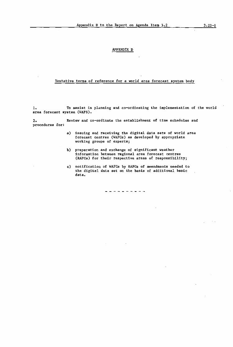
Appendix D to the Report on Agenda Item 3.2 3.2D-l
APPENDIX D
Tentative terms of reference for a world area forecast system body
1. To assist in planning and co-ordinating the implementation of the world area forecast system (WAFS).
2. Review and co-ordinate the establishment of time schedules and procedures for:
a) issuing and receiving the digital data sets of world area forecast centres (WAFGs) as developed by appropriate working groups of experts;
b) preparation and exchange of significant weather information between regional area forecast centres (RAFCs) for their respective areas of responsibility;
c) notification of WAFGs by RAFGs of amendments needed to the digital data set on the basis of additional basic data.


Appendix E to the Report on Agenda Item 3.2 3.2E-l
APPENDIX E
Proposals for amendments to Annex 3/Technical Regulations (C.3.1)
The text of the amendment Is arranged in two columns or pageB'~ In the first column or page the relevant existing text of Annex 3 is re~roduced and in the second column or page the proposed amendment is shown, use being made of the following diagrammatic devices:
x--------------------~
delete
new text to replace the existing text
new text to be inserted
text to be· deleted

3.2E-2 AppendixE to the Eeport on Agenda Item 3.2
RSPP Existing text of Annex 3 Proposed amendment
CHAPTER I.-DEFINITIONS
I.t.-Definitions
Area forecast {,.'(,lItr('. A meteorological centre designated by regional air navigation agreement to issue aeronautical I- ---Jdelete forecasts for one or morc specified arcas.
Area foret·us! system. A co-ordinaled system by which World area forecast system (WAFS). A area forecast centres provide standardized aeronautical
I-world-wide system by which world and
meteorological services. regional area forecast centres provide aeronautical meteorological en-route forecasts in uniform, standardized formats.
Area of coverage (world area forecast system). A geographical area for which a
" regional area forecast centre supplies forecasts for flights departing from aerodromes in its service area.
Area of responsibility (world area
" forecast system). A geographical area for which a regional area forecast centre prepares significant weather forecasts •.
Ilrje!ing. Oral commentary on existing and/or expected meteorological condilions .
...

RSPP
Appendix E to the Report on Agenda Item 3.2 3.2E 3
Existing text of Annex 3
Regional air navigation agreement. Agreement approved by the Council of ICAO nonnally on the advice of a Regional Air Navigation Meeting.
Proposed amendment
Regional area forecast centre (RAFC). A meteorological centre designated to
:>e-_______________________ +--jprepare and supply area forecasts for flights departing from aerodromes within its service area and to supply grid point data in digital form for up to world-wide coverage.
Regional collecting centre. Collecting centre designated to collect air-reports on a regional basis.
Search and rescue service unit. A generic term meaning, as the case may be. rescue co-ordination centrf;, rescue subcentre or alerting post.
Service area (world area forecast system). A geographical area within Which a
x-_______________________ +-tregional area forecast centre is responsible for supplying area forecasts to meteorological authorities and other users.
SIGMET information. Infonnation issued by a meteorologica] watch office concerning the occurrence or expected occurrence of specified en-route weather phenomena which may affect the safety of aircraft operations.

3.2E-4 Appendix E to the Report on Agenda Item 3.2
-RSPP Existing text of Annex 3 Proposed amendment
VOLMET broadcast. Routine broadcast of meteoro-logical information for aircraft in flight.
World area forecast centre (WAFC). A ceteorologlcal centre designated to prepare and supply upper air forecasts in digital form on a global basis to regional area fore.cast centres.
CHAPTER 3.-AREA FORECAST CENTRES CHAPTER 3.- AREA FORECAST SYSTEM AND AND METEOROLOGICAL OFFICES METEOROLOGICAl OFFICES
3.1.-Area forecast centres .3.1 Objectives and comEonents of the
3.1.1 A Contracting State, having accepted the area forecast system .responsibility for providing area forecast services within the framework of the Area Forecast System in accordance with
3.1.1 The objectives of the world area regional air navigation agreement, shall: forecast system shall be:
a) establish one· or more area forecast centres; and a) to supply meteorological offices
b) make available means, or arrange for access to means with forecasts of en-route for the centres to disseminate their forecasts. meteorological conditions
3.1.2 Area forecast centres shall issue and dissemi· concerning upper winds, upper nate forecasts for the areas or routes for which they are f- air temperatures and significant responsible. weather in pictorial and/or
alphanumeric form suitable, as
3.1.3 ReoommendatiolL -Services required from far a8 practicable, for direct area forecast centres should be determined by regional air use by operators, flight,' crew navigation agreement. Such agreement should include: members, air traffic services
aJ the area of responsibility for preparation of fore- units and other aeronautical
casts; users;
bJ the types of the forecasts; b) to supply meteorological authorities and other users
cJ the levels for which forecasts are necessary; with upper wind and upper air
dJ the extent of dissemination of the forecasts to cover temperature forecasts for grid the operational requirements. points in digital form.

RSPP
Appendix E to the Report on Agenda Item 3.2 3.2E-5
Existing text of Annex 3
3.1.4 Recommendation.-The forecasts issued by an area forecatt centre should contain significant en-route weather phenomena, upper winds and upper air temperatures. Unless otherwise determined by regional air llavigatl'on agreement. the forecasts should be isrued four times a day, be valid for 0000, 0600, 1200 and 1800 GMT, respectively. and be ismed approximately 12 hours before their valid time.
3.1.5 Recommendation-The forecasts issued by an area forecast centre should cover the following layers:
oj the layer between Flight Lel/eis 300 and 400;
b) the layer between Flight Levels 500 and 600, as determined by regional air navigation agreement for flights by supersonic aircraft;
c) the layer up to Flight Level 100. as determined by regional air navigation agreement for low-revel /lights, inchtding those in accordance with the visual flight rules;
d) other layers as determined by regional air navigation agreement.
3.1.6 Recommendation.-The number of levels for which forecasts are to be isslled by an area forecast centre should be kept to a minimum.
3.1. 7 Recommendation.-The forecasts issued by an area forecast centre should be given in chart form or, as determined by regional air navigation agreement. they should be given as grid point data in numerical form or in other non-pictorial forms.
3.1.8 Recommendation. -Forecasts issued by an area forecast centre in chart f07m should consist of fixed time prognostic charts and should he disseminated by facsimile.
Note.-Specifications relating to the dissemination of charts issued by area forecast centres are contained in Chapter 11. Section 11.5.
3.1.9 Recommendation. -ForecaJ'ts issued by an area forecast centre as grid point data in numerical form should be given in the ARMET code form or, as determined by regional air navigation agreement, in another appropriate code form, and should be disseminated by teletypewriter.
Note. - The ARMET code form is contained in World Meteorological Organization Publication No. 306 - Manual on Codes, Volume I.
3.1.10 Recommendation.-Area forecast cenrres should provide an amendment J'ervice.
Proposed amendment
These objectives shall be achieved throug~ a comprehensive, integrated, world-wide and, as far as practicable, uniform system, and in a cost-effective manner.
3.1.2 Recommendation.- The world area forecast system should conform with the principles given in Appendix 1.
3.2 World area forecast centres
3.2.1 A Contracting State/Member, having accepted the responsibility for providing a world area forecast centre within the framework of the world area forecast system shall arrange for that centre:
a) to prepare global forecasts for grid points in digital form for all required levels and in a standard formatj the forecasts shall comprise upper winds, upper air temperatures, tropopause heights and maximum wind speed, direction and height;
b) to issue the forecasts for grid points to regional area forecas centres as required; and
c) to prepare and issue amendments to the forecasts for grid point as necessary in accordance with the requirements as specified ih paragraph 3.2.7.
Note: GJ.idance on the procedures of a world area forecast centre is contained in Attachment A.

RSPP
3.2E-6 Appendix E to the Report on Agenda Item 3.2
Existing text of Annex 3
x----------------------------------~
Proposed amendment
3.2.2 Recommendation.- In case of interruption of the operation of a world area forecast centre, its functions should be carried out by the other world area forecast centre.
3.2.3 Recommendation.- The forecasts prepared twice daily by a world area forecast centre should be valid for 12, 18; 24 and 30 hours after the time (0000 and 1200 GMT) of the synoptic data on which- the forecasts were based and should be available for start of transmission not later than hours after standard time of observation.
3.2.4 Recommendation.- The grid point forecasts prepared by a world area forecast centre should comprise:
a) wind and temperature data for flight levels 50 (850 mb), 100 (700 mb), 180 (500 mb). 240 (400 mb), 300 (300 mb). 340 (250 mb). 390 (200 mb) and 450 (150 mb);
b) tropopause height and maximum wind information; and
c) wind and temperature data for flight levels 530 (100 mb) and 600 (70 mb) when and where required.
3.2.5 World area forecast centres shall adopt uniform formats and codes for the supply of forecasts and amendments.
3.2.6 Recommendation.- The forecasts prepared by a world area forecast centre should be issued in the GRID code form.
NOte: The GRID code form 1s contained in the World Meteorological Organization Publication No. 306, Manual on Codes, Volume I.
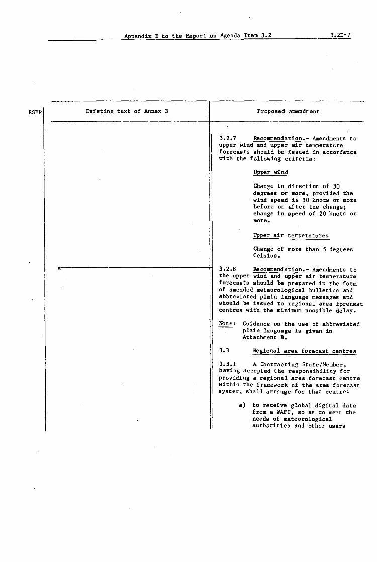
RSPP
Appendix E to the Report on Agenda Item 3.2 3.2E-7
Existing text of Annex 3 Proposed amendment
3.2.7 Recommendation.- Amendments to upper wind and upper air temperature forecasts should be issued in accordance with the following criteria:
Upper wind
Change in direction of 30 degrees or more, provided the wind speed 1s 30 knots or more before or after the change; change in speed of 20 knots or more.
upper air temperatures
Change of more than 5 degrees Celsius.
3.2.8 Recommendation.- Amendments to the upper wind and upper air temperature forecasts should be prepared in the form of amended meteorological bulletins and abbreviated plain language messages and should be issued to regional area forecast centres with the mdnimum possible delay.
Note: Guidance on the use of abbreviated plain language is -given in Attachment B.
3.3 Regional area forecast centres
3.3.1 A Contracting State/Member, having accepted the responsibility for providing a regional area forecast centre within the framework of the area forecast system, shall a-rrange for that centre!
a) to receive global digital data from a WAFC, so as to meet the needs of meteorological authorities and other users

3.2E-8
RSPP
Appendix E to the Report on Agenda Item 3.2
Existing text of Annex 3 . Proposed amendment
within its service area, including those needs related to centralized flight planning;
b) to store the digital grid point data received from a WAFC. and to process and supply selectively, as agreed, these data to meteorological authorities and other users in its service area, in a vertically-stacked formatj
c) to prepare upper wind and temperature charts on the basis of the data received, and to supply the relevant charts and plain language amendments thereto to users, as agreed between the RAFe and the users within its service areaj
Note: The upper wind and temperature charts will be produced from grid point data received from a WAFC, except on those occasions when the RAFC considers it essential to adjust the chart(s) on the basis of recent basic data received.
d) to notify the relevant.WAFC. i~diately of the content and reasons for any amendments it issues to the forecast received from the WAFCj
e) to prepare significant weather charts and, as required, significant weather forecast messages in plain language, for its area of responsibility;
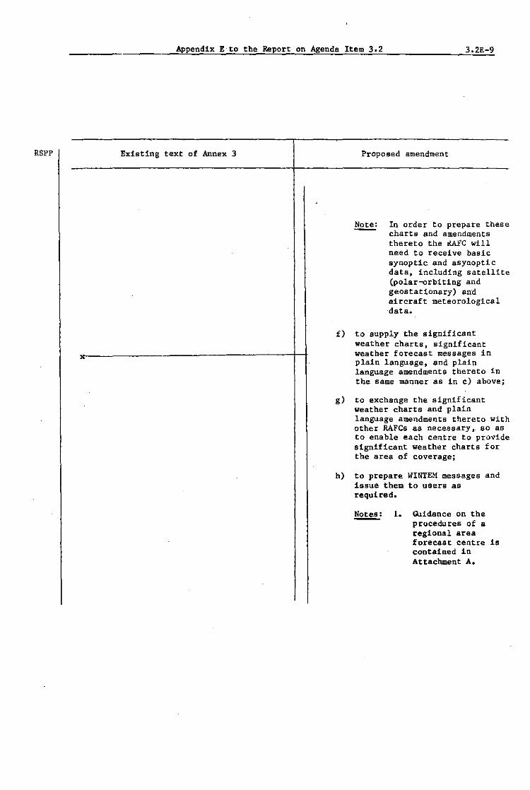
RSPP
Appendix E to the Report on Agenda Item 3.2 3.2E-9
Existing text of Annex 3 Proposed amendment
~ In order to prepare these charts and amendments thereto the ~'C will need to receive basic synoptic and asynoptic data, including satellite (polar-orbiting and geostationary) and aircraft meteorological data.
f) to supply the significant weather charts, significant weather forecast messages in plain language, and plain language amendments thereto in the same manner as in c) above;
g) to exchange the significant weather charts and plain language amendments thereto with other RAFes as necessary, so as to enable each centre to provide Significant weather charts for the area of coverage;
h) to prepare WINTEM messages and issue them to users as required.
~: 1. GJidance on the procedures of a regional area forecast centre Is contained In Attachment A.

3.2E-IO
RSPP
Appendix E to the Report on Agenda Item 3.2
Existing text of Annex 3
3.3.2
Proposed amendment
2. Specifications for the preparation of weather charts are contained in Appendix 2.
3. Guidance on the preparation of plain language significant weather forecast messages is contained in Attachment B.
4. The WINTEM code is contained in World Meteorological Organization PUblication No. 306, Manual on Codes, Volume 1.
Recommendation.- The boundaries of the service areas within which users receive area forecast products may be adjusted by regional air navigation agreement.
The service areas are contained in the relevant Regional Air NavIgation Plan.
3.3.3 Recommendation.- The areas of responsibility for the preparation of significant weather forecasts should be as agreed by the RAPes responsible for providing area forecasts for flight operations conducted ov~r the area of

RSPP
x
Appendix E to the Report on Agenda _Item 3.2 3.2E-1l
Existing text of Annex 3 Proposed amendment
coverage. and subject to subsequent regional air navigation agreement.
Note: The areas of responsibility are contained in the relevant Regional Air Navigation Plan.
3.3.4 Recommendation.- The areas of coverage of the forecasts in chart and/or alphanumeric form supplied to the users should be determined by agreement between the relevant regional area forecast centre and the users.
Note: Maximum areas of coverage suitable for use in flight documentation are contained in the relevant Regional Air Navigation Plan.
3.3.5 Recommendation.- Regional area forecast centre products should be issued four times a day for fixed valid times of 0000, 0600, 1200 and 1800 GMT. The transmission of each forecast should be completed nine hours before its valid time.
3.3.6 Recommendation.- The digital data should be transmitted to meteorologi~al authorities and other users with minimum delay after receipt from the WAFC.
·3.3.7 Recommendation.- The Significant weather charts should cover the following layers:
a) the layer between flight levels 250 and 450 (400 and 150 mb);

3.2E-12
RSPP
Appendix E to the Report on Agenda Item 3.2
Existing text of Annex 3 Proposed amendment
b) the layer between flight levels 100 and 250 (700 and 400 mb) for limited geographical areas, as determined by regional air navigation agreement;
c) the layer between flight levels 450 and 600 (150 and 70 mb) if so determined by regional air navigation agreement. When 60
determined, forecasts covering the layer between flight levels 450 and 600 should be combined with those covering the layer between flight levels 250 and 450.
3.3.8 Recommendation.- The upper wind and upper air temperature charts should cover:
3.3.9
a) flight level 340 (250 mb);
b) other levels as determined by regional air navigation agreement.
Recommendation.- Amendments to Significant weather forecasts should be 8_upplied in the form of abbreviated plain language messages.
~:. Guidance on the preparation of plain language significant weather forecast messages is contained in Attachment B.

RSPP
Appendix E to the Report on Agenda Item 3.2 3.2E-13
Existing text of Annex 3
more shall be adequate for the provision of the meteorological service required to satisfy operational needs.
Proposed amendment
3.3.1'0 Recommendation.- Regional area forecast centres should apply the following criteria for the amendment of significant weather forecasts:
Aircraft icing and turbulence
New expectation; intensity increasing; intensity decreasing from severe to light or nil, or from moderate to nil.
Other significant en-route weather phenomena
New expectation; no longer expected.
303.11 Recommendation.- Regional area forecast centres should supply to meteorological authorities and other users Within their service areas amendments to upper wind and upper air temperature forecasts received from a world area forecast centre.
assistance from so~ur~,~e~,~~=~~3~~~~ be determined by the Meteorological Authority concerned.
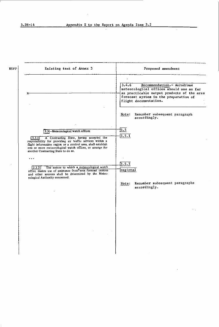
RSPP
3.2E-14 Appendix E to the Report on Agenda Item 3.2
Existing text of Annex 3 Proposed amendment
3.4.6 Recommendation.- Aerodrome meteorological offices should use as far
xc--------------------------Has practicable output products of the area forecast system in the preparation of flight documentation.
Note: Renumber subsequent paragraph accordingly.
~_ Meteorological watch o(fices 3.5
__ ~"3 ... ""3-,.I",-A.--;C"'.o"n:-;tr=a"c"t1;:-n::g"S"'-::a';:e:-.Lh::av::;in=g::-:-.c::c::e=p7.,.,::d"':;:h"e--+--J3 •S • 1
responsibility for providing air traffic services within a flight infonnation region or a control area, shall establish one or more meteorological watch offices, or arrange for another Contracting State to do so,
...... ~_ The extent to which a meteorological watch office makes use of assistance fronf\"area forecast centres and other sources shall be determined by the Meteorological Authority concerned.
regional
Note: Renumber subsequent paragraphs accordingly.
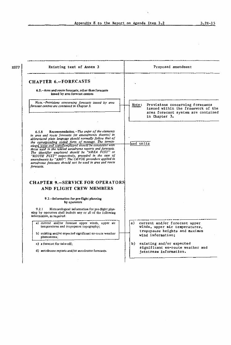
Appendix E to the Report on Agenda Item 3.2 3.2E-lS
RSPP Existing text of Annex 3 Proposed amendment
CHAPTER 6.-FORECASTS
6.5.-Area and route forecasts, other than forecasts issued by area forecast centres
Note. -Provisions concerning forecasts issued by area r- - Note: Provisions concerning forecasts forecast centres aTe contained in Chapter 3.
issued within the framework of the area forecast system are contained in Chapter 3.
6.5.8 Recommendation-The order of the elements in area and route forecasts (or amendments thereto) in abbreviated plain language should normally follow that of the corresponding coded fonn of message. The term in- and units alom. units and scales emptoy:d ShOUld De consLStenr WIt I those used in the related aerodrome reports and forecasts. The identifier employed should be "AREA FeST" or "ROUTE FeST" respectively. preceded in the case of amendments by "AMD'~ The CA VOK procedure applied in aerodrome forecasts should not be used in area and route forecasts.
CHAPTER 9.-SERVICE FOR OPERA TORS AND FLIGHT CREW MEMBERS
9.2.-lnformation for pre-flight planning by operators
9.2.1 Meteorological infonnation for pre-flight plan-ning by operators shall include any or all of the following information, as required:
aJ current and/or forecast upper winds, upper air a) current and/or forecast upper temperatures and tropopause topography; winds, upper air temperatures,
bJ existing and/or expected significant en-route weather f-- - tropopause heights and maximum
phenomena; wind information;
cJ a forecast for take-off; b) existing and/or expected significant en-route weather and
d) aerodrome reports and/or aerodrome forecasts. jetstream information.

3.2E-16 Appendix E to the Report on Agenda Item 3.2
RSPP Existing text of Annex 3 Proposed amendment
9.2.4 Recommendation.-When computer processed upper air data for grid points are made available to operators in digital form for flight planning by computer, the contents, format and transmi:ision arrangements should be as agreed between the Meteorological Authority and the operators. Where the data aTe supplied in a code form prescribed by the World Meteorological Organization, use Idelete; replaced by new paragraph 11.1.10. should be made of the GRID code form employing the oph"on provided therein for upper air forecast data for aeronautical purposes. The data should normally be sup-plied as soon as is practicable after the processing of the forecasts has been completed.
Note.-The GRID code form is contained in World Meteorological Organization Publication No. 306 - Manual on Codes, Volume 1
9.3.-Briefing, consultation and display
9.3.2 Meteorological information used for briefing and consultation shall include any or all of the following: as required:
a) current and/or forecast upper winds, upper aU a) current and/or forecast upper temperatures and tropopause topography; winds, upper air temperatures, b) existing and/or expected significant en·route weather tropopause heights and maximum
phenomena; wind information;
c) a forecast for take·off; b) existing and/or expe-cted d) aerodrome reports and/or aerodrome forecasts. significant en-route weather , phenomena and jetstream
information;
9.4.-Flight documentation - General
9.4.1 Recommendation - Flight documentation Ihould comprise information on:
aj upper winds, upper air temperatures and, ilrelevant, a) upper winds and upper air tropopause topography,' temperatures; I-bj expected significant en-route weather phenomena;
b) expected significant weather cj aerodrome forecasts. and, if relevant, tropopause
heights and jetstream information;

Appendix E to the Report on Agenda Item 302 3.2E-17
RSPP Existing text of Annex 3 Proposed amendment
9.4.2 Recommendation.-The flight documentation 9.4.2 Recommendation.- Meteorological should be presented in the form of charts, tabular forms, offices should, as far as practicable, cross-sections or abbreviated plain language texts. Aero-
drome forecasts should be presented in the TAF code form; provide information received within the they may also be presented in tabular form or in abbrevi- framework of the world area forecast aled plain language texts. Models of charts and forms, system for flight documentation. The which should be adhered to for use in the preparation of flight documentation should be presented flight documentation, are given in Appendix 1. in the form of charts, tabular forms,
Note.-The model charts and forms and methods for or abbreviated plain language texts. their completion are developed by the World Meteoro- Aerodrome forecasts should be presented in lOgical Organization on the basis of the relevant operational the TAF code t or in abbreviated plain requirements. language text using a tabular
presentation.
Note: llidels of charts and forms for use in the preparation of flight documentation are given in Appendix 2. Thes-e models and methods for their completion are developed by the World Meteorological Organization on the basis of relevant operational requirements.
9.4.3 Recommendation -For [lights of a duration of 2 hours or more, the charts included in [light docu-mentation should comprise at least a significant weather chart and one upper wind and upper air temperature chart f!E.l!!!2E!.iate to the cruisi1]Jf level and, fL relevant,-~ tropopause heights and jetstream mation concerning the tropopause topographY:J
information. 9.4.4 Recommendation -For [lights of a duration
of less than 2 hours, the charts included in [light docu-mentation should comprise at least a Significant weather chart and, either one upper wind and upper air temperature chart appropriate to the cruising level or a tabular forecast a[upper winds and upper air temperatures.
9.4.5 Recommendation.- Charts included
" in flight documentation should have the following phYSical characteristics:
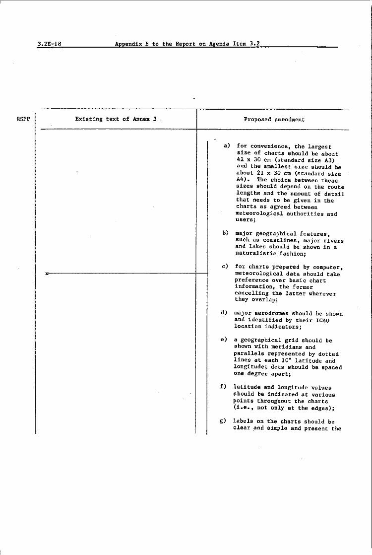
RSPP
3.2E-18 Appendix E to the Report on Agenda Item 3.2
------------------,-----------------Existing text of Annex 3 Proposed amendment
~------------------+--------------------
~--------------------~
a) for convenience, the largest size of charts should be about 42 x 30 em (standard size A3) and the smallest size should be about 21 x 30 cm (standard size A4). The choice between these sizes should depend on the route lengths and the amount of detail that needs to be given in the charts as agreed between meteorological authorities and users;
b) major geographical features, such as coastlines, major rivers and lakes should be shown in a naturalistic fashion;
c) for charts prepared by computer, meteorological data should take preference over basic chart information, the former cancelling the latter wherever they overlap;
d) major aerodrome~ should be shown and identified by their lCAO location indicators;
e) a geographical grid should be shown with meridians and parallels represented by dot.ted lines at each 10D latitude and longitude; dots should be spaced one degree apart;
f) latitude and longitude values should be indicated at various points throughout the charts (i.e., not only at the edges);
g) labels on the charts should be clear and simple and present the

RSPP
Appendix E to the Report on Agenda Item 3.2 3.2E-19
Existing text of Annex 3 Proposed amendment
name of the regional area forecast centre, the type of chart, date and valid time and if necessary the types of units used in an unambiguous way_
9.4.6 Recommendation.- Meteorological information included in flight documentation should be represented as follows:
a) winds on charts should be depicted by arrows with feathers and shaded pennants on a sufficiently dense grid;
b) temperatures should be depicted by figures in circles on a sufficiently dense grid;
c) grid points should coincide with the relevant grid points in the digital data received from a world area forecast centre; and
d) wind arrows should take precedence over temperatures and either should take precedence over chart background.
9.4.7 Recommendation.- For short haul flights charts should be prepared covering limited areas at a scale of 1:15 x 106 as required and subject to regional air navigation agreement.

RSPP
3.2E-20 Appendix E to the Report on Agenda Item 3.2
Existing text of Annex 3
9.4.5 Recommendation -The number of charts in-cluded in flight dOC'llmentation should be kepi to Q
minimum.
J~~ Recommendation - -Flight documentation should normally be supplied as shortly before "departure as U practicable.
Proposed amendment
9.4.8 Recommendation.- The mdnimum number of charts for flights between flight level 250 and flight level 450 should include a high level significant weather chart (flight level 250 to flight level 450) and a forecast 250 mb wind and temperature chart. The actual charts provided for pre-flight and in-flight planning and for flight documentation should be arranged between meteorological aut~orities and other users and the regional area forecast centre concerned within a service area.
9.4.9 Recommendation.- The set of charts to be provided under the area forecast system for flights below flight level 250 and for flights above flight level 450 including supersonic flights should be arranged between user States and users and the regional area forecast centre concerned within a service area.
I 9.4.10
Note: Renumber subsequent paragraphs accordingly.

RSPP
Appendix E to the Report on Agenda Item 3.2
Existing text of Annex 3
9.S.-FHaht documentation - Upper wind Ind upper air tempenture information
-The upper air the wind direction by isohypses (contours)
tropics. by streamlines and they should depict the by isotachs; on such charts the temperatures
given for selected points. Alternatively, the charts depict the wind direction and speed fOT selected Using. for example, arrows with an appropriate of feathers to indicate the wind direction and
mch charts the temperatures should be given for points or by isotherms, using for the latte'. for
example, dashed lines.
9.5.3 Recommendation.-On upper air charts for supersonic aircraft isopleths of temperature should be depicted boldly and should preferably be labelled in departures from the International Standard Atmosphere.
Note. -Examples of the form of presentation of upper wind and upper air temperature charts are given in Appendix 1. Section 1.
Note. -Examples of the form of presentation of tabular air temperatures are
given
Proposed amendment
3.2E-21
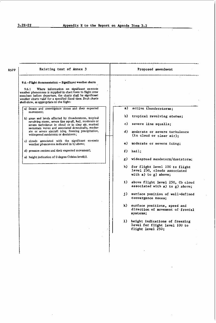
RSPP
3.2E-22 Appendix E to the Report on Agenda Item 3.2
Existing text of Annex 3
9.6.-Fll&ht documentation - Significant weather charts
9.6.1 Where infonnation on significant en-route weather phenomena is supplied in chart fonn to flight crew members before departure, the charts shall be significant weather charts valid for a specified fixed time. Such charts shall show, as appropriate to the flight:
a) fronts and convergence zones and their expected movement;
b) areas and levels affected by thunderstonn. napka! revolving stonn, severe line squall, hail, moderate or severe turbulence in cloud or in clear air, marked mountain waves and associated downdrafts, moderate or severe aircraft icing, freezing precipitation, widespread sandstorm or duststonn;
c) clouds associated with the significant en-route weather phenomena indicated in b) above;
d) pressure centres and their expected movement;
e) height indication of 0 degree Celsius level(s).
I-
Proposed amendment
a) active thunderstormsj
b) tropical revolving storms;
c) severe line squalls;
d) moderate or severe turbulence (in cloud or clear air)j
e) moderate or severe iCing;
f) hail;
g) widespread sandstorm/duststorm;
h) for flight level 100 to flight level 250, clouds associated with a) to g) above;
i) above flight level 250, Cb cloud associated with a) to g) abovej
j) surface position of well-defined convergence zoneSj
k) surface positions, speed and direction of movement of "frontal systemsj
1) height indications of freezing level for flight level 100 to flight level 250;
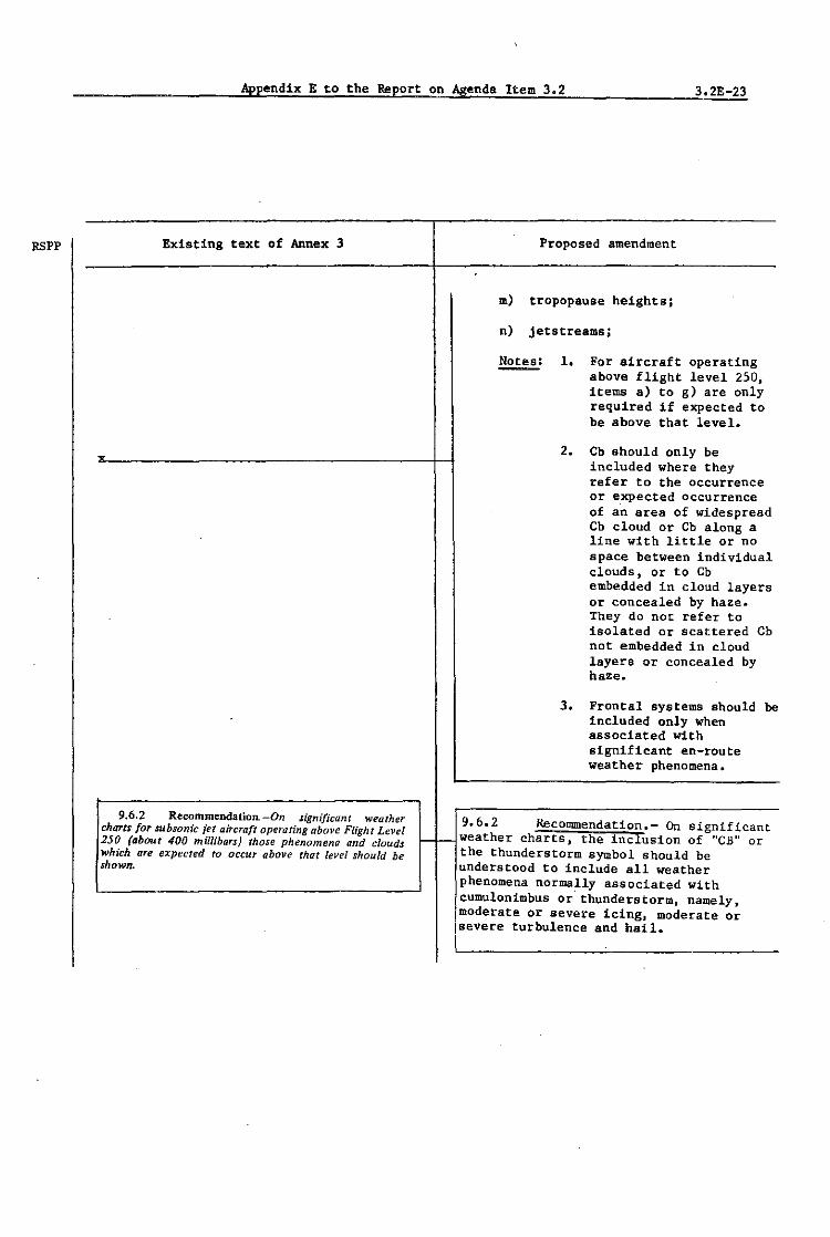
RSPP
Appendix E to the Report on Agenda Item 3.2 3.2E-23
Existing text of Annex 3
9.6.2 RecommendatiolL -On significant weather charts for subsonic jet aircraft operating above Flight Level 250 (about 400 millibars) those phenomena and clouds which are expected to occur above that level should be shown.
Proposed amendment
m) tropopause heights;
n) jet&treamsj
!!2E.!.!.: 1. For aircraft operating above flight level 250, itema a) to g) are only required if expected to be above that level.
2. Cb should only be included where they refer to the occurrence or expected occurrence of an area of widespread Cb cloud or Cb along a line with little or no space between individual clouds, or to Cb embedded in cloud layers or concealed by haze. They do not refer to isolated or scattered Cb not embedded in cloud layers or concealed by haze.
3. Frontal systems should be included only when associated with significant en-route weather phenomena.
9.6.2 Recommendation.- On significant r- r- weather charts. the inclusion of "C.B" or
the thunderstorm symbol should be understood to include all weather phenomena normally associated with
Icumulonlmbus or" thunderstorm, namely, Imoderate or severe icing. moderate or jsevere turbulence and hail.
I

3.2E-24 AppendixE to the Report on Agenda Item 3.2
RSPP Existing tex.t of Annex 3
9.6.3 Recommendation.-Significant weather charts for supersonic aircraft should include cumulonimbus tops, moderate and severe turbulence, and precipitation at or above Flight Level 500 (about 100 millibars).
_lJ?..64l Recommendation. Significant weather charts for low-level /lights, including those in accordance with the visUal flight rules, operating up to Flight Level 100 should show, as appropriate to the flight:
oj fronts and convergence zones and their expected movement;
b) areas and levels affected by thunderstorm. tropical revolving storm, line squall. hail, moderate or severe turbulence in cloud or in clear air, mountain waves and associated downdrafts, aircraft icing, freeZing precipitation, widespread sandstorm or duststorm, fog, precipitation and other phenomena causing widespread· reduction of visibility to less than 10 Idlometres;
c) cloud amount, type and height indications of bases and .tops;
d) surface visibility, ifless than 10 kilometres;
e) pres~re centres and their expected movement,'
f) height indication of 0 degree Celsius level(s) if lower than the top of the airspace for which the forecast is provided.
Note. -Examples of the form of vresentation of signifi· cant weather charts are given iriA endix 1, ection 3.
9.7.-Flight documentation - Aerodrome forecasts
9.7.5 Recommendation - Aerodrome forecasts should be presented in the TAF code form; they may also be presented in tabular [onn or in the form of an abbreviated plain kmguage text. Where presentation in the TAF code form is used, the location indicators and the abbreViations used should be explained in the flight. dOC'l4mentation. If several aerodrome forecasts are incluc!ed in the TAF code form, they should -be presented in a manner which permits the ready identification -of the beginning and end of each forecast.
~ delete
9.6.3
Appendix 2.
Note. -Examples of the form of presentation of aero· drome forecasts are given in~@j~e~n~dl/X~'tJ •• :§ .. ec~t~lO~ntr~ 4··:C--------+-lA~p~p~e~n~d[i~x~2~.
Proposed amendment

RSPP
Appendix E to the Report on Agenda Item 3.2 3.2E-25
EXisting text of Annex 3
9.8.-Fliaht dOCllmentation - Supplementary charts and other forms of presentation
9.8.1 Kecommenoal!0n. -w~_ere information on the tropopause configuration is supplied in chart form, the charts should be tropopause and vertical wind shear charts. or tropopause and maximum wind charts or, alternatively. in the tropics, constant pressure or streamline charts with tropopause information. Such charts should give height indications of and the mean temperature at the tropopause. The vertical wind shear information, if given, should be indicllted as an arithmetic mean of the absolute values of the .hear from 2400 metres (8000 feet) below to 1 200 metres (4000 feet) above the tropopause. The maximum wind information, if given, should include the height indication and configuration of jet str~ams.
Note. -Examples of the form of presentation of tropopause charts are given in Appendix 1, Section 5.
9.8.2 Where flight documentation is provided in the form of a cross-section, it shall show, as appropriate to the route to be flown:
a) fronts and convergence zones;
b) significant en-route weather phenomena;
c) clouds associated with the significant en-route weather phenomena;
d) upper winds and upper air temperatures.
9.8.3 Recommendation. -As agreed between the Meteorologl'cal Authority and the operator, a cross-section should also show supplementary information. including height indications of the 0 degree Celsius level(s) and of the tropopause and the lowest mean sea level pressure.
9.8.4 Reoommendation.-Wlzere information for the transonic and supersonic climb by sllp{.'rsoll;c aircraft ;s supplied in the form of a cro~·s-sectio"J it shollld S'1011'
upper winds, upper air ·temperatures alid the locati.·,' 01/,· verlical eXlent of cumulonimbus clouds. moderate fill:: severe turbulence alld precipitatioll.
Proposed amendment
_-I delete
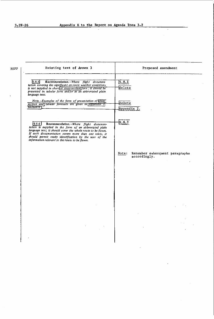
3.2E 26 Appendix E to the Report on Agenda Item 3.2
RSPP Existing text of Annex 3
covering is not supplied in presented in tabular language text.
Note.
-Where /light documenweather conditio1lS
as an abbreviated plain
Recommendation.-Where flight documensupplied in the form of an abbrelljated plain
language text, it should cover the whole route to be /lown. If such documentation covers more than one TOU te, it should permit ready identification by the user of the information relevant to the route to be flown.
Proposed amendment
Renumber subsequent paragraphs accordingly.

RSPP
Appendix E to the Report on Agenda Item 3.2 3.2E-27
Existing text of Annex 3
CHAPTER It.-REQUIREMENTS FOR
AND USE OF COMMUNICATIONS
Note.-It is recognized that it is for each Contracting State to decide upon its own internal organization and responsibility for implementing the communications facilities referred to in this chapter.
I I. I.-Requirements for communiCations
11. J.8 Recommendation - The telecommunications facUities JOT the transmission of operational meteorological informq£ion between meteorological offices, and the related transit time reqUirements, should be determined by regionai air navigation agreement.
Proposed amendment
11.1.9 Recommendation.- When upper air data for grid points in digital form are
x _______________________ -j-tmade available for use by air traffic services computers, the transmission arrangements should be as agreed between the meteorological authority and the appropriate air traffic services authority.

3.2E-28 Appendix E to the Report on Agenda Item 3.2
RSPP Existing text of Annex 3 Proposed amendment
11.1.10 Recommendation.- When upper air data for grid points in digital form are
x made available to operators for flight planning by computer) the transmission arrangements should be as agreed among the regional area forecast centre, the meteorolog_ieal authority and the operators.
III.s.-Dissemination of charts issued byl area forecast centres I
I 11.5.- Dissemination of area forecasts
11.5.1 RecommendatiotL - Where area forecast cen-tres issue their forecasts in the form of charts, the facsimile facilities used {or their transmission should be such as to permit reception in States located within the geographical area determined ~Y regional air navigation agreement.
11.5.2 Recommendation. -The quality of the charts received should be such as to permit reproduction in a I- ---jde1ete mfficientIy legible form for flight planning and documen-tation. Charts received should be legible over 95 per cent of their area.
11.5.3 Recommendation -Transmissions should be such as to ensure that their interruption should not exceed ten minutes during any period of 6 hours.
LTo be expanded so as to include specifications related to exchanges between world area forecast centres, between world area forecast centres and regional area forecast centres, and between regional area forecast centres and user States or users!.!

Appendix E to the Report on Agenda Item 3.2 3.2E-29
INTENTIONALLY LEFT BLANK

3.2E-30 Appendix E to the Report on Agenda Item 3.2
RSPP ~xisting text of Annex 3
x-------------------------------------------------------------------------
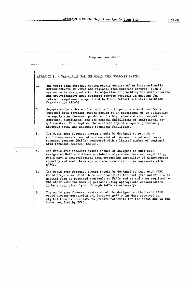
Appendix Eto the Report on Agenda Item 3.2 3.2E-31
Proposed amendment
APPENDIX 1. - PRINCIPLES FOR THE WORLD AREA FORECAST SYSTEH
1. The world area forecast system should consist of an internationally agreed network of world and regional area forecast centres, such a system to be designed with the objective of providing the most accurate and cost-effective area forecast service possible in meeting the relevant requirements specified by the International Civil Aviation Organization (ICAO).
2. Acceptance by a State .of an obligation to provide a world and/or a regional area forecast centre should be an acceptance of an obligation to supply area forecast products of a high standard with respect to accuracy, timeliness, and the general fulfillment of operational requirements. This implies the availability of adequate personnel, adequate data, and adequate technical facilities.
3. The world area forecast system should be designed to provide a continuous service and should consist of two associated world area forecast centres (WAFCs) connected with a limited number of regional area forecast centres (RAFCs).
4. The world area forecast system should be designed so that each designated WAFC would have a global analysis and forecast capabilitYJ would have a meteorological data processing capability of commensurate capacity and would have appropriate communication arrangements with RAFC ••
5. The world area forecast system should be designed so that each WAFC would prepare and distribute meteorological forecast grid point data in digital form as required routinely to RAFCs and as and when required to the other WAFC for back-up purposes using appropriate communication links either directly or through RAFCs as necessary.
60 The world area forecast system should be designed so that each RAFC would process meteorological forecast grid point data received in digital form as necessary to prepare forecasts for the areas and in the forms required by ICAO.

3.2E-32 Appendix E to the Report on Agenda Item 3.2
RSPP Existing text of Annex 3
X~--------------------------------------------------------------------

Appendix E to the Report on Agenda Item 3.2 3.2E-33
Proposed amendment
7. The world area forecast system should be designed 80 that each RAFe would issue significant weather and upper wind and temperature forecasts in chart form as required for departures from designated aerodromes within a specified area. An RAFC should be located within the specified area from which such departures would occur.
8. The world area forecast system should be designed such that the determination of size and placement of areas of coverage should take into consideration the air route patterns 60 that the information on en-route meteorological conditions for anyone level or volume of airspace could be provided on one chart of appropriate scale and size to the maximum extent possible.
9. The world area forecast system anould be designed such that the number of forecast charts required of an RAFe should be tailored to meet operational needs bearing in mind the need to prevent excessivecommunication loads. As a minimum, this would require one significant weather chart and one upper wind and temperature chart for the appropriate flight level.
10. The world area forecast system should be designed so that each RAFC would make available to any aviation user, as required and agreed to, meteorological forecast grid point data in digital form suitable for computer use.
II. The world area forecast system should be designed so as to be capable of application in any part of the world. Therefore, the relevant procedures and the presentation of the products of the various WAFCs and RAFCs should be standardized on a world-wide basis.
12. The world area forecast system should be closely related to the World 11eteorological Organization (WMO) World Weather Watch (WWW).
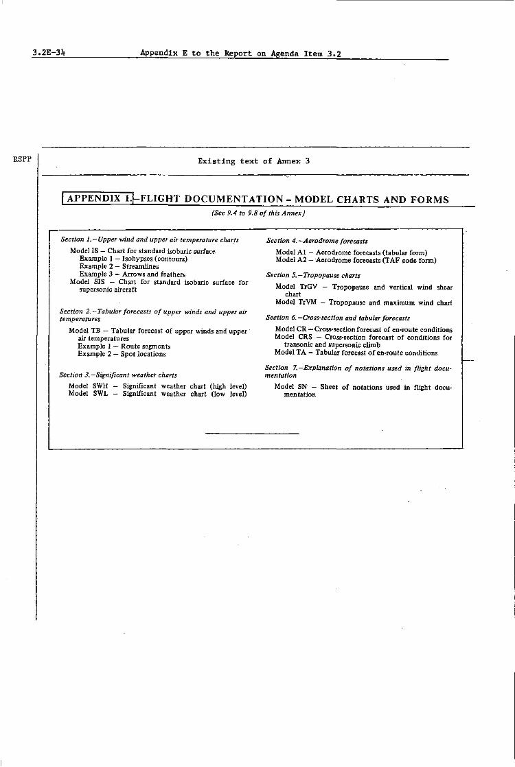
RSPP
3.2E-34 Appendix E to the Report on Agenda Item 3.2
Existing text of Annex 3
I APPENDIX l.t-FLIGHT DOCUMENT A nON - MODEL CHARTS AND FORMS (See 9.4 to 9.8 of this Annex)
Section I.-Upper wind and upper air temperature char,ts
ModeJ IS - Chart for standard isobaric surface Example 1 - Isohypses (contours) Example 2 - Streamlines Example 3 - Arrows and feathers
Model SIS - Chart for standard isobaric surface for supersonic aircraft
Section 2. - Tabular forecasts of upper winds and upper ajr temperatures
Model TB - Tabular forecast of upper winds and upper air temperatures Example 1 - Route segments Example 2 - Spot locations
Section 3.-Significant weather charts
Model SWH Significant weather chart (high level) Model SWL - Significant weather chart (low level)
Section 4. -Aerodrome forecasts
Model Al - Aerodrome forecasts (tabular form) Model A2 -·Aerodrome forecasts (TAP !:ode fann)
Section 5. - Tropopause charts
Model TrGV - Tropopause and vertical wind shear chart
Model TrVM - Tropopause and maximum wind chart
Section 6. -Cross-section and tabu lOT forecasts
Model CR - Cross-section forecast of en-route conditions Model eRS - Cross-section forecast of conditions for
transonic and supersonic climb Model TA - Tabular forecast of en-route conditions
Section 7. -Explanation of notations used in flight documentation
Model SN - Sheet of notations used in flight documentation
f-
Appendix E to the Report on Agenda Item 3.2 3.2E-35
Proposed amendment
I APPENDIX 2.
____________ ~IL:d:e:le:t:e:; replacement Appendix 2 to be prepared by WMO.

3.2E-36 AppendixE to the Report on Agenda Item 3.2
RSPP Existing text of Annex 3
x----------------------------------

Appendix E to the Report on Agenda Item 3.2 3.2E-37
Proposed amendment
ATTACHMENT A - GUIDANCE ON THE PROCEDURES OF A WORLD AREA FORECAST CENTRE AND A REGIONAL AREA FORECAST CENTRE
PART 1 - PROCEDURES TO BE FOLLOWED BY A WAFC
The procedures to be followed by a WAFe should include the following:
a) maintenance of adequate communications links with the other WAFC and with its associated RAFC(s)j
b) procedures to establish qUickly, on short nat1ee t adequate communications links with other (non-associated) RAFCs, either directly or through an associated RAFC, in case of failure of the other WAFC;
c) procedures to receive, store and quallty-control global surface and upper air basic meteorological data, both synoptic and asynoptic, including satellite and aircraft meteorological data;
d) procedures to analyse the data received, to process into forecasts, and to further process and encode as required for transmission to associated RAPes;
e) procedures to monitor continuously, incoming data, to compare with previously issued forecasts, and to prepare and issue amendments as required;
f) procedures to notify associated RAFCs and the other WAFC of break-down of essential data processing or communications capability, such that back-up procedures may be put into effect;
g) procedures to ensure effective communication with the other WAFC and with both associated and non-associated RAFCs on procedural, technical, and administrative matters as necessary for adequate -functioning of the area forecast system.

3.2E 38 Appendix E to the Report on Agenda Item 3.2
RSPP Existing text of Annex 3
x

Appendix E to the Report on Agenda Item 3.2 3.2E-39
Proposed amendment
PART 2 - PROCEDURES TO BE FOLLOWED BY AN RAFC
While the development of detailed procedures to carry out the functions of the RAFes would differ from State to State and is the province of the authority concerned, in consultation with its associated WAFC and/or with the Contracting States/Members served, the general procedures should include but may not necessarily be limited to:
a) maintenance of communications links of required capacity with its associated WAFG and with other RAPes as necessary, and users as agreed;
b) procedures to establish quickly on short notice, communications links as necessary in the event of communications or data processing failure of its associated WAFCj
c) procedures to receive basic synoptic and asynoptic data, including satellite (polar-orbiting and geostationary) and aircraft meteorological data;
d) procedures to analyse the data received, to process into forecasts of significant weather, and to supply these forecasts as agreed between the RAFC and its associated users;
e) procedures to monitor continuously data received under paragraph c) above and to prepare and issue amendments to significant weather forecasts;
f) procedures to supply upper air forecasts as agreed between the RAFC and its associated users.
g) procedures to supply, as agreed, amendments to forecast upper air data received from its associated WAFC;
h) procedures to notify the associated WAFC, other RAFCs concerned and users w_ithin its service area of breakdown in essential data processing or communications capability, so that back-up procedures may be put into effect;
i) procedures to ensure effective communications with its associated WAFC and, as required, with other RAFCs on procedural, technical and administrative matters as necessary for adequate functioning of the area forecast system; and
j) procedures to establish rapidly, according to agreements between States and users, the necessary cornmunications_ means in case of a breakdown in normal communications.

3.2E-40 Appendix E to the Report on Agenda Item 3.2
RSPP Existing text of Annex 3
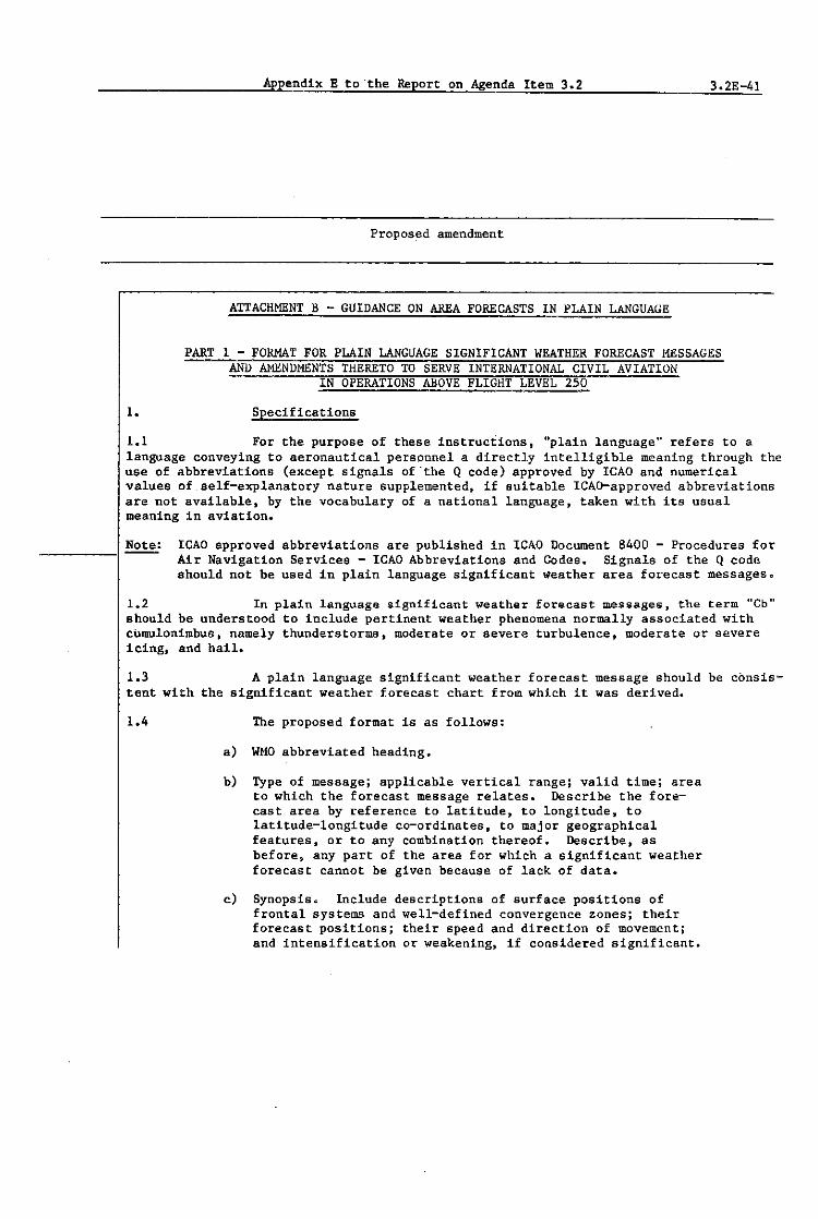
Appendix E to the Report on Agenda Item 3.2 3.2E-41
Proposed amendment
ATTACHMENT B - GUIDANCE ON AREA FORECASTS IN PLAIN LANGUAGE
WEATHER FORECAST
I. Specifications
1.1 For the purpose of these instructions, "plain language" refers to a language conveying to aeronautical personnel a directly intelligible meaning through the use of abbreviations (except signals of "the Q code) approved by ICAO and numerical values of self-explanatory nature supplementedt if suitable leAD-approved abbreviations are not available, by the vocabulary of a national language, taken with its usual meaning in aviation.
-----------1 Note: leAD approved abbreviations are published in leAO Document 8400 - Procedures for Air Navigation Services - leAO Abbreviations and Codes. Signals of the Q code should not be used in plain language significant weather area forecast messageso
1.2 In plain language significant weather forecast messages, the term "Cb" should be understood to include pertinent weather phenomena normally associated with cumulonimbus, namely thunderstorms, moderate or severe turbulence, moderate or severe icing, and hail.
1.3 A plain language significant weather forecast message should be consis-tent with the significant weather forecast chart from which it was derived.
1.4 The proposed format is as follows:
a) WHO abbreviated heading.
b) Type of message; applicable vertical range; valid timej area to which the forecast message relates. Describe the forecast area by reference to latitude, to longitude, to latitude-longitude co-ordinates, to major geographical features, or to any combination thereof. Describe, as before, any part of the area for which a significant weather forecast cannot be given because of lack of data.
c) Synopsi6~ Include descriptions of surface positions of frontal systems and well-defined convergence zones; their forecast positionsj their speed and direction of movement; and intensification or weakening, if considered significant.

3.2E-42 Appendix E to the Report on Agenda Item 3.2
RSPP Existing text of Annex 3

2.
Appendix E to the Report on Agenda Item 3.2
Proposed amendment
Give forecast positions as in b). Describe direction of movement in terms of eight points of the compass related to true north; give speed of movement in knots.
d) Significant weather phenomena. Describe areas as in b). Describe the amount of Cb as ISOL EMBD CH (individual embedded Cb) or ISOL CB IN HAZE (individual Cb concealed in haze); OCNL EMBD CB (well separated embedded Cb) or OCNL CH IN HAZE (well separated Cb concealed in haze); or FRQ CB (Cbs with little or no separation). Describe Cbs contained in layers of other clouds as EMED. Give bases and tops of significant weather phenomena as flight level (FL). If no significant weather is forecast, enter the term "SIGWX NIL".
Note: Include turbulence not associated with Cb in separate section as described below.
e) Turbulence. This should include turbulence, other than that associated with Cb, if expected to be moderate or severe, and the intensity thereof. Describe areas as in b). Give bases and tops of phenomenon as FL. If no turbulence in this category is forecast, no entry for turbulence should be given.
~: Give bases of significant weather phenomena only if expected to be at or above the lowest level of the atmosphere for which the forecast is prepared. Similarly, give the tops of significant weath~r phenomena only 1f expected to be at or below the highest level of the atmosphere for which the forecast is prepared.
Examples
3.2E-43
Examples of plain language significant weather messages are described in the format below.

3.2E-44 Appendix E to the Report on Agenda Item 3.2
RSPP Existing text of Annex 3

Example 1
Example 2
Example 3
Appendix E to the Report on Agenda Item 3.2 3.2E-45
Proposed amendment
FAPN13 KWBC 101200 AREA FCST FL250 TO FL450 VALID 110000 FOR AREA 37N135E 48N1U~ 2HN13UW 28N158E 37N135E
SYNOPSIS. COLD FRONT 45N179W 33N179W MOV E 20 KT. COLD FRONT 43N152W 44N14OW 35N131W 29N134W MOV NE 15 KT. INTSF.
SIGWX NIL
TURB. MOD CAT FL260 TO FL3'0 36N140E 36N150E 34N141E 36N140E. MOD CAT FL280 TO FL380 41N133W 45N125W 42Nll7W 40N12OW 41N133W.
FAEW1 EJJJ 101300 AREA FCST FL250 TO FL450 VALID 110000 FOR AREA 50N2OW 50N20E 30N20E 3UN2OW 50N20W.
SYNOPSIS. NO MAJOR WX SYSTEM.
SIGWX NIL.
FANT10 KWBC 101200 AREA FCST FL250 TO FL600 VALID 110000 FOR AREA 55N8~ 50N42E 33NI3E 27N59W 55N88W.
SYNOPSIS. WARM FRONT 42N84W 43N79W 39N62W MOV NE 30 RI. OCCLUDED FRONT 63N4OW 60N25W 50N2!M MOV E 35 KT. COLD FRONT 50N29W 40N43W 31N6OW MOV SE Il KT INTSF.
SIGWX AND ASSOCIATED CLD. 1S0L EMBD CB TOPS FL340 55N20E 55N30E 46N34E 44N24E 55N20E.
TURB. MOD CAT FL250 TO FL340 46N41W 53N40W 56N28W 50N32W 46N41W. MOD CAT FL250 TO FL350 62N3OW 67N1lJ 63NOBW 61N2OW 62N3UW.

3.2E-46 Appendix E to the Report on Agenda Item 3.2
RSPP Existing text of Annex 3
,.
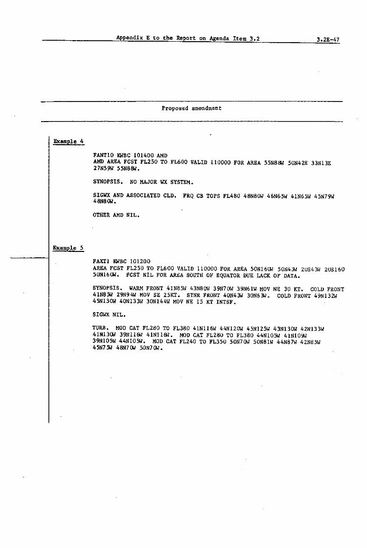
Example 4
Example 5
Appendix E to the Report on Agenda Item 3.2 3.2E-47
Proposed amendment
FANTIO KWBC 101400 AND AMD AREA FCST FL250 TO FL600 VALID 110000 FOR AREA 55N88W 50N42E 33NI3E 27N59W 55N88W.
SYNOPSIS. NO MAJOR WX SYSTEM.
SIGWX AND ASSOCIATED CLD. FRQ CB TOPS FL4S0 48N80W 46N65W 41N65W 45N79W 4SNSOW.
OTHER AND NIL.
FAXTI KWBC 101200 AREA FCST FL250 TO FL600 VALID 110000 FOR AREA 50N16OW 50N43W 2US43W 208160 50N16OW. FCST NIL FOR AREA SOUTH OF EQUATOR DUE LACK OF DATA.
SYNOPSIS. WARM FRONT 4IN85\; 43NSOW 39N70W 39N61W MOV NE 30 KT. COLD FRONT 41N8SW 29N94W MOV SE 25KT. STNR FRONT 40N43W 30N63W. COLD FRONT 49N132W 45NI3OW 40NI33W 30NI44W MOV NE 15 KT INTSF.
SIGWX NIL.
TURB. MOD CAT FL280 TO FL3S0 41NI16W 44NI2OW 45NI25W 43NI3OW 42NI33W 41N13OW 39Nll6W 41NII6W. MOD CAT FL28U TO FL3S0 44NIOSW 41NIOYW 39NI05W 44NIOSW. MOD CAT FL240 TO FL350 50N70W 50NSIW 44N87W 42N85W 45N7 SW 48N7OW 50N7OW.

3.2E-48 Appendix E to the Report on Agenda Item 3.2
RSPP Existing text of Annex 3

Appendix E to the Report on Agenda Item 3.2 3.2E-49
Proposed amendment
1. Specifications
1.1 For the purpose of these instructions. "plain language" refers to a language conveying to aeronautical personnel a directly intelligible meaning through the use of abbreviations (except signals of the Q code) approved by leAD and numerical values of self-explanatory nature supplemented. if suitable ICAo-approved abbreviations are not available, by the vocabulary of a national language. taken with its usual meaning in aviation.
Note: leAD approved abbreviations are published in leAD Document 8400 - Procedures for Air Navigation Services - leAO Abbreviations and Codes. Signals of the Q code should not be used in plain language significant weather area forecast messages.
1.2 In plain language significant weather forecast messages, the term "Cb" should be understood to include pertinent weather phenomena normally associated with cumu19nimbus, namely thunderstorms, moderate or severe turbulence, moderate or severe icing, and hail.
1.3 A plain language significant weather forecast message should be consis-tent with the significant weather forecast chart from which it was derived.
1.4 The proposed format is as follows:
a) WHO abbreviated heading.
b) Type of messagej applicable vertical range. valid time; area to which the forecast message relates. Describe the forecast area by reference to latitude, to longitude, to latitude-longitude co-ordinates, to major geographical features, or to any combination thereof. Describe, as before, any part of the area for which a significant weather forecast cannot be given because of lack of data.
c) Synopsis. Include descriptions of surface positions of frontal systems and well-defined convergence zones. their forecast positions; their speed and direction of movement; and intensification or weakening, if considered significant.

3.2E-50 Appendix E to the Report on Agenda Item 302
RSPP Existing text of Annex 3
·x
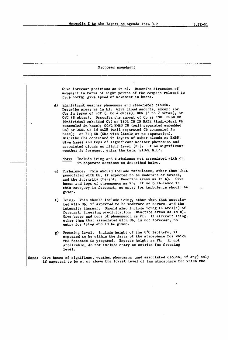
Appendix E to the Report on Agenda Item 3.2
Proposed amendment
Give forecast positions as in b). Describe direction of movement in terms of eight pOints of the compass related to true north; give speed of movement in knots.
d) Significant weather phenomena and associated clouds.
e)
f)
g)
Describe areas as in b). Give cloud amounts, except for Cbs in terms of SCT (1 to 4 oktas), BKN (5 to 7 oktas), or OVC (8 oktas). Describe the amount of Cb as ISOL EMBD CB (individual embedded Cb) or ISOL CB IN HAZE (individual Cb concealed in haze)j OCNL EMBD CB (well separated embedded Cb) or OCNL CB IN HAZE (well separated Cb concealed in haze); or FRQ CB (Cbs with little or no separation). Describe Cbs contained in layers of other clouds as EMBD. Give bases and tops of significant weather phenomena and associated clouds as flight level (FL). If no significant weather is forecast, enter the term "SIGWX NIL".
Note: Include icing and turbulence not associated with Cb in separate sections as described below.
TUrbulence. This should include turbulence, other than that associated with Cb, if expected to be moderate or severe, and the intensity thereof. Describe areas as in b). Give bases and tops of phenomenon as FL. If no turbulence in this category is forecast, no entry for turbulence should be given.
Icing. This should include icing, other than that associated with Cb, if expected to be moderate or severe, and the intensity thereof. Should also include icing in area(s) of forecast, freezing precipitation. Describe areas as in b). Give bases and tops of phenomenon as FL. If aircraft icing, other than that associated with Cb, is not forecast, no entry for icing should be given.
Freezing level. Include height of the O°C isotherm, if exPected to be within the layer of the atmosphere for which the forecast is prepared. Express height as FL.- If not applicable, do not include entry or entries for freezing level.
3.2E-51
Give bases of significant weather phenomena (and associated clouds, if any) only if expected to be at or above the lowest level of the atmosphere for which the

3.2E-52 Appendix E to-the Report on Agend~ Item 3.2
RSPP Existing text of Annex 3
x---------------------------------------------------------
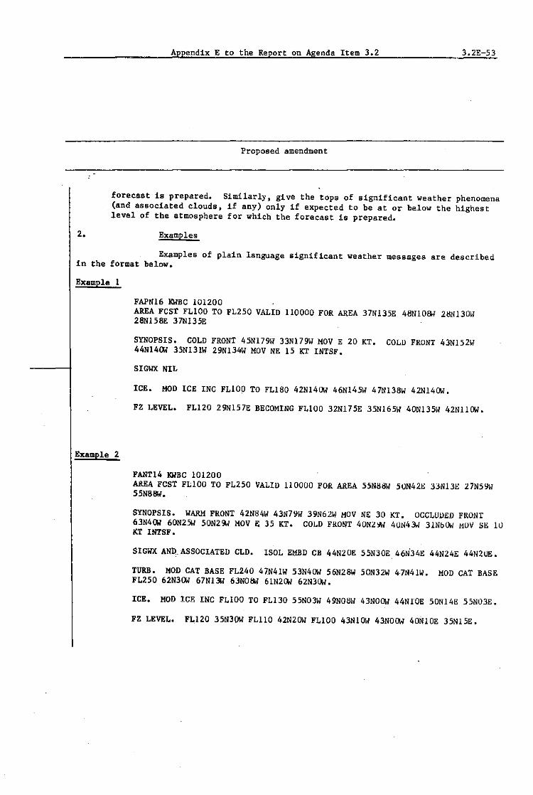
2.
Appendix E to the Report on Agenda Item 3.2 3.2E-53
Proposed amendment
forecast is prepared. Similarly, give the tops of significant weather phenomena (and associated clouds, if any) only if expected to be at or below the highest level of the atmosphere for which the forecast is prepared.
Examples
Examples of plain language significant weather messages are described in the format below.
Example 1
Example 2
FAPN16 KWBC 101200 AREA FCST FL100 TO FL250 VALID 110000 FOR AREA 37N135E 48N10BW 2BN130W 28N158E 37N135E
SYNOPSIS. COLD FRONT 45N179W 33N179W MOV E 20 KT. COLD FRONT 43N152W 44N14OW 35N131W 29N134W MOV NE 15 KT INTSF.
SIGWX NIL
ICE. MOD ICE INC FL100 TO FL180 42N14OW 46N145W 47N138W 42N14OW.
FZ LEVEL. FL120 29N157E BECOMING FL100 32N175E 35N165W 40N135W 42N11OW.
FANT14 KWBC 101200 AREA FCST FL100 TO FL250 VALID 110000 FOR AREA 55N8BW 50N42E 33N13E 27N59W 55N88W.
SYNOPSIS. WARM FRONT 42N84W 43N79W 39N62W MOV NE 30 KT. OCCLUDED FRONT 63N4OW 60N25W 50N2!M MOV E 35 KT. COLD FRONT 40NZ". 40N43.1 31NbOW MOV BE 1lJ KT INTSF.
SIGWX AND_ASSOCIATED CLD. ISOL EMBD CB 44N20E 55N30E 46ti34E 44N24E 44N20E.
TURB. MOD CAT BASE FL240 47N41W 53N4OW 56N28W 50N32W 47N41W. MOD CAT BASE FL250 62N3OW 67Nl3W 63NOBW 61N2OW 62N3OW.
ICE. HOD ICE INC FLlOO TO FL130 55N03W 49N0811 43NOOW 44NfOE 50N14E 55N03E.
FZ LEVEL. FL120 35N30W FL110 42N2OW FL100 43N10W 43NOOW 40N10E 35N15E.

3.2E-54 Appendix E to the Report on Agenda Item-302_
RSPP Existing text of Annex 3
Jl

Example 3
1.
Appendix E to the Report on Agenda Item 3.2 3.2E-55
Proposed amendment
FANT14 KWBC 101400 AMD AMD AREA FCST FL100 TO FL250 VALID 110000 FOR AREA 55N68W 40N42E 33N13E 27N59W 55N81lW.
SYNOPSIS. WARM FRONT 42N84W 43N79W 39N62W MOV NE 10 KT INrSF.
SIGWX AND ASSOCIATED CLD. FRQ CB 48N8OW 46N65W 41N65W 45N79W 48N8OW INTSF.
OTHER AMD NIL.
PART 3 - FORMAT FOR MESSAGES CONTAINING PLAIN LANGUAGE AMENDMENTS TO UPPER AIR FORECASTS
Specifications
1.1 For the purpose of these instructions, "pla.in language" refers to a language conveying to aeronautical personnel a directly intelligible meaning through the u~e of abbreviations (except Signals of the Q code) approved by the International Civil Aviation Organization (reAO) and numerical values of self-explanatory nature Bupplemented, 1f suitable leAD-approved abbreviations are not available, by the vocabulary of a national language, taken with its usual meaning in aviation.
Note: leAD-approved abbreviations are published in ICAO Document 8400, "Procedures for air navigation services - Abbreviations and codes". Signals of the Q code should not be used in plain language messages issued as amendments to relevant upper air wind and temperature forecasts.
1.2 Amendments to plain language upper air forecasts should be understood to apply to all relevant forecasts prepared by world and regional area forecast centres for any specified area, level and valid time(s). Such forecasts could include meteorological charts, grid point data in numerical form and grid point data in digital form.
1.3 The area and levels for which amendments to upp~r air forecasts are to be issued should be described with regard to horizontal dimensions by applicable latitude/longitude co-ordinates and with regard to vertical dimensions by applicable leAO flight levels related to standard constant pressure surfaces.

3.2E-S6 Appendix E to the Report on Agenda Item 3.2
RSPP Existing text of Annex 3
X~--------------------------------------------------------~---------------------
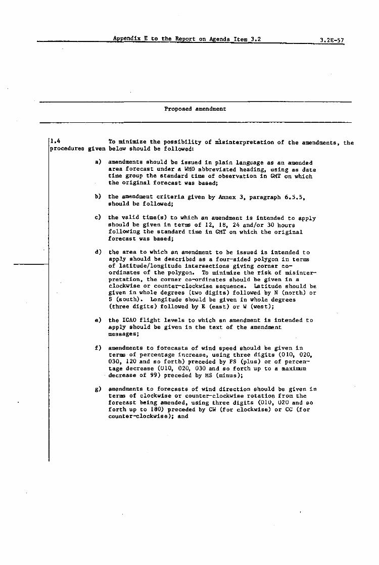
Appendix E to the Report on Agenda Item 3.2 3.2E-57
Proposed amendment
1.4 To minimize the possibility of misinterpretation of the amendments, the procedures given below should be followed:
a) amendments should be issued in plain language as an amended area forecast under a WMO abbreviated heading, using as date time group the standard time of observation in GMT on which the original forecast was based;
b) the amendment criteria given by Annex 3, paragraph 6.5.5, should be followed;
c) the valid time(.) to which an amendment is intended to apply should be given in terms of 12, 18. 24 and/or 30 hours following the standard time in GMT on which the original forecast was based;
d) the area to which an amendment to be issued is intended to apply should be described as a four-sided polygon in terms of latitude/longitude intersections giving corner coordinates of the polygon. To minimize the risk of misinterpretation, the corner co-ordinates should be given in a clockwise or counter-clockwise sequence. Latitude should be given in whole degrees (two digits) followed by N (north) or S (south). Longitude should be given in whole degrees (three digits) followed by E (east) or W (west);
e) the leAD flight levels to which an amendment Is intended to apply should be given in the text of the amendment messages;
f) amendments to forecasts of wind speed should be given in terms of_ percentage increase, using three digits (010, 020, 030, 120 and so forth) preceded by PS (plus) or of percentage decrease (U10, 020, 030 and 80 forth up to a maximum decrease of 99) preceded by MS (minus);
g) amendments to forecasts of wind direction should be given in terms of clockwise or counter-clockwise rotatio~ from the forecast being amended, using three digits (010, 020 and so forth up to 180) preceded by CW (for clockwise) or CC (for counter-clockwise); and

3.2E-58 Appendix E to the Report on Agenda Item 3.2
RSPPI Existing text of Annex 3

Appendix E to the Report on Agenda Item 3.2
Proposed amendment
h) amendments to upper air temperature forecasts should be given in three digits as absolute temperature increases or decreases. in degrees Celsius, preceded by PS (plus) or MS (minus).
3.2E 59
~: No entry should be made for any feature for which an amendment 1s not being issued.
2. EXamples
2.1 Examples of messages c~ntaining amendments to upper air forecasts are given below:
Example 1
FXPA1 RWBC 241200 AMD AMIl AREA FCST
SPEED CHANGE PER CENT INCR (PS) OR DECR (MS). DIRECTION CHANGE CLOCK~ISE (CW) OR COUNTER-CLOCK~ISE TEMPERATURE CHANGE ABSOLUTE INCR (PS) OR DECR (MS).
AMEND WIND AND TEMPERATUltE FORECAST IN AREA 38N160E AMENDMENT VALID 18 Hlt 24 HR AND 30 HR AFTElt 241200. AMENDMENT FOR FL250 FL300 FL340 WIND SPEED/PElt CENT PS035 PS035 PS035 WIND DlRECTION/DEG eC020 CC020 CC020 TEMPERATURE/DEG C PS005 PS005 PS005
(ce).
46N160E 47N178~ 35N178~.
FL390 PS035 CC020 PS005
AMEND WIND AND TEMPERATURE FORECAST IN AREA 47N177W 40N161W 30N161W 3SN177W. AMENDMENT VALID 18 HR 24 HR AND 30 HR AFTER 241200. AMENDMENT FOR FL250 FL300 FL340 FL390 WIND SPEED/PER CENT MS025 MS040 MS050 MS040

3.2E-60 Appendix E to the Report on Agenda Item 3.2
RSPP Existing text of Annex 3
JE

Example 2
Appendix E to the Report on Agenda Item 3.2
FXPA2 KWBC 241200 AHD AHD AREA FCST
Proposed amendment
SPEED CHANGE PER CENT INCR (PS) OR DECR (KS). DIRECTION CHANGE CLOCKWISE (CW) OR COUNTER-CLOCKWIS~ (CC). TEMPERATURE CHANGE ABSOLUTE INCR (PS) OR DECR (KS).
3.2E-61
AMEND WIND AND TEMPERATURE FORECAST IN AREA 33N143E 43N147E 45N159E 33N159E. AMENDMENT VALID 18 HR AND 24 HR AFTER 241200. AMENDMENT FOR FL250 FL300 FL340 FL390 WIND SPEED/PER CENT PS040 PS050 PS070 PS050 WIND DIRECTION/DEG CW020 CW020 CW020 CW02U TEMPERATURE/DEG C HSO05 HS008 HSOI0 MSOOd
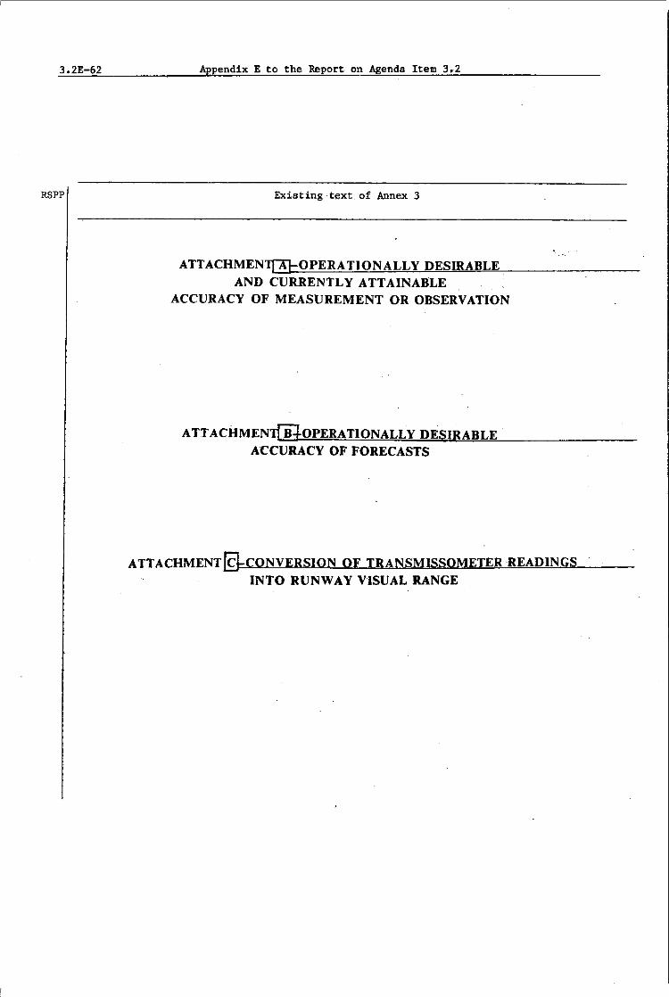
3.2E-62
RSPP
Appendix E to the Report on Agenda Item 3.2
Existing-t~xt, of Annex 3
ATTACHMENT[AJ-OPERATIONALLY DESIRABLE AND CURRENTLY ATTAINABLE
ACCURACY OF MEASUREMENT OR OBSERVATION
ATTACHMENWOPERATIONALLY DESIRABLE ACCURACY OF FORECASTS
[email protected] OF TRANSMISSOMETERREADINGS INTO RUNWAY VISUAL RANGE

Appendix E to the Report on Agenda Item 3.2 3.2E-63
Proposed amendment
----lIT:
----I!r
----lIT:


Report on Agenda Item 3.3 3.3-1
Agenda Item 3.3 Improvements in the existing area forecast systems
3.3.1 Introduction
3.3.1.1 The meeting noted that, in accordance with the usual reAD procedures, its recommendations would-need to be considered by the ICAO Air Navigation Commission (ANe), followed by consultation with States/Members and international organizations, review of the results of that consultation by ANC, and final consideration and approval by the ICAO Council. An applicability date would also be established by Council and this date would possibly fall in the first quarter of 1984.
3.3.1.2 On the basis of the above, the meeting concurred with the view that had previously been expressed by the second meeting of the Area Forecast Panel (AFP) that, speclflcB:tions for the depiction of meteorolog:l,cal elements in upper air and signific.ant weather charts; optimum size of charts for production, transmission and inclusion in flight documentation; number and level of charts; plain language Significant weather forecasts and amendments to area forecasts in general; and improvements to alphanumeric codes, were to be developed primarily for application to the world area forecast system (WAFS), but were also to be used, as far as practicable, in the existing area forecast systems.
3.3.1.3 At its first Plenary, the meeting agreed to invert the order in which the development of the new system and the improvements to the current system should be discussed. This resulted, in fact, in the ~onsideration of the two tasks as interrelated. As a consequence, decisions taken by the meeting under this agenda item, as recorded below, are considered also applicable to the WAFS and as such were embodied in its proposal for the amendment of Annex 3/Tec.hnical Regulations (C.3.1) given in Recommendation 3.2/3.
3.3.1.4 Tne AFP/2 report on its Agenda Item 3. as contained in Doc 9351. AFP/2. pages 3.1-1 to 3.5-7, constituted the basic document for consideration. The AFP/2 proposals received general acceptance, but certain revisions and refinements were introduced. These are reported upon in the following paragraphs.
3.3.2 K>del charts and- forms for flight documentation
3.3.2.1 The meeting conSidered the proposals of AFP/2 on methods of depicting meteorological elements in upper air and ,significant weather charts to be prepared under the WAFS, from the point of view of their use as flight documentation. It also examined proposals of the CAeM Working Group on the Provision of Meteorological Information Required Before and During Flight (PROMET) for updating the model forms and charts contained in Annex 3 (Appendix I)/Technical Regulations (C.3.3). Tne meeting concluded that the work on this subject should be continued with a view to its completion if possible by the the end of 1983. The meeting developed guidelines for the further work on this subject. In this connexion the conclusion of'AFP/2 on chart presentation, methods of depicting meteorological elements in upper air and significant weather charts, chart specifications and optimum size of flight documentation charts should be taken fully into account. The meeting also agreed to the deletion of the current Models IS (Examples 1 and 2). SIS. TB (Example I) TrGV. TrVM. CR and CRS from Annex 3 (Appendix I)/Technical Regulations (C.3.3).
3.3.2.2 The meeting reviewed the proposals of the CAeM Working Group on PROMET for amending Models IS, TB, SWH, SWM, SWL, AI, TA and SN and made a number of 8uggestions and comments. It was decided that tropopause and jet stream data should be inserted in the significant weather map. Therefore Tr Models would not be necessary .. In respect of Model swa, it decided that surface pressure centres and mountain waves should not be depicted on the chart, whereas isolated embedded CB should be shown. Fronts should only be shown on significant weather charts if they are associated with significant en-route weather phenomena. It was also dec-ided that contour lines should not be included in Model IS. It was mentioned that no examples of aerodrome forecasts need to be given in Table TA.
3.3.2.3 The scales to be used fol;' the preparation of area forecast charts and for the exchange of charts between regional area forecast centres (RAFCs) were discussed. It was felt the scale 1:25 x 106 may be used. The meeting invited the WHO Commission for Basic Systems (CBS) to consider the inclusion of that scale in the appropriate section of the Ma~ual On the Global Data ProceSSing System (GDPS) at an early date.

3.3-2 Report on Agenda Item 3.3
3.3.2.4 The meeting endorsed the views expressed by AFP/2, that the overriding consideration in the preparation and production of material for inclusion in the flight documentation was to give first priority to ensuring legibility of charts and tables and standard presentation to the maximum extent possible. In connexion with the size of charts for flight documentation, the meeting endorsed the AFP/2 views that standard sizes A3 or A4 should be used.
3.3.2.5
3.3.3
Accordingly, the following recommendation was made:
RECOMMENDATION 3.3/1 - REVISION OF MODEL CHARTS AND FORMS FOR FLIGHT DOCUMENTATION
That WMO be invited to consider the revision of model charts and forms for flight documentation contained in Annex 3 (Appendix l)/Technlcal Regulations (C.3.3) with a view to bringing them in line with updated Annex 3/Technical Regulations (C.3.1) and taking into account the guidance given by the meeting on this subject.
Alphanumeric codes
3.3.3.1 The meeting was advised that, in follow-up of the deliberations of AFP/2 on its Agenda Item 3.5 - Improvements to the ARMET and/or WINTEM codes, the CAeM Working Group on PROMET had studied the matter further and had reached the conclusion that the WINTEM code, being more user-orientated, adequately met requirements for an alphanumeric code for the exchange of upper air forecasts. PROMET also considered that, as a result, there was no further need for the ARMET code.
3.3.3.2 Certain simplification of the WINTEM code, such as the elimination of superfluous geographical co-ordinates, spaces at the beginning of lines and within groups, and the indication of the negative sign for temperatures, were briefly considered. There was agreement that WMO should continue work on the improvements to the WINTEM code submitted by the Working Group on PROMET, to be completed not later than the end of 1983.
3.3.3.3 The following recommendation was adopted:
RECOMMENDATION 3.3/2 - WINTEM CODE
That WMO:
a) continue work on the WINTEM code for the exchange of upper air forecasts in alphanumeric form, on the basis of the report of second meeting of the Area Forecast Panel on Agenda Item 3.5 and taking into consideration the views expressed at the COM/MET Divisional Meeting/CAeM-VII;
b) arrange for inclusion of the WINTEM code in its Manual on Codes; and
c) delete the ARMET code from that document.
STATEMENTS BY DELEGATIONS
3.3.4 Statement by the Delegation of the International Federation of 'Air Line Pilots' Associations (IFALPA)
3.3.4.1 IFALPA wishes it to be recorded in the report of the COM/MET Divisional Meeting, its complaint against the decisions of the Committee B, in two areas in particular:
1) The refusal of the committee to consider seriously and adequately, or to refer for further study, a number of proposals by IFALPA.

Report on Agenda Item 3.3
These proposals, based on fundamental requirements voiced during a comprehensive, world-wide survey of airline pilots, were designed:
a) to promote increased fuel economy in aircraft operation;
b) to lay down guidelines on the minimum requirements for flight documentation issued at regional levelj
c) to preserve the ability of pilots to meet their responsibilities as required by Annex 6 (paragraph 4.5 in particular).
All three of these aims are considered by IFALPA to be increasingly vital, especially in the face of growing pressure on the supply of flight documentation.
The refusal was maintained despite a (repeated) offer of flexibility of wording of the proposals, in order to alleviate Some delegates concern about overstatement of requirements.
2) The tendency of the committee, in the relative absence- of operational representation, to give undue weight to the preferences of the providers, at the expense of the operational needs; hence, in general, to fail to recognize the principal obligation of the provider services, which is to make sincere efforts to meet the stated requirements, by understanding the problems which give rise to them.
3.3-3

Report on Agenda Item 4.1
Agenda Item 4 Dissemination of area forecasts
4.1 Improvements in the dissemination arrangements of existing area forecast systems
4.1.1 Introduct-ion
4.1-1
4.1.1.1 The report of the second meeting of the Area Forecast Panel (AFP) on its Agenda Item 3.6 served as a basis for discussions under this agenda item.
4.101.2 AFP/2 considered the need for improvements in the dissemination arrange-ments of existing area forecast systems giving particular attention to the following aspects:
a) improvement of HF broadcasts;
b) greater use of LF facsimile broadcasts -and of landline transmissions;
c) use of satellite WEFAX broadcasts;
d) possible use of digital data transmissions in lieu of facsimile;
and recognized that with regard to the LF, MF and HF facsimile radio broadcasts, changes of frequencies in use, upgrading of power of the transmitters and adjustments of the receiving equipment including antenna systems could result in some improvements on a local basis or for some small areas. However, it believed that no substantial improvements could be achieved.
4.1.1.3 Some delegates were of the opinion that any efforts to improve HF facsimile broadcasts were a waste of time and money. For example, increases in tranSmission power could only be achieved through the purchase of expensive new equipment and that, in any case, only marginal improvements could be exp-ected from such_ increases 5 It was felt, however, that in many parts of the world, radio facsimile broadcasts would continue to be used for many years and that, therefore, efforts ought to be made to improve them.
4.1.1.4 The meeting therefore concurred with the views of AFP/2, noting that, whilst the scope for such improvements might appear to be rather limited, they could have a noticeable effect in some parts of the world. In particular, with respect to LF, MF and HF facsimile broadcasts, the upgrading of the power of transmitters and the maiutenance of such power levels and the availability of a suitable family of frequencies especially to cope with night-time propagation conditions could result in some improvements in broadcast quality. It also noted that the installation of more directional and nOise-reducing receiving antennas for HF facsimile broadcasts could also have some beneficial results in localized areas.
4.1.1.5 In order to encourage States/Members to introduce the improvements referred to in the preceding paragraphs, the following recommendation was formulated:
RECOMMENDATION 4.1/1 - IMPROVEMENTS IN THE DISSEMINATION ARRANGEMENTS OF EXISTING AREA FORECAST SYSTEMS
That, in order to improve the dissemination arrangements of the existing area forecast system products, reAD and WMQ invite StateS/Members to ensure that:
a) the WHO procedures and technical characteristics of equipment for meteorological analogue facsimile transmission of area forecast system products in chart form published in the Manual on the Global Telecommunication System (WMO Publication No. 386) should be strictly applied;

4 & 1-2 Report on Agenda Item 4.1
b) consideration be given to the dissemination of area forecast products in pictorial and alphanumeric form via dedicated circuits, or existing networks, such as the WMO Global Telecommunication System and the aeronautical fixed telecommunication network, when this is feasible, efficient and cost-effective;
c) where cost-effective improvements can be obtained, the power of transmitters used in LF, MY and HF facsimile radio broadcasts be upgraded, and an appropriate family of frequencies employed which adequately meets requirements for 24-hour broadcasts;
d) where cost-effective improvements can be obtained, consideration be given to the installation of directional and noise-reducing antennas for receiving area forecast system facsimile broadcasts; and
e) when using or planning to use dedicated circuits or telecommunic~tions networks for the transmission of area forecast centre products in chart form, consideration be given to the use of uncoded arid/or coded digital facsimile transmissions.
Note: To ensure compatibility with systems implemented by WHO, attention will need to be paid to the related standardization work of WHO and the International Telegraph and Telephone Consultative Committee (CCITT).
- - - - - - - - ~ -
Report on Agenda Item 4.2 4.2-1
Agenda Item 4.2 Dissemination arrangements for a new area forecast system
4.2.1 Communication means
4.2.1.1 The meeting noted that the dissemination arrangements for the new area forecast system would have to meet a different set of requirements for communications compared to those of the existing system. Instead of carrying only area forecasts in chart form, the information to be carried by the future communication system would include grid point data in digital form, area forecasts in chart form, grid point data in nume-rical form and significant weather forecasts and amendments to area forecasts in plain language.
4.2.1.2 With regard to the possible communication means to be employed in the new system, the meeting considered a two-phased implementation. The first phase would be based on the selective use of conventional communication means, several of Which were already available in some parts of the world and which could be implemented gradually area by area. The second would be based on a satellite broadcast concept using the services of an appropriate international satellite system (e.g., that of the International Telecommunications Satellite Organization (INTELSAT)). On the basis of this sequential progression, with the satellite broadcast concept supplanting eventually the system based on conventional communication means, the meeting referred to the first as "world area forecast system - initial phase", and the second as "world area forecast system - final phase".
4.2.2 Communication means - initial phase
4.2.2.1 The initial phase of the new area forecast system involved two world area forecast centres (WAFCs), which would process upper wind and temperature forecasts in the form of grid point data in digital form for dissemination to a number of regional area forecast centres (RAFCs). More than one world centre was required to provide the redundancy necessary to ensure continuity of service. Each WAFC would provide identical functions in respect of the development of grid point data in digital form for the entire world and each would service two or more RAFCs with this data. The regional centres would in turn pass on the digital_grid point data to users and/or process those data into other forms, i.e., charts or forecasts in ARMET code.
4.2.2.2 The meeting noted that the Area Forecast Panel (AFP) had considered the different existing communication means, such as the aeronautical fixed celecommunication network (AFTN)~ the WMO Global Telecommunication System (GTS), dedicated circuits and LF/MF/HF radio broadcasts to meet the above commUnication requirements. In this respect it also took note of the conclusion made by AFP.
4.2.3 Communications: WAFC to WAFC
4.2.3.1 The meeting recognized that there was a requirement for communications between WAFCs in respect of the exchange of grid point data in digital form under abnormal conditions. It was considered tha_t the GTS was the most appropriate means for meeting this requirement.
4.2.4 Communications: WAFC to RAFC
4.2.4.1 According to Principle No. 1 developed under Agenda Item 5.2, operational meterological (OPMET) data, which-includes area forecast products, should be transmitted on ICAD circuits, i.e., the AFTN. However, it was pointed out that the volumes of data to be handled could not be accommodated on the existing low speed AFTN and that plans for upgrading the low speed system to a medium speed system had been agreed so far only in three ICAO regions. The long range plan of those regions called for transition to medium speed circuits over a period of two decades which, it was thought, was too long in comparison to the planned development of the new area forecast system, and planning for medium speed circuits in other ICAO regions had not yet begun. If area forecast products were to be disseminated on the AFTN, implementation of the medium speed circuits on a world~ide basis would have to be expedited. The meeting recognized that until then a suitable means of communicating grid point data in digital form from WAFCs to related RAFCs would be the GTS.

4.2-2 Report on Agenda Item 4,2
4.2.5 Communications: RAFes to RAFes
4.2.5.1 The need for communication between RAFes was identified as that to enable each centre to provide the required significant weather information for agreed areas of coverage. Medium speed communications capability would be required, and it was concluded that the GTS would fulfil the requirement.
4.2.6
4.2.6.1 appUed in the It came to the circuits.
4.2.7
Communications: RAFCs to users
The meeting considered the possible communication means which could be initial phase to communicate area forecast products from RAFCs to users, conclusion that these means could include the GTS, the AFTN and dedicated
Use of WHO GTS
4.2.7.1 There was agreement that the GTS would be the suitable means for fulfilling in general the operational requirements for most of the communications of area forecast products. A strong desire was expressed to expedite the implementation of medium speed ci.rcuits of the AFTN 80 that it could transport the products of the world area forecast system (WAFS). It was also pointed out that, if aviation industry money were to be spent on upgrading circuits, it should be spent on the AFTN. In this connexion, the Delegate of France pointed out that in his view the GTS was not only the suitable means for area forecast product dissemination, but furthermore advocated that there should also be no charges arising to civil aviation from such a dissemination from WAFC to RAFC. This view was shared by the Delegate of the Federal Republic of Germany. The use of GTS circuits from RAFCs to users could, however, involve user charges to civil aviation. The Delegate of SWitzerland e~pressed the view that before a firm commitment was made it was very important to clarify the question to what extent, if any, aviation would be charged for the use of the GTS. Moreover, if such a cost recovery was intended, explicit criteria for the cost allocation should be established fi.rst.
4.2.7.2 In the end, the meeting agreed to make a recommendation which would call on lCAO to inform WMO that, during the initial phase of the WAFS, and until the improved AFTN was able to play its part, the GTS would be the suitable means of fulfilling in general the requirements for communications from WAFCs to RAFCs, between WAFCs and between RAFes t and to Bome extent also from RAFCs to users. The meeting therefore made the following recommendation:
RECOMMENDATION 4.2/1 - TELECOMMUNICATION ARRANGEMENTS FOR THE WORLD AREA FORECAST SYSTEM -INITIAL rHASE
That lCAO, in planning the telecommunication arrangements for the initial phase of the new area forecast system:
a) urge States -to expedite the implementation of the aeronautical fixed· telecommunication network in accordance with the air navigation plan, upgrading circuits as necessary;
b) inform WHO:
1) that the Global Telecommunication System is recognized as the suitable means of fulfilling in general the operational requirements in the initial phase for the transmission of area forecast products from world area forecast centres to world area forecast centres, from world area forecast centres to regional area forecast centres and between regional area forecast centres;

Report on Agenda Item 4.2
2) that Some parts of the Global Telecommunication System should be used for the dissemination of area forecast products from regional area forecast centres to users when this is efficient and costeffective;
c) invite WMO to take the necessary measureS in respect of b) 1) and 2) above.
4.2-3
4.2.7.3 In respect of part a) of Recommendation 4.2/1, concern was voiced by one delegate that the implementation of the AFTN had lagged in some parts of the world because of conditions beyond control of the Sta-tes involved and it did not appear that the situation was going to improve. The introduction of new concepts involving advanced technology as that of the new area forecast system could result in further difficulties. It was suggested that lCAO might consider additional ways to provide, assistance to such States when introducing advanced technology systems.
4.2.8 Digital systems
4.2.8.1 The trend was towards digital systems and the meeting agreed that this trend was also going to affect the provision of area forecast products in chart form in the future. Indeed, it had been noted that', according to WMO World Weather Watch Planning Report No. 37 (Conversion of grid-point data into meteorological maps with a mini-computer system), communications terminals had been developed which could process grid point data in digital form and automatically provide charts for selected areas and flight levels, including, in future, significant weather.
4.2.8.2 The meeting agreed that in consideration of this trend towards digital systems, where facsimile might be applied in the new area forecast system, digital facsimile should be used. It was noted that the WMO Commission for Basic Systems (CBS) at its. extraordinary session (December 1980) had agreed to adopt the code for black and white digital facsimile transmissions which was specified in the International Telegraph and Telephone Consultative Committee (CCITT) Recommendation T.4 (Standardization of Group 3 facsimile apparatus for document transmission, paragraph 4.1 and tables I/T.4 and 2/T.4). Although there was still some complementary work needed to permit use of this standard, progress had been made and it was thought that compatibility with this WHO system would be of importance in respect of the cost-effective distribution of area forecast products by digital facsimile. It was alsd thought that in future there would be a much broader application of digital facsimile in aeronautical networks and a single standard, in comformance with applicable CCITT recommendations, would be desirable.
4.2.8.3 The meeting was advised that the WHO was in the process of developing standards for both coded and uncoded digital,facsimile. Although use of different facsimile standards at the option of regions could be envisaged, it was generally agreed that this would be undesirable and, in any case, for centres to provide back-up service in the event of centre or circuit failures, a single standard would be required. The meeting therefore agreed to the follOWing recommendation:
4.2.9
RECOMMENDATION 4.2/2 - DIGITAL FACSIMILE
That J noting the current trend towards digital . systems, consideration be given to the use of a single international standard for a digital facsimile system by lCAO and WHO in the further planning and implementation of the world area forecast system.
Communication means - final phase
4.2.9.1 The meeting was presented with information regarding material and recommendations prepared by AFP/2 concerning the future use of communication satellites for the broadcast dissemination of area forecast products on a world~lde basis. When reviewing this material the meeting noted that many circuits of the AFTN and GTS were routed via satellites, with proven reliability. The panel had recognized several problem areas inherent in the conventional communications means recommended to be used

4.2-4 Report on Agenda __ ltem 4.2
in the lnital phase of implementation of the WAFS (i.e., problems connected with transmission and transit times, processing and network loading), and considered it necessary to explore alternatives that might better satisfy prescribed system requisites. The satellite broadcast concept.had therefore been recommended by the panel, in the interest of achieving a more efficient. uniform and economical area forecast system in respect of availability and coverage, reliability, timeliness and cost-effectiveness.
4.2.10 Satellite broadcast __ conc~pt_
4.2.10.1 Inherent in the satellite broadcast concept recommended by the panel ~a8 the clear division of responsibilities between provider State and user State. The respective responsibilities vere:
a) The provider State was responsible for the generation of area forecast system global products, and making them available in a uniform manner to·' user States, W'ith ~o products being uniquely generated on behalf of a particular State or region. The demarcation point at which these products were thus made available was effectively the satellite concerned.
b) It was incumbent on the user State to arrange access to that satellite for the reception of these products, and to arrange nationally for selecting, proceSSing, distributing and making available products in keeping with national requirements and international commitment·s unique to that State. the processing function. would include the conversion of grid point data to chart form.
4.2.10.2 AFP had considered the INTELSAT system as the appropriate spaCe segment, in order to assure States· compliance with international agreements, to be universally acceptable to State telecommunications authorities and to meet system requirements of coverage, reliability and cost-effectiveness. The INTELSAT system was available to provide the transport vehicle for distribution of area forecast system products on a world-wide and immediate basis. It required no research and development effort, and could be implemented State by State, as readily as any other leased circuit service provided by the INTELSAT system in co-operation with States' telecommunications authorities and/or carriers.
4.2.10.3 The meeting was provided with detailed information in respect of INT~LSAT) an organization of governments that were parties to the INTELSAT Agreement. INTELSAT originated as an international jOint venture in August 1964 when eleven countries signed agreements to form a single global communications satellite system. By. year-end 1980, it comprised an international legal entity with owners1 equity of about $729 million in which 105 countries held investment shares. The satellites in the INTELSAT system, and more than 190 earth station antennas operating with them, provided more than 840 pathways, or direct communications links, among more than 130 countries, territories, and possessions. A growing number of countries were also building earth stations within their boundaries and were using INTELSAT system satellites to improve their domestic communications systems.
4.2.11 Discussion of the satellite broadcast concept
4.2.11.1 In conSidering the ·satellite concept recommended by AFP, the meeting found that there were numerous unanswered questions, many of which did not have ready answers. Conditions were different from State to State and before decisions could be made there would have to be further internal discussions among the responsible authorities within States.
4.2.11.2 States were concerned with many requirements and obligations; particularly in developing countries where the necessary funds needed for technical improvements were not adequate. While it was true that the cost of implementing satellite technology had dropped and, it appeared, would continue to drop with the introduction of new techniques, in some States such cost reductions were not necessarily always passed on to the user.

Report on Agenda Item 4.2 4.2-5
4.2.11.3 It was pointed out that the present LF/MF/HF broadcast system, and also the MOTNE system in Europe, which was a broadcast system, were in use today because of the inability of existing traditional networks to provide the necessary service. A satellite broadcast system therefore was a logical approach to satisfying the dissemination requirements. A paint of view was expressed that such a broadcast system might allow the use of small receive-only earth stations costing in the range of US $30 000 and the price of such stations was decreasing. The cost of improvements to the present LF/MF/HF broadcast system to provide similar performance would greatly exceed this figure. In this regard, one delegate pointed out that although US $30 000 might be the cost of a receive-only satellite terminal in North America, it could be up to five times that amount in his country and because of lack of foreign currency procurement could be difficult.
4.2.1104 Some delegates felt that if satellite systems were to be used for the dissemination of area forecast products, they should be integrated with the AFTN to provide a two-way communications capability for other flight safety data. This, however, might have an impact on system complexity and costs. There might also be administrative and regulatory implications additional to those foreseen with a satellite broadcast system. AdditionallYJ the satellite system might not be applicable in all States and a combination of terrestrial networks and satellites could be expected to be selectively applied.
4.2.11.5 The point was also made that the WMO was considering the use of satel-lite communication systems, possibly of a two-way type as meteorological information needs to be collected and disseminated j there should therefore be consult-ation concerning any ICAO satellite planning with that organization.
4.2.11.6 The meeting had recommended the use of the GTS, and also the AFTN, and other communications means to be used during the initial phase of the new area forecast system. This would require capital investment for improvement to existing facilities and the possible implementation of new facilitieso Considering the costs involved it was believed that if a satellite system were to be proposed consideration should be given to the need to amortize these investments. A phased transition plan should therefore be developed which would facilitate evolut~on from the initial phase to the final phase with a minimum of economic impact on both provider and user States.
4.2.12 Conclusions
4.2.12.1 As a result of the discussions summarized above the meeting agreed that a satellite system appeared to be capable of satisfying the operational requirement for the dissemination of area forecast products in the final phase. In corrdng to this conclusion, the meeting recognized that although the communications capability to implement the satellite concept was available immediately, many jurisdictional, administrative, technical, co-ordinative and procedural matters must be resolved. In this respect, the meeting concluded that it would be necessary to study all the various aspects involved before deciding on the operational use of a satellite system. For this reason, the meeting concluded that as a satellite communication system appeared to furnish the best means. for the final phase of the WAFS, an early study should be made of the various aspects involved. It therefore made the fallowing reco~endations:
RECOMMENDATION 4.2/3 - WORLD AREA FORECAST SYSTEM CONFIGURATION AND TELECOMMUNICATION SUPPORT DURING THE FINAL PRASE OF THE SYSTEM
That, as a satellite communication system appeared to furnish the best means for the final phase, ICAO, in consultation with WMO, carry out an early study of a concept and its implementation according to which the world area forecast system configuration and telecommunications support function be based on satellite broadcast and comprise:
a) two world area forecast centres, each generating global area forecast system products;

4.2-6 Report on Agenda Item 4Q2
4.2.13
b) up-link to an appropriate international satellite system and broadcast of area forecast system products; and
c) national reception, processing and distribution of area forecast system products.
This study should also include points listed in Appendix A to the report on this agenda item.
RECOMMENDATION 4.2/4 - RELATIONSHIP OF SATELLITE COMMUNICATION SYSTEM TO THE
That the satellite broadcast as the communications vehicle of area forecast system products, and its potential usage, expanded to accommodate other aeronautical traffic, would constitute a subsystem of the aeronautical fixed telecommunication network.
RECOMMENDATION 4.2/5 - RELATIONSHIP OF SATELLITE COMMUNICATION SYSTEM TO WHO'S GLOBAL TELECOMMUNICATION SYSTEM
That leAD inform WMO that to the extent usage of a satellite communication system for broadcasting area forecasts might be further expanded to accommodate traffic of the Global Telecommunication System, it could additionally comprise a subsystem of the Global Telecommunication System, providing that, on the basis of the development of appropriate cost allocation criteria, usage of the broadcast vehicle to satisfy n~n-aeronautical requirements does not result in user charges to civil aviation.
Formats for disseminating WAFC products
4.2.13.1 The meeting was presented with a proposal that WAFCs should disseminate digital data in grid point form in a vertical format using a compressed bit-orientated code instead of the horizontal format in grid code as recommended by the AFP/2 meeting. Due to insufficient time this proposal was not discussed.
4.2.14 Participation of communications experts in the world-wide planning process
4.2.14.1 The proposal regarding the participation of communications experts in the ad hoc body proposed to be established under Recommendation 3.2/2 of Agenda Item 3.2 was also not discussed due to insufficient time.
Appendix A to the Report on Agenda Item 4.2
APPENDIX A
Points to be included in a study of the configuration of, and telecommunication support to the world area forecast system -
final phase (Recommendation 4.2/3 refers)
4.2A-1
1. Agreement of provider States to implement world area forecast centres (WAFC) and associated support communications.
2.
3. points.
Agreement of user States to implement complementary facilities.
The generation of significant weather forecasts in digital data for grid
4. Analysis of traffic volume and resultant determination of modulation rate necessary to complete timely broadcast of area forecast products and the scheduling of periodic re-broadcast.
5. Cost of a satellite broadcast and regulatory implications.
6. Use of established communication systems.
7. Analysis of message format and refinement as necessary for satellite broadcast and selective reception.
8. Selection of a protocol to be applied.
9. Selection of a forward error correction (FEC) coding technique to be applied, as necessary.
10 Transition from inital to final phase.
11. Amendment to Annexes 3 and 10 and other related ICAO and WMO documents.

Agenda Item 5.4
5.4.1
Report on Agenda Item 5.4
Development of improved specifications and/or guidance material for OPMET data exchange,s for inclusion in Annex 3
Introduction
5.4-1
5.4.1.1 Under this agenda item the meeting considered what, if any, amendments need to be made to Annex 3/Technical Regulations (C.3.1) to reflect the principles for the exchange of operational meteorological COPMET) data developed under Agenda Item 5.2, or to effect any other improvements in OPHET data exchanges that discussions during Agenda Items 5.1 to 5.3 showed as being desirable. The only chapter in Annex 3/ Technical Regulations (C.3.1) affected is Chapter 11, "Requirements for, and use of communications".
5.4.2 Communication facilities to be.used
5.4.2.1 According to Principle No. 1 established under Agenda Item 5.2, exchanges of OPMET data should be carried out by means of the aeronautical fixed telecommunication network (AFTN); the use of other aeronautical fixed service (AFS) circuits should be determined by regional air navigation agreement.. Afte.:r: some discussion it was decided to amend the present paragraph 11.1.8 in Annex 3/Technical Regulations (C.3.1), which leaves the overall choice of the telecommunication facilities to regional air navigation agreement, to reflect this new principle. TIle Delegate of Kenya and some others expressed the fear that reference to regional air navigation agreement could prevent States/Members from using, by bilat·eral agreement, communication means other than the AFTN, because in some areas, where the AFTN was below required standards, this is the only way to ensure reception of operationally required data. These delegates would have preferred a Recommended Practice that would have given them more flexibility for making bilateral arrangements, than regional air navigation agreement, which they think takes a long time to bring about. After some discussion the meeting decided not to include a reference to regional air navigation agreement in the proposed amendment to paragraph 11.1.8.
5.4.2.2 To meet the thought expressed in Principle No.6, a new provision was proposed to be included in Annex 3/Technical Regulations (C.3.1) that r~commended the use of data banks for the exchange of operational meteorological information. After some discussion it was decided that in view of Recommendation 5.2/1 c) the inclusion in Annex 3/Technical Regulations (C.3.1) of provisions concerning data banks was premature.
5.4.3
RSPP RECOMMENDATION 5.4/1 - AMENDMENT TO ANNEX 3/TECHNICAL REGULATIONS (C.3.1) COMMUNICATiON FACILITIES TO BE USED
Amend paragraph 11.1.8 of Annex 3/Technical Regulations (C.3.1) to read:
"11.1.8 Recommendation.- The telecommunication facilities used for .the exchange of operational meteorological information presented in the form of messages or in digital form should be the aeronautical fixed telecolDIIUnication network."
Use of bulletin formats
5.4.3.1 To meet the intent of Principle No.3 developed under Agenda Item 5.2, it was agreed to propose the inclusion of a new provision in Annex 3/Technical Regulations (C.3.l) calling for the use of consolidated bulletins for the exchange of OPMET data, whenever this was possible. As explained in the preamble of Principle No.3, the use of consolidated bulletins presents numerous advantages including an overall decrease in AFTN circuit loading.

5.4-2
5.4.4
Report on Agenda Item 5.4
RSPP REGOMMENDATION 5.4/2 - AMENDMENT TO
I.
2.
Transit times
ANNEX 3jTECHNICAL REGULATIONS (G.3.l) USE OF cuNSoLIDAtED BULLETINS
~ the following new paragraph as paragraph ••• 2.1 in Annex 3/Technical Regulations (G.3.1):
"11.2.1 Recommendation.- Whenever possible exchanges of operational meteorological ) information should be made in consolidated bulletins of the same types of meteorological information ...
Renumber existing paragraphs 11.2.1 to 11.2.7 as paragraphs 11.2.2 to 11.2.8.
5.4.4.1 Most leAO regions have adopted transit time requirements for a set of OPMET data messages (SIGMET. TAF, METAR, SPECr and amended TAF) with relatively little variations among the various regional versions of these requirements. The basic version of these requirements (which is prepared by the Air Navigation Commission for submission to regional air navigation meetings) is as follows:
a) If a meteorological operational telecommunication network is recommended, it should be de"signed so as to meet transit time criteria 8S follows:
In the peak season of the year, even in the average peak hours, at least 95% of the messages should achieve transit times of less than the following:
SIGfEI'IDessages •••••••••••••••••••••••••••••••••••••••• (5) nIimtes ~ts to ~ forecasts •••••••••••••••••••••• (5) minutes AeroclrtJoe reports) , ..... ,_~ f lfra> 0 to 550 1M •••••••••••••••••••••• (5) minutes >.U.L ..... LI ..... O orecasts . Selected special for distanres e""""<ling 550 NM •••••• (10) mimtes
reports
b) Aerodrome forecast messages originated by meteorological offices in the region should be available, at all locations in the region to which they are addressed, at least 30 minutes before their period of validity commences. Transit timea of aerodrome forecast messages originated by meteoroio-gieal offices in the region and intended for destinations outside of the region should be established taking account of those established by the other regions concerned so that these messages reach their destinations before the periods of validity commence.
5.4.4.2 When considering the possibility of proposing a general Recommended Practice on the subject of transit times, the meeting noted a number of points:
a) Paragraph 5.4.4.1 a) quoted above implies that landing forecasts themselves are the subj'ect of separate AFTN messages. However, where landing forecasts of the trend type are prepared (the usual case) they comprise a routine, special or selected special report to which a "trend" is appended.
Report on Agenda Item 5.4
b) Annex 3, Chapter 11, paragraph 11.2.2 recommends that aerodrome forecasts should be filed for transmission at least one hour before commencement of their period of validity. unless otherwise determined by regional air navigation agreement. If this procedure is adhered to and the transit time requirements in paragraph 5.4.4.1 a) quoted above are met. then the requirement that aerodrome forecasts should be available to users at least 30 minutes before commencement of their period of validity would also be satisfied. A transit time quoted in minutes is more readily understood than a requirement such as is stated in paragraph 5.4.4.1 b) above. Another point is that the requirements in paragraph 5.4.4.1 a) of the basic statement relate·to a meteorological operational telecommunication network but the transit time requirements for aerodrome forecasts given in paragraph 5.4.4.1 b) have no Buch qualification and, by implication, apply to the AFTN.
c) In view of the fact that most regional air navigation meetings have agreed on the transit times inserted in 5.4.4.1 a) above it would appear logical to apply these transit time criteria on a world-wide basis and, since it has been agreed that OPMET data exchanges should usually be made on the AFTN, the reference to a meteorological operational telecommunication network will cease to have any relevance.
d) In respect of distances involved, the meeting agreed that there should be a compromise between what appeared in the basic operational requirements prepared by the Air Navigation Comfidssion, (550 NM) and what had been proposed to the meeting (450 NM), i.e., 500 NM.
5.4 3
In the light of the above considerations the meeting agreed to make a recommendation for a Recommended Practice in respect of transit time requirements. It also agreed that references to "at least 95%", the "peak season" and the "peak hour" used in the region~l transit time requirements should not be used in the Recommended Practice as it believed that the requirements should be met at all times.
RSPP RECOMMENDATION 5.4/3 - AMENDMENT TO ANNEX 3/ TECHNICAL REGULATIONS (C.3.1) TRANSIT TIME REQUIREMENTS
Add the following new paragraph in Chapter 11 of A<Ulex 3/Technical Regulations (C.3.1):
"11.1.9 Recommendation.- Unless otherwise determined by regional air navigation agreement. AFTN messages containing operational meteorological information should achieve transit times of less than the following:
SICHET messages: •••••••••••••••••••••••••••••••• ) 5minutes 1m:!n:ied and correctioos to aerodrome forecasts: •••••••••••••••••••••••••••• ) 5 m1.rutes
1erodr0ID:! reIX>rts with. where required, tren:H:ype 0-500 1M ............ 5 mlootes landing forecasts:
fur krodrome forecasts: distances ••••••••••• 10 mLmtes
greater than lhlected special reports: 500 1M

Agenda Item 6
Report on Agenda Item 6.1
Observing and reporting of visibility, runway visual range (RVR) and slant visual range (SVR)
6.1 Observing and reporting of visibility
6.1-1
681.1 The meeting had available a document based on the report of the eighth session of the Commdssion for Instruments and Methods of Observation (elMO-VIII) concerning observation and reporting of visibility, runway visual range (RVR) and slant visual range (SVR). The following definitions drafted at ClMo-VIII were considered and it was agreed that they should be noted.
Upward visibility (daylight only)
"The maximum distance in daylight at which an observer on the ground can see and identify a dark object of moderate angular size viewed vertically upwards into the surface-based obscuring phenomenon."
Downward visibility (daylight only)
"lhe maximum height above ground in daylight from which a pilot can see and identify features of moderate angular size at ground level viewed vertically downwards in conditions of a surface-based obscuring phenomenon. II
Note: For downward visibility, the features are viewed against a terrestrial background and the result is generally different from the upward visibility. Also, the pilot may be unaware whether or not the obscuring phenomenon actually extends to the ground.
Runway slant visual range
"The slant distance to the farthest high-intensity runway edge light or approach light which a pilot will see from a height, H, above the runway threshold elevation on the approach path. II
6.1D2 The meeting also noted the conclusions in Recommendation 5 (elMO-VIII) and these were as follows:
a) That Members should conform to the recommendations of Chapter 10 of the WMO Guide to Meteorological Instrument and Observing Practices (WMO-No.8.TP.3) as regards the estimation of visibility at night by making use of a series of special lOW-intensity marker lights and conversion tables, taking account of background luminance.
b) That the value 0.05 should be retained as the luminance contrast threshold for determining both the meteprological optical range, and the runway visual range by contrast, pending further studies on the suitability of this value.
c) That Members should continue to report on the following: (a) the development of instruments deSigned for making measurements of low level wind shear or turbulence, (b) new developments as regards variables which can be measured automatically, (c) standards for visibility or height of cloud base, especially if they contribute to the quest for greater representativeness over an area such as an airport, (d) any development of methods and equipment suitable for measuring the slant visual range, (e) the results of experiments in the use of instruments such as ceilometers, for determining vertical visibility.

6.1-2 Report on Agenda Item 6.1
d) That the comparison of various instruments designed for determining the visibility and height of cloud base be continued at the national level, and that the Secretariat be kept informed of results.
6.1.3 The mee·ting examined a proposal made by the Chairman of the CAeM Working Group on Aeronautical Requirements for Meteorological Observations and Specialized Instruments (ARMOSI) regarding action by WMO to develop a definition of visibility for use at aeronautical meteorological stations based on meteorological optical range (MOR) in particular for night use. The view was expressed that such a concept would be particula·rly useful for application to automatic observing stations at aerodromes where the provision of observers would not be cos·t-effective. The meeting noted however that the concept was not appropriate for use at major international airports but it was accepted that it might be of use at smaller airports, e.g., those catering for international general aviation.
6.1.4 The meeting confirmed that there is a requirement for a more precise definition of visibility at night to permit the use of automatic weather stations ~nd/or instruments at aeronautical meteorological stations and noted action by WHO to develop guidance material for observations and reports of visibility at night.
6.1.5 With regard to the adoption in principle of the concept of MOR to deter-mine visibility at night at aeronautical meteorological stations, the meeting agreed that this should be referred to the appropriate IeAO body for examination of the operational implications.
6.1.6 The meeting discussed the need to amend Annex 3/Technical Regulations (C.3.l) paragraph 4.6.3 which would provide for the reporti.ng of actual visibilities over 10 km instead of the current recommendation to report such visibilities simply as 10 km. Some sympathy was expressed for this view and there was general agreement that it was feasible to include in automatic terminal information service (ATIS) broadcasts the actual value of the observed visibility when it was more than 10 km. However, it was noted that this procedure for VOLMET broadcasts would have implications for the format used for ground-to-ground dissemination of aerodrome reports and it was decided that no action should be taken at this time on the proposal and that it should also be referred to an appropriate ICAO body for examination of the operational implications.
6.1.7 With regard to the matters requiring further study in paragraphs 6.1.5 and 6.1.6 above, the following recommendation was formulated:
RECOMMENDATION 6.1/1 -·REQUIREMENT FOR STUDY OF THE OPERATIONAL ASPECTS RELATED TO METEOROLOGICAL OPTICAL RANGE AND VISIBILITY
That leAO examine the operational implications in:
a) the ad.option of the concept of meteorological optical range. t·o determine visibility at night for aeronautical meteorological stations;
b) the proposal to amend Annex 3/Technical Regulations (C.3.1) to provide for the reporting of actual visibility values over 10 km.

Report on Agenda Item 6.2 6.2-1
Agenda Item 6.2 Assessing and reporting of runwaz visual range
6.2.1 The meeting was informed -that the use of the guidance material in Annex 3/Technical Regulations (C.3.1) Appendix C had presented some difficulties in that the values of runway visual range (RVR) which were produced by instrumented systems using this guidance were not wholly comparable with actual values of RVR observed during calibration field trials. It was accepted that in view of the increase in the number of Category II and III operations, the provision of a more accurate assessment of RVR was becoming increasingly important. The meeting agreed that there was a need to improve the guidance material in Annex 3 and that co-ordinated action was required to investigate a number of related items. These included the relationship between illuminance threshold and background luminance, the spectral characteristics of scattering and attenuation of fog and haze and the effect of the brilliance of runway lights on background luminance. It was noted that studies of the results of different researchers in these fields had shown considerable differences and in order to ensure that standardized techniques were used in any future investigations, the meeting agreed that co-ordination in the use of such techniques would be needed in order to ensure that the results of such investigations were comparable. Accordingly, it was agreed that these matters should be referred for further study by an appropriate body in leAD.
6.2.2 The meeting considered the need to include in reports of RVR an indication of the degree of any fluctuation during a given period. There was general agreement that this was not a requirement for aircraft beginning, or in the course of, an approach to an aerodrome since the normal procedure of reporting changes in RVR during this period provided sufficient information to the pilot on the degree of variation. However, it was accepted that for reports disseminated beyond the aerodrome, an indication of the degree of variability over a given period might be useful for operational planning, but there was no agreement as to the method of indicating this in practice. The view was expressed that such a procedure would not add significantly to the operational value of the report due to the physical characteristics of fog.
6.2.3 The meeting discussed the "need to clarify the meaning of Annex 3/ Technical Regulations (C.3.1), paragraph 4.7.8 due to the fact that several States/ Members had expressed difficulty with the interpretation of the present,·_text. There was general agreement that the text could be improved and a recommendation for the relevant amendment to paragraph 4.7.8 is given in paragraph 6.2.11.
6.2.4 The meeting discussed the use of runway light intensity in the computa-tion of RVR and the majority view was that the value reported to an aircraft approaching or departing an aerodrome should be based on the light intensity being used on the runway-. There was no agreement on the intensity that should be used in the computation of RVR intended for dissemination beyond the_aerodrome. On the one hand it was argued that the reference light intensity should be the 100% value, while on the other hand, it was felt that it should be the optimum intensity- appropriate for operational use in the prevaili-ng conditions and that this value might well be less than 100%. It was then agreed that this matter should be referr.ed for further study of the operational considerations to an appropriate body in leAD.
6.2.5 The meeting noted that there was some dissent from the guidance material in Doc 9328, Manual on Runway Visua1-Range Observing and Reporting Practices relating to the use of edge lights and centre line lights intensities in the assessment of RVR. There was general agreement that further ~nvestigation was required and that this matter should be referred for further study by an appropriate body in ICAD.
6.2.6 The meeting noted that a degree of confusion existed with respect to the identification of multiple runway reporting positions along a runway as described in the example in Annex 3/Technical Regulations (C.3.1)~ paragraph 407.13 and agreed without discussion that it should be referred to the appropriate body in ICAO for examination of the operational and reporting aspects.
6.2.7 The meeting was informed of a recommendation by the Operations (OPS) Panel at its fourth meeting to include in Annex 6 the following Standard at paragraph 4.2.6.4:
4.2.6.4 For aeroplane landing operations t aerodrome operating minima below 800 metres visibility shall not be authorized unless RVR information is providedo
6.2-2 Report on Agenda Item 6.2
It was also noted that OPSP/4 stressed that the intent of Annex 3, paragraph 4.7.5 should be retained. In this context, the meeting considered a proposal to clarify Annex 3, paragraph 4.7.5 which would make it clear that RVR should be reported when either the horizontal visibility or the RVR was observed to be less than 1 500 metres. It was agreed that this proposal would clarify paragraph 4.7.5 and a recommendation for the relevant amendment to Annex 3/Technical Regulations (C.3.l) is given 1n paragraph 6.2.11.
6.2.& It was also noted that the acceptance of the OPSP/4 recommendation for amendment to Annex 6 might require a consequential amendment to Annex 3.
6.2.9 A proposal was made to upgrade the existing recommendation in Annex 3/Technical Regulations (C.3.1), paragraph 4.7.6 to a Standard. This proposal received no support and was rejected.
6.2.10 The meeting considered a proposal by the International Air Transport Association (lATA) that Annex 3/Te chnieal Regulations (C.3.1), paragraph 4.7.10 should be amended so as to change the reporting increments. There was considerable discussion of this proposal but there was no agreement that such a change was acceptable. It was then decided that the question should be referred to an appropriate lCAO body for consideration of the operational implications. A further proposal that RVR values which do not coincide with a value in the reporting scale sho_uld be rounded up or down to the nearest increment was debated. It was agreed that there were safety implications in this proposal and that it should be referred to the appropriate lCAO body for examination of the operational implications.
6.2.11 As regards the amendments to Annex 3/Technical Regulations (C.3.1) proposed in paragraphs 6.2.3 and 6.2.7 above, the meeting made the following recommendation:
RSPP RECOMMENDATION 6.2/1 -
That:
I. Annex 3/Technical Regulations (C.3.1), paragraph 4.7.5 be amended to read:
4.7.5 Recommendation.- Runway visual range observations should be made, and the runway visual range reported, throughout periods when either the horizontal visibility or the runway visual range is observed to be less than 1 500 metres.
2. Annex 3/Technical Regulations (C.3.1), paragraph 4.7.8 be amended to read:
4.7.8 Recommendation.- When instruments are used for determination of runway visual range, computations should be made separately for each available runway. The light "intensity to be used for the computation should be:
a) for a runway with the lights switched on: the light intensity actually in use on that runway;

Report on Agenda Item 6.2
b) for a runway with lights switched off (or at the lowest setting pending the resumption of operations), the optimum light intensity that would be appropriate for operational use in the prevailing conditions.
6.2-3
6.2.12 Concerning matters requiring referral to leAO for further study dealt _ with in paragraphs 6.2.1 and 6.2.5 and matters requiring further study by ICAO of the operational implications dealt with in paragraphs 6.2.4, 6.2.6 and 6.2.10, the meeting formulated the following recommendations:
RECOMMENDATION 6.2/2 - REQUIREMENT FOR FURTHER STUDIES RELATED TO THE ASSESSMENT OF RUNWAY VISUAL RANGE
That:
1. Ao appropriate ICAO body be tasked with improving the guidance material in Annex 3 related to the instrumented assessment of runway visual range. In the examination of the relationship between_eye illuminance threshold and background luminance the task should include:
a) the development of techniques for the calibration of illuminance threshold of an observer in the field and the development of standard observational techniques;
b) the- co~rdination of activity in the trial of such techniques on runways and t-he .development of an appropriate method for establishing the true value of background luminance in such trialsj
c) the co-ordination of activity in the application of these results to operational runway visual range systems together with models for glare in order to investigate the apparent paradox whereby an increase in runway light intensity may cause a reduction in runway visual range;
d) the establishment of the magnitude of angular scattering effects on transmittance or scatter measurements under differing types of-conditions, i.e., warm fog, freezing fog, heavy rain, snow, dust, smoke, etc.;
e) the establishment of the magnitUde and spectral range of spectral selectivity at rural, urban and coastal aerodromes with aview to the establishment of boundary conditions; and

6.2 4 Report on Agenda Item 6~2
2. An appropriate body in ICAO examine the use of the intensities of runway edge lights and centre line lights respectively in the assessment of runway visual range with a view to the development of guidance material for inclusion in Annex 3, Attachment C.
RECOMMENDATION 6.2/3 -
That an appropriate body in lCAD:
a) examine the operational considerations regarding the light intensity that should be used in the computation of runway visual range for reports disseminated beyond the aerodrome;
b) review the text of Annex 3, paragraph 4.7.13 in order to establish ~hether it 1s desirable from an operational point of view to amend the identification of reporting positions on the runway from A, Band C to TOUCHDOWN J MID-POINT and STOP-END; and
c) examine the operational implications in a change to the existing criteria for reporting increments in Annex 3 J paragraph 4.7.10 to a scale where runway visual range would be reported in 25-metre increments between 50 met-res and 400 metres J 50-metre increments between 400 metres -and 800 metres and 100-metre increments above 800 metres and to determine the acceptability of rounding to the nearest increment, either up or down, those observed values which do not coincide with a value- in the incremental scale.

Report on Agenda Item 6.3 6.3 1
Agenda Item 6.3 Review of progress on forecasting of runway visual range
6.3.1 The meeting had a full discussion of the various facets in the forecast-ing of runway visual range (RVR) and there was a comprehensive exchange of views. It was noted that work was in progress or was planned in several States.
6.3.2 During the discussion it became apparent that the phrase "short-term forecast" was being interpreted in a -number of different ways ranging from 5 to 10 minutes on the one hand, and to 6 hours on the other. There was general agreement that a forecast of RVR for 5 to 10 minutes ahead was of little or no operational -value and it was accepted that the longer the period of the forecast, the more difficult it became to achieve accuracy. It was agreed that in order to give some guidance to States/Members engaged in this wo~k, a short-term forecast of RVR should be one for a period of between 15 minutes and 2 hours.
6.3.3 There was also discussion of the need for standardization of the lighting intensity value and of the value of background luminance to be used in the computation and it was decided that the optimum light intensity for the forecast conditions should be used and also that an average background luminance value estimated for the time of day should be used.
6.3.4 There was general agreement that States/Members currently undertaking studies on the forecasting of RVR should be encouraged to continue the work. It was also felt that studies should include the feasibility or otherwise of making RVR forecasts at remote meteorological offices for aerodromes not staffed by forecasters. The meeting t therefore, f,ormulated the following recommendation:
RECOMMENDATION 6.3/1 - STUDIES ON SHORT-TERM RUNWAY VISUAL RANGE FORECASTS
That WMO. in consultation with leAO, invite States/Members to continue studies on short-term ~runway visual range forecasting.

Report on Agenda Item 6.4 6.4-1
Agenda Item 6.4 Review of progress on slant visual range
6.4.1 Introduction
6.4.1.1 The meeting noted that work was continuing in several States on the development of techniques for observing and reporting of slant visual range (SVR), including work in two States which involved the use of a LIDAR for measurements. The feeling was expressed that, following many years of research, some progress had been made and a breakthrough in the near future was possible.
6.4.2 Operational aspects of SVR
6.4.2.1 The question of the operational usefulness of SVR was discussed and a number of arguments were put forward indicating that the provision to pilots of SVR could improve the regularity of flights for Category I operations. It was also thought that information on the vertical structure of fog around decision height could assist the pilot to decide whether or not to continue his descent to decision height. The point was made that this, in turn, could reduce the number of missed approaches.
6.4.2.2 On the other hand the view was expressed that in the light of the fact that research had continued for many years, seemingly with little progress, these efforts could be usefully employed in other areas.
6.4.2.3 Some StateS/Members and the International Air Transport Association (lATA) stated that they had no operational requirement for SVR. Nevertheless, the meeting noted that there was an existing operational requirement for SVR, but that the validity of this requirement could not be discussed at this meeting. It was also decided that attempts to meet the requirement for SVR should continue and States/Members currently engaged in solving the problems of SVR should carryon with this work. It was also agreed that, under the circumstances, it would be premature for the meeting to recommend any assessment or reporting procedures or gUidance material at this stage.
6.4.2.4 In connexion with the continuance of studies by States/Members on SVR, the following recommendation was made:
RECOMMENDATION 6.4/1 - SLANT VISUAL RANGESTUDIES
That IeAO invite StateS/Members currently engaged in efforts to solve the problems of slant visual range to continue this work.


Report on Agenda Item 7.1
Agenda Item 7 Message contents and formats
7.1 Updating of OPMET messages
7.1.1 Cloud information in OFIS broadcasts and aerodrome meteorological reports
7.1-1
7.1.1.1 The meeting discussed a proposal to limit cloud reports in operational flight information service (OFIS) broadcasts to those considered operationally relevant, which had been made by the OFIS Panel, echoed by the European Air Navigation Planning Group (EANPG) and subsequently adopted for inclusion in ICAO regulatory documents. This proposal had the advantage of easing the load on communications, by reducing the MET content and thereby allowing more room for the OPS content in the operationally integrated format envisaged in the OFIS broadcast concept.
7.1.102 On the other hand, the opposing view was advanced that there existed a firm requirement for complete cloud reports. It was considered that both meteorologists and pilots required full cloud information in particular in regions of sparse synoptic coverage and especially for aerodromes with the minimum of approach aids. Furthermore, general aviation would, as a rule, require more complete cloud information than would be obtainable from OF IS broadcasts giving only abbreviated cloud reports. The meeting also felt that there was a genuine need for complete cloud information for the preparation of forecasts for aviation.
7.1.1.3 The proposal made by the OFIS Panel and endorsed by the EANPG was that the only cloud reported in OFIS broadcasts would be:
cloud below 1 500 metres (5 000 feet) or below the highest minimum sector altitude, whichever is greater; cumulonimbus.
7.1.1.4 In addition, it was recognized that the intention was that, unless the pilot requested more complete cloud information, abbreviated information in the form of an OF is message would be provided in directed transmissions. It was felt that pilots would, on occasion, wish to obtain full cloud information and, in order to provide for such requests,- this information had to be exchanged in ground-to-ground messages and this could have implications on the codes used.
7.1.2 Proposals to meet the OFIS requirement
7.1.2.1 The meeting considered that the difference which might exist between cloud information given in an OFIS broadcast and that in ground-to-ground messages would lead to procedural problems. In an attempt to obvi~te these possible difficulties various proposals were put forward.
7.1.2.2 In the first proposal it was suggested that all the cloud groups could be retained in messages exchanged ground-to-ground, but that the groups giving cloud above 1 500 metres (5 000 feet) or the highest minimum sector altitude, whichever is greater, could be disp_laced to the end of the message under "supplementary information", to facilitate their removal prior to their inclusion in OFIS broadcasts. This proposal would introduce substantial changes in the format of the METAR and SPEC! codes. It was agreed that, although such changes might be acceptable as far as manual proceSSing was concerned, it would have significant procedural and cost implications where the messages were processed by computer., to provide "synthetic voice broadcasts" or automaticallyplotted METAR charts. It was further pointed out that simple displacement of these cloud groups would not effect any reduction in the loading on ground-to-ground communications. The meeting therefore decided that the proposal could not be accepted and that, at this stage, no changes should be made to the METAR and SPEC I codes.
7.1.2.3 A second proposal was made that cloud groups above I 500 metres should only be reported when the cloud observed was 4 oktas or more. The meeting did not support this proposal for the same reasons as discussed in paragraph 7.1.2.2 above.
7.1.2.4 In the third proposal, it was suggested that no world~ide limitation should be placed on the height at which cloud should be reported in ground-to-air communications, but that the cloud reporting procedures themselves should be made more flexible and more responsive to regional requirements. This proposal was not supported by the meeting, as the general view was that cloud reporting procedures must continue to be standardized world-wide.

7.1-2 Report on Agenda Ite_m 7.1
7.1.3 General effect on aeronautical meteorological codes
7.1.3.1 During the general discussion, the view was expressed that, should there be a need to change the content or the format of the METAR and SPEcr codes, for whatever reason, it would be best that WMO, in consultation with leAD, undertake an overall review of the codes rather than deal with such changes piecemeal. It was considered that during such a review, the codes could be made more machine-compatible, thereby facilitating automatic processing of messages. This emphasis on machine-compatibility should not, however, be made at the expense of reasonable self-evident quality of the code.
7.1.3.2 Taking account of all the problems associated wi,th the various requirements for cloud reporting, and their implications on coding and processing, the meeting formulated the following recommendation:
7.1.4
RECOMMENDATION 7.111 - OPERATIONAL FLIGHT INFORMATION SERVICE BROADCASTS - NEED TO AMEND ANNEX 3/ TECHNICAL REGULATIONS (C.3.1)
That ICAD study further whether there is a need for an amendment to Annex 3/Technical Regulations (C.3.1) to provide for meteorological information required for the compilation of operationally integrated messages for operational flight information service broadcasts, taking into account the requirements of aircraft operating agencies, pilots and meteorologists.
Limitation of cloud groups in aerodrome forecasts
7.1.4.1 The meeting considered a proposal originating from the seventeenth meeting of the EANPG that the requirement to limit cloud information in OFIS messages should also be applied to aerodrome forecasts. The reasoning behind the proposal was that, in aerodrome forecasts, there was no operational requirements for forecasting cloud above 1 500 metres (5 000 feet) or the highest minimum sector altitude, whichever is greater. The view was expressed that meteorologists did not normally require information on higher level clouds in aerodrome forecasts. However, the contrary view was also expressed that meteorologists did have a need for forecasts of upper cloud and that pilots, especially those operating into less well equipped airfields, had a similar need. The meeting decided, therefore, that no immediate change should be made to procedures concerning cloud groups in aerodrome forecasts.
7.1.5 Use of the term CAVOK
7.1.5.1 The question of the reduction in information available to pilots and meteorologists which resulted from th.e use of the term CAVOK was discussed by the meeting. There were conflicting views on th~ value of the term CAVOK as experienced during the last decade. It was noted that the use of the term CAVOK had reduced the load on communications. However, the view was expressed that, while the use of the term in aerodrome forecasts might be considered acceptable, its use in reports deprived both pilots and meteorologists of useful information. The meeting agreed that these latter requirements could best be met by specific national practices, a ·solution which had already been applied by some States/Members.
7.1.6 SPEcr criteria
701.6.1 Two proposals were discussed concerning the SPECr criteria as contained in Annex 3/Technical Regulations (C.3.l), paragraph 4.3.3. In the first proposal, it was suggested that in paragraph 4.3.3 g) provision should be made to include the height of base of cloud at 450 metres (1 500 feet) to ensure that SPEeIs are issued for this height at aerodromes where this is justified by the number of visual flight rules (VFR) operations. The second proposal concerned the problem that the current provisions did not require the issuance of SPEC! when cloud amount below 1 500 metres (5 000 feet) or the highest minimum sector altitude) whichever is greater, changes through 4 oktas.

7.1.6.2 improved. of SPECIs
7.1.7
Report on Agenda Item 7.1 7.1-3
The meeting recognized that the current SPECI criteria may have to be It was felt that such changes would lead to a marked increase in the number
issued and therefore agreed that the matter should be studied further by lCaO.
Change groups in aerodrome forecasts
7.1.7.1 The meeting also considered a proposal for the inclusion of detailed specifications in Annex 3/Technical Regulations (C.3.1) for the use of change groups in aerodrome forecasts based upon the SPECr criteria. Whilst the proposed specifications followed in general the existing SPECr criteria) in the case of forecast changes in surface wind) reference was made to expected changes in the wind components for the runway. Following a short discussion, the meeting agreed that the proposed specifications needed further study and should be referred to ICAO.
7.1.7.2 With regard to matters referred to ICAD for further study dealt with in paragraphs 7.1.6 and 7.1.7 above, the meeting made the following recommendation:
7.1.8
RECOMMENDATION 7.1/2 - REQUIREMENTS FOR FURTHER STUDIES RELATED TO SPECI CRITERIA AND THE USE OP CHANGE GROUPS IN AERODROME FORECASTS
That lCAD give further study to:
a) the need for additional SPECr criteria regarding:
1) height of cloud base of 450 metres (I 500 feet);
2) changes in cloud amount through 4 oktas; and
b) the inclusion in Annex 3/Technical Regulations (C.3.1) of detailed specifications for the use of change groups in aerodrome forecasts.
Reporting of surface wind direction
7.1.8.1 The meet-ing discussed a proposal to change Annex 3/Technical Regulations (C.3.1) to provide for the reporting of the direction of surface wind in degrees magnetic. It was decided that, although it may be advantageous from the operational standpoint, the proposed change would create serious difficulties for the meteorological services. In addition, it was pointed out that the task of converting the reported surface wind direction from true to magnetic should be done by ATS units when required.
7.1.9 OPMET data banks - SIGMET message storage and retrieval
7.1.9.1 The meeting was informed of discussions which had taken place in the EANPG regarding the storage of SIGMET messages in OPHET data banks. It had been suggested that the existence of SIGMETs for the same flight information region (FIR) with overlapping periods of validity would cause difficulties for some data banks. Following an exchange of views the meeting agreed that there was no necessity to introduce special world-wide procedures. It was furthermore pointed out that the procedures for the storage of SIGMET messages should not be dictated by the configuration of data banks.
7.1.10 Replacement of the term "tropical revolving storm"
7.1.10.1 A proposal by the WMO to replace the term "tropical revolving storm" by "tropical cyclone" as defined in the WMO International Meteorological Vocabulary was unanimously agreed by the meeting.

7.1-4
7.1.11
Report on Agenda Item 7.1
Standardization of message for interrogation of international OPMET data banks
7.1.11.1 The meeting, when discussing future OPMET data exchanges under-Agenda Item 5.3, proposed that a standardized. form of message be used for automatic access to international OPMET data banks and the matter was referred for consideration under Agenda Item 7.1. In view of the detailed nature and complexity of the subject, it was agreed that it would not be possible to give it adequate consideration at this meeting. It was therefore agreed that the subject should be studied further by ICAO with a view to providing guidance for world-wide application and the following recommendation was made:
RECOMMENDATION 7.1/3 -
That the procedures for interrogation of international operational meteorological (OPMET) data banks be studied by ICAO with a view to providing guidance material for world-~ide application.
Report on Agenda Item 7.2
Agenda Item 7.2 Development of a format for the ground-to-ground exchange of OFIS messages
7.2.1 Introduction
7.2-1
7.2.1.1 The meeting noted that the concept of operational flight information service (OFIS) had been introduced with the objective of providing aircraft-in-flight with ess~ntial AIS, ATS, MET and other pertinent operational information in an integrated form. The requirement for integrated operational information was already established by the Ninth Air Navigation Conference (1976), which recommended further work on the subject initiated by the OFlS Panel.
7.2.1.2 It was also noted that subsequent to the second meeting of the OFIS Panel, via the usual consultation with States, material concerning OFIS broadcasts which, inter alia, reflects the operational requirement for information, has been incorporated in Amendment 29 to Annex 11. This amendment has been adopted by the lCAO Council on 2 April 1982 and will become applicable on 25 November 1982.
7.2.1.3 The meeting recognized that the provision of information concerning aerodrome weather conditions, as well as other information, was the responsibility of flight information service. Moreover, for this reason, the Standards and Recommended Practices (SARPs) concerning OFIS broadcasts have been included in Annex 11, Chapter 4 -Flight Information Service. It was noted that according to the new provisions in Annex 11, the preparation and dissemination of automatic terminal information service (ATIS) messages is the responsibility of the air traffic services and that HF and VHF OFIS messages should be prepared and disseminated by the most appropriate unit(s) as deSignated by each State.
7.2 .. 1.,4 As a consequence of the above, it was recognized tha't the VQLMET broadcasts should eventually be replaced by OFlS broadcasts, when the requirement for such a broadcast has been determined by regional air navigation agreement.
7.2.2 Progress in the development of a format for OFlS messages
7.2.2-.1 The meeting recognized that as a prerequiSite to the introduction of an OFIS broadcast system, in addition to administrative arrangements concerning, inter alia, t,he transmission of ground-to-ground messages, a format for the ground-to-ground exchange of OFIS messages would be required. It was noted that the development of a code of operational and meteorological elements in the OFIS messages suitable for ground-to-ground c01IlIll1nications J pursuant to OFISP/2 Recommendation 2/5 J was- currently being carried out by the ICAO Secretariat through correspondence with selected aeronautical experts.
7.2.2.2 The development of a code for ground-to-ground exchanges of OFIS messages has progressed slowly. Limited results had ,been achieved and the basic principles to govern the code development had not been finalized prior to the meeting. This was mainly due to the time-consuming procedure of correspondence and the complexity of the subject, which made it difficult to balance the various requirements.
7.2.2.3 In view of the adoption of SARPs concerning OFIS broadcasts, as a conse-quence of which such broadcast-s could be implemented subject to regional agreement, the meeting expressed the opinion that the development of a code for the ground-to-ground exchange of OFlS messages should be expedited. To this end, at least one meeting of experts would appear to be required. Consequently, the meeting formulated the following recommendation:
RECOMMENDATION 7.2/1 - DEVELOPMENT OF A FORMAT FOR THE GROUND TO-GROUND EXCHANGE OF OPERATIONAl FLIGHT INFOR~~TION
That lCAO take steps to expedite the development of a format for the ground-to-ground exchange of operational flight information by an appropriate lCAO body in order to permit an early and costeffective implementation of operational flight information service broadcasts.
7.2-2 Report on Agend~ Item 7.2
7.2.3 Principles governing the development of a format for OFIS messages
7.2.3.1 The concept of integrated operational information currently applies to OFIS broadcasts and directed transmissions (request/reply t.raffic). However, the idea was expressed that it is possible that this concept may be extended in the future with a view to utilization at a pre-flight stage and also for the provision of information to aircraft-in-flight via automated ground-to-air data links. With this· in view, the format to be developed for OF IS messages should permit such a potential extension of the OFIS concept.
7.2.3.2 OFIS messages for ground-to-ground exchanges must satisfy the requirements of the different users. For use by personnel at broadcasting stations and ATS units, the OFIS mess~ges should be reasonably self-evident in order to permit facilitated decoding of the information. At the same time, manual encoding would be facilitated and implementation of the OFIS concept would be possible without appreciable investments in equipment or training of personnel.
7.2.3.3 On the other hand, in some States automation of the OFIS broadcast can be cost-effective, and for this reason, OFIS messages must permit efficient aut9matic processing. This requires a rigid definition of the'message formats and ambiguity should be avoided. Furthermore, the OFIS messages should permit efficiency in groundto-ground communications, i.e., redundancy should be avoided.
7.2.3.4 It was noted that different circumstances may exist in different States for which reason the OFIS ground-to-air messages should be prepared and disseminated by the most appropriate unites). Similarly, the method of integration of the operational and meteorological elements of information may be different, as integration at each aerodrome or at a central point are equally feasible. The OFIS message formats should therefore not necessitate local or central integration of information and both methods should be possible.
7.2.3.5 The meeting agreed that available WHO.codes as used in METARs, SPEeIs and TAFs are suitable for the ground-to-ground exchange of the meteorological information contained in OFIS messages. Other available coding techniques· and abbreviations, e.g., SNOWTAMs and MOTNE (Meteorological Operational Telecommunications Network, Europe) runway state messages should also be taken into account in the development of the OFIS code, since in many instances the same personnel would be involved in the ~ncoding of information for different purposes.
7.2.3.6 The meeting noted a proposal for a code form suitable for ground transmission of VHF OFIS messages, as presented by one delegation. that the proposal was a valuable contribution and that it should be taken in the further work on the subject.
the ground-toIt was felt
into account
7.2.3.7 In order to permit a cost-effective implementation of OFIS broadcasts and potential further extension of the OFIS concept, the meeting agreed on the principles, which should govern the development of a format for the ground-to-ground exchange of OFIS messages. Accordingly, the following recommendation was formulated:
RECOMMENDATION 7.2/2 - PRINCIPLES GOVERNING THE DEVELOPMENT OF A CODE FOR OPERATIONAL FLIGHT INFORMATION SERVICE MESSAGES
That the follOWing principles govern the development of a code for operational flight information service messages:
a) the code for OFIS messages should meet the requirements for the,provision of integrated operational flight information in a costeffective way, without appreciable investments in equipment or training of personnel. For this reason the code should be sufficiently self-evident for human int"erpretation;

Report on Agenda Item 7.2
b) the code for OFIS messages should permit efficient automatic processing;
c) the OFIS messages should permit efficiency in ground-to-ground communications, i.e., redundancy in messages and characters should be avoided;
d) as the method of integration should be determined by each State, separate (ground-toground) transmission of operational and meteorological information should be possible as well as exchanges in an integrated form. Fo"r this re-ason, integration of the operational and meteorological elements of information should not be restricted by the codej and
e) available WMQ codes as used in METARs, SPEeIs and TAFs should be used and available codes and abbreviations for the operational information should be taken into account.
7.2-3