Embed Size (px)
Citation preview

COMMUNITY-BASED LAND ADMINISTRATION FOR INDIGENOUS GROUPS AS AN INSTRUMENT FOR POVERTY REDUCTION AND SUSTAINABLE DEVELOPMENT. CASE STUDY: MITÚ-VAUPÉS, COLOMBIA
Álvaro Rojas Ferreira Civil & Industrial Engineer Universidad de los AndesDaniel Paéz BarajasPhD of Engineering, University of Melbourne

Table of contentsIntroduction Context Goals Approach
Concepts of land
The government
The indigenous communities
Previous cases
Darién, Panamá
Mitú, Colombia
The methodology The 5 steps
Field Work Specifics Results
Conclusions Conclusions Recommendations
Additional research
Context Methodology Preliminary results

INTRODUCTION - CONTEXT
Almost 1/3 of Colombian territory is recognized as Indigenous Reservation where less than 3.28% of the population lives
(SIGOT, 2005) (IGAC, 2014)

INTRODUCTION - CONTEXT
Indigenous communities live in poverty conditions on they great majority
(DANE, 2005) (INVÍAS, 2010)

INTRODUCTION - CONTEXT
Vaupés region is inhabited by more than 42000 natives coming mainly from the Tucano family.
(Consultorías Integrales SA, 2013)
Urban Rural
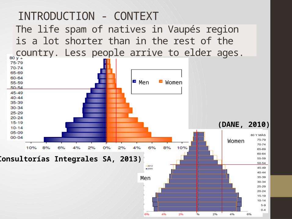
INTRODUCTION - CONTEXT
The life spam of natives in Vaupés region is a lot shorter than in the rest of the country. Less people arrive to elder ages.
(Consultorías Integrales SA, 2013)
(DANE, 2010)
Men Women
Women
Men
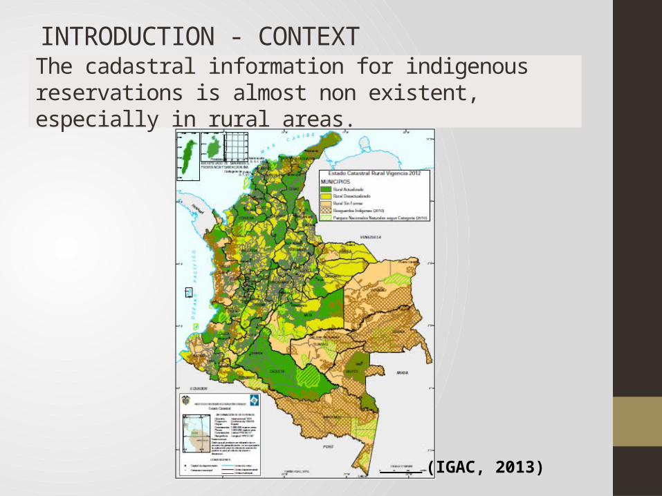
INTRODUCTION - CONTEXT
The cadastral information for indigenous reservations is almost non existent, especially in rural areas.
(IGAC, 2013)
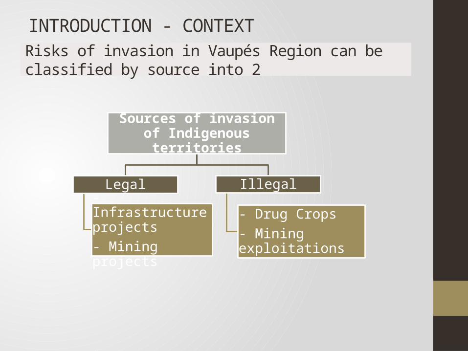
INTRODUCTION - CONTEXTRisks of invasion in Vaupés Region can be classified by source into 2
Sources of invasion of Indigenous territories
Legal
- Infrastructure projects- Mining projects
Illegal
- Drug Crops- Mining exploitations

INTRODUCTION - CONTEXTNo major infrastructure projects are planned for connecting indigenous communities in the Vaupés Region with the economic center of the country
(ANI, 2013)

INTRODUCTION - CONTEXT
A very high mining potential is recognized by the government but mining legal means have proven insufficient to regulate it
(SINCHI, 2012)
(Consultorías Integrales SA, 2013)
Requests of mining licenses
Approved mining licenses

A CLAS Methodology for
Indigenous Groups should
aim:
To identify, geo-reference and sketch the resources, cadastral
boundaries and land uses of the region
To incorporate the relevant
legal framework
To reflect the cultural relationship between the communities and
their land
To increase general understanding on
communities’ approach to land administration
To incorporate the state of art
in the field
INTRODUCTION - GOALSProcesses the recording and disseminating information about ownership, value, and use of land, when implementing land management and development policies (UNECE,1996).

INTRODUCTION - APPROACH
2 steps process for developing the methodology
• State of art• Previous cases• Specifics of the
communitiesTheoretical
• Try a preliminary questionnaire
• Geo-reference most significant points
• Draft a map
Fieldwork

CONCEPTS OF LAND - THE GOVERNMENT
Colombia has had a very slow legal evolution in respect to indigenous land administration.
1991 1993 1997 2000 2011 2014
• National Constitution – Article 329
• Addition to ILO Convention 169 – Law 21/1991
Law 1809 / 1993
Law 388 / 1997
Sentence C-729 of 2000 from the Constitutional Court
Law 1454 of 2011 - Organic law on territorial planning (LOOT)
Decree 1953/2014

CONCEPTS OF LAND - THE INDIGENOUS COMMUNITIES
The territory is physical and mythical, and expresses the place where life comes from; it has to do with the cosmos and with the social and natural relationships. This expression of the territory is not ideological; on the contrary, it is social and concrete, and its explanation evolves according to each new relationship for which rituals and the myths change: From a general point of view the social relations materialize, to begin with, in the space. And it seems logical that this ends up as a fundamental factor of the ethnic group identity: the territory. (Peña Márquez, 2011)
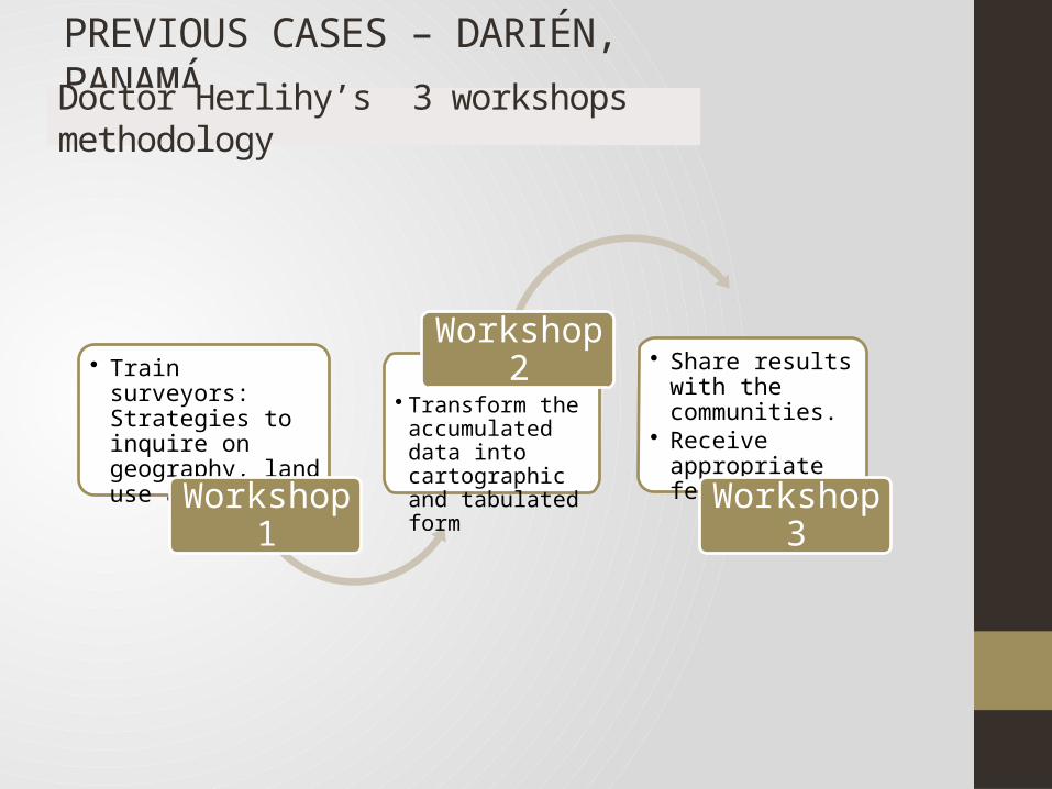
PREVIOUS CASES – DARIÉN, PANAMÁDoctor Herlihy’s 3 workshops methodology
• Train surveyors: Strategies to inquire on geography, land use and mores.
Workshop 1
• Transform the accumulated data into cartographic and tabulated form
Workshop 2 • Share results with the communities.
• Receive appropriate feedback
Workshop 3

PREVIOUS CASES – DARIÉN, PANAMADoctor Herlihy’s 3 workshops methodology
Elements of the questionnaire 1) Subsistence as resource-use locations
(where villagers farm, fish and hunt), collect forest material locations (fruit, wood, medicine plants, etc), and social areas as meeting houses or commercial areas for sales and trade;
2) Landmark as compass directions and limits and boundaries; and
3) Census as gender, age and primary language
Ideal surveyor:1) Native and resident of their survey
zone;2) Able to read and write in Spanish; 3) Respected among the local
population; and 4) Knowledgeable on the natural
environments used by the communities in question

PREVIOUS CASES – MITÚ, COLOMBIA Professor Peña Marquez public consultation in the urban Mitú
(Google Maps)
(Peña Márquez, 2011)

PREVIOUS CASES – MITÚ, COLOMBIA Professor Peña Marquez public consultation in the rural Mitú
(Google Maps)
(Peña Márquez, 2011)

THE METHODOLOGY – THE 5 STEPSProfessor Peña Marquez public consultation in the urban Mitú
• Design a schedule• Identify resources
needed
Planning
• Present the questionnaire
• Simulate situations
Training surveyors
Surveyors collect the information
• Geo-reference major points.
• Draw identified borders.
Mapping
• Define undiscussed borders
• Establish shared areas
Discussing
• Present outcome• Present poverty
reduction opportunities
Presenting

FIELDWORK – ESPECIFICS3 communities were tested for the study, living under semi-urban conditions
The native inhabitants come from the Cubeo
family Gender segregated culture
Agricultural based economy
Very open view for western mores, including a high level of spoken and an intermediate level of
written Spanish by most of its members.
Several territories are shared with settlers.
The interaction between “whites” and aboriginals and the geographical closeness to urban areas has an effect on
the future aspirations on young native generations.

FIELDWORK – RESULTS

FIELDWORK – RESULTS

CONCLUSIONS
The methodology proposed organizes the process of collecting land information from the indigenous groups while formalizing their oral agreements.
The questionnaire tested proved itself insufficient as the natives could not locate their resources, their boundaries or even their crops on a map designed for nonindigenous communities to understand.
The whole methodology is still considered adequate for the intentions of the project but a new questionnaire is to be developed.
The process of discussing the boundaries with settlers was beyond the scope of this project.

Assure the support of institutions recognized by the communities, including the government and indigenous authorities.
Incorporate a parallel but independent methodology to obtain the native agricultural knowledge. RECOMENDATIONS
Incorporate new technologies for information recompilations as UAV

Mitú
Santa Marta
Puerto López
Garrafa
Mitú
Piracemo
ADDITIONAL RESEARCH UAV - CONTEXTUAV pilot study to delimit indigenous territory in Piracemo Community.

• Establish use of the land.• Identify strategic points:
• Hunting• Fishing• Farming
Interviews
• UAV-derived mapping.
• Draw identified borders.
Mapping
• Define undiscussed borders.
• Establish shared areas.
Socializing
• Present results in agreement with the community
Presenting
ADDITIONAL RESEARCH UAV - METHODOLOGY
4 steps methodology - Social cartography with UAV

ADDITIONAL RESEARCH UAV – PRELIMINARY RESULTS
Air view of the community
Mitú
Santa Marta
Puerto López
Garrafa
Piracemo

Population: 200 Families: 32 Houses: 31
Social cartography (UDIC, 2005)
ADDITIONAL RESEARCH UAV – PRELIMINARY RESULTS

• ANI. (2013). Proyectos 4G infraestructura vial. Bogotá: ANI.• Consultorías Integrales SA. (2013). DIAGNÓSTICO Y ESTUDIOS PARA LA
ELABORACIO N DEL PLAN DE ORDENAMIENTO TERRITORIAL DEPARTAMENTAL DE VAUPÉS. Mitú: Gobernación Vaupés.
• DANE. (2005). Mapa índice de pobreza Multidimensional. Bogotá: DANE.• DANE. (2010). Predicciones población 2012. Bogotá: DANE.• Google Maps. (s.f.). Google Maps. Recuperado el 2015, de google.es/maps• IGAC. (2013). MApa estado Catastro Colombia. Bogotá: IGAC.• IGAC. (2014). MApa densidad poblacional Colombia. Bogotá: IGAC.• INVÍAS. (2010). Mapa red vial pavimentada Colombia. Bogotá: INVÍAS.• Peña Márquez, J. (2011). Mitú, Ciudad Amazónica, Territorialidad
Indígena. Leticia: Universidad Nacional de Colombia: sede Amazonas.• SIGOT. (2005). Mapa resguardos indigenas Colombia. Bogotá: IGAC.• SINCHI. (2012). MApa Áreas estratégicas de minería en la Amazonía.
Bogotá: SINCHI.
REFERENCES