Embed Size (px)
Citation preview
103
state
chap
ter - a
nd
hra
pra
desh
Community conservation in Andhra Pradesh
Neema Pathak
1. Background1.1. Geographic profile
Andhra Pradesh lies between 12º37’ and 19º54’ N latitude and 76º46’ and 84º46’ E longitude, with Tamil Nadu to the south, Orissa to the north, Maharashtra and Karnataka to the west, and the Bay of Bengal on the east. It has a geographical area of 276,000 sq km. Out of this, 63,770 sq km (23 per cent) is classified as forest. About 40 major, medium and minor rivers flow through the state, the most important being the Godavari, the Krishna, the Pennar and the Vamsadhara.
Andhra Pradesh can be broadly divided into three natural regions: the coastal plains, Eastern Ghats and the Andhra plateau. The coastline of Andhra Pradesh is about 966 km long, and is located between 13º24’ and 19º54’ N latitude and 80º02’ and 86º46’ E longitude.
The forest department controls 23 percent of the state’s area, 79 per cent of which is Reserve Forest. 26 per cent of the official forest area lacks any forest cover. The forests are classified as southern tropical dry deciduous and moist deciduous, and southern tropical thorn forest, with a small percentage of littoral and mangrove forests.1. The forests are mainly in the west and north of the state, in the semi-arid hills of the Deccan and on the borders of Orissa. Areas rich in forests are dominated by tribal populations, which constitute 6.3 per cent of the total population of the state.
Agriculture accounts for 40 per cent of the state’s income and provides a livelihood for 71 per cent of its population. The major commercial crops are paddy, jowar, groundnut, tobacco, chillies, cotton, castor and sugarcane, while these and a wide variety of millets and pulses continue also to be grown for domestic consumption.
1.2. Socio-economic profile Andhra Pradesh has a population of 76.2 million as per the 2001 census, of which 73 per cent is
rural and 27 per cent urban.2 This contains a diversity of tribal or adivasi communities, including the Gonds, Kolams, Naikpods, Pradhans and Thoties. While the Gonds practiced settled cultivation, the Kolams and Naikpods have been shifting cultivators (podu). Community livelihood has depended heavily on the forests and the Kolams and Naikpods owe their income to the sale of non-timber forest produce (NTFP). Tribal families or clans have custodianship of the land, but traditionally the concept of private ownership was alien to their culture. Though there are several tribal communities, they together consist of only 6.6 per cent of the state’s population.3 The majority of the state’s population consists of Hindus (89 per cent)and Muslims (9 per cent).4
Andhra Pradesh is believed to have about 50,000 ha of forest land under illegal occupation.5 Disputes over illegally occupied lands; forest reservation policies and increased restriction on the use of the forests by local people have created deep-seated conflicts between the tribals and the government. These conflicts have provided a fertile ground for the growth of the Naxalite6
movement.
2. A brief history of administrative control over land and resources 2.1. Pre-independence period
Much of the state was under the rule of the Nizam7 of Hyderabad until 1948, when he was forced to accede to the Indian Union; the remainder was under British rule till 1947.
104 Community Conserved Areas in India - a directory
2.1.1. Nizam dominions
Representatives of the Nizam, such as the Jagirdars, Watandars and Deshmukhs, played a role similar to the Zamindars. Lands including forest tracts were awarded to them for use. Remnants of large areas of land in non-forested areas are still under the ownership of the families of Jagirdars. Jagir forest lands, although owned by individuals, were openly accessible to the local communities for collection of non-timber forest produce and firewood, and in some cases even timber for construction8. Settlement of rights for these communities was accomplished under the Hyderabad Forest Act, 1890.
Several areas were controlled by the forest department of the Nizam’s Government, which followed policies designed to regulate access to forests so as to regulate and exploit timber, prevent destruction by fires and so on. Concepts of forest management do not, however, seem to have been employed till about the end of 1800s.
Areas under the Nizam’s dominion were highly forested and inhabited largely by tribals till the 1940s. The construction of motorable roads in following decades increased access to the region and led to the influx of migrants from outside the state. The new settlers were aggressive and shrewd and soon occupied most of the tribal lands. Unable to assert ownership over these lands, the tribals were pushed further into remote areas and forced to ‘encroach’ newer forest areas. These migrations led to tribal rebellions in many parts of the Hyderabad State, forcing the Nizam to commission a study by the famous German anthropologist F. von.Haimendorf, who documented the pathetic condition of the tribal people, and recounted the stories of exploitation, extortion and displacement of unassuming tribals by migrant settlers. The recommendations of this study led to the appointment of a Special Officer to look into the grievances of the tribals. Many steps were taken to prevent land alienation of tribals, including the redistribution of lands under illegal control of non-tribals to the tribals.
A subsequent visit by Haimendorf in 1975 revealed a completely different story. By this time the population ratio had reversed drastically in favour of non-tribals from adjoining states, many of them earning their living by smuggling timber from forests. The tribals were once again under the grip of moneylenders, dispossessed of their land, and with their life-sustaining forests badly degraded.9
2.1.2. British dominions
Not much has been documented about the kinds of traditional forestry practices that existed in areas of Andhra Pradesh under British dominion. Around 1770 AD the British annexed well-forested, tribal-dominated areas, mainly in the Eastern Ghats, from small rulers and zamindars (landlords). Most forested and ‘unclaimed’ areas (often community lands, where the community had no wherewithal to stake a claim that was credible in the eyes of the government) came under the control of the state, thus restricting the rights of local communities. References in the state forest department’s records claim that effective control and management of forests was not possible since much of the lands were also controlled by the Revenue Department, and were distributed under traditional land titles such as pattas10 and ijaras. Management was focused on conservation and plantation (mainly of teak and after the 1930s on other high-revenue-yielding plants such as bamboo and katha).
Following several tribal rebellions, the hill estates were given special status, exempting them from normal civil and judicial laws. In 1839, the Ganjam and Vaizagapatnam Act was passed, constituting these areas as ‘Agency areas’ under the jurisdiction of a special official called the Agent to the Governor General. This was followed by bringing these lands under the scheduled districts Act of 1874, the Agency Tracts Interest and Land Transfer Act of 1917, and the Government of India Act of 1935. Eventually, the Fifth Schedule of the Constitution (after Independence) marked most of the Agency area as a legally distinct entity (called Schedule V areas), and the Panchayat (Extension to Scheduled Areas) Act 1996 has special provisions for these areas. These legislations were ostensibly passed to protect the interests of local tribals against outside traders, settlers and moneylenders. Muttadars (hereditary local chiefs) were appointed to administer these areas but they had no ownership over the land. Their main responsibilities included revenue collection and discouraging the practice of shifting cultivation. The forest reservation and anti-podu policies faced strong opposition from the local tribals, which were suppressed or overcome in most areas.11
The alienation of communities from their habitat is intimately related to rights and access to the forest resources they used, and can be traced back to faulty colonial understandings of land ownership. Alien concepts of private property and a centralised land revenue system introduced in the colonial era initiated a process of land titling, which resulted in alienation for two immediate

Andhra Pradesh 105 sta
te ch
ap
ter - a
nd
hra
pra
desh
reasons: (i) the diversion of uncultivated land for agriculture by migrant settlers, land deeds (pattas) for which were subsequently issued to them by the Government, and (ii) the establishment of the forest department leading to large tracts of forested (and non-forested) land coming under control of the state. The extent of pre-independence alienation of tribal land in the state is difficult to ascertain, except in cases of land regularisation where the revenue department and forest department have measured losses in terms of the acreage of land lost.12
In 1932, when the forests may have been abundant and exploitation of timber was on a small scale and that of NTFP negligible, a forest policy was formulated by the Government of Hyderabad with the help of the then Inspector General of Forests of India, Mr. L. Mason. However, before the recommendations could be implemented the Second World War began and forest areas which were accessible were worked in advance to meet war needs. To rectify this over-exploitation, a post-war forest policy was prepared but when this was about to be implemented Hyderabad state was merged into the Indian Union and jagirs were abolished. As a result, large tracts of land were transferred to the forest department.13
2.3 Post-independence governance2.3.1 Pre-JFM era (1947-1992)
In the post-Independence era, colonial policies and attitudes of mistrust and neglect of the tribals continued in AP, as in the rest of the country. The Panchayati Raj Act that was introduced in the 1950s to decentralise and democratise governance has little in common with the traditional institution of panchayats (village executive) and gram sabhas (village council) that were/are in place in many parts of the country. The institutions established under this Act were multi-village, bureaucratic and corrupt.14 Thus this Act failed to empower the local communities. There was also little linking between Panchayati Raj institutions and those responsible for forest management.
With the introduction of the Jagir Abolition Regulation 1949, 21 Jagir forest blocks covering a total area of 26,931 acres were claimed by the forest department of the Government of Hyderabad between 1951 and 1952. As more forests were taken over, either by the Government or by other settlers from outside, the rights of many tribal settlers were not legally recognised as many of them had no land records or pattas and also practised shifting cultivation. The lands left fallow in the shifting cultivation cycle were often taken over by outsiders or designated as forest land, and the tribals who came back after the cycle to reclaim the fallow area were either unable to do so, or, if they succeeded, were termed ‘encroachers’. Under severe political pressure, the State Government was forced to regularise these ‘encroachments’ in 1972 and again in 1980. The settlement process was itself flawed, unjust and corrupt, leading to hardship to many tribals whose rights were not recognised, while many others got pattas on land not rightfully theirs.15 These regularizations led to an increase in the trend of encroachment. Events leading to the second regularisation in 1980 are significant in that they included open instigation of tribals by ‘extremists’ to indulge in illicit felling and encroachment into forests.
Meanwhile, the mandate of the forest department continued to be revenue generation rather than ecological safeguarding or meeting the requirements of the local people. A report by the National Commission on Agriculture in 1976 recommended clear-felling and establishment of industrially valuable plantations in degraded or other natural forests, completely ignoring the heavy dependence of local people on such forests and the impact of such a move on forest biodiversity. This report also recommended encouragement of farm forestry on common and private lands to meet industrial demand.16 The former recommendation laid the foundation for the establishment of the AP Forest Development Corporation (APFDC). Nearly 600,000 ha of state forest lands have been leased out to the corporation for plantations.17
The Social Forestry Scheme (supported by the Canadian Funding Agency, CIDA) was perhaps the first step towards any kind of state support for participatory management of natural resources in AP. However, the programme was not very successful for three major reasons: (i) not enough community lands were available for plantation; (ii) communities were distrustful of the government and in many cases refused to participate for fear of their limited common lands being taken over by the State; and (iii) benefits went mainly to big farmers.18 The programme did, however, provide some space for positive action amongst some local communities, supporting NGOs and interested government officials. The Social Forestry Programme stopped in 1993 with CIDA funding coming to an end.19 Among the most well-known examples of community forestry efforts in AP are the regeneration of degraded forests on Revenue Department hillocks in the drought-prone Anantpur district, facilitated and promoted by the Anana Paryavaran Parirakshana (APP), an active NGO. Local NGOs and communities in the Cuddappah district replicated this effort, supported by the funding agencies OXFAM and AFPRO.
106 Community Conserved Areas in India - a directory
The policy on NTFP is clearly reflected in the Government policy on bamboo. Forest-dependent communities use bamboo extensively: bamboo basket-making itself is believed to generate partial employment for about 23,000 people in the tribal areas. Yet areas rich in bamboo continue to be preferentially allocated to industry20 while there are restrictions on the extraction of bamboo by local communities. Forest-dependent communities, mainly tribal populations, consider the industry responsible for degradation of forests and the extraction practices as unsustainable.
2.3.2. 1992 onwards – joint forest management and PESA
Andhra Pradesh adopted the 1990 central government Joint Forest Management Policy in 1992. Under this scheme, degraded forest lands could be handed over for reforestation and regeneration to local communities, with conditions relating to a share in the forest produce (including timber), and the villages’ responsibilities towards conservation being specified from the start.
In 2000, a proposal was mooted by the government to hand over some degraded forests including joint forest management areas to industry. The contention was that industry would invest in these areas and share the benefits with the local people. The proposal met with massive opposition from all sectors including community members, academics and activists who felt that industry was too powerful a partner for local communities, and would gain more power over the forests in the long term, which would adversely affect local communities. Some NGOs also saw it as an effort to provide a direct entry point to industry in the forestry sector. Many believe that participatory programmes like JFM do not require massive external investment. Much of these can be generated locally, if funds already allocated for the area are utilized and dispersed among many line agencies.21
The 73rd amendment of the Constitution and the Extension to Scheduled Areas Act was enacted in 1996 by the Central Government, empowering village level institutions and conferring the rights (and in the case of scheduled areas, the ownership) over NTFP and many other decision-making powers to them. The Act has not yet been implemented in the state.22 The most valuable NTFP continues to be extracted by contractors and/or government monopoly institutions such as the Girijan Cooperative Corporation (GCC). Forest-dependent communities can collect nationalised NTFP but cannot sell it in the open market. On the other hand not much attention has been paid towards development, management and marketing of NTFP that is of lower commercial value but meets most local livelihood needs.23
3. Origins of community conservationMany communities have traditionally depended on the forest for various products. This
includes:
• Fruits such as sitaphal, jamun, jaam, danim, jeedi or bilawa.
• Non-timber forest products such as mahua (flower and seed of Madhuca indica for making liquor and oil), thunki fruit and leaves, bel fruit, kaweet, thangedu and rela barks, and nuts like chironji;
• Resins and gums such as gum karaya, nalla tumma and tella tumma;
• Honey and beeswax;
• Bamboo;
• Katha;
• Medicinal products such as visha mushti, chilla ginjalu, ashwagandha, harda;
• Paala kodish, a soft wood used in making delicate items such as combs and numerous other materials such as rousa grass, basur grass, rope grass, fodder grass, jarob grass, kopir grass and bodha grass which are used in making ropes, mats, brooms and other household items, as well as some which are good fodder for cattle.
The strong dependence of the local people on these resources provides a powerful stake for conservation, if appropriately channelled.
Documentation of resources being conserved and managed by local communities in the state is scant. In the following sections, both traditional and newer initiatives at community conservation are explored along resource-based divisions: (i) forest resources, (ii) mangroves, and (iv) heronries.
Andhra Pradesh 107 sta
te ch
ap
ter - a
nd
hra
pra
desh
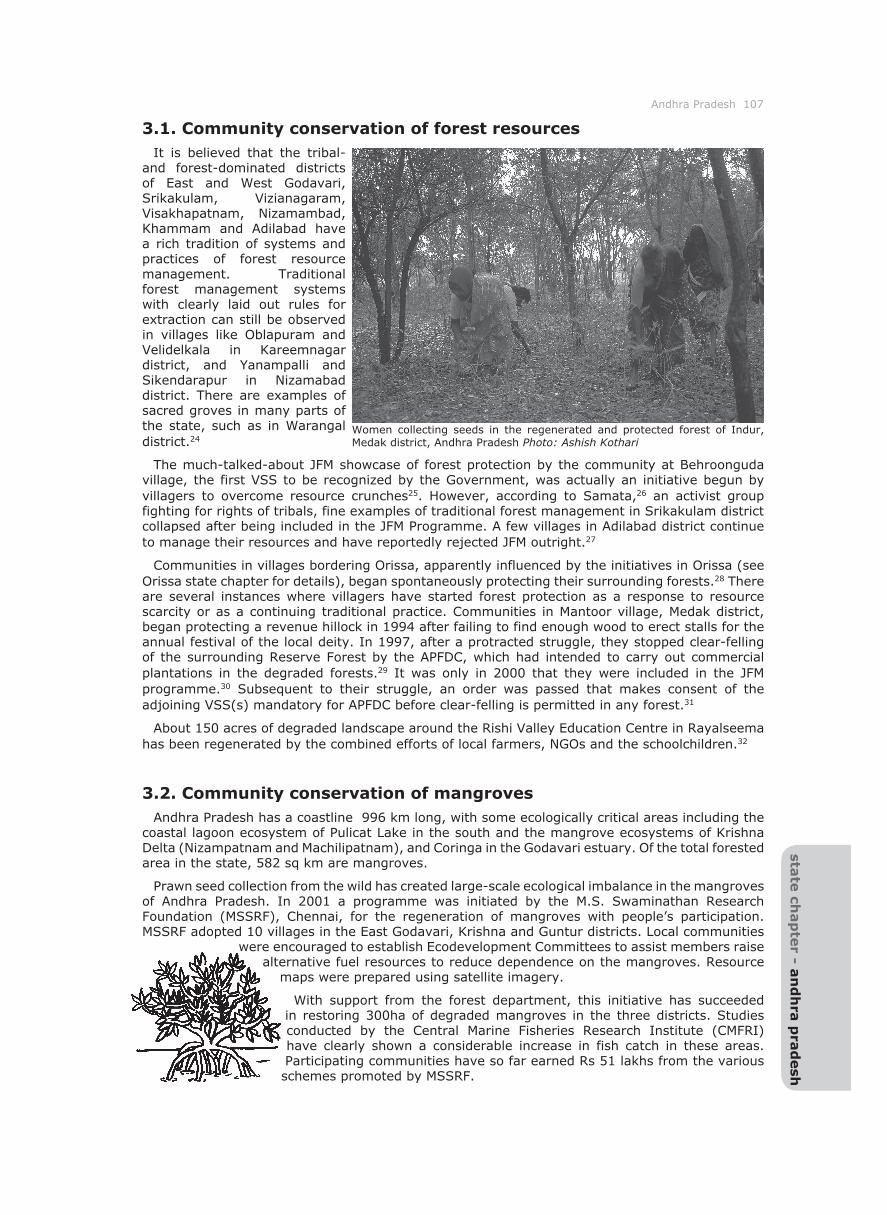
3.1. Community conservation of forest resourcesIt is believed that the tribal-
and forest-dominated districts of East and West Godavari, Srikakulam, Vizianagaram, Visakhapatnam, Nizamambad, Khammam and Adilabad have a rich tradition of systems and practices of forest resource management. Traditional forest management systems with clearly laid out rules for extraction can still be observed in villages like Oblapuram and Velidelkala in Kareemnagar district, and Yanampalli and Sikendarapur in Nizamabad district. There are examples of sacred groves in many parts of the state, such as in Warangal district.24
The much-talked-about JFM showcase of forest protection by the community at Behroonguda village, the first VSS to be recognized by the Government, was actually an initiative begun by villagers to overcome resource crunches25. However, according to Samata,26 an activist group fighting for rights of tribals, fine examples of traditional forest management in Srikakulam district collapsed after being included in the JFM Programme. A few villages in Adilabad district continue to manage their resources and have reportedly rejected JFM outright.27
Communities in villages bordering Orissa, apparently influenced by the initiatives in Orissa (see Orissa state chapter for details), began spontaneously protecting their surrounding forests.28 There are several instances where villagers have started forest protection as a response to resource scarcity or as a continuing traditional practice. Communities in Mantoor village, Medak district, began protecting a revenue hillock in 1994 after failing to find enough wood to erect stalls for the annual festival of the local deity. In 1997, after a protracted struggle, they stopped clear-felling of the surrounding Reserve Forest by the APFDC, which had intended to carry out commercial plantations in the degraded forests.29 It was only in 2000 that they were included in the JFM programme.30 Subsequent to their struggle, an order was passed that makes consent of the adjoining VSS(s) mandatory for APFDC before clear-felling is permitted in any forest.31
About 150 acres of degraded landscape around the Rishi Valley Education Centre in Rayalseema has been regenerated by the combined efforts of local farmers, NGOs and the schoolchildren.32
3.2. Community conservation of mangrovesAndhra Pradesh has a coastline 996 km long, with some ecologically critical areas including the
coastal lagoon ecosystem of Pulicat Lake in the south and the mangrove ecosystems of Krishna Delta (Nizampatnam and Machilipatnam), and Coringa in the Godavari estuary. Of the total forested area in the state, 582 sq km are mangroves.
Prawn seed collection from the wild has created large-scale ecological imbalance in the mangroves of Andhra Pradesh. In 2001 a programme was initiated by the M.S. Swaminathan Research Foundation (MSSRF), Chennai, for the regeneration of mangroves with people’s participation. MSSRF adopted 10 villages in the East Godavari, Krishna and Guntur districts. Local communities
were encouraged to establish Ecodevelopment Committees to assist members raise alternative fuel resources to reduce dependence on the mangroves. Resource
maps were prepared using satellite imagery.
With support from the forest department, this initiative has succeeded in restoring 300ha of degraded mangroves in the three districts. Studies conducted by the Central Marine Fisheries Research Institute (CMFRI) have clearly shown a considerable increase in fish catch in these areas. Participating communities have so far earned Rs 51 lakhs from the various schemes promoted by MSSRF.
Women collecting seeds in the regenerated and protected forest of Indur, Medak district, Andhra Pradesh Photo: Ashish Kothari
108 Community Conserved Areas in India - a directory
There has also been an attempt to follow the JFM model and initiate joint mangrove management (JMM). According to a MSSRF report33 ‘The Joint Mangrove management (JMM) model consists of two aspects. The first involves mobilization of institutional organizations and mobilization of the community towards mangrove management. It also involves village development through training and capacity building and awareness. The second part involves technical support…JMM in this region has resulted in the restoration of 515 hectares of degraded mangroves and brought over 9,442 hectares of verdant mangroves under the management of the village level JMM institutions.’
3.3. Community conservation of heronriesAP is known for its heronries, where a host of large waterbird species roost and breed on trees
around traditional tanks. There are three major factors that attract birds to these:
a) Feeding conditions: Aquatic birds depend on large wetlands and they need many wetlands, distributed over a large area, a condition that decentralised village tanks ideally provide.
b) Availability of nesting sites, usually trees, to help avoid predation.
c) Safety (possibly the main factor).
In many instances the local villagers traditionally protect these sites. Heronries are to be found in Vedurupattu in Nellore district, Uppalapadu in Guntur district and Nelapattu in Nellore district among others (for details, see case studies). One of the well-known examples is that of Nelapattu. The heronry here was declared a sanctuary under the Wildlife (Protection) Act in September 1997. Unfortunately, due to this, local people’s access to the lake was restricted, leading to serious conflicts between the sanctuary authorities (the forest department), and the local people who have been protecting the birds for generations.34
It is interesting to note that birds from Neelapattu, Vedurupattu also feed on fish from Pulicat lake (see the Tamil Nadu state chapter in this volume). Pulicat lake is also a CCA site, where fisherman not only follow traditional fishing practices which ensure conservation but also vigorously fight against pollution and development project-related impacts.
4.1. Opportunities and constraints for community conservation The JFM process has taken some steps towards effective people’s participation and benefit
sharing in the state. Since 1992, 12 amendments have been made based on feedback from NGOs and the JFM monitoring cell of the APFD. JFM is in fact now being seen as a means to resolve land conflicts with tribals. In many cases encroached lands have been included under JFM, providing a form of official sanction of tribal presence in these areas as long as it leads to conservation and regeneration of forests, though it does not of course resolve the deeper problem of land rights for the tribal community. The version of JFM popularly called ‘Chief Minister’s JFM’ started in 1996-97 receives funds from the state exchequer and supports about 35 per cent of all VSSs in the state.35 The then CM had three state-level meetings with the members of the VSSs. His interventions are believed to have been very effective in creating instantaneous operational changes.36 According a report,37 ‘The joint forest management (JFM) movement has been in operation in more than 62,000
villages. This has improved the biophysical condition of around 11.2 million hectares of degraded forest and the socio-economic conditions of about 35,000 villages.’
In districts where a large number of VSSs exist and are either encouraged by the local NGOs or the FD, VSSs have started forming federations at
the Forest Range level. These initiatives are still too new to comment on any impacts. The monitoring mechanism to ascertain ecological regeneration, local empowerment and transparent as well as efficient management of funds is not
clear at this stage.
Though there have been notable positive outcomes of JFM, the negative consequences (e.g., undermining some self-generated forest conservation initiatives)
and weaknesses (continued lack of power-sharing with villagers, inequities in benefit-sharing, etc.) are also important. The state government passed a Community Forest Management (CFM) Resolution in 200238 that appears the same as the JFM resolution in spirit and content. Although it aims at achieving greater empowerment of local institutions, local NGOs do not feel that the new Resolution will substantially change
ground realities. Villagers continue to be largely unaware of the new resolution or its operational impacts.39 There is also a lot of fear among tribals and tribal
Andhra Pradesh 109 sta
te ch
ap
ter - a
nd
hra
pra
desh
activists that CFM may be used to term tribals practising shifting cultivation as encroachers and thus deny their rights.
Another programme aimed at decentralization of resource management is the ‘Janmabhoomi Programme’ proposed by the Chief Minister. Under this programme, villagers can take up projects and contribute free labour to the project through the local village institutions (gram sabhas).40 It is not clear whether this has had any positive outcome for conservation of ecosystems around villages.
Much of the following text first appeared in the Andhra Pradesh section in Tejaswini Apte and Neema Pathak, ‘International Community Forestry Networks in India’, (Bogor, Indonesia, CIFOR, 2003). Despite many efforts we found it extremely difficult to update the information contained in this chapter. At the same time we were not able to get much information on the conservation efforts in marine areas or of mangroves. This limitation is regretted.
Endnotes1 Joint forest management in Andhra Pradesh: Final Report (Hyderabad, AP NGOs Committee on JFM, 1998).
2 http://www.censusindia.net/t_00_003.html
3 http://www.censusindia.net/t_00_005.html
4 http://www.censusindia.net/religiondata/Religiondata_2001.xls. Note that most tribal communities seem to be classified as Hindus, Muslims, or Christians, having been converted to these mainstream religions at various stages of history.
5 Bharati and M. Patnaik, Joint Forest Management in Andhra Pradesh (Hyderabad, AP NGOs Committee on JFM, 1998).
6 The Naxalite movement is a leftist, armed movement, which started in protest against alienation of tribal land and continues to be strongly anti-establishment in tribal dominated parts of the country.
7 The Qutub Shahi dynasty ruled Hyderabad till 1687. It was extinguished by Aurangzeb in 1687. One of the Mughal nobles set himself up as an independant ruler of Hyderabad area. His title was Nizam-ul-Mulk and his successors were popularly known as the Nizams of Hyderabad. Their dynasty was called the Asaf Jahi dynasty. They ruled Hyderabad till 1948, when Indian forces took charge of the estate.
8 Sushruti Santhanam, ‘Report on the Study of Sustainable NTFP Collection’ (Pune, Kalpavriksh, Unpublished, 2000).
9 C.S. Rangachari and S.D. Mukherji, Old Roots, New Shoots: A Study of Joint Forest Management in Andhra Pradesh, India (New Delhi, Winrock International and Ford Foundation, 2000).
10 A patta is a memorandum of the particulars of a holding and land assessment, given by the state to the landholder, usually considered as constituting a title to the land. A pattadar is a holder of the patta.
11 N. Sundar, R. Jeffery and N. Thin, Branching Out: Joint Forest Management in India (New Delhi, Oxford University Press, 2001).
12 Santhanam, ‘Report on the Study of Sustainable NTFP Collection’.
13 (As above).
14 R. Raina, ‘Study on Networks in Community Forestry in India’ (Bhopal, Indian Institute of Forest Management, 2002).
15 LAYA, Land Rights in Tribal Areas (1998).
16 Raina, ‘Study on Networks’. (As above).
17 Personal communication with Satya Srinivas, co-convenor of AP NGOs Committee for JFM in Andhra Pradesh, 2002.
18 Rangachari and Mukherji, Old Roots, New Shoots. (As above).
19 Sundar et al., Branching Out. (As above).
20 Bharati and Patnaik, Joint Forest Management in Andhra Pradesh. (As above).
21 R. Mahapatra, ‘Seeking Reliance’, Down To Earth, 15 September 2000; Personal communication with members of AP NGOs Committee for JFM in Andhra Pradesh, 2002; Personal communication with S.K. Chhottray, Conservator of Forests, Khammam, 2002.
22 Santhanam, ‘Report on the Study of Sustainable NTFP Collection’. (As above).
23 (As above).
24 Personal communication with Surendra Pandey, Conservator of Forests, Nizamabad, 2002.
110 Community Conserved Areas in India - a directory
25 E. D’Silva and B. Nagnath, ‘Behroonguda: A Rare Success Story in Joint Forest Management’, Economic and Political Weekly, 9 February 2002.
26 Anon. Joint Forest Management: A Critique Based on People’s Perceptions (Hyderabad, Samata, 2001).
27 Personal communication with Madhoo, Anthra, Andhra Pradesh, 2002.
28 Personal communication with Madhoo, Anthra, Andhra Pradesh, 2002; Personal communication with Bhanumathi, Samata, Andhra Pradesh, 2002.
29 There are similar experiences in Karnataka where villagers opposed monoculture plantations proposed by the government under various schemes.
30 Personal communication with Satya Srinivas, co-convenor of APNGOs Committee for JFM in Andhra Pradesh, 2002.
31 Personal communication with V.R. Sowmitri, Co-convenor of APNGOs Committee for JFM in Andhra Pradesh, 2002.
32 S. Rangaswami, ‘Rishi Valley Experiment’, Hindu Folio, September 1998.
33 T. Ravishankar, R. Ramasubramanian and N. Sreenivasa Rao, Intersectoral Linkages for Conservation and Management of Forest Resources – A Case Study on Mangroves of India (Kakinada, M.S. Swaminathan Research Foundation, undated).
34 Personal communication with Satya Srinivas, co-convenor of APNGOs Committee for JFM in Andhra Pradesh, 2002.
35 Bharati and Patnaik, Joint Forest Management in Andhra Pradesh. (As above).
36 Personal communications with V.R. Sowmitri, co-convenor, APNGOs Committee for JFM in Andhra Pradesh, 2002.
37 Ravishankar et al., Intersectoral Linkages. (As above).
38 G.O. Ms. No. 13, EFES&T (for III) Dept., dated 12.02.2002
39 Personal communication with villagers of village Eliminadu in Ranga Reddy district, 2002.
40 Sundar et al., Branching Out. (As above).